REPORT ON THE ARCHAEOLOGICAL SITE EXAMINATION OF THE ...
72
REPORT ON THE ARCHAEOLOGICAL SITE EXAMINATION OF THE ENTRANCE DRIVE, CARRIAGE HOUSE, GREENHOUSE, VEGETABLE GARDEN, FLOWER GARDEN AND GRAPERY AT GORE PLACE, WALTHAM, MASSACHUSETTS FISKE CENTER FOR ARCHAEOLOGICAL RESEARCH UNIVERSITY OF MASSACHUSETTS BOSTON CULTURAL RESOURCES MANAGEMENT STUDY NO. 17 2006
Transcript of REPORT ON THE ARCHAEOLOGICAL SITE EXAMINATION OF THE ...

REPORT ON THEARCHAEOLOGICAL SITE EXAMINATION
OF THE ENTRANCE DRIVE, CARRIAGE HOUSE,GREENHOUSE, VEGETABLE GARDEN,
FLOWER GARDEN AND GRAPERYAT GORE PLACE, WALTHAM, MASSACHUSETTS
FISKE CENTER FOR ARCHAEOLOGICAL RESEARCHUNIVERSITY OF MASSACHUSETTS BOSTON
CULTURAL RESOURCES MANAGEMENT STUDY NO. 17
2006

Cover Illustration: Detail of the Gore Place property as depicted by the HistoricAmerican Buildings Survey in 1936.
REPORT ON THEARCHAEOLOGICAL SITE EXAMINATION
OF THE ENTRANCE DRIVE, CARRIAGE HOUSE,GREENHOUSE, VEGETABLE GARDEN,
FLOWER GARDEN AND GRAPERYAT GORE PLACE, WALTHAM, MASSACHUSETTS
PREPARED FORGORE PLACE SOCIETY
BYJ.N. LEITH SMITH AND GREGORY DUBELL
FISKE CENTER FOR ARCHAEOLOGICAL RESEARCHUNIVERSITY OF MASSACHUSETTS BOSTON
CULTURAL RESOURCES MANAGEMENT STUDY NO 17
2006

ii
Fiske Center for ArchaeologicalResearch
The Fiske Center for Archaeological Research(formerly the Center for Cultural andEnvironmental History) was established in 1996with a mission that includes research, publicservice, and educational initiatives. The Centermaintains archaeology and conservation labora-tories and supports research in landscape andenvironmental archaeology, historical archaeol-ogy, and environmental history. Center projectsoften have an applied focus, seeking to promote
and protect the cultural heritage and historiclandscape of the Commonwealth ofMassachusetts and the surrounding region. As apublic service unit of the Department ofAnthropology, the FCAR also serves an impor-tant educational role at the University ofMassachusetts, Boston by creating opportunitiesfor students to participate in public service proj-ects.

iii
ABSTRACT
A landscape restoration plan for the 45-acre GorePlace property in Waltham and Watertown, MA,calls for restoration of grounds, gardens andstructures to depict and interpret the late eigh-teenth- and early nineteenth-century occupationof Massachusetts governor and United Statessenator, Christopher Gore, and his wife,Rebecca. The restoration plan includes archaeo-logical investigation to help identify the locationand integrity of six historically documented fea-tures on the Gore Place grounds. Blocks andtransects of shovel test pits at 5, 10 and 20 meterintervals along with 1 x 1 m excavation units andtrenching were employed in the archaeologicalsite examination of these areas. Testing in thearea of the present entrance drive revealed evi-dence of significant landscape alteration charac-terized by a unique process of top soil removalfollowed by filling first with a layer of stone,then loamy sand and gravel and finally replace-ment of topsoil, all in an effort to create flat andwell-drained yard space. The existing entrancedrive is hypothesized to have been constructedduring the Gore occupation as was a separateservice drive. Work at the site of the 1793 car-riage house succeeded in pinpointing the location of the original foundation, a task that contributesto the structure’s relocation. The site of theGore-period greenhouse was also identified by
architectural remains that include fragments ofmarble tile flooring identical to that in the GoreMansion. A stone-lined drain, glass bell jar frag-ments as well as a soapstone brick possibly asso-ciated with the greenhouse heating system werealso found. Investigations in the vegetable andflower gardens revealed intact soils and lateeighteenth- / early nineteenth-century artifactssuggesting Gore-period garden features may bepreserved and are potentially archaeologicallyidentifiable. Work in the area of thegrapery/fruitwall revealed remains of the largegreenhouse that occupied the site from the sec-ond quarter of the nineteenth century until ca.1921. Intact greenhouse soils and foundationssuggest that the original fruitwall footing is pre-served within the later greenhouse foundation.All of these features are well preserved andexhibit a high level of integrity. Those areas ofthe property not tested during the survey may bearchaeologically sensitive and may requrie test-ing in advance of future proposed impacts.Recommendations specific to each area includeoptions for grounds restoration and interpreta-tion as well as additional archaeological investi-gations to proceed in tandem with proposedlandscape changes. The report also includes asummary of scholarly research associated withdesign landscape archaeology with reference toMassachusetts.
iv
MANAGEMENT SUMMARY
The Gore Place Society contacted the Center forCultural and Environmental History at theUniversity of Massachusetts, Boston to conductan archaeological site examination at historicGore Place in Waltham and Watertown, MA. Amaster landscape plan developed by HalvorsonDesign Partnership of Boston has as its goal therestoration of Gore Place grounds and structuresto reflect the late eighteenth- and early nine-teenth-century occupation of Christopher andRebecca Gore. Archaeological investigationswere recommended by the master plan to deter-mine the location and assess the integrity of sixareas or landscape features including theentrance drive area, carriage house, greenhouse,
vegetable and flower gardens and grapery/fruit-wall. The archaeological site examination con-ducted under State Archaeologist permit #2716succeeded in identifying the Gore periodentrance drive, original carriage house andgreenhouse foundations, the location of the veg-etable and flower gardens as well as that of thegrapery area green house. All areas were foundto maintain a high degree of archaeologicalintegrity and are archaeologically sensitiveAreas not tested by the survy may be archaeolog-ically sensitive and may require testing prior tofuture proposed impacts. Recommendations callfor additional archaeological investigation ineach area to be coordinated with proposed land-scape modifications and interpretive plans.

v

vi
TABLE OF CONTENTS
Abstract ....................................................................................................................................iiiManagement Summary ............................................................................................................ivTable of Contents ......................................................................................................................vList of FiguresviList of Tables viiiI. Introduction ..........................................................................................................................1
II. Project Location and Environmental Context ......................................................................3
III. Background..........................................................................................................................4A. Native American Cultural Context of Southern New England ..........................................................4
1. Paleo-Indian Period (ca. 12,000-10,000 B.P.)2. Early Archaic Period (ca. 10,000-8000 B.P.)3. Middle Archaic Period (ca. 8,000-6,000 B.P.)4. Late Archaic Period (ca. 6,000-3,000 B.P.)5. Early Woodland Period (ca. 3,000-1,600 B.P.)6. Middle Woodland Period (ca. 1,600-1,000 B.P.)7. Late Woodland Period (ca. 1,000-450 B.P.)8. Contact Period
B. Native American Archaeological Sites Around the Project Area ..............................................6C. Historic Development of Waltham and Watertown ..............................................................6D. Summary History of the Gore Place Property....................................................................10
1. Seventeenth- and Eighteenth-Century Ownership/Occupation2. Gore Occupation ca. 1786-18343. Lyman Occupation ca. 1834-18384. Green Occupation ca. 1838-18565. Walker Occupation ca. 1856-19076. Episcopal Church Ownership ca. 1907-19117. Metz Occupation ca. 1911-19218. Waltham Country Club Occupation 1921-19359. Gore Place Society Occupation ca. 1935-Present
E. Archaeological Potential of the Gore Place Property ..........................................................15F Previous Investigations ..................................................................................................18
IV. Archaeological Site Examination......................................................................................19A. Research DesignB. Scope of WorkC. Field MethodologyD. Site Examination Results
V. Interpretations and Discussion ..........................................................................................43
VI. Recommendations ............................................................................................................54
References Cited ......................................................................................................................58
Appendix A: Artifact Catalog ................................................................................................61

vii
LIST OF FIGURES
Figure I.1. Gore Place Project Area on USGS Boston South Quadrangle ......................................1
Figure III.1. Historic American Buildings Survey Plan of Gore Place Drawn in 1936 ................11
Figure III.2. Detail of 1831 Plan of Waltham Depicting Gore Place Property (CourtesyMassachusetts State Archives). ..................................................................................12
Figure III.3. Detail of the Estate of Theodore Lyman Drawn Between 1834 and 1838. ..............13
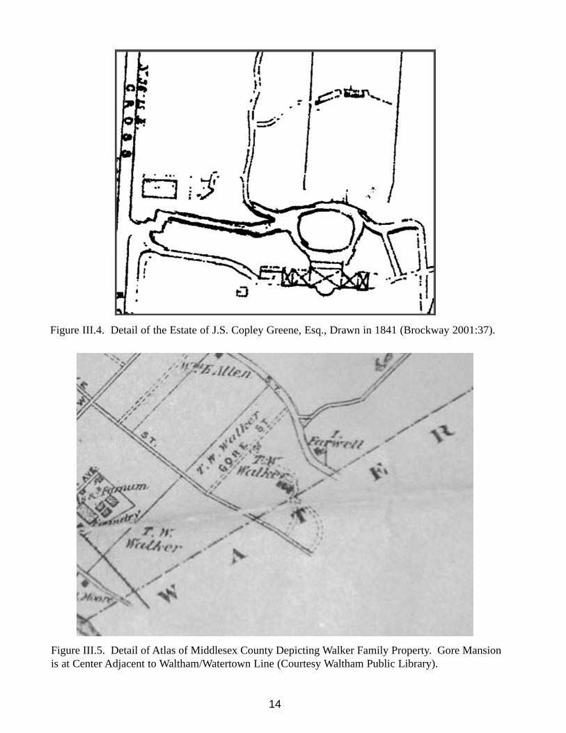
Figure III.4. Detail of the Estate of J.S. Copley Greene, Esq., Drawn in 1841. ............................14
Figure III.5. Detail of Atlas of Middlesex County 1875 Depicting Walker Family Property. ......14
Figure III.6. Charles Eliot Sketch of Gore Place Grounds Drawn in 1889. ..................................15
Figure III.7. Detail of Proposed Changes to the Gore Place Grounds ca. 1921 DuringOwnership by the Waltham Country Club (Courtesy GPS).......................................16
Figure IV.1. Gore Estate by Col. Henry Lee Who Sketched in 1881 from Memory of an 1834Visit.............................................................................................................................20
Figure IV.2. Archaeological Testing Plan in the Entrance Drive Area. ..........................................22
Figure IV.3. Detail of 1834-38 Lyman Estate Plan Depicting the Location of the CarriageHouse and Greenhouse (Courtesy GPS). ..................................................................23
Figure IV.4. Plan of Proposed Changes to Gore Street ca. 1967 (Courtesy GPS). ........................24
Figure IV.5. Archaeological Testing Plan in the Greenhouse Area ................................................25
Figure IV.6. Archaeological Testing Plan in the Vegetable Garden ..............................................27
Figure IV.7. Archaeological Testing Plan in the Flower Garden....................................................29
Figure IV.8. Archaeological Testing Plan in the Grapery/Fruitwall Area ......................................31
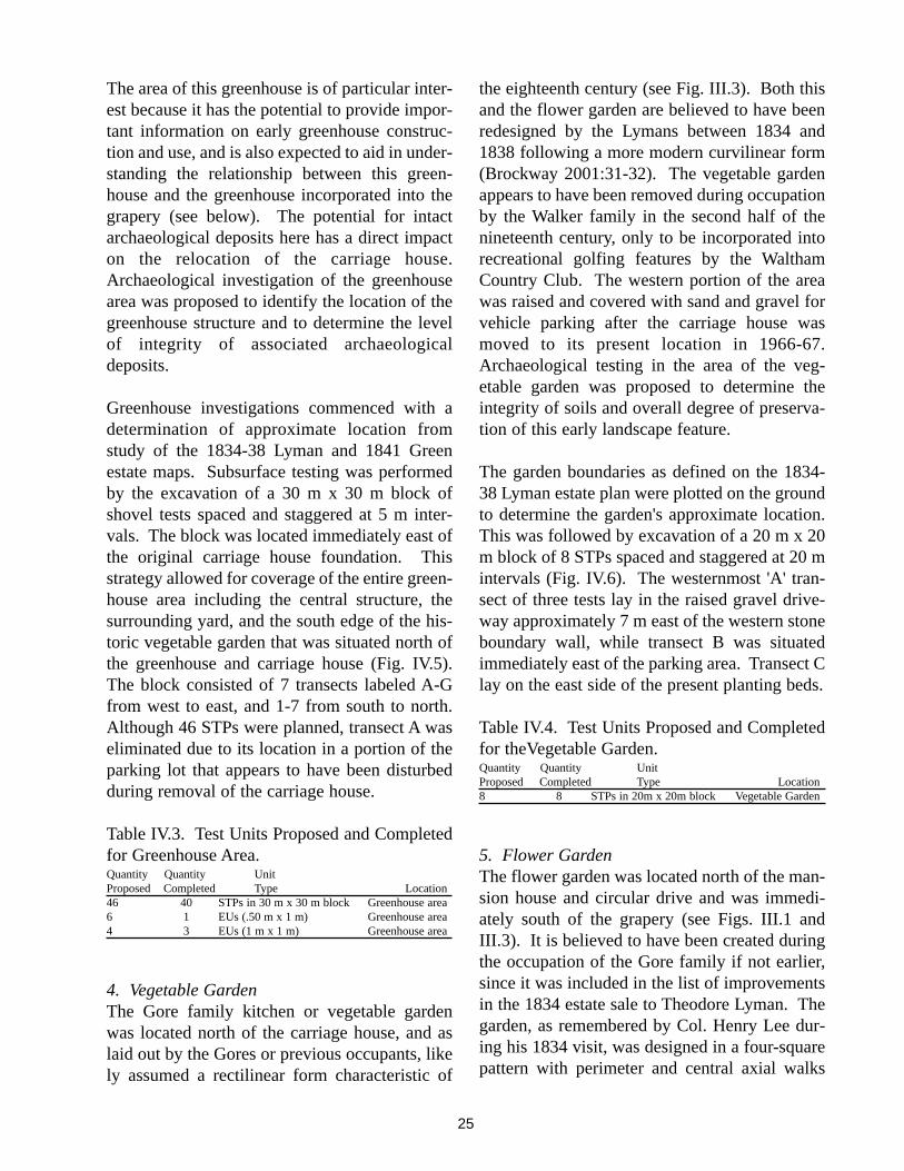
Figure IV.9. East Wall Profile of Excavation Unit 1 in the Entrance Drive Area..........................32
Figure IV.10. West Wall Profile of Excavation Unit 2 under the Asphalt Entrance Drive ............32
Figure IV.11. Artifacts Recovered from the Entrance Drive Area..................................................33
Figure IV.12. Location of Excavation Trench and Foundation Wall in the Carriage House Area 34
Figure IV.13. Carriage House Area Trench and Foundation Wall (facing north)...........................35
viii
Figure IV.14. Artifacts Recovered from the Greenhouse Area.......................................................36
Figure IV.15. Stone-lined drain revealed in Excavation Unit 1 in the Greenhouse Area. ............36
Figure IV.16. North Wall Profile of Excavation Unit 2 in the Greenhouse Area...........................37
Figure IV.17. North Wall Profile of STP F4 Extension in the Greenhouse Area ..........................38
Figure IV.18. Artifacts Recovered from the Flower Garden. ........................................................39
Figure IV.19. Artifacts Recovered from the Grapery Area.............................................................41
Figure IV.20. West Wall Profile of Excavation Unit 1 in the Grapery Area. ................................42
Figure V.1. Gore Street Entrance ca. 1937 (Courtesy GPS)...........................................................45
Figure V.2. Entrance Drive Area Depicting Main and Service Drive Locations and ModernCurb Line on 1936 HABS Plan. ................................................................................45
Figure V.3. Approximate Location of Greenhouse Based Upon Archaeological Findings. ..........47
Figure V.4. Marble and Slate Tile Fragments Recovered from the Greenhouse Area. ..................48
Figure V.5. Marble Floor Tiles in the Central Hall of the Gore Mansion House...........................48
Figure V.6. Soapstone Brick Fragment Recovered from the Greenhouse Area. ............................49
Figure V.7. Fragments of Glass Bell Jar Recovered from the Greenhouse Area. ..........................49
Figure V.8. HABS Plan (1936) of the Flower Garden. ..................................................................50
Figure V.9. Flower Garden ca. 1906 Taken from the Grapery Greenhouse (facing southwest,courtesy GPS). ............................................................................................................51
Figure V.10. West Wing and Central Block of the Grapery Greenhouse ca. 1906, (facing north,courtesy GPS). ............................................................................................................52

ix
LIST OF TABLES
Table IV.1. Test Units Proposed and Completed for Entrance Drive Identification . . . . . .21
Table IV.2. Test Units Proposed and Completed for Carriage House Foundation Area . . .23
Table IV.3. Test Units Proposed and Completed for the Greenhouse Area . . . . . . . . . . . . .25
Table IV.4. Test Units Proposed and Completed for the Vegetable Garden . . . . . . . . . . . .25
Table IV.5. Test Units Proposed and Completed for the Flower Garden . . . . . . . . . . . . . . .28
Table IV.6. Test Units Proposed and Completed for the Grapery/Fruitwall Area . . . . . . . .30

I. INTRODUCTION
The Gore Place Society (GPS) owns and main-tains Gore Place, the historic mansion and estateof Massachusetts Governor and U.S. SenatorChristopher Gore and his wife Rebecca from1786 to 1834. The Gore property, located at 52Gore Street in the towns of Waltham andWatertown, Massachusetts (Fig. I.1), is aNational Historic Landmark because of its his-torical connections to the Gore Family and itsdepiction of a Federal-period country estate. The
present mansion house is unique for its design byFrench architect, Jacques Guillaume Legrand. Itis also known for its exemplary role in Americanlabor history due to its association with the writ-ings of house servant, Robert Roberts (1998(1827)). The mansion with its extant 1793 car-riage house and extensive grounds is one of asmall number of Federal-period country seats inthe greater Boston area that have been preservedfor the purpose of public education and enjoy-ment.
1
Figure I.1. Project Area on USGS Boston South Quadrangle.

The Gore Place Society hired LandscapeArchitects Halvorson Design Partnership Inc.(HDP) of Boston to create a landscape masterplan for Gore Place that incorporates theSociety's mission of preservation and mainte-nance of the 1806 mansion, its collections, out-buildings and grounds. This collaborative efforthas as its central focus a unique commitment touse the surrounding landscape to enhance thestory of the Gore Family. The landscape masterplan, therefore, seeks to restore the existing land-scape to its early nineteenth-century form to theextent practicable, and outlines procedures forpreliminary investigation, rehabilitation andrestoration that will occur in a series of phases.Phase one consists of historic backgroundresearch that focuses on the identification ofknown Gore-period resources as well asunknown resources that could be impacted byimplementation of the landscape plan. Thisphase was initiated by the completion of adetailed landscape history (Brockway 2001).Phase two calls for archival and archaeologicalresearch to identify subsurface features that will
aid in the landscape rehabilitation effort and con-tinue the Society's mission of preservation.
Christopher Greene of HDP contacted the Centerfor Cultural and Environmental History (CCEH)at the University of Massachusetts, Boston inOctober 2004 to solicit archaeological servicesfor the proposed landscape project. An archaeo-logical site examination was carried out underState Archaeologist Permit No. 2716 betweenDecember 2004 and June 2005. The primarypurpose of this preliminary work was to identifythe locations and state of preservation of specif-ic features associated with the occupation of theGore Family. This work was performed in com-pliance with Section 106 of the National HistoricPreservation Act of 1966 (36 CFR 800),Massachusetts General Laws Chapter 9, Sections26-27C, as amended by Chapter 254 of the Actsof 1988 (950 CMR 71). University ofMassachusetts staff and students who worked onthe project included Amity and Greg Dubell, JonPatton, Leith Smith and Tom Witt.
2

II. PROJECT LOCATION ANDENVIRONMENTAL CONTEXT
The Gore Place property is composed of 45 acressituated on the boundary between the towns ofWaltham to the west and Watertown to the east inMiddlesex County. It is bordered by Main Street(Route 20) on the north, Edward Road on theeast, Grove Street on the south and Gore Streeton the west. The property is approximately 2600ft (800 m) north of the Charles River and lies atthe geographic boundary between the upperCharles River flood plain and northern upland.The entire parcel slopes gently southward towardthe river. The eastern portion of the propertycontains a small north-south stream that origi-nates north of Main Street. Its course appears tohave been altered by filling and channeling.
A. SoilsSoils in the project area are composed of two
types that correspond to the site's topography.The lower Charles River floodplain consists ofHinckley loamy sand with 3-5% slopes (USDA1995). The Hinckley series ranges from a friableand gravelly or very gravelly sandy loam to aloamy coarse sand, both of which have rapid per-meability making them excessively drained. Thesubstratum at 12-30 in. consists of stratifiedsands and gravels. These soils form on gravellyand cobbly, coarse textured glacial outwashplains, terraces, kames and eskers. Soils thatmake up the upland portion of the property con-sist of Canton fine sandy loam with 3-8% slopes.The Canton series soils are characterized as fri-able fine sandy loam with moderately rapid per-meability. The substratum between 18 in. and 36in. is a loamy coarse sand. Canton soils form onwell-drained upland glacial till and are typicallystony, but this characteristic is generally absentfrom the northwestern upland portion of theproperty.
3

III BACKGROUND
A. Native American Cultural Context ofSouthern New EnglandThe history of Native American occupation inthe greater Boston area derives from numerousarchaeological studies conducted in and aroundthe region. Paleoenvironmental syntheses arederived primarily from work conducted in theNeponset River valley (Ritchie 1994) that uti-lizes palynological data collected within the mid-dle Neponset drainage in Canton and Milton.
1. Paleo-Indian Period (ca 12,000-10,000 B.P.)New England was first occupied by humans soonafter the retreat of the Wisconsin ice sheetaround 13,000 B.P. The environment at the timewas rapidly changing as the glacial marginsslowly moved northward. Forests came to bedominated by spruce, birch and alder. Faunawould have been characterized by cold adaptedspecies including mastodon, mammoth, caribou,elk and a variety of birds and smaller mammals.While big game would have been an importantsource of food (Ritchie 1980, Snow 1980),smaller species probably made up the bulk of thediet along with a wide variety of plant foods(Curran 1987; Curran and Dincauze 1977;Dincauze 1990, Dincauze and Curran 1984;Donta et al 2002). Nothing is known of humansocial structure from this time, but it likely wascharacterized by small family groups that band-ed together to move frequently about the land-scape in search of food. This mobile hunting andgathering lifeway led to living sites that weretypically occupied for short periods of time.Artifact assemblages from such sites are domi-nated by stone tools that include fluted scrapingtools, drills, gravers projectile points and largequantities of flakes from stone working, some ofwhich are utilized. Many of the tools are manu-factured of exotic, fine grained stone that wascarried for long distances from their sources oforigin. With the exception of isolated finds (Eliaand Mahlstedt 1982) few archaeological sites ofthis period have been found in New England(Loparto 1986). Bull Brook in Ipswitch (Grimes
et. al. 1984), the Neponset site in Canton (Cartyand Spiess 1992), and the Shattock Farm site inAndover (Speiss and Bradley 1996) are a few.
2. Early Archaic Period (ca 10,000-8,000 B.P.)Although little is actually known of this phasedue to a scarcity of well-documented sites, a life-way characterized by mobile hunting and gather-ing is believed to have continued during theEarly Archaic with an emphasis on seasonal set-tlement patterning (Ritchie 1980). The environ-ment remained cool, but through a slow warmingtrend forest species in the Boston area came to bedominated by pine, oak and birch (Ritchie 1994).The manufacture of stone tools out of locallyavailable materials suggests a trend toward occu-pation of particular regions with a decrease inlong distance mobility and trade. Differences inthe lithic tool kit characterized by the manufac-ture of bifurcate-base projectile points have beeninterpreted by some researchers to suggest a dis-continuity with the preceding Paleoindian Perid(Donta et al 2002, Ritchie 1969, Snow 1980),while others suggest a general continuum ofdevelopment (Custer 1984).
3. Middle Archaic Period (ca 8,000-6,000 B.P.)During the Middle Archaic the New Englandlandscape began to resemble that of today withthe establishment of a deciduous forest andincreased diversity of plant and animal foods(Dincauze 1976, Dincauze and Mulholland1977). The number of archaeological sites fromthis period increase dramatically in comparisonwith the past period, suggesting a significant risein population. The Merrimack River Valleyassociated with northern Massachusetts andsouthern New Hampshire, in particular, containthe best known sites of the period. These includethe Neville and Smyth sites in New Hampshire(Dincause 1976, Kenyon 1983 and ShattuckFarm in Andover (Mahlstedt 1981, Leudtke1985). Settlement in and exploitation of a vari-ety of environments is clearly indicated by bothfaunal remains and tool kits and this was increas-ingly associated with seasonal resource avail-ability (Dincauze and Mulholland 1977, Barber
4

1979). Andromous fishing at falls was clearlythe primary attraction at a number of localitiesincluding the Neville site that revealed evidenceof reoccupation over a period of time. The lith-ic tool kit during this period is characterized bythree distinctive projectile point styles (Dincauze1976). These include the Neville, Stark andMerrimack that are joined by atlatl weights,knives, perforators, axes, adzes, scrapers,abraders, ulus, gouges and harpoons (Donta et al2002).
4. Late Archaic Period (ca 6,000-3,000 B.P.)The greatest number of Native American archae-ological sites in New England is associated withthe Late Archaic. Seasonal temperatures wereslightly higher than today and an oak-hickoryforest came to dominate southern New England(Loparto 1986:7). The period is characterized byrelatively high populations that occupied theentire range of available environments for thepurpose of exploiting an equally wide range ofplant and animal resources. Seasonal settlementpatterns continued, but toward the end of theperiod populations became more settled on thelandscape as evidenced by shell middens andfish weirs. Coupled with this sedentism was lim-ited cultivation of plant foods such as squash,gourds and sunflower. Three different lithic tra-ditions suggest the possible development ofregional ethnic diversity (Dincauze 1974, 1975)or of differing tool kit functions. The Small-Stemmed point tradition is most widespread andis associated with indigenous populations thathad long inhabited the region. The Laurentiantradition may represent a migration of peoplesfrom the Great Lakes region where such tool kitsare common. The Susquehanna tradition is gen-erally associated with groups that derived fromthe Mid-Atlantic region. The mixture of thesetraditions in single sites suggests the coexistenceof the three groups, exchange of technologiesand functional specialization (Dincauze 1976;Ritchie 1969; Snow 1980; Custer 1984; Bourque1995). Evidence of religious beliefs from buri-als becomes more common during this perioddue to the use of particular practices that
includes use of red ocher and burial goods.
5. Early Woodland Period (ca 3,000-1,600 B.P.)The Early Woodland is generally associated witha period of population reduction and a clusteringof sites in valleys along river courses, but thischaracterization may be a product of samplingerror. An expansion of spruce and slight declinein oak may have been associated with a coolingtrend (Ritchie 1994). Coastal resources, particu-larly fish and shellfish, take on greater impor-tance, but the most significant development dur-ing this period is the transition from simple cul-tivation to horticulture, and the development ofceramic technology that coincided with anincreasingly settled lifeway. The Small-Stemmed and Susquehanna projectile point tra-ditions continue in this period and were joinedby the more common Meadowood and Rossvilleprojectile points. The latter is associated withindigenous development, while the former mayderive from the western interior (Loparto 1986).The Early Woodland is also known for increas-ingly complex burial customs that incorporateartworks including gorgets, pottery pipes, copperbeads as well as red ocher (Ritchie 1965; Ritchieand Funk 1973; Spence and Fox 1986). Thesegoods imply a rich belief in the afterworld.
6. Middle Woodland Period (ca 1,600-1,000B.P.)The general lifeway established during the EarlyWoodland continues in the Middle with a subsis-tence and settlement focus on marine and river-ine environments. Living sites by this time weresemi-permanent or year-round habitations wheresurpluses of cultivated foods began to be pre-served in storage pits (Donta et al 2002; Snow1980). Ceramic use expanded and came toinclude the use of decoration, thought in somecases to signify ethnic identity. The major tech-nological innovation of the period was that of thebow and arrow that ushered in a new repertoireof small projectile points.
7. Late Woodland Period (ca 1,000-450 B.P.)By the Late Woodland Period Native populations
5

are living in settled communities, some of whichwere occupied throughout the year. Some sea-sonal movement continued to occur, particularlyfor the exploitation of migratory species. Inaddition, small groups may have traveled vary-ing distances for the purpose of hunting as wellas gathering of plant foods. While wild foodresources remained a large component of thediet, cultivated species came to be produced infields cleared specifically for that purpose. Thedevelopment of regional home bases by this timealso led to the formation of ethnic diversityreflected in the growth of linguistic and culturaltraditions unique to individual groups. TheBoston Harbor area came to be occupied by theMassachusett-speakers, while southeasternMassachusetts was home to the Wampanoag(Simmons 1986; Goddard and Bragdon 1988).The Nipmuc and Pawtucket (or Pennacook) werepresent to the north and west of theMassachusett, and to the west and south were theNarragansett and Pequot. Together these groupsbecame known as the Eastern Algonquians.
8. Contact PeriodThe Contact Period commenced with the arrivalof Europeans on the coast. Basque fishermenwere among the first to arrive as early as the six-teenth century. These were followed by explor-ers such as Champlain in 1605 (Champlain1907) and later by groups with the express pur-pose of settlement and exploitation of NewWorld resources. Thus, the actual period of con-tact along the coast lasted for nearly a century.The period closes with the establishment of per-manent settlements. For the Native Americanpopulations, this was a period of tremendouschange and transition. European borne diseasesfor which the Natives had no immunity mayhave killed as much as ninety percent of NewEngland populations (Spiess and Speiss 1987;Carlson et al. 1992). This tremendous loss inpopulation had particularly negative effects onthe ability of remaining community members tocarry on long established traditions (Johnson1997). This effort was made more difficult bythe prejudicial European attitudes of Native peo-
ples as uncivilized, leading to restricted use ofhunting grounds, enforced Christianization(Cogley 1999) and removal from traditionallyoccupied lands.
B. Native American Archaeological SitesAround the Project AreaMuch of the landscape in the vicinity of GorePlace has been severely impacted by urbandevelopment. Nevertheless, evidence of NativeAmerican occupation has been found at a num-ber of localities in the area. Three NativeAmerican archaeological sites are registered atthe Massachusetts Historical Commission(MHC) for Waltham. The closest lies approxi-mately 1 km due north of the project area andwas identified by Late Archaic and MiddleWoodland projectile points found near ClematisBrook. Three and a half kilometers to the south-east is a Middle and Late Archaic site that con-tained a drill and flaking debris adjacent to theCharles River. The third site reportedly was astockaded village located several kilometers tothe west. Many more sites are known to thesoutheast in close proximity to the Charles Riverin Watertown. The closest of these lies at a dis-tance of 2 km from the project area. Clear evi-dence of Native occupation in the region, thusspans from at least the Middle Archaic to LateWoodland periods. No finds of Native culturalmaterial have been made in the immediate vicin-ity of the Gore Place Society property.
C. Historic Development of Waltham andWatertownWatertown was one of the original town grantsgiven to the Massachusetts Bay Colony in 1630.The grant encompassed what was to become thetown's of Waltham, Weston, Cambridge andBelmont. Initial settlement by 100 families wasin the area of the Perkins Institute on the Northside of the Charles River. Focus quickly shiftedto the present Watertown Square area where aford across the river was present, and where asmall industrial center consisting of a corn milland fish weir were established. By 1650 thenumbers of families present in the area had
6

grown to 160. Agriculture provided the primaryeconomic base coupled with grazing and fishing.Watertown Square remained the industrial cen-ter, while civic and residential development tookplace along Mt. Auburn-Belmont Streets. Thisarea also served as a crossroads for importantroutes north (Warren, Common and LexingtonStreets) and south via a bridge over the CharlesRiver at Galen Street and east and west via Mt.Auburn, Grove, Belmont and Main Streets(Route 20) that came to be known as theConnecticut Path. By the latter seventeenth cen-tury the region's farms were providing vegeta-bles to the more densely populated Boston alongwith mutton that had come to dominate over cat-tle. Timber was also transported from the headof navigation at Watertown Square via riverbarge to shipyards in Charlestown and Medford.
Population growth in the western portion of theWatertown grant led to the parceling off ofWeston in 1692 and Waltham in 1720.Settlement in Waltham had commenced in the1630s as farmsteads were established along theConnecticut Path (Route 20) and the Beaver-Lexington Street crossroads. Early improve-ments to the area included the erection of grist-mills by 1679 on Stony Brook and 1690 onChester Brook. The early economy of Walthamparalleled that of Watertown with many farmsproviding a wide range of goods including corn,a variety of grains, hay, wool, butter, fruit andvegetables as well as anadromous fish, muttonand beef for the local and Boston market. Thisagricultural base contributed to a relatively dis-persed and slow rate of growth that was main-tained through the early nineteenth century.
By the mid eighteenth century a distinct residen-tial pattern had been established that consisted ofa string of rural estates constructed by an elitegentry along the major east-west thoroughfaresthat paralleled the north side of the CharlesRiver. These estates stretched intermittentlywestward from Brattle Street in Cambridge toMain Street in Waltham, and included the con-struction of a mansion house and barn on the
Gore Place property prior to 1744. More com-mon residential dwellings and farms were locat-ed on some of these thoroughfares and at devel-oping population centers that includedWatertown Square and Piety Corner onLexington Street in Waltham.
The region's centralized industrial heritage com-menced with the construction of a paper mill onthe Charles River at Farwell Street in Waltham in1760. The establishment of additional papermills followed between 1780 and 1801, includ-ing Bois Mill (1788) that later became theBoston MFG Co., Gore's Mill (1800) andUpham's Mill (1801). Textile manufacture wasintroduced in Waltham in 1810, resulting in theconversion of Gore's Mill to the Cotton andWoolen MFG Co. This company was bought outin 1813 by the Boston MFG Co. that expanded tothe Bois Mill and erected two new five-storeymills in 1814. This company introduced theprocess of manufacturing cloth by starting withraw cotton and proceeding to finished cloththrough use of the new power loom. These mill-related activities resulted in the creation of animportant industrial center that led to a gradualshift from an agricultural economic base to onefocused on industry. Mill development attractednot only new auxiliary businesses to the area, butalso created jobs, resulting in an influx of Irishmill workers who contributed to an expandingpopulation from 1014 in 1800 to 1677 in 1830.
These events were accompanied in Watertownby the expansion of gristmills on both sides ofthe Charles at Bridge and Galen Streets and bythe improvement of Mill Creek as a source ofwaterpower. Further improvements during thelatter eighteenth and early nineteenth centuriesled to the introduction of large-scale cotton spin-ning (1803) resulting in the establishment of sev-eral textile-related industries. Other mills inWatertown produced paper, dyes, medicines,soap and candles (MHC 1980:4). Other industri-al activities included the production of lace,using the first lace-making machines, and therelocation of the federal arsenal from
7

Charlestown to Watertown (1816). Many of thenew mill jobs here were filled by immigrantsfrom the English midlands.
By the early nineteenth century area neighbor-hoods were well established with a major focusnorth and south of Main Street (Route 20) and onthe south side of the Charles (Moody StreetArea) in Waltham, and in the Watertown Squarearea and east and west along the Boston turnpikein Watertown. Some suburban estates continuedto be created by wealthy Bostonians, particular-ly in elevated settings. Transportation betweenWatertown/Waltham was improved by the exten-sion of the railroad from Cambridge in 1847 andthe addition of the horse railway via MountAuburn Street ten years later. Waltham was con-nected to the railroad via the Fitchburg main linein 1845 that ran along Beaver Brook and theCharles River. The horse railway came toWaltham via Moody-Crescent Street fromNewton in 1868.
Population in both towns rose steadily during thefirst half of the century, nearly doubling between1830 and 1850. Growth was little influenced bythe annexation of part of Newton in 1849 and theloss of town land through the establishment ofBelmont in 1859. Immigrants by mid centurycame primarily from Ireland, helping the popula-tion of Waltham to reach over 9000 and over4300 in Watertown by 1870. Mill and factorysites along the Charles River remained the focusof commercial and industrial activities through-out the century. At Watertown Square textilesincluding satinet, cotton duck and Hathawayshirts were made along with paper products. ThePratt foundry specialized in wood and laterwood/coal stoves that became nationally known.Other metal work consisting of the casting ofcannons, cannon balls and shells was performedat Arsenal Square. Factories and mills nearWaltham Center produced chemicals as well astar and other oil-based derivatives includingkerosene. The textile industry was dominated bythe production of cloth sheeting (BostonManufacturing Co.) and other textile-related
businesses. By the 1860s timepieces were beingproduced by the famous Waltham WatchCompany. Market farms located in the northernportion of town along Lexington-Lincoln andTrapello roads continued to produce agriculturalproducts including vegetables, fruit, milk beefand pork for local and regional markets.
Residential development by mid century consist-ed of well-established working class districtsadjacent to the industrial centers, while affluentareas came to characterize much of MountAuburn-Common Streets in Watertown and theMain Street and Piety Corner area in Waltham.Accompanying this residential growth was theerection of many civic, commercial and institu-tional structures including banks, hotels andplaces of worship that still survive.
During the latter nineteenth and early twentiethcenturies population continued to rise in the twotowns, in part, as a result of improved streetcarand trolley service that linked Boston withWatertown-Waltham resulting in the formationof streetcar suburbs particularly in Watertown.Access was also improved by construction ofnew bridges in Waltham center. Population inWatertown soared to more than 16,500 by 1915.Foreign-born immigrants were dominated byIrish, Italians and toward the end of the century,Armenians. Helping to fuel this populationboom was a period of prosperity and expansionof Watertown's industries. The largest of thesewas the Aetna Woolen Mills that by 1865 wereproducing $938,000 worth of goods. A second-ary, but equally important business was the HoodRubber Company (1896) that by 1920 employed10,000 workers. Additional businesses produceda range of products including paper(Hollingsworth and Whitney) that encouragedthe further development of French dyeing andcleansing (Lewando's), the manufacture of laun-dry machinery that was used by Lewando's andthe Metropolitan Laundry, and starch and soapproduction (Warren Soap Mfg. and Barker andCrystal Springs). Bicycles began to be producedin the 1880s leading to a number of design inno-
8

vations that included inflatable tires. The bicy-cle factory was later used for the production ofphotographic dry plates and steam-poweredautomobiles starting by 1897. Watertownretained a surprising tie to its agricultural pastthrough the creation of Union Stock Yards, oneof the largest facilities of its kind in the country.Cattle were shipped from here to Brighton forslaughter or were shipped for sale overseas.Activities at the Arsenal continued to be focusedon weapons manufacture and materials analysisof metals.
The same period in Waltham followed a similarcourse of development. Access to the town wasimproved by the creation of new streetcar routesthat connected Waltham Center to Watertown viaMain Street, Lexington via Lexington Street andNewton via Moody-High Street. A number oftrolley lines were also added. Industrial growthremained focused on textile production, princi-pally by the Boston Mfg. Co. and also expandedto include the manufacture of watches and clocksthat made Waltham nationally known as the"Watch City." Several competing manufactoriesarose, including the American Waltham WatchCo., the U.S. Watch Co., Columbia Watch Co.,and Waltham Clock Co. A number of associatedclock parts manufacturers were also establishedwith centers on Rumford Ave. at Crescent Park.Additional industries included the Davis andFarnum Foundry that specialized in water andgas pipes, and a rivet and riveter factory thatcame to be one of the largest in the country. Abutton manufactory focusing on shell buttonswas established ca. 1911 and this was followedin 1916 by a separate factory that produced prod-ucts made of mica. The manufacture of bicyclesby the Waltham Mfg. Co., also on Rumford Ave.,and later the American Waltham Mfg. Co. com-menced in 1894, making Waltham a major pro-duction and bicycling center. One of thefounders of the parent company was CharlesMetz, who owned and occupied Gore Placebetween 1909 and 1921, the period during whichMetz had incorporated the Metz Co. that manu-factured motorcycles and automobiles until
1926. This combined industrial success resultedin continued population growth, although not asgreat as that in Watertown. Immigrants to thetown derived principally from Ireland andincreasingly from Nova Scotia. Residentialareas continued to expand, particularly north andwest of the town, and many institutional andcommercial structures were constructed such asthose present on Moody Street at the town cen-ter.
The first half of the twentieth century saw theexpansion of transportation thoroughfares intoauto roadways and the filling of the few remain-ing areas in both towns by residential construc-tion. Commercial centers remained focused atWatertown Square and in east Watertown alongGrove Street. In Waltham, areas west and southof Waltham Square were heavily commercial-ized and filled with two and three family hous-ing. Other commercial centers formed east ofthe center along River Street as well as LakeStreet. The more affluent housing around PietyCorner expanded to Lexington-Beaver Streetsand Lyman Street. Waltham Highlands andProspect Hill in the western part of town alsoincreased in affluence during the first half of thecentury. Middle classes came to dominate theLakeview area around Hardy's Pond and inCedarwood along Weston Street and StonyBrook. Only the northeast portion of townremained undeveloped until the 1940s and1950s. The demand for land for residentialdevelopment in both towns created pressure onthe large estates established in the eighteenth andnineteenth centuries. As a result, many weresold and/or subdivided to provide room for hous-ing, schools and country clubs. It was at thistime (1921) that Gore Place became the WalthamCountry Club with much of the grounds madeinto a golf course and other recreational facili-ties.
Industries remained centered within the CharlesRiver corridor in both towns. By 1924 therewere 24 manufacturing plants in Watertown and94 in Waltham. Industry in the former was dom-
9

inated by the Hood Rubber Company that wasbought out by B.F. Goodrich in 1929 and closedin 1959. Lewando's cleaning and dyeing compa-ny founded in the mid nineteenth century contin-ued to expand, so that by 1930 it was the largestcompany of its type with its headquarters onWatertown Square. The greater number ofWatertown's industries by this time came to belocated east of the square in the Arsenal area. In1931 General Electric opened a center for itselectronics manufacture here. In neighboringWaltham, the watch industry remained thelargest employer and this status was strength-ened in 1929 by the ceasing of textile productionby the Boston Mfg. Co. The Raytheon Mfg. Co.opened its doors in 1934, occupying and eventu-ally replacing many of the older manufactories(Davis and Farnum Foundry, Boston Mfg. Co.bleachery, and the Howell and Son button manu-factory) in the southeast part of town and southof Gore Place. Much of this factory complexremains in place today.
D. Summary History of the Gore PlaceProperty
1. Seventeenth- and Early Eighteenth-CenturyOwnership/OccupationThe present Gore Place property was originallypart of a tract of land granted to the ReverendGeorge Phillips, co-founder with Sir RichardSaltonstall of Watertown, as early as the 1630s.In 1651 the parcel was sold by Phillips' heirs toEdward Garfield. The lands were sold bySamuel Garfield to Samuel Brown of Leicester,Massachusetts in 1742. Over the remainder ofthe year ownership passed through severalhands, ultimately, ending with John and HannahBrown who purchased "the mansion house andbarn with 12 acres of plowing and pasture land."In 1744 the property was sold to JamesDavenport together with a "mansion house andbarn and other buildings." Davenport kept aninn known as "Davenports Corner" that waslocated on the southeast corner of Main andCross (renamed Gore) Streets. The propertyagain changed hands in 1752 when Davenport
sold to John Gould, "with the mansion house,barn, and all other buildings." Gould held theproperty for investments, renting the inn toThomas Wellington Jr., who ran it until 1769.The lands and inn were sold to Jonathan Brewerin 1770. The inn was known as "Brewer'sTavern" and according to an oral account byBenjamin Worcester and William Farwell in1904, the tavern was built ca. 1745, was dividedin half, and in 1834/5 one half was moved acrossMain Street and became the residence of IsaacFarwell. The remnants of that structure survivedon the southeast corner of Gore and Main Streetsuntil after 1922 (Hammond 1986). The widen-ing of Gore Street in the late 1960s likelyimpacted much of the tavern site.
2. Gore Occupation ca. 1786-1834The history of the Gore family in Walthambegins in 1786 when Christopher and RebeccaGore purchased 50 acres of land from AaronDexter. This transfer consisted of a 33-acre par-cel, known as the "mansion house lot," that con-tained a mansion house, barn and other outbuild-ings, and a separate parcel of 18 acres with noimprovements. Additional acreage purchased bythe Gores in 1791 included the 34 acre "home-stead lot" or "forty acre lot" to the north and the75-acre "Ward farm" that bordered the CharlesRiver to the south. The acquisition of additionalwood lots created a total of 197 acres owned bythe Gores by 1834. The mansion house lot andan adjacent 12 acre parcel that was not actuallyowned by the Gores together make up the pres-ent 45-acre Gore Place estate (Fig. III.1).
The presence of an existing mansion house at thetime of Gore's 1786 purchase suggests that hemay have rehabilitated the old structure for hisown mansion and at the same time (1793) con-structed a new carriage house at the west end ofthe entrance drive. The mansion house consist-ed of a central block plan with flanking wings(Brockway 2001:23) situated on the crest of aglacial flood plain terrace of the Charles River.From 1796-1804, while the Gores were living inLondon, Rebecca Gore's brother, William Payne,
10

11
Figure III.1. Detail of Historic Amcerican Buildings Survey Plan of Gore Place Drawn in 1936.

served as caretaker of the mansion house andgrounds, and he later claimed to have "layed outmany of the present walks" (Hammond 1986).Waltham tax records for 1798 list a number oftracts of land owned by Christopher Gore as wellas a barn, paper mill and house. Thegrapery/fruitwall that was located approximately130 m (427 ft.) north of the mansion house waseither present or constructed around this time aswas the flower garden since both landscape fea-tures are aligned with the pre-1805 mansionhouse. A greenhouse was attached to the end ofthe east wing and it was here that a fire started in1799 that destroyed all of the house but the westwing.
The Gores constructed a new brick mansion onthe same site between 1805 and 1806. Otherimprovements made to the property around thistime were construction of a greenhouse (proba-bly located adjacent to the east end of the car-riage house), a vegetable garden north of the car-riage house (this may have existed previously),ice house and other support buildings (Brockway2001:23). In addition, a 10-acre field was pres-ent northeast of the house and a twelve-acre fieldwas to its south. The main farm complex layacross Main Street to the north, leaving much ofthe grounds surrounding the mansion house to beused for pleasure (Fig. III.2).
Actual occupation of the property by the Goreswas intermittent between 1793 and 1834, duringwhich time they also stayed in Boston, Paris andLondon. As noted, William Payne stayed at thehouse beginning in 1796 when the Gores left forseven years in London. William was living inthe house at the time of the 1799 fire and mayhave remained on the property until the newhouse was completed in 1806. Other potentialoccupants of the property include house ser-vants, slaves, gardeners and farm managers.Occupation by Rebecca after the death ofChristopher in 1827 is unclear, but by the time ofher death in 1834, Judge Charles Jackson wasrenting the property.
3. Lyman Occupation ca. 1834-1838The parcel containing the "mansion house, sta-ble, vinery and sheds" was purchased byTheodore Lyman Jr. in the same year (1834)(Fig. III.3). Theodore and his wife, Mary, main-tained a keen interest in scientific agriculture andin further developing the pleasure gardens on theproperty. Changes made during their ownershipincluded redesigning the formal flower gardennorth of the house following a modern Europeanstyle that stressed curves over the earlier rectilin-ear forms of the eighteenth century. They alsomay have improved greenhouse facilities and thegrapery and were responsible for painting the
12
Figure III.2. Detail of 1831 Hales Plan of Waltham Depicting Gore Place Property (CourtesyMassachusetts State Archives).

house white. Mary Lyman died in 1836 prompt-ing Theodore to put the property up for auction.
4. Green Occupation ca. 1838-1856John Singleton Copley Greene purchased theestate on October 23rd, 1838 and continued toemploy a gardener and farm manager who main-tained the pleasure garden character of the prop-erty. Cartographic evidence from an 1841 planof the estate (Fig. III.4) provides the earliestclear depiction of the entrance and servicedrives, and it is not known if these were createdduring the Green occupation or earlier.Depiction of the greenhouse in this plan suggeststhis structure was still extant.
5. Walker Occupation ca. 1856-1907The Greenes sold the mansion house lot in 1856to Theophilus Walker, who in turn sold it to hisnieces, Mary Sophia and Harriet Sarah Walker in
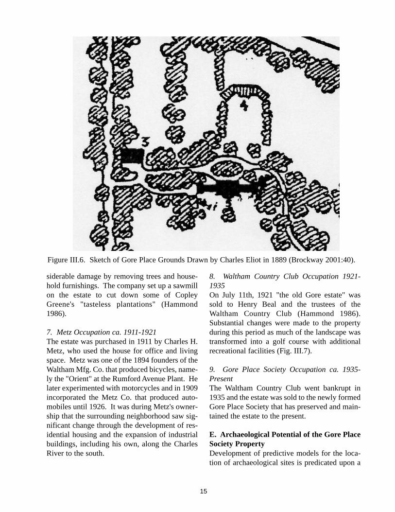
1890 (Fig. III.5). A number of changes appear tohave been made to the property during this peri-od that include removal of the vegetable gardennorth of the carriage house and removal of thegreenhouse east of the carriage house. This sce-nario is based on the absence of the greenhousein the 1889 Eliot sketch of the property (Fig.III.6). It is possible that abundant tree growthdepicted in the sketch so reduced sunlight as torender the greenhouse of little use. In such a sce-nario, greater efforts may have been made tomaintain and/or even improve the grapery green-house with its superior solar exposure.
6. Episcopal Church Ownership ca. 1907-1911Mary Sophia bequeathed the property to theEpiscopal Church on October 10th, 1907. Thechurch sold the property after only four years,but not before a company based in Colorado towhom the property had been leased, caused con-
13
Figure III.3. Detail of the Estate of Theodore Lyman Drawn Between 1834 and 1838 (Courtesy GPS).
14
Figure III.4. Detail of the Estate of J.S. Copley Greene, Esq., Drawn in 1841 (Brockway 2001:37).
Figure III.5. Detail of Atlas of Middlesex County Depicting Walker Family Property. Gore Mansionis at Center Adjacent to Waltham/Watertown Line (Courtesy Waltham Public Library).
siderable damage by removing trees and house-hold furnishings. The company set up a sawmillon the estate to cut down some of CopleyGreene's "tasteless plantations" (Hammond1986).
7. Metz Occupation ca. 1911-1921The estate was purchased in 1911 by Charles H.Metz, who used the house for office and livingspace. Metz was one of the 1894 founders of theWaltham Mfg. Co. that produced bicycles, name-ly the "Orient" at the Rumford Avenue Plant. Helater experimented with motorcycles and in 1909incorporated the Metz Co. that produced auto-mobiles until 1926. It was during Metz's owner-ship that the surrounding neighborhood saw sig-nificant change through the development of res-idential housing and the expansion of industrialbuildings, including his own, along the CharlesRiver to the south.
8. Waltham Country Club Occupation 1921-1935On July 11th, 1921 "the old Gore estate" wassold to Henry Beal and the trustees of theWaltham Country Club (Hammond 1986).Substantial changes were made to the propertyduring this period as much of the landscape wastransformed into a golf course with additionalrecreational facilities (Fig. III.7).
9. Gore Place Society Occupation ca. 1935-PresentThe Waltham Country Club went bankrupt in1935 and the estate was sold to the newly formedGore Place Society that has preserved and main-tained the estate to the present.
E. Archaeological Potential of the Gore PlaceSociety PropertyDevelopment of predictive models for the loca-tion of archaeological sites is predicated upon a
15
Figure III.6. Sketch of Gore Place Grounds Drawn by Charles Eliot in 1889 (Brockway 2001:40).

16
Figure III.7. Detail of Proposed Tennis Courts and Golf Tees North of the Gore Mansion House ca.1921 during ownership by the Waltham Country Club (Courtesy GPS).

number of factors including known site locationsand a general sense of past landscape use and itslevel of preservation.
1. Native American SitesEvidence of Native American prehistoric occu-pation has been identified in New England inmany types of settings, but these are most oftenfound in particular environmental contexts thatshare a number of characteristics (Funk 1972;Root 1978; Thorbahn et al. 1980; McManamon1984; Mulholland 1984; Thorbahn 1988, 1984;Nicholas 1988, 1990). Models of archaeologicalpotential take these common characteristics intoaccount to predict the location of prehistoricresources (Dincauze 1974; Hoffman 1985;Kenyon and McDowell 1983; Ritchie 1983.These models are generally based on three vari-ables: topography, soil type and proximity to asource of fresh water. Variables offering thegreatest potential for prehistoric settlement con-sist of flat to gently sloped topography, well-drained sandy soil, and a distance of under 300 m(1,000 ft) to fresh water. Localities of medium tolow potential are, therefore, greater than 300 m(1,000 ft) from fresh water and/or have poorlydrained or rocky soils on moderate to steepslopes. Factors that hold lesser importance, butnevertheless can contribute to site locationinclude proximity to additional resources such ashunting grounds, fishing sites and seasonal foodgathering localities, a south facing exposure forcold season occupation, lithic material for toolmanufacture and even clay for pottery produc-tion. Access to transportation routes in the formof paths and rivers can also be influential.
The combination of these factors provides aframework within which prehistoric settlementhas been analyzed. Findings to date suggest thatPaleoindian and Early Archaic sites are frequent-ly located around glacial lake margins. Thesesites are usually small and often represent singleepisodes or short-term occupations involvinghunting and gathering as well as the processingof natural resources. Sites associated with theMiddle and Late Archaic periods tend to be
located on the banks of major rivers such as theAssabet and Merrimack, and on the edges ofupland wetlands and streams. The upland interi-or sites tend to be small, probably associatedwith exploitation of specific resources. Larger,repeatedly used sites tend to be present next tolarge wetlands and at fords or rapids in rivers totake advantage of anadromous fish runs.Occupation associated with the Late Archaic andWoodland periods is characterized by a trendtoward exploitation of major river estuaries andcoastal environments. In time this adaptationcame to be characterized by long-term seasonaloccupation of large settlements accompanied byshort-term occupation of camps associated withseasonally available inland plant and animalresources potentially collected by family-basedgroups. Those sites that offered a southern expo-sure as protection from winter weather and con-sistent access to food sources came to be occu-pied throughout the year.
These generalized patterns suggest that Nativeoccupation of the Charles River drainage is mostlikely to have occurred during the Archaic andWoodland periods. Primary food sources wouldhave included fish from the Charles River andtributary streams, migratory birds, locally avail-able small and large game, reptiles and numerousplant foods including nuts and cultivated prod-ucts as the Woodland period progressed. Thegently sloped and reasonably well-drained soilscoupled with the southern exposure of the GorePlace setting represent ideal conditions forNative occupation. The only potentially limitingfactor is the distance of around 800 m to a majorriver. Secondary water sources likely consistedof the stream on the eastern portion of the prop-erty and the wetland south of Grove Street thatwas later excavated to create a pond.
The assessment of known Native Americanarchaeological sites in the Waltham/Watertownarea reveals the presence of Middle Archaicthrough Late Woodland occupations that tend tobe associated with the lower Charles Riverfloodplain or upland streams. The combination
17

of locational characteristics and presence ofknown archaeological sites in the area suggests amedium to high potential for the presence ofArchaic and Woodland period Native Americansites. The fact that portions of the originalground surface within the property have beendisturbed reduces the probability of intact cultur-al remains, but this does not negate the potentialfor their presence in undisturbed or minimallydisturbed contexts.
2. Historic Period SitesThe same characteristics that made the projectarea potentially attractive to Native occupantswere also attractive to Europeans. Throughoutits history the property has been characterized asagricultural in the broader context of a ruralestate established by at least the 1740s. Theextensive documentary record that spans theeighteenth- through twentieth-centuries as wellas resources that exist or are known to have beenpresent on the site suggests a high potential forhistoric archaeological sites. The known eigh-teenth- and nineteenth-century habitation cou-pled with the establishment of the Gore’s coun-try seat suggests the project area has the potentialto contain remains that could increase an under-standing of:
1) a late eighteenth- and early nineteenth-centu-ry country estate that was associated with theFederalist interest in scientific agriculture andthe development of both functional and recre-ational gardens,2) late eighteenth- and early nineteenth-centurydomestic life of house servants and estate work-ers,3) eighteenth- and nineteenth-century farmingpractices in the context of an elite country seat,and4) mid to later eighteenth-century taverns
The fact that Gore Place is a National HistoricLandmark listed on the National Register ofHistoric Places signifies that any intact archaeo-logical remains present on the property are con-sidered significant because they have the poten-tial to provide data pertaining to the history andinterpretation of the property.
F. Previous InvestigationsThe only previous archaeological investigationsconsist of a trench excavation in close proximityto the mansion house conducted by Dr. StephenPendery. A report of this work was not complet-ed, but findings will be provided to the GorePlace Society once a copy of field notes isreceived from Dr. Pendery.
18

IV. ARCHAEOLOGICAL SITEEXAMINATION
A. Research DesignThe Gore Place property, consisting of the man-sion, 1793 carriage house and grounds, is one oftwo examples of an eighteenth- and nineteenth-century country estate in Waltham, and is one ofa small number in the greater Boston region.The listing of the property on the NationalRegister implies that any subsurface culturalremains are considered significant due to theirpotential to contribute data to the prehistoric andhistoric interpretation of the property. The goalsof the archaeological site examination were toidentify the presence of six features that wereimportant components of the historical land-scape and to determine their integrity and poten-tial to represent resources that can be included inthe present restoration and interpretative pro-gram. Of equal importance was the identifica-tion of intact archaeological deposits that mightbe impacted by proposed changes to the proper-ty.
By the eighteenth century, gardens had taken ona dual function that combined utilitarian needswith an increasingly popular colonial aestheticthat favored the creation of visually appealinglandscapes. Over time the arrangement of plant-ings within the utilitarian vegetable garden wascombined with fruit trees and shrubs to createspaces that were not only functional, but werealso aesthetically pleasing. Thus, the concept ofthe garden was transformed from a place of workto a place of recreation and beauty. Because itwas the wealthy who maintained the means ofcreating and maintaining such spaces, formalgardens and associated landscapes became syn-onymous with the image of the colonial gentle-man and came to serve, in addition to the estatehouse, as a symbol of one's wealth and status(Yentsch 1996). The popularity of the gardenwith its romantic associations and its connectionto a purer perception of the past (Beaudry1996:3) extended the appreciation of landscapegardens through the nineteenth century.
Archaeology has become a valuable tool in theidentification and restoration of such historicallyimportant landscape features (Kelso 1990;Leone 1984, 1988, Yentsch 1994). A multidisci-plinary approach to landscape research that com-bines non-destructive remote sensing techniquesalong with documentary research, careful exca-vation and soil analysis, and detailed mapping ofextant vegetation is now considered standard forsuch projects (Metheny et al. 1999; Yentsch1994).
B. Scope of WorkAn important component of the LandscapeMaster Plan is the consideration of historic Gore-period features, both extant and archaeological,that can contribute to the interpretation of thesite's history as well as provide functional space.To this end archaeological investigations focusedon six specific localities: the entrance drive area,original carriage house location, greenhousearea, vegetable garden, flower garden and thegrapery/fruitwall. The present entrance road wasbelieved to be in the general vicinity of the orig-inal drive, but the identification and restorationof the Gore-period roadbed is desired if it can befound. The carriage house was moved from itsoriginal foundation to the present location in the1960s. The location of the original foundation isnecessary so that the structure can be returned asclosely as possible to its original setting. Thegreenhouse, known from depictions on historicmaps, needs to be located and assessed forarchaeological integrity and data potential, sinceits remains could be disturbed by the relocationof the carriage house. The vegetable gardenlocated north of the original carriage house site ispartially covered by parking lot and also runs therisk of being disturbed by movement of the car-riage house. Determination of integrity of gar-den soils is necessary to assess this feature for itsfuture interpretive potential. The flower gardenlocated north of the mansion house survived intothe early twentieth century, but the potential forintact Gore-period garden features is not known.Archaeological assessment here will focus on theoverall integrity of the area and on its potential to
19
retain features associated with the Gore occupa-tion. The grapery/fruitwall was transformed intoa formal greenhouse over the course of its histo-ry. The question to be addressed in this area iswhether any vestiges of the original featureremain intact and can contribute to a betterunderstanding of its use and can provide infor-mation useful for its potential reconstruction andinterpretation.
C. Field MethodologyField methods employed for the investigation ofthe six areas are presented below by area.
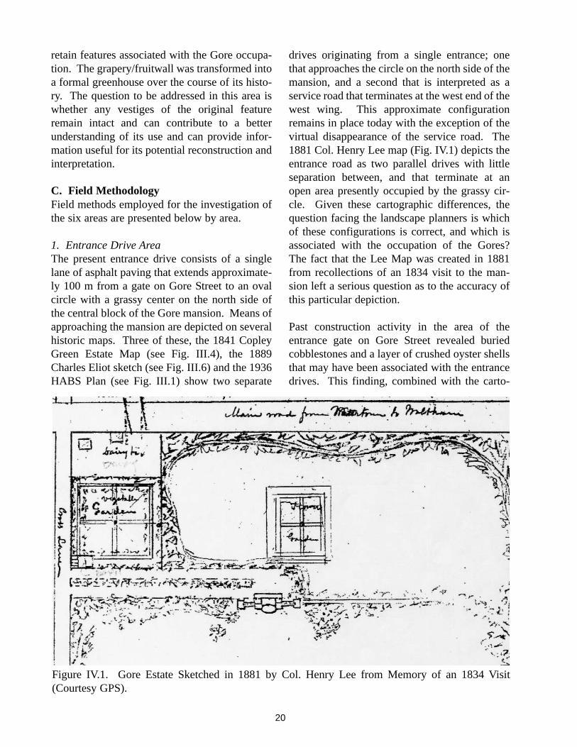
1. Entrance Drive AreaThe present entrance drive consists of a singlelane of asphalt paving that extends approximate-ly 100 m from a gate on Gore Street to an ovalcircle with a grassy center on the north side ofthe central block of the Gore mansion. Means ofapproaching the mansion are depicted on severalhistoric maps. Three of these, the 1841 CopleyGreen Estate Map (see Fig. III.4), the 1889Charles Eliot sketch (see Fig. III.6) and the 1936HABS Plan (see Fig. III.1) show two separate
drives originating from a single entrance; onethat approaches the circle on the north side of themansion, and a second that is interpreted as aservice road that terminates at the west end of thewest wing. This approximate configurationremains in place today with the exception of thevirtual disappearance of the service road. The1881 Col. Henry Lee map (Fig. IV.1) depicts theentrance road as two parallel drives with littleseparation between, and that terminate at anopen area presently occupied by the grassy cir-cle. Given these cartographic differences, thequestion facing the landscape planners is whichof these configurations is correct, and which isassociated with the occupation of the Gores?The fact that the Lee Map was created in 1881from recollections of an 1834 visit to the man-sion left a serious question as to the accuracy ofthis particular depiction.
Past construction activity in the area of theentrance gate on Gore Street revealed buriedcobblestones and a layer of crushed oyster shellsthat may have been associated with the entrancedrives. This finding, combined with the carto-
20
Figure IV.1. Gore Estate Sketched in 1881 by Col. Henry Lee from Memory of an 1834 Visit(Courtesy GPS).
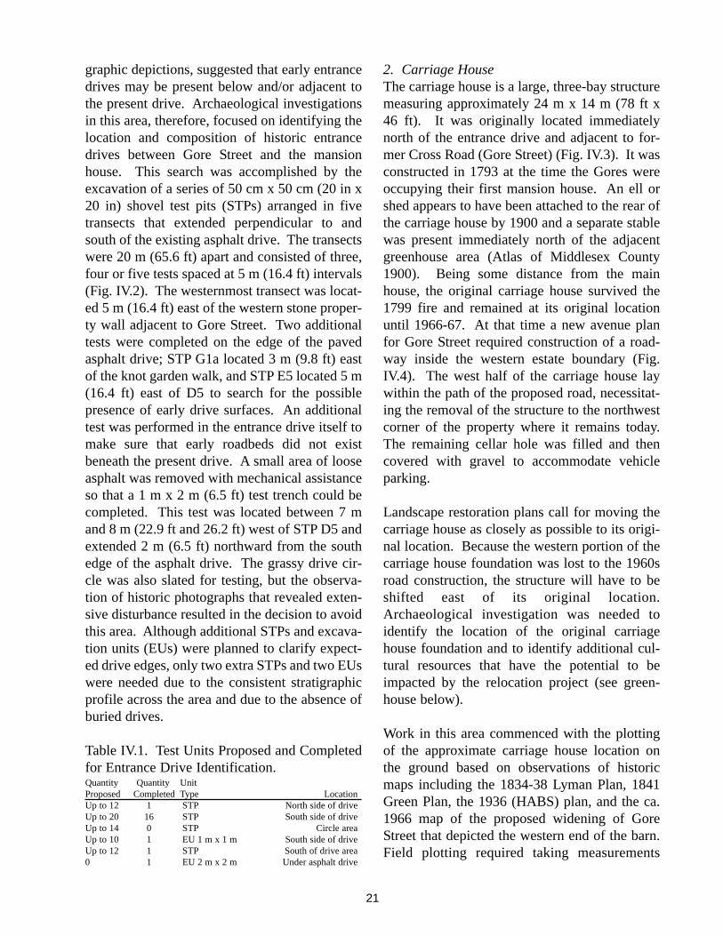
graphic depictions, suggested that early entrancedrives may be present below and/or adjacent tothe present drive. Archaeological investigationsin this area, therefore, focused on identifying thelocation and composition of historic entrancedrives between Gore Street and the mansionhouse. This search was accomplished by theexcavation of a series of 50 cm x 50 cm (20 in x20 in) shovel test pits (STPs) arranged in fivetransects that extended perpendicular to andsouth of the existing asphalt drive. The transectswere 20 m (65.6 ft) apart and consisted of three,four or five tests spaced at 5 m (16.4 ft) intervals(Fig. IV.2). The westernmost transect was locat-ed 5 m (16.4 ft) east of the western stone proper-ty wall adjacent to Gore Street. Two additionaltests were completed on the edge of the pavedasphalt drive; STP G1a located 3 m (9.8 ft) eastof the knot garden walk, and STP E5 located 5 m(16.4 ft) east of D5 to search for the possiblepresence of early drive surfaces. An additionaltest was performed in the entrance drive itself tomake sure that early roadbeds did not existbeneath the present drive. A small area of looseasphalt was removed with mechanical assistanceso that a 1 m x 2 m (6.5 ft) test trench could becompleted. This test was located between 7 mand 8 m (22.9 ft and 26.2 ft) west of STP D5 andextended 2 m (6.5 ft) northward from the southedge of the asphalt drive. The grassy drive cir-cle was also slated for testing, but the observa-tion of historic photographs that revealed exten-sive disturbance resulted in the decision to avoidthis area. Although additional STPs and excava-tion units (EUs) were planned to clarify expect-ed drive edges, only two extra STPs and two EUswere needed due to the consistent stratigraphicprofile across the area and due to the absence ofburied drives.
Table IV.1. Test Units Proposed and Completedfor Entrance Drive Identification.Quantity Quantity UnitProposed Completed Type LocationUp to 12 1 STP North side of driveUp to 20 16 STP South side of driveUp to 14 0 STP Circle areaUp to 10 1 EU 1 m x 1 m South side of driveUp to 12 1 STP South of drive area0 1 EU 2 m x 2 m Under asphalt drive
2. Carriage HouseThe carriage house is a large, three-bay structuremeasuring approximately 24 m x 14 m (78 ft x46 ft). It was originally located immediatelynorth of the entrance drive and adjacent to for-mer Cross Road (Gore Street) (Fig. IV.3). It wasconstructed in 1793 at the time the Gores wereoccupying their first mansion house. An ell orshed appears to have been attached to the rear ofthe carriage house by 1900 and a separate stablewas present immediately north of the adjacentgreenhouse area (Atlas of Middlesex County1900). Being some distance from the mainhouse, the original carriage house survived the1799 fire and remained at its original locationuntil 1966-67. At that time a new avenue planfor Gore Street required construction of a road-way inside the western estate boundary (Fig.IV.4). The west half of the carriage house laywithin the path of the proposed road, necessitat-ing the removal of the structure to the northwestcorner of the property where it remains today.The remaining cellar hole was filled and thencovered with gravel to accommodate vehicleparking.
Landscape restoration plans call for moving thecarriage house as closely as possible to its origi-nal location. Because the western portion of thecarriage house foundation was lost to the 1960sroad construction, the structure will have to beshifted east of its original location.Archaeological investigation was needed toidentify the location of the original carriagehouse foundation and to identify additional cul-tural resources that have the potential to beimpacted by the relocation project (see green-house below).
Work in this area commenced with the plottingof the approximate carriage house location onthe ground based on observations of historicmaps including the 1834-38 Lyman Plan, 1841Green Plan, the 1936 (HABS) plan, and the ca.1966 map of the proposed widening of GoreStreet that depicted the western end of the barn.Field plotting required taking measurements
21
22
Figure IV.2. Archaeological Testing Plan in the Entrance Drive Area.

from the original west boundary wall of theproperty now located in the median of GoreStreet. The original north foundation wall wasroughly aligned with the center of RichgrainAvenue. A single trench measuring approxi-mately 2 m (6.56 ft.) in width (east-west) and 7.5m (24.6 ft) long (north-south) was marked out inthe snow-covered parking lot in hopes ofencountering the north foundation wall close toits east end. Because the foundation area nowlay within a raised gravel parking area, coupledwith the possibility that the foundations wereactually removed from the site, machine assistedtrenching was determined to be necessary.Although as many as six trenches had beenplanned for the identification of the foundation,only one came to be needed.
Grounds superintendent, Scott Clarke, used hisJohn Deere tractor with a 6 ft wide front-endloader to gently remove successive layers ofparking area bedding and underlying fill
deposits. Loose foundation stones and a fewbrick fragments were encountered at a depth ofapproximately 90 cm (35.4 in) below the parkinglot surface. An additional pass with the tractorfollowed by hand excavation revealed the car-riage house north foundation wall right where itwas supposed to be.
Table IV.2. Test Units Proposed and Completedfor Carriage House Foundation AreaQuantity Quantity UnitProposed Completed Type Location6 0 Trench, 1 m wide N, S, E walls12 0 STPs N and S of carriage house0 1 Trench, 2 m x 7.5 m Northeast foundation wall
3. GreenhouseGreenhouses have been an important componentof Gore Place history since the eighteenth centu-ry, being a ubiquitous element of the Federalistinterest in the American landscape garden andthe development of scientific agriculture. Theearliest greenhouse known to be on the property
23
Figure IV.3. Detail of 1834-38 Lyman Estate Plan Depicting the Carriage House (Stable) andGreenhouse (Courtesy GPS).

was incorporated into the east wing of the Gore'sfirst mansion. A fire that started in the green-house resulted in the destruction of all but thewest wing of the mansion. A second greenhousewas erected some distance from the new 1806Gore mansion and was sited immediately east ofthe carriage house.
All that is known about the greenhouse derivesfrom the 1834-38 Lyman estate map (see Fig.IV.3) and the 1841 Greene estate plan (see Fig.III.4). Both of these sources depict a rectangularstructure with its long axis facing due south, anorientation that is asymmetrical to other build-ings and landscape features. This structureappears to be contained within a fenced yard orsurround of plantings immediately east of thecarriage house. Although its construction date isunknown, the greenhouse presence on the 1834-38 map strongly suggests an association with theGore family. The Gore's intense interest in sci-entific agriculture coupled with a December 9th,
1834 advertisement for greenhouse plants sup-port this association. Further indication of Gorefamily association is the recorded purchase ofthe late Mrs. Gore's orange and lime trees in thesame year (Brockway 2001:26). The purchase ofthe estate by the Lymans between 1834 and 1838undoubtedly resulted in continued use of thegreenhouse due to their agricultural interests thatincluded the growing of pineapples. The suc-ceeding Greene family also maintained a stronginterest in gardening and likely continued to usethe structure into the 1850s. The followingWalker family apparently did not share such aninterest in gardening, suggesting the greenhousemay have gone into disuse between 1856 and1907. The structure, in fact, may have beenremoved by the 1880s due to its absence onCharles Eliot's depiction of the estate grounds in1889 (see Fig. III.6). The site of the greenhousewas transformed into a formal garden and lawnsometime during the twentieth century.
24
Figure IV.4. Plan of Proposed Changes to Gore Street ca. 1967 (Courtesy GPS).
The area of this greenhouse is of particular inter-est because it has the potential to provide impor-tant information on early greenhouse construc-tion and use, and is also expected to aid in under-standing the relationship between this green-house and the greenhouse incorporated into thegrapery (see below). The potential for intactarchaeological deposits here has a direct impacton the relocation of the carriage house.Archaeological investigation of the greenhousearea was proposed to identify the location of thegreenhouse structure and to determine the levelof integrity of associated archaeologicaldeposits.
Greenhouse investigations commenced with adetermination of approximate location fromstudy of the 1834-38 Lyman and 1841 Greenestate maps. Subsurface testing was performedby the excavation of a 30 m x 30 m block ofshovel tests spaced and staggered at 5 m inter-vals. The block was located immediately east ofthe original carriage house foundation. Thisstrategy allowed for coverage of the entire green-house area including the central structure, thesurrounding yard, and the south edge of the his-toric vegetable garden that was situated north ofthe greenhouse and carriage house (Fig. IV.5).The block consisted of 7 transects labeled A-Gfrom west to east, and 1-7 from south to north.Although 46 STPs were planned, transect A waseliminated due to its location in a portion of theparking lot that appears to have been disturbedduring removal of the carriage house.
Table IV.3. Test Units Proposed and Completedfor Greenhouse Area.Quantity Quantity UnitProposed Completed Type Location46 40 STPs in 30 m x 30 m block Greenhouse area6 1 EUs (.50 m x 1 m) Greenhouse area4 3 EUs (1 m x 1 m) Greenhouse area
4. Vegetable GardenThe Gore family kitchen or vegetable gardenwas located north of the carriage house, and aslaid out by the Gores or previous occupants, likely assumed a rectilinear form characteristic of
the eighteenth century (see Fig. III.3). Both thisand the flower garden are believed to have beenredesigned by the Lymans between 1834 and1838 following a more modern curvilinear form(Brockway 2001:31-32). The vegetable gardenappears to have been removed during occupationby the Walker family in the second half of thenineteenth century, only to be incorporated intorecreational golfing features by the WalthamCountry Club. The western portion of the areawas raised and covered with sand and gravel forvehicle parking after the carriage house wasmoved to its present location in 1966-67.Archaeological testing in the area of the veg-etable garden was proposed to determine theintegrity of soils and overall degree of preserva-tion of this early landscape feature.
The garden boundaries as defined on the 1834-38 Lyman estate plan were plotted on the groundto determine the garden's approximate location.This was followed by excavation of a 20 m x 20m block of 8 STPs spaced and staggered at 20 mintervals (Fig. IV.6). The westernmost 'A' tran-sect of three tests lay in the raised gravel drive-way approximately 7 m east of the western stoneboundary wall, while transect B was situatedimmediately east of the parking area. Transect Clay on the east side of the present planting beds.
Table IV.4. Test Units Proposed and Completedfor theVegetable Garden.Quantity Quantity UnitProposed Completed Type Location8 8 STPs in 20m x 20m block Vegetable Garden
5. Flower GardenThe flower garden was located north of the man-sion house and circular drive and was immedi-ately south of the grapery (see Figs. III.1 andIII.3). It is believed to have been created duringthe occupation of the Gore family if not earlier,since it was included in the list of improvementsin the 1834 estate sale to Theodore Lyman. Thegarden, as remembered by Col. Henry Lee dur-ing his 1834 visit, was designed in a four-squarepattern with perimeter and central axial walks
25

26
Figure IV.5. Archaeological Testing Plan in the Greenhouse Area.

27
Figure IV.6. Archaeological Testing Plan for the Vegetable Garden

running north-south and east-west through thegarden's center (see Fig. IV.1). This rectilinearform, characteristic of eighteenth-centurydesigns, was modified by the Lymans with thehelp of landscape gardener Robert Murraybeginning in 1835. The new design followed amore modern, curvilinear pattern and likelyremained in place through the occupation of theGreene family as Murray continued to work onthe estate until 1856. Although ownership shift-ed to the Walkers at that time, the garden contin-ued to be maintained and was described byCharles Eliot in the 1880s as "carefully shelteredand quaintly laid out in geometric fashion, withgreat banks of shrubs at the sides, plenty ofsmooth grass, and large beds crowded withperennials in rich, old-fashioned array"(Brockway 2001:39). Garden maintenanceappears to have ceased when the property wasbequeathed to the Episcopal Church in 1907.The garden was probably sodded over around1921 to become part of the golf course construct-ed by the Waltham Country Club.
Archaeological investigation of the flower gar-den held the potential to reveal evidence of boththe earlier rectilinear and later curvilinear con-figurations. The potential stripping of topsoil inthis area, however, was feared to have severelyimpacted garden deposits. The site examination,thus, sought to determine the potential presenceof such deposits and their level of integrity. Tothis end a 40 m x 60 m block of eleven shoveltests staggered at 20 m intervals was completed(Fig. IV.7). Two transects (A and C) of four testseach paralleled the north-south tree lines oneither side of the garden area, while transect Bpassed north-south close to its center.
Table IV.5. Test Units Proposed and Completedfor the Flower GardenQuantity Quantity UnitProposed Completed Type Location11 11 STPs in 40 m x 60 m block Flower Garden
6. Grapery/FruitwallThe grapery/fruitwall was located at the northend of the flower garden that was situated north
of the mansion house. The structure consisted ofa central wall with two flanking wings, each setoff at angles of approximately 30° from the cen-tral span. The entire structure was oriented withits long axis parallel and slightly offset to theeast of the mansion house. The earliest depictionof the grapery appears on the 1834-38 Lymanestate plan that shows single lines to representthe central span and flanking fruit walls (see Fig.III.3). By the time of its next depiction on the1841 Greene estate plan (see Fig. III.4), the wallsappear as blocks, suggesting the structure con-sisted of three attached buildings that maintainedthe configuration of the original grapery walls.An approach road is also depicted at the struc-ture's west end by this time. A similar configu-ration, but with a clearly enlarged central block,appears in the 1889 Charles Eliot sketch of theproperty (see Fig. III.6). Also by this time thestructure is labeled as a greenhouse. Both thisand the earlier depictions reveal the structure tobe nearly as long as the mansion house itself.According to Brockway (2001:41), the graperywas removed from the property between 1907and 1935 during the ownership by the EpiscopalChurch or during the use of the estate by theWaltham Country Club. The grapery definitelywould have impeded golfing activities on thelawn.
According to grounds superintendent, ScottClarke, portions of the grapery area were minedof topsoil that was used for landscaping in thepast. In addition, some of the area was regularlyplowed for crop production into the 1980s. Thisrecent activity, particularly the deep plowing thatwould have resulted from the loss of topsoil mayhave severely impacted archaeological evidenceof the structures. Nevertheless, the substantialsize of the buildings suggested that foundationsor post impressions may remain at the base of theplow zone.
The purpose of archeological testing in this areawas to identify the location of the grapery/fruit-wall with the intent of possible reconstruction,and to determine if intact archaeological deposits
28

29
Figure IV.7. Archaeological Testing Plan for the Flower Garden.

were present. Investigations of the grapery com-menced with a determination of its approximatelocation from map depictions. This exercise wasfollowed by the laying out of a 30 m x 50 mblock of 21 shovel tests staggered at 10 m inter-vals. The block consisted of six north-south ori-ented transects labeled A through F from west toeast (Fig. IV.8). A single 1 m x 1 m excavationunit was completed immediately southwest ofSTP D1 to investigate architectural remains.
Table IV.6. Test Units Proposed and Completedin the Grapery/Fruitwall Area.Quantity Quantity UnitProposed Completed Type Location21 21 STPs in 30 m x 50 m block Grapery10 0 STPs (additional) Grapery6 0 EUs (.50 m x 1 m) Grapery8 1 EUs (1 m x 1 m) Grapery
D. Site Examination ResultsA total of 98 shovel test pits, 6 excavation unitsand one excavation trench were completed dur-ing the archaeological site examination. Historicperiod artifacts and features derived from 80 ofthe shovel tests and from all units and the trench.No evidence of Native American occupation wasidentified. Results of testing in each of the sixareas is provided below.
1. Entrance DrivesArchaeological investigations in the area of theentrance drives revealed the existence of a singleentrance drive and a separate service drive, aswell as significant landscape modification acrossthe entire area. All STPs and the single 1 m x 1m EU revealed a redeposited dark brown loamyA-horizon with a low density of eighteenth- andearly nineteenth-century artifacts. This soiloverlies a deposit of coarse sand and gravel fillwith an occasional oyster shell suggesting thismaterial may have derived from Charles Rivergravel deposits (Fig. IV.9). The gravel, in turn,lies on a layer of field/cobble stones, also poten-tially derived from the river. The cobbles liedirectly on the surface of the orangy-brown B-horizon or on a remnant truncated buried A-hori-zon that was only one to two centimeters in
thickness. These findings reveal that the originalsouth sloping ground in this area was stripped ofits topsoil and then filled with well-differentiatedlayers of stones, sandy gravel and landscapingloam respectively. These landscape changes suc-ceeded in raising and leveling the yard surface.In addition, the entrance and service drives werecreated by these alterations through the additionof extra sand and gravel in the roadway areas.
The 2 m x 2 m test (EU2) under the asphalt of thepresent entrance drive revealed a series of sand,loam and gravel fills over the sand, gravel andcobbles that underlies the broader area. Belowthis fill were the remnants of a truncated darkbrown sandy loam buried A-horizon over anorangy brown clay loam B-horizon (Fig. IV.10).Artifacts identified by the testing revealed aremarkably consistent, low-density scatter offragmented ceramics including planting pots,creamware (ca. 1762-1820), and pearlware (ca.1775-1830), as well as window glass and nails(Fig. IV.11). Also discovered in this area wereutility lines consisting of a possible gas lineencountered in EU1 and a rubber coated electriccable in STP A3 under the service drive.
2. Carriage HouseThe carriage house north foundation wall liesapproximately 23.75 m (77.92 ft) north of thenorth entrance post and 1.25 m (4.10 ft) south ofan electric utility pole (Fig. IV.12). The surfaceof the partially demolished wall lies between 1 m(3.28 ft) and 1.20 m (3.93 ft) below surface.Measurements suggested the cellar entrance inthe east wall was just outside of the test trenchthat was located approximately 9 m (29.5 ft) eastof the present western stone boundary wall. Thefoundation wall is constructed of large roundedboulders and angular foundation stones heldtogether with mortar. Excavation revealed upperfoundation stones to lie out of place on eitherside of the wall, with most having fallen or beenpushed into the cellar's interior (Fig. IV.13). Asmall section of collapsed brick wall was alsopresent in this area. Cellar fill consisted of aloose, medium brown sandy loam that also con-
30

31
Figure IV.8. Archaeological Testing Plan in the Grapery/Fruitwall Area. Tests Between LinesRevealed Deep Grapery Greenhouse Soils.
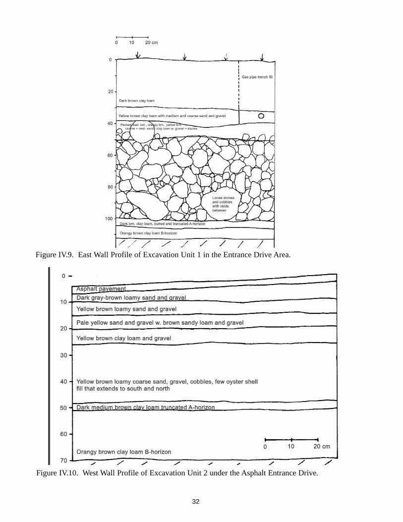
32
Figure IV.9. East Wall Profile of Excavation Unit 1 in the Entrance Drive Area.
Figure IV.10. West Wall Profile of Excavation Unit 2 under the Asphalt Entrance Drive.

tained stones and a few pieces of asphalt pave-ment. A small deposit of artifacts consisting oflater nineteenth-century bottle and some windowglass was encountered on the north side of thefoundation wall at an elevation between 70 cm(27.5 in) and 100 cm (39 in) below the parkinglot surface. After the foundation wall's locationwas recorded the excavation trench was back-filled.
3. GreenhouseThe block of shovel tests revealed soils in thegreenhouse area to consist of approximately 30-35 cm of dark brown sandy loam A-horizonoverlying either a yellow-brown coarse sand,gravel and stones or a yellow-brown/orangy-brown clay loam B-horizon. The central portionof the block represented by test pits in transects
C, D, E and F revealed foundation stones andbrick and mortar rubble between the A-horizonand underlying sand and gravel (see Fig. IV.5).This rubble area underlies the present oak tree,west bench and west and north edges of the pres-ent knot garden and a portion of the yew hedgenorth of the knot garden. Soils to the south andimmediate east of the structure rubble are char-acterized by a thick A-horizon over a B-horizon,while tests further east contained sand and grav-el below the A-horizon. The western portion ofthe area (Transect B) adjacent to the presentgravel parking lot revealed a variety of soil typesas well as a possible cobble surface.
Artifacts recovered from the greenhouse areawere dominated by a low density scatter of frag-mented planting pots (in 56% of STPs) window
33
Figure IV.11. Artifacts Recovered from the Entrance Drive Area. 1)Tobacco Pipe Bowl, 2)BritishBrown Stoneware (1671-1775), 3)Nottingham Stoneware 1638-1810, 4)White Salt-GlazedStoneware 1720-1805, 5)Aluminum pulltab (1962+), 6)Pearlware 1775-1830, 7)Wine Bottle Base,8)Redware Planting Pot Fragments, 9)Lead-glazed Redware, 10)Lamp Chimney.

glass, and lesser amounts of creamware/pearl-ware (in 53% of STPs) (Fig. IV.14). Other arti-facts included brick and mortar, cut and wroughtnails, bottle glass, oyster shell and smoking pipefragments. Artifacts were distributed fairlyevenly across the block with the exception of thetests in Transect B adjacent to the parking areathat revealed a lower density.
Stones interpreted to be possible structure foun-dations were encountered in STP C2 and F4.Unit 1, measuring 1 m x 1 m, was excavatedimmediately east of C2 to further explore thisanomaly. The upper 40 cm of dark brown medi-
um sandy loam contained scattered fragments ofbrick, mortar and foundation stone along with anassortment of artifacts common to the area asrevealed by the shovel tests. A stone drain fea-ture was encountered below 40 cmbs in the westportion of the unit. The drain consisted of twoparallel lines of field stones covered with flat,rough paving stones and other stones that cov-ered cracks and openings between the top stones(Fig. IV.15). The drain cavity is approximately15 cm (6 in) deep and 25 cm (10 in) wide with anearthen floor. The parallel support stones wereset into the upper portion of the yellow-brownsandy clay loam B-horizon soil. The interior
34
Figure IV.12. Location of Excavation Trench and Foundation Wall in the Carriage House Area.

space was completely filled with dark brown finesandy loam. The stones extended across the westportion of Unit 1 and the eastern portion of STPC1. The drain alignment is generally east-westand the feature was traced with a metal probewestward for over a meter and eastward to theyew hedge.
Unit 2 was excavated 1 m to the southwest toinvestigate a depression visible on the groundsurface that was potentially located at the westend of the greenhouse, and to investigate whatwas believed to be the west end of the drain. Thestratigraphy revealed in this unit was similar tothat in Unit 1, consisting of a layer of landscap-ing loam over a dark brown sandy loam withsome demolition rubble in the upper portion.The end of the stone drain was located in thenortheast corner of the unit. Here, two and threestones, respectively, supported the flat top
stones. The base of the drain lay at 70 cm (27.5in) below surface, 15 cm (6 in) below the surfaceof the B-horizon (Fig. IV.16). Dark brown siltyloam filled the drain and excavation of the fillrevealed fragments of a colorless glass bell jar.
Unit 3 was located immediately south of STP C4to investigate a possible cobble pavement pres-ent between 52 cm (20.5 in) and 68 cm (27 in)below surface. Soils in this unit consisted of dis-turbed dark brown sandy loam that extended to adepth of 85 cm (33.4 in). Below this was a darkyellow-brown loamy sand and gravel. No evi-dence of the cobble surface was encountered andthe area appears to have been disturbed possiblyfrom carriage house moving activities.
Unit 4 consisted of a 90 cm (35.4 in) west exten-sion of STP F4, located at the north end of theknot garden (see Fig. IV.5). Demolition rubble
35
Figure IV.13. Carriage House Area Trench and Foundation Wall (facing north). Note post 1967Carriage House location in background.

36
Figure IV.14. Artifacts Recovered from the Greenhouse Area. 1)Redware Planting Pot Fragments,2)Creamware Plate (1775-1820), 3)Blue Shell-edge Pearlware Plate (1800-1835), 4)Ballast Flint,5)Tobacco Pipe Stem, 6)Tinglazed Ointment Pot Rim, 7)Chinese Export Porcelain, 8)Lead-glazedRedware, 9)Wine Bottle Neck. See Appendix A for context information.
Figure IV.15. Stone-lined Drain Revealed in Excavation Unit 1 in the Greenhouse Area.

and possible foundation stones were firstencountered in F4 at a depth of 18 cm (7 in)below surface. Work on the STP was halted untilthe unit could be expanded for further investiga-tion. The completion of F4 and its extensionrevealed 25 cm (9.8 in) of medium brown clayloam containing demolition rubble consisting offragmented plaster, mortar, brick, stones, gravel,possible large foundation stones and fragmentsof marble and slate floor tiles (Fig. IV.17). Alsopresent was a low density of artifacts includingplanting pot and bottle fragments, nails, windowglass, bone and coal. This was underlain by 2 cm(.8 in) of yellow sand that covered hard packed,brown coarse sandy clay loam with gravel and
small stones that graded to yellow brown coarsesand and gravel. This bottom layer extendedbeyond 78 cm (31 in) below surface and con-tained a single fragment of bottle glass. Thislayer is also the same fill soil that was depositedacross the entrance drive area.
4. Vegetable GardenThe three tests located in the parking area (STPsA1-A3 in Fig. IV.6) revealed between 25 cm (9.8in) and 40 cm (15.7 in) of a yellow, medium sandbedding below 10 cm (3.9 in) of gravel. A1revealed gray-brown coarse sand and gravel fillto a depth of 60 cm (23.6 in), while A2 and A3revealed dark brown clay loam that extended to
37
Figure IV.16. North Wall Profile of Excavation Unit 2 in the Greenhouse Area.

a depth of 70+ cm (27.5 in+) below surface. TheB and C transects revealed A-horizons that var-ied in depth between 20 (7.8 in) and 45 cm (17.7in). Strata below the A-horizon ranged betweenan A2 and a B-horizon consisting of yellow toorangy brown clay loam. The two tests thatstood out as possibly containing features wereB1 and C1, both of which fell within the transi-tional area between the greenhouse and veg-etable garden and within the present yew-bor-dered garden. B1 that was further north revealedclean A-horizon clay loam over a sloped B-hori-zon surface between 35 (13.7 in) and 45 cm(17.7 in) below surface. STP C1 revealed medi-um brown clay loam A- and A2-horizons overtwo layers of mixed gray brown and yellowbrown clay loam that were divided by a surfacethat sloped down to the north. The B-horizonhere was hit at 53 cm (20.9 in) below surface.Soils in this test revealed more mixing than anyof the other units. Another anomalous unit wasC2 that revealed a possible buried A-horizonover a layer of mixed sand and gravel. Artifactsin the vegetable garden area consisted of thesame low-density scatter of fragmentedcreamware, pearlware, window glass, vesselglass, a few nails and pieces of planting pots. No
artifacts were present in the soil from Transect Ain the parking lot.
5. Flower GardenTest excavation in the former flower gardenrevealed the presence of intact garden beds andwalks that correspond with the 1936 HABS gar-den plan, and possibly with some features of theGore period or pre-Gore period garden. Soil pro-files within the garden beds consist of a darkbrown clay loam A-horizon that is between 32cm (12.6 in) and 46 cm (18 in) below surface.Underlying this is an orangy-brown or yellow-brown clay loam B-horizon. In some areas thesesoils are separated by a layer of mixed A- and B-horizon soil. Walks situated within the gardenon the HABS plan were identified by a layer ofcoarse sand and gravel between 8 cm (3 in) and13 cm (5 in) below surface in STP B2 and B3(see Fig. IV.7). The west perimeter garden walkidentified in STP A1 consisted of a coarse sandwith gravel and coal between 16 cm (6.2 in) and38 cm (15 in) below surface, below which wasthe surface of the B-horizon. The perimeter walkat the north end of the garden is represented by a3 cm (1 in) lens of dark yellow brown coarsesand overlying a layer of orangy brown coarse
38
Figure IV.17. North Wall Profile of STP F4 Extension in the Greenhouse Area.

sandy loam and gravel. Below these layers wasa 20 cm (7.1 in) thick deposit of cobble and field-stones. The only other test unit to reveal adeposit of stones was STP B2. The function ofstones at this location may be associated with awalk, but may also be associated with a centralgarden feature. Interestingly, a mortar fragmentwas found in association with the stones. Thearea south of the garden tested by STP B1 andC1 revealed a deep loamy A-horizon that extend-ed to between 43 cm (17 in) and 45 cm (18 in)below surface. The surface of the orangy-brown
clay loam B-horizon revealed a possible gardenplanting feature consisting of a small depressioncontaining dark brown loam and a brick frag-ment.
A consistent low-density scatter of artifacts wasfound in the flower garden area. These weredominated by planting pot fragments found in 10of the 11 shovel tests, fragmented creamware orpearlware ceramics in 8 of the tests and windowglass in 7 of the tests. A few of the artifactsrevealed evidence of burning (Fig. IV.18).
39
Figure IV.18. Artifacts Recovered from the Flower Garden. 1)Pearlware (1775-1830) 2)RedwarePlanting Pot Fragments, 3)Lead-glazed Redware 4)Burned Creamware (1775-1820) 5)Slip-trailedRedware 6)Tobacco Pipe Stems. See Appendix A for specific context information.

6. Grapery/FruitwallArchaeological investigations in the grapery arearevealed remnants of brick foundation in three ofthe shovel tests (C2, D1 and D2) and demolitiondebris in a number of others. Soil profiles alsoprovided a general indication of areas that laywithin and outside of the greenhouse structure(see Fig. IV.8). Tests believed to be located out-side revealed a sandy loam A-horizon between35 and 42 cm in depth. Below this was 10 cm (4in) to 20 cm (7 in) of mixed transition sandyloam subsoil that overlay a sterile sand. Theseunits were located across the north and northwestportion of the block. Shovel tests across much ofthe south and southeast portion of the blockrevealed deeper stratigraphic profiles and arebelieved to be located within the west wing ofthe greenhouse. Tests A1, A2 and B1 revealed a70 cm (27.5 in) deep A-horizon that overlay mot-tled sandy loam. Tests immediately east (C2, D1and D2) revealed foundation remains consistingof intact brick piers and possibly a stone founda-tion, while EU1 adjacent to D1 revealed a brickwall. These tests are believed to be located with-in the grapery greenhouse's central block. TestsE2, E3 and F1-F3 further east revealed an A-horizon between 50 cm (20 in) and 75 cm (29.5in) in depth overlying a loamy sand subsoil.These tests may be inside the central blockand/or east wing. Two of the southernmost tests,C1 and E1, revealed shallower stratigraphyamounting to an A-horizon 38-40 cm (14.9-15.7in) in depth and these are believed to lie outsideof the structure. A low density of historic arti-facts was fairly evenly spread across the block oftests. Fragmented planting pots and windowglass were present in all 21 tests. Creamwareand/or pearlware was present in just under halfof the tests, while whiteware was present in 17,amounting to 81% of the tests. Also present wasa low density of burned glass and ceramic, aswell as bottle glass, nails, and fragments of coal,oyster shell and bone (Fig. IV.20).
The discovery of a brick foundation pier in STPD1 prompted the excavation of EU1 to its south-west to identify additional foundation compo-
nents (Fig IV.21). The upper two strata consist-ed of 15 cm (5.9 in) of dark brown landscapingloam overlying 25 cm (9.8 in) of dark yellow-brown fine and medium sandy clay loam withstones and a small amount of demolition rubble.Below this was additional rubble and the surfaceof a brick wall and pier situated along the southunit wall. Excavation of the soil within (northof) the greenhouse foundation revealed 45 cm(17.7 in) of dark medium brown clay loam witha trace of fine sand. This matrix was mixed withoyster shell, charcoal, coarse yellow-brown sandand bone. Also present were a few brick frag-ments, roofing slate, window glass, stones and afew fragments of 4-5 in (10-12 cm) -diametercast iron pipe. Below this was 4-5 cm (1.6-1.9in) of medium brown clay loam with dark yellowbrown coarse sand. The lowest soil deposit com-mencing at approximately 55 cm (21.6 in) was adark medium brown loam slightly lighter incolor than the main deposit above and containedfragments of brick, oyster and a few artifactsincluding a pipe stem and fragment of graystoneware. This soil extends beyond a depth of80 cm (31.5 in) from the top of the foundationwall and beyond 120 cm (47.2 in) from the pres-ent ground surface. All of the above soils areunderlain by a dark yellow-brown, silty, coarsesand and gravel that extended as a flat surfacenorthward from the base of the foundation walland then dropped sharply downward (see Fig.IV.21).
The brick wall follows an east-west orientationand appears to represent the south foundationwall of the greenhouse's central block. The wallis two brick courses in thickness and is fivecourses in height, with the top course approxi-mately 40 cm below the present ground surface.The wall was constructed on a stone sill toppedwith mortar. An interior brick pier extendsapproximately 46 cm. (18 in) northward from thewall, and what appears to be a separate brick pieris situated nearly 15 cm (5.9 in) to the northeast.The orientation of this second pier is slightly off-set from the wall and pier immediately south,suggesting that it may have been constructed
40

41
Figure IV.19. Artifacts Recovered from the Grapery Area. 1)Window Glass, 2)Redware Planting PotFragment, 3)Nails, 4)Oyster Shell, 5)Animal Bone Fragments. See Appendix A for specific con-text information.

after the main structure. Unpointed mortar jointsin the piers and interior wall suggest these sur-
faces were not intended to be seen and wereprobably covered by interior greenhouse soil.
42
Figure IV.20. West Wall Profile of Excavation Unit 1 in the Grapery Area.

V. INTERPRETATIONS AND DIS-CUSSION
A. Entrance DrivesInvestigations in the area of the entrance drivesrevealed that the original, gently south-slopinglandscape here was significantly altered to createa formal, level approach to the mansion housefrom the west. The process of elevating theground surface followed a specific plan thatresulted in an expanded and flattened yard areathat was also well drained. A reconstruction ofthe sequence of landscape modification is as fol-lows.
1. The original south-sloping groundsurface consisting of a dark brown clay loam A-horizon soil was stripped from a large area thatextended roughly from present Gore Street near-ly to the west side of the mansion, and from thetree line immediately south of the drive areanorthward to the original carriage house andgreen house locations north of the main entrancedrive. This soil was removed down to the sur-face of the underlying orangy-brown B-horizon.One to two centimeters of the A-horizon loamwas left in place in some areas. The newlyexposed ground surface sloped gently southwardtoward the Charles River as had the originalground surface before the stripping. This sameslope is presently observable immediately southof the present tree line and drive area. The strip-ping also removed all vestiges of the formereighteenth-century entrance drive. This originalroad may have been constructed of cobblesand/or oyster shell that was observed by work-men near the intersection of the entrance driveand Gore Street (Scott Clarke pers. com.).
2. The exposed B-horizon surface wasthen covered with a layer of large (30 cm (11.8in) or more in diameter) and small, roundedfield/cobble stones. The depth of the stonesranged from approximately 50 cm (20 in) at thewest end of the area that was lowest in elevationto a single layer or sometimes merely scatteredcobbles or no cobbles toward the area's highereast end as it approached the mansion. Similarly,the cobble layer was deeper along the south edge
of the drive area under the present tree line andlessened in depth toward the north. The uppersurface created by the cobbles was relatively flat(see Fig. IV.9).
3. The cobble surface was then coveredwith 15-20 cm (6-8 in.) of mixed coarse sand andgravel in a yellow-brown clay loam matrix. Thissoil may have derived from the lower CharlesRiver flood plain terrace or from river marginssince a few oyster shells are present. The dump-ing of numerous cartloads of river gravel leftunfilled voids between the underlying cobbles.Extra sand and gravel was laid down in the areasthat were to become the entrance drive and serv-ice drive, resulting in roadbeds that were elevat-ed above the surrounding sand and gravel.
4. Dark brown loam, likely the originalstripped A-horizon soil, was then spread acrossthe river gravel to a depth of between 17 cm and30 cm (6.7 in and 12 in). The raised entrance andservice roadbeds were not covered, leaving themwith loam borders that were then planted withgrass.
The question of when these extensive landscapemodifications were made and by whom is bestaddressed by the artifacts encountered and, sur-prisingly, by the soil profiles in the area of thegreenhouse. The only artifacts found below thecobbles in the truncated A-horizon consisted ofthree non-diagnostic pipe stem fragments. Theonly cultural material from the cobble layer wasa brick fragment that is similar to the bricks ofthe present mansion house. No cultural materialwas present in the sand and gravel layer, but theoverlying redeposited loam contained a smallassortment of artifacts that date very closely tothe Gore occupation (creamware, ca. 1762-1820and pearlware, ca. 1775-1830), some or all ofwhich can be characterized as sheet refuse likelyassociated with use of the greenhouse due to theadded presence of planting pot fragments andwindow glass. Once the landscape in this areawas reworked and became part of the formalgrounds, the chance for deposition of artifactswas limited to activities associated with thegreenhouse and possibly the carriage house.
43

This area continued to serve as a passagewaywith a low probability for refuse accumulationthroughout the nineteenth and twentieth cen-turies.
The layer of sand and gravel that was put downover the cobbles in the entrance drive area wasalso deposited in portions of the greenhouse area(see greenhouse discussion). The fact that thestructural remains of the greenhouse lie on top ofthis layer reveals that the landscape was modi-fied prior to and very likely just prior to green-house construction. If the Greenhouse wasindeed constructed by the Gores as all indicatorsseem to show, then the landscape was modifiedand the present entrance drives were createdaround the time the Gores were constructingtheir new mansion and greenhouse. No evidencewas found for any other drives beyond whatexists today as the main entrance drive and themore southerly service drive.
The layering of soil over sand and then cobblesreveals a very specific and carefully executedplan that not only leveled this portion of thegrounds, but also ensured adequate drainage ofthe new, flat landscape that was created. Theextensive changes that are known to have beenmade to the grounds and house by Gore, coupledwith his keen interest in landscape design andknowledge of current agricultural developmentsall point to Gore as the architect of the changesto the entrance drive area and creator of the for-mal and service drives.
Archaeological investigations suggest that theconfiguration of the main entrance and servicedrives has remained unchanged (with the excep-tion of the loss of the single entryway when GoreStreet was widened) since they were created,most likely, during the Gore occupation. It ishypothesized that this portion of the propertywas relandscaped and the entrances were createdaround the same time that the carriage house wasconstructed (1793) to afford level and unimped-ed access between the mansion and carriagehouse. Thus, the drive depictions on the 1841
Green Estate Plan, 1889 Eliot sketch and 1936HABS plan are all correct. Not surprisingly andas anticipated, the 1881 Lee sketch provides theleast accurate depiction and should be consid-ered as a generalized recreation of the grounds.Close observation of the first three depictionsreveals that the location of the west entrance tothe property was slightly south of the presententrance. The original configuration provided ashort entryway before the main drive curved tothe left (north) and the service drive turned to theright (south) (Fig. V.1). Thus, when Gore Streetwas widened, the short entryway disappearedand the new entry was aligned with the existingmain entrance drive (Fig. V.2). Access to theservice drive was cut off and a new connectionwas never made, possibly because this passage-way was little used by the late 1960s.
B. Carriage HouseBecause the purpose of testing in this area was toidentify the location of the original carriagehouse foundation, little effort was made to dis-cern construction details or to identify the eleva-tion of the cellar floor. The foundation was con-structed of both rounded fieldstones and angularfoundation stones set in mortar. The uppercourses of the foundation wall were missing so itis not clear what type of stones actually support-ed the structure's sill or their original elevation.It is very likely that the cut stones presentlyunder the building derived from the originalfoundation. Although brick fragments werepresent in the cellar fill, it is unclear if thesederived from the foundation itself. The smallsection of articulated bricks found inside thefoundation may have come from a bricked-inopening in the wall or may have derived fromcellar fill. The presence of asphalt in the fill sug-gests that some material may have derived fromthe adjacent roadwork or even from off site. Thesmall trash deposit identified on the north side ofthe foundation wall likely represents accumula-tion from the later nineteenth and early twentiethcenturies. It may have been created by ground'sworkers who knew the area was behind the car-riage house and was more or less out of view.
44

45
Figure V.1. Gore Street Entrance in 1937 Showing the Intersection of the Main Drive (extending tothe left), and Service Drive and Perimeter Path (extending to the right) (Courtesy GPS).
Figure V.2. Entrance Drive Area Depicting Main and Service Drive Locations with SuperimposedModern Curb Line on 1936 HABS Plan.

C GreenhouseArchaeological investigation of the greenhousearea succeeded in identifying the structure'slocation as well as details of its construction anduse. The combination of cartographic depictionsand archaeological investigations reveal thegreenhouse to take the form of an elongated rec-tangle approximately 20 m (65.5 ft) long and 10m (32.8 ft) wide (Fig. V.3). The structure isessentially east-west oriented to provide a fullsouthern exposure, and may have resembled ascaled down version of the greenhouse at theVale (nearby Lyman estate) consisting of a tall,north brick wall and short south wall with a roofof glass panels. The floor of the structureappears to have been constructed of square,white Italian marble tiles (Fig. V.4) identical tothose in the entryway and central hall of themansion house (Fig. V.5). Fragments of finishedblack slate of a similar thickness with adheringmortar suggest the possibility of an alternatingblack and white tile floor. The slate may alsohave been used in a different capacity within thestructure such as providing support for pottedplants. The presence of such a refined floor aswell as plastered walls provides an image of thestructure as more of a formal conservatory, pos-sibly with a state-of-the-art heating and humidi-ty system rather than a simpler sand- or gravel-floored greenhouse. The subfloor consists ofapproximately 20 cm (7.9 in) of fragmentedbrick, mortar and foundation stone (possiblyderived from mansion construction) that wascovered with a layer of mortar that potentiallyheld the floor tiles in place. While some green-houses are heated via a subfloor hypercost(Yentsch 1994) similar to that designed by Gorefor the main hall of the mansion, more excava-tion is needed before the presence of such a fea-ture can be determined in the greenhouse.
While the heating design remains a question, theexcavation revealed potentially important evi-dence of moisture creation within the green-house. Found within the structure's demolitionrubble was the fragment of what appears to be asmall or miniature brick made of cut soapstone
(Fig. V.6). Its length is unknown, but its thick-ness is 2.3 cm (.9 in) and width varies between4.1 and 4.7 cm (1.6 and 1.85 in). The variedwidth creates a cross section that is trapezoidal inshape. The widest surface and narrow sides ofthe brick are covered with shallow parallel stria-tions that run the length of the brick. The miner-al composition of the brick would have made itresistant to expansion and contraction fromexposure to fire. This miniature brick is hypoth-esized to be one of many that would have beentightly arranged on a stove surface or grate thatallowed the bricks to be heated. The hot bricksmay have been wetted with water to producesteam in the same manner as heated stones areused to produce steam in a sauna. While asource of heat was a necessary component of anygreenhouse, particularly in a cold climate, mois-ture was also essential to maintain a high level ofhumidity and prevent drying of the plants. Moreresearch is needed before we can learn if such atechnique for creating steam was used in green-house contexts and whether this was an innova-tive or standard practice.
Also discovered at the site was a stone-lineddrain that appears to have extended beneath thelong axis of the greenhouse (see Fig. V.3). Itspresence is logical given the constant use ofwater in such a facility and given Gore's interestin designing adequate ventilation and drainagesystems for the mansion house and grounds.Questions regarding access to this drain withinthe structure will need to be addressed by futureinvestigations. The eastern extent of the drain isunknown. It is possible the drain also servicedthe small structure northeast of the greenhousethat has been suggested to be a cold frame. Thewestern extent of the drain is also enigmaticsince it appears to terminate just outside of thegreenhouse with no clear evidence for a catch ordrainage basin other than a shallow depression.Soil staining that continued beyond the depres-sion will need to be investigated further and mayindicate that the drain structure was removedfrom this area.
46

Fragments of a glass bell jar that would havebeen used to cover moisture sensitive plantswere found at the western end of the drain (Fig.V.7). The jar is of typical cylindrical form witha thin, sheared rim and thickened top or upperend that has a solid, oblong knob measuring 4.5cm (1.25 in) in diameter. The jar's height ispresently unknown. A cracked-off pontil scar ispresent at the top of the knob. The reason for thejar fragments at the end of the drain is unclear,but may have been placed there to help withdrainage. The presence of the bell jar reveals theefforts to which the Gores and/or their gardenerwent to protect and propagate plants. It is notknown if this jar was imported or producedlocally, but such vessels were likely available
from the Boston Crown Glass Manufactory onEssex Street of which John Gore was one of theoriginal proprietors. After 1809 such glasswould have been available from the same firmrenamed the Boston Glass Manufactory that wasexpanded by the addition of the South BostonFlint Glass Works ca. 1811. An additionalsource would have been the New England GlassWorks after ca. 1818 (Smith et al. 2000). Gorenoted in his account book on July 31, 1806 thathe "paid the Proprietors of the Glass House inpart $423.68" and on Dec. 9 paid the "GlassHouse in full $123.52" (Hammond 1982). Nospecific reference is made to the items being pur-chased from the New England Glass Co. ofwhich Gore was a charter member. Such high
47
Figure V.3. Approximate Location of Greenhouse based upon Archaeological Findings.

costs may well have been for window glass forthe mansion house and possibly for the green-house as well. Flat glass found in the context ofthe greenhouse includes both clear and lightgreen tinted panes. It remains to be determinedif these differences are meaningful, such as rep-resenting original panes versus replacementpanes. Given Gore's attention to detail, it is pos-sible that he insisted on colorless lead glass forthe initial installation since this would maximizesun exposure.
48
Figure V.4. Artifacts Recovered from the Greenhouse Area. 1)Marble Floor Tile Fragments,2)Window Glass, 3)Nails, 4)Possible Slate Floor Tile Fragments, 5)Cuprous Latch.
Figure V.5. Marble Floor Tiles in the CentralHall of the Gore Mansion House.

Fragments of redware planting pots were com-mon to most of the greenhouse area and indeedto most areas tested, again pointing out anintense agricultural focus. Planting pots are ofsuch utilitarian use that they are commonlyobtained from local potters rather than imported(Noel Hume 1969:223-227). The producers of
these vessels is not yet known, but future analy-sis may reveal a source such as the Hews Potteryin nearby Weston. It is clear that at least two potsizes were used. The fact that planting pots con-tinued to be used on the estate over a long peri-od may provide the opportunity to identifydiachronic changes in planting pot forms as wellas specific use contexts of particular forms andsizes.
Archaeological testing in much of the green-house yard revealed the same coarse sand andgravel layer that was found in the entrance drivearea below the present surface loam. This sandylayer was probably extended northward to helplevel the landscape as well as provide drainagefor the greenhouse area. The west portion of thegreenhouse yard did not reveal these fill layers.The ground elevation in this area appears to havebeen raised and leveled by the addition of land-scaping loam to the surface rather than by entire-ly reworking the soil structure as was done to theeast and south. The reason for this different typeof leveling may be due to the close proximity ofthe 1793 carriage house and/or may have beendone in an effort to create deep loam bedding forplantings in the vicinity of the greenhouse.
Although no clear evidence of planting beds hasbeen found in the yard area surrounding thegreenhouse such as specific features or prepared
49
Figure V.6. Soapstone Brick FragmentRecovered from the Greenhouse Area. Striatedsurface (left) and brick profile (above).
Figure V.7. Glass Bell Jar Fragments Recoveredfrom the Greenhouse Area Drain.

drainage surfaces (see Yentsch 1994, Brown andSamford 1990), a variety of artifacts hint at thepossibility of specially prepared planting soils.A specific growing medium recommended in an1806 (M'Mahon) manual of the MassachusettsSociety for the Propagation of Agriculture ofwhich Gore was a member, consisted of "fiftybushels of old bones, fifty bushels of pulverizedcharcoal, twenty-five bushels of oyster shells, aquantity of leather scrapings, twenty-fivebushels of coal and leached ashes, twelvebushels of blacks with cinders and iron fillings,twelve wads of well-decomposed manure, wellmixed together and filled in on the last ofMarch." Many of these ingredients have beenfound in the greenhouse area, but their low den-sity does not necessarily support the contentionthat prepared bedding surrounded the structure.More extensive excavations will help to resolvethis issue. A slightly higher density of suchmaterials was found in the bedding of the grap-ery greenhouse, pointing to the greater chance ofprepared soils there (see grapery/fruitwall).
D. Vegetable GardenSix of the eight STPs revealed relatively well-developed stratigraphic profiles that suggest thepotential for identification of early garden fea-tures. The presence of an A2-horizon, in partic-ular, suggests some differentiation of gardeninglevels may be possible. It is important to note,however, that the long history of vegetable pro-duction in this area coupled with the commonpractice of turning the soil prior to planting mayhave eliminated features associated with theGore period use of the area. That being said, thelayer of sand encountered in STP C2 may beassociated with an early perimeter walk. Thedifferent soils encountered in STP C1 may indi-cate activities associated with the north portionof the greenhouse yard where a small structure ofunknown function was located.
E. Flower GardenArchaeological investigations along with docu-mentary sources suggest that the larger nine-teenth- and early twentieth-century configura-tion of the former flower garden is relativelyintact below the sod surface (Figs. V.8 and V.9).
50
Figure V.8. HABS Plan (1936) of the Flower Garden.
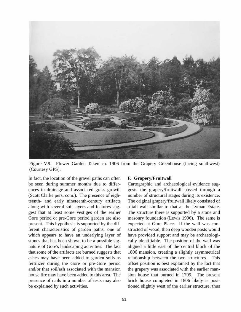
In fact, the location of the gravel paths can oftenbe seen during summer months due to differ-ences in drainage and associated grass growth(Scott Clarke pers. com.). The presence of eigh-teenth- and early nineteenth-century artifactsalong with several soil layers and features sug-gest that at least some vestiges of the earlierGore period or pre-Gore period garden are alsopresent. This hypothesis is supported by the dif-ferent characteristics of garden paths, one ofwhich appears to have an underlying layer ofstones that has been shown to be a possible sig-nature of Gore's landscaping activities. The factthat some of the artifacts are burned suggests thatashes may have been added to garden soils asfertilizer during the Gore or pre-Gore periodand/or that soil/ash associated with the mansionhouse fire may have been added to this area. Thepresence of nails in a number of tests may alsobe explained by such activities.
F. Grapery/FruitwallCartographic and archaeological evidence sug-gests the grapery/fruitwall passed through anumber of structural stages during its existence.The original grapery/fruitwall likely consisted ofa tall wall similar to that at the Lyman Estate.The structure there is supported by a stone andmasonry foundation (Lewis 1996). The same isexpected at Gore Place. If the wall was con-structed of wood, then deep wooden posts wouldhave provided support and may be archaeologi-cally identifiable. The position of the wall wasaligned a little east of the central block of the1806 mansion, creating a slightly asymmetricalrelationship between the two structures. Thisoffset position is best explained by the fact thatthe grapery was associated with the earlier man-sion house that burned in 1799. The presentbrick house completed in 1806 likely is posi-tioned slightly west of the earlier structure, thus
51
Figure V.9. Flower Garden Taken ca. 1906 from the Grapery Greenhouse (facing southwest)(Courtesy GPS).

producing an angled line of sight to the earliergrapery.
The depiction of the grapery and fruit wall asthree connected lines on the Lyman Estate mapof 1834-38 (see Figure III.3) suggests the struc-ture was not significantly changed during Gore'sor Lyman's occupation. Its appearance on the1841 plan of Green's estate (see Figure III.4),however, suggests substantial enlargement thatresulted in what appear to be three connectedbuildings instead of single walls. Until furtherevidence is uncovered to clarify this issue, thestructure probably was significantly improvedbetween 1838 and 1841 during the Green's occu-pation, resulting in its transformation from a sup-portive wall to a formal greenhouse. The struc-ture may have been further enlarged and modi-fied between 1841 and 1889, for the CharlesEliot sketch (1889) depicts an enlarged central
block (see Figure III.6). This additional modifi-cation was made either by the Greens before theysold the property in 1856 or was made byTheophilus Walker before leaving the estate tohis nieces in 1890 (Fig. V.10). The greenhouseis very likely to have been demolished around1921. At that time the property was transformedinto the Waltham Country Club that constructeda golf course across much of the property.Excavation of STP D1 and EU1 revealed a darkyellow-brown clay loam to directly overlie dem-olition rubble and a portion of the greenhouse'scentral block (see Fig. IV.20). This same soilwas also used to create an elevated golf teeimmediately south of the greenhouse site andnorth of the old flower garden. The fact that thissoil directly overlies the demolition layer is high-ly suggestive that the greenhouse was demol-ished immediately before the creation of the tee.
52
Figure V.10. West Wing and Central Block of the Grapery Greenhouse ca. 1906 (facing north,Courtesy GPS).

Archaeological investigations found the grap-ery/fruitwall area to maintain a high level ofintegrity due to the preservation of foundations,greenhouse soils and associated deposits. Asnoted above, the soil profiles revealed in theshovel tests provide an indication of the locationof the greenhouse's central block and a portion ofthe west wing as well. A brick foundation walland piers are believed to be associated with thestructure's central block. Additional investiga-tions are needed to confirm these observations.The deep greenhouse soils identified within thecentral block are intact, and reveal a specific mixof soil and other ingredients including bone,charcoal and shell. Such a formula for green-house soils dates to the early nineteenth centuryif not earlier (see greenhouse section above).The coarse sand below the soils is believed tohave served for drainage. The presence of thesedeep soils within the central block suggest thisportion of the greenhouse may have been usedfor larger trees with extensive root systems,while the slightly shallower soils in the wingsmay have supported smaller plantings. The pres-ence of fragmented planting pots across theentire area provides no clue as to specific uselocations.
Evidence of the original eighteenth- and earlynineteenth-century grapery/fruitwall that waspresent during the occupation of the Gores like-ly would consist of post impressions if it wasconstructed of wood, or would consist of stoneand/or brick foundation remains similar to con-struction of the fruitwall at the Lyman Estate.Although the incorporation of the original fruit-wall into the greenhouse cannot yet be docu-mented, the fact that the greenhouse followed thesame or similar lines, size and orientation of theoriginal fruitwall suggests a high likelihood that
the former structure was indeed incorporatedinto the later structure. A logical use of the fruit-wall in the greenhouse would have been as a cen-tral support wall to take advantage of what canbe assumed was a considerable height. In such ascenario, lower walls would have been con-structed to the north and south. This plan, inpart, assumes that the greenhouse was construct-ed similarly to the greenhouse at the nearbyLyman estate. Additional archaeological investi-gations are needed to identify the fruitwall foun-dation if it remains preserved within the latergreenhouse foundation.
Documentary and archaeological investigationsfor this project raised the question of why a sec-ond greenhouse was constructed when onealready existed adjacent to the carriage house. Itis hypothesized that the trees lining the entrancedrive planted by the Gores were beginning toreach a substantial height by the 1830s to 1840s.This growth may well have blocked sunlightfrom the greenhouse. The grapery/fruitwall, onthe other hand, was ideally situated and receivedmaximum solar exposure. At the same time theearly nineteenth-century greenhouse may havebecome outdated due to its small size and design.Excavation in the area of the early greenhouserevealed no evidence of deep interior greenhousesoils, whereas these are clearly prevalent at thelater site. If the propagation of new trees bene-fited from deeper greenhouse soils for example,then the apparent solid floor of the former struc-ture would not have been conducive to this need.In addition, aging mullions exposed to outsideweather and interior humidity may have begun torequire replacement around this time, thusencouraging creation and use of a newer struc-ture.
53

VI. RECOMMENDATIONS
A. Entrance DrivesArchaeological investigations suggest that thepresent entrance and service drives have been inplace since their probable construction duringthe Gore occupation of the property. Both drivesconsist of coarse sand and gravel, possiblyderived from the nearby Charles River. Removalof the present asphalt pavement revealed a layerof sand bedding under which are three layers ofroadbed that overlie the original sand and stonefill that extends across the area. Restoration ofthe Gore period roadbed should include removalof the present asphalt surface to expose theunderlying sand and gravel. This surface can beused as is, but may need an appropriate binder tocreate a more easily maintained bed that canwithstand winter plowing.
In addition, the service drive should be recon-nected to the main drive, but options exist as tohow this can be done. The original west entranceformed a ‘Y’ such that a turn to the left providedaccess to the main drive, while a turn to the rightprovided access to the service drive. The widen-ing of Gore Street resulted in the removal of the‘Y’ and a shifting of the entrance northward to bealigned with the entrance drive (see Fig. V.2).This effectively cut off access to the servicedrive. The option exists either to leave the GoreStreet entrance where it is and create a link tojoin the service drive, or to shift the entranceslightly southward and create a new ‘Y’ configu-ration similar to the original. Both plans requirethe creation of new roadbed to link both drives.The new roadbed can be created merely byremoving the landscaping loam from the pro-posed route down to the sand and gravel fill, fol-lowed by replacement with appropriate sand andgravel. The service drive could benefit from theaddition of some fresh sand and gravel since thepresent roadbed is low and lacks visibility. It isimportant to remember that a number of utilitylines enter the property in this area, so anychanges must be coordinated with utility identi-fication.
B. Carriage HouseThe carriage house cannot be returned to its orig-inal site due to the destruction of the western twothirds of its foundation for the widening of GoreStreet. As a result, the landscape master plancalls for its placement as close to the original siteas possible. Two options are available for its cit-ing. The first places the structure immediatelyeast of the remaining foundation and possiblyover the east end of the old foundation. Underthis plan the structure would overlie most of thegreenhouse and its west yard, would require theremoval of the present English Oak that is sitedon top of the greenhouse site, and would effec-tively eliminate both the opportunity to demar-cate the greenhouse foundation on the groundand to interpret the structure at its original site.If this option is chosen then a complete archaeo-logical mitigation (data recovery) of the green-house site is recommended. In addition, archae-ological investigation as well as monitoring ofthe original carriage house area during prepara-tion of the site for construction is recommendedto record details of the original foundation and ofthe space that once existed between the carriagehouse and greenhouse that would also be impact-ed.
Option two consists of placing the carriage housenorth and east of the original foundation. Thislocation would not only provide a small carriageyard similar to the original configuration, butwould also preserve what remains of the originalcarriage house foundation as well as the site ofthe greenhouse, leaving open a number of possi-bilities for the future interpretation of both. Inaddition, the English Oak would remainunthreatened. Serious consideration must begiven to the possibility of greenhouse recon-struction, for if this were to occur, then the car-riage house should not lie immediately north, butshould be placed so there is an adequate separa-tion of space between the two structures. If thereis little to no possibility of greenhouse recon-struction, then less space is needed between thecarriage house and greenhouse site. The secondoption is considered to be most appropriate in
54

considering both the future use of the carriagehouse and long-term preservation and interpreta-tion of the area. A second phase of archaeologi-cal work is recommended for option two toinvestigate the area that will be impacted by thenew carriage house cellar and utility construc-tion. This work would potentially include thenorthern portion of the greenhouse yard andsouthern portion of the vegetable garden. Thisarea has the potential to contain importantarchaeological deposits associated with green-house related activities, carriage house relatedactivities and the early design and use of the veg-etable garden. Little known structures may havealso occupied this area around the turn of thenineteenth century. Archaeological investiga-tions would focus on the evolving use of each ofthese three areas and how they relate to oneanother.
C. GreenhouseThe greenhouse site is an historically importantcomponent of the landscape and agricultural his-tory of Gore Place. The high level of integrity ofthe site points to the exceptional potential itmaintains to provide significant data on the gar-dening and landscape history of the property andits important role in the nineteenth-centurydevelopment of scientific agriculture. Furtherarchaeological investigation of the site is contin-gent upon the eventual citing of the carriagehouse. If this structure is placed immediatelyeast of its original foundation and over the green-house site, then complete mitigation (data recov-ery) of the site is recommended. This willinvolve examination of architectural remains todocument details of its construction and func-tion. Additional investigations will focus on thegreenhouse yard to determine the historic use ofthis area. If the carriage house is located north ofthe greenhouse, then the north greenhouse yardwill be investigated to document the presenceand function of structures in this area and toidentify the nature of the boundary between thegreenhouse and vegetable garden. Both optionswill require the investigation of extensive areaswith blocks of contiguous excavation units.
D. Vegetable GardenIf recreation of this garden becomes a compo-nent of the landscape master plan implementa-tion, additional subsurface investigations for thepurpose of defining bed boundaries and internalstructure should be performed. The timing ofthis work in the southern portion of the garden isdependent upon citing decisions for the carriagehouse. Parts of the garden that will be impactedby construction of the new foundation will needto be investigated prior to the moving of thestructure, while the remainder of the gardeninvestigations can be performed at a later time.The work plan will be similar to that presentedfor the flower garden (see below), whereby gar-den paths will be the object of the initial searchwith interior bed areas to follow. An additionalfocus here will be definition of the boundarylikely represented by fence lines between thecarriage house and greenhouse yards and thevegetable garden. Investigation under the park-ing lot portion of the garden will commence withmachine-assisted work to remove overlying fill.
The archaeological identification of garden fea-tures is contingent upon the presence and, thus,preservation of specific indicators. These caninclude differences in soil type, texture and ele-vation across the site, borders that are indicatedby soil differences, the presence of walkways oredging that may appear as linear arrangements ofpost holes, bricks or other border materials, aswell as indications of specific plant locations.Plant locations are generally defined by depres-sions or holes that have been backfilled with soilthat can be differentiated from surroundingmatrix due to obvious or subtle alterations in soilcolor, texture and composition. Occasionally,artifacts are incorporated into the backfill ofplanting holes and these aid in identification anddating.
E. Flower GardenIdentification of the general configuration andinternal structure of the eighteenth- and earlynineteenth-century flower garden appears to bepossible given the results of preliminary archae-
55

ological investigations. Work in garden contextstypically focuses on more visible features suchas walking paths and well-marked bed borders.Given an adequate state of preservation, less vis-ible planting bed boundaries and planting holescan be detected as well, but this work requiresextreme care to differentiate not only the pres-ence of such features, but to determine their tem-poral associations. Such work at Gore Place willbe a challenge due to the long history of garden-ing at the site and relatively shallow stratigraphyin the flower garden.
The Col. Henry Lee description of the garden ascontaining central north-south and east-westwalks provides a starting point for archaeologi-cal investigations. It is recommended that a sec-ond phase of archaeological exploration focus ondefining garden walks beginning with the morerecent gravel paths associated with the mid andlater nineteenth-century curvilinear garden iden-tified in some of the shovel tests and known fromthe 1936 HABS plan and historic photographs.Once the configuration and elevations of theseare known, then the search will continue for ear-lier walks. The latter, in theory, should lie belowthe later walks, should be linear in form andpotentially constructed of different material thanthe later curvilinear walks. Once the rectilineargarden form has been defined, then work withinthe garden can begin. It is expected that interiorbedding and plantings of the early garden willfollow, at least to an extent, the rectilinear formestablished by the walks and perimeter. Suchalignments will help to differentiate early plant-ing patterns from later curvilinear configura-tions. Identification of the walks can be per-formed through the excavation of a series of 50cm x 50 cm STPs and .5 m x 1 m and 1 m x 1 munits. Garden areas within the walks are bestexplored by the completion of small blocks ofcontiguous units. It is important to note thatalthough the focus of garden restoration is on thelate eighteenth- and early nineteenth-centuryGore period, archaeological investigations musttreat all periods equally, thus tracing the entiregarden history.
F. Grapery/FruitwallThe focus of the landscape masterplan on theGore period calls for the identification of theearly grapery/fruitwall prior to its transformationinto a more substantial greenhouse structure.Now that the general location and state of preser-vation of the later greenhouse structure isknown, additional archaeological investigationsare recommended to locate the north greenhousewall and to expose larger portions of the founda-tion remains as a means of identifying the poten-tial presence of the original fruitwall. Becauseboth the fruitwall and later greenhouse structureswere so large, such an effort would best be per-formed by careful mechanical removal of filldeposits overlying specific portions of the latergreenhouse foundation. In this way foundationwalls and piers can be pinpointed prior to handexcavation. This recommendation is based onthe hypothesis that because the later greenhousemimicked the same configuration and alignmentof the original grapery/fruitwall, it is very likelythat this was incorporated in whole or in part intothe walls of the later greenhouse. If the graperywalls were substantial, their identification maybe possible in close association with the existinggreenhouse foundation. Further archaeologicalinvestigation would also need to incorporateidentification of planting areas, pathways andother structural remains that may be presentaround the perimeter of the existing greenhousefoundation. The research potential of this workshould not be underestimated as it presents therare opportunity to examine historic gardeningactivities including plant propagation practiceswithin the context of the scientific agriculturemovement and the creation of historic pleasuregardens potentially over a period in excess of100 years.
It is also recommended that future reconstructionof the Gore period grapery/fruitwall should con-sider incorporating the footprint of the latergreenhouse, since this was an impressive struc-ture in its own right and was an important com-ponent of the site's history. The footprint couldbe marked on the ground surface by adding sev-
56

eral courses of brick to the existing foundation tobring the walls even with the ground surface.Another option would be to mark the foundationwith stone dust or gravel bedding used for gar-den paths. Interpretive signage that includes adetail of the 1834-38 Lyman map and a copy of
an historic photograph of the greenhouse (seeFig. V.10) is also recommended. It should benoted that those areas of the property not testedduring the survey may be archaeologically sensi-tive and should be tested in advance of futureproposed impacts.
57

REFERENCES CITED
Barber, R.J.1979 A Summary and Analysis of Cultural Resource
Information on the Continental Shelf from theBay of Fundy to Cape Hatteras. Vol. II:Archaeology and Paleontology. Institute forConservation Archaeology, Peabody Museum,Harvard University.
Beaudry, Mary C.1996 Why Gardens: In Landscape Archaeology:
Reading and Interpreting the AmericanHistorical Landscape, edited by Rebecca Yaminand Karen B. Metheny, pp. 3-5. University ofTennessee Press, Knoxville.
Binzen, Timothy L. and Margaret Kelley2000 Archaeological Site Reconnaissance and
Intensive (Locational) Survey for the ProposedUtilities Corridor and Parking Area and theConstruction and Restoration at the Forecourt,Lime Walk, and Greenhouse, The Mount, Lenox,Massachusetts. Copy on file at the MassachusettsHistorical Commission.
2002 Results of an Archaeological Site Examination in2000 for Historic Landscape Restorations at TheMount, Lenox, Massachusetts. Copy on file at theMassachusetts Historical Commission.
Bourque, B.J.1995 Diversity and Complexity in Prehistoric Maritime
Societies: A Gulf of Maine Perspective. Plenum,New York.
Brockway, Lucinda A.2001 Landscape History, Gore Place, Waltham, MA.
Past Designs for the Halvorson Group.
Carty, Frederick M., and Arthur E. Spiess1992 The Neponset Paleoindian Site in Massachusetts.
Archaeology of Eastern North America 20: 19-37.
Cogley, R.W.1999 John Eliot’s Mission to the Indians Before King
Phillips War. Harvard University Press.
Curran, M.L. and D.F. Dincauze1977 Paleo-Indians and Paleo-Lakes: New Data from
the Connecticut Drainage. Annals of the NewYork Academy of Sciences 288:333-348.
Custer, Jay1984 Delaware Prehistoric Archaeology: An
Ecological Approach. University of Delaware,Newark.
Dincauze, D.F.1974 An Introduction to Archaeology in the Greater
Boston Area. Archaeology of Eastern NorthAmerica. 2:39-67.
1975 The Late Archaic Period in Southern NewEngland. Arctic Anthropology 12(2):23-34.
1976 The Neville Site: 8000 Years at Amoskeag.Peabody Museum Monographs No. 4. HarvardUniversity, Cambridge, MA.
1990 A Capsule Prehistory of Southern New England.In The Pepuots in Southern New England: TheFall and Rise of an American Indian Nation, L.M. Hauptman and J.D. Wherry, eds., pp. 19-32.University of Oklahoma Press, Norman.
Dincauze, D.F. and M.L. Curran1984 Paleoindians as Flexible Generalists: An
Ecological Perspective. Paper Presented at the24th Annual Meeting of the Eastern StatesArchaeological Federation, Hartford, CT.
Dincauze, D.F. and M.T. Mulholland1977 Early and Middle Archaic Site Distributions and
Habitats in Southern New England. In Amerindsand Their Paleoenvironments in NortheasternNorth Amcerica. Annals of the New YorkAcademy of Sciences 288:439-456.
Elia, Ricardo and Thomas F. Mahlstedt1982 Report on the Phase II Tewksbury to Ames bury
Right-of-Way 345 KV Transmission Line. Officeof Public Archaeology, Boston University.Report on file at the Massachusetts HistoricalCommission, Boston.
Goddard, I., and K.J. Bragdon1988 Native Writings in Massachusett. American
Philosophy Society, Philadelphia.
Hammond, Charles A.1982 "Where the Arts and the Virtues Unite": Country
Life Near Boston, 1637-1864. Ph.D. dissertation,Department of American and New EnglandStudies, Boston University.
1986 Chronology of Land Ownership at Gore Place,Waltham, Massachusetts. Gore Place Society,Waltham, MA.
58

Hodges, Maud deLeigh1980 Crossroads on the Charles, A History of
Watertown, Mass. Watertown.
Kelso, William M., and Rachel Most (eds.)1990 Earth Patterns: Essays in Landscape
Archaeology. University Press of Virginia,Charlottesville.
Kenyon, V.B.1983 Prehistoric Archaeology in the Merrimack River
Valley. Man in the Northeast 25:1-5.
Leone, Mark P.1984 Interpreting Ideology in Historical Archaeology:
Using the Rules of Perspective in the WilliamPaca Garden in Annapolis, Maryland. InIdeology, Power and Prehistory, edited by DanielMiller and Christopher Tilley, pp. 25-36.Cambridge University Press, Cambridge.
1988 The Relationship Between Archaeological Dataand the Documentary Record: 18th CenturyGardens in Annapolis, Maryland. HistoricalArchaeology 22(1):29-35.
Leudke, Barbara1985 The Camp at the Bend in the River: Prehistory at
the Shattuck Farm Site. Copy on file at theMassachusetts Historical Commission, Boston.
Lewis, Ann-Eliza H.1996 Summary of Partial Phase I Archaeological
Investigations at “The Vale,” Lyman Estate,Waltham, MA. Report prepared for The Societyfor the Preservation of New England Antiquities.
Loparto Leonard1986 Draft Report, Prehistoric Background Study,
Olmstead Parks Project. Museum of AfroAmerican History, Boston, MA.
Massachusetts Historical Commission1980 MHC Reconnaissance Survey Report: Waltham.
Report on file at the MHC, Boston.
Massachusetts Historical Commission1980 MHC Reconnaissance Survey Report:
Watertown. Report on file at the MHC, Boston.
M'Mahon, Bernard1806 The American Gardener's Calendar, Adapted to
the Climates and Seasons of the United States.Philadelphia. Society for Preservation of NewEngland Antiquities Library.
Metheny, Karen B., Judson Kratzer, Ann E. Yentsch, and
Conrad M. Goodwin1996 Method in Landscape Archaeology: Research
Strategies in a Historic New Jersey Garden. InLandscape Archaeology: Reading andInterpreting the American Historical Landscape,edited by Rebecca Yamin and Karen B. Metheny,pp., 6-31. University of Tennessee Press,Knoxville.
Noel Hume, Ivor1969 A Guide to the Artifacts of Colonial America.
Alfred A. Knopf, New York, NY.
Pinello, Martha E.1999 An Archaeological Site Examination of the Peach
Wall at The Vale, The Lyman Estate, Waltham,Massachusetts. Report prepared for The Societyfor the Preservation of New England Antiquities.
Ripley, Samuel1815 A Topographical and Historical Description of
Waltham. Massachusetts Historical SocietyCollections. 2nd series, vol. 3.
Ritchie, Duncan1994 New Neponset Valley Relief Sewer System Data
Recovery Program for Locus D of theNeponset/Wamsutta Site (19-NF-70), Canton,Massachusetts. The Public ArchaeologyLaboratory Inc., Pawtucket, RI, Report No. 498.Report on file at the Massachusetts HistoricalCommission, Boston.
Ritchie, W.A.1980 The Archaeology of New York State. Natural
History Press, Garden City, NY.
1969 The Archaeology of Martha's Vineyard. NaturalHistory Press, Garden City, NY.
1965 The Small-Stemmed Point in New England.Pennsylvania Archaeologist 35:134-138.
Ritchie, W.A. and R.E. Funk1973 Aboriginal Settlement Patterns in the Northeast.
New York State Museum and Science ServiceMemoir 20.
Roberts, Robert1998 (1827) The House Servant's Directory, or A
Monitor for Private Families: comprising hintson the arrangement and performance of servant'swork…and upwards of 100 various and usefulrecipes, chiefly compiled for the use of house ser-vants; with an introduction by Graham RussellHodges. ME Sharpe, Armonk, NY.
59

Robinson, George Frederick and Ruth R. Wheeler1930 Great Little Watertown: A Tercentenary History.
Watertown.
Sanderson, Edmund1936 Waltham as a Precinct of Watertown and as a
Town, 1630-1884. Waltham.1957 Waltham Industries. Waltham.
Simmons, W.S.1986 Spirit of the New England Tribes: Indian History
and Folklore, 1620-1984. University Press ofNew England, Hanover, New Hampshire.
Smith, J.N. Leith, Barbara Donohue and Martin Dudek2000 Emergency Archaeological Data Recovery of The
South Boston Flint Glass Works and TheAmerican Glass Company, Contingency PlanImplementation, Contos Property, Parcel 60-CS-1, Central Artery/Tunnel Project, Boston,Massachusetts. Report prepared by TimelinesInc., Littleton, MA.
Snow, D.1980 The Archaeology of New England. Academic
Press, NY.
Spiess, A.E. Deborah B. Wilson, and James Bradley1998 Paleoindian Occupation in the New England-
Maritimes Region: Beyond Cultural Ecology.Archaeology of Eastern North America 26:201-264.
Spiess Arthur E. and B. D Spiess1987 New England Pandemic of 1616-1622: Cause
and Archaeological Implication. Man in theNortheast 34:71-83.
Spence, M.W. and W.A. Fox1986 The Early Woodland Occupations of Southern
Ontario. In Early Woodland Archaeology, pp.4-46. Edited by K.B. Farnsworth and T.E.Emerson. Center for American ArchaeologyPress, Kampsville, IL.
Stachiw, Myron1996 Memorandum of Completion, Greenhouse
Drainage Project, Archaeological TestExcavations at The Vale, Lyman Estate, Waltham,Massachusetts. Report prepared for the Societyfor the Preservation of New England Antiquities.Historic New England Library and Archives,Boston.
USDA1995 Soil Survey of Middlesex County, Massachusetts.
USDA Soil Conservation Service.
Yentsch, Anne E. and Judson M. Kratzer1994 Techniques for Excavating and Analyzing Buried
Eighteenth Century Garden Landscapes. In TheArchaeology of Garden and Field, edited byNaomi F. Miller and Kathryn L. Gleason, pp.168-201. University of Pennsylvania Press,Philadelphia.
60

61
APPENDIX A
ARTIFACT CATALOG