
Report on Met Office drifter activities - wmo.int · Jersey buoy (62027), operated by Jersey Met...
25
© Crown copyright Met Office Report on Met Office buoy activities DBCP-XXVII Sept 2011 Jon Turton, UK Met Office
Transcript of Report on Met Office drifter activities - wmo.int · Jersey buoy (62027), operated by Jersey Met...

© Crown copyright Met Office
Report on Met Office buoy activitiesDBCP-XXVII Sept 2011Jon Turton, UK Met Office

© Crown copyright Met Office
Drifter activities
•
Have budget line for drifter activities that includes support for E-SURFMAR plus a separate line to procure and deploy barometer drifters in the South Atlantic/Southern Ocean as a contribution to the global drifter array (supporting GCOS and NWP)
•
Has enabled purchase of
•
Iridium drifters (contributing to the Iridium Drifter Pilot Project)
•
Drifters with lithium batteries (hope for up to 2x the normal SVP lifetime at ~1.3 x the normal SVP cost)
•
Iridium drifters with high precision SST sensors (PP-HRSST)

© Crown copyright Met Office
South Atlantic/Southern Ocean drifters
•
5 MetOcean
SVP-B drifters deployed in Southern Ocean, Dec 2005
•
4 MetOcean
SVP-B drifters (with lithium batteries) deployed in South Atlantic, May 2007
•
5 MetOcean
SVP-B Iridium drifters deployed in Southern Ocean, Dec 2007/Jan 2008
•
7 MetOcean
SVP-B Iridium drifters deployed in South Atlantic, Oct/Nov 2008 (2 with lithium batteries)
•
10 MetOcean
SVP-B drifters (9 Iridium, 1 Argos) deployed in South Atlantic, Oct/Nov 2009 (all with lithium batteries)
•
7 MetOcean
SVP-P Iridium drifters deployed in Southern Ocean, Dec 2010/Mar 2011 (all with lithium batteries and YSI 46000 temperature probe)
•
Expect delivery of 9 MetOcean
HRSST drifters in next month or so (5 + 2 + 2)

© Crown copyright Met Office
Active UKMO drifters (16 Sept)
1 Argos drifter ●,
12 Iridium drifters ●
–
all with Li batteries

© Crown copyright Met Office
Drifter lifetimes
Expired drifters in red, active drifters in greenHatched for alkalines, solid for lithiums
Argos drifters Iridium drifters
0
400
800
1200
1600
1 2 3 4 5 6 7 8 9 10
lifet
ime
(day
s)
0
400
800
1200
1600
1 2 3 4 5 6 7 8 9 10 11 12 13 14 15 16 17 18 19 20 21 22 23 24 25 26 27 28
lifet
ime
(day
s)

© Crown copyright Met Office
Marine Automatic Weather Station (MAWS) network
•
Operational MAWS network presently comprises
•
9 moored buoys
•
5 light vessels
•
2 remote islands

© Crown copyright Met Office
Moored buoy networks
•
Met Office moored buoy network developed following the ‘Great Storm’
of 1987
•
Brittany/Gascogne
operated jointly with Méteo-France
•
Collaboration with Irish Marine Institute and Met Eireann
on the Irish buoy network
•
Pre-operational system operated at PAP with the National Oceanography Centre
•
Weymouth Bay operated for LOCOG (2012 Olympics)

© Crown copyright Met Office
K-series buoys
Specifications•
2.6 m diameter hull•
6 m overall height•
4 m sensor exposure height above sea level
•
1.5 m diameter sensor ring•
Duplicate sensors attached with quick release clamps
•
Single heave sensor in hull•
Cross-linked dual control electronics and communications systems for maximum resilience

© Crown copyright Met Office
K-series buoys
•
Have been in operation since the early 90s
•
Buoys are normally deployed for 2 years with an annual service visit (sensor change and mooring inspection)
•
Proven reliability, but ageing control electronics and transmission systems need replacement
•
Iridium now on one side on all buoys except K1 (which has been in the water since Apr 2006)
•
will be replacing ageing Meteosat Standard Rate DCPs
with new Sutron
DCPs
(upgradeable for high rate transmissions)
•
Following trial of sonic anemometers, dual WindSonics
on all deployments from 2010
•
single sonic on K2, Aberporth
and Turbot Bank
•
dual sonics
on K4, K5, K7, Brittany and Gascogne
© Crown copyright Met Office
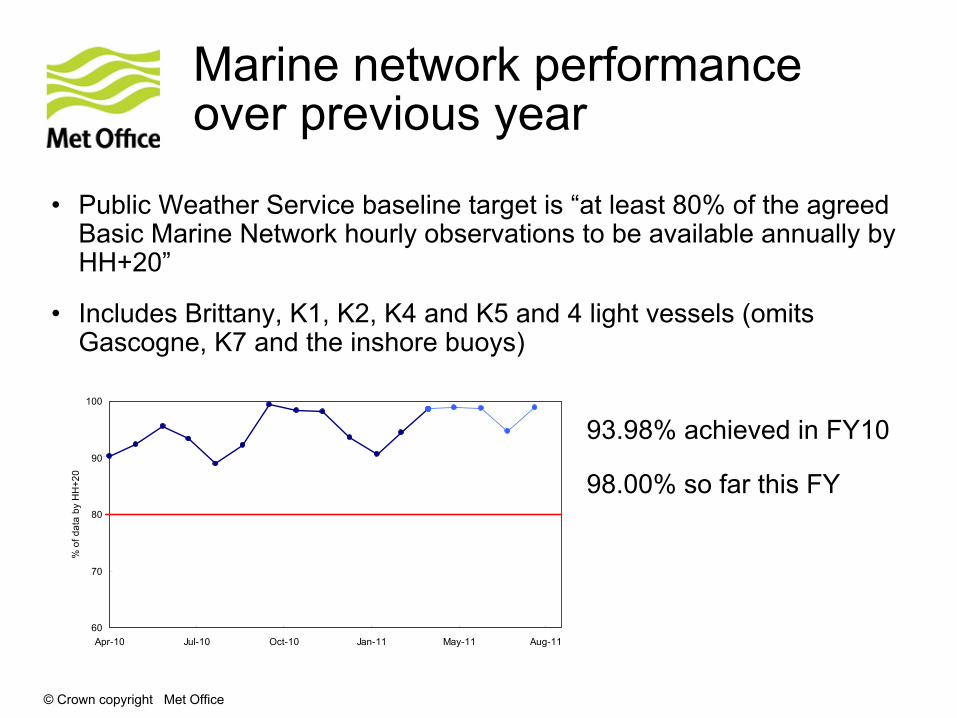
Marine network performance over previous year
•
Public Weather Service baseline target is “at least 80% of the agreed Basic Marine Network hourly observations to be available annually by HH+20”
•
Includes Brittany, K1, K2, K4 and K5 and 4 light vessels (omits Gascogne, K7 and the inshore buoys)
60
70
80
90
100
Apr-10 Jul-10 Oct-10 Jan-11 May-11 Aug-11
% o
f dat
a by
HH
+20
93.98% achieved in FY10
98.00% so far this FY

© Crown copyright Met Office
Porcupine Abyssal Plain (PAP) buoy
•
Deployed buoy 1st
June 2010 at Porcupine Abyssal Plain site to complement NOCS mooring (OceanSITES/ EuroSITES) –
depth 4,800m
•
If we can maintain the buoy using only scheduled research vessel visits to PAP, then expected that a longer-term collaboration agreement to maintain a Met Office moored buoy at the PAP site will be developed
© Crown copyright Met Office
PAP buoy system
•
Modified K-series buoy with a single met system as one side is given over to NOCS systems to receive and transmit sub-surface data from a sensor frame at 30m below the buoy
•
Buoy serviced in August 2011 where both the oceanographic and meteorological systems were (largely) fixed
•
Lessons so far•
single met system lacks resilience•
need more power for oceanographic sensors
•
Plan to build replacement system on K-series hull with dual sensors and Axys
Watchman 500 for deployment in
April 2012 (better resilience but no more energy)

© Crown copyright Met Office
PAP servicing in August
Photographs courtesy of the National Oceanography Centre

© Crown copyright Met Office
Weymouth Bay system
•
Deployed in July 2011, will be operated until after the Olympics (WMO 62028)
•
Dual Axys
Watchman system, with dual Iridium systems and a Triaxys
spectral wave sensor, built on a DB-300 3m hull
•
Currently sending in data every 15 minutes

© Crown copyright Met Office
Spectral wave on K5
•
Triaxys
spectral wave system originally deployed on K5 in August 2008, system replaced in June 2011 with a stand-alone spectral wave and Iridium system
•
Replacement system returns the ‘first-5’
spectral parameters over 32 frequency bands (as opposed to first-3 over 123 bands on original system)
•
Data received via emails in NMEA (text) format, work to convert these data into a BUFR message for dissemination on GTS is underway
•
System only able to provide spectral data every 3-hours due to energy budget limitations (59N –
limited solar recharging in winter)
•
Triaxys
data to be compared with heave sensor on K5 (sampling periods properly aligned)

© Crown copyright Met Office
Developments at K7
•
K7 buoy is in international waters but on the Denmark/Faroes
side of the ‘Denmark Faroes
Island/UK demarcation line’
as shown on Admiralty/mariners charts
•
Has caused confusion and misunderstanding on occasions, when Faroese vessels have wrongly identified the buoy as being ‘adrift’
and within Faroese waters and jurisdiction
•
Plan to move the buoy early 2012 to a position that is on the UK
side of the demarcation line to avoid such confusion
•
At the same to deploy a new buoy (Hydrosphere DB8000 hull) with Triaxys
spectral wave capability adjacent to the to existing K7 system,
able to carry more solar panels so hourly spectral measurements may be possible
•
The new platform will be tested for suitability for operating in
the North Atlantic, the Triaxys
spectral wave outputs will be compared with data from the Datawell
Heave Sensor on the adjacent K-series buoy

© Crown copyright Met Office
Plans for spectral wave capability
•
Extend capability to selected buoys across the network by installing further stand-alone Triaxys
systems with Iridium
•
Gascogne
and Brittany (Meteo-France funded systems) should be deployed in October, hourly spectral observations should be possible as much further south
•
K7 (operated for NWAG) replacement (in 2012)
•
Plan to implement on either K1 or K2 to provide information for the south-west approaches (in 2012)
•
Cross comparison with a Datawell
waverider
remains an outstanding requirement
•
Good prospects to purchase a waverider
over the coming months (and follow PP-WET first-5 comparison approach)

© Crown copyright Met Office
Collaboration with PML
•
Western Channel Observatory (Plymouth Marine Lab) funded through the NERC Oceans2025 programme
•
2 buoys at L4 (62030) and E1 (62050) stations, 3-hourly met data (& SST) going to GTS, oceanographic data available on WCO web-site
www.westernchannelobservatory.org.uk
•
Met Office and PML to build a new system for E1 that is more resilient for to winter conditions
•
build system on a Hydrosphere DB8000 hull with an Axys
Watchman 500 for the meteorological capability
•
PML to put their oceanographic sensors (salinity, oxygen, turbidity, fluorescence, nitrates) and system onto the new hull

© Crown copyright Met Office
Network developments
•
Trial a smaller DB-175 single Axys Watchman based system at Turbot
Bank as a potential replacement for the K-series buoy
•
After proving new design systems (Hydrosphere DB8000 and Orchid Plastics hulls with Axys
Watchman 500)
over the winter months, plan to start replacing existing K-series systems from 2012

© Crown copyright Met Office
Hydrosphere and Orchid Plastics buoys
© Crown copyright Met Office
Other sources of moored buoy data around the UK
•
Irish buoy network
•
Marine Institute programme to replace their K-series buoys with Fugro-Oceanor
systems
•
Jersey Met Dept
•
WaveNet
•
CEFAS SmartBuoys

© Crown copyright Met Office
Jersey buoy
•
Jersey buoy (62027), operated by Jersey Met Department
•
Redeployed in autumn 2009, 20 minute met data, hourly wave data
•
Data now going routinely to GTS

© Crown copyright Met Office
WaveNet
Includes data from Met Office buoys and lightships, CEFAS wave buoys, Shell metnet
platforms, Irish buoys, Environment Agency wave buoys etc.
The Defra
strategic wave monitoring network for England and Wales (now extended into Scotland)
www.cefas.co.uk/wavenet
© Crown copyright Met Office
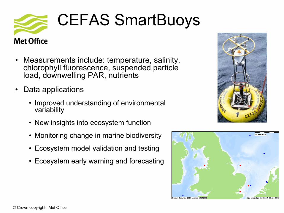
CEFAS SmartBuoys
•
Measurements include: temperature, salinity, chlorophyll fluorescence, suspended particle load, downwelling
PAR, nutrients
•
Data applications
•
Improved understanding of environmental variability
•
New insights into ecosystem function
•
Monitoring change in marine biodiversity
•
Ecosystem model validation and testing
•
Ecosystem early warning and forecasting

© Crown copyright Met Office