COMMUNITY DEVELOPMENT BLOCK GRANT TECHINCAL ASSISTANCE WORKSHOP Town of Union CDBG Program FFY 2010.

Report of the Technical Assistance Panel
Conducted for Cleveland Circle &
The Reservoir MBTA Station
Brookline & Boston, Massachusetts
The Urban Land Institute Boston District Council
October 2009

Cleveland Circle/Reservoir Station TAP
1
Contents
1. Introduction 1
2. Existing Conditions 5
3. Issues 12
4. Opportunities 15
5. Alternatives 16
6. Recommendations 18
1. Introduction
In October 2009, a Technical Assistance Panel
representing the Urban Land Institute’s Boston
District Council gathered at the request of the
Massachusetts Bay Transportation Authority
(“MBTA”) to study the development potential of
the MBTA property at Reservoir Station and the
adjacent MBTA maintenance facility, located
mostly in the Town of Brookline and partially in the
City of Boston. This report describes the findings
and recommendations of the panel. Specifically,
this report outlines the TAP process; describes
the existing conditions; summarizes critical issues,
opportunities and alternatives; and concludes with
the recommendations of the panel.
The panel determined that the development
potential of the site could not be adequately
considered without examining larger issues
associated with its context. Therefore, the panel
studied issues and opportunities associated with a
study area larger than the MBTA site. For the
purposes of this report, “the site” refers to the
MBTA property and “the study area” refers to
Cleveland Circle and surrounding neighborhoods.
Furthermore, the panel believes that jurisdictional
boundaries and intergovernmental cooperation
play a critical role in any development within the
study area. Because of the stake that the City of
Boston and the Town of Brookline have in the
future of the site and the study area, the panel’s
recommendations are directed as much to Boston
and Brookline as to the MBTA.
Cleveland Circle/Reservoir Station TAP
2
The Urban Land Institute
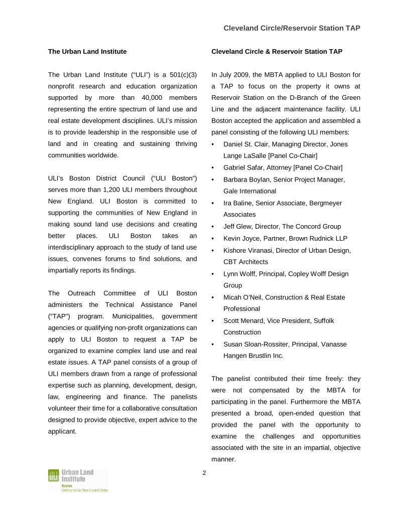
The Urban Land Institute (“ULI”) is a 501(c)(3)
nonprofit research and education organization
supported by more than 40,000 members
representing the entire spectrum of land use and
real estate development disciplines. ULI’s mission
is to provide leadership in the responsible use of
land and in creating and sustaining thriving
communities worldwide.
ULI’s Boston District Council (“ULI Boston”)
serves more than 1,200 ULI members throughout
New England. ULI Boston is committed to
supporting the communities of New England in
making sound land use decisions and creating
better places. ULI Boston takes an
interdisciplinary approach to the study of land use
issues, convenes forums to find solutions, and
impartially reports its findings.
The Outreach Committee of ULI Boston
administers the Technical Assistance Panel
(“TAP”) program. Municipalities, government
agencies or qualifying non-profit organizations can
apply to ULI Boston to request a TAP be
organized to examine complex land use and real
estate issues. A TAP panel consists of a group of
ULI members drawn from a range of professional
expertise such as planning, development, design,
law, engineering and finance. The panelists
volunteer their time for a collaborative consultation
designed to provide objective, expert advice to the
applicant.
Cleveland Circle & Reservoir Station TAP
In July 2009, the MBTA applied to ULI Boston for
a TAP to focus on the property it owns at
Reservoir Station on the D-Branch of the Green
Line and the adjacent maintenance facility. ULI
Boston accepted the application and assembled a
panel consisting of the following ULI members:
• Daniel St. Clair, Managing Director, Jones
Lange LaSalle [Panel Co-Chair]
• Gabriel Safar, Attorney [Panel Co-Chair]
• Barbara Boylan, Senior Project Manager,
Gale International
• Ira Baline, Senior Associate, Bergmeyer
Associates
• Jeff Glew, Director, The Concord Group
• Kevin Joyce, Partner, Brown Rudnick LLP
• Kishore Viranasi, Director of Urban Design,
CBT Architects
• Lynn Wolff, Principal, Copley Wolff Design
Group
• Micah O’Neil, Construction & Real Estate
Professional
• Scott Menard, Vice President, Suffolk
Construction
• Susan Sloan-Rossiter, Principal, Vanasse
Hangen Brustlin Inc.
The panelist contributed their time freely: they
were not compensated by the MBTA for
participating in the panel. Furthermore the MBTA
presented a broad, open-ended question that
provided the panel with the opportunity to
examine the challenges and opportunities
associated with the site in an impartial, objective
manner.
Cleveland Circle/Reservoir Station TAP
3
Specifically, the MBTA asked the panel to provide
input as to what development options would have
the potential to generate non-fare revenue without
impairing the MBTA’s ability to carry out its core
mission of providing efficient transit services to the
community. In addition, the MBTA asked the
panel to consider strategies that would mitigate
traffic congestion, noise and other adverse effects
of having its transit infrastructure within surface
streets and abutting a residential neighborhood.
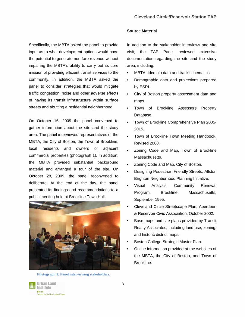
On October 16, 2009 the panel convened to
gather information about the site and the study
area. The panel interviewed representatives of the
MBTA, the City of Boston, the Town of Brookline,
local residents and owners of adjacent
commercial properties (photograph 1). In addition,
the MBTA provided substantial background
material and arranged a tour of the site. On
October 28, 2009, the panel reconvened to
deliberate. At the end of the day, the panel
presented its findings and recommendations to a
public meeting held at Brookline Town Hall.
Photograph 1: Panel interviewing stakeholders.
Source Material
In addition to the stakeholder interviews and site
visit, the TAP Panel reviewed extensive
documentation regarding the site and the study
area, including:
• MBTA ridership data and track schematics
• Demographic data and projections prepared
by ESRI.
• City of Boston property assessment data and
maps.
• Town of Brookline Assessors Property
Database.
• Town of Brookline Comprehensive Plan 2005-
2015.
• Town of Brookline Town Meeting Handbook,
Revised 2008.
• Zoning Code and Map, Town of Brookline
Massachusetts.
• Zoning Code and Map, City of Boston.
• Designing Pedestrian Friendly Streets, Allston
Brighton Neighborhood Planning Initiative.
• Visual Analysis, Community Renewal
Program, Brookline, Massachusetts,
September 1995.
• Cleveland Circle Streetscape Plan, Aberdeen
& Reservoir Civic Association, October 2002.
• Base maps and site plans provided by Transit
Realty Associates, including land use, zoning,
and historic district maps.
• Boston College Strategic Master Plan.
• Online information provided at the websites of
the MBTA, the City of Boston, and Town of
Brookline.
Cleveland Circle/Reservoir Station TAP
4
Acknowledgements
ULI Boston would like to acknowledge the Town
of Brookline, Transit Realty Associates, and The
Waterworks Museum for their assistance and for
hosting the panel activities.
The panel would like to recognize and thank all
the stakeholders and community members who
participated in the interviews and public
presentation. The panel appreciates the interest
and input of the City of Boston, the Town of
Brookline, and the MBTA.
Francis DeCoste of Transit Realty Associates
provided the panel with information and logistical
support. Kara Brewton, Economic Development
Director of the Town of Brookline was
instrumental in setting up the Brookline portion of
the TAP. Stephanie Wasser, Executive Director of
ULI Boston, and Michelle Landers, Manager of
ULI Boston provided operational support. Ned
Baldwin, an independent real estate consultant,
drafted this report.
All images are credited to ULI Boston unless
otherwise noted.
For additional information on this TAP or ULI
Boston please contact Michelle Landers at
617-239-0564 or [email protected].
Cleveland Circle/Reservoir Station TAP
5
2. Existing Conditions
The Site
The site that the MBTA requested the TAP to
focus on is located at the southeast side of
Cleveland Circle, the intersection of Beacon
Street and Chestnut Hill Avenue. The site consists
of Reservoir Station on the D-Branch of the Green
Line and a rail yard and maintenance facility that
supports the Green Line.
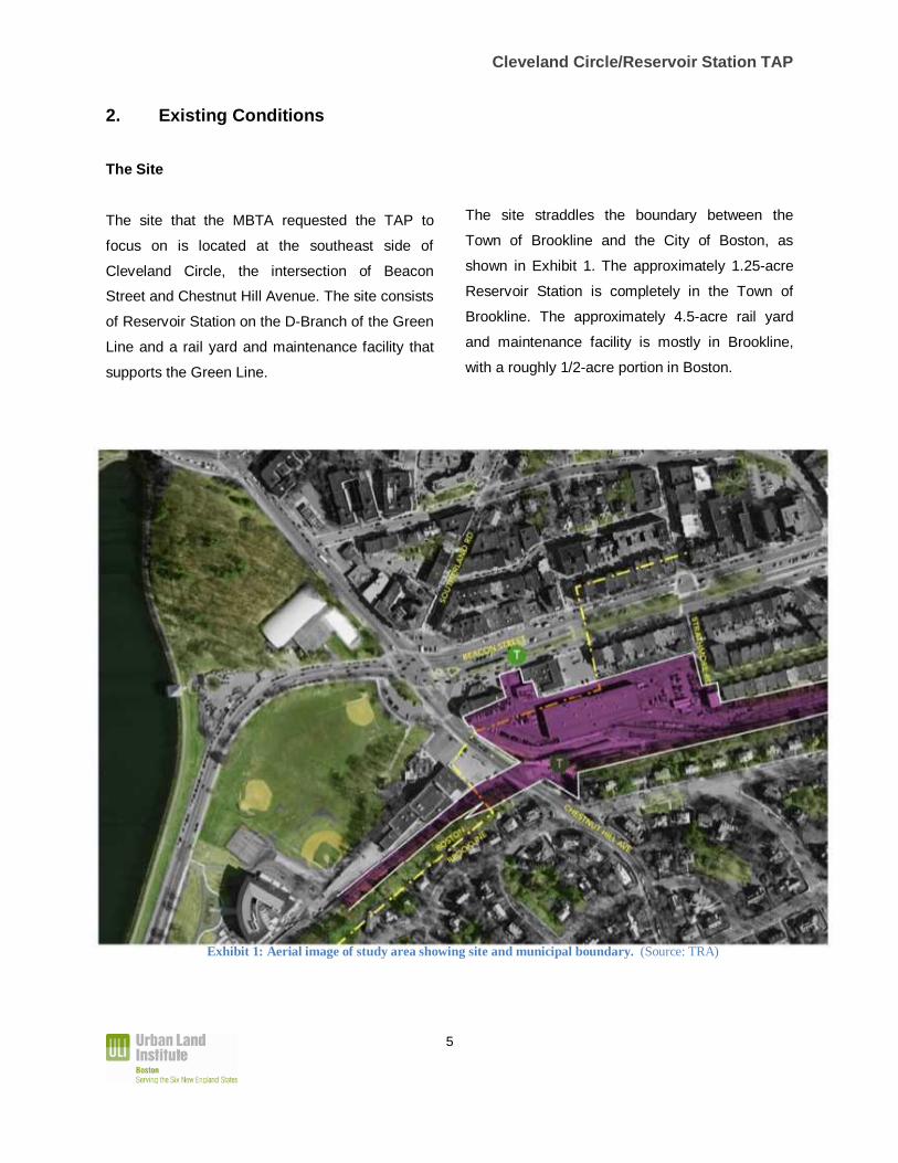
The site straddles the boundary between the
Town of Brookline and the City of Boston, as
shown in Exhibit 1. The approximately 1.25-acre
Reservoir Station is completely in the Town of
Brookline. The approximately 4.5-acre rail yard
and maintenance facility is mostly in Brookline,
with a roughly 1/2-acre portion in Boston.
Exhibit 1: Aerial image of study area showing site and municipal boundary. (Source: TRA)
Cleveland Circle/Reservoir Station TAP
6
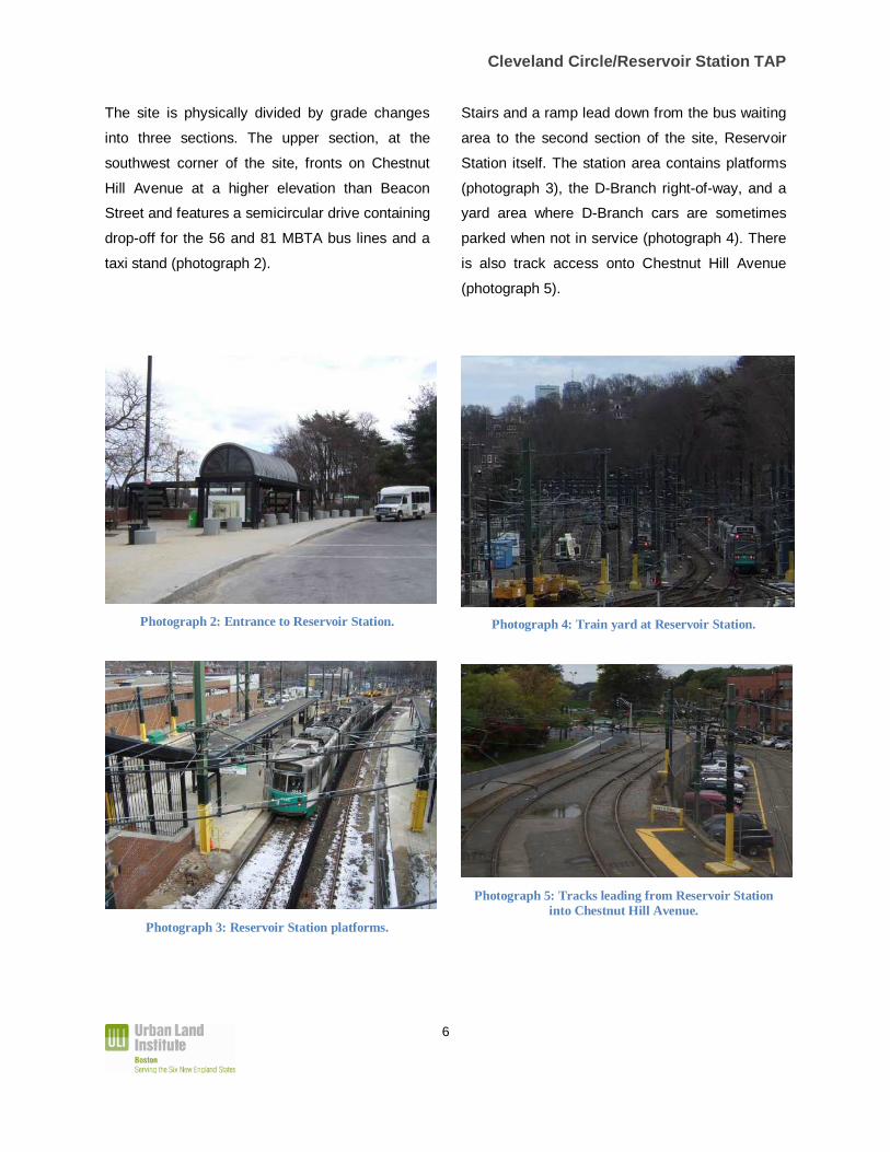
The site is physically divided by grade changes
into three sections. The upper section, at the
southwest corner of the site, fronts on Chestnut
Hill Avenue at a higher elevation than Beacon
Street and features a semicircular drive containing
drop-off for the 56 and 81 MBTA bus lines and a
taxi stand (photograph 2).
Photograph 2: Entrance to Reservoir Station.
Photograph 3: Reservoir Station platforms.
Stairs and a ramp lead down from the bus waiting
area to the second section of the site, Reservoir
Station itself. The station area contains platforms
(photograph 3), the D-Branch right-of-way, and a
yard area where D-Branch cars are sometimes
parked when not in service (photograph 4). There
is also track access onto Chestnut Hill Avenue
(photograph 5).
Photograph 4: Train yard at Reservoir Station.
Photograph 5: Tracks leading from Reservoir Station into Chestnut Hill Avenue.
Cleveland Circle/Reservoir Station TAP
7
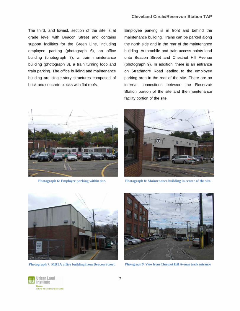
The third, and lowest, section of the site is at
grade level with Beacon Street and contains
support facilities for the Green Line, including
employee parking (photograph 6), an office
building (photograph 7), a train maintenance
building (photograph 8), a train turning loop and
train parking. The office building and maintenance
building are single-story structures composed of
brick and concrete blocks with flat roofs.
Photograph 6: Employee parking within site.
Photograph 7: MBTA office building from Beacon Street.
Employee parking is in front and behind the
maintenance building. Trains can be parked along
the north side and in the rear of the maintenance
building. Automobile and train access points lead
onto Beacon Street and Chestnut Hill Avenue
(photograph 9). In addition, there is an entrance
on Strathmore Road leading to the employee
parking area in the rear of the site. There are no
internal connections between the Reservoir
Station portion of the site and the maintenance
facility portion of the site.
Photograph 8: Maintenance building in center of the site.
Photograph 9: View from Chestnut Hill Avenue track entrance.
Cleveland Circle/Reservoir Station TAP
8
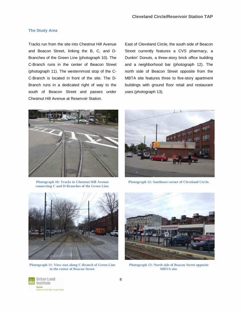
The Study Area
Tracks run from the site into Chestnut Hill Avenue
and Beacon Street, linking the B, C, and D-
Branches of the Green Line (photograph 10). The
C-Branch runs in the center of Beacon Street
(photograph 11). The westernmost stop of the C-
C-Branch is located in front of the site. The D-
Branch runs in a dedicated right of way to the
south of Beacon Street and passes under
Chestnut Hill Avenue at Reservoir Station.
Photograph 10: Tracks in Chestnut Hill Avenue connecting C and D-Branches of the Green Line.
Photograph 11: View east along C-Branch of Green Line in the center of Beacon Street.
East of Cleveland Circle, the south side of Beacon
Street currently features a CVS pharmacy, a
Dunkin’ Donuts, a three-story brick office building
and a neighborhood bar (photograph 12). The
north side of Beacon Street opposite from the
MBTA site features three to five-story apartment
buildings with ground floor retail and restaurant
uses (photograph 13).
Photograph 12: Southeast corner of Cleveland Circle.
Photograph 13: North side of Beacon Street opposite MBTA site.
Cleveland Circle/Reservoir Station TAP
9
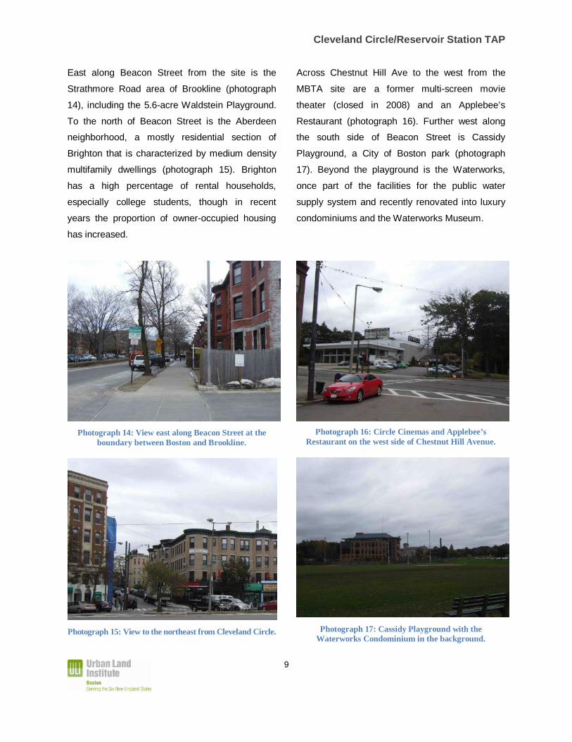
East along Beacon Street from the site is the
Strathmore Road area of Brookline (photograph
14), including the 5.6-acre Waldstein Playground.
To the north of Beacon Street is the Aberdeen
neighborhood, a mostly residential section of
Brighton that is characterized by medium density
multifamily dwellings (photograph 15). Brighton
has a high percentage of rental households,
especially college students, though in recent
years the proportion of owner-occupied housing
has increased.
Photograph 14: View east along Beacon Street at the boundary between Boston and Brookline.
Photograph 15: View to the northeast from Cleveland Circle.
Across Chestnut Hill Ave to the west from the
MBTA site are a former multi-screen movie
theater (closed in 2008) and an Applebee’s
Restaurant (photograph 16). Further west along
the south side of Beacon Street is Cassidy
Playground, a City of Boston park (photograph
17). Beyond the playground is the Waterworks,
once part of the facilities for the public water
supply system and recently renovated into luxury
condominiums and the Waterworks Museum.
Photograph 16: Circle Cinemas and Applebee’s
Restaurant on the west side of Chestnut Hill Avenue.
Photograph 17: Cassidy Playground with the Waterworks Condominium in the background.
Cleveland Circle/Reservoir Station TAP
10
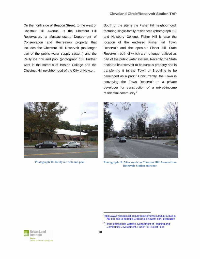
On the north side of Beacon Street, to the west of
Chestnut Hill Avenue, is the Chestnut Hill
Reservation, a Massachusetts Department of
Conservation and Recreation property that
includes the Chestnut Hill Reservoir (no longer
part of the public water supply system) and the
Reilly ice rink and pool (photograph 18). Further
west is the campus of Boston College and the
Chestnut Hill neighborhood of the City of Newton.
Photograph 18: Reilly ice rink and pool.
South of the site is the Fisher Hill neighborhood,
featuring single-family residences (photograph 19)
and Newbury College. Fisher Hill is also the
location of the enclosed Fisher Hill Town
Reservoir and the open-air Fisher Hill State
Reservoir, both of which are no longer utilized as
part of the public water system. Recently the State
declared its reservoir to be surplus property and is
transferring it to the Town of Brookline to be
developed as a park.1 Concurrently, the Town is
conveying the Town Reservoir to a private
developer for construction of a mixed-income
residential community.2
Photograph 19: View south on Chestnut Hill Avenue from Reservoir Station entrance.
1http://www.wickedlocal.com/brookline/news/x2025176739/Fis
her-Hill-site-to-become-Brookline-s-newest-park-eventually 2 Town of Brookline website, Department of Planning and
Community Development, Fisher Hill Project Files

Cleveland Circle/Reservoir Station TAP
11
Historic Context
Until the second half of the 19th Century, the study
area was rural in character.
Starting in the 1850s, rail service was extended
through Brookline into Newton. The railway
curved around the north side of Fisher Hill with a
stop placed on Chestnut Hill Avenue close to the
intersection of Beacon Street. After a century of
operation under private railroad companies, this
line became part of the Metropolitan Transit
Authority, precursor to the MBTA, and is the
current D-Branch of the Green Line.
In the 1860s, the Chestnut Hill Reservoir was
constructed to provide a single storage facility for
Boston’s municipal water supply. Parkland was
later created around the reservoir.3
In the late 1880s, Frederick Law Olmsted was
commissioned to redesign Beacon Street through
Brookline. Olmsted’s plan tripled the width of the
street, which had been a 50-foot wide country
way, in order to accommodate a branch of the
West End Street Railway, now the C-Branch of
the Green Line. Olmsted’s plan also created a
circle at the intersection of Beacon Street and
Chestnut Hill Avenue, which thus became
Cleveland Circle. 4
3 http://www.mass.gov/dcr/parks/metroboston/chesHistory.htm
4 Cynthia Ridgway Zaitzevsky, "Frederick Law Olmsted and the Boston Park System”, Belknap Press, Cambridge MA 1982, page 111.
These infrastructure improvements, particularly
the introduction of streetcar service along Beacon
Street, spurred development of the surrounding
neighborhoods and the stretch of Beacon Street
closest to Cleveland Circle became a commercial
node. In the 1880s, Olmsted laid out the Fisher
Hill neighborhood, to the south.5 The Aberdeen
neighborhood, to the north, developed in the
1880s and 1890s.6
The Chestnut Hill Reservoir, Fisher Hill, Beacon
Street and Strathmore Road are all designated on
the National Register of Historic Places. The
Aberdeen neighborhood has been designated by
the City of Boston as a Local Historic District.
5http://www.brooklinehistoricalsociety.org/history/fisherHill.asp
6 http://www.bahistory.org
Cleveland Circle/Reservoir Station TAP
12
3. Issues
During the stakeholder interviews, the panel heard
a number of concerns relating to the current use
and potential development of the site and the
study area. In addition, as a part of its document
review, research and site visit, the panel identified
critical issues that would have to be addressed as
part of the development process. These issues
and concerns are summarized below.
Site Operations
MBTA transit services are a valued amenity for
the community and the operations conducted on
the site are critical for the MBTA. The site includes
maintenance, cleaning and parking facilities that
are essential for operations of the Green Line.
However, the current use of the site has negative
aspects from the point of view of the surrounding
community: visual aesthetics of the site are not
pleasing; noise of train operations is disturbing;
and the use of the adjacent roadways for train
access causes traffic disruption.
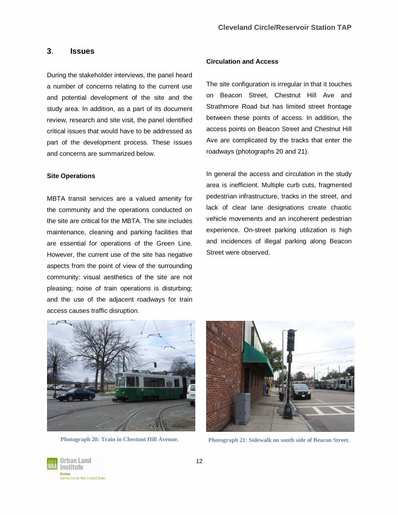
Photograph 20: Train in Chestnut Hill Avenue.
Circulation and Access
The site configuration is irregular in that it touches
on Beacon Street, Chestnut Hill Ave and
Strathmore Road but has limited street frontage
between these points of access. In addition, the
access points on Beacon Street and Chestnut Hill
Ave are complicated by the tracks that enter the
roadways (photographs 20 and 21).
In general the access and circulation in the study
area is inefficient. Multiple curb cuts, fragmented
pedestrian infrastructure, tracks in the street, and
lack of clear lane designations create chaotic
vehicle movements and an incoherent pedestrian
experience. On-street parking utilization is high
and incidences of illegal parking along Beacon
Street were observed.
Photograph 21: Sidewalk on south side of Beacon Street.

Cleveland Circle/Reservoir Station TAP
13
Traffic
Traffic conditions around Cleveland Circle are a
major concern of the local community. Beacon
Street is a major arterial spine through the length
of Brookline. Chestnut Hill Avenue connects
Boylston Street, Beacon Street, Commonwealth
Avenue and Brighton Center. As a result existing
pass-through traffic volumes are heavy. Recent
traffic analysis indicates that the Cleveland Circle
intersection currently operates at a Level of
Service “F” during both the a.m. and p.m. peak
hours, resulting in long queues of traffic in all
directions. (photograph 22)
The community is concerned that additional
development would exacerbate congestion. In
addition, the community is concerned that
changes to Cleveland Circle that could reduce
congestion at the intersection would merely push
traffic flows into the adjacent neighborhoods.
Photograph 22: Traffic in Cleveland Circle; tracks and lack of clear lane designations add to poor traffic flow.
Streetscape
The existing streetscape in the study area is poor.
Linkages between quadrants of Cleveland Circle
are difficult to navigate. Sidewalks are of
inconsistent width and quality. Bicycle
accommodations are lacking.
In addition, the City of Boston has indicated its
dissatisfaction with the street edge along the
south side of Beacon Street. The existing uses
are internally oriented or face off-street surface
parking. The street front consists mostly of
extensive blank brick walls (photograph 23).
Photograph 23: The south side of Beacon Street is characterized by plain brick facades; a train is visible
parked in the entrance to the MBTA site.

Cleveland Circle/Reservoir Station TAP
14
Neighborhood Change
The cinema on Chestnut Hill Avenue is closed
and is being marketed for sale. The future of the
adjacent Applebee’s restaurant may also be
uncertain. Local residents feel that the commercial
vitality of Cleveland Circle is fragile and hope that
it will become a more vibrant commercial center
such as Coolidge Corner, further east along
Beacon Street. They are also concerned that any
future development could conflict with existing
neighborhood character in density or height.
Furthermore, household character of future
development is a potential concern because of the
existing dynamic between owner-occupant and
student-renter populations.
Process and Jurisdictional Complexity
The interplay of the MBTA (a state entity) and the
two municipalities, Boston and Brookline, with a
boundary that cuts across the site and across
Beacon Street creates challenges that have
slowed the process of change. Local residents
have expressed frustration that several planning
studies have been conducted without
implementation and/or apparent coordination
between Boston and Brookline. Furthermore,
residents are skeptical of the MBTA’s commitment
to addressing community concerns.

Cleveland Circle/Reservoir Station TAP
15
4. Opportunities
In addition to the issues described in the previous
section, the panel also identified opportunities that
it feels are important to highlight.
Site Control
The MBTA site is a sizeable property owned by a
single entity with public authority to fund and
implement a development plan.
Impetus for Action
The Town of Brookline and the City of Boston
have both shown interest in enhancing Cleveland
Circle. As evidenced by its request for this TAP,
the MBTA is motivated to explore alternative uses
for the site. Many of the goals and visions of the
three jurisdictions are aligned. In addition, current
conditions, such as the closure of the cinema on
the west side of Chestnut Hill Avenue, have
created the opportunity to more readily redevelop
a larger portion of the study area.
Transit Oriented Context
The site is ideally located to build upon existing
urban form. Bisecting Brookline, Beacon Street is
a traditional streetcar boulevard connecting a
series of transit-oriented commercial nodes
(Audubon Circle, Coolidge Corner, Washington
Square, Cleveland Circle). At Cleveland Circle,
the presence of three branches of the Green Line
in close proximity is a significant opportunity for
transit-oriented-development.
Precedent
The MBTA has attempted similar redevelopment
projects. For example, the Ashmont Station was
recently reconfigured with new subway platforms,
lobbies, bus way and trolley way in such a way to
permit a portion of the site to be developed with a
new building featuring 116 units of mixed income
housing and street front retail (Exhibit 2). This
project was accomplished through a public-private
partnership and with important community input.
The MBTA can draw lessons from this, and other
projects, to inform its decision-making at the
Cleveland Circle/ Reservoir Station site.
Exhibit 2: Rendering of new Ashmont Station and associated development. (Source: MBTA)

Cleveland Circle/Reservoir Station TAP
16
5. Alternatives
The future of MBTA operations defines the nature
of alternatives for the site. How or where the
current uses are accommodated is therefore the
starting point for considering future uses.
If there were to be no change to current MBTA
operations, any future development would have to
be accommodated through air-rights development
on a deck built over the existing facility. Initial
analysis indicates that the construction cost
premium for an elevated deck is prohibitive,
mostly because of limitations on construction
activity imposed by the need to maintain
unimpeded MBTA activities during construction,
the site constraints on construction staging and
storage, and design features necessary to build
over an active rail line.
The panel estimated that a deck over the MBTA
facilities would cost approximately $400 per
square foot. Regardless of the use type, in order
to make development economically viable on a
base at that cost, the new structure would have to
be somewhat in excess of 8 stories. This assumes
the land would be contributed by the MBTA at no
cost and the value of the development would
support a land use of $25-50 per square foot of
leasable space.
Development at this scale would be incompatible
with the desires of the community and the policy
vision of Boston and Brookline. Development at
the necessary height to achieve economic returns
from air rights would exceed existing regulatory
constraints and would not fit within the established
urban context. As such, the panel does not
recommend a pure air rights project.
Alternatively, MBTA operations could be
reconfigured or relocated, creating developable
space on the site not requiring a deck.
Additionally, the MBTA could assemble adjacent
parcels, such as that at the corner of Beacon
Street and Chestnut Hill Avenue, which the MBTA
property wraps around, and/or the Circle Cinema
site across Chestnut Hill Avenue, in order to
create enough site area for a viable project.
If the MBTA was able to reposition existing
operations and acquire adjacent parcels,
development could take a more sophisticated
form. Multiple structures with different uses could
be accommodated within a framework of streets
or alleys that would connect Beacon Street with a
new Reservoir Station (Exhibits 3 and 4). The
panel also considered the possibility of
redesigning Cleveland Circle and Beacon Street
in order to improve traffic flow and reduce conflict
between automobiles and trains. Potential
redesigns could feature a submerged station at
the end of the C-Branch, allowing for physical
separation of trains and automobiles and more
substantial station amenities to be built (Exhibit 5).

Cleveland Circle/Reservoir Station TAP
17
Exhibit 4: Conceptual plan for site and adjacent properties with relocation of MBTA maintenance facility
Exhibit 3: Conceptual plan for site and adjacent properties with modification of MBTA maintenance facility
Exhibit 5: Cross section of potential underground station for Cleveland Circle

Cleveland Circle/Reservoir Station TAP
18
6. Recommendations
After considering the issues, opportunities and
alternatives outlined previously, the panel
developed a set of recommendations in reference
to the MBTA’s use of the site and also for the
MBTA, City of Boston and Town of Brookline in
assessing the future of the study area.
Inter-Jurisdictional Cooperation
While past studies have developed strong design
concepts, they have not developed new
processes to effect change. The panel believes
that past studies of Cleveland Circle have not
been successfully implemented because the focus
has been too narrow and larger issues of vision
and process have not been adequately
addressed. The panel believes that in order to
unlock the full potential for redevelopment of the
study area, obstacles to inter-jurisdictional
cooperation must be addressed. Cooperation and
coordination between the MBTA, the City of
Boston and the Town of Brookline is essential.
Specifically there needs to be a new mechanism
to deal with cross-jurisdictional planning,
infrastructure and entitlement and to coordinate
development efforts through one area master
plan. The situation calls for oversight by a ‘higher
power’ than the municipal level. As such the panel
recommends the creation of a jointly-sponsored
master planning process with Boston,
MBTA/Mass DOT, and Brookline that would
address planning, permitting, governance and
cost/revenue sharing.
Design Principles
The community representatives who were
interviewed indicated preferences for a mixed-use
project that provided amenities to the local
community without generating substantial new
impacts. While the panel discussed different
potential land uses, no specific use was selected
as the preferred alternative. Rather, the panel felt
that any proposed uses should conform to the
following set of principles:
• Development plans should be transit-oriented
and seek to minimize traffic impact on
Cleveland Circle, which already operates at a
Level of Service F.
• Proposed uses should connect the site with
the community and provide amenities to
exiting residents without significant burdens.
• MBTA passenger experience should be
enhanced, including better waiting facilities at
the Cleveland Circle Station and greater
connectivity between Cleveland Circle and
Reservoir Stations.
• Neighborhood character and historic context
should not be impaired and massing and
height at street edge should be consistent.
Cleveland Circle/Reservoir Station TAP
19
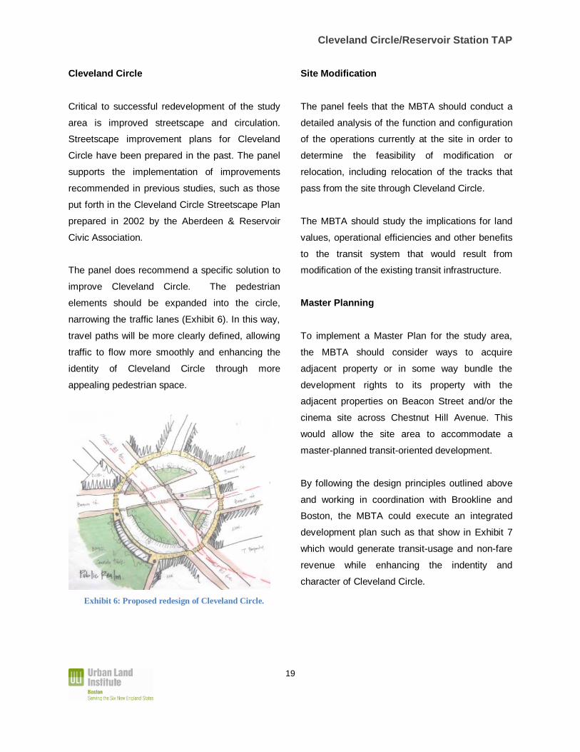
Cleveland Circle
Critical to successful redevelopment of the study
area is improved streetscape and circulation.
Streetscape improvement plans for Cleveland
Circle have been prepared in the past. The panel
supports the implementation of improvements
recommended in previous studies, such as those
put forth in the Cleveland Circle Streetscape Plan
prepared in 2002 by the Aberdeen & Reservoir
Civic Association.
The panel does recommend a specific solution to
improve Cleveland Circle. The pedestrian
elements should be expanded into the circle,
narrowing the traffic lanes (Exhibit 6). In this way,
travel paths will be more clearly defined, allowing
traffic to flow more smoothly and enhancing the
identity of Cleveland Circle through more
appealing pedestrian space.
Exhibit 6: Proposed redesign of Cleveland Circle.
Site Modification
The panel feels that the MBTA should conduct a
detailed analysis of the function and configuration
of the operations currently at the site in order to
determine the feasibility of modification or
relocation, including relocation of the tracks that
pass from the site through Cleveland Circle.
The MBTA should study the implications for land
values, operational efficiencies and other benefits
to the transit system that would result from
modification of the existing transit infrastructure.
Master Planning
To implement a Master Plan for the study area,
the MBTA should consider ways to acquire
adjacent property or in some way bundle the
development rights to its property with the
adjacent properties on Beacon Street and/or the
cinema site across Chestnut Hill Avenue. This
would allow the site area to accommodate a
master-planned transit-oriented development.
By following the design principles outlined above
and working in coordination with Brookline and
Boston, the MBTA could execute an integrated
development plan such as that show in Exhibit 7
which would generate transit-usage and non-fare
revenue while enhancing the indentity and
character of Cleveland Circle.

Cleveland Circle/Reservoir Station TAP
20
Exhibit 7: Concept plan of master-planned redevelopment of the site and adjacent parcels.