Report of Geotechnical Investigation · Report of Geotechnical Investigation OF ... and transported...
31
DROCK CONSULTING Report of Geotechnical Investigation OF SH 55 over Big Elk Creek Washita County, Oklahoma 26479 (04) Prepared For: H.W. Lochner, Inc. 51 O East Memorial Road, Suite A-1 Oklahoma City, Oklahoma 73114 Attn: Mr. Brent Bolerjack, PE Prepared By: Red Rock Consulting, LLC PO Box 30591 Edmond, Oklahoma 73003 (405) 562-3328 March 2/2012 Project No. 11064
Transcript of Report of Geotechnical Investigation · Report of Geotechnical Investigation OF ... and transported...

DROCK CONSULTING
Report of Geotechnical Investigation
OF
SH 55 over Big Elk Creek Washita County, Oklahoma
26479 (04)
Prepared For:
H.W. Lochner, Inc. 51 O East Memorial Road, Suite A-1 Oklahoma City, Oklahoma 73114
Attn: Mr. Brent Bolerjack, PE
Prepared By:
Red Rock Consulting, LLC PO Box 30591
Edmond, Oklahoma 73003 ( 405) 562-3328
March 2/2012 Project No. 11064

RED ROCK CONSULTING
March 02, 2012
H.W. Lochner, Inc. 510 East Memorial Road, Suite A-1 Oklahoma City, Oklahoma 7.3114
Attention: Mr. Brent Bolerjack, PE
Re: Report of Geotechnical Investigation SH 55 over Big Elk Creek Washita County, Oklahoma 26479(04) Project No. 11064
Dear Mr. Bolerjack,
Red Rock Consulting is pleased to submit herewith this report entitled "Report of Geotechnical Investigation, SH 55 over Big Elk Creek, Washita County, Oklahoma; 26479(04)."
In an effort to provide a more environmentally friendly service, this report has been printed double sided on 100% recycled paper.
It has been our pleasure to assist you with this project. Should you have any questions regarding the contents of this report, please contact us at your convenience.
Yours very truly, RED ROCK CONSUL TING, LLC CA No. 5707 Exp. 06/30/13
g~;,,~ O~ason T. Unruh, El
Project Specialist
~'K~~ Kristi K. Bumpas, PE, LEED AP Project Engineer
P.O. BOX 30591 •EDMOND. OK 73003 • 405-562-3328 • WWW.REDROCKGEO.COM

REPORT OF GEOTECHNICAL INVESTIGATION
STATE HIGHWAY 55 OVER BIG ELK CREEK WASHITA COUNTY, OKLAHOMA
BRFY-175C(106)SS 26479(04)
PROJECT NO. 11064
INTRODUCTION ........................................................................................................................................ 1
GENERAL. ....................................................................................................................... 1 PROPOSED CONSTRUCTION ............................................................................................ 1 SCOPE OF WORK ............................................................................................................ 1
FIELD AND LABORATORY INVESTIGATIONS ................................................................................. 2
FIELD EXPLORATION ....................................................................................................... 2 LABORATORY TESTING .................................................................................................... 3
SITE DESCRIPTION .................................................................................................................................. 4
SURFACE CONDITIONS .................................................................................................... 4 SITE GEOLOGY ............................................................................................................... 4 SUBSURFACE CONDITIONS .............................................................................................. 5 SOLUBLE SULFATES ........................................................................................................ 6 GROUNDWATER CONDITIONS .......................................................................................... 6
ENVIRONMENTAL CONSIDERATIONS ............................................................................................... 8 CLOSURE ..................................................................................................................................................... 9
APPENDICES
APPENDIX A - Field Investigation APPENDIX B - Laboratory Results APPENDIX C - General Notes

INTRODUCTION
General
REPORT OF GEOTECHNICAL INVESTIGATION
STATE HIGHWAY 55 OVER BIG ELK CREEK WASHITA COUNTY, OKLAHOMA
BRFY-175C(106)SS 26479(04)
PROJECT NO. 11064
This report presents the results of the geotechnical investigation performed for the replacement of the triple span bridge over Big Elk Creek located along State Highway 55 approximately 5.1 miles east of the Beckham County line in Washita County, Oklahoma. The purpose of this investigation is to evaluate the subsurface conditions at the site and to provide information pertaining to the geotechnical aspects of the proposed project.
Proposed Construction
The project will include the replacement of the triple span bridge with a four span bridge including new piers, abutments and approaches along the current alignment.
Scope of Work
The scope of this investigation includes the following:
1. Review of previous geotechnical and geological information of sites near this site. This was augmented with data obtained during the field investigation phase of the project.
2. Investigation of the subsurface soils by drilling and testing a total of 5 boreholes within the planned project area.
3. A laboratory testing program consisting of moisture content, Atterberg limits, sieve analysis and soluble sulfate testing on the soils encountered. Water testing was also performed on water samples collected from the project site.
4. Additional considerations for sustainable design and construction pertaining to aspects of this project.
SH 55 over Big Elk Creek, Washita Co. BRFY-175C(106)SS; 26479(04) RRC Project No. 11064 March 2, 2012
FIELD AND LABORATORY INVESTIGATIONS
Field Exploration
Subsurface exploration was performed February 2 through February 8, 2012. The borings were located in the field by a representative of Red Rock Consulting by measuring distances from known site reference points as depicted on plans provided by HW Lochner. The locations of the borings should be considered accurate only to the degree implied by the methods used to define them.
The subsurface exploration program consisted of drilling 5 borings under the full time supervision of an engineer. One boring was drilled at each of the abutment locations and at the three pier locations. The boring locations are shown on the boring location diagram, which is included in Appendix A.
The borings were drilled 30 feet into bedrock following Standard Penetration Test (SPT) refusal at the surface of the bedrock. The borings were advanced using wet rotary drilling methods from an all-terrain CME-75 drill rig equipped with an automatic hammer. Samples of the overburden materials were obtained in the borings as per Oklahoma Department of Transportation (ODOT) specifications. Representative samples were obtained by split-barrel sampling procedures (Standard Penetration Test, SPT) in general accordance with ASTM Specifications D-1586. After SPT refusal was attained, the hardness of bedrock was evaluated using a Texas Cone Penetrometer in accordance with the AASHTO Manual on Subsurface Investigation and as modified by the Oklahoma Department of Transportation.
The SPT test uses a standard, 2-inch O.D., split-barrel sampling spoon that is driven into the bottom of the boring with a 140 pound automatic drive hammer that falls 30 inches. The blows per foot, N, is the number of hammer blows required to advance the sampling spoon the last 12 inches, or less, of an 18-inch sampling interval. The N value is used to estimate the in-situ relative density of granular soils, the consistency of cohesive soils, and the hardness of weathered bedrock.
The Texas Highway Department cone penetrometer test is a standard test developed by the Texas Highway Department to evaluate the consistency or hardness of the bedrock material. The Texas Cone Penetrometer (TCP) test drives a penetrometer cone into the bedrock material with a 140 pound automatic drive hammer that falls 30 inches. The TCP is driven for a series of blows, the first being seating blows, followed by two 50 blow counts. After 50 blows of the automatic hammer, the distance the TCP has advanced is measured and recorded. The distance the TCP is driven is used to estimate the hardness of bedrock.
2

SH 55 over Big Elk Creek, Washita Co. BRFY-175C(106)SS; 26479(04) RRC Project No. 11064 March 2, 2012
After performing SPT and TCP tests, the holes were backfilled with grout and cuttings as required by the Oklahoma State Statutes for Geotechnical drilling.
Samples were collected and transported back to the lab for further classification and testing. The final boring logs were developed from the draft logs, observations and test results of the samples returned to the laboratory. The stratigraphic contacts indicated are only for the specific dates and locations reported, and therefore, are not necessarily representative of other locations and times. The boring logs, presenting conditions encountered at each location explored, are included in Appendix A.
Laboratory Testing
Representative soil samples were tested to refine the field classifications and evaluate physical properties of the soils which may affect the geotechnical aspects of project design and construction.
The laboratory testing program included the following:
• Liquid and Plastic Limits (ASTM 04318)
• Washed No. 200 US Standard Sieve test (ASTM 01140) • Moisture content tests (ASTM 02216) • Soluble Sulfate Content (OHO L-49)
• Soil Classification (ASTM 02487)
The results of the physical laboratory tests conducted are shown on the boring logs in Appendix A and included in Appendix B.
Water testing was also performed on two samples from the project site. One sample was collected from surface water of the creek and another sample was collected from boring B-1 at a depth of approximately 22.7 feet below existing grade. Water samples were evaluated for chloride, sulfate content and pH level. The analytical results are provided in Appendix B.
3

SH 55 over Big Elk Creek, Washita Co. BRFY-175C(106)SS; 26479(04) RRC Project No. 11064 March 2, 2012
SITE DESCRIPTION
Surface Conditions
At the time of this investigation, an existing triple span bridge was present along the alignment of SH-55 over Big Elk Creek.
The creek banks were lined with tall weeds and moderately sized trees. The creek was approximately 25 feet wide and was approximately 25 feet below the existing bridge. The water in the creek was approximately 3 feet deep and was flowing slowly.
The boring locations were covered with grass and were relatively flat. Bull dozer work was not required for access to the boring locations. The boring locations were dry at the time of drilling and the ATV drill rig did not experience difficulty moving around the site.
The surface elevations were determined using differential leveling procedures. Benchmark number 16, a chiseled square on the south wing wall at the west end of the existing bridge, was used as the benchmark. According to the plans provided by HW Lochner, the benchmark is at station 119+52.77, offset 16.23 feet right of the construction reference line (CRL) of the proposed bridge and had an elevation of 1636.19 feet. This benchmark elevation differs from the benchmark elevation on the provided plans, but was subsequently provided by HW Lochner. Based on this benchmark, the elevations of the borings ranged from 1627.3 to 1636.2 feet. All station numbers and offsets, including the benchmark location and elevation, are approximate and were estimated from the plans provided by HW Lochner. The approximate elevation at each boring location is shown on the boring location diagram and on the boring logs in Appendix A.
Site Geology
Division Five of the "Engineering Classification of Geological Materials", published by the Oklahoma Department of Transportation (ODOT) indicates the project site consists of alluvium (Qas) underlain by the Cloud Chief (Pee) unit.
Alluvium consists of deposits of sand, silt, clay, gravel, and/or combinations of materials. Alluvium is found along the flood plains (bottom land) of streams and is normally present at places along all streams.
The Cloud Chief unit consists of a heterogeneous mixture of gypsum, sandstone, reddish-orange shale, and dolomite. The unit overlies the sandstones of the Rush Springs unit and underlies the red shales and siltstones of the Doxey unit. A 1 to 9 feet
4

SH 55 over Big Elk Creek, Washita Co. BRFY-175C(106)SS; 26479(04) RRC Project No. 11064 March 2, 2012
thick bed of gypsum or dolomite, of greenish-gray color called the Moccasin Creek bed marks the base of the unit. Gypsums are prominent near the base and thin rapidly from a maximum thickness of 118 feet in central Washita County to less than 9 feet in Custer County, 7 feet in Roger Mills county, and 6 feet in Beckham County. A dolomite (Day Creek) bed occurs 25 to 50 feet above the base of the unit in parts of Dewey and Custer Counties. Here, it varies in thickness from zero to ten feet. The total thickness of the unit is variable.
In Division 5, the Cloud Chief unit outcrops in an irregular U-shaped pattern near the center of the Anadarko Basin in Beckham, Washita, Custer, Dewey, and Roger Mills Counties.
Topographically, the Cloud Chief unit is usually gently rolling. It supports grass vegetation and cultivation. Buttes, mesas, and highly dissected canyons are common locally near the base unit in the thicker gypsum areas and near drainage systems. The gypsums generally support the growth of short grass, cacti, prickly pear, and mesquite.
Subsurface Conditions
Information collected during this investigation indicates that the overburden materials consist of various combinations of silt, sand, lean clay and fat clay that extended from the surface to the top of bedrock, which ranged between 57.5 and 84.5 feet in the borings.
The overburden materials in all of the borings was underlain by well cemented to very well cemented siltstone that extended to the boring termination depths, which ranged between 88 and 116 feet. Depth to bedrock is summarized in Table 1.
Table 1- Depth to Bedrock
····Depth 1:o B.edrock · .. Boring (feet)
B-1 57.5 B-2
B-3
B-4
B-5
67.5
77
83
84.5
- --- . - - -·---- _,
> Elevation , . (feet)
1578.3
1561.5
1550.3
1553.2
1551.6
Subsurface conditions are described in greater detail on the boring logs in Appendix A.
5

SH 55 over Big Elk Creek, Washita Co. BRFY-175C(106)SS; 26479(04) RRC Project No. 11064 March 2, 2012
Soluble Sulfates
Sulfates are naturally occurring in some soils. If combined with calcium based materials, such as cement, lime, fly ash and cement kiln dust, sulfate rich soils can expand up to 250 percent of the original size when exposed to moisture.
Based on soluble sulfate test results, low to high levels of soluble sulfates were encountered in boring B-2. Levels encountered ranged from 373 ppm to 4,933 ppm. Soluble sulfate levels are included in the laboratory results in Appendix B.
A level of "less than 200 ppm" is the lowest and "greater than 8,000 ppm" is the highest reportable level when using the colorimeter method OHO L-49. Soluble sulfate levels less than 3,000 ppm are considered to be too low to be of concern when considering the use of calcium based construction materials. Soluble sulfate levels in excess of 8,000 ppm are considered to be high risk.
Soluble sulfates levels for sections of this project site were between 3,000 and 5,000 I ppm. Therefore, this site should be considered moderate risk. Calcium-based materials can still be used in the concrete mix or to stabilize the subgrade soils. Extra caution must be used when designing the mix and during construction. A contractor experienced in construction in sulfate soils should be considered for this project.
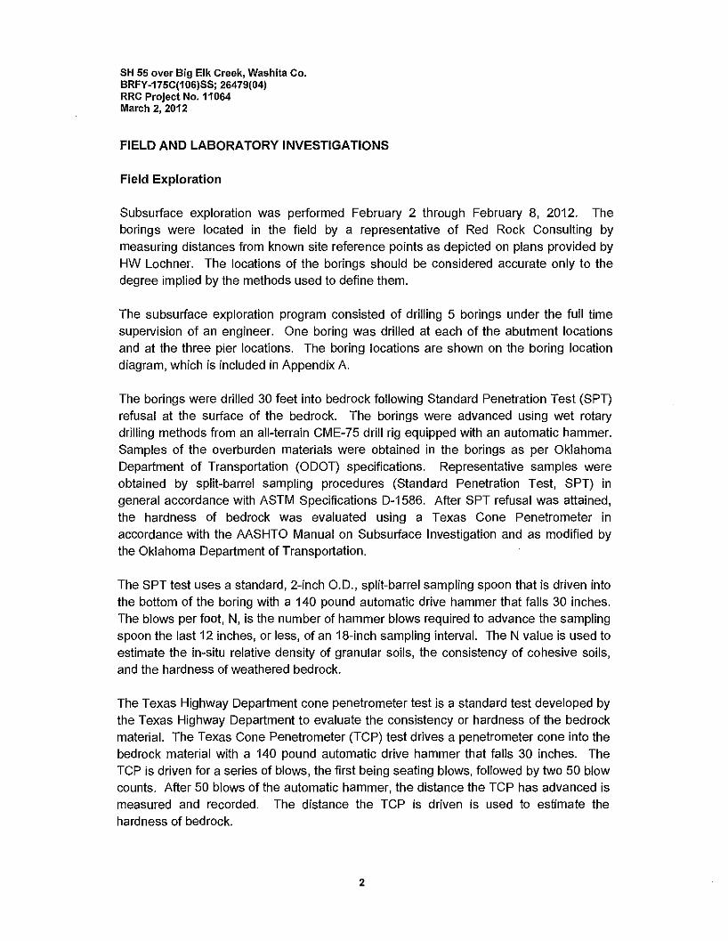
Groundwater Conditions
Groundwater conditions and cave in depths were monitored in the borings following drilling operations and also after a delay of at least 24 hours after the completion of drilling. The groundwater levels and cave-in depths are outlined in Table 2. Cave-in depths can be an indicator of the actual groundwater depth.
It should be noted that water levels measured during drilling may not be precise due to the nature of wet rotary drilling.
To obtain more accurate groundwater level information, long-term observations in a well or piezometer that is sealed from the influence of surface water would be needed. Fluctuations in groundwater levels can occur due to seasonal variations in the amount of rainfall, runoff, altered drainage paths, and other factors not evident at the time borings were advanced. Consequently, the contractor should be aware of these possibilities while constructing this project.
6
SH 55 over Big Elk Creek, Washita Co. BRFY-175C(106)SS; 26479(04) RRC Project No.11064 March 2, 2012
Table 2 - Approximate Groundwater Levels Cave-in Depths ·.·.·-' ' -- .-. --__ ---: _- :-_-:-·-.-.-:-:-: --:---: :-: :---_ - -: - .·. . . .
0 ""3 H<lurs.After• Drilling ·•.· 24-432.HoursA~er Drilling
Depth .. Ele~~tion (feet) (feet)
": ·• --- ----- ' ·- .
Depth ····•·· Ell!vatiol) (feet) (feE!tJ
Boring Weiter .. ..
.•Water· Water Cpyecin Water • Ccive~iil
B-1 20 1615.8 22.7 23 1613.1 1615.8
B-2 15.5 1613.5 18.5 20 1610.5 1609
B-3 18 1609.3 * 16.3 * 1611
B-4 22 1614.2 21 22.5 1615.2 1613.7
B-5 18 1618.1 20.8 21.3 1615.3 1614.8 *The 288 hour water in boring B-3 was not present due to cave-in of the hole
Water testing was performed on two samples collected from the project site. The surface sample was taken from the creek which was flowing under the bridge. The other was taken from boring B-1 at a depth of approximately 22.8 feet below the ground surface, which was below the surface of the water level and above the cave in depth. The samples were tested for chlorides, sulfates, and pH level. Water testing results are included in Appendix B.
7
SH 55 over Big Elk Creek, Washita Co. BRFY-175C(106)SS; 26479(04) RRC Project No.11064 March 2, 2012
ENVIRONMENTAL CONSIDERATIONS
The environmental effect of construction projects is a growing concern in our industry. Some points for consideration of the environment regarding site construction and construction materials are summarized in the following paragraphs. These points should be incorporated into the design and construction of this project for a more environmentally friendly result. The following is only a summary. For a more in-depth discussion on sustainable design and construction, please contact Red Rock Consulting.
Site Construction
SEDIMENTATION AND EROSION CONTROL
Reduce pollution from construction activities by controlling soil erosion, waterway sedimentation, and airborne dust generation. This can be accomplished most efficiently by using seeding or mulching and silt fence.
• Seeding or Mulching - If the excavated site is left open for an extended amount of time, soil erosion should be retarded by using seeding or mulching to cover and hold the soils.
• Silt Fence - Prevent sedimentation of receiving streams by constructing silt fence (posts with a filter fabric media) around the project site. The silt fence is used to remove sediment from stormwater that may runoff the construction site.
Construction Materials
LOCAL MATERIALS
Increase the demand for building materials and products that are extracted and manufactured within the region, thereby supporting the use of indigenous resources and reducing the environmental impacts resulting from transportation of materials. Examples of local materials that could be considered in the construction of this project include water, recycled steel, concrete and/or aggregate and sand.
RECYCLED MATERIALS
Reuse building materials and products in order to reduce demand for virgin materials and to reduce waste, thereby reducing impacts associated with the extraction and processing of virgin resources. Examples of recycled materials that could be considered in the construction of this project include recycled steel piles, concrete and aggregate.
8

SH 55 over Big Elk Creek, Washita Co. BRFY-175C(106)SS; 26479(04) RRC Project No.11064 March 2, 2012
CLOSURE
The data presented in this report are based on site conditions as they existed at the time of the field exploration. The conditions encountered in the exploratory borings are representative subsurface conditions within the study area.
This report was prepared for the exclusive use of HW Lochner, ODOT and their agents and consultants. It should be made available to prospective contractors for information and factual data only and not as a warranty of subsurface conditions similar to those interpreted from the boring logs or discussions presented herein.
9
APPENDIX A

-'1------'_r:::-
. I --7-4---. / \ Ii I
\ ls-a-o'n ; .. Jdoe \ SfC)....._~18-9~7'7)
\seq in A:io;-.:;ac~\ Ste. i 18-+S:t .~·
Benchmark #16: Chiseled square in south wing wall
at west end of existing bridge Offset = 16.23 feet Right Station = 119+52.77 Elevation = 1236.19
APPROXIMATE BORING LOCATIONS AND ELVATION Boring Station Offset
B-1 118+77 27.5' Left of CRL
B-2 120+18 28' Right of CRL
B-3 121+11 32' Left of CRL
B-4 122+13 24' Right of CRL
B-6 123+07 22' Left of CRL
Construction Reference Line used to approximate offset Plans provided by HW Lochner
Elevation
1635.8' 1629'
1627.3'
1636-2'
1636.1'
; --
RED ROCK CONSULTING
P.O. Box 30591 Edmond, Oklahoma 73003
Phone: 405 562-3328 BORING LOCATION DIAGRAM
SH 55 OVER BIG ELK CREEK WASHITA COUNTY, OKLAHOMA BRFY-175C 106 SS: 26479 04
Projoct MnlJI"' KKB P!<>joct N11- 11064 Dal;nod By: KKB Scalo: NOT TO SCALE
KK6 Doto: 2/24/12

RED ROCK 7042 Highwater Circle BORING NUMBER B-1
C 0 NS U l TI NG Edmond,Ok73034 PAGE 1 OF 2
Telephone: (405)562-3328
CLIENT HW Lochner PROJECT NAME SH 55 over Big Elk Creek,
PROJECT NUMBER 11064 PROJECT LOCATION Washita Coun~, Oklahoma
DATE STARTED 212112 COMPLETED 2/2/12 GROUND ELEVATION 1635.8 ft HOLE SIZE 6 in
DRILLING CONTRACTOR DSO - Drilling Services of Oklahoma GROUND WATER LEVELS:
DRILLING METHOD Wet Rola!):'. 'Sf. 3 hrs AFTER DRILLING 20.0ftIElev1615.8 ft
LOGGED BY RAG CHECKED BY KKB .'f.95 hrs AFTER DRILLING 22.7ft/ Elev 1613.1 ft
NOTES BRFY-175C(106)SS; 26479(04) :L Cave In Depth 23.0ftIElev1612.8 ft
ATIERBERG f-w w ;#! LIMIT
z a. w
I 0 !'.: 5~ o::-
!'.: f-
'E"' :::> f- z_
fug a.a MATERIAL DESCRIPTION w oz ;-Z 9;- 0
?;:l@ 8~ ~ _,
_, _, :::> Cl) w i= !:::: a. mo -f- :::> -~~ f-o
0 :;; oz a~ Cl)
"' 0 :;; 0 ~~ w
cii u ::; _,
a. z a. u:
0 LEAN CLAY with SAND, dark red (2.5YR 3/6) to dusky red (2.5YR 3/2), medium stiff
e . e .
- . SPT 7 19 .
10 SPT 7 19 25 14 11 77.1
- . .
'/
SANDY SILT, dark reddish brown (2.5YR 3/4 ), very loose to loose SPT 5 19
__1Q__ : _: :. '5l. SPT 3 26 17 0 NP 64.4 - - :
-- - ::: ~- :: "' SIL TY SAND, brown (7.5YR 5/4), loose
SPT 4 29 0 0 NP 43.1
c·I LEAN CLAY with SAND, dark gray (5YR4/1), very soft
N=O, weight of hammer at 30 feet SPT 0 24 31 11 20 79.4
r - SANDY LEAN CLAY redd'1sh brown (5YR4/4) to dark reddish brown (5YR 4/4), very soft to medium stiff
r -r -
SPT 2 22 24 12 12 64.7 " " " " 40
SPT 5 21 -.-
--
SPT 1 22 26 12 14 60.7
-
50 SILTY LEAN CLAY with SAND. dark red (2.5YR 3/6), very stiff to hard SPT 23 -
-b
(Continued Next Page)

RED ROCK 7042 Highwater Circle BORING NUMBER B-1
C 0 NS ULT IN(; Edmond,Ok73034 Telephone: (405)562-3328
CLIENT HW Lochner
PROJECT NUMBER 11064
PROJECT NAME SH 55 over Big Elk Creek,
PROJECT LOCATION Washita County, Oklahoma
--- - x x
x x - - x x __fil_ ~ ~ I- - x x
x x I- - x x t- - x x
x x r - x x
x x r - x x r - x x
x x r - x x r - x x
x x f- - x x
~~ x x
r - x x x x
r - x x r
x x - x x
r - x x x x
f- - x x f- - x x
x x f- - x x
f- - x x x x
f- - x x 80 x x ~x x r - x x
x x - -X x
x x - -x x - _x x
x x - -x x - _x x
x x - -X x
x x -
MATERIAL DESCRIPTION
SIL TY LEAN CLAY with SAND, dark red (2.5YR 3/6), very stiff to hard {continued)
SILTSTONE, dark reddish brown (2.5YR 3/6), very well cemented
Boring Completed 2/2/2012 and Grouted 2/6/2012
w w*' a_
i': (f) o:-51-- ::ii--
w oz ,__z --' --' :::> ww a_ roO -1--:;; oz u 20 <( (f) u
SPT 34 18
SPT 50/3" 18 TC 50/0.6"
ill&£
TC 50/0.8" ~&QlQJ'.'
TC 50/0.6" -~
TC 50/0.1" 50/0.1"
TC 50/0.3" -50/0.1"
TC 50/0.3" 50/0.1"
TC 50/0.3" '-------- 50/0.1"
PAGE 2 OF 2
ATTERBERG 1--LIM! T3 z w
i': 1--z_ 91--
u -x 8e: i= != S2 w a~ (f) :;; i--o (f)
:J--' '.'i :J Wz w '.I-Q_ z a_ iL
22 15 7 75.6
24 17 7 80.8
:RED ROCK 7042 Highwater Circle BORING NUMBER B-2
C 0 NS ULT ING Edmond,Ok73034 PAGE 1 OF 2
Telephone: (405)562-3328
CLIENT HW Lochner PROJECT NAME SH 55 over Big Elk Creek,
PROJECT NUMBER 11064 PROJECT LOCATION Washita Countyr, Oklahoma
DATE STARTED 2/8/12 COMPLETED 2/8/12 GROUND ELEVATION 1629 ft HOLE SIZE 6 in
DRILLING CONTRACTOR DSO - Drilling Services of Oklahoma GROUND WATER LEVELS:
DRILLING METHOD WetRota!Y 'Sl-o hrs AFTER DRILLING 15.5ftIElev1613.5 ft
LOGGED BY JTU CHECKED BY KKB .'f 288 hrs AFTER DRILLING 18.5 ft I Elev 1610.5 ft
NOTES BRFY-175C(106)SS; 26479(04) '5L Cave In Depth 20.0 ft I Elev 1609.0 ft
ATTERBERG 1--w
LU~ LIMIT z a_ w
u ~ :;:fl! Cl'.~
~ 1--
:r: :!:"'
=i 1-- z ~g "-o MATERIAL DESCRIPTION w oz 1--Z
91--u
?;l i'Jj O;? (Ji --' --' __, =i Cllw ~!::: U"--a_ cog -1-- =i-
~~ 1-- Cl Cl oz a~ Cl)
(9 2 20 :J--' ~~ w <{ Cl) u a_ z
a_ iL 0
r - LEAN CLAY with SAND, dark red (2.5YR 3/6), medium stiff to stiff
r
r
~ -~ -~ - SPT 11 17
~ -r -e
10 SPT 7 19 25 16 9 79.6
- LEAN CLAY, dark reddish brown (2.5YR 2.5/3), very soft
- 'l SPT 1 32 34 17 17 90.2
~
i\·'•• ~ POORLY GRADED SAND with SILT, brown (7.5YR 5/4), loose
~ 'l ·.:· .·
SPT 8 19 0 0 NP 9.5
-- - ·:·: ~- SIL TY SAND reddish brown (2.5 4/8), loose
- - ... :." · ..
SPT 6 24 14 0 NP 44.1
30~ LEAN CLAY, brown (7.5YR 3/2), soft to medium stiff
- -lW SPT 7 26 37 12 25 90.6
-- FAT CLAY with SAND, brown (7.SYR 3/4 ), medium stiff
SPT 4 29
_AQ_ SPT 7 28 54 15 39 93.6
. - --- LEAN CLAY with SAND, dark brown, (7.5YR 3/3), very soft to soft
SPT 3 27
50 N=O, weight of hammer at 50 feet SPT 0 28 31 13 18 84.2
- -- -
<AAAAA SIL TY CLAY reddish brown 15YR 413' soft (Continued Next Page)
M
i 3 8 I ro I 0
~ "
RED ROCK 7042 Highwater Circle BORING NUMBER B-2
C 0 NS U l TI NG Edmond,Ok73034 PAGE 2 OF 2
Telephone: (405)562-3328
CLIENT HW Lochner PROJECT NAME SH 55 over Big Elk Creek,
PROJECT NUMBER 11064 PROJECT LOCATION Washita Countj', Oklahoma
ATTERBERG 1--w w~ LIMIT~
z a_ w
I u ~ s~ o::-
~x 1--
:c"' :i 1-- z fug "-o MATERIAL DESCRIPTION w oz ,_.z
91--u
8~ ;?_..., --' --' :i Cl)w i= t: !< w a_ roO -1-- :i- Cl) :2 1--o 0 oz a~ Cl)
"' :2 u :20 ::J --' :s ::J ~~ w ('Ji u a_ z
"- u:
- - SILTY CLAY reddish brown (SYR 4/3), soft (continued) SPT 3 29
- -- -- -
60
" - SPT 4 27 24 17 7 86.5
" -
" -e -r -r - SILT with SAND, reddish brown (2.5YR 4/8) with gray (GLEY1 6/N), very dense SPT 59 18 19 16 3 72.0
r -r - x x SILTSTONE with thin layers of gypsum, reddish brown (2.5YR 4/8) with gray (GLEY1 6/N), SPT 50/4.8" 20 0 0 NP 76.8 x x f- 70 - x x cemented to very well cemented TC 50/2.5"
x x x x !i0/0.8'
" - x x x x
e - x x e - x x
x x TC 50/0.5" e - x x
x x - 50/0.5" - - x x - - x x
x x - - x x - - x x
x x TC 50/0.5" - - x x ~ x x 50/0.5"
x x - - x x
x x - - x x
x x -- x x 50/1.3" - - x x TC
x x - 5010.B" - - x x x x - - x x
- - x x x x - - x x 50/0.3"
" - x x TC
~ x x 50/0.1" x x
r - x x x x
r - x x x x
r - x x 50/1.3" r - x x TC
x x - ,50/0.8"
" - x x
" - x x
x x
" - x x x x
" Boring Completed 2/8/2012 and Grouted 2/20/2012 TC 50/0.5" 50/0.4"
M
'!! "
RED ROCK 7042 Highwater Circle C 0 NS U l TING Edmond,Ok73034
Telephone: (405)562-3328
CLIENT HW Lochner
PROJECT NUMBER 11064
DATE STARTED ~2~/7~/~12~---- COMPLETED _,2,,-/8"-/1~2~---
DRILLING CONTRACTOR DSO - Drilling Services of Oklahoma
DRILLING METHOD _,Wc=eteoR,,o,,,ta,,_ry,__ ___________ _
LOGGED BY _,J~T~U~----- CHECKED BY _,K~K~B~----
NOTES BRFY-175C(106\SS: 26479(04) Auger cased to 30 feet
I
~g "
0
10
20
0
:c"' "-o ;?_ ..J
"'
•.• .•••.• 'l.
... '".": 5.L
MATERIAL DESCRIPTION
SANDY SILT, reddish brown
LEAN CLAY. red
SIL TY SAND, reddish brown
SANDY LEAN CLAY, brown
LEAN CLAY, brown to dark brown
~l--""---1'0/. ;:;
BORING NUMBER B-3
PROJECT NAME SH 55 over Big Elk Creek,
PROJECT LOCATION Washita County, Oklahoma
PAGE 1 OF 2
GROUND ELEVATION 1627.3 ft
GROUND WATER LEVELS:
HOLE SIZE _,6,_,i~n _____ _
'.J_ 0 hrs AFTER DRILLING _1~8.,,.0,_,f,._t/,_,E='le,,,vc._1~6.,,0~9.~3_,,ft~-------
.!'.2aa hrs AFTER DRILLING -----=------------'l. Cave In Depth 16.3 ft/ Elev 1611.0 ft
ATIERBERG I-w
LU~ LIMIT z Q_ w j':: 31'! a'.-
j':: I-
:::JI- z~ w oz I- z
91-0
~@ 8e:. ..J _,:::i "'w i= !::: Q_ "'8
-1- :::i-
~~ 1-o Oz a~ "' ~ 20 :J ..J ~~ w
"' 0 Q_ z Q_ u:
i 0L__Ll'~"1.._ _________________________ _J_ _ _J_ _ _J_ _ _J__L__J_ _ _J_ _ _J
(Continued Next Page)

~D ROCK 7042 Highwater Circle BORING NUMBER B-3
C 0 NS U l TING Edmond,Ok73034 PAGE 2 OF 2
Telephone: (405)562-3328
CLIENT HW Lochner PROJECT NAME SH 55 over Big Elk Creek,
PROJECT NUMBER 11064 PROJECT LOCATION Washita Count't. Oklahoma
UJ ATTERBERG I-
w~ LIMIT~ z
£L UJ () i': en "'- i': I-
:r: J""'
51-- ::ii- z_ b:e a_ 0 MATERIAL DESCRIPTION UJ oz ,_z 91--
() -x 8~ w- g;__, --' _,::i (/) UJ i= !:: "UJ a_ aiO -1-- a~ (/) 2 1--o 0 oz en
"' 2 ()
20 :::;--' :s:::; en z UJ ;)j () a_ :s- z
a_ ;;::
- - LEAN CLAY, brown to dark brown (continued)
-
60
e . e .
e . .
70
- • & POORLY GRADED SAND, brown . : .
• "'fi
~:i\:::::. x x SILTSTONE with thin layers of gypsum, reddish brown (2.5YR 4/8) with gray (GLEY1 6/N), SPT 50/1" 16 0 0 NP 55.3 x x x x poorly cemented to well cemented 50/2.1"
_!lQ__ x x TC x x 50/1.5" x x x x
- - x x x x 50/2.3" - - x x TC x x 50/2" - - x x
- x x x x x x x x x x x x x x 50/1 .3"
~ x x TC x x 50/2" x x
e . x x x x e . x x
. x x x x x x TC 50/1 .4" x x ~ 2QLQJr' x x x x x x x x x x x x x x TC 50/1.3"
• ____1_QQ_ x x 50/0.4" x x - . x x
x x - . x x - x x x x
x x TC 50/2" x x x x - 50/1.5" x x x x x x x x x x
Boring Completed 218/2012 and Grouted 2/20/2012 TC 50/1.5" 50/1.3"

JR.ED ROCK 7042 Highwater Circle C 0 NS ULT ING Edmond,Ok73034
Telephone: (405)562-3328
CLIENT HW Lochner
PROJECT NUMBER 11064
DATE STARTED _.2,./6,,_/1,,2~--- COMPLETED _.2"'/?cc/1,,2~---
DRJLLING CONTRACTOR DSO - Drilling Services of Oklahoma
DRJLLING METHOD _W"°"et,_,R_,,o,,,ta,,rv,_ ___________ _
LOGGED BY ~J,_,T~Uc__ ____ _ CHECKED BY __,K~K_,,B~----
NOTES BRFY-175C(106)SS; 26479(04)
MATERIAL DESCRIPTION
0 SANDY LEAN CLAY. brown
SIL TY SAND, reddish brown 10
20 .•..•••.••• i SANDY SILT, reddish brown
30
BORING NUMBER B-4
PROJECT NAME SH 55 over Biq Elk Creek.
PROJECT LOCATION Washita County, Oklahoma
PAGE 1 OF 2
GROUND ELEVATION 1636.2 ft
GROUND WATER LEVELS:
HOLE SIZE ~6~i~n _____ _
'l-o hrs AFTER DRILLING ~2.,,2,,..0,_f"'t,_/ E.,,l"'ev.._11-'6,_,1"4.,,,2-'ft'---------
~24 hrs AFTER DRILLING _.2'-'1"'.0,_,f'-'t/'-'E='le'"v'-1"6'-'15.-,."2"11~-----'l Cave In Depth 22.5 ft/ Elev 1613. 7 ft
w ATIERBERG I-
w*' LIMIT z
0. w f'.: 3r'! ir-
f'.: I-
:::>I- u z_ w oz ,_z Q,_ -x 8~ __J __J :::> CJ) w F!:: gw 0. "'0 -1- :o-
CJ) 2 Oz a~ I- 0 CJ) 2 u 20 '.'i:::; CJ) z w <( :::; __J '.I-CJ) u 0. z
0. u:
SANDY LEAN CLAY reddish brown
LEAN CLAY, dark brown
(Continued Next Page)
RED ROCK 7042 Highwater Circle BORING NUMBER B-4
C 0 NS ULT ING Edmond,Ok73034 PAGE 2 OF 2
Telephone: (405)562-3328
CLIENT HW Lochner PROJECT NAME SH 55 over Big Elk Creek,
PROJECT NUMBER 11064 PROJECT LOCATION Washita Count~, Oklahoma
w ATIERBERG f-
w~ LIMITe z
"- w I
0 j':: UJ "'- j':: f-
I'<'> :;;:>- :::l f- z_ fug w oz f- z 0 82-"-o MATERIAL DESCRIPTION -' -' :::l UJ w g,_ Ft: ~['.'.)
<?.-' "- "'8 - f- :::i- UJ;,, 0 2 oz a~ f- 0 UJ
{') 20 :'I :::; UJ z w 4'. :::; -' '.)-UJ 0 "- z
"- u::
IJ LEAN CLAY, dark brown (continued)
60
-- .
70
-- .
- .
r SIL TY SAND, reddish brown
....
80 - ~; '.· POORLY GRADED SAND, brown
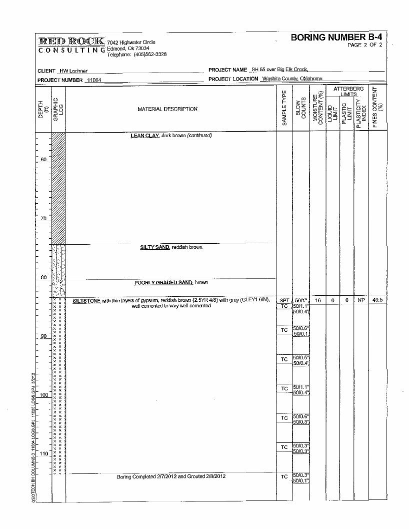
{Ci x x SILTSTONE with thin layers of gypsum, reddish brown (2.5YR 4/8) with gray (GLEY1 6/N), SPT 5011" 16 0 0 NP 49.5 x x x x well cemented to very well cemented TC 50/1.1" x x illlM' x x x x x x x x - x x 50/0.6"
- - x x TC 50/0.1 90 x x
~xx x x x x x x x x x x TC 50/0.5" x x x x ~ JilllQA'. x x x x x x
- . x x x x - . x x 50/1.1"
- - x x TC . __1QQ_ ~ ~ 5010.4"
. x x x x x x x x x x 50/0.6" x x TC x x - 50/0.3" x x x x x x x x x x
- . x x 50/0.3" - - x x TC
-11Q_ ~ ~ 50/0.3"
- x x x x x x x x
Boring Completed 217/2012 and Grouted 2/8/2012 TC 50/0.3" 50/0.1"
JRED ROCK 7042 Highwater Circle BORING NUMBER B-5
C 0 NS ULT I NG Edmond,Ok73034 PAGE 1 OF 2
Telephone: (405)562-3328
CLIENT HW Lochner PROJECT NAME SH 55 over Big Elk Creek,
PROJECT NUMBER 11064 PROJECT LOCATION Washita County, Oklahoma
DATE STARTED 212112 COMPLETED 212112 GROUND ELEVATION 1636.1 ft HOLE SIZE 6in
DRILLING CONTRACTOR DSO - Drilling Services of Oklahoma GROUND WATER LEVELS:
DRILLING METHOD Wet Rota!}' SJ_ 0 hrs AFTER DRILLING 18.0 ft/ Elev 1618.1 ft
LOGGED BY JTU CHECKED BY KKB :J-432 hrs AFTER DRILLING 20.8flIElev1615.3 fl
NOTES BRFY-175C(106)SS; 26479(04) 5L Cave In Depth 21.3 ft/ Elev 1614.8 ft
w ATIERBERG ,_ w;;;? LIMI F z
"- w J:
0 i'= 5~ O'. ~
i'= ,_
~g 'i'0
:::> ,_ z_ "- 0 MATERIAL DESCRIPTION
w oz ,_ z Q,_
0 -x 8~ ii ...J ...J ...J :::> "'w i= !::: !2w "- ro o - ,_ ::i-
0 oz a~ "'2 ,_ 0 "' 0 2 0 20 ::J ...J :"i ::J "'z w <( :')-"' 0 "- z
"- u: 0
- · ... SANDY SILT, dark red (2.5YR 3/6), medium dense
- - ..
- _.
-- ...
-· SPT 14 16
-.· '/'. LEAN CLAY, dark reddish brown (2.5YR2.5/3), stiff -
__1Q__ SPT 12 19 29 15 14 85.7 -
f-
f-
h
h
h SPT 11 22 48 13 35 91.5
h
h 7'J_ h
~ -f- - .. .:::~ SIL TY SAND, red (2.5YR 4/8), loose to medium dense SPT 6 19 0 0 NP 23.0
h - ......
:: .. · h -h - •.•.• h -h - :· . SPT 9 26
h - ·. ·:: - - :. :". .. : - -::.
30 .. ~.
- - · ... ' SPT 18 20 0 0 NP 13.2
- -· h
::·f·. h
h
h SPT 4
h
f- - EAT CLAY, dark brown (7.5YR 3/2), medium stiff
I- 40 -
f- - SPT 8 28 53 15 38 92.4
h
h -h
h
h SPT 6 32
~ :~ LEAN CLAY dark reddish brown (5YR 3/4) TO dark brown (7.5 3/2), very soft to medium
I- 50 -stiff
f- N=O, weight of hammer at 60 feet SPT 2 32 46 13 33 90.6
" •
(Continued Next Page)

RED ROCK 7042 Highwater Circle BORING NUMBER B-5
C 0 NS ULT ING Edmond,Ok73034 Telephone: (405)562-3328
CLIENT HW Lochner
PROJECT NUMBER 11064
PROJECT NAME SH 55 over Big Elk Creek.
PROJECT LOCATION Washita CountVi Oklahoma
1-70-:·.·· ~.
f- - .
r- - ·:· .. r- - : r- - ::. :. - --- - ·. - - · ..
- 80 6-· .. ;'·:··:·:: - - :: ~·
- - ·. - --:·: ·;·
MATERIAL DESCRIPTION
LEAN CLAY, dark reddish brown (5YR 3/4) TO dark brown (7.5 3/2), very soft to medium stiff
N=O, weight of hammer at 60 feet (continued)
SIL TY CLAY, reddish brown (5YR 4/3), soft
SIL TY SAND. reddish brown (5YR 4/4), medium dense to dense
SANDY GRAVEL, coarse, brown SIL TY SAND red (2.5YR 4/8) with gray (GLEY1 4/1), very dense
w
~ w _, a.
~ SPT
SPT
SPT
8
0
4
SPT 35
SPT 27
SPT 55
31
23
30
23
21
21
PAGE 2 OF 2
ATIERBERG LIMIT'
39 13 26 95.6
17 13 4 67.4
0 0 NP 40.9
0 0 NP 46.0
-- _:···
-~~~xtxi-~~-,,srn1L1rC.s~T~OThN~E'.~re;dMd~is~h'b~ro~w~n~(~2<.5~Y~R~4U/8W)>.~w~elttlce;:;;;m~e;n"-tect;;ilt~o~ve;,ry:;;;;w~eMll~ce;,m~e;,n~ted;;:;-~~-(_5-P-T_j_~25~+--16~+-2-1-l--1-7-l~4--l~~_j - x x ~50/3 5"'1--'..'---J-=--J---'--+--'-J_:..7c_7.CC7-j -
- -~~ ~~ - - ~ ~ ~010.8"
r-90-xx !----'=- ~ ~ t- - x x
x x t- - x x t- - x x
x x t- - x x I- - x x
x x NI- - X X
~I- - ~ ~ iir- -~~ <.':!f--10-xx ~~~~ gr - x x
x x - x x - x x
x x - x x
x x - x x - x x
x x - x x - x x
x x - - x x
~ _JjQ__ ~ ~ ~ - - ~ ~ 3- - x x 0 o-ili-" -
x x - x x - x x
TC 50/1.8" 1-----~'
TC 50/1.6" 5010.5"
TC 50/0.6" I-----~
TC 50/1" - --50/0.3"
TC 50/0.8" ~§QlM:
x x - x x
x x ~ - Boring Completed 21212012 and Grouted 2/20/2012 TC 50/0.1" ~'-~__j__~__j__~~~~~~~~~~~~~~~~~~~~~~~~~~~~~~--'====~5&0~/0~.1L"L_~_J_~_J_~-'-~_l~~__J

APPENDIXB
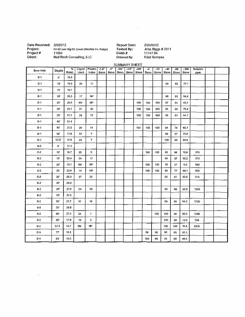
Date Received: Project: Project# Client:
Bore Hole
B-1
B-1
B-1
B-1
B-1
B-1
B-1
B-1
B-1
8-1
B-1
8-2
B-2
B-2
B-2
B-2
B-2
B-2
B-2
B-2
B-2
B-2
B-2
B-2
B-2
B-3
84
2/9/2012 SH-55 over Big Elk Creek (Washita Co. Bridge)
11064 Red Rock Consulting, LLC
Depth % Liquid Plastic -1.6"
Moist. Limit Index Sieve
5' 18.8
10' 19.3 25 11
15' 19.1
20' 25.5 17 NP
25' 29.3 NV NP
30' 23.7 31 20
35' 21.7 24 12
40' 21.4
45' 21.5 26 14
55' 17.9 22 7
57.5' 17.5 24 7
5' 17.3
10' 18.7 25 9
15' 32.4 34 17
20' 19.1 NV NP
25' 23.9 14 NP
30' 26.3 37 25
35' 29.2
40' 27.6 54 39
45' 27.0
50' 27.7 31 18
55' 28.8
60' 27.1 24 7
65' 17.5 19 3
67.5 19.7 NV NP
77' 16.3
83' 16.0
Report Date: Tested By: Cobb# Ordered By:
SUMMARY SHEET -1" -3/4" -1/2" -3/8'
Sieve Sieve Sieve Sieve
100
100
100
100
2/20/2012 John Riggs# 2311 11147.04 Kristi Bumpas
-4 -10 -40 Sieve Sf eve Sieve
99
99
100 100 97
100 100 96
100 100 96
100 100 94
99
100
100 100 99
99
100 100 78
100 100 95
99
99
99
100 100
100
100
98 98 95
100 95 91
-80 -200 Sulfates Sieve Sieve opm
93 77.1
93 64.4
61 43.1
89 79.4
84 64.7
79 60.7
97 75.6
99 80.8
96 79.6 373
97 90.2 373
27 9.5 560
77 44.1 BOO
97 90.6 413
98 93.6 1533
96 84.2 1720
98 86.5 1240
99 72.0 506
100 76.8 4933
93 55.3
89 49.5

Date Received: Project: Project# Client:
Bore Hole
B-5
B-5
B-5
B-5
B-5
B-5
B-5
B-5
B-5
B-5
B-5
B-5
B-5
B-5
B-5
B-5
2/9/2012 SH-55 over Big Elk Creek (Wash1la Co. Bridge)
11064 Red Rock Consulting, LLC
Depth % Liquid Plastic -1.5"
Moist. Limit Index Sieve
5' 15.5
10' 19.2 29 14
15' 21.7 48 35
20' 18.9 NV NP
25' 25.7
30' 20.0 NV NP
40' 27.7 53 38
45' 32.4
50' 31.7 46 33
55' 31.1 39 26
60' 23.0
65' 29.6 17 4
70' 23.2
75' 20.7 NV NP
80' 20.7 NV NP
85' 15.8 21 4
Report Date: Tested By: Cobb# Ordered By:
SUMMARY SHEET -1" -3/4" -1/2" -318'
Sieve Sieve Sieve Sieve
100 99
100
2/20/2012 John Riggs #2311 11147.04 Kristi Bumpas
-4 -10 -40 Sieve Sieve Sieve
100 100 100
100
100 94
99 99 93
100
190 98
100
100 100 100
96 94 89
100 98
99
-80 -200 Sulfates Sieve Sieve ppm
97 85.7
98 91.5
51 23.0
42 13.2
98 92.4
96 90.6
100 95.6
98 67.4
80 40.9
96 46.0
99 77.7

Environmental ). Tasting
Wilii Inc. 11.1:r..a111•• 4619 N. Santa Fe, OKC, OK 73118 - (405) 488-2400 - (405) 488-2404 fax
Client: Mr. Jason Unruh Red Rock Consulting P.O. Box 30591 Edmond, OK 73003
Analytical Report
Report Date: 02/14/2012
Order# 2012020151 Project II 11064
Laboratory Certificate# 721 I
Project: SH 55 Over Big Elk Creek, Washita Co.
Analytical Results Client Sample ID: Surface
Sample Collected : 02/08/2012 @ 15:00
Parameter Result Chloride 131 Sulfate 1290 pH 8.18
pH analyzed outside regulatory holding time.
Client Sample ID: B-1
Sample Collected: 02/08/2012®15:00
Parameter Chloride Sulfate pH
pH analyzed outside regulatory txlldi'ng time.
~:;Jjj;)J;; Russell Britten President
Result 29.6 364
7.39
Units Analyzed On mg/L 02/10/201211:01:00 PM mg/L 02/10/201211:01:00 PM s.u. 02/13/2012 01:15:00 PM
Units Analyzed On mg/L 02/10/201211:19:00 PM mg/L 02/10/201211:19:00 PM s.u. 02/13/2012 01:15:00 PM
Unless ETI receives prior notification, all sample material not consumed in analysis will be retained for a period of 30 days before disposal.
Order#: 2012020151
ETI ID: 1
Matrix: Aqueous
Analyst Method DS 300.0 DS 300.0 DS 4500 H+ B
ETI ID: 2
Matrix: Aqueous
Analyst Method DS 300.0 DS 300.0 DS 4500 H+ B
Page 1 of2

Quality Coutrol Report Environmental ·. ,>c:" *Tes ling
Report Date: 0211412012 2012020151 Order#
8 Inc. e1:1:rt'411111 4619 N. Santa Fe, OKC, OK 73118 - (405) 488-2400- (405) 488-2404 fax
Aqueous
Blank
Parameter Chloride
Sulfate
Duplicate
Parameter pH
LCS
Parameter Chloride
Sulfate
pH
Matrix Spike
Parameter Chloride
Sulfate
Matrix Spike Dup
Parameter Chloride
Sulfate
E = Estimated Value (above linear range) M = Out of Control Due to Matrix Effect D = Surrogate or Matrix Spike Diluted Out Q =Outside of QC limits on Both Original and Rerun C = Possible Laboratory Contamination • = Out of Control
Order#: 2012020151
Quality Control
QC Value <0.160
<0.300
QC Value 0.7
QC Value 107
100
100
QC Value 100
101
QC Value 106
94
Units ETI ID mg/L 1,1
mg/L 1,1
Units ETI ID %dif. 1,1
Units ETI ID %rec. 1,1
%rec. 1,1
%rec. 1,1
Units ETllD %rec. 1,1
%rec. 1,2
Units ETllD %rec. 1,2
%rec. 1,2
J = Value Between Detec!ion Limit and Reporting Limit 'TA" Lab ID: 9412 'ER " Lab ID: 8727
LaboratoiJ' Certificate# 7211
Page 2 of2

APPENDIXC

REDROCI<C CONSULTING
GENERAL NOTES
The Unified Soil Classification System Is used to identify the soil unless otherwise noted.
UNIFIED SOIL CLASSIFICATION SYSTEM ASTM D 2487 0
., 0
6 0
' '1--ll1B&llclly tml!n~ 4 0
' 0
0
0
- Cc
"
,--, lqw plm1U.;rfty <- ~ hluh pf .. H(iclty
/
,,-.'l/
OH /v
/ ~ --
Oc / M-landOH"
/ /
ML """"' ,_, qi!'
"" 0 .. o s-·o nqu!dUm!t
/
~-
--
"0
"DJstlngulshlng between Mand o dassifkatiom requires Identifying organiccomJXJnents by observation, odor, orothar testing.
SOIL PROPERTY SYMBOLS N Standard "N" penetration: Blows per foot Qu Unconfined Compressive Strength, tsf Qp Penetrometer value, tsf Mc LL Pl DD
'i
Water Content, %
Liquid Limit,%
Plasticity Index,% Natural Dry density, pcf
Apparent groundwater levels
DRILLING AND SAMPLING SYMBOLS BS SPT ST AU TC DCP
Bag Sample Split Spoon -13/8" l.D., 2" O.D,, except where noted Shelby Tube- 3" O.D., except where noted Auger Sample
Texas Cone Penetrometer
Dynamic Cone Penetrometer
RELATIVE DENSITY AND COSNISTENCY CLASSIFICATIONS
Major Divisions Group Typical Names Symbol
Clean GW Well-graded gravels and gravel-sand mixtures, little or no fines
Gravels Gravels GP Poorly graded gravels and gravel-sand mixtures, little or no fines 50°/o or more of course fraction retained
Course- on the No, 4 sieve Gravels GM Silty gravels, gravel-sand-silt mixtures With
Grained Soils Fines GC Clayey gravels, gravel-sand-clay mixtures More than 50°/o retained on the Clean SW Well-graded sands and gravelly sands, little or no fines No. 200 sieve Sands Sands SP Poorly graded sands and gravelly sands, little or no fines
50°/o or more of course fraction passes Sands SM Silty sands, sand-silt mixtures the No. 4 sieve With Fines SC Clayey sands, sand-clay mixtures
ML Inorganic silts, very fine sands, rock four, silty or clayey fine sands Silts and Clays
CL Inorganic clays of low to medium plasticity, gravelly/sandy/silty/lean clays Fine-Grained Liquid Limit 50°/o or less Soils OL Organic silts and organic silty clays of low plasticity
More than 50°/o passes the MH Inorganic silts, mlcaceous or diatomaceous fine sands or silts, elastic silts
No. 200 sieve Silts and Clays Inorganic clays or high plastlclty, fat clays Liquid limit greater than 50°/o CH
OH Organic clays of medium to high plasticity
Highly Organic Soils PT Peat, muck, and other highly organic soils
Rmf.ix;, G = Gravel, S =Sand, M =Slit, C =Clay, O = Organic Suffix: W =Well Graded, P = Poorly Graded, M =Silty, L"' Clay, LL< 50'%, H =Clay, LL> SOo/o
DEGREE OF PLASTICITY OF COHESIVE SOILS COHESIVE SOILS QUALITY OF ROCK CORE Degree of Plasticity
Swell Potential Plasticity Index
CONSISTENCY SPT Qu-(tsf) CORE
R.Q.D. CONDITIONS QUALITY
None Oto4 Very Low
Slight Sto9 Low
Very Soft ' <2 0.00-0.25 Soft 2 to 4 0.25-0.50
Excellent 90-Unweathered
Quality 100%
Medium 10to 19 Low to Medium Medium Stiff 5to8 0.50-1.00 Good Quality 75-90% Slightly Weathered
High 20to 39 Medium to High Very High 4D+ Very High
Stiff 9to14 1.00-2.00 Very Stiff 15 to 30 2.00-4.00
Fair Quality 50-75% Moderately Weathered
Hard 31+ 4.00+ Poor Quality 25-50% Highly Weathered
MOISTURE CONDITION OF COHESIVE SOILS
Description Condition Moisture Content
Very Poor <25%
Completely Quality Weathered COHESIONLESS SOJlS
RELATIVE DENSITY SPT PARTICAl SIZE
Absence of DESCRIPTION SIZE moisture, dusty, Dry Oto 10% Very Loose <4
Boulders 11.81 ln. dry to touch Loose 4to10 Cobbles 2.95 in. Damp but no
Moist 10 to 30% visible water
Medium Dense 11 to30 Dense 31 to so
Gravel 0.19in. Course Sand 0.08in.
Visible free water Wet 30to 70% Very Dense 51+ Medium Sand 0.02 in. Fine Sand 0.003 in. Silt 0.0002 in.