Home Range and Habitat Use by American Crows in Relation to ...

F O R E S T A N D R A N G E E VA L U AT I O N P R O G R A M
Sustainability of Forest and Range Resources Through Science and Stewardship
R E P O R T # 32
April 2012
PILOT TESTING INDICATORS AND METHODS FOR MONITORING THE EFFECTIVENESS OF MOUNTAIN GOAT WINTER RANGESPrepared by: Steven F. Wilson, Ph.D., R.P.Bio. EcoLogic Research
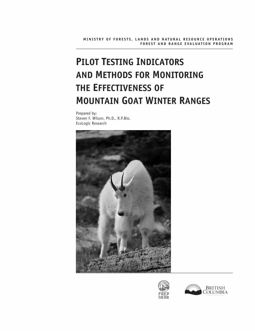
Photo by Jared Hobbs
M I N I S T R Y O F F O R E S T S , L A N D S A N D N AT U R A L R E S O U R C E O P E R AT I O N S F O R E S T A N D R A N G E E VA L U AT I O N P R O G R A M
PILOT TESTING INDICATORS AND METHODS FOR MONITORING THE EFFECTIVENESS OF MOUNTAIN GOAT WINTER RANGESPrepared by: Steven F. Wilson, Ph.D., R.P.Bio. EcoLogic Research

The use of trade, firm, or corporation names in this publication is for the information and convenience of the reader. Such use does not constitute an official endorsement or approval by the Government of British Columbia of any product or service to the exclusion of any others that may also be suitable. Contents of this report are presented for discussion purposes only. Funding assistance does not imply endorsement of any statements or information contained herein by the Government of British Columbia.
Management of forest and range resources is a complex process that often involves the balancing of ecological, social, and economic considerations. This evaluation report represents one facet of this process. Based on monitoring data and analysis, the authors offer the following recommendations to those who develop and implement forest and range management policy, plans, and practices.
Citation: Wilson, S. 2012. Pilot Testing Indicators and Methods for Monitoring the Effectiveness of Mountain Goat Winter Ranges. Ministry of Environment, Ecosystems Br. and Ministry of Forests, Lands and Natural Resource Operations, Resource Practices Br., Victoria, B.C. FREP Report #32. http://www.for.gov.bc.ca/hfp/frep/publications/index.htm
Prepared by: Steven F. Wilson, Ph.D., R.P.Bio., EcoLogic Research
Cover photo: Jared Hobbs
Copies of this report may be obtained, depending on supply, from: Government Publications PO Box 9452, Stn Prov Govt Victoria BC V8W 9V7
In Victoria (250) 387-6409 Outside Victoria 1-800-663-6105
http://www.publications.gov.bc.ca
For more information on Forest Practices Branch publications, visit our web site at: http://www.for.gov.bc.ca/hfp/meta/publications.htm
© 2012 Province of British Columbia

R E P O R T 3 2
iv Pilot Testing Indicators and Methods for Monitoring the Effectiveness of Mountain Goat Winter Ranges
ACKNOWLEDGEMENTS
I would like to thank Laurence Turney (Ardea Biological Consulting, Smithers) for providing advice and data related to the Foxy Canyon and Dungate Creek winter range areas. Laurence Turney and Steve Gordon (B.C. Ministry of Forests, Lands and Natural Resource Operations, Nanaimo) assisted with fieldwork. Darryl Reynolds (B.C. Ministry of Forests, Lands and Natural Resource Operations, Sechelt) and Steve Gordon provided advice and data related to the McNab Creek winter range. Greg Ferguson and Steve Gordon assisted with fieldwork. Brian Harris (B.C. Ministry of Forests, Lands and Natural Resource Operations, Penticton) provided advice related to the Sitkum Creek site and Rick Morley (Twin Spruce Resource Management Consulting, Nelson) assisted with fieldwork.
I would like to thank Kathy Paige (B.C. Ministry of Environment, Victoria), Laura Darling (B.C. Ministry of Environment, Victoria), Steve Gordon, Greg George (B.C. Ministry of Forests, Lands and Natural Resource Operations, Surrey), Pierre Johnstone (B.C. Ministry of Forests, Lands and Natural Resource Operations, Cranbrook), and Wayne Erickson (retired) for comments on this and earlier versions of the report
R E P O R T 3 2
vPilot Testing Indicators and Methods for Monitoring the Effectiveness of Mountain Goat Winter Ranges
EXECUTIVE SUMMARY
Mountain goats (Oreamnos americanus) are common residents of British Columbia’s most rugged habitats and more than 50% of the world’s population resides in the province. Winter is considered a critical period for goats because of poor foraging conditions and high energy expenditures related to thermoregulation and mobility in snow. Consequently, provisions in the Forest and Range Practices Act (FRPA) allow for legal designation of Ungulate Winter Ranges, which are intended to provide sufficient habitat to ensure the over-winter survival of mountain goats or other ungulates.
As a key component of Ungulate Winter Range management, monitoring determines whether a range is meeting its goal of providing the habitat necessary to meet the winter requirements of mountain goats. This report summarizes work completed on the development and pilot testing of a monitoring protocol for evaluating the effectiveness of legally established mountain goat winter ranges.
Indicators for monitoring effectiveness include:
• forest cover characteristics;
• snow depth and consolidation;
• forage availability;
• evidence of sustained winter use by mountain goats;
• potential disturbance;
• evidence of goat movement between winter ranges; and
• proportion of suitable or capable habitat managed as mountain goat winter range.
Office and field monitoring methods were piloted in three study areas during the late winter of 2006 and 2007: (1) McNab Creek (Lower Mainland Region), (2) Foxy Canyon (Skeena Region), and (3) Sitkum Creek (Okanagan Region). Both office and field testing confirmed that the recommended indicators were relatively simple and efficient to measure and could be deployed province-wide as part of an effectiveness monitoring protocol for mountain goat winter ranges. Monitoring of some indicators will be constrained by the availability of radio-telemetry data and the steep and inaccessible nature of mountain goat winter range will limit the application of field protocols.
R E P O R T 3 2
vi Pilot Testing Indicators and Methods for Monitoring the Effectiveness of Mountain Goat Winter Ranges
TABLE OF CONTENTSACKNOWLEDGEMENTS .........................................................................................................................ivExecutive Summary ............................................................................................................................v1.0 Introduction ............................................................................................................................... 12.0 Monitoring Questions .................................................................................................................. 1
2.1 A – Small scale (individual winter range) .......................................................................................1
2.2 B – Medium scale (watershed or management unit) .........................................................................1
2.3 C – Large scale (subregional or regional populations) ......................................................................2
3.0 Documenting Important Relationships ......................................................................................... 24.0 Indicators .................................................................................................................................. 2
4.1 Forest Cover Characteristics .........................................................................................................2
4.2 Snow Depth and Consolidation .....................................................................................................4
4.3 Forage Availability .....................................................................................................................4
4.4 Evidence of Sustained Winter Use .................................................................................................4
4.5 Potential Disturbance .................................................................................................................5
4.6 Evidence of Movement Between Winter Ranges ...............................................................................5
4.7 Proportion of Suitable or Capable Habitat Managed as Mountain Goat Winter Range .............................5
5.0 Monitoring Methods .................................................................................................................... 65.1 Office Procedures .......................................................................................................................6
5.1.1 Base mapping and summary statistics ..................................................................................6
5.1.2 Forest cover characteristics .................................................................................................6
5.1.3 Evidence of animal movements between winter ranges .............................................................6
5.1.4 Proportion of suitable / capable habitat under management ......................................................6
5.2 Field Procedures.........................................................................................................................7
5.3 Data Analysis Procedures .............................................................................................................8
6.0 Pilot Study Areas ........................................................................................................................ 87.0 Results ....................................................................................................................................... 9
7.1 Forest Cover Characteristics ....................................................................................................... 10
7.2 Snow Depth and Consolidation ................................................................................................... 10
7.2 Evidence of Sustained Winter Use ............................................................................................... 10
7.4 Evidence of Movement Between Winter Ranges ............................................................................. 11
7.5 Proportion of Suitable or Capable Habitat Managed as Mountain Goat Winter Range ........................... 11
8.0 Discussion .................................................................................................................................128.1 Forest Cover Characteristics ....................................................................................................... 12
8.2 Snow Depth and Consolidation ................................................................................................... 12
8.3 Evidence of Sustained Winter Use ............................................................................................... 13
8.4 Evidence of Movement Between Winter Ranges ............................................................................. 13
8.5 Proportion of Suitable or Capable Habitat Managed as Mountain Goat Winter Range .......................... 13
9.0 Next Steps .................................................................................................................................14REFERENCES .....................................................................................................................................14

R E P O R T 3 2
1Pilot Testing Indicators and Methods for Monitoring the Effectiveness of Mountain Goat Winter Ranges
1.0 INTRODUCTION
Mountain goats (Oreamnos americanus) are a relatively common resident of British Columbia’s most rugged habitats. More than 50% of the world’s population resides in the province (Shackleton 1999) and, as a result, the provincial government has a global responsibility to sustain their distribution and abundance. Mountain goats are considered a priority under British Columbia’s Conservation Framework.1 Winter is a critical period for goats and other ungulates because of poor foraging conditions and high energy expenditures related to thermoregulation and mobility in snow (Wilson 2005a). Provisions under the Forest and Range Practices Act (FRPA) enable the legal designation of Ungulate Winter Ranges.2 These ranges, which have been either established or are proposed in most regions of the province, are intended to provide sufficient habitat to ensure the over-winter survival of the species.
One of the priority evaluation questions of the Forest and Range Evaluation Program (FREP) is:
Do Ungulate Winter Ranges (UWRs) maintain the habitats, structures and functions necessary to meet the species winter habitat requirements, and is the amount, quality and distribution of UWRs contributing effectively with the surrounding land base (including protected areas and managed land base) to ensure the winter survival of the species now and over time?
As a key component of Ungulate Winter Range management, monitoring determines whether ranges are meeting their goal of ensuring the over-winter survival of mountain goats. This report summarizes the work completed (Wilson 2005b, 2006, 2007) on the development and pilot testing of a monitoring protocol for evaluating the effectiveness of mountain goat winter ranges. The report:
• presents small-, medium-, and large-scale monitoring questions;
• describes important relationships and processes for determining effectiveness indicators;
• describes effectiveness monitoring indicators;
1 Priority 1 under Goal 2: Prevent species and ecosystems from becoming at risk.
2 Government Actions Regulation (B.C. Reg. 582/2004), Section 12. See: http://www.bclaws.ca/EPLibraries/bclaws_new/document/ID/freeside/17_582_2004
• describes methods for both office and field monitoring procedures;
• presents results of pilot monitoring efforts in three study areas; and
• discusses the suitability of selected indicators and methods.
2.0 MONITORING QUESTIONS
The following are key monitoring questions related to assessing the effectiveness of Ungulate Winter Range management for mountain goats under FRPA.
2.1 A – Small scale (individual winter range)
• A1. Does the UWR provide the habitat elements required to fulfil the life requisites of mountain goats for which it was established?
• A2. Is the UWR receiving sustained use by mountain goats?
• A3. Is human-related disturbance affecting use of the UWR by mountain goats?
2.2 B – Medium scale (watershed or management unit)
• B1. Are there barriers outside of the UWR that prevent the movements of mountain goats between ranges?
• B2. Is the distribution and abundance of established mountain goat winter ranges sufficient to ensure over-winter survival in typical and severe winters?
Population maintenance:
Maintain the current approximate pattern of habitat occupancy (medium scale) and abundance and distribution (large scale) of mountain goats. Use currently occupied habitat and indices of abundance as the basis for defining desired conditions.
Population recovery:
Increase rates of occupancy of suitable habitat and increase the abundance and possibly the regional distribution of mountain goats. Use habitat capability and recovery objectives related to abundance and distribution as the basis for defining desired conditions.

R E P O R T 3 2
22 Pilot Testing Indicators and Methods for Monitoring the Effectiveness of Mountain Goat Winter Ranges
2.3 C – Large scale (subregional or regional populations)
• C1. Is the distribution and abundance of UWR and
other protected habitat established for mountain goats
sustaining the regional mountain goat population?
• C2. Is the current suite of management practices
achieving regional mountain goat objectives
(e.g., population maintenance or recovery)?
3.0 DOCUMENTING IMPORTANT RELATIONSHIPS
An important consideration when selecting and
interpreting indicators of the effectiveness of mountain
goat winter ranges is an understanding and appreciation
of the many factors and relationships that have an
influence on the result. A conceptual model was developed
to illustrate important factors and their relationships
(Figure 1 and Table 1).
4.0 INDICATORS
Indicators can measure the function, structure, or use of mountain goat winter ranges. Indicators need to be:
• measurable (accurately and precisely);
• cost effective to monitor; and
• sensitive to management or stressor change.
Table 2 outlines the seven indicators selected to address the monitoring questions.
4.1 Forest Cover Characteristics
Forest cover is an important characteristic of many mountain goat winter ranges, particularly in coastal regions where deep, unconsolidated snow forces mountain goats to elevations below the tree line and dense canopies intercept snowfall, reducing snow depths on the ground (Wilson 2005b). Monitoring forest cover characteristics ensures that forest canopy conditions are sufficient to moderate snow depths on winter ranges and that these canopy conditions persist over time.
Figure 1. Conceptual model of mountain goat population dynamics, illustrating the interaction among habitat features, habitat and population stressors, vital rates, and ultimately population size. The arrow colour indicates the direction of the interaction.
R E P O R T 3 2
3Pilot Testing Indicators and Methods for Monitoring the Effectiveness of Mountain Goat Winter Ranges
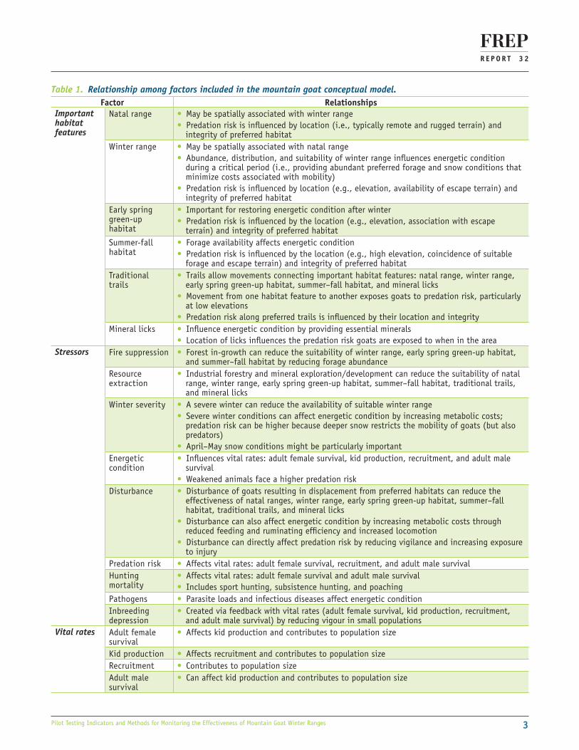
Table 1. Relationship among factors included in the mountain goat conceptual model.Factor Relationships
Important habitat features
Natal range • May be spatially associated with winter range • Predation risk is influenced by location (i.e., typically remote and rugged terrain) and integrity of preferred habitat
Winter range • May be spatially associated with natal range • Abundance, distribution, and suitability of winter range influences energetic condition during a critical period (i.e., providing abundant preferred forage and snow conditions that minimize costs associated with mobility)
• Predation risk is influenced by location (e.g., elevation, availability of escape terrain) and integrity of preferred habitat
Early spring green-up habitat
• Important for restoring energetic condition after winter • Predation risk is influenced by the location (e.g., elevation, association with escape terrain) and integrity of preferred habitat
Summer-fall habitat
• Forage availability affects energetic condition • Predation risk is influenced by the location (e.g., high elevation, coincidence of suitable forage and escape terrain) and integrity of preferred habitat
Traditional trails
• Trails allow movements connecting important habitat features: natal range, winter range, early spring green-up habitat, summer–fall habitat, and mineral licks
• Movement from one habitat feature to another exposes goats to predation risk, particularly at low elevations
• Predation risk along preferred trails is influenced by their location and integrityMineral licks • Influence energetic condition by providing essential minerals
• Location of licks influences the predation risk goats are exposed to when in the areaStressors Fire suppression • Forest in-growth can reduce the suitability of winter range, early spring green-up habitat,
and summer–fall habitat by reducing forage abundanceResource extraction
• Industrial forestry and mineral exploration/development can reduce the suitability of natal range, winter range, early spring green-up habitat, summer–fall habitat, traditional trails, and mineral licks
Winter severity • A severe winter can reduce the availability of suitable winter range • Severe winter conditions can affect energetic condition by increasing metabolic costs; predation risk can be higher because deeper snow restricts the mobility of goats (but also predators)
• April–May snow conditions might be particularly importantEnergetic condition
• Influences vital rates: adult female survival, kid production, recruitment, and adult male survival
• Weakened animals face a higher predation riskDisturbance • Disturbance of goats resulting in displacement from preferred habitats can reduce the
effectiveness of natal ranges, winter range, early spring green-up habitat, summer–fall habitat, traditional trails, and mineral licks
• Disturbance can also affect energetic condition by increasing metabolic costs through reduced feeding and ruminating efficiency and increased locomotion
• Disturbance can directly affect predation risk by reducing vigilance and increasing exposure to injury
Predation risk • Affects vital rates: adult female survival, recruitment, and adult male survivalHunting mortality
• Affects vital rates: adult female survival and adult male survival • Includes sport hunting, subsistence hunting, and poaching
Pathogens • Parasite loads and infectious diseases affect energetic conditionInbreeding depression
• Created via feedback with vital rates (adult female survival, kid production, recruitment, and adult male survival) by reducing vigour in small populations
Vital rates Adult female survival
• Affects kid production and contributes to population size
Kid production • Affects recruitment and contributes to population sizeRecruitment • Contributes to population sizeAdult male survival
• Can affect kid production and contributes to population size
R E P O R T 3 2
44 Pilot Testing Indicators and Methods for Monitoring the Effectiveness of Mountain Goat Winter Ranges
snow depths in open areas compared to those under the forest canopy.
Research on similarly sized ungulates (e.g., mule deer) suggests that mobility becomes increasingly restricted as snow depths exceed 25 cm and can significantly restrict movements if depths exceed 50 cm (see Ungulate Winter Range Technical Advisory Team 2005 and references therein). Based on these results, an ecological baseline consisting of snow depths less than 40 cm and sinking depths3 less than 25 cm is proposed to indicate suitable winter range snow conditions for mountain goats.
4.3 Forage AvailabilityMountain goats are generalist herbivores and have varied diets (Laundré 1994). The characteristics of the forest understorey determine the availability of winter forage. Goats subsist on grasses, forbs, ferns, conifers, lichens, and mosses (Hjeljord 1973; Laundré 1994; Côté and Festa-Bianchet 2003). As snow depths increase, the proportion of forbs and ferns in the diet declines (Fox and Smith 1988). At snow depths greater than 50 cm, forbs and ferns become unavailable and goats forage on conifer leaves and lichens from standing trees and litterfall, and on mosses from substrates not covered by snow (Fox and Smith 1988).
Establishing ecological baselines for forage availability is difficult because of the adaptability of mountain goats to locally variable forage and the lack of information on energetic or fitness consequences of switching food sources as snow depths increase. As a result, beyond qualitative assessments of forage availability (e.g., shrub cover and lichen litter fall), more formal monitoring of forage was considered impractical at this time.
4.4 Evidence of Sustained Winter UseEvidence of consistent winter use by mountain goats over many years is the most important indicator of the effectiveness of winter range management. Where mountain goats are being monitored by radio-telemetry, use of winter ranges can be determined through analysis of location data. Telemetry data can confirm occupancy, but it cannot establish whether winter ranges have been abandoned. Monitoring use based on radio-collared animals is not practical in the long term because most telemetry studies last only a few years.
Annual aerial reconnaissance flights can also determine winter range occupancy at the time of the survey,
3 Distance between the surface of the snow and the hoofprint.
Table 2. Indicators of the effectiveness of mountain goat winter range.
Indicator Monitoring question addressed
Office or field methods
1. Forest cover characteristics A1 Field / Office2. Snow depth and
consolidation A1 Field
3. Forage availability A1 Field4. Evidence of sustained winter
use by mountain goatsA2 Field
5. Potential disturbance A3 Field / Office6. Evidence of movement
among winter rangesB1 Field / Officea
7. Proportion of suitable or capable habitat managed as mountain goat winter range
B2, C1, C2 Office
a Using existing telemetry data
The most important variable is the percent canopy cover of different canopy strata. Multi-storied canopies intercept more snow than single-storied canopies. Arboreal lichens are more abundant in older, multi-storied stands with dead branches and good stand ventilation (Arsenault and Goward 2000; Coxson et al. 2003). Lichen litterfall can provide an important food source when other forage is unavailable because of deep snow conditions, particularly in coastal areas (Fox and Smith 1988).
Forest age is a surrogate indicator for these forest cover characteristics. Suitable forest cover can be approximated by examining the proportion of forested area in mature stands greater than 120 years old, which represents late–mature seral conditions in most forest types found in British Columbia. This age is only a coarse estimate; the actual forest age required to provide suitable attributes will vary by forest type and with biogeoclimatic characteristics. Blowdown and forest health issues can also affect forest structural conditions independent of stand age.
The forest characteristics of the winter range at the time of legal establishment form the ecological baseline against which future monitoring results should be assessed, unless recovery of forest characteristics is an objective for the winter range.
4.2 Snow Depth and ConsolidationSnow depth and consolidation are important winter range variables that influence energy balance by restricting mobility and access to forage. Therefore, a key measure of the effectiveness of forest canopy characteristics in moderating snow conditions is the difference between
R E P O R T 3 2
5Pilot Testing Indicators and Methods for Monitoring the Effectiveness of Mountain Goat Winter Ranges
4.6 Evidence of Movement Between Winter Ranges
Winter ranges are established only where suitable habitat exists; therefore, these ranges tend to be small and distributed within a matrix of less suitable habitat. Although some mountain goats remain within areas smaller than most established winter ranges for large parts of the season, more typically the animals move between patches of suitable habitat (Taylor et al. 2004). As a result, it is important that activities occurring in areas between ranges do not interfere with movements of mountain goats from one range to another. As a result, it is important to document such movements wherever possible.
Ecological baselines related to evidence of movement between winter ranges are difficult to establish because failing to detect these movements does not necessarily indicate that the winter ranges are ineffective. Failing to detect these movements also does not necessarily mean that the intervening forest matrix is unsuitable for movement of mountain goats. Mountain goat movements are highly variable and there is no reason to assume that every goat would necessarily use two or more ranges.
4.7 Proportion of Suitable or Capable Habitat Managed as Mountain Goat Winter Range
The proportion of suitable or capable mountain goat habitat currently protected (e.g., legal designations such as other UWRs, Wildlife Habitat Areas, Old-growth Management Areas, and parks) indicates how extensively habitat is managed to benefit mountain goats. Whether suitable or capable habitat is used for the calculation depends on the population goal (i.e., maintenance or recovery of the local mountain goat population). Determining the proportion of suitable or capable habitat under management is an office procedure that depends on availability of:
• maps of winter range boundaries and other constrained areas such as parks and protected areas; and
• maps of all suitable or capable mountain goat winter range.
This is a one-time calculation when winter ranges are evaluated.
Maps of suitable or capable mountain goat winter range can be derived using several methods. A systematic aerial inventory (e.g., Rochetta 2002) provides the opportunity to characterize both fine-scale habitat characteristics as well as the presence of mountain
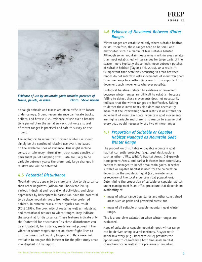
Evidence of use by mountain goats includes presence of tracks, pellets, or urine. Photo: Steve Wilson
although animals and tracks are often difficult to locate under canopy. Ground reconnaissance can locate tracks, pellets, and browse (i.e., evidence of use over a broader time period than the aerial survey), but only a subset of winter ranges is practical and safe to survey on the ground.
The ecological baseline for sustained winter use should simply be the continued relative use over time based on the available lines of evidence. This might include census or telemetry information, track count density, or permanent pellet sampling sites. Data are likely to be variable between years; therefore, only large changes in relative use will be detected.
4.5 Potential DisturbanceMountain goats appear to be more sensitive to disturbance than other ungulates (Wilson and Shackleton 2001). Various industrial and recreational activities, and close approaches by helicopters in particular, have the potential to displace mountain goats from otherwise preferred habitat. In extreme cases, direct injuries can result (Côté 1996). The proximity of roads, as well as industrial and recreational tenures to winter ranges, may indicate the potential for disturbance. These features indicate only the “potential for disturbance” as these disturbances can be mitigated if, for instance, roads are not plowed in the winter or winter ranges are not on direct flight lines to or from mines, backcountry lodges, etc. Data were not available to analyze this indicator for the pilot study areas investigated in this report.
R E P O R T 3 2
66 Pilot Testing Indicators and Methods for Monitoring the Effectiveness of Mountain Goat Winter Ranges
this method was deemed impractical for of the following reasons.
• Visually assessing winter range boundaries is time-consuming and subjective.
• The catalogue of digital orthophotos is updated infrequently (the vintage of digital orthophoto files retrieved from the Land and Resource Data Warehouse was 1996–1997).
• Results are difficult to quantify and subsequently monitor over time.
Forest cover on goat winter ranges is most threatened by windthrow along the edges of recent cutblocks. Catastrophic events such as beetle kill or fire are also risks that vary depending on the particular region of the province. Anecdotal notes on local windthrow events can be recorded during aerial or ground reconnaissance (see Section 5.2, below).
5.1.3 Evidence of animal movements between winter ranges
Mountain goat movements between winter ranges were determined through analysis of existing telemetry location data that were available for ranges included in the pilot study. Several telemetry data analysis techniques are capable of visually illustrating the evidence of movement between winter ranges. For this project, the spatial relationship among recorded telemetry locations was illustrated by generating a “spanning tree” according to mountain goat and year. Spanning trees do not connect consecutive locations but rather create a network of points based on minimum Euclidean distances without loops. The resulting network is relatively simple to interpret for the purposes of assessing movements between winter ranges.
5.1.4 Proportion of suitable / capable habitat under managementThe entire watershed was used to define the area of interest for the analysis of suitable habitat. In addition to Ungulate Winter Ranges established under FRPA, other areas considered “under management” were Parks and Protected Areas, Wildlife Habitat Areas, and Old-growth Management Areas. Threats to high-elevation, suitable habitat located outside these areas are limited, but there is no legal protection; therefore, these areas were included in the analysis as areas not under management.
goats. Habitat models have also been used to identify “potential” winter range areas based on topographic and forest cover characteristics (e.g., Gross et al. 2002; Heinemeyer et al. 2003); however, these models typically overestimate the availability of suitable winter ranges and reconnaissance is still necessary to confirm habitat characteristics and occupancy by goats. Also, the detailed terrain characteristics of microsites used by wintering goats cannot be resolved by available mapping (e.g., Jex 2004). A blend of methods using model-derived maps, air photo interpretation, and survey flights is also an option (e.g., Pollard 2002; Dunsworth 2004).
No ecological baseline is associated with the proportion of suitable or capable habitat managed as mountain goat winter range; rather, the indicator provides a management baseline that reflects the landscape-level potential for managing and protecting goat winter range.
5.0 MONITORING METHODSOffice and field procedures were developed to pilot effectiveness evaluation methods.
5.1 Office Procedures
5.1.1 Base mapping and summary statistics
All metrics were developed using data available in the Vegetation Resources Inventory (VRI) and Terrain Resource Information Mapping (TRIM) databases.4 A 25-m resolution digital elevation model was derived from TRIM to define watersheds, slopes, and aspects.
The following summary statistics were calculated in the office for each winter range to be assessed in the field.
• Total area
• Total vegetated area
• Total forested area
• Total area of consolidated rock
5.1.2 Forest cover characteristics
The proportion of forested area in mature stands over 120 years old was interpreted from VRI data. Although forest cover can be interpreted from digital orthophotos,
4 These databases were previously accessible through the Integrated Land Management Bureau’s Land and Resource Data Warehouse but are now maintained by GeoBC (see http://archive.ilmb.gov.bc.ca/lrdw/ or go to http://www.geobc.gov.bc.ca/).

R E P O R T 3 2
7Pilot Testing Indicators and Methods for Monitoring the Effectiveness of Mountain Goat Winter Ranges
determining occupancy (i.e., by the presence of tracks, pellets, evidence of browse) but are impractical to conduct on every winter range.
• Evidence of movement between winter ranges – Mountain goat tracks are often observed on winter reconnaissance flights and can be distinguished from those of other ungulates by the terrain in which these tracks are found. Although tracks can be inventoried during fieldwork (see procedures outlined below), it is impractical to use fieldwork to confirm travel between winter ranges because of the area and terrain involved.
The following procedure was implemented during ground-based field sampling in 2006 and 2007.
1. Establish a point of origin outside the winter range boundary. Ideal locations are in clearcuts on shallow slopes near the winter range boundary and on an aspect similar to most of the winter range. Points should permit transects to be traversed moving either upslope or downslope (if possible). A point of origin should be marked as a waypoint on a GPS and flagged so that it can be located in future years and data collected along the same (or similar) transect locations.
2. Navigate from the point of origin and select a representative area for a 20 x 20 m plot approximately 20 m outside the winter range boundary with no forest overstorey (if possible). Record plot data as illustrated in Table 3.
3. Record mountain goat tracks encountered on transect. Tracks encountered along transects can be followed to look for evidence of browse, beds, hair, or other signs of use. Effort spent backtracking depends on the abundance of tracks and time available. These data can be recorded as anecdotal notes. If areas of intense use (e.g., large pellet concentrations and hair, often on rocky outcrops with little or snow cover) by goats are encountered either on the transect or while backtracking, note GPS location and take photographs. Mark the area with paint blazes and a tree marker and make detailed notes of the location to ensure that future surveyors can find the area.
4. Return to the plot location and take a bearing that traverses the winter range, either upslope or downslope (if possible). Establish the next plot 20 m inside winter range boundary and repeat data collection.
One of the difficulties in establishing an objective measure for this indicator was that no consistent method was available for mapping mountain goat habitat. Mountain goat habitat suitability has been defined by topographic models (e.g., Gross et al. 2002; Heinemeyer et al. 2003; Turney 2004), aerial reconnaissance (Gordon and Reynolds 2000; Rochetta 2002), air photo interpretation, or a combination of techniques (e.g., Pollard 2002; Dunsworth 2004). Models have been developed in relation to local conditions and could not be applied reliably to areas with different ecological conditions.
To provide a simple and consistent ecological baseline for determining the abundance and distribution of suitable habitat, a generalized model of mountain goat habitat was developed. It was designed to correspond to the area that could be considered suitable for mountain goats, based on generally available spatial data. The model defined suitable habitat as areas meeting all of the following criteria.
• Warm aspects: 135–315°
• Steep slopes: 30–60°
• Consolidated rock or forest cover greater than 120 years
Areas meeting these criteria were queried in the spatial database to map suitable habitat within watersheds. The proportion of this area falling within legally established goat winter ranges and other protected or reserve areas was then calculated.
5.2 Field Procedures
Field procedures can include data collected from aerial reconnaissance surveys and ground surveys. Aerial reconnaissance data were not collected during this pilot study but could include the following.
• Forest cover characteristics – Windthrow and forest health can be assessed qualitatively during reconnaissance flights.
• Evidence of sustained winter use – Winter aerial inventory surveys (Resources Inventory Committee 2002) are most commonly used to detect occupancy of winter ranges and to indicate the regional distribution and abundance of mountain goats. Experienced observers on low-speed flights can detect tracks and animals in forested areas; however, the ability to see animals is generally poor, although the failure to detect goats does not necessarily mean that the winter range is unoccupied. Repeated surveys within or between years might be required to determine when a winter range has been abandoned. Ground surveys are more reliable at

R E P O R T 3 2
88 Pilot Testing Indicators and Methods for Monitoring the Effectiveness of Mountain Goat Winter Ranges
6.0 PILOT STUDY AREAS
Study areas were selected based on the following criteria.
• Approved or proposed UWR that could be reached by road or by a short helicopter flight
• Ability to navigate terrain safely (this is a major safety concern and limited the number of ranges that are feasible to sample on the ground)
• Confirmed use by mountain goats
Three winter range areas were selected:
1. Foxy Canyon (includes Dungate Creek Bluffs) in the Nadina Forest District,
2. Howe Sound (McNab Creek) in the Sunshine Coast Forest District, and
3. Sitkum Creek in the Okanagan-Shuswap Forest District (see Figure 2).
Only Sitkum Creek was a legally established Ungulate Winter Range (U-8-005, polygon ID 18). Boundaries for McNab Creek were draft and boundaries had yet to be drafted for Foxy Canyon and Dungate Creek.
Foxy Canyon is approximately 35 km southeast of Houston. A continuous section of canyon extends for approximately 13 km along Foxy Creek; canyon walls are 50-150 m high. The canyon is entirely within the Sub-Boreal Spruce Moist Cold Babine (SBSmc2) biogeoclimatic subzone variant
5. Continue establishing plots at either 20 or 50 m intervals, depending on the size of the winter range and the feasibility of navigating along the transect line. The objective should be to collect data for at least five plots along the transect within the winter range boundary (plus the one plot outside the boundary). The number of transects, and hence the sampling intensity, is expected to vary because of the size of the winter range and the feasibility of navigating terrain.
Although beyond the scope of this pilot project, areas of intense use can be further monitored by clearing pellets from small plots (e.g., 1 m2) at the beginning of the winter and returning in the spring to assess use. Pellets can be dried and weighed, counted, or simply photographed to assess relative use.
5.3 Data Analysis ProceduresMost of the monitoring data require only summary statistics and qualitative comparisons. The exceptions are data related to snow and sinking depths, crown closure and pellet removal plots. The relationship between snow and sinking depths and crown closure can be explored using regression analyses by forest type. Relative use of pellet removal plots can be compared among years using frequency analyses if pellets are counted (e.g., chi-squared, g-tests or log-linear analyses), or comparisons among means (t-tests, ANOVA) where pellets are weighed and data are available for several sites and / or years.
Table 3. Field data collected at each 20 x 20 m plot along transects during pilot effectiveness study, 2006 and 2007.
Field Data Variable Methods
Plot context Site characteristics Estimate slope with clinometer, aspect with compass, elevation from altimeter or GPS, UTMs from GPS, other site characteristics (Ecosystem Field Form; B.C. Ministry of Environment, Lands and Parks and B.C. Ministry of Forests 1998); take photograph
Snow depth and consolidation
Snow depth Measure to nearest 5 cm with graduated pole at 10 locations within 20 x 20 m plot; note depth of crust layers
Snow consolidation Sink graduated pole into snow using strength of one arm, record sinking depth to nearest 5 cm at 10 locations within 20 x 20 m plot
Forest cover characteristics
Forest Canopy Percent cover for tree layer, dominant species in A1, A2, and A3 layers within 20 x 20 m plot (B.C. Ministry of Environment, Lands and Parks and B.C. Ministry of Forests 1998)
Forage availability Shrub, herb and moss abundance
Percent cover for shrub, herb, and moss layers above the snow line within 20 x 20 m plot (B.C. Ministry of Environment, Lands and Parks and B.C. Ministry of Forests 1998)
Lichen / litterfall Plot estimate of lichen abundance, qualitative assessment of lichen-bearing branch litterfall within 20 x 20 m plot (Armleder et al. 1992)
Evidence of use by Mountain Goats
Visible sign Record all tracks (and sinking depth), pellets, hair, or other signs evident in the 20 x 20 m plot and the number of tracks encountered along transects

R E P O R T 3 2
9Pilot Testing Indicators and Methods for Monitoring the Effectiveness of Mountain Goat Winter Ranges
winter range was studied during this project. It covers 872 ha and ranges in elevation between approximately 800 m and 2000 m. Most of the range is south-facing and is within the Interior Cedar-Hemlock Moist Warm Columbia-Shuswap (ICHmw2) biogeoclimatic subzone variant, although parts of the upper slopes are also located within the Engelmann Spruce-Subalpine Fir Wet Cold Selkirk (ESSFwc4) and Wet Cold Woodland (ESSFwcw) subzone variants (Lloyd et al. 1990).
7.0 RESULTSField procedures were piloted in two locations within Foxy Canyon and one at the Dungate winter range areas on 23-24 February 2006. Data were collected at 10 field plots in total: seven were established along two transects on either side of Foxy Canyon and three along a third transect at the Dungate Creek winter range. Snow conditions were typical for midwinter, with a well-consolidated snowpack and little recent snow.
The McNab Creek winter range was investigated on 23 March 2006 and data at five plots along one transect were collected, ranging in elevation between approximately 432 m and 779 m. The lowest-elevation portions of the winter range were snow-free under forest cover, with snow cover beginning above 600 m and no recent snowfall. The area was revisited on 13 March 2007 and data were collected at an additional six plots along a similar transect to the one established in 2006. Lower elevations were snow-free except for 10-15 cm of new snow that had fallen within the previous 24 hours. Consolidated snow was found in open areas above 715 m.
Fieldwork at the Sitkum Creek winter range was conducted on 16 March 2007. Data were collected at five plots along a single transect, ranging in elevation from 714 m to 921 m. The area had recently been snow-free but 15 cm or less had fallen within the previous 24 hours.
Sampling transects at all study areas generally did not follow a 45° angle upslope during any of the surveys because either slopes were gentle and variable or slopes were very steep (often > 80%) and progress was governed by navigable terrain.
Office procedures were piloted in the McNab Creek and Sitkum Creek winter range areas.
A summary of results for each of the five indicators follows.5
5 Forage availability and potential disturbance were not included in this pilot study.
Figure 2. Mountain Goat UWR effectiveness pilot study areas, 2006 and 2007.
(Banner et al. 1993) and consists of discontinuous bedrock cliffs and steep forested slopes. Much of the canyon is mapped as mountain goat winter range (R. Heinrichs, B.C. Ministry of Environment, Smithers, B.C., pers. comm., 2008) The canyon supports a minimum population of 37 goats (as of September 2000), with use concentrated near the canyon rim (Turney et al. 2001; Mahon and Turney 2002). Although part of the same pilot study area, Dungate Creek Bluffs are located approximately 20 km west of Foxy Canyon and consist of bedrock cliffs and a plateau of subalpine forest. This area is within the Engelmann Spruce-Subalpine Fir Moist Cold (ESSFmc) biogeoclimatic subzone (Banner et al. 1993).
McNab Creek is approximately 20 km southwest of the town of Squamish on Howe Sound. Several Ungulate Winter Ranges for mountain goats are proposed within the watershed, one of which was investigated during this study. The winter range is located on a primarily southwest aspect and elevations range between approximately 400 m and 1450 m. Lower elevations are located within the Coastal Western Hemlock Very Wet Maritime Submontane (CWHvm1) biogeoclimatic subzone variant, whereas mid- and upper-elevation areas are in the Very Wet Maritime Montane (CWHvm2) and the Mountain Hemlock Moist Maritime Windward (MHmm1) biogeoclimatic subzone variants, respectively (Green and Klinka 1994).
Sitkum Creek goat winter ranges are located east of Sugar Lake in the Monashee Range of the Okanagan-Shuswap Forest District. The area is approximately 45 km east-northeast of the town of Lumby. The westernmost
R E P O R T 3 2
1010 Pilot Testing Indicators and Methods for Monitoring the Effectiveness of Mountain Goat Winter Ranges
7.1 Forest Cover Characteristics
Monitoring forest canopy characteristics through time was
beyond the scope of this project but forest canopy was
assessed at all pilot study areas and were related to snow
depths (see Section 7.2, below).
7.2 Snow Depth and Consolidation
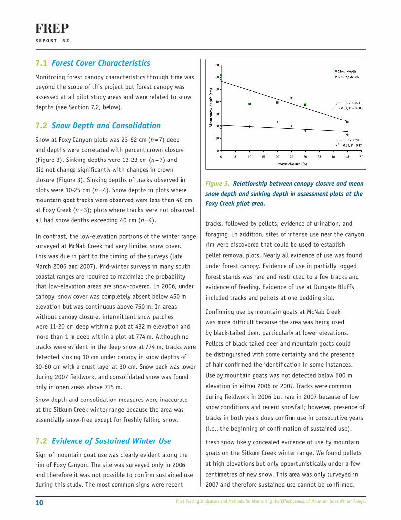
Snow at Foxy Canyon plots was 23-62 cm (n = 7) deep
and depths were correlated with percent crown closure
(Figure 3). Sinking depths were 13-23 cm (n = 7) and
did not change significantly with changes in crown
closure (Figure 3). Sinking depths of tracks observed in
plots were 10-25 cm (n = 4). Snow depths in plots where
mountain goat tracks were observed were less than 40 cm
at Foxy Creek (n = 3); plots where tracks were not observed
all had snow depths exceeding 40 cm (n = 4).
In contrast, the low-elevation portions of the winter range
surveyed at McNab Creek had very limited snow cover.
This was due in part to the timing of the surveys (late
March 2006 and 2007). Mid-winter surveys in many south
coastal ranges are required to maximize the probability
that low-elevation areas are snow-covered. In 2006, under
canopy, snow cover was completely absent below 450 m
elevation but was continuous above 750 m. In areas
without canopy closure, intermittent snow patches
were 11-20 cm deep within a plot at 432 m elevation and
more than 1 m deep within a plot at 774 m. Although no
tracks were evident in the deep snow at 774 m, tracks were
detected sinking 10 cm under canopy in snow depths of
30-60 cm with a crust layer at 30 cm. Snow pack was lower
during 2007 fieldwork, and consolidated snow was found
only in open areas above 715 m.
Snow depth and consolidation measures were inaccurate
at the Sitkum Creek winter range because the area was
essentially snow-free except for freshly falling snow.
7.2 Evidence of Sustained Winter Use
Sign of mountain goat use was clearly evident along the
rim of Foxy Canyon. The site was surveyed only in 2006
and therefore it was not possible to confirm sustained use
during this study. The most common signs were recent
Figure 3. Relationship between canopy closure and mean
snow depth and sinking depth in assessment plots at the
Foxy Creek pilot area.
tracks, followed by pellets, evidence of urination, and
foraging. In addition, sites of intense use near the canyon
rim were discovered that could be used to establish
pellet removal plots. Nearly all evidence of use was found
under forest canopy. Evidence of use in partially logged
forest stands was rare and restricted to a few tracks and
evidence of feeding. Evidence of use at Dungate Bluffs
included tracks and pellets at one bedding site.
Confirming use by mountain goats at McNab Creek
was more difficult because the area was being used
by black-tailed deer, particularly at lower elevations.
Pellets of black-tailed deer and mountain goats could
be distinguished with some certainty and the presence
of hair confirmed the identification in some instances.
Use by mountain goats was not detected below 600 m
elevation in either 2006 or 2007. Tracks were common
during fieldwork in 2006 but rare in 2007 because of low
snow conditions and recent snowfall; however, presence of
tracks in both years does confirm use in consecutive years
(i.e., the beginning of confirmation of sustained use).
Fresh snow likely concealed evidence of use by mountain
goats on the Sitkum Creek winter range. We found pellets
at high elevations but only opportunistically under a few
centimetres of new snow. This area was only surveyed in
2007 and therefore sustained use cannot be confirmed.

R E P O R T 3 2
11Pilot Testing Indicators and Methods for Monitoring the Effectiveness of Mountain Goat Winter Ranges
Figure 4. Spanning tree diagrams from GPS telemetry data collected on collared mountain goats in and near the Foxy Canyon‑Dungate Creek UWR study sites from January‑April 2003 (n = 8 goats; n = 2651 locations) and November 2003‑March 2004 (n = 5 goats; n = 1056 locations). Different colours represent different goats. Spanning trees are restricted to a single winter season.
7.4 Evidence of Movement Between Winter Ranges
Telemetry data was available for the Foxy Canyon pilot study area and nearby blocks of winter ranges (Turney and Roberts 2004; Turney 2005). Mountain goat telemetry data from January-April 2003 (n = 8 goats; n = 2651 locations) and November 2003-March 2004 (n = 5 goats; n = 1056 locations) indicated that mountain goat movements were largely restricted to a single winter range (Figure 4), although movements were evident between winter ranges in consecutive winters (Turney 2005).
A complete aerial reconnaissance was not completed as part of the pilot assessments. Although tracks were clearly visible during flights over and near Foxy Canyon and Dungate Bluffs, no tracks were detected between winter range areas because the terrain consisted entirely of low-elevation forest where any tracks would be obscured by forest canopy.
No telemetry data was available for either the McNab Creek or Sitkum Creek areas. Tracks within the winter range were clearly visible from the air, but again no tracks were observed between winter ranges.
7.5 Proportion of Suitable or Capable Habitat Managed as Mountain Goat Winter Range
Data to model this indicator were only available for the McNab Creek and Sitkum Creek winter ranges because boundaries for the Foxy Creek and Dungate winter ranges had not been defined.
The total area of the winter range investigated in McNab Creek was 317 ha (Table 4). The range was only one of many proposed winter range polygons within the boundaries of the McNab watershed. In total, the proposed winter ranges in the McNab watershed captured 57% of the potentially suitable mountain goat habitat (Figure 5). A relatively small proportion of the McNab Creek winter range was vegetated with almost two-thirds of the area covered in rock, but most of the forest cover was more than 120 years old.
The total area of the Sitkum Creek goat winter range was 872 ha, of which 65% was forested and 22% was covered with consolidated rock (Table 5). Only 39% of the forested area consisted of stands more than 120 years old. Most of the older forest was located at higher elevations.
Table 4. Results for the McNab Creek goat winter range. Data field and value refer to the VRI database.
Metric Data Field Value Hectares Percent
Total area AREA 317
Vegetated BCLC_L1 V 119 37.5% of total area
Forested BCLC_L2 T 93 29.4% of total area
Rock BCLC_L4 RO 198 62.5% of total area
Forest age >120 PROJECTED_AGE >120 85 91.6% of forested area
Potential habitat in watershed See text 854
Area in goat winter range See text 491 57.5% of potential habitat
R E P O R T 3 2
1212 Pilot Testing Indicators and Methods for Monitoring the Effectiveness of Mountain Goat Winter Ranges
Figure 5. Potentially suitable mountain goat habitat in the McNab Creek watershed in relation to proposed winter ranges. Shaded area indicates the polygon investigated in the field as part of the pilot project.
More than 90% of the potentially suitable mountain goat habitat within the watershed was captured within the boundaries of the established winter range (Figure 6).
8.0 DISCUSSION
The pilot studies discussed in this report focussed on developing and testing practical office and field procedures for monitoring the effectiveness of mountain goat winter ranges. Although the emphasis of the pilot studies was on the field procedures, office procedures are equally important and will likely constitute the majority of future monitoring activities. Field monitoring is expensive and technically feasible in only select areas; however, there is no substitute for ground-based work when assessing habitat characteristics and use by mountain goats under the forest canopy.
Figure 6. Potentially suitable mountain goat habitat in the Sitkum Creek watershed in relation to the winter range boundary. This polygon was also investigated using field methods.
8.1 Forest Cover Characteristics
Forest cover on winter ranges is retained to provide snow interception cover. Forest age and canopy closure are useful for characterizing the snow interception characteristics of the forest. The importance of snow interception differs among regions. In regions dominated by deep snow mountain goats will take refuge under the forest canopy, but in areas of shallow snow, or where windswept ridges are available, more open habitats are preferred habitats (Shackleton 1999). Interior winter ranges are characterized by higher proportions of exposed rock and lower proportions of forest cover compared to coastal winter ranges.
8.2 Snow Depth and Consolidation
Snow depth and consolidation is a critical variable for ungulates in winter and moderating snow depths is the
Table 5. Results for the Sitkum Creek goat winter range. Data field and value refer to fields in the VRI database.
Metric Data Field Value Hectares Percent
Total area AREA 872
Vegetated BCLC_L1 V 677 77.6% of total area
Forested BCLC_L2 T 564 64.7% of total area
Rock BCLC_L4 RO 196 22.4% of total area
Forest age >120 PROJECTED_AGE >120 221 39.1% of forested area
Potential habitat in watershed See text 280
Area in goat winter range See text 256 91.4% of potential habitat

R E P O R T 3 2
13Pilot Testing Indicators and Methods for Monitoring the Effectiveness of Mountain Goat Winter Ranges
principal reason for retaining forest cover on winter ranges. Understanding the relationships among snow depths, sinking depths, and use by mountain goats, and relating these to forest cover is required to test our assumptions about suitable forest cover and to improve effectiveness evaluations.
8.3 Evidence of Sustained Winter Use
Evidence of use by mountain goats during consecutive winters over the long term is the most important indicator of the effectiveness of winter ranges. In areas of low or non-existent canopy closure, this can be established relatively easily and quickly using reconnaissance-level aerial surveys to look for tracks and animals. Nevertheless, use of heavily timbered areas is more difficult to determine from the air. During this study, evidence of use was easy to confirm on the ground under the forest canopy, although not all areas and conditions will be as favourable as the pilot areas investigated during this project. The systematic bias created by sampling home ranges, which are relatively accessible and safe to traverse, should be considered in the interpretation of any results. In addition, areas where winter ranges of mountain goats overlap with those of other species can create challenges for definitively identifying use to species. Evidence of use can be classified to species only under ideal field conditions or through follow-up lab analyses.
8.4 Evidence of Movement Between Winter Ranges
Monitoring movement between winter ranges is a significant challenge. Telemetry data are rare and most studies are conducted for only a few years; therefore, these data cannot be relied on to monitor movements as the forest matrix changes over the long term. Observations of tracks on aerial survey flights provide anecdotal information, but tracks are difficult to detect under the forest canopy. Even where winter ranges are separated by expanses of unforested habitat, movements are still difficult to detect because mountain goats can remain on specific winter ranges for long periods and move to different areas only infrequently (e.g., Taylor et al. 2004).
In this instance, it might be better to infer movements between winter ranges from other indicators. For example, evidence of use within a winter range indicates that mountain goats are reaching the area and that the condition of the intervening forest matrix is not serving as a barrier to movement. Where monitoring
indicates that use by mountain goats is in decline, hypotheses regarding the reasons for the decline could be tested with monitoring data. For example, data could indicate whether the decline was a function of changing ecological conditions in the winter range itself or in the surrounding forest matrix, or due to other anthropogenic features (e.g., new roads or other developments) or declines in local mountain goat populations.
8.5 Proportion of Suitable or Capable Habitat Managed as Mountain Goat Winter Range
The varied histories of Ungulate Winter Range plans in British Columbia make it difficult to measure the proportion of habitat under management in a consistent manner. Some proposed or established winter ranges were based on habitat models whereas others were based on “grandparented” linework that had been generated by less-formal methods.
Developing a generalized mountain goat habitat model made it possible to measure a consistent metric, regardless of the ecological information used to determine the linework. Although habitat requirements of mountain goats vary, consistent requirements can be captured at the landscape scale. The model developed was not intended to replace finer-scale habitat investigations and locally calibrated habitat models, but it could serve as the basis for broad comparisons among different areas.
In some obvious situations, the model is likely to either overestimate or underestimate the abundance of suitable mountain goat habitat. For instance, to escape deep snow during severe winters, mountain goats in coastal locations will move to low elevations in areas with shallower slopes than indicated by the model. On the coast, forested areas with trees over 120 years old might overestimate the abundance of suitable habitat because forest canopies capable of intercepting sufficient snow to reduce snow depths on the ground might form only in older stands. At McNab Creek, only 57.5% of potential mountain goat habitat was captured in draft winter ranges (current to 2006). The polygons in this drainage have a long management history and their sizes have generally been reduced over time as the distribution of mountain goats has been verified and as boundaries have been negotiated with the forest industry (S. Gordon, B.C. Ministry of Forest, Lands and Natural Resource Operations, Nanaimo, B.C., pers. comm., 2008).

R E P O R T 3 2
1414 Pilot Testing Indicators and Methods for Monitoring the Effectiveness of Mountain Goat Winter Ranges
Despite these limitations, there is utility in using a generalized habitat model for monitoring purposes because the proportion of suitable, modelled habitat can provide a relative index of habitat change over time, or indicate relative risk to habitat among winter ranges.
Minor adjustments were made to procedures as a result of the pilot studies. Pilot testing confirmed that indicators are relatively simple and efficient to measure, and that they could be deployed province-wide as part of a protocol for evaluating the effectiveness of mountain goat winter ranges. Opportunities for fieldwork will always be limiting, but office procedures are relatively inexpensive, use widely available data, and provide useful monitoring information.
9.0 NEXT STEPS
To finalize the mountain goat winter range effectiveness monitoring protocol, the following steps are recommended.
1. Include further indicators of disturbance or risk.
2. Develop a process to assess the effectiveness of UWR based on recommended thresholds that trigger management responses.
3. Compare the approach taken for mountain goats with those recommended for other ungulate species.
REFERENCES
Armleder, H. M., S. K. Stevenson, and S. D. Walker. 1992. Estimating the abundance of arboreal forage lichens. B.C. Ministry of Forests, Victoria, B.C. Land Management Handbook Field Guide Insert No. 7.
Arsenault, A. and T. Goward. 2000. Ecological characteristics of inland rainforests. In: Proceedings, Biology and management of species and habitats at risk, Kamloops, B.C., 15–19 February 1999. L. M. Darling (editor). B.C. Ministry of Environment, Lands and Parks, Victoria, B.C., and University-College of the Cariboo, Kamloops, B.C. pp. 437–439.
Banner, A., S. Haeussler, W. MacKenzie, J. Pojar, S. Thomson, and R. Trowbridge. 1993. A field guide to site series identification and interpretation for the Prince Rupert Forest Region. B.C. Ministry of Forests, Research Branch, Victoria, B.C. Land Management Handbook No. 26.
British Columbia Ministry of Environment, Lands and Parks and British Columbia Ministry of Forests. 1998. Field manual for describing terrestrial ecosystems. Victoria, B.C. Land Management Handbook No. 25.
Côté, S. D. 1996. Mountain goat responses to helicopter disturbance. Wildlife Society Bulletin 24:681–685.
Côté, S. D. and M. Festa-Bianchet. 2003. Mountain goat Oreamnos americanus. In: Wild mammals of North America: Biology, management, conservation. G. A. Feldhamer, B. Thompson, and J. Chapman (editors). The John Hopkins University Press, Baltimore, Md. pp. 1061–1075.
Coxson, D. S., S. K. Stevenson, and J. Campbell. 2003. Short-term impacts of partial cutting on lichen retention and canopy microclimate in an Engelmann Spruce-subalpine fir forest in north-central British Columbia. Canadian Journal of Forest Research 33:830-841.
Dunsworth, K. 2004. Establishment of winter ranges for mountain goats: a biological rationale. Central Coast portion of the North Island Central Coast Forest District. B.C. Ministry of Water, Land and Air Protection, Williams Lake, B.C. Final draft.
Fox, J. L. and C. A. Smith. 1988. Winter mountain goat diets in southeast Alaska. Journal of Wildlife Management 52:362-365.
Gordon, S. M. and D. M. Reynolds. 2000. The use of video for mountain goat winter range habitat inventory and assessment of overt helicopter disturbance. Biennial Symposium, Northern Wild Sheep and Goat Council Proceedings 12:26-37.
Green, R. N. and K. Klinka. 1994. A field guide for site identification and interpretation for the Vancouver Forest Region. B.C. Ministry of Forests, Research Branch, Victoria, B.C. Land Management Handbook No. 28.
Gross, J. E., M. C. Kneeland, D. F. Reed, and R. M. Reich. 2002. GIS-based habitat models for mountain goats. Journal of Mammalogy 83:218-228.
Hjeljord, O. 1973. Mountain goat forage and habitat preference in Alaska. Journal of Wildlife Management 37:353–362.
Heinemeyer, K., T. Lind, and R. Tingey. 2003. Potential goat winter habitat model for the Central and North Coast Regions of British Columbia. Prepared for The Coast Information Team and Ecological Spatial Analysis Team. Draft.
R E P O R T 3 2
15Pilot Testing Indicators and Methods for Monitoring the Effectiveness of Mountain Goat Winter Ranges
Jex, B. 2004. Analysis of the topographic habitat attributes for mountain goat (Oreamnos americanus) winter ranges on the south-coast of British Columbia. B.C. Ministry of Water, Land and Air Protection, Surrey, B.C.
Laundré, J. W. 1994. Resource overlap between mountain goats and bighorn sheep. Great Basin Naturalist 54:114-121.
Lloyd, D., K. Angove, G. Hope, and C. Thompson. 1990. A guide to site identification and interpretation for the Kamloops Forest Region. B.C. Ministry of Forests, Research Branch, Victoria, B.C. Land Management Handbook No. 23.
Mahon, T. and L. Turney. 2002. Canyon-dwelling mountain goats along Foxy Creek: status, habitat use patterns and management recommendations. Prepared for Small Business Forest Enterprise Program, B.C. Ministry of Forests, Lakes Forest District.
Pollard, B. T. 2002. Mountain goat winter range mapping for the North Coast Forest District. Prepared for The North Coast Land and Resources Management Planning Team and the Land Use Coordination Office, Victoria, B.C.
Resources Inventory Committee. 2002. Aerial-based inventory methods for selected ungulates: bison, mountain goat, mountain sheep, moose, elk, deer and caribou. Prepared by B.C. Ministry of Sustainable Resource Management, Victoria, B.C.
Rochetta, S. 2002. Soo Timber Supply Area Mountain Goat Winter Range Plan. B.C. Ministry of Water, Land and Air Protection, Surrey, B.C.
Shackleton, D. M. 1999. Hoofed mammals of British Columbia. Royal British Columbia Museum, Victoria, B.C. and University of British Columbia Press, Vancouver, B.C.
Taylor, S. D., W. Wall, and Y. Kulis. 2004. A GPS-telemetry study of mountain goat habitat use in south coastal B.C. Interfor, Campbell River, B.C. and Forest Investment Account, Victoria, B.C.
Turney, L. 2004. Modeling of ungulate winter range for mountain goat in the Nadina Forest District, British Columbia. Prepared for B.C. Ministry of Water, Land and Air Protection, Smithers, B.C.
———. 2005. Non-alpine habitat use and movements of mountain goats in north-central British Columbia:
summary of 2004-2005 activities. Prepared for Morice and
Lakes Innovative Forest Practice Agreement.
Turney, L., T. Mahon, R. Blume, and J. Farkvam. 2001.
Mountain goat populations, movement patterns and
habitat use in forested habitats near Nadina Mountain
and Foxy Creek British Columbia: 2000 summary report.
Prepared for Houston Forest Products Ltd., Canadian Forest
Products Ltd., and B.C. Ministry of Environment, Lands and
Parks, Smithers, B.C.
Turney, L. and A.-M. Roberts. 2004. Non-alpine habitat use
and movements of mountain goats in north-central British
Columbia: summary of 2003-2004 activities. Prepared for
Morice and Lakes Innovative Forest Practice Agreement.
Ungulate Winter Range Technical Advisory Committee.
2005. Desired conditions for mule deer, elk, and moose
in the southern interior of British Columbia. B.C. Ministry
of Water, Land and Air Protection, Victoria, B.C. Wildlife
Bulletin B-120.
Wilson, S. F. 2005a. Desired conditions for coastal
mountain goat winter range. B.C. Ministry of Water, Land
and Air Protection, Victoria, B.C. Wildlife Working Report
No. WR-107.
———. 2005b. Monitoring the effectiveness of mountain
goat habitat management. Prepared for B.C. Ministry
of Water, Land and Air Protection, Biodiversity Branch,
Victoria, B.C.
———. 2006. Monitoring the effectiveness of mountain
goat habitat management: establishing monitoring
protocols and ecological baselines. Prepared for B.C.
Ministry of Forests and Range, Forest Practices Branch,
Victoria, B.C.
———. 2007. Mountain goat winter range effectiveness
monitoring pilot project. Prepared for B.C. Ministry of
Environment, Ecosystems Branch, Victoria, B.C.
Wilson, S. F. and D. M. Shackleton. 2001. Backcountry
recreation and mountain goats: a proposed research and
adaptive management plan. B.C. Ministry of Environment,
Lands and Parks. Victoria, B.C. Wildlife Bulletin B-103.