
REMOVAL PROGRAM PRELIMINARY ASSESSMENT/ … · REMOVAL PROGRAM PRELIMINARY ... Appendix F - Global...
77
REMOVAL PROGRAM PRELIMINARY ASSESSMENT/ SITE INVESTIGATION REPORT FOR THE FORMER CHAPMAN VALVE/CRANE COMPANY SPRINGFIELD, HAMPDEN COUNTY, MASSACHUSETTS 6 APRIL 2011 1 THROUGH 3 AUGUST 2011 8 AND 9 NOVEMBER 2011 4 APRIL 2012 Prepared For: U.S. Environmental Protection Agency Region I Emergency Planning and Response Branch 5 Post Office Square, Suite 100 Boston, Massachusetts 02109-3912 CONTRACT NO. EP-W-05-042 TDD NO. 01-11-03-0008 TASK NO. 0712 DC NO. R-7157 Submitted By: Weston Solutions, Inc. Region I Superfund Technical Assessment and Response Team (START) 3 Riverside Drive Andover, MA 01810 August 2012
Transcript of REMOVAL PROGRAM PRELIMINARY ASSESSMENT/ … · REMOVAL PROGRAM PRELIMINARY ... Appendix F - Global...

REMOVAL PROGRAM PRELIMINARY ASSESSMENT/
SITE INVESTIGATION REPORT FOR THE
FORMER CHAPMAN VALVE/CRANE COMPANY SPRINGFIELD, HAMPDEN COUNTY, MASSACHUSETTS
6 APRIL 2011 1 THROUGH 3 AUGUST 2011
8 AND 9 NOVEMBER 2011 4 APRIL 2012
Prepared For:
U.S. Environmental Protection Agency Region I
Emergency Planning and Response Branch 5 Post Office Square, Suite 100
Boston, Massachusetts 02109-3912
CONTRACT NO. EP-W-05-042
TDD NO. 01-11-03-0008
TASK NO. 0712
DC NO. R-7157
Submitted By:
Weston Solutions, Inc. Region I
Superfund Technical Assessment and Response Team (START) 3 Riverside Drive
Andover, MA 01810
August 2012

TABLE OF CONTENTS
I. Preliminary Assessment/Site Investigation Forms
II. Narrative Chronology
III. Appendices
Appendix A - Figures Figure 1 - Site Location Map Figure 2 - Site Map Figure 3 - Soil Sample Location Map Figure 4 - Debris Piles and ACM Samples Location Map Figure 5 - Activity-Based Sample Location Map
Appendix B - Tables Table 1 - Surface Soil Sample Results Table 2 - Bulk Asbestos Sample Descriptions and Results Table 3 - Debris Pile Estimated Volume and Descriptions Table 4 - Activity-Based Sampling on 8 November 2011, Air Sample
Results
Appendix C - Photodocumentation Log
Appendix D - Chain-of-Custody Records
Appendix E - Weather Underground, Weather Data for Weather Stations KCEF (unofficial NWS data) and KBDL on 8 November 2011
Appendix F - Global Positioning System (GPS) Information for Debris Piles and Asbestos-Containing Material Samples from Figure 4

I. Preliminary Assessment/Site Investigation Forms

EPA REGION I REMOVAL PRELIMINARY ASSESSMENT
Site Name and Location
Name: Former Chapman Valve/ Location: Pinevale/Goodwin/Moxon Streets Crane Company (Co.) City: Springfield County: Hampden State: Massachusetts (MA)
Site Status: ( ) NPL (T) NON-NPL ( ) RCRA ( ) TSCA ( ) ACTIVE ( ) ABANDONED (T) OTHER: The site is currently inactive and privately owned.
(T) Attached USGS Map of Location (T)Site I.D. No.: 01HD
Latitude: 42º 09′ 17″ North Longitude: 72º 29′ 59″ West
Referral
( ) Citizen ( ) City/Town (T) State ( ) Preremedial ( ) RCRA (T) Other: EPA Brownfields Program
Contacts Identified
Name of referring party: EPA Brownfields Program Address: 5 Post Office Square, Boston, MA 1) Frank Gardner Telephone: (617) 918-1278
Name of referring party: Massachusetts Department of Environmental Protection (MassDEP) Western Regional Office (WRO) Address: 436 Dwight Street, Springfield, MA 1) Ben Fish Telephone: (413) 755-2285
Source of Information
( ) Verbal: (T) Report: (1) WjF GeoConsultants, Inc. February 2009. Release Abatement Measure (RAM) Completion Report for the Former Crane Company, Pinevale, Moxon, & Goodwin Streets, Springfield, Massachusetts, MADEP RTN 1-00170, Wilbraham, MA. (2) O’Reilly, Talbot, and Okun Associates, Inc. (OTO). April 2010. Asbestos Assessment. MADEP RTN 1-00170. Springfield, MA.
1 R:\11030008\Reports\0712_PAform_Final.doc

REMOVAL PRELIMINARY ASSESSMENT
(3) MassDEP. 30 September 2010. Letter to Ms. Judy Bergdoll of Goodwin Realty, LLC, RE: Former Chapman Valve/Crane Co. Property abutted by Pinevale, Goodwin, and Moxon Streets, Parcel ID# 097550086. (T) Other: City of Springfield, Massachusetts, Building Department. 1942-1944. Application for other than a Dwelling, Building Permit granted to the Chapman Valve Co.
Potential Responsible Parties
Owner: Goodwin Realty, LLC (Ms. Judy Bergdoll) Telephone: ( ) Address: 10 Beechwood Drive, Wilbraham, MA
Operator: Not applicable (Inactive property) Telephone: ( ) Address:
Site Access
Authorizing Person: Ms. Judy Bergdoll Date: 6 April 2011 (T)Obtained (T)Verbal Telephone: ( ) ( )Not Obtained (T)Written
Historical Preservation
( ) Site is Historically Significant or Eligible for Historic Preservation
Contacts Identified
1) State Historical Preservation Officer (SHPO) Name: Judith B. McDonough Telephone: (617) 727-8470 2) Tribal Historical Preservation Officer (THPO) Name: Telephone: ( ) Comments:
Physical Site Characterization
Background Information: The Former Chapman Valve/Crane Company (the site) is located adjacent to (south of) 121 Pinevale Street, Springfield, Hampden County, Massachusetts (MA). The site does not have a specific street number address, but is referred to as a commercial property along Pinevale Street on the City of Springfield Property Record Card, Map Identification Number 097550086. The geographic coordinates of the approximate center of the site are 42° 09' 17" north latitude and 72° 29' 59" west longitude. The site is bordered by Moxon Street and residential properties to the east; Pinevale Street and residential properties to the west; an industrial property owned by the City of Springfield to the north; and Goodwin Street and a recently developed solar panel power station to the south.
2 R:\11030008\Reports\0712_PAform_Final.doc

REMOVAL PRELIMINARY ASSESSMENT
The original Chapman Valve Manufacturing Company (Chapman Valve) property consisted of 54 acres. However, the current site encompasses approximately 16 acres of the original property. Furthermore, the original 12 factory buildings have been demolished, with only the buildings’ slab foundations remaining on the site. The majority of these buildings were destroyed prior to 1996.
The 16-acre site is currently owned by Goodwin Realty, LLC. In addition, the Springfield Redevelopment Authority owns 14 of the surrounding acres that were also part of the original property.
According to site file information, in 1874 Chapman Valve moved from Boston to the 54-acre location in Springfield, MA. Chapman Valve was one of the world’s largest manufacturers of valves, especially for fire hydrants.
In 1948, Chapman Valve was contracted by Brookhaven Laboratory to manufacture uranium metal. The work was associated with government defense-related projects conducted under the Manhattan Engineer District (MED) and Atomic Energy Commission (AEC). Upon termination of the contract, the site was decontaminated in accordance with the standards and survey methods in use at that time.
In 1959, Crane Company (Crane Co.) purchased Chapman Valve. Crane Co. continued valve manufacturing operations on site. All on-site operations ceased in the 1980s, and the 54 acres were sold to various parties.
In August 1991, at the request of the United States Department of Energy (US DOE), the Measurement Applications and Development Group of Oak Ridge National Laboratory (ORNL) conducted a radiological survey within and around Building 23 on the site. The survey was conducted under the US DOE Formerly Utilized Sites Remedial Action Program (FUSRAP). Building 23 housed all of the uranium used during the 1948 contract between Chapman Valve and Brookhaven Laboratory. The survey included a gamma scan, beta-gamma scan, and measurement of alpha activity; measurement of direct and removable alpha and beta-gamma levels; and the collection of soil, dust, debris, and wipe samples for radionuclide analyses. Results of the radionuclide analyses indicated that residual uranium-238 was present at the site. In January 2004, US DOE issued a Certification of the Radiological Condition of Chapman Valve. The certification provided assurance that reasonably foreseeable future use of the site would result in no radiological exposure above current US DOE radiological criteria and standards for protecting members of the general public and occupants of the property. According to the ORNL report, all possible radiation sources were removed from the site; however, previous employees had been on site during periods of potential radiation exposure. Over 400 employee claims were submitted to the US Department of Labor for radiation exposure from Chapman Valve. Since not all the claims were approved for compensation, the National Institute for Occupational Safety and Health (NIOSH) submitted an evaluation report in November 2005, based on the Energy Employees Occupational Illness Compensation Program Act of 2000. A dose reconstruction was performed for employees on site during various periods of operation. No additional information available to START in background files indicated that a radiation source remained on the site.
In October 2003, ATC Associates of West Springfield (ATC), on behalf of Crane Co., prepared a Post Audit Completion Statement and Addendum Risk Characterization Report. The documentation
3 R:\11030008\Reports\0712_PAform_Final.doc

REMOVAL PRELIMINARY ASSESSMENT
demonstrated that a level of No Significant Risk had been achieved on the site, and that a Class A-2 Response Action Outcome (RAO) Statement was appropriate. In October 2005, after having received this report, Goodwin Realty, LLC purchased approximately 16 acres of the Crane Co. property.
In 2006, O’Reilly, Talbot and Okun Associates (OTO) conducted environmental sampling at the Goodwin Realty, LLC property (i.e., the site) and on another parcel of land previously owned by Crane Co. OTO conducted this sampling on behalf of the Westmass Area Development Corporation. As a result of these sampling activities, OTO discovered soil contamination. Elevated levels of lead, arsenic, polychlorinated biphenyls (PCBs), and petroleum hydrocarbons were detected in soil samples collected below the floor slabs of the former Buildings 5, 10, and 16. Goodwin Realty, LLC addressed the contaminated soil on their property (i.e., the site). In February 2009, WjF GeoConsultants of Wilbraham, MA, on behalf of Goodwin Realty, LLC, published a Release Abatement Measure (RAM) Completion Report. This report summarized the results of the soil boring program implemented on site, the excavation of impacted soils in June 2007 and March 2008, and the transportation and disposal of approximately 161 tons of contaminated soil.
In 2010, the City of Springfield (Springfield Redevelopment Authority) contracted OTO to conduct an asbestos assessment on the site. Based on their assessment, OTO estimated that there was approximately 34,000 cubic yards of asbestos debris on the property. Subsequently, in September 2010, Massachusetts Department of Environmental Protection (MassDEP) sent a notification letter to Goodwin Realty, LLC regarding MassDEP’s intent to assess a Unilateral Administrative Order (UAO) against Goodwin Realty, LLC. The UAO addressed the presence of over 30,000 cubic yards of asbestos debris on site, as estimated by OTO; and observations by MassDEP staff that Goodwin Realty, LLC was conducting RAM activities on site without approval. Goodwin Realty, LLC was ordered to cease all operations on site and was granted 30 days to provide proper documentation of a RAM Plan. Goodwin Realty, LLC ceased operations; however, MassDEP did not subsequently receive a complete RAM Plan.
Description of Substances Possibly Present, Known or Alleged: An asbestos assessment conducted by OTO indicated the presence of asbestos on site. Other site contaminants encountered during previous site assessments have reportedly been removed or addressed.
Existing Analytical Data
( ) Real-Time Monitoring Data: (T) Sampling Data: (1) Oak Ridge National Laboratory. July 1992. Results of the Radiological Survey at the Former Chapman Valve Manufacturing Company, Indian Orchard, Massachusetts, (CIO001), DOE contract DE-AC05-84OR21400. (2) O’Reilly, Talbot, and Okun Associates, Inc. (OTO). April 2010. Asbestos Assessment. MADEP RTN 1-00170. Springfield, MA.
4 R:\11030008\Reports\0712_PAform_Final.doc

REMOVAL PRELIMINARY ASSESSMENT
Potential Threat
Description of potential hazards to environment and/or population-identify any of the criteria for a Removal Action (from NCP) that may be met by the site under 40 CFR 300.415 [b] [2].
i. Actual or potential exposure to nearby human populations, animals, or the food chain from hazardous substances, pollutants or contaminants.
ii. Actual or potential contamination of drinking water supplies or sensitive ecosystems.
iii. Hazardous substances or pollutants or contaminants in drums, barrels, tanks, or other bulk storage containers, that may pose a threat of release.
iv. High levels of hazardous substances or pollutants or contaminants in soils largely at or near the surface, that may migrate.
v. Weather conditions that may cause hazardous substances or pollutants or contaminants to migrate or be released.
vi. Threat of fire or explosion.
vii. The availability of other appropriate federal or state response mechanisms to respond to the release.
viii. Other situations or factors that may pose threats to public health or welfare or the environment.
Prior Response Activities
(T) PRP ( ) STATE ( ) FEDERAL (T) OTHER
Brief Description: In 2009, the potentially responsible party, Goodwin Realty LLC, hired environmental consultants WjF GeoConsultants to write a RAM documenting the excavation and removal of contaminated soil from site. In 2010, the City of Springfield contracted OTO to conduct an asbestos assessment on site.
Priority for Site Investigation
(T) High ( ) Medium Low ( ) None ( ) Comments:
5 R:\11030008\Reports\0712_PAform_Final.doc

REMOVAL PRELIMINARY ASSESSMENT
Report Generation
Originator: Lauren Bolte Date: 30 November 2011 Affiliation: Weston Solutions, Inc. (START) Telephone: (978) 552-2106 TDD No.: 01-11-03-0008 Task No.: 0712
6 R:\11030008\Reports\0712_PAform_Final.doc

EPA REGION I REMOVAL SITE INVESTIGATION
Inspection Information
Site Name: Former Chapman Valve/ Address: Pinevale/Moxon/Goodwin Streets Crane Company (Co.) City: Springfield County: Hampden State: Massachusetts (MA)
Date of Inspection: 6 April 2011 Time of Inspection: 0930 hours to 1430 hours Weather Conditions: 50 degrees Fahrenheit (°F). Sunny, breezy, and cool. Date of Inspection: 1 August 2011 Time of Inspection: 0800 hours to 1730 hours Weather Conditions: 85 °F. Sunny, thunderstorms in the afternoon. Date of Inspection: 2 August 2011 Time of Inspection: 0700 hours to 1700 hours Weather Conditions: 85 °F. Sunny and warm. Date of Inspection: 3 August 2011 Time of Inspection: 0700 hours to 1430 hours Weather Conditions: 80 °F. Sunny, breezy, and warm. Date of Inspection: 8 November 2011 Time of Inspection: 0830 hours to 1830 hours Weather Conditions: 65 °F. Sunny and breezy. Date of Inspection: 9 November 2011 Time of Inspection: 0730 hours to 1230 hours Weather Conditions: 65 °F. Sunny and breezy. Date of Inspection: 4 April 2012 Time of Inspection: 0900 hours to 1400 hours Weather Conditions: 55 °F. Sunny and windy.
Site Status at Time of Inspection: ( ) ACTIVE (T) INACTIVE Comments: The site is an overgrown 16-acre parcel with several remaining building foundations. The site is privately owned, but not in use for any purpose.
Agencies/Personnel Performing Inspection
Names Program
(T) EPA: John McKeown U.S. Environmental Protection Agency (EPA) Region I, Emergency Planning and Response Branch (EPRB), On-Scene Coordinator (OSC)
(T) EPA Contractor: Lauren Bolte Carolyn Imbres Gerry Hornok Dean Brammer
Weston Solutions, Inc. (WESTON), Superfund Technical Assessment and Response Team III (START)
John Kelly Bill Mahany John Burton
1
R:\11030008\Reports\0712_SIform_Final.doc

REMOVAL SITE INVESTIGATION
(T) State: Ben Fish Massachusetts Department of Environmental Protection (MassDEP)
( ) Other:
Current Owner Based on Field Interview: Goodwin Realty LLC (Ms. Judy Bergdoll)
Physical Site Characteristics
Parameter Quantities/Extent ( ) Cylinders: ( ) Drums: ( ) Lagoons: ( ) Tanks: ( ) Above:
( ) Below: (T) Asbestos: Bulk asbestos samples have been collected from on-site
debris piles, and laboratory analysis has indicated the presence of asbestos.
(T) Piles: There are piles of building debris located in the center of the site.
( ) Stained Soil: ( ) Sheens: ( ) Stressed Vegetation: ( ) Landfill: (T) Population in Vicinity: Residential properties are located immediately to the east
and west of the site. (T) Wells: ( ) Drinking:
(T) Monitoring: There are several groundwater monitoring wells located throughout the site.
( ) Other:
Physical Site Observations
The site consists of an approximately 16-acre parcel of land which was previously part of a 54acre property operated by the Chapman Valve Company (Chapman Valve). The original 12 factory buildings have been demolished, with only the buildings’ slab foundations remaining on site. The majority of these buildings were destroyed by 1996. The site is currently overgrown with small trees, and contains building debris piles scattered throughout the site. The site is bordered by Moxon Street and residential properties to the east; Pinevale Street and residential properties to the west; an industrial property owned by the City of Springfield to the north; and Goodwin Street and a recently developed solar panel power station, which is located on part of the original 54-acre property, to the south. The site is currently owned by Goodwin Realty LLC.
2
R:\11030008\Reports\0712_SIform_Final.doc

REMOVAL SITE INVESTIGATION
Field Sampling and Analysis
Matrix/Analytical Field InstrumentationParameter CGI/O2 RAD PID FID Other Background 0.0%/20.9% 8-10 µR/hr 0.0 ppm Readings:
Air: 0.0%/20.9% 5-10 µR/hr 0.0 ppm Soil: 0.0%/20.9% 8-11 µR/hr 0.0 ppm Surface: Water: Tanks: Drums: Vats: Lagoons: Spillage: Run Off: Piles: 0.0%/20.9% 8-10 µR/hr 0.0 ppm Sediments: Groundwater: Other: µR/hr = micro Roentgen per hour ppm = parts per million
Field Quality Control Procedures
(T) SOP Followed ( ) Deviation From SOP
Comments: START followed the protocol outlined in the document entitled, Sampling and Analysis Plan for the Former Chapman Valve/Crane Company Site, Springfield, Hampden County, Massachusetts, dated July 2011, and Revision 1, dated October 2011, and Revision 2, dated March 2012.
Description of Sampling Conducted
From 1 to 3 August 2011, START personnel conducted soil sampling activities on site as part of the EPA Removal Program Preliminary Assessment/Site Investigation (PA/SI). A total of 85 composite surface soil samples (including five field duplicates) (SS-01 through SS-80 and SS100 through SS-104) were collected from 0 to 3 inches below ground surface (bgs). START collected an additional 15 bulk asbestos-containing material (ACM) samples (ACM-74A-E, ACM-75A-C, ACM-76A-B, ACM-77-78, ACM-79A-B, and ACM-80) from debris piles throughout the site. Surface soil samples were submitted to a Delivery of Analytical Services (DAS) laboratory, Batta Environmental Laboratory (Batta) in Newark, Delaware, for asbestos analysis via polarized light microscopy (PLM) with California Air Resources Board (CARB) 435 sample preparation (milling) Level A for 0.25% target analytical sensitivity. In addition, 10% of
3
R:\11030008\Reports\0712_SIform_Final.doc

REMOVAL SITE INVESTIGATION
PLM samples were submitted for asbestos analysis via transmission electron microscopy (TEM) with CARB 435 sample preparation (milling) Level B for 0.1% target analytical sensitivity. All bulk ACM samples were submitted to the EPA Office of Environmental Measurement and Evaluation (OEME) New England Regional Laboratory (NERL) located in North Chelmsford, MA for bulk asbestos analysis by PLM with dispersion staining.
On 8 and 9 November 2011, START personnel collected personal, perimeter, and reference air samples as part of activity-based sampling (ABS) events conducted at three on-site locations. Three walking scenarios were conducted during personal and perimeter air sampling to reflect the current land use by trespassers. Air samples were submitted to Batta for analysis via International Organization for Standardization (ISO) 10312, Ambient Air – Determination of Asbestos Fibers: Direct Transfer Transmission Electron Microscopy Method. One grab surface soil sample (0 to 1 inch bgs) was collected from each ABS location and submitted to EPA OEME NERL for percent solids analysis.
On 4 April 2012, START personnel collected 18 bulk ACM samples (ACM-01 through ACM18) (including one field duplicate) at locations throughout the site. ACM had been detected on site previously by other contractors. Samples ACM-01 through ACM-18 were collected from debris piles and debris areas in the same general locations as the previous samples collected by other contractors. START mapped these locations as possible ACM debris areas. Samples were submitted to OEME NERL for bulk asbestos analysis by PLM with dispersion staining.
Analyses
Analytical Parameter Media Laboratory ( ) VOC (T) AIR (T) NERL ( ) PCB ( ) WATER ( ) CLP ( ) PESTICIDE (T) SOIL ( ) PRIVATE ( ) METALS (T) SOURCE (T) DAS ( ) CYANIDE ( ) SEDIMENT ( ) SOW ( ) SVOC ( ) SOIL GAS ( ) FIELD ( ) TOXICITY ( ) DIOXIN (T) ASBESTOS (T) OTHER: percent solids
Analytical results: see Summary Tables, Appendix B
Receptors
Comments ( ) Drinking Water: ( ) Private:
( ) Municipal: ( ) Groundwater: (T) Unrestricted Access: The fence that surrounds the site has multiple breaches and
holes in it, allowing trespassers to walk onto the property.
4
R:\11030008\Reports\0712_SIform_Final.doc

REMOVAL SITE INVESTIGATION
(T) Population in Proximity: The site is in a residential neighborhood. ( ) Sensitive Ecosystem: ( ) Other:
Additional Procedures for Site Determination
( ) Biological Evaluation ( ) ATSDR
To be determined by the On-Scene Coordinator.
Site Determination
Depending on further information, criteria that may be met by the site include 40 CFR 300.415 [b] [2], parts:
i. Actual or potential exposure to nearby human populations, animals, or the food chain from hazardous substances, pollutants or contaminants.
ii. Actual or potential contamination of drinking water supplies or sensitive ecosystems.
iii. Hazardous substances or pollutants or contaminants in drums, barrels, tanks, or other bulk storage containers, that may pose a threat of release.
iv. High levels of hazardous substances or pollutants or contaminants in soils largely at or near the surface, that may migrate.
v. Weather conditions that may cause hazardous substances or pollutants or contaminants to migrate or be released.
vi. Threat of fire or explosion.
vii. The availability of other appropriate federal or state response mechanisms to respond to the release.
viii. Other situations or factors that may pose threats to public health or welfare or the environment.
Report Generation
Originator: Lauren Bolte Date: 9 April 2012 Affiliation: Weston Solutions, Inc. (START) Telephone: (978) 552-2106 TDD No.: 01-11-03-0008 Task No.: 0712 44444444444444444444444444444444444444444444444444444444444444444
5
R:\11030008\Reports\0712_SIform_Final.doc

II. Narrative Chronology

Narrative Chronology
Site Description
The Former Chapman Valve/Crane Company (the site) is located adjacent to (south of) 121 Pinevale Street, Springfield, Hampden County, Massachusetts (MA) (see Appendix A, Figure 1) [1]. The site does not have a specific street number address, but is referred to as a commercial property along Pinevale Street on the City of Springfield Property Record Card, Map Identification Number 097550086 [2]. The geographic coordinates of the approximate center of the site are 42° 09' 17" north latitude and 72° 29' 59" west longitude. The site is bordered by Moxon Street and residential properties to the east; Pinevale Street and residential properties to the west; an industrial property owned by the City of Springfield to the north; and Goodwin Street and a recently developed solar panel power station to the south (see Appendix A, Figure 2) [3].
The original Chapman Valve Manufacturing Company (Chapman Valve) property consisted of 54 acres. However, the current site encompasses approximately 16 acres of the original property. Furthermore, the original 12 factory buildings have been demolished, with only the buildings’ slab foundations remaining on the site. The majority of these buildings were destroyed prior to 1996.
The 16-acre site is currently owned by Goodwin Realty, LLC. In addition, the Springfield Redevelopment Authority owns 14 of the surrounding acres that were also part of the original property [4].
Site Background
In 1874, Chapman Valve moved from Boston to the 54-acre location in Springfield, MA. Chapman Valve was one of the world’s largest manufacturers of valves, especially for fire hydrants [4].
In 1948, Chapman Valve was contracted by Brookhaven Laboratory to manufacture uranium metal. The work was associated with government defense-related projects conducted under the Manhattan Engineer District (MED) and Atomic Energy Commission (AEC). Upon termination of the contract, the site was decontaminated in accordance with the standards and survey methods in use at that time [5].
In 1959, Crane Company (Crane Co.) purchased Chapman Valve. Crane Co. continued valve manufacturing operations on site. All on-site operations ceased in the 1980s, and the 54 acres were sold to various parties.
In August 1991, at the request of the United States Department of Energy (US DOE), the Measurement Applications and Development Group of Oak Ridge National Laboratory (ORNL) conducted a radiological survey within and around Building 23 on the site. The survey was conducted under the US DOE Formerly Utilized Sites Remedial Action Program (FUSRAP). Building 23 housed all of the uranium used during the 1948 contract between Chapman Valve and Brookhaven Laboratory. The survey included a gamma scan, beta-gamma scan, and
1 R:\11030008\Reports\0712 PASI Final.doc

measurement of alpha activity; measurement of direct and removable alpha and beta-gamma levels; and the collection of soil, dust, debris, and wipe samples for radionuclide analyses. Results of the radionuclide analyses indicated that residual uranium-238 was present at the site. In January 2004, US DOE issued a Certification of the Radiological Condition of Chapman Valve. The certification provided assurance that reasonably foreseeable future use of the site would result in no radiological exposure above current US DOE radiological criteria and standards for protecting members of the general public and occupants of the property [6]. According to the ORNL report, all possible radiation sources were removed from the site; however, previous employees had been on site during periods of potential radiation exposure. Over 400 employee claims were submitted to the US Department of Labor for radiation exposure from Chapman Valve. Since not all the claims were approved for compensation, the National Institute for Occupational Safety and Health (NIOSH) submitted an evaluation report in November 2005, based on the Energy Employees Occupational Illness Compensation Program Act of 2000. A dose reconstruction was performed for employees on site during various periods of operation. No additional information available to START in background files indicated that a radiation source remained on the site [7].
In October 2003, ATC Associates of West Springfield (ATC), on behalf of Crane Co., prepared a Post Audit Completion Statement and Addendum Risk Characterization Report. The documentation demonstrated that a level of No Significant Risk had been achieved on the site, and that a Class A-2 Response Action Outcome (RAO) Statement was appropriate. In October 2005, after having received this report, Goodwin Realty, LLC purchased approximately 16 acres of the Crane Co. property.
In 2006, O’Reilly, Talbot and Okun Associates (OTO) conducted environmental sampling at the Goodwin Realty, LLC property (i.e., the site) and on another parcel of land previously owned by Crane Co. OTO conducted this sampling on behalf of the Westmass Area Development Corporation. As a result of these sampling activities, OTO discovered soil contamination. Elevated levels of lead, arsenic, polychlorinated biphenyls (PCBs), and petroleum hydrocarbons were detected in soil samples collected below the floor slabs of the former Buildings 5, 10, and 16. Goodwin Realty, LLC addressed the contaminated soil on their property (i.e., the site). In February 2009, WjF GeoConsultants of Wilbraham, MA, on behalf of Goodwin Realty, LLC, published a Release Abatement Measure (RAM) Completion Report. This report summarized the results of the soil boring program implemented on site, the excavation of impacted soils in June 2007 and March 2008, and the transportation and disposal of approximately 161 tons of contaminated soil [8].
In 2010, the City of Springfield (Springfield Redevelopment Authority) contracted OTO to conduct an asbestos assessment on the site. Based on their assessment, OTO estimated that there was approximately 34,000 cubic yards of asbestos debris on the property. Subsequently, in September 2010, Massachusetts Department of Environmental Protection (MassDEP) sent a notification letter to Goodwin Realty, LLC regarding MassDEP’s intent to assess a Unilateral Administrative Order (UAO) against Goodwin Realty, LLC. The UAO addressed the presence of over 30,000 cubic yards of asbestos debris on site, as estimated by OTO; and observations by MassDEP staff that Goodwin Realty, LLC was conducting RAM activities on site without approval. Goodwin Realty, LLC was ordered to cease all operations on site and was granted 30
2 R:\11030008\Reports\0712 PASI Final.doc

days to provide proper documentation of a RAM Plan. Goodwin Realty, LLC ceased operations; however, MassDEP did not subsequently receive a complete RAM Plan [9].
Overview of Site Activities
On 6 April 2011, U.S. Environmental Protection Agency (EPA) On-Scene Coordinator (OSC) John McKeown, Weston Solutions, Inc. Superfund Technical Assessment and Response Team III (START) Site Leader (SL) Lauren Bolte, MassDEP representative Ben Fish, and the property owners, the Bergdolls, conducted a reconnaissance (recon) of the site to determine a Preliminary Assessment/Site Investigation (PA/SI) sampling strategy for ascertaining the extent of asbestos contamination at the site. All on-site personnel reviewed and signed the site-specific health and safety plan (HASP). The HASP was prepared as a separate document, entitled Weston Solutions, Inc., Region I START Site Health and Safety Plan for the Former Chapman Valve/Crane Company Site, Springfield, Massachusetts, dated April 2011 [12]. START personnel established a support zone and calibrated the air monitoring instruments, including a MultiRAE Plus meter [with lower explosive limit (LEL), oxygen (O2), hydrogen sulfide (H2S), carbon monoxide (CO), and volatile organic compound (VOC) sensors] and a Ludlum Model 19A radiation (MicroR) meter [10; 11]. Background levels were recorded in the HASP as follows: LEL = 0%; O2 = 20.9%; H2S = 0.0 parts per million (ppm); CO = 0.0 ppm; and MicroR = 5-10 microRoentgens per hour (µR/hr).
During the recon, it was noted that there was evidence of trespassing as indicated by breaches in the perimeter fence and by disposal of household waste. No drums or tanks were observed on site. START observed some open trenches, which were presumed to be remnants of the old tunnel system that was blocked off but not completely sealed to ground level. START observed several monitoring wells that had been installed by various companies. Portions of the site were overgrown with vegetation, while other portions were covered with concrete slabs from the old building foundations. In the center of the site, there were large piles of crushed building debris. Based on the recon, EPA determined that the site would be delineated with a grid for asbestos soil sampling.
On 1 through 3 August 2011, EPA OSC McKeown and START SL Bolte, START Professional Geologist (P.G.) John Kelly, and START members Carolyn Imbres, Gerry Hornok, and Dean Brammer returned to site to establish a sampling grid and to conduct surface soil sampling for asbestos analysis (see Appendix B, Table 1). Prior to site activities, all personnel reviewed and signed the HASP. Sampling procedures were conducted in accordance with the site-specific Sampling and Analysis Plan (SAP), which was prepared by START as a separate document, entitled Sampling and Analysis Plan for the Former Chapman Valve/Crane Company Site, Springfield, Hampden County, Massachusetts, dated July 2011 [13]. In addition, bulk asbestos-containing material (ACM) samples were collected at this time as well (see Appendix B, Table 2). A detailed description of all on-site sampling activities is provided in the section below.
START photodocumented site conditions during reconnaissance and sampling activities (see Appendix C, Photodocumentation Log).
Based on the analytical results of the August 2011 surface soil samples, EPA determined that on-site activity-based sampling (ABS) was needed to evaluate the potential risk of airborne asbestos
3 R:\11030008\Reports\0712 PASI Final.doc
exposure. On 8 November 2011, EPA and START conducted Phase II of the PA/SI, which included conducting air sampling for asbestos analysis during three ABS walking scenarios [14].
On 9 November 2011, EPA and START concluded on-site activities for Phase II of the PA/SI. All locations of the air sampling pumps were recorded with a global positioning system (GPS) unit [15]. The locations of building debris piles were recorded with a GPS unit and measured to obtain an approximate volume of potential ACM debris on site.
On 4 April 2012, EPA and START returned to site. The objective of the site visit was to further quantify the site’s ACM debris. START conducted additional ACM sampling and recorded sample locations with a GPS unit to distinguish the areas and piles containing ACM debris from areas and piles of non-contaminated building debris.
Sampling Activities
Soil and ACM Sampling – August 2011
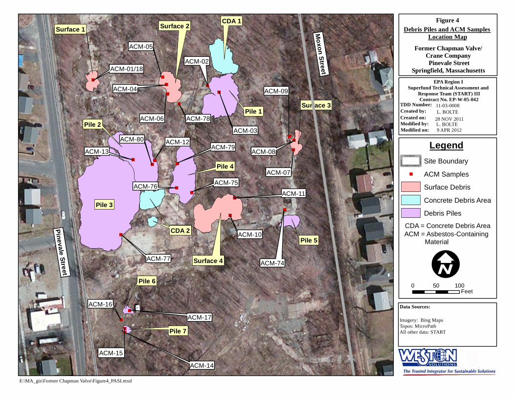
In August 2011, START collected 85 surface soil samples (including five field duplicate samples) and 15 bulk ACM samples throughout the site. Waypoint locations of sampling grids were uploaded onto a GPS unit. While on site, personnel navigated to a waypoint and measured the necessary grid size from the point. A soil sample was collected from within each grid. The dimensions of sampling grids varied, and included 31 100-foot by 100-foot grids, 13 100-foot by 50-foot grids, and 26 50-foot by 50-foot grids. The sampling grids extended to the fence lines of the property and encompassed the entire 16-acre site, with the exception of an area with debris piles (see Appendix A, Figure 3). All surface soil samples were screened with a MultiRAE Plus and a MicroR meter to determine if there were levels of VOCs or radiation greater than background in the soil. All surface soil samples were five-point composite samples collected from 0 to 3 inches below ground surface (bgs) using dedicated sampling equipment. Following sample collection, samples were homogenized and classified by START P.G. Kelly in accordance with the Burmeister method and the Unified Soil Classification System (USCS). Information regarding vegetation, soil characterization, and screening results of the soil for each sample location was recorded by START personnel on field data sheets. The USCS symbol for each soil sample is included with a summary of the analytical results (see Appendix B, Table 1).
The bulk ACM samples and 11 collocated soil samples were collected from the debris piles located in the center of the site. Fifteen ACM samples were collected at the surface of these debris piles (see Appendix A, Figure 4 and Appendix B, Table 2). Additional debris pieces were characterized by START personnel but were not sent to the laboratory for asbestos analysis. These additional samples were noted to be similar to the ACM samples that were sent for laboratory analysis. The surface soil samples were submitted to the Batta Environmental Laboratory (Batta) in Newark, Delaware for Polarized Light Microscopy (PLM) analysis via EPA 600/R-93/116 Method with California Air Resources Board (CARB) 435 sample preparation (milling) Level A for 0.25% target analytical sensitivity. In addition, 10% of the soil samples were submitted for Transmission Electron Microscopy (TEM) analysis via Modified EPA 600/R-93/116 Method with CARB 435 sample preparation (milling) Level B for 0.1% target analytical sensitivity. The bulk ACM samples were submitted to EPA Office of Environmental Measurement and Evaluation (OEME) New England Regional Laboratory
4 R:\11030008\Reports\0712 PASI Final.doc

(NERL), located in North Chelmsford, MA, for bulk asbestos analysis by PLM with dispersion staining (see Appendix D, Chain-of-Custody Records).
ABS Sampling – November 2011
Based upon the analytical results of the August 2011 soil sampling, EPA made the determination to conduct ABS sampling.
On 8 November 2011, OSC McKeown, START SL Bolte, and START members John Burton, Bill Mahany, and Imbres mobilized to the site to conduct ABS. The current land-use activity of trespassing was considered in selecting soil disturbance scenarios for ABS, consistent with the recommendations of the EPA Framework For Investigating Asbestos-Contaminated Superfund Sites [16]. Sampling was conducted in accordance with Revision 1 of the START SAP, dated October 2011 [13].
Three personal sampling areas were selected for ABS. The first ABS location was Grid 29 (the area where soil sample SS-29 was collected), an approximate 50-foot by 50-foot area covered mostly by an old foundation slab, located in the southern portion of the site. The second ABS location was a 50-foot by 50-foot area measured from the center point of Grid 8 (the area soil sample SS-08 was collected), which was previously a 100-foot by 100-foot grid. These two locations were walked through for 100 consecutive minutes. The third ABS location was around Debris Piles 75, 76, and 79. For this location, personnel walked around and through the piles to cause disturbance to material with known asbestos contamination (see Appendix A, Figure 5). These three ABS locations were chosen based on soil types, terrain, and laboratory results from the soil sampling previously conducted.
Each ABS event consisted of one person (the sampler) conducting an activity for approximately 100 minutes throughout the personal sampling area, while wearing a backpack containing one high-volume and one low-volume air sampling pump, with 0.8-micron (µm) mixed cellulose ester (MCE) cassettes situated in the breathing zone of the sampler. At the discretion of OSC McKeown, high-volume air sampling pumps were established at two or three perimeter locations, within 10 feet of each personal sampling area, to assess nearby dust migration during the activity. All air sampling pumps were calibrated prior to and following sample collection. The flow rate of high-volume air sampling pumps was set at approximately 10 liters per minute (L/min), and the flow rate of low-volume air sampling pumps was set at approximately 3 L/min, to obtain air sample volumes of approximately 1,000 and 300 L, respectively. Little to no wind was detected prior to initiating ABS (see Appendix E, Weather Data). Three reference air sampling pumps were established at locations in the northern and eastern portions of the site. All perimeter and reference samples were collected using 0.8-µm MCE cassettes situated at breathing zone height, approximately 4 to 5 feet above the ground surface.
Using dedicated sampling equipment, START collected one grab surface soil sample (0 to 1 inch bgs) for percent solids analysis from each ABS location. These three surface soil samples were submitted to EPA OEME NERL for percent solids analysis.
At the conclusion of all sampling, START walked through the site to determine the estimated volume of building debris on site that contained or was suspected to contain ACM. The piles
5 R:\11030008\Reports\0712 PASI Final.doc

were measured and described to obtain the approximate extent of bulk material contamination on site (see Appendix A, Figure 4 and Appendix B, Table 3).
ACM Sampling – April 2012
On 4 April 2012, OSC McKeown and START SL Bolte mobilized to site to conduct ACM sampling throughout the site. A total of 18 bulk ACM samples (including one duplicate sample) were collected and submitted to EPA OEME NERL for asbestos analysis by PLM with dispersion staining. ACM had been detected on site previously by other contractors. In 2009, OTO collected bulk ACM samples in similar areas on site that had results ranging from non-detect to 40% chrysotile asbestos [17]. Samples ACM-01 through ACM-18 were collected from debris piles and debris areas in the same general locations as these previous samples collected by OTO (see Appendix A, Figure 4; Appendix B, Table 2; and Appendix F). START mapped these locations as possible ACM debris areas. Sampling was conducted in accordance with Revision 2 of the START SAP, dated March 2012 [13].
Analytical Data Summaries
August 2011 Soil and ACM Sampling Results
Results of the on-site soil classification revealed the following USCS soil types: OH (organic, high plasticity); ML (silt, low plasticity); SC (sand and clay); and SM (sand and silt) (see Appendix B, Table 1).
In September 2011, START received the soil sample analytical results from Batta [18]. The complete analytical data packages are provided in the Site File. The analytical PLM results revealed chrysotile asbestos in one soil sample, SS-29, at 0.75% by volume; and in two soil samples, SS-08 and SS-18, at trace concentrations of <0.25% by volume. The TEM result of these samples revealed 1.66% chrysotile asbestos by weight in soil sample SS-29, and non-detect levels in soil samples SS-08 and SS-18. Two soil samples, SS-38 and SS-104, were non-detect for asbestos by PLM analysis; however, trace levels were detected (<0.01% of chrysotile by weight) by TEM analysis. A summary of PLM and TEM asbestos results for soil samples is included in Appendix B, Table 1.
START conducted Tier I data validation of the soil sample analytical data packages [19].
START received the bulk asbestos analytical results from OEME NERL [20]. The complete analytical data packages are provided in the Site File. Analysis via PLM with dispersion staining indicated the presences of chrysotile asbestos in two bulk ACM samples. Analysis of bulk ACM sample ACM-74C, located in Pile 5 and near soil sample SS-74, indicated 20% chrysotile asbestos by volume. During analysis, laboratory personnel characterized this sample of ACM as a gray, cement-like material, and pimpled on one side. Analysis of bulk ACM sample ACM75A, located in Pile 4 and near soil sample SS-75, indicated 15% chrysotile asbestos by volume. Laboratory personnel characterized this sample of ACM as a thin, gray, hard board. A summary of PLM results for bulk ACM samples is included in Appendix B, Table 2.
6 R:\11030008\Reports\0712 PASI Final.doc

November 2011 Activity-Based Sampling Results
Based on the results of the August 2011 soil samples, EPA determined that activity-based air sampling was needed to evaluate the potential risk of airborne asbestos exposure on the site.
In January 2012, START received the air sample analytical results from Batta [21]. A summary of TEM results for air samples is included in Appendix B, Table 4. There were no asbestos fibers detected in the air samples. Based on the EPA Framework for Investigating Asbestos-Contaminated Superfund Sites, the laboratory-achieved sensitivity level was met, and an airborne risk was evaluated [16].
START conducted Tier II data validation of the analytical data package for air samples collected as part of ABS [22].
Analysis of the three surface soil samples submitted for percent solids analysis revealed 80% solids in the Grid 8 sample, 84% solids in the Grid 29 sample, and 90% solids in the Debris Pile 75 sample [23].
April 2012 Bulk ACM Sampling Results
On 13 April 2012, START received the bulk ACM sample results from EPA OEME NERL [24]. The results and a description of each bulk sample are included in Appendix B, Table 2. There were no asbestos fibers detected in these bulk ACM samples.
7 R:\11030008\Reports\0712 PASI Final.doc

REFERENCES
[1] U.S. Geological Survey. 1981 (7th Edition). Quadrangle Ludlow and Springfield North, Massachusetts (7.5-minute series topographic map).
[2] City of Springfield, Massachusetts, Registry of Deeds. 2011. Commercial Property Record Card. Map ID 097550086.
[3] Massachusetts Geographic Information Systems (MassGIS). 2005. 1:5,000 Color Digital Orthophoto Imagery, RE: Image Numbers 117878 and 121878. Available from http://www.mass.gov/mgis/laylist.htm. Internet accessed 31 March 2011.
[4] City of Springfield, Massachusetts, Registry of Deeds. 2011. Commercial Property Record Cards. Map ID 097550070 and 058100170.
[5] Oak Ridge National Laboratory. July 1992. Results of the Radiological Survey at the Former Chapman Valve Manufacturing Company, Indian Orchard, Massachusetts, (CIO001), DOE contract DE-AC05-84OR21400.
[6] U. S. Department of Energy. January 2004. Certification of the Radiological Condition of the Chapman Valve in Indian Orchard, MA. Available at: edocket.access.gpo.gov/2004/04-1203.htm. Internet accessed 30 March 2011.
[7] National Institute of Occupational Safety and Health (NIOSH). 8 August 2006. SEC Petition Evaluation Report, Petition SEC-00043.
[8] WjF GeoConsultants, Inc. February 2009. Release Abatement Measure (RAM) Completion Report for the Former Crane Company, Pinevale, Moxon, & Goodwin Streets, Springfield, Massachusetts, MADEP RTN 1-00170, Wilbraham, MA.
[9] Massachusetts Department of Environmental Protection. 2010. Letter to Ms. Judy Bergdoll of Goodwin Realty, LLC, RE: Former Chapman Valve/Crane Co. Property abutted by Pinevale, Goodwin, and Moxon Streets Parcel ID# 097550086. 30 September.
[10] Weston Solutions, Inc. (WESTON) May 2011. Standard Operating Procedure for PID-MultiRae (Multi-gas monitor with VOC detection and LEL Rae Model PGM-50 multi-gas monitor MultiRae, SOP No. WSI/S3-018, Superfund Technical Assessment and Response Team III (START), Andover, MA.
[11] WESTON. May 2011. Standard Operating Procedure for Ludlum Model 19 Micro R Meter, SOP No. WSI/S3-027, Superfund Technical Assessment and Response Team III (START), Andover, MA.
[12] WESTON. April 2011, updated October 2011. Health and Safety Plan for the Former Chapman Valve/Crane Company Site, Springfield, Hampden County, Massachusetts. TDD 01-11-03-0008.
[13] WESTON. July 2011, revision 1 October 2011, revision 2 March 2012. Sampling and Analysis Plan for the Former Chapman Valve/Crane Company Site, Springfield, Hampden County, Massachusetts. TDD 01-11-03-0008.
8 R:\11030008\Reports\0712 PASI Final.doc

REFERENCES (Concluded)
[14] WESTON. May 2011. Standard Operating Procedure for Asbestos Sampling, SOP No. WSI/S3-029, Superfund Technical Assessment and Response Team III (START), Andover, MA.
[15] WESTON. May 2011. Standard Operating Procedure for TrimbleTM Pathfinder Pro XRS Global Positioning System (GPS) with TSCI Data Logger, SOP No. WSI/S3-020, Superfund Technical Assessment and Response Team III (START), Andover, MA.
[16] U. S. Environmental Protection Agency Office of Solid Waste and Emergency Response, Asbestos Committee of the Technical Review Workgroup. September 2008. Directive 9200.0-68, Framework for Investigating Asbestos-Contaminated Superfund Sites.
[17] O’Reilly, Talbot, and Okun Associates. April 2010. Asbestos Assessment. MADEP RTN 1-00170. Springfield, MA.
[18] Batta Laboratories, Inc. 7 September 2011. RE: Narrative, DAS Case No. 0828F, 85 PLM CARB 435 Level A, plus 10% TEM CARB 435 Level B, Lab project number L688811.
[19] WESTON. 14 November 2011. Letter to Mr. John McKeown, US EPA Region 1 - New England, Subject: Case No. 0828F; SDG No. D30449, BATTA Laboratories, Inc. Former Chapman Valve/Crane Co., Springfield, Massachusetts.
[20] U.S. Environmental Protection Agency. 15 August 2011. Office of Environmental Measurement and Evaluation. Laboratory Report. Project No. 11080009. [Chapman Valve/Crane, Indian Orchard, MA – Bulk Asbestos].
[21] Batta Laboratories, Inc. 28 December 2011. RE: Narrative, DAS Case No. 0835F, ISO 10312:1995(E) – Direct Transfer, Lab project number L6888B.
[22] WESTON. 2012. Letter to Mr. John McKeown, US EPA Region 1 - New England, Subject: Case No. 0835F; SDG No. D30841, BATTA Laboratories, Inc. Former Chapman Valve/Crane Co., Springfield, Massachusetts. 23 January.
[23] U.S. Environmental Protection Agency. 16 November 2011. Office of Environmental Measurement and Evaluation. Laboratory Report. Project No. 11110030. [Chapman Valve/Crane, Indian Orchard, MA - Percent Solids].
[24] U.S. Environmental Protection Agency. 10 April 2012. Office of Environmental Measurement and Evaluation. Laboratory Report. Project No. 12040006. [Chapman Valve/Crane, Indian Orchard, MA – Bulk Asbestos].
9 R:\11030008\Reports\0712 PASI Final.doc

III. Appendices

Appendix A
Figures
Figure 1 - Site Location Map Figure 2 - Site Map Figure 3 - Soil Sample Location Map Figure 4 - Debris Piles and ACM Samples Location Map Figure 5 - Activity-Based Sample Location Map

I
0 10.5 Miles
0 10.5 Kilometers
The Site
: MA_g s Former Chapman Va ve gure 1.mxd
Figure 1
11-03-0008 L. Bolte 29 MARCH 2011 B. Mace 15 JULY 2011
Former Chapman Valve/Crane Company Site
Pinevale Street
EPA Region ISuperfund Technical Assessment and
TDD Number:
Quadrangle Name(s): Ludlow and Springfield
Springfield, Massachusetts
Site Location Map Response Team (START) IIIContract No. EP-W-05-042
Created by: Created on:Modified by:Modified on:
Topos: MicroPath/USGS North, MA All other data: START
Data Sources:
E \ i \ l \Fi

Goodwin Street
Pinevale Street
Moxon Street
121 Pinevale Street
Essex Street
Hampshire Street
Figure 2
Site Map
Former Chapman Valve/Crane CompanyPinevale Street
Springfield, Massachusetts
EPA Region ISuperfund Technical Assessment and
Response Team (START) IIIContract No. EP-W-05-042
TDD Number: 11-03-0008Created by: L. BOLTECreated on: 31 MARCH 2011Modified by: L. BOLTEModified on: 17 FEBRUARY 2012
Legend Site Boundary
I Data Sources: Imagery: Massachusetts GeographicInformation Systems (MassGIS)Topos: MicroPath, Bing MapsAll other data: START
E:\MA_gis\Former Chapman Valve\Figure2_PASI.mxd

!( !( !(
!(
!( !(!(
!( !(
!(!(!(!(
!(!(
!(
!(
!(
!(
!(
!(
!(
!( !( !( !( !(
!(
!(
!(
!(
")
")
")
") ")
")
")
")")
!( !(
!( !(
!(
!(
!(
!( !(
!( !( !( !(
!( !(
!(
!(
!(
!(
!(
!(
!(!(
!(
!(
!( !(
!(
!(
!(
!(
!(
!(
!(!(
!(
!(
!(
!(
!(
SS-58
SS-11 SS-12
SS-13
SS-01 SS-02 SS-03 SS-04
SS-10/SS-101 SS-09 SS-08 SS-07
SS-06 SS-05
SS-14 SS-15 SS-17
SS-18
SS-19
SS-20
SS-21 SS-22 SS-23
SS-31/SS-100
SS-30
SS-33
SS-32
SS-24 SS-25
SS-37
SS-16
SS-29
SS-28 SS-27
SS-35 SS-36
SS-38
SS-40
SS-26
SS-34
SS-39
SS-41
SS-72
SS-77
SS-73
SS-74/SS-104
SS-75
SS-76
SS-80 SS-79
SS-78 SS-43/SS-103
SS-47
SS-52
SS-53
SS-54
SS-55
SS-56
SS-59
SS-51
SS-46
SS-42 SS-45
SS-44
SS-48
SS-49
SS-57
SS-50/SS-102
SS-61
SS-65
SS-69 SS-68
SS-64
SS-60
SS-62
SS-66
SS-70 SS-71
SS-67
SS-63
I
Legend ! Grid Samples (
" Pile Samples)
50 x 50 Foot Grid50 x 100 Foot Grid100 x 100 Foot GridAsbestos AreaSite Boundary
.
Note: Grid numbers correspond to sample numbers. (i.e. Grid 29 = area surrounding SS-29).
E:\MA_gis\Former Chapman Valve\Figure3_PASI.mxd
Figure 3
Former Chapman Valve/Crane CompanyPinevale Street
Springfield, Massachusetts
Soil Sample Location Map 11-03-0008L. BOLTE 11 MAY 2012L. BOLTE11 MAY 2012
EPA Region ISuperfund Technical Assessment and
Response Team (START) IIIContract No. EP-W-05-042
TDD Number: Created by:Created on: Modified by: Modified on:
0 50 100 15025 Feet
Imagery: Digital Globe, Bing Maps Topos: MicroPath All other data: START
Data Sources:
)
)
"
"
")
")
")
")
")
")")
")
")
")
")
")
")
")
") ")
")
")
")")
")")
")
")
Pinevale Street
Moxon Street
ACM-03
ACM-02
ACM-79
ACM-74
ACM-13
ACM-77
ACM-10
ACM-17
ACM-14
Surface 1
ACM-05
ACM-09
ACM-11
ACM-01/18
ACM-04
ACM-06 ACM-78
Surface 2 CDA 1
Pile 1
ACM-08
ACM-07
Surface 3
ACM-75ACM-76
Pile 4
ACM-12ACM-80
Pile 2
Surface 4
CDA 2CDA 2 Pile 5
Pile 3
Pile 6
Pile 7
ACM-15
ACM-16
Figure 4
Debris Piles and ACM SamplesLocation Map
Former Chapman Valve/Crane CompanyPinevale Street
Springfield, Massachusetts
EPA Region ISuperfund Technical Assessment and
Response Team (START) IIIContract No. EP-W-05-042
TDD Number: 11-03-0008Created by: L. BOLTECreated on: 28 NOV 2011Modified by: L. BOLTEModified on: 9 APR 2012
Legend Site Boundary
)" ACM Samples
Surface Debris
Concrete Debris Area
Debris Piles
CDA = Concrete Debris Area ACM = Asbestos-Containing
Material
I 0 50 100
Feet
Data Sources:
Imagery: Bing MapsTopos: MicroPathAll other data: START
E:\MA_gis\Former Chapman Valve\Figure4_PASI.mxd

!(
!( !(
!(
!(
!(!(
!(!(
!(
!(
!(
Goodwin Street
Pinevale Street
Moxon Street
REF1108-02
REF1108-01
PD02-29 PD01-29
PUP-29PD02-08
PUP-08
PD01-08
PD01-75
PD02-75
PUP-75
Grid 8
Grid 29
Pile 75
REF1108-03
I Figure 5
Activity-Based SampleLocation Map
Former Chapman Valve/Crane CompanyPinevale Street
Springfield, Massachusetts
EPA Region ISuperfund Technical Assessment and
Response Team (START) IIIContract No. EP-W-05-042
TDD Number: 11-03-0008Created by: L. BOLTECreated on: 28 NOV 2011Modified by: L. BOLTEModified on: 17 MAY 2012
Legend Site Boundary
! Air Pump Locations(
Soil Sampling Grid Pile
Note: Air Pumps designated on the map are only the perimeter and reference pumps that were in fixed locations. The personal air sampling pumps (locations PLOW-01 through PLOW-03) were affixed to sampling personnel.
0 50 100 200 300 Feet
Data Sources: Imagery: Digital Globe, Bing Maps AerialTopos: MicroPathAll other data: START
E:\MA_gis\Former Chapman Valve\Figure5_ABS Samples.mxd

Appendix B
Tables
Table 1 Surface Soil Sample Results Table 2 Bulk Asbestos Sample Descriptions and Results Table 3 Debris Pile Estimated Volume and Descriptions Table 4 Activity-Based Sampling on 8 November 2011, Air Sample Results

TABLE 1
SURFACE SOIL SAMPLE RESULTS FORMER CHAPMAN VALVE/CRANE COMPANY
SPRINGFIELD, MASSACHUSETTS
Sample Location
Sample Number
Sample Date
Grid Size (feet)
USCS Soil Classification
PLM Results % by volume
TEM Results % by weight
SS-01 D30449 2-Aug-11 100x100 ML ND ND SS-02 D30450 2-Aug-11 100x100 SM ND -----SS-03 D30452 2-Aug-11 ~100x100 ML ND -----SS-04 D30457 2-Aug-11 ~100x100 ML ND -----SS-05 D30466 2-Aug-11 N/A ML ND -----SS-06 D30467 2-Aug-11 100x100 ML ND -----SS-07 D30468 2-Aug-11 100x100 ML ND -----SS-08 D30469 2-Aug-11 100x100 SM <0.25% Chrysotile ND SS-09 D30458 2-Aug-11 100x100 ML ND -----SS-10 D30459 2-Aug-11 100x100 ML ND -----
SS-101 (Dup of SS-10) D30460 2-Aug-11 100x100 ML ND -----SS-11 D30451 2-Aug-11 100x100 SM ND -----SS-12 D30453 2-Aug-11 100x100 SM ND -----SS-13 D30454 2-Aug-11 100x100 SC ND -----SS-14 D30455 2-Aug-11 100x100 ML ND -----SS-15 D30456 2-Aug-11 100x100 SM ND -----SS-16 D30483 2-Aug-11 50x100 ML ND -----SS-17 D30472 2-Aug-11 50x50 ML ND -----SS-18 D30473 2-Aug-11 50x50 ML <0.25% Chrysotile ND SS-19 D30470 2-Aug-11 50x50 ML ND -----SS-20 D30471 2-Aug-11 50x50 ML ND -----SS-21 D30463 2-Aug-11 100x100 ML ND -----SS-22 D30461 2-Aug-11 100x100 SM ND -----SS-23 D30462 2-Aug-11 100x100 ML ND -----SS-24 D30479 2-Aug-11 50x50 ML ND -----SS-25 D30478 2-Aug-11 50x50 ML ND -----SS-26 D30484 2-Aug-11 50x100 ML ND -----SS-27 D30474 2-Aug-11 50x50 ML ND -----SS-28 D30475 2-Aug-11 50x50 ML ND -----SS-29 D30476 2-Aug-11 50x50 ML 0.75% Chrysotile 1.66% Chrysotile SS-30 D30477 2-Aug-11 50x50 ML ND -----SS-31 D30464 2-Aug-11 100x100 ML ND -----
SS-100 (Dup of SS-31) D30465 2-Aug-11 100x100 ML ND -----SS-32 D30480 2-Aug-11 50x50 ML ND -----SS-33 D30481 2-Aug-11 50x50 ML ND -----SS-34 D30485 2-Aug-11 50x100 ML ND -----SS-35 D30482 2-Aug-11 50x50 ML ND -----SS-36 D30486 2-Aug-11 50x100 ML ND -----SS-37 D30516 3-Aug-11 50x100 ML ND -----SS-38 D30487 2-Aug-11 50x100 OH ND Trace (<0.01%) Chrysotile SS-39 D30488 2-Aug-11 50x100 SM ND -----SS-40 D30489 2-Aug-11 50x100 ML ND -----SS-41 D30491 2-Aug-11 50x100 ML ND -----SS-42 D30490 2-Aug-11 50x100 ML ND -----SS-43 D30492 2-Aug-11 50x100 SM ND -----
SS-103 (Dup of SS-43) D30493 2-Aug-11 50x100 SM ND -----SS-44 D30495 2-Aug-11 50x50 SM ND -----SS-45 D30509 2-Aug-11 50x50 SM ND -----SS-46 D30494 2-Aug-11 50x100 ML ND -----SS-47 D30496 2-Aug-11 50x100 SM ND -----SS-48 D30510 2-Aug-11 50x50 ML ND -----SS-49 D30511 2-Aug-11 50x50 ML ND -----SS-50 D30512 2-Aug-11 50x50 ML ND -----
SS-102 (Dup of SS-50) D30513 2-Aug-11 50x50 ML ND -----
R:\11030008\Reports\Table1_soil sample results.xls Page 1 of 2

TABLE 1
SURFACE SOIL SAMPLE RESULTS FORMER CHAPMAN VALVE/CRANE COMPANY
SPRINGFIELD, MASSACHUSETTS
Sample Location
Sample Number
Sample Date
Grid Size (feet)
USCS Soil Classification
PLM Results % by volume
TEM Results % by weight
SS-51 D30517 3-Aug-11 100x100 ML ND -----SS-52 D30497 2-Aug-11 50x50 SM ND -----SS-53 D30514 2-Aug-11 50x50 SM ND -----SS-54 D30515 2-Aug-11 50x50 SM ND -----SS-55 D30508 2-Aug-11 50x50 SM ND -----SS-56 D30507 2-Aug-11 50x50 ML ND -----SS-57 D30506 2-Aug-11 50x50 ML ND -----SS-58 D30505 2-Aug-11 50x50 ML ND -----SS-59 D30504 2-Aug-11 50x50 SM ND -----SS-60 D30503 2-Aug-11 100x100 ML ND -----SS-61 D30502 2-Aug-11 100x100 ML ND -----SS-62 D30518 3-Aug-11 100x100 SM ND -----SS-63 D30519 3-Aug-11 100x100 ML ND -----SS-64 D30501 2-Aug-11 100x100 ML ND -----SS-65 D30500 2-Aug-11 100x100 ML ND -----SS-66 D30520 3-Aug-11 100x100 SM ND -----SS-67 D30521 3-Aug-11 100x100 ML ND -----SS-68 D30499 2-Aug-11 100x100 ML ND -----SS-69 D30498 2-Aug-11 100x100 SM ND -----SS-70 D30523 3-Aug-11 100x100 ML ND -----SS-71 D30522 3-Aug-11 100x100 ML ND -----SS-72 D30524 3-Aug-11 N/A SM ND -----SS-73 D30525 3-Aug-11 N/A ML ND -----SS-74 D30526 3-Aug-11 N/A ML ND -----
SS-104 (Dup of SS-74) D30527 3-Aug-11 N/A ML ND Trace (<0.01%) Chrysotile SS-75 D30528 3-Aug-11 N/A ML ND -----SS-76 D30529 3-Aug-11 N/A ML ND -----SS-77 D30530 3-Aug-11 N/A ML ND -----SS-78 D30531 3-Aug-11 N/A ML ND -----SS-79 D30532 3-Aug-11 N/A ML ND -----SS-80 D30533 3-Aug-11 N/A ML ND -----
Notes: 1) All samples were submitted to Batta Environmental in Newark, Delaware for Polarized Light
Microscopy (PLM) analysis of soil samples for asbestos via EPA 600/R-93/116 Method with California Air Resources Board (CARB) 435 Prep (Milling) Level A for 0.25% Target Analytical Sensitivity.
2) Ten percent of PLM samples were submitted for asbestos analysis of soil samples via Modified EPA 600/R-93/116 Method Utilizing Analytical Electron Microscopy [equivalent to Transmission Electron Microscopy (TEM)] for 0.1% Target Analytical Sensitivity. Analysis was modified to include Durable Mineral Fiber (DMF).
3) ----- = Sample not analyzed. 4) < = Less than 5) Unified Soil Classification System (USCS) definitions:
ML = Silt, Low plasticity SM = Sand and Silt SC = Sand and Clay OH = Organic, High plasticity
6) No. = Number 7) % = Percent 8) N/A = Not Applicable because sample was collected from a debris pile and not a grid. 9) ND = Not detected
10) ~ = Approximately 11) Dup = Duplicate field sample
R:\11030008\Reports\Table1_soil sample results.xls Page 2 of 2

TABLE 2
BULK ASBESTOS SAMPLE DESCRIPTIONS AND RESULTS FORMER CHAPMAN VALVE/CRANE COMPANY
SPRINGFIELD, MASSACHUSETTS
Sample Location
Sample Number
Sample Date
Bulk Asbestos Results Description of ACM
Near SS-74/ Pile 5
ACM-74A 8/3/2011 ND Gray, thread-like layers, dense board material ACM-74B 8/3/2011 ND White, fibrous, and malleable, possibly burnt tile ACM-74C 8/3/2011 20% Chrysotile Tan, thread-like, dense material, 1/2-inch thick ACM-74D 8/3/2011 ND Black, fibrous, and dense material that contains dried tar, possibly roofing material ACM-74E 8/3/2011 ND Off-white, fibrous, tile material
Near SS-75/ Pile 4
ACM-75A 8/3/2011 15% Chrysotile Green and gray, fibrous, tile material ACM-75B 8/3/2011 ND Black and off-white, fibrous, tile material ACM-75C 8/3/2011 ND White, fibrous, and soft material
Near SS-76/ Pile 4
ACM-76A 8/3/2011 ND Gray, fibrous, and malleable material (one-side)/ black with white fibers (other side) ACM-76B 8/3/2011 ND Brown, malleable, and thread-like material
Near SS-77/ Pile 3
ACM-77 8/3/2011 ND Black with white fibrous material
Near SS-78/ Surface 2
ACM-78 8/3/2011 ND Black, fibrous, and soft material, with small pebbles attached (one side)/ white fibers throughout material (other side)
Near SS-79/ Pile 4
ACM-79A 8/3/2011 ND White, soft material with long fibers ACM-79B 8/3/2011 ND Dense, fibrous material (curved, possibly burnt)
Near SS-80/ Pile 2
ACM-80 8/3/2011 ND Black, soft, thin material with long white fibers throughout material
Surface 1 ACM-01 4/4/2012 ND Green and gray, fibrous, tile material with black stripes ACM-18 4/4/2012 ND Field Duplicate of ACM-01
Pile 1 ACM-02 4/4/2012 ND Tan, brittle, tile-like material ACM-03 4/4/2012 ND Tan, brittle, tile-like material
Surface 2 ACM-04 4/4/2012 ND White, dense, tile-like material with blue pattern on one side ACM-05 4/4/2012 ND Thick, green, dense material with marble-pattern (one side)/ white cement (other side) ACM-06 4/4/2012 ND Tan, brittle, tile-like material (one side)/ green and thread-like (other side)
Surface 3ACM-07 4/4/2012 ND White, dense, thread-like material ACM-08 4/4/2012 ND Black, cement/concrete-like materialACM-09 4/4/2012 ND Thick, white cement/concrete-like material with a black coating
R:\11030008\Reports\Table 2_Bulk ACM.xls Page 1 of 2

TABLE 2
BULK ASBESTOS SAMPLE DESCRIPTIONS AND RESULTS FORMER CHAPMAN VALVE/CRANE COMPANY
SPRINGFIELD, MASSACHUSETTS
Sample Location
Sample Number
Sample Date
Bulk Asbestos Results Description of ACM
Surface 4 ACM-10 4/4/2012 ND Black, dense, thread-like pipe ACM-11 4/4/2012 ND Black, dense, 1/2-inch-thick pipe attached to concrete
Pile 2 ACM-12 4/4/2012 ND Tan, dense, threaded, tile-like material ACM-13 4/4/2012 ND Black, burnt, fibrous, roofing material
Pile 7 ACM-14 4/4/2012 ND Off-white, brittle, and mastic material ACM-15 4/4/2012 ND Thick, light-brown, and multi-colored tiling with a cement/concrete-like base
Near Pile 6 ACM-16 4/4/2012 ND Tan, thread-like, dense material, 1/2-inch thick Pile 6 ACM-17 4/4/2012 ND Red, tile-like material with black stripes on one side
Notes: 1) ACM = Asbestos-containing material. 2) ND = Not detected. 3) SS = soil sample 4) All bulk samples were collected from a debris pile or debris areas and analyzed by Polarized Light Microscopy (PLM)
with Dispersion Staining. 5) All the debris pile samples, collected near SS-74 through SS-80, had a Unified Soil Classification System (USCS)
definition of ML (Silt, low plasticity).
R:\11030008\Reports\Table 2_Bulk ACM.xls Page 2 of 2

TABLE 3
DEBRIS PILE ESTIMATED VOLUME AND DESCRIPTIONS FORMER CHAPMAN VALVE/CRANE COMPANY
SPRINGFIELD, MASSACHUSETTS
Debris Pile
Location
Pile
Height (ft)*
Pile Area (ft2)*
Pile Volume+ (ft3)*
Description of Pile
Pile 1 4.5 4,989 7,484 Mainly small pieces of debris and wooden beams, some household waste from dumping, suspected ACM (pipe wrap).
CDA 1 --- --- ---Concrete debris area located near Pile 1 that contains large pieces of concrete and construction debris only, and does not appear to contain possible ACM.
Pile 2 7 6,896 16,091 Very vegetated, large concrete foundation pieces and industrial masonry debris, possible ACM, and some household waste from dumping.
CDA 2 --- --- --- Large concrete foundation slabs located adjacent to Piles 2 and 3.
Pile 3 9 21,740 65,220 Very vegetated with small tree growth, household building construction debris, and possible ACM.
Pile 4 4 5,212 6,949 Small building debris (bricks, concrete, wood), and ACM (pipe wrap, tile).
Pile 5 3 836 836 Household building construction debris (brick, wooden beams), and ACM (roofing material, tile).
Pile 6 2 311 622 ++ Small household building construction debris, and suspected ACM (roofing material, tile).
Pile 7 4 254 339 Household building construction debris, and suspected ACM (shingles).
Surface 1 0.5 1,994 997 Tile flooring on an old foundation slab.
Surface 2 1 3,854 3,854 Scattered brick debris and possible ACM tiling.
Surface 3 1 5,831 5,831 Mainly shredded wooden debris and concrete debris scattered along a hillside.
Surface 4 1 13,452 13,452 Old pipes mixed in with brick and concrete debris.
Total Volume = 121,675 cubic feet or
4,507 cubic yards
Notes: 1) * = estimated values
2) ft = feet
3) ft2 = square feet
4) ft3 = cubic feet
5) ACM = asbestos-containing material
6) CDA = concrete debris area
7) --- = information not calculated
8) + = Pile volumes are approximate values, calculated using the height and area of each pile, and based on the assumption that each pile shape is a cone or pyramid.
The surface areas (Surface 1 through 4) are generally flat and are assumed to have a volume closer to a cylinder. 9) ++ = Pile 6 is mixed with fill, and the debris only extends 2 feet into the pile; therefore, the pile volume calculation is based only on the top 2 feet of
construction debris.
R:\11030008\Reports\Table 3_Debris Piles.xls Page 1 of 1

TABLE 4
ACTIVITY-BASED SAMPLING ON 8 NOVEMBER 2011 AIR SAMPLE RESULTS
FORMER CHAPMAN VALVE/CRANE COMPANY SPRINGFIELD, MASSACHUSETTS
Sample No. ABS
Location Air Sampling Pump
Location Sample
Volume (L) No. of Grids
Counted TEM Results
(Structure)+ TEM Results
(str./cc) Lab Achieved
Sensitivity (f/cc) D30841 REF1108-01 Reference-south 5037* 100 0 0.000218 0.000167 D30842 REF1108-02 Reference-central 5842.85* 100 0 0.000188 0.000167 D30843 REF1108-03 Reference-north 5567.5* 100 0 0.000197 0.000167
D30844 PLOW-01 Personal (Low Volume
at Grid 29) 313.1 99 0 0.001 0.001
D30845 PLOW-02 Personal (Low Volume
at Pile 75) 364.03 84 0 0.001 0.001
D30846 PLOW-03 Personal (Low Volume
at Grid 8) 311.95 98 0 0.001 0.001
D30850 PD01-29 Perimeter of Grid 29 1082.5 29 0 0.001 0.001
D30847 PD02-29 Perimeter of Grid 29 1039.5 30 0 0.001 0.001
D30851 PUP-29 Perimeter of Grid 29 1037 30 0 0.001 0.001
D30853 PD01-75 Perimeter of Pile 75 1071.53 29 0 0.001 0.001
D30854 PD02-75 Perimeter of Pile 75 1057.68 29 0 0.001 0.001
D30852 PUP-75 Perimeter of Pile 75 1040.91 30 0 0.001 0.001
D30856 PD01-08 Perimeter of Grid 8 1105.5 28 0 0.001 0.001
D30857 PD02-08 Perimeter of Grid 8 1033 30 0 0.001 0.001
D30858 PUP-08 Perimeter of Grid 8 990.5 31 0 0.001 0.001
D30859 LBLANK-01 Lot Blank 0 10 0 N/A N/A
D30860 FBLANK-01 Field Blank 0 10 0 N/A N/A
Notes: 1) All samples were analyzed for asbestos in air via International Organization for Standardization (ISO) 10312,
Ambient Air - Determination of Asbestos Fibers: Direct Transfer Transmission Electron Microscopy (TEM) Method. 2) * Samples were analyzed by the indirect sample preparation method based on ISO 13794:1999 (E),
Ambient Air - Determination of Asbestos Fibers: Indirect Transfer TEM Method. 3) ABS = Activity-Based Sampling 4) No. = Number 5) L = Liters 6) str./cc = structures per cubic centimeter 7) f/cc = fibers per cubic centimeter 8) N/A = Not Applicable
+9) = Both the number and type of structure were analyzed.
R:\11030008\Reports\Table4_ABS Results.xlsx Page 1 of 1

Appendix C
Photodocumentation Log

PHOTODOCUMENTATION LOG Former Chapman Valve/Crane Company ● Springfield, Massachusetts
SCENE: View of a raised foundation slab in the southern portion of the property, toward Goodwin Street. Photograph taken facing southeast. DATE: 6 April 2011 TIME: 0944 hours PHOTOGRAPHER: L. Bolte CAMERA: Samsung SL605
SCENE: View of household disposal that occurred in the southern portion of the property. Photograph taken facing northeast. DATE: 6 April 2011 TIME: 0956 hours PHOTOGRAPHER: L. Bolte CAMERA: Samsung SL605
TDD No. 11-03-0008 Page 1 of 13 TASK No. 0712

PHOTODOCUMENTATION LOG Former Chapman Valve/Crane Company ● Springfield, Massachusetts
SCENE: View of the eastern portion of the site lacking vegetation due to the old foundation slabs still in place. Photograph taken facing north. DATE: 6 April 2011 TIME: 1006 hours PHOTOGRAPHER: L. Bolte CAMERA: Samsung SL605
SCENE: View of a breach in the perimeter fence of the site, large enough to allow access for trespassers. Photograph taken facing east. DATE: 6 April 2011 TIME: 1010 hours PHOTOGRAPHER: L. Bolte CAMERA: Samsung SL605
TDD No. 11-03-0008 Page 2 of 13 TASK No. 0712

PHOTODOCUMENTATION LOG Former Chapman Valve/Crane Company ● Springfield, Massachusetts
SCENE: View of the open slab area in the middle of the site. Photograph taken facing west.
DATE: 6 April 2011 TIME: 1026 hours PHOTOGRAPHER: L. Bolte CAMERA: Samsung SL605
SCENE: View of a Chapman valve on a fire hydrant located in Grid 4.
DATE: 2 August 2011 TIME: 0905 hours PHOTOGRAPHER: L. Bolte CAMERA: Samsung SL605
TDD No. 11-03-0008 Page 3 of 13 TASK No. 0712

PHOTODOCUMENTATION LOG Former Chapman Valve/Crane Company ● Springfield, Massachusetts
SCENE: View of hummock debris piles located in Grid 19. Photograph taken facing north.
DATE: 2 August 2011 TIME: 1123 hours PHOTOGRAPHER: L. Bolte CAMERA: Samsung SL605
SCENE: View of Grid 39 along Pinevale Street. Photograph taken facing west.
DATE: 2 August 2011 TIME: 1355 hours PHOTOGRAPHER: L. Bolte CAMERA: Samsung SL605
TDD No. 11-03-0008 Page 4 of 13 TASK No. 0712

PHOTODOCUMENTATION LOG Former Chapman Valve/Crane Company ● Springfield, Massachusetts
SCENE: View of Grid 52, with the 5-gallon bucket marking the center point. Photograph taken facing south.
DATE: 2 August 2011 TIME: 1436 hours PHOTOGRAPHER: L. Bolte CAMERA: Samsung SL605
SCENE: View of a breach in the perimeter fence near Grid 15 along Moxon Street. Photograph taken facing east.
DATE: 3 August 2011 TIME: 0959 hours PHOTOGRAPHER: C. Imbres CAMERA: Samsung SL605
TDD No. 11-03-0008 Page 5 of 13 TASK No. 0712

PHOTODOCUMENTATION LOG Former Chapman Valve/Crane Company ● Springfield, Massachusetts
SCENE: View of a breach in the perimeter fence, and household trash that was disposed of in the northern part of the site. Photograph taken facing west. DATE: 3 August 2011 TIME: 1015 hours PHOTOGRAPHER: C. Imbres CAMERA: Samsung SL605
SCENE: View of a Superfund Technical Assessment and Response Team (START) representative conducting activity-based sampling (ABS) by walking through Grid 29 to simulate a local trespasser. Photograph taken facing west. DATE: 8 November 2011 TIME: 1138 hours PHOTOGRAPHER: L. Bolte CAMERA: Samsung SL605
TDD No. 11-03-0008 Page 6 of 13 TASK No. 0712

PHOTODOCUMENTATION LOG Former Chapman Valve/Crane Company ● Springfield, Massachusetts
SCENE: View of the two downwind perimeter air pumps on the northern side of Grid 29 during ABS. Photograph taken facing northwest. DATE: 8 November 2011 TIME: 1146 hours PHOTOGRAPHER: L. Bolte CAMERA: Samsung SL605
SCENE: View of a START representative walking through Grid 8 as a second ABS scenario, and the two downwind perimeter air pumps along the north side of the 50- x 50-foot area. Photograph taken facing north. DATE: 8 November 2011 TIME: 1523 hours PHOTOGRAPHER: C. Imbres CAMERA: Samsung SL605
TDD No. 11-03-0008 Page 7 of 13 TASK No. 0712

PHOTODOCUMENTATION LOG Former Chapman Valve/Crane Company ● Springfield, Massachusetts
SCENE: View of the single upwind air pump located along the south side of Grid 8 during ABS. Photograph taken facing southwest. DATE: 8 November 2011 TIME: 1524 hours PHOTOGRAPHER: C. Imbres CAMERA: Samsung SL605
SCENE: View of Debris Pile 2. Photograph taken facing north.
DATE: 9 November 2011 PHOTOGRAPHER: L. Bolte
TIME: 1102 hours CAMERA: Samsung SL605
TDD No. 11-03-0008 Page 8 of 13 TASK No. 0712

PHOTODOCUMENTATION LOG Former Chapman Valve/Crane Company ● Springfield, Massachusetts
SCENE: View of Debris Pile 3 and part of Concrete Debris Area (CDA) 2. Photograph taken facing west.
DATE: 9 November 2011 TIME: 1103 hours PHOTOGRAPHER: L. Bolte CAMERA: Samsung SL605
SCENE: View of Debris Pile 4. Photograph taken facing east.
DATE: 9 November 2011 PHOTOGRAPHER: L. Bolte
TIME: 1104 hours CAMERA: Samsung SL605
TDD No. 11-03-0008 Page 9 of 13 TASK No. 0712

PHOTODOCUMENTATION LOG Former Chapman Valve/Crane Company ● Springfield, Massachusetts
SCENE: View of Debris Pile 5. Photograph taken facing south.
DATE: 9 November 2011 TIME: 1120 hours PHOTOGRAPHER: L. Bolte CAMERA: Samsung SL605
SCENE: View of Debris Pile 6. Photograph taken facing north.
DATE: 9 November 2011 PHOTOGRAPHER: L. Bolte
TIME: 1149 hours CAMERA: Samsung SL605
TDD No. 11-03-0008 Page 10 of 13 TASK No. 0712

PHOTODOCUMENTATION LOG Former Chapman Valve/Crane Company ● Springfield, Massachusetts
SCENE: View of Debris Pile 7. Photograph taken facing east.
DATE: 9 November 2011 TIME: 1203 hours PHOTOGRAPHER: L. Bolte CAMERA: Samsung SL605
SCENE: View of Surface 2 Debris Area. Photograph taken facing north.
DATE: 4 April 2012 TIME: 0935 hours PHOTOGRAPHER: L. Bolte CAMERA: Samsung SL605
TDD No. 11-03-0008 Page 11 of 13 TASK No. 0712

PHOTODOCUMENTATION LOG Former Chapman Valve/Crane Company ● Springfield, Massachusetts
SCENE: View of tile flooring on an old foundation slab within the Surface 1 Area.
DATE: 4 April 2012 TIME: 0938 hours PHOTOGRAPHER: L. Bolte CAMERA: Samsung SL605
SCENE: View of Surface 3 Debris Area along a hillside that borders Moxon Street. Photograph taken facing northeast.
DATE: 4 April 2012 TIME: 1013 hours PHOTOGRAPHER: L. Bolte CAMERA: Samsung SL605
TDD No. 11-03-0008 Page 12 of 13 TASK No. 0712

PHOTODOCUMENTATION LOG Former Chapman Valve/Crane Company ● Springfield, Massachusetts
SCENE: View of Surface 4 Debris Area located between Debris Piles 4 and 5. Photograph taken facing west.
DATE: 4 April 2012 TIME: 1033 hours PHOTOGRAPHER: L. Bolte CAMERA: Samsung SL605
SCENE: View of pipes fused to a large mass of concrete in Surface 4 Debris Area. Photograph taken facing southwest.
DATE: 4 April 2012 TIME: 1042 hours PHOTOGRAPHER: L. Bolte CAMERA: Samsung SL605
TDD No. 11-03-0008 Page 13 of 13 TASK No. 0712

Appendix D
Chain-of-Custody Records

Page 1 of 5
CHAIN OF CUSTODY RECORD No: 1-080311-155717-0001 USEPA Case #: 0828F
Date Shipped: 8/4/2011 Contact Name: John Burton Lab: Batta Environmental
CarrierName: FedEx Contact Phone: 978-552-2130 Lab Phone: 302-737-3376
Lab # Sample # Location Analyses Matrix Collected Sample Time Numb Cont
Container
D30449 SS-01 Asbestos in Soil by PLM 0.25%, CARB 435 Prep Soil 8/2/2011 08:07 1 8 oz amber jar
D30450 SS-02 Asbestos in Soil by PLM 0.25%, CARB 435 Prep Soil 8/2/2011 08:23 1 8 oz amber jar
D30451 SS-11 Asbestos in Soil by PLM 0.25%, CARB 435 Prep Soil 8/2/2011 08:10 1 8 oz amber jar
D30452 SS-03 Asbestos in Soil by PLM 0.25%, CARB 435 Prep Soil 8/2/2011 08:46 1 8 oz amber jar
D30453 SS-12 Asbestos in Soil by PLM 0.25%, CARB 435 Prep Soil 8/2/2011 08:30 1 8 oz amber jar
D30454 SS-13 Asbestos in Soil by PLM 0.25%, CARB 435 Prep Soil 8/2/2011 08:40 1 8 oz amber jar
D30455 SS-14 Asbestos in Soil by PLM 0.25%, CARB 435 Prep Soil 8/2/2011 08:45 1 8 oz amber jar
D30456 SS-15 Asbestos in Soil by PLM 0.25%, CARB 435 Prep Soil 8/2/2011 09:00 1 8 oz amber jar
D30457 SS-04 Asbestos in Soil by PLM 0.25%, CARB 435 Prep Soil 8/2/2011 09:04 1 8 oz amber jar
D30458 SS-09 Asbestos in Soil by PLM 0.25%, CARB 435 Prep Soil 8/2/2011 09:45 1 8 oz amber jar
D30459 SS-10 Asbestos in Soil by PLM 0.25%, CARB 435 Prep Soil 8/2/2011 09:26 1 8 oz amber jar
D30460 SS-101 Asbestos in Soil by PLM 0.25%, CARB 435 Prep Soil 8/2/2011 09:26 1 8 oz amber jar
D30461 SS-22 Asbestos in Soil by PLM 0.25%, CARB 435 Prep Soil 8/2/2011 09:55 1 8 oz amber jar
D30462 SS-23 Asbestos in Soil by PLM 0.25%, CARB 435 Prep Soil 8/2/2011 09:25 1 8 oz amber jar
D30463 SS-21 Asbestos in Soil by PLM 0.25%, CARB 435 Prep Soil 8/2/2011 10:05 1 8 oz amber jar
D30464 SS-31 Asbestos in Soil by PLM 0.25%, CARB 435 Prep Soil 8/2/2011 09:40 1 8 oz amber jar
D30465 SS-100 Asbestos in Soil by PLM 0.25%, CARB 435 Prep Soil 8/2/2011 09:40 1 8 oz amber jar
D30466 SS-05 Asbestos in Soil by PLM 0.25%, CARB 435 Prep Soil 8/2/2011 10:20 1 8 oz amber jar
D30467 SS-06 Asbestos in Soil by PLM 0.25%, CARB 435 Prep Soil 8/2/2011 10:16 1 8 oz amber jar
Special Instructions: 30-day TAT requested. Lab personnel please select 1 positive PLM sample for TEM 0.1% analysis, if possible.
SAMPLES TRANSFERRED FROM
CHAIN OF CUSTODY #
Items/Reason Relinquished by Date Received by Date Time Items/Reason Relinquished By Date Received by Date Time

Page 2 of 5
CHAIN OF CUSTODY RECORD No: 1-080311-155717-0001 USEPA Case #: 0828F
Date Shipped: 8/4/2011 Contact Name: John Burton Lab: Batta Environmental
CarrierName: FedEx Contact Phone: 978-552-2130 Lab Phone: 302-737-3376
Lab # Sample # Location Analyses Matrix Collected Sample Time Numb Cont
Container
D30468 SS-07 Asbestos in Soil by PLM 0.25%, CARB 435 Prep Soil 8/2/2011 10:07 1 8 oz amber jar
D30469 SS-08 Asbestos in Soil by PLM 0.25%, CARB 435 Prep Soil 8/2/2011 09:54 1 8 oz amber jar
D30470 SS-19 Asbestos in Soil by PLM 0.25%, CARB 435 Prep Soil 8/2/2011 11:15 1 8 oz amber jar
D30471 SS-20 Asbestos in Soil by PLM 0.25%, CARB 435 Prep Soil 8/2/2011 10:59 1 8 oz amber jar
D30472 SS-17 Asbestos in Soil by PLM 0.25%, CARB 435 Prep Soil 8/2/2011 11:36 1 8 oz amber jar
D30473 SS-18 Asbestos in Soil by PLM 0.25%, CARB 435 Prep Soil 8/2/2011 11:27 1 8 oz amber jar
D30474 SS-27 Asbestos in Soil by PLM 0.25%, CARB 435 Prep Soil 8/2/2011 11:05 1 8 oz amber jar
D30475 SS-28 Asbestos in Soil by PLM 0.25%, CARB 435 Prep Soil 8/2/2011 11:15 1 8 oz amber jar
D30476 SS-29 Asbestos in Soil by PLM 0.25%, CARB 435 Prep Soil 8/2/2011 11:35 1 8 oz amber jar
D30477 SS-30 Asbestos in Soil by PLM 0.25%, CARB 435 Prep Soil 8/2/2011 11:45 1 8 oz amber jar
D30478 SS-25 Asbestos in Soil by PLM 0.25%, CARB 435 Prep Soil 8/2/2011 11:54 1 8 oz amber jar
D30479 SS-24 Asbestos in Soil by PLM 0.25%, CARB 435 Prep Soil 8/2/2011 12:03 1 8 oz amber jar
D30480 SS-32 Asbestos in Soil by PLM 0.25%, CARB 435 Prep Soil 8/2/2011 12:00 1 8 oz amber jar
D30481 SS-33 Asbestos in Soil by PLM 0.25%, CARB 435 Prep Soil 8/2/2011 12:05 1 8 oz amber jar
D30482 SS-35 Asbestos in Soil by PLM 0.25%, CARB 435 Prep Soil 8/2/2011 12:15 1 8 oz amber jar
D30483 SS-16 Asbestos in Soil by PLM 0.25%, CARB 435 Prep Soil 8/2/2011 13:14 1 8 oz amber jar
D30484 SS-26 Asbestos in Soil by PLM 0.25%, CARB 435 Prep Soil 8/2/2011 13:21 1 8 oz amber jar
D30485 SS-34 Asbestos in Soil by PLM 0.25%, CARB 435 Prep Soil 8/2/2011 13:32 1 8 oz amber jar
D30486 SS-36 Asbestos in Soil by PLM 0.25%, CARB 435 Prep Soil 8/2/2011 13:30 1 8 oz amber jar
Special Instructions: 30-day TAT requested. Lab personnel please select 1 positive PLM sample for TEM 0.1% analysis, if possible.
SAMPLES TRANSFERRED FROM
CHAIN OF CUSTODY #
Items/Reason Relinquished by Date Received by Date Time Items/Reason Relinquished By Date Received by Date Time

Page 3 of 5
CHAIN OF CUSTODY RECORD No: 1-080311-155717-0001 USEPA Case #: 0828F
Date Shipped: 8/4/2011 Contact Name: John Burton Lab: Batta Environmental
CarrierName: FedEx Contact Phone: 978-552-2130 Lab Phone: 302-737-3376
Lab # Sample # Location Analyses Matrix Collected Sample Time Numb Cont
Container
D30487 SS-38 Asbestos in Soil by PLM 0.25%, CARB 435 Prep Soil 8/2/2011 13:40 1 8 oz amber jar
D30488 SS-39 Asbestos in Soil by PLM 0.25%, CARB 435 Prep Soil 8/2/2011 13:50 1 8 oz amber jar
D30489 SS-40 Asbestos in Soil by PLM 0.25%, CARB 435 Prep Soil 8/2/2011 13:50 1 8 oz amber jar
D30490 SS-42 Asbestos in Soil by PLM 0.25%, CARB 435 Prep Soil 8/2/2011 14:00 1 8 oz amber jar
D30491 SS-41 Asbestos in Soil by PLM 0.25%, CARB 435 Prep Soil 8/2/2011 14:09 1 8 oz amber jar
D30492 SS-43 Asbestos in Soil by PLM 0.25%, CARB 435 Prep Soil 8/2/2011 14:08 1 8 oz amber jar
D30493 SS-103 Asbestos in Soil by PLM 0.25%, CARB 435 Prep Soil 8/2/2011 14:08 1 8 oz amber jar
D30494 SS-46 Asbestos in Soil by PLM 0.25%, CARB 435 Prep Soil 8/2/2011 14:10 1 8 oz amber jar
D30495 SS-44 Asbestos in Soil by PLM 0.25%, CARB 435 Prep Soil 8/2/2011 14:35 1 8 oz amber jar
D30496 SS-47 Asbestos in Soil by PLM 0.25%, CARB 435 Prep Soil 8/2/2011 14:20 1 8 oz amber jar
D30497 SS-52 Asbestos in Soil by PLM 0.25%, CARB 435 Prep Soil 8/2/2011 14:33 1 8 oz amber jar
D30498 SS-69 Asbestos in Soil by PLM 0.25%, CARB 435 Prep Soil 8/2/2011 16:28 1 8 oz amber jar
D30499 SS-68 Asbestos in Soil by PLM 0.25%, CARB 435 Prep Soil 8/2/2011 16:20 1 8 oz amber jar
D30500 SS-65 Asbestos in Soil by PLM 0.25%, CARB 435 Prep Soil 8/2/2011 16:17 1 8 oz amber jar
D30501 SS-64 Asbestos in Soil by PLM 0.25%, CARB 435 Prep Soil 8/2/2011 16:10 1 8 oz amber jar
D30502 SS-61 Asbestos in Soil by PLM 0.25%, CARB 435 Prep Soil 8/2/2011 16:02 1 8 oz amber jar
D30503 SS-60 Asbestos in Soil by PLM 0.25%, CARB 435 Prep Soil 8/2/2011 16:00 1 8 oz amber jar
D30504 SS-59 Asbestos in Soil by PLM 0.25%, CARB 435 Prep Soil 8/2/2011 14:55 1 8 oz amber jar
D30505 SS-58 Asbestos in Soil by PLM 0.25%, CARB 435 Prep Soil 8/2/2011 15:05 1 8 oz amber jar
Special Instructions: 30-day TAT requested. Lab personnel please select 1 positive PLM sample for TEM 0.1% analysis, if possible.
SAMPLES TRANSFERRED FROM
CHAIN OF CUSTODY #
Items/Reason Relinquished by Date Received by Date Time Items/Reason Relinquished By Date Received by Date Time

Page 4 of 5
CHAIN OF CUSTODY RECORD No: 1-080311-155717-0001 USEPA Case #: 0828F
Date Shipped: 8/4/2011 Contact Name: John Burton Lab: Batta Environmental
CarrierName: FedEx Contact Phone: 978-552-2130 Lab Phone: 302-737-3376
Lab # Sample # Location Analyses Matrix Collected Sample Time Numb Cont
Container
D30506 SS-57 Asbestos in Soil by PLM 0.25%, CARB 435 Prep Soil 8/2/2011 15:39 1 8 oz amber jar
D30507 SS-56 Asbestos in Soil by PLM 0.25%, CARB 435 Prep Soil 8/2/2011 15:17 1 8 oz amber jar
D30508 SS-55 Asbestos in Soil by PLM 0.25%, CARB 435 Prep Soil 8/2/2011 15:00 1 8 oz amber jar
D30509 SS-45 Asbestos in Soil by PLM 0.25%, CARB 435 Prep Soil 8/2/2011 14:30 1 8 oz amber jar
D30510 SS-48 Asbestos in Soil by PLM 0.25%, CARB 435 Prep Soil 8/2/2011 15:20 1 8 oz amber jar
D30511 SS-49 Asbestos in Soil by PLM 0.25%, CARB 435 Prep Soil 8/2/2011 15:15 1 8 oz amber jar
D30512 SS-50 Asbestos in Soil by PLM 0.25%, CARB 435 Prep Soil 8/2/2011 14:50 1 8 oz amber jar
D30513 SS-102 Asbestos in Soil by PLM 0.25%, CARB 435 Prep Soil 8/2/2011 14:50 1 8 oz amber jar
D30514 SS-53 Asbestos in Soil by PLM 0.25%, CARB 435 Prep Soil 8/2/2011 14:41 1 8 oz amber jar
D30515 SS-54 Asbestos in Soil by PLM 0.25%, CARB 435 Prep Soil 8/2/2011 14:50 1 8 oz amber jar
D30516 SS-37 Asbestos in Soil by PLM 0.25%, CARB 435 Prep Soil 8/3/2011 09:25 1 8 oz amber jar
D30517 SS-51 Asbestos in Soil by PLM 0.25%, CARB 435 Prep Soil 8/3/2011 07:40 1 8 oz amber jar
D30518 SS-62 Asbestos in Soil by PLM 0.25%, CARB 435 Prep Soil 8/3/2011 08:55 1 8 oz amber jar
D30519 SS-63 Asbestos in Soil by PLM 0.25%, CARB 435 Prep Soil 8/3/2011 07:55 1 8 oz amber jar
D30520 SS-66 Asbestos in Soil by PLM 0.25%, CARB 435 Prep Soil 8/3/2011 08:40 1 8 oz amber jar
D30521 SS-67 Asbestos in Soil by PLM 0.25%, CARB 435 Prep Soil 8/3/2011 08:10 1 8 oz amber jar
D30522 SS-71 Asbestos in Soil by PLM 0.25%, CARB 435 Prep Soil 8/3/2011 08:20 1 8 oz amber jar
D30523 SS-70 Asbestos in Soil by PLM 0.25%, CARB 435 Prep Soil 8/3/2011 08:30 1 8 oz amber jar
D30524 SS-72 Asbestos in Soil by PLM 0.25%, CARB 435 Prep Soil 8/3/2011 07:33 1 8 oz amber jar
Special Instructions: 30-day TAT requested. Lab personnel please select 1 positive PLM sample for TEM 0.1% analysis, if possible.
SAMPLES TRANSFERRED FROM
CHAIN OF CUSTODY #
Items/Reason Relinquished by Date Received by Date Time Items/Reason Relinquished By Date Received by Date Time

Page 5 of 5
CHAIN OF CUSTODY RECORD No: 1-080311-155717-0001 USEPA Case #: 0828F
Date Shipped: 8/4/2011 Contact Name: John Burton Lab: Batta Environmental
CarrierName: FedEx Contact Phone: 978-552-2130 Lab Phone: 302-737-3376
Lab # Sample # Location Analyses Matrix Collected Sample Time Numb Cont
Container
D30525 SS-73 Asbestos in Soil by PLM 0.25%, CARB 435 Prep Soil 8/3/2011 07:48 1 8 oz amber jar
D30526 SS-74 Asbestos in Soil by PLM 0.25%, CARB 435 Prep Soil 8/3/2011 08:02 1 8 oz amber jar
D30527 SS-104 Asbestos in Soil by PLM 0.25%, CARB 435 Prep Soil 8/3/2011 08:02 1 8 oz amber jar
D30528 SS-75 Asbestos in Soil by PLM 0.25%, CARB 435 Prep Soil 8/3/2011 08:21 1 8 oz amber jar
D30529 SS-76 Asbestos in Soil by PLM 0.25%, CARB 435 Prep Soil 8/3/2011 08:33 1 8 oz amber jar
D30530 SS-77 Asbestos in Soil by PLM 0.25%, CARB 435 Prep Soil 8/3/2011 08:47 1 8 oz amber jar
D30531 SS-78 Asbestos in Soil by PLM 0.25%, CARB 435 Prep Soil 8/3/2011 09:08 1 8 oz amber jar
D30532 SS-79 Asbestos in Soil by PLM 0.25%, CARB 435 Prep Soil 8/3/2011 09:26 1 8 oz amber jar
D30533 SS-80 Asbestos in Soil by PLM 0.25%, CARB 435 Prep Soil 8/3/2011 09:28 1 8 oz amber jar
Special Instructions: 30-day TAT requested. Lab personnel please select 1 positive PLM sample for TEM 0.1% analysis, if possible.
SAMPLES TRANSFERRED FROM
CHAIN OF CUSTODY #
Items/Reason Relinquished by Date Received by Date Time Items/Reason Relinquished By Date Received by Date Time
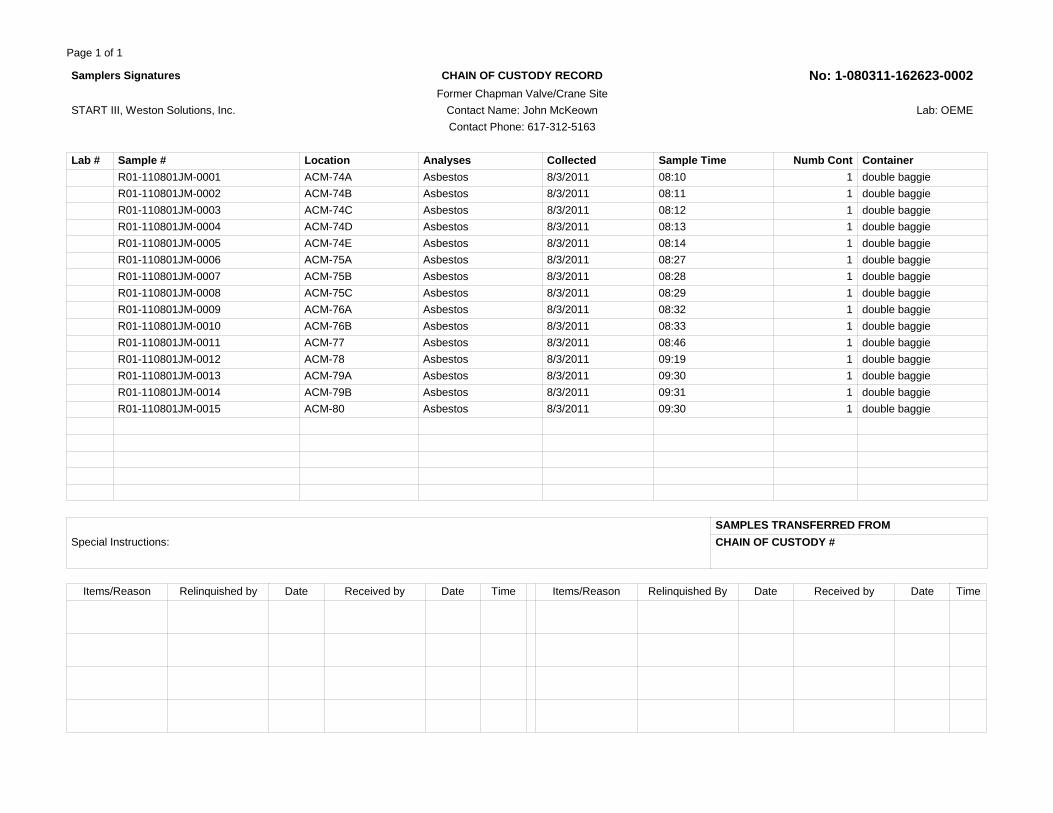
Page 1 of 1
Samplers Signatures CHAIN OF CUSTODY RECORD No: 1-080311-162623-0002 Former Chapman Valve/Crane Site
START III, Weston Solutions, Inc. Contact Name: John McKeown Lab: OEME
Contact Phone: 617-312-5163
Lab # Sample # Location Analyses Collected Sample Time Numb Cont Container
R01-110801JM-0001 ACM-74A Asbestos 8/3/2011 08:10 1 double baggie
R01-110801JM-0002 ACM-74B Asbestos 8/3/2011 08:11 1 double baggie
R01-110801JM-0003 ACM-74C Asbestos 8/3/2011 08:12 1 double baggie
R01-110801JM-0004 ACM-74D Asbestos 8/3/2011 08:13 1 double baggie
R01-110801JM-0005 ACM-74E Asbestos 8/3/2011 08:14 1 double baggie
R01-110801JM-0006 ACM-75A Asbestos 8/3/2011 08:27 1 double baggie
R01-110801JM-0007 ACM-75B Asbestos 8/3/2011 08:28 1 double baggie
R01-110801JM-0008 ACM-75C Asbestos 8/3/2011 08:29 1 double baggie
R01-110801JM-0009 ACM-76A Asbestos 8/3/2011 08:32 1 double baggie
R01-110801JM-0010 ACM-76B Asbestos 8/3/2011 08:33 1 double baggie
R01-110801JM-0011 ACM-77 Asbestos 8/3/2011 08:46 1 double baggie
R01-110801JM-0012 ACM-78 Asbestos 8/3/2011 09:19 1 double baggie
R01-110801JM-0013 ACM-79A Asbestos 8/3/2011 09:30 1 double baggie
R01-110801JM-0014 ACM-79B Asbestos 8/3/2011 09:31 1 double baggie
R01-110801JM-0015 ACM-80 Asbestos 8/3/2011 09:30 1 double baggie
Special Instructions:
SAMPLES TRANSFERRED FROM
CHAIN OF CUSTODY #
Items/Reason Relinquished by Date Received by Date Time Items/Reason Relinquished By Date Received by Date Time

Page 1 of 1
CHAIN OF CUSTODY RECORD No: 1-110911-081357-0003 Sampler Signatures Project Code: Chapman Valve
Date Shipped: 11/9/2011 Contact Name: John McKeown Lab: OEME
Hand-delivered Contact Phone: 617-918-1793
Lab # Sample # Location Analyses Matrix Collected Sample Time Numb Cont
Container
R01-110911JM-001 Grid 29 Percent Solids (% Solids) Soil 11/8/2011 10:00 1 4oz jar
R01-110911JM-002 Grid 75 Percent Solids (% Solids) Soil 11/8/2011 14:00 1 4oz jar
R01-110911JM-003 Grid 8 Percent Solids (% Solids) Soil 11/8/2011 14:30 1 4oz jar
Special Instructions:
SAMPLES TRANSFERRED FROM
CHAIN OF CUSTODY #
Items/Reason Relinquished by Date Received by Date Time Items/Reason Relinquished By Date Received by Date Time

Page 1 of 2
US EPA CHAIN OF CUSTODY RECORD No: 1-111011-085859-0004 Sampler Signatures Former Chapman Valve/MA Lab: Batta Environmental
Contact Name: John Burton DateShipped: 11/10/2011
Contact Phone: 978-621-2130 AirbillNo: 874742741215
Lab # Sample # Location Sub Location Analyses Matrix Collected Num b
Cont
Container Volu me
Vol Units
Avg_Fl ow
Flow_Units
D30841 REF1108-01 Reference Asbestos in Air by TEM ISO 10312
Air 11/8/2011 1 MCE Cassette
5037 Liters 10.95 L/min
D30842 REF1108-02 Reference Asbestos in Air by TEM ISO 10312
Air 11/8/2011 1 MCE Cassette
5842. 85
Liters 13.13 L/min
D30843 REF1108-03 Reference Asbestos in Air by TEM ISO 10312
Air 11/8/2011 1 MCE Cassette
5567. 5
Liters 13.1 L/min
D30844 PLOW-01 personal-29 Asbestos in Air by TEM ISO 10312
Air 11/8/2011 1 MCE Cassette
313.1 Liters 3.131 L/min
D30845 PLOW-02 personal-75 Asbestos in Air by TEM ISO 10312
Air 11/8/2011 1 MCE Cassette
364.0 3
Liters 3.1655 L/min
D30846 PLOW-03 personal-08 Asbestos in Air by TEM ISO 10312
Air 11/8/2011 1 MCE Cassette
311.9 5
Liters 3.1195 L/min
D30847 PD02-29 perimeter-29 Asbestos in Air by TEM ISO 10312
Air 11/8/2011 1 MCE Cassette
1039. 5
Liters 10.395 L/min
D30848 PHIGH-01 personal-29 Asbestos in Air by TEM ISO 10312
Air 11/8/2011 1 MCE Cassette
1030. 5
Liters 10.305 L/min
D30849 PHIGH-02 personal-75 Asbestos in Air by TEM ISO 10312
Air 11/8/2011 1 MCE Cassette
1065 Liters 10.65 L/min
D30850 PD01-29 perimeter-29 Asbestos in Air by TEM ISO 10312
Air 11/8/2011 1 MCE Cassette
1082. 5
Liters 10.825 L/min
Special Instructions: DL = detection limit: S = sensitivity: max # of grid openings = 100. Please prioritize samples in order listed on COC. NADES electronic requested as samples completed. Please advise ASAP on samples that require Indirect Prep Method. High and low volume samples, PHIGH01-03 and PLOW01-03 are collocated, please analyze PHIGH first- if overloaded, analyze PLOW. 8-week TAT requested. Send results to John Burton.
SAMPLES TRANSFERRED FROM
CHAIN OF CUSTODY #
Items/Reason Relinquished by Date Received by Date Time Items/Reason Relinquished By Date Received by Date Time

Page 2 of 2
US EPA CHAIN OF CUSTODY RECORD No: 1-111011-085859-0004 Sampler Signatures Former Chapman Valve/MA Lab: Batta Environmental
Contact Name: John Burton DateShipped: 11/10/2011
Contact Phone: 978-621-2130 AirbillNo: 874742741215
Lab # Sample # Location Sub Location Analyses Matrix Collected Num b
Cont
Container Volu me
Vol Units
Avg_Fl ow
Flow_Units
D30851 PUP-29 perimeter-29 Asbestos in Air by TEM ISO 10312
Air 11/8/2011 1 MCE Cassette
1037 Liters 10.37 L/min
D30852 PUP-75 perimeter-75 Asbestos in Air by TEM ISO 10312
Air 11/8/2011 1 MCE Cassette
1040. 91
Liters 10.205 L/min
D30853 PD01-75 perimeter-75 Asbestos in Air by TEM ISO 10312
Air 11/8/2011 1 MCE Cassette
1071. 53
Liters 10.205 L/min
D30854 PD02-75 perimeter-75 Asbestos in Air by TEM ISO 10312
Air 11/8/2011 1 MCE Cassette
1057. 68
Liters 10.17 L/min
D30855 PHIGH-03 personal-08 Asbestos in Air by TEM ISO 10312
Air 11/8/2011 1 MCE Cassette
1076. 1
Liters 10.55 L/min
D30856 PD01-08 perimeter-08 Asbestos in Air by TEM ISO 10312
Air 11/8/2011 1 MCE Cassette
1105. 5
Liters 11.055 L/min
D30857 PD02-08 perimeter-08 Asbestos in Air by TEM ISO 10312
Air 11/8/2011 1 MCE Cassette
1033 Liters 10.33 L/min
D30858 PUP-08 perimeter-08 Asbestos in Air by TEM ISO 10312
Air 11/8/2011 1 MCE Cassette
990.5 Liters 9.905 L/min
D30859 LBLANK-01 lot blank Asbestos in Air by TEM ISO 10312
Air 11/8/2011 1 MCE Cassette
0 Liters 0 L/min
D30860 FBLANK-01 field blank Asbestos in Air by TEM ISO 10312
Air 11/8/2011 1 MCE Cassette
0 Liters 0 L/min
Special Instructions: DL = detection limit: S = sensitivity: max # of grid openings = 100. Please prioritize samples in order listed on COC. NADES electronic requested as samples completed. Please advise ASAP on samples that require Indirect Prep Method. High and low volume samples, PHIGH01-03 and PLOW01-03 are collocated, please analyze PHIGH first- if overloaded, analyze PLOW. 8-week TAT requested. Send results to John Burton.
SAMPLES TRANSFERRED FROM
CHAIN OF CUSTODY #
Items/Reason Relinquished by Date Received by Date Time Items/Reason Relinquished By Date Received by Date Time

Page 1 of 1
US EPA CHAIN OF CUSTODY RECORD No: 1-033012-100930-0005 Sampler Signatures Project Code: Chapman Valve Lab: OEME
Contact Name: John McKeown DateShipped: 4/4/2012
Contact Phone: 617-918-1793 CarrierName: Hand Delivered
Lab # Sample # Location Analyses Matrix Collected Sample Time Numb Cont Container
R01-110801JM-0016 ACM-01 Asbestos Asbestos 4/4/2012 09:45 1 double baggie
R01-110801JM-0017 ACM-02 Asbestos Asbestos 4/4/2012 10:00 1 double baggie
R01-110801JM-0018 ACM-03 Asbestos Asbestos 4/4/2012 10:10 1 double baggie
R01-110801JM-0019 ACM-04 Asbestos Asbestos 4/4/2012 10:15 1 double baggie
R01-110801JM-0020 ACM-05 Asbestos Asbestos 4/4/2012 10:20 1 double baggie
R01-110801JM-0021 ACM-06 Asbestos Asbestos 4/4/2012 10:25 1 double baggie
R01-110801JM-0022 ACM-07 Asbestos Asbestos 4/4/2012 11:00 1 double baggie
R01-110801JM-0023 ACM-08 Asbestos Asbestos 4/4/2012 11:05 1 double baggie
R01-110801JM-0024 ACM-09 Asbestos Asbestos 4/4/2012 11:15 1 double baggie
R01-110801JM-0025 ACM-10 Asbestos Asbestos 4/4/2012 11:30 1 double baggie
R01-110801JM-0026 ACM-11 Asbestos Asbestos 4/4/2012 11:35 1 double baggie
R01-110801JM-0027 ACM-12 Asbestos Asbestos 4/4/2012 12:00 1 double baggie
R01-110801JM-0028 ACM-13 Asbestos Asbestos 4/4/2012 12:05 1 double baggie
R01-110801JM-0029 ACM-14 Asbestos Asbestos 4/4/2012 12:30 1 double baggie
R01-110801JM-0030 ACM-15 Asbestos Asbestos 4/4/2012 12:35 1 double baggie
R01-110801JM-0031 ACM-16 Asbestos Asbestos 4/4/2012 13:00 1 double baggie
R01-110801JM-0032 ACM-17 Asbestos Asbestos 4/4/2012 12:45 1 double baggie
R01-110801JM-0033 ACM-18 Asbestos Asbestos 4/4/2012 09:45 1 double baggie
Special Instructions:
SAMPLES TRANSFERRED FROM
CHAIN OF CUSTODY #
Items/Reason Relinquished by Date Received by Date Time Items/Reason Relinquished By Date Received by Date Time

Appendix E
Weather Underground, Weather Data Weather Stations KCEF (unofficial NWS data) and KBDL
on 8 November 2011

History : Weather Underground Page 1 of 5
History for Chicopee, MATuesday, November 8, 2011 — View Current Conditions
Tuesday, November 8, 2011
November 8 2011« Previous Day View Next Day »
http://www.wunderground.com/history/airport/KCEF/2011/11/8/DailyHistory.html 12/30/2011
Daily Weekly Monthly Custom
Actual Average Record
Temperature
Mean Temperature 50 °F -
Max Temperature 69 °F 48 °F 69 °F (2011)
Min Temperature 32 °F 31 °F 21 °F (1999)
Degree Days
Heating Degree Days 14
Moisture
Dew Point 40 °F
Average Humidity 89
Maximum Humidity 100
Minimum Humidity 49
Precipitation
Precipitation 0.00 in - - ()
Sea Level Pressure
Sea Level Pressure 30.24 in
Wind
Wind Speed 1 mph (WSW)
Max Wind Speed 6 mph
Max Gust Speed
Visibility 6 miles
Events Fog
Averages and records for this station are not official NWS values. Click here for data from the nearest station with official NWS data (KBDL).

History : Weather Underground Page 2 of 5
T = Trace of Precipitation, MM = Missing Value Source: NWS Daily Summary
http://www.wunderground.com/history/airport/KCEF/2011/11/8/DailyHistory.html 12/30/2011
Seasonal Weather Averages
Certify This Report
Hourly Observations

History : Weather Underground Page 3 of 5
Time (EST) Temp. Windchill Dew Point Humidity Pressure Visibility Wind Dir Wind Speed Gust Speed Precip Events Conditions
12:55 AM 37.8 °F - 36.5 °F 95% 30.23 in 10.0 mi Calm Calm - N/A Clear
1:55 AM 37.8 °F 33.3 °F 36.3 °F 95% 30.23 in 10.0 mi NW 5.8 mph - N/A Clear
2:55 AM 36.3 °F - 35.1 °F 95% 30.22 in 10.0 mi Calm Calm - N/A Clear
3:55 AM 35.1 °F - 34.2 °F 97% 30.23 in 10.0 mi Calm Calm - N/A Clear
4:55 AM 35.2 °F - 34.7 °F 98% 30.25 in 9.0 mi Calm Calm - N/A Clear
5:11 AM 35.6 °F - 33.8 °F 93% 30.25 in 2.5 mi Calm Calm - N/A Clear
5:12 AM 35.6 °F - 33.8 °F 93% 30.25 in 2.0 mi Calm Calm - N/A Clear
5:19 AM 33.8 °F - 33.8 °F 100% 30.25 in 2.5 mi Calm Calm - N/A Clear
5:20 AM 35.6 °F - 33.8 °F 93% 30.25 in 3.0 mi Calm Calm - N/A Clear
5:55 AM 33.1 °F - 32.7 °F 99% 30.26 in 3.0 mi Calm Calm - N/A Clear
6:01 AM 35.6 °F - 33.8 °F 93% 30.25 in 3.0 mi Calm Calm - N/A Clear
6:18 AM 33.8 °F - 33.8 °F 100% 30.26 in 2.0 mi Calm Calm - N/A Clear
6:20 AM 33.8 °F - 33.8 °F 100% 30.26 in 1.8 mi Calm Calm - N/A Clear
6:22 AM 33.8 °F - 32.0 °F 93% 30.26 in 1.5 mi Calm Calm - N/A Clear
6:23 AM 33.8 °F - 32.0 °F 93% 30.26 in 1.2 mi Calm Calm - N/A Clear
6:24 AM 33.8 °F - 32.0 °F 93% 30.26 in 1.0 mi Calm Calm - N/A Clear
6:29 AM 32.0 °F - 32.0 °F 100% 30.26 in 1.2 mi Calm Calm - N/A Clear
6:33 AM 33.8 °F - 33.8 °F 100% 30.26 in 1.8 mi Calm Calm - N/A Clear
6:34 AM 33.8 °F - 33.8 °F 100% 30.26 in 2.5 mi Calm Calm - N/A Clear
6:35 AM 33.8 °F - 33.8 °F 100% 30.26 in 4.0 mi Calm Calm - N/A Clear
6:55 AM 33.8 °F - 33.3 °F 98% 30.27 in 4.0 mi Calm Calm - N/A Clear
7:55 AM 39.4 °F - 38.8 °F 98% 30.28 in 8.0 mi Calm Calm - N/A Clear
Show full METARS | METAR FAQ | Comma Delimited File
12/30/2011http://www.wunderground.com/history/airport/KCEF/2011/11/8/DailyHistory.html

History : Weather Underground Page 4 of 5
Time (EST) Temp. Windchill Dew Point Humidity Pressure Visibility Wind Dir Wind Speed Gust Speed Precip Events Conditions
8:55 AM 46.9 °F - 42.6 °F 85% 30.30 in 10.0 mi Calm Calm - N/A Clear
9:55 AM 53.6 °F - 44.1 °F 70% 30.28 in 10.0 mi Calm Calm - N/A Clear
10:55 AM 61.7 °F - 47.3 °F 59% 30.27 in 10.0 mi Variable 3.5 mph - N/A Scattered Clouds
11:55 AM 65.3 °F - 48.9 °F 55% 30.24 in 10.0 mi Variable 3.5 mph - N/A Partly Cloudy
12:55 PM 67.5 °F - 49.6 °F 53% 30.22 in 10.0 mi Calm Calm - N/A Partly Cloudy
1:55 PM 69.3 °F - 50.2 °F 51% 30.20 in 10.0 mi Calm Calm - N/A Clear
2:55 PM 69.8 °F - 49.8 °F 49% 30.19 in 10.0 mi SSE 3.5 mph - N/A Scattered Clouds
3:55 PM 67.1 °F - 51.1 °F 56% 30.20 in 10.0 mi Calm Calm - N/A Clear
4:55 PM 58.6 °F - 50.2 °F 73% 30.21 in 10.0 mi Calm Calm - N/A Clear
5:55 PM 53.4 °F - 49.1 °F 85% 30.22 in 10.0 mi Calm Calm - N/A Clear
6:55 PM 49.8 °F - 46.8 °F 89% 30.22 in 10.0 mi Calm Calm - N/A Clear
7:55 PM 47.8 °F - 45.7 °F 92% 30.23 in 10.0 mi Calm Calm - N/A Clear
8:55 PM 45.0 °F - 44.1 °F 97% 30.24 in 10.0 mi Calm Calm - N/A Clear
9:38 PM 44.6 °F - 44.6 °F 100% 30.24 in 2.5 mi Calm Calm - N/A Clear
9:40 PM 44.6 °F - 44.6 °F 100% 30.24 in 5.0 mi Calm Calm - N/A Fog Clear
9:55 PM 44.6 °F - 42.8 °F 93% 30.24 in 7.0 mi Calm Calm - N/A Fog Shallow Fog
10:55 PM 42.8 °F - 42.8 °F 100% 30.23 in 7.0 mi Calm Calm - N/A Fog Shallow Fog
11:50 PM 42.8 °F - 42.8 °F 100% 30.22 in 2.5 mi Calm Calm - N/A Clear
11:51 PM 42.8 °F - 42.8 °F 100% 30.22 in 2.0 mi Calm Calm - N/A Clear
11:53 PM 42.8 °F - 42.8 °F 100% 30.22 in 1.8 mi Calm Calm - N/A Clear
11:55 PM 43.0 °F - 42.4 °F 98% 30.22 in 1.8 mi Calm Calm - N/A Clear
Show full METARS | METAR FAQ | Comma Delimited File
12/30/2011http://www.wunderground.com/history/airport/KCEF/2011/11/8/DailyHistory.html

History : Weather Underground Page 5 of 5
Time (EST) Temp. Windchill Dew Point Humidity Pressure Visibility Wind Dir Wind Speed Gust Speed Precip Events Conditions
http://www.wunderground.com/history/airport/KCEF/2011/11/8/DailyHistory.html 12/30/2011
11:58 PM 42.8 °F - 42.8 °F 100% 30.22 in 2.0 mi Calm Calm - N/A Clear
11:59 PM 42.8 °F - 41.0 °F 93% 30.22 in 2.5 mi Calm Calm - N/A Clear
Show full METARS | METAR FAQ | Comma Delimited File

History : Weather Underground Page 1 of 5
History for Windsor Locks, CTTuesday, November 8, 2011 — View Current Conditions
Tuesday, November 8, 2011
November 8 2011« Previous Day View Next Day »
http://www.wunderground.com/history/airport/KBDL/2011/11/8/DailyHistory.html 12/30/2011
Daily Weekly Monthly Custom
Actual Average Record
Temperature
Mean Temperature 53 °F 45 °F
Max Temperature 69 °F 55 °F 77 °F (1975)
Min Temperature 37 °F 35 °F 15 °F (1960)
Degree Days
Heating Degree Days 12 20
Month to date heating degree days 173 152
Since 1 July heating degree days 582 681
Cooling Degree Days 0 0
Month to date cooling degree days 0 0
Year to date cooling degree days 935 756
Growing Degree Days 3 (Base 50)
Moisture
Dew Point 43 °F
Average Humidity 68
Maximum Humidity 92
Minimum Humidity 44
Precipitation
Precipitation 0.00 in 0.12 in 2.02 in (1972)
Month to date precipitation 0.00 1.01
Year to date precipitation 60.42 39.53
Sea Level Pressure

History : Weather Underground Page 2 of 5
Actual Average Record
Sea Level Pressure 30.23 in
Wind
Wind Speed 1 mph (South)
Max Wind Speed 8 mph
Max Gust Speed 10 mph
Visibility 10 miles
Events
T = Trace of Precipitation, MM = Missing Value Source: NWS Daily Summary
http://www.wunderground.com/history/airport/KBDL/2011/11/8/DailyHistory.html 12/30/2011

History : Weather Underground Page 3 of 5
12/30/2011http://www.wunderground.com/history/airport/KBDL/2011/11/8/DailyHistory.html
Certify This Report
Hourly Observations

History : Weather Underground Page 4 of 5
Time (EST) Temp. Dew Point Humidity Pressure Visibility Wind Dir Wind Speed Gust Speed Precip Events Conditions
12:51 AM 43.0 °F 37.9 °F 82% 30.23 in 10.0 mi Calm Calm - N/A Clear
1:51 AM 42.8 °F 37.4 °F 81% 30.22 in 10.0 mi Calm Calm - N/A Clear
2:51 AM 39.2 °F 35.6 °F 87% 30.21 in 10.0 mi Calm Calm - N/A Clear
3:51 AM 39.0 °F 36.0 °F 89% 30.22 in 9.0 mi Calm Calm - N/A Clear
4:51 AM 39.0 °F 35.1 °F 86% 30.24 in 10.0 mi Calm Calm - N/A Clear
5:51 AM 37.9 °F 36.0 °F 93% 30.25 in 10.0 mi Calm Calm - N/A Partly Cloudy
6:51 AM 41.0 °F 37.0 °F 86% 30.25 in 10.0 mi Calm Calm - N/A Scattered Clouds
7:51 AM 45.0 °F 39.0 °F 80% 30.27 in 10.0 mi Calm Calm - N/A Scattered Clouds
8:51 AM 48.9 °F 41.0 °F 74% 30.28 in 9.0 mi Calm Calm - N/A Scattered Clouds
9:51 AM 55.0 °F 43.0 °F 64% 30.28 in 10.0 mi Calm Calm - N/A Scattered Clouds
10:51 AM 61.0 °F 45.0 °F 56% 30.26 in 10.0 mi Calm Calm - N/A Clear
11:51 AM 64.9 °F 46.0 °F 50% 30.22 in 10.0 mi South 3.5 mph - N/A Scattered Clouds
12:51 PM 68.0 °F 46.9 °F 47% 30.20 in 10.0 mi Calm Calm - N/A Scattered Clouds
1:51 PM 69.1 °F 46.9 °F 45% 30.19 in 10.0 mi South 3.5 mph - N/A Scattered Clouds
2:51 PM 69.1 °F 46.9 °F 45% 30.18 in 10.0 mi SE 5.8 mph - N/A Partly Cloudy
3:51 PM 66.9 °F 46.9 °F 49% 30.19 in 10.0 mi SSE 6.9 mph - N/A Partly Cloudy
4:51 PM 64.9 °F 46.9 °F 52% 30.20 in 10.0 mi Calm Calm - N/A Partly Cloudy
5:51 PM 57.0 °F 46.9 °F 69% 30.21 in 10.0 mi Calm Calm - N/A Clear
6:51 PM 57.9 °F 46.9 °F 67% 30.21 in 10.0 mi South 5.8 mph - N/A Clear
7:51 PM 54.0 °F 46.0 °F 75% 30.22 in 10.0 mi Calm Calm - N/A Clear
8:51 PM 53.1 °F 46.0 °F 77% 30.23 in 10.0 mi SSW 4.6 mph - N/A Clear
9:51 PM 52.0 °F 46.0 °F 80% 30.23 in 10.0 mi Calm Calm - N/A Clear
Show full METARS | METAR FAQ | Comma Delimited File
12/30/2011http://www.wunderground.com/history/airport/KBDL/2011/11/8/DailyHistory.html

History : Weather Underground Page 5 of 5
Time (EST) Temp. Dew Point Humidity Pressure Visibility Wind Dir Wind Speed Gust Speed Precip Events Conditions
http://www.wunderground.com/history/airport/KBDL/2011/11/8/DailyHistory.html 12/30/2011
10:51 PM 52.0 °F 46.0 °F 80% 30.23 in 9.0 mi Calm Calm - N/A Clear
11:51 PM 50.0 °F 46.0 °F 86% 30.21 in 8.0 mi South 3.5 mph - N/A Clear
Show full METARS | METAR FAQ | Comma Delimited File

Appendix F
Global Positioning System (GPS) Information for Debris Piles and Asbestos-Containing Material Samples from Figure 4

LATITUDE AND LONGITUDE FOR FIGURE 4 FORMER CHAPMAN VALVE/CRANE COMPANY
SPRINGFIELD, MASSACHUSETTS
Location Latitude Longitude 1 ACM-01/18 42.155439550 -72.500671632 2 ACM-02 42.155414611 -72.499770244 3 ACM-03 42.155376971 -72.499678275 4 ACM-04 42.155418168 -72.500093268 5 ACM-05 42.155461451 -72.500123408 6 ACM-06 42.155363063 -72.500082815 7 ACM-07 42.155044320 -72.499087162 8 ACM-08 42.155101176 -72.499083703 9 ACM-09 42.155122932 -72.499118993
10 ACM-10 42.154655772 -72.499578868 11 ACM-11 42.154759138 -72.499544784 12 ACM-12 42.154972945 -72.500179938 13 ACM-13 42.154975846 -72.500349233 14 ACM-14 42.153964340 -72.500396958 15 ACM-15 42.153986570 -72.500398763 16 ACM-16 42.154037247 -72.500427867 17 ACM-17 42.154091784 -72.500362064 18 ACM-74 42.154707262 -72.499147618 19 ACM-75 42.154802426 -72.499880969 20 ACM-76 42.154829516 -72.500000643 21 ACM-77 42.154551751 -72.500435975 22 ACM-78 42.155321516 -72.499989279 23 ACM-79 42.154971558 -72.499995981 24 ACM-80 42.154965909 -72.500194574
25 Surface 1 (South) 42.155367984 -72.500674591 26 Surface 1 (East) 42.155425147 -72.500616188 27 Surface 1 (West) 42.155461600 -72.500734320 28 Surface 1 (North) 42.155494490 -72.500651694 29 Surface 2 (South) 42.155310562 -72.500047633 30 Surface 2 (East) 42.155358715 -72.499969428 31 Surface 2 (West) 42.155431751 -72.500151828 32 Surface 2 (North) 42.155496289 -72.500090144 33 Surface 3 (South) 42.155008231 -72.499083620 34 Surface 3 (East) 42.155058198 -72.499016209 35 Surface 3 (West) 42.155121823 -72.499142939 36 Surface 3 (North) 42.155165367 -72.499065373 37 Surface 4 (South) 42.154552430 -72.499780258 38 Surface 4 (East) 42.154637889 -72.499481497 39 Surface 4 (West) 42.154679816 -72.499871517 40 Surface 4 (North) 42.154783877 -72.499598981 41 Pile 1 (North) 42.155477202 -72.499625318 42 Pile 1 (South) 42.155233222 -72.499647540
R:\11030008\Reports\Appendix F\AppendixF-lat_long_6-11.xls Page 1 of 2

LATITUDE AND LONGITUDE FOR FIGURE 4 FORMER CHAPMAN VALVE/CRANE COMPANY
SPRINGFIELD, MASSACHUSETTS
Location Latitude Longitude 43 Pile 1 (West) 42.155360451 -72.499787237 44 Pile 1 (East) 42.155334462 -72.499514104 45 Pile 2 (South) 42.154812564 -72.500232085 46 Pile 2 (North) 42.155118885 -72.500372875 47 Pile 2 (Northwest) 42.155097005 -72.500544213 48 Pile 2 (East) 42.154953439 -72.500381412 49 Pile 2 (West) 42.154977949 -72.500173802 50 Pile 3 (North) 42.155041973 -72.500534064 51 Pile 3 (South) 42.154441465 -72.500560076 52 Pile 3 (East) 42.154733447 -72.500293059 53 Pile 3 (West) 42.154747067 -72.500768884 54 Pile 4 (North) 42.155087537 -72.499922603 55 Pile 4 (South) 42.154719631 -72.499934340 56 Pile 4 (East) 42.154890841 -72.499854524 57 Pile 4 (West) 42.154907198 -72.500055021 58 Pile 5 (North) 42.154659658 -72.499089651 59 Pile 5 (South) 42.154600318 -72.499106711 60 Pile 5 (West) 42.154621738 -72.499168736 61 Pile 5 (East) 42.154627956 -72.499029654 62 Pile 6 (North) 42.154124085 -72.500379253 63 Pile 6 (South) 42.154073027 -72.500368720 64 Pile 6 (West) 42.154094146 -72.500416571 65 Pile 6 (East) 42.154089306 -72.500329445 66 Pile 7 (North) 42.154005150 -72.500391101 67 Pile 7 (South) 42.153958148 -72.500372862 68 Pile 7 (West) 42.153983063 -72.500414917 69 Pile 7 (East) 42.153981557 -72.500344070 70 CDA 1 (South) 42.155475174 -72.499670305 71 CDA 1 (East) 42.155529466 -72.499524372 72 CDA 1 (West) 42.155648306 -72.499765445 73 CDA 1 (North) 42.155692569 -72.499689635 74 CDA 2 (South) 42.154582630 -72.500207394 75 CDA 2 (West) 42.154763809 -72.500295896 76 CDA 2 (East) 42.154779717 -72.500094347 77 CDA 2 (North) 42.154813648 -72.500129008
Note:
Instead of all the points along each perimeter, the most northern, southern, eastern, and western points of each area were recorded.
R:\11030008\Reports\Appendix F\AppendixF-lat_long_6-11.xls Page 2 of 2


![PRELIMINARY TECHNICAL PROGRAM - …nepcap2014.ciam.ru/files/Technical_Program_[NEPCAP_2014].pdfNEPCAP 2014 Preliminary Technical Program 1 PRELIMINARY TECHNICAL PROGRAM Sunday, October](https://static.fdocuments.us/doc/165x107/5adb772e7f8b9a4a268b5532/preliminary-technical-program-nepcap2014pdfnepcap-2014-preliminary-technical.jpg)


