RELINQUISHMENT REPORT FOR LICENCE P.1814, BLOCK 29/10d ... · The resolution and continuity of...
13
Relinquishment Report P.1814, Block 29/10d November 2013 Page 1 RELINQUISHMENT REPORT FOR LICENCE P.1814, BLOCK 29/10d Licence Number: P.1814 Blocks: 29/10d Licence Round: 26th Round Licence Type: Traditional Licence Partners Prior to relinquishment: Ithaca Energy UK (Ltd) (Operator) 54.66% Dyas UK Limited 25.34% Petrofac Energy Developments UK Limited 20 % Ithaca confirms DECC is free to publish this report and that all third party ownership rights have been considered and appropriately cleared for publication purposes. LICENCE SYNOPSIS Fig 1. Location of Block 29/10d showing Leads and Prospects
Transcript of RELINQUISHMENT REPORT FOR LICENCE P.1814, BLOCK 29/10d ... · The resolution and continuity of...

Relinquishment Report P.1814, Block 29/10d November 2013 Page 1
RELINQUISHMENT REPORT FOR LICENCE P.1814, BLOCK 29/10d
Licence Number: P.1814
Blocks: 29/10d
Licence Round: 26th Round
Licence Type: Traditional Licence
Partners Prior to relinquishment: Ithaca Energy UK (Ltd) (Operator) 54.66%
Dyas UK Limited 25.34%
Petrofac Energy Developments UK Limited 20 %
Ithaca confirms DECC is free to publish this report and that all third party ownership rights
have been considered and appropriately cleared for publication purposes.
LICENCE SYNOPSIS
Fig 1. Location of Block 29/10d showing Leads and Prospects

Relinquishment Report P.1814, Block 29/10d November 2013 Page 2
The licence P.1814 (Block 29/10d) was awarded on 10th January 2011 as a Traditional licence in
the 26th round of licensing to Ithaca Energy UK (Ltd) and Dyas, with Ithaca as the operator of the
licence (Figure 1). In October 2011, Petrofac joined the co-venture through a multi-block
agreement with Ithaca and Dyas to align all three companies in the area of the Stella field
development.
The block was applied for primarily because of the presence of the undeveloped Paleocene, Andrew
sandstone discovery (Helios, 29/10-2). Two additional high risk prospects, one in the Paleocene
(Lead HB) and one in the Upper Jurassic Fulmar (Helios Deep) were also identified. (Figure 1).
WORK PROGRAMME SUMMARY
The agreed work programme consisted of a firm commitment to obtain and reprocess 90 km2 of 3D
seismic data. This has been fulfilled. A further Drill or Drop commitment was made to drill one
well to 3000m or the Top of the Chalk whichever was the shallower. A decision was made to drop
the licence in October 2013.
An extensive regional seismic dataset has been established over the area (PGS 3D MegaSurvey
data). The licensees initially purchased 90km2 of the Fugro TerraCube PSTM 3D and 460 km2 of
CGG Long Offset PSTM data, of which approximately 250km2 lie within block 29/10d. Ithaca
Energy performed a post stack inversion and qualitative interpretation studies on this data. The
work undertaken also included updating log and biostratigraphic correlations of all wells in the area
and an update of the geological model.
The analysis of seismic data has focused on establishing the presence and nature of the reservoir
formations, particularly the Andrew Sand Formation. The operator commissioned Ikon Science to
undertake an extensive regional study involving the inversion and calibration of the seismic
response to well data. The study concluded that the sands in the area of the Helios discovery are
probably highly cemented.
Further work using the Foster Findlay Associated technology to undertake detailed spectral
decomposition studies of the CGG Long Offset data demonstrated that deposition of reservoir sands
was quite limited in the Helios area. The addition of the 29/10-7 well to the database when it was
released in early 2012 showed that the Andrew sand was absent. This supported earlier conclusions
Relinquishment Report P.1814, Block 29/10d November 2013 Page 3
on reservoir distribution and placed an increased risk on the presence of effective Andrew sand
reservoir away from the Helios area.
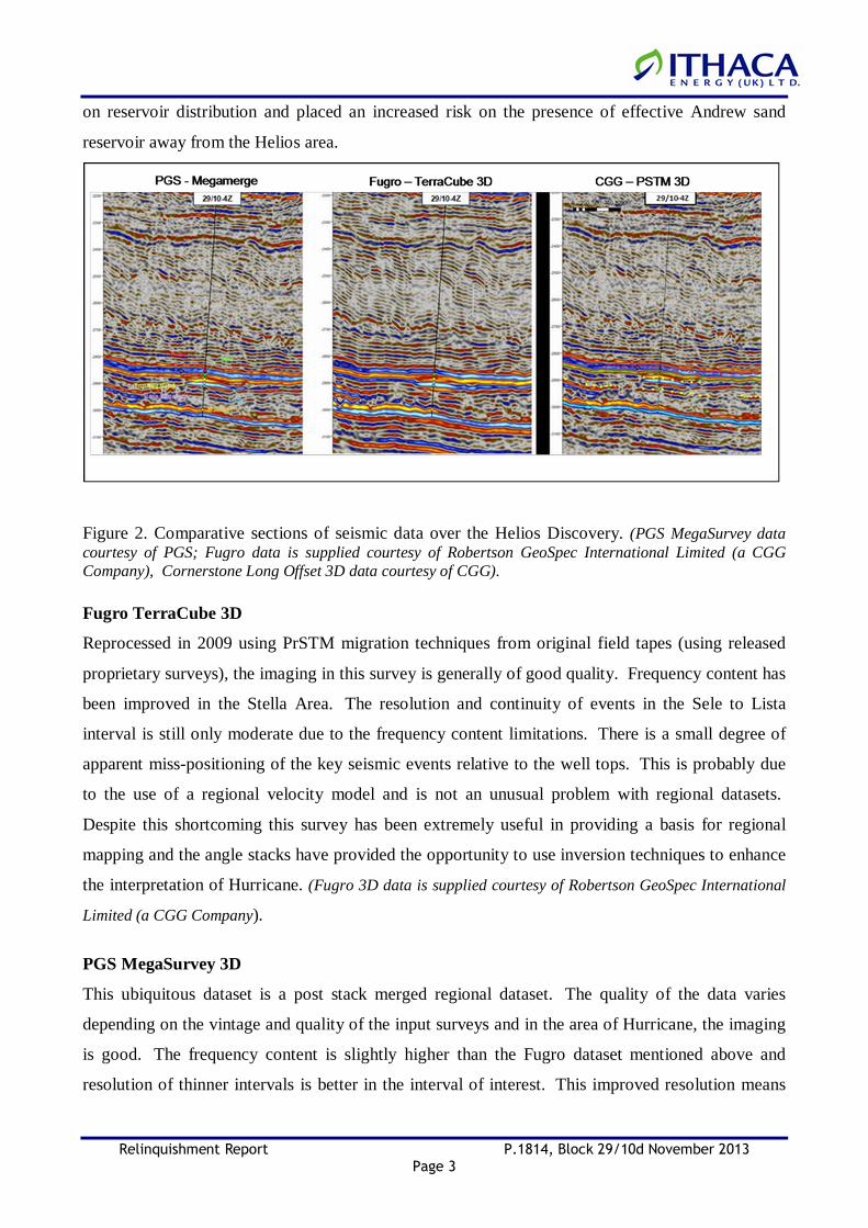
Figure 2. Comparative sections of seismic data over the Helios Discovery. (PGS MegaSurvey data courtesy of PGS; Fugro data is supplied courtesy of Robertson GeoSpec International Limited (a CGG Company), Cornerstone Long Offset 3D data courtesy of CGG).
Fugro TerraCube 3D
Reprocessed in 2009 using PrSTM migration techniques from original field tapes (using released
proprietary surveys), the imaging in this survey is generally of good quality. Frequency content has
been improved in the Stella Area. The resolution and continuity of events in the Sele to Lista
interval is still only moderate due to the frequency content limitations. There is a small degree of
apparent miss-positioning of the key seismic events relative to the well tops. This is probably due
to the use of a regional velocity model and is not an unusual problem with regional datasets.
Despite this shortcoming this survey has been extremely useful in providing a basis for regional
mapping and the angle stacks have provided the opportunity to use inversion techniques to enhance
the interpretation of Hurricane. (Fugro 3D data is supplied courtesy of Robertson GeoSpec International
Limited (a CGG Company).
PGS MegaSurvey 3D
This ubiquitous dataset is a post stack merged regional dataset. The quality of the data varies
depending on the vintage and quality of the input surveys and in the area of Hurricane, the imaging
is good. The frequency content is slightly higher than the Fugro dataset mentioned above and
resolution of thinner intervals is better in the interval of interest. This improved resolution means

Relinquishment Report P.1814, Block 29/10d November 2013 Page 4
that confident interpretation of the Rogaland Sandstone Member is possible over a larger proportion
of Hurricane and this survey was used as the primary dataset for the interpretation of the Hurricane
structure prior to the 29/10b-8 well.
CGG PSTM 3D
Following the results of the 29/10b-8 well, it became clear that access to higher quality seismic data
were necessary to improve the interpretation of FSM and ASM intervals and to reduce the
associated uncertainty. To address this, the partnership licenced 460 km2 of CGG Cornerstone 3D
data (“the CGG data”). The CGG data covers all the key discoveries and prospects in the Greater
Stella Area including Stella, Harrier, Hurricane. The improved frequency content and imaging of
this dataset has improved the resolution of the key Hurricane reservoir intervals and allows a more
confident interpretation of the stratigraphic elements of the trap to the North and South. Also
improved is the reflector continuity to the West of Hurricane which has helped develop a more
integrated geological understanding of the sand fairway(s). (Cornerstone Long Offset 3D data courtesy
of CGG).
DATABASE
Ithaca have acquired a large amount of seismic and well data in the vicinity of 29/10d due to their
involvement in several of the surrounding blocks (Figure 3).
Four wells have been drilled on block 29/10d itself. these are summarised in the table below.
Well Completion Date Operator Formation at TD Status Logs Checkshots Core29/10-1 18/07/1969 Shell Ekofisk P&A Gas shows Full Yes Sidewall only29/10-2 14/11/1983 Shell Triassic P&A Gas shows Full Yes Paleocene and Fulmar29/10-6 10/07/1998 Shell Ekofisk P&A Dry Hole Full No Maureen29/10-7 21/12/2006 Shell Rotliegend P&A Dry Hole Full No No
Table 1 – Well Summary Table 29/10d
Log data is available from all wells, and constitutes a minimum of GR/Res/Neu/Den/Sonic over the
Paleocene interval. Wireline formation tester tools were run in all wells with varying degrees of
success.
Sidewall core data only is available from well 29/10-1, the sampling density is relatively good,
however the samples are percussion only; basic lithology description is available. Well 29/10-2
recovered 3 cores from within the Paleocene, and a considerable footage from the Upper Jurassic.
Well 29/10-6 recovered core from the Lower Lista and Maureen Formations.
Relinquishment Report P.1814, Block 29/10d November 2013 Page 5
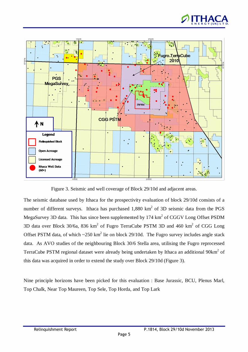
Figure 3. Seismic and well coverage of Block 29/10d and adjacent areas.
The seismic database used by Ithaca for the prospectivity evaluation of block 29/10d consists of a
number of different surveys. Ithaca has purchased 1,880 km2 of 3D seismic data from the PGS
MegaSurvey 3D data. This has since been supplemented by 174 km2 of CGGV Long Offset PSDM
3D data over Block 30/6a, 836 km2 of Fugro TerraCube PSTM 3D and 460 km2 of CGG Long
Offset PSTM data, of which ~250 km2 lie on block 29/10d. The Fugro survey includes angle stack
data. As AVO studies of the neighbouring Block 30/6 Stella area, utilising the Fugro reprocessed
TerraCube PSTM regional dataset were already being undertaken by Ithaca an additional 90km2 of
this data was acquired in order to extend the study over Block 29/10d (Figure 3).
Nine principle horizons have been picked for this evaluation : Base Jurassic, BCU, Plenus Marl,
Top Chalk, Near Top Maureen, Top Sele, Top Horda, and Top Lark

Relinquishment Report P.1814, Block 29/10d November 2013 Page 6
PROSPECT UPDATE
Ithaca identified two early Tertiary (Lista Formation, upper Andrew Sandstone) stratigraphic traps
in Block 29/10d; one discovery (Helios) and one lead (Lead HB). One Upper Jurassic (Fulmar
Sandstone) lead (Helios Deep) was also identified (Figures 1 and 4).
Figure 4. Seismic section showing the Helios Discovery, Lead HB and Helios Deep Lead in Block 29/10d, P.1814. (Fugro Terracube 3D data is supplied courtesy of Robertson GeoSpec International Limited (a CGG Company)).
Paleocene Prospects
Block 29/10d lies on the western margin of the Central Graben, where salt diapirism has created
structural trapping potential (such as the salt-induced four-way dip closure in the Curlew A
discovery) and has influenced early Tertiary channel distribution, by creating bathymetric highs. In

Relinquishment Report P.1814, Block 29/10d November 2013 Page 7
addition, the erosion of salt-induced highs led to re-distribution of Chalk debris in early to late
Palaeocene times (in the Maureen Formation), creating bathymetric relief which also influenced
subsequent deep water channel distribution. The fact that the early Tertiary sands are often at their
most distal setting in Block 29/10d area also creates stratigraphic trapping potential although the
thin nature of these sands makes identification difficult.
Prior to the award Ithaca identified two early Tertiary (Lista Formation, upper Andrew Sandstone)
stratigraphic traps in Block 29/10d; one undeveloped discovery (Helios) and one lead (Lead HB).
One Upper Jurassic (Fulmar Sandstone) lead (Helios Deep) was also identified (Figure 1).
Block 29/10d has previously been appraised by wells 29/10-1, 29/10-2 and 29/10-6, drilled by
Shell/Esso in 1969, 1983 and 1998 respectively (Figure 1). Wells 29/10-1 and 29/10-2 discovered
gas-condensate within Lista Formation-aged Andrew sands (Helios Discovery), whilst well 29/10-6
was a dry hole. In the wider area, the northern part of Quadrant 29 and neighbouring Blocks 30/6
and 30/7 contain numerous oil and gas condensate discoveries in the Lista Formation-aged upper
Andrew Sandstone (Stella, Harrier, Julia, Hurricane and Puffin). In addition, since 1996, the
Andrew Sandstone has been successfully developed in the Joanne Field, operated by
ConocoPhillips.
An additional well, 29/10-7, was drilled in Block 29/10d by Shell / Esso in 2005, the results of this
well only became available after the award of the licence. No Andrew sands were encountered in
this well only tight Chalk debrites, this has resulted in a significant downgrading of the Helios
discovery.
Helios Discovery
The Helios structure that lies in the middle of Block 29/10d provided the primary focus of the work
programme. The structure is a salt cored anticline with the underlying tilted Jurassic fault block
facilitating the upward movement of the salt into and through the Mesozoic sediments. The Helios
discovery is located within a three way dip closed stratigraphic trap on the southern flank of the
Helios structure (Figure 4, 5 and 6). Modelling the upper Andrew Sandstone distribution, thickness
and quality is a critical factor in any volume calculations for the Helios discovery. The regional
model however suggests that Helios is away from the main sand fairway and chalk debrite
deposition dominated in this area thus downgrading the potential, the 29/10-7 data supports this.

Relinquishment Report P.1814, Block 29/10d November 2013 Page 8
Fig 5. Depth Map on Helios Structure showing possible outline of Andrew Sand
Fig 6. Geoseismic section through the Helios structure and Lead HB illustrating Andrew Sandstone prospectivity

Relinquishment Report P.1814, Block 29/10d November 2013 Page 9
Volumes were based on polygons defined using the Poisson’s Ratio attribute (geobody cut-off and
strength of response), closing contour, and P impedance attribute. Three main polygons were
utilised (Figure 7), a low case based on the most prominent PR and low AI , a mid case based on
channel form geometry clipped at spill and a high case based on the entire anomaly. Volumes are
heavily dependent on thickness and N:G (as well as area), the thickness was based on well 29/10-1
and the N:G on the nearby well values and regional work.
Fig. 7. Polygons defining areal extent of anomaly on Helios Structure
All cases assume that the structure is filled to the structural spill point, which is mapped at 9,160 ft
TVDSS. This assumption is based on evidence from Stella and Julia, which have been proven to be
filled to spill. However, a stratigraphic trapping element may be expected if the upper Andrew
Sandstone is channelized, and there remains the possibility that hydrocarbons may be present below
the structural spill point.
Based on the data from well 29/10-1 it would appear that the Helios structure contains
gas-condensate at the crest and gas condensate fits with other discoveries in the area. As with the
nearby Stella field, oil may exist down flank however for purposes of volume calculations a gas
condensate fluid was assumed.

Relinquishment Report P.1814, Block 29/10d November 2013 Page 10
The Helios Discovery has proven hydrocarbons and therefore all the risk is associated with the
presence and effectiveness of the reservoir. The COS of Helios Discovery is estimated as 20%.
� Gas/Condensate Case (P90-P50-P10)
� GIIP 5-17-50 bcf
� CIIP 1-3-8 MMstb
Lead HB
Lead HB is an Andrew Sandstone lead located on the north-east side of the Helios structure (Figure
4, 6 and 8). As described previously, regional studies suggest that Andrew Sandstone deposition
was more heavily influenced by seafloor bathymetry in the Block 29/10 area when compared with
the Block 30/6 area. The Sele-Maureen TWT isopach map clearly shows thinning of the section
towards the crest of the Helios structure suggesting that the structure provided an element of
bathymetric relief during deposition. It is possible that upper Andrew Sandstone channels deposited
sand on the north eastern edge of the structure (Figure 6 and 8) and this supported by the results of
the most recent Hurricane appraisal well, 29/10b-8.
Fig 8. Depth Map on Helios Structure showing outline of possible HB Lead.

Relinquishment Report P.1814, Block 29/10d November 2013 Page 11
Upper Jurassic
Most of the wells drilled in the northern part of Quadrant 29 targeted Jurassic objectives,
particularly the Oxfordian/Kimmeridgian aged Fulmar Sandstone Member. Examples of Quadrant
29 fields which produce from late Jurassic reservoirs are the HPHT Elgin/Franklin and Shearwater
fields. The Fulmar Sandstone Member in the Block 29/10 area is interpreted to have been deposited
in an upper shoreface / deltaic environment. The late Jurassic Fulmar deltaic / shoreface system is
thought to have prograded in a northeast direction from the margin of the Central graben. Well
29/10-2 penetrated and cored a 770 ft thick section of Fulmar Sandstone Member. Rock quality is
modest at the base of the section, but increases upwards, with core measured porosity regularly
exceeding 20 % and air permeability over 100 mD. Calculated NTG from the CPI interpretation is
also very high at 95 %. However, the sands were wet in this location, suggesting a lack of suitable
trapping mechanism. RFT formation pressures acquired show that the reservoir pressure within the
Jurassic section is in excess of 12,000 psi, suggesting HPHT conditions. The underlying alluvial
plain coals and fluvial sandstones of the Pentland Formation are also wet, and of lower quality
(average porosity 14 %, Net to Gross 0.14 from CPI interpretation). However, some of the more
apparently channelized sands towards the base of the sequence appear to be of a significant
thickness (112 ft TVD), and have porosities approaching 20 %. Although water-bearing, well
29/10-2 provides evidence for the existence of reservoir quality sands in both the Fulmar Sandstone
Member and Pentland Formations.
Helios Deep Lead
The Helios Deep lead is a structural trap of middle to late Jurassic Fulmar and Pentland Sandstones
at approximately 15,000 ft. The structural trap is created by the up-dip onlapping of the Fulmar and
Pentland Sandstone onto the extensive north-north-west to south-south-east trending fault that
forms the western margin of the lead (Figure 4 and 9). Regionally, similar analogous fault bound
shoreface sandstone accumulations (Puffin) have been successfully explored and appraised
providing evidence of a successful play fairway in the Jurassic stratigraphy.

Relinquishment Report P.1814, Block 29/10d November 2013 Page 12
Fig. 9. Depth Map and Geoseismic Section of Upper Jurassic on Fulmar Sandstone showing the Helios Deep Lead.
The main risks for the Helios Deep Lead are identified as the trap configuration and the seal. The
lead is also likely to be HPHT.
The COS of the Helios Deep lead is estimated as 11%.
Oil in Place: P90 15 mmboe P50 46 mmboe P10 79 mmboe
Conclusion . The licence was dropped after two years and nine months. The decision to drop the block and not
commit to a firm well followed on from technical work on the undeveloped discovery that
significantly increased the risk on reservoir presence and effectiveness which subsequently reduced
the size of the discovery. The limited size and uncertainty of the Helios discovery does not
currently merit drilling and development.
Relinquishment Report P.1814, Block 29/10d November 2013 Page 13
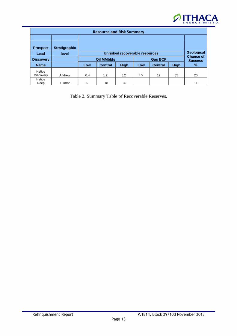
Resource and Risk Summary
Prospect Stratigraphic
Lead level Unrisked recoverable resources
Discovery Oil MMbbls Gas BCF
Name Low Central High Low Central High
Geological Chance of Success
%
Helios Discovery Andrew 0.4 1.2 3.2 3.5 12 35 20
Helios Deep Fulmar 6 18 32 11
Table 2. Summary Table of Recoverable Reserves.