Relatório Nacional ICA2011 Junho atualizado · INSTITUTO GEOGRÁFICO PORTUGUÊS (IGP) Rua...
50
PORTUGAL NATIONAL REPORT ICA 2011 15th General Assembly 25th International Cartographic Conference Paris 03-08 July 2011
Transcript of Relatório Nacional ICA2011 Junho atualizado · INSTITUTO GEOGRÁFICO PORTUGUÊS (IGP) Rua...

PORTUGAL
NATIONAL REPORT
ICA 2011
15th General Assembly
25th International Cartographic Conference
Paris
03-08 July 2011

PORTUGAL – National Report to the 15th General Assembly of the International Cartographic Association
IGP2011 2/50
Portuguese representatives
National delegate : Carlos Manuel Mourato Nunes, Lieutenant-General General-Director of the National Mapping and Cadastral Agency President of the National Cartographic Council
National deputy : João Cordeiro Fernandes, Geographic Engineer National Mapping and Cadastral Agency
LIST OF CONTENTS
FOREWORD ................................................................................................................................... 3
INSTITUTO GEOGRÁFICO PORTUGUÊS (IGP) ................................................................................ 4
INSTITUTO GEOGRÁFICO DO EXÉRCITO (IGeoE) ........................................................................ 18
INSTITUTO HIDROGRÁFICO (IHPT) .............................................................................................. 19
INSTITUTO NACIONAL DE ESTATÍSTICA (INE) ............................................................................. 26
AUTORIDADE FLORESTAL NACIONAL (AFN) ............................................................................... 28
INSTITUTO DE INVESTIGAÇÃO CIENTÍFICA TROPICAL (IICT) ....................................................... 30
INSTITUTO DA ÁGUA, I. P. (INAG, I. P.) ....................................................................................... 34
DIRECÇÃO REGIONAL DA CIÊNCIA, TECNOLOGIA E COMUNICAÇÕES (DRCTC) ......................... 38
DIRECÇÃO REGIONAL DE INFORMAÇÃO GEOGRÁFICA E ORDENAMENTO DO TERRITÓRIO
(DRIGOT) ..................................................................................................................................... 40
INSTITUTO NACIONAL DE RECURSOS BIOLÓGICOS (INRB)......................................................... 44
ESCOLA PROFISSIONAL DE CARTOGRAFIA E CADASTRO (EPCG) ................................................ 48
ORDEM DOS ENGENHEIROS ....................................................................................................... 49
Edition: Instituto Geográfico Português (IGP), 2011 Depósito Legal: ISBN: CD Reprodution: IGP Editor’s note : Each institutional report is the respective institution’s exclusive responsibility.
PORTUGAL – National Report to the 15th General Assembly of the International Cartographic Association
IGP2011 3/50
FOREWORD
The constant growth of the information society and the globalization of knowledge have been two of the most important elements on the participation that the scientific and technological community have been manifesting concerning the Geographical Information (GI) area of knowledge. The globalization of knowledge, based on information technologies, has been promoting an elevated index of search for spacial information, which usability purposes cover many scientific and commercial interests. Because of this, the easiness of communication and distribution of data nowadays is very high, giving the user of GI the possibility to access georefered data, that used to only be accessible after a long bureaucratic process for its visualization, selection, ordering and reception. In parallel, the easiness of knowledge trading between scientific and technological communities has contributed, in a notable way, for an important advance in the processes of acquisition and distribution of spacial data, deriving from many different and heterogeneous data sources. The guarantees of interoperability between various information systems, which promote the communication and the distribution of GI, and the interchange of scientific and technological knowledge surpass the barriers between the producers of information and its potencial users. On a national level, the becoming of Instituto Geográfico Português (IGP), the National Mapping and Cadastral Agency, into the national authority in areas such as Geodesy, Cartography and Cadastre, reaffirmed its role in the regulation of the exercise of this activities in what concerns the rules and technical specifications of data production and reproduction, licensing and fiscalization of the referred activities, as well as the homologation of the respective products. Since 2007, with the approval of the INSPIRE directive, the user’s community gained access, in an harmonized way, to the spacial data spreading from the different kinds of Public Administration’s organisms, remaining open to the data spreading from the private sector. In this scope, with the transposition of the INSPIRE directive, in 2009, to the portuguese juridical order, this Institute has been assuring the consolidation of the national spacial data infrastructure, the Sistema Nacional de Informação Geográfica (SNIG), that already worked in an innovative structure regimen since 1995 and was recently an european level awardee. With this report, we can evidence the involvement of the many entities which constitute the Cartography Coordinator Council, one of the organisms which were reforced through the qualification of the national authority given to IGP. We should note the participation of those institutions in many different scientific research projects, shared with international institutions, although the actual economic context may restrict this evolution, given the scarcity of human and financial resources that has been registered in many institutions. However, based on a significant effort by the governmental entities in the sector, it was possible to begin a program of real propriety cadastre execution through the Sistema Nacional de Exploração e Gestão de Informação Cadastral (SiNErGIC), which will have its reflections in the private sector, who will execute the program under the ruling of IGP. The harmonization of the information between the land registry offices and the inland revenue offices and the use of specific execution techniques, based on open rules and on open source products, will provoke the participation by the intervenient community, that is wanted to be rational and innovative. The need of a response to this initiatives will inevitably call for a mobilization of knowledge and human and technological resources, that will be reflected on the final quality of the geographical information that will be distributed in a nearby future. Lisbon, June 2011 Carlos Manuel Mourato Nunes, Lieutenant-General General-Director of the National Mapping and Cadastral Agency President of the National Cartographic Council

PORTUGAL – National Report to the 15th General Assembly of the International Cartographic Association
IGP2011 4/50
INSTITUTO GEOGRÁFICO PORTUGUÊS (IGP) Rua Artilharia 1, 107 1099 – 052 LISBOA Tel: + 351 21 381 96 00 Fax: + 351 21 381 96 99 e.mail: [email protected] http: //www.igeo.pt
1 – INTRODUCTION Heir to an institutional tradition that can be traced back to 1788, when the first systematic geodetic works began in Portugal with the purpose of “creating the general triangulation of the Kingdom, aiming both to establish new bases for the theory on the shape of the earth and to be a sound and undisputed basis for the construction of the geographic map of the Kingdom at scale 1:100 000”, IGP is Portugal’s national geodetic, mapping, cadastre and geographic information agency. IGP’s mission is to act as the national authority in the four fields mentioned above, to produce official geographical information, to develop and coordinate the national geographical information system, to promote training and research in earth sciences and geographical information technologies and to contribute to the information society. It is responsible for the execution of geographical information policies. In this capacity, IGP is responsible for licensing private companies for cadastral production and for the certification of mapping and cadastre produced by other organisations, with the exception of military and hydrographic cartography.
IGP has a staff of 241, with its head office in Lisboa and six regional offices on mainland Portugal. The former offices in the autonomous regions of Madeira and Azores are already under the regional government.
2 – RESEARCH AND DEVELOPMENT
IGP has a research team than develops activities in scientific areas such Analysis, Models and Georeferenced Data Systems in domains of expertise of Environment, Spatial Planning, Social and Human Sciences, and also in Processing, Analysis and Modelling Remote Sensing Data. The activities in specific areas were focused in the following tasks: INSPIRE: In the process of implementation and their monitoring of INSPIRE directive 2007/2/EC of 14 March) in Portugal, the IGP has developed an internal support structure that supported the work required to achieve the commitments assigned as National Contact Point (PCN), which relied on a strategy for inter-institutional cooperation which they have developed appropriate tools and techniques of participation. Given the technical complexity and underlying technology to implement the Directive, in particular as regards the Provisions of Enforcement, the IGP has ensured the participation of a set of R&D projects in order to participate in defining specific components of their areas of knowledge, to establish best practices in the European context and to enable resources to an active involvement in the related areas. Thus, the various projects with EU funding, which are ongoing or have been completed, constitute a support for the development of National Geographic Information System (SNIG), especially in what is now referred to specific aspects of harmonization and interoperability of sets and Geographical Data Services (CSDG) on the issues considered in the three annexes to the Directive. REMOTE SENSING: In the context of scientific research in remote sensing, the IGP is devoted essentially to the field of Earth observation, developing various projects, either individually or in partnership with other national and international organizations. These projects have been mainly financed by the European Commission (EC), European Space Agency (ESA) and the Foundation for Science and Technology (FCT) under the Portuguese Ministry of Science, Technology and Higher Education (MCES). In parallel, the IGP permanently hosts several undergraduate students, MsC’s and PhD’s degrees, that they develop their research work in the context of this activity. The IGP has been building a solid experience in the field of satellite images of moderate spatial resolution (eg Landsat TM). In response to recent developments in remote sensing technologies, the activities are expanding in order to encompass the very large images (eg IKONOS) and low (eg MODIS) spatial resolution. Most of the activity focused on methods of digital processing of satellite images for the extraction of thematic information. These methods are mainly applied in the field of characterization of the land occupation and use, often associated with thematic areas such as forestry, agriculture, land management, environmental monitoring and natural disasters (eg forest fires).
PORTUGAL – National Report to the 15th General Assembly of the International Cartographic Association
IGP2011 5/50
SPATIAL COGNITION: Within this research area, the problems that are being investigated fall within the scope of representation and spatial reasoning methodologies and its applicability to Geographic Information Systems (GIS). Topological relationships, together with directions and distances, are a fundamental type of spatial relationships in georeferenced databases. Until now the existing studies on topological relations studied regions and lines with regions. Following previous studies, which studied the existence of topological relations for two models of uncertainty associated with the lines, in particular, sweeping lines and lines with wide border, in 2010, studied the existence of topological relations between points with dimension and ample space between lines and points with a spatial dimension and new model, more complete modelling of the uncertainty associated with lines. SPATIAL AND TEMPORAL ANALYSIS: This component is present in various R&D activities that are underway in the IGP. Refers in this context that refers to the distribution and evolution of the annual rainfall applied to the Mira River Basin. This activity is specifically designed to perform the statistical analysis of comparative data and parameters of the udometric stations in order to define and recreate a model for temporal and spatial comparisons based on the current operation of arrays with those previously obtained. This activity includes a training of a MsC student. INTEGRATED WATER MANAGEMENT AND SPACE: Based on earlier work for the establishment of an Information System Support for Collaborative Integrated Water & Space, this activity has been produced in order to demonstrate the relevance of the management of geographic information in understanding and performance improvement of the state in pursuit of sustainable development strategies. This infrastructure includes technical developments and scientific norms, national and European, associated with planning and integrated management of human activities and natural resources, sustainable development. This is a collaborative information system that gives special emphasis to water management and space management in a framework made of geo-referenced information and demonstrates the transversality and relevance of data infrastructure on the construction and monitoring of models of economic development, institutional and political. The system integrates and monitors developments in the scientific-technical field of information technology and, in particular, the cooperation of the responsible public entities with responsibilities in building sustainable development strategies, as well as under the implementation of the INSPIRE Directive, paying special attention Aspects related to quality of information produced by official bodies and in understanding the problems associated with it in the conduct of public policy. MAPPING THE COAST: Following previous work done, have developed activities for the specific purpose of making a detailed mapping of coastal landforms within the range limits of the active intervention of geomorphic coastal processes. Once implemented this stage it is envisaged the establishment of a dynamic basis to sustain a deep and accurate knowledge of the geomorphic diversity of the coast that, simultaneously, allow enable quantitative and qualitative analysis, both in terms of the inventory of the diversity, both in terms determined by the dynamic evolution of the coastal zone. This methodology aims to determine precisely the areas most susceptible to erosive agents and tendencies, so that they can be used to build evolutionary scenarios with predictive tools to Land Management, particularly in support of Risk mapping. This analysis will allow to consider a systemic approach to the landform concept in the coastal geomorphologic classification and, consequently, the introduction of innovations in the representation of the shoreline at the official mapping. GEOGRAPHIC INFORMATION SYSTEM TO SUPPORT THE DECISION: The Geographic Information Systems (GIS) are important tools to support decision and dissemination of geo-referenced information that can and should be used at various levels, including within the assessment and decision policy and subsequent monitoring, this scope the PGI in 2010 began the implementation to the Ministry of Environment and Spatial Planning (MAOT), whose potential falls in pursuing the principles expounded in the INSPIRE Directive (Directive 2007/2/EC of the European Parliament and the Council of 14 March 2007) and in the headquarters of the restructuring of the SNIG. This tool aims to (i) optimize the resources available to organisms in MAOT by promoting interoperability, (ii) access to information produced by them, (iii) permitting the registration of their own data and (iv) be structured in a scalable in order to enable early and midterm results. SUSTAINABILITY: Participation in the activities of Research Center for Environmental Sustainability Research (CENS), Department of Science and Environmental Engineering FCT-UNL, which promotes the development of research in science and environmental engineering based on the interaction between human systems and ecological systems to promote sustainable development. RISK: Over the past year was collected a wealth of information that has allowed to study this scientific branch that, for being recent, still lacks systematization, not only at the level of analysis techniques, as well as the basic concepts that should be applied. In this context develops theoretical research in this field, which could lead to new methods of sustained scientific analysis, particularly applied to the risk analysis related to natural

PORTUGAL – National Report to the 15th General Assembly of the International Cartographic Association
IGP2011 6/50
phenomena. At this stage, it aims to establish a list of concepts interrelated and constitute a flow analysis. It was published a book on the subject. The main projects that are being developed during this period are the following: 2.1 AQUAPATH - GMES Service Element Extension to Portugal.
Objectives: 1) Providing services within the portfolio Land Information Services of the GMES Service Element (GSE) of the European Space Agency (ESA), Sub-theme: Inland Water Quality / Contamination. 2) Production of M.2.1.cartography, and mapping input for the SWAT model for 80% of Tagus river basin area. Project was completed 2.2 BRISEIDE - Bridging Services, Information and Data for Europe www.briseide.eu/ Objectives: Development of Web services by integrating temporal series of spatial data on open source applications in GIS. The role of IGP in this project is to develop a prototype called applicational IQ2U - Information Quality to Evaluate Urban Growth. This prototype is to evaluate the evolution of urban growth and quality of economic and environmental development models consolidated on the approved Land Management instruments. Project in development. 2.3 DW-E - DesertWatch – Extension
http://www.desertwatch.info/index.php?option=com_content&view=article&id=73&Itemid=2
Objectives: Development and production desertification indicators maps from satellite images. These indicators are reported to three different scales (regional, national and local) through a computer application to also develop during the project. It is intended that the indicators obtained are able to help countries, firstly to establish and monitor action plans for the phenomenon of desertification, and the other to fulfill their obligations to provide information to the United Nations Convention to Combat Desertification (United Nations Convention to Combat Desertification - UNCCD). The activities of the IGP include: (i) collection and selection of images to be used in the classification process for the three scales, (ii) construction of a database to support the collection of training areas of automatic classifiers and construction of a reference sample to validate the produced maps, (iii) programming and comparison of several algorithms for automatic classification in order to select one that best suits the conditions imposed on the final product, and (iv) programming and comparison of algorithms for image segmentation satellite, in order to be incorporated in the computer application. In addition to these tasks, the IGP was also charged with providing technical support to implement these components in the final application. The remaining task for the IGP are to prepare a user manual of the final application, as well as prepare and train the users of the three countries where the project DesertWatch – Extension. Project in completion phase. 2.4 EFICP - European Forest Information land Communication Platform
Objectives: 1) Validate the model Alpha (General Information Model Forestry Resources for the Domain); 2) Load the dictionary forest, according to the model already defined; 3) Validate the final model. Project was completed 2.5 EURADIN – European Addresses Infrastructure https://www.euradin.eu/
Objectives: To constitute a network of good practice for promotion the harmonization of the European Union Address. Project was completed 2.6 FURBS - Sustainable urban form - Methodological Approach to Portugal
http://www.ceg.ul.pt/SPOTIA/FURBS/
Objectives: Develop a methodology for analyzing the evolution of urban form in Portugal, based on the selection of indicators that represent the different dimensions of sustainable urban form, the project aims FURBS side: (i) identify and analyze the factors and mechanisms that characterize current patterns of urbanization and discuss its importance in Portugal, (ii) to summarize the policy guidelines at the international, national and regional / local and apply to different countries and localities, (iii) identify the regional urban systems and their role in Portugal (Iv) develop key indicators to analyze the sustainable urban form and (v) establish a methodology to assess the sustainability of urban form. Project in development. 2.7 GIS4EU - Provision of interoperable datasets to open GI to the EU communities
http://www.gis4eu.eu/
Objectives: 1)Project management; 2). State of the art and requirements collections; 3). Specification of data models and harmonisation processes; 4). Defining / redefining of interoperable SDIs; 5).Data harmonisation

PORTUGAL – National Report to the 15th General Assembly of the International Cartographic Association
IGP2011 7/50
processes; 6. Operational validation of applied standards; 7) Supply cartographic data of Portugal: CAOP; 1:200,000 (hydrography, altimetry) or EuroGlobalMap (1/1.000.000); 8) Final report about data aggregation in the hydrography theme. Project in completion phase. 2.8 HUMBOLDT - Development of a Framework for Data Harmonisation and Service Integration according to
the INSPIRE directive - http://www.esdi-humboldt.eu/
Objectives: 1) Prepare documents D3.5 (State of the art groups and user needs) and D3.6 (State of Art in harmonization of data and methods and data management tools); 2) Review of version 2 of the document on the state of art; 3) Collaboration in the specification process harmonization (WP7); 4) Participation in the development of the scenario HSProtected Areas (WP9), in evaluating the results the project (WP10), and dissemination of results and training (WP11 and WP12); 5) Participation in two general meetings of the project held in March and October 2008, with first organized by the IGP. Project in completion phase. 2.9 LANDAU Geostatistical methodology for the Characterization of Spatial Uncertainty and Updating of Land
Cover Maps - http://www.igeo.pt/gdr/index.php?princ=projectos/landau&sessao=m_projectos
Objectives: Definig geostatistical methods to characterize the spatial uncertainty and Update the Land Cover Maps. Project in development 2.10 LANDEO - User driven land cover characterisation for multi-scale environmental monitoring using multi-
sensor earth observation data Objectives: 1) To test the methodologies developed in tasks previous project for data mining MERIS following a sampling protocol probabilistic; 2) To explore series of multitemeporal images ASAR; 3) Produce final report; 4) Build your Web Site project. This project has finished in 2008. Project in completion phase. 2.11 LANDYN Changes on Land Use and Occupation n Portugal: Characteristics, Driving Forces and Future
Scenarios
http://www.igeo.pt/gdr/index.php?princ=PROJECTOS/LANDYN&sessao=m_projectos
Objectives: (i) provide a clear and reliable information of use changes and land use have occurred in mainland Portugal in 1960, 1980, 1990 and 2000, (ii) identify and understand the main drivers of these changes, (iii) build the main change scenarios for use and occupation up to 2040, using a spatial model, and (iv) use the information generated to make a study related to energy demand and emissions and removals greenhouse gases. The entire project will be done at two scales: Continental Portugal and regions (NUTS - Nomenclature of Territorial Units for Statistics - 2). Project in development 2.12 NATURE-SDIplus - Best Practice Network for a European SDI in Nature Conservation.
http://www.nature-sdi.eu/
Objectives: Establishment a network of good practice for the harmonization and inter operability of data & services in the field of Environment / Nature Protection. It also aims to contribute to the implementation of INSPIRE, particularly in relation to the Data Specifications of the themes related to Nature Conservation. The IGP participated as technical partner and data provider. Project in development.
2.13 SAGLIT II – Spatial Analysis System on Coastal Geomorphology
Objectives: Implementation of a GIS for geomorphic assessment of the Portuguese coast: 1)Identification, inventorying, and establishing a base map of coastal landforms; 2) Chrono-spatial analysis; 3) Risk assessment and evolutionary aspects of the coast. Project in development. 2.14 SchoolSenses@Internet
Objectives: 1)Develop interfaces for exploration multisensory geographic information, which promote cooperation and collaboration, improving the quality of learning in a basic cycle of education; 2) Submit two articles to scientific journals; 3) Reception of a trainee for examine the role that Google Earth can play in the educational context associated with the School @ senses; 4) To produce a “Case Based Library”. Project was completed 2.15 PREK - Pilot study for the development of the methodology taken by Portugal to provide information on LULUCF under the UNFCCC and the Kyoto Protocol.

PORTUGAL – National Report to the 15th General Assembly of the International Cartographic Association
IGP2011 8/50
Objectives: To produce a methodological protocol and a technical document for monitoring the fulfillment of the Kyoto Protocol, with regard to land cover and use, according to the IGP participation in the National System of Inventory Emissions of Sources and Removal by Sinks of Air Pollutants (SNIERPA). Project was completed
2.16 PREMIRA II – Evolution of the Spatial Distribution of the Annual Precipitation within the River Mira Basin (SW Portugal ). Objectives: Based on the previous project PREMIRA where was studied and modeled the behavior of the spatial distribution of the annual precipitation over 60 years (between 1931/32 and 1990/91), this project aims, using GIS models and tools, to evaluate the differences with a new 60 years series (between 1946/47 and 2005/2006). Project in completion phase.
2.17 TIGER - TIGER Capacity Building Facility (TCBF) http://www.itc.nl/Pub/services/Major-projects/TIGER_2nd_phase.html Objectives: It is an initiative, that seeks to support African researchers on projects involving the exploitation and management of water resources. The IGP participating in the TIGER initiative in cooperation with the Institute of Statistics and Information Management Universidade Nova de Lisboa (UNL-ISEGI), who is currently responsible for supporting the technical and scientific development of four projects: the P08 Senegal, Egypt P09, P14 to P33 also from Egypt and the Congo. Project in development.
2.18 VESTA-GIS - Vocational Education and Training network on GIS & GI Application domains www.vesta-gis.eu/ Objectives: To participate in the project candidature, which aims Promoting Advanced Training in the field of GIS Technology and Applications, sharing experience and Innovation through the involvement of specialists, organizations and users of Geographic.Information. 3 – EDUCATION AND TRAINING
SNIG-Educação: Web platform dedicated to Education in Geography with collaboration of Universities.
http://62.48.187.114/snig-educ/ ESA Advanced training course on Remote Sensing
4 – PRODUCTION
4.1 – Geodetic Production 4.1.1 – Geodetic Reference Frames
In 1989 Portugal participated in the first GPS campaign promoted by EUREF (the IAG Sub-Commission for the European Reference Frame) with the purpose of connecting the European countries. Given that these measurements did not cover appropriately the Iberian Peninsula, a densification network was measured later on in the IBERIA 95 campaign. Between 1999 and 2004 the 1st and 2nd orders geodetic networks (around 1000 trig points) were measured with GPS and connected to the results of IBERIA95. The geodetic network of Portugal mainland is now a realization of the ETRS89, called PT-TM06/ETRS89. In the Azores and Madeira archipelagos a group of points was measured in the international GPS campaign TANGO1994 (Trans-Atlantic Network for Geodynamics and Oceanography). In the subsequent years the geodetic networks of all the islands were measured with GPS and a realization of ITRS93 (PTRA08-UTM/ITRF93) was established as the reference frame for the archipelagos. The parameters for coordinate transformation from the old geodetic reference systems to PT-TM06/ETRS89 and PTRA08-UTM/ITRF93 were calculated. IGP also provide software for coordinate transformation and applications for the transformation of vector data to these new systems. 4.1.2 – ReNEP – The Portuguese GNSS CORS (Continuously Operating Reference Stations) Network In 1997 IGP installed the first CGPS station in Cascais (CASC), near the reference tide gauge, which is in operation since1882. In the following years, until 2002, seven more stations were installed, having as main goal the maintenance of the Portuguese reference frames. Since 2006 IGP is being working on the densification and the upgrade of the GNSS CORS (Continuously Operating Reference Stations) network - ReNEP - with two main goals: i) the maintenance of the national reference frames; and ii) to provide a real time precise point positioning service. At the present time the network consists of 43 CORS: 36 in the mainland and 7 on the islands (Azores and Madeira Archipelagos). Most of the stations collect
PORTUGAL – National Report to the 15th General Assembly of the International Cartographic Association
IGP2011 9/50
both GPS and GLONASS data, 6 are part of the EPN (EUREF Permanent Network) and 3 of these also belong to the IGS (International GNSS Service) network. ReNEP provides data for pos-processing (hourly RINEX files at 5 seconds rate) and real time applications. The real-time corrections are distributed in RTCM format over the NTRIP protocol. There are three different types of products available: i) single-base station, for those users whose equipments cannot send NMEA messages; ii) nearest-site; and iii) network coverage. The services and products provided by ReNEP are free of charge. Presently there are about 900 registered users for the access of real-time data. 4.1.3 – GeodPT08 - Geoid Model for Portugal Mainland In a joint project of IGP and FCUL (Faculty of Sciences of the University of Lisbon) a new gravimetric geoid model for Portugal Mainland was developed. This model is available for download on IGP’s webpage in ASCII format. 4.1.4 – Tide Gauges IGP is responsible for two tide gauges, at Cascais and Lagos. In 2004 IGP acquired 2 new acoustic tide gauges, in order to replace the floating tide gauges systems. These systems record sea level measurements at 5 seconds rate and all the data are streamed to IGP central office. Both tide gauges contribute with their data to SLEAC (Levels along the European Atlantic Coastline) and IOC (Intergovernmental Oceanographic Commission of UNESCO). The Cascais tide gauge is the reference for the mainland ordnance datum and the floating tide gauge, installed in 1882 is still working. 4.2 – Map Production
4.2.1 – Large scale mapping For the purpose of large scale topographic maps and orthophotos, IGP has been establishing partnerships with regional and local authorities for the production and updating of cartography at scales 1:10 000, 1:1:2 000 and 1:1 000. 4.2.2 – National Topographic Map Series 1:10 000 This map series was designed mainly to use the data in a GIS environment. It’s based on a multi-codes system. IGP coordinates and verifies all the activities related with the production of this map series. At the moment 60% of Portugal mainland is covered with this map. 4.2.3 – National Topographic Map Series 1:50 000 This map series is being updated. Around 50% of the country is covered with vector data for all themes. 4.2.4 – National Topographic Map Series 1:100 000 This map series is being produced using the data from the topographic map series at scale 1:50 000. Around 25% of the country is already covered with vector data for all themes. 4.2.5 – National Topographic Map Series 1:500 000 This map covers the entire territory of Portugal mainland in one sheet and is updated every year since 1998. 4.2.6 – National Orthophotos coverage IGP produces a full coverage of ortophotos of Portugal mainland with a 50 cm GSD using digital aerial photopraphs obtained with a digital camera since 2004. The last coverage was done in 2010. 4.2.7 – EuroglobalMap The first version was produced with the coordination of EuroGeographics in 2003. It was updated in 2009. 4.2.8 – EuroRegionalMap The first version was produced with the coordination of EuroGeographics in 2007. It’s being updated every year, since then, according to EuroGeographics solicitations. 4.2.9 - CLC2006 – CORINE Land Cover 2006 Project of European Environment Agency (EEA) integrated on the
Global Monitoring for Environment and Security (GMES) Fast Track Service (FTS) on Land.
PORTUGAL – National Report to the 15th General Assembly of the International Cartographic Association
IGP2011 10/50
Objectives:1) CLC2006 production with a minimum cartographic unit (UMC) of 25 ha for 50% of Portugal; 2) Production of "CLC-Changes 2000-2006" with a UMC 5 ha for 50% of Portugal; 3)Validation of high resolution maps of areas and urban forestry. 4.2.10 - COS – Land cover and land use map 2007:
Objectives: 1) Prepare the 2nd version of the handbook of COS; 2) launch public tender and setting criteria and procedures for quality control; 3) Monitoring the performance (10% in 2007). 4.2.11 - COSMIC - Multi-Scale Mapping of Landcover:
Objectives: 1)Apply the methodologies developed in the previous year to production of two maps (raster pixel 500 m and UMC vector 25 ha) for the whole territory; 2) Validate the cartographic products. 4.2.12 - CRIF: Forest Fire Risk Mapping:
Objectives: 1) Publish and make available the CRIF produced in 2006 (districts of Porto, Braga, Viana do Castelo and Portalegre); 2) Produce the CRIF in 6 more districts of the National Territory. 4.3 – WEB SERVICES
4.3.1 - SNIG - National Spatial Information Infrastructure (NSDI) http://snig.igeo.pt/portal/ The National Geographic Information System - “Sistema Nacional de Informação Geográfica” (SNIG), established in 1990, is the NSDI and was the first to be available on the Internet in 1995. In addition to its role of NSDI, SNIG represents a major foundation for the implementation of the INSPIRE directive that aims the creation of European Spatial Data Infrastructure (ESDI). In 2006 began a new phase of SNIG with a conceptual model in accordance with the principles and norms established by the INSPIRE Directive, in force since May 15, 2007. Thus, the geoportal appears with the following features:
- Catalog Service of metadata data sets, applications and services in accordance with ISO 19139. This feature allows users to search and query metadata and, through them, to know the existence, availability and evaluate the Geographic Information (GI). The platform SNIG meets all requirements for managing metadata according to ISO 19139.
- Other network services for the sets and spatial data services for which metadata have been created, namely view services, download services, services for transformation of spatial data sets in order to ensure interoperability, and access services for applications of Geographic Information.
- Interaction space in the Community Geographic, involving information on the INSPIRE Directive, R&D projects in the field of geographic information science, and a space for opinion and debate, the Forum
SNIG (http://www.igeo.pt/forum/). To promote coordination and development of SNIG and, by extension, the monitoring of the implementation work of the INSPIRE directive in Portugal, for which the IGP is the national focal point coordinator, it is imperative to consolidate the SNIG Network, which includes all entities linked to the commitments of Portugal with the INSPIRE directive and other public entities that are producers and disseminators of GI. 4.3.2 - m@pas online http://mapas.igeo.pt/ The IGP through the online service m@pas online (online maps) provides to the public a free set of spatial data services according to the standards of the Open Geospatial Consortium Web Map Service (WMS) and Web Feature Service (WFS). This service integrates into a single interactive interface on Chameleon viewer to view mapping products such as the Official Administrative Chart of Portugal CAOP2010, Fire Forestry Risk Chart (CRIF), cartographic series (Chart of Portugal, 1:500 000; 1:200 000; 1:100 000; 1:50 000), and Orthophotomaps, Fligth Plans of the IGP photo library. This service includes also a beta version of an Openlayers viewer. 4.3.3 - Atlas de Portugal Online : Creating an online atlas of Portugal:
Objectives: 1) Development of protocols with scientific partners; 2) Establishment of a reference thematic structure; 3) Discussion, approval, development and setting up a support visualization web platform for the Atlas; 4) Start of Construction of a Geo Database; 5) Development and production of prototypes. This project was suspended in 2010

PORTUGAL – National Report to the 15th General Assembly of the International Cartographic Association
IGP2011 11/50
5 – PUBLICATIONS
− Abdi, Abdulhakim, 2010. Investigating habitat association of breeding birds using public domain satellite imagery and land cover data, MSc in Geospatial Technologies, Instituto Supejorior de Estatística e Gestão de Informação da Universidade Nova de Lisboa, Institute for Geoinformatics - University of Münster, Universitat Jaume.
− Afonso, C., Julião, R. P. 2010. Infra-estruturas de Dados Espaciais nos Municípios, JIIDE 2010 – I Jornadas Ibéricas de Infra estruturas de Dados Espaciais, 27-29 Oct., Hotel Sana, Lisboa.
− Alonso, J., Julião, R. P. 2010: O desenvolvimento e a avaliação de Infra estruturas de Dados Espaciais Locais, JIIDE 2010 – I Jornadas Ibéricas de Infra estruturas de Dados Espaciais, 27-29 Oct., Hotel Sana, Lisboa.
− Alves-da-Silva, A.A., 2007. Coastal Geomorphology: GI, GIS and integration in CZM, ECO-Imagine: Future Perspectives of GI for ICM, 21-23 Nov., Génova, Itália
− Alves-da-Silva, A.A., 2007. Geomorfologia e Ordenamento do Litoral, Colecção OmniCiência, Vol.10, Apenas Livros, Lisboa, Portugal, 64p.
− Alves-da-Silva, A.A., 2007. Modelação Geográfica em Geomorfologia Litoral, Forum Geográfico, nº2, IGP, Lisboa, Portugal
− Alves-da-Silva, A.A., 2007. Sistema de Análise Espacial em Geomorfologia Litoral, 13º Congresso da APDR, 5 - 7 Jul. , Angra do Heroismo, Açores, Portugal
− Alves-da-Silva, A.A., 2010. Epistemologia e “mecânica” do risco: reflexões, Apenas Livros, Colecção Omniciência, Nº12, Lisboa, Portugal, 46p.
− Alves-da-Silva, A.A., 2010. Epistemologia e Mecânica do Risco: reflexões , Communication on II Congresso Internacional de Riscos / VI Encontro Nacional de Riscos, 24-25 May, 2010.
− Alves-da-Silva, A.A., Costa, F.L. 2009. Classificação de geoformas litorais activas: proposta metodológica para análise em SIG. Proceedings of the 15º Congresso da APDR; 3º Congresso de Gestão e Conservação da Natureza, 6–11 July 2009, Cidade da Praia, Cabo Verde.
− Alves-da-Silva, A.A., e F. Costa , 2009. Classificação de geoformas litorais activas: proposta metodológica para análise em SIG, Geomorfologia, Review of the Portuguese Geomorphologits Association, Vol.VI, pp.45-50.
− Alves-da-Silva, A.A., Freire, E., 2007. Some Remarks on Sea Level Variation in Portugal: A Statistical Analysis, in GOMÉZ-PUJOL, L.; FORNÓS, J. (eds.) - Investigaciones recientes (2005-2007) en Geomorfologia Litoral, p.153
− Alves-da-Silva, A.A., Freire, E., Crisóstomo, G. 2009. Variações do nível médio anual do mar em cascais: características e tendências. Estudos do Quaternário, 5, pp.51-56
− Alves-da-Silva, A.A.M., 2010, A Geomorfologia Litoral como ramo da Geografia Física e como veículo para o progresso sustentado do litoral, Proceedings of the VI Seminário Latino-Americano de Geografia Física / II Seminário Ibero-Americano de Geografia Física, 25-30 May 2010, Coimbra, Portugal: http://www.uc.pt/fluc/cegot/VISLAGF/actas/tema3/antonio_amilcar (May, 2010).
− Araújo, A., 2008. Análise de padrões espectrais e temporais de imagens MERIS para caracterização da ocupação do solo em Portugal, MsC in GIS, Instituto Superior Técnico da Universidade Técnica de Lisboa.
− Araújo, A., Caetano, M., Cerdeira. C., Raposo, D., 2007. Avaliação da incerteza de mapas globais de ocupação do solo para Portugal Continental. Cartografia e Geodesia 2007 (J. Casaca e J. Matos (eds)), LIDEL, Lisboa, Portugal, pp. 147-156
− Araújo, A., Carrão, H., Caetano, M., 2008. An operational approach for annual land cover mapping at the national scale with MERIS images, “Remote Sensing for a Changing Europe” 28th EARSeL Symposium, 2-5 June, Istambul, Turkey
− Araújo, A., Carrão, H., Caetano, M., 2008. Using estimated land cover classes accuracies in multi-temporal classification, Geoinformation in Europe (M. Gomarasca, editor) , Millpress, Rotterdam, The Netherlands, pp.345-352
− Araújo, A., Carrão, H.,Caetano, M., 2008. Geoinformation in Europe (M. Gomarasca, editor), Millpress, Rotterdam, The Netherlands, pp. 345-352
− Araya, Yikalo, 2009. Urban land use change analysis and modeling: a case study of Setúbal and Sesimbra, Portugal, MSc in Geospatial Technologies, Instituto Superior de Estatística e Gestão de Informação da Universidade Nova de Lisboa, Institute for Geoinformatics - University of Münster, Universitat Jaume.
− Arnaud, A., Silva, H., Geirinhas J., Julião, R. P. 2010. O projecto EURADIN como suporte à constituição da infra-estrutura nacional de georreferenciação indirecta em conformidade com a INSPIRE., JIIDE 2010 – I Jornadas Ibéricas de Infra estruturas de Dados Espaciais, 27-29 Oct., Hotel Sana, Lisboa.
− Bandeira, P., 2007. Cartografia de ocupação do solo com imagens MERIS: uma abordagem exploratória com classificação não assistida, MsC in Statistics and Information Management, Instituto Superior de Estatística e Gestão de Informação da Universidade Nova de Lisboa.
PORTUGAL – National Report to the 15th General Assembly of the International Cartographic Association
IGP2011 12/50
− Bhandari, Sushil, 2010. Urban change monitoring using GIS and Remote Sensing tools in Kathmandu valley (Nepal), MSc in Geospatial Technologies, Instituto Superior de Estatística e Gestão de Informação da Universidade Nova de Lisboa, Institute for Geoinformatics - University of Münster, Universitat Jaume
− Martins, G. Crisóstomo, M. Vasconcelos, H. Botelho (2008) Rede Nacional de Estações GNSS de Observação Contínua. Resumos da 6.ª Assembleia Luso-Espanhola de Geodesia e Geofísica, Tomar, Portugal, pp. 206.
− Caetano, M., A. Araújo, 2008. Caracterização da ocupação do solo para monitorização ambiental multi-escala com utilização de dados multi-sensor de observação da Terra: relatório final do projecto LANDEO, Technical Report, Instituto Geográfico Português, Lisboa, Portugal.
− Caetano, M., A. Nunes. e V. B. Nunes, 2007. Manual de apoio à produção do CLC2006 para Portugal Continental, Instituto Geográfico Português, Lisboa, Portugal.
− Caetano, M., Araújo, A., Nunes, V., and Carrão, H., 2008. Portugal CORINE Land Cover 2006: Accuracy assessment of the High Resolution Built-up map for Continental Portugal, April 2008, Instituto Geográfico Português, Lisboa, Portugal.
− Caetano, M., Fonseca, A., Gomes, A., Reis, R., Alves-da-Silva, A., 2008. Investigação e Desenvolvimento em tecnologias, Mapping - Revista Internacional de Ciências de la Tierra e de informação geográfica: http://www.revistamapping.com
− Caetano, M., Nunes, V., Araújo, A., 2008. Concepção e desenvolvimento das especificações técnicas da nova Carta de Ocupação do Solo de Portugal Continental, X Encontro de Utilizadores de Informação Geográfica (ESIG 2008), 14-16 May, Oeiras, Portugal
− Caetano, M., Pereira, M., 2008. Methodological approach for Portugal’s reporting under UNFCCC and Kyoto Protocol, in the LULUCF sector, Geoinformation in Europe (M. Gomarasca, editor) Millpress, Rotterdam, The Netherlands, pp. 181-188
− Capão, L., H. Carrão, A. Araújo, and M. Caetano, 2007. An approach for land cover mapping with multi-temporal MERIS imagery, Proceedings of the 2007 International Geoscience and Remote Sensing Symposium (IGARSS'2007), 23 - 27 July 2007, Barcelona, Spain, pp. 3836-3839.
− Capão, Luís, 2007. Análise de imagens MERIS para cartografia de ocupação de solo de Portugal, MsC in Statistics and Information Management, Instituto Superior de Estatística e Gestão de Informação da Universidade Nova de Lisboa.
− Carrão, H., A. Araújo, C. Cerdeira, P. Sarmento, L. Capão, and M. Caetano, 2007. A reference sample database for the accuracy assessment of medium spatial resolution land cover products in Portugal, Proceedings of the 2007 International Geoscience and Remote Sensing Symposium (IGARSS'2007), 23 - 27 July 2007, Barcelona, Spain, pp. 3967-3970.
− Carrão, H., A. Araújo, P. Gonçalves e M. Caetano, 2010. Multitemporal MERIS images for land cover mapping at national scale: the case study of Portugal. International Journal of Remote Sensing, 31(8): 2063-2082.
− Carrão, H., M. Caetano, and P. Coelho, 2007. Sample design and analysis for thematic map accuracy assessment: an approach based on domain estimation for the validation of land cover products, Proceedings of the 32nd International Symposium on Remote Sensing of Environment,
− Carrão, H., P. Gonçalves e M. Caetano, 2010. A Nonlinear Harmonic Model for Fitting Satellite Images Time Series: Analysis and Prediction of Land Cover Dynamics. IEEE Transactions on Geoscience and Remote Sensing. 48(4): 1919-1930.
− Carrão, H., P. Gonçalves, and M. Caetano, 2007. Use of intra-annual satellite imagery time-series for land cover characterization purpose, New Developments and Challenges in Remote Sensing (Z. Bochenek, editor), Millpress, Rotterdam, The Netherlands, pp. 355-365.
− Carrão, H., P. Sarmento, A. Araújo, and M. Caetano, 2007. Retrieving land cover information from MERIS and MODIS data: a comparative study for landscape characterization in Portugal, Proceedings of the 2007 International Geoscience and Remote Sensing Symposium (IGARSS'2007), 23 - 27 July 2007, Barcelona, Spain, pp. 1271-1274.
− Carrão, H., P. Sarmento, A. Araújo, and M. Caetano, 2007. Separability analysis of land cover classes at regional scale: a comparative study of MERIS and MODIS data, Proceedings of the Envisat Symposium, 2007, 23 - 27 April 2007, Montreaux, Switzerland, unpaginated CD-ROM.
− Carvalho, A., 2010. A detecção remota e os SIG na produção animal, Mestrado em Estatística e Gestão da Informação, Instituto Superior de Estatística e Gestão de Informação da Universidade Nova de Lisboa.
− Coimbra, Portugal
− Costa, H. e M. Caetano, 2009. Classificação de imagens AWiFS com uma abordagem combinada pixel/objecto. Anais XIV Simpósio Brasileiro de Sensoriamento Remoto, 25-30 April 2009, Natal, Brasil, CD-ROM
− Costa, H., 2008. Estratégia multi-temporal para produção automática de cartografia de ocupação do solo com

PORTUGAL – National Report to the 15th General Assembly of the International Cartographic Association
IGP2011 13/50
imagens AWiFS, MsC in GIS, Instituto Superior de Estatística e Gestão de Informação da Universidade Nova de Lisboa.
− Costa, H., Araújo, A., Carrão, H., Caetano, M., 2008. Influência das características técnicas das imagens de satélite na produção de cartografia de ocupação do solo: estudo baseado em imagens MERIS e AwiFS, X Encontro de Utilizadores de Informação Geográfica (ESIG 2008), 14 - 16 May, Oeiras, Portugal
− Das, T., 2009. Land use / land cover change detection: an object oriented approach, Münster, Germany, MSc in Geospatial Technologies, Instituto Superior de Estatística e Gestão de Informação da Universidade Nova de Lisboa, Institute for Geoinformatics - University of Münster, Universitat Jaume.
− espacial dos sensores de muito grande resolução espacial, X Encontro de Utilizadores de Informação Geográfica (ESIG 2008), 14-16 May, Oeiras, Portugal
− Fonseca, A., Gomes, A.L., Furtado, D., Velasco, M., Belver, M.C., Martínez, A., 2010. O Papel das Infra-estruturas de Informação Geográfica no Apoio à Gestão Ambiental: Caso de estudo de dois Parques Naturais transfronteiriços. JIIDE 2010 – I Jornadas Ibéricas de Infra-estruturas de Dados Espaciais, 27-29 de Oct., Hotel Sana, Lisboa.
− Fonte, C., L. Gonçalves, and M. Caetano, 2010. Assessing the uncertainty of land cover area estimates with the information about the classification uncertainty. Proceedings of the 25th Mini-EURO Conference on Uncertainty and Robustness in Planning and Decision Making (URPDM 2010), 15-17 Abril, 2010, Coimbra. Portugal
− Gomes, A.L. 2007. Áreas para a Conservação da Vida Selvagem, 13º Congresso da APDR; 1º Congresso de Gestão e Conservação da Natureza, 5-7 Jul., Angra do Heroísmo, Açores, Portugal.
− Gomes, A.L. 2008. Corredores de ligação entre áreas protegidas com base num gradiente de perturbações ambientais derivado das actividades humanas, X Encontro de Utilizadores de Informação Geográfica (ESIG 2008), 14-16 May, Oeiras, Portugal
− Gomes, A.L. 2008. Estratégia de conservação baseada na modelação geográfica das perturbações ambientais provenientes das actividades humanas, 11º Encontro Nacional de Ecologia, Portugal
− Gomes, A.L. 2008. Selecção de áreas para a conservação da vida selvagem com base na modelação geográfica das perturbações ambientais, Forum Geográfico, nº2, IGP, Lisboa, Portugal
− Gomes, A.L., 2009. Identificação de corredores de ligação entre as áreas protegidas com base na modelação geográfica das perturbações ambientais provenientes das actividades humanas. Proceedings of 15º Congresso da APDR; 3º Congresso de Gestão e Conservação da Natureza, , 6–11 Jul. 2009, Cidade da Praia, Cabo Verde.
− Gonçalves, L., C. Fonte, and M. Caetano. 2010. Using uncertainty information to combine soft classifications. Proceedings of the 13th International Conference on Information Processing and Management of Uncertainty in Knowledge-Based Syste (IPMU2010), 28 Jun. to 2 Jul., 2010, Dortmund, Germany.
− Gonçalves, L., C. Fonte, E. Júlio and M. Caetano, 2009. Assessment of the state of conservation of buildings through roof mapping using very high spatial resolution images, Construction and Building Materials, 23 (8): 2795-2802.
− Gonçalves, L., C. Fonte, E. Júlio e M. Caetano, 2008. A method to incorporate uncertainty in the classification of remote sensing images, International Journal of Remote Sensing, 30(20): 5489-5503
− Gonçalves, L., C. Fonte, E. Júlio e M. Caetano, 2009. Evaluation of remote sensing images classifiers with uncertainty measures, in Spatial Data Quality - From Process to Decisions (R. Devillers and H. Goodchild, editors), CRC Press Taylor & Francis, pp. 163- 177.
− Gonçalves, L., C. Fonte, E. Júlio, e M. Caetano. 2009. On the information provided by uncertainty measures in the classification of remote sensing images. Proceedings of the International Fuzzy Systems Association World Congress (IFSA 2009) and European Society for Fuzzy Logic and Technology Conference (EUSFLAT 2009), pp.1051-1056.
− Gonçalves, L., C. Fonte, H. Carrão, and M. Caetano, 2010. Improving image classification accuracy: a method to incorporate uncertainty in the selection of training sample sets, Accuracy 2010 - Proceedings of the 9th International Symposium on Spatial Accuracy Assessment in Natural Resources and Environmental Sciences (N. Tate and P. Fisher, editors), University of Leicester, Leicester, England, pp. 261-264.
− Gonçalves, L., Fonte, C., Júlio, E., Caetano, M., 2008. Application of remote sensing to heritage conservation: a case study in central Portugal 28th EARSeL Symposium “Remote Sensing for a Changing Europe”, 2-5 Jun. Istanbul, Turkey
− Gonçalves, L., Júlio, E., Caetano, M., 2008. Estudo sobre um futuro aumento da resolução
− Gonçalves, P., H. Carrão, and M. Caetano, 2007. Parametric model for intra-annual reflectance time series, New Developments and Challenges in Remote Sensing (Z. Bochenek, editor), Millpress, Rotterdam, The
PORTUGAL – National Report to the 15th General Assembly of the International Cartographic Association
IGP2011 14/50
Netherlands, pp. 517-526.
− Gouveia, C. Fonseca, A., Condessa, B. and Câmara, A., 2007. Citizens as Mobile Nodes of Environmental Collaborative Monitoring Networks, Drummond, J., Billen, R., Forrest, D. and João, E. (eds), Dynamic & Mobile GIS: Investigating Change in Space and Tim, Taylor & Francis, pp 237 – 261
− Gouveia, C., Fonseca, A., 2008. New approaches to environmental monitoring: The use of ICT to explore volunteer geographic information, GeoJournal, nº72, Springer, pp.185-197
− Gouveia, C., Fonseca, A., Ferreira, J., Campagna, M., 2007. Is there an SDI 2.0 model? 13th EC GI & GIS Workshop, INSPIRE Time: ESDI for the Environment, 4 - 6 Jul., Porto, Portugal
− Julião, R. P., 2010. Improving SDI geoportal accessibility – SNIG example, ESRI User Conference, ESRI, San Diego (EUA).
− Julião, R. P., 2010. Low-Cost SDI. The Portuguese example of building a SDI for small countries, XXIV FIG International Congress 2010, FIG, Sydney, Autrália.
− Julião, R. P., Neto, J. P., Roque, C., 2010. SiNErGIC – Um novo paradigma, COBRAC 2010, Universidade Federal de Santa Catarina. Florianópolis, Brasil.
− Julião, R. P., Roque, C., Neto, J. P., 2010. SiNErGIC - A new approach to cadastre, XXIV FIG International Congress 2010, FIG, Sidney, Australia.
− Kandel, C., 2009. Forest cover monitoring in the Bara district (Nepal) with Remote Sensing and Geographic Information Systems, MSc in Geospatial Technologies, Instituto Superior de Estatística e Gestão de Informação da Universidade Nova de Lisboa, Institute for Geoinformatics - University of Münster, Universitat Jaume
− Kandel, C., M. Caetano, and P. Cabral, 2010. Forest cover monitoring of Bara district (Nepal) using remote sensing and geographic information systems, Banko Janakari, 20(1): 30-36.
− Loureiro, M., 2008. Exploração das características espectrais de imagens IKONOS para caracterização da ocupação do solo: comparação de classificadores, MsC in GIS, Instituto Superior Técnico da Universidade Técnica de Lisboa.
− Lourenço, M., 2009. Caracterização das NUTS da Europa de acordo com a dinâmica de ocupação/uso do solo entre 1990 e 2000, MsC in Statistics and Information Management, Instituto Superior de Estatística e Gestão de Informação da Universidade Nova de Lisboa.
− Luz, A., Nunes, A., Caetano, M., 2008. Proposta metodológica para a correcção das distorções geométricas da COS’90: resultados preliminares, X Encontro de Utilizadores de Informação Geográfica (ESIG 2008), 14-16 May, Oeiras, Portugal
− M. Vasconcelos, H. Botelho (2008) Implementação do ETRS89 em Portugal Continental. Resumos da 6.ª Assembleia Luso-Espanhola de Geodesia e Geofísica, Tomar, Portugal, pp. 281-282.
− M. Vasconcelos, J.A.G. Martins, L.F.P. Nunes (2007) Informação Geográfica Institucional na Internet - GeoPortais do Instituto Geográfico Português e do Instituto Geográfico do Exército. INGENIUM – Revista da Ordem dos Engenheiros, n.º 99, Maio/Junho 2007, pp. 71-72.
− Maia, F., 2007. Aplicação da Detecção Remota à análise da paisagem: caso do Parque Nacional da Peneda-Gerês, MsC in Remote Sensing, Faculdade de Ciências da Universidade do Porto.
− Manuela Vasconcelos, Ana Carla Bernardes, Paulo Patrício, (2008) Determinação de Coordenadas ETRS89/PT-TM06 para Vértices Geodésicos não observados com GNSS.. Actas da 6ª Assembleia Luso-Espanhola de Geodesia e Geofísica, Tomar, Portugal
− Marcelino, M. J., Azevedo Gomes, C., Silva, M.J., Gouveia, C., Fonseca, A., Pestana, B., Brigas, C.,2007. SCHOOLSENSES@INTERNET. Children as Multisensory Geographic Information Creators, in B. Fernández-Manjón et al. (eds) Computers and Education: E-learning, from Theory to pratice, pp. 57-66
− Marrecas, P., Lopes, N., 2008. CRIF - Cartografia de Risco de Incêndio Florestal, Mapping - Revista Internacional de Ciências de la Tierra, Maio, Espanha
− Medeiro, H. Kol, C. Martins, M. Vasconcelos (2007) Rede Geodésica dos Arquipélagos da Madeira e dos Açores. Cartografia e Geodesia 2007 – Actas da V Conferência Nacional de Cartografia e Geodesia, Lisboa, Portugal, pp. 295-300.
− Medeiro, M. Vasconcelos, C. Martins, H. Kol (2008) Revisão das Redes Geodésicas da Madeira e dos Açores. Resumos da 6.ª Assembleia Luso-Espanhola de Geodesia e Geofísica, Tomar, Portugal, pp. 331-332.
− Molin, P., e M. Caetano, 2010. An analysis of carbon stock changes in Continental Portugal from 1985 to 2006, Proceedings of my ESIG2010, Conferência Ibérica de Utilizadores de Sistemas de Informação Geográfica, Oeiras, 10 a 12 de Fevereiro, 2010, unpaginated CD-ROM.
− Molin, Paulo, 2010. Estimation of vegetation carbon stock in Portugal using land use / land cover data, MSc in Geospatial Technologies, Instituto Superior de Estatística e Gestão de Informação da Universidade Nova de
PORTUGAL – National Report to the 15th General Assembly of the International Cartographic Association
IGP2011 15/50
Lisboa, Institute for Geoinformatics - University of Münster, Universitat Jaume.
− Mwambo, F., P. Cabral, M. Caetano e J. Mateu, 2010. Human activities and climatic change modelling on the habitat suitability for the chimpanzee (Pan troglodytes ellioti) in the proposed Mount Cameroon National Park using Maxent, Proceedings of myESIG2010, Conferência Ibérica de Utilizadores de Sistemas de Informação Geográfica, 10 a 12 de Feb., 2010, Oeiras, Portugal, unpaginated CD-ROM.
− Mwambo, Francis, 2010. Human and climatic change impact modelling on the habitat suitability for the chimpanzee (Pan troglodytes ellioti), MSc in Geospatial Technologies, Instituto Superior de Estatística e Gestão de Informação da Universidade Nova de Lisboa, Institute for Geoinformatics - University of Münster, Universitat Jaume
− Nunes, A., 2008. Detecção automática de alterações do coberto florestal com imagens de satélite de grande e muito grande resolução espacial, MsC in GIS, Instituto Superior de Estatística e Gestão de Informação da Universidade Nova de Lisboa.
− Nunes, A., V. Nunes, V. Mateus, e M. Caetano, 2007. AQUAPATH M21 cartography production manual, Relatório Técnico, Instituto Geográfico Português, Lisboa, Portugal.
− Nunes, V., 2008. Comparação entre cartografias de ocupação e/ou uso do solo para a produção de um mapa de incerteza temática, MsC in GIS, Instituto Superior de Estatística e Gestão de Informação da Universidade Nova de Lisboa.
− Papudo, R. 2008. Proposta metodológica para a constituição de um quadro de indicadores a aplicar ao Ordenamento do Território, XI Colóquio Ibérico de Geografia, 1-4 de Oct., Alcalá de Henares, Espanha
− Papudo, R., Alves-da-Silva, A., Simões, C., Furtado, D., Reis, J., 2008. Atlas de Portugal Online, XI Colóquio Ibérico de Geografia, 1-4 Oct., Alcalá de Henares, Espanha
− Papudo, R., Julião, R. P., Vale, M. J. 2010. As potencialidades das plataformas Web de informação geográfica na promoção da Governança. O caso prático do SNIG., MyESIG 2010, Oeiras, Portugal.
− Paulo Patrício (2006) Câmara Aérea Digital – Ortofotomapas. Revista Fórum Geográfico - Revista Científica e Técnica do IGP, Ano I, N.º 1, Outubro 2006.
− Paulo Patrício (2008) Câmara Aérea Digital – Ortofomapas. Revista Mapping N.º 126, Maio 2008
− Paulo Patrício, Henrique Botelho (2008) Aplicações Informáticas para transformar informação geográfica para o sistema de referência PT-TM06/ETRS89. Actas da 6ª Assembleia Luso-Espanhola de Geodesia e Geofísica, Tomar, Portugal
− Pereira, M., A. Luz, e M. Caetano, 2008. Pilot study for defining Portugal’s reporting methodology under the UNFCCC and the Kyoto Protocol, in the LULUCF sector: WP10 final report, Relatório Técnico, Instituto Geográfico Português, Lisboa, Portugal.
− Pereira, M., Luz, A., Caetano, M., 2008. Estudo piloto para definição da metodologia a adoptar por Portugal para prestação de informação no âmbito do sector LULUCF da UNFCCC e do Protocolo de Quioto, X Encontro de Utilizadores de Informação Geográfica (ESIG 2008), 14 - 16 May, Oeiras, Portugal
− Pimentel D., Plantier, T., Bica, V., Navarro, A., Caetano, M., 2008. Aplicação da Detecção Remota à actualização da distribuição parcelar do Cadastro Geométrico da Propriedade Rústica no Concelho do Seixal, X Encontro de Utilizadores de Informação Geográfica (ESIG 2008), 14 - 16 May, Oeiras, Portugal
− Pinheiro, A., 2007. Exploração de imagens ASAR para cartografia de ocupação do solo, MsC in GIS, Instituto Superior Técnico da Universidade Técnica de Lisboa.
− Pinheiro, A., H. Carrão, and M. Caetano, 2007. Evaluation of ASAR and optical data synergy for high resolution land cover mapping in Portugal, Proceedings of the 2007 International Geoscience and Remote Sensing Symposium (IGARSS'2007), 23 - 27 July 2007, Barcelona, Spain, pp. 1517-1520.
− Pinheiro, A., H. Carrão, P. Gonçalves, and M. Caetano, 2007. A toolbox for multi-temporal analysis of satellite imagery, New Developments and Challenges in Remote Sensing (Z. Bochenek, editor), Millpress, Rotterdam, The Netherlands, pp. 395-404.
− Pinto, P., 2008. Sistema de apoio à gestão das zonas costeiras - Aplicação de um modelo para simulação do crescimento urbano no trecho Ovar-Mira, MsC in GIS, Instituto Superior de Estatística e Gestão de Informação da Universidade Nova de Lisboa.
− Pinto, P., P. Cabral, M. Caetano e M.F. Alves, 2009. Urban growth on coastal erosion vulnerable stretches, Journal of Coast Research, 2: 1567-1571.
− Reis, R. and Barrot, D.,2010. Testing Cartographic Data Harmonization in the INSPIRE Context: The Case for Hydrography. Proceedings of 6ª Conferência Nacional de Cartografia e Geodesia, Lisboa: Lidel, 2010, pp.452-461.
− Reis, R. M. P., 2010. Processos de harmonização e agregação de dados no âmbito do projecto GIS4EU. JIIDE 2010 – I Jornadas Ibéricas de Infra estruturas de Dados Espaciais, 27-29 de Oct., Hotel Sana, Lisboa.

PORTUGAL – National Report to the 15th General Assembly of the International Cartographic Association
IGP2011 16/50
− Reis, R., Fonseca, A., Gomes, A.L., Furtado, D., 2008. HUMBOLDT – Uma contribuição para a construção da Infraestrutura Europeia de Informação Geográfica, X Encontro de Utilizadores de Informação Geográfica (ESIG 2008), Oeiras, Portugal
− Reis, R.,Egenhofer, M.,Matos, J., 2008. Conceptual Neighborhoods of Topological Relations Between Lines, SDH´08 Spatial Data Handling, 23-25 Jun., Montpellier, France
− Ribeiro, A., Fonseca, A., 2010. A glance on ICT programmes and projects in the field of Sustainable Development in Portugal, Enviroinfo 2010 - 24th International Conference on Informatics for Environmental Protection in cooperation with Intergeo 2010, 6-8 Oct., Köln and Bönn, Germany,.
− Ribeiro, J., 2008. A Detecção Remota no inventário florestal - análise das potencialidades da utilização das imagens de satélite, MsC in GIS, Instituto Superior de Estatística e Gestão de Informação da Universidade Nova de Lisboa
− Rizonne, A. S., Fonseca, A. 2010. Temas dos Anexos da Directiva INSPIRE – que Autoridades Públicas são Responsáveis? JIIDE 2010 – I Jornadas Ibéricas de Infra-estruturas de Dados Espaciais, 27-29 Oct., Hotel Sana, Lisboa.
− Sarmento, P., 2007. Avaliação da exactidão temática de cartografias de ocupação do solo: abordagem aplicada a mapas derivados de imagens de satélite de média resolução espacial, Estágio final da Licenciatura em Engenharia Biofísica, Universidade de Évora. Orientador: Mário Caetano.
− Sarmento, P., 2009. Incorporação de incerteza na elaboração de bases de dados de referência para avaliação da exactidão temática de mapas de ocupação do solo, MsC in GIS, Instituto Superior de Estatística e Gestão de Informação da Universidade Nova de Lisboa.
− Sarmento, P., Carrão, H., Caetano, M., 2008. A fuzzy synthetic evaluation approach for land cover cartography accuracy assessment, 8th International Symposium on Spatial Accuracy Assessment in Natural Resources and Environmental Sciences, 25-27 June, Xangai, China
− Sarmento, P., Carrão, H., Caetano, M., 2008. Avaliação da exactidão temática de cartografias de ocupação do solo através de funções fuzzy: Primeira abordagem, X Encontro de Utilizadores de Informação Geográfica (ESIG 2008), Oeiras, Portugal
− Sarmento, P., Carrão, H., Caetano, M., Fonte, Cortês, N., 2010. Incorporating uncertainty in the accuracy assessment of land cover maps using fuzzy numbers and fuzzy arithmetic, Accuracy 2010 - Proceedings of the 9th International Symposium on Spatial Accuracy Assessment in Natural Resources and Environmental Sciences (N. Tate and P. Fisher, editors), University of Leicester, Leicester, pp. 25-28.
− Sarmento, P., Carrão, H., Caetano, M., Stehman, S. V., 2009. Incorporating reference classification uncertainty into the analysis of land cover accuracy, International Journal of Remote Sensing, 30 (20): 5309-5321
− Silva, M. J. Azevedo Gomes, C., Pestana, B., Correia-Lopes, J., Marcelino, M. J., Gouveia, C., Fonseca, A., 2009, Adding Space and Senses to Mobile World Exploration, in Mobile Technology for Children. Designing for Interaction and Learning. Allison Druin, Ed., Morgan Kauffmann, pp.147–164.
− Vale, M. J. and Papudo, R.,” 2007. INSPIRE and Dynamic Indicators: SDI Towards Strategic Sustainable Development” 13 EC GIGIS workshop, Jul. de 2007; Porto,
− Vale, M. J. L., 2010. Avaliação Ambiental Estratégica-AAE num Quadro de Gestão de Informação – A Inovação na Abordagem, CNAI’10, 4ª Conferência Nacional de Avaliação de Impactes, 20- 22 Oct., UTAD, Vila Real, Portugal
− Vale, M. J. L., Papudo, R., Gonçalves, J. C. 2010. A disponibilidade e qualidade da informação na promoção da saúde pública em Portugal, MyESIG 2010, Oeiras.
− Vale, M. J. L.. Authoer, R. G. S., Lemos, S., Silva, J. M. 2010. Avaliação Ambiental Estratégica - AAE na elaboração de Planos de Ordenamento de Albufeiras - Inovação de abordagem num quadro de Gestão de Informação, 10º Congresso da Água, APRH, Algarve, Portugal.
− Vale, M.J. Instrumentos de Gestão Territorial Desmaterialização e Sustentabilidade do Desenvolvimento Português“, 2007. Integrated on the cycle of conferences about. “Perspectivas europeia e nacional da política de ordenamento do território. A importância da digitalização dos planos.” Post graduated upgrading course Urban and land management laws, ,19 Oct. 2007; Instituto de Ciências Jurídico-Políticas da Faculdade de Direito de Lisboa
− Vale, M.J., 2009. “Água um desafio sem Espaço nem Tempo- Chapter 9. Água e Ordenamento do Território”, Coord. F.Xavier Malcata, Ed. Principia.
− Vale, M.J., Geirinhas, J., Julião R.P., 2010. BRISEIDE: the case study on Indicators for Environmental Quality to reach Urban Welfare – IQ2U, JIIDE 2010 – I Jornadas Ibéricas de Infra estruturas de Dados Espaciais, 27-29 de Oct., Hotel Sana, Lisboa.

PORTUGAL – National Report to the 15th General Assembly of the International Cartographic Association
IGP2011 17/50
− Vale, Maria José Lucena, Papudo, Rui , Gonçalves, José Cid (2010). ”A disponibilidade e qualidade da informação na promoção da saúde pública em Portugal”, MyESIG 2010, Oeiras. Portugal.
− Vaz, E., 2008. GIS from a cultural heritage perspective - when past and future collide, MSc in Geographical Information Systems and Science, Instituto Superior de Estatística e Gestão de Informação da Universidade Nova de Lisboa.
− Vaz, E., Caetano, M., Nijkamp, P., 2009. Trapped between antiquity and urbanism. A multi-crietria assessment model for the greater Cairo metropolitan area.Faculty of Economics and Business Administration, Research memorandum Series, 2009-6, Vrije Universiteit, Amsterdam, , The Netherlands, 22 p
− Vaz, E., P, Cabral, M. Caetano, P. Nijkamp, and M. Painho, 2010. Urban Heritage Endangerment - Proximity of Future cities to Past Heritage: A spatial vulnerability assessment", Proceedings of the GIRA 2010 Conference, 22 Sep., 2010, Lisboa; Portugal
− Vaz. E., P. Nijkamp, M. Painho and M.; Caetano, 2010. A Multi-scenario prospection of urban change – the case of urban growth in the Algarve", Proceedings of the European Regional Science Association (ERSA) Congress 2010, 18-23 Aug., 2010, Jonkoping, Sweden.
− Weddige, U., 2010. Detection of clear-cuts and burnt areas with AwiFS images: a study case in the south of Portugal, Diploma Thesis in the Department of Geography in the Humboldt University of Berlin, Germany

PORTUGAL – National Report to the 15th General Assembly of the International Cartographic Association
IGP2011 18/50
INSTITUTO GEOGRÁFICO DO EXÉRCITO (IGeoE) Avenida Dr. Alfredo Bensaúde – Olivais Norte 1849-014 LISBOA Tel: (+351) 21 850 53 00 Fax: (+351) 21 853 21 19 e-mail: [email protected] http: //www.igeoe.pt 1 – INTRODUCTION
The Instituto Geográfico do Exército (IGeoE) is a military Institute that develops and produces geographic information, based upon experience and tradition dating back to more than 70 years, according to the highest international standards of quality, precision and accuracy. The geographic information produced by IGeoE is more and more necessary to all those who need updated, consistent, reliable geo-referenced data to support projects in areas such as Planning, Management and Administration of the territory and also in Research and Training or yet, in recreational activities. 2 – RESEARCH AND DEVELOPMENT
NTR. 3 – EDUCATION AND TRANNING
NTR. 4 – PRODUTION
During the year of 2010 the IGeoE produces the following maps:
• 32 maps at scale 1:25 000
• 11 maps at scale 1:50 000
• 1 map at scale 1:500 000 5 – PUBLICATIONS
NTR.

PORTUGAL – National Report to the 15th General Assembly of the International Cartographic Association
IGP2011 19/50
INSTITUTO HIDROGRÁFICO (IHPT) Rua das Trinas, 49 1249-093 LISBOA Tel. +351 21 0943000 Fax: +351 21 0943299 E-mail: [email protected] http: //www.hidrografico.pt
1. INTRODUCTION
Instituto Hidrográfico (Portuguese Hydrographic Institute - IHPT), created by Decree-Law No. 43177 of September 22, 1960, in addition to the activities of military nature, has provided significant contribution to the study, research and dissemination of matters related to science and sea techniques. The increasing activity in recent years at the Institute makes it indispensable for national development in marine areas of knowledge and, in particular, nautical cartography, as it is stated on its main mission:
• Production of cartography of internal and territorial waters and other waters of national interest (…)”;
• National Authority for the publication of nautical charts and nautical publications (…)”;
• To conduct activities related with marine science and technology (…)”. Moreover, IHPT has other assignments. Under the new Law of Cartography, in force since 2007, IHPT is the national authority in the matter of hydrographic production for public purposes from other entities. In this area, IHPT published in 2008/2009 the following documents:
• "Technical Specifications for Planning, Execution and Processing of hydrographic surveys”; and
• “Specifications for Production of Hydrographic Cartography". 2. RESEARCH AND DEVELOPMENT
2.1 Paper Charts Production
Nautical paper chart (NC) production in IHPT is done entirely using a Computer Assisted Cartography system (CAC), since mid 2004. All charts are stored in digital support, which is also used for Electronic Navigational Charts (ENC) production. 2.2 Computer Assisted Cartography System
CAC used in Paper Chart production is based on CARIS GIS. Some topographic data processing is also performed using AutoCAD MAP. Some developments were conducted using several CARIS modules. Namely: chart correction, several scripts for Quality Control (QC) and spatial data assimilation, using mainly Visual Basic, C and TCL/TK programming languages. 2.3 Paper Chart Updates
To respond to the demand of chart update, IHPT maintains an enhancement program for the in-house, windows based, chart updating software. 2.4 Hydrographic Data Warehouse
To store and manage all bathymetric data and metadata, IHPT developed its own Hydrographic Data Warehouse (HDW) according to the IHPT specific needs. The main advantages of this system are its capability to store, manage, handle, and select the bathymetric data and respective metadata either for nautical chart production or on request for internal or external users. 2.5 Print on Demand
Since 2005, nautical paper charts are printed on demand (PoD) using large format ink jet plotters. In 2010 this capability was improved with the acquisition of two new faster and more versatile plotters.

PORTUGAL – National Report to the 15th General Assembly of the International Cartographic Association
IGP2011 20/50
2.6 Hydrographic Production Database
To improve the efficiency of the cartographic production, in 2005 the IHPT began the implementation of a new system called Hydrographic Production Database (CARIS HPD) to manage the cartographic data and produce the two different kinds of navigational cartographic products, the Nautical Charts (NC) and the Electronic Navigational Charts (ENC). This system is composed by a set of applications implemented over a Spatial Database and Management System (SDBMS). While the SDBMS (Oracle Spatial) stores and manages the cartographic data and the produced products, the system of specific applications connect to the database and implement the system explicit functionalities which ranges from data loading to products creation and updating processes. Presently, most of the ENC published and data from some NC has been already loaded into the HPD database. In addition, three NC and three ENC were produced using CARIS HPD. This system is intended to take on all IHPT chart production in the near future. 2.7 Quality Management System
In 2007 was implemented at IHPT a Quality Management System (QMS). Procedures for paper and electronic nautical chart productions were approved under the general chart production program. Obtaining NP EN ISO 9001:2000 Certificate of Compliance proves that IHPT produces its paper and electronic nautical charts with a QMS which aims to ensure a continuous improvement in achieving high standards of quality, thus increasing customer satisfaction. 3. EDUCATION AND TRAINING
During the period of this report, IHPT organized several training courses with the following CARIS software tools:
• CARIS HIPS/SIPS;
• CARIS HPD Administration Tools;
• CARIS HPD Source Editor;
• CARIS HPD ENC Editor;
• CARIS HPD Paper Chart Editor. And one training course in ENC Server, a SevenCs software used for the ENC production.
4. PRODUCTION
In the context of Nautical Charts production from the Portuguese responsibility areas, production programs were created as follows:
• New Charts: The aim of this program is to cover, with New Charts, in different scales, all maritime areas of national responsibility, and other areas where Portugal has assumed international commitments in the context of the International Hydrographic Organization (IHO);
• New Editions: The aim of this program is to ensure the coverage of the maritime areas of national interest and responsibility with updated editions of charts previously published.
IHPT produces nautical charts both in paper form and Electronic form (S-57).
4.1 Paper Charts
IHPT organizes its charts portfolio as follows:
• Small scale charts are provided for passage planning and for navigation out of sight of land. These charts are typically in scales from 1: 1 million to 1: 3,5 million;
• Medium scale charts (coastal chart series) are provided for passage along the coast. These charts are typically in scales from 1: 350 000 to 1: 150 000;
• Large scale charts are provided for harbour approaches, ports and inner waters. These charts are typically in scales greater than 1: 30 000.
The existing nautical chart portfolio (53 charts) was planned taking into consideration that: the number of charts should be as minimal as possible; the safeguarding of navigation safety principles; and, the requisites of the International Hydrographic Organization (IHO). Beyond the production of a nautical chart portfolio, IHPT had also developed two other portfolios: one for recreational navigation (with 12 charts) and other for fishery navigation (6 planned, 4 produced). Both recreational and fisheries charts are based on the medium scale nautical charts (1: 150 000 and A0 size). They have the base information from the corresponding nautical chart and meet IHO specifications. Two nautical charts/plans were produced for exclusive use by the Portuguese Navy. Production of nautical and thematic charts in IHPT is carried out by computerized graphic methods

PORTUGAL – National Report to the 15th General Assembly of the International Cartographic Association
IGP2011 21/50
From 2005 until now, it has been made an effort to produce data with ETRS89 and ITRF93 geodetic reference systems, and nautical paper charts with WGS84. 4.2 Electronic Charts
4.2.1 ENC Production Plan
The strategic plan of ENC production was established with the purpose of satisfying, in a faster way, the needs of the maritime navigation in the whole extension of the Portuguese coast. In this way, maximum priority was given to the production of coastal ENC (compilation scale between 90 000 and 349 999). When the coastal waters coverage was concluded the ENC production proceeded with the coverage of the main harbors (Lisboa, Leixões, Setúbal and Sines). Following this and considering the importance of the maritime transportation for the Madeira and Azores Archipelagos, as well as the extension of the Portuguese Exclusive Economic Zone (EEZ), the production of ENC from those archipelagos was initiated, allowing any ship crossing that waters, navigate along the coast or demand any one of the main harbors to use ENC, contributing to their safety and efficiency. ENC portfolio, with all planned ENC, was completed in 2010. In accordance with the IHO recommendations, Portugal should produce some International Nautical Paper Charts (INT) from Africa, as well as the equivalent ENC. Realizing that at the moment it is neither possible to conduct hydrographic surveys nor to have access to up-to-date hydrographic data from Angola, Mozambique, Cape Vert and Guinea. But, taking into account the safety of navigation and the lack of ENC coverage in Africa, IHPT decided to start the production of ENC, Usage Band 2 (General), from those countries.
4.2.2 Quality Control / Quality Assurance
Quality Control / Quality Assurance (QC/QA) of ENC requires not only the verification of the correct graphic representation of all objects according to the IHO S-57
(1) dictionary, but also the integrity of the data in
accordance with the IHO S-58(2)
. IHPT has defined that QC/QA of their ENC should be made using the programs included in the tools used for the ENC production, and also with other independent programs. In the final phase of this process the ENC production is externally audited. The first step of the QC/QA process is performed using the tools of the production software, CARIS Hydrographic Object Manager (HOM) from USL, and ENCAnalyzer from SevenCs. In the second step it is used independent software from the production process. IHPT choice was dKart Inspector, from HydroService AS. 4.2.3 External Audit
During QC/QA procedures, a large percentage of errors and warnings are detected and corrected. Then the ENC is verified in the environment where it will be used, the Electronic Chart Display and Information System (ECDIS. For that purpose, two software of certified ECDIS systems are used, the Navi Sailor 2400 ECDIS from TRANSAS and the ECPINS from Offshore Systems. The software runs under the S57 file, interprets it and if this file is in agreement with the S57 publication, converts it to a SENC format (System Electronic Navigational Charts). This SENC file represents the database used by ECDIS and is equivalent to the updated paper chart. When visualized in the display, the SENC allows a manual verification of objects and attributes.
4.2.4 ENC Distribution - World-wide Electronic Navigational Chart Database scheme
The first hurdle to the ECDIS acceptance was related with the low quantity of ENC available in number and in coverage. The scheme adopted in 1994 by IHO, had in mind a concept of a world database and makes a perfect distinction between the databases of national data created and updated by each IHO Member State, and the production and diffusion of databases of regional data, under the responsibility of Regional Coordinating Centres (RENC–Regional Electronic Navigational chart coordinating Centres). Since 2001, the commercialization and distribution of IHPT ENC is carried out through the services of the International Centre for ENC (IC-ENC). 4.3 Updates
All ENC, as well as NC, must be kept updated. IHPT also assures the production of the updates to the produced ENC and paper charts.
1 IHO Special Publication 57– Transfer Standard for Digital Hydrographic Data .
2 Special Publication 58, Edition 2 – recommended ENC Validation Checks.
PORTUGAL – National Report to the 15th General Assembly of the International Cartographic Association
IGP2011 22/50
5. PUBLICATIONS
5.1 Nautical Charts produced from 2007 to 2010
YEAR NUMBER NAME EDITION
2007
24P01 Caminha a Aveiro New Chart
24201 Caminha a Aveiro New Edition
24206 Cabo de São Vicente à Foz do Guadiana New Edition
26308 Barra e Porto de Setúbal Reprint
26402 Aproximações a Leixões e à Barra do Rio Douro New Edition
36402 Ponta Gorda à Ponta de São Lourenço New Edition
37501 Portos da Ilha da Madeira New Chart
2008
90 Enseada de Albufeira Reprint
113 Ilha Graciosa e Planos de Portos Reprint
24202 Aveiro a Peniche New Edition
25R04 Figueira da Foz a S. Pedro de Muel New Edition
25R05 S. Pedro de Muel a Peniche New Edition
25R06 Cabo Carvoeiro ao Cabo da Roca New Edition
25R08 Cabo Espichel a Lagoa de Sto. André New Edition
25R09 Lagoa de Sto. André ao Cabo Sardão New Edition
25R11 Ponta de Sagres a Vilamoura New Edition
26303 Baía de Cascais e Barras do Rio Tejo (Porto de Lisboa) New Edition
26304 Porto de Lisboa (de Paço de Arcos ao Canal do Montijo) New Edition
26305 Porto de Lisboa (de Alcântara ao Canal do Montijo) New Edition
26306 Porto de Lisboa (do Cais do Sodré a Sacavém) New Edition
26308 Barra e Porto de Setúbal New Edition
26309 Porto de Setúbal (da Carraca à Ilha do Cavalo) New Edition
26405 Peniche e Ilhas Berlengas New Edition
36403 Paúl do Mar à Praia Formosa New Chart
66302 Porto do Porto Grande (Cabo Verde) New Chart
2009
165 Vila Franca do Campo (S. Miguel) Reprint
24203 Nazaré a Lisboa Reprint
25R01 Caminha a Leça da Palmeira New Edition
25R02 Leixões a Aveiro New Edition
25R03 Aveiro a Figueira da Foz New Edition
26311 Barra e Portos de Faro e Olhão Reprint
26403 Aproximações a Aveiro New Edition
26M01 Baía de Cascais e Barras do Rio Tejo (Porto de Lisboa) Carta Militar Exercícios
New Edition
27503 Portos e Enseadas (Costa Sul / Zona Leste) New Chart
43103 Arquipélago dos Açores - Grupo Oriental Reprint
67503 Portos das Ilhas da Boavista e do Sal New Chart
2010
27M01 Planos de Portos Militares New Chart
23204 Cabo de São Vicente ao Estreito de Gibraltar Reprint
26307 Rio Tejo (de Sacavém a Vila Franca de Xira) Reprint
26310 Barra e Porto de Portimão New Edition
26408 Aproximações a Sines New Edition
27504 Portos e Enseadas (Costa Oeste - Zona Centro) New Chart
36406 Ilhas Desertas New Chart
36407 Ilhas Selvagens New Chart
47501 Portos das Ilhas de São Jorge e do Pico New Chart
47502 Portos da Ilha de S. Miguel New Chart
PORTUGAL – National Report to the 15th General Assembly of the International Cartographic Association
IGP2011 23/50
5.2 ENC produced from 2007 to 2010
YEAR NUMBER NAME EDITION
2007
PT111101 Portugal Continental, Arquipélago dos Açores e Arquipélago da Madeira
New Edition
PT200401 Canal de Moçambique New Chart
PT201003 Cabo Verde ao Senegal New Chart
PT233101 Arquipélago da Madeira New Edition
PT324201 Vila Praia de Âncora ao Furadouro New Edition
PT324206 Ponta da Arrifana à Ilha Cristina (Espanha) New Edition
PT528515 Enseadas de Belixe, Sagres e Baleeira New Chart
PT528516 Ponta da Piedade à Praia do Vau New Chart
PT627M01 Plano da Base Naval de Lisboa New Chart
2008
PT271101 Angola - Cabinda à Baía dos Tigres
PT281101 Canal de Moçambique – parte Central e Sul New Chart
PT336201 Arquipélago da Madeira- Ilha da Madeira e Ilhas Desertas New Edition
PT426405 Aproximações a Peniche e Ilhas Berlengas New Chart
PT436402 Ilha da Madeira – Ponta Gorda à Ponta de S. Lourenço New Edition
PT436403 Ilha da Madeira – Paúl do Mar à Praia Formosa New Chart
PT528510 Porto de Peniche New Chart
PT538502 Ilha da Madeira – Porto da Cruz New Chart
PT538503 Ilha da Madeira – Porto do Moniz New Chart
PT538504 Ilha da Madeira – Portos do Caniçal e Machico New Edition
PT538505 Ilha da Madeira – Câmara de lobos e Praia Formosa New Chart
PT538506 Ilha da Madeira – Porto do Funchal New Edition
PT548502 Ilha das Flores – Porto de Santa Cruz das Flores New Edition
PT548503 Ilha das Flores – Porto das Lages das Flores New Edition
PT548515 Ilha Terceira – Porto da Praia da Vitória New Edition
PT566301 Ilha da Praia – Porto de Santiago New Chart
PT627M01 Base Naval de Lisboa New Edition
2009
PT324201 Caminha a Ovar New Edition
PT324202 Aveiro à Nazaré New Edition
PT324203 Nazaré à Ericeira New Edition
PT324204 Ericeira à Praia das Areias Brancas New Edition
PT324205 Melides à Praia da Arrifana New Edition
PT324206 Praia da Arrifana à Foz do Guadiana New Edition
PORTUGAL – National Report to the 15th General Assembly of the International Cartographic Association
IGP2011 24/50
PT426405 Peniche e Ilhas Berlengas New Chart
PT526303 Baía de Cascais e Barras do Rio Tejo (Porto de Lisboa) New Edition
PT526304 Porto de Lisboa (de Paço de Arcos ao Terreiro do Trigo) New Edition
PT526305 Porto de Lisboa (de Alcântara ao Canal do Montijo) New Edition
PT526306 Porto de Lisboa (do Cais do Sodré a Sacavém) New Edition
PT526307 Rio Tejo (Sacavém a Vila Franca de Xira) New Edition
PT526310 Barra e Porto de Portimão New Edition
PT526311 Barra e Portos de Faro e Olhão New Edition
PT528510 Porto de Peniche New Chart
PT548514 Ilha Terceira – Porto de Angra do Heroísmo New Edition
PT548519 Ilha de São Miguel – Porto de Ponta Delgada New Edition
PT566302 Ilha de S. Vicente - Porto Grande New Chart
2010
PT262101 Cabo Verde Ao Senegal e Arquipélago de Cabo Verde New Chart
PT336407 Arquipélago da Madeira – Ilhas Selvagens New Chart
PT343101 Arquipélago dos Açores – Grupo Oriental New Edition
PT343102 Arquipélago dos Açores – Grupo Central New Edition
PT343103 Arquipélago dos Açores – Grupo Ocidental New Edition
PT426403 Aproximações a Aveiro New Edition
PT426408 Aproximações ao porto de Sines New Edition
PT436M01 Ilhas Selvagens – Selvagem Grande New Chart
PT436M02 Ilhas Selvagens – Selvagem Pequena New Chart
PT446201 Arquipélago dos Açores – Canal de S. Jorge New Edition
PT446403 Arquipélago dos Açores – Ilha do Faial e Canal do Faial New Edition
PT446404 Arquipélago dos Açores – Ilha Graciosa New Chart
PT446405 Arquipélago dos Açores – Ilha Terceira New Edition
PT526308 Barra e Porto de Setúbal New Edition
PT526309 Porto de Setúbal (Cais da Secil à Ilha do Cavalo) New Edition
PT526310 Porto de Portimão New Edition
PT528506 Porto de Aveiro New Edition
PT528514 Porto de Sines New Edition
PT528518 Porto de Quarteira New Chart
PT528M05 Porto de Albufeira New Chart
PT528M06 Porto de Tavira New Chart
PT548507 Ilha Graciosa – Porto das Velas New Chart

PORTUGAL – National Report to the 15th General Assembly of the International Cartographic Association
IGP2011 25/50
PT548513 Ilha do Pico – Porto de S. Roque New Chart
PT548515 Terceira – Porto da Praia da Vitória New Edition
PT566302 Ilha de S. Vicente - Porto Grande New Chart
PT627M01 Base Naval de Lisboa New Edition
PT627M03 Portinho da Costa New Chart
5.3 Hydrographic Charts produced from 2007 to 2010
YEAR NUMBER CHART TYPE NAME EDITION
2009 SED 7 & 8 Sediment Cabo de São Vicente ao Rio Guadiana New Edition
2010
SED 1 Sediment De Caminha a Espinho New Chart
SED 2 Sediment De Espinho ao Cabo Mondego New Chart
SED 3 Sediment Do Cabo Mondego ao Cabo Carvoeiro New Chart
SED 4 Sediment Do Cabo Carvoeiro ao Cabo da Roca New Chart
5.4 Other Nautical publications produced from 2007 to 2010
YEAR NUMBER NAME EDITION
2007 Catálogo de Cartas e Publicações Náuticas do Instituto Hidrográfico
New Edition
2008 Índice de Cartas Náuticas e Cartas Electrónicas de Navegação de 2008
New Edition
2009 Índice de Cartas Náuticas e Cartas Electrónicas de Navegação de 2009
New Edition
2010 Índice de Cartas Náuticas e Cartas Electrónicas de Navegação de 2010
New Edition
5.5 Articles, Studies and Oral Communications.
− Artilheiro, F., 2010. “Contributo para a interpretação dos requisitos dos levantamentos hidrográficos estabelecidos na S-44”, 1as Jornadas de Engenharia Hidrográfica, Instituto Hidrográfico, Lisboa.
− Guerreiro, R. and P. Sanches, 2007. “A Cartografia Náutica e o WGS84 - A Transição da Carta Náutica para o Sistema WGS84”. Anais do Instituto Hidrográfico, Lisboa;
− Guerreiro, R. and S. Godinho, 2007. “Sobrevalorização da Cartografia Náutica Antiga”. Anais do Instituto Hidrográfico, Lisboa;
− Lourenço, N., F. Artilheiro and A. Campos, 2007. “EM120 Swath Bathymetric Surveys on the Deep West Iberia Margin: Performance and New Geological Insights”. FEMME 2007, Amesterdão;
− Monteiro, C., J. Vicente and R. da Silva, 2010. “Validação de dados hidrográficos”, 1as Jornadas de Engenharia Hidrográfica, Instituto Hidrográfico, Lisboa.
− Pinheiro, M., 2007. “Additional Military Layers: Perspectivas de operacionalidade na Marinha”. Anais do Instituto Hidrográfico, Lisboa;
− Pinheiro, M., 2007. “Produção de Inland ENC na União Europeia”. 5as Jornadas Portuguesas de Engenharia Costeira e Portuária, Laboratório Nacional de Engenharia Civil, Lisboa.
− Pinheiro, M., H. Julião, A. José, I. Fortes and F. Artilheiro, 2007. “A produção de Cartas Electrónicas de Navegação no IH”. V Conferência Nacional de Cartografia e Geodesia, Laboratório Nacional de Engenharia Civil, Lisboa;
− Sanches, P., R. Guerreiro, A. Moura and S. Prelhaz, 2010. “ A representação das Ilhas Selvagens na cartografia náutica actual”, 1as Jornadas de Engenharia Hidrográfica, Instituto Hidrográfico, Lisboa.
− Veiga, L., R. da Silva and F. Artilheiro, 2010. “Levantamentos hidrográficos para fins especiais: dragagens”, 1as Jornadas de Engenharia Hidrográfica, Instituto Hidrográfico, Lisboa.

PORTUGAL – National Report to the 15th General Assembly of the International Cartographic Association
IGP2011 26/50
INSTITUTO NACIONAL DE ESTATÍSTICA (INE) Av António José Almeida 2, P-1000-043 LISBOA Tel: + 351 218 426 100 Fax: + 351 218 426 380 e.mail: [email protected] http://www.ine.pt 1 – INTRODUCTION
The National Statistical Institute, IP (hereinafter referred to as Statistics Portugal), is a public institution integrated within indirect State administration, endowed with administrative autonomy. Its mission is to produce and disseminate, in an effective and independent manner, high-quality official statistical information relevant for society as a whole. The Decree-Law nº166/2007, (D.R. nº85, Series I of 3 May 2007) approves the organization of Statistics Portugal. In the exercise of official statistical activities, Statistics Portugal enjoys technical independence and may, in its capacity as national statistical authority, require information to be reported, which shall be mandatory and free of charge, safeguarding respect for statistical confidentiality, pursuant to the law governing the National Statistical System. Statistics Portugal is responsible for the production and dissemination of official statistics, promoting the coordination, development and dissemination of the national statistical activity. Its main tasks are: 1. To produce official statistical information, with the purpose of supporting decisions of a public, private,
individual or collective nature, as well as scientific research; 2. To prepare the Portuguese National Accounts, in coordination with the other competent authorities and
complying with the national obligations in the European Statistical System frame; 3. To disseminate in an accessible manner the statistical information produced; 4. To coordinate and perform the technical-scientific and methodological supervision of official statistics
produced by the entities that are delegated for that purpose and by the Regional Statistical Services of the Autonomous Regions;
5. To cooperate with national entities and with entities of other European Union Member States and international organizations in the statistical area.
Statistics Portugal can produce and disseminate other information of statistical nature in order to meet the needs of public or private users. According to the Decree-Law Nº 166/2007 of 3 May 2007, which approves the organization of the National Statistical Institute, Statistics Portugal can get access, gather and manage geographic information files to support the production and dissemination of geo-referenced statistical information.
2 – RESEARCH AND DEVELOPMENT
Over the period 2007-2010, Statistics Portugal activity was developed according to the Statistical Program issued by the European Community for the European Statistical Bureaus and the General Guide Lines of Statistical Portugal Activity (LGAEN) for the years 2003-2007 and 2008-2012. The following actions are to be mentioned:
- The coordinating function of Statistics Portugal - The processes of collecting information - The statistical census production - The dissemination of statistical results - The statistical cooperation
From a particular point of view, i.e. the production and dissemination of geographic information of support to the statistical activity, the work related to the development of the Geographic Infrastructure Reference (IRG), was of great importance. This Infrastructure of spatial data supported the production and dissemination of official geo-referenced statistical information. Besides a polygonal component which corresponds to small statistical areas, this Infrastructure has two other components, one of linear nature and the other of point nature, for the geographic and alpha-numbered representation of buildings and street lines. 3 – EDUCATION AND TRAINING
PORTUGAL – National Report to the 15th General Assembly of the International Cartographic Association
IGP2011 27/50
The Geo-Information staff attended SIG courses over the period 2007-2010. Subsequently, they developed in the same area other courses destined to the staff of African national statistics Offices of Portuguese speaking countries.
4 – PRODUCTION
4.1. Geographic Base of Spatial Reference (BGRI)
This is geographic structure of polygonal nature which divides the national territory in homogeneous statistical areas – the statistical sections and sub-sections. 4.2 Toponymy
This is a geographic structure of polygonal nature which corresponds to Census localities. 4.3 Maps services
Geographic data sets concerning the Geographic Base of Spatial Reference and its cartography of reference are made available through a mapservices. 4.4 WEB applications
The visualization of territorial indicators is made possible through SIG Web applications.
5 – PUBLICATIONS
Over the period mentioned, several publications and communications both in Portuguese and other foreign languages were produced on the subject of geographic cartography/mapping and information.

PORTUGAL – National Report to the 15th General Assembly of the International Cartographic Association
IGP2011 28/50
AUTORIDADE FLORESTAL NACIONAL (AFN) Av. João Crisóstomo 26/28 1069-040 LISBOA Tel: + 351 21 312 48 00 Fax: + 351 21 312 49 88 e.mail: [email protected] http://www.afn.min-agricultura.pt 1 – INTRODUCTION National Forest Authority (AFN) is a body of the Ministry of Agriculture, Rural Development and Fisheries (MADRP) and has its head-office in Lisbon, whose mission is to promote sustainable development of forest resources, and other services directly related to forest and forestry activities.
1-1 Main Activities
- Support the development and promote the implementation of policies for the forestry sectors, as well as the integrated development of the sector and its industries;
- Coordinate the management of forestry resources of the State, develop and promote the management of private forest areas, promote the establishment and monitoring of forest areas to support the associations and patterns of management in private areas
- Promote and development the policies hunting, apiculture, aquaculture and inland waterways for other forest products and resource;
- Promote and coordinate the plans of intervention to reduce the impacts and effects by biotic agents and implement policies to protect forest against fires.
2 – RESEARCH AND DEVELOPMENT
2-1 National Forest Inventory Between 2005 and 2006 as occurred the work base of the Portuguese fifth National Forest Inventory (NFI5). The inventory work was based in a regular georreferencied grid, with 500m for 500m that covered the mainland of country for sampling. There are generated 360.000 point of photo analysis and 12.258 field’s plots. After this period there are processed and modeling all the information. The link http://www.afn.min-agricultura.pt/portal/ifn/manual-de-campo-inventario-florestal-nacional presented the manuals of NFI5. One of major objectives of the IFN5 is collecting information to cover as many as possible indicators like as MCPFE Indicators for Sustainable Forest Management. 2-2 Forest Fires
National Forest Authority (AFN) is responsible, since 1990, for the production of yearly burnt area cartography, from continental site. This cartographic information is available for public on AFN website. The European Forest Fire Information System (EFFIS), of the European Commission, supply AFN with cartographic information of burnt areas, obtained with low resolution satellite images. AFN has a partnership with Superior Institute of Agronomy – Forestry Department from where burnt areas cartography is produced, by using MODIS and LANDSAT satellites. Since 2007, risk site mapping is also produced. AFN produces different cartographical information (fuel management, infrastructures, planning, etc.) and puts it available to National Authority on Civil Protection, becoming a decision support basis of relevant importance in what matters firefighting. AFN is compiling and integrating municipalities and district forest plans against fire. During 2010, AFN reformulated Forest Fires Management Systems.
2-3 Sanidade Development of a data bank that warehouses all operations related to quarantine organisms, eradication and prospection. 2-4 ¬ Public Interest Trees
AFN produces cartography related to Public Interest Trees and maintain a database available to public. These Trees are classified as monuments because of their exceptional dimension, age, history, culture or special features and are iconographic for locations where they exist. The importance of classifying such trees relies on

PORTUGAL – National Report to the 15th General Assembly of the International Cartographic Association
IGP2011 29/50
population awareness, conservation of biological heritage, historical motivations and as a source of value for increasing tourism, particularly ecotourism, around locations they are in. This cartography includes single trees, malls and clumps. 2-5 Hunting
In December 31, 2010 there were 4479 georeferenced specially managed hunting units, representing approximately 87 % of the Portuguese territory where hunting is possible.
2-6 Inland fisheries
Since 2004, AFN has been developing the project “Projecto Aquariport – Programa Nacional de Monitorizção de Recursos Piscícolas e de Avaliação da Qualidade Ecológica de Rios”, involving ADISA – Associação para o Desenvolvimento do Instituto Superior de Agronomia, ISA - Instituto Superior de Agronomia and ESAB – Escola Superior Agrária de Bragança. Monitoring involves 320 georeferenced points, and each must be sampled every 6 years. Since 2004, AFN has been developing a database of fish passes existing in inland waters. AFN has also been developing the geographical database of inland aquaculture and fishing areas managed by MADRP, Municipalities or fishing associations. 3 – EDUCATION AND TRAINING
With other aims, nearly 42 technical staff of AFN has attended remote sensing courses at the ESRI AFN Staff received professional training on GIS software, in 2010, divided on three knowledge levels. AFN provided professional training to National Republican Guard, Municipalities Forest Offices and National Authority on Civil Protection, on Forest Fires Management Systems, as well as produced technical tutorials to support those training actions. 4 – PRODUCTION
From a cartographic point of view, the main AFN production is connected to what was referred in 2., thought at a national, sub- national and local levels
5 – PUBLICATIONS
The public presentation of NFI took place in 2010. It is compose of a book with cartographic output maps of land use and forest and a CD with executable tools, named Florestat (in the link http://www.afn.min-agricultura.pt/portal/ifn/florestat) who can search the final data for Themes and Land unity (country, NUTS II and III region and municipalities). The graphical user interface is made of three multi-selection panels and by a set of action buttons’, which is possible to select one of the four themes into which the NFI5 information is organized: Land use or land cover, stands structure, forest production and stand condition. OLIVEIRA, J.M.(coord), J.M. SANTOS, A. TEIXEIRA, M.T.FERREIRA, P.J.PINHEIRO, A. GERLDES e J. BOCHECHAS (2007) – Projecto AQUARIPORT: Programa Nacional de Monitorização de Recursos Piscícolas e de Avaliação da Qualidade Ecológica de Rios. DGRF, Lisboa. http://www.afn.min-agricultura.pt/portal/pesca/projecto-aquariport/resource/ficheiros/aquariport.pdf SANTO, Marta – Dispositivos de Passagens para Peixes em Portugal. DGRF, Lisboa, 2005. http://www.afn.min-agricultura.pt/portal/pesca/passagens-para-peixes/dispositivos-de-passagens-para-peixes-em-portugal Posters and scientific publications on inland fisheries were presented/produced either to national or international fora. All the data and metadata from forest services are available on the SNIG services, ensure be consulted.
PORTUGAL – National Report to the 15th General Assembly of the International Cartographic Association
IGP2011 30/50
INSTITUTO DE INVESTIGAÇÃO CIENTÍFICA TROPICAL (IICT) Rua da Junqueira, 86 – 1º 1300-344 LISBOA Tel: + 351 21 361 63 40 Fax: + 351 21 363 14 E-mail: [email protected] http://www.iict.pt 1- INTRODUCTION
The Tropical Research Institute of Portugal (IICT) is a government agency (state laboratory) that promotes tropical knowledge by pursuing interdisciplinary research of relevance to countries in tropical regions. It has a special mandate towards the Community of Portuguese Speaking Countries (CPLP), to develop research and capacitance for development in human and natural sciences. Established in 1883 as the Commission of Cartography, IICT is the oldest autonomous government agency that conducts research for development in human and natural sciences. In 1983 IICT became a state laboratory under the supervision of the Minister for Science, Technology and Higher Education. Through the output of over 100 researchers, it seeks to increase the scientific and technical capacity of developing countries and also to ensure the preservation of its documental collections. Included in an interdisciplinary matrix comprising research in Natural and Human Sciences, the main activities of the Geo-information for Development Centre (Geo-DES) relates to (i) land use/land cover change assessment and forest monitoring, (ii) analysis and modeling of spatial variables that relates to geomorphologic, climate, fire, and health risks, (iii) geodesy and border monitoring, using remote sensing data and global positioning systems. IICT/Geo-DES short- to mid-term strategy relates to ongoing work related to the abovementioned activities in several tropical and sub-tropical countries, not only developed or emerging such as Australia and Brazil but also developing (e.g., Angola, Cape Verde, Guinea-Bissau, Mozambique, four of the PALOP group) targeted at natural resources monitoring, assessment of land degradation and carbon stock and emissions quantification, geodesic studies and global positioning systems. As this Centre is directly linked to the Commission of Cartography established in 1883, geographic information collections related with PALOP are part of its heritage (e.g., topographic and thematic maps, geodesic data, aerial photography, etc). The Portuguese participation on GMES and Africa initiative (an extension of the European GMES services and applications) is assured by IICT. The long-term cooperation strategy is developed based on applications and services proposed and developed within the scope of this Africa-Europe initiative. 2- RESEARCH AND DEVELOPMENT
IICT/Geo-DES activity is based on the implementation of research projects using geospatial technologies (remote sensing, GIS, GPS) applied to studies contributing for the development of Tropical countries, namely CPLP countries. The following list provides a summary of the main research and development projects and initiatives lately developed at IICT/Geo-DES as coordinator or participant:
• CARBOVEG-GB: Quantification of carbon stocks and sinks in the forests of Guinea-Bissau - towards REDD. Coordinator: IICT. Collaboration with Metacortex, New University of Lisbon, School of Agronomy (Technical University of Lisbon), and WinRock International.
• ANGOLA-COVER: Quantification of deforestation in the Central Plateau, Angola. Coordination IICT, in collaboration with Piaget Institute and Fundação Valle Flor.
• GMES and Africa initiative, implemented under the 8th
partnership under coordination of Portugal represented by IICT.
• REGROWTH-BR: Remote Sensing of Regenerating Tropical Forests in Brazil: Mapping and Retrieving Biophysical Parameters. Coordinator: IICT. Collaboration with: School of Agronomy (Technical University of Lisbon), National Institute for Space Research (INPE, Brazil), and Institute of Geography & Earth Sciences (Aberystwyth University, UK).
• EVALAND: Evaluation of landscape changes and susceptibility to rain erosion in Santiago Island (Cape Verde). Coordinator: IICT. Collaboration withUniversity of Cape Verde.
3- EDUCATION AND TRAINING
The Geoinformation Centre of IICT includes in its activities supervision of MSc and PhD students and post-Doc studies. Taylor-made programs, short and long term training courses and study visits for CPLP scientists are

PORTUGAL – National Report to the 15th General Assembly of the International Cartographic Association
IGP2011 31/50
provided on request, to encourage international networks and contribute for the sustainable development of tropical countries 4- PRODUCTION
Since its foundation in 1883 and until 1974, IICT was responsible for the production of cartography related with the five African Portuguese speaking countries, Macau, East Timor and India (Goa, Daman and Diu). Thematic maps were also produced since 1974, including hypsometric and vegetation maps of Cape Verde and geological maps of Cape Verde, Guinea-Bissau and Angola. The main topographic maps produced by the Institute include:
- ANGOLA (1:5 000 000, 1:2 000 000, 1:1 000 000, 1:250 000, 1:100 000) - CABO VERDE (1:1 000 000, 1:500 000, 1:100 000, 1:75 000, 1:50 000) - GUINEA-BISSAU (1:500 000, 1:50 000) - INDIA: GOA, DAMAN and DIU (1:750 000, 1:300 000, 1:250 000, 1:60 000, 1:50 000) - MACAU (1:25 000) - MOÇAMBIQUE (1:2 000 000, 1:500 000, 1:750 000, 1:250 000) - S. TOMÉ and PRINCIPE (1:75 000, 1:50 000, 1:25 000) - TIMOR (1:500 000, 1:50 000)
The following thematic maps were produced by IICT: ANGOLA soil maps
Districts of Huambo, Cabinda, Cuanza Sul and Benguela (1:500 000) Districts of Bié and Malange (1:750 000) Districts of Uíge and Zaire and Moçâmedes (1:1 000 000) 3rd approach (1:3 000 000)
CAPE VERDE Hipsometric maps of Maio, S. Vicente and Boavista islands (1:50 000) Geological maps of Brava (1:50 000); Santiago (1:25 000); S. Nicolau (1:50 000); Sal 1:25 000); Maio (1:30 000) Agro-Ecological maps of Maio, Boavista, Fogo, Sal, Santiago, S. Nicolau S. Vicente/Luzia (1:50 000); Brava (1: 25 000) Soil maps of S. Nicolau and Maio (1:30 000), Santiago (1:50 000), Fogo (1:100 000)
GUINEA-BISSAU
Multitemporal (1990, 1994, 2002, 2007 and 2010) Land Cover maps (1:100 000) Geological and Soil maps (1:500 000)
TIMOR Soil map (1:100 000)
S. TOMÉ and PRÍNCIPE Soil, Vegetation and Agro-Ecological maps (1:50 000) 5- PUBLICATIONS (2008-2010)
Books and Chapters of Books
− Fonseca, Madalena; Pinto, Inês; Pinto Ricardo, Rui. (2010). Missões Pedológicas em África: Passado, Presente e Futuro, in Viagens e Missões Científicas nos Trópicos, 1883-2010, pp 65 a 71. IICT, Lisboa, (2010). ISBN: 978-972-672-988-4.
− Lucas, R.M., Lee, A.C., Armston, J., Carreiras, J.M.B., Viergever, K., Bunting, P., Clewley, D., Moghaddam, M., Siqueira, P., & Woodhouse, I. (2010). Quantifying carbon in savannas: the role of active sensors in measurements of tree structure and biomass. In M. J. Hill, & N. P. Hanan (Eds.), Ecosystem Function in Savannas: Measurement and Modeling at Landscape to Global Scales (pp. 155-174). USA: CRC Press.
− Santos, Paula; Morgado, Ana; Nunes, Carmo (2010). Informação Geográfica desde 1883, Fronteiras, Missões Geodésicas, Cartografia e Detecção Remota, in Viagens e Missões Científicas nos Trópicos, 1883-2010, pp 46 a 49. IICT, Lisboa, (2010). ISBN: 978-972-672-988-4.
− Tenhunen, J., Geyer, R., Carreiras, J. M. B., Dinh, N.Q., Besson, C., Ribeiro, N., Otieno, D., & Pereira, J.S. (2009). Simulating function and vulnerability of cork oak woodland ecosystems. In Cork Oak Woodlands on the Edge. Ecology, Adaptive Management, and Restoration, pp. 227-234 . J. Aronson, J.S. Pereira, & J.G. Pausas, eds., Island Press, Washington, D.C.

PORTUGAL – National Report to the 15th General Assembly of the International Cartographic Association
IGP2011 32/50
Journals with Referees
− Cabral, A., (2008). Cartografia de coberto do solo para o território Angolano utilizando imagens de satélite MODIS. Revista Portuguesa de Estudos Regionais, nº 15, 2º quadrimestre de 2007, impressão Janeiro de 2008.
− Cabral, A.I.R., Vasconcelos, M.J., Oom, D. and Sardinha R. (2010). Spatial dynamics and quantification of deforestation in the central-plateau woodlands of Angola (1990-2009), Applied Geography (2010), doi:10.1016/j.apgeog.2010.09.003.
− Costa F.L. e Nunes M.C.S. (2009). Contribuições para o conhecimento da erosividade das precipitações na fachada oriental da Ilha de Santiago (Cabo Verde). Publicações da Associação Portuguesa de Geomorfólogos, Volume VI, APGEOM, Braga 2009, pp.115-120.
− Costa, F.L., Fonseca, A. (2009). Morfometria e controlo estrutural da rede de drenagem na bacia da Ribeira Seca (Ilha de Santiago, Cabo Verde). Publicações da Associação Portuguesa de Geomorfólogos, Volume VI, Braga 2009, pp.25-30.
− Lucas, R., Armston, J., Fairfax, R., Fensham, R., Accad, A., Carreiras, J.M.B., Kelly, J., Bunting, P., Clewley, D., Bray, S., Metcalfe, D., Dwyer, J., Bowen, M., Eyre, T., & Laidlaw, M. (2010). An Evaluation of the ALOS PALSAR L-Band Backscatter – Above Ground Biomass Relationship over Queensland, Australia. IEEE Journal of Selected Topics in Applied Earth Observations and Remote Sensing, 3(4), 576-593.
− Silva, S, MJ Vasconcelos and J. B. Melo (2010) Bloat free genetic programming versus classification trees for identification of burned areas in satellite imagery. Evo* 2010 - EvoApplications 2010, in Applications of Evolutionary Computation, EvoIASP-2010, pp. 272-281, Springer.
− Torres, J, J.C. Brito, M.J. Vasconcelos, L. Catarino, J. Gonçalves, J. Honrado (2010) Ensemble models of habitat suitability relate chimpanzee (Pan troglodytes) conservation to forest and landscape dynamics in Western Africa. Biological Conservation, 143 pp 416-425.
Proceedings
− Armston, J., Carreiras, J., Lucas, R., & Shimada, M. (2010). ALOS PALSAR backscatter mosaics for Queensland, Australia. Proceedings of the 15th Australasian Remote Sensing & Photogrammetry Conference (ARSPC) (pp. 1-15). Alice Springs, Northern Territory (Australia), 13-17 September 2010.
− Armston, J., Lucas, R.M., Carreiras, J.M.B., & Bunting, P.F. (2008). Integration of Landsat and ALOS PALSAR for Mapping Vegetation Structure in Queensland. Submitted to the 14th Australasian Remote Sensing & Photogrammetry Conference (ARSPC), Darwin, Northern Territory (Australia), 29 September – 3 October 2008.
− Cabral, A. & Costa F., 2010. Condicionantes físicas da distribuição do coberto do solo na província de Huambo (Angola). XII Colóquio Ibérico de Geografia, 6-9 Outubro 2010, Porto.
− Cabral, A., 2008. Monitorização das alterações do coberto do solo para a Guiné-Bissau entre 1994 e 2002, Workshop Internacional sobre Clima e Recursos Naturais nos países de língua portuguesa: Parcerias na Área do Clima e Ambiente, Cabo verde, Ilha do Sal, 2 a 7 de Março de 2008.
− Cabral, A., Vasconcelos, M. And Oom, D., 2010. Comparing Information derived from global land cover datasets with Landsat imagery for the Huambo province and Guinea-Bissau, ISPRS Technical Commission VII Symposium, International Society for Photogrammetry and Remote Sensing, Volume XXXVIII, part 7B, 5-7 July 2010, Viena, Austria.
− Cabral, A.I.R., Vasconcelos, M.J., Oom, D. e Sardinha, R., 2009. Deforestation or regrowth? A quantification of forest extension in the miombo of Angola for the period 1990-2000, 33
rd International Symposium on Remote
Sensing of Environment, 4-8 May 2009, Stresa, Italia.
− Clewley, D., Lucas, R.M., Moghaddam, M., Bunting, P., Dwyer, J., & Carreiras, J.M.B. (2010). Forest parameter retrieval from SAR data using an estimation algorithm applied to regrowing forest stands in Queensland, Australia. Proceedings of the 2010 IEEE International Geoscience and Remote Sensing Symposium (IGARSS'10) (pp. 1238-1241). Honolulu, Hawai (USA), 25-30 July 2010.
− Costa F.L. e Nunes M.C. (2008). Factores geomorfológicos de erodibilidade nas bacias das ribeiras dos Picos e Seca (Santiago, Cabo Verde). Seminário “A Importância dos SIG na Gestão dos Recursos Geológicos e Mitigação dos Riscos Geológicos Naturais e Tecnológicos, 27-28 de Outubro, Lisboa.
− Costa F.L. e Nunes M.C., (2008). A precipitação como factor de erosão hídrica na bacia da ribeira Seca, Santiago, Cabo Verde. Workshop Internacional sobre clima e recursos naturais nos países de língua portuguesa: parcerias nas áreas do clima e ambiente, Ilha do Sal, Cabo Verde, 16p.

PORTUGAL – National Report to the 15th General Assembly of the International Cartographic Association
IGP2011 33/50
− Costa F.L. e Nunes M.C., (2008). Susceptibilidade à erosão hídrica na bacia da Ribeira Seca (Santiago, Cabo Verde). XI Colóquio Ibérico de Geografia, Alcalá de Henares, Espanha, 12p.
− Costa F.L. e Nunes M.C.S. (2009). Distribuição espacial da susceptibilidade à erosão hídrica nas bacias das ribeiras de Picos e Seca (Santiago, Cabo Verde). Actas do 1º Congresso de Desenvolvimento Regional de Cabo Verde / 15º Congresso da APDR, 6-11 de Julho de 2009, Praia, Cabo Verde, pp.1815-1827, ISBN 978-989-963532.
− Lourenço, P., Cabral, A.I.R., Oom, D., Vasconcelos, M.J.P., Catarino, L. e Temudo, M.P., 2009. Re-growth of mangrove forests of Guinea-Bissau, 33
rd International Symposium on Remote Sensing of Environment, 4-8
Maio 2009, Stresa, Italia.
− Lucas, R., Armston, J., Carreiras, J., Nugroho, N., Clewley, D., & De Grandi, F. (2010). Advances in the integration of ALOS PALSAR and Landat sensor data for forest characterisation, mapping and monitoring. Proceedings of the 2010 IEEE International Geoscience and Remote Sensing Symposium (IGARSS'10) (pp. 1851-1854). Honolulu, Hawai (USA), 25-30 July 2010.
− Lucas, R., Lee, A., Armston, J., Breyer, J., Bunting, P., & Carreiras, J.M.B. (2008). Advances in Forest Characterisation, Mapping and Monitoring Through Integration of LiDAR and other Remote Sensing Datasets. Submitted to Silvilaser 2008: 8th international conference on LiDAR applications in forest assessment and inventory, Edinburgh (UK), 17-19 September 2008.
− Lucas, R.M., Armston, J., Clewley, D., Accad, A., & Carreiras, J. (2010). On the estimation of above ground biomass from ALOS PALSAR backscatter data for forests and woodlands in Queensland, Australia. Proceedings of the 15th Australasian Remote Sensing & Photogrammetry Conference (ARSPC) (pp. 1-13). Alice Springs, Northern Territory (Australia), 13-17 September 2010.
− Nunes M.C. e Costa F.L., (2008). Interpolação espacial da precipitação na bacia da Ribeira Seca por procedimentos geoestatísticos. Workshop Internacional sobre clima e recursos naturais nos países de língua portuguesa: parcerias nas áreas do clima e ambiente, Ilha do Sal, Cabo Verde, 11p.
− Nunes M.C.S., Costa F. e Sousa A.J. (2009). Modelação espacial da precipitação da fachada oriental da Ilha de Santiago. Actas do 1º Congresso de Desenvolvimento Regional de Cabo Verde / 15º Congresso da APDR, 6-11 de Julho de 2009, Praia, Cabo Verde, pp.1647-1658, ISBN 978-989-963532.
− Nunes, M.C. & Costa, F. L. (2010). Modelação de susceptibilidade à erosão hídrica na fachada oriental da Ilha de Santiago (Cabo Verde). Porto, Volume de Actas do V Congresso Nacional de Geomorfologia, pp. 183-186. ISBN 978-989-96462-2-3.
− Oom, D., Lourenço, P., Cabral, A.I.R., Vasconcelos, M.J.P., Catarino, L., Cassamá, V. And Moreira, J., 2009. Quantification of deforestation rates in Guinea-Bissau – a baseline for carbon trading under REDD, 33
rd
International Symposium on Remote Sensing of Environment, 4-8 Maio 2009, Stresa, Italia.
PORTUGAL – National Report to the 15th General Assembly of the International Cartographic Association
IGP2011 34/50
INSTITUTO DA ÁGUA, I. P. (INAG, I. P.) Av. Almirante Gago Coutinho, nº 30 1049 – 066 LISBOA Tel: + 351 21 843 00 00 Fax: + 351 21 381 96 99 e-mail: [email protected] webpage: http://www.inag.pt
1. INTRODUCTION
The Water Institute (Instituto da Água, I. P.) is the National Water Authority, a body of Public Administration, whose mission is to execute water resources policies at national level, namely the task of coordination the gradual implementation of the Water Law. Its main attributions are:
• Information Systems: o Develop and maintain information systems about water resources; o Develop and maintain information systems about water uses;
• Conservation water quantity and quality: o Promote the conservation and sustainable use of water resources in quantity and quality; o Protect water quality by ensuring the application of national and European legislation;
• Land Use Plans for Public Water Dams: Promote the creation, evaluation and updating of the land use plans of public water reservoirs;
• Use of the Public Water Domain: Exerts State power over the public water domain within the terms and limitations defined by law;
• Planning and Management of Water Resources: o Formulate objectives and strategies and define the technical, economic and legal measures for
the implementation of water resources management policy; o Promote the integrated planning of water resources by river basin, including estuaries and
coastal waters;
• Hydraulic Infrastructures / Dam Safety: o Promote the implementation of new hydraulic infra-structures with socio-economic and
environment value; o Ensure and control the safety of dams according to the national safety norms;
• Protection of Coastal Zone: Ensure the re-qualification and the reorganization of national coastal zone, and the implement measures to prevent coastal erosion or retreat of the sea front;
• Co-operation for Development: To ensure, in cooperation with the relevant bodies, the involvement on and fulfillment of agreements related to water resources at the bilateral, community and international levels.
• 2. RESEARCH AND DEVELOPMENT
INAG develops activities related to the management of geographical information for water resources. The main projects that are being maintained are the following: 2.1. SNIRH (http://snirh.inag.pt)
Management Information System for Water Resources (Sistema Nacional de Informação de Recursos Hídricos, SNIRH), is a database with information about water resources that is composed by several components like Flood Surveillance and Early Warning System for Portugal (Sistema de Vigilância e Alerta de Recursos Hídricos, SVARH), Atlas of the Water (Atlas da Água) and National System Information of the Coastal Resources (Sistema Nacional de Recursos do Litoral, SNIRLit) 2.2. INSAAR (http://insaar.inag.pt)
National Survey on Water Supply and Wastewater Systems (Inventário Nacional de Sistemas de Abastecimento de Água e de Águas Residuais, INSAAR), is a database that store´s alphanumeric and geographic data due to the urban, industrial and agricultural water cycle, available and update on-line and produce information easily accessible.
PORTUGAL – National Report to the 15th General Assembly of the International Cartographic Association
IGP2011 35/50
2.3. InterSIG (http://intersig.inag.pt)
InterSIG is a National Spatial Data Infrastructure (NSDI) for water management related data. It intends to center and to organize all the existing spatial data in INAG and also enable that information by intranet and internet according to different access levels. And the main projects that are being developed are the following: 2.4. SNITURH
National Information System of Water Resources Use Rights (Sistema Nacional de Informação dos Títulos de Utilização dos Recursos Hídricos, SNITURH), this system adds functionalities in the area of the licensing and concession of use in water domain. The module on the application of the Rate of Water Resources is already in operation and it allows the calculation of the rate and the emission of invoices by the River Basin Administration. The users of water resources can load the data related with the consumptions, discharges and inert extraction, that are used for calculate the rate and view the emitted invoices. 2.5. PNA2010 (http://www.pna2010.inag.pt/)
The PNA2010 is a composed system for a website and an alphanumeric and geographic database, with information on water management, strategic in nature, according to the major options of national water policy and the principles and rules of this policy orientation. 3. EDUCATION AND TRAINING
INAG has also provided training periods to recent graduated students from Portuguese universities, who planned to work with digital cartography and GIS. These training periods varies between one, two or twelve months. The Water Institute should promote the harmonization of procedures used in monitoring programmes carried out under the scope of the Water Framework Directive (WFD). Therefore it is necessary to promote training courses and assessment trials:
• Sampling and laboratory analysis of biological quality elements. This training course “Benthic Invertebrates and Diatom Sampling and Laboratory Analysis Training Course” was promoted by INAG, I.P. in collaboration with the University of Coimbra and University of Aveiro at 6-9th April 2009 in Coimbra;
• Characterization of river hydromorphology. This training course “River Habitat Survey Accreditation Course” was promoted by INAG, I.P. in collaboration with the Environment Agency and the University of Trás-os-Montes e Alto Douro at 20-23rd April 2009 in Vila Real;
• Assessment trials are essential to improve the quality of the data produced when monitoring water body status. During 2009 and 2010 three phytoplankton assessment trials were held. These focused on the identification, counting and biovolume determination procedures. These assessment trials were promoted by INAG, I.P. in collaboration with the Portuguese Environment Agency (APA) and the Interdisciplinary Centre of Marine and Environmental Research (CIIMAR).
4. PRODUCTION
Mapping related to water resources:
• Competent Authority of Water;
• River Basin District;
• Main River Basins;
• Coastal Water Bodies;
• Ground Water Bodies;
• Lake Water Bodies;
• Protected Areas;
• River Water Bodies;
• Transitional Water Bodies;
• Surface water monitoring programmes;
• Ground water monitoring programmes;
• Coastal Cartography 1:2000;
• INSAAR – National survey on water supply and wastewater infrastructures:

PORTUGAL – National Report to the 15th General Assembly of the International Cartographic Association
IGP2011 36/50
o Water Abstraction Facilities; Water Treatment Plants; Chlorination points; Reservoirs; Water Supply Networks; Wastewater Treatment Plants; Collective Septic Tanks; Wastewater treatment networks; Disposal points;
• Land Use Plans for Public Water Dams;
• National Programme for Dams with High Hydropower Potential (PNBEPH);
• Large dams (power plants, facilities, concession areas);
• Urban Waste Water Treatment;
• Accessible beaches to people with mobility restrictions;
• Water resources uses. 5. PUBLICATIONS
5.1. Poster
Leitão, N., Mariano, A. C. – “InterSIG: Visão Estratégica para a Informação Geográfica do INAG”. 9º Encontro de Utilizadores ESRI, Lisboa, 2011. 5.2. Technical
� Ferreira, J.; Pádua, J.; Hughes, S.J.; Cortes, R. M. V.; Oliveira, S.V.; Holmes ,N. & Raven, P. (Submitted). – “Adapting and Adopting River Habitat Survey: Problems and Solutions for Fluvial Hydromorphological Assessment in Portugal”. Limnetica.
� INAG, I. P – “Modelação Matemática da Qualidade da Água Avaliação da Eficiência das Medidas Propostas nos Planos de Ordenamento das Albufeiras de Castelo do Bode, Aguieira e Santa Clara”, apresentação realizada na 37.ª Reunião do Conselho Nacional da Água, 2009.
� INAG, I. P - Session dissemination of results of INSAAR 2005, Lisboa, Maio 2007. � INAG, I. P - Session dissemination of results of INSAAR 2006, Aveiro, Outubro de 2008. � INAG, I. P - Session dissemination of results of INSAAR 2008, Lisboa, Junho 2009. � INAG, I. P - Session dissemination of results of INSAAR 2009, Lisboa, Junho 2010. � INAG, I. P. – “Critérios para a Classificação do Estado das Massas de Água Superficiais – Rios e Albufeiras”.
Ministério do Ambiente, do Ordenamento do Território e do Desenvolvimento Regional. Instituto da Água, I.P., 2009.
� INAG, I. P. – “Tipologia de Rios em Portugal Continental no âmbito da implementação da Directiva Quadro da Água. I – Caracterização abiótica”. Ministério do Ambiente, do Ordenamento do Território e do Desenvolvimento Regional. Instituto da Água, I.P., 2008.
� Mariano, A. C. e Leitão, N. – “InterSIG - A Infra-estrutura de Dados Espaciais (IDE) do INAG”. I Jornadas Ibéricas de Infra-estruturas de Dados Espaciais, Lisboa, 2010.
� Oliveira, J.M.; Cortes, R.; Teixeira, A.; Santos, J.M.; Pinheiro, P.J.; Ferreira, M.T.; Bochechas, J.; Ferreira, J. & Pádua, J. – “A Qualidade das Bases de Dados como Factor Crucial em Estudos Ambientais: Condições de Referência e Tipologia com Base Piscícola para Rios Portugueses”. Acta do 10º Congresso da Água, Portimão, 2010.
� Raven, P.; Holmes, N.; Pádua, J.; Ferreira, J.; Hughes, S.; Baker, L.; Taylor, L. & Seager, K. – “River Habitat Survey in Southern Portugal – Results from 2009”. Environment Agency, Bristol, 2009.
5.3. Report
• Relatório do Estado do Abastecimento de Água e da Drenagem e Tratamento de Águas Residuais. Sistemas Públicos Urbanos. Campanha INSAAR 2005 (Dados 2005). INAG, I.P., Abril 2007.
• “Relatório Síntese sobre os Programas de Monitorização das Regiões Hidrográficas Previstos na Directiva-Quadro da Água” – Relatório Interno, Junho de 2007, INAG, I. P.
• Relatório do Estado do Abastecimento de Água e da Drenagem e Tratamento de Águas Residuais. Sistemas Públicos Urbanos. Campanha INSAAR 2006 (Dados 2006). INAG, I.P., 2008.
• INAG, I. P e FCT/UNL – “Avaliação dos efeitos dos fogos florestais no regime de escoamento e na qualidade de massas de água doce superficiais”, Lisboa, 2008.
• Relatório do Estado do Abastecimento de Água e da Drenagem e Tratamento de Águas Residuais. Sistemas Públicos Urbanos. INSAAR 2008 (Dados 2007). INAG, I.P., Maio de 2009.
• INAG, I. P e FCT/UNL – “Aplicação do modelo matemático bidimensional de simulação da qualidade da água CE-QUAL-W2 à Albufeira de Santa Clara, calibração do modelo e desenvolvimento de cenários de simulação, considerando as opções do Plano de Ordenamento”, Lisboa, 2009.
PORTUGAL – National Report to the 15th General Assembly of the International Cartographic Association
IGP2011 37/50
• Questões Significativas da Gestão da Água – Informação de Suporte - Região Hidrográfica do Minho e Lima, (INAG/ARH Norte, Janeiro 2009).
• Questões Significativas da Gestão da Água – Participação Pública - Região Hidrográfica do Minho e Lima, (INAG/ARH Norte, Janeiro 2009).
• Questões Significativas da Gestão da Água – Informação de Suporte - Região Hidrográfica do Cávado, Ave e Leça, (INAG/ARH Norte, Janeiro 2009).
• Questões Significativas da Gestão da Água – Participação Pública - Região Hidrográfica do Cávado, Ave e Leça, (INAG/ARH Norte, Janeiro 2009).
• Questões Significativas da Gestão da Água – Informação de Suporte - Região Hidrográfica do Douro, (INAG/ARH Norte, Janeiro 2009).
• Questões Significativas da Gestão da Água – Participação Pública - Região Hidrográfica do Douro, (INAG/ARH Norte, Janeiro 2009).
• Questões Significativas da Gestão da Água – Informação de Suporte - Região Hidrográfica do Vouga, Mondego, Lis e Ribeiras do Oeste, (INAG/ARH Centro, Janeiro 2009).
• Questões Significativas da Gestão da Água – Participação Pública - Região Hidrográfica do Vouga, Mondego, Lis e Ribeiras do Oeste, (INAG/ARH Centro, Janeiro 2009).
• Questões Significativas da Gestão da Água – Informação de Suporte - Região Hidrográfica do Tejo, (INAG/ARH Tejo, Janeiro 2009).
• Questões Significativas da Gestão da Água – Participação Pública - Região Hidrográfica do Tejo, (INAG/ARH Tejo, Janeiro 2009).
• Questões Significativas da Gestão da Água – Informação de Suporte - Região Hidrográfica do Guadiana, (INAG/ARH Alentejo, Janeiro 2009).
• Questões Significativas da Gestão da Água – Participação Pública - Região Hidrográfica do Guadiana, (INAG/ARH Alentejo, Janeiro 2009).
• Questões Significativas da Gestão da Água – Informação de Suporte - Região Hidrográfica do Sado e Mira, (INAG/ARH Alentejo, Janeiro 2009).
• Questões Significativas da Gestão da Água – Participação Pública - Região Hidrográfica do Sado e Mira, (INAG/ARH Alentejo, Janeiro 2009).
• Questões Significativas da Gestão da Água – Informação de Suporte - Região Hidrográfica das Ribeiras do Algarve, (INAG/ARH Algarve, Janeiro 2009).
• Questões Significativas da Gestão da Água – Participação Pública - Região Hidrográfica das Ribeiras do Algarve, (INAG/ARH Algarve, Janeiro 2009).
• Relatório do Estado do Abastecimento de Água e da Drenagem e Tratamento de Águas Residuais. Sistemas Públicos Urbanos. INSAAR 2009 (Dados 2008). INAG, I.P., Maio de 2010.
• INAG, I. P e FCT/UNL – “Aplicação e calibração do modelo bidimensional de simulação matemática da hidrodinâmica e da qualidade da água CE-QUAL-W2 à albufeira do Alto Rabagão, e desenvolvimento de cenários de simulação considerando as opções do correspondente Plano de Ordenamento.”, Lisboa, 2010.

PORTUGAL – National Report to the 15th General Assembly of the International Cartographic Association
IGP2011 38/50
DIRECÇÃO REGIONAL DA CIÊNCIA, TECNOLOGIA E COMUNICAÇÕES (DRCTC) Rua Conselheiro Dr. Luis Bettencourt, N. º16 9500-058 Ponta Delgada Tel: (+351) 296 206 500 Fax: (+351) 296 206 590 Email: [email protected] http://www.azores.gov.pt 1 – INTRODUCTION
The Azorean Region is composed by 9 islands, aggregated in three groups: West, Central and East. The west group has the islands of Flores and Corvo; the central group is composed by the islands of Graciosa, Terceira, Pico, Faial and S. Jorge; finally, the eastern group has two islands: S. Miguel and Santa Maria. With the decree law n. 362/2007 of 2
nd November, were transferred to the Azores the attributions of the
Portuguese Geographic Institute (IGP), in its regional context, in the fields of geodesy, cartography and cadastre. The regional decree n. 4/2011/A, approves Science, Technology and Equipment Regional Secretary (SRCTE) new structure and sets the referred attributions to Science, Technology and Communications Regional Directorate (DRCTC), among others, as follows:
• Promote the implementation of the regional geographic information system;
• Consider and formulate proposals for continued and improving the regional geodetic reference;
• Promote and disseminate mapping coverage of the regional territory;
• Promote the execution and conservation of regional cadastral parcels;
• Develop and propose legislative and regulatory necessary measures for the regulation of the production of geographic information, cartography and cadastre;
• Promote the referencing and identification of rural and urban buildings in the region;
• Monitoring the activity of entities licensed by the Portuguese Geographic Institute in the Azores;
• Cooperate with other agencies with interest in geographic information, mapping cadastre, in in order to adjust information contained in files and databases, and implementation of GIS sectored projects, or research projects;
2 – RESEARCH AND DEVELOPMET
2.1 – Azorean Interactive Spatial Data Infrastructure (IDEiA)
IDEiA is a GIS project, which has as main objective the development and management of a Reference Infrastructure for Spatial Data in Azores. This project aims to include at first, all Regional Government entities, and subsequently extend its scope to municipalities in the Azores, public institutes, the University of the Azores and businesses. The fundamental aspect of this project lies in the ability of this infrastructure will make available spatial data services to those entities and the general public, they can access content whenever possible, in a free and without cost, such as orthophotos and / or base maps. Given the existing guidelines by the EU with the Inspire Directive and the importance of infrastructure for spatial information as a vehicle to support access to datasets and spatial data services, it appeared necessary to establish appropriate coordination structures at the regional level, taking into account the division of powers and responsibilities in the production and sharing of geographic information. As said, it was established InspireAçores, within IDEiA, in order to make sure the Directive is correctly applied in the region. In this project it has been developed a metadata application to create metadata in the region, as well as the interpretation of data models and implementing rules of Inspire. 3 – EDUCATION AND TRAINING
During the period 2007-2011, DRCTC has carried through workshops in some fields, such as Reference Systems in 2009, and GNSS in 2010. At the same time promoted workshops related to EU Funding Projects, as CARTOGRF, GEOCID and GABITEC in 2007 and 2010. 4 – PRODUCTION
4.1 – SIGEndA
According to the EU Directive INSPIRE, the various European regions should provide several themes of spatial data, including the one listed in Annex 1 as the fifth priority, "Addresses". Address is defined in the Directive as:

PORTUGAL – National Report to the 15th General Assembly of the International Cartographic Association
IGP2011 39/50
“Location of properties based on address identifiers, usually the name of the street, the house number and postcode.” Although the public nature of this information, it is primarily the responsibility of municipalities, as they have the assignment in the names of roads and the numbers. However, most of Municipalities in the Azores do not have a geographic database with this information, or when they have, it is not in accordance with the data model required by the directive. Inspired by the urge to find alternatives, the regional government started this project, SIGEndA, in 2009. At the moment is open to users by a webpage (http://ideia.azores.gov.pt/sigenda.aspx), and there have been contacts with municipalities in order to participate in the maintenance of this information at the same time they access to the database. 4.2 – Aerophotogrammetric Flights
With the aim of providing base information for all entities in the Azorean Government (GRA), it were promoted aerophotogrammetric flights for all the islands. These flights began in 2004, ending in 2008 with Corvo Island. This information was the base to provide orthophotomaps and Topographic Maps at 1:5000 scale: they have longitudinal overlapping will be of 85% and 40% in lateral overlapping. Due to weather conditions it was never possible to acquire aerial photography in Flores Island. In 2010 a new set of flights has been started in Terceira Island. This time, it was used a digital camera, and used a 1:8000 scale in urban areas and 1:18000 scale in rural areas. It was also included a NIR band. 4.4 – Orthophotomaps 1:5000
Using the material provided by the aerophotogrammetric flights, S. Jorge and Faial orthophotomaps at 1:5000 scale were executed within a partnership with IFAP in 2008. This information was followed, in 2009, by orthophotomaps of Pico, Graciosa and Corvo. Finally, in 2010, there were acquired orthophotomaps of Santa Maria. Since there was no flight of Flores Island, the region bought an IKONOS image of 2004, in 2009. 4.3 – Topographic Map 1:5000
In the year of 2009, were promoted topographic maps, at 1:5000 scale, for the islands of Graciosa, Corvo and Santa Maria, using the material provided by the aerophotogrammetric flights. In 2010, topographic maps of Pico Island were also executed. 4.6 – Digital Terrain Model (DTM)
At the same time as the orthophotomaps of Pico, Graciosa, Corvo were being produced, it were also made the DTM of these islands: in ascii grid files, spacing 10 m, as well as vector digital files, in .dwg form, having all break lines as well as point information. 4.7 – Topographic Map 1:50 000
In 2010, it was produced the 1/50000 map of S. Miguel Island, renewing the existing information at this scale from 1971. 4.8 – Digital conversion of Geometrical Cadastre
DRCTC continued the process, initialized by IGP, of digitalization into vector the Geometric Cadastre of S. Miguel Island, the only one existing in the region. Together with the Inspire Directive and its data modelling, we hope to allow citizens and all entities to access this data using IDEiA project. 4.9 – REPRAA
In 2007 it was established the regional network of permanent reference stations (REPRAA).It starts with one station, in Furnas (S. Miguel Island). Thanks to collaboration with IGP, research centres and municipalities REPRAA has grown, and it has 8 stations in all groups. REPRAA provides GNSS data for post-processing and RTK services and is testing network corrections. All services are free and can be accessed in REPRAA’s website (www.repraa.azores.gov.pt). 5 – PUBLICATIONS
«Rede de Estações Permanentes da Região Autónoma dos Açores», Actas da VI Conferência Nacional de Cartografia e Geodesia, Caldas da Raínha, Portugal – 5,6 de Maio de 2009, Marlene Antunes, Luis Santos, Luísa Magalhães
PORTUGAL – National Report to the 15th General Assembly of the International Cartographic Association
IGP2011 40/50
DIRECÇÃO REGIONAL DE INFORMAÇÃO GEOGRÁFICA E ORDENAMENTO DO
TERRITÓRIO (DRIGOT) Rua da Sé, nº38 9000-066 Funchal Tel: + 351 291 000 410 Fax: + 351 291 231 206 e.mail: [email protected] http: //www.sres.pt
1 – INTRODUCTION
The regional decree N. 8/2007M of 21 April 2007, of the Autonomous Region of Madeira (RAM), establishes the Direcção Regional de Informação Geográfica e Ordenamento do Território (DRIGOT), with the following responsibilities: a) Develop and coordinate the implementation of the geographic information regional system; b) To study and formulate proposals to improve the regional geodetic reference; c) To promote cartographic coverage; d) Promote the implementation, renewal and conservation of land cadastre; e) Develop and propose for approval by the Regional Secretary the laws and regulations necessary to pursuit its mission; f) Collaborate in areas of its business core with other institutions or agencies, in implementing sectorial Geographic Information Systems projects or research projects; g) Promote the reference and identification of land cadastre; h) Supervise the activities, of licensed entities by the Instituto Geográfico Português, in the Autonomous Region of Madeira (RAM); i) Promote and disseminate cartographic and land cadastre information; j) To promote, coordinate and implement, in RAM, geographic information programs and projects. 2 – RESEARCH AND DEVELOPMENT
2.1 - Regional Infrastructure for Geographic Information (IRIG)
The Regional Infrastructure for Geographic Information seeks to modernize public administration in the context of the Regional Information Society, relying on information and communication technologies applied to the management, processing, storing, delivery and exchange of geographic information. This infrastructure is composed of three regional projects: RRIG (Regional Network of Geographic Information), PROSIG (Project of Geographic Information System) and Geocid. In RRIG, DRIGOT will be the core of IRIG, in close relationship with local clusters (municipalities) and partners (regional nodes) that produce geographic information and that are willing to share and access this service. In PROSIG, the main aim is to provide all regional municipalities with a solution that can optimize and improve the use of the geographic information. This data, can be produced, by DRIGOT, municipalities, or both and should be easily available in the internal net (Intranet) of the municipalities. GEOCID is the visible layout, for general public, of IRIG. This platform, allows the visualization and exploration of geographic information. Through this system a vast set of geographic information is available to support the exercise of the citizenship. GEOCID is accessible by Internet, integrating geographic information in digital format, produced by DRIGOT, and IRIG associates. Available features in Geocid :
1. Institutional Information; 2. Regional and local detailed Information; 3. Statistical Information; 4. RAM’s Digital Atlases; 5. Cadastre; 6. Guide of Madeira: applications for exploration of geographic information; 7. Image Data Base; 8. Discussion group; 9. Historic Geographic Information.
Geocid is accessible in www.geocidmadeira.com, and has been developed with opensource platforms, such as: PostGIS Database, Geoserver and OpenLayer.

PORTUGAL – National Report to the 15th General Assembly of the International Cartographic Association
IGP2011 41/50
2.2 – GisStudio
Within the Madeira SDI, IRIG project, and in partnership with SAPO (www.sapo.pt), DRIGOT has developed a web software in order to manage and update Points of Interest (POI). GisStudio works as an interface between “Sapo Mapas” (http://mapas.sapo.pt/) and Geocid (www.geocidmadeira.com) updating POI, in real time, in both these web map servers. GisStudio was developed using opensource software such as PostgreSQL - PostGis -, Geoserver and MapServer, and has the ability to manage users, including access, viewing and editing of geographic information. Currently, IRIG partners and DRIGOT have updated and created around 3220 POI, divided into 50 thematic categories, such as Hotels, Restaurants, Museums, Shopping Centers, Parks, Pharmacies ... among many others. With GisStudio we intend to facilitate the task of updating the POI and simultaneously keep the information with a high degree of reliability. The trial period is currently ongoing with the support of all municipalities (11) and three regional offices that, along, with DRIGOT will help to update and promote Geographic information produced in the Autonomous Region of Madeira. 3 – EDUCATION AND TRAINING
Under the IRIG project, from 2003 to 2007, DRIGOT has conducted various training courses in the area of geosciences, in the following software:
1. MicroStation V8; 2. NGXis V8; 3. Geomedia Pro 6.0 4. Geomedia Terrain 5. Geomedia Grid
In the educational field DRIGOT tends to be a proactive institution. We’ve participated in the organization of several Geography expositions, supplying educational material and technical equipment in numerous schools of Madeira. Since 2005, DRIGOT collaborates with the “Planning and Environment Technology Course”, ("GCE 'A' level" England) offering these students the possibility to attend an internship in a real working environment, for 12 weeks. 4 – PRODUCTION
4.1 - Up Load of Cadastre Database
This project consisted in the computerization of the analogical cadastre records into a digital alphanumeric database. These records will be one of the inputs, to add to the digital geometrical cadastre. The upload was finished in September 2005, but this task is an ongoing process because it needs to be frequently updated. This product is updated, in MsOffice Access Data Base (internal use only)
4.2 - Digital Conversion of the Geometrical Cadastre
In early 2005 all analogic rustic maps (2784 items) were digitalized, into digital format, and then georeferenced into the local coordinate system and UTM - 28N, Datum Base SE. Recently, DRIGOT finished the digitalization, into vector, of the Geometric Cadastre of RAM. This will allow the management of this information in GIS platforms, providing more efficiency in updates, data storage, and data visualization. Plus, it will be the input information, in to a future geographic web service, containing the geometrical cadastre. This product is available in GIS and CAD format. (Internal use only) 4.3 – Front office tool
During the former year, DRIGOT has developed a web (intranet) tool with geographical exploration and printing capabilities (maps), to meet the needs of users, and facilitate the work of our front office technical services. The main tools of this web tool are:
1. User management 2. Query by map name, 3. Query by street name, 4. Query by name place; 5. Orthophoto visualization and print; 6. Cadastre map visualization and print.
This product was developed with opensouce tools (Geoserver)

PORTUGAL – National Report to the 15th General Assembly of the International Cartographic Association
IGP2011 42/50
4.4 - Official Administrative Map of RAM
In contribution with IGP, DRIGOT has elaborated the Official Administrative Map of RAM (CAORAM). In April of 2010, version 5 was finished. Input information was collected in several cadastre maps, field work and the contribution of the municipalities. This product is available in GIS and CAD format. In a near future it will be available in WFS service.
4.5 - REPGRAM – Rede de Estações Permanentes GNSS da RAM
The GNSS Permanent Station Network of Madeira (REPGRAM) has, presently, four (04) local stations. Three (03) are located in Madeira Island (Santana, Funchal and Paúl da Serra) and one (01) in Porto Santo Island. As soon as possible, DRIGOT will install a fifth station, in the Selvagens Islands (Selvagem Grande). REPGRAM is accessible in www.repgram.org.pt. This platform manages and displays information to authorized users. The main tools of this web service are:
1. RTK correction (by radio, GSM and internet); 2. Download of GNSS data; 3. Automatic Pos-processing correction; 4. Display of quality parameters of each station; 5. Display of geodesic network in a API map platform (opensource).
All these products are free of charge. 4.6 - Geodesic Regional Network
DRIGOT is responsible for the maintenance of the geodesic network of RAM. This network consists of 120 Geodesic Vertices and 278 Marks, in UTM - 28N and WGS84.
4.7 - Aerial Photographs and Orthophoto images
DRIGOT has made several aerial coverages of Madeira archipelago: 1 - March 2004 - Flights were performed in two scales - 1:18 000 and 1:8 000, resulting in 1:2 000 and 1:5 000 orthophotos images. Covered area (islands) – Madeira, Porto Santo, Desertas and Selvagens islands 2 – October 2007 – Digital photographs with 30 cm resolution, were used in order to produce orthophotos images at 1:5 000 scale. Covered area (islands) – Madeira and Porto Santo 3 – August 2008 – Analogical photographs were used, in order to produce orthophotos images at 1:5 000 scale, for Porto Santo Island. Covered area (islands) – Porto Santo 4 – January 2009 - Digital photographs with 20 cm resolution, were used in order to produce orthophotos images at 1: 5 000 scale. Covered area (islands) – Madeira and Porto Santo 5 – May/July 2010 - Digital photographs, with 30 cm resolution, were used in order to produce orthophotos images at 1:5 000 scale. Covered area (islands) – Madeira and Desertas These products will soon be available in WCS service
4.8 - Numerical Altimetry Model
Altimetry products (GRID, TIN, and Numerical Altimetry Model) were created using as reference the Orthophoto images from the aerial coverages of March 2004, October 2007, August 2008, May/July 2010. .
4.9 - Satellite Images
DRIGOT as acquire satellite Images from SPOT4 (1998), LANDSAT ETM (2000) and SPOT5 (2006), of Madeira Island These multi-spectral radiometric geographic information images were later orthorectified and, for instance, used to update the “Road Map of the Madeira Island”. 4.10 - Vectorial Cartography - 1:5 000
Using as reference, the 2007 aerial coverage, DRIGOT acquire multicoded vectorial cartography for Madeira and Porto Santo. Output products were: 1 – Altimetry - 1:5 000 (DGN, DWG, ASCII) 2 – Planimetry - 1: 5 000 (DGN, DWG) DRIGOT has recently migrated, the CAD vector data (Altimetry/Planimetry), to GIS (Geomedia) according to a pre-established catalog of objects.
PORTUGAL – National Report to the 15th General Assembly of the International Cartographic Association
IGP2011 43/50
Additionally, in the current year, DRIGOT will have at its disposal the new vectorial cartography 1:5 000 from 2010. These products will be available in GIS and CAD format, and in a near future as a WMS service. 4.11 - LIDAR - Aerial Flight
The objective of this project was to create a Digital Terrain Model (DTM) and a Digital Surface Model (DSM) with high accuracy using LIDAR technology - 1 point per square meter. The flight took place in January of 2009 and the outcome products were:
1 - Digital Terrain Model – DTM (4x4 meters cells); 2 - Digital Surface Model – DSM (4x4 meters cells); 3 – Primary contour lines (10 to 10 meters); 4 – Secondary contour lines (2 to 2 meters); 5 - Elevation points. 6 – Aerial photos (20 cm)
4.12 - Corine LandCover
The CORINE program (Co-ordination of Information on the Environment) was created in 1985 by the European Community with the aim of developing an information system on the state of the environment at European level. DRIGOT together with the Portuguese Geographic Institute (IGP) produced the Corine Land Cover (CLC) mapping for the following dates: 1990, 2000 and 2006. The CLC, vector mapping has a minimum cartographic unit of 25 ha, was performed at 1:100 000 scale and is composed of three hierarchical levels, with 44 classes in the higher level of detail and covered the islands of Madeira and Porto Santo. Additionally, the project involved a study of changes in land use and or land occupation, using the maps produced. This product is available in GIS and CAD format. In a near future it will be available in WMS service. 4.13 - Occupation Soil Map of the Autonomous Region of Madeira (COSRAM)
The COSRAM is a polygonal map that represents units of occupation / use of land with a minimum cartographic unit of 0.25 ha. The production of COSRAM was based on ortophoto images, derived from aerial coverage of 2007 (1:5 000) and is composed by six hierarchical levels, covering Madeira, Porto Santo, Desertas and Selvagens islands. This product is available in GIS and CAD format. 5 – PUBLICATIONS
5.1 - Road Map 1:50 000
The Road Map of the Madeira Island is a printed product that first came out in 2006 (December). Since then, seven more editions have been prepared. This product represents motorways, main roads and secondary roads and paths, as well as regional and local designations at 1:50 000 scale. This product is available in digital format (Pdf, Dgn) and printed format. 5.2 - The Madeira Photographic Atlas
The “Madeira Photographic Atlas” is a printed publication with aerial photographs and thematic contents. This project took advantage of 2004 and 2007 aerial coverages and compiled them in a publication of great benefit to the citizen, public or private entities, with interest in the area of geography. It also includes a chapter dedicated to thematic mapping, where it is mapped the road network, points of interest, forest areas, urban areas and other information. This product is available in printed format (580 pages). 5.3 - The “Ortofotocartografia do Arquipélago da Madeira”
The “Ortofotocartografia do Arquipélago da Madeira”, is a raster image format, printed publication, which is based on aerial photography from 2007, to which were added geographic elements of orientation, such as administrative boundaries, place names and points of interest. This cartographic publication consists of two maps. One of Madeira Island (1:50 000), and another featuring Porto Santo (1:20 000), Desertas (1:100 000) and Selvagens (1:100 000) islands This product is available in digital format (Tiff, Jpeg, Pdf) and printed format.
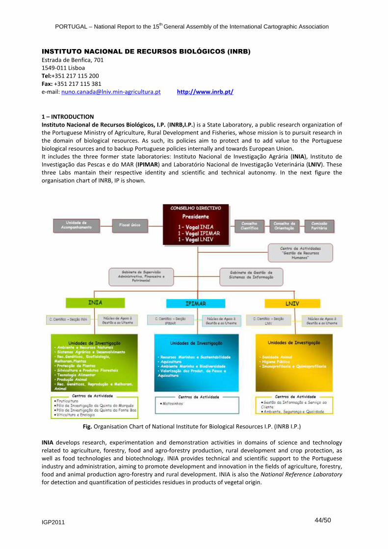
PORTUGAL – National Report to the 15th General Assembly of the International Cartographic Association
IGP2011 44/50
INSTITUTO NACIONAL DE RECURSOS BIOLÓGICOS (INRB) Estrada de Benfica, 701 1549-011 Lisboa Tel:+351 217 115 200 Fax: +351 217 115 381 e-mail: [email protected] http://www.inrb.pt/
1 – INTRODUCTION
Instituto Nacional de Recursos Biológicos, I.P. (INRB,I.P.) is a State Laboratory, a public research organization of the Portuguese Ministry of Agriculture, Rural Development and Fisheries, whose mission is to pursuit research in the domain of biological resources. As such, its policies aim to protect and to add value to the Portuguese biological resources and to backup Portuguese policies internally and towards European Union. It includes the three former state laboratories: Instituto Nacional de Investigação Agrária (INIA), Instituto de Investigação das Pescas e do MAR (IPIMAR) and Laboratório Nacional de Investigação Veterinária (LNIV). These three Labs mantain their respective identity and scientific and technical autonomy. In the next figure the organisation chart of INRB, IP is shown.
Fig. Organisation Chart of National Institute for Biological Resources I.P. (INRB I.P.)
INIA develops research, experimentation and demonstration activities in domains of science and technology related to agriculture, forestry, food and agro-forestry production, rural development and crop protection, as well as food technologies and biotechnology. INIA provides technical and scientific support to the Portuguese industry and administration, aiming to promote development and innovation in the fields of agriculture, forestry, food and animal production agro-forestry and rural development. INIA is also the National Reference Laboratory for detection and quantification of pesticides residues in products of vegetal origin.

PORTUGAL – National Report to the 15th General Assembly of the International Cartographic Association
IGP2011 45/50
IPIMAR develops research, experimentation and demonstration activities in the following thematic areas: fisheries resources, aquaculture, marine environment and upgrade of marine products. IPIMAR provides a wide range of information and technical support to the Portuguese industry and administration, aiming to promote a sustainable and competitive fishing industry and aquaculture, to contribute for the protection of marine environment, and to monitor and upgrade the seafood quality of fishery and aquaculture products. LNIV participates in the conception and implementation of programmes of research, development and demonstration activities in domains related to animal and public health as well as feed and food safety. LNIV is the National Reference Laboratory for diagnosis of animal diseases including zoonosis, for feed safety and for detection and quantification of chemical and biological hazards in animal origin products. INRB cooperates with scientific and technological institutions with similar aims and participates in national and international activities of science and technology, namely, through consortia, networks and other forms of conjunct work. In this context, INRB,I.P. coordinates the Portuguese participation on FAO actions namely the ITPGRFA (International Treaty for Plant Genetic Resources for Food and Agriculture), the activities of BIOVERSITY Center, such as European Regional Programmes on Genetic Resources (ECP/GR), and European Regional Programmes on Forest Genetic Resources (EUFORGEN), and is the National representative at the International Institute of High Agricultural Mediterranean Studies (CIHEAM). The Institute also integrates several international Organizations and Networks, such as: International Council for the Exploitation of the Sea (ICES), North Atlantic Fisheries Organization (NAFO), International Commission for the Conservation of Atlantic Tunas (ICCAT), Scientific Technical and Economic Committee for Fisheries (STECF), the European Aquaculture Platform (EATP), the European Fisheries Aquaculture Research Organisation (EFARO), the European Aquaculture Platform (EATP), the Ibero-American Network of Microbian Biofertilisers for Agriculture and Environment (BIOFAG), the Agricultural Research for Development (ARD); Dimension of the European Research Area (ERA), European Soil Bureau Network; European Flu Reference Labs Network (FLU-LAB-NET), Global Ecology and Oceanography of Harmful Algal Blooms (GEOHAB), Global Ocean Ecosystem Dynamics (GLOBEC), International Society for Horticultural Science (ISHS), EraNet on Marine Science (MARIFISH), Network of excellence of Prion Diseases (NEUROPRION), among others. INRB,I.P. is also involved in germplasm testing networks including CGIAR Centers (CIMMYT, ICARDA and ICRISAT), CLIMA (Center for Legumes in Mediterranean Agriculture), EBC (European Brewery Convention), Fundación Ibercebadas and Vavilov Institute, and leads the national networks for germplasm testing involving farmers and industry associations. 2 - RESEARCH AND DEVELOPMENT
INRB is currently involved in a wide range of national and international research projects and monitoring activities financed by the Ministry of Agriculture, National Research Council, European Community and Public and Private Companies. In the context of several research projects, two of INRB laboratories, INIA and IPIMAR, have been involved, in the conception and production of charts and thematic maps of local or national areas. INIA has been essentially concerned with forest, natural vegetation and bioclimatic cartographic research, through modeling and ground surveys and IPIMAR in sea map products and research. 2.1 – Instituto Nacional de Investigação Agrária (INIA)
During the 2007-2010 period, INIA’s Research Unit of “Forestry and Forestry Products” (former EFN - National Forest Research Station) was concerned with research projects that had cartographic output of national or local areas at different scales. The unit was also involved in mapping methodologies research in the context of Master and PhD Thesis of students and researchers of the unit. Some examples are bioclimatic modeling for natural vegetation mapping and remote sensing methodologies research for automatic cartography of cork oak woodlands (see publications number (1.) and (8). The most relevant projects and the corresponding cartographic output for this period of time are briefly listed below: Project Title – “Mixed Forests. Modeling, Dynamics and Geographical Distribution Of Productivity And Carbon Storage In Mixed Forest Ecosystems In Portugal” (PTDC/AGR-CFL/68186/2006). Other Portuguese Institutions involved: UTAD-Universidade de Trás-os-Montes e Alto Douro (Leading Institution); IPB-Instituto Politécnico de Bragança; ISA-Instituto Superior de Agronomia; UE-Universidade de

PORTUGAL – National Report to the 15th General Assembly of the International Cartographic Association
IGP2011 46/50
Évora. The following maps of mainland Portugal are an output of this project and correspond to part of INRBs contribution to the project: Portuguese Forest Dynamics Map from 1995 to 2005 (see publications number (4)). In this map of mainland Portugal the forest change between 1995 and 2005 is analised for the main forest species in pure or mixed stands, namely, pine, eucalyptus, cork oak, green oak and other oaks. The map was elaborated on a 500x500m grid, that corresponds to the fotointerpretation grid used in the National Forest Inventory of 2005 (NIF5). The base map for 1995 was IGPs Land Use Map (COS’90). Forest Biomass Map for mainland Portugal 2005 (see publications number (5)). A map of pure and mixed forest stands biomass based on the NFI5 data collected in 2005-2006 (DGRF, 2007). It was also produced a forecast scenario map for 2035, resulting of the landscape dynamics between the years of 1990 and 2005. Project Title – “Prevenção de riscos provocados por agentes bióticos e abióticos” (Programa AGRIS - Sub-Acção 3.4). Other Institutions involved: ACHAR (Associação dos Agricultores de Charneca; DGRF (Direcção Geral dos Recursos Florestais (actually AFN)); DRARO (Direcção Regional de Agricultura do Ribatejo e Oeste). Several maps representing the sanitary status of the main forest species of a region of 1063 km
2 in Ribatejo,
namely cork oak, maritime pine and stone pine, were produced by this project from ground surveys undertaken by the project team. The maps were published in a 1/500 000 scale (see publication number (7)) and consist for each forest species of the percentage of dead trees, the defoliation Index, the damage índexes for foliage, branches and trunk and a decaying índex, a composit of the former ones. Several other maps representing the risk assessment for the 10 main tree pests and diseases present in the forests of the region were also elaborated. Project Title: Nova Carta Ecológica Florestal de Portugal (1:500 000). Modelação bioclimática e da vegetação natural potencial como instrumento para a planificação e gestão sustentada do espaço florestal em Portugal. Other Institutions involved: D.G.F. Direcção-Geral das Florestas (actually AFN) and I.S.A. (Instituto Superior de Agronomia). An output of this Project, that finished before 2007, was now published after the conclusion of a master thesis supported by the project (see publication number (8)). Bioclimatic Map for mainland Portugal (Thermotypes and Ombrotypes maps for mainland Portugal). Scale 1 : 1.000.000. The map expresses complex rain and temperature regimes that have high correlation (and hence predictive power) with vegetation types and is used to vegetation spatial modeling. Researchers of the unit were also involved in vegetation mapping research and production, as is the case of the Map of Natural Potential Vegetation (Vegetation Series) of mainland Portugal. Scale 1 : 1.000.000 (see publication number (2)). This Vegetation Series Map expresses all the vegetation communities that can occur in a site throughout time depending on anthropogenic activities on the site and have high value for land-use planning purposes; 2.2 - Instituto de Investigação das Pescas e do MAR (IPIMAR)
During the 2007-2010 period, IPIMAR has carried out activities concerning mapping of seabed areas in the Portuguese EEZ in the framework of research and monitoring projects, based on remote sensing (acoustics) and direct data acquisition methodologies. The relevant mapping output in the above mentioned period were: Project Title - “Biomares. Restoration and Management of Biodiversity in the Marine Park Site Arrábida-Espichel” (PTCON0010). Other Portuguese Instituitions involved: UAlg – Universidade do Algarve; ICNB - Instituto da Conservação da Natureza e Biodiversidade; ISPA – Instituto Superior de Psicologia Aplicada and CSIC – Consejo Superior de Investigaciones Científicas. As an output of this project the Arrábida Marine Park Habitat Map was produced at the scale of 1:50.000, in 2010. This map characterizes the spatial distribution of important physical and biological attributes of seabed from the coastline up to 100m depth within the marine area belonging to the Portuguese Arrábida Natural Park, located in the W coast of the Portuguese mainland. In this map are represented a distribution of seabed sediment classes and bathymetry contours (10m equidistance) as well as a spatial distribution of algae and machozoobenthos main species. Project Title - “Tecnologias da pesca” – Programa MARE, FEDER, QCA-III, 22-05-01-FDR-00014. No other Portuguese Institutions were involved. As an output of this project a Deep-Sea Fishing Map of the S. Vicent Sea, Sagres Plateau was produced at a scale of 1/150.000, in 2007. This fishing chart represents the major seabed morphology and bottom attributes of
PORTUGAL – National Report to the 15th General Assembly of the International Cartographic Association
IGP2011 47/50
interest for deep-sea commercial fishing activities over an area of 21´latitude x 24´longitude located off the S. Vicent Cape, in the SW Portuguese mainland coast, with depths ranging from 600 down to 1500m. The information displayed in this chart was based on data obtained from acoustic surveys carried out along the Portuguese slope and aiming to identify deep-sea fishing grounds suitable to commercial fishing and species assessment in the EEZ. 3 – EDUCATION AND TRAINING
INIA researchers involved in mapping and remote sensing activities attended specialized training courses in International Research Laboratories and Portuguese Universities. INIA also promotes training and gives assistance to masters and PhD scientists and to recent forestry graduated students. IPIMAR researchers have attended training courses in mapping and analysis and representation of spatial data in the marine domain using GIS in the framework of various research and monitoring projects undertaken. 4 – PRODUCTION
It is not an aim of INRB to produce cartography, nevertheless as it was already mentioned, in the context of several research projects the Institution has been involved in the conception and production of charts and thematic maps of local or national areas at different scales. From a cartographic point of view, the maps produced by INIA are those described in section 2.1 (see also corresponding scientific and technical publications). IPIMAR has been involved in the construction of maps of the Fishing Charts Series for the Portuguese Coast led by the Portuguese Hydrographic Institute (IH) under a collaboration Protocol agreed between the IPIMAR and the IH. As a result of this activity, it was edited in 2007 the following chart: Carta de Pesca Caminha a Aveiro 24P01 da Série Pescas na escala 1/150.000. Ed. IH-IPIMAR 2007. 1ª Edição. 5 – PUBLICATIONS
INRB’s scientific and technical publications related to the above mentioned are the following: (1) Cadima, I.S.P. 2008– Cartografia dos montados a partir de imagens multiespectrais de muito alta resolução
espacial: Exploração de uma metodologia. Dissertação original para efeitos de acesso à categoria de Investigador Auxiliar. INRB-UISPF, Oeiras, 225 pp.
(2) Capelo J, Mequita S, Costa JC, Ribeiro S, Arsénio P, Neto C, Monteiro T, Aguiar C, Honrado J, Espíırito-Santo MD, Lousã M. 2007. A methodological approach to potential vegetation modeling using GIS techniques and phytosociological expert-knowledge: application to mainland Portugal. Phytocoenologia 37(3–4): 399–415.
(3) Godinho-Ferreira, P. 2008. A estrutura do mosaico florestal de Portugal Continental (The structure of forest mozaic in Portugal mainland). PhDThesis, Institute of Agronomy, Technical University of Lisbon, Portugal.
(4) Godinho-Ferreira, P.; Magalhães, M. and Rego, F.C. 2010 - "Portuguese forests dynamics. Future scenarios and implications for forest management and policy decisions." Comunication presented at the IUFRO Conference “Mixed and Pure Forests in a Changing World 2010”. 6 to 9
th October 2010. Vila Real, UTAD.
(5) Godinho-Ferreira, P.; Magalhães, M.; Tomé, M. and Rego, F.C. 2010 - "Mapping Forest Biomass of Mainland Portugal. Pure and Mixed Stands. Poster presented at the IUFRO Conference “Mixed and Pure Forests in a Changing World 2010”. Session2: Carbon and Biomass Modeling. 6 to 9
th October 2010. Vila Real, UTAD.
(6) Henriques, V.; Quintans, M.; Parente, J.; Fonseca, P. 2008. Cartografia de fundos de pesca de profundidade do Mar de S. Vicente, Planalto de Sagres. Relat. Cient. Téc. IPIMAR, Série digital (http://ipimariniap.ipimar.pt) nº45, 22pp.
(7) Sousa, E. e Melo, I.P. 2008 - Prevenção de riscos provocados por agentes bióticos em Almeirim, Alpiarça e Chamusca. Editores ACHAR e INRB, com apoio do Programa AGRIS. 162 pp..
(8) Mesquita, S. and Sousa, A.J. 2009 - Bioclimatic mapping using geostatistical approaches: application to mainland Portugal. International Journal of Climatology, 29(14): 2156-2170.
PORTUGAL – National Report to the 15th General Assembly of the International Cartographic Association
IGP2011 48/50
ESCOLA PROFISSIONAL DE CARTOGRAFIA E CADASTRO (EPCG) Rua de Artilharia Um, nº 107 – Edifício 1, 1º piso 1099-052 Lisboa. Tel.: +351213819644; Fax: +351213881728 e-mail: [email protected] http://www.ep-ciencias-geograficas.rcts.pt/
3 – EDUCATION AND TRAINING
Professional Education of technical level in the field of Geographical Sciences has been a tradition of all entities preceding the present “Instituto Geogáfico Português (IGP)”. In 1980´s was created a professional school to form and prepare technicians to carry out the tasks committed to the mission of the then called IGC. Its main aims were to ensure the professional education of the Institute’s technical staff,
• Land Surveying;
• Cartography;
• Photogrammetry. Initially, the courses covered essentially the practical aspects, but later on, in 1983, were reformulated and framed in the Portuguese Professional Technical Education System. In September 2000, was created the “Escola Profissional de Ciências Geográficas (EPCG), a public professional school that is installed in the IGP building. EPCG has a long experience and training expertise in the Surveying and Cartographic fields, benefiting from its links to IGP, namely in terms of its technical team. EPCG has two targets:
1- Provides initial education training in the following professional courses: a) Surveyor Technician; b) Cartographer Technician, which involves two specialisation, Cartography and Photogrammetry c) Geographical Information Systems (GIS) Technician; d) Environmental Management Technician.
These courses award a 4th
level vocational qualification certificate (QNQ-National Qualification Catalogue), and a secondary educational degree.
2- Life Long Education:
a) Organise and teach short courses aiming at the education, training and updating of professional technicians, in the field of Planning and Land Management, Environment and Social Infrastructures.
b) Special up-dating courses, for technicians from others public organisations have also been organized, concerning subjects such as GPS, Cartography and GIS. We are looking forward to install some new training programmes for Local Administration staff, concerning new methodologies and digital technologies in Cartography, Cadastre, CAD and Survey Applications.
Since the last report send to ICA, in 2007, 90 students have got a diploma in the 3 courses, Surveyor, Cartographer and GIS.

PORTUGAL – National Report to the 15th General Assembly of the International Cartographic Association
IGP2011 49/50
ORDEM DOS ENGENHEIROS Av. António Augusto de Aguiar n.º3D 1069-030 - Lisboa Tel: +351213132600 Fax: +351213524632 E-mail: [email protected] http://www.ordemengenheiros.pt 1 – INTRODUCTION
The Ordem dos Engenheiros (OE), Engineers’ Professional Association) is the regulatory and licensing body for the engineering profession in Portugal. It is headquartered in Lisbon, and has several regional branches in other Portuguese cities. The OE congregates twelve engineering specialities, one of witch is Geographical Engineering (Engenharia Geográfica) whose professionals are competent on Geodesy, Topography, Cartography, Photogrammetry, Cadastre, Hydrography, Remote Sensing and GIS. This speciality is organized on Geographical Engineering Colleges, one at a national level (Colégio Nacional de Engenharia Geográfica - CNEG) and three at regional levels, North (Colégio Regional Norte de Engenharia Geográfica – CRNEG), Center (Colégio Regional Centro de Engenharia Geográfica – CRCEG) and South (Colégio Regional Sul de Engenharia Geográfica – CRSEG). 2 – RESEARCH AND DEVELOPMENT
The OE is not focused on research and development but organizes several professional seminars, conferences, training courses, etc.. Several professional events were organized by Geographical Engineering Colleges since 2007: Iniciatives of CNEG:
May, 2007 - National Conference of Cartography and Geodesy 2007 (Conferência Nacional de Cartografia e Geodesia 2007) - CNCG2007; May, 2009 - National Conference of Cartography and Geodesy 2009 (Conferência Nacional de Cartografia e Geodesia 2009) - CNCG2009; May, 2011 - National Conference of Cartography and Geodesy 2011 (Conferência Nacional de Cartografia e Geodesia 2011) - CNCG2011. All three editions of this two-day conference received an average of 80 communications for oral presentation, which are published on conference proceedings and approach several themes of interest, such as Geodesy and Topometry (GNSS), Cartography and Cadastre, GIS, Remote Sensing, Hydrography, Risk Monitoring and Land Information Management. Iniciatives of CRNEG:
June 2009 – The first edition of the Conference on Geographic Information (JIG) entitled “Geographic Information in Local Administration Modernization” was held at the Municipal Library of Santa Maria da Feira, in which some issues of most relevance were discussed, such as the transformation of coordinates to the reference system ETRS 89 (European Terrestrial Reference System 1989), updating of digital cartography, and using of GIS for municipalities management; June 2010 – “The Geographic Information Technologies in the Planning Service” was the theme of the second edition of JIG. The main objective of the 2010 edition was to inform the participants on the state of the art regarding the application of GIS tools in spatial planning, it’s governmental (central and local) and private use, as well as it’s application in the review of the Municipal Master Plans. In Portugal, the use of new Geographic Information Technologies is providing crucial changes in the functioning of companies, central and local government. The new challenges local authorities deal with and the incorporation of GI technologies force them to evolve into new organizational models.
3 – EDUCATION AND TRAINING
Iniciatives of CRNEG:
September 2009 - lecture entitled 'New challenges for Geocommunity: Inspire Directive and Reference System ETRS89'. The INSPIRE, Infrastructure for Spatial Information in the European Community requires Member States to manage and make available data and geographic information services (GI) according to common principles and rules (metadata, interoperability and data services, GI services, principles of access and data sharing). The

PORTUGAL – National Report to the 15th General Assembly of the International Cartographic Association
IGP2011 50/50
definition and the adoption of a common geographic reference system for geographical information from each Member State are essential for the total homogeneity of the spatial data produced. The session contributed to the dissemination of the INSPIRE directive and the new reference system covering the practical aspects of its implementation. May 2011 - organization of the Month of Geographical Engineering with several activities: − Visualization and Manipulation of 3D Geoinformation – Field Trips - The new information technologies have
brought the possibility of quick access to images and maps of the surface of the globe, particularly through the widespread use of Google Earth and satellite navigation systems (GPS); activities developed: Geographic location using GPS and 3D Visualization on PC of images of the coastal zone northern Portugal;
− Exhibition of Instruments used in Geographical Engineering: with the support of the Tropical Science Research Institute, a set of scientific instruments used in geographical engineering was exhibited from May 4 to June 8.
Iniciatives of CRCEG:
− 04 May 2010 – Technical Session “The coordinate system PT-TM06”, Geographic Engineer João Agria Torres (IAG), Coimbra, Auditorium of the OERC;
− 09 July 2010 – Technical Session “Combined terrestrial imaging systems”, Geogra-phic Engineer João Boavida (ARTESCAN), Coimbra, Auditorium of the OERC;
− 03 September 2010 – Technical Session “The National Territorial Information System and its importance in the territory planning and management”, Geographic Engineer Regina Pimenta (SNIT), Coimbra, Auditorium of the OERC;
− 09 October 2010 – Product/company presentation “Carlson Software: GNSS equipment and Carlson Surveyor software”, Coimbra, Auditorium of the OERC;
− 14 October 2010 – Journey on “Prevention and Management of Natural Disasters”, Figueira da Foz, Sweet Atlantic Hotel (joint organization with the College of Geologic and Mines Engineering);
− 13 November 2010 – Participation in the “XVI National Meeting of Geographical Engineering”; presentation of the work “Crossing Africa with GNSS for calibration of the altimetric information measured by the Tandem satellite”, by the vowels of the College of Geographical Engineering of the Centre Region, Geographic Engineers Rui Fernandes (UBI) and Jorge Santos (FCTUC), Coimbra, Auditorium of the OERC;
− 27 November 2010 – Participation in the “National Day of the Engineer”, where the Geographic Engineer of the Centre Region, Virginia Manta (Coimbra Municipality), was distinguished with the National Prize Engineer Trainee 2010 in the specialty of Geographical Engineering, with the work “Use of images of high resolution satellite in a municipal context”, Funchal;
− 06 January 2011 – Technical Session “Videogeoreferencing - survey of underground water infrastructures”, Geographic Engineer Teresa Cunha (Geometrics), Coimbra, Auditorium of the OERC;
− 09 February 2011 – Inauguration of the Hall “Luís de Albuquerque” (Geographic Engineer, University Professor, Historian and former President of the OERC), General Library of the University of Coimbra (joint organization);
− 04 March 2011 – Technical Session “The importance of geographic information in the municipality of Santa Maria da Feira”, Geographic Engineer Sandra Resende (CMFeira), Aveiro, Auditorium of the District Delegation of the OERC;
− 12 March 2011 – Technical Visit to the construction sites of the “System of Mobility of the Metro Mondego” (joint organization).
5 – PUBLICATIONS: − [1] Matos, J.., J. Casaca (ed.) (2007) - PROCEEDINDS OF THE CNCG 2007. LIDEL. Lisbon. − [2] Colégio Nacional de Engenharia Geográfica (ed.) (2009) - PROCEEDINDS OF THE CNCG 2009. LIDEL.
Lisbon.


