Postglacial Population History of the Common Shrew (Sorex araneus

Palaeogeography, Palaeoclimatology, Palaeoecology 265 (2008) 159–169
Contents lists available at ScienceDirect
Palaeogeography, Palaeoclimatology, Palaeoecology
j ourna l homepage: www.e lsev ie r.com/ locate /pa laeo
Regional and local controls on postglacial vegetation and fire in theSiskiyou Mountains, northern California, USA
Christy E. Briles a,⁎, Cathy Whitlock b, Patrick J. Bartlein a, Philip Higuera b
a Department of Geography, University of Oregon, Eugene, OR 97403-1251 USAb Department of Earth Sciences, Montana State University, Bozeman MT 59717 USA
⁎ Corresponding author. Tel.: +1 406 994 6856; fax: +E-mail addresses: [email protected], christybrile
0031-0182/$ – see front matter © 2008 Elsevier B.V. Aldoi:10.1016/j.palaeo.2008.05.007
A B S T R A C T
A R T I C L E I N F OArticle history:
The Siskiyou Mountains of n Received 1 December 2007Received in revised form 3 May 2008Accepted 20 May 2008Keywords:Pacific NorthwestSiskiyou MountainsVegetation historyBiological diversity controlsClimate changeSynchrony
orthwestern California and southwestern Oregon are a floristic hotspot, and thehigh diversity of conifers there likely results from a combination of geological, ecological, climatological andhistorical factors. To evaluate how past climate variability has influenced the composition, structure and fireregime of the Siskiyou forests, pollen, charcoal, and lithological evidence was examined from two lakes alonga moisture gradient to reconstruct the vegetation, fire and climate history. The late-glacial period wascharacterized by subalpine parkland and infrequent fire at both sites. During the late-glacial/Early Holocenetransition period, subalpine parkland was replaced by a closed forest of Pinus, Cupressaceae, Abies andPseudotsuga and more frequent fires a 1000 years earlier at the wetter site, and it is likely that reducedPacific Ocean upwelling created warmer drier conditions at the coast. In the Early Holocene, Pinus,Cupressaceae were less abundant and fire less frequent at the coastal site during a period of increased coastalupwelling and fog production. In the Late Holocene, Abies, Pseudotsuga, Pinus, and Quercus vaccinifoliaincreased in the forest at both sites suggesting a widespread response to cooling. Fewer fires at the wettersite may account for the abundance of Picea breweriana within the last 1000 years. The comparison of thetwo records implies that large-scale controls in climate during the last 14,000 cal yr BP have resulted in majorchanges in vegetation and fire regime. Asynchrony in the ecosystem response of wetter and drier sites arisesfrom small-scale spatial variations in effective moisture and temperature resulting from topographically-influenced microclimates and coastal-to-inland climate gradients.
© 2008 Elsevier B.V. All rights reserved.
1. Introduction
The environmental response to climate change in mountainousregions is complex and not well-understood (Shafer et al., 2005).Steep elevational gradients created by mountains transform large-regional scale climate patterns into site-specific microclimates inwhich different aspects and elevations strongly influence vegetationand fire across the landscape. The Siskiyou Mountains of north-western California and southwestern Oregon, a subrange of theKlamath Mountains, are known for their heterogeneous landscapeand extraordinary gamma diversity (i.e., total number of speciesacross the region). This diversity is attributed to spatial variabilityin soil, climate, and disturbance regime (DellaSala et al., 1999);however, the role of long-term climate change or stability in shapingvegetation and fire across this complex landscape has only begunto be addressed (West, 1989; Mohr et al., 2000; Briles et al., 2005;Daniels et al., 2005).
The Siskiyou Mountains have traditionally been considered aregionwhere the climate has remained stable during the Cenozoic Era,
1 406 994 [email protected] (C.E. Briles).
l rights reserved.
thereby providing a refuge for temperate forest taxa as conditionsbecame cooler and drier elsewhere in the Pacific Northwest (Whit-taker, 1960). This notion of stability is contradicted by evidence fromthe Quaternary which suggests that the region experienced significantclimate fluctuations on millennial and shorter time scales (Kaufmanet al., 2004; Vacco et al., 2005). Here we compare the postglacialvegetation and fire history in the northern Siskiyou Mountains fromtwo sites located along a moisture gradient to further describe thenature of environmental change over the last 14,000 years followingdeglaciation of the region. The two sites are within 20 km of eachother on similar substrates, but the site closest to the coast, SangerLake, is slightly wetter than the more inland site, Bolan Lake, and has awell established population of endemic conifers including Piceabreweriana (Brewer's spruce) and Chamaecyparis lawsoniana (Port-Orford cedar) unlike themore inland site (see site descriptions below).One objective of this study was to determine whether the presentvegetation differences arise from distinct vegetation, fire and climatehistories or merely reflect local site differences. Another objective wasto determine the geographic extent of early-Holocene trade-offsbetween haploxylon Pinus (likely Pinus monticola and Cupressaceae(likely Calocedrus decurrens)), that were associated with changes infire frequency recorded at Bolan Lake (Briles et al., 2005).

160 C.E. Briles et al. / Palaeogeography, Palaeoclimatology, Palaeoecology 265 (2008) 159–169
2. Study area
2.1. Study sites
Sanger Lake (Lat. 41°54′06″N, Long.123°38′49″W,1550m elevation,4 ha) is located in a late-Pleistocene cirque (Fig. 1). The bedrock aroundthe lake is diorite, and upslope and downslope of Sanger Lake areserpentine deposits. The lake has no permanent inflowing streams andis mainly fed by groundwater. Sanger Lake lies in the Abies concolor(white fir) Vegetation Zone (1300–1900 m elevation) (Franklin andDryness, 1988) (all botanical nomenclature is based on Hickman, 1993).The dominant conifers around the lake include A. concolor, Piceabreweriana, Chamaecyparis lawsoniana, Pinus monticola (western whitepine), and Pseudotsuga menziesii. C. lawsoniana is restricted to anddominates mesic serpentine slopes within the basin. The dominantshrubs around the lake include Quercus vaccinifolia (huckleberry oak),Chrysolepis chrysophylla (golden chinquapin), Lithocarpus densiflora(tanoak), and Ceanothus velutinus (snowbrush).
The modern climate (based on elevation adjusted interpolatedstation data; Bartlein and Shafer, unpublished data, 2007) at SangerLake is characterized bycoolwinters (1 °Cmean temperature) andmildsummers (12.7 °C mean temperature). The annual precipitation isabout 1300 mm with 48% received in the winter and 15% in summer.Sanger Lake is slightlymore humid in the summer,with lower absolute
Fig. 1. Map showing location of Sanger and Bolan lakes. Aerial perspective is from
maximum temperatures, and slightly warmer wetter winters than atBolan Lake.
Young Pseudotsuga (b20 years old) on the south side of the lakehave charred bark and Chamaecyparis lawsoniana on the southeastslope of the lake have fire scars, both attesting to recent fire in thewatershed. The north slope of the lake supports a young cohort oftrees b100 year old, whereas the east and south slopes have treesN300 years old. Fire return intervals (FRI) for Abies concolor forests inthe region range between 25 and 64 years (Agee, 1993; Skinner et al.,2006), but the Sanger Lake forests likely have a longer FRI as a result ofwetter cooler conditions.
Bolan Lake (Lat. 42.023, Long. 123.458, 1638 m elevation, 5 ha) islocated in southwestern Oregon on the California/Oregon borderabout 20 km northeast of Sanger Lake (Fig. 1). Like Bolan Lake, it alsooccupies a late-Pleistocene cirque basin underlain by diorite andserpentine and has no inflowing streams. The forest at Bolan Lake ismore open than at Sanger Lake and is dominated by Abies concolor,Pinus monticola and Pseudotsuga menziesii. Picea breweriana andChamaecyparis lawsoniana do not grow at the site today. The warmer,drier setting, with 190 mm less annual precipitation (mostly in winteras snow), cooler winters (−0.5 °C mean temperature), more snow, andwarmer summers (13 °C mean temperature) at Bolan Lake than atSanger Lake (Bartlein and Shafer, unpublished data), is likely due to itsmore inland location.
late winter for Bolan Lake and summer for Sanger Lake (from Google Earth).

161C.E. Briles et al. / Palaeogeography, Palaeoclimatology, Palaeoecology 265 (2008) 159–169
2.2. Regional vegetation and fire patterns
In addition to the Abies concolor Zone, five other vegetation zonesoccur in the Siskiyou region (Franklin and Dyrness, 1988). The OakWoodland Zone (Quercus garryana and Quercus kelloggii) occurs up to800m elevation and is warmer and drier than other zones. In theMixed-Evergreen Zone from 800 to 1100 m elevation, Pseudotsuga, Pinusponderosa (ponderosa pine), P. jeffreyi (Jeffrey pine), Calocedrus decurrensand Lithocarpus densiflora are common. As conditions become cooler andwetter, A. concolor and Pseudotsuga become dominant in the Mixed-Conifer Zone, from1100 to 1300melevation. In both theMixed-Evergreenand Mixed-Conifer zones, mixed-severity fires occur on average every 6–22 years (Taylor and Skinner, 1998). Above the Abies concolor Zone, Abiesmagnifica (red fir) and Tsuga mertensiana (mountain hemlock) grow from1900 to 2300 m elevation as conditions become progressively cooler andwetter in the Tsugamertensiana Zone. Fires are generally less frequent andof higher severity in progressively higher zones, with a FRI of N100 yr inthe Tsuga-dominated forests (Skinner et al., 2006).
Fires in the SiskiyouMountains usually occur with strongwinds andlow humidity in summer. Critical fire weather includes a persistentupper-level ridge, strong subsidence that suppresses precipitation, andlow relative humidity that dries fuels, followed by a weak upper-leveltrough that causes atmospheric instability, strong winds, and drythunderstorms with lightning (Agee, 1993). Topographic featuresdetermine areas of similar fire occurrence and size (Taylor and Skinner,2003). Fires have consumed large areas of the Klamath Mountains inrecent decades, including the Uncle, Orleans, and Bar fire complexes of2006 (60,000 ha), the Biscuit Fire of 2002 (202,000 ha), and the SilverCreek Fire of 1987 (74,000 ha). The Biscuit Fire, currently Oregon'slargest recorded fire on record and the 7th largest for the U.S, hasspurred federal management decisions (e.g. Health Forest Initiative of2003; USDA Forest Service, 2004) and scientific debates (Donato et al.,2005).
3. Methods
Methods for the analysis of Sanger Lake record are described below.The SangerandBolan lake recordswereobtainedwith similarmethods asdescribed by Briles et al. (2005). However, to standardize the treatment ofeach record, the chronology and charcoal analytical methods used forBolan Lake were modified from the original publication.
3.1. Field and lithological
A6.66-m-long sediment core and a 60-cm-short corewere recoveredfromSanger Lakewith afloating platformand a5-cm-diametermodifiedLivingstone square-rod piston sampler (Wright et al., 1983). Cores wereextruded in the field, wrapped in cellophane and aluminum foil andtransported to the laboratorywhere theywere refrigerated. In addition, a7.5-cm-diameter Klein piston corer was used to capture the mud-waterinterface and the upper sediments. This core was extruded at 1-cmintervals into plastic bags and lithology was noted in the field. In thelaboratory, long cores were split longitudinally and changes in lithologyand color were noted.
Magnetic susceptibility was measured at 1-cm intervals to assesschanges in inorganic allochthonous sediment (Gedye et al., 2000).Measurements were made on 10 cm3 subsamples using a Bartingtonmagnetic susceptibility meter unit and results were reported as cgs.Organic content of the lake sediments was measured as weight-lossafter ignition at 550 °C in 1 cm3 samples taken at 2 to 5 cm intervals toevaluate changes in lake productivity through time (Dean, 1974).
3.2. Chronology
Radiocarbon dates were obtained on plant macrofossils (seed, twigs,leaves, etc.) and gyttja for Sanger Lake. Dried sediment from the upper
10 cm of the core was 210Pb dated at the USGS-Denver. Age-depthmodels were constructed based on radiocarbon and 210Pb dating andtephrochronology from both long and short cores. Radiocarbon ageswere calibrated using Calib 5.0.2 (Stuiver et al., 2005) for both Bolan andSanger lakes and age-depth models were constructed using a cubicsmoothing spline and a bootstrap approach that allowed each date toinfluence the age model through the probability density function of thecalibrated ages (Higuera et al., 2008). The smoothing parameter for eachspline was selected based on the assumption that the predicted ages ofeach sample fell within the confidence intervals of the calibrated 14Cdates. The overall uncertainty of each age estimate (i.e., two standarddeviations) was used to weight the influence of each calibrated age inthe age-depthmodel (e.g., Telford et al., 2004), and confidence intervals,reflecting the combined uncertainty of all age estimates in the model,were derived from 10,000 bootstrap-estimated chronologies. For eachbootstrap chronology, the specific ages used to develop the chronologywere selected randomly based on the probability distribution of the210Pb or calibrated 14C date. The final chronology represents themedianage of each depth from the 10,000 bootstrap-estimated chronologies.
3.3. Charcoal
Macroscopic charcoal samples were prepared following methodsdescribed by Whitlock and Larsen (2001) and the data was used toreconstruct past fire activity. Sediment samples of 2 cm3 were taken atcontiguous 1-cm intervals and soaked in 5% sodiummetaphosphate andbleach for 24 h. They were washed through 250- and 125-micron-meshscreens. Particles in each size class were counted in gridded petri dishesunder a stereomicroscope at 50–100× magnification. Charcoal concen-tration (number of particles cm−3) from the two size fractions showedsimilar trends and were combined. Charcoal concentrations anddeposition times were interpolated to the median sample resolutionof each record (i.e., 20 yr cm−1) to produce equally-spaced intervalswithin and between records. Charcoal accumulation rates (CHAR,particles cm−2 yr−1) were determined by multiplying the interpolatedcharcoal concentrations (particles cm−3) by the interpolated sedimenta-tion rate (cm yr−1) using CharAnalysis software (http://www.charanal-sysis.googlepages.com; Higuera et al., 2008, Higuera et al., in revision).
To identify peaks in CHAR likely related to local fire occurrence, theCHAR time series was decomposed into two components: 1) abackground component and 2) a peaks component. The backgroundcomponent represents long-term variations in charcoal production,secondary transport, sediment mixing, and sediment sampling (Longet al., 1998, Higuera et al., 2007) and was defined by a locally-weightedregression using the tricube weight function with a 700-yr window,robust to outliers (Cleveland, 1979; 5 robustness steps). The peakscomponent represents high-frequency variability around backgroundand was defined as the residuals after the background component wassubtracted. The peaks component canbe further separated into two sub-components: non-fire-related variability in CHAR (i.e. analytical andnatural noise; assumed to follow a normal or Gaussian distribution) andfire-related CHAR peaks (i.e., signal). A Gaussian mixture model wasused to identify the noise component (Gavin et al., 2006, Higuera et al.,2008; Higuera et al., in revision), and the 95th percentile of thisdistribution was taken as the threshold value separating fire-relatedsignal from noise in the peaks component (Higuera et al., 2008; Higueraet al., in revision). The procedure was done on each 700-yr, overlappingportion of the CHAR record, producing a unique threshold for eachsample. The individual threshold values were smoothed with a 700-yrtricubic locally-weighted regression to produce the final thresholdvalues for the record. Finally, all peaks exceeding the locally-definedthresholdwere screened using the original charcoal counts contributingto each peak. If themaximum count in a CHAR peak had a N5% chance ofcoming from the same Poisson-distributed population as the minimumcharcoal count within the proceeding 75 years, then the “peak” wasrejected (e.g., Charster user's guide, accessed March 2008, http://

Table 1Uncalibrated and calibrated 14C and 210Pb ages for Sanger Lake
Depth(m)a
Predicted age(cal yr BP;med Prob.)b,d
Upperage range(cal yr BP)c
Lowerage range(cal yr BP)c
14Cage BP
± Materialdated
Referencee
0.01 −48 −48 −47 – – Gyttja 210Pb USGS-Denver0.02 −40 −40 −39 – – Gyttja 210Pb USGS-Denver0.03 −31 −31 −30 – – Gyttja 210Pb USGS-Denver0.04 −22 −23 −20 – – Gyttja 210Pb USGS-Denver0.05 −13 −14 −11 – – Gyttja 210Pb USGS-Denver0.06 −4 −6 −1 – – Gyttja 210Pb USGS-Denver0.07 2 0 4 – – Gyttja 210Pb USGS-Denver0.57 684 731 640 625 30 Twig CAMS1129650.79 699 747 655 1220 35 Needle CAMS1129951.415 714 763 670 1995 35 Needle CAMS1129661.64 2233 2293 2177 2215 35 Needles CAMS1196192.16 3001 3064 2947 2910 35 Wood CAMS1129672.42 3478 3533 3428 3205 35 Needle CAMS1129682.64 3979 4034 3921 3580 35 Wood CAMS1129693.25 5702 5757 5627 5035 35 Wood CAMS1187583.34 5955 6010 5881 5150 35 Leaf CAMS1129703.75 6992 7040 6940 6135 40 Wood CAMS1129713.96 7412 7452 7368 6845 50 Mazama Ash Bacon, 19833.97 7430 7469 7386 6430 35 Needles CAMS1196194.26 7897 7942 7848 7005 35 Twig CAMS1187604.415 8144 8199 8085 7300 40 Wood CAMS1129724.775 8902 8983 8815 8060 45 Wood CAMS1129735.135 9901 10,000 9815 8795 45 Wood CAMS1129745.395 10,909 11,002 10,829 9455 35 cone scale CAMS1129965.4 10,953 11,046 10,873 9625 45 Gyttja CAMS1187615.58 11,810 11,892 11,734 10,060 40 Gyttja CAMS1187625.68 12,330 12,406 12,256 10,435 50 Gyttja CAMS1187635.83 13,143 13,220 13,071 11,460 70 Gyttja CAMS1187645.95 13,805 13,892 13,724 12,025 40 Gyttja CAMS1129946.23 Too old Too old Too old 15,720 510 Gyttja CAMS112993
aDepth below mud surface.b14C calibrated ages derived using a bootstrapping approach based on the probabilitydistribution function of all 14C ages in the age-depth model (see Methods; Calib 5.0.2;Stuvier et al., 2005).c95% confidence interval based on 10,000 runs.d210Pb dates were adjusted for the 53 years (the corewas taken in 2003) since 1950 A.D.before being considered with the radiocarbon dates.e210Pb ages and errors from USGS-Denver.
Fig. 2. Age-versus-depth curves and deposition time for (a) Sanger Lake and (b) BolanLake based on 14C and 210Pb dates, and tephrochronology. The gray band reflects themodeled range of dates and deposition times and the black line the 50th (i.e., medianage) percentile of all runs. Circles and bars reflect the 50th, 2.5th (i.e., lower age) and97.5th (i.e., upper age) percentiles of the probability distribution function of calibrateddates. See Table 1 and Table 2 for age information.
162 C.E. Briles et al. / Palaeogeography, Palaeoclimatology, Palaeoecology 265 (2008) 159–169
geography.uoregon.edu/gavin/charster/Analysis.html). Statistical treat-ment of the charcoal records was done using the program CharAnalysis(PEH, available online at http://www.charanalysis.googlepages.com).
Fire episode frequency (number of fire episodes1000 yr−1) wasdetermined by smoothing the binary peak series with a tricubiclocally-weighted regression to summarize long-term (i.e., millennialscale) trends. Peak magnitude (particles cm−2 peak−1) represents thetotal accumulation of charcoal for all samples of a peak exceeding thethreshold value, and may be related to fire size, fire intensity, and/orcharcoal delivery (Whitlock et al., 2006; Higuera et al., 2007).
3.4. Pollen
Pollen analyses provided information on the regional and localvegetation history. Pollen was sampled every 50–100 years for the last2000 years and every 100–200 years for the remainder of the SangerLake record. A total of 89 pollen samples were processed usingmethodsof Bennett andWillis (2002). A Lycopodium tracerwas added to calculatepollen concentration (grains cm−3). Pollen grains were identified atmagnifications of 500 and 1250×, and counts ranged from 300 to 530terrestrial grains per sample, with at least 100 non-Pinus grains.
Pollen was identified to the lowest taxonomic level possible usingreference collections, atlases (e.g., Moore andWebb, 1978; Kapp et al.,2000), and other publications (Hebda et al., 1988a,b; Jarvis et al., 1992).The assignment of pollen taxa was based on modern phytogeography.Haploxylon-type Pinus pollen was attributed to Pinus monticola butcontributions from P. lambertiana (sugar pine) and/or minor amountsof P. balfouriana (fox tail pine) and P. albicaulis (whitebark pine) may
also have been included. Pinus grains missing a distal membrane wereidentified as undifferentiated Pinus. Abies pollen grains were fromA. concolor, A. magnifica and possibly A. procera (noble fir; although itsrange is limited in northern California and does not occur at either sitetoday). Picea pollen was attributed to P. breweriana or P. engelmannii(Engelmann spruce). Cupressaceae grains probably come mostly fromCalocedrus decurrens or Chamaecyparis lawsoniana, but Juniperusoccidentalis (western juniper) and Thuja plicata are also in the regionbut not near the sites today. Chrysolepis-type grains were either fromC. chrysophylla or Lithocarpus densiflora. Quercus vaccinifolia-typepollen were distinguished from Q. garryana-type based on coarsenessof the sculpturing elements and differences in the apertures (Jarviset al., 1992). Ceanothus grains were from C. cuneatus (buckbrush),C. integerrimus (deerbrush), C. prostratus (squaw carpet), C. pumilus(dwarf ceanothus), C. thyrsiflorus (blue blossom ceanothus), orC. velutinus (snowbrush ceanothus). Pollen grains that were broken,corroded, hidden or otherwise damaged were counted as ‘Indetermi-nate', and those that were unidentifiable were counted as ‘Unknown.’
Pollen percentages and accumulation rates (PAR; grains cm−2 yr−1)were used to reconstruct past vegetation. Percentages of terrestrialupland taxawere based on a sum of pollen from all trees, shrubs, herbs,and pteridophytes. The pollen-percentage record was divided into fivezones by use of a constrained cluster analysis (CONISS; Grimm, 1988).PAR were determined by dividing pollen concentrations by depositiontime (yr cm−1).
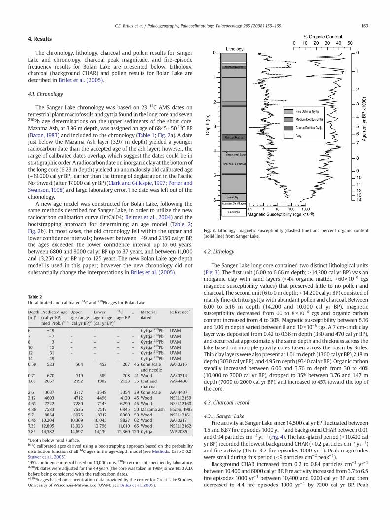
Fig. 3. Lithology, magnetic susceptibility (dashed line) and percent organic content(solid line) from Sanger Lake.
163C.E. Briles et al. / Palaeogeography, Palaeoclimatology, Palaeoecology 265 (2008) 159–169
4. Results
The chronology, lithology, charcoal and pollen results for SangerLake and chronology, charcoal peak magnitude, and fire-episodefrequency results for Bolan Lake are presented below. Lithology,charcoal (background CHAR) and pollen results for Bolan Lake aredescribed in Briles et al. (2005).
4.1. Chronology
The Sanger Lake chronology was based on 23 14C AMS dates onterrestrial plantmacrofossils and gyttja found in the long core and seven210Pb age determinations on the upper sediments of the short core.Mazama Ash, at 3.96 m depth, was assigned an age of 6845±50 14C BP(Bacon, 1983) and included to the chronology (Table 1; Fig. 2a). A datejust below the Mazama Ash layer (3.97 m depth) yielded a youngerradiocarbon date than the accepted age of the ash layer; however, therange of calibrated dates overlap, which suggest the dates could be instratigraphic order. A radiocarbondate on inorganic clayat thebottomofthe long core (6.23 m depth) yielded an anomalously old calibrated age(~19,000 cal yr BP), earlier than the timing of deglaciation in the PacificNorthwest (after 17,000 cal yr BP) (Clark and Gillespie, 1997; Porter andSwanson, 1998) and large laboratory error. The date was left out of thechronology.
A new age model was constructed for Bolan Lake, following thesame methods described for Sanger Lake, in order to utilize the newradiocarbon calibration curve (IntCal04; Reimer et al., 2004) and thebootstrapping approach for determining an age model (Table 2;Fig. 2b). In most cases, the old chronology fell within the upper andlower confidence intervals; however between −49 and 2150 cal yr BP,the ages exceeded the lower confidence interval up to 60 years,between 6800 and 8000 cal yr BP up to 37 years, and between 11,000and 13,250 cal yr BP up to 125 years. The new Bolan Lake age-depthmodel is used in this paper; however the new chronology did notsubstantially change the interpretations in Briles et al. (2005).
Table 2Uncalibrated and calibrated 14C and 210Pb ages for Bolan Lake
Depth(m)a
Predicted age(cal yr BP;med Prob.)b, d
Upperage range(cal yr BP)c
Lowerage range(cal yr BP)c
14Cage BP
± Materialdated
Referencee
6 −19 – – – – Gyttja 210Pb UWM7 −7 – – – – Gyttja 210Pb UWM8 3 – – – – Gyttja 210Pb UWM10 15 – – – – Gyttja 210Pb UWM12 31 – – – – Gyttja 210Pb UWM14 49 – – – – Gyttja 210Pb UWM0.59 523 564 452 267 46 Cone scale
and needleAA40215
0.71 670 719 589 708 41 Wood AA402141.66 2057 2192 1982 2123 35 Leaf and
charcoalAA44436
2.6 3637 3717 3549 3354 39 Cone scale AA444373.12 4603 4712 4496 4120 45 Wood NSRL121594.63 7222 7280 7143 6290 45 Wood NSRL121604.86 7583 7636 7517 6845 50 Mazama ash Bacon, 19835.7 8854 8975 8717 8060 50 Wood NSRL121616.45 10,204 10,369 10,045 8827 62 Wood AA402177.39 12,895 13,023 12,796 11,010 65 Wood NSRL121627.86 14,382 14,697 14,139 12,360 120 Gyttja WIS2085
aDepth below mud surface.b14C calibrated ages derived using a bootstrapping approach based on the probabilitydistribution function of all 14C ages in the age-depth model (see Methods; Calib 5.0.2;Stuiver et al., 2005).c95% confidence interval based on 10,000 runs. 210Pb errors not specified by laboratory.d210Pb dates were adjusted for the 49 years (the core was taken in 1999) since 1950 A.D.before being considered with the radiocarbon dates.e210Pb ages based on concentration data provided by the center for Great Lake Studies,University of Wisconsin-Milwaukee (UWM; see Briles et al., 2005).
4.2. Lithology
The Sanger Lake long core contained two distinct lithological units(Fig. 3). The first unit (6.00 to 6.66 m depth; N14,200 cal yr BP) was aninorganic clay with sand layers (b4% organic matter, N60×10−6 cgsmagnetic susceptibility values) that preserved little to no pollen andcharcoal. The secondunit (6 to 0mdepth;b14,200 cal yr BP) consistedofmainly fine-detritus gyttjawith abundant pollen and charcoal. Between6.00 to 5.16 m depth (14,200 and 10,000 cal yr BP), magneticsusceptibility decreased from 60 to 8×10⁻⁶ cgs and organic carboncontent increased from 4 to 30%. Magnetic susceptibility between 5.16and 1.06 m depth varied between 8 and 10×10−6 cgs. A 7 cm-thick claylayer was deposited from 0.42 to 0.36 m depth (380 and 470 cal yr BP),and occurred at approximately the same depth and thickness across thelake based on multiple gravity cores taken across the basin by Briles.Thin clay layerswere also present at 1.01mdepth (1360cal yr BP), 2.18mdepth (3030cal yr BP), and4.95mdepth (9340 cal yr BP). Organic carbonsteadily increased between 6.00 and 3.76 m depth from 30 to 40%(10,000 to 7000 cal yr BP), dropped to 35% between 3.76 and 1.47 mdepth (7000 to 2000 cal yr BP), and increased to 45% toward the top ofthe core.
4.3. Charcoal record
4.3.1. Sanger LakeFire activity at Sanger Lake since 14,500 cal yr BP fluctuated between
1.5 and 6.87fire episodes 1000 yr−1 and backgroundCHARbetween0.01and 0.94 particles cm−2 yr−1 (Fig. 4). The late-glacial period (N10,400 calyr BP) recorded the lowest background CHAR (b0.2 particles cm−2 yr−1)and fire activity (1.5 to 3.7 fire episodes 1000 yr−1). Peak magnitudeswere small during this period (b9 particles cm−2 peak−1).
Background CHAR increased from 0.2 to 0.84 particles cm−2 yr−1
between10,400 and6000 cal yr BP. Fire activity increased from3.7 to 6.5fire episodes 1000 yr−1 between 10,400 and 9200 cal yr BP and thendecreased to 4.4 fire episodes 1000 yr−1 by 7200 cal yr BP. Peak

Fig. 4. Charcoal accumulation rates (CHAR) for the last 14,500 cal yr at Sanger Lake.Accumulation rates were decomposed into background CHAR (the slowly varying curveoverlying the accumulation rate curve; window-width=700 yr) and peaks or fireepisodes. The fire-episode frequency shows the number of peaks 1000 yr−1, based on a2500 year smoothing window. Peak magnitude (particles cm−2) measures fire size, fireintensity, and/or charcoal delivery.
164 C.E. Briles et al. / Palaeogeography, Palaeoclimatology, Palaeoecology 265 (2008) 159–169
magnitudes increased after 8450 cal yr BP to ~50 particles cm−2 peak−1,endingwith a largefire episode (N300 particles cm−2 peak−1) at 6900 calyr BP (the largest peak of the record that spanned several samples).
Fig. 5. Pollen percentages of select taxa, total pollen accumulat
Background CHAR declined after 6000 cal yr BP, fluctuatingbetween 0.6 and 0.8 particles cm−2 yr−1 until 1250 cal yr BP when itincreased and reached the highest levels of the record at 660 cal yr BP(0.94 particles cm−2yr−1). Background CHAR then declined between660 and the present to 0.45 particles cm−2yr−1. Fire activity continuedto decline slightly between 7200 and 5300 cal yr BP to a 4.2 fireepisodes 1000 yr−1 and then increased and reached the highest levelsof the record by 2200 cal yr BP (6.9 fire episodes 1000 yr−1). Firefrequency declined after 2200 cal yr BP to 3.5 episodes 1000 yr−1 andwas comparable to fire frequencies of the late-glacial period. Peakmagnitudes averaged ~100 particles between 6900 and 3000 cal yr BP,dropped to ~50 particles cm−2 peak−1 between 3000 and 1250 cal yrBP, and increased to ~200 particles cm−2 peak−1 between 1250 and thepresent.
4.3.2. Bolan LakeFire-episode frequency and background CHAR for Bolan Lake are
described in full in Briles et al. (2005), however,fire-episode frequency ispresented here again for purposes of comparing it with the Sanger Lakerecord in the Discussion section. Peak magnitudes were analyzed andpresented below. Fire-episode frequency over the last 14,500 cal yr B.P.varied between 4 and 10 episodes 1000 yr−1. Between 14,500 and10,900 cal yr B.P., fire-episode frequency fluctuated between 3 and 7episodes 1000 yr−1, with the highest frequency at 13,000 cal yr B.P. andthe lowest frequency at 14,000 and 11,500 cal yr B.P. (4 and 3 episodes1000 yr−1). Fire-episode frequency increased from 4 to 8 episodes1000 yr−1 between 11,500 and 9200 cal yr B.P., declined to 7 episodes1000 yr−1 between 9200 and 8500 cal yr B.P., and increased to 10episodes 1000 yr−1, the highest values of the record, by 7000 cal yr B.P.Fire-episode frequency steadily declined from10 to7 episodes 1000 yr−1
between 7000 and 3500 cal yr B.P., increased slightly from 7 to 8episodes 1000 yr−1 between 3500 and 2500 cal yr B.P., decreased to 7episodes 1000 yr−1 between 2500 and 1500 cal yr B.P. and thenincreased to 9 episodes 1000 yr−1 toward the present.
Peak magnitudes were small (b35 particles cm−2 peak−1) between14,000 and 11,800 cal yr BP, except for a large peak at 13,800 cal yr BP(380 particles cm−2 peak−1). A mix of large (300 to N400 particles cm−2
ion rate (PAR) and haploxylon Pinus PAR from Sanger Lake.

165C.E. Briles et al. / Palaeogeography, Palaeoclimatology, Palaeoecology 265 (2008) 159–169
peak−1) and small (1 to b70 particles cm−2 peak−1) peak magnitudesoccurred between11,800 and9500 cal yr BP. Small peaks (b100 particlescm−2 peak−1) occurred between 9500 and 6000 cal yr BP. Between6000 cal yr BP and the present the record was characterized by small-magnitude peaks (b50 particles cm−2 peak−1) for 1000-year time spansand thesewere interrupted by large-magnitude peaks of N300 particlescm−2 peak−1.
4.4. Sanger Lake pollen record
The Sanger Lake pollen record was divided in to five zones (Fig. 5):Zone SA-1 (6.04–5.65m depth; 14,200 to 12,000 cal yr BP) featured
high percentages of haploxylon Pinus, Tsuga, Picea and increasingpercentages of Abies concolor. Moderate percentages of Artemisia,Poaceae and Chenopodiineae and low but increasing pollen accumu-lation rates (PAR; 1000–3000 grains cm−2yr−1) suggest that the forestwas initially open and became more closed (Fall, 1992; Davis et al.,1973; Ritchie and Lichti-Federovich,1967). The forest compositionwasprobably most similar to open forests of the Tsuga mertensiana Zone.
Zone SA-2 (5.65–5.01 m depth; 12,000 to 9600 cal yr BP) containedthe highest percentages of haploxylon Pinus and high percentages ofAbies. Tsugadropped to lowpercentages and remained low for the rest ofthe record. Pseudotsuga and Cupressaceae percentages increased,especially between 9500 and 10,500 cal yr BP. Artemisia, Poaceae andChenopodiineae percentages declined and PAR increased to the highestlevels of the record (6000–8000 grains cm−2yr−1) suggesting that the
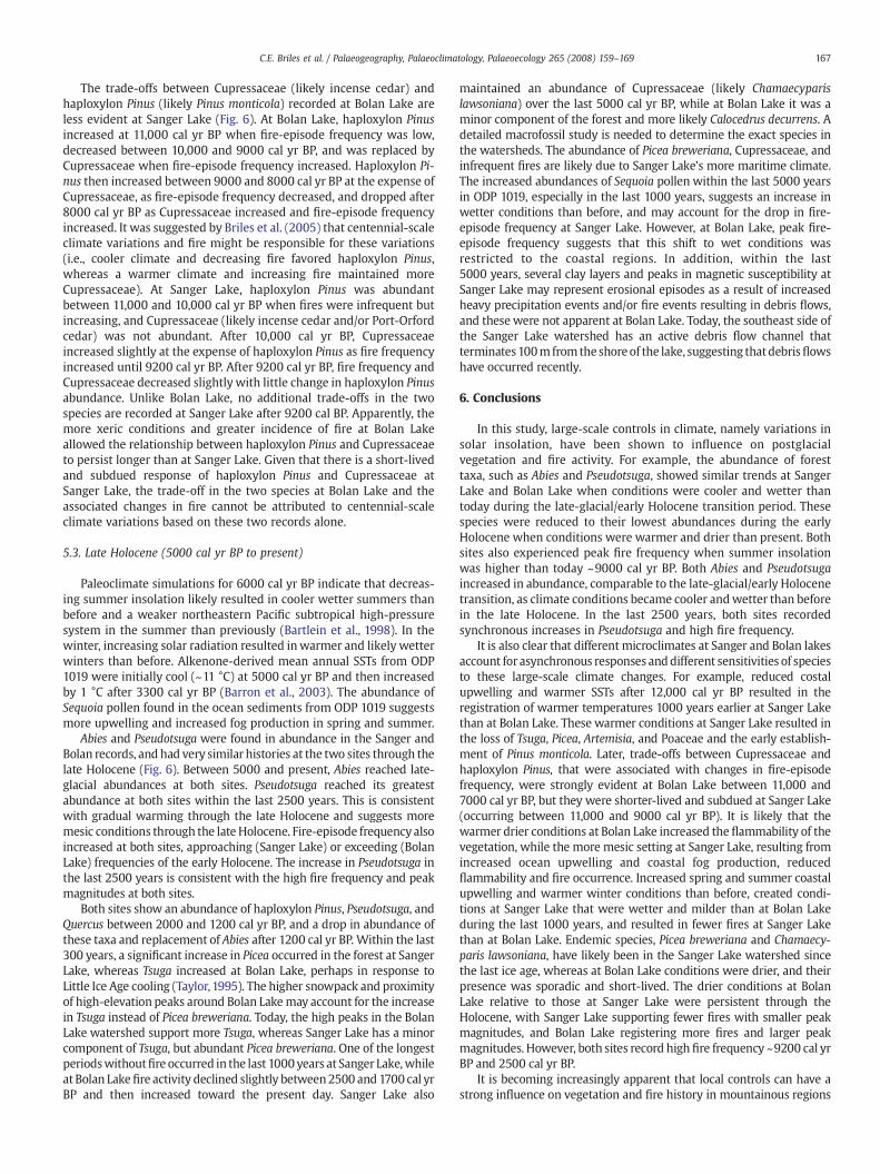
Fig. 6. Fire episodes, peak magnitude, fire frequency, and pollen percentages for Sanger and Bthe relationship between fire-episode frequency, Cupressaceae, and haploxylon Pinus (likelyarrows) is followed by a period of increased Cupressaceae and decreased Pinus monticola. TDryas chronozone (YDC) is defined by the dashed line.
forest became more closed than before (Ritchie and Lichti-Federovich,1967; Davis et al., 1973; Fall, 1992). The pollen types represented in thiszone come from taxa growing in the Abies concolor Zone today.
Zone SA-3 (5.65–3.05 m depth; 9600 to 5000 cal yr BP;) had highpercentages of Quercus and low-to-moderate percentages of Ceanothus.Haploxylon Pinus percentages dropped to comparable amounts inZone1;however, PAR for the taxondroppedbut remainedhigher than inZone1. The significantly increased percentages ofQuercus likely resultedin an under representation of the haploxylon Pinus percentages in thiszone as suggested by PAR. Cupressaceaepercentageswere the highest ofthe record. Pseudotsuga and Abies percentages were low. The forestcomposition was similar to present day Mixed-Evergreen forests~500 m below the watershed today (Ritchie and Lichti-Federovich,1967; Davis et al., 1973; Fall, 1992).
Zone SA-4 (3.05–1.49 m depth; 5000 to 2000 cal yr BP) wascharacterized by increasing percentages of Abies and Pseudotsuga.Ceanothus and Chrysolepis/Lithocarpus percentages peaked between2000 and 3000 cal yr BP. Cupressaceae percentages remainedcomparable to those in Zone 3. Haploxylon Pinus PAR continued todecrease to 1000 grains cm−2yr−1, while percentages remained similarto Zone 3. Quercus percentages decreased through the zone. The forestduring this time was similar to the Mixed-Conifer Zone located ~200to 300 m downslope today (Solomon and Silkworth, 1986).
Zone SA-5 (1.49–0 m depth; 2000 cal yr BP to present) featured thehighest percentages of Pseudotsuga and Picea of the record. Pseudotsuga,Quercus, Ceanothus, Artemisia, and Poaceae were high between 2000
olan lakes. Quercus pollen accumulation rates (PAR) are also included. The arrows showPinus monticola) at the two sites. Increased fire-episode frequency (triangle and squarehe opposite occurs when fire-episode frequency decreases (circle arrow). The Younger
166 C.E. Briles et al. / Palaeogeography, Palaeoclimatology, Palaeoecology 265 (2008) 159–169
and 1200 cal yr BP and then decreased thereafter. Picea and Abies hadincreased percentages between 1200 cal yr BP and present. Themodernforest became established at Sanger Lake within the last 2000 cal yr.
5. Discussion
The vegetation and fire records of Sanger Lake and Bolan Lake arecompared in the following section (Fig. 6). In addition, a brief overview isgiven on what is currently known about the regional climate history ofthe last 14,000 cal yr BP inferred from climate model simulations andocean and terrestrial paleoclimate records (Bartlein et al., 1998; Barronet al., 2003; Vacco et al., 2005).
5.1. Late-glacial/early Holocene transition period (N11,000 cal yr BP)
Paleoclimate simulations for 14,000 cal yr BP suggest that increasingsummer insolation resulted in summers that were warmer than beforein the PNW, but still cooler and drier than present (Bartlein et al., 1998).Ocean coreODP1019 (Barron et al., 2003), located at the same latitude asSanger Lake and ~50 km offshore, recorded sea surface temperatures(SST) that were 1 °C less than the present day (12 °C) using alkenone-derivedmeanannual SSTestimates between15,000 and13,000 cal yr BP.An abundance of diatoms between 14,600 to 12,900 cal yr BP from ODP1019 suggests upwelling of colder bottom ocean waters (Barron et al.,2003). Pinus and Artemisia pollen found in ODP 1019 declined and Alnusincreased from before, suggesting that conditions were becomingwarmer and wetter on land.
Sanger and Bolan lakes were colonized by a subalpine parklandforest between 14,000 and 12,000 cal yr BP, and this vegetation waswidespread across the region (Fig. 6; Daniels et al., 2005; Mohr et al.,2000). The lack of a tundra period prior to this forested period isconsistent with relatively warm conditions following deglaciation.Tsuga, Abies, Picea and haploxlyon Pinus (likely Pinus monticola) werethe dominant forest species. The gradual increase in pollen percen-tages of Tsuga, Abies and in PAR suggests a closing of the forest at thistime. Tsugawould have been favored by deep spring snowpacks and ashort mild growing season (Burns and Honkala, 1990). Fire-episodefrequency and peak magnitudes were higher at Bolan Lake than atSanger Lake at this time, suggesting that fires may have been largerand/or more intense at Bolan Lake and /or produced more charcoal.
Between 12,900 and 11,600 cal yr BP (i.e., during the Younger Dryaschronozone, Alley et al., 1993), alkenone-derived mean annual SSTestimates from ODP 1019 abruptly dropped to b8 °C and diatomproduction decreased suggesting reduced coastal upwelling (Barronet al., 2003). After 11,600 cal yr BP,meanannual SSTs increasedmore than5 °C within a 500-year period and diatom abundances remained low.Barron et al. (2003) attribute these changes to the Younger Dryas coolperiod (11,500 to 12,900 cal yr B.P.; Alley et al., 1993). This eastern Pacificcool event and subsequent abrupt warming event are recorded in oceanrecords to the north and south of ODP 1019 (Kienast and McKay, 2001;Mortyn et al., 1996). An isotopic speleothem record from the OregonCaves NationalMonument suggests that land atmospheric temperaturesdroppedmore than 3 °C after 13,000 cal yr BP for a 1200-year period andthen abruptly increased (Vacco et al., 2005).
No distinctive or synchronous vegetation or fire change has beendetected during the YD chronozone in the PNW region (Grigg andWhitlock,1998;Mohret al., 2000;Daniels et al., 2005). Bolan and Sangerlakes show increasing Tsuga suggesting that conditions were becomingwarmer and wetter than before. Tsuga declined after 12,000 cal yr BP atSanger Lake butwas in greatest abundance at Bolan Lake until 11,500 calyr BP. Haploxylon Pinus (and total Pinus) increased at Sanger Lake at12,000 cal yr BP and around 500 years later at Bolan Lake. The fireregimes at the two sites were also different after 12,500 cal yr BP. Fire-episode frequencyat Sanger Lake increased slowlyand peakmagnitudeswere low through theperiod,whereas at Bolan Lake, frequencywashighuntil 12,500 cal yr BP, declined to the lowest levels of the record at
11,500 cal yr BP and increased thereafter. Peak magnitudes alsoincreased after 11,500 cal yr BP at Bolan Lake indicating that fires werelarge and/or intense. Increasing fire activity at Sanger Lake after12,000 cal yr BP was likely responsible for the abundance of haploxylonPinus (likely Pinus monticola). P. monticola is a seral species that relies ondisturbances to remove competing vegetation for regeneration (Burnsand Honkala, 1990).
Reduced upwelling that resulted in warmer conditions at SangerLake after 12,000 cal yr BP, is likely responsible for the loss of Tsuga andestablishment of a forest with more Pinus monticola and increasing fireactivity. Sanger Lake became more productive, as evidenced byincreased organic content, whereas Bolan Lake remained relativelyunproductive until 11,000 cal yr BP (Briles et al., 2005). At Bolan Lake,clastic minerals and the presence of pebbles in gyttja suggest moreavalancheor glacial activity in thewatershed. Therefore, themore inlandlocation of Bolan Lake may have permitted cooler wetter conditions topersist 500 to 1000 years longer than at Sanger Lake.
5.2. Early and Middle Holocene (11,000 to 5,000 cal yr BP)
Paleoclimate simulations for 11,000 cal yr BP suggest that higher-than-present summer insolation in the early Holocene led to theexpansion and intensification of the northeastern Pacific subtropicalhigh pressure system and continental heating and drying in the PacificNorthwest (Bartlein et al., 1998). From 11,000 to 8200 cal yr BP,alkenone-derived mean annual SSTs temperatures from ODP 1019were up to 1 °C abovemodern levels, and then decreased to 1 °C belowmodern levels between 8200 and 3300 cal yr BP (Barron et al., 2003).In addition, warm-water diatoms between 11,600 and 8200 cal yr BP,suggest a weak California Current and reduced upwelling. Cool-waterdiatoms increased between 8200 and 3300 cal yr BP, reflecting astronger California Current and increased upwelling.
Major changes in vegetation and fire activity were registered atBolan and Sanger lakes during the early Holocene (Fig. 6). Both sitesshow a decrease in the abundance of Abies at 11,000 cal yr BP andPseudotsuga at 10,000 cal yr BP. Abies and Pseudotsuga occur in lowestabundance during the summer insolation maximum, between 10,000and 9000 cal yr BP, which is not surprising since the species do best inwetter environments today. As summer insolation decreased,between 9000 and 5000 cal yr BP, Abies and Pseudotsuga increasedin abundance responding to the cooler and wetter conditions thanbefore. The changes in Abies during the early Holocene are similar tothose found at other sites in the Klamath Mountains (Mohr et al.,2000; Daniels et al., 2005).
Understory shrubs, Quercus and Ceanothus, became abundant atBolan and Sanger lakes and at other sites in the Klamath region (Mohret al., 2000; Daniels et al., 2005). Ceanothus increased after 11,000 calyr BP, and Quercus increased at Bolan Lake ca. 11,000 cal yr BP and atSanger Lake ca. 9500 cal yr BP. Ceanothus species favor warm dryconditions and require fire to regenerate. Quercus is a shrub that doeswell in warm and especially dry conditions, has resinous leaves thatcarry fire from the understory into the forest canopy, and sprouts fromthe root crown following fire (Burns and Honkala, 1990). The presenceof these species at both sites occurs during a period of high fire-episode frequency.
The delayed expansion of Quercus in the early Holocene at SangerLake, compared with Bolan Lake, is likely the result of slightly wetterconditions there compared with drier inland conditions resulting fromintensified summer heating. Interestingly, PAR of Quercus increasedabruptly and fire was frequent at Sanger Lake around 9200 cal yr BP, theinsolation maximum. Both Quercus PAR and fire activity declined until7000 cal yr BP, during a period when SSTs dropped and upwellingincreased (Barron et al., 2003). In contrast, PAR of Quercus at Bolan Lakepeaked ca. 7000 cal yr BP, when fire-episode frequencywas highest, anddecreased after 5500 cal yr BP, suggesting that warm dry conditions andhigh fire activity persisted for a longer period at Bolan Lake.
167C.E. Briles et al. / Palaeogeography, Palaeoclimatology, Palaeoecology 265 (2008) 159–169
The trade-offs between Cupressaceae (likely incense cedar) andhaploxylon Pinus (likely Pinus monticola) recorded at Bolan Lake areless evident at Sanger Lake (Fig. 6). At Bolan Lake, haploxylon Pinusincreased at 11,000 cal yr BP when fire-episode frequency was low,decreased between 10,000 and 9000 cal yr BP, and was replaced byCupressaceae when fire-episode frequency increased. Haploxylon Pi-nus then increased between 9000 and 8000 cal yr BP at the expense ofCupressaceae, as fire-episode frequency decreased, and dropped after8000 cal yr BP as Cupressaceae increased and fire-episode frequencyincreased. It was suggested by Briles et al. (2005) that centennial-scaleclimate variations and fire might be responsible for these variations(i.e., cooler climate and decreasing fire favored haploxylon Pinus,whereas a warmer climate and increasing fire maintained moreCupressaceae). At Sanger Lake, haploxylon Pinus was abundantbetween 11,000 and 10,000 cal yr BP when fires were infrequent butincreasing, and Cupressaceae (likely incense cedar and/or Port-Orfordcedar) was not abundant. After 10,000 cal yr BP, Cupressaceaeincreased slightly at the expense of haploxylon Pinus as fire frequencyincreased until 9200 cal yr BP. After 9200 cal yr BP, fire frequency andCupressaceae decreased slightly with little change in haploxylon Pinusabundance. Unlike Bolan Lake, no additional trade-offs in the twospecies are recorded at Sanger Lake after 9200 cal BP. Apparently, themore xeric conditions and greater incidence of fire at Bolan Lakeallowed the relationship between haploxylon Pinus and Cupressaceaeto persist longer than at Sanger Lake. Given that there is a short-livedand subdued response of haploxylon Pinus and Cupressaceae atSanger Lake, the trade-off in the two species at Bolan Lake and theassociated changes in fire cannot be attributed to centennial-scaleclimate variations based on these two records alone.
5.3. Late Holocene (5000 cal yr BP to present)
Paleoclimate simulations for 6000 cal yr BP indicate that decreas-ing summer insolation likely resulted in cooler wetter summers thanbefore and a weaker northeastern Pacific subtropical high-pressuresystem in the summer than previously (Bartlein et al., 1998). In thewinter, increasing solar radiation resulted inwarmer and likely wetterwinters than before. Alkenone-derived mean annual SSTs from ODP1019 were initially cool (~11 °C) at 5000 cal yr BP and then increasedby 1 °C after 3300 cal yr BP (Barron et al., 2003). The abundance ofSequoia pollen found in the ocean sediments from ODP 1019 suggestsmore upwelling and increased fog production in spring and summer.
Abies and Pseudotsuga were found in abundance in the Sanger andBolan records, and had very similar histories at the two sites through thelate Holocene (Fig. 6). Between 5000 and present, Abies reached late-glacial abundances at both sites. Pseudotsuga reached its greatestabundance at both sites within the last 2500 years. This is consistentwith gradual warming through the late Holocene and suggests moremesic conditions through the late Holocene. Fire-episode frequencyalsoincreased at both sites, approaching (Sanger Lake) or exceeding (BolanLake) frequencies of the early Holocene. The increase in Pseudotsuga inthe last 2500 years is consistent with the high fire frequency and peakmagnitudes at both sites.
Both sites show an abundance of haploxylon Pinus, Pseudotsuga, andQuercus between 2000 and 1200 cal yr BP, and a drop in abundance ofthese taxa and replacement of Abies after 1200 cal yr BP. Within the last300 years, a significant increase in Picea occurred in the forest at SangerLake, whereas Tsuga increased at Bolan Lake, perhaps in response toLittle Ice Age cooling (Taylor,1995). The higher snowpack and proximityof high-elevation peaks around Bolan Lakemay account for the increasein Tsuga instead of Picea breweriana. Today, the high peaks in the BolanLake watershed support more Tsuga, whereas Sanger Lake has a minorcomponent of Tsuga, but abundant Picea breweriana. One of the longestperiodswithoutfire occurred in the last 1000 years at Sanger Lake,whileat Bolan Lakefire activity declined slightly between2500 and 1700 cal yrBP and then increased toward the present day. Sanger Lake also
maintained an abundance of Cupressaceae (likely Chamaecyparislawsoniana) over the last 5000 cal yr BP, while at Bolan Lake it was aminor component of the forest and more likely Calocedrus decurrens. Adetailed macrofossil study is needed to determine the exact species inthe watersheds. The abundance of Picea breweriana, Cupressaceae, andinfrequent fires are likely due to Sanger Lake's more maritime climate.The increased abundances of Sequoia pollen within the last 5000 yearsin ODP 1019, especially in the last 1000 years, suggests an increase inwetter conditions than before, and may account for the drop in fire-episode frequency at Sanger Lake. However, at Bolan Lake, peak fire-episode frequency suggests that this shift to wet conditions wasrestricted to the coastal regions. In addition, within the last5000 years, several clay layers and peaks in magnetic susceptibility atSanger Lake may represent erosional episodes as a result of increasedheavy precipitation events and/or fire events resulting in debris flows,and these were not apparent at Bolan Lake. Today, the southeast side ofthe Sanger Lake watershed has an active debris flow channel thatterminates100mfromthe shoreof the lake, suggesting thatdebrisflowshave occurred recently.
6. Conclusions
In this study, large-scale controls in climate, namely variations insolar insolation, have been shown to influence on postglacialvegetation and fire activity. For example, the abundance of foresttaxa, such as Abies and Pseudotsuga, showed similar trends at SangerLake and Bolan Lake when conditions were cooler and wetter thantoday during the late-glacial/early Holocene transition period. Thesespecies were reduced to their lowest abundances during the earlyHolocene when conditions were warmer and drier than present. Bothsites also experienced peak fire frequency when summer insolationwas higher than today ~9000 cal yr BP. Both Abies and Pseudotsugaincreased in abundance, comparable to the late-glacial/early Holocenetransition, as climate conditions became cooler andwetter than beforein the late Holocene. In the last 2500 years, both sites recordedsynchronous increases in Pseudotsuga and high fire frequency.
It is also clear that different microclimates at Sanger and Bolan lakesaccount for asynchronous responses anddifferent sensitivities of speciesto these large-scale climate changes. For example, reduced costalupwelling and warmer SSTs after 12,000 cal yr BP resulted in theregistration of warmer temperatures 1000 years earlier at Sanger Lakethan at Bolan Lake. These warmer conditions at Sanger Lake resulted inthe loss of Tsuga, Picea, Artemisia, and Poaceae and the early establish-ment of Pinus monticola. Later, trade-offs between Cupressaceae andhaploxylon Pinus, that were associated with changes in fire-episodefrequency, were strongly evident at Bolan Lake between 11,000 and7000 cal yr BP, but they were shorter-lived and subdued at Sanger Lake(occurring between 11,000 and 9000 cal yr BP). It is likely that thewarmer drier conditions at Bolan Lake increased the flammability of thevegetation, while the more mesic setting at Sanger Lake, resulting fromincreased ocean upwelling and coastal fog production, reducedflammability and fire occurrence. Increased spring and summer coastalupwelling and warmer winter conditions than before, created condi-tions at Sanger Lake that were wetter and milder than at Bolan Lakeduring the last 1000 years, and resulted in fewer fires at Sanger Lakethan at Bolan Lake. Endemic species, Picea breweriana and Chamaecy-paris lawsoniana, have likely been in the Sanger Lake watershed sincethe last ice age, whereas at Bolan Lake conditions were drier, and theirpresence was sporadic and short-lived. The drier conditions at BolanLake relative to those at Sanger Lake were persistent through theHolocene, with Sanger Lake supporting fewer fires with smaller peakmagnitudes, and Bolan Lake registering more fires and larger peakmagnitudes. However, both sites record high fire frequency ~9200 cal yrBP and 2500 cal yr BP.
It is becoming increasingly apparent that local controls can have astrong influence on vegetation and fire history in mountainous regions

168 C.E. Briles et al. / Palaeogeography, Palaeoclimatology, Palaeoecology 265 (2008) 159–169
and account for differences in closely-spaced sites that experienced thesame large-scale controls. In a similar comparison of the vegetationhistory along a steep coastal-to-inland moisture gradient on VancouverIsland, British Columbia, Brown et al. (2006) found dry conditions wereregistered inland during the early Holocene, while more coastal sitesremained wet. Fire history reconstructions from two closely-spacedsites in British Columbia showed asynchronous patterns in fire episodesand different fire intervals in the middle Holocene, but more synchronyin the late Holocene (Gavin et al., 2006). The temporal differences in fireactivity were attributed to shifts in the importance of local controls (i.e.,aspect and topography) versus large scale controls under differentconfigurations of regional climate. A similar comparison of two siteswith different aspects and elevations in the eastern KlamathMountainsshowed that a high elevation site with a north-facing aspect (CraterLake) supported amoremesic forest through the Holocene than a lowerelevation sitewith a south-facing aspect (Bluff Lake) (Mohr et al., 2000).
The comparison of Bolan and Sanger lakes vegetation andfire historyin the SiskiyouMountains suggests delays in the response of vegetationand fire response to long-term climate change can be on the order ofcenturies tomillennia. Periodsof contrastingvegetation andfire regimesin the Siskiyou Mountain region need further study to better evaluatehow local factors (i.e., topography, aspect, ocean, edaphic controls)either enhance or suppress regional climate patterns on multiple timescales.
Acknowledgments
Christy Briles designed the study, analyzed the data, and wrote thepaper. Cathy Whitlock and Patrick J. Bartlein assisted with the studydesign, data analysis, interpretation of the research project and editingof the manuscript. Philip Higuera provided statistical advice andsoftware development, and helped edit the manuscript. We thank CarlSkinner for his ideas, comments and edits on the manuscript, and TomGuilderson for instruction on radiocarbon dating and interpretation.Wealso thank to anonymous reviewers for suggestions and comments onthe manuscript. This research was supported by National ScienceFoundation Grant ATM-0117160 and USFS PSWCooperative Agreement,a Lawrence Livermore National Laboratory University CollaborativeResearch Grant, field research support from Mazamas, Sigma Xi, andgraduate research grants from the University of Oregon Department ofGeography.
References
Agee, J.K., 1993. Fire Ecology of Pacific Northwest Forests. Island Press, Washington, D.C.Alley, R.B., Meese, D.D., Shuman, C.A., 1993. Abrupt increase in Greenland snow
accumulation at the end of the Younger Dryas event. Nature 362, 527–529.Bacon, C.R., 1983. Eruptive history of Mount Mazama and Crater Lake Caldera, Cascade
Range, U.S.A. Journal of Volcanology and Geothermal Research 18, 57–115.Barron, J.A., Heusser, L., Herbert, T., Lyle, M., 2003. High-resolution climate evolution of
coastal northern California during the past 16,000 years. Paleoceanography 18,1020–1029.
Bartlein, P.J., Anderson, K.H., Anderson, P.M., Edwards, M.E., Mock, C.J., Thompson, R.S.,Webb, R.S.,Webb III, T.,Whitlock, C.,1998. Paleoclimate simulations for North Americaover the past 21,000 years: features of the simulated climate and comparisons withpaleoenvironmental data. Quaternary Science Reviews 17, 549–585.
Bennett, K.D., Willis, K.J., 2002. Pollen. In: Smol, J.P., Birks, H.J.B., Last, W.M. (Eds.),Tracking Environmental Change Using Lake Sediments. Terrestrial, Algal, andSiliceous Indicators, vol. 3. Kluwer Academic Publishers, Dordrecht, pp. 5–32.
Briles, C., Whitlock, C., Bartlein, P.J., 2005. Postglacial vegetation, fire and climate historyof the Siskiyou Mountains, Oregon, USA. Quaternary Research 64, 44–56.
Brown, K.J., Fitton, R.J., Schoups, G., Allan, G.B., Wahl, K.A., Hebda, R.J., 2006. Holoceneprecipitation in the coastal temperate rainforest complex of southern BritishColumbia, Canada. Quaternary Science Reviews 25, 2762–2779.
Burns, R.M., Honkala, B.H., 1990. Silvics of North America: 1. Conifers; 2. Hardwoods.Agriculture Handbook 654, vol. 2. U.S. Department of Agriculture, Forest Service,Washington, DC.
Clark, D.H., Gillespie, A.R., 1997. Timing and significance of late-glacial and Holocenecirque glaciation in the Sierra Nevada, California. Quaternary International 38/39,21–38.
Cleveland, W.S., 1979. Robust locally weighted regression and smoothing scatterplots.Journal of the American Statistical Association 74, 829–836.
Daniels, M.L., Anderson, R.S., Whitlock, C., 2005. Vegetation and fire history since theLate Pleistocene from the Trinity Mountains, northwestern California, USA. TheHolocene 15, 1062–1071.
Davis, M.B., Brubaker, L.B., Webb III, T., 1973. Calibration of absolute influx. In: Birks, H.J.B.,West, R.G. (Eds.), Quaternary Plant Ecology. JohnWileyand Sons,NewYork, pp.109–116.
Dean, W.E., 1974. Determination of carbonate and organic matter in calcareoussediments by loss on ignition comparison to othermethods. Journal of SedimentaryPetrology 44, 242–248.
DellaSala, D.A., Reid, S.R., Frest, T.J., Strittholt, J.R., Olson, D.M., 1999. A global perspectiveon the biodiversity of the Klamath-Siskiyou ecoregion. Natural Areas Journal 19,300–319.
Donato, D.C., Fontaine, J.B., Campbell, J.L., Robinson, W.D., Kauffman, J.B., Law, B.E.,2005. Post-wildfire logging hinders regeneration and increases fire risk. Science311, 352.
Fall, P., 1992. Spatial patterns of atmospherical pollen dispersal in the Colorado RockyMountains, USA. Review of Palaeobotany and Palynology 74, 293–313.
Franklin, J.F., Dyrness, C.T., 1988. Natural Vegetation of Oregon and Washington. OSUPress, Oregon State University, Corvallis, Oregon.
Gavin, D.G., Hu, F.S., Lertzman, K., Corbett, P., 2006. Weak climatic control of stand-scalefire history during the late Holocene. Ecology 87, 1722–1732.
Gedye, S.J., Jones, R.T., Tinner, W., Ammann, B., Oldfield, F., 2000. The use of mineralmagnetism in the reconstruction of fire history: a case study from Lago di Origlio,Swiss Alps. Palaeogeography, Palaeoclimatology, Palaeoecology 164, 101–110.
Grigg, L.D., Whitlock, C., 1998. Late-glacial vegetation and climate change in WesternOregon. Quaternary Research 49, 287–298.
Grimm, E.C., 1988. Data analysis and display. In: Huntley, B., WebbIII III, T. (Eds.),Vegetation History. Kluwer Academic, Dordrecht, Netherlands, pp. 43–76.
Hebda, R.J., Chinnappa, C.C., Smith, B.M., 1988a. Pollen morphology of the Rosaceae ofWestern Canada, I. Agrimonia to Crataegus. Grana 27, 5–113.
Hebda, R.J., Chinnappa, C.C., Smith, B.M., 1988b. Pollen morphology of the Rosaceae ofWestern Canada, II. Dryas, Fragaria, Holodiscus. Canadian Journal of Botany 66, 5–113.
Hickman, J.C. (Ed.), 1993. The Jepson Manual: Higher Plants in California. University ofCalifornia Press, Berkeley.
Higuera, P.E., Peters, M.E., Brubaker, L.B., Gavin, D.G., 2007. Understanding the origin andanalysis of sediment charcoal records with a simulation model. Quaternary ScienceReviews 26, 1790–1809.
Higuera, P.E., Brubaker, L.B., Anderson, P.M., Brown, T.A., Kennedy, A.T., Hu, F.S., 2008.Frequent fires in ancient Shrub Tundra: implications of paleo-records for Arcticenvironmental change. PLoS ONE 3, e0001744.
Higuera, P.E., Brubaker, L.B., Anderson, P.M., Hu, F.S., Brown, T.A., in revision. Vegetationmediated impacts of past glacial climatic change on fire regimes in the south centralBrooks Range, Alaska. Ecology.
Jarvis, D.I., Leopold, E.B., Liu, Y., 1992. Distinguishing the pollen of deciduous oaks,evergreen oaks and certain rosaceous species of southwestern Sichuan Province,China. Review of Palaeobotany and Palynology 75, 259–271.
Kapp, R.O., Davis, O.K., King, J.E., 2000. Pollen and Spores. The American Association ofStratigraphic Palynologists. Texas A&M University, College Station, Texas.
Kaufman, D.S., Porter, S.C., Gillespie, A.R., 2004. Quaternary alpine glaciation in Alaska,the Pacific Northwest, Sierra Nevada, and Hawaii. In: Gillespie, A.R., Porter, S.C.,Atwater, B.F. (Eds.), The Quaternary Period in the United States. Elsevier,Amsterdam, pp. 77–104.
Kienast, S.S., McKay, J.L., 2001. Sea surface temperatures in the subarctic northeastPacific reflect millennial-scale climate oscillations during the last 16 kyrs.Geophysical Research Letters 28, 1563–1566.
Long, C.J., Whitlock, C., Bartlein, P.J., Millspaugh, S.H., 1998. A 9000-year fire history fromthe Oregon Coast Range, based on a high-resolution charcoal study. CanadianJournal of Forestry 28, 774–787.
Mohr, J.A., Whitlock, C., Skinner, C.N., 2000. Postglacial vegetation and fire history,Eastern Klamath Mountains, California. The Holocene 10, 587–601.
Moore, P.O., Webb, J.A., 1978. An Illustrated Guide to Pollen Analysis. John Wiley andSons, New York.
Mortyn, P.G., Thunell, R.C., Anderson, D.M., Stott, L.D., Le, J., 1996. Sea surfacetemperature changes in the southern California borderlands during the lastglacial-interglacial cycle. Paleoceanography 11, 415–430.
Porter, S.C., Swanson, T.W., 1998. Radiocarbon age constraints on rates of advance andretreat of the Puget Lobe of the cordilleran ice sheet during the last glaciation.Quaternary Research 50, 205–213.
Reimer, P.J., Baillie, M.G.L., Bard, E., Bayliss, A., Beck, J.W., Bertrand, C.J.H., Blackwell, P.G.,Buck, C.E., Burr, G.S., Cutler, K.B., Damon, P.E., Edwards, R.L., Fairbanks, R.G.,Friedrich, M., Guilderson, T.P., Hogg, A.G., Hughen, K.A., Kromer, B., McCormac, F.G.,Manning, S.W., Ramsey, C.B., Reimer, R.W., Remmele, S., Southon, J.R., Stuiver, M.,Talamo, S., Taylor, F.W., van der Plicht, J., Weyhenmeyer, C.E., 2004. IntCal04terrestrial radiocarbon age calibration, 26–0 ka BP. Radiocarbon 46, 1029–1058.
Ritchie, J.C., Lichti-Federovich, S., 1967. Pollen dispersal phenomena in Arctic-subarctic.Canada. Review of Paleobotany and Palynology 3, 255–266.
Skinner, C.N., Taylor, A.H., Agee, J.K., 2006. Fire in the Klamath Mountains bioregion. In:Sugihara, N.S., vanWagtendonk, J.W., Fites-Kaufmann, J., Shaffer, K., Thode, A. (Eds.),Fire in California ecosystems. University of California Press, Berkeley, pp. 170–194.
Shafer, S.H., Bartlein, P.J., Whitlock, C., 2005. Understanding the spatial heterogeneityof global environmental change in mountainous regions. In: Huber, U.M., Bugmann,H.K.M., Reasoner, M.A. (Eds.), Global change and mountain regions: an overview ofcurrent knowledge. Kluwer, pp. 21–31.
Solomon, A.M., Silkworth, A.B., 1986. Spatial patterns of atmospheric pollen transport ina montane region. Quaternary Research 25, 150–162.
Stuiver, M., Reimer, P.J., Reimer, R.W., 2005. CALIB 5.0. [WWW program anddocumentation].

169C.E. Briles et al. / Palaeogeography, Palaeoclimatology, Palaeoecology 265 (2008) 159–169
Taylor, A.H., 1995. Forest expansion and climate change in themountain hemlock (Tsugamertensiana) zone, Lassen Volcanic National Park, California, USA. Arctic & AlpineResearch 27, 207–216.
Taylor, A., Skinner, C.N., 1998. Fire history and landscape dynamics in a late-successionalreserve, Klamath Mountains, California, USA. Forest Ecology and Management 111,285–301.
Taylor, A.H., Skinner, C.N., 2003. Spatial patterns and controls on historical fire regimesand forest structure in the Klamath Mountains. Ecological Applications 13,704–719.
Telford, R.J., Heegaard, E., Birks, H.J.B., 2004. All age-depth models are wrong: but howbadly? Quaternary Science Reviews 23, 1–5.
USDA Forest Service, 2004. The Healthy Forests Initiative and Healthy ForestsRestoration Act: Interim Field Guide. Department of the Interior and Bureau ofLand Mangement. FS-799.
Vacco, D.A., Clark, P.U., Mix, A.C., Cheng, H., Edwards, R.L., 2005. A speleothem record ofYounger Dryas cooling, Klamath Mountains, Oregon, USA. Quaternary Research 64,249–256.
West, G.J., 1989. Late Pleistocene/Holocene vegetation and climate. In: Basgall, M.E.,Hildebrandt, W.R. (Eds.), Prehistory of the Sacramento River Canyon, Shasta County,California. Center for Archaeological Research, Davis, California, pp. 36–55.
Whitlock, C., Larsen, C.P.S., 2001. Charcoal as a fire proxy. In: Smol, J.P., Birks, H.J.B.,Last, W.M. (Eds.), Tracking Environmental Change Using Lake Sediments.Terrestrial, Algal, and Siliceous indicators, vol. 3. Kluwer Academic Publishers,Dordrecht, pp. 75–97.
Whitlock, C., Bianchi, M.M., Bartlein, P.J., Markgraf, V., Walsh, M., Marlon, J.M., McCoy, N.,2006. Postglacial vegetation, climate, and fire history along the east side of theAndes (lat 41–42.5 S), Argentina. Quaternary Research 66, 187–201.
Whittaker, R.H., 1960. Vegetation of the Siskiyou Mountains, Oregon and California.Ecological Monographs 30, 279–338.
Wright Jr., H.E., Mann, D.H., Glaser, P.H., 1983. Piston cores for peat and lake sediments.Ecology 65, 657–659.