Reference: Proposal to Provide Engineering Services for...
16
Stantec Consulting Services, Inc. 6995 Sierra Center Parkway, Suite 200 Reno, Nevada 89511 January 21, 2014 File: 180101283 Mr. Richard Brookes CITY OF SPARKS 431 Prater Way Sparks, Nevada 89431 Reference: Proposal to Provide Engineering Services for the North Truckee Drain Channel Improvements at Lillard Drive in Sparks, Nevada Dear Mr. Brookes, Stantec is pleased to provide this proposal to provide engineering services for the North Truckee Drain channel improvements at Lillard Drive in Sparks, Nevada. The proposed project is located at the North Truckee Drain from Lillard Drive west approximately 140-feet to the existing concrete lined channel. The existing section of channel is trapezoidal with native, riprap and vegetative cover. The site is located within the NW ¼ of Section 11, Township 19 North, Range 20 East, M.D.M. The site is also located in an AE Flood Zone, with a Base Flood Elevation of 4394, as shown on the Federal Emergency Management Agency’s Flood Insurance Rate Map for Washoe County, Nevada and Incorporated Areas, panel 3064 of 3475, dated March 16, 2009. The City of Sparks has requested Stantec to prepare plans for the construction of a new concrete lined channel between Lillard Drive and the existing concrete lined channel 140-feet west of Lillard Drive including a new water quality floating trash collection system, a new driveway and access road to the concrete lined channel, along with new fencing. Stantec will also prepare hydraulic modeling of the existing and proposed improvements and prepare the necessary permitting applications. Stantec proposes to provide these services under the following scope of work: Scope of Work Task 1 Project Management, Coordination and Meetings Stantec will provide project management services throughout the project. The project manager will: 1. Perform general project management activities including tracking project budget and completion status, project invoice preparation, and project billing status. 2. Attend three progress meetings with City of Sparks personnel; one during the alternatives analysis, one at 50% review, one at 100% review. The purpose of these meetings will be to gather information, coordinate project planning, discuss project alternatives and issues, and resolve project constraints. 3. Perform a site visit to verify design constructability.
Transcript of Reference: Proposal to Provide Engineering Services for...

Stantec Consulting Services, Inc. 6995 Sierra Center Parkway, Suite 200 Reno, Nevada 89511
January 21, 2014 File: 180101283
Mr. Richard Brookes CITY OF SPARKS 431 Prater Way Sparks, Nevada 89431
Reference: Proposal to Provide Engineering Services for the North Truckee Drain Channel Improvements at Lillard Drive in Sparks, Nevada
Dear Mr. Brookes,
Stantec is pleased to provide this proposal to provide engineering services for the North Truckee Drain channel improvements at Lillard Drive in Sparks, Nevada. The proposed project is located at the North Truckee Drain from Lillard Drive west approximately 140-feet to the existing concrete lined channel. The existing section of channel is trapezoidal with native, riprap and vegetative cover. The site is located within the NW ¼ of Section 11, Township 19 North, Range 20 East, M.D.M. The site is also located in an AE Flood Zone, with a Base Flood Elevation of 4394, as shown on the Federal Emergency Management Agency’s Flood Insurance Rate Map for Washoe County, Nevada and Incorporated Areas, panel 3064 of 3475, dated March 16, 2009.
The City of Sparks has requested Stantec to prepare plans for the construction of a new concrete lined channel between Lillard Drive and the existing concrete lined channel 140-feet west of Lillard Drive including a new water quality floating trash collection system, a new driveway and access road to the concrete lined channel, along with new fencing. Stantec will also prepare hydraulic modeling of the existing and proposed improvements and prepare the necessary permitting applications. Stantec proposes to provide these services under the following scope of work:
Scope of Work
Task 1 Project Management, Coordination and Meetings
Stantec will provide project management services throughout the project. The project manager will:
1. Perform general project management activities including tracking project budget and completion status, project invoice preparation, and project billing status.
2. Attend three progress meetings with City of Sparks personnel; one during the alternatives analysis, one at 50% review, one at 100% review. The purpose of these meetings will be to gather information, coordinate project planning, discuss project alternatives and issues, and resolve project constraints.
3. Perform a site visit to verify design constructability.

January 21, 2014 Mr. Richard Brookes Page 2 of 6
Reference: Proposal to Provide Engineering Services for the North Truckee Drain Channel Improvements at Lillard Drive in Sparks, Nevada
Task 2 Surveying Services (Sub-consultant Tri State Surveying) Surveying services shall be provided by Tri State Surveying and shall be in accordance with the attached letter proposal from Tri State Surveying to Stantec, Proposal for Professional Surveying Services North Truckee Drain/Lillard Drive Channel Improvements Approximately – 200 feet of the existing channel, Lillard Drive, Sparks, Nevada, dated January 7, 2014. Fees shown below include a standard 10% sub-consultant markup. Task 3 Geotechnical Investigation (Sub-consultant CME, Inc.) Geotechnical Investigation services shall be provided by CME, Inc. and shall be in accordance with the attached letter proposal from CME to Stantec regarding Geotechnical Investigation Proposal – Channel Improvements North Truckee Drain, Sparks, Nevada, dated January 8, 2014. Fees shown below include a standard 10% sub-consultant markup. Task 4 Hydraulic Modeling Stantec will provide hydraulic modeling services to support the design, construction and environmental permitting of the proposed channel improvements. Hydraulic modeling services shall include:
1. Obtain the effective hydraulic model of the North Truckee Drain from the City of Sparks or FEMA.
2. Review the existing conditions hydraulic model and determine if the model is suitable for the analysis. Provide minor revisions to the existing conditions HEC-RAS hydraulic model, if necessary.
3. Revise the existing conditions hydraulic model to include the proposed design improvements to ensure no net increase in water surface elevations due to the improvements.
Task 5 Plans, Specifications and Opinion of Probable Construction Cost Stantec will provide the following engineering services for the design and construction of the channel improvements:
1. Preparation of 50% design construction improvement plans. The improvement plan set is assumed to include:
• Cover Sheet (1-sheet) • Notes/Legend/Abbreviations (1-sheet) • Horizontal Control Plan (1-sheet) • Demolition Plan (1-sheet) • Site Plan and Profile (1-sheet) • Grading Plan (1-sheet) • Details (3-sheets) • Structural Plans (2-sheets) • Storm Water Pollution Prevention Plan (1-sheet) • Dewatering Plans (2-sheets)

January 21, 2014 Mr. Richard Brookes Page 3 of 6
Reference: Proposal to Provide Engineering Services for the North Truckee Drain Channel Improvements at Lillard Drive in Sparks, Nevada
2. Preparation of final design construction improvement plans. The improvement plan set is assumed to include the sheet set listed above.
3. Preparation of specifications and bid documents. 4. Preparation of an opinion of probable construction costs.
Task 6 SWPPP, Environmental Permitting and Coordination
Stantec will prepare a preliminary storm water pollution prevention plan (SWPPP) for the project site. Based on the depth to groundwater, as determined from the Geotechnical analysis, a more extensive dewatering plan may be necessary and need to be accounted for in the SWPPP.
Permitting for the overall North Truckee Drain Realignment Project has been ongoing. Should this portion of the overall project require separate permitting, Stantec will provide the following services to support the design and construction of the channel improvements:
1. Preparation of a Nevada Department of Environmental Protection (NDEP) 401 Water Quality Certification. This permit application will require completion a narrative of the project scope, topographic map, project plans, site photographs, and Storm Water Pollution Prevention Plan (SWPPP, see above) including a list of equipment to be used for the project.
2. Preparation of a United States Army Corp of Engineers (USACE) Letter of Permission (LOP). This Letter of Permission will require preparation for and attendance at one pre-project application meeting. Approximately two weeks before the pre-project application meeting the USACE will require submittal of a pre-meeting information packet for their review. The LOP application will include completion of the Department of the Army ENG FORM 4345, with associated drawings.
3. Preparation of a Federal Emergency Management Agency (FEMA) Certification of a “No-Rise” Determination for submittal to the City of Sparks (will not be submitted to FEMA.) This certification will include a “No-Rise” Determination letter and form, all necessary supporting back-up calculations including hydraulic modeling data, and project plans.
4. Preparation of a City of Sparks Floodplain and Floodway Development Permit. This permit shall be submitted with the final plan set, opinion of probable cost, and Certification of “No-Rise” Determination. The $365 permit fee will be waived by or paid for by the City of Sparks.
Task 7 Bid Period Services
Stantec will prepare a notice advertising the upcoming bid as directed by the City of Sparks. Bid packages will be available to bidders from the City of Sparks. We will respond to bidder inquiries, attend and run a pre-bid meeting, prepare addenda as required, attend the bid opening and prepare the bid analysis leading to a recommendation of award. Task 8 Construction Period Services
At this time, we are basing our fee estimate on an eight week construction period. Our design project manager will continue to be involved in the construction phase through attendance at weekly site meetings and the pre-construction meeting. The PM or structural engineer will also respond to contractor
January 21, 2014 Mr. Richard Brookes Page 4 of 6
Reference: Proposal to Provide Engineering Services for the North Truckee Drain Channel Improvements at Lillard Drive in Sparks, Nevada
requests for clarification/interpretation, review contractor submittals, respond to routine contractor requests for information and manage the production of record drawings. Stantec and the City shall review the proposed construction services following the completion of final design to determine their appropriateness to the project. Assumptions:
1. The City of Sparks will provide all necessary backup information including, but not limited to:
o Plans for the existing concrete lined channel as part of the Sparks Boulevard Interchange o Plans for the Lillard Drive Improvements including the box culvert at the North Truckee
Drain. o FEMA’s existing effective hydraulic model of the North Truckee Drain and any other
current hydraulic models used for the North Truckee Drain Realignment Project. o Geotechnical analysis of existing conditions at the channel site including material
properties, depth to groundwater and dynamic loading. o Survey of existing infrastructure to verify channel cross sectional geometry at multiple
locations including surface transition areas, channel slope, and box culvert invert elevations.
2. Should the City be unable to provide Stantec with FEMA’s latest effective existing conditions hydraulic model of the NTD, we can attempt to obtain the model from FEMA, which will require an initial research and retrieval fee of $150 (fees could be higher).
3. It is assumed that the existing conditions hydraulic model received for this analysis will be suitable for the Lillard Drive channel analysis and that updates or modifications will not be required. Should updates or modifications other than to include the proposed improvements associated with this project be required, Stantec can provide these services on a time and expense basis in accordance with our Standard Fee Schedule.
4. Detailed hydrologic analyses of the North Truckee Drain are not included in this Scope of Work. If required, Stantec can provide a separate proposal for these services.
5. It is assumed that we will provide one iteration of the site layout. Should additional layouts be required, Stantec can provide these services on a time and expense basis in accordance with our Standard Fee Schedule.
6. Should additional plan sheets be required beyond those described in Task 3 above, Stantec can provide these service on a time and expense basis, in accordance with our Standard Fee Schedule.
7. It is assumed that neither a biological assessment nor a cultural resources inventory will be required for the project. Should either be required, Stantec can retain a local subconsultant to provide these services.
8. It is assumed that the contractor will obtain the required Temporary Working in Waterways permit to obtain the Notice of Intent (NOI). The $250 application fee will be paid by the City of Sparks. The permit duration is 180 days from its issuance.
9. Permit application fees will be the responsibility of the City. It is assumed that a City of Sparks Variance to Title 15- Floodway Permit will not be required.
January 21, 2014 Mr. Richard Brookes Page 5 of 6
Reference: Proposal to Provide Engineering Services for the North Truckee Drain Channel Improvements at Lillard Drive in Sparks, Nevada
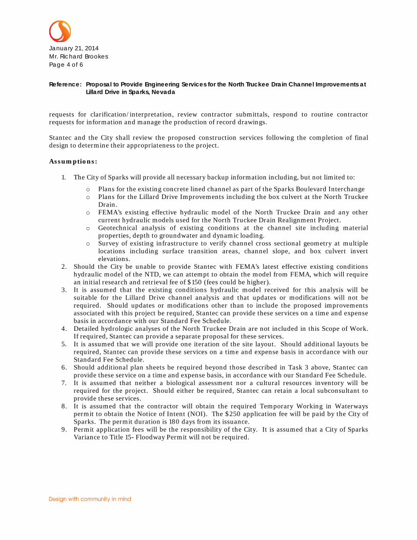
Schedule:
Stantec proposes to provide the services listed above in accordance with the following schedule:
SCHEDULED TASK DATE City Council Meeting February 10, 2014 Notice to Proceed February 10, 2014 Submittal Package to USACE for Pre-Project Meeting March 2014 USACE Pre-Project Meeting March 2014 Preliminary PS&E’s and Permit Applications March 2014 Final PS&E’s May 2014 Obtain Final Permits May 2014 Advertise Bid May 2014 City Council Meeting June/July 2014 Begin Construction July 2014 Construction Completed September 2014
Deliverables:
Deliverables will include four copies each of the final improvement plans, Certification of “No-Rise” Determination, and permit applications, should they be necessary. It is assumed that the plans, modeling and permitting can be completed within the schedule outlined above provided that there are no significant delays in permitting. It is the City’s desire for the project to go to construction in June 2014 and although Stantec has no control over the timeframe of the permitting process (that can take up to 1 year to complete), it is anticipated that we will be able to meet this schedule. Fees:
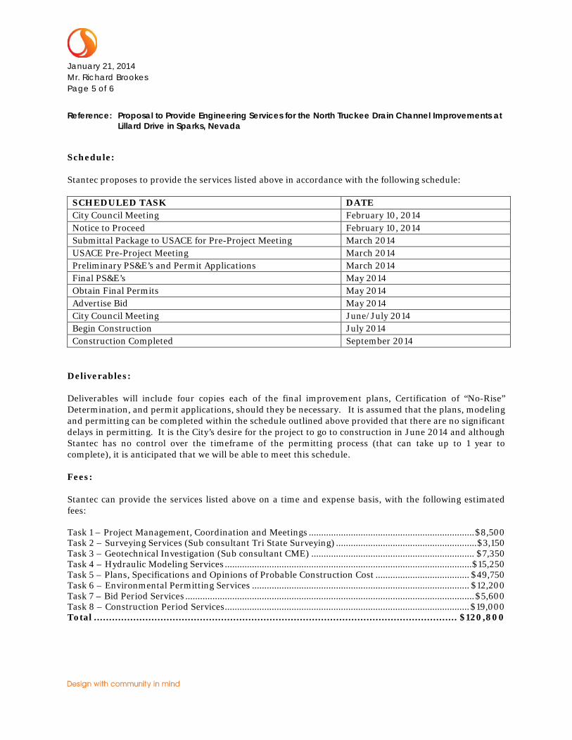
Stantec can provide the services listed above on a time and expense basis, with the following estimated fees:
Task 1 – Project Management, Coordination and Meetings ................................................................... $8,500 Task 2 – Surveying Services (Sub consultant Tri State Surveying) ......................................................... $3,150 Task 3 – Geotechnical Investigation (Sub consultant CME) .................................................................. $7,350 Task 4 – Hydraulic Modeling Services .................................................................................................... $15,250 Task 5 – Plans, Specifications and Opinions of Probable Construction Cost ...................................... $49,750 Task 6 – Environmental Permitting Services ........................................................................................ $12,200 Task 7 – Bid Period Services ..................................................................................................................... $5,600 Task 8 – Construction Period Services ................................................................................................... $19,000 Total ........................................................................................................................ $120,800
January 21, 2014 Mr. Richard Brookes Page 6 of 6
Reference: Proposal to Provide Engineering Services for the North Truckee Drain Channel Improvements at Lillard Drive in Sparks, Nevada
Should you find this proposal acceptable, please provide Stantec with a City of Sparks agreement. We appreciate the opportunity to submit this proposal and look forward to working with you. Please call should you have any questions or comments regarding this proposal.
Regards,
STANTEC CONSULTING SERVICES, INC.
Trina Magoon, PE Senior Water Resource Engineer Phone: (775) 850-0777 Direct: (775) 398-1220 [email protected]
Attachments: Tri State Proposal to Stantec, dated January 7, 2014
CME Proposal to Stantec dated January 8, 2014
c. File – 180101283
v:\1801\active\180101283\promotion\city of sparks north truckee drain lillard channel improvements scope.docx
1/7/2014
Page 1 of 6
Boundary Surveys Water Rights Land Divisions Construction Surveys Global Positioning Aerial Photogrammetry
TRI STATE SURVEYING, Ltd.
1925 East Prater Way, Sparks, Nevada 89434
Telephone (775) 358-9491 FAX (775) 358-3664 Toll Free: 1-800-411-3752
“NDOT Certified DBE Number NV00656UCPN”
Ms. Trina Magoon, P.E. Via e-mail: [email protected] Stantec 6995 Sierra Center Parkway, Suite 200 Reno, Nevada 89511-2279 Subject: Proposal for Professional Surveying Services North Truckee Drain/Lillard Drive Channel Improvements Approximately – 200 feet of the existing channel Lillard Drive, Sparks, Nevada Dear Ms. Magoon: Tri State Surveying is pleased for the opportunity to submit this proposal to provide Topographic Surveying and Construction Surveying Services for North Truckee Drain/Lillard Drive Channel Improvements Approximately – 200 feet of the existing channel located on Lillard Drive, Sparks, Nevada, which is referred to herein as the PROJECT. After execution of this agreement and your authorization to proceed, Tri State will provide the following scope of services based upon our understanding of the PROJECT based on the terms and conditions provided herein: 300. TOPOGRAPHIC SURVEYING SERVICES 301. Control Survey. Provide horizontal and vertical survey control necessary to accomplish the topographic
mapping for the PROJECT. 302. Design Survey. Obtain measurements locating physical features over and adjacent to the PROJECT
including: (1) top of existing channel on 50-foot intervals and at grade breaks; (2) toe of slope at channel on 50-foot intervals and at grade breaks; (3) flow line elevations, size of pipes for existing culvert pipes; (4) and flow line elevations and detail measurements of existing culvert boxes.
303. Topographic Mapping. Prepare and provide a Topographic Survey Map at 1” = 40’ scale with a 1 foot
contour interval in accordance with National Map Accuracy Standards.

1/7/2014
Page 2 of 6
Boundary Surveys Water Rights Land Divisions Construction Surveys Global Positioning Aerial Photogrammetry
900. CONSTRUCTION SURVEY SERVICES FOR OFF-SITE IMPROVEMENTS Grading Staking 901. Control and Verification Survey. Conduct a horizontal and vertical survey to establish control throughout
the PROJECT based upon the Basis of Bearings and Benchmark referenced on the Approved Improvement Plans. Conduct a survey to verify the location and elevation of existing improvement match locations such as curbing and pavement.
902. Slope Staking – Flood Control Channel. Provide one set of slope stakes to top of cut or toe of fill on 50-
foot intervals for slope grading. This will include grade breaks and angle points. 941. Culverts & Headwalls. Provide one set of stakes at an offset designated by the Contractor for the location
of culverts and headwalls. Note To Contractors Grades for construction surveys are given from the top of stakes or nails. In the case of curb, the given grade refers to the top back of the curb; in the case of a pipe or culvert, it refers to the elevation of the invert, or inside bottom; in the case of a header, it refers to the top of header. Prior to the start of construction it is the Contractors responsibility to verify the size and elevation of existing features at all match/join conditions. Contractors are also cautioned to observe the following rule in using the grades given by this office for putting in curbs, walks, pipes, channels and all other work. Three (3) consecutive points that are shown to be on the same rate of slope must be used in common in order that any variation out of a perfect straight grade may be detected. In case any such discrepancy is found, the same must be reported to our office prior to final construction, otherwise Tri State Surveying will not be responsible for any error in the grade of the finished work. Tri State Surveying will not be responsible for the acts or omissions of the Contractor, or any Subcontractor, performing work on the PROIJECT.
Acceptance of Digital Electronic Files In accepting and utilizing computer aided mapping drawings or other data in the form of electronic media prepared by Tri State Surveying, Ltd., the CLIENT agrees that all such digital drawings and data are instruments of the professional services of Tri State Surveying, who shall be deemed the author and shall retain all copyrights. The CLIENT agrees that any digital drawings prepared by Tri State Surveying shall conform to the specifications Digital Mapping Standards of Tri State Surveying. The electronic files submitted by Tri State Surveying to the CLIENT are submitted for an acceptance period of 90 calendar days. Any defects the CLIENT discovers during this period shall be reported to Tri State Surveying and will be corrected as part of Tri State Surveying’s scope of services contained in this proposal. The CLIENT further agrees not to use such digital drawings and data, in whole or in part, for any purpose other than the PROJECT, which is the subject of this proposal. The CLIENT agrees to waive all claims against Tri State Surveying resulting from any unauthorized changes or reuse of the digital drawings and data. In addition, the CLIENT agrees to indemnify and hold Tri State Surveying harmless for any damage, liability or cost, including reasonable attorneys’ fees, arising from any changes made by anyone other than Tri State Surveying or from any reuse of the digital drawings and data without the prior written consent of Tri State Surveying.

1/7/2014
Page 3 of 6
Boundary Surveys Water Rights Land Divisions Construction Surveys Global Positioning Aerial Photogrammetry
EXCLUDED SERVICES The following services are specifically excluded from this proposal: 1. CONSULTANT has not made an independent title search and has relied upon CLIENT supplied documents
relative to the PROJECT and specifically disclaims any items not shown on a deliverable which may or may not be of record and not provided by the CLIENT that may affect the PROJECT.
DELIVERABLES The deliverables for the TOPOGRAPHIC SURVEYING SERVICES provided to the PROJECT shall include the following:
(1) Design Survey points file with copies of field notes and sketches
(2) Basis of Bearings and Benchmark Notes (3) Topographic Survey Map with accompanying digital file
The deliverables for the CONSTRUCTION SURVEYING SERVICES provided to the PROJECT shall include the following:
(1) Wet stamped Cut Sheets for applicable tasks
FEES FOR SERVICES The fees for the services included in the proposal are as follows: For the services described under TOPOGRAPHIC SURVEYING SERVICES: $1620 The fees for the services described under CONSTRUCTION SURVEYING
SERVICES OFF-SITE IMPROVEMENTS: $1230 Total Fees For Services $2850
This proposal includes estimated costs for reimbursable expenses such as reproduction of drawings, postage,
express shipping charges, travel, lodging or other out-of-pocket expenses in connection with the PROJECT. The above fees will not be exceeded without your prior authorization. This proposal is subject to the terms and conditions attached. CLIENT SUPPLIED INFORMATION
Upon notice to proceed from the CLIENT to commence work on the PROJECT the CLIENT shall supply the following necessary PROJECT information to Tri State Surveying, Ltd.: For TOPOGRAPHIC SURVEYING SERVICES:
(1) Limits of Topographic Survey

1/7/2014
Page 4 of 6
Boundary Surveys Water Rights Land Divisions Construction Surveys Global Positioning Aerial Photogrammetry
For CONSTRUCTION SURVEYING SERVICES: (1) Two (2) sets of Approved Improvement Plans for the PROJECT (2) Supporting CAD files for the improvement plans (3) Revisions to Approved Improvement Plans for the PROJECT (4) Revised Supporting CAD files for Improvement Plan Revisions
SCHEDULE OF DELIVERABLES
The schedule of deliverables is based upon receipt of this signed proposal, the CLIENT supplied information in its entirety and your authorization to proceed.
The items described under TOPOGRAPHIC SURVEYING SERVICES shall be completed within two (2) weeks after
notice to proceed. Completion of services involving field surveying is contingent upon weather conditions. The items under CONSTRUCTION SURVEYING SERVICES shall be executed on an “on-call” basis. We require
48-hour notice for these services in order to properly prepare and schedule field survey crews. Completion of services involving field surveying is contingent upon weather conditions.
TERMS AND CONDITIONS
1. This agreement shall be governed by and construed in accordance with the laws of the State of Nevada. Any
legal action shall be filed in Washoe County, Nevada. Services provided shall be in conformance with local ordinances, Nevada Revised Statutes and the Nevada Administrative Code Standards of Practice for Professional Land Surveyors. The CLIENT understands and acknowledges that as a professional service provider Tri State Surveying, Ltd. (CONSULTANT) cannot and does not offer any warranty or guarantee relating to the construction of the PROJECT.
2. The CLIENT shall place on deposit with CONSULTANT a prepayment on the contract of $0.00, which shall be
used as payment against the final billing invoice. CONSULTANT shall perform the services that are contained in the subject proposal promptly, without delay and that the product of such services will be of customary quality and consistent with professional skill and care. Upon written request the CLIENT shall execute and deliver such additional instruments, documents, governmental fees and charges that are necessary to perform the services for the PROJECT.
3. This proposal, once executed will remain in effect until December 31, 2014, at which time CONSULTANT reserves the right to increase remaining fees for unrendered services described in this proposal 2.5% due to increase in labor and material costs. Any increase in excess of 2.5% will be negotiated with the CLIENT.
4. The CLIENT agrees that periodic billings from CONSULTANT to the CLIENT are correct, conclusive, and binding
on the CLIENT unless the CLIENT, within ten days from the date of receipt of such billing, notifies CONSULTANT in writing of alleged inaccuracies, discrepancies, or errors in the billing. Payment for the services described above will be due within a net 30 days upon receipt of an invoice statement for our work performed during the preceding billing period. Invoices not paid within 60 days of the date of the invoice are subject to an interest charge of 1% per month until paid in full.
1/7/2014
Page 5 of 6
Boundary Surveys Water Rights Land Divisions Construction Surveys Global Positioning Aerial Photogrammetry
5. In the event that the contract is mutually terminated, any prior work completed shall be billed as services rendered and any monies received over and above the final bill shall be returned to the CLIENT. Either party may terminate this agreement at any time without cause upon delivery of written notice to that effect to the other.
6. It is the CLIENT’s responsibility to provide CONSULTANT with wet stamped plan revisions and supporting CAD files for Construction Surveying Services. CONSULTANT shall not be responsible or liable for errors resulting from construction surveys or staking based on plan revisions that were not delivered to CONSULTANT prior to the CLIENT’s survey request.
7. Should the CLIENT require additional services, other than those detailed in this proposal, such additional services shall be provided based upon our current hourly rate schedule. Additional services involving field surveying will only be performed after written authorization from the CLIENT or the CLIENT’s onsite representative. At the time of engagement of CONSULTANT the CLIENT shall provide CONSULTANT, in writing, the names of those individuals authorized to order and approve payment of restaking and additional requested services. In the event that any staking is destroyed, damaged or disturbed by an act of God or parties other than CONSULTANT, the cost of restaking shall be paid for by the CLIENT as additional services. CONSULTANT shall not be responsible for delays or damages incurred from such delays in the PROJECT caused by activities or factors beyond the control of CONSULTANT. Unless otherwise stated herein, CONSULTANT shall not be responsible for verifying or coordinating the services or work of other consultants or subcontractors.
8. When applicable, CLIENT is noticed that at a future date CONSULTANT may claim a lien as provided by law against the property if not paid in full. CONSULTANT’s liability is limited to the sole negligence, willful misconduct of its own employees and subconsultants. In recognition of the relative risks and benefits of the PROJECT to both the CLIENT and CONSULTANT, the risks have been allocated such that the CLIENT agrees to limit the liability of CONSULTANT for any and all claims and expenses from any cause or causes, including attorney’s fees, expert witness fees and costs, so that the total aggregate liability of CONSULTANT to the CLIENT shall not exceed $25,000.00, or the amount of CONSULTANT’s total fee for services rendered on the PROJECT, whichever is less. It is intended that this limitation apply to any and all liability or cause of action however alleged or arising, unless otherwise prohibited by law.
9. CONSULTANT’S scope of services is limited to those services selected and agreed to by CLIENT. CONSULANT is
not obligated to project services beyond the agreed to scope of services unless written authorization is provided by CLIENT.
10. CONSULTANT’s opinions and certifications are limited to the practice of land surveying as defined by Nevada
Revised Statutes.
We appreciate the opportunity to offer to provide our professional services to this project, and look forward
to working with you. If this proposal is satisfactory to you, please indicate your agreement by signing and returning one original to us to serve as our notice to proceed. This proposal is valid for execution for a period of 90 days. If you have any questions, or if I can be of further service, please don’t hesitate to call me. Thank you for your consideration of Tri State Surveying for this project.
1/7/2014
Page 6 of 6
Boundary Surveys Water Rights Land Divisions Construction Surveys Global Positioning Aerial Photogrammetry
Sincerely, Tri State Surveying, Ltd. Lee H. Smithson, P.L.S., W.R.S. Vice President
CLIENT Acceptance and Notice to Proceed: Stantec By: ________________________________________ Date: ____________________ CLIENT’S Authorized Representative Print Name and Title: __________________________________________________________

6980 Sierra Center Parkway, Suite 90 Reno, NV 89511
Office 775‐851‐8205 fax 775‐851‐8593 www.cme‐corp.com
January 8, 2014 Ms. Trina Magoon STANTEC CONSULTING SERVICES INC. 6980 Sierra Center Parkway, Suite 100 Reno, NV 89511 RE: Geotechnical Investigation Proposal- Channel Improvements North Truckee Drain, Sparks, Nevada
Reference: Draft Plan Set entitled, North Truckee Drain/Lillard Drive, Channel Improvements, City of Sparks,
Nevada, Public Works Department , by HDR Engineering Inc., received January 2, 2013; Dear Ms. Magoon: Construction Materials Engineers, Inc. (CME) is pleased to submit the following proposal to provide a design level geotechnical investigation for the proposed North Truckee Drain Channel Improvements located near Lillard Drive in Sparks, Washoe County, Nevada. Included in this proposal is a brief description of our understanding of the proposed project, the scope of services we can provide, and an estimate of our fees.
1.0 Project Description
The proposed project includes improvements to approximately 130 linear feet of the existing North Truckee Drain located on the west side of Lillard Drive. Proposed improvements include:
Realignment of the existing drainage channel to include a minor centerline adjustment; Construction of an access ramp structure and associated retaining walls; Installation of concrete channel lining; Minor grading of the new alignment to match the current trapezoidal configuration of the existing
drainage channel located upstream of the proposed improvements. The trapezoidal channel walls will have a topographic relief of approximately 12 feet from the drainage channel centerline to the top of the channel wall ;
Installation of a trash grate at the inlet of the existing reinforced concrete box located below Lillard Drive, and
Construction of a new concrete barrier on the west side of Lillard Drive.
The subject site is bound to the north and south by privately owned parcels and to the east by Lillard Drive. Access to the site is limited due to perimeter chain link fencing and a concrete barrier rail located on the west side of Lillard Drive. It is understood that a potential access easement exists between the City of Sparks and the parcel owners to the south.
2.0 Scope of Services The geotechnical investigation includes a literature review, subsurface exploration utilizing test pit excavation, laboratory testing, and engineering analyses to allow formulation of geotechnical recommendations for design and construction of this project.
STANTEC CONSULTING SERVICES INC. NTD Channel Improvements January 8, 2014 Page 2 of 4
Stantec-NDT Geotech_prop_ltr 1-8-14
2.1 Literature Review
Prior to initiating the field exploration, our engineer will review published geologic maps, fault hazard reports, and soils maps to identify the presence of documented geologic hazards at the site.
2.2 Field Exploration
The subsurface field exploration will consist of one test pit to a depth of 12 feet below the existing ground surface or to refusal (whichever comes first) using a rubber tired backhoe. It is assumed access to the site will be provided by the client1. Soils encountered in the field will be visually classified in accordance with the Unified Soils Classification System. Samples of the underlying soils will be collected and brought back to our laboratory for testing.
CME will obtain an encroachment permit from the City of Sparks, if required. Prior to initiating the subsurface exploration, CME will contact USA dig to determine the location of existing utilities. CME will complete two site visits to complete USA dig coordination. The first site visit will be to mark proposed exploration locations and a second site visit to review marked utility locations to determine an appropriate location for the proposed boring to be drilled, away from marked utilities. CME will take every precaution to lower the risk of damaging underground structures; however, underground exploration is inherently risky as it is not possible to precisely locate all underground structures. Our fee is not adequate to compensate for damage or disruption of service and repair costs. If insufficient or incorrect data results in damage to underground structures, the cost for repair will be the responsibility of the client.
2.3 Laboratory Testing
The purpose of the laboratory test program will be to evaluate the engineering and mechanical properties of soil samples collected in the field. We anticipate our laboratory test program will consist of the following:
Testing for index properties including moisture determination, grain size distribution and plasticity;
Corrosion testing including soluble sulfates; and Consolidation or expansion testing, as appropriate, may be conducted on
fine-grained soils to evaluate settlement or expansion potential.
1 The scope and fee assumed in this proposal are based upon the assumption that the site is accessible to the exploration equipment
proposed.

STANTEC CONSULTING SERVICES INC. NTD Channel Improvements January 8, 2014 Page 3 of 4
Stantec-NDT Geotech_prop_ltr 1-8-14
2.4 Report and Analysis
Upon completion of our field, laboratory and office studies, a geotechnical investigation report will be completed for the project and will include the following:
Description of the project site with the approximate locations of our field
exploration(s), shown on a Site Plan;
Descriptive logs of the exploration(s) performed for this study;
General summary of the site soils and geology;
Discussion of seismic hazards including site seismicity and parameters for design;
Discussion of the general surface and ground water conditions encountered during our exploration;
Recommendations for the following:
Earthwork and site preparation including general site grading and remedial earthwork;
Concrete slab-on-grade subgrade soils preparation including stabilization recommendations
Allowable bearing values, anticipated settlements, minimum footing depth and widths; and
Lateral earth pressures for retaining wall and foundation design; 3.0 Cost Estimate and Schedule
We will provide our services as outlined in Section 2.0 for an estimated cost of $6,700. Any additional work, if required for this investigation, will be billed on a time and materials basis in accordance with our Standard Fee Schedule.
If the client provides the excavation equipment, our fees can be reduced by $880.
Depending on the availability of the excavation equipment, the field exploration can begin within 7 to 10 days of receiving written authorization to proceed. Verbal geotechnical recommendations can be provided within one week following the completion of field exploration. A written report will be available within about 3 weeks after the completion of the field investigation.

STANTEC CONSULTING SERVICES INC. NTD Channel Improvements January 8, 2014 Page 4 of 4
Stantec-NDT Geotech_prop_ltr 1-8-14
We thank you for the opportunity to submit this proposal, and look forward to its favorable consideration. If you have any questions, please call.
Sincerely, CONSTRUCTION MATERIALS ENGINEERS, INC.
Stella A. Montalvo, P.E. Geotechnical Project Manager [email protected] Direct: 775-737-7569