Reduced Risk Timing Windows and Measures for the ...€¦ · Reduced Risk Timing Windows and...
21
File: Instream Measures May 3, 2004 To: District Manager(s); Ft. St. James, Mackenzie, Prince George, Headwaters, Vanderhoof Forest Districts Ministry of Forests Small Business Forest Enterprise Program Ft. St. James, Mackenzie, Prince George, Headwaters and Vanderhoof Forest District Licensees Ft. St. James, Mackenzie, Prince George, Headwaters, Vanderhoof Forest District Woodlot Licensees Dear Sir/Madame: Re: Reduced Risk Timing Windows and Measures for the Conservation of Fish and Fish Habitat for the Omineca Region The attached Reduced Risk Timing Windows and Measures document is provided to meet the legal obligations of Designated Environment Officials under the Forest Practices Code Act of BC (FPC), pursuant to the following regulations: Timber Harvesting and Silvicultural Practices Regulation (THSPR) - Section 14(2) - temporary crossings of fish streams Forest Road Regulation (FRR) - Section 9(1)(h) – construction of crossings in fish streams - Section 14 - road deactivation in and around stream crossings Woodlot Licence Forest Management Regulation - Section 49(1)(h)(i)) – construction of crossings in fish streams - Section 54 - road deactivation in and around stream crossings - Section 68(c)- temporary crossings of fish streams These timing windows (windows of least risk) and measures are legally required to be applied to all operations to which the above FPC regulations apply, and are effective May 3, 2004. This document may be accessed in digital format at http://wlapwww.gov.bc.ca/nor/habitat/index.html , is URL address may change in the future as we update our Ministry regional web page. These reduced risk timing windows and measures are based on the best information currently available. This document is updated to quote the new regulation numbering with a slight change to the timing windows but no changes to measures from the early Omineca Region Timing Windows and Measures version (dated March 31, 2002) for the above Forest Districts, and may be revised from time to time as new information becomes available. Ministry of Water, Land and Air Protection Environmental Stewardship Division Omineca Region Mailing Address: 4051 – 18 th Avenue. Prince George, B.C. V2N 1B3 Tel: 250-565-6135 Fax: 250-567-6940
Transcript of Reduced Risk Timing Windows and Measures for the ...€¦ · Reduced Risk Timing Windows and...

File: Instream Measures
May 3, 2004 To: District Manager(s); Ft. St. James, Mackenzie, Prince George, Headwaters, Vanderhoof Forest Districts Ministry of Forests Small Business Forest Enterprise Program Ft. St. James, Mackenzie, Prince George, Headwaters and Vanderhoof Forest District Licensees Ft. St. James, Mackenzie, Prince George, Headwaters, Vanderhoof Forest District Woodlot Licensees
Dear Sir/Madame:
Re: Reduced Risk Timing Windows and Measures for the Conservation of Fish and Fish Habitat for the Omineca Region
The attached Reduced Risk Timing Windows and Measures document is provided to meet the legal obligations of Designated Environment Officials under the Forest Practices Code Act of BC (FPC), pursuant to the following regulations:
Timber Harvesting and Silvicultural Practices Regulation (THSPR)
- Section 14(2) - temporary crossings of fish streams
Forest Road Regulation (FRR)
- Section 9(1)(h) – construction of crossings in fish streams
- Section 14 - road deactivation in and around stream crossings
Woodlot Licence Forest Management Regulation
- Section 49(1)(h)(i)) – construction of crossings in fish streams
- Section 54 - road deactivation in and around stream crossings
- Section 68(c)- temporary crossings of fish streams
These timing windows (windows of least risk) and measures are legally required to be applied to all operations to which the above FPC regulations apply, and are effective May 3, 2004. This document may be accessed in digital format at http://wlapwww.gov.bc.ca/nor/habitat/index.html, is URL address may change in the future as we update our Ministry regional web page.
These reduced risk timing windows and measures are based on the best information currently available. This document is updated to quote the new regulation numbering with a slight change to the timing windows but no changes to measures from the early Omineca Region Timing Windows and Measures version (dated March 31, 2002) for the above Forest Districts, and may be revised from time to time as new information becomes available.
Ministry of Water, Land and Air Protection
Environmental Stewardship Division Omineca Region
Mailing Address: 4051 – 18th Avenue. Prince George, B.C. V2N 1B3 Tel: 250-565-6135 Fax: 250-567-6940

Reduced Risk Timing Windows and Measures for the Omineca Region
Please contact the undersigned (250.614-9910) if you require further clarification of this matter. Yours truly, Original signed by Chris Ritchie _________________________ Chris Ritchie Ecosystems, Section Head Omineca Region cc: Don Cadden (acting), Regional Manager, Environmental Stewardship - MWLAP Carl Erickson, Regional Engineering Officer, Ministry of Forest – Prince George Don Cadden, Fish and Wildlife Science and Allocation Section - MWLAP
May 3, 2004

Reduced Risk Timing Windows and Measures for the Omineca Region
REDUCED RISK TIMING WINDOWS AND MEASURES FOR THE CONSERVATION OF FISH AND FISH HABITAT FOR THE OMINECA REGION
Effective May 3, 2004
Environmental Stewardship Division Ministry of Water, Land and Air Protection
4051 – 18th Avenue Prince George, British Columbia V2N 1B3
May 2004
May 3, 2004 ii

Reduced Risk Timing Windows and Measures for the Omineca Region
TABLE OF CONTENTS
TABLE OF CONTENTS........................................................................................................... iii 1.0 PURPOSE AND OBJECTIVES......................................................................................... 1 2.0 AUTHORITY ..................................................................................................................... 1 3.0 RESPONSIBILITY ............................................................................................................ 1 4.0 REFERRALS AND EXEMPTIONS ................................................................................... 2 5.0 TIMING WINDOWS ......................................................................................................... 4 6.0 MEASURES...................................................................................................................... 5 6.1 Planning Measures.................................................................................................... 5 6.2 Construction and Deactivation Measures.................................................................. 9 6.3 Emergency Situations.............................................................................................. 11 6.4 Temporary Winter Crossings................................................................................... 11 6.4.1 Log Bundles................................................................................................. 12 6.4.2 Frozen Soil Bridges (Plywood Culverts) ...................................................... 12 6.4.3 Non-embedded Culverts.............................................................................. 13 6.4.4 Log Culverts................................................................................................. 13 7.0 REFERENCES ............................................................................................................... 15 STREAM CROSSING DATA SHEET .................................................................................... 16
May 3, 2004 iii

Reduced Risk Timing Windows and Measures for the Omineca Region
1.0 PURPOSE AND OBJECTIVES The purpose of this document is to provide timing windows (windows of reduced risk) and
measures for work related to stream crossings within the Omineca Region. To facilitate compliance with the Forest Practices Act (FPC). Forest districts to which the document applies include: Fort St. James, Mackenzie, Prince George, Vanderhoof and Headwaters within the Omineca Region. The document has been prepared by Designated Environment Officials (DEOs) within the Omineca Region, using the best information currently available, and in consultation with Ministry of Water, Land and Air Protection (WLAP) fisheries staff; Fisheries and Oceans Canada (DFO); the Ministry of Forests (MOF); and forest licensees.
In order to meet FPC requirements, the direction provided in this document is designed to
achieve the following objectives:
• Protect fish habitat at crossings and immediately upstream and downstream of crossing structures; and,
• Provide safe passage through stream crossing structures for all life stages of fish. 2.0 AUTHORITY The Minister of WLAP has established Senior Habitat Biologists, Forest Ecosystem
Specialists, Habitat Protection Officers, Senior Water Resource Specialists and Water Resource Specialists as DEOs for the purposes of Timber Harvesting and Silvicultural Practices Regulation (THSPR) 14(2), Forest Road Regulations (FRR) 9(1)(h), 14, and Woodlot Licence Forest Management Regulations (WLFMR) 49(1)(h)(i), 54 and 68(c).
The FPC authorizes the DEO to provide timing windows and measures for construction
activity on all fish stream crossings, and for the construction, repair or removal of all temporary crossings of fish streams. In addition, for woodlot operations, the DEO may also establish timing windows and measures for the location, design and use of temporary crossings of fish streams.
3.0 RESPONSIBILITY It is the responsibility of the proponents of forest operations to ensure compliance with these
timing windows and measures, which are legally required to be applied to all operations to which the above FPC regulations apply. If followed, it is expected that risks to aquatic resources will be significantly reduced or eliminated. However, these timing windows and measures do not authorize anyone to conduct or participate in any activity that is contrary to any provincial or federal statute. No authorization to alter, disrupt or destroy fish habitat, or introduce deleterious substances to water frequented by fish, is expressed or implied, as such authorization is within the exclusive purview of the Minister of Fisheries and Oceans, Canada. It is highly recommended that any proposed stream crossing installation be referred to the DFO, to ensure compliance with the Canada Fisheries Act.
Any contract between a forest licensee or tenure holder and the MOF does not affect WLAPs mandate to monitor and, when necessary, investigate apparent violations of the regulations listed above.
May 3, 2004 Page 1 of 17

Reduced Risk Timing Windows and Measures for the Omineca Region
4.0 REFERRALS AND EXEMPTIONS
4.1 Activities that are consistent with the identified timing windows and measures do not require referral to WLAP unless specifically requested by a DEO.
4.2 Works conducted pursuant to the FPC do not require Water Act authorization or
notification.
4.3 Where a proponent wishes to conduct work outside the approved timing window or deviate from an approved measure as stated in this document, authorization must be requested from a DEO in writing. Any such request must include site-specific information (Stream Crossing Data Sheet - attached). Where, as a result of proposed activities, impacts to fish or fish habitat are likely, the DEO may also require submission of a Proponent Action Plan, as described in Section 4.7.
A request to vary from an approved timing window or measure may or may not
be approved by a DEO. 4.4 Any request to vary from an approved timing window or measure must be received by
a DEO at least fourteen days prior to the initiation of in-stream work.
4.5 No work may proceed until approval to vary from an approved timing window or measure is provided in writing by a DEO, and any such variance approval must be kept on the work site while work is being conducted.
4.6 Notwithstanding the measures set forth in this document, if any of the following
conditions are met, the timing window extends from January 1 through December 31 of any given year.
1. On fish streams, the stream channel is dry and the construction, repair, removal or
deactivation activity will not result in the introduction of sediment into fish habitat;
2. On fish streams, the crossing structure does not encroach into the stream channel, no work will be conducted within the stream channel or fisheries sensitive zone, and the risk of sediment delivery to fish habitat is low;
3. On non-fish streams, the deactivation activity does not result in the introduction of
sediment into fish habitat; or,
4. A temporary winter crossing is constructed on a fish stream as directed in Section 6.4.
May 3, 2004 Page 2 of 17

Reduced Risk Timing Windows and Measures for the Omineca Region
4.7 Proponent Action Plan A Proponent Action Plan encompasses five major components that describe the proposed works, possible impacts on fish or fish habitat, and steps that will be undertaken to minimize or avoid possible negative impacts. The plan must be prepared by a qualified professional or technician with adequate training and knowledge of fish habitat assessment and requirements for fish habitat protection and restoration.
The plan must detail:
1. Fisheries Resource Values
A description is required of the existing fisheries resource values of the area that could be affected by the proposed works, including hydrologic features, water quality, species of fish that frequent the waterbody, fish habitat present (spawning, rearing, overwintering, migration) and riparian vegetation. The sensitivity of the habitat to disturbance must also be described in this section (e.g., soil type, bank stability, substrate type, gradient).
2. Description of Proposed Activities
The plan must include a description of the proposed works and a site plan, and describe how the works will be carried out, all machinery and materials to be used, road maintenance requirements and deactivation plans. A project time schedule is required, which will include activities and applicable timing windows that may apply. Methods to maintain fish passage for the lifespan of the structure must also be clearly stated.
3. Impacts to the Fisheries Resources Anticipated impacts to fisheries and fish habitat must be discussed, including the identification of the nature, duration, magnitude and location of potential impacts and effects on fish and fish habitat in downstream areas. All anticipated changes to fish habitat as a result of construction, maintenance and deactivation activities must be stated, including predicted changes to downstream flows, sediment and debris transport, bars and stream banks. Justification for any changes to fish habitat must be provided.
4. Mitigation Proposed
A description of all measures (actions and contingencies) that will be taken to avoid, reduce or eliminate any adverse impacts described in Point # 3 is required. Proposed measures should include a discussion of any proposed habitat compensation works in order to achieve no net loss of fish habitat.
5. Environmental Monitoring
An environmental monitor may be required where construction occurs in critical or important habitats or where construction will occur outside of the normal timing window. The monitor acts at arms length from the proponent and the proponent’s contractors, reports to the DEO, and ensures that all proposed activities are completed to the satisfaction of the DEO. Construction activities may be continually monitored or periodically inspected, depending on the sensitivity of the site to disturbance and the nature of construction. It is expected that the monitor will photographically document critical or sensitive phases of the project, and record important observations. The monitor must be
May 3, 2004 Page 3 of 17

Reduced Risk Timing Windows and Measures for the Omineca Region
given authority by the proponent to modify or stop operations in case of non-compliance with approved conditions or where it is anticipated that unforeseen circumstances are likely to cause environmental problems. By allowing the monitor to represent the concerns of the DEO, costly shutdowns and complications can be avoided. After the installation is completed, the monitor will prepare a post-construction report that will detail the effectiveness of the Proponent Action Plan, identify problem areas, and make recommendations regarding further required mitigative measures and future monitoring of the site. This report must be made available to the DEO on request. An environmental monitor must be a qualified professional or technician with adequate training and knowledge of fish habitat assessment and requirements for fish habitat protection and restoration.
5.0 TIMING WINDOWS
Work in or around steams can result in harmful effects to fish and fish habitat, including the harmful alteration or destruction of spawning habitat, introduction of sediment and the destruction of fish eggs and alevins prior to emergence from gravels, and displacement or other behavioral impacts on fish. Therefore, such work must be undertaken during times or periods when such harmful effects will be minimized.
Reduced risk timing (in-stream work) windows for the Omineca region are shown in the following Table.
White (non-shaded) areas in the Table represent time periods when in-stream work must be conducted. Numbers in the Table represent an approved start or end date for in-stream work.
Month Jan Feb Mar Apr May Jun Jul Aug Sep Oct Nov Dec Species
A. grayling 31 15
Rainbow tr. 15 15
Steelhead 15 15
Bull trout 15 15
Dolly Vard. 15 31
Kokanee 1 31
M. whitefish 1 15
Spring and Fall Spawners
15 15
Anadromous – Contact the DFO for appropriate timing window Salmon
District-specific timing windows are as follows. These timing windows replace the general timing windows provided above. MacKenzie Forest District Bull trout – July 1st -August 15th Mountain whitefish – July 15th -August 31st
May 3, 2004 Page 4 of 17
Reduced Risk Timing Windows and Measures for the Omineca Region
Vanderhoof Forest District Kokanee – June 1st -August 15th – Cluculz Creek watershed Fort St. James Forest District Kokanee – June 1st - July 31st – Tsilcoh River watershed If fish species information for a particular stream is not available, the in-stream timing window for both spring and fall spawners must be used.
Proponents are reminded that stream inventory data for fish presence/absence are critical to establishing the widest possible timing windows.
6.0 MEASURES
Guidelines such as the FPC Fish-stream Crossing Guidebook (BCMOF March 2002) and the Land Development Guidelines for the Protection of Aquatic Habitat (Chilibeck et al 1992) should be consulted for potential culvert and bridge installation options to minimize the risk of damage to fish and fish habitat. However, the additional direction in this document takes precedence over such guidelines and best management practices, where there is a difference. The following measures must be implemented during the construction, repair or removal of a temporary stream crossing and other operations in a fish stream (THSPR 14(2), WLFMR 68(c), while constructing or modifying a crossing in a fish stream (FRR 9(1)(h), WLFMR 49(1)(h)(i), or during road deactivation works in and around stream crossings (FRR 14, WLFMR 54). Sections 6.1, 6.2 and 6.3 of this document are applicable to crossings of streams that are not considered to be temporary winter crossings. Section 6.4 applies specifically to temporary winter crossings.
6.1 Planning Measures
6.1.1 Stream crossings should not be located where streams are meandering, braided or
located on alluvial fans.
6.1.2 Fords are generally not approved for fish streams. Any application for construction of a ford must include submission of a Stream Crossing Data Sheet and a Proponent Action Plan.
6.1.3 Culverts or bridges must be installed at crossings of fish streams on permanent or
planned five-year roads in approved road permits.
6.1.4 Streams having a channel width of two or more metres must be crossed using a bottomless structure.
May 3, 2004 Page 5 of 17
Reduced Risk Timing Windows and Measures for the Omineca Region
Stream channel width is defined as: the horizontal distance between streambanks on opposite sides of the stream measured at right angles to the general orientation of the banks. The point on each bank from which width is measured is usually indicated by a definite change in vegetation and sediment texture. This border is the “normal” high-water mark of the stream and is sometimes shown by the edges of rooted terrestrial vegetation. Above this border, the soils and terrestrial plants appear undisturbed by recent stream erosion. Below this border, the banks typically show signs of both scouring and sediment deposition.
6.1.5 Closed-bottom culverts may not be installed in the following circumstances:
1. In critical fish habitat. Critical fish habitat is defined as habitat that is critical in
sustaining the local population of a species listed in Operational Planning Regulation (OPR) 1 of the FPC, because of its rareness, productivity and sensitivity. Critical fish habitat is indicated by the presence of high value spawning or rearing habitat. This is evidenced by the abundance of suitably-sized spawning gravels, or by deep pools, undercut banks and/or stable debris which are critical to the fish population present. It is highly recommended that a fish habitat assessment be carried out at any potential stream crossing site, prior to the selection of a stream crossing structure. In order to identify critical fish habitat which may be present, this assessment should be carried out by a qualified professional or technician with adequate training in fish habitat assessment.
2. In areas of channel instability, such as in areas of past or current beaver activity
upstream of the proposed stream crossing site; in areas prone to lateral channel movement; or in areas where the stream channel in the vicinity of the proposed stream crossing site is aggrading or degrading.
6.1.6 Closed-bottom culverts must be embedded into the substrate. Pipe arch or
elliptical culverts measuring 1000 millimetres or greater in diameter must be embedded below the natural streambed a minimum of 0.3 metres, or 20 percent of the culvert height - whichever is greater. Pipe arch or elliptical culverts smaller than 1000 millimetres in diameter must be embedded a minimum of 20 percent of the culvert height. Round culverts must be embedded a minimum of 40 percent of the culvert diameter.
6.1.7 Culverts must be sized to accommodate the 100-year return period peak flow after
embedment.
6.1.8 Stream channel width at a fish stream crossing, at any point within the stream channel, may not be constricted by crossing structures, bridge abutments, sill logs, riprap or by anything else associated with the stream crossing.
6.1.9 Closed-bottom culverts in fish streams must be set at the average channel slope for
the site.
6.1.10 Closed-bottom culverts may not be installed at gradients that exceed 5 percent. 6.1.11 To promote fish passage and mitigate against the loss of the productive
capacity of a stream where it flows through a culvert, substrate material
May 3, 2004 Page 6 of 17

Reduced Risk Timing Windows and Measures for the Omineca Region
must be placed throughout the barrel of all closed-bottom culverts measuring 1400 millimetres or greater in diameter that are installed in fish streams. This material must fill the culvert to the elevation of the natural stream bed in areas where it is placed.
A heterogeneous mixture of various substrate sizes that contains enough fine
materials to seal the stream bed is recommended. A homogeneous substrate such as large, coarse rock, or washed gravel, should be avoided - particularly where such substrates are relatively thick and are placed at steeper gradients - as this can lead to subsurface flow during low-flow periods and the creation of a barrier to fish movement. This is especially problematic when there is little input of bedload from upstream areas to seal the substrate, such as when there is a wetland or pond immediately upstream of the culvert.
Recommended mixtures are shown in the following Table*.
D max
(centimetres) Particle Size Distribution (centimetres)
30% 30% 20 40% <5 5-12 12-20 30 40% <8 8-18 18-30 45 15% <3 25% 3-13 13-28 28-45 60 10% <3 30% 3-15 15-36 36-60 75 10% <3 30% 3-20 20-46 46-75
* Adapted from Washington Dept. of Fish and Wildlife (1999). ** Dmax - the mean diameter of the largest material within the stream channel in the vicinity of
the stream crossing that is moveable by flowing water. The largest moveable particle does not include large lag boulders deposited during periods with distinctly different streamflow regimes (e.g., immediately post-glacial) or boulders that have fallen into the stream from surrounding glacial moraines, colluvial fans, etc. Dmax material should show evidence of movement by flowing water during the past decade, i.e., it should be surrounded by other sediment and not be an isolated particle, distinctly different from all others in the vicinity.
In many cases, it will be necessary to combine a select pit run with cobbles and boulders or riprap to achieve the recommended fraction of larger materials.
6.1.12 Substrate placement within culverts must be done at the time of culvert installation
or modification. 6.1.13 Larger (Dmax) material must be distributed throughout the culvert barrel. This is
particularly important where a closed-bottom culvert is installed at a gradient that exceeds three percent. At such gradients, the culvert must be large enough to allow for the physical placement and orientation of the larger substrate elements, to assist in preventing scour and the loss of substrate from within the culvert.
6.1.14 The width of the streambed placed within closed-bottom culverts must equal
or exceed the natural width of the stream channel at the crossing location. 6.1.15 Substrate material placed within closed-bottom culverts should be free of silt or
other substances deleterious to aquatic life.
May 3, 2004 Page 7 of 17
Reduced Risk Timing Windows and Measures for the Omineca Region
6.1.16 Substrate material must be placed throughout the barrel of all closed-bottom culverts measuring less than 1400 millimetres in diameter that are installed in fish streams at gradients that exceed 0.5 percent. This material must fill the culvert to the elevation of the natural streambed in areas where it is placed. If substrate material is not placed within such culverts, upstream movement of juvenile fish past the culvert inlet is often not possible in situations where the culvert barrel does not infill naturally (e.g., in small headwater streams not subject to significant variation in flow rates and lacking bedload movement within the stream channel). For this reason, any application to vary from the requirement to place substrate material within such culverts must clearly demonstrate that significant bedload movement occurs in the vicinity of the culvert.
6.1.17 Substrate material is not required to be placed throughout the barrel of closed-
bottom culverts measuring less than 1400 millimetres in diameter that are installed essentially flat, at gradients of 0.5 percent or less.
6.1.18 Bridges and culverts must be designed and installed to permit the passage of
bedload and debris. This is especially important for fish streams or direct tributaries to fish streams that have high gradients, exhibit evidence of channel instability or debris torrenting, or have unstable terrain or highly-erodible soils within the inner gorge.
6.1.19 Baffled culverts should only be used where all other practicable options have been
exhausted. Application to use baffled culverts must be made to the DEO. Poulin et al (1999) describe the disadvantages of baffled culverts.
6.1.20 Pile driving or blasting that will result in vibrations harmful to fish is subject to the
timing windows set forth in Section 5.0 of this document.
May 3, 2004 Page 8 of 17
Reduced Risk Timing Windows and Measures for the Omineca Region
6.2 Construction and Deactivation Measures
6.2.1 The installation period must be minimized. 6.2.2 Equipment must be located on and work from the stream bank or naturally dry
channel rather than within the wetted perimeter of the stream. 6.2.3 Temporary sediment control structures must be installed to reduce the risk of
sediment delivery to a fish stream. These structures must be functional, maintained, cleaned out on a regular basis and cleaned prior to removal. Maintaining the natural vegetation in the vicinity of stream crossings serves as the best sediment control measure.
6.2.4 The work area must be isolated from flowing water, to limit sediment mobilization
and introduction into streams. 6.2.5 Silt-laden water may not be discharged from the work site to the channel of a fish
stream during the course of works and prior to the re-establishment of streamflow. 6.2.6 If channel de-watering is conducted, fish must be salvaged from the de-watered
area and returned to the stream. Fish salvaging requires a fish collection permit from the regional office of WLAP.
6.2.7 Two pre-installation crossings (across - first crossing; back - second crossing) by
heavy equipment (e.g., hoe) are permitted for installation of crossing structures during the appropriate timing window, providing the stream bed and banks are comprised of relatively stable, non-erodible materials. If, however, the stream bed and banks are highly erodible (e.g., dominated by organic materials, silt, silt loams, etc.), and significant erosion and stream sedimentation or bank or stream channel degradation will result from heavy equipment crossings (e.g., streamflow is relatively high), a temporary work bridge must be used for fish stream crossings for the purpose of installing a crossing structure. If multiple crossings of a fish stream are required in association with the installation of a crossing structure, an appropriate temporary or permanent crossing structure (e.g., bridge, culvert) must be installed.
6.2.8 Materials such as riprap or gabion rock that is placed within a stream channel
should be free of silt or other substances deleterious to aquatic life. 6.2.9 All equipment used on site should be in good repair and free of excess grease and
oil. All refueling and servicing must be conducted outside of the Riparian Management Area (RMA).
6.2.10 Where wood containing a wood preservative that is potentially toxic to fish is
placed within the channel of a fish stream, the recommendations of Hutton and Samis (2000) must be followed. Treated wood so utilized must be treated with preservatives according to Best Management Practices as described by the Canadian Institute of Treated Wood and the Western Wood Preservers Institute (1997).
Treated wood fines or cut ends may not be deposited within a fish stream.
May 3, 2004 Page 9 of 17

Reduced Risk Timing Windows and Measures for the Omineca Region
6.2.11 All cast-in-place concrete and grouting must be completely isolated from fish-
bearing waters for a minimum of 48 hours if the ambient air temperature is greater than 0 degrees C, or for 72 hours if the ambient air temperature is less than 0 degrees C.
6.2.12 Where there is an ongoing risk of sediment delivery to a fish stream from road
surfaces or ditches at the crossing location, permanent sediment control structures must be installed and properly maintained. Structures that are utilized - both temporary and long-term - must be functioning immediately after completion of the construction or deactivation activity. Suggested measures include, but are not limited to, those outlined in BCMOF (2002) and Chilibeck et al (1992).
6.2.13 During deactivation, the crib of a wooden culvert or bridge that is stable and
integrated into the channel of a fish stream may not be removed. However, loose or unembedded components of such structures must be removed. Soil or other backfill material behind the crib that could enter the stream must be removed and placed in a location where it cannot enter the stream channel.
6.2.14 During construction or deactivation activities, damage to the stream channel,
banks and vegetation in the vicinity of the work area must be minimized. 6.2.15 During periods of heavy or persistent rainfall, work that could result in sediment
delivery to a fish stream must stop. During the shutdown period, measures to minimize the risk of sediment delivery to the stream must be implemented.
6.2.16 If migrating adults or redds of species of fish that are associated with a fish stream,
as listed in OPR 1 of the FPC, are observed in or downstream of the work area, work activities must be suspended and a DEO notified.
6.2.17 As part of construction or deactivation activities, the stream channel, banks and
other affected work areas at the site must be restored to their approximate original configuration. Any fill material that has been temporarily added to the stream channel must be removed and deposited in a location where it cannot enter the stream channel.
6.2.18 Upon completion of construction or deactivation activities, material that is no longer
being used and has the potential to harm fish or fish habitat must be placed above the normal high-water mark. These materials must be removed from the stream floodplain prior to the spring freshet.
6.2.19 All soils exposed as a result of work activities that have significant potential for
delivery to a fish stream must be promptly stabilized and re-vegetated to prevent erosion and stream sedimentation. A seed mix that is ecologically suitable and minimally palatable to livestock should be used. Fertilizers applied through hand seeding may not be used where they will directly enter a fish stream.
May 3, 2004 Page 10 of 17

Reduced Risk Timing Windows and Measures for the Omineca Region
6.3 Emergency Situations
If emergency works are required to protect roads, stream environments or crossing structures, or a stream crossing structure has failed, the incident and remediation activities undertaken must be reported to a DEO as soon as possible, within normal business hours. Section 38(4) of the Canada Fisheries Act states that where a person is responsible for the deposition of a deleterious substance (which includes silt) into water frequented by fish, or where there is a serious and eminent danger of such an occurrence, the occurrence must be reported to the DFO. Furthermore, pursuant to Section 38(5) of the Canada Fisheries Act, a person responsible for such an occurrence must take all reasonable measures to prevent the occurrence or to counteract, mitigate or remedy any adverse effects that result or may reasonably be expected to result therefrom. 6.4 Temporary Winter Crossings
The following conditions apply to temporary winter crossings (i.e., in place for one winter only) of fish streams, including any temporary winter crossing to be approved in a silviculture prescription. Conditions applicable to stream crossings by heavy equipment, and the selection and installation of crossing structures, are included.
Temporary winter crossings are subject to the following conditions:
1. Timber will be skidded or hauled across streams over acceptable crossing structures.
No hauling or skidding will occur through the channel of any stream.
2. Up to three one way crossings of S4 streams by heavy tracked equipment are permitted, providing they are associated with the installation of an acceptable crossing structure. It is recognized that such crossings are necessary for site preparation at crossing locations, right-of-way bunching, the installation of crossing structures, etc.
3. Crossings through a stream channel by wheeled equipment are not permitted.
4. Up to two one way crossings of S3 streams by heavy tracked equipment are permitted,
providing they are associated with the installation of an acceptable crossing structure.
5. If at a crossing location the stream bed and banks are highly erodible (e.g., dominated by organic materials, silt, silt loams, etc.), and bank or stream channel degradation would result from heavy equipment crossings, a bridging structure must be used to cross the stream.
6. Applications for heavy equipment crossings of S1 or S2 streams will be considered on a
case-by-case basis, and must be referred to a DEO.
7. All crossing structures, including geotextile material, must be removed from streams prior to the spring melt, and by April 15 at the latest, unless the district manager waives this requirement pursuant to THPR 21(4) or WLFMR 68(d).
8. After a crossing structure has been removed, all appropriate measures must be taken to control erosion and stabilize and revegetate disturbed areas.
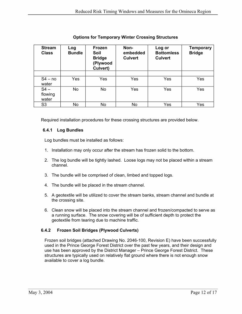
9. Crossing structures must be selected from the following Table.
May 3, 2004 Page 11 of 17
Reduced Risk Timing Windows and Measures for the Omineca Region
Options for Temporary Winter Crossing Structures
Stream Class
Log Bundle
Frozen Soil Bridge (Plywood Culvert)
Non-embedded Culvert
Log or BottomlessCulvert
TemporaryBridge
S4 – no water
Yes Yes Yes Yes Yes
S4 – flowing water
No No Yes Yes Yes
S3 No No No Yes Yes
Required installation procedures for these crossing structures are provided below.
6.4.1 Log Bundles Log bundles must be installed as follows: 1. Installation may only occur after the stream has frozen solid to the bottom.
2. The log bundle will be tightly lashed. Loose logs may not be placed within a stream
channel.
3. The bundle will be comprised of clean, limbed and topped logs.
4. The bundle will be placed in the stream channel.
5. A geotextile will be utilized to cover the stream banks, stream channel and bundle at the crossing site.
6. Clean snow will be placed into the stream channel and frozen/compacted to serve as
a running surface. The snow covering will be of sufficient depth to protect the geotextile from tearing due to machine traffic.
6.4.2 Frozen Soil Bridges (Plywood Culverts)
Frozen soil bridges (attached Drawing No. 2046-100, Revision E) have been successfully used in the Prince George Forest District over the past few years, and their design and use has been approved by the District Manager – Prince George Forest District. These structures are typically used on relatively flat ground where there is not enough snow available to cover a log bundle.
May 3, 2004 Page 12 of 17

Reduced Risk Timing Windows and Measures for the Omineca Region
6.4.3 Non-embedded Culverts
1. A non-embedded culvert may not be installed where stream channel alterations are necessary to install the culvert, i.e., excavating material from the stream channel, re-aligning the channel to accommodate a rigid pipe, etc., is prohibited.
2. After the culvert has been placed within the stream channel, a geotextile must be
utilized to cover the stream banks, stream channel and culvert at the crossing site.
3. Clean snow must be placed into the stream channel and frozen/compacted to serve as a running surface. The snow covering must be of sufficient depth to protect the geotextile from tearing due to machine traffic.
6.4.4 Log Culverts
Log stringers must be covered with a non-woven geotextile cloth with a minimum grab strength of 700 N, to prevent fines and other material from entering the stream. Shot rock and gravel or other suitable material that is used as a roadbed must be placed over the geotextile.
May 3, 2004 Page 13 of 17

Reduced Risk Timing Windows and Measures for the Omineca Region
Frozen Soil Bridge (Plywood Culvert) – D.R. Estey Engineering Ltd. (1997).
May 3, 2004 Page 14 of 17

Reduced Risk Timing Windows and Measures for the Omineca Region
7.0 REFERENCES
BC Ministry of Forest. 2002. Fish-stream Crossing Guidebooks. 68 p. Web Site: http://www.for.gov.bc.ca/tasb/legsregs/fpc/FPCGUIDE/FishStreamCrossing/FSCGdBk.pdf Canadian Institute of Treated Wood and Western Wood Preservers Institute. 1997. Best
management practices for the use of treated wood in aquatic environments. Canadian Version. 33p.
Web Site: http://www.wwpinstitute.org Chilibeck, B., G. Chislett, and G. Norris. 1992. Land development guidelines for the
protection of aquatic habitat. Dept. of Fisheries and Oceans Canada – Habitat Management Division. 128 p.
Web Site: http://www.pac.dfo-mpo.gc.ca/english/publications.htm D.R. Estey Engineering Ltd. 1997. Frozen soil bridges – Drawing No. 2046-100, Revision E.
Prepared for Northwood Pulp and Paper Ltd., Prince George, B.C. Hutton, K.E., and S.C. Samis. 2000. Guidelines to protect fish and fish habitat from treated
wood used in aquatic environments in the Pacific Region. Can. Tech. Rep. Fish. Aquat. Sci. 2314: vi + 34 p.
Web Site: http://www.pac.dfo-mpo.gc.ca/english/publications.htm Washington Dept. of Fish and Wildlife. 1999. Fish passage design at road culverts.
Washington Dept. of Fish and Wildlife, Habitat and Lands Program, Environmental Engineering Div., Olympia, WA.
Web Site: http://www.wa.gov/wdfw/hab/engineer/cm/culvertm.htm#int
May 3, 2004 Page 15 of 17

Reduced Risk Timing Windows and Measures for the Omineca Region
STREAM CROSSING DATA SHEET Ministry of Water, Land & Air Protection – Omineca Region
STREAM CLASS:
CONTACT PERSON / LICENSEE:
Administrative Information:
Stream Name: General Location:
Tributary to: Watershed: Fish species present in system and what information was used to determine this (anecdotal, F.I.S.S. maps, sampling): Road Permit No.: CP/Block No.: Date Surveyed: Field Crew: BCGS Mapsheet : Air Photo No.:
Crossing Structure Information:
Type and Dimensions of Crossing Structure (bridge/culvert/arch):
Culvert Gradient: Permanent or Temporary Installation: Proposed Dates of Work (start / finish): In-stream Work Window:
Stream Channel Information:
Average channel width (m): Average wetted width (m): Average water depth (m): High water mark (m): Left bank height (m): Left bank sideslope (%): Right bank height (m): Right bank sideslope (%): Stream gradient (%): Flow estimate: (Low / Moderate / High) Permanent / ephemeral: Length surveyed:
Note that left and right banks are designated when facing downstream.
Stream Bed Material: Percent (%)
Fines/Organics (clay, silt, sand (<2 mm)) Small Gravels (.2-1.0 cm) Large Gravels(1-6 cm) Small Cobbles (6-12 cm) Large Cobbles (13-25 cm) Boulders (>25 cm) Bedrock
May 3, 2004 Page 16 of 17

Reduced Risk Timing Windows and Measures for the Omineca Region
Habitat Type (%)* Above Crossing At Crossing Below Crossing
Pool Riffle Glide Other
Side channels
* Definitions (as per DFO Stream Survey Field Guide): • Pool: portions of the stream with reduced current velocity at low flow and with deeper water than the surrounding
areas • Riffle: shallow rapids where the water flows swiftly over completely or partially submerged materials to produce
surface agitation • Glide: areas of swiftly flowing water, without surface waves, which approximate uniform flow • Other: rapids, chutes, marsh, slough • Side channels: lateral channels which flow roughly parallel to mainstem and are fed by water from the mainstem.
General Comments: Streambank vegetation and material composition, habitat components present (cutbanks, boulders, deep pools, instream vegetation, overhanging vegetation, etc.), channel debris, obstructions, how aquatic resources will be adequately managed and conserved given timing of in-stream operations. Use extra page if necessary. Sketch of Stream/Valley Cross-section Please attach the following: 1. 1:50,000 location map 2. 1:20,000 or better topographical map showing site location 3. A ground-based photo series (upstream, right and left banks at site, downstream) to assist in visualizing the site.
Stream Crossing Data Sheet - Page 2
May 3, 2004 Page 17 of 17