Redevelopment of the former St Leonards Hospital Development Brief
29
Redevelopment of the former St Leonards Hospital Development Brief by Kendall Kingscott with White Design June 2014
Transcript of Redevelopment of the former St Leonards Hospital Development Brief

Redevelopment of the former St Leonards Hospital Development Brief
by Kendall Kingscott with White Design
June 2014

Contents1. Introduction
2. Planning Overview
- The Development Plan- Material Considerations- Planning History and Analysis of Previous Consents- Alternatives- Legal Framework
3. Site Characteristics & constraints
- Locational details & surrounding land uses- Access- Green Belt- Ecology on-site & adjacent European sites- Topography & Ground Conditions- Flood Risk & Drainage- Noise and Acoustic Assessment- Air Quality Assessment- Retained hospital uses
4. Development Principals
- Overarching Objectives- Green Belt- Ecology- Developable Area- Access & Movement- Landscape & Open space- Built Form- Uses- Sustainable Design- Construction Environmental Management Plan (CEMP)- Developer Contributions
5. Indicative Site Layout
6. Implementation
- Phasing
7. Contact Details
- Consultant Team
Contents

Introduction1. Introduction1.1. This Development Brief has been prepared by
Kendall Kingscott Ltd in conjunction with White Design.
1.2. Contributions from Johns Associates, WYG, Wilmott Dixon and Tetlow King Planning are also included.
1.3. The subject of this development brief relates to the future of the former Military Hospital site at St Leonards, Ringwood.
1.4. The brief proposes the development of a sustainable suburban community connected and responding to the surrounding landscape, neighbourhood and amenities.
2.Planning OverviewThe Development Plan2.2. The Development Plan against which the planning
application will be determined comprises the Christchurch and East Dorset Core Strategy. Adopted on 28 April 2014, this replaces the authorities’ separate Local Plans. It is relevant that EDDC’s Local Plan (Policy SL5) designated the site as a Major Developed Site in the Green Belt and this is continued in the Core Strategy’s Policy VTSW7, which states that:
“Land at St Leonards Hospital is identified as a Previously Developed Site in the Green Belt, in accordance with the provisions of the National Planning Policy Framework (NPPF).
Prerequisites for development include:
• Approval of a development brief by the Council.
• A wildlife strategy to be agreed with the Council that ensures that no harm to the Moors River SSSI, the Site of Nature Conservation Interest on
the site and the adjacent internationally protected heathland will derive from the development. The Applicant will need to show that they have avoided harm to priority habitats and species. The layout of the site is likely to require compensatory measures which may include SANG provision where recreational pressure is generated. Particular regard to the water environment will be needed and in this respect the use of Sustainable Drainage Systems to mitigate any potential impacts will be expected to form part of this strategy.
• Agreement of a comprehensive travel plan”
2.3. This is in the wider context of the intention to deliver around 8,490 new dwellings in Christchurch and East Dorset between 2013 and 2028 under Policy KS4 of the Core Strategy, while Policy LN3 seeks affordable housing provision at 40% of the net yield on brownfield sites. 80 hectares of employment land are sought under Policy KS5
Material Considerations 2.4. Like its predecessor Local Plan Policy SL5, the
basis of VTSW7 is in national policy. The Local Plan was based on Planning Policy Guidance note 2 (PPG2) which has since been superseded by the NPPF and which confirms that “limited infilling or the partial or complete redevelopment of previously developed sites” is appropriate in the Green Belt. The NPPF is a material consideration of prime importance.
2.5. PPG2’s criteria for redevelopment have been carried forward into the NPPF except for a strict restriction on footprint contained in the PPG’s Annex C. When in place, this required close adherence to the ground floor area occupied by the existing buildings and their height. The NPPF does not require this but states in more general terms that redevelopment must not “have greater impact on the openness of the Green Belt and the
purpose of including land within it than the existing development” (NPPF, paragraph 89, bullet point six).
2.6. The stated fundamental aim of Green Belt policy in the NPPF is “to prevent urban sprawl by keeping land permanently open; the essential characteristics of Green Belts are their openness and their permanence” (paragraph 79). This is reflected in the Core Strategy which defines the main Green Belt purpose as preventing settlement coalescence (Policy KS2).
2.7. Additional material considerations to the NPPF are National Planning Policy Guidance (NPPG) and all of the following:
Dorset Heathlands Planning Framework 2012-2014 Supplementary Planning Document (2011)
2.8. This SPD defines the mitigation measures that have been agreed between the councils and Natural England and is intended for use until the councils have adopted the following DPD. It utilises a tapered approach to new development according to its distance and potential impact, starting with a blanket ban on new development within 400 metres of protected heathland sites.
2.9. The St Leonards Hospital site does not fall within the blanket ban zone, but does fall within the 400 metres to five kilometres of protected heathland zone where mitigation is considered able to reduce development impacts to a level that is not significant.
2.10. For a strategic site such as this the preferred method of mitigation is a new area of Suitable Accessible Natural Greenspace (SANG). SANGs can be provided from areas of natural green space that were previously private and EDDC requires quantum of provision equivalent to 16 hectares per 1,000 resident population within the development.
Emerging Dorset Heathlands Joint Development Plan Document
2.11. The currently draft Development Plan Document (DPD) outlines key drivers of damage to heathland habitat and bird species. It proposes to continue to focus mitigation strategies through on-site provision of SANGs.
Nature Conservation and the Planning Process in East Dorset SPD (2009)
2.12. The SPD signposts the relevant regulations on habitat and wildlife conservation as well as local considerations. It specifies some of the key species of flora and fauna that inhabit the protected sites and an expectation that development proposals affecting SSSIs will require EIA.
Design Requirements for Landscaping Residential Areas Supplementary Planning Guidance (2007)
2.13. This Supplementary Planning Guidance (SPG) endorses a landscape-led approach to the layout and design of new development, utilising existing features in a coherent landscape strategy and planting schedule.
Housing and Affordable Housing SPD
2.14. This adds further detail to the 40% affordable housing requirement under Core Strategy Policy LN3 including a proposed tenure split of (broadly) 30% intermediate to 70% rented tenures, and for house sizes to be provided in accordance with the latest SHMA. It states that the affordable housing should be integrated with the market housing in small clusters and of equivalent external design, so as to be ‘tenure blind’ and, on developments providing 10 or more affordable homes, for at least 10% of this be provided as specially adapted or supported housing.
South East Dorset Transport Contributions Scheme SPD (2012)
2.15. The SPD provides guidance on financial contributions that will be sought from developers via Section 106 Agreements prior to the adoption of CIL, with the intention of alleviating pressures of new residential development on the area’s transport network. Contributions secured will be prioritised on projects within the Bournemouth, Poole and Dorset Local Transport Plan 3 including A31 road improvements and bus schemes.
CIL (Community Infrastructure Levy)
2.16. Preliminary Draft and Draft Charging Schedules for East Dorset and Christchurch have been published for public consultation. Once adopted (post-examination), CIL will be levied per square metre for new market dwellings and care homes but not affordable housing, as this does not attract a CIL charge under the CIL Regulations.
2.17. It is intended that a planning application will be determined ahead of CIL being adopted in East Dorset.
Planning History & Analysis of Previous Consents 2.18. The site has been subject to a variety of planning
applications which have included outline applications for a business park, hotel and garden centre, while pre-application discussions have taken place about possible alternative schemes including a multiplex cinema. None of these have come to fruition.
2.19. Consent was granted by EDDC in 2002 for demolition of the remaining hospital buildings on the site and redevelopment of a care village and community and recreation facilities (03/01/0666/OUT). The care village fell within the C2 Use Class for residential institutions. Reserved matters consent in 2007 (03/07/0925/REM) fixed the level

Planning Overview
of development at 128 bungalows for occupation by the over-55s and approved access was a new roundabout off the A31.
Figure 1 - Previously approved Care Home scheme developable area
2.20. The care village applications were subject to Environmental Impact Assessment (EIA) undertaken in 2001. Planning conditions restricted the developable area to 7 hectares with the remainder of the site to be managed for nature conservation, as indicated in Figures 1 and 2. The approved footprint was restricted to a gross external floor area of 15,000 square metres to achieve a comparable footprint to the previous buildings. These restrictions were necessary to ensure compliance with the former Green Belt provisions of PPG2.
2.21. The implementation period for the reserved matters consent was extended in 2010 but this expired on 17 February 2013. No extant permissions remain.
Figure 2 - Previously approved Landscaping Plan
Alternatives
2.22. The principle of redevelopment is long-established through planning policy at the St Leonards Hospital site. ‘Doing nothing’ is therefore not a pragmatic alternative option. Doing nothing would allow the heathland and grassland habitats within the site to continue to be encroached by scrub and invasive plant species, lowering their ecological value. Moreover, while signed as having prohibited access and monitored by a security firm, it is entirely possible to enter the site from adjoining land which makes it susceptible to vandalism and places those who are trespassing at risk of exposure to a number of potential hazards, as well as disturbance risk to
the habitats and protected species on site. Redevelopment offers opportunity for extensive and costly site remediation which, otherwise, would be highly unlikely to occur, as well as offering legitimate opportunities for controlled public access.
2.23. Doing nothing would also run counter to the Government’s overarching growth and sustainable development agendas as enshrined in the statutory duties to be discharged by the HCA, as landowner. It would lead a deficit in land supply and undermine the Core Strategy
2.24. In an attempt to secure its redevelopment, a number of commercial and residential alternatives have already been tested through the previous planning applications and pre-application discussions noted above. All of these have proven to be inappropriate or undeliverable. The care village application was made speculatively; it was not viewed as being a viable option by the development industry. While Policy VTSW7 does not prescribe any specific use, EDDC has confirmed its potential as a residential (C3 Use Class) housing site in its 2012 SHLAA.
2.25. In addition to alternative sites, land uses and the ‘do nothing’ option, the EIA will explore alternative layouts and mixes that have been carefully considered and rejected in the evolution of the masterplan.
Legal Framework
2.26. EIA is a systematic process for considering the nature of development and the environment in which it is to take place, so as to identify the potential for any significant impacts and integrate actions for their mitigation in the design process.
2.27. The 2001 EIA for the care village is no longer relevant and there have been changes in the nature of the site and to planning policy that will have a bearing. EDDC has confirmed in a Screening and
Scoping Opinion that development proposals for this site require a fresh EIA and that it should cover the following topics:
• Soils and Contamination.
• Water.
• Ecology, Nature Conservation and Biodiversity.
• Landscape and Visual.
• Traffic and Transport.
• Air Quality.
• Noise and Vibration.
• Social and Economic.
2.28. The Conservation of Habitats and Species Regulations 2010 (as amended) transpose the requirements of the European Habitats Directive into UK law. Under Article 6 of the Habitats Directive, Appropriate Assessment is required where a plan or project may give rise to significant effects upon a European (Natura 2000) site. Regulation 61(1) of the Conservation of Habitat and Species Regulations 2010 (as amended) stipulates that if a plan or project is likely to have a significant effect on a Natura 2000 site in the UK (alone or cumulatively), the competent authority shall undertake Appropriate Assessment of the implications for the site in view of its conservation objectives.
2.29. EDDC has confirmed that it will act as the competent authority. The baseline survey and assessment work conducted through the EIA will ensure that the Council is provided with sufficient information to fulfill that element of the HRA requirement.

3. Site characteristics & constraints
Location details & surrounding land uses
Site location in regional context, (above)
Site location in local context, (right)
3.2. The village of St Leonards lies to the north of the Bournemouth/Poole urban area. Situated alongside the A31 between Ferndown and St Ives.
Surrounding land uses
3.3. To the northeast of the site lies the Grange Estate holiday park and some low density residential development, dispersed along Boundary Lane. Along the site’s western boundary there is the sprawling Oak Dene Holiday Park which shares a small slip road off the A31 with St Leonards Hospital
Current Buildings on the site
3.4. Within the site there are three working NHS facilities. The St Leonards Community Hospital, an Ambulance Training Centre and the Acorn building; a facility which is used by the NHS trust as a wheelchair clinic and by the ambulance service as a vehicle maintenance workshop and communication centre. (See Retained Hospital Uses section)
3.5. St Leonards Hospital Cricket Club also occupy a section of the site. One of the single storey former
hospital ward buildings provides changing facilities and this affords direct access onto their playing pitch.
3.6. To the south of the cricket pitch there is a small brick structure presumed to be a well or pumping station
3.7. Alongside the working NHS facilities there are a number of abandoned buildings constructed from a mixture of facing bricks, painted bricks, profiled
Site character

and timber cladding materials with painted metal windows and pitched roofs.
3.8. There is an abandoned, derelict brick built water tower adjacent to the A31 along with a pedestrian bridge.
3.9. There are no heritage assets on the site.
Access
3.10. The site is bounded by the A31, Ringwood Road to the northwest and by Boundary Lane to the northeast. A narrow access road runs to the west of the site leading to the nearby caravan park development.
3.11. Current access into St Leonards Hospital is via a left in / left out slip road from the A31, Ringwood Road. The left in / left out arrangement means that visitors to the development using their cars are likely to need to turn around either to enter the development or exit the development. There are roundabouts located a short distance along the A31 both northeast and southwest of the development that provide a turnaround facility.
Access Routes
3.12. The A31 Ringwood Road forms part of the trunk road network and is managed and maintained by the Highways Agency. The speed limit is 50mph. It
is a dual carriageway with two lanes operating in each direction and footways along both sides of the road, separated by a grass verge. A footbridge, located near the site boundary, provides the only segregated crossing facility.
3.13. Boundary Lane is a narrow single carriageway road of approximately 5.8m wide with access directly from the A31 Ringwood Road and is managed and maintained by Dorset County Council. It has a 40mph speed limit, changing to 50mph immediately before it joins with the A31. A footway runs along the north side only. The road provides local access to individual properties and also a caravan park located opposite the development.
3.14. Bus stops are located on the A31 adjacent to the development. The southwest bound bus stop is located on the exit slip of the existing site access, while the northeast bound bus stop is located on the north side of the A31 and can be accessed via the pedestrian footbridge.
Green Belt
3.15. The presence of previous large scale development, such as hospitals, has long been recognised in Government guidance as affording some Green Belt land the status of major development sites, which in turn defines the principal of their redevelopment.
3.16. This is the case with the St Leonards Hospital site which falls within the South East Dorset Green Belt. The designation, which surrounds the conurbation of Poole, Bournemouth and Christchurch, covers 47% of the East Dorset District land area.
3.17. PPG2 sought to constrain redevelopment of such sites specifically to the previously developed area or ‘footprint’ and with adherence to the strict size and height parameters noted in Section 2. Although the NPPF offers some flexibility in this regard, EDDC has indicated that an application of NPPF paragraph 89 (to limit Green Belt impact) the existing footprint should be closely adhered to.
3.18. The footprint is taken as being the core of that area occupied by the redundant hospital buildings and retained hardstanding at the front and centre of the site. Previous discussions on the expired care home scheme have confirmed that the footprint occupies approximately 7 hectares of the 26.4 hectares within the red line boundary of the application site. Proposals should be required to make a comparison with the consented scheme.
3.19. The primary purpose of development is to create sustainable communities in accordance with the NPPF. This has necessitated a critical mass of development which is also informed by viability.
Ecology on site & adjacent European sites
3.20. A Phase 1 Habitat survey of the site was completed by Terence O’Rourke in 2000/2001, together with a range of other detailed ecological studies which were required to support the original planning application at the site. Halcrow Group Plc updated the studies in 2007 and a further Extended Phase 1 Habitat survey, bat surveys, and reptile surveys were undertaken in 2009 by Johns Associates. Current ecological studies of the site are being undertaken by Johns Associates.
Work Undertaken and Dates
3.21. A desk study has been undertaken to obtain information relating to the biodiversity associated with the St. Leonards site and the surrounding 2km. An Extended Phase 1 Habitat survey has been undertaken, along with detailed botanical survey work. A suite of surveys has been undertaken for protected species, including bats, hazel dormouse Muscardinus avellana, reptiles, birds and invertebrates.
3.22. Consultations are underway with Natural England and Dorset Wildlife Trust in respect of the ecological surveys proposed and undertaken,
Ecology
together with consultation on the emerging masterplan.
Results Overview
Designated Sites
3.23. There are 19 statutory designated sites within 5km of the site: one National Nature Reserve (NNR), two Special Areas of Conservation (SAC), two Special Protection Areas (SPA), two Ramsar sites, and 12 Sites of Special Scientific Interest (SSSI).
3.24. There are 15 non-statutory designated sites within 2km, 14 of which are Sites of Nature Conservation Importance (SNCIs) and one being a Dorset Wildlife Trust (DWT) Conservation Verge.
Plants and Habitats
3.25. The site supports habitats of nature conservation value. Biodiversity Action Plan habitats within the site include acid grassland, dry heathland and lowland mixed woodland. Areas of unimproved, rabbit-grazed, sun- parched acid grassland within the site are of particularly high value. It should be noted that brownfield areas within the site have been colonised by a diverse mosaic (of acid grassland, heathland, tall ruderal, scrub and bracken stands), which is of value in the local area.
3.26. Rare or scarce plant species have also been observed within the site including mossy stonecrop Crassula tillaea, green-winged orchid Anacamptis morio. The site also contains invasive, non-native species including Japanese knotweed Fallopia japonica, listed on Schedule 9 of the Wildlife and Countryside Act 1981 (as amended).
Reptiles
3.27. Records of all six species of reptiles, including the European Protected Species (EPS) smooth snake Coronella austriaca and sand lizard Lacerta agilis, were provided within 2km of the site. Surveys undertaken in 2013 have confirmed the presence of common lizard Zootoca vivipara, slow worm
Anguis fragilis, and adder Vipera berus and grass snake Natrix natrix. A targeted survey of the site undertaken in Spring 2014 recorded sand lizard to the south west of the site.
Hazel Dormice
3.28. The desk study revealed several records of hazel dormouse along the A31 to the north-east of the site. Targeted nest tube surveys for dormice recorded a hazel dormouse nest along the northern boundary of the site, adjacent the A31.
Bats
3.29. Bat survey work undertaken in 2013 confirmed the presence of one maternity colony of brown long-eared bats Plecotus auritus, and a further 16 buildings have been found to support individual bat roosts of common pipistrelle Pipistrellus pipistrellus, soprano pipistrelle P. pygmaeus, brown long-eared bats and a Myotis bat. A maternity colony of common pipistrelle bats Pipistrellus pipistrellus has also been recorded within an existing hospital ward; this building is out with the site boundary but within the grounds of St. Leonards Hospital.
Birds
3.30. The desk study provided numerous records of bird species of conservation concern within 2km of the site, including the three species for which the Dorset Heathlands SPA/Ramsar is designated. Targeted breeding bird surveys have recorded eight red listed species of conservation concern and 13 amber listed species of conservation concern within the site, although not all of these species were confirmed to be breeding. Crepuscular bird surveys undertaken at the site have confirmed at least two nightjar Caprimulgus europaeus territories located within and adjacent to the site.
3.31. Nightjar are a qualifying species of the nearby Dorset Heaths SPA, together with woodlark Lullula arborea and Dartford warbler Sylvia undata. The latter two species have not been recorded at the site to date.
Badgers
3.32. A large main badger sett was found within woodland in the south-west of the site, together with a nearby annex sett. Further outlying setts, largely comprising single entrances, were found across the site during further surveys for badgers.
Invertebrates
3.33. An invertabrate survey undertaken in 2013 identified that the mosaic of grassland, heathland and brownfield habitats within the site are of value to invertabrate species.
Amphibians
3.34. Survey work undetaken in 2014 recorded no great crested newts Triturus cristatus within a small waterbody on site. There are no desk study records of great crested newts within 2km of the site. It is therefore considered that great crested newts are absent from the site.
Refer to section 4 for recommendation summary
Topography & Ground Conditions3.35. Within the developable area the lowest recorded
level is approximately 16.00m (above GPS datum) towards the eastern corner of the site. The highest level recorded is approximately 18.5m recorded along the northern site boundary. The general slope of the site is NW to SE towards the Barnsfield Wood Stream but, as the change in levels occurs over a distance approaching 500m, it is indiscernible on the ground and it could be said that the site is nominally flat.
Geology, Hydrogeology, Hydrology and Radon
3.36. A Ground Conditions Desk Top Study Report was undertaken by WYG Environment in May 2013. A summary of the report’s key findings is as follows:
3.37. The geology of the site consists of superficial River Terrace Deposits underlain by Parkstone Sand Member bedrock. The site is underlain by a Secondary (A) Aquifer. The nearest water feature is the Moors River, approximately 150m west of the site with an unnamed tributary of it approximately 200m south of the site; both of which are prone to flooding. The site lies within an area where no radon protection measures are required for a new development.
Ground Contamination Assessment
3.38. There have been a number of sources of potential contamination identified on site. The presence of suspected asbestos containing materials within existing derelict structures, coupled with the potential for such materials to have become entrained within shallow soils, leads to the conclusion that the potential risk from asbestos to site users is high. Secure fencing and clear signage is controlling this risk with respect to current site users, but it is a significant consideration when looking to redevelop the site.
3.39. Notwithstanding the above, the potential for general ground contamination is considered to be relatively low, and thus is not likely to provide a significant risk to its redevelopment. Potential localised point sources of contamination were noted during the study, including discarded oil drums, a former sewage works and electrical sub-stations. The made ground on site and adjacent historical sand pit has the potential for limited land gas production. These potential sources are assessed as posing a moderate to low risk to future site users assuming a residential end use. A comprehensive programme of intrusive site investigations to assess risks and to provide a land remediation strategy will be undertaken for the planning application.
Flood Risk & Drainage
3.40. A Surface Water and Wastewater Drainage Strategy Report was undertaken by WYG Transport in June 2013. A summary of the report’s key findings is as follows:
3.41. The site is located on high ground between the Moors River to the west and the Barnsfield Wood Stream to the south. These watercourses meet to the south west of the site before flowing southwards. The site is located in Flood Zone 1, consequently the development is not at risk from fluvial or coastal flooding up to the 1000 year event. There are some reports of minor flooding within the St. Leonards and St Ives communities.
Indicative Flood Map
3.42. There are no previous reports of flooding on the site. Surface water flooding issues were indicated by East Dorset District Council in other areas of St. Leonards village but not in the vicinity of the proposed development site.

Flood Risk & Noise
3.43. The development site is located downstream of St Leonards village. Therefore surface water runoff from the development will flow away from existing developed area and will not increase the flood risk in this community, or exacerbate any current flooding issues.
3.44. No groundwater flooding is reported in the area. The development is not situated within a groundwater source protection zone, however groundwater vulnerability mapping shows the locality as being in a minor aquifer zone.
3.45. The adjacent figure shows the the Environment Agency’s indicative flood maps. The site proposed for re-development is in Flood Zone 1 (low flood risk). The closest Flood Zone 2 (1 in 1000 year flood risk – medium risk) area is on the southern boundary of the site. The proposed development will not be in an area at risk of flooding and will satisfy the requirements of the National Planning Policy Framework (NPPF) Sequential Test. The Exception Test is not required.
Noise and acoustic Assessment
3.46. A noise survey and assessment was carried out by WYG Planning & Environment in April 2013. Existing ambient noise levels around the site are dominated by road noise from A31 Ringwood road including noise from the bus stop to the west of the site, visitors to St. Leonards Hospital along the access road, and plant noise identified from current hospital buildings during the attended survey. Further impact testing will be undertaken as part of the EIA. A summary of the key findings thus far are as follows:
Drawing showing Existing Daytime LAeq,16hr Noise Levels
• NPPF Test - Section 123 pts. A & B
In considering the NPPF test in section 123, points A & B: The proposed development is not expected to have an ‘adverse impact’ on health or quality of life. Similarly, with regard to NPPF (123) point B, it is considered that all ‘adverse impacts on health and quality of life’ (relating to noise) are mitigated through the use of an appropriate glazing and ventilation strategy.
• NPPF Test - Section 123 pts. C & D
The site is surrounded by woodland to the south, St Leonards Hospital to the west, and static caravan sites to the north east and south west of the site, it is not considered that any existing businesses wanting to develop would be particularly restricted by the introduction of the new sensitive use of the proposed development.
3.47. The development is situated in a CPRE Zone 3 area of tranquillity (Zone 1 being the least tranquil and Zone 10 being the most tranquil), as such is not considered to be an area of Tranquillity.
3.48. It is recommended that any potential dwellings to the north and west of the site, within approximately 90 metres of the A31 be taken into account in the site layout and design process. To reduce the impact of noise, enhanced glazing, the favourable orientation of dwellings, suitably located windows and gardens and effective internal layouts will be considered.
Air Quality Assessment
3.49. WYG have undertaken an Air Quality Assessment for the proposed mixed use development at The St Leonards HRA site, in accordance with the methodology and parameters described within the Technical Report.
3.50. In the context of the proposed development, transportation is identified as the dominant emission source that is likely to cause potential risk of exposure of air pollutants at receptors. The air quality assessment therefore consists of the quantified predictions of the change in nitrogen dioxide (NO2) and particulate matter (PM10) due to changes in traffic movement.
3.51. Preliminary modelling results show that the significance of the effects of the proposed development with respect to NO2 exposure is determined to be ‘negligible’. Further testing will be undertaken for the EIA. With respect to predicted PM10 exposure initial findings, the significance of
409960
409960
409980
409980
410000
410000
410020
410020
410040
410040
410060
410060
410080
410080
410100
410100
410120
410120
410140
410140
410160
410160
410180
410180
410200
410200
410220
410220
410240
410240
410260
410260
410280
410280
410300
410300
410320
410320
410340
410340
410360
410360
410380
410380
410400
410400
410420
410420
410440
410440
410460
410460
410480
410480
410500
410500
410520
410520
410540
410540
1018
80
1018
80
1019
00
1019
00
1019
20
1019
20
1019
40
1019
40
1019
60
1019
60
1019
80
1019
80
1020
00
1020
00
1020
20
1020
20
1020
40
1020
40
1020
60
1020
60
1020
80
1020
80
1021
00
1021
00
1021
20
1021
20
1021
40
1021
40
1021
60
1021
60
1021
80
1021
80
1022
00
1022
00
1022
20
1022
20
1022
40
1022
40
1022
60
1022
60
1022
80
1022
80
1023
00
1023
00
1023
20
1023
20
Client:
Spectrum House Group.
Project:
St Leonards Hospital, Ringwood
Project Number:
A080844
Drawing Title / Scenario:
Existing DaytimeLAeq,16hr Noise Levels
Drawing Number:
SK03
Key:
0.0 - 55.0 dB 55.0 - 63.0 dB 63.0 - 72.0 dB 72.0 - 90.0 dB
Scale : Not to scale
WYGE Leicester 05.04.13This map is based upon Ordnance Survey material reproducedby WYG on behalf of Her Majesty's Stationery Office, © Crown Copyright. Unauthorised reproduction infringesCrown copyright and may lead to civil proceedings.
Licence Number AL 553611
Executive ParkAvalon WayAnsteyLeicestershireLE7 7GRTel 0116 234 8000
© WYG Environment
409960
409960
409980
409980
410000
410000
410020
410020
410040
410040
410060
410060
410080
410080
410100
410100
410120
410120
410140
410140
410160
410160
410180
410180
410200
410200
410220
410220
410240
410240
410260
410260
410280
410280
410300
410300
410320
410320
410340
410340
410360
410360
410380
410380
410400
410400
410420
410420
410440
410440
410460
410460
410480
410480
410500
410500
410520
410520
410540
410540
1018
80
1018
80
1019
00
1019
00
1019
20
1019
20
1019
40
1019
40
1019
60
1019
60
1019
80
1019
80
1020
00
1020
00
1020
20
1020
20
1020
40
1020
40
1020
60
1020
60
1020
80
1020
80
1021
00
1021
00
1021
20
1021
20
1021
40
1021
40
1021
60
1021
60
1021
80
1021
80
1022
00
1022
00
1022
20
1022
20
1022
40
1022
40
1022
60
1022
60
1022
80
1022
80
1023
00
1023
00
1023
20
1023
20
Client:
Spectrum House Group.
Project:
St Leonards Hospital, Ringwood
Project Number:
A080844
Drawing Title / Scenario:
Existing DaytimeLAeq,16hr Noise Levels
Drawing Number:
SK03
Key:
0.0 - 55.0 dB 55.0 - 63.0 dB 63.0 - 72.0 dB 72.0 - 90.0 dB
Scale : Not to scale
WYGE Leicester 05.04.13This map is based upon Ordnance Survey material reproducedby WYG on behalf of Her Majesty's Stationery Office, © Crown Copyright. Unauthorised reproduction infringesCrown copyright and may lead to civil proceedings.
Licence Number AL 553611
Executive ParkAvalon WayAnsteyLeicestershireLE7 7GRTel 0116 234 8000
© WYG Environment

the proposed development is determined to be ‘negligible’, based on assumptions detailed throughout the report. No proposed receptor locations are predicted to experience NO2 or PM10 concentrations in exceedance of the relevant air quality objective.
3.52. Following the adoption of the recommended mitigation measures, the development is not considered to be contrary to any of the national, regional or local planning policies.
Retained hospital uses
3.53. St Leonards Hospital was built in 1942 as a military hospital to care for American and Canadian forces. Injured servicemen were flown into Hurn Airport (now Bournemouth Airport) and then transported, through Hurn forest, directly to St. Leonards. By the end of WWII it had a capacity of 1250 beds.
3.54. During the 1950s the site was adopted by the NHS to run as a 350-bed hospital for the elderly. Since then the site has served a variety of healthcare uses. Over the years the medical accommodation has substantially reduced in size and many original structures have been abandoned and have become dilapidated. The original wooden huts were demolished in the 1960s leaving only their concrete bases although several derelict buildings, including a number of single-storey brick huts and a water tower, remain on the site.
3.55. There are three working NHS facilities on site occupying a number of buildings. These include the following:
3.56. St. Leonards Community Hospital, managed by Dorset Healthcare University NHS Foundation Trust, houses two inpatient wards, outpatients clinics and community services. The facility is a single storey, brick-built collection of buildings with pitched roofs located centrally within the site. The
Community Hospital also includes staff and visitor parking on hardstanding.
Aerial Photo, 1977
3.57. An Ambulance Service Training Centre, operated by South Western Ambulance Service NHS Trust. The facility is housed in a single-storey brick and rendered building with pitched roof and is located centrally within the site adjacent to the Community Hospital. The facility also includes three additional temporary buildings, plus staff and visitor parking on hardstanding.
3.58. Lastly, the Acorn Building, a two-storey brick and profiled metal sheet cladded shed, located to the west of the site adjacent to the site entrance. The building is used by Dorset NHS Primary Care Trust as a wheelchair clinic, by South Western Ambulance Service NHS Trust as a vehicle maintenance workshop and communication centre, and by NRS National Care. The facility includes staff, customer and service vehicle parking on hardstanding.
3.59. All three NHS facilities are accessed directly off the A31 route to the north west of the site.

4. Development Principles
4.1. The redevelopment of the site offers the opportunity to create a high quality housing scheme set on the edge of a new nature reserve and with strong links to the Hurn Forest.
4.2. The site is complex and it is important that future proposals respond to a number of environmental constraints, as well as the requirements of planning policy, to ensure a high standard of design is achieved. This section of the brief sets out the key principles to guide future proposals.
Overarching Objectives
4.3. Future development proposals for the site should ensure:
• the site layout is efficient and respects the Green Belt policy requirements
• ecological features (species and habitats) are protected in line with policy and used to shape a positive development scheme within the context of a new nature reserve
• the site layout creates a hierarchy of legible routes and spaces that are well connected to the surrounding area, including a new vehicular access to Boundary Lane
• landscape is integrated throughout the scheme and meaningful open spaces are created for new residents
• the built form of the development responds to Green Belt policy and respects local vernacular design context
• the site layout follows sustainable design principles
Green Belt
4.4. While the status of the site as a Major Developed Site in the Green Belt defines a principle of redevelopment, it is important to ensure that development proposals fall within the parameters set out by NPPF and Core Strategy Policy VTSW7.
4.5. As noted in Section 3, it is EDDC’s expectation that the existing footprint should be used as the starting point to ensuring that the development has no greater impact on Green Belt openness than the previous development on the site. As many of the old hospital buildings have been removed leaving hard standing in the footprint, the care village scheme (though expired) is a benchmark against which proposals can be assessed.
4.6. The care village was approved in the context of strict criteria in PPG2 which required application of the same height and area as the existing hospital the buildings in the footprint. This resulted in a care village scheme with buildings restricted to 15,000 square metres floor area (reserved matters consent fixed this at 13,025 square metres) and single storey (limited to six metres above ground level). This was also informed by a different set of ecological conditions to those that have evolved to the present day.
4.7. A Landscape and Visual Impact Assessment (LVIA) should be conducted as part of EIA as a means of further ensuring that the appearance of the development is not detrimental from public viewpoints in the vicinity.
DevelopmentPrinciples
Requirement for comparison of proposed developable area with care village scheme (purple outline)
Requirement for Landscape and Visual Impact Assessment to consider impacts from public

4.8. Due to the nature of the existing vegetation bounding the site there is a restricted number of locations which offer views into the site even during winter months; these include the A31 footbridge to the north, the A31 road junction with Boundary Lane to the north-east and the Community Hospital car park, all of which will be assessed. This will further inform the layout and landscaping of the development proposal to ensure that any adverse impacts on the Green Belt can be minimised.
4.9. Notwithstanding the ability to minimise impact, the NPPF clearly defines any development that falls outside the previously developed part of the Green Belt as ‘harmful’. It will therefore likely be necessary to demonstrate very special circumstances for development capable of outweighing any harm, paragraph 88 stating that: “Very special
circumstances’ will not exist unless the potential harm to the Green Belt by reason of inappropriateness, and any other harm, is clearly outweighed by other considerations”.
4.10. NPPG and appeal decisions confirm that unmet housing need is unlikely to be accepted as a very special circumstance. However, a combination of factors can be capable of meeting this policy requirement.
Development Principles:
• Comparison with consented care village scheme to review comparative impact.
• Very special circumstances to be demonstrated if developable area exceeds previously developed footprint.
• Completion of LVIA required to assess Green Belt impact.
• Landscaping scheme to reduce impact on Green Belt openness.
Ecology
4.11. The development site supports habitats of nature conservation value as well as several animal species (some of which are European Protected Species). Development proposals will need to carefully consider and balance the relative status of these habitats and species and integrate retained and restored habitat areas.
4.12. The following points outline the principles of recommended ecological measures, although these will be refined as further ecological baseline information is collected.
4.13. Proposals should seek to minimise land taken from the St. Leonards SNCI through development design, focusing the footprint of the development on undesignated areas in the north of the site.
Requirement for landscaping proposals to minimise visual impact and preserve Green Belt Existing SNCI boundary (green fill)

4.14. The remainder of the site should be established as a nature reserve, with the majority of the area designated as SNCI. This area will have limited public access to avoid impacts on valuable habitats, ground nesting birds and reptiles. Within this area, existing SNCI habitats should be restored and enhanced.
4.15. Proposals will need to include for a programme of long-term management within the nature reserve. This will need to be supported by an appropriate funding/implementation mechanism; this is likely to be via a S106 agreement and a long-term Nature Conservation Management Plan.
4.16. Proposals should also include public information on the nature conservation value of the site in order to
engender community participation in its management. Other measures may be required to ensure long-term viability; for example, avoidance of post-construction predation of reptiles and birds through the prohibition of cat ownership and ensuring dogs are kept on a lead in sensitive areas.
4.17. Where possible, heathland on the site should be retained. Where it is not possible for habitats to be retained, these should be translocated to a suitable location within the nature reserve or off-site. This should be a last resort where avoidance or retention in situ is not possible.
4.18. Proposals will need to allow for exclusion of reptiles from the development footprint and enhancement of suitable habitats for these species within the nature reserve. In addition, it will be necessary to create bat
roosts in areas of suitable habitat and to retain and enhance existing hazel dormouse habitat on site.
Mitigation Measures
4.19. Proposals should include a mitigation and enhancement strategy agreed with both EDDC and Natural England to avoid potential impacts on habitats and protected species. All works, including initial groundworks and clearance, which may afect European Protected Species including bats, hazel dormouse and sand lizard will need to be undertaken under the necessary licence from Natural England.
Suitable Alternative Natural Greenspace
4.20. Proposals should include creation of an off-site Suitable Alternative Natural Greenspace (SANG) to mitigate for the proposed development, which lies within 5km of the Dorset Heaths SAC/SPA. It is considered that the development site is not suitable to accommodate a SANG due to its high ecological value. However, given the site’s proximity to the Hurn Forest, and existing Forestry Commission plans for improvements, proposals should seek to create the SANG within the forest adjacent to the site.
4.21. Walking and cycling links should then be created from the development site to the SANG. In addition, proposals should include access and suitable walking areas for the new residents within areas of the Site that are not designated as a restricted access nature reserve.
Construction Environmental Management Plan
4.22. Proposals should include a site-specific Construction Environmental Management Plan (CEMP). This should include measures to minimise ecological impacts; for example, clearance of vegetation outside of the bird breeding season. (See also 4.71 & 4.72.)
DevelopmentPrinciples
Existing habitats: woodland (dark green) and grassland, heathland or habitat mosaic (light
Existing species: reptiles (yellow), dormouse (green) and bats (arrows indicate bat feeding
4.23. A recreational impact assessment will also be required to consider how the new occupiers of the proposed development could affect habitats and species within the site and also those of the nearby European sites. This will be considered in combination with other known projects or plans and the SANG proposal.
Development Principles:
• Proposals to minimise impacts on existing SNCI.
• Valued habitats to be retained where possible or translocated as a last resort.
• Rare reptile habitat and hazel dormouse habitat on site to be retained and enhanced.
• Protect key bat foraging / commuting corridor to the South from the known maternity roost located in the occupied NHS hospital. Retain or create new bat roosts
• Provide SANG off-site to ensure no net loss of on-site habitat or SNCI.
Developable Area
4.24. Proposals should respond sensitively to the Green Belt in which the site sits in order to develop a neighbourhood that is integrated within and respects the adjacent habitats. The site is a former military hospital and therefore a brownfield site and sits adjacent to the A31, it is well connected to the nearby centres of Verwood and Ringwood and presents a sustainable location for a new housing neighbourhood.
4.25. Through lack of formal management, the site has developed a rich flora and fauna including heathland, grassland, reptiles and invertebrates. However, a lack of management has allowed fast growing conifer woodland (both self seeded and planted) to establish, which is not native to this part of Dorset. The site also contains land that is categorised as SNCI and some that is not.
4.26. Much of the SNCI is species-rich acid grassland or heathland. However, some of the area designated as SNCI has been degraded due to scrub encroachment. The area outside the SNCI principally contains the remnants of the military hospital, however within this area there is significant ecological interest with respect to roosting bats within buildings, and habitat for reptile species.
4.27. Proposals should therefore seek to identify a developable area that understands the relative importance of habitats inside and outside of the SNCI alongside an appropriate spread of development that does not negatively impact on the Green Belt. This may mean that the SNCI boundary could be altered in consultation with Natural England and Dorset Wildlife Trust to reflect a more locally specific designation relative to the identification of the current and proposed valued ecology.
4.28. The opportunity created by development at St. Leonard's, should not only provide much needed
housing in response to local need but also the enhancement and re-creation of natural habitats which are managed for biodiversity. This management will aim to protect the ecological value of the existing flora and fauna and also restore new swathes of acid grassland and heathland.
4.29. The Green Belt status of the site should be respected and preserved in part by the same principles that relate to protection and enhancement of the site ecology. However there are other potentially negative impacts to the Green Belt status through the form of development e.g. spread of development, density, height, massing, terracing effects that will require any emerging proposal for the site to incorporate the following development principles.
Potential C2 use class site
Developable area to be defined and tested against Green Belt and ecology constraints

4.30. It is suggested that any development that would have a more significant visual impact due to its massing should be associated with the existing ambulance depot and hospital buildings to the west of the site. A site has been identified (see plan) that could accommodate a C2 residential institution use (e.g. residential care home) within the developable area.
4.31. Due to the proximity of the developable area to the A31 and the existing hospital and ambulance depot uses, proposals will have to carefully consider the amenity of new residents as well as the functioning of the existing facilities.
Development Principles:
• Appropriate density to help minimise spread of development in proximity to the sensitive habitats whilst also preventing visual obstruction to Green Belt through terracing effect.
• Height of development not to exceed two storeys.
• Careful built form and landscape design and consideration to the proximity of dwellings nearer to the A31 to minimise the impacts of noise and / or air pollution.
• Orientation of blocks to set up rhythm through site and ensure views to surrounding woodland and habitats areas, minimising visual impact and creating a sense of openness.
• Proposals should ensure that the existing hospital site is not compromised by layout of buildings and roads.
Access & Movement
4.32. The site should be developed in such a way as to encourage walking and cycling and to create links to / from the wider surroundings of the site. In accordance with the Local Transport Plan, the following road user hierarchy should be adopted:
• pedestrians
• cyclists
• public transport users
• specialist service vehicles (emergency services, waste etc.)
• other motor traffic
4.33. Streets are important public spaces and their landscaping and design should create an individual character for the site. A clear hierarchy of routes should be established to aid legibility and to promote a safe residential environment.
Pedestrian and cycle access
4.34. As identified in the Local Transport Plan, “many people are discouraged from walking and cycling because of the danger (both real and perceived), pollution and intimidation caused by passing traffic, and because of breaks in the continuity of networks”. The development should prioritise pedestrian and cycle movement to create an environment that encourages people to walk and cycle regularly out of choice.
4.35. Existing routes should not be compromised and the development should actively seek to be well integrated with the wider network. Routes should be overlooked by buildings where possible to provide natural surveillance. Shared pedestrian / cycle routes should be wide enough to safely accommodate both users.
4.36. Pedestrian and cycle access to the care home should be achieved via the existing access from the A31.
4.37. Access to the residential site should include at least two connections to the existing footpath along the edge of the A31; one of these should be located close to the existing bridge to facilitate access to the wider route network, the other should allow easy access to the existing bus stop on the south side of the A31.
4.38. Pedestrian and cycle connections should also be made to the Hurn Forest to the east as part of a network of SANG routes. Two access points to the east will create a short loop walk for future residents as well as connecting to this wider network.
DevelopmentPrinciples
Existing pedestrian and cycle links to the site (new connections shown by dotted lines)
Public transport
4.39. It is not anticipated that the site will be required to accommodate a public transport route. The A31 currently serves nine bus routes and there are two bus stops close to the site. The site layout should encourage pedestrian links to these stops.
4.40. The bus stop on the south side of the A31, close to the junction with Boundary Lane, serves southwest bound routes linking to Ferndown and Wimbourne Minster. Buses run from around 7am to 6pm from Monday to Friday with two services per hour during the day. Saturday services are around one bus per hour; no buses run on a Sunday. The bus stop on the north side of the A31 (accessed via the pedestrian footbridge) serves northeast bound routes linking to Ringwood. Timings are similar to southwest bound routes.
Servicing
4.41. All roads and access points will need to be designed to ensure that residential units and the care home can be suitably serviced by the refuse vehicles used by the Dorset Waste Partnership as well as emergency vehicles.
4.42. Residential roads should be designed following the guidance set out in Dorset County Council’s Highway Guidance for Estate Roads document. In addition, a swept path analysis will be required to support detailed proposals for the site to demonstrate that larger vehicles can be accommodated.
Vehicular access
4.43. Vehicle access to the care home should be via the existing access from the A31. This access point will not serve any residential units. Access to the residential site should be via a new junction to Boundary Lane. Initial testing has suggested that a right-hand turn lane from Boundary Lane could provide a junction suitable for the anticipated volume of traffic. The junction will need to be a minimum of 90m from the A31 roundabout in order to provide the necessary visibility for vehicles exiting the site.
4.44. The site should include a hierarchy of routes and for vehicles these should be based on the estate road guidance where they are to be adopted.
4.45. Roads should be designed to reduce vehicle speeds (typically 20mph) with shared surface routes having an even lower design speed. Design features to reduce vehicle speeds should include: changes to surface materials, raised areas, positioning of on-street parking and landscape features.
Parking
4.46. A range of parking approaches should be employed across the site. These will include on-plot, on-street, garages (some on plot and some with flats above) and some small parking courtyards. Garages should be located to ensure that main routes are not dominated by blank frontages.
4.47. Dorset County Council does not apply fixed parking standards to residential developments. They require parking levels to be set based on location, number of bedrooms and number of allocated parking spaces associated with the development.
Existing bus stops / routes adjacent to the site Existing vehicular connections to the site (new connections shown by dotted lines)
4.48. In general unallocated parking spaces are used more efficiently and can often accommodate visitors as well as residents. In contrast allocated spaces are often more valuable to buyers; however a greater number of spaces are required overall because spaces are not shared. A combination of allocated and unallocated spaces should be used, based on the methodology set out in Residential Car Parking Provision, Local Guidance for Dorset.
4.49. Dorset County Council also requires parking spaces to be dimensioned greater than the typically acceptable minimum dimensions e.g. 2.8mx5.0m is required for a standard bay perpendicular to the road. A table of the minimum acceptable dimensions is available in the above guidance document.
Development Principles:
• Provide cycle and pedestrian priority routes and spaces which offer an attractive and safe experience.
• Create an easily legible hierarchy of streets and pathways using a site specific choice of materials.
• Minimise use of kerb edges and engineered road materials. Utilise shared surfaces and materials to promote rural feel and natural habitat environment.
• Provide new access from Boundary Lane offset a minimum of 90m from the A31 roundabout.
• Provide a suitable mix of allocated off street and unallocated on street parking determined by mix, house type, orientation, and street hierarchy.
• Limited use of garaging adjacent to main routes to minimise inactive frontages.
Landscape & Open Space
4.50. An integrated landscape approach is seen as the key opportunity for St. Leonard's to respond to and help promote many of the development principles that this document identifies.
4.51. The landscape design fundamentally needs to:
• help protect the openness of the Green Belt
• respond to the on-site translocation of existing habitats and help enhance and protect the site ecology
• provide well-designed and appropriate play and amenity facilities
• support the placemaking strategy through well-considered design of the public realm
• help promote legibility through a clear road hierarchy and network of roads and paths
4.52. In accordance with policy HE4 of the adopted Core Strategy, the following types and amounts of open space can be accommodated within the new development. The proximity of the application site to existing typologies of open space is taken from the PPG17 Assessment accessibility standards.
Amenity Green Space
4.53. Requirement for 5sqm per person within a straight line distance of 450m. Existing amenity green space is located approximately 800m to the west of the site. Provision will therefore be required on site.
Children and Young People’s Space
4.54. Requirement for 2.5sqm per person within a straight line distance of 450m. Existing provision is identified over 2,000m to the northeast. Provision will therefore be required on site.
Natural & Semi-Natural Green Space
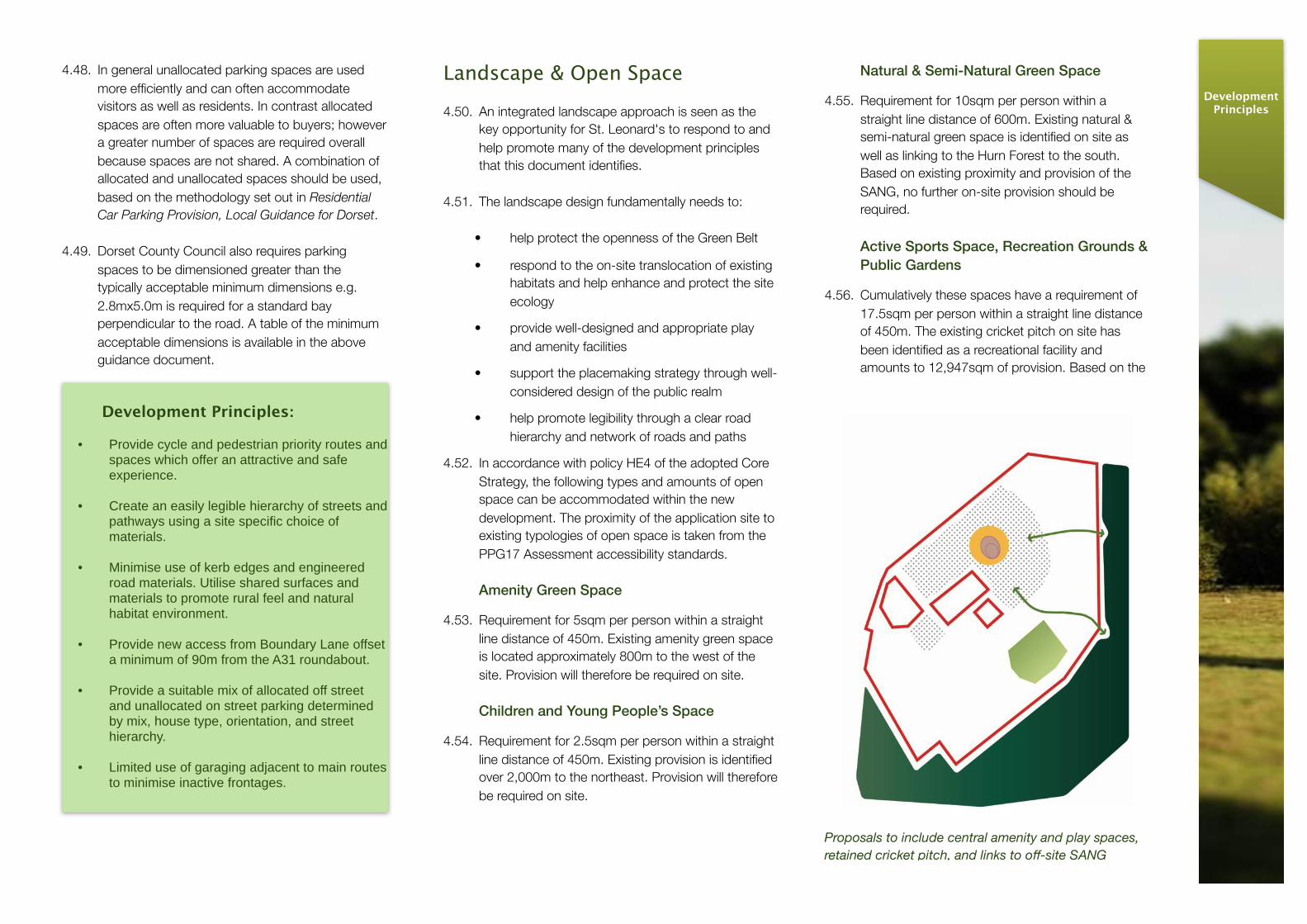
4.55. Requirement for 10sqm per person within a straight line distance of 600m. Existing natural & semi-natural green space is identified on site as well as linking to the Hurn Forest to the south. Based on existing proximity and provision of the SANG, no further on-site provision should be required.
Active Sports Space, Recreation Grounds & Public Gardens
4.56. Cumulatively these spaces have a requirement of 17.5sqm per person within a straight line distance of 450m. The existing cricket pitch on site has been identified as a recreational facility and amounts to 12,947sqm of provision. Based on the
DevelopmentPrinciples
Proposals to include central amenity and play spaces, retained cricket pitch, and links to off-site SANG
retention of the cricket pitch, no further provision should be required.
Suitable Alternative Natural Greenspace
4.57. Proposals will need to include creation of a SANG within the adjacent Hurn Forest. The SANG should be set out in accordance with planning policy and SANG guidance and also link to Forestry Commission plans. The landscape design of the site also needs to provide a useable and meaningful link to SANG to help protect the existing habitats nearer the development and provide the necessary amenity provision for the new residents.
Sustainable Drainage
4.58. Proposals will need to include for sustainable drainage features suitable to local ground conditions and hydrology.
Development Principles:
• Openness of Green Belt - ensure the proposals adopt principals relating to Green Belt planning policy at local and national level.
• Break up building blocks using landscape to promote openness.
• Legibility - ensure landscape is easily readable with hierarchy of streets that define character areas to aid legibility.
• Landscape arrangement - landscape elements to respond to site context whilst contemplating built form, mix of formal and informal spaces, hard and soft treatments.
• Landscape proposals to accommodate sustainable drainage features.
• Landscape proposals to minimise removal of contaminated land from site.
Built Form
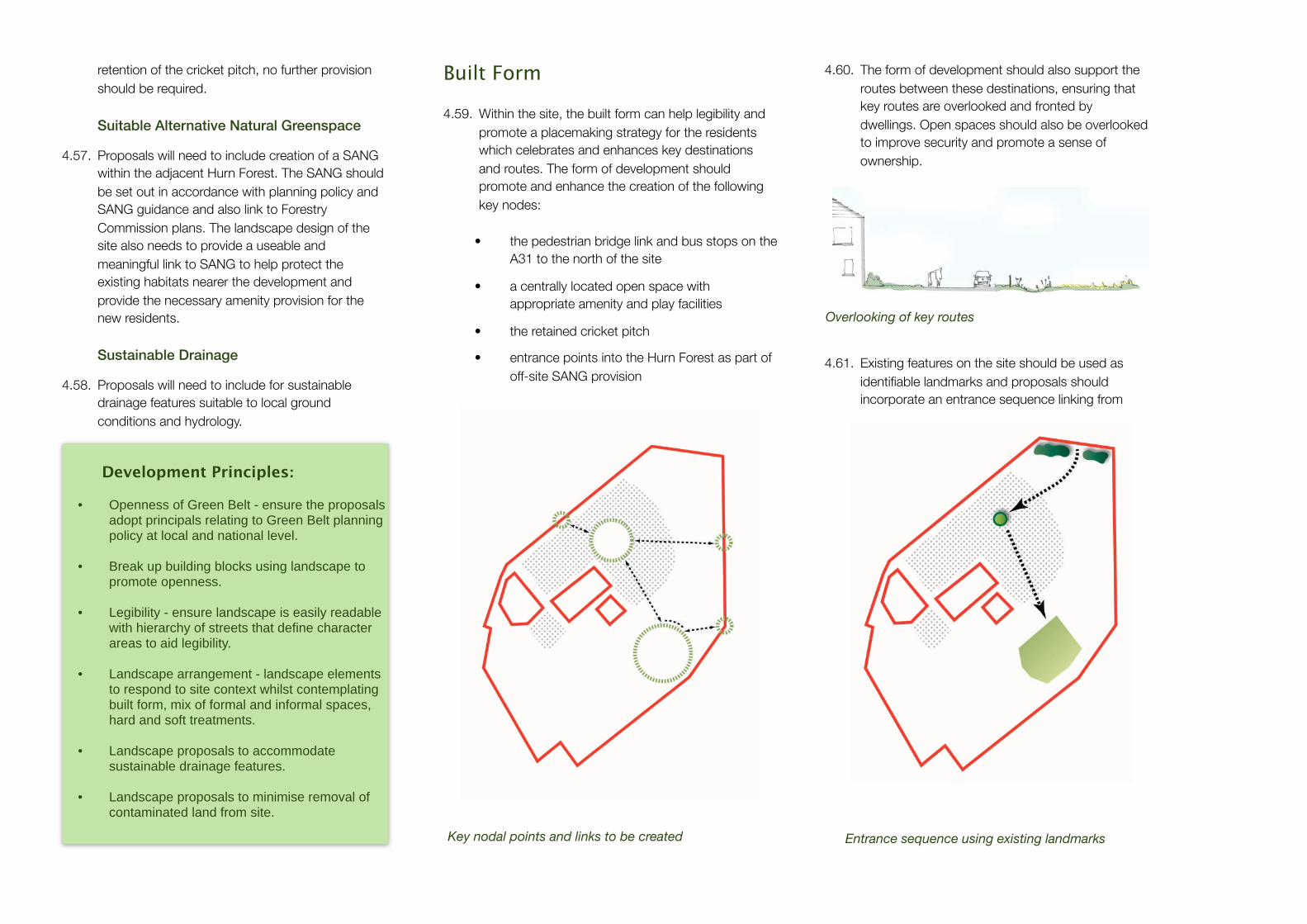
4.59. Within the site, the built form can help legibility and promote a placemaking strategy for the residents which celebrates and enhances key destinations and routes. The form of development should promote and enhance the creation of the following key nodes:
• the pedestrian bridge link and bus stops on the A31 to the north of the site
• a centrally located open space with appropriate amenity and play facilities
• the retained cricket pitch
• entrance points into the Hurn Forest as part of off-site SANG provision
4.60. The form of development should also support the routes between these destinations, ensuring that key routes are overlooked and fronted by dwellings. Open spaces should also be overlooked to improve security and promote a sense of ownership.
4.61. Existing features on the site should be used as identifiable landmarks and proposals should incorporate an entrance sequence linking from
Key nodal points and links to be created
Overlooking of key routes
Entrance sequence using existing landmarks
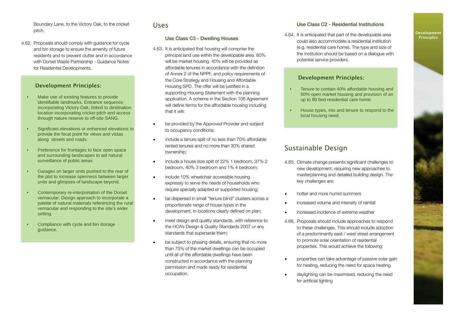
Boundary Lane, to the Victory Oak, to the cricket pitch.
4.62. Proposals should comply with guidance for cycle and bin storage to ensure the amenity of future residents and to prevent clutter and in accordance with Dorset Waste Partnership - Guidance Notes for Residential Developments.
Development Principles:
• Make use of existing features to provide identifiable landmarks. Entrance sequence incorporating Victory Oak, linked to destination location incorporating cricket pitch and access through nature reserve to off-site SANG.
• Significant elevations or enhanced elevations to provide the focal point for views and vistas along streets and roads.
• Preference for frontages to face open space and surrounding landscapes to aid natural surveillance of public areas.
• Garages on larger units pushed to the rear of the plot to increase openness between larger units and glimpses of landscape beyond.
• Contemporary re-interpretation of the Dorset vernacular. Design approach to incorporate a palette of natural materials referencing the rural vernacular and responding to the site’s wider setting.
• Compliance with cycle and bin storage guidance.
Uses
Use Class C3 - Dwelling Houses
4.63. It is anticipated that housing will comprise the principal land use within the developable area. 60% will be market housing. 40% will be provided as affordable tenures in accordance with the definition of Annex 2 of the NPPF, and policy requirements of the Core Strategy and Housing and Affordable Housing SPD. The offer will be justified in a supporting Housing Statement with the planning application. A scheme in the Section 106 Agreement will define terms for the affordable housing including that it will:
• be provided by the Approved Provider and subject to occupancy conditions;
• include a tenure split of no less than 70% affordable rented tenures and no more than 30% shared ownership;
• include a house size split of 22% 1 bedroom, 37% 2 bedroom, 40% 3 bedroom and 1% 4 bedroom;
• include 10% wheelchair accessible housing expressly to serve the needs of households who require specially adapted or supported housing;
• be dispersed in small “tenure blind” clusters across a proportionate range of house types in the development, in locations clearly defined on plan;
• meet design and quality standards, with reference to the HCA’s Design & Quality Standards 2007 or any standards that supersede them;
• be subject to phasing details, ensuring that no more than 75% of the market dwellings can be occupied until all of the affordable dwellings have been constructed in accordance with the planning permission and made ready for residential occupation.
Use Class C2 - Residential Institutions
4.64. It is anticipated that part of the developable area could also accommodate a residential institution (e.g. residential care home). The type and size of the institution should be based on a dialogue with potential service providers.
Sustainable Design
4.65. Climate change presents significant challenges to new development, requiring new approaches to masterplanning and detailed building design. The key challenges are:
• hotter and more humid summers
• increased volume and intensity of rainfall
• increased incidence of extreme weather
4.66. Proposals should include approaches to respond to these challenges. This should include adoption of a predominantly east / west street arrangement to promote solar orientation of residential properties. This would achieve the following:
• properties can take advantage of passive solar gain for heating, reducing the need for space heating
• daylighting can be maximised, reducing the need for artificial lighting
Development Principles:
• Tenure to contain 40% affordable housing and 60% open market housing and provision of an up to 80 bed residential care home.
• House types, mix and tenure to respond to the local housing need.
DevelopmentPrinciples

• south-facing roofs can be utilised for PV or solar hot water panels
4.67. To ensure that orientation is maximised, properties should ideally be a maximum of 30 degrees from due south. This typically results in an east / west street pattern. Trees and shading structures can be used to provide shading during summer months. Facing properties south makes it easier to provide shading and to control overheating.
4.68. In addition to orientation, energy efficiency should be sought through maximising building fabric performance. Use of renewable and low carbon materials should also be prioritised where possible.
4.69. Proposals will be required to demonstrate carbon emissions reduction, water and energy efficiency measures. These should also incorporate a sustainable drainage strategy suitable to the ground conditions of the site.
Development Principles:
• Orientation of blocks to minimise overheating and provide all properties with a south west to south east roof form to aid future performance of renewables if used.
• Promote sustainable transport use through links to surrounding infrastructure and destinations.
• Create permeable housing blocks to aid natural ventilation.
• Implement Sustainable Drainage strategy relevant to soil type.
Construction Environmental Management Plan (CEMP)
4.70. A CEMP should be submitted with the planning application as part of the Environmental Statement and informed by the EIA. By controlling and managing aspects such as traffic, materials and waste, adverse impacts of construction will be kept to a minimum.
4.71. The CEMP should define a controlled construction programme and good working practices to protect construction workers against any environmental impacts arising from construction methods on the site. It should mitigate any noise and vibration on local receptors, including local residents and wildlife, and carefully control discharge and waste so as to protect watercourses including those which form and/or influence the Moors River System SSSI. Movement of construction vehicles and siting of the compound should also be matters covered by the CEMP. It should also ensure that measures are monitored and define the actions to be taken if changes are shown to be required.
Developer Contributions
4.72. A Section 106 Agreement should be prepared in accordance with the Town and Country Planning Act 1990 and fulfilling the CIL Regulatory Tests, as currently set out in Section 122 of the Community Infrastructure Regulations 2010 (as amended). Through this mechanism the applicant is expected to make those contributions necessary to make the development acceptable in planning terms, including for a SANG; on-site ecological mitigation and enhancement; transport contributions; and an affordable housing scheme. Heads of Terms should be submitted ahead of the Section 106 Agreement being worked up so as to gain consensus between the applicant, EDDC and statutory consultees of the main forms of contribution and general content.

5. Indicative Site Layout
Features of the indicative plan:
1. Site identified for a care home associated with the existing hospital and ambulance depot uses.
2. Creation of a landscaped bund along the edge of the A31 to minimise visual impact of the development and to improve amenity for new residents.
3. Positive connection to A31 footbridge, linking to central open space and through to SANG within Hurn Forest.
4. Secondary pedestrian connection to A31 providing access to southwest bound bus stop.
5. New vehicular access from Boundary Lane, 90m from A31 roundabout.
6. Strip of existing trees retained to provide visual screening of the development from the north and east.
7. Area enhanced as a reptile receptor site.
8. Secondary SANG connection, providing pedestrian access only to the off-site route.
9. Creation of nature reserve, incorporating SNCI, with limited public access.
10. Primary SANG connection, providing pedestrian and cycle access to the off-site route.
11. Cricket pitch retained for community use.
12. Area identified for on-site habitat translocation.
13. Area identified for creation of a reptile receptor site.
1.
2.
3.
4.
8.
12.
5.
7.
11.
6.
10.
13.
9.
SiteLayout

Features of the indicative plan:
1. Properties fronting A31 staggered and broken up to minimise visual impact from outside the site.
2. Some small parking courts and flats over garages within northern area, enabling a denser building form.
3. Boundary to existing hospital allows for circa 5m maintenance strip outside of development red line boundary. Properties provided with large, south-facing gardens to allow space for additional planting to screen hospital buildings.
4. Victory Oak retained as a key feature within central open space. Area also incorporates play provision and amenity space for residents.
5. Landscaping to eastern edge of development softens boundary and provides secondary screening from the Hurn Forest.
6. Detached properties moved apart to minimise visual impact from the Hurn Forest and to enable views through the residential blocks.
7. Some street trees to provide shading to south-facing properties.
8. Shared surface routes maximised to create rural feel to eastern area.
9. Pedestrian routes created along the eastern perimeter of the development to help limit informal access to nature reserve.
10. Properties positively overlooking open spaces, providing natural surveillance of routes and public areas.
11. Potential new cricket pavilion with associated parking, located to the edge of the existing cricket pitch.
1.
2.
3.
4.
7.
8.
10.
5.
6.
9.
11.

6. ImplementationPhasing
6.1. The adjacent diagram represents an indicative initial phasing proposal based on preliminary discussions with a main contractor. This would be subject to further development.
Phase 5
Phase 1
Phase 3
Phase 4
St Leonards, East Dorset
Care Home to the linked into residential phasing to suit the Care Home provider requirements.
Phase 2
Implementation


7. Contact Details
7.1. For further information about the contents of this development brief, please contact:
Client:
Mary Miller, Regional Development ManagerSpectrum Housing GroupGrange RoadChristchurchBH23 4GE
email: [email protected]
Planning Consultant:
Elizabeth Boyd, Associate DirectorTetlow King PlanningUnit 2, Eclipse Office ParkHigh Street, Staple HillBristolBS16 5EL
email: [email protected]
Consultant Team
Architect & Lead Consultant:
Kendall Kingscott LimitedGlentworth CourtLime Kiln CloseStoke GiffordBristolBS34 8SR
Masterplanners, Landscape & Sustainability Consultant:
White DesignThe Proving House21 Sevier HouseBristolBS2 9LB
Engineer & Highways Consultant:
WYG5th Floor, Longcross Court47 Newport RoadCardiffCF24 0AD
Employers Agent:
Welling PartnershipViceroy House6 Mountbatten Business CentreMillbrook Road EastSouthamptonSO15 1HY
Environmental Consultants
Johns Associates LtdLimpley MillLower StokeLimpley StokeBathBA2 7FJ
Contact Details