Redesigning More Resilent Sahana System For Disaster ... · infrastructure and real conditions are...
9
The 13 th Industrial Electronics Seminar 2011 (IES 2011) Electronic Engineering Polytechnic Institute of Surabaya (EEPIS), Indonesia, October 26, 2011 ISBN: 978-979-8689-14-7 434 Redesigning More Resilent Sahana System For Disaster Information In Indonesia Wahjoe Tjatur S., Arna Fariza, Idris Winarno, Robiatul Kamelia, Jauari Akhmad Electronics Engineering Polytechnic Institute of Surabaya [email protected] Abstract This application is a disaster information system in Indonesia using Sahana platform that has many unique features of the integration Sahana disaster with some applications that have been built independently in the previous year of mudflow in Sidoarjo, Solo in Bojonegoro Flood, and Forest Fires in Kalimantan. Addition, this application provides a virtual feature class that is learning GIS and Sahana, complete with an online test and the results. Since the system is web-based, then use the appropriate technology that is MapServer as web server, php, html, and javascript as a system builder and PostgreSQL for data storage. To improve the security of these applications also added SSL and Mod Security. SSL to secure data line and mod security to prevent attacks SQL Injection and Cross Site Scripting. Two of these securities will keep the system from attack, so the important data such as victims of disasters, infrastructure and map safe. With this integration, these applications into a complete information system, safely and in accordance with local conditions of each disaster. Keywords : Disaster Management, Sahana, Virtual Class, Integration System. 1. Introduction Indonesia is prone to disaster because it is located between several plates of the earth. But the government is still slow in handling disasters so the greater the impact of disasters. In addition unpreparedness society and government become a major factor in disaster management. Consequently not only the people who become victims, but various infrastructures such as transportation, communications, emergency management, all of them paralyzed. With the information technology all of these problems can be overcome by either of linking all relevant elements such as governments, communities, donors, and volunteers so that they can work together as a single unit. Actually in Indonesia has been trying to apply information technology that is used as the Sahana disaster management in the earthquake in Yogyakarta in 2006, but its application is not optimal because it has different data formats with the conditions in the affected areas, the data infrastructure and real conditions are not clearly visible. This application integrates with multiple applications Sahana disaster that was built independently in the previous year include Lapindo mud disaster in Sidoarjo, floods Solo in Bojonegoro, and forest fires in Kalimantan. Results of integration provides unique features in accordance with the conditions of the disaster areas such as data infrastructure, data of victims, the assistance data, latest news, reports, and disaster evacuation procedures. In addition there is a virtual feature class to which the user can learn GIS and Sahana online and conduct online test to determine the user's understanding of the learning materials provided. With the unique features of this application not only provides comprehensive information about the disaster but becomes learning information system online. This application is very useful for all people, including government, community, students and organizations concerned with disasters. Governments, relevant organizations and donors can coordinate with each other easily so the disaster can be addressed appropriately.For communities and volunteers to access this application then they will get a lot of information about post-disaster conditions such as casualty data, data loss, and the assistance provided. To support the securities side, this application is protected with SSL. SSL uses public key cryptograph, which protects the entire transportation data and information between the client to the server. So if the information is take non the way, will not be used by the hackers. Besides there are also additional security SSL is a web applications. Mod Security as a firewall as an additional security to secure the data from SQL Injection and Cross Site Scripting. From the description above it is expected that with the integration of GIS can integrate existing applications into the GDMS making it easier for Sahana disaster management in one application. 2. Design System Here is an integration process with several applications GDMS Sahana was mentioned earlier that it becomes a new information system is a complete disaster:
Transcript of Redesigning More Resilent Sahana System For Disaster ... · infrastructure and real conditions are...

The 13th Industrial Electronics Seminar 2011 (IES 2011) Electronic Engineering Polytechnic Institute of Surabaya (EEPIS), Indonesia, October 26, 2011
ISBN: 978-979-8689-14-7 434
Redesigning More Resilent Sahana System For Disaster Information In Indonesia
Wahjoe Tjatur S., Arna Fariza, Idris Winarno, Robiatul Kamelia, Jauari Akhmad
Electronics Engineering Polytechnic Institute of Surabaya [email protected]
Abstract
This application is a disaster information system in Indonesia using Sahana platform that has many unique features of the integration Sahana disaster with some applications that have been built independently in the previous year of mudflow in Sidoarjo, Solo in Bojonegoro Flood, and Forest Fires in Kalimantan. Addition, this application provides a virtual feature class that is learning GIS and Sahana, complete with an online test and the results. Since the system is web-based, then use the appropriate technology that is MapServer as web server, php, html, and javascript as a system builder and PostgreSQL for data storage. To improve the security of these applications also added SSL and Mod Security. SSL to secure data line and mod security to prevent attacks SQL Injection and Cross Site Scripting. Two of these securities will keep the system from attack, so the important data such as victims of disasters, infrastructure and map safe. With this integration, these applications into a complete information system, safely and in accordance with local conditions of each disaster. Keywords : Disaster Management, Sahana, Virtual Class, Integration System. 1. Introduction
Indonesia is prone to disaster because it is located between several plates of the earth. But the government is still slow in handling disasters so the greater the impact of disasters. In addition unpreparedness society and government become a major factor in disaster management. Consequently not only the people who become victims, but various infrastructures such as transportation, communications, emergency management, all of them paralyzed. With the information technology all of these problems can be overcome by either of linking all relevant elements such as governments, communities, donors, and volunteers so that they can work together as a single unit.
Actually in Indonesia has been trying to apply information technology that is used as the Sahana disaster management in the earthquake in Yogyakarta in 2006, but its application is not optimal because it has different data formats with the conditions in the affected areas, the data infrastructure and real conditions are not clearly visible.
This application integrates with multiple applications Sahana disaster that was built independently in the previous year include Lapindo mud disaster in Sidoarjo, floods Solo in Bojonegoro, and forest fires in Kalimantan. Results of integration provides unique features in accordance with the conditions of the disaster areas such as data infrastructure, data of victims, the assistance data, latest news, reports, and disaster evacuation procedures. In addition there is a virtual feature class to which the user can learn GIS and Sahana online and conduct online test to determine the user's understanding of the learning materials provided.
With the unique features of this application not only provides comprehensive information about the disaster but becomes learning information system online. This application is very useful for all people, including government, community, students and organizations concerned with disasters. Governments, relevant organizations and donors can coordinate with each other easily so the disaster can be addressed appropriately.For communities and volunteers to access this application then they will get a lot of information about post-disaster conditions such as casualty data, data loss, and the assistance provided. To support the securities side, this application is protected with SSL. SSL uses public key cryptograph, which protects the entire transportation data and information between the client to the server. So if the information is take non the way, will not be used by the hackers. Besides there are also additional security SSL is a web applications. Mod Security as a firewall as an additional security to secure the data from SQL Injection and Cross Site Scripting. From the description above it is expected that with the integration of GIS can integrate existing applications into the GDMS making it easier for Sahana disaster management in one application.
2. Design System
Here is an integration process with several applications GDMS Sahana was mentioned earlier that it becomes a new information system is a complete disaster:

Computer Science and Engineering, Information Systems Technologies and Applications
435
Figure 1. System Integration Block Diagram Here is a flow chart that describes the system design system integration process:
Figure 2. Data Flow Diagram Level 0
2.1 Input System The data entered is the learning materials and questions about Sahana and GIS. Besides the input data is data that disaster management had been established earlier.
Table 1. Database used
database no of table
function
vclass 11 Storingthe dataforthe learningpagesandSahanaGIS
lusi 22 Storing data for lapindo mud flood
fire 23 Storing data for forest fire in Kalimantan
banjir 23 Storing data for Bengawan Solo Flood in Bojonegoro
2.2 Process
Here is the stage of making the final project of this
system:
Figure 3. Stages ofCreationSystem
a. Stages of data collection is performed to determine
whether existing data on the application to be integrated in accordance with the features of Sahana.
b. Interface design stages undertaken to compare the features of Sahana with application features that will be integrated so it gets a new unique features.
c. Stages of system design done for designing the system and the data flow from the new system is the result of integration with the old system.
d. Stages of making Sahana system include the installation (the installation process can be seen in appendix) and other software needed. In addition there are two branches of this stage is the stage of making the database and system integration. Stages of manufacture made to update the database on the application of integrated database while the system integration phase is the stage of data capture and start scripting until the system was completed.
e. Stages of system testing is performed to determine whether the system output in accordance with the expected results.
For more details, the following is an overview of system integration between the old with the Sahana system so as to produce a new system.
input_data_vclassdata_vclass
input_data_fi re
input_data_flood
input_data_ lusi
data_fi redata_flooddata_lusi
data_report
input_data_report
data_admin data_user
input_data_admin
input_data_user
data_gisdata_shn
data_test
data_ques
data_news
input_data_gisinput_data_shn
input_data_test
input_data_ques
input_data_news
input_data_aid
input_data_victim
input_data_cond
input_data_ infra
input_data_map
input_data_evacuation
data_aid
data_victim
data_cond
data_infra
data_map
data_evacuation
Victim Data
In formation System of
Lusi , Flood, Fi re
Aid Data
Administration
Users
User View
Aid Management
Admin
Evacuation Data
Infrastructure Data
Evacuation Procedure
Situation Map
Infrastructure
Condi tion Data
Map Data
Disaster Victim Registry
T he Last Condi tion
Disaster Information System
System Information Vclass
News Data
Questionaire Data
Onl ine T est DataModul SahanaModul GIS
News
Questionai re
Online TestChapters of Sahana
Chapters of GIS
Lapindo Mud Flood
Bojonegoro's Flood
Vi rtual Class
Forest Fi re of Kalimantan
Reporting System
Report Data
SSL +Mod security

Computer Science and Engineering, Information Systems Technologies and Applications
436
Figure 4. Integration System
To clarify the process of integration, the following
will explain the process of data collection a tone of the menu mapping situation. Menu mapping situation at the end of this project to renew the original Sahana system. Situation mapping is updated depict the actual conditions in each affected area, including a map of the disaster, local infrastructure, and the final condition of the affected areas. Amendments clarify the image below:
Figure 5. Integration of Situation Mapping
From the picture above can be seen that the results of the integration of Sahana with previous applications generate a lot of advantages in that the data presented a more complete and dynamic. The following comparison table: Table 2. Comparation Situation Mapping of New System
with the Older System Older
System Sahana Original
Integration System
Not dynamic
Features are not complete such as: Infrastructure The Last
Condition
Complete features such as: Infrastructure The Last
Condition
While the data collection process for each of these features can be seen in the image below:
Figure 6. Process of Integration System in Situation
Mapping
Then to display the data used shpeach template as follows disaster
Figure 7. Template SHP
3. Experiment and Analysis
3.1 Experiment
Test phase was to determine the success rate of applications that have been built as well as to determine whether it has been going well according to predetermined specifications. In this chapter, the tests done specifically on menu that is integrated virtual application class and application "Lapindo MudFlood" because it has the most complete data. The following is the main page of the application made:
Figure 8. Main Page

Computer Science and Engineering, Information Systems Technologies and Applications
437
3.1.1 Login User To get in on the unique features are already
integrated, the user must log in first as shown below:
Figure 9. Login User Form
The system is divided into two user among registered user and admin. User login function to determine the condition of the disaster area and access a virtual class, while the admin in charge of managing all the data presented in these information systems. 3.1.2 Anonymous User
This page can be accessed by any user without a
login. The information is presented only data in general disaster such as infrastructure, casualty data, and data support as seen in the picture below:
Figure 10. Anonymous User Page
This page can be accessed by any visitors, so to access this page does not have to do the first login. 3.1.3 Registered User Page
To access this page a visitor must login process as
user first. If you do not already have a user account then the user must register themselves in advance with registration form like the picture 11. And if the user login process is successful then the user page will appear as in Figure 12.
Figure 11. Registration User Form
Figure 12. Registered User Page
On user pages, as well as the anonymous user pages, but on this page there are additional features of the Virtual Class. 3.1.4 Virtual Class
Virtual Class is a feature that can be accessed by
registered users, where the user can enjoy this feature of GIS learning module, learning module Sahana, Online Test, Questionaire, and News. With this feature users will find new knowledge about GIS and Sahana.
Figure 13. Virtual Class Page
3.1.5 Online Test
This page contains questions about learning and
Sahana GIS as a measure of user understanding of the material presented. Figure below is a non line test that is presented:

Computer Science and Engineering, Information Systems Technologies and Applications
438
Figure 14. Online Test Page
After the user completes an online test, then the user can see the results of its tests online, as shown below:
Gambar 15. Online Test Result Show
3.1.6 Administrator Page
Just a show to access the user page, to access the admin pages also need to login. Admin in this final project has two categories admin roles as organization and role as an administrator. Here's his explanation: 1. Organization Admin Role Organization admin role tailor-made to the parties that will update the data every disaster, which isused by the BPBD, Government, Satkorlak, or other similar organizations. Here is one page that can be accessed user with admin role organization:
Figure 16.Organization Admin Page Evacuation
Procedure 2. Role Administrator Administrator role is a role with the highest privilege where an administrator can find out all user activities with roles below. System administrators who will manage the information presented. Picture below is one example of the admin page to add data assistance. The data presented support the far more complete than the old system.
Figure 17. Administrator Page Add New Aid
If the comparison between the old system to new system, the administrator page at the end of the project is far more complex than the old system. 3.1.7 Situation Map Page
This page is the result of integration of Sahana
with the old system which was built in dependently in the previous year. With the integration of this information is presented more quickly accessed than using the old system.
Figure 18. Situation Map Page
3.1.8 Module SHP
Shp modules created are still using a simple design
and further highlight the functionality in displays shp data into the browser. With hopes of improving performance when ditampilakan simultaneously two systems at once disaster. Following trials on the previous application.
Figure 19. Show old applications
At first the application runs perfectly on the run together. Looks up the layer on which the application is performing as well. But not necessarily when running the

Computer Science and Engineering, Information Systems Technologies and Applications
439
query together. Here are the screen when done collectively or load a query layer on top of it.
Figure 20. Featuring two applications and perform queries
We can see that there is a problem if we do a query
on a layer bersaman. Can be seen on the left of the layer kalimantan can still display layer on top. However, different layers in Sidoarjo, in this condition Sidoarjo visible layer displays a clear layer of Borneo certainly no connection at all with the application of Sidoarjo mud. Then we compare it with a new application created with a simple module shp. Here are the results:
Figure 21. Featuring two applications with the new
module
At the same time we open the beginning of a new layer to the application using the module shp. Looks left side of the Sidoarjo Mud adalh SIG and SIG Foretfire right are Kalimantan, visible applications run normally when accessed together as in the previous application, if performed without performing the query. Then the next trial we do process a query on two applications simultaneously. Here are the results of the query process when done together.
Figure 22. Featuring two new modules and applications to run queries upper layer.
Of the experiments done then we can see in new
applications using shp module, the application can run properly display the layers in accordance with the diquerykan or ordered. So it can be performed together without disturbing other applications as above. 3.2 Analysis
Analysis of test results performed on the output of the disaster information system is built. The results of this analysis is to determine the accuracy of the application in providing information to the user, whether the information presented is informative and appropriate. The following is an analysis of the results of experiments performed. 3.2.1 The Older System a. GDMS Project
As already mentioned earlier GDMS integrated project that includes the Lapindo mud disaster, floods solo in Bojonegoro and forest fires in Kalimantan. All applications are built independently and disaster information displays include: Disaster - which consists of the sub menus on
evacuation procedures and data of victims and material losses
Coordination - which consists of sub menu reports, infrastructure, material aid, and emergency numbers
Current Conditions - featuring the latest condition of any disaster area
General Information - consisting of infrastructure in each of the affected areas include housing, schools, health, industry, and agencies
Unfortunately, information systems are not built on a full dynamic so that the data presented are not up to date such as evacuation procedures, victim data, material losses, and data infrastructures.
Computer Science and Engineering, Information Systems Technologies and Applications
440
b. Modul Learning GIS The system presents learning GIS information, questionnaires, and the third link GDMS previous project. GIS learning module presented is complete and has been dynamic. The questionnaire presented a questionnaire to the system being presented. And there is a link page to see the GDMS already built previously. Unfortunately, this information system is still not quite complete because the project was built GDMS presented separately / independently. c. Sahana Original
As already mentioned above the Sahana disaster management system which is open source. This information system provides features that are quite complete, including a feature to view a map of disaster situations. Unfortunately, to see a map of the situation, the user must connect to the internet. And if implemented in Indonesia, the disaster area would be difficult to connect to the internet due to infrastructure damage. Actually Sahana support for offline maps, using GIS and use the PostgreSQL database for data storage. But until the end of this construction project books, Sahana still not provide the feature. So far Sahana still using the MySQL database.
3.2.2 Sahana Integration
Disaster information system that is built is the result of integration between the project GDMS previous warp application, the application floods, and fires as well as application of GIS learning modules with Sahana disaster management system. The results make the integration of disaster information systems are built to have a complete and efficient features. If drawn would look like in the picture below:
Figure 23. Integration Process System
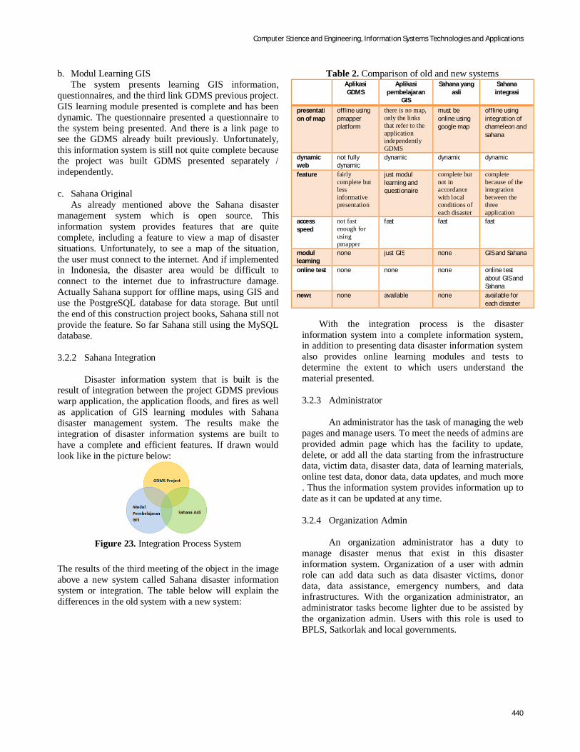
The results of the third meeting of the object in the image above a new system called Sahana disaster information system or integration. The table below will explain the differences in the old system with a new system:
Table 2. Comparison of old and new systems Aplikasi
GDMS Aplikasi
pembelajaran GIS
Sahana yang asli
Sahana integrasi
presentation of map
offline using pmapper platform
there is no map, only the links that refer to the application independently GDMS
must be online using google map
offline using integration of chameleon and sahana
dynamic web
not fully dynamic
dynamic dynamic dynamic
feature fairly complete but less informative presentation
just modul learning and questionaire
complete but not in accordance with local conditions of each disaster
complete because of the integration between the three application
access speed
not fast enough for using pmapper
fast fast fast
modul learning
none just GIS none GIS and Sahana
online test none none none online test about GIS and Sahana
news none available none available for each disaster
With the integration process is the disaster
information system into a complete information system, in addition to presenting data disaster information system also provides online learning modules and tests to determine the extent to which users understand the material presented.
3.2.3 Administrator
An administrator has the task of managing the web pages and manage users. To meet the needs of admins are provided admin page which has the facility to update, delete, or add all the data starting from the infrastructure data, victim data, disaster data, data of learning materials, online test data, donor data, data updates, and much more . Thus the information system provides information up to date as it can be updated at any time.
3.2.4 Organization Admin An organization administrator has a duty to manage disaster menus that exist in this disaster information system. Organization of a user with admin role can add data such as data disaster victims, donor data, data assistance, emergency numbers, and data infrastructures. With the organization administrator, an administrator tasks become lighter due to be assisted by the organization admin. Users with this role is used to BPLS, Satkorlak and local governments.

Computer Science and Engineering, Information Systems Technologies and Applications
441
3.2.5 Module SHP
In the process of making shp module can not be separated from the previously existing system, which uses pmapper. After testing on old applications that use pmapper it is known that this framework has its disadvantages. As in Table 3.2 below
Table 3. Comparison shp on old and new systems
Old System New System Not able to walk normally when used for more than one disaster at a computer. Because the temporary imagenya used together
Able to serve multiple applications within a single computer because the design of the temporary image each application individually so as not to clash with other applications
Pmapper use of a lot of javascript to display the shp to png and has many tools that make pmapper itself becomes slow when loading the data shpnya own.
Shp module can be faster because the process of displaying images using a short process by using a simple php.
Function tools that used a lot so it takes a lot of memory resouce
Function tools that used a little so resource consuming less memory
Not able to be integrated with Sahana, because it is itself a complex framework.
Capable be integrated with Sahana because the form has a simple module
4. Conclusions
From the test results of this disaster information system can be concluded:
1. To perform the integration of every disaster with Sahana, database synchronization is required for the system to the information presented have complete data.
2. Creating an information system must consider the structure of the database that the bedrock of the system flexibility to be easily developed.
3. Disaster information system presents the results of the integration of disaster information and learning with a complete disaster.
4. Sahana module integrates with shp, so as to display data shp each disaster.
5. With the security of SSL and Mod Security is able to present web safe from SQL injections and Cross Site Scripting
6. Sahana integration with local disasters such as mud Sidoarjo, Kalimantan forest fires and floods Bojonegoro easier to conduct risk management in the disaster area.
References [1] Masruhah, Siti, Sistem Informasi Kebakaran Hutan
di Kalimantan, PENS-ITS, Surabaya, 2009. [2] Wahyuning Tyas, Arie, Sistem Informasi Geografi
(SIG) Situs Bengawan Solo PENS-ITS, Surabaya, 2009.
[3] Azhari Rusandi, Joko, Manajemen Emergency dan Evakuasi untuk Bencana Banjir, PENS-ITS, Surabaya, 2009.
[4] Anggraini, Dyah, Modul Pembelajaran Sistem Informasi Manajemen Bencana Berbasis Web GIS, PENS-ITS, 2010.
[5] Dadan. Indonesia Rawan Gempa Akibat Pertemuan Lempeng Tektonik [internet]. Jakarta. Okezone. 2009 [9 Sept 2009]. Tersedia dari: http://news.okezone.com/read/2009/09/09/1/255831/indonesia-rawan-gempa-akibat-pertemuan-lempeng-tektonik. Diakeses 02 Maret 2011.
[6] Mamuju. Pemerintah Harus Cepat Atasi Dampak Bencana [internet]. Jakarta. AntaraNews. 2010 [27 Nov 2010]. Tersedia dari: http://arsipberita.com/show/jk-pemerintah-harus-cepat-atasi-dampak-bencana-109817.html. Diakses 02 maret 2011.
[7] Seta W. Evakuasi Penyelamatan [internet]. Sidoarjo. Blogspot. 2007 [30 Des 2007]. Tersedia dari: http://setawiriawan.blogspot.com/2007/12/evakuasi-penyelamatan.html. Diakses 02 Maret 2011.
[8] Ruslan B, DPR Dorong Kinerja Pemerintah Atasi Dampak Bencana [internet]. Jakarta. AntaraNews. 2010 [28 Okt 2010]. Tersedia dari: http://www.antaranews.com/berita/1288257772/dpr-dorong-kinerja-pemerintah-atasi-dampak-bencana. Diakses 02 Maret 2011.
[9] Wicak H, Onno Terapkan Software Manajemen Bencana [internet]. Jakarta. Detikinet. 2009 [06 Okt 2009]. Tersedia dari: http://www.detikinet.com/read/2009/10/06/082055/1215956/398/onno-terapkan-software-manajemen-bencana?topnews. Diakses 02 Maret 2011.
[10] Mprutsalis, Sahana Software Foundation Wiki [internet]. 2011 [diperbaharui 03 Feb 2010]. Tersedia dari: http://wiki.sahanafoundation.org/doku.php. Diakses 02 Maret 2011.

Computer Science and Engineering, Information Systems Technologies and Applications
442
[11] Indra D, Sistem Informasi Bencana Diterapkan [internet], Jakarta. VivaNews. 2009 [09 Nov 2009]. Tersedia dari: http://teknologi.vivanews.com/news/read/103979-sistem_informasi_bencana_sahana_diterapkan. Diakses 02 Maret 2011.
[12] Unknown, Telaahan Sistem Terpadu Penanggulangan Bencana di Indonesia [internet]. Tersedia dari: http://bpdjateng.info/telaah/ringkasan.pdf. Diakses 02 Maret 2011.
[13] Rudi P, Sahana Singgah di Padang [internet]. Jakarta. LIPI. 2009 [12 Des 2009]. Tersedia dari: http://informatika.lipi.go.id/latest/sahana-singgah-di-padang.html. Diakses 02 Maret 2011.
[14] Onno W, Peta Informasi Bencana Sumatera Barat [internet]. Telkom. 2009 [04 Okt 2009]. Tersedia dari: http://opensource.telkomspeedy.com/map/. Diakses 02 Maret 2011.