Recovery Plan for the Tidewater Goby
208
U.S. Fish & Wildlife Service Recovery Plan for the T idewater Goby (Eucyclogobius newberryi) Cover illustration of tidewater goby reproduced by permission of Camm Swift, from Swift et. al. (1989).
-
Upload
greenspace-the-cambria-land-trust -
Category
Documents
-
view
218 -
download
0
Transcript of Recovery Plan for the Tidewater Goby

8/3/2019 Recovery Plan for the Tidewater Goby
http://slidepdf.com/reader/full/recovery-plan-for-the-tidewater-goby 1/208
U.S. Fish & Wildlife Service
Recovery Planfor the Tidewater Goby
(Eucyclogobius newberryi)
Cover illustration of tidewater goby reproduced by permission of Camm Swift, from Swift et. al. (1989).
8/3/2019 Recovery Plan for the Tidewater Goby
http://slidepdf.com/reader/full/recovery-plan-for-the-tidewater-goby 2/208
Recovery Plan
For theTidewater Goby
( Eucyclogobius newberryi)
Pacific Region
U. S. Fish and Wildlife Service
Portland, Oregon
8/3/2019 Recovery Plan for the Tidewater Goby
http://slidepdf.com/reader/full/recovery-plan-for-the-tidewater-goby 3/208
i
DISCLAIMER
Recovery plans delineate reasonable actions that are believed to be required to
recover and/or protect listed species. We, the U.S. Fish and Wildlife Service,
publish recovery plans, sometimes preparing them with the assistance of recovery
teams, contractors, State agencies, and others. Objectives will be attained and anynecessary funds made available subject to budgetary and other constraints
affecting the parties involved, as well as the need to address other priorities.
Recovery plans do not necessarily represent the views nor the official positions or
approval of any individuals or agencies involved in the plan formulation, other
than our own. They represent our official position only after they have been
signed by the Regional Director, Director, or California/Nevada Operations
Manager as approved. Approved Recovery plans are subject to modification as
dictated by new findings, changes in species status, and the completion of
recovery tasks.
Literature citation should read as follows:
U.S. Fish and Wildlife Service. 2005. Recovery Plan for the Tidewater Goby
( Eucyclogobius newberryi). U.S. Fish and Wildlife Service, Portland,
Oregon. vi + 199 pp.
An electronic version of this recovery plan will also be made available at
http://www.r1.fws.gov/ecoservices/endangered/recovery/plans.html andhttp://endangered.fws.gov/recovery/index.html.

8/3/2019 Recovery Plan for the Tidewater Goby
http://slidepdf.com/reader/full/recovery-plan-for-the-tidewater-goby 4/208
ii
ACKNOWLEDGMENTS
Primary Authors
Chris Dellith of the Ventura Fish and Wildlife Office, U.S. Fish and WildlifeService, Ventura, California served as the Recovery Team Manager and prepared
this draft recovery plan, with assistance from Bill McIver of the Ventura Fish and
Wildlife Office. Recovery plan preparation was supervised and edited by Diane
Noda, Carl Benz, and Mike McCrary of the Ventura Fish and Wildlife Office.
Each member of the tidewater goby recovery team contributed valuable
information and assistance. In particular, we gratefully acknowledge the efforts
of Dr. Camm Swift, Dr. Kevin Lafferty, and Dr. David Jacobs, for being generous
with their technical assistance and time throughout the development of this
recovery plan. We thank them also for their thorough editorial review.
Drawings of Eucyclogobius newberryi are reproduced by permission of Camm
Swift, from Swift et al. (1989).
The following individuals contributed significant information/assistance during
recovery plan development (tidewater goby recovery team members are
italicized):
Ed Ballard Roger Bloom
Ray Bosch
Diane Elam
Bridget Fahey
Darren Fong
Nancy Francine
Greg Goldsmith
Gjon Hazard
Bob Hoffman
David Jacobs
Kevin Lafferty Bill McIver
Jack Malone
Carl Page
Ramona Swenson
Camm Swift
Anna Toline
Bill Berry
Larry Williamson
Jill Terp
Mark Helvey
Rick FarrisLilian Carswell
Kurt Roblek
Grant Canterbury
David Anderson
Jerry Smith
Natascha Miljkovic
Harald Ahnelt
Mike McCrary
Glenn Yoshioka
8/3/2019 Recovery Plan for the Tidewater Goby
http://slidepdf.com/reader/full/recovery-plan-for-the-tidewater-goby 5/208
iii
EXECUTIVE SUMMARY
Current Species Status: The tidewater goby ( Eucyclogobius newberryi) is listed
as endangered. It is a small fish that inhabits coastal brackish water habitats
entirely within California, ranging from Tillas Slough (mouth of the Smith River,Del Norte County) near the Oregon border south to Agua Hedionda Lagoon
(northern San Diego County). The tidewater goby is known to have formerly
inhabited at least 134 localities. Presently 23 (17 percent) of the 134 documented
localities are considered extirpated and 55 to 70 (41 to 52 percent) of the localities
are naturally so small or have been degraded over time that long-term persistence
is uncertain.
Habitat Requirements: Tidewater gobies are uniquely adapted to coastal
lagoons and the uppermost brackish zone of larger estuaries, rarely invading
marine or freshwater habitats. The species is typically found in water less than 1meter (3.3 feet) deep and salinities of less than 12 parts per thousand. Principal
threats to the tidewater goby include loss and modification of habitat, water
diversions, predatory and competitive introduced fish species, habitat
channelization, and degraded water quality.
Recovery Objective: Downlist to threatened status, then delist. The primary
objective of this recovery plan is to manage the threats to and improve the
population status of the tidewater goby sufficiently to warrant reclassification
(from endangered to threatened status) or delisting.
Recovery Priority Number: The tidewater goby has a recovery priority number
of 7C (on a scale of 1 to 18), per criteria published in the Federal Register (U.S.
Fish and Wildlife Service 1983). This number indicates a species with moderate
threats and a high potential for recovery. The letter C indicates that there is some
degree of conflict between the species’ recovery efforts and economic
development.
Recovery Criteria: We subdivide the geographic distribution of the tidewater
goby into 6 recovery units, encompassing a total of 26 Sub-Units defined
according to genetic differentiation and geomorphology.
1) The tidewater goby may be considered for downlisting when:
a) Specific threats to each metapopulation, such as habitat destruction and
alteration (e.g., coastal development, upstream diversion, channelization
of rivers and streams, discharge of agriculture and sewage effluents),
introduced predators (e.g., centrarchid fishes), and competition with

8/3/2019 Recovery Plan for the Tidewater Goby
http://slidepdf.com/reader/full/recovery-plan-for-the-tidewater-goby 6/208
iv
introduced species (e.g., yellowfin and chameleon gobies), have been
addressed through the development and implementation of individual
management plans that cumulatively cover the full range of the species.
b) A metapopulation viability analysis (see Recovery Action 2.11) based
on scientifically credible monitoring over a 10-year period indicates thateach Recovery Unit is viable. The target for downlisting is for individual
Sub-Units within each Recovery Unit to have a 75 percent or better chance
of persistence for a minimum of 100 years. Specifically, the target is for
at least 5 Sub-Units in the North Coast Unit, 8 Sub-Units in the Greater
Bay Unit, 3 Sub-Units in the Central Coast Unit, 3 Sub-Units in the
Conception Unit, 1 Sub-Unit in the Los Angeles/Ventura Unit, and 2 Sub-
Units in the South Coast Unit to individually have a 75 percent chance of
persisting for 100 years
2) The tidewater goby may be considered for delisting when downlisting criteriahave been met and:
a) A metapopulation viability analysis projects that all recovery units are
viable, as in downlisting criterion 1( b) except that the target for Sub-Units
is a 95 percent probability of persistence for 100 years.
Actions Needed:
1. Monitor, protect and enhance currently occupied tidewater goby habitat.
2. Conduct biological research to enhance the ability to integrate land use
practices with tidewater goby recovery and revise recovery tasks as
pertinent new information becomes available.
3. Evaluate and implement translocation where appropriate.
4. Increase public awareness about tidewater gobies.
Estimated Total Cost of Recovery: $1,980,000 over the next 10 years, with
costs yet to be determined for securing and protecting coastal wetlands and for assurance of successful establishment of additional populations of tidewater goby.
Funding opportunities and management will need to be developed between
landowners, regulatory agencies, nonprofit organizations, and other interested
parties.
Date of Recovery: If recovery criteria are met, reclassification to threatened
status could be initiated in 2015.

8/3/2019 Recovery Plan for the Tidewater Goby
http://slidepdf.com/reader/full/recovery-plan-for-the-tidewater-goby 7/208
v
TABLE OF CONTENTS
I. BACKGROUND........................................................................................................................ 1A. Brief Overview ...................................................................................................................... 1B. Description and Taxonomy.................................................................................................... 2
C. Distribution and Habitat......................................................................................................... 6D. Critical Habitat .................................................................................................................... 12E. Life History .......................................................................................................................... 12F. Abundance and Trends......................................................................................................... 15G. Reason for Decline and Current Threats ............................................................................. 16
1. The present or threatened destruction, modification, or curtailment of its
habitat or range...................................................................................................................... 162. Overutilization for commercial, recreational, scientific, or educational
purposes. ................................................................................................................................ 183. Disease or predation. ........................................................................................................ 184. The inadequacy of existing regulatory mechanisms ......................................................... 19
5. Other natural or manmade factors affecting its continued existence ............................... 19H. Conservation Measures........................................................................................................ 24
II. RECOVERY STRATEGY ..................................................................................................... 28
III. RECOVERY GOALS AND CRITERIA............................................................................... 30A. Recovery Units .................................................................................................................... 30
1. Criteria for Designating Recovery Units/Sub-Units ......................................................... 302. Regional Genetic Structure and Recovery Units............................................................... 323. Regional Morphologic Data.............................................................................................. 324. Local Differentiation ......................................................................................................... 335. Summary of Units from North to South............................................................................. 35
B. Recovery Criteria................................................................................................................. 391. Reclassification to Threatened .......................................................................................... 402. Delisting ............................................................................................................................ 41
IV. RECOVERY PROGRAM..................................................................................................... 43A. Recovery Action Outline ..................................................................................................... 43B. Recovery Action Narrative .................................................................................................. 45
V. IMPLEMENTATION SCHEDULE....................................................................................... 60
VI. REFERENCES ...................................................................................................................... 69
A. Literature Cited.................................................................................................................... 69B. Personal Communications ................................................................................................... 77
Appendix A. Glossary................................................................................................................ A-1
Appendix B. Maps of Recovery Sub-Units ............................................................................... B-1
Appendix C. Status of Recovery Sub-Units .............................................................................. C-1

8/3/2019 Recovery Plan for the Tidewater Goby
http://slidepdf.com/reader/full/recovery-plan-for-the-tidewater-goby 8/208
vi
Appendix D. Tidewater Goby Critical Habitat Description ...................................................... D-1
Appendix E. Tidewater Goby Threats Table ..............................................................................E-1
Appendix F. Tidewater Goby Survey Protocol...........................................................................F-1
Appendix G. Description of Recovery Units and Sub-Units..................................................... G-1
Appendix H. Summary of Threats and Recommended Recovery Actions. .............................. H-1
Appendix I. Summary of Comments ........................................................................................... I-1
LIST OF TABLES
Table G-1. Tidewater Goby Reintroduction Sites ................................................................... G-17
LIST OF FIGURES
Figure 1. Tidewater Goby ( Eucyclogobius newberryi).................................................................. 2
Figure 2 Tidewater Goby Rangewide Distribution....................................................................... 5
Figure 3. Tillas Slough, Del Norte County .................................................................................... 7
Figure 4. Santa Clara River, Ventura County, after a storm-breach-event.................................... 8
Figure 5. Lake Talawa, Del Norte County................................................................................... 12
Figure 6. Tidewater goby ( Eucyclogobius newberryi) ................................................................ 13
Figure 7. Arundo in Santa Clara River Estuary Ventura County................................................. 23
8/3/2019 Recovery Plan for the Tidewater Goby
http://slidepdf.com/reader/full/recovery-plan-for-the-tidewater-goby 9/208
1
I. BACKGROUND
A. Brief Overview
We, the U.S. Fish and Wildlife Service, listed the tidewater goby ( Eucyclogobius
newberryi) as endangered on March 7, 1994 (U.S. Fish and Wildlife Service
1994) and designated critical habitat on November 20, 2000 (U.S. Fish and
Wildlife Service 2000). On June 24, 1999, we published a proposed rule to
remove the northern populations* of the tidewater goby from the endangered
species list (U.S. Fish and Wildlife Service 1999). The proposed rule was
withdrawn on November 7, 2002 (U.S. Fish and Wildlife Service 2002).
The tidewater goby, a species endemic to California, is found primarily in waters
of coastal lagoons*
, estuaries*
, and marshes. The species is benthic*
in nature, andits habitat
*is characterized by brackish, shallow lagoons and lower stream reaches
where the water is fairly still but not stagnant (Miller and Lea 1972; Wang 1982;
Irwin and Soltz 1984; Swift et al. 1989; Swenson 1999; Moyle 2002). Tidewater
gobies prefer a sandy substrate for breeding, but they can be found on rocky, mud,
and silt substrates as well. Tidewater gobies have been documented in waters
with salinity* levels from 0 to 42 parts per thousand, temperature levels from 8 to
25 degrees Celsius (46 to 77 degrees Fahrenheit), and water depths from 25 to
200 centimeters (10 to 79 inches) (Irwin and Soltz 1984; Swift et al. 1989;
Worcester 1992; Lafferty 1997; Smith 1998).
The tidewater goby appears to spend all life stages in lagoons, estuaries, and river
mouths. Tidewater gobies may enter marine environments only when flushed out
of lagoons, estuaries, and river mouths by normal breaching of the sandbars
following storm events. The tidewater goby is typically an annual species,
although some variation has been observed (Irwin and Soltz 1984; Swift et al.
1989; Swenson 1999). Reproduction occurs year-round although distinct peaks in
spawning, often in early spring and late summer, do occur (Swenson 1999).
This recovery plan briefly describes the species and provides a history of its
taxonomy and known distribution. Tidewater goby life history and habitat parameters are described. The factors responsible for the tidewater goby’s decline
are tabulated and actions that have been taken thus far to protect populations of
this species are summarized.
* Technical terms are marked with an asterisk and defined below in the Glossary (Appendix A)
8/3/2019 Recovery Plan for the Tidewater Goby
http://slidepdf.com/reader/full/recovery-plan-for-the-tidewater-goby 10/208
2
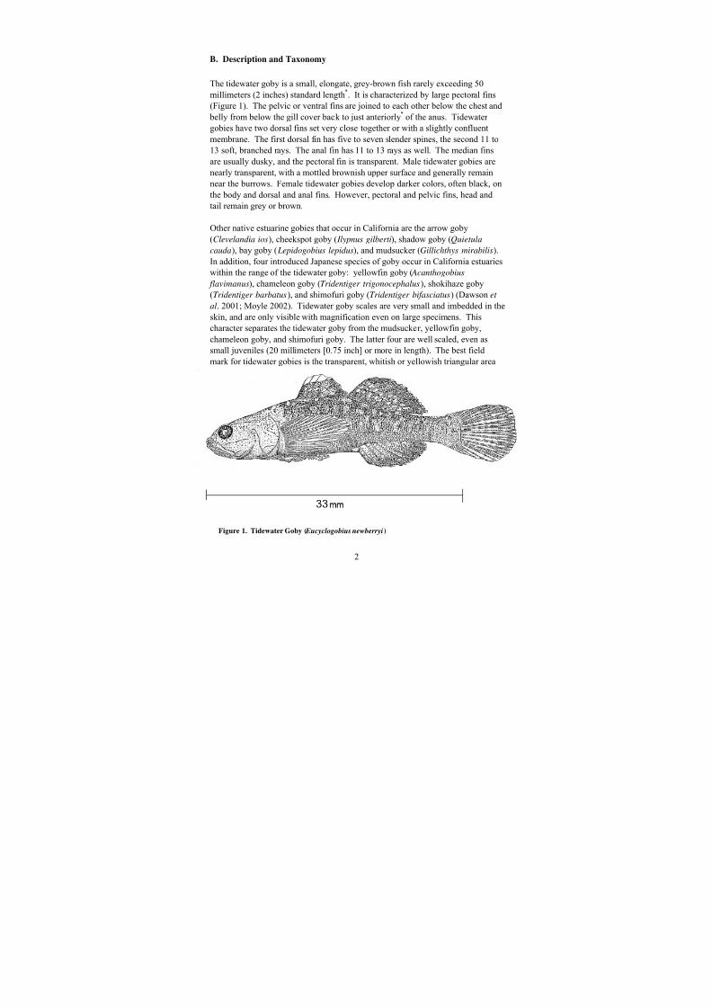
B. Description and Taxonomy
The tidewater goby is a small, elongate, grey-brown fish rarely exceeding 50
millimeters (2 inches) standard length*. It is characterized by large pectoral fins
(Figure 1). The pelvic or ventral fins are joined to each other below the chest and
belly from below the gill cover back to just anteriorly* of the anus. Tidewater
gobies have two dorsal fins set very close together or with a slightly confluent
membrane. The first dorsal fin has five to seven slender spines, the second 11 to
13 soft, branched rays. The anal fin has 11 to 13 rays as well. The median fins
are usually dusky, and the pectoral fin is transparent. Male tidewater gobies are
nearly transparent, with a mottled brownish upper surface and generally remain
near the burrows. Female tidewater gobies develop darker colors, often black, on
the body and dorsal and anal fins. However, pectoral and pelvic fins, head and
tail remain grey or brown.
Other native estuarine gobies that occur in California are the arrow goby(Clevelandia ios), cheekspot goby ( Ilypnus gilberti), shadow goby (Quietula
cauda), bay goby ( Lepidogobius lepidus), and mudsucker (Gillichthys mirabilis).
In addition, four introduced Japanese species of goby occur in California estuaries
within the range of the tidewater goby: yellowfin goby ( Acanthogobius
flavimanus), chameleon goby (Tridentiger trigonocephalus), shokihaze goby
(Tridentiger barbatus), and shimofuri goby (Tridentiger bifasciatus) (Dawson et
al. 2001; Moyle 2002). Tidewater goby scales are very small and imbedded in the
skin, and are only visible with magnification even on large specimens. This
character separates the tidewater goby from the mudsucker, yellowfin goby,
chameleon goby, and shimofuri goby. The latter four are well scaled, even assmall juveniles (20 millimeters [0.75 inch] or more in length). The best field
mark for tidewater gobies is the transparent, whitish or yellowish triangular area
Figure 1. Tidewater Goby ( Eucyclogobius newberryi)

8/3/2019 Recovery Plan for the Tidewater Goby
http://slidepdf.com/reader/full/recovery-plan-for-the-tidewater-goby 11/208
3
on the upper 1/4 to 1/3 of the first, spinous dorsal fin (Figure 1). Another
characteristic unique to the tidewater goby is that the upper end of the gill opening
stops a few fin rays below the upper end of the pectoral fin base (Miller and Lea
1972). Arrow gobies are much more slender, particularly at small sizes. They
also have a much smaller spinous dorsal fin widely separated from the soft dorsal,
rather than adjacent to it. The spinous dorsal fins on cheekspot and bay gobies aredusky or mottled throughout, or with only a narrow pale edge. Specimens of the
last three species can be difficult to distinguish from tidewater gobies smaller than
approximately 25 millimeters (approximately 1 inch) in standard length.
Cheekspot and bay gobies inhabit deeper, more marine, tidal habitats and have
been rarely collected with tidewater gobies. The species most likely to occur with
tidewater gobies are the arrow goby, mudsucker, and possibly yellowfin goby,
which are all easy to distinguish from the early juvenile stage onward.
The tidewater goby was first described as a new species by Girard (1856) as
Gobius newberryi. Gill (1863) erected the genus Eucyclogobius for thisdistinctive species. The vast majority of scientists have accepted this
classification (Jordan and Everman 1898; Miller and Lea 1972; Hubbs et al. 1979;
Eschmeyer et al. 1983; Nelson et al. 2004). No other species has been described
in this genus. A few older works and Ginsberg (1945), a gobiid systematist, put
the tidewater goby and all the related eastern Pacific species into the genus
Lepidogobius. This classification includes the currently recognized genera
Lepidogobius, Clevelandia, Ilypnus, Quietula, and Eucyclogobius. These genera,
which include the eastern Pacific species, are related to each other. Birdsong et
al. (1988) recognized this relationship, and that these eastern Pacific gobies were
phyletically related to several similar species in the northwestern Pacific.Birdsong et al. (1988) coined the informal Chasmichthys species group as a
collective name for all of these northwestern and eastern Pacific species. Later
Stevenson (2000) found discrepancies among the actual museum type specimens
for some of the western Pacific species; the genus name Chasmichthys was
replaced by Chaenogobius and the more numerous species formerly placed in
Chaenogobius were transferred to the genus Gymnogobius (Akihito et al. 2002).
Neither of these changes affected the names of the eastern Pacific species.
Unpublished work by Camm Swift indicates that all the eastern Pacific genera
noted above are closely related to each other. As a group, they are more distantly
related to the species in the northwestern Pacific.
The intraspecific phylogeny* of the tidewater goby is highly geographically
structured. Crabtree’s (1985) genetic work on the tidewater goby shows fixed
allelic* differences at the extreme northern (Lake Earl, Humboldt Bay, Appendix
B and C) and southern (Cañada de Agua Caliente, Winchester Canyon, and San
Onofre Lagoon, Appendix B and C) ends of the range and some variation in
Corcoran Lagoon in Santa Cruz County, central California (Appendix B and C).
8/3/2019 Recovery Plan for the Tidewater Goby
http://slidepdf.com/reader/full/recovery-plan-for-the-tidewater-goby 12/208
4
Each of these northern and southern populations is distinct from each other and
from those central populations that have been sampled. The other more centrally
distributed populations are relatively similar to each other (Brush Creek, Estero
Americano, Arroyo de Corral, Morro Bay, Santa Ynez River, and Jalama Creek
(Appendix B and C). This study is based on 12 localities distributed over most of
the range. The precise limits of allozyme* differentiation are not known. Theresults of this study indicate that there is a very low level of gene flow between
the populations sampled. Many of the populations may be diverging genetically
from each other due to discrete, seasonally closed estuaries, where tidewater
gobies have low dispersal ability (Crabtree 1985).
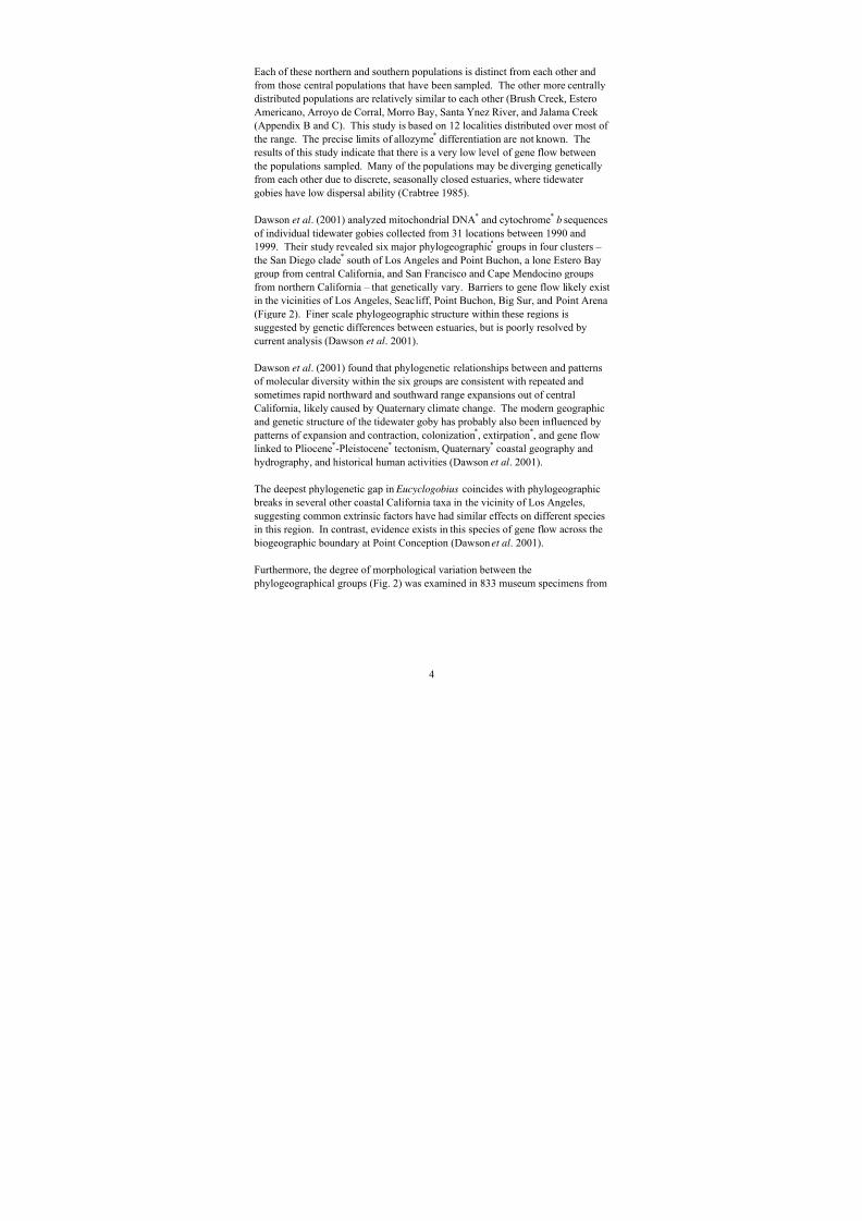
Dawson et al. (2001) analyzed mitochondrial DNA* and cytochrome* b sequences
of individual tidewater gobies collected from 31 locations between 1990 and
1999. Their study revealed six major phylogeographic* groups in four clusters –
the San Diego clade*
south of Los Angeles and Point Buchon, a lone Estero Bay
group from central California, and San Francisco and Cape Mendocino groupsfrom northern California – that genetically vary. Barriers to gene flow likely exist
in the vicinities of Los Angeles, Seacliff, Point Buchon, Big Sur, and Point Arena
(Figure 2). Finer scale phylogeographic structure within these regions is
suggested by genetic differences between estuaries, but is poorly resolved by
current analysis (Dawson et al. 2001).
Dawson et al. (2001) found that phylogenetic relationships between and patterns
of molecular diversity within the six groups are consistent with repeated and
sometimes rapid northward and southward range expansions out of central
California, likely caused by Quaternary climate change. The modern geographicand genetic structure of the tidewater goby has probably also been influenced by
patterns of expansion and contraction, colonization*, extirpation
*, and gene flow
linked to Pliocene*-Pleistocene* tectonism, Quaternary* coastal geography and
hydrography, and historical human activities (Dawson et al. 2001).
The deepest phylogenetic gap in Eucyclogobius coincides with phylogeographic
breaks in several other coastal California taxa in the vicinity of Los Angeles,
suggesting common extrinsic factors have had similar effects on different species
in this region. In contrast, evidence exists in this species of gene flow across the
biogeographic boundary at Point Conception (Dawson et al. 2001).
Furthermore, the degree of morphological variation between the
phylogeographical groups (Fig. 2) was examined in 833 museum specimens from
8/3/2019 Recovery Plan for the Tidewater Goby
http://slidepdf.com/reader/full/recovery-plan-for-the-tidewater-goby 13/208
5
Figure 2. Tidewater Goby Rangewide Distribution with Recovery Unit and Sub-Unit
Boundaries.

8/3/2019 Recovery Plan for the Tidewater Goby
http://slidepdf.com/reader/full/recovery-plan-for-the-tidewater-goby 14/208
6
25 localities including samples from extirpated populations (Malibu Creek and an
Artesian Well in Santa Monica Los Angeles County, and Aliso Creek, Orange
County) (N. Miljkovic and H. Ahnelt pers comm. 2005). The examination of
these specimens for morphological differences support the six recovery units,
which are based on phylogeographic analysis (Dawson et al. 2001) and on the
variation of the head lateral line canals (Ahnelt et al. 2004).
C. Distribution and Habitat
Tidewater gobies are endemic*
to California and historically ranged from Tillas
Slough (mouth of the Smith River, Del Norte County; Figure 3) near the Oregon
border to Agua Hedionda Lagoon (northern San Diego County), and are found
today entirely within the original known range of the species. The known
localities (Appendix B, C; Figure 2) are discrete lagoons, estuaries, or stream
mouths separated by mostly marine conditions. Tidewater gobies are absent from
areas where the coastline is steep and streams do not form lagoons or estuaries.Tributaries to Arcata Bay (northern Humboldt Bay) and Morro Bay are each
treated as single localities. Inhabited localities are separated by as little as a few
hundred meters up to tens of kilometers. North of Tomales Bay in Sonoma
County, several large gaps in distribution are considered natural; no evidence has
been found for historical occurrences in the intervening streams in this area.
From Tomales Bay southward to San Francisco Bay, many populations are
extirpated, leaving large unnatural gaps between remaining populations. Another
apparently natural gap occurs south of San Francisco Bay to San Gregorio Creek,
San Mateo County. A much larger natural gap occurs between the Salinas River,
(Monterey County), southward to Arroyo del Oso (northern San Luis ObispoCounty), because of very steep shorelines preventing lagoon development. The
only other large gap occurs in the Los Angeles Basin between city of Santa
Monica (western Los Angeles County) and Aliso Creek (central Orange County).
Habitat conditions ideal for the tidewater goby historically existed in the Los
Angeles Basin (Swift et al. 1993). A collection of four specimens from an
artesian well in Santa Monica (Steindachner 1879) is stored at the Natural History
Museum of Vienna, Austria (H. Ahnelt, pers. comm.. 2005).
Swift et al. (1989) reported 87 localities where the tidewater goby was historically
known to occur, although 134 localities are currently known (Appendix B, C;Figure 2) (U.S. Fish and Wildlife Service, unpublished data, 2004). Twenty-three
(17 percent) of the 134 documented locations are considered extirpated, and 55 to
70 (41 to 52 percent) localities are naturally so small or have been so degraded
over time that long-term persistence is uncertain (C. Swift pers. comm. 2004).
8/3/2019 Recovery Plan for the Tidewater Goby
http://slidepdf.com/reader/full/recovery-plan-for-the-tidewater-goby 15/208
7
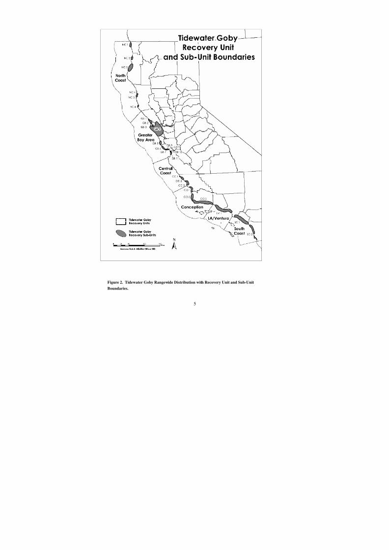
Tidewater goby
localities closely
correspond to major
stream drainages.Sediments provided by
major drainages
produce sandy beaches
with low-lying coastal
areas conducive to
formation of coastal
lagoons (Swift et al.
1989; Habel and
Armstrong 1977).
Recolonization of extirpated localities has
been documented as
occurring when extant
populations are present within several kilometers (Holland 1992; Lafferty et al.
1999a, 1999b). More recently, tidewater gobies have been found in localities
considered extirpated that are separated from the nearest tidewater goby locality
by 10 to 20 kilometers (6.2 to 12.4 miles). In 1995, tidewater gobies were found
for the first time in Cañada Honda, Santa Barbara County (Lafferty et al. 1996).
Tidewater gobies had never been found in this locality during previous surveys.
The locality was observed to go nearly dry during the drought of the late 1980’sand early 1990’s (C. Swift, pers. comm. 1995). The nearest locality to Cañada
Honda is the Santa Ynez River, 10.5 kilometers (6.5 miles) to the north. These
more recent records suggest that distant movement by tidewater gobies is
possible. However, the source of these recolonizations may have been small
numbers of individuals present in these localities that were missed by surveyors
(K. Lafferty, U.S. Geological Survey, pers. comm. 1996). Furthermore, Lafferty
et al. (1999a) suspects that recolonization is due to individuals being flushed into
the littoral zones. During floods, this zone has strong longshore currents capable
of moving small fishes substantial distances down the coast (Bascom 1980).
Longshore currents off the Pacific coast appear to be dispersing tidewater gobiesin a north to south direction (Lafferty et al. 1999a).
Tidewater gobies generally select habitat in the upper estuary, usually within the
fresh-saltwater interface. Tidewater gobies range upstream a short distance into
fresh water, and downstream into water of up to about 75 percent sea water (28
parts per thousand). The species is typically found in salinities of less than 12
parts per thousand (Swift et al. 1989). These conditions occur in two relatively
Figure 3. Tillas Slough, Del Norte County
8/3/2019 Recovery Plan for the Tidewater Goby
http://slidepdf.com/reader/full/recovery-plan-for-the-tidewater-goby 16/208
8
distinct situations: 1)
the upper edge of
tidal bays, such as
Tomales, Bolinas,
and San Francisco
Bays near theentrance of
freshwater
tributaries, and 2) the
coastal lagoons
formed at the mouths
of coastal rivers,
streams, or
seasonally wet
canyons.
Tidewater gobies held at the Granite Canyon Fish Culture Facility were subject to
a salinity tolerance test in hypersaline* water (45 to 54 parts per thousand) for 6
months, with no mortality (Worcester and Lea 1996). Holding temperatures
(fresh water) varied annually from 4.0 to 21.5 degrees Celsius (39.2 to 70.7
degrees Fahrenheit). During the late 1980’s and early 1990’s, Karen Worcester
(Morro Bay Estuary Program) conducted an investigation of habitat use in Pico
Creek lagoon, and observed large numbers of tidewater gobies using the lower
portion of the lagoon where highest salinities (up to 27 parts per thousand) were
observed. In general, abundance did not appear to be associated with oxygen
levels, which at times were quite low. Based on these studies it appears that thetidewater goby is adapted to a broad range of environmental conditions
(Worcester and Lea 1996).
Like estuarine habitats in general, tidewater goby habitat is subject to
considerable fluctuation of physical factors on both a daily and a seasonal basis.
The lagoonal nature of many habitats tends to dampen short-term variation, but
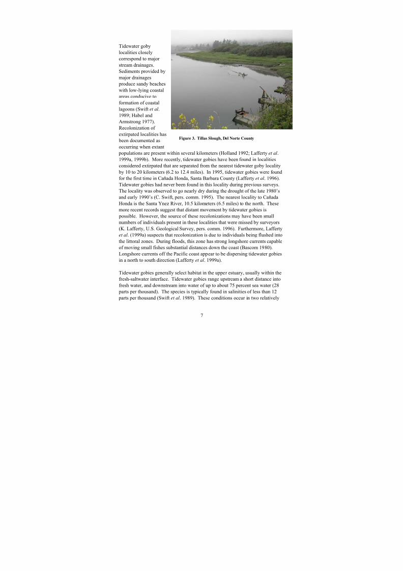
annual variation can still be wide. Winter rains and subsequent increased stream
flows usually cause considerable flooding, breaching, and washing out of
lagoonal waters, reducing salinity levels to near fresh water conditions (Figure 4).
These flows may bring in considerable sediment. The finely divided mud andclay either moves through or settles out in backwaters, while the heavier sand is
left in or near the lagoon. Initial high flows can scour out the lagoon bottom to
lower levels, with sand building up again after flows decline. The sediments are
usually spread quite evenly by the declining flows; lagoons often end up only 1 to
2 meters (3.3 to 6.6 feet) deep despite a width of 30 to 150 meters (100 to 500
feet) or more (Habel and Armstrong 1977). This pattern holds true even in larger
systems, such as the Santa Ynez River and Santa Margarita River. A central
Figure 4. Santa Clara River, Ventura County, after a storm-
breach-event
8/3/2019 Recovery Plan for the Tidewater Goby
http://slidepdf.com/reader/full/recovery-plan-for-the-tidewater-goby 17/208
9
channel, excavated by brief winter flows in these larger streams, will be another
meter (3.3 feet) or so deeper than most of the lagoon. Half or more of the
substrate of the lagoon will be soft sand, with mud in backwaters. Elevated lateral
backwaters often flood only in winter. Without these deeper, backwater habitats
(e.g. lateral sloughs), tidewater gobies can be flushed out by heavy winter floods
(Jerry Smith, Biology Department, San Jose State University, pers. comm. 2004),resulting in the extirpation of some populations (however, see next paragraph).
Some rocks or gravel may be present, mostly at the upper (inlet) and lower
(outlet) ends where constricted flow directly scours the channel. These rocks are
exposed by high water flow. Declining flows continue to bring in sand that often
covers the rocks by early spring.
Lafferty et al. (1999a) monitored post-flood persistence of 17 tidewater goby
populations in Santa Barbara and Los Angeles Counties during and after the
heavy winter floods of 1995. All 17 populations persisted after the floods, and no
significant changes in population sizes were noted. In addition, gobies apparentlycolonized Cañada Honda after the flood. This information suggests that flooding,
although generally negative, may sometimes have a positive effect by
contributing to recolonization of extirpated habitats.
In general, water is least saline during the winter and spring rainy seasons because
of precipitation and runoff. However, in north coast lagoons, the salinity level
following breaching can be near marine levels, as the breach site remains low and
open to high tides once or twice daily. This condition can last for weeks (Ray
Bosch, U.S. Fish and Wildlife Service, pers. comm. 2004). Later in the year,
occasional waves washing over the sandbars can introduce some sea water, butgood mixing often keeps the lagoon water at a few parts per thousand or less.
Summer salinity in the lagoon depends upon the amount of freshwater inflow at
the time of sandbar formation. Time of sandbar closure, which usually occurs
from spring to late summer, varies greatly between systems and years. The flow
into the lagoon declines enough to allow the surf to build up the sandbar at the
mouth of the lagoon. The sandbar closes the lagoon with the water at a relatively
high and stable level. Typically, water level changes slowly, in response to the
balance between inflow, evaporation, and outflow. In drier systems or in drought
years the closed lagoons may remain brackish after bar formation. Also, in very
wet years beach erosion due to storm waves may delay bar formation until streamflow is low, resulting in a brackish lagoon. Larger systems with greater tidal
prisms may close later, but even this relationship is often less important than
beach processes, lagoon shape (especially width), and inflow. The role of waves
washing over the sandbar also varies with the system. In some (usually small)
lagoons with little inflow, overwash may be important in affecting lagoon volume
and salinity. In others, overwash has insignificant effects on lagoon salinity or
volume (J. Smith, pers. comm. 1996). Different degrees of mixing or

8/3/2019 Recovery Plan for the Tidewater Goby
http://slidepdf.com/reader/full/recovery-plan-for-the-tidewater-goby 18/208
10
stratification of fresh and salt water occur in systems open to the ocean, varying
greatly with system surface area, depth, and wind. Small, narrow systems or
wind-protected upper portions of lagoons may be stratified for salinity (and
temperature and dissolved oxygen). In broad, shallow, open embayments wind
gradually can mix the salt layers; in some systems the broad embayment by the
sandbar may be mixed, but the narrow protected upper channels remain stratified(J. Smith, pers. comm. 1996). Lagoons in areas dominated by sand dunes usually
fluctuate in tandem with the local water table. In summer, the fresh water seeps
into the lagoon from the water table, exerting a strong freshening influence often
absent in lagoons bounded by firmer substrate (Ferren et al. 1995).
The high water line in lagoons is usually 1 to 2 meters (3.3 to 6.6 feet) higher than
local high tide levels, typically during the times of the year when the mouth is
closed off. The perimeter of the lagoon usually is defined by a steeply inclined or
vertical bank, typically 0.3 to 1.0 meter (1 to 3.3 feet) high. The position and
location of these lateral banks is usually stable for years at a time. They oftendelineate the inland or upstream two-thirds to three-quarters of most lagoons.
They are strongly cut into clay or rocky substrate and are usually stabilized along
the top by Salicornia (pickleweed), Distichlis (salt grass), Scirpus (tules),
Spartina (cordgrass) and other marsh vegetation. The banks on the seaward one-
third to one-quarter are usually more gently sloping, unstable, mostly unvegetated
and mostly sand. Even lagoons within large areas of sand dunes have their
configuration carved into the underlying harder substrate. These banks maintain
the integrity of the lagoon for years at a time.
The shallow, pan configuration of the lagoons means that normal vertical changesin water level have little effect on surface area. Only at extremely high or low
water levels does surface area change dramatically. Conversely, once the water
level drops below the base of the steep lateral banks, any further drop directly
lowers the surface area. Once the water level surmounts the top of these banks,
the surface area can double or triple because the flats adjacent to the lagoon
suddenly become flooded. Only a much larger volume of water will enable the
lagoon to occupy this much larger area, and such enlargements are infrequent
events. For this reason, these flats are often muddy, anoxic*, or hypersaline, and
are seldom, if ever, heavily utilized by tidewater gobies.
Water temperatures in lagoons closed to the ocean seldom exceed a range of 10 to
25 degrees Celsius (50 to 77 degrees Fahrenheit), and usually fall somewhere in
between. North of Point Conception, where the ocean is consistently 9 to 11
degrees Celsius (48 to 52 degrees Fahrenheit), lagoons are almost always warmer
than the ocean. South of Point Conception, winter temperatures are similar, but
late summer ocean temperatures reach 19 to 21 degrees Celsius (68 to 72 degrees
Fahrenheit). Shallow, stratified lagoons can act as solar collectors, with more

8/3/2019 Recovery Plan for the Tidewater Goby
http://slidepdf.com/reader/full/recovery-plan-for-the-tidewater-goby 19/208
11
saline bottom layers trapping heat and reaching 30 degrees Celsius (86 degrees
Fahrenheit). Thus, in southern California, lagoons are usually warmer than the
ocean in winter and cooler in summer (Swift et al. 1989). Often the surface is a
few degrees warmer than the bottom if the salinity is uniform. Coastal fog and
maritime influence often keep lagoon waters several degrees cooler than stream
waters just a few kilometers further upstream. In addition, heavy summer fog can block the sun's warming effect and cause a depression in water temperatures for a
few weeks or months. The sunnier days in spring and fall result in bimodal peaks
of higher water temperatures (Purer 1942; Swift and Frantz 1981). At localities
open to tidal influence, temperature fluctuates more in parallel with the ocean,
salinities stay mixed, and these microgeographic effects may not develop (Purer
1942; Swift and Frantz 1981).
Stable lagoons are often almost completely choked with aquatic* vegetation,
usually with Potamogeton pectinatus (sago pond weed) and two species of
Ruppia (widgeon grass), R. maritima and R. cirrhosa. Ruppia cirrhosa is moretypical of the brackish zone inhabited by tidewater gobies (Wayne Ferren,
Museum of Systematic Biology, University of California, Santa Barbara, pers.
comm. 1995). The invasion of fall migrating waterfowl and winter washing out
of lagoons often removes virtually all of this growth (Mason 1957). This
vegetation rapidly regrows in the spring and summer and provides cover from
predators and substrate for the invertebrates used as food by tidewater gobies.
This role is particularly important in steep narrow lagoons with little or no
vegetation along the lagoon margin, or even in wide lagoons if the water level
falls below the level of the emergent vegetation.
The lagoons in which tidewater gobies are found range in size from a few square
meters of surface area to about 800 hectares (2,000 acres). Most lagoons are
much smaller, ranging from about 0.5 to 5 hectares (1.25 to 12.5 acres). Surveys
of tidewater goby localities and historic records indicate that size, configuration,
location, and access by humans are all factors in the persistence of populations of
this species (Swift et al. 1989, 1994). Lagoons and estuaries smaller than about 2
hectares (about 5 acres) generally have histories of extinction*, extirpation, or
population reduction to very low levels. Many of the records for smaller
localities, less than about 0.5 hectare (1 acre), include one or a few large tidewater
gobies with no evidence of reproduction. These small localities are also oftenwithin a kilometer or so of another locality from which recolonization could occur
following catastrophic events (C. Swift, pers. comm. 2004).
The largest localities are not necessarily the most secure, as evidenced by the fact
that San Francisco Bay and the Santa Margarita River have lost their populations
of tidewater gobies. However, an exception is Lake Talawa, Del Norte County,
which is several thousand acres in size (Figure 5). The most stable or largest

8/3/2019 Recovery Plan for the Tidewater Goby
http://slidepdf.com/reader/full/recovery-plan-for-the-tidewater-goby 20/208
12
populations today are
in localities of
intermediate sizes, 2
to 50 hectares (5 to
125 acres) that have
remained relativelyunaffected. In many
cases these have
probably provided the
colonists for the
smaller ephemeral
sites (Lafferty et al.
1999b).
D. Critical Habitat
Critical habitat, as defined by section 3 of the Endangered Species Act of 1973
(16 U.S.C. 1531 et sec.), as amended, and at 50 CFR Part 424, includes: 1) the
specific areas, within the geographic area occupied by a species at the time of its
listing in accordance with the provisions of section 4 of the Endangered Species
Act on which are found those physical or biological features essential to the
conservation of the species and which may require special management
considerations or protection; and 2) specific areas outside the geographical area
occupied by the species at the time it is listed* which are determined to be
essential for the conservation of the species. Tidewater goby critical habitat (U.S.
Fish and Wildlife Service 2000) includes 10 coastal stream segments in Orangeand San Diego Counties, California. See Appendix D for a description of
tidewater goby critical habitat.
Critical habitat includes the stream channels and their associated wetlands, flood
plains, and estuaries. These habitat areas provide for the primary biological needs
of foraging, sheltering, reproduction, and dispersal, which are essential for the
conservation of the tidewater goby. Information exists suggesting that critical
habitat boundaries should be revised (U.S. Fish and Wildlife Service 2002).
E. Life History
The life history of tidewater gobies is keyed to the annual cycles of the coastal
lagoons and estuaries (Swift et al. 1989; Swenson 1995, 1999). Most tidewater
goby collections occurred in water of approximately 1/3 sea salinity; i.e. 12 parts
per thousand or less. Tidewater gobies are usually collected in areas with water
less than 1 meter (3.3 feet) deep (Swenson 1999). Tidewater gobies often migrate
Figure 5. Lake Talawa, Del Norte County

8/3/2019 Recovery Plan for the Tidewater Goby
http://slidepdf.com/reader/full/recovery-plan-for-the-tidewater-goby 21/208
13
upstream into tributaries, as far as 1.0 kilometer (0.5 mile) from the estuary.
However, in Ten Mile River, Mendocino County, and San Antonio Creek and the
Santa Ynez River, Santa Barbara County, tidewater gobies are often collected 5 to
8 kilometers (3 to 5 miles) upstream of the tidal lagoonal areas, sometimes in
sections of stream impounded by beavers (Castor canadensis) (Irwin and Soltz
1984). Half-grown to adult tidewater gobies (Figure 6) move upstream insummer and fall. Evidence demonstrates reproduction in these upstream
tributaries.
Male tidewater gobies begin digging breeding burrows in relatively
unconsolidated, clean, coarse sand (averaging 0.5 millimeter [0.02 inch] in
diameter), in April or May after lagoons close to the ocean (Swift et al. 1989;
Swenson 1995). Swenson (1995) has shown that tidewater gobies also prefer this
substrate in the laboratory. Burrows are at least 70 to 100 millimeters (3 to 4
inches) from each other.
Female tidewater gobies aggressively spar with each other for access to males
with burrows for laying their eggs. This rare female-dominant breeding system in
vertebrates makes the tidewater goby evolutionarily interesting and almost unique
among gobies (Swift et al. 1989; Swenson 1995).
Female tidewater gobies can lay 300 to 500 eggs per clutch, depending on the size
of the individual female tidewater goby (Swift et al. 1989). Female tidewater
gobies lay 6 to 12 clutches per year (Swenson 1999). Male tidewater gobies
remain in the burrow to guard the eggs that are attached to sand grains in the
burrow ceiling and walls. Egg clutches are laid approximately 2.5 centimeters (1
inch) below the entrance of the burrow (Swenson 1999). Field collections of eggclutches have demonstrated that male tidewater gobies may accept more than one
clutch, but this behavior is uncommon (Swenson 1999). The male tidewater goby
cares for the embryos for approximately 9 to 11 days until they hatch, rarely if
ever emerging from the burrow to feed.
Figure 6. Tidewater goby ( Eucyclogobius newberryi)

8/3/2019 Recovery Plan for the Tidewater Goby
http://slidepdf.com/reader/full/recovery-plan-for-the-tidewater-goby 22/208
14
Tidewater gobies generally live for only 1 year, with few individuals living longer
than a year (Moyle 2002). Reproduction occurs at all times of the year, as
indicated by female tidewater gobies in various stages of ovarian development
(Swenson 1999). The peak of spawning activity occurs during the spring and then
again in the late-summer. Fluctuations in reproduction are probably due to death
of breeding adults in early summer and colder temperatures or hydrologicaldisruptions in winter (Swift et al. 1989). Reproduction takes place in water
between 9 to 25 degrees Celsius (48 to 77 degrees Fahrenheit) and at salinities of
2 to 27 parts per thousand (Swenson 1999).
Tidewater gobies have successfully reproduced under laboratory conditions for at
least two different investigators (Worcester and Lea 1996). Several thousand
were raised at the Granite Canyon Hatchery facility of the California Department
of Fish and Game, Carmel, California in the late 1980’s and early 1990’s
(Worcester and Lea 1996). Swenson (1999) observed tidewater gobies spawning
regularly in 8 to 15 parts per thousand and 17 to 22 degrees Celsius (62 to 71degrees Fahrenheit). Larvae and juveniles have been successfully raised to
reproductive maturity on green algae, rotifers, and brine shrimp larvae ( Artemia
nauplii).
Tidewater goby standard length at hatching is approximately 4 to 5 millimeters
(0.17 to 0.25 inch). Tidewater goby larvae are planktonic for 1 to 3 days and then
become benthic from that point on. The average size of tidewater gobies tends to
be significantly larger in marshes (43 to 45 millimeters [1.7 to 1.8 inches]
standard length) when compared to tidewater gobies from lagoons or creek
habitats (Swenson 1999). Swenson (1999) speculated that the more stable
physical conditions of the marsh foster improved growth or a more consistent or
abundant supply of prey. Swift also suggests that larger tidewater gobies exist in
marshes because they are able to retreat into areas with better cover (C. Swift,
pers. comm. 2005).
Tidewater gobies feed mainly on small animals, usually mysid shrimp, gamarid
amphipods*, ostracods*, and aquatic insects, especially chironomid midge larvae
(Swift et al. 1989; Swenson 1995; Moyle 2002). Swenson (1996) found that
juvenile tidewater gobies are generally day feeders, although adults mainly feed at
night. Tidewater gobies use three different foraging styles to capture benthic
prey: plucking prey from the substrate surface, sifting sediment in their mouth,and mid-water capture. Swenson and McCray (1996) suggested that the tidewater
goby’s food requirements are adaptable to a variety of habitats, an advantageous
trait in a fluctuating estuarine environment.
Tidewater gobies are known to be preyed upon by native species such as small
steelhead (Oncorhynchus mykiss), prickly sculpin (Cottus asper ), and staghorn
sculpin ( Leptocottus armatus) (Swift et al. 1989). Predation by the tule perch
8/3/2019 Recovery Plan for the Tidewater Goby
http://slidepdf.com/reader/full/recovery-plan-for-the-tidewater-goby 23/208
15
( Hysterocarpus traski), and historically by the Sacramento perch ( Archoplites
interruptus), has probably prevented tidewater gobies from inhabiting the San
Francisco Bay delta, an otherwise ideal habitat for tidewater gobies (Swift et al.
1989).
Tidewater gobies are also preyed upon by several nonnative fish species.Shapavalov and Taft (1954) documented the nonnative striped bass ( Morone
saxatilis) preying upon tidewater gobies in Waddell Creek Lagoon. Sunfishes
( Lepomis spp.) and basses ( Micropterus spp.), have been introduced in or near
coastal lagoons and could prey heavily on tidewater gobies. Anecdotal
observations indicate that tidewater gobies have disappeared at several localities,
soon after centrarchids were introduced (Swift et al. 1989, 1994; Rathbun 1991).
Other predatory fish such as catfish and bullheads (Ictaluridae) have been
introduced into some localities, including the San Francisco Bay delta (Moyle
2002). In addition, the shimofuri goby, which has become established in the San
Francisco Bay region (Moyle 2002), competes with and preys upon the smaller tidewater goby (Swenson and Matern 1995).
Many piscivorous*
birds, including egrets ( Egretta spp.), herons ( Ardea herodias,
Butorides striatus, Nycticorax nycticorax), cormorants (Phalacrocorax spp.),
terns (Sterna spp.), mergansers ( Mergus spp.), grebes (Podiceps ssp., Podilymbus
spp., Aechmophorus spp.), and loons (Gavia spp.), frequent the coastal lagoon
habitats, mainly in fall and winter, and may feed on tidewater gobies (Rathbun
1991). Garter snakes (Thamnophis spp.) also probably prey on tidewater gobies.
Rathbun (1991) suggested that robust populations of tidewater gobies, as well as
threespine stickleback and prickly sculpins, would provide food for the two-
striped garter snake (Thamnophis hammondii) in Santa Rosa Creek Lagoon.
F. Abundance and Trends
No long-term monitoring program is available for the tidewater goby, and
population dynamics are not well documented for this species. Deriving
population size estimates for the tidewater goby is difficult because of the
variability in local abundance. In addition, seasonal changes in distribution and
abundance further hamper efforts to estimate population size, especially for a
short-lived species. Tidewater goby populations also vary greatly with the
varying environmental conditions (e.g., drought, El Niño) among years; this
environmental variation is a normal phenomenon, but one that makes thedetermination of trends difficult.
Estimating tidewater goby population size is complicated because the populations
are controlled by environmental conditions. For example, when lagoons are
breached due to flood events during the rainy seasons, tidewater goby populations
decrease and then recover during the following summer. Swift et al. (1989)

8/3/2019 Recovery Plan for the Tidewater Goby
http://slidepdf.com/reader/full/recovery-plan-for-the-tidewater-goby 24/208
16
estimated that individual tidewater gobies within a population at Aliso Creek
Lagoon ranged from 1,000 to 1,500 in the late winter-early spring and 10,000 to
15,000 tidewater gobies in the late summer-early fall.
When present, tidewater gobies are frequently the most abundant fish species
found at the site (Lafferty et al. 1999a). Worchester (1992) documented a patchydistribution within habitats using meter-square drop traps for fine scale sampling.
The results indicated density at Little Pico Creek, San Luis Obispo County ranged
from 0 to 67 tidewater gobies per square meter in May 1990, 0 to 138 tidewater
gobies per square meter in November 1990, and 0 to 27 tidewater gobies per
square meter in February 1991. Density ranges for the following locations at the
Camp Pendleton Marine Corps Base, San Diego County in October 1996 included
2 to 11 tidewater gobies per square meter in San Mateo Creek, 1 to 102 tidewater
gobies per square meter in the creek at San Onofre Lagoon (October 1996), 0 to 4
tidewater gobies per square meter in Los Flores Creek (November 1996), 0 to 6
tidewater gobies per square meter in Hidden Creek (November 1996), and 1 to 51tidewater gobies per square meter in French Creek Lagoon (October 1996)(Swift
and Holland 1998).
G. Reason for Decline and Current Threats
The tidewater goby is threatened by modification and loss of habitat as a result of
coastal development, channelization of habitat, diversions of water flows,
groundwater overdrafting, and alteration of water flows. Potential threats to the
tidewater goby include discharge of agricultural and sewage effluents, increased
sedimentation due to cattle grazing and feral pig activity, summer breaching of lagoons, upstream alteration of sediment flows into the lagoon areas, introduction
of exotic*
gobies (e.g., yellowfin and shimofuri gobies) and rainwater killifish
( Lucina parva), habitat damage, and watercourse contamination resulting from
vehicular activity in the vicinity of lagoons. The following discussion is
organized according to the five listing criteria under section 4(a)(1) of the
Endangered Species Act.
1. The present or threatened destruction, modification, or curtailment of its
habitat or range.
Coastal development projects that modify or destroy coastal brackish-water habitat are the major factor adversely affecting the tidewater goby. Coastal
lagoons and marshes have been drained and reclaimed for residential and
industrial developments. Waterways have been dredged for navigation and
harbors, resulting in direct losses of wetland habitats as well as indirect losses due
to associated changes in salinity. Coastal road and railroad construction have
severed the connection between marshes and the ocean, resulting in unnatural
temperature and salinity profiles (U.S. Fish and Wildlife Service 1994).
8/3/2019 Recovery Plan for the Tidewater Goby
http://slidepdf.com/reader/full/recovery-plan-for-the-tidewater-goby 25/208
17
Bridging of coastal lagoons and consequent restriction of water flow probably
began with the railroads; the early coastal highways always turned inland and
crossed upstream of lagoons. The railroads along the coast often obliterated much
or all of those lagoons traversed. Populations in San Luis Obispo, Santa Barbara,
and San Diego Counties were probably lost before 1900 (Swift et al. 1993; U.S.Fish and Wildlife Service 1994; Moyle 2002). Many early highway bridges and
trestles spanned the lagoons, leaving the lagoon habitat intact. Subsequently,
highway builders adopted some of the methods used for building crossings for
railroads near the coast. Later, some lagoons were obliterated by complete filling.
For several reasons, lagoons and their tributary streams have been partially or
completely channelized to protect bridges, adjacent structures, and farmland.
These efforts hasten the flow of water through the marsh to the sea and isolate the
lateral marshes from the mainstream. Tidewater gobies depend on the cover and
protection of the marshes for growth and as refugia from scouring winter flows.If they are denied access to the marsh, the possibility of losing a population to a
major flood event increases. One such loss where channelization had been done
was documented by Jack Nelson in 1972 and 1973 at Waddell Creek (Swift et al.
1989). The channelization upstream of San Onofre Lagoon on Camp Pendleton
probably led to the washing out of the tidewater gobies during the “March
miracle” storm of 1993 (Swift et al. 1994). Strong flood flows in January and
March of 1995 severely reduced the population at the channelized Jalama Creek,
Vandenberg Air Force Base, but some individuals survived (Swift et al.1997). In
addition, channelization can increase scouring and deepen the narrow channels,
leaving behind only rocks and gravel. Increased velocity of flow created bychannelization transports sand into the ocean. Therefore, substrate required for
breeding by the tidewater goby is reduced or eliminated.
Stream diversions have adversely affected the tidewater goby by altering
downstream flows, thereby diminishing the extent of marsh habitats that occurred
historically at the mouths of most rivers and creeks. Diversions are known to
exacerbate the effects of natural deleterious events. In San Luis Obispo County
alone, the effects of drought, exacerbated by upstream water diversions, were
responsible for the extirpation of at least three populations between 1986 and
1990 (K. Worcester, pers. comm. 1991, as cited in U.S. Fish and Wildlife Service1994). Alterations of flows upstream of coastal lagoons have changed the
distribution of downstream salinity regimes. Changes in salinity distributions
because of upstream water diversions may adversely affect both the size and
distribution of tidewater goby populations (D. Holland, pers. comm. 1991, as
cited in U.S. Fish and Wildlife Service 1994).
8/3/2019 Recovery Plan for the Tidewater Goby
http://slidepdf.com/reader/full/recovery-plan-for-the-tidewater-goby 26/208
18
2. Overutilization for commercial, recreational, scientific, or educational
purposes.
We do not believe overutilization is a threat to the tidewater goby.
3. Disease or predation.
The only parasite recorded on tidewater gobies is the fluke Cryptocotyle lingua,
which occurred on the skin of many adults from Corcoran Lagoon and possibly
Pescadero Lagoon (Swenson 1999; Swift et al. 1989). Cryptocotyle lingua is a
common marine parasite in the family Heterophyidae. The infection can kill the
host fish, particularly juveniles, at high intensities or facilitate secondary bacterial
infections in the ruptured skin. In addition to pathological impacts, infection
could increase the fish’s vulnerability to predation, either by increased visibility
because of the black cysts, or by altered predator-avoidance behavior (Swenson
1999).
Tidewater gobies are vulnerable to introduced predators and exotic estuarinespecies of goby. Unauthorized illegal introductions of nonnative species are on
the increase today for sport, bait, commercial, and aquaculture purposes (Baltz
1991; Courtenay and Williams 1992; Aquatic Nuisance Task Force 1993; Swift et
al. 1993; Hastings and Henle 1995). Shapavalov and Taft (1954) documented
predation on tidewater gobies by striped bass at Waddell Creek lagoon. The bass
were introduced to San Francisco Bay and drifted down the coast to Waddell
Creek. Since the early 1900's, several introductions of striped bass have been
made to a variety of coastal lagoons and bays in central and southern California
and are a threat to those populations (Swift et al. 1993). Nonnative African
clawed frogs ( Xenopus laevis) also prey upon tidewater gobies (Lafferty and Page1997), although they are probably not a significant source of mortality due to the
limited distribution of this species in tidewater goby habitat.
Although few brackish or estuarine fish species have been introduced to
California, several freshwater species potentially affect the brackish zone also.
Introduced centrarchid sunfishes and basses have long been a staple feature of
California fresh waters. Studies in their native habitats in Mississippi and Florida
show that, seasonally, they can be the major fish predators in the upper brackish
portion of estuaries (Swift et al. 1977; Hackney and de la Cruz 1981). Only
further seaward, in more saline water, do the major marine predators becomeabundant.
Introduced centrarchids occur in virtually all tributaries to tidewater goby
habitats. It is not clear why more lagoons have not been invaded. A substantial
downstream movement of centrarchids into upper Santa Margarita River Lagoon
seems to have eliminated or severely reduced tidewater gobies there in the
summer of 1993 (C. Swift, pers. comm. 1995). Tidewater gobies seem to have
8/3/2019 Recovery Plan for the Tidewater Goby
http://slidepdf.com/reader/full/recovery-plan-for-the-tidewater-goby 27/208
19
been eliminated by largemouth bass ( Micropterus salmoides) at Old Lagoon, San
Luis Obispo County in the late 1980’s or early 1990’s (D. Holland, pers. comm.
1992). Green sunfish ( Lepomis cyanellus) dominated San Mateo Creek Lagoon,
San Diego County in the late 1980’s and early 1990’s (Feldmuth and Soltz 1986;
Swift et al. 1994) and tidewater gobies could not be found. Green sunfish were
absent in the fall of 1993 and a small number of tidewater gobies were present.The sunfish may have been washed out during high flows or were eliminated by
other factors such as changing salinity. Survival in lateral marshes or
recolonization from other extant sites may explain the re-occurrence of tidewater
gobies in San Mateo Lagoon following the elimination of the green sunfish.
Abbotts Lagoon on Pt. Reyes National Recreation Area appears to be ideal
tidewater goby habitat but is inhabited by introduced Sacramento perch that may
have eliminated them. The proximity of these Sacramento perch possibly
threatens other local populations of tidewater gobies at Estero San Antonio,
Estero Americano, and Rodeo Lagoon on Golden Gate National Recreation Area.
4. The inadequacy of existing regulatory mechanisms.
Section 10 of the Rivers and Harbors Act, section 404 of the Clean Water Act, the
National Environmental Policy Act, the California Environmental Quality Act,
and the California Coastal Act are regulatory mechanisms that may be used to
manage tidewater goby habitat. We have the authority to comment on
notifications from these Acts. However, our comments are only advisory,
although procedures exist for elevation when disagreements between agencies
arise. Therefore, the agencies’ (i.e. U.S. Army Corps Of Engineers,Environmental Protection Agency, U.S. Fish and Wildlife Service, California
Department of Fish and Game, California Coastal Commission) actions under the
legislation discussed above may be insufficient to protect the tidewater goby.
5. Other natural or manmade factors affecting its continued existence.
The brackish zone, preferred by the tidewater goby, is often modified or
eliminated by human created barriers (e.g., dikes and levees), typically at the
upstream terminus of channelization. These barriers are typically built to create
water reservoirs or provide flood protection to farm or grazing land, residential or commercial development. In several areas, including the mouth of the Santa
Maria River, Ballona Marsh, and the Los Angeles-Long Beach Harbor area,
subsurface oil and water extraction causes the land to sink below sea level in areas
just behind the beaches. This subsidence makes surrounding dikes and levees
necessary to keep the salt water from flooding those areas. In all of these cases
the fresh water flowing downstream toward the lagoon reaches the dike or levee
and falls over or seeps through into relatively high salinity water on the

8/3/2019 Recovery Plan for the Tidewater Goby
http://slidepdf.com/reader/full/recovery-plan-for-the-tidewater-goby 28/208
20
downstream side. The water downstream tends to be saltier than it would be in
the absence of the dikes and levees because of reduced freshwater inflow,
evaporation, opening of the barrier sandbar to the ocean, and sometimes saltwater
intrusion underground from the ocean as the freshwater volumes decline
underground. The net result is to narrow or eliminate the broad low salinity zones
of the downstream brackish lagoons and estuaries (Ferren et al. 1995).
In addition to the loss of coastal marsh caused by water diversions and alteration
of flows, as noted above, water diversions and alterations of water flows may
negatively affect the species’ breeding and foraging activities. Reductions in
water flows may allow aggressive plant species to colonize the otherwise bare
sand/mud substrates of lagoon margins, thus degrading the open sand/mud
substrate needed by the tidewater goby for breeding (Holland 1992). Decreases in
stream flows also reduce the depth of streams, preventing tidewater gobies from
venturing upstream from lagoons.
As the size of the human population and use of many coastal areas increases,
more wells are dug and the increasing demand on the water supply can result in
groundwater overdrafting. Groundwater overdrafting decreases the amount of
fresh water reaching the lagoons (Moyle and Williams 1990; Swift et al. 1993),
thus contributing to a reduction or elimination of the brackish zone. During the
drought of the late 1980’s and early 1990’s, many small lagoons in San Luis
Obispo, Santa Barbara, and Santa Cruz Counties went dry or nearly so. This
natural drought was often made worse by water tables lowered from additional
water withdrawal upstream (Rathbun 1991). The degree to which some of these
populations survived is not known. In San Antonio Creek, Santa Barbara County,5 to 6 kilometers (3.2 to 3.8 miles) of stream upstream of the lagoon that
historically held tidewater gobies were dry until the rains in January 1995.
Additional water withdrawal will further reduce tidewater goby habitat.
A trend in southern California is for more water to be available all year in streams
that receive municipal waste discharges. Today many streams (e.g., Santa Ynez
River and Malibu Creek) are flowing with much more water in the dry season
than probably occurred historically. This water is high in nutrients that contribute
to enrichment of lagoon water and the associated decreases in dissolved oxygen.
This extra water can cause the lagoon to rise and increase the frequency of breaching experienced under natural conditions, causing erratic fluctuations in
water level. These erratic fluctuations result in decreases in habitat that increase
chances of predation and leave spawning burrows exposed to the air. The sudden
draining of a lagoon in late spring or summer also can allow marine water to
dominate the lagoon for months until winter rains return (Swift et al. 1989).

8/3/2019 Recovery Plan for the Tidewater Goby
http://slidepdf.com/reader/full/recovery-plan-for-the-tidewater-goby 29/208
21
Many current drainages to coastal lagoons are contaminated with animal wastes
(manure, dairy washings, lime from stalls), agricultural runoff (both chemicals
and soil), and oil field runoff (C. Swift, pers. comm. 1995) (see Appendix C for
water quality information for each location if available). Oil field runoff consists
of petroleum products and various well slurries, salts, and chemicals. The larger
the drainage, the greater the possibility that more of these factors may be present.The Santa Maria River Lagoon lies in an active oil field. The Ventura River
drains the area of extensive productive oil fields. Many smaller lagoons receive
local septic tank effluent, particularly in winter when flooding overwhelms or
washes out some systems.
Estero San Antonio, Arroyo del Oso, Pismo Creek, Santa Ynez River, and other
localities show clear signs of extensive anoxia in the summer and fall, due to
oxidation of the excess nutrients and phytoplankton* blooms. The enrichment
stimulates macroalgae*
growth. The excessive consumption of oxygen by the
algae at night can make lagoon waters anoxic. Excessive nutrients are alsoimplicated in the increasing frequency of toxic algae blooms in estuaries (Lewitus
et al. 1995). Anecdotal evidence indicates that the algal blooms and
deoxygenation resulting from agricultural and sewage effluent enrichment reduce
the habitable area of lagoons in summer (Swift et al. 1989). The extirpation of
tidewater gobies in the Salinas River probably occurred during the period when
poorly treated sewage was discharged into the lagoon (J. Smith, pers. comm.
2004).
Several small, potentially competitive or predatory estuarine fishes have been
introduced into tidewater goby habitat. Rainwater killifish, chameleon goby, andyellowfin goby appeared in the 1960’s in San Francisco Bay, coincident with the
last collections of tidewater gobies there (Hubbs and Miller 1965; Haaker 1979;
Swift et al. 1989). Rainwater killifish have become widespread in San Francisco
Bay, and have recently become established in Upper Newport Bay, but have not
become established elsewhere (Moyle 2002; C. Swift, pers. comm. 2004).
Yellowfin gobies have slowly spread to many of the larger, tidal and muddy
California estuaries. They have seldom been collected in the smaller brackish,
nontidal systems where tidewater gobies are found (Swift et al. 1993). However,
in 1992 and 1993 yellowfin gobies were collected in the Santa Clara River and
Santa Margarita River lagoons (K. Lafferty, pers. comm. 1994; Swift et al. 1994).The recent appearance of yellowfin gobies in southern California and the
coincident disappearance of the tidewater goby in the Santa Margarita River in
late 1993 suggest that the species is slowly spreading to brackish habitats and may
be eliminating tidewater gobies.
Chameleon gobies have been locally abundant on hard substrates in San Francisco
and Los Angeles harbors since the 1960’s and 1970’s, respectively (Haaker
8/3/2019 Recovery Plan for the Tidewater Goby
http://slidepdf.com/reader/full/recovery-plan-for-the-tidewater-goby 30/208
22
1979). Recently, shimofuri gobies made an upstream invasion into the San
Francisco Bay Delta that allowed them to move down the California Aqueduct
into Pyramid Reservoir and Piru Creek in southern California. The shimofuri
goby is a more freshwater adapted taxon*, as described by Akihito and Sakamoto
(1989). Thus, marine invasions from bilge water of marine ships and downstream
or inland invasions with imported water are possible now in southern California.California Aqueduct water is soon to be piped into central coastal California, and
the potential invasion of exotic gobies with this water poses a potential threat to
tidewater gobies in this area (C. Swift, pers. comm. 1995).
Initial experiments by Swenson and Matern (1995) indicated that shimofuri
gobies aggressively intimidate, outcompete and prey upon tidewater gobies in the
laboratory. However, like the chameleon goby, the shimofuri goby prefers hard
substrates. It was found almost exclusively on rocky shores and around boulders
of levees and breakwaters in Pyramid Lake (Wade Sinnen and Janice Curl,
California Department of Fish and Game, pers. comm. 1992). Thus it might beexpected to remain in such habitats in coastal lagoons, and perhaps not interact
extensively with tidewater gobies. However, any increase in hard substrate in
lagoons inhabited by tidewater gobies should be carefully considered because this
substrate would provide the habitat that could result in the establishment of the
shimofuri goby. If lagoons were breached or other conditions lowered the water
level, the shimofuri gobies could potentially move from the rocky areas and
establish themselves in the tidewater goby habitat, to the detriment of tidewater
gobies. To date, the possible effects of interactions in the wild between these
exotic goby species and tidewater gobies are largely conjectural.
Anthropogenic breaching of lagoons during the dry season occurs to: 1)
ameliorate real or imagined stagnation and attendant odors of the water; 2)
prevent flooding of adjacent structures or agricultural fields built within the flood
plain of the lagoon; 3) remedy a mosquito problem by reducing the vegetated
marsh adjacent to lagoons (thought to reduce breeding habitat for mosquitos); and
4) cause a new spread (or fan) of fresh deposited sediment in the surf, improving
the break of the waves for surfing (Tom Evan, Department of Biology, University
of California, Santa Barbara, pers. comm. 1993). The extent of anthropogenic
breaching to improve the break of waves for surfing is not well known.
Anthropogenic breaching of lagoons during the dry season may adversely affect
tidewater gobies in a variety of ways. After a lagoon has been breached it reforms
in a week or so, but often stabilizes at a lower level. Usually the level of the
lagoon falls a meter (3.3 feet) or more, which can strand many tidewater gobies in
shallow pools and leave breeding burrows above the water level, subject to
desiccation and predation. The salinity increases considerably because freshwater
inflow is low or absent in the dry season at many sites. Higher salinity can be

8/3/2019 Recovery Plan for the Tidewater Goby
http://slidepdf.com/reader/full/recovery-plan-for-the-tidewater-goby 31/208
23
tolerated, but is suboptimal for tidewater gobies (Swenson 1994). Adjacent
marshes, which are used by tidewater gobies for protection from predators and as
productive areas in which to grow, become unavailable. Tidewater gobies have
been found to grow faster and larger in adjacent marshes when compared with
those in the open waters (Swenson 1994). Because adjacent marshes are
shallower than the lagoon, small changes in the lagoon water levels can havemajor effects on the amount of this habitat that is available for tidewater gobies.
The barrier sandbar and sand content of the lagoon are dependent on sediment
supplies from upstream. Interruption of sediment flow by upstream barriers is a
cause of wasting away of sandy beaches (Bascom 1980). Lack of sediment flow
into lagoons hinders formation of barrier bars and helps cause many of the
attendant difficulties of anthropogenic breaching during the dry season by
allowing tidal influence to alter the breeding substrate and salinity levels.
Several introduced mammal and plant species have become established intributaries and lagoons along the California coast. The presence of beaver,
Arundo donax (giant reed), Tamarix pentandra (saltcedar), and Spartina
alterniflora (smooth cordgrass) has the potential to change the natural
characteristics of tidewater goby habitat (Figure 7). Beaver ponds trap nutrients
in bottom sediments, preventing them from reaching lagoons (Naiman et al. 1993)
and potentially affecting the composition of sediments and nutrient levels in
lagoons. Beaver ponds seemed to provide slow water for tidewater gobies in at
least one drainage, San Antonio Creek on Vandenberg Air Force Base, until the
drought of the early 1990’s, which dried up much of the lower creek above the
lagoon. Both plant species are rapidly expanding their range in southernCalifornia. Tamarix is known to exacerbate the channelization of streams by
stabilizing banks and forcing water to flow in a more restricted channel (Ohmart
et al. 1988). Tamarix
thus has the effect of
contributing to the
degradation of
tidewater goby habitat
associated with
channelization. In
1993, large windrowsof Arundo stems were
massed throughout the
Santa Margarita River
Lagoon, and may
provide substrate for
shimofuri gobies if they
gained access to thisFigure 7. Arundo in Santa Clara River Estuary Ventura
County

8/3/2019 Recovery Plan for the Tidewater Goby
http://slidepdf.com/reader/full/recovery-plan-for-the-tidewater-goby 32/208
24
area. Providing habitat conducive to this exotic species could prevent the
tidewater goby from reestablishing itself in this locality. Spartina alterniflora,
another estuarine plant from the eastern United States, was intentionally
introduced into San Francisco Bay. It is rapidly spreading and also alters channel
forming characteristics of flowing tidal and nontidal areas that could degrade
habitat conditions for tidewater gobies (Daehler and Strong 1995).
Vehicular activity in the vicinity of lagoons threatens tidewater goby habitat by
disturbing wetland vegetation, as well as contaminating the watercourse with
petroleum. Toxic spills from highway or railway accidents are a threat when it
occurs in the vicinity of tidewater goby habitat. The presence of recreational
vehicles close to lagoons also poses a threat because of dumping of waste and
grey-water tanks (Appendix E) (Holland 1992).
H. Conservation MeasuresSince the 1994 listing of the tidewater goby, several conservation efforts have
been undertaken by various Federal, State, and local agencies and private
organizations. The following briefly describes some regulatory protection and
conservation measures accomplished to date.
Federal Regulatory Protection. We identified the tidewater goby as a Category 2
candidate species in 1982, and a Category 1 candidate species in 1991. It was
listed as a federally endangered species effective March 7, 1994, and is protected
under the provisions of the Endangered Species Act (U.S. Fish and Wildlife
Service 1994).
Section 9 of the Endangered Species Act of 1973, as amended, prohibits any
person subject to the jurisdiction of the United States from taking (i.e., harassing
harming, pursuing, hunting, shooting, wounding, killing, trapping, capturing, or
collecting) listed wildlife species. It is also unlawful to attempt such acts, solicit
another to commit such acts, or cause such acts to be committed. Regulations
implementing the Endangered Species Act (50 CFR 17.3) define “harm” to
include significant habitat modification or degradation that results in the killing or
injury of wildlife, and intentional or negligent “harassment” as acts that
significantly impair essential behavioral patterns (i.e., breeding, feeding).
Section 10(a)(1)(A) of the Endangered Species Act and related regulations
provide for permits that may be granted to authorize activities otherwise
prohibited under section 9, for scientific purposes or to enhance the propagation
or survival of a listed species. Section 10(a)(1)(B) of the Endangered Species Act
allows permits to be issued for take that is “incidental to, and not the purpose of,
carrying out an otherwise lawful activity” if we determine that certain conditions

8/3/2019 Recovery Plan for the Tidewater Goby
http://slidepdf.com/reader/full/recovery-plan-for-the-tidewater-goby 33/208
25
have been met that will minimize the impacts to the listed species. Under this
section, an applicant must prepare a habitat conservation plan that specifies the
impacts of the proposed project and steps the applicant will take to minimize and
mitigate the impacts.
Section 7(a)(2) of the Endangered Species Act requires Federal agencies,including us, to ensure that actions they fund, authorize, or carry out do not
destroy or adversely modify critical habitat. Individuals, organizations, states,
local governments, and other non-Federal entities are affected by the designation
of critical habitat only if their actions occur on Federal lands, require a Federal
permit, license, or other authorization or involve Federal funding.
Since the listing, we have entered into section 7(a)(2) consultations with other
Federal agencies on numerous project proposals per the requirements of the
Endangered Species Act. Examples include interagency section 7(a)(2)
consultations on proposed road construction and maintenance, channelconstruction and maintenance, effluent treatment plans, and other activities within
the current and historic range of the species.
Measures Implemented by California State Resource Agencies. The State of
California listed the tidewater goby as a species of special concern in 1980 and
subsequently elevated its status to fully protected in 1987 (Swift et al. 1997). The
California Water Quality Resources Control Board regulates water appropriation
from streams that potentially affects most if not all tidewater goby populations. A
permit from the California Coastal Commission is also required for breaching
sandbars. Breaching lagoons in the summer has become controversial at manylocalities given the various interests noted above. Winter breaching has been
allowed to prevent flooding for the Pajaro and Salinas Rivers (Monterey County)
and Soquel Creek (Santa Cruz County) after development of management plans,
which specify criteria for breaching and methods (J. Smith, pers. comm. 1996).
The California Coastal Commission issues Coastal Development Permits for all
developments within the Commission’s area of retained jurisdiction, which
includes many historic state tide-lands, encompassing most coastal estuaries. The
California Water Resources Control Board issues both waste discharge permits
for liquid waste discharges, and 401 Water Quality Certifications for discharges to
navigable waters that require a Federal permit or license. The California StateLands Commission issues permits for developments on State tide and trust lands,
which include many coastal estuaries. California Department of Fish and Game
issues Stream and Lake Alteration Agreements under Sections 1600-1605 of the
California Fish and Game Code for the alteration of any stream or water course
depicted as a blue-line channel on U.S. Geological Survey topographic maps.

8/3/2019 Recovery Plan for the Tidewater Goby
http://slidepdf.com/reader/full/recovery-plan-for-the-tidewater-goby 34/208
26
Survey, Monitoring and Research. We have developed a survey protocol to
facilitate the determination of presence or absence of the tidewater goby in
habitats that have potential to support it (Appendix F). The primary use for this
protocol is for project-level surveys in support of requests for consultation under
section 7 of the Endangered Species Act of 1973, as amended. Additionally, this
protocol may also be used for section 10(a)(1)(B) permit applications, and todetermine general presence-absence for other management purposes.
Regional studies of tidewater goby biology have been completed for Rodeo
Lagoon, Marin County (Wang 1982; Swenson 1994); Shuman and San Antonio
Lagoons, Santa Barbara County (Irwin and Soltz 1984); San Gregorio Creek and
Pescadero Creek, San Mateo County (Swenson 1993a, 1993b, 1995, 1999); seven
lagoons on Camp Pendleton, San Diego County (Holland et al. 2001); lagoons in
central San Luis Obispo County (Worcester 1992); Vandenberg Air Force Base
(Swift et al. 1997); and some occurrence data for Santa Barbara and Ventura
Counties were reported by Lafferty et al. (1999a, b).
Ramona Swenson (The Nature Conservancy, Cosumnes River Preserve, Galt,
California) has worked on many aspects of the biology and behavior of tidewater
gobies, primarily at San Gregorio Creek and Pescadero Creek in central
California. She has elucidated many details of the ecology of the species,
confirming some previous findings and expanding on many of these.
Crabtree (1985) did the first genetic study of the species, based on allozyme
studies. Dan Holland collected more materials for a DNA study, which were
analyzed by Dawson et al. (2001, 2002). Dawson et al. (2001, 2002) conductedan analysis of mitochondrial genetic material from tidewater goby populations
ranging from Del Norte to San Diego Counties.
Two reintroductions of tidewater gobies were made in 1991, one to Waddell
Creek and another into Malibu Creek. Both of these have been successful at least
through the summer of 1996. Only 52 fish were placed in Malibu Creek and
slightly over 200 at Waddell. In each case it is unlikely that all individuals were
able to reproduce, so the founding populations were somewhat less. The Malibu
Creek population has increased to several thousand individuals. Surveys in the
Malibu Lagoon indicate that tidewater gobies were still present in 2004 (C. Swift pers. comm.. 2005). The Waddell Creek population numbers increased to several
thousand individuals by 1994 but was again extirpated by the high flows resulting
from 1998 winter storms (J. Smith, pers. comm. 2004).
Redwood National and State Park have been assessing the status of tidewater
goby populations at Redwood Creek estuary and Freshwater Lagoon in Humboldt
County for the purpose of implementing protective measures. The Golden Gate

8/3/2019 Recovery Plan for the Tidewater Goby
http://slidepdf.com/reader/full/recovery-plan-for-the-tidewater-goby 35/208
27
National Recreation Area has funded three status surveys of the tidewater goby
population in Rodeo Lagoon. The Monterey County Water Resources Agency is
developing a management plan for the lagoon of the Salinas River. The plan
included a proposal to reintroduce the tidewater goby as an experimental,
nonessential population, and to manage the lagoon to optimize tidewater goby
habitat. However, the proposal to reintroduce the tidewater goby was deletedfrom the management plan, due to opposition by agricultural groups. The City of
San Buenaventura, California Department of Parks and Recreation, and California
State Coastal Conservancy have developed a habitat enhancement plan for the
Ventura River estuary, which includes provisions for managing the habitat that
could provide optimal conditions for the tidewater goby.
Lafferty et al. (1999a) monitored post-flood persistence of 17 tidewater goby
populations in Santa Barbara and Los Angeles Counties during the heavy winter
floods of 1995. All 17 populations persisted and no significant changes in
population sizes were determined.
At the time of the listing in 1994, tidewater gobies were known to have occurred
in at least 87 of California’s coastal lagoons. Approximately 50 percent of these
populations were considered extirpated (U.S. Fish and Wildlife Service 1994).
The assessment for listing of the tidewater goby occurred after the prolonged
drought of the late 1980’s and early 1990’s, when conditions in many habitats
were at a low level. Presently, 23 of the known historic populations are
considered extirpated. Some of the re-discovered populations are located in
habitats that became dry or nearly so during the drought. In addition, new
populations continue to be discovered, increasing the number of known historic populations to 134. The increased understanding of the tidewater goby’s
tolerance for a range of habitat conditions, its resiliency and recovery following
catastrophic events (e.g., the recolonization of Laguna Creek and Moore Creek,
Santa Cruz County, following extirpations during the drought of the late 1980’s
and early 1990’s), and the growing number of known extant populations suggests
that the threat of extinction is likely less severe than originally thought.

8/3/2019 Recovery Plan for the Tidewater Goby
http://slidepdf.com/reader/full/recovery-plan-for-the-tidewater-goby 36/208
28
II. RECOVERY STRATEGY
Presently, the natural diversity and ecological integrity of coastal lagoon and
estuary habitats to which the tidewater goby is uniquely adapted are threatened primarily by habitat modification and loss, decreased freshwater inflow, exotic
species, and habitat channelization, compounded by degraded water quality,
anthropogenic dry season breaching, and excessive sedimentation. The
extirpation and decline of tidewater goby populations occurs as a direct result of
these threats or by their exacerbating the effects of natural deleterious events. As
the number of populations extirpated or in decline increases, there is a decrease in
the ability for recolonization and gene flow, which based on present information
is necessary for the continued persistence of the species. Therefore, the strategy
for recovery of the tidewater goby is designed to:
1. preserve the diversity of tidewater goby habitats throughout the range of
the species;
2. preserve the natural processes of recolonization and population exchange
that enable population recovery following catastrophic events; and
3. preserve the genetic diversity as it is understood now and in the future.
Recovery of the tidewater goby should take into consideration the variation of
genetic diversity that exists throughout the species’ range and the recolonizationand gene flow processes that allow recovery of populations following natural
extirpations. An example of the metapopulation*
dynamic aspect of the tidewater
goby is the fact that extirpated populations located in central and southern
California have been recolonized from nearby extant populations following storm
events (Lafferty et al. 1999a, 1999b). In the metapopulation model of
populations, several subpopulations*
survive or remain viable*
by way of
continual exchange of individuals and recolonizations after occasional
extirpations (Doak and Mills 1994). Rates of genetic interchange or
recolonization depend on the degree of isolation between subpopulations, physical
distance, and character of the intervening habitat (Gilpin 1987). Solitarysubpopulations separated from other extant subpopulations by large geographic
distances probably cannot be naturally recolonized after a local extinction from
weather or other factors. As subpopulations become isolated, recolonization rates
decrease, local extirpations become permanent, and an entire metapopulation can
move incrementally toward extinction (Rieman and McIntyre 1993).

8/3/2019 Recovery Plan for the Tidewater Goby
http://slidepdf.com/reader/full/recovery-plan-for-the-tidewater-goby 37/208
29
Thus, to minimize the chance of local extirpations resulting in extinction of a
broader metapopulation and resultant loss of its unique genetic traits, we
recommend a targeted program of introduction and reintroduction into suitable
habitat. Experience to date with translocation of this species (e.g., at Waddell
Creek and Malibu Creek) indicates that in suitable habitat translocations can be
accomplished successfully and with little difficulty. Translocations from robustnearby populations with similar genetic composition should result in
establishment of additional subpopulations as alternative sources for
recolonization in the event of extirpations. With these subpopulations as a buffer,
the vulnerability of the entire metapopulation to catastrophic events is expected to
decrease, its genetic diversity will be maintained, and its probability of
persistence should increase.
Past and current land use practices have degraded tidewater goby habitat. If the
tidewater goby’s current habitat conditions are secured or enhanced, recovery of
the species would likely be ensured. However, competing demands upon limitedresources continue to directly and/or indirectly affect the quality of tidewater
goby habitat (e.g., upstream water diversions, pumping of groundwater, erosion,
etc.). Furthermore, other anthropogenic activities and stochastic events are
known to adversely affect tidewater gobies (e.g., introduction of exotic predators
or competitors). Management plans must be established for tidewater goby
habitat that are sufficient to ensure necessary water quality and flow, prevent loss
or degradation of habitat (by coastal development projects, channelization, etc.),
and preclude exotic species from adversely affecting the viability of populations.
Particular requirements of management plans would need to be specific to the
threats and physiographic features associated with individual sites. In certainlocalities, particularly in southern California, restoration of degraded habitat (e.g.,
removal of fill, reestablishment of natural semi-open connections between lagoon
and ocean) will be necessary for establishment of viable metapopulations.
To ultimately define the management requirements for the tidewater goby in light
of the continuing resource demands and perturbations, additional research is
necessary to determine the tidewater goby’s tolerance levels for water quality and
flow, and optimal habitat diversity. With this additional information, we can
more precisely describe the range and extent of activities that can occur without
threatening the continued survival of the species and habitat conditions that wouldcontinue to support tidewater gobies even with the occurrence of stochastic events
that might otherwise threaten a population.
8/3/2019 Recovery Plan for the Tidewater Goby
http://slidepdf.com/reader/full/recovery-plan-for-the-tidewater-goby 38/208
30
III. RECOVERY GOALS AND CRITERIA
The goal of this plan is to conserve and recover the tidewater goby throughout itsrange by managing threats and perpetuating viable metapopulations within each
Recovery Unit*
while maintaining morphological and genetic adaptations to
regional and local environmental conditions. Implementation of this plan would
allow reclassification and ultimately removal of this species from the Federal list
of "Endangered and Threatened Wildlife and Plants" (50 CFR 17.12). The
tidewater goby may be considered for reclassification to threatened status and
ultimately delisting as the recovery criteria outlined below are met.
A. Recovery Units
1. Criteria for Designating Recovery Units/Sub-Units
Genetic variation provides the raw material from which adaptation proceeds, and
is critical to continued evolutionary change. Consequently, loss of genetic
diversity can result in reduced evolutionary flexibility and decline in fitness.
Change in the distribution of diversity can destroy local adaptations or break-up
coadapted gene complexes (outbreeding depression). Both problems can lead to
poorer match of the tidewater goby to its environment, reducing individual fitnessand increasing the probability of species extinction. Thus we have used data on
genetic substructuring of the species, in combination with patterns of
morphological and environmental variation, to define recovery units and sub-
units.
Six regional clades based on morphological differences (Ahnelt et al. 2004) that
are supported by genetic work done by Dawson et al. (2001) have been used to
define the Recovery Units. In situations where morphological and genetic work is
lacking, recovery units are based on geomorphology. Recovery Units are further
divided into Sub-Units*, which are defined as regions that are genetically different
from each other. There are 26 Recovery Sub-Units and 29 potential introduction
and reintroduction sites described in this plan. The following describes criteria
used to establish Recovery Units and Sub-Units. For a more detailed description
and recommended primary recovery tasks of each Recovery Unit and Sub-Unit,
see Appendix G.

8/3/2019 Recovery Plan for the Tidewater Goby
http://slidepdf.com/reader/full/recovery-plan-for-the-tidewater-goby 39/208
31
The tidewater goby occupies lagoon and estuarine habitats that are often closed.
Little documentation exists of recovery of larval or adult tidewater gobies outside
these specialized habitats. The tidewater goby exhibits: 1) ;regional
morphological differentiation in degree and frequency of reduction of the
supraorbital canal* (Ahnelt et al. 2004); 2) genetic differentiation into regional
clades based on mitochondrial sequence (Dawson et al. 2001); and 3) regionaldifferences in metapopulation dynamics. In some regions sequence data
document long term isolation of local populations (Barlow 2002), while in other
regions population survey data support source/sink * type metapopulations. High
historic frequencies of extirpation and recolonization have been observed
(Lafferty et al. 1999b). Thus, the tidewater goby appears to have more regional
and local genetic differentiation than other coastal marine vertebrates. These
regional distinctions in metapopulation process are a highly unusual feature of
considerable scientific and conservation interest.
The genetic isolation and metapopulation differences observed in tidewater gobiescan reasonably be explained by inferring limitations on dispersal consistent with
this taxon’s habitat preference and life history. Reproduction occurs in the
summertime when most estuaries/coastal lagoons are closed by sand berms. This
knowledge of life history, combined with genetic data, argues strongly that
tidewater goby larvae do not generally have access to the sea or at least do not
exhibit the long distance marine dispersal often associated with larval fish. On
the other hand some populations are known to have recolonized, documenting that
dispersal does occur. The available evidence suggests that: 1) adult tidewater
gobies rather than larvae are involved in dispersal; 2) dispersal occurs in
association with high stream-flow events that open estuaries to the sea during thewinter rainy season (Lafferty et al. 1999a), and 3) dispersal along the coast is
greatly facilitated by sandy substrate and is limited by rocky coastal substrate.
This last inference is consistent with the preference of this benthic fish for sandy
bottoms for reproduction and is supported by mitochondrial sequence data
(Dawson et al. 2001; Barlow 2002). This limited dispersal by tidewater goby
contrasts with dispersal in the closely related arrow goby, which lives in open
marine habitats permitting larval dispersal and exhibits minimal regional genetic
differentiation (Dawson et al. 2002).
Understanding of the dispersal potential, based on regions in which the geneticshave been studied in detail (Barlow 2002) or where recolonization has been
observed (Lafferty et al. 1999b), provides a basis of inference to define units
along the coast where there is limited or incomplete genetic data available.
Regions where estuaries are separated by sandy beaches located in low-lying
coastal settings composed of Holocene*
alluvium are grouped together.
Populations in habitats separated by long distances (e.g., Arcata /Humboldt Bay,
Humboldt County, to the Ten Mile River, Mendocino County), especially where
8/3/2019 Recovery Plan for the Tidewater Goby
http://slidepdf.com/reader/full/recovery-plan-for-the-tidewater-goby 40/208
32
habitat consists of steep harder rocky substrate, are presumed to be separate
genetic entities. This pattern is evident in the regional phylogeographic scale
(Dawson et al. 2001) and locally within the regions extending from Salmon Creek
to the Salinas Valley and from the Ventura River to Topanga where the degree of
genetic isolation of populations has been examined in far greater detail (Barlow
2002).
2. Regional Genetic Structure and Recovery Units
Dawson et al. (2001) provided a broad-brush phylogeographic basis for
subdivision of tidewater gobies into regional entities. This examination of 1,300
base pairs of mitochondrial sequence from 88 individuals from 31 localities
examines the entire range of the tidewater goby from Smith River in Del Norte
County to Camp Pendleton in San Diego County. This work identifies six
regional clades that have been used to define the Recovery Units: 1) southern endof Mendocino County line - North Coast Unit; 2) Salmon Creek in Sonoma
County to Bennett’s Slough in the Salinas Valley- Greater Bay Unit; 3) Arroyo
del Oso to Morro Bay in San Luis Obispo County - Central Coast Unit; 4) San
Luis Creek in San Luis Obispo County to Rincon Creek in Santa Barbara County
- Conception Unit; 5) Ventura River in Ventura County to Topanga Creek in Los
Angeles County – LA/Ventura Unit; and 6) San Pedro in Los Angeles County to
Los Peñasquitos in San Diego County- South Coast Unit (Figure 2).
3. Regional Morphologic Data
Until recently, we presumed that tidewater gobies were not significantly
morphologically differentiated; however, this is not the case. The degree of
reduction of the cephalic canal portion of the lateral line system was examined in
546 museum specimens of tidewater gobies from 26 localities (Ahnelt et al.
2004). Although sample sizes are uneven, several of the regional clade
differences evident in the mitochondrial sequence data are supported, including
North Coast /Greater Bay, Greater Bay/Central Coast and Ventura LA/South
Coast. Cephalic canals are more complex and developed in the northern
populations, and reduced or absent in the south. In addition local variation exists,which may indicate selective forces operating in different habitats.
To an even higher degree than with the head lateral line canals, variations occur in
several morphological features including squamation*, fin ray counts, and the
axial skeleton (number of vertebrae, and position and number of the
pterygiophores* of the unpaired fins). The degree of variation between the unit
boundaries (Fig. 2) was examined in 833 museum specimens from 25 localities

8/3/2019 Recovery Plan for the Tidewater Goby
http://slidepdf.com/reader/full/recovery-plan-for-the-tidewater-goby 41/208
33
including samples from extirpated populations (Malibu Creek and an Artesian
Well in Santa Monica Los Angeles County, and Aliso Creek, Orange County) (N.
Miljkovic and H. Ahnelt pers comm. 2005). Examination of these specimens for
morphological differences further supports the boundaries delineated for the six
recovery units (Fig. 2), which as noted above were based on phylogeographic
analysis (Dawson et al. 2001) and on the variation of the head lateral line canals(Ahnelt et al. 2004).
Collections from sites such as Malibu Creek and Artesian Wells in Santa Monica,
Los Angeles County, and Aliso Creek, Orange County, (sites that were extirpated
after museum collections were made, but before appropriate samples were
recovered for molecular work) can be assigned to groups or units on the basis of
morphology. Examination of these samples supports the placement of a break
between the LA/Ventura Recovery Unit and the South Coast Recovery Unit at the
Palos Verdes Peninsula, as morphological analysis groups historic Malibu/Santa
Monica samples with samples to the north and historic Aliso Creek samples withthose to the south in San Diego County (Ahnelt et al. 2004). The data also
suggest additional morphological differences, possibly related to system size or
gradient. Differences in the lateral line structure, which involves sensing relative
movement associated with locomotion or current flow, are likely to be a
consequence of differences in selection.
From a conservation perspective, evidence of selective or adaptive differences in
tidewater gobies complements evidence of genetic isolation. The genetic and
morphological diversity across the range of the species may affect the fitness of
individual populations in adaptation to selective pressures associated with localenvironmental conditions. For example, southerly populations of tidewater
gobies occur in relatively dry climates resulting in small estuaries with low water
flow. Completion of the life cycle in such isolated habitats with stagnant waters
may lead to evolutionary reduction of the cephalic canal system. Conversely, the
northerly populations with more developed cephalic canal structure occur in
wetter climates, associated with larger habitats that are influenced more strongly
by running water. The ability to effectively orient with the lateral line system and
retain position in turbulent water is likely to increase local fitness in habitats
subject to high outflows (Ahnelt et al. 2004). In particular, if gobies are washed
into coastal waters, actively orienting and returning to an estuary is critical tosurvival. Thus we have used both genetic and morphological distinctiveness to
assess local adaptation of populations and define recovery units and sub-units.

8/3/2019 Recovery Plan for the Tidewater Goby
http://slidepdf.com/reader/full/recovery-plan-for-the-tidewater-goby 42/208
34
4. Local Differentiation
Barlow (2002) sequenced the mitochondrial control region from approximately 15
tidewater gobies from each of 15 localities across the Greater Bay Unit. In a
separate study, 30 control region sequences were generated from each of 5
localities constituting the existing populations in the LA/Ventura Unit. In the
Greater Bay Unit, rocky headlands isolate populations. Sets of closely spaced
localities show significant genetic differentiation. Interestingly, in the Greater
Bay Unit, using data resampling to generate significance values based on FST* ,
only a few localities fail to demonstrate a highly statistically significant difference
from all others (Barlow 2002). This result emphasizes the degree of isolation of
these populations in coastal estuaries and the lack of frequent dispersal within the
Greater Bay Unit. In the LA/Ventura Unit, sandy shores separate the naturally
occurring populations and, although genetic variation is limited, it is sufficient for
statistical analysis. In this unit, the only statistical differences were associatedwith the loss of variation in the recently recolonized Topanga sample,
highlighting the distinction between sandy and rocky coasts. Substantially greater
dispersal is evident over sand than rock. It also suggests that statistical
differences due to the loss of variation in recolonization might not be an
appropriate rationale for designation of a unit. This information about the
substrate specific nature of dispersal is used to infer the relationship between Sub-
Units in the North Coast Unit, the Central Coast Unit and the Conception Unit
where genetic information available is minimal to moderate.
In general, where sufficient genetic information is available, Sub-Units aredefined as regions that are not only statistically different (highly significant at the
P = 0.01 level) from entities elsewhere, but also contain genetic resources not
found elsewhere. Evidence for local genetic resources takes the form of dominant
endemic haplotypes*, fixed differences, endemic clades of haplotypes suggestive
of in situ sequence evolution, and in some case localities where all haplotypes
form a single clade. The above approach can only be applied in cases where there
is sufficient genetic information; 10 mitochondrial control region sequences
would be considered a minimum.
The only case where we support a more restrictive definition of units is in theSouth Coast Unit. The tidewater gobies in this region form a monophyletic
*clade
that is 4 percent sequence divergent from all other tidewater gobies (Dawson et al.
2002). Tidewater gobies in the South Coast Unit are also the most
morphologically distinct as all the supraorbital canals are substantially reduced
(Ahnelt et al. 2004). This unit also exhibits a very high rate of
extirpation/recolonization (Lafferty et al. 1999b). Based on the limited
mitochondrial sequencing, it appears that very little genetic variation is present in
8/3/2019 Recovery Plan for the Tidewater Goby
http://slidepdf.com/reader/full/recovery-plan-for-the-tidewater-goby 43/208
35
the unit. This situation is probably not natural, but likely results from the
elimination of many more stable habitats to the north and south of Camp
Pendleton where the only remaining localities are small and seemingly extirpation
prone. In this context of reduced genetic variation two units are defined on a
modest geographic distance between northern and southern localities in Camp
Pendleton. The available genetic evidence differentiating these units involves asmall sample size of microsatellites*. Thus, a genetic difference between these
Sub-Units is yet to be confirmed.
5. Summary of Units from North to South
See Appendices B, C, E, and G for more detailed description of recovery units
and sub-units. Information included in these appendices includes maps of the
recovery units, status of the recovery sub-units, threats specific to recovery sub-
units, and phylogeographical features and geological characterizations specific tothe recovery sub-units. Any new populations that may be discovered in the future
may be treated as components of existing sub-units based on similarities in their
morphology, genetic composition, or geographic features of their habitat; or if
sufficiently distinct may be assigned to a new sub-unit within the recovery unit.
North Coast Unit (NC)
This Recovery Unit extends from Smith River near the Oregon border to the
southern end of Mendocino County. It has the greatest geographic extent along
the coast (approximately 150 miles) of any of the proposed recovery units.
Sub-Units
The NC1 Sub-Unit extends from the Smith River south to Lake Earl/Talawa.
This stretch of coast is characterized by low-lying sandy shores. The NC1 Sub-
Unit consists of two occupied tidewater goby localities. This Sub-Unit is located
within Del Norte County.
The NC2 Sub-Unit extends from north of Patrick’s Point and is isolated from
other regions by steep coasts. The northernmost site, Redwood Creek estuary, is aseasonally breached freshwater estuary with sloughs. The other three sites are
large lagoons. The NC2 Sub-Unit consists of four occupied tidewater goby
localities. This Sub-Unit is located within Humboldt County.
The NC3 Sub-Unit consists of about 25 miles from the mouth of the Mad River in
the north across Arcata /Humboldt Bay to the Eel River to the south. The NC3

8/3/2019 Recovery Plan for the Tidewater Goby
http://slidepdf.com/reader/full/recovery-plan-for-the-tidewater-goby 44/208
36
Sub-Unit consists of six occupied tidewater goby localities. This Sub-Unit is
located within Humboldt County.
The NC4 Sub-Unit consists of the Ten Mile River, a large relatively pristine
locality that is seasonally closed. This site is separated by at least 60 miles of
steep coast and Cape Mendocino from locations in NC3 to the north. The NC4Sub-Unit consists of one occupied tidewater goby locality. This Sub-Unit is
located within Mendocino County.
The NC5 Sub-Unit consists of Virgin and Pudding Creeks. These small closed
stream habitats near Fort Bragg are separated by less than 10 miles from Ten Mile
River. The NC5 Sub-Unit consists of two occupied tidewater goby localities.
This Sub-Unit is located within Mendocino County.
The NC6 Sub-Unit consists of three small localities, Davis Pond, Brush Creek
and Lagoon Creek located on a low sandy shore north of Pt. Arena (Manchester State Beach). It is separated by about 25 miles of rocky coast to the north. The
NC6 Sub-Unit consists of two occupied tidewater goby localities. This Sub-Unit
is located within Mendocino County.
Greater Bay Unit (GB)
This Recovery Unit extends from Salmon Creek just north of Bodega Head in
Sonoma County to the Salinas River Valley in Monterey County.
Sub-Units
The GB1 Sub-Unit is located immediately north of Bodega Head and includes
Salmon Creek. The GB1 Sub-Unit consists of one occupied tidewater goby
locality. This Sub-Unit is located within Sonoma County.
The GB2 Sub-Unit includes the “Esteros” (Estero Americano and Estero San
Antonio) where tidewater gobies are generally present, and extirpated sites in
Bodega Bay (Cheney Gulch) and Walker Creek in northern Tomales Bay. The
GB2 Sub-Unit consists of two occupied tidewater goby localities. This Sub-Unit
is located within Marin County.
The GB3 Sub-Unit is located in southern Tomales Bay and includes Lagunitas
Creek. The GB3 Sub-Unit consists of one occupied tidewater goby locality. This
Sub-Unit is located within Marin County.
The GB4 Sub-Unit includes sites on the outer coast from Point Reyes, south to
Point San Pedro, as well as sites within San Francisco Bay. The GB4 Sub-Unit
8/3/2019 Recovery Plan for the Tidewater Goby
http://slidepdf.com/reader/full/recovery-plan-for-the-tidewater-goby 45/208
37
consists of one occupied tidewater goby locality. This Sub-Unit is located in
Sonoma, Marin, San Francisco, San Mateo, and Alameda Counties.
The GB5 Sub-Unit includes San Gregorio, Pescadero, and Bean Hollow Creeks.
The GB5 Sub-Unit consists of three occupied tidewater goby localities. This Sub-
Unit is located within San Mateo County.
The GB6 Sub-Unit is the first of a number of Sub-Units that are relatively closely
spaced along the steep intermittently rocky shores from north of Santa Cruz to the
Salinas Valley, which includes Waddell, Scott and Laguna Creeks. The GB6
Sub-Unit consists of two occupied tidewater goby localities. This Sub-Unit is
located within Santa Cruz County.
The GB7 Sub-Unit consists of a suite of closely spaced localities including
Baldwin Creek, Lombardi Creek, Old Dairy Creek, Wilder Creek, Younger
Lagoon and Moore Creek. The GB7 Sub-Unit consists of six occupied tidewater goby localities. This Sub-Unit is located within Santa Cruz County.
The GB8 Sub-Unit includes Moran Lake, San Lorenzo Lagoon, and Corcoran
Lagoon. The GB8 Sub-Unit consists of three occupied tidewater goby localities.
This Sub-Unit is located within Santa Cruz County,
The GB9 Sub-Unit includes Soquel and Aptos Creek. The GB9 Sub-Unit
consists of one occupied tidewater goby locality. This Sub-Unit is located in
Santa Cruz County.
The GB10 Sub-Unit includes the Pajaro River, which is isolated from other
tidewater goby localities in the region. The GB10 Sub-Unit consists of no
occupied tidewater goby localities. The Pajaro River serves as the boundary
between Santa Cruz and Monterey Counties.
The GB11 Sub-Unit includes Bennett’s Slough, which is the only locality where
tidewater gobies have been recovered recently in the Salinas Valley/Monterey
Coastal Plain. The GB11 Sub-Unit also includes the Salinas River. This Sub-
Unit is located within Monterey County.
Central Coast Unit (CC)
This Recovery Unit is bounded on the north by the steep Big Sur Coast from
Point Pinos, Monterey County, and on the south by Point Buchon immediately
south of Morro Bay, San Luis Obispo County.
8/3/2019 Recovery Plan for the Tidewater Goby
http://slidepdf.com/reader/full/recovery-plan-for-the-tidewater-goby 46/208
38
Sub-Units
The CC1 Sub-Unit is immediately north of Piedras Blancas, and consists of
Arroyo del Oso, which is extirpated, and Arroyo del Corral. The CC1 Sub-Unit
consists of one occupied tidewater goby locality. This Sub-Unit is located within
San Luis Obispo County.
The CC2 Sub-Unit consists of shallow coast with multiple small estuaries south
of Piedras Blancas and north of the Point Estero Coast. The CC2 Sub-Unit
consists of seven occupied tidewater goby localities. This Sub-Unit is located
within San Luis Obispo County.
The CC3 Sub-Unit extends south of Estero Point into Morro Bay. The CC3 Sub-
Unit consists of seven occupied tidewater goby localities. This Sub-Unit is
located within San Luis Obispo County.
Conception Unit (CO)
This Recovery Unit begins south of the promontory of Point Buchon and extends
all the way around Point Conception and is bounded to the south and east of the
Santa Barbara coast ending at the southern Ventura County line. This Recovery
Unit is divided into three Sub-Units on the basis of promontories at Point Sal and
Point Arguello. There is considerable sandy shore north of Point Arguello.
Along the south-facing coast to the southeast of Point Conception there are many
closely spaced habitats with potential rocky shore barriers that are limited in
scale.
Sub-Units
The CO1 Sub-Unit extends between Point San Luis and Point Sal and is a largely
sandy shore-line. The CO1 Sub-Unit consists of three occupied tidewater goby
localities. This Sub-Unit is located within San Luis Obispo County. The Santa
Maria River serves as the boundary between San Luis Obispo and Santa Barbara
Counties.
The CO2 Sub-Unit extends from Point Sal to Point Arguello over generally sandycoast. The CO2 Sub-Unit consists of four occupied tidewater goby localities.
This Sub-Unit is located within Santa Barbara County.
The CO3 Sub-Unit extends from Point Arguello to the southeastern terminus of
the unit in the steep Seacliff region. This Sub-Unit is a fairly long stretch of coast
and contains a large number (28) of small habitats, which are located within Santa
Barbara County. The CO3 Sub-Unit consists of 24 occupied tidewater goby

8/3/2019 Recovery Plan for the Tidewater Goby
http://slidepdf.com/reader/full/recovery-plan-for-the-tidewater-goby 47/208
39
localities. Rincon Creek serves as the boundary between Santa Barbara and
Ventura Counties.
LA/Ventura Unit (LV)
This Recovery Unit is bounded on the north by the steep region at Seacliff and is
not subdivided into Sub-Units. The southern terminus is here treated as the Palos
Verdes Peninsula. This Recovery Unit is located within Ventura and Los Angeles
Counties.
South Coast Unit (SC)
This Recovery Unit is bounded on the north by San Pedro Harbor, Los Angeles
County, and on the south by Los Pensaquitos Creek, San Diego County.
Sub-Units
The SC1 Sub-Unit includes San Pedro, Bolsa Chica, Aliso Creek, San Juan
Creek, and San Onofre Creek. San Mateo and San Onofre Creek are located on
Camp Pendleton. The SC1 Sub-Unit consists of two occupied tidewater goby
localities. This Sub-Unit is located within Los Angeles, Orange, and San Diego
Counties.
The SC2 Sub-Unit includes locations from Camp Pendleton as well as sites
located to the south. The SC2 Sub-Unit consists of six occupied tidewater gobylocalities. This Sub-Unit is located within San Diego County.
B. Recovery Criteria
The goal of conservation and recovery of the tidewater goby is complicated by the
species’ complex genetics, the genetic metapopulation structure of its populations,
the 1-year lifespan of most individuals, large swings in population size from
season to season and year to year, the limited amount of scientific research on the
species, and the difficulties in determining population size. The current state of research does not yet allow the development of metapopulation-based recovery
objectives for tidewater gobies. Until data on demography and dynamics of
tidewater goby metapopulations are available, interim objectives emphasize
consistent occupancy of habitat capable of sustaining viable tidewater goby
populations. Recovery strategies and tasks include acquiring research data
necessary to begin evaluating metapopulation viability.
8/3/2019 Recovery Plan for the Tidewater Goby
http://slidepdf.com/reader/full/recovery-plan-for-the-tidewater-goby 48/208
40
Although tidewater gobies face a variety of threats, 45 to 65 percent of historical
localities are viable and support tidewater goby populations (C. Swift pers. comm.
2004). Small populations have been declining over time, independent of climate
changes (Lafferty et al. 1999b). Consequently, downlisting criteria will focus on
protecting existing tidewater goby populations, monitoring, and reintroducing
tidewater gobies to formerly occupied and restored habitat. See Table G-1 inAppendix G for tidewater goby reintroduction and introduction suggestions.
These factors apply at several levels, but particularly at the recovery Sub-Unit
level, as this level denotes the best available evidence for metapopulations with
potential for genetic exchange.
"The recovery of endangered species and the restoration of damaged ecosystems
may be the greatest technical challenge in biological conservation" (Pavlik 1996,
p. 150). "Recovered" species are expected to be restored to a point where their
long-term survival in nature is ensured. Criteria used to evaluate when listed
species are "recovered" should include number and distribution of populations, population sizes, and probabilities of persistence over specific time periods (Mace
and Lande 1991, Tear et al. 1993, Schemske et al. 1994, Carroll et al. 1996).
However, development of realistic, appropriate recovery criteria is hampered by
lack of adequate and reliable demographic and genetic data (Schemske et al.
1994, National Research Council 1995, Tear et al. 1995, Cypher 1998), as well as
by the difficulties of applying population viability analysis and extinction theory
to assess likelihood of extinction in any particular situation (e.g., Mace and Lande
1991, National Research Council 1995, Taylor 1995). More and better data
increase the reliability of population forecasting and assessment of recovery
potential (Scott et al. 1995). However, the Committee on Scientific Issues in theEndangered Species Act suggest that setting scientifically defensible recovery
criteria will demand resources well beyond those currently available (National
Research Council 1995). Because data upon which to base reclassification
decisions for tidewater gobies are currently limited and no metapopulation
analyses have yet been conducted, the numerical targets for downlisting and
delisting below are preliminary. We may revise these numerical targets as
appropriate as new data become available. Revisions must be based on the best
available data.
1. Reclassification to Threatened
The tidewater goby may be considered for downlisting when:
a) Specific threats to each metapopulation, such as habitat destruction and
alteration (e.g., coastal development, upstream diversion, channelization
of rivers and streams, discharge of agriculture and sewage effluents),
introduced predators (e.g., centrarchid fishes), and competition with
8/3/2019 Recovery Plan for the Tidewater Goby
http://slidepdf.com/reader/full/recovery-plan-for-the-tidewater-goby 49/208
41
introduced species (e.g., yellowfin and chameleon gobies), have been
addressed through the development and implementation of individual
management plans that cumulatively cover the full range of the species.
b) A metapopulation viability analysis (see Recovery Action 2.11) based
on scientifically credible monitoring over a 10-year period indicates thateach Recovery Unit is viable. The target for downlisting is for individual
Sub-Units within each Recovery Unit to have a 75 percent or better chance
of persistence for a minimum of 100 years. Specifically, the target is for
at least 5 Sub-Units in the North Coast Unit, 8 Sub-Units in the Greater
Bay Unit, 3 Sub-Units in the Central Coast Unit, 3 Sub-Units in the
Conception Unit, 1 Sub-Unit in the Los Angeles/Ventura Unit, and 2 Sub-
Units in the South Coast Unit to individually have a 75 percent chance of
persisting for 100 years.
For the species to be downlisted, each of the six recovery units must meet thesecriteria. For example, if the Sub-Units in the Central Coast Recovery Unit were
determined to have probabilities of 86 percent, 79 percent, and 95 percent that
they would persist for 100 years, and a management plan was in place for all
three, that recovery unit would meet the downlisting criteria. The five other
recovery units would also need to similarly meet their criteria in order for
downlisting to be considered.
2. Delisting
The tidewater goby may be considered for delisting when downlisting criteriahave been met and:
a) A metapopulation viability analysis projects that all recovery units are
viable, as in downlisting criterion 1(b) except that the target for Sub-Units
is a 95 percent probability of persistence for 100 years.
For the species to be delisted, each recovery unit must meet this criterion in
addition to those required for downlisting.
Downlisting and delisting criteria provide a basis for considering a change in thestatus of the tidewater goby, but would not trigger automatic downlisting or
delisting. Such decisions are made by us through a rule-making process that
involves public review and comment. Before delisting may occur, we must
determine that the species is neither threatened or endangered with extinction
based on an evaluation of the following five listing factors: (1) the present or
threatened destruction, modification, or curtailment of the species’ habitat or
range; (2) overutilization for commercial, recreational, scientific, or educational

8/3/2019 Recovery Plan for the Tidewater Goby
http://slidepdf.com/reader/full/recovery-plan-for-the-tidewater-goby 50/208
42
purposes; (3) disease and predation; (4) inadequacy of existing regulatory
mechanisms (e.g., laws, existing land use); and (5) other human-made or natural
factors affecting the continued existence of the species.

8/3/2019 Recovery Plan for the Tidewater Goby
http://slidepdf.com/reader/full/recovery-plan-for-the-tidewater-goby 51/208
43
IV. RECOVERY PROGRAM
A. Recovery Action Outline1. Protect and enhance currently occupied tidewater goby habitat.
1.1. Assess the current status of extant tidewater goby populations and
their habitats.
1.1.1. Standardize and implement survey, sampling, and
monitoring procedures for tidewater goby populations.
1.1.2. Standardize and implement protocols for assessing
nonnative predator populations.
1.1.3. Standardize and implement protocols for assessing impactsand source of sedimentation in tidewater goby habitat.
1.2. Manage extant tidewater goby habitat.
1.2.1. Develop and implement management strategies to avoid
further direct net loss/modification of habitat.
1.2.2. Develop and implement strategies for managing freshwater
inflow within current or enhanced parameters.
1.2.3. Develop and implement strategies for managing deleterious
exotic species at current or reduced levels.1.2.4. Develop and implement strategies for managing adverse
effects resulting from channelization at current or reduced
levels.
1.2.5. Develop and implement strategies for managing water
quality within current or enhanced parameters.
1.2.6. Develop and implement strategies for minimizing
anthropogenic breaching of lagoons.
1.2.7. Develop and implement strategies for managing excessive
sedimentation in tidewater goby habitat within current or
enhanced parameters.1.2.8. Monitor tidewater goby population status and trends, and
habitat conditions.
1.2.9. Develop an umbrella Safe Harbor Agreement or obtain
financial incentives for landowners to maintain or enhance
tidewater goby habitat.
1.2.10. Implement regional ecosystem strategies through
coordination, exchanging information, and existing
8/3/2019 Recovery Plan for the Tidewater Goby
http://slidepdf.com/reader/full/recovery-plan-for-the-tidewater-goby 52/208
44
regulatory processes to maximize the protection of
tidewater goby habitat.
1.2.11. Standardize and implement protocols for rescue of
tidewater goby populations.
2. Conduct biological research to enhance the ability to integrate land use practices with tidewater goby recovery and revise recovery tasks as
pertinent new information becomes available.
2.1. Determine water quality parameters for tidewater goby habitat.
2.2. Determine freshwater inflow parameters.
2.3 Investigate the interactions of exotic species with tidewater gobies.
2.4. Conduct studies to determine how to minimize the threats from
nonnative predators.
2.5. Conduct studies to determine how to minimize the effects of
channelization.2.6. Conduct studies to determine how to minimize the effects of
sedimentation.
2.7. Conduct studies to determine how to minimize the effects of
anthropogenic breaching.
2.8. Describe optimal tidewater goby habitat characteristics.
2.9. Determine the genetic diversity and intraspecific phylogeography
of the tidewater goby.
2.10. Determine population demography characteristics for the tidewater
goby.
2.11. Develop a metapopulation viability analysis.2.12. Conduct annual aerial surveys to quantify habitat losses, identify
areas that have high potential for habitat creation/restoration, and
acquire electronic imagery for GIS applications.
2.13 Practice adaptive management*
in which we revise recovery tasks
as pertinent new information becomes available.
2.13.1 Reevaluate recovery criteria.
2.13.2 Keep recovery plan current and useful.
2.13.3 Revise maps on recovery Sub-Units as new genetic data
become available.
3. Evaluate and implement translocation where appropriate.
3.1 Develop and refine protocols and guidelines for translocation.
3.1.1 Develop protocols, guidelines and selection criteria for
translocation.
3.1.2 Incorporate research findings into protocols.
3.2 Implement translocation in subunits.
8/3/2019 Recovery Plan for the Tidewater Goby
http://slidepdf.com/reader/full/recovery-plan-for-the-tidewater-goby 53/208
45
4. Increase public awareness about tidewater gobies.
4.1. Prepare and distribute brochures and educational materials on the
tidewater goby.
4.2. Develop a website that will educate the public on the tidewater goby and recovery actions.
B. Recovery Action Narrative
The recovery of the tidewater goby and its habitat will require implementation of
four primary tasks: 1) monitor, protect, and enhance current habitat conditions for
extant populations; 2) conduct research to acquire additional information needed
for management; 3) restore degraded habitats to suitable conditions and
reintroduce or introduce tidewater gobies to those habitats; and 4) develop andimplement an information and education program.
In the first task, habitat conditions at occupied sites should be stabilized and
protected by developing strategies to maintain or enhance, as needed, current
habitat conditions, including managing freshwater inflow and water quality, and
reducing threats from exotic species, channelization, sedimentation, and
mechanical anthropogenic dry season breaching. These strategies should be
developed and implemented in management plans specific for each recovery Sub-
Unit that optimizes flexibility between recovery of the tidewater goby and local
land use. Annual monitoring of populations is essential. Paramount importanceshould be placed on determining the compatibility of tidewater goby management
strategies with other listed and sensitive species (California red-legged frog [ Rana
aurora draytonii], California least tern [Sterna antillarum browni], western
snowy plover [Charadrius alexandrinus nivosus], light-footed clapper rail [ Rallus
longirostris levipes], Belding’s savannah sparrow [Passerculus sandwichensis
beldingi], brown pelican [Pelecanus occidentalis californicus], steelhead trout
[Oncorhynchus mykiss], etc.) that utilize the same or adjacent habitat.
For the second task, biological research should be conducted to develop the
parameters within which the habitat conditions and threats can be managed for recovery. Data specific to the water quality (including dissolved oxygen, pH*,
and the contaminants commonly entering tidewater goby habitat) and freshwater
inflow requirements and tolerances of the different tidewater goby life stages
should be acquired. Research should also identify the characteristics of optimal
habitat diversity that enhances the tidewater goby’s ability to persist in an already
degraded environment. In addition, metapopulation viability models should be
developed and genetic diversity studies should be conducted. Information from
8/3/2019 Recovery Plan for the Tidewater Goby
http://slidepdf.com/reader/full/recovery-plan-for-the-tidewater-goby 54/208
46
these tasks would then be used to validate the number and distribution of
populations needed for population viability and long-term persistence. These
studies should be initiated concurrent with the first task.
Where research or monitoring finds that current conditions should be improved
for the tidewater goby, the existing management plans should be revised.Monitoring of the tidewater goby populations and habitat conditions begun during
the first task of recovery should continue to be conducted on at least an annual
basis to assess the efficacy of management actions in meeting the recovery
parameters and accomplishing the recovery objectives. The numbers and
distribution of metapopulations required for recovery should also be evaluated
and redefined, if necessary, based on the outcome of the genetic and population
demographic research studies. This is particularly important for providing the
best available determination of recovery Sub-Units.
For the third task, the first step is to determine what Sub-Units would significantlyincrease their long-term probability of persistence by the addition of new
populations. These Sub-Units are most likely to be those consisting of a small
number of populations, or of small populations. A reintroduction plan would
consist of the following: 1) identify potential sites where, through a combination
of restoration and recolonization, tidewater gobies could be introduced; and 2)
determine a strategy for reintroducing gobies to locations where they have been
recently extirpated; this would involve a strategy for determining criteria for
concluding extirpation, a time to wait for natural colonization, and a
determination of the most appropriate donor population.
For the fourth task, public support, cooperation and contribution are essential to
accomplishing the recovery of the tidewater goby. During the course of recovery,
activities should be organized to increase public awareness about tidewater
gobies. Recovery activities will have a greater chance of success if the public,
landowners, and other potentially affected parties are provided information about
the tidewater goby, its habitat requirements, its threats, and the actions necessary
to conserve its habitat and recover the species. Preparation and distribution of
brochures and educational materials and public meetings will facilitate a better
public awareness and understanding of the actions needed for the recovery of the
tidewater goby.
1. Monitor, protect, and enhance currently occupied tidewater goby habitats.
Management actions should be taken to maintain current habitat
conditions and ensure that the number and severity of threats currently
affecting extant habitats do not increase. Protocols for assessing the
current status of the tidewater goby populations and their habitat
conditions and threats should first be standardized and implemented. The

8/3/2019 Recovery Plan for the Tidewater Goby
http://slidepdf.com/reader/full/recovery-plan-for-the-tidewater-goby 55/208
47
baseline information collected on the current status of the extant tidewater
goby populations and the habitat threats should then be the basis for a
management plan for each metapopulation. The management plan should
describe the management actions that will be taken to stabilize habitat
conditions and, if needed restore historic natural conditions to which the
species is adapted.
1.1. Assess the current status of extant tidewater goby populations and
their habitats. The current status of the tidewater goby populations
and habitat conditions should be assessed to provide the baseline
information for determining the management actions needed to
prevent further habitat degradation and loss. Protocols for
assessing the present status (relative abundance) of the tidewater
goby populations and the threats to their habitats (water inflow,
exotic species, water quality, sedimentation) should be
standardized and implemented to assure consistent, comparableevaluations.
1.1.1. Standardize and implement survey, sampling, and
monitoring procedures for tidewater goby populations.
Protocols for surveying, sampling, and monitoring the
relative abundance of tidewater goby populations should be
standardized to ensure consistent evaluation of each extant
population. The protocols should specify the time of year
and methods required. The methods should be low-cost
and easily replicated to encourage/facilitate annualmonitoring of the populations and have low-impact to the
species. Each probable extant tidewater goby population
should be surveyed to determine its current size and status
using these protocols. Surveys should be rigorous enough
to detect tidewater gobies when population numbers are
very low. In addition, surveys should be conducted, when
possible, in tidewater goby habitats currently considered
extirpated to investigate possible changes in status.
1.1.2. Standardize and implement protocols for assessingnonnative predator populations. Protocols for assessing the
abundance and distribution of exotic species should be
standardized. The current abundance and distribution of
deleterious exotic species should be determined for each
extant tidewater goby habitat using these protocols.
Protocols should be developed so as to minimize impacts to
tidewater gobies and other listed species.
8/3/2019 Recovery Plan for the Tidewater Goby
http://slidepdf.com/reader/full/recovery-plan-for-the-tidewater-goby 56/208
48
1.1.3. Standardize and implement protocols for assessing impacts
and source of sedimentation in tidewater goby habitat.
Protocols for assessing levels of sedimentation should be
standardized. Where excessive sedimentation has been
identified as a known or potential threat for a tidewater goby habitat, the source(s) and severity of the current level
of sedimentation should be evaluated using these protocols.
1.2. Manage extant tidewater goby habitat. Management plans should
be developed that are specific for each Sub-Unit. The management
plans should include provisions for managing the threats listed in
Appendix E for the habitats such that they are managed within
current or improved levels, (e.g., total habitat area, water inflow,
nonnative predators, water quality, anthropogenic breaching of
lagoons, etc). Locally, implementation of each recovery action below should be given highest priority within localities where the
corresponding threats have been identified as “known threats” in
Appendix E. Recovery actions at localities with “possible threats”
should be implemented so as to prevent threats from developing.
The management plans should also include provisions for
monitoring of the tidewater goby populations and habitat
conditions on at least an annual basis to assess the efficacy of
management actions in halting and decreasing habitat threats and
in enhancing habitat quality. If habitat quality or quantity
continues to decline, or if a tidewater goby metapopulation isfound to be declining, the management plan should be modified to
ameliorate the causal factor(s). Management plans should take
into consideration the relationships between climate variation and
extinction and recolonization probabilities. Information derived
from Action 2 should be incorporated as appropriate.
1.2.1. Develop and implement management strategies to avoid
further direct net loss/modification of habitat and restore
degraded habitat. Management strategies should be
developed and implemented, to avoid, minimize or mitigatedirect and indirect loss and adverse modification of
tidewater goby habitat due to dredging, draining and filling
of wetlands (for localities needing action, see columns DV
and RH in Appendix E). Additional management actions
should be taken to restore historic locations and potential
habitats as opportunities become available to eliminate,
minimize, or mitigate, the effects of existing structures and
8/3/2019 Recovery Plan for the Tidewater Goby
http://slidepdf.com/reader/full/recovery-plan-for-the-tidewater-goby 57/208
49
past activities that have destroyed or degraded tidewater
goby habitat (see localities in Appendix E for which habitat
restoration is needed; see also notes in Appendix G
regarding Sub-Units for which habitat improvement is
recommended).
1.2.2. Develop and implement strategies for managing freshwater
inflow within current or enhanced parameters.
Management strategies should be developed and
implemented, if necessary, to prevent further decrease in
freshwater inflow, water depth, and surface area at each
extant tidewater goby habitat due to dams, water diversions
and groundwater pumping (for localities needing action,
see columns WD and SR in Appendix E). As opportunities
become available to enhance the freshwater inflow into
tidewater goby habitats, additional management actionsshould be implemented.
1.2.3. Develop and implement strategies for managing deleterious
exotic species at current or reduced levels. Based on the
findings of action 1.1.2 or the best available information,
management strategies should be developed and
implemented, if necessary, to prevent further increases in
the abundance and distribution of exotic fish (e.g.,
largemouth bass, striped bass, yellowfin goby, etc.) and
frogs (e.g., African clawed frogs) in each extant tidewater goby habitat (for localities needing action, see columns FI
and FR in Appendix E as modified by the findings of action
1.1.2). As opportunities become available to decrease the
abundances of exotic species, additional management
actions should be taken.
1.2.4. Develop and implement strategies for managing adverse
effects resulting from channelization at current or reduced
levels. Management strategies should be developed and
implemented to minimize the adverse effects duechannelization that can eliminate crucial backwater habitats
or other flood refuges (for localities needing action, see
column CH in Appendix E). As opportunities become
available to reduce adverse effects resulting from
channelization, additional management actions should be
taken.
8/3/2019 Recovery Plan for the Tidewater Goby
http://slidepdf.com/reader/full/recovery-plan-for-the-tidewater-goby 58/208
50
1.2.5. Develop and implement strategies for managing water
quality within current or enhanced parameters.
Management strategies should be developed and
implemented to prevent further degradation of the water
quality at each extant tidewater goby habitat resulting from
agricultural runoff and effluent, municipal runoff, golf course runoff, sewage treatment effluent, cattle grazing,
development, oil spills, oil field runoff, toxic waste, and
gray water dumping once we have assessed tolerance levels
for the tidewater goby to these contaminants (for localities
needing action, see columns in Appendix E referring to non
point source and point source pollution). Furthermore
management strategies should be developed and
implemented, to prevent further degradation of the water
quality due to dikes, tidal gates and other impedances to the
natural freshwater/saltwater interface alter the salinityregime of some tidewater goby habitats. As opportunities
become available to enhance water quality, additional
management actions should be implemented.
1.2.6. Develop and implement strategies for minimizing
anthropogenic breaching of lagoons. Strategies to avoid
anthropogenic breaching of lagoons (e.g., use of pumping
and other water control structures to regulate water levels)
should be developed and implemented to provide
conditions during the summer and fall, when reproductionis at its highest and freshwater inflow is at its lowest (for
localities needing action, see column BR in Appendix E).
1.2.7. Develop and implement strategies for managing excessive
sedimentation in tidewater goby habitat within current or
enhanced parameters. Based on the findings of action 1.1.3
or the best available information, develop strategies and
management actions should be taken, to prevent further
increases in sedimentation in extant tidewater goby habitat
due to cattle grazing, development, channel modification,recreational activity, and agricultural practices (for
localities needing action, see columns DV, GR, ER, and
RA in Appendix E as modified by findings of action 1.1.3).
As opportunities become available to decrease the levels of
sedimentation, additional management actions should be
taken.

8/3/2019 Recovery Plan for the Tidewater Goby
http://slidepdf.com/reader/full/recovery-plan-for-the-tidewater-goby 59/208
51
1.2.8. Monitor tidewater goby population status and trends, and
habitat conditions. Tidewater goby habitat conditions can
undergo dramatic changes on a yearly basis that are largely
dependent on levels of precipitation. Tidewater goby
populations and habitat conditions should be monitored
(using the protocols developed in actions 1.1.1 through1.1.4) for abundance and trends on a minimum of an annual
basis to evaluate management activities and assess recovery
at each extant locality.
All survey data should be submitted to the California
Department of Fish and Game’s Natural Heritage Program
for input into their natural diversity database system on a
yearly basis. All individuals that conduct research or
survey activities that may result in the killing or injury of a
tidewater goby must be authorized pursuant to section10(a)(1)(A) of the Endangered Species Act of 1973, as
amended. Researchers and surveyors should, as a term and
condition for holding a section 10(a)(1)(A) scientific take
permit, provide survey and monitoring information to the
California Department of Fish and Game, and the U.S. Fish
and Wildlife Service for input into appropriate databases.
Furthermore, all individuals that conduct research or survey
activities that may result in the killing or injury of a
tidewater goby must have the appropriate permits and be in
compliance with other applicable laws (e.g., California Fishand Game Code).
The California Department of Fish and Game’s Natural
Heritage Program should input survey data into their
natural diversity database system on a yearly basis. In
addition, population monitoring data and habitat condition
information should be consolidated into a database, and
maintained by our Arcata Fish and Wildlife Office. This
database should be accessible to all interested parties
including planning agencies and the general public.
1.2.9. Develop an umbrella Safe Harbor Agreement or obtain
financial incentives for landowners to maintain or enhance
tidewater goby habitat. Landowners should be informed of
conservation measures such as Safe Harbor Agreements for
tidewater goby habitat that are available to them.
Landowners should be encouraged to streamline the

8/3/2019 Recovery Plan for the Tidewater Goby
http://slidepdf.com/reader/full/recovery-plan-for-the-tidewater-goby 60/208
52
permitting process by applying for an umbrella Safe Harbor
Agreement. Private landowners should be assisted in their
efforts to obtain economic incentives for maintaining or
enhancing suitable habitat and working towards the
recovery of the tidewater goby. Land owners should be
informed of various grant opportunities and incentives.
1.2.10. Implement regional ecosystem strategies through
coordination, exchanging information, and existing
regulatory processes to maximize the protection of
tidewater goby habitat. Our partners involved with
recovery activities in the region covered by this recovery
plan include California Department of Fish and Game,
California Department of Parks and Recreation, U.S. Army
Corps of Engineers, National Oceanic Atmospheric
Administration Fisheries, Environmental ProtectionAgency, California Department of Transportation,
Department of Defense, Marine Corps Base Camp
Pendleton, university and research departments, property
owners, and other individuals knowledgeable about the
species and their habitats. Existing plans, data, and
information pertinent to the recovery of the tidewater goby
must be synthesized and shared effectively by promoting
information exchange and discussion between all agencies,
groups, and individuals. In addition, management
strategies must incorporate conservation needs for other listed species and species at risk. Support from local lead
agencies for the protection of habitat for the tidewater goby
is essential for its recovery.
1.2.11. Standardize and implement protocols for rescue of
tidewater goby populations. Protocols should be
standardized for rescuing populations of tidewater gobies
suddenly threatened by catastrophes like toxic spills or
anoxic conditions, and anthropogenic breaching events.
Such protocols could be particularly important for recoverywhere only one stable population exists that is genetically
important to the recovery of the species and is isolated from
other populations by large geographic distances. Protocols
should include the facilities needed to hold tidewater gobies
during catastrophic events (e.g., aquariums, fish hatcheries,
habitat partitioning). The isolated localities are as follows:
Rodeo Lagoon, Pajaro River, San Luis Obispo Creek,
8/3/2019 Recovery Plan for the Tidewater Goby
http://slidepdf.com/reader/full/recovery-plan-for-the-tidewater-goby 61/208
53
Pismo Creek, Santa Maria River, Carpinteria Creek,
Ventura River, Santa Clara River, Malibu Creek, Aliso
Creek, San Onofre Creek, San Mateo Creek, Las Flores
Creek, and Santa Margarita River.
2. Conduct biological research to enhance the ability to integrate land use practices with tidewater goby recovery. Data specific to tidewater goby
optimal water quality and freshwater inflow conditions and tolerances
need to be acquired, as well as a description of optimum habitat
conditions. Research should also identify how to minimize the threat
posed by exotic species, sedimentation, channelization, and anthropogenic
lagoon breaching. These latter threats may best be minimized by
managing for optimal habitat conditions based on the best available
research. This research should be used to fully implement management
actions (Action 1) needed for recovery to accommodate situations where
habitat conditions should be enhanced and/or in determining to whatextent proposed land used practices can occur consistent with recovery of
the species, while minimizing adverse effects to the tidewater goby. In
addition, population demographics and genetic diversity data are needed to
validate the number and distribution of populations needed for population
viability and long term persistence.
2.1. Determine water quality parameters for tidewater goby habitat.
Studies should be conducted that determine tidewater goby water
quality requirements (e.g., dissolved oxygen and pH) and
tolerances (e.g., nitrogen, phosphorus, petroleum products, and pesticides and herbicides commonly found in agricultural, urban,
oil field, and golf course runoff). These studies should also
identify strategies for achieving these parameters in the event that
ongoing monitoring indicates that current habitat conditions should
be enhanced and/or to address future land use practices that may
affect tidewater goby habitat.
2.2. Determine freshwater inflow parameters. Optimal parameters for
water velocity, water depth and water surface area should be
established at each extant tidewater goby habitat. The level of inflow necessary to maintain suitable tidewater goby habitat within
these parameters and the parameters for water quality should be
determined in the event that ongoing monitoring indicates that
current habitat conditions should be enhanced and/or to address
future land use practices that may affect tidewater goby habitat.

8/3/2019 Recovery Plan for the Tidewater Goby
http://slidepdf.com/reader/full/recovery-plan-for-the-tidewater-goby 62/208
54
2.3. Investigate the interactions of exotic species with tidewater gobies.
Interactions can include, but are not limited to, predation,
competition, and habitat alteration.
2.4. Conduct studies to determine how to minimize the threats of
nonnative predators. Studies should be conducted to provideinformation needed in developing and implementing strategies that
will minimize the level of predatory and competitive threat posed
by exotic species (e.g., habitat enhancement). These strategies
should be determined in the event that ongoing monitoring
indicates that predation/competition from exotic species is
threatening the survival of a population and/or to address future
anticipated increases in exotic species inhabiting tidewater goby
habitats.
2.5. Conduct studies to determine how to minimize the effects of channelization. Studies should be conducted to provide
information needed in developing and implementing strategies that
will minimize the deleterious effects of channelization. These
strategies should be determined in the event that ongoing
monitoring indicates that current levels of channelization are
threatening the survival of a population and/or to address future
anticipated increases in channelization.
2.6. Conduct studies to determine how to minimize the effects of
sedimentation. Studies should be conducted to provideinformation needed in developing and implementing strategies that
will minimize the effects of sedimentation. Because excessive
sedimentation may particularly degrade substrate conditions
needed for reproduction, the studies should include assessments of
the effects of sedimentation on the reproductive success of the
tidewater goby. The strategies for minimizing the effects of
sedimentation should be determined in the event that ongoing
monitoring indicates that current levels of sedimentation are
threatening the survival of a population and/or to address future
anticipated increases in sedimentation where mitigation for thesource of sedimentation is not possible.
2.7. Conduct studies to determine how to minimize the effects of
anthropogenic breaching. Studies should be conducted to provide
the information needed in developing and implementing strategies
for minimizing the threat of anthropogenic season breaching. The
strategies for minimizing the deleterious effects of anthropogenic

8/3/2019 Recovery Plan for the Tidewater Goby
http://slidepdf.com/reader/full/recovery-plan-for-the-tidewater-goby 63/208
55
breaching should be determined in the event that ongoing
monitoring indicates that current levels of anthropogenic breaching
are threatening the survival of a population and/or to address future
anticipated increases in such breaching.
2.8. Describe natural tidewater goby habitat characteristics. Studiesshould be conducted that will provide the information necessary to
describe natural tidewater goby habitat characteristics. These
studies should be conducted using habitats where tidewater goby
populations are stable or improving. It may be of value to compare
sites where threats are minimal or nonexistent with sites that have
threats (e.g., exotic species). Characteristics to be described
should include, at least, substrate gradient and composition,
proportion of habitat comprising lateral marsh, and
abundance/distribution/composition of aquatic vegetation. These
data on optimal habitat characteristics, along with those for freshwater inflow and water quality determined in actions 2.1 and
2.2, should be used in developing and implementing management
strategies needed for minimizing threats in the event that ongoing
monitoring indicates that current habitat conditions should be
enhanced and/or to address future land use practices that may
affect tidewater goby habitat.
2.9. Determine the genetic diversity and intraspecific phylogeography
of the tidewater goby. A thorough study of the genetic diversity
within the tidewater goby’s range where data are lacking should beconducted, including a phylogenetic analysis. The resulting
hierarchy will provide a definition of the genetic variability
between localities and geographic areas in this species, and provide
a firm basis for evaluating the number and distribution of
populations needed for recovery. The genetic studies should
include as many of the extant populations as possible, spanning the
whole range of the species.
2.10. Determine population demography characteristics for the tidewater
goby. Research is needed on dispersal mechanisms, rates, anddistances, and the numbers of populations needed for long-term
persistence. Furthermore, certain data needed to conduct the
metapopulation viability analysis should be collected. These data,
at a minimum, include: presence/absence data; population
estimates; observed rates of extirpation and natural recolonization;
effects of exotic predators or habitat degradation; results of
introduction efforts to new localities and reintroduction to sites of

8/3/2019 Recovery Plan for the Tidewater Goby
http://slidepdf.com/reader/full/recovery-plan-for-the-tidewater-goby 64/208
56
known or suspected extirpation; and the relationships between
climate variation and extinction and recolonization probabilities.
This information, combined with the information gathered in
action 2.9, will provide the basis for evaluating the sizes, numbers,
and distribution of populations necessary for the implementation of
action 2.11 and the recovery of the species.
2.11. Develop a metapopulation viability analysis. Using the
demographic and dispersal information gathered for the tidewater
goby, a metapopulation viability analysis should be conducted that
estimates the likelihood of extinction of tidewater goby
metapopulations, assesses relative threats of various factors (see
Appendix E), and compares alternative management strategies.
A metapopulation viability analysis (Hanski 1989, Hanski and
Gilpin 1991, Sjogren-Gulve and Hanski 2000) is similar to a population viability analysis but, rather than tracking persistence of a population as a function of varying birth and death rates, tracks persistence of a set of populations as a function of extirpation andrecolonization rates. Detailed demographic dynamics of individual populations need not be modeled, yet sites may vary predictably intheir likelihood of extirpation and/or recolonization and thus can be treated individually. Site-specific patch occupancy models may be developed based on relevant biological characteristics such ashabitat size and quality, distance from neighboring populations,and intervening habitat types. Through multiple replications, a
metapopulation viability analysis can project the probability of population persistence for a given period of time in the future.
In the case of the tidewater goby (Lafferty et al. 1999b), the spatialand genetic structure of the populations gives insight into the likelysource of colonists to a potentially extirpated population. Annualmonitoring of populations under a range of climatic conditions canempirically provide estimates of extirpation and recolonizationrates and constrain model parameters for assessing how these ratesmay vary with environmental conditions, population size andspatial arrangement. Information needed for development of a
metapopulation viability analysis includes: presence/absence data; population estimates; observed rates of extirpation and naturalrecolonization; effects of exotic predators or habitat degradation;results of introduction efforts to new localities and reintroductionto sites of known or suspected extirpation; and the relationships between climate variation and extinction and recolonization probabilities. These data exist at present for some parts of thegoby's range, and should be obtainable throughout the range with
8/3/2019 Recovery Plan for the Tidewater Goby
http://slidepdf.com/reader/full/recovery-plan-for-the-tidewater-goby 65/208
57
additional survey effort. Moreover, independent data may also beused to test and validate model predictions after analyses arecomplete. Analyses should be interpreted within the context of the potential for discretionary management actions such as habitatmanipulation that may affect model parameters.
2.12. Conduct annual aerial surveys to quantify habitat losses and
identify areas that have high potential for habitat
creation/restoration and acquire electronic imagery for GIS
applications. Annually review the California coastline for habitat
losses to learn how and if the goal of tidewater goby recovery is
being achieved. This assessment should be accomplished by
reviewing aerial photographs or by conducting aerial surveys.
Update aerial imagery as needed.
2.13 Practice adaptive management in which we revise recovery actions
as pertinent new information becomes available. We should offer
periodic updates to the press and general public regarding the
status of the tidewater goby and recovery efforts. The scientific
validity of the recovery criteria and recovery plan should be
reviewed and revised as more information become available. The
criterion of maintaining sufficient populations or conservation
areas should be examined. Additionally, the success or failure of
management actions should be evaluated.
2.13.1. Reevaluate recovery criteria. The criteria for downlisting
and delisting the tidewater goby in this recovery plan
should be evaluated based on future information gathered
from life history studies, threats analysis, research,
monitoring, and management actions. If necessary,
downlisting or delisting criteria should be refined.
2.13.2. Keep recovery plan current and useful. The recovery plan
should be updated, amended, or revised based on the
expanded knowledge from research and monitoring results
and evaluation of the relative success and failure of themanagement programs in attaining recovery goals every 5
years. Management responses should be incorporated into
the revised recovery program when potential threats are
found to be actual threats.

8/3/2019 Recovery Plan for the Tidewater Goby
http://slidepdf.com/reader/full/recovery-plan-for-the-tidewater-goby 66/208
58
2.13.3. Revise maps of management units as new genetic data
become available. We should work with biologists and
consultants to revise management unit maps if new genetic
data become available. Revised maps should be distributed
to all who received a Recovery Plan.
3. Evaluate and implement translocation where appropriate. Translocation
efforts include introduction, accelerated dispersal and reintroductions.
The reintroduction of tidewater gobies to historic locations and
translocation to new location or areas with low population densities
(accelerated dispersal) within developing metapopulations (with an extant
tidewater goby population) are anticipated to enhance or accelerate the
rangewide recovery effort. Protocols and guidelines should be developed
and refined to ensure that translocation procedures are both appropriate
and likely to be successful.
3.1 Develop and refine protocols and guidelines for translocation.
Before translocation of tidewater gobies occurs, the conditions
necessary for ensuring metapopulation viability should be
assessed. Moving tidewater gobies in the absence of suitable
habitat or adequate habitat is not a wise use of resources. Before
these relatively drastic measures are attempted, there should be a
realistic expectation of long-term success based on the presence of
adequate tidewater goby habitat, ongoing habitat management and
restoration efforts, and the capacity for tidewater goby/habitat
management and monitoring. For example, factors causing thefailure of the native population should be remedied, following the
methods identified above under actions 1 and 2, prior to any
translocation effort. See Appendix G for further discussion of
specific localities with respect to translocation and reintroduction.
3.1.1 Develop protocols, guidelines and selection criteria for
translocation. Locations identified as potential
translocation sites should meet certain minimum habitat
quality and management criteria. A protocol detailing the
assessment of these minimum criteria needs to bedeveloped to ensure that sites are suitable before actions are
taken.
3.1.2 Incorporate research findings into protocols. As ecological
data are generated, and experience with translocation
accumulates, timely refinements should be incorporated
into the standardized translocation protocols.

8/3/2019 Recovery Plan for the Tidewater Goby
http://slidepdf.com/reader/full/recovery-plan-for-the-tidewater-goby 67/208
59
3.2 Implement translocation in sub-units. The habitats and tidewater
goby numbers in some Sub-Units have declined to the point that
the tidewater gobies persistence is very precarious. In these cases,
actions such accelerated dispersal to expand the metapopulation
and translocation to boost tidewater goby numbers may be requiredto prevent metapopulation decline. These tools may be useful for
speeding recovery in a metapopulation, by increasing
metapopulation densities and accelerating dispersal faster than
might otherwise occur. Reintroductions to historic habitat are
necessary in Sub-Units to re-establish metapopulations that have
been extirpated.
4. Increase public awareness about estuarine ecosystems and tidewater
gobies. Recovery activities will have a greater chance of success if the
public, landowners, and other potentially affected parties are educatedabout the tidewater goby, where it lives, its unique and special attributes,
why it is in jeopardy, and the actions necessary to protect its habitat and
recover the species. Preparation and distribution of brochures and
educational materials and public meetings will facilitate a better public
awareness and understanding of the actions needed for the recovery of the
tidewater goby, and increase public support and participation in the
recovery efforts.
4.1. Prepare and distribute brochures and educational materials on the
tidewater goby and its habitat. A brochure and other educationalmaterials in layperson’s terms about the tidewater goby and
estuarine ecosystems will provide education to the public and
landowners unfamiliar with the technical literature. These
brochures and other educational materials should be distributed to
public parks, beaches, and other sites associated with tidewater
goby habitats. This information should also be made available
through Federal, State, and local agencies associated with the
protection and improvement of tidewater goby localities.
4.2. Develop website that will educate the public on the tidewater gobyand recovery actions. Recovery information regarding the
tidewater goby and its habitat should be available to the public to
better inform parties potentially affected by tidewater goby
recovery efforts as to the issues involved and why the actions are
being taken.

8/3/2019 Recovery Plan for the Tidewater Goby
http://slidepdf.com/reader/full/recovery-plan-for-the-tidewater-goby 68/208
60
V. IMPLEMENTATION SCHEDULE
The table that follows is a summary of scheduled actions and costs for recovery of
the tidewater goby. It is a guide for meeting the objectives discussed in Parts II,
III, and IV of this recovery plan. The table includes the following five elements:
1. Priority. The actions identified in the implementation schedule are those that,
in our opinion, are necessary to bring about the recovery of these species.
However, the actions are subject to modification as dictated by new findings,
changes in species status, and the completion of recovery actions. The priority for
each action is given in the first column of the implementation schedule, and is
assigned as follows:
Priority 1: An action that must be taken to prevent extinction or
to prevent the species from declining irreversibly in
the foreseeable future.
Priority 2: An action that must be taken to prevent a significant
decline in species population/habitat quality or some
other significant negative impact short of extinction.
Priority 3: All other actions necessary to provide for fullrecovery of the species.
2. Action Number and Description (from narrative outline). The action
number and description are extracted from the stepdown narrative found in Part
IV of the recovery plan. Please refer back to this narrative for a more detailed
description of each action.
3. Action Duration. The action duration column indicates the number of years
estimated to complete the action if it is a discrete action, or whether it is a
continual or ongoing action. Continual and ongoing actions are defined asfollows:
Continual: Action will be implemented on a regularly scheduled basis once it is
begun.
Ongoing: Action is currently being implemented and will continue until no
longer necessary for recovery.
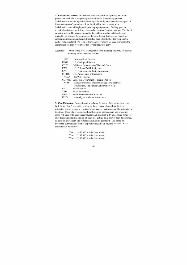
8/3/2019 Recovery Plan for the Tidewater Goby
http://slidepdf.com/reader/full/recovery-plan-for-the-tidewater-goby 69/208
61
4. Responsible Parties. In the table, we have identified agencies and other
parties that we believe are primary stakeholders in the recovery process.
Stakeholders are those agencies who may voluntarily participate in any aspect of
implementation of particular actions listed within this recovery plan.
Stakeholders may willingly participate in project planning, funding, provide
technical assistance, staff time, or any other means of implementation. The list of potential stakeholders is not limited to the list below; other stakeholders are
invited to participate. In some cases, the most logical lead agency (based on
authorities, mandates, and capabilities) has been identified as the “responsible
party” with an asterisk (*). The following abbreviations are used to indicate the
stakeholder for each recovery action for the tidewater goby:
Agencies: refers to the local lead agencies with planning authority for actions
that may affect the listed species
NPS National Park ServiceUSGS U.S. Geological Survey
CDFG California Department of Fish and Game
FWS U.S. Fish and Wildlife Service
EPA U.S. Environmental Protection Agency
CORPS U.S. Army Corps of Engineers
NOAA NOAA Fisheries
CLTRNS California Department of Transportation
NGO Nongovernmental organizations (e.g., The Surfrider
Foundation, The Nature Conservancy, etc.)
PVT Private partiesTBD To be determined
MULTI Multiple stakeholders involved
UNIV University or academic researchers
5. Cost Estimates. Cost estimates are shown for some of the recovery actions,
both for the first 5 years after release of the recovery plan and for the total
estimated cost of recovery. Costs of some recovery actions cannot be estimated at
this time. Costs of developing and implementing management and protection
plans will vary with local circumstances and details of individual plans. Sites for
introduction and reintroduction of tidewater gobies have not yet been determined,so costs of assessment and restoration cannot be estimated. The scope of
necessary contaminants studies depends on results of ongoing research. Cost
estimates are as follows:
Year 1: $450,000 + to be determined
Year 2: $285,000 + to be determined
Year 3: $230,000 + to be determined
8/3/2019 Recovery Plan for the Tidewater Goby
http://slidepdf.com/reader/full/recovery-plan-for-the-tidewater-goby 70/208
62
Year 4: $275,000 + to be determined
Year 5: $275,000 + to be determined
TOTAL: $1,980,000 + to be determined

8/3/2019 Recovery Plan for the Tidewater Goby
http://slidepdf.com/reader/full/recovery-plan-for-the-tidewater-goby 71/208
Implementation Schedule for the Tidewater Goby Draft Recovery Plan
Cost EAction
PriorityAction
Number Action DescriptionAction
DurationResponsible
Parties TotalCosts
Year1
1 1.2.1 Develop and implement management strategies toavoid further direct net loss/modification of habitatand restore degraded habitat.
2 years MULTI 70
1 1.2.5 Develop and implement strategies for managingwater quality within current or enhanced parameters.
Continual MULTI 360 80
1 1.2.8 Monitor tidewater goby population status and trends,and habitat conditions.
5 years FWS*,MULTI
340 80
1 2.1 Determine water quality parameters for tidewater goby habitat.
2 years FWS* 20
1 2.9 Determine the genetic diversity and intraspecific phylogeny of the tidewater goby.
Ongoing UNIV* TBD
6 3
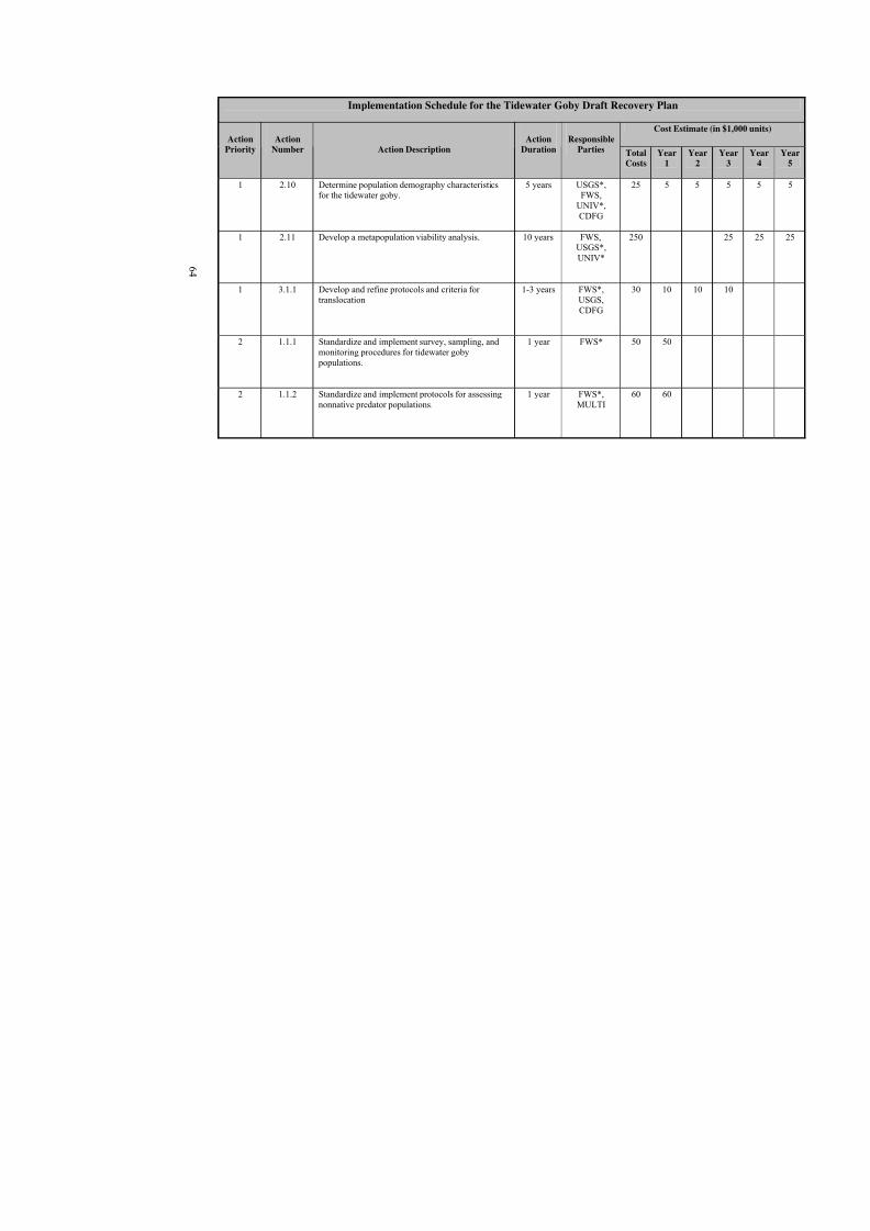
8/3/2019 Recovery Plan for the Tidewater Goby
http://slidepdf.com/reader/full/recovery-plan-for-the-tidewater-goby 72/208
Implementation Schedule for the Tidewater Goby Draft Recovery Plan
Cost E
ActionPriority
ActionNumber Action Description
ActionDuration
ResponsibleParties Total
CostsYear
1
1 2.10 Determine population demography characteristicsfor the tidewater goby.
5 years USGS*,FWS,
UNIV*,CDFG
25 5
1 2.11 Develop a metapopulation viability analysis. 10 years FWS,USGS*,UNIV*
250
1 3.1.1 Develop and refine protocols and criteria for translocation
1-3 years FWS*,USGS,CDFG
30 10
2 1.1.1 Standardize and implement survey, sampling, andmonitoring procedures for tidewater goby populations.
1 year FWS* 50 50
2 1.1.2 Standardize and implement protocols for assessingnonnative predator populations.
1 year FWS*,MULTI
60 60
6 4

8/3/2019 Recovery Plan for the Tidewater Goby
http://slidepdf.com/reader/full/recovery-plan-for-the-tidewater-goby 73/208
Implementation Schedule for the Tidewater Goby Draft Recovery Plan
Cost E
ActionPriority
ActionNumber Action Description
ActionDuration
ResponsibleParties Total
CostsYear
1
2 1.1.3 Standardize and implement protocols for assessingimpacts and source of sedimentation in tidewater goby habitat.
2 years FWS*, TBD 20 20
2 1.2.3 Develop and implement strategies for managingdeleterious exotic species at current or reducedlevels.
Continual FWS*,MULTI
250
2 1.2.11 Standardize and implement protocols for rescue of tidewater goby populations.
1 year FWS* 10
2 2.3 Investigate the interactions of tidewater gobies withexotic species.
3 years USGS* 40 20
2 2.4 Conduct studies to determine how to minimize thethreats of deleterious exotic species.
Continual FWS* TBD
2 2.6 Conduct studies to determine how to minimize theeffects of sedimentation.
Continual MULTI TBD
2 2.7 Conduct studies to determine how to minimize theeffects of natural and anthropogenic breaching.
Continual FWS* TBD
2 2.8 Describe natural tidewater goby habitatcharacteristics.
1 year FWS* 10 10
6 5

8/3/2019 Recovery Plan for the Tidewater Goby
http://slidepdf.com/reader/full/recovery-plan-for-the-tidewater-goby 74/208
Implementation Schedule for the Tidewater Goby Draft Recovery Plan
Cost E
ActionPriority
ActionNumber Action Description
ActionDuration
ResponsibleParties Total
CostsYear
1
2 2.12 Conduct annual aerial surveys to quantify habitatlosses and identify areas that have high potential for habitat creation/restoration.
Continual USGS*,CDFG
TBD
2 2.13.1 Reevaluate recovery criteria. Ongoing FWS* 125 5
2 2.13.2 Keep recovery plan current and useful. Continual FWS* TBD
2 2.13.3 Revise maps on recovery Sub-Units as new geneticdata become available.
Ongoing FWS*,UNIV*
TBD
2 3.1.2 Incorporate research findings into protocols 1-3 years FWS*,USGS,CDFG
30 15
2 3.2 Implement translocation in subunits 5 years FWS*,USGS*,CDFG
TBD TBD
2 4.1 Prepare and distribute brochures and educationalmaterials on the tidewater goby and its habitat.
1 year MULTI 30 30
2 4.2 Develop a website that will educate the public on thetidewater goby and recovery actions.
1 year MULTI 40 40
6 6
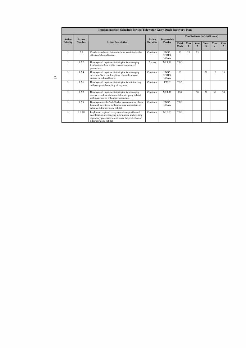
8/3/2019 Recovery Plan for the Tidewater Goby
http://slidepdf.com/reader/full/recovery-plan-for-the-tidewater-goby 75/208
Implementation Schedule for the Tidewater Goby Draft Recovery Plan
Cost E
ActionPriority
ActionNumber Action Description
ActionDuration
ResponsibleParties Total
CostsYear
1
3 2.5 Conduct studies to determine how to minimize theeffects of channelization.
Continual FWS*,CORPS, NOAA
50 25
3 1.2.2 Develop and implement strategies for managingfreshwater inflow within current or enhanced parameters.
2 years MULTI TBD
3 1.2.4 Develop and implement strategies for managingadverse effects resulting from channelization at
current or reduced levels.
Continual FWS*,CORPS,
NOAA
50
3 1.2.6 Develop and implement strategies for minimizinganthropogenic breaching of lagoons.
Continual FWS* TBD
3 1.2.7 Develop and implement strategies for managingexcessive sedimentation in tidewater goby habitatwithin current or enhanced parameters.
Continual MULTI 120
3 1.2.9 Develop umbrella Safe Harbor Agreement or obtainfinancial incentives for landowners to maintain or enhance tidewater goby habitat.
Continual FWS*, NOAA
TBD
3 1.2.10 Implement regional ecosystem strategies throughcoordination, exchanging information, and existingregulatory processes to maximize the protection of tidewater goby habitat.
Continual MULTI TBD
6 7
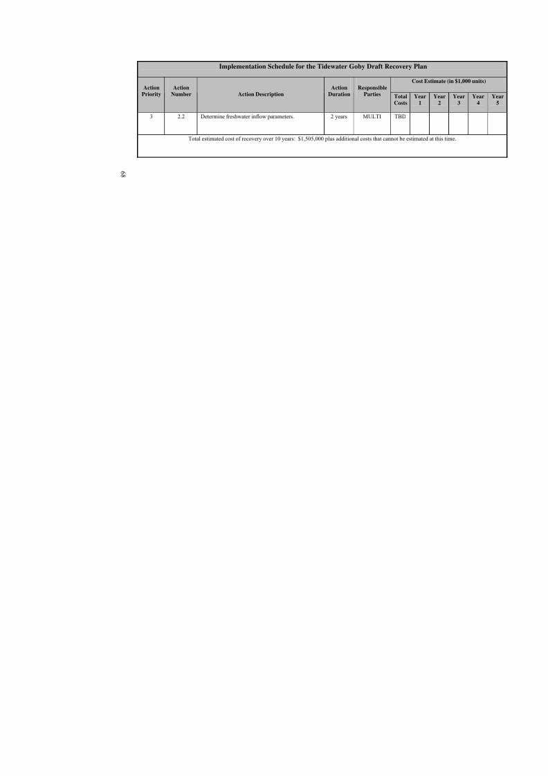
8/3/2019 Recovery Plan for the Tidewater Goby
http://slidepdf.com/reader/full/recovery-plan-for-the-tidewater-goby 76/208
Implementation Schedule for the Tidewater Goby Draft Recovery Plan
Cost E
ActionPriority
ActionNumber Action Description
ActionDuration
ResponsibleParties Total
CostsYear
1
3 2.2 Determine freshwater inflow parameters. 2 years MULTI TBD
Total estimated cost of recovery over 10 years: $1,505,000 plus additional costs that cannot be estimated
6 8
8/3/2019 Recovery Plan for the Tidewater Goby
http://slidepdf.com/reader/full/recovery-plan-for-the-tidewater-goby 77/208
69
VI. REFERENCES
A. Literature Cited
Ahnelt H., J. Göschl, M. N. Dawson and D. K. Jacobs. 2004. Geographicalvariation in the cephalic lateral line canals of Eucyclogobius newberryi (Teleostei, Gobiidae) and its comparison with molecular phylogeography.Folia Zoologica 53(4):385-398.
Akihito and K. S. Sakamoto. 1989. Reexamination of the status of the stripedgoby. Japanese Journal of Ichthyology 36:100-112.
Akihito, K. S. Sakamoto, Y. Ikeda, and K. Sugiyama. 2002. Gobiidae. Pp. 1154-1259, 1596-1605. In: Tetsuji Nakabo, Editor. Fishes of Japan with pictorial keys to the species, English Edition, volume II, Tokai UniversityPress, Tokyo, Japan.
Aquatic Nuisance Task Force. 1993. Findings, conclusions, andrecommendations of the intentional introductions policy review. ProposedReport to Congress, 37 pp.
Barlow, M. 2002. Phylogeographic structure of the tidewater goby, Eucyclogobius newberryi (Teleostei: Gobiidae), in the San Francisco Bayarea and Ventura County: Implications for Conservation Management. Athesis submitted in partial satisfaction of the requirements for the degreeMaster of Arts in Biology, University of California at Los Angeles.
Baltz, D. M. 1991. Introduced fishes in marine systems and inland seas.Biological Conservation 56:151-177.
Bascom, W. 1980. Waves and Beaches. Revised and updated edition. Anchor Books, Doubleday Publishing, New York. xviii + 366 pp.
Birdsong, R. S., E. O. Murdy, and F. L. Pezold. 1988. A study of the vertebralcolumn and median fin osteology in gobioid fishes with comments ongobioid relationships. Bulletin of Marine Science 42:174-214.
Carroll, R., C. Augsperger, A. Dobson, J. Franklin, G. Orians, W. Reid, R. Tracy,D. Wilcove, and J. Wilson. Strengthening the use of science in achievingthe goals of the Endangered Species Act: An assessment by theEcological Society of America. Ecological Applications 6:1-11.
Courtenay, W. R., Jr. and J. D. Williams. 1992. Dispersal of exotic species fromaquaculture sources, with emphasis on freshwater fishes. Pp. 49-81 in: A.

8/3/2019 Recovery Plan for the Tidewater Goby
http://slidepdf.com/reader/full/recovery-plan-for-the-tidewater-goby 78/208
70
Rosenfield and R. Mann (Eds.), Dispersal of Living Organisms intoAquatic Ecosystems.
Crabtree, C. B. 1985. Allozyme variability in the tidewater goby, Eucyclogobius
newberryi (Pisces: Gobiidae). Isozyme Bulletin 18:70.
Daehler, D. C. and D. R. Strong. 1995. Impact of high herbivore densities onintroduced smooth cordgrass, Spartina alterniflora, invading SanFrancisco Bay, California. Estuaries 18:409-417.
Dawson, M. N., J. L. Stanton, and D. K. Jacobs. 2001. Phylogeography of thetidewater goby, Eucyclogobius newberryi (Teleostei, Gobiidae), in coastalCalifornia. Evolution 55(6):1167-1179.
Dawson, M.N., K.D. Louie, M. Barlow, D.K. Jacobs and C.C. Swift. 2002.Comparative phylogeography of sympatric sister species, Clevelandia ios
and Eucyclogobius newberryi (Teleostei, Gobiidae), across the CaliforniaTransition Zone. Molecular Ecology 11:1065-1075.
Doak, D. F. and L. S. Mills. 1994. A useful role for theory in conservation.Ecology 75:615-626.
Eigenmann, C. H., and R. Eigenmann. 1892. A catalogue of the fishes of thePacific coast of America north of Cerros Island. Annals New York Academy of Sciences 6:349-358.
Eschmeyer, W.N., E.S. Herald, and H. Hamann. 1983. A field guide to Pacificcoast fishes of North America. Houghton Mifflin Co., Boston, xxi + 336 pp.
Feldmuth, R. and D. Soltz. 1986. Biological Survey of San Mateo Lagoon.Report to Marine Corps Base Camp Pendleton.
Ferren, W., P.L. Fiedler, and R.A. Leidy. 1995. Wetlands of the central andsouthern California coast and coastal watersheds. A methodology for their classification and description. Final Report to U. S. EnvironmentalProtection Agency, Region IX, San Francisco, CA and EnvironmentalReport. No. 1, Museum of Systematics and Ecology, University of California, Santa Barbara, ix + 500 pp.
Gill, T. 1863. Notice of a collection of fishes of California presented to theSmithsonian Institution by Mr. Samuel Hubbard. Proceedings of theAcademy of Natural Sciences of Philadelphia 14:274-282.
8/3/2019 Recovery Plan for the Tidewater Goby
http://slidepdf.com/reader/full/recovery-plan-for-the-tidewater-goby 79/208
71
Gilpin, M.E. 1987. Spatial structure and population vulnerability. Pp. 125-139in: M. E. Soule, editor. Viable Populations for Conservation. CambridgeUniversity Press, New York, New York.
Ginsburg, I. 1945. Contribution to a methodology in the caudal fin ray count of
fishes and its use in classification. Copeia, 1945:133-142.
Girard, C. 1856. A list of the fishes collected in California by Mr. E. Samuels,with descriptions of the new species. Boston Journal of Natural History6:533-544.
Haaker, P. 1979. Two Asiatic gobiid fishes, Tridentiger trigonocephalus, and Acanthogobius flavimanus, in southern California. Bulletin of theSouthern California Academy of Sciences 78:65-61.
Habel, J.S. and G.A. Armstrong. 1977. Assessment and atlas of shoreline erosion
along the California coast. California Department of Navigation andOcean Development, vii + 277 pp.
Hackney, C.T. and A.A. de la Cruz. 1981. Some notes on the macrofauna of anoligohaline tidal creek in Mississippi. Bulletin of Marine Science 31:658-661.
Hagar, J. 2005. 2004 annual report to USFWS for recovery permit TE-089980-0for Jeff Hagar. Report dated 16 March 2005 and received by VFWO 21March 2005.
Hanski, I. 1989. Metapopulation dynamics - does it help to have more of thesame? Trends in Ecology and Evolution 4:113-114.
Hanski, I., and M. E. Gilpin. 1991. Metapopulation dynamics: brief history andconceptual domain. Biological Journal of the Linnean Society 42:3-16.
Hastings, R.W. and D.R. Heinle. (Organizers) 1995. The effects of aquaculture inestuarine environments: Dedicated issue. Estuaries, Vol. 18, No. 1A, 197 pp.
Holland, D. 1992. The distribution and status of the tidewater goby( Eucyclogobius newberryi) on Camp Pendleton, San Diego County,
California. Environmental and Natural Resources Office, CampPendleton, Unpublished Report.
Holland, D., C. Swift, and N. Sisk. 2001. Status, distribution, and habitat use of the tidewater goby, Eucyclogobius newberryi (Telestei:Gobiidae), onMCB Camp Pendleton, California 1998-2001. Final Report for AC/SEnvironmental Security, MCB Camp Pendleton, CA, by Camp Pendleton

8/3/2019 Recovery Plan for the Tidewater Goby
http://slidepdf.com/reader/full/recovery-plan-for-the-tidewater-goby 80/208
72
Amphibian and Reptile Survey, Fallbrook, CA Contract #M00681-00-P-1347.
Hubbs, C.L., and R.R. Miller. 1965. Studies of cyprinodont fishes. XXII.Variation in Lucania parva, its establishment in western United States,
and descriptions of a new species from an interior basin in Coahuila,Mexico. Miscellaneous Publications of the Museum of Zoology,University of Michigan, No. 127, 104 pp.
Hubbs, C.L., W.I. Follet, and L.C. Hubbs. 1979. List of the fishes of California.Occasional Papers of the California Academy of Sciences. Number 113,51 pp.
Irwin, J.F., and D.L. Soltz. 1984. The natural history of the tidewater goby, Eucyclogobius newberryi, in the San Antonio and Schuman Creek system,Santa Barbara County, California. U.S. Fish and Wildlife Service,
Sacramento Endangered Species Office Contract No. 11310-0215-2.
Jordan, D.S., and B.W. Evermann. 1898. The fishes of North and MiddleAmerica: a descriptive catalogue of the species of fish-like vertebratesfound in the waters of North American, north of the Isthmus of Panama.Bull. Uni. Sta. Nat. Mus., No. 47, Pt. III, pp. xxiv, 2183-3136.
Lafferty, K.D. 1997. Tidewater goby collection report, 1996 and 1997. Reportto U.S. Fish and Wildlife Service.
Lafferty, K.D., and C.J. Page. 1997. Predation on the endangered tidewater goby, Eucyclogobius newberryi, by the introduced African clawed frog, Xenopus laevis, with notes on the frog's parasites. Copeia 3:589-592.
Lafferty, K. D., C. C. Swift, and R. F. Ambrose. 1996. Post-flood persistence of tidewater goby populations. Abstract for the Southern CaliforniaAcademy of Sciences 1996 Annual Meeting.
Lafferty, K.D., C.C. Swift, and R.F. Ambrose. 1999a. Postflood persistence andrecolonization of endangered tidewater goby populations. NorthAmerican Journal of Fisheries Management 19:618-622.
Lafferty, K.D., C.C. Swift, and R.F. Ambrose. 1999b. Extirpation andrecolonization in a metapopulation of an endangered fish, the tidewater goby. Conservation Biology 13:1447-1453.
Lewitus, A.J., R.V. Jesien, T.M. Kana, J.M. Burkholder, H.B. Glasgow, Jr., andE. May. 1995. Discovery of the "Phantom" dinoflagellate inChesapeake Bay. Estuaries 18:373-378.

8/3/2019 Recovery Plan for the Tidewater Goby
http://slidepdf.com/reader/full/recovery-plan-for-the-tidewater-goby 81/208
73
Mace, G. M., and R. Lande. 1991. Assessing extinction threats: Toward areevaluation of IUCN threatened species categories. ConservationBiology 5:148-157.
Mason, H.L. 1957. A flora of the marshes of California. University of California
Press, Berkeley. ix + 878 pp.
Miller, D.J., and R.N. Lea. 1972. Guide to the coastal marine fishes of California. California Department of Fish and Game Bulletin 157.
Moyle, P.B., J.E. Williams, and E.D. Wikuamanayake. 1989. Fish species of special concern in California. Final Report for California Department of Fish and Game. Contract No. 7337.
Moyle, P.B., and J.E. Williams. 1990. Biodiversity loss in the temperate zone:Decline of the native fish fauna of California. Conservation Biology
4:275-284.
Moyle, P.B. 2002. Inland Fishes of California revised and expanded. Universityof California Press, Berkeley, California.
Naiman, R.J., G. Pinay, C.A. Johnston, and J. Pastor. 1994. Beaver influences onthe long-term biogeochemical characteristics of boreal forest drainagenetworks. Ecology 75:905-921.
National Research Council. 1995. Science and the Endangered Species Act. National Academy Press; Washington, DC. 271 pages.
Nelson, J. S., E. J. Crossman, H. Espinosa-Perez, L. T. Findley, C. R. Gilbert, R. N. Lea, and J. D. Williams. 2004. Common and scientific names of fishesfrom the United States, Canada, and Mexico. American Fisheries Society,Special Publication 29, Bethesda, MD. 386 pages.
Ohmart, R.D., B.W. Anderson, and W.C. Hunter. 1988. The ecology of thelower Colorado River from Davis Dam to the Mexican-United StatesInternational Boundary: A community profile. U. S. Fish and WildlifeService, Biological Report 85, xvi + 296 pp.
Pavlik, B. M. 1996. Defining and measuring success. Pages 127-156 in: D. A.Falk, C. I. Millar, and M. Olwell, Eds. Restoring diversity: Strategies for reintroduction of endangered plants. Island Press, Covelo, California.
Purer, E.A. 1942. Plant ecology of the coastal salt marshlands of San DiegoCounty, California. Ecological Monographs 12:81-111.

8/3/2019 Recovery Plan for the Tidewater Goby
http://slidepdf.com/reader/full/recovery-plan-for-the-tidewater-goby 82/208
74
Rathbun, G. 1991. Status of declining aquatic reptiles, amphibians, and fishes inthe lower Santa Rosa Creek, Cambria, California. Report to Greenspace;A land trust, Cambria, California.
Rieman, B.E. and J.D. McIntyre. 1993. Demographic and habitat requirements
for conservation of bull trout. U.S. Department of Agriculture, ForestService General Technical Report INT-302. Intermountain ResearchStation, Ogden, Utah. 38 pp.
Schemske, D. W., B. C. Husband, M. H. Ruckelshaus, C. Goodwillie, I. M.Parker, and J. G. Bishop. 1994. Evaluating approaches to theconservation of rare and endangered plants.
Scott, J. M., T. H. Tear, and L. S. Mills. 1995. Socioeconomics and the recoveryof endangered species: Biological assessment in a political world.Conservation Biology 9:214-216.
Shapavalov, L., and A.C. Taft. 1954. The life histories of the steelhead rainbowtrout (Salmo gairdneri gairdneri) and silver salmon (Oncorhynchus
kisutch). California Department of Fish and Game Bulletin 98, 575 pp.
Sjögren-Gulve, P. and Hanski, I. 2000. Metapopulation viability analysis usingoccupancy models. Ecological Bulletins 48:53-71.
Smith, J.J. 1998. Report of tidewater goby and California red-legged frogsampling results for 1997, to U.S. Fish and Wildlife Service. Unpublishedmanuscript.
Steindachner, F. 1879. Icthyologische beiträge VIII. Sitzungsberichte der Akademie der Wissenschaften 80:119-191.
Stevenson, D. E. 2000. Discovery of the holotype of Chaenogobius annularisGill (Perciformes: Gobiidae) and its taxonomic consequences. Copeia(3):835-840.
Swenson, R.O. 1993a. The ecology and reproductive biology of the tidewater goby ( Eucyclogobius newberryi). pp. 341-352. In: The WesternProceedings, 1993 Annual Conference Western Association of Fish andWildlife Agencies, Western Divison, American Fisheries Society, July 22-29, Sacramento, CA.
Swenson, R.O. 1993b. Marshes build better gobies: Population dynamics andreproduction in an estuarine fish, Eucyclogobius newberryi. AmericanZoologist 33:441 (Abst.)

8/3/2019 Recovery Plan for the Tidewater Goby
http://slidepdf.com/reader/full/recovery-plan-for-the-tidewater-goby 83/208
75
Swenson, R.O. 1994. A survey of the tidewater goby ( Eucyclogobius newberryi)at Rodeo Lagoon, Marin County, California. Unpublished Report for the
Golden Gate National Recreation Area.
Swenson, R.O. 1995. The reproductive behavior and ecology of the tidewater
goby Eucyclogobius newberryi (Pisces: Gobiidae). Ph.D. Dissertation,University of California at Berkeley.
Swenson, R.O. 1999. The ecology, behavior, and conservation of the tidewater goby, Eucyclogobius newberryi. Environmental Biology of Fishes 55:99-119.
Swenson, R.O.,and S.A. Matern. 1995. Interactions between two estuarinegobies, the endangered tidewater goby ( Eucyclogobius newberryi) and arecent invader, the shimofuri goby (Tridentiger bifasciatus). Presented,Cal-Neva Chapter American Fisheries Society, Napa, California, 3
February 1995.
Swenson, R.O., and A.T. McCray. 1996. Feeding ecology of the tidewater goby.Trans. Amer. Fish. Soc. 125:956-970.
Swift, C.C. and G.D. Frantz. 1981. Estuarine fish communities of Ballona[Marsh]. Pp. F 1-32. In: R. Schrieber (Ed.), Biota of the Ballona Region,Los Angeles County. Suppl. I, Marina Del Rey/Ballona Local CoastalPlan, Natural History Museum of Los Angeles County.
Swift, C.C., R.W. Yerger, and P.F. Parrish. 1977. Distribution and natural
history of the fresh and brackish water fishes of the Ocklockonee River,Florida and Georgia. Bull. Tall Timbers Research Station No. 20,Tallahassee.
Swift, C.C., J.L. Nelson, C. Maslow, and T. Stein. 1989. Biology anddistribution of the tidewater goby, Eucyclogobius newberryi (Pisces:Gobiidae) of California. Natural History Museum of Los Angeles County, No. 404.
Swift, C.C., T.R. Haglund, M. Ruiz, and R.N. Fisher. 1993. The status anddistribution of the freshwater fishes of southern California. Bull. S. Calif.Acad. Sci. 92:101-167.
Swift, C.C., J.N. Baskin, and T.R. Haglund. 1994. The status and distribution of the tidewater goby, Eucyclogobius newberryi (Pisces: Gobiidae), on MCBCamp Pendleton, California. Marine Corps Base Camp Pendleton, Reportfor Contract Number M0068193P4385. 69 pp.
8/3/2019 Recovery Plan for the Tidewater Goby
http://slidepdf.com/reader/full/recovery-plan-for-the-tidewater-goby 84/208
76
Swift, C.C., P. Duangsitti, C. Clemente, K. Hasserd, and L. Valle. 1997. Biologyand distribution of the tidewater goby, Eucyclogobius newberryi, onVandenberg air force Base, Santa Barbara County, California. FinalReport, USNBS Cooperative Agreement 1445-007-94-8129. 121 pp.
Swift, C.C., and D.C. Holland. 1998. The status and distribution of the tidewater goby, Eucyclogobius newberryi (Pisces, Gobiidae), on MCB CampPendleton, California. Final report for Environmental Security, MarineCorps Base Camp Pendleton, California. Report for Contract Number MOO68196T5642. 104 pp.
Taylor, B. L. 1995. The reliability of using population viability analysis for risk classification of species. Conservation Biology 9:551-558.
Tear, T. H., J. M. Scott, P. H. Hayward, and B. Griffith. 1993. Status and prospects for success of the Endangered Species Act: A look at recovery
plans. Science 262:976-977.
U.S. Fish and Wildlife Service. 1983. Endangered and threatened species:Listing and recovery priority guidelines. Federal Register 48:43098-43105. September 21, 1983.
U.S. Fish and Wildlife Service. 1994. Endangered and threatened wildlife and plants: determination of endangered species status for the tidewater goby.Federal Register 59:21(1994):5494-5498.
U.S. Fish and Wildlife Service. 1999. Endangered and threatened wildlife and plants: proposed rule to move the northern populations of tidewater gobyfrom the list of endangered and threatened wildlife. Federal Register 64:33816-33825.
U.S. Fish and Wildlife Service. 2000. Endangered and threatened wildlife and plants: designation of critical habitat for the tidewater goby. FederalRegister 65:69693-69717.
U.S. Fish and Wildlife Service. 2002. Endangered and threatened wildlife and plants: withdrawal of proposed rule to remove the northern populations of the tidewater goby from the list of endangered and threatened wildlife.Federal Register 67:67803-67818.
Wang, J.C.S. 1982. Early life history and protection of the tidewater goby( Eucyclogobius newberryi)(Girard) in the Rodeo Lagoon of the GoldenGate National Recreation Area. Cooperative National Park ResearchStudy Unit, Technical Report 7, Institute of Ecology, University of California, Davis, CPSU/UCD 022/3.

8/3/2019 Recovery Plan for the Tidewater Goby
http://slidepdf.com/reader/full/recovery-plan-for-the-tidewater-goby 85/208
77
Worcester, K.R. 1992. Habitat utilization in a central California coastal lagoon
by the tidewater goby ( Eucyclogobius newberryi). Masters thesis,California Polytechnic State University, San Luis Obispo.
Worcester, K.R., and R.N. Lea. 1996. Observations on tidewater goby habitat
utilization and laboratory maintenance during the California drought.Unpublished abstract from Symposium on tidewater goby, SouthernCalifornia Academy of Sciences Annual Meeting at Loyola Marymount
University May 3-4, 1996.
B. Personal Communications
Ahnelt, Harald. 2005. University of Vienna, Austria.
Anderson, David. 2004. Redwood National Park.
Bosch, Ray. 2004. Arcata Fish and Wildlife Office, U.S. Fish and Wildlife
Service, Arcata, California.
Even, Tom. 1993. Department of Biology, University of California, Santa
Barbara, California.
Ferren, Wayne. 1995. Museum of Systematic Biology, University of California,
Santa Barbara, California.
Goldsmith, Greg. 2005. U.S. Fish and Wildlife Service, Arcata, California.
Holland, Dan. 1992. Department of Biology, Southwestern Louisiana
University, Monroe, Louisiana.
Jacobs, David. 2004. University of California, Los Angeles, California.
Lafferty, Kevin. 1994, 1996, 2005. U.S. Geological Survey, Santa Barbara,
California.
Miljkovic, Natascha. 2005. University of Vienna, Austria.
Sinnen, Wade, and Janice Curl. 1992. California Department of Fish and Game.
Smith, Jerry. 1996, 2004, 2005. Biology Department, San Jose State University,
San Jose, California.
Swift, Camm. 1995, 2004, 2005. Entrix, Inc.

8/3/2019 Recovery Plan for the Tidewater Goby
http://slidepdf.com/reader/full/recovery-plan-for-the-tidewater-goby 86/208
A-1
Appendix A. Glossary
adaptive management a method of using known information, hypotheses,
and information gained while managing a system toalter management practices so that the managementobjectives can be more readily attained. Adaptivemanagement may be used to improve themanagement system in a relatively risk-free way, itcan be used to reduce management risk anduncertainty, or it can be used to choose amongmanagement alternatives with unknown or uncertain effects.
allele one of two or more alternative forms of a gene
which occupy corresponding loci in homologouschromosomes.
allozyme form of an enzyme that differs in amino acidsequence, as shown by electrophoretic mobility or some other property, from other forms of the sameenzyme and is encoded by one allele at a singlelocus.
amphipods a variety of small aquatic crustacean, used by fishfor food.
anoxic lacking oxygen.
anterior toward the head or front end of an organism.
aquatic of or in water; streams, lakes, rivers, ponds, andmarshes are aquatic habitats.
benthic a bottom dwelling community of organisms.
bottleneck a relatively short period of time during which the
size of a population becomes unusually small,resulting in a random change in gene frequencies.
clade a branch of biological taxa or species that sharefeatures inherited from a common ancestor.
colonization the act or process of establishing a new colony or population.

8/3/2019 Recovery Plan for the Tidewater Goby
http://slidepdf.com/reader/full/recovery-plan-for-the-tidewater-goby 87/208
A-2
cytochrome any of group of iron heme enzymes or carrier
proteins in the oxidative and photosynthetic electrontransport chains used in the study of heredity andvariation.
DNA deoxyribonucleic acid, the genetic material of allorganisms (except RNA viruses); in eukaryotesDNA is confined to the nucleus, mitochondria, and plastids.
endemic native to or confined to a certain region.
estuary a partially enclosed coastal water body that isconnected to the ocean. Salinity here is measurablyreduced by the freshwater flow of rivers and
streams.
exotic not native to the area, introduced from another region or country.
extinct no longer existing. Can refer to a species in itsentirety, or in a particular part of the range.
extirpated extinct in a particular area.
founder effect the possibility that a new, small, isolated populationmay diverge genetically because the foundingindividuals are a random sample from a large, main population.
FST a statistical measure used to reflect the history of small populations created from colonization events.
habitat the environment in which a species or populationlives and grows. Different types of habitats may beused for different life stages.
haplotype a set of closely linked genetic markers present onone chromosome which tend to be inheritedtogether.
Holocene the geological period comprising approximately thelast 10,000 years.

8/3/2019 Recovery Plan for the Tidewater Goby
http://slidepdf.com/reader/full/recovery-plan-for-the-tidewater-goby 88/208
A-3
hypersaline term to characterize waters with salinity greater that40 parts per thousand.
lagoon a shallow sound, channel, or pond near or communicating with a larger body of water.
listed species recognized by Federal or State governmentsas endangered or threatened.
macroalgae algal plants large enough either as individuals or communities to be readily visible without the aid of optical magnification.
metapopulation several to many subpopulations for tidewater gobiesthat are close enough to one another that dispersingindividuals could be exchanged.
microsatellite a microsatellite consists of a specific sequence of DNA bases or nucleotides which contains mono, di,tri, or tetra tandem repeats.
mitochondria one of the minute, spherical, rod-shaped or filamentous organelles present in all cells.
monophyletic organisms in a group are known to have developedfrom a common ancestral form, and all descendantsof that form are included in the group.
pH a common measure of the acidity or alkalinity of aliquid.
phylogeographic the geographic distributions of genealogicallineages, especially those within and among closelyrelated species.
phylogeny the evolutionary interrelatedness of an organism or group of organisms.
phytoplankton photosynthesizing planktonic organisms.
piscivorous fish eating animal.
Pleistocene an epoch of the Quaternary period beginning about1.6 million years ago and ending about 10,000 yearsago. Best known as a time of extensive continentalice sheets.

8/3/2019 Recovery Plan for the Tidewater Goby
http://slidepdf.com/reader/full/recovery-plan-for-the-tidewater-goby 89/208
A-4
Pliocene the last epoch of the Tertiary period, during which
man and most species of modern mammals cameinto existence.
population in the wider sense, all tidewater gobies throughouttheir range. In the narrower sense, used to refer tothe tidewater gobies in one particular locality; acollection of individuals that share a common gene pool.
Pterygiophore ossified and/or cartilaginous elements to whicharticulate the median fin rays or spines and to whichare attached erector and depressor fin muscles.
ostracod a variety of small aquatic crustacean, used by fish
for food.
Quaternary period a geological period which includes both thePleistocene and Holocene periods comprising thesecond portion of the Cenozoic ere, characterized by the rise of man and modern mammals.
recovery units regions of the species’ distribution that are distinctfrom one another based on geomorphology andgenetic diversity.
riparian terrestrial areas adjacent to aquatic habitats; on the bank of a stream, river, estuary, lagoon, or lake.
salinity the concentration of salt in a solution.
singleton population an individual population that is distinct from othersgrouped with it.
source/sink characterizing a metapopulation consisting of actively breeding source subpopulations (whichhave average birth rates exceeding average deathrates, and thus produce an excess of juveniles thatmay disperse to other areas) and sink subpopulations (with death rates exceeding birthrates, thus functioning to absorb dispersers).
squamation arrangement of scales

8/3/2019 Recovery Plan for the Tidewater Goby
http://slidepdf.com/reader/full/recovery-plan-for-the-tidewater-goby 90/208
A-5
standard length a fish measurement from the tip of the snout to thehypural bone (approximately origin of caudal fin).
subpopulation a group of tidewater gobies using a particular breeding site or area; several to many
subpopulations constitute a metapopulation.
Sub-Unit an area within a recovery unit that supports atidewater goby population showing significantdifferences in genetics from other populations.
supraorbital canal that portion of the lateral line system on thetidewater gobies head which begins at its junctionwith the lateral canal behind mid-eye, courses upand over the eye, and continues forward nearly tothe tip of the snout.
taxon a level in the classification system, such as species,genus, family, or order.
UTM Universal Transverse Mercator projection.
viability capability to survive; for populations, the ability tosurvive into the foreseeable future.

8/3/2019 Recovery Plan for the Tidewater Goby
http://slidepdf.com/reader/full/recovery-plan-for-the-tidewater-goby 91/208
±
Crescent City
Tillas Slough
(Smith River)
Lake Talawa/
Lake Earl
NC 1a
NC 1b
North Coast
Recovery Unit
Sub-Unit NC 1
Elk Creek (I)NC 1c
KÎ
KË
KË
0 52.5Miles
Ventura Fish & Wildlife Office GIS
Tidewater Goby Occurrence Data: CDFG, Natural Heritage Division, California NaturalDiversity Database, 2005; personal communication, Drs. C. Swift, K . Lafferty, and D. JacobsCoastal Streams derived from USGS 1:100,000 Digital Line Graph Data
Locations Occupied by
Tidewater Gobies
Potential Introduction Locations
(No Historical Records)Elk Creek (I)
Figure B-1. North Coast Recovery Unit (Sub-Unit NC-1)B-1
Appendix B. Maps of Recovery Units

8/3/2019 Recovery Plan for the Tidewater Goby
http://slidepdf.com/reader/full/recovery-plan-for-the-tidewater-goby 92/208
Big Lagoon
Patrick's Point
Freshwater Lagoon
Redwood Creek Estuary
Stone Lagoon
NC 2a
NC 2b
NC 2c
NC 2d
KË
±0 52.5Miles
Ventura Fish & Wildlife Office GIS
Tidewater Goby Occurrence Data: CDFG, Natural Heritage Division, California NaturalDiversity Database, 2005; personal communication, Drs. C. Swift, K. Lafferty, and D. JacobsCoastal Streams derived from USGS 1:100,000 Digital Line Graph Data
North Coast
Recovery UnitSub-Unit NC 2
Locations Occupied
By Tidewater GobiesStone Lagoon
Locations Occupied Historically
by Tidewater Gobies (Extirpated) Freshwater Lagoon
Figure B-2. North Coast Recovery Unit (Sub-Unit NC-2)B-2
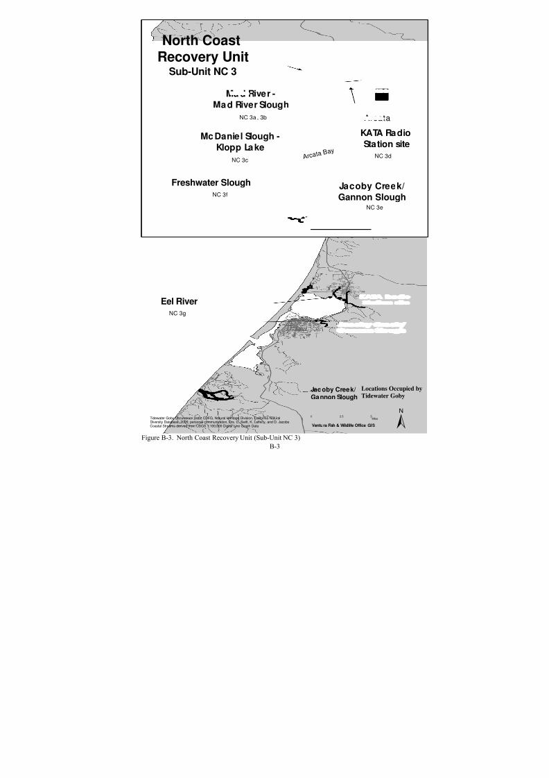
8/3/2019 Recovery Plan for the Tidewater Goby
http://slidepdf.com/reader/full/recovery-plan-for-the-tidewater-goby 93/208
Mc Daniel Slough -
Klopp Lake
AØ
Eureka
Arcata
Freshwater Slough
Ma d River -
Mad River Slough
KË
KATA Radio
Station site
Jacoby Creek/
Gannon Slough
NC 3a , 3b
NC 3c
NC 3e
NC 3d
NC 3f
NC 3g
Eel River
A r c a t a B a y
Tidewater Goby Occurrence Data: CDFG, Natural Heritage Division, California NaturalDiversity Database, 2005; personal communication, Drs. C. Swift, K. Lafferty, and D. JacobsCoastal Streams derived from USGS 1:100,000 Digital Line Graph Data
North CoastRecovery Unit
Sub-Unit NC 3
±0 52.5
Miles
Ventura Fish & Wildlife Office GIS
Locations Occupied by
Tidewater GobyJac oby Creek/Gannon Slough
Figure B-3. North Coast Recovery Unit (Sub-Unit NC 3)B-3

8/3/2019 Recovery Plan for the Tidewater Goby
http://slidepdf.com/reader/full/recovery-plan-for-the-tidewater-goby 94/208
Fort Bragg
Virgin Creek
NC 4a
NC 5a
PuddingCreek
NC 5b
?ç
?Ò
Tenmile River
Tidewater Goby Occurrence Data: CDFG, Natural Heritage Division, California NaturalDiversity Database, 2005; personal communication, Drs. C. Swift, K. Lafferty, and D. JacobsCoastal Streams derived from USGS 1:100,000 Digital Line Graph Data
North Coast
Recovery UnitSub-Units NC 4 and NC 5
Ventura Fish & Wildlife Office GIS
0 52.5Miles ±
Locations Occupied byTidewater Gobies
Virgin Creek
Figure B-4. North Coast Recovery Unit (Sub-Units NC 4 and NC 5)B-4

8/3/2019 Recovery Plan for the Tidewater Goby
http://slidepdf.com/reader/full/recovery-plan-for-the-tidewater-goby 95/208
Point Arena
Lagoon Creek
Brush Creek
Davis Pond
?Ò
NC 6b
NC 6c
NC 6a
Tidewater Goby Occurrence Data: CDFG, Natural Heritage Division, California NaturalDiversity Database, 2005; personal communication, Drs. C. Swift, K. Lafferty, and D. JacobsCoastal Streams derived from USGS 1:100,000 Digital Line Graph Data
North Coast
Recovery UnitSub-Unit NC 6
0 52.5Miles ±Ventura Fish & Wildlife Office GIS
Locations Occupied by
Tidewater GobiesDavis Pond
Figure B-5. North Coast Recovery Unit (Sub-Unit NC 6)B-5

8/3/2019 Recovery Plan for the Tidewater Goby
http://slidepdf.com/reader/full/recovery-plan-for-the-tidewater-goby 96/208
AÏ
GB 1a
GB 2c
?Ò
?Ò
Marshall Gulch (I)
GB 1b
Salmon CreekEstero Americano
Estero de
San Antonio
GB 2d
Walker Creek (R)GB 2e
GB 2b
Cheney Gulch
Bodega Head
Johnson Gulc h (I)
GB 1a
T o m a l e s B
a y
Tidewater Goby Occurrence Data: CDFG, Natural Heritage Division, California NaturalDiversity Database, 2005; personal communication, Drs. C. Swift, K. Lafferty, and D. JacobsCoastal Streams derived from USGS 1:100,000 Digital Line Graph Data
Greater Bay Area
Recovery UnitSub-Unit GB 1 and GB 2
0 52.5Miles ±Ventura Fish & Wildlife Office GIS
Locations Occupied by
Tidewater GobiesSalmon Creek
Locations Occupied Historicallyby Tidewater Gobies (Extirpated)
(R)= Potential Reintroduction Sites
Cheney Gulch
Potential Introduction Locations
(No Historical Records)Ma rsha ll Gulc h (I)
Figure B-6. Greater Bay Area Recovery Unit (Sub-Units GB 1 and GB 2)B-6
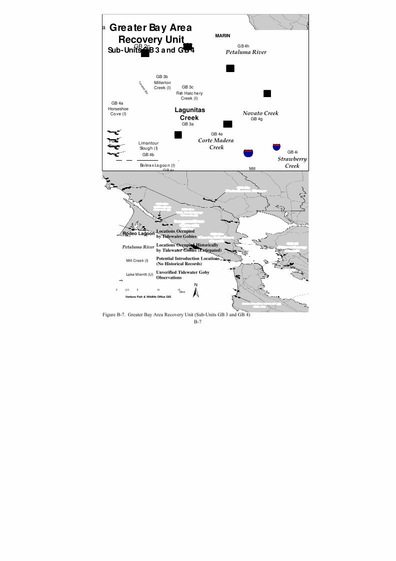
8/3/2019 Recovery Plan for the Tidewater Goby
http://slidepdf.com/reader/full/recovery-plan-for-the-tidewater-goby 97/208
Corte MaderaCreek
?Ò
KË
!"c$
?ú
?Ò
%&n(
?¾
PillarPoint
PointReyes
Rodeo Lagoon
Cliff House Restaurant
StrawberryCreek
Petaluma River
a
GB 2c
?Ò
Lake Merced
Lake Merritt (U)
KË
Bolina s La goo n (I)
Horseshoe
Cove (I)
Limantour
Slough (I)
Millerton
Creek (I)
Fish Hatc hery
Creek (I)GB 4a
GB 3b
GB 3c
GB 3a
GB 4b
GB 4c
GB 4e
GB 4d
GB 4k
GB 4I
Laguna
Sa lad a (I)
San Pedro Creek (I)
GB 4m
GB 4n
GB 4h
GB 4g
GB 4i
GB 4f
Mill
Creek (I)
KË
AÏ
Novato Creek
GB 4j
Lagunitas
Creek
T o m a l e s B
a y
MARIN
SAN MATEO
Tidewater Goby Occurrence Data: CDFG, Natural Heritage Division, California NaturalDiversity Database, 2005; personal communication, Drs. C. Swift, K. Lafferty, and D. JacobsCoastal Streams derived from USGS 1:100,000 Digital Line Graph Data
Greater Bay Area
Recovery UnitSub-Units GB 3 a nd GB 4
0 5 10 152.5Miles ±Ventura Fish & Wildlife Office GIS
Potential Introduction Locations
(No Historical Records)Mill Creek (I)
Petaluma River Locations Occupied Historically
by Tidewater Gobies (Extirpated)
Rodeo LagoonLocations Occupied
by Tidewater Gobies
Unverified Tidewater Goby
ObservationsLake M erritt (U)
Figure B-7. Greater Bay Area Recovery Unit (Sub-Units GB 3 and GB 4)B-7

8/3/2019 Recovery Plan for the Tidewater Goby
http://slidepdf.com/reader/full/recovery-plan-for-the-tidewater-goby 98/208
San Gregorio CreekGB 5a
GB 5c
Pescadero-Butano Creek
Bean Hollow CreekGB 5d
Pomponio Creek (I)GB 5b
?Ò
?±
Tidewater Goby Occurrence Data: CDFG, Natural Heritage Division, California NaturalDiversity Database, 2005; personal communication, Drs. C. Swift, K. Lafferty, and D. JacobsCoastal Streams derived from USGS 1:100,000 Digital Line Graph Data
Greater Bay AreaRecovery Unit
Sub-Unit GB 5
0 52.5Miles ±Ventura Fish & Wildlife Office GIS
Locations Occupied by
Tidewater Gobies
Bean Hollow Creek
Potential Introduction Locations
(No Historical Records)Pomponio Creek (I)
Pescadero - Butano Creek }
Figure B-8. Greater Bay Area Recovery Unit (Sub-Unit GB 5)
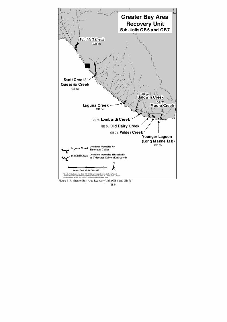
8/3/2019 Recovery Plan for the Tidewater Goby
http://slidepdf.com/reader/full/recovery-plan-for-the-tidewater-goby 99/208
Waddell Creek
Scott Creek/
Queseria Creek
Laguna Creek
Baldwin Creek
Lombardi Creek
Old Dairy Creek
Wilder CreekYounger Lagoon
(Long Marine Lab)
Moore Cree k
GB 6a
GB 7d
GB 7c
GB 7b
GB 6c
GB 6b
GB 7a
GB 7f
GB 7e
Tidewater Goby Occurrence Data: CDFG, Natural Heritage Division, California NaturalDiversity Database, 2005; personal communication, Drs. C. Swift, K. Lafferty, and D. JacobsCoastal Streams derived from USGS 1:100,000 Digital Line Graph Data
Greater Bay Area
Recovery UnitSub-Units GB 6 and GB 7
0 52.5Miles ±Ventura Fish & Wildlife Office GIS
?Ò
Locations Occupied by
Tidewater GobiesLaguna Creek
Locations Occupied Historically
by Tidewater Gobies (Extirpated)Waddell Creek
Figure B-9. Greater Bay Area Recovery Unit (GB 6 and GB 7)B-9

8/3/2019 Recovery Plan for the Tidewater Goby
http://slidepdf.com/reader/full/recovery-plan-for-the-tidewater-goby 100/208
Soquel
Creek
Salinas
River (R)
Bennet Slough
Pajaro River
Aptos
CreekMoran Lake
Corcoran Lagoon
?Ò
?à
?Ò
Añ
San Lorenzo
River
GB 8a
GB 8b
GB 8c
GB 9a
GB 9b
GB 10a
GB 11a
GB 11b
Tidewater Goby Occurrence Data: CDFG, Natural Heritage Division, California NaturalDiversity Database, 2005; personal communication, Drs. C. Swift, K. Lafferty, and D. JacobsCoastal Streams derived from USGS 1:100,000 Digital Line Graph Data
Greater Bay Area
Recovery UnitSub-Units GB 8 through GB 11
0 52.5Miles ±Ventura Fish & Wildlife Office GIS
Salinas River Locations Occupied Historicallyby Tidewater Gobies (Extirpated)(R)= Potential Reintroduction Sites
Aptos Creek
Locations Occupied
by Tidewater Gobies
Figure B-10. Greater Bay Area Recovery Unit (Sub-Units GB 8 to GB 11)B-10

8/3/2019 Recovery Plan for the Tidewater Goby
http://slidepdf.com/reader/full/recovery-plan-for-the-tidewater-goby 101/208
Arroyo
de la C ruz (I)
Arroyo del Oso
Arroyo del Corra lCC 1a
CC 1a
CC 1c
Oa k Knoll Creek
(Arroyo Laguna)Arroyo de Tortuga
Arroyo del Puerto
Broken Bridge Creek
Little Pico Creek
Pico Creek
San Simeon Creek
Leffingwell Creek
Santa Rosa Creek
CC 2a
CC 2b
CC 2c
CC 2e
CC 2f
CC 2g
CC 2h
CC 2i
CC 2d?Ò
Cambria
Tidewater Goby Occurrence Data: CDFG, Natural Heritage Division, California NaturalDiversity Database, 2005; personal communication, Drs. C. Swift, K. Lafferty, and D. JacobsCoastal Streams derived from USGS 1:100,000 Digital Line Graph Data
Central Coast
Recovery UnitSub-Units CC 1 and CC 2
0 52.5Miles ±Ventura Fish & Wildlife Office GIS
Potential Introduction Locations
(No Historical Records)Arroyo de la C ruz (I)
Leffingwell CreekLocations Occupied Historically
by Tidewater Gobies (Extirpated)
Little Pico CreekLocations Occupied
by Tidewater Gobies
Figure B-11. Central Coast Recovery Unit (Sub-Units CC 1 and CC 2)B-11

8/3/2019 Recovery Plan for the Tidewater Goby
http://slidepdf.com/reader/full/recovery-plan-for-the-tidewater-goby 102/208
Villa Creek
San Geronimo Creek
Cayucos Creek
Little Cayucos Creek
Toro Creek
Los Osos Creek
Morro Creek
Chorro Creek
Willow Creek
Old Creek
CC 3a
CC 3b
CC 3c
CC 3d
CC 3e
CC 3f
CC 3g
CC 3h
CC 3i
CC 3j
Morro Bay
?Ò
Tidewater Goby Occurrence Data: CDFG, Natural Heritage Division, California NaturalDiversity Database, 2005; personal communication, Drs. C. Swift, K. Lafferty, and D. JacobsCoastal Streams derived from USGS 1:100,000 Digital Li ne Graph Data
Central Coast
Recovery UnitSub-Unit CC 3
0 52.5Miles ±Ventura Fish & Wildlife Office GIS
Locations Occupied Historically
by Tidewater Gobies (Extirpated)
Locations Occupied
by Tidewater Gobies
Morro Creek
Villa Creek
Figure B-12. Central Coast Recovery Unit (Sub-Unit CC 3)B-12
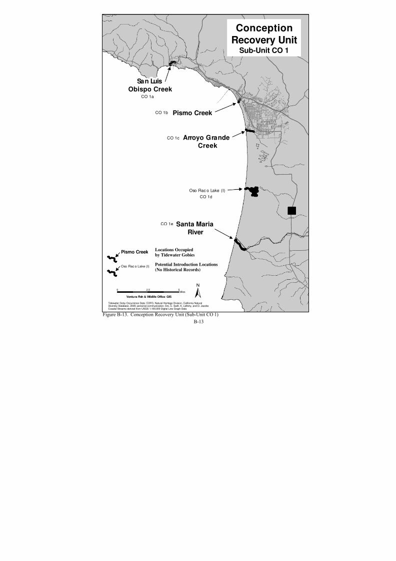
8/3/2019 Recovery Plan for the Tidewater Goby
http://slidepdf.com/reader/full/recovery-plan-for-the-tidewater-goby 103/208
San Luis
Obispo Creek
Pismo Creek
Santa Maria
River
Oso Flac o Lake (I)
Arroyo Grande
Creek
?Ò
CO 1d
CO 1a
CO 1b
CO 1c
CO 1e
Tidewater Goby Occurrence Data: CDFG, Natural Heritage Division, California NaturalDiversity Database, 2005; personal communication, Drs. C. Swift, K. Lafferty, and D. JacobsCoastal Streams derived from USGS 1:100,000 Digital Line Graph Data
Conception
Recovery UnitSub-Unit CO 1
0 52.5Miles ±Ventura Fish & Wildlife Office GIS
Potential Introduction Locations
(No Historical Records)Oso Flac o Lake (I)
Pismo Creek Locations Occupiedby Tidewater Gobies
Figure B-13. Conception Recovery Unit (Sub-Unit CO 1)B-13
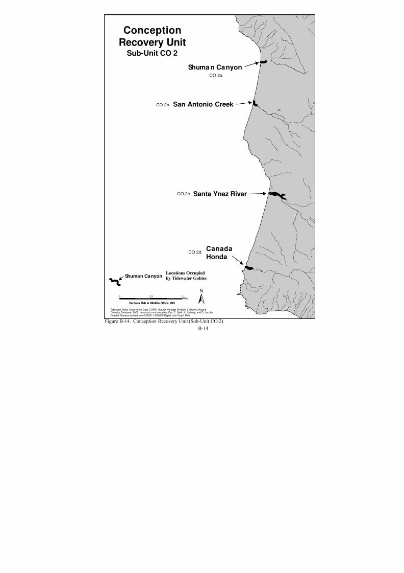
8/3/2019 Recovery Plan for the Tidewater Goby
http://slidepdf.com/reader/full/recovery-plan-for-the-tidewater-goby 104/208
Shuma n Canyon
Canada
Honda
Santa Ynez River
San Antonio Creek
CO 2a
CO 2b
CO 2c
CO 2d
Tidewater Goby Occurrence Data: CDFG, Natural Heritage Division, California NaturalDiversity Database, 2005; personal communication, Drs. C. Swift, K. Lafferty, and D. JacobsCoastal Streams derived from USGS 1:100,000 Digital Line Graph Data
ConceptionRecovery Unit
Sub-Unit CO 2
0 52.5Miles ±Ventura Fish & Wildlife Office GIS
Shuman CanyonLocations Occupied
by Tidewater Gobies
Figure B-14. Conception Recovery Unit (Sub-Unit CO-2)B-14

8/3/2019 Recovery Plan for the Tidewater Goby
http://slidepdf.com/reader/full/recovery-plan-for-the-tidewater-goby 105/208
Jalama Cree k
Canada de Agua Ca liente
Gaviota Creek
Canada de l Agua
Canada de las Agujas
Canad del Pescado/
San Augustine
Canada del Cojo
Arroyo Hondo
Arroyo Quema d
Canada de Alegria
KË
Canada de
Santa Anita
?Ò
Refugi
Creek
Arroyo e l Bulito
CO 3a
CO 3e
CO 3c
CO 3b
CO 3h
CO 3i
CO 3jCO 3k
CO 3f
CO 3g
CO 3
CO 3m
CO 3d
Tidewater Goby Occurrence Data: CDFG, Natural Heritage Division, California NaturalDiversity Database, 2005; personal communication, Drs. C. Swift, K. Lafferty, and D. JacobsCoastal Streams derived from USGS 1:100,000 Digital Line Graph Data
Conception Recovery Unit
Sub-Unit CO 3
(Western Half)
0 52.5Miles ±Ventura Fish & Wildlife Office GIS
Jalama Creek Locations Occupied byTidewater Gobies
Figure B-15. Conception Recovery Unit (Sub-Unit CO 3, Western Half)

8/3/2019 Recovery Plan for the Tidewater Goby
http://slidepdf.com/reader/full/recovery-plan-for-the-tidewater-goby 106/208
CO 3n
Eagle
Canyon
Aò
KË
Tecolote
Canyon
Rincon
Creek
Carpinteria
Creek
Carpinteria
Salt Marsh
Arroyo
ParedonLaguna
ChannelMission
CreekArroyo
Burro
Sycamore
CreekDevereux
Slough
Winchester/
Bell CanyonCO 3o
CO 3q
CO 3p
CO 3t
CO 3aa
CO 3z
CO 3y
CO 3xCO 3u
CO 3v
CO 3w
CO 3s
Andre Clark
Bird Refuge(Outlet)
Goleta
Sloug h (I)
KËCO 3r
Santa
Barbara
^
Tidewater Goby Occurrence Data: CDFG, Natural Heritage D ivision, California NaturalDiversity Database, 2005; personal communication, Drs. C. Swift, K. Lafferty, and D. JacobsCoastal Streams derived from USGS 1:100,000 Digital Line Graph Data
Conception Recovery UnitSub-Unit CO 3
(Eastern Half)
0 52.5Miles ±Ventura Fish & Wildlife O ffice G IS
Locations Occupied by
Tidewater GobiesEagle Canyon
Locations Occupied Historically
by Tidewater Gobies (Extirpated)CarpinteriaSalt Marsh
Potential Introduction Locations
(No Historical Records)Goleta Slough (I)
Figure B-16. Conception Recovery Unit (Sub-Unit CO 3, Eastern Half)

8/3/2019 Recovery Plan for the Tidewater Goby
http://slidepdf.com/reader/full/recovery-plan-for-the-tidewater-goby 107/208
Ventura RiverLV 1a
Santa Clara
RiverLV 1b
Calleguas Creek- Mugu Lagoon
LV 1d
Zuma
Canyon (I)
LV 1g
J Street Drain/
Ormond LagoonLV 1c
Arroyo
Seq uit (I)
Sycam ore
Canyon (I)
LV 1e
LV 1f
AØKË
?Ò?ë
Tidewater Goby Occurrence Data: CDFG, Natural Heritage Division, California NaturalDiversity Database, 2005; personal communication, Drs. C. Swift, K. Lafferty, and D. JacobsCoastal Streams derived from USGS 1:100,000 Digital Line Graph Data
LA/ Ventura Recovery Unit
Sub-Unit LV 1
(Western Half)
0 52.5Miles
±Ventura Fish & Wildlife Office GIS
Locations Occupied byTidewater Gobies
Ventura River
Locations Occupied Historicallyby Tidewater Gobies (Extirpated)
Mugu Lagoon
Potential Introduction Locations(No Historical Records)
Arroyo Seq uit
Figure B-17. LA/Ventura Recovery Unit (Sub-Unit LV 1, Western Half)

8/3/2019 Recovery Plan for the Tidewater Goby
http://slidepdf.com/reader/full/recovery-plan-for-the-tidewater-goby 108/208
Zuma
Canyon (I)
LV 1g
)Malibu
CreekLV 1h
Topanga
CreekLV 1i
Santa Monica Artesian Springs
LV 1j
Ballona
Creek (I)
LV 1k
^
Malibu
^Ma rina Del Rey
^
Santa Mo nic a
^Redondo Beach
?þ
?ë
Los Angeles
Tidewater Goby Occurrence Data: CDFG, Natural Heritage Division, California NaturalDiversity Database, 2005; personal communication, Drs. C. Swift, K. Lafferty, and D. JacobsCoastal Streams derived from USGS 1:100,000 Digital Line Graph Data
LA/ Ventura Recovery Unit
Sub-Unit LV 1
(Eastern Half)
0 52.5Miles ±Ventura Fish & Wildlife Office GIS
?Ò
Locations Occupied byTidewater Gobies
Malibu Creek
Locations Occupied Historicallyby Tidewater Gobies (Extirpated)
Santa Monica Artesian Springs
Potential Introduction Locations(No Historical Records)
Zuma Ca nyon (I)
Figure B-18. LA/Ventura Recovery Unit (Sub-Unit LV 1, Eastern Half)

8/3/2019 Recovery Plan for the Tidewater Goby
http://slidepdf.com/reader/full/recovery-plan-for-the-tidewater-goby 109/208
San Pedro
Harbor (U)
Bolsa Chica (I)
SC 1a
SC 1b ?Ò ^
Costa Mesa
^
Long Bea ch
^Santa Ana
^
Newport Beach
?Ú?Ø
Tidewater Goby Occurrence Data: CDFG, Natural Heritage Division, California NaturalDiversity Database, 2005; personal communication, Drs. C. Swift, K. Lafferty, and D. JacobsCoastal Streams derived from USGS 1:100,000 Digital Line Graph Data
South Coast Recovery Unit
Sub-Unit SC 1
(Western Half)
0 52.5Miles ±Ventura Fish & Wildlife Office GIS
Potential Introduction Locations
storical Records)Bolsa Chica (I)
San Ped ro Harbor (U)
(No Hi
Unverified Tidewater Goby Observations
Figure B-19. South Coast Recovery Unit (Sub-Unit SC 1, Western Half)
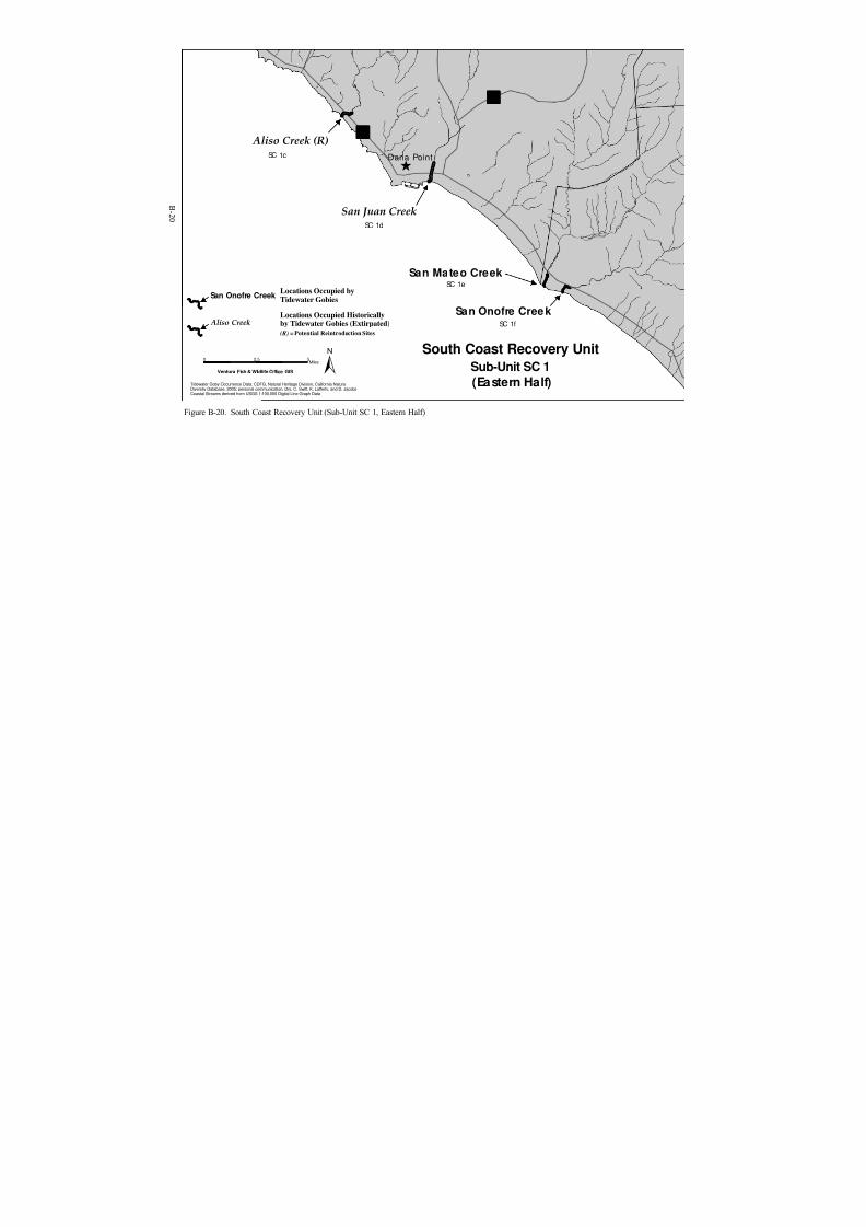
8/3/2019 Recovery Plan for the Tidewater Goby
http://slidepdf.com/reader/full/recovery-plan-for-the-tidewater-goby 110/208
^Dana Point
Aliso Creek (R)
San Juan Creek
San Mateo Creek
San Onofre Creek
SC 1c
SC 1d
SC 1e
SC 1f
?¦
?Ò
Tidewater Goby Occurrence Data: CDFG, Natural Heritage Division, California NaturalDiversity Database, 2005; personal communication, Drs. C. Swift, K. Lafferty, and D. JacobsCoastal Streams derived from USGS 1:100,000 Digital Line Graph Data
South Coast Recovery Unit
Sub-Unit SC 1
(Eastern Half)
0 52.5Miles ±Ventura Fish & Wildlife Office GIS
Locations Occupied byTidewater Gobies
San Onofre Creek
Aliso CreekLocations Occupied Historicallyby Tidewater Gobies (Extirpated)
(R) = Potential Reintroduction Sites
Figure B-20. South Coast Recovery Unit (Sub-Unit SC 1, Eastern Half)

8/3/2019 Recovery Plan for the Tidewater Goby
http://slidepdf.com/reader/full/recovery-plan-for-the-tidewater-goby 111/208
Cockleburr
CanyonSC 2e
Agua Hedionda Lagoon
SC 2i
San Ma rc os Creek-
Ba tiquitos Lagoon (I)
SC 2J
Esc ond ido Creek -
San Elijo Lagoon (I)
SC 2k
San Dieg uito
Lagoon (I)
SC 2l
Los Penasquitos
Lagoon (I)
SC 2m
Buena Vista Lagoon
SC 2h
Hidden LagoonSC 2b
French LagoonSC 2d
Las Flores/
Las Pulgas
Creek
SC 2a
Aliso
CanyonSC 2c
San Luis Rey River (R)SC 2g
Santa Margarita
RiverSC 2f
^ Oceanside
^
^ Leucadia
Carlsbad
Solana
Beach^
Yç
?©
?̈
Tidewater Goby Occurrence Data: CDFG, Natural Heritage Division, California NaturalDiversity Database, 2005; personal communication, Drs. C. Swift, K. Lafferty, and D. JacobsCoastal Streams derived from USGS 1:100,000 Digital Line Graph Data
South Coast
Recovery UnitSub-Unit SC 2
0 2.5Miles ±Ventura Fish & Wildlife Office GIS
Locations Occupied by
Tidewater GobiesFrench Lagoon
Locations Occupied Historicallyby Tidewater Gobies (Extirpated)
(R) = Potential Reintroduction Sites
San Luis Rey River
Potential Introduction Locations(No Historical Records)
San Dieg uito Lag oo n (I)
Figure B-21. South Coast Recovery Unit (Sub-Unit SC 2)
B-21

8/3/2019 Recovery Plan for the Tidewater Goby
http://slidepdf.com/reader/full/recovery-plan-for-the-tidewater-goby 112/208
C-1
Appendix C. Status of Recovery Sub-Units
This list of 160 localities is current to October 2005; all are represented onFigures B-1 to B-21 in Appendix B. This list includes 134 locations where
tidewater gobies either occur or are known historically to have occurred, 2locations with unverified occurrence records, and 24 locations where tidewater gobies are not known to occur, but could potentially be introduced. More detailedoriginal data are in Swift et al. (1989); additional data are given for new localities,or those that have changed. The localities are organized geographically in order from north to south, and are grouped by unit and Sub-Unit (e.g., North CoastUnit, Sub-Unit NC 1). County names are included with the Sub-Unit headingsand, as necessary, with specific localities. The localities are separated bydistinctly marine habitats, usually open coastline of the Pacific Ocean or lower San Francisco Bay. Closely located tributaries in more estuarine situations, suchas within Humboldt Bay, are treated as one locality. For each locality, we present
the following information: 1) The surface area of the body of water, based onestimates from topographic sheets and notes taken during visits over the last 25years, and based on a relatively high water mark at or near the maximum surfacearea within the relatively steep shores typical of the upper two-thirds or more of the lagoons at most localities, 2) land ownership, 3) the most recent year (for locations where tidewater gobies are known to occur) when tidewater gobies werecollected or observed to be present or absent, and 4) water quality description, based upon the State Water Resources Control Board’s 2002 Clean Water ActSection 303(d) List of Water Quality Limited Segments.
NORTH COAST UNIT
Sub-Unit NC1 (Del Norte County)
Tillas Slough - The available tidewater goby habitat encompasses approximately2 to 3 hectares (5 to 7.5 acres) minimum, but there may be as much as 200hectares (500 acres) of habitat in the Smith River estuary. All land adjacent toTillas Slough is privately owned. Tidewater gobies were collected in 1996 (C.Chamberlain, graduate student, Humboldt State University, pers. comm., 1996),and the species was considered common here in 1988. Tidewater gobies werecollected in October 1999 by C. Swift (February 2000 recovery permit report).Tidewater gobies were not found there during a 2003 survey by G. Goldsmith.Threats at this site include pollution from pasture runoff, anddisturbance/modification of drainage pattern. The area supporting tidewater gobies is small, and immediately down channel from a metal culvert crossing atrail/road with access to people staying at nearby lodging. Although connected tothe Smith River estuary, this site is the only recorded location of tidewater gobiesin the Smith River watershed. Tidewater gobies appear to be associated with thestructure near the culvert, which has included a large root wad. The population isvulnerable to any catastrophic event in this small area that would alter water
8/3/2019 Recovery Plan for the Tidewater Goby
http://slidepdf.com/reader/full/recovery-plan-for-the-tidewater-goby 113/208
C-2
quality, stream flow regime, or connectivity to other habitats. An event such asdredging or filling the area, chemical spills, stream channelization could quicklyextirpate the population. Tillas Slough and the Smith River estuary are notdesignated as “Water Quality Limited” by the State Water Resources ControlBoard.
Lake Earl/Lake Talawa - Lake Earl and Lake Talawa constitute two connectedcoastal lagoons that range in size from several hundred to a few thousand acresdepending on the season, time since breaching, and current water level. Much of this lagoon is within the Lake Earl Wildlife Area, managed by the CaliforniaDepartment of Fish and Game, and a California State Parks. This site is alsoadjacent to Pacific Shores Association land development. Tidewater gobies arealways present, possibly in the millions (C. Chamberlain, pers. comm. 1999).Tidewater gobies were collected during extensive surveys in 1999 by C. Page andin October 1999 by C. Swift (February 2000 recovery permit report). Gobieswere also collected by G. Goldsmith and California Department of Fish and Game
personnel in February 2002 and March 2003. Threats include artificial breachingof Lake Talawa, causing a rapid emptying of the lagoon which transports manythousands of gobies into the Pacific Ocean. Stranding of tidewater gobies withinLake Talawa and Lake Earl is well documented after breach events, as well as the presence of gobies at the breach site immediately prior to breaching. Despiteannual breaching for several years, the population of gobies has recovered and persisted in these lagoons in large numbers. Lake Earl and Lake Talawa are notdesignated as “Water Quality Limited” by the State Water Resources ControlBoard.
Elk Creek - The available tidewater goby habitat encompasses approximately 0.4hectare (1.0 acre). Elk Creek empties into Crescent City Harbor. This locality isentirely encompassed by private land. There are no historic tidewater gobyrecords for this locality, which is a potential introduction site. Tidewater gobieswere supposedly found by a Caltrans biologist; however, this account is undatedand unsubstantiated. C. Page surveyed the site in May of 1999 with nodetections. Tidewater gobies were not found during surveys in 2003 by G.Goldsmith. Threats include sedimentation from upstream development and localchannelization and culverting. Elk Creek is not designated as “Water QualityLimited” by the State Water Resources Control Board.
Sub-Unit NC2 (Humboldt County)
Redwood Creek Estuary, North Slough - The available tidewater goby habitatencompasses 1.0 to 4.0 hectares (2.5 to 10 acres). The site is managed byRedwood National and State Parks and private landowners. Tidewater gobieswere collected February to December 1980 by T. Salamunovich (M.S. thesis,Humboldt State University). Collected specimens were deposited at NaturalHistory Museum of Los Angeles County (LACM). Tidewater gobies have not been detected since 1980. Gobies were not found here in 1996 (D. Anderson,
8/3/2019 Recovery Plan for the Tidewater Goby
http://slidepdf.com/reader/full/recovery-plan-for-the-tidewater-goby 114/208
C-3
pers. comm. 2004), or in 1997 or 1998 (C. Chamberlain, pers. comm. 1998).Tidewater gobies are assumed extirpated here due to anoxic conditions in prior habitat, following a thorough search by D. Anderson that yielded no detections.Threats include channelization of Redwood Creek, separation of North Sloughfrom main channel, and severe alteration of natural flood flow regime in slough
and channel immediate upstream of slough. Redwood Creek is designated as“Water Quality Limited” by State Water Resources Control Board. Pollutants andstressors and their respective potential sources (in parentheses) includesedimentation/siltation (range grazing, silviculture, restoration, residuemanagement, logging road construction/maintenance, land development, removalof riparian* vegetation, streambank modification/destabilization, erosion/siltation,natural sources) and temperature (logging road construction/maintenance,removal of riparian vegetation, streambank modification/destabilization,erosion/siltation, natural sources, nonpoint source).
Freshwater Lagoon - Total size of lagoon encompasses approximately 100
hectares (250 acres). Redwood National and State Parks controls about 10 percent of the area, Caltrans controls sand spit and highway separating Freshwater Lagoon from the ocean, with remaining area in private ownership. Tidewater gobies were last collected in 1951; none have been detected during several recentsurveys. Tidewater gobies were not collected in 1996 (C. Chamberlain, pers.comm. 1996). Threats include the elimination of the natural breaching cycle dueto construction of State Route 101, and the introduction of centrarchids andsalmonids for recreational fishing. The reestablishment and maintenance of tidewater goby populations within this lagoon in the future are unlikely due to themore or less permanently altered breaching regime, elimination of salt water intrusion into the former lagoon, and naturally reproducing populations of introduced predatory fishes. Freshwater Creek is not designated as “Water Quality Limited” by the State Water Resources Control Board.
Stone Lagoon - Total size encompasses approximately 270 to 300 hectares (675to 750 acres). Dry Lagoon State Park controls about 60 percent of the area, withabout 40 percent in private ownership. Tidewater gobies have always been present during past surveys, and were most recently collected in 1997 (C.Chamberlain, pers. comm. 1997) and in 2003 by G. Goldsmith (U.S. Fish andWildlife Service). Threats include past history of planting coastal cutthroat trout,the possibility of a catastrophic chemical spill from adjacent State Route 101, andthe potential future alteration of breaching regime. Stone Lagoon is notdesignated as “Water Quality Limited” by the State Water Resources ControlBoard.
Big Lagoon - This locality is a large coastal lagoon, measuring 700 to 800hectares (1750 to 2000 acres). Big Lagoon County Park controls about 5 percent,Big Lagoon Rancheria about 5 percent, Dry Lagoon State Park about 30 percent;the remaining is private or corporate ownership. Tidewater gobies were detectedduring surveys in 2004 by G. Goldsmith. Threats include native salmonids, and
8/3/2019 Recovery Plan for the Tidewater Goby
http://slidepdf.com/reader/full/recovery-plan-for-the-tidewater-goby 115/208
C-4
potential threats include nonnative predatory fish and amphibians. Big Lagoon isnot designated as “Water Quality Limited” by the State Water Resources ControlBoard.
Sub-Unit NC3 (Humboldt County)
Northern Arcata Bay ( Humboldt Bay) - This locality encompassesapproximately 200 to 400 hectares (500 to 1000 acres), included in several smalllagoons and estuaries of coastal streams. About 20 percent owned by the City of Eureka, 30 percent by the City of Arcata, and 50 percent private. A tidewater goby observation was recorded in 1982 for Arcata Marsh/Klopp Lake (HumboldtState University Fisheries Museum). Tidewater gobies were not found in surveysof Arcata Marsh, Mad River Slough, and Freshwater Slough in Humboldt Bay in1996, but they were found in Jacoby Creek, a tributary to Arcata Bay (C.Chamberlain, pers. comm. 1996, G. Goldsmith 2003). Subsequently, staff fromthe Arcata Fish and Wildlife Service field office found tidewater gobies in the
upper end of Freshwater Slough in Wood Creek (G. Goldsmith, pers comm.2005). Tidewater gobies also have been found in Liscom Slough, a tributary toMad River Slough, collected October 1999 by C. Swift (Feb. 2000 recovery permit report), report of collection from Liscom Slough by C. Swift, 2001.Tidewater gobies were not found in Liscom Slough during a survey by G.Goldsmith (U.S. Fish and Wildlife Service) in 2003. Surveys conducted by G.Goldsmith in ditches tributary to Eureka Slough, 2001, and in Butchers Slough(lower Jolly Giant Creek), 2002 found no tidewater gobies in those small sites.Recently, in July 2005, a population of tidewater goby was discovered in GannonSlough, near Jacoby Creek, during surveys related to a restoration project. Nonumerical estimates are available at this time, but this newly discovered population may number 1,000 or more individuals. Threats at numerous siteswith suitable habitat in Humboldt Bay include operation of tide gates to controlwater flow, grazing, oil spill contamination, contamination from adjacent paper and lumber mill sites, highway construction and maintenance, alteration of streamflood flows, and possibly sedimentation. Humboldt Bay is designated as “Water Quality Limited” by State Water Resources Control Board. Pollutants andstressors and their respective potential sources (in parentheses) include PCBs(source unknown).
Eel River - The available tidewater goby habitat encompasses approximately 22hectares (55 acres). This location is owned by the California Department of Fishand Game, as part of the Eel River Wildlife Area. Tidewater gobies were foundin an unnamed slough here during surveys in 2004 (G. Goldsmith, pers. comm.2004). The Eel River delta is designated as “Water Quality Limited” by StateWater Resources Control Board. Pollutants and stressors and their respective potential sources (in parentheses) include sedimentation/siltation (range grazing,silviculture, nonpoint source) and temperature (removal of riparian vegetation,nonpoint source).

8/3/2019 Recovery Plan for the Tidewater Goby
http://slidepdf.com/reader/full/recovery-plan-for-the-tidewater-goby 116/208
C-5
Sub-Unit NC4 (Mendocino County)
Ten Mile River - The available tidewater goby habitat encompassesapproximately 30 to 50 hectares (75 to 100 acres). This locality is all privatelyowned, except for highway right-of-way and small portion of State parks.
Tidewater gobies were collected in 1997 (C. Chamberlain, pers. comm. 1997),October 1999 by C. Swift (February 2000 recovery permit report), and in 2003(G. Goldsmith, U.S. Fish and Wildlife Service). Threats include highwayconstruction and maintenance, dry season artificial breaching, and potentialchemical contamination from highway accidental spills. Ten Mile River isdesignated as “Water Quality Limited” by State Water Resources Control Board.Pollutants and stressors and their respective potential sources (in parentheses)include sedimentation/siltation (silviculture, road construction and maintenance)and temperature (habitat modification, removal of riparian vegetation, nonpointsource).
Sub-Unit NC5 (Mendocino County)
Virgin Creek - The available tidewater goby habitat encompasses approximately0.5 to 0.7 hectare (1.2 to 1.7 acres). The coastal one-third portion of this localitylies within McKerricher State Beach. There are several small residential propertyowners directly above State land adjacent to the creek. Tidewater gobiescollected there in 1996 by California Department of Fish and Game, in October 1999 by C. Swift (pers. comm. and recovery permit report), and in 2003 by G.Goldsmith. Threats include highway construction and maintenance, sewagecontamination, residential development. Virgin Creek is not designated as “Water Quality Limited” by the State Water Resources Control Board.
Pudding Creek - The available tidewater goby habitat encompassesapproximately 5 to 6 hectares (12.5 to 15 acres). About 45 percent of this localityoccurs in McKerricher State Beach, 45 percent is managed by the City of FortBragg, and 10 percent is privately owned. Tidewater gobies were collected in1997 (C. Chamberlain, pers. comm. 1997), Jan. 1998 by C. Page, and in 2003 byG. Goldsmith. Threats include water diversion directly upstream of the StateRoute 1 bridge, highway construction and maintenance, development, andrecreational use. Pudding Creek is not designated as “Water Quality Limited” bythe State Water Resources Control Board.

8/3/2019 Recovery Plan for the Tidewater Goby
http://slidepdf.com/reader/full/recovery-plan-for-the-tidewater-goby 117/208
C-6
Sub-Unit NC6 (Mendocino County)
Davis Pond/Lake Davis - The available tidewater goby habitat encompassesapproximately 1.0 to 3.1 hectares (2.6 to 7.7 acres). This locality occursapproximately 1.0 miles north of Brush Creek, on the edge of Manchester State
Park. Davis Pond is located approximately 250 feet south of Lake Davis, which isthe terminus for an unnamed creek. Davis Pond is likely contiguous with LakeDavis during periods of high water levels. Tidewater gobies were found in DavisPond in a July, 1996 survey (C. Chamberlain, pers. comm. 1997), and in 2003 byG. Goldsmith. Davis Pond is not designated as “Water Quality Limited” by theState Water Resources Control Board. Threats include exotic species; moreresearch is needed at this locality to determine other potential threats.
Brush Creek - The available tidewater goby habitat encompasses approximately0.2 to 0.5 hectare (0.5 to 1.2 acres). Approximately 75 percent of this localityoccurs in Manchester State Beach and about 25 percent is privately owned.
Tidewater gobies were last collected in 1990. Tidewater gobies were not found ina July 1996 survey. Tidewater gobies were not collected during trapping surveysin 2003; however, the trapping efforts were minimal and did not include all thesuitable habitat within Brush Creek and Lagoon Creek system, therefore, BrushCreek and Lagoon Creek are both considered extant populations (G. Goldsmith, pers comm. 2005). Threats include highway construction and maintenance, anddevelopment. Brush Creek is not designated as “Water Quality Limited” by theState Water Resources Control Board.
Lagoon Creek - The available tidewater goby habitat encompasses approximately20.5 hectares (50.6 acres). This locality occurs on privately owned land adjacentto Manchester Beach State Park, and is the terminus of Lagoon Creek, calledHunter’s Lagoon. Tidewater gobies were last collected in 1981 (Swift et al.1989). Tidewater gobies were not found during sampling in 2003 by G.Goldsmith; however, Lagoon Creek is considered extant for the reason describedin the Brush Creek description. Lagoon Creek is not designated as “Water Quality Limited” by the State Water Resources Control Board.
GREATER BAY AREA UNIT
Sub-Unit GB1 (Sonoma County)
Marshall Gulch - The available tidewater goby habitat encompassesapproximately 0.2 to 0.5 hectares (0.5 to 1.2 acres). There are no historictidewater goby records for this locality, which is a potential introduction site.Exotic fish species are a threat to the tidewater goby at this location. MarshallGulch is not designated as “Water Quality Limited” by the State Water ResourcesControl Board.

8/3/2019 Recovery Plan for the Tidewater Goby
http://slidepdf.com/reader/full/recovery-plan-for-the-tidewater-goby 118/208
C-7
Salmon Creek - The available tidewater goby habitat encompasses approximately9 to 12 hectares (22.5 to 36 acres). Approximately 75 percent of this locality isowned by Sonoma Beach State Park, and the rest is privately owned. Habitatdegradation resulting from sandbar breaching, water diversions, and groundwater pumping is a threat to the tidewater goby at this location. Tidewater gobies were
collected here in October of 1999 (C. Swift February 2000 permit report).Salmon Creek is not designated as “Water Quality Limited” by the State Water Resources Control Board.
Sub-Unit GB2 (Sonoma and Marin Counties)
Johnson Gulch - (Sonoma County) The available tidewater goby habitatencompasses approximately 0.2 to 0.5 hectare (0.5 to 1.2 acres). There are nohistoric tidewater goby records for this locality, which is a potential introductionsite. Johnson Gulch is not designated as “Water Quality Limited” by the StateWater Resources Control Board.
Cheney Gulch - (Sonoma County) The available tidewater goby habitatencompasses approximately 2 to 5 hectares (5 to 10 acres). Approximately 90 percent of this locality occurs in Doran County Park, and the rest is privatelyowned. Tidewater gobies were collected here in 1948, but were not found in 1996(C. Chamberlain pers. comm. 1999). Cheney Gulch is not designated as “Water Quality Limited” by the State Water Resources Control Board.
Estero Americano - (Marin County) The available tidewater goby habitatencompasses approximately 300 to 400 hectares (750 to 1000 acres). All of theadjacent lands are privately owned. Tidewater gobies were collected here inOctober of 1999 (C. Swift February 2000 permit report). The State Water Resources Control Board considers Estero Americano to be “Water QualityLimited” due to excess nutrients and sedimentation/siltation. The excess nutrientsare due to by pasture grazing and riparian and upland manure ponds. Thesedimentation/siltation is due to riparian and upland grazing, hydromodification,removal of riparian vegetation, streambank modification and destabilization,erosion and siltation, and nonpoint source runoff. The tidewater goby is alsothreatened by exotic fish species at this location.
Estero de San Antonio - (Marin County) The available tidewater goby habitatencompasses approximately 200 to 300 hectares (500 to 750 acres). All of theadjacent lands are privately owned. Tidewater gobies were collected here in 1997(C. Chamberlain, pers. comm. 1997). The State Water Resources Control Boardconsiders Estero de San Antonio to be “Water Quality Limited” due to excessnutrients and sedimentation. The excess nutrients are due to agriculture, irrigatedcrop production, riparian and upland pasture grazing, riparian range grazing,intensive animal feeding operations, concentrated animal feeding operations,agricultural runoff, land development, hydromodification, channelization,removal of riparian vegetation, streambank modification/destabilization, drainage

8/3/2019 Recovery Plan for the Tidewater Goby
http://slidepdf.com/reader/full/recovery-plan-for-the-tidewater-goby 119/208
C-8
and filling of wetlands, channel erosion, and natural sources. The sedimentationis due to agriculture, grazing, land development, erosion and siltation, andnonpoint sources. The tidewater goby is also threatened at this location by exoticfish species, habitat degradation due to sandbar breaching, water diversions, andgroundwater pumping.
Walker Creek - The available tidewater goby habitat encompasses approximately10 to 20 hectares (25 to 50 acres). All of the adjacent lands are privately owned.Tidewater gobies were collected here in 1897 (USNM 67297), but were not foundin 1996 or 1999 (C. Chamberlain, pers. comm. 1999; C. Swift Feb. 2000 recovery permit report). The State Water Resources Control Board considers Walker Creek to be “Water Quality Limited” due to mercury from surface mining andmine tailings, and nutrients and sedimentation/siltation from agriculture. TheTMDL ranges from 2,002 to 2,007.
Sub-Unit GB3 (Marin County)
Lagunitas ( Papermill ) Creek - The available tidewater goby habitat encompassesapproximately 10 to 20 hectares (25 to 50 acres). All of the adjacent lands are privately owned. Tidewater gobies were collected here in 1953, but were notfound in 1996 (C. Chamberlain pers. comm. 1999). Tidewater gobies were foundin lower Tomasini Creek, a tributary of the Lagunitas Creek delta, during surveysin 2003 (C. Swift, pers. comm. 2004). The State Water Resources Control Boardconsiders Lagunitas Creek to be “Water Quality Limited” due to excess nutrients, pathogens, and sedimentation/siltation due to agriculture, urban runoff, and stormsewers. The TMDL ranges from 2,002 to 2,007.
Millerton Gulch - The available tidewater goby habitat encompassesapproximately 1.0 to 3.0 hectares (2.5 to 7.4 acres). There are no historictidewater goby records for this locality, which is a potential introduction site.Millerton Gulch is not designated as “Water Quality Limited” by the State Water Resources Control Board.
Fish Hatchery Creek - The available tidewater goby habitat encompassesapproximately 1.0 to 3.0 hectares (2.5 to 7.4 acres). There are no historictidewater goby records for this locality, which is a potential introduction site.Fish Hatchery Creek is not designated as “Water Quality Limited” by the StateWater Resources Control Board.
Sub-Unit GB4 (Marin, Alameda, Contra Costa, San Francisco and SanMateo Counties)
Horseshoe Lagoon - (Marin County) The available tidewater goby habitatencompasses approximately 8 to 10 hectares (20 to 25 acres). There are nohistoric tidewater goby records for this locality, which is a potential introduction

8/3/2019 Recovery Plan for the Tidewater Goby
http://slidepdf.com/reader/full/recovery-plan-for-the-tidewater-goby 120/208
C-9
site. Horseshoe Lagoon is not designated as “Water Quality Limited” by the StateWater Resources Control Board.
Estero de Limantour - (Marin County) The available tidewater goby habitatencompasses approximately 40 to 121 hectares (100 to 300 acres). There are no
historic tidewater goby records for this locality, which is a potential introductionsite. Estero de Limantour is not designated as “Water Quality Limited” by theState Water Resources Control Board.
Bolinas Lagoon - (Marin County) The available tidewater goby habitatencompasses approximately 240 hectares (593 acres). There are no historictidewater goby records for this locality, which is a potential introduction site.Bolinas Lagoon is not designated as “Water Quality Limited” by the State Water Resources Control Board.
Rodeo Lagoon - (Marin County) The available tidewater goby habitat
encompasses approximately 15 to 20 hectares (37.5 to 50 acres) and is locatedentirely within the Golden Gate National Recreation Area. Tidewater gobies werecollected here in October of 1999 (C. Swift February 2000 recovery permitreport). Threats to the tidewater goby at this location include reduction or modification of habitat, and exotic fish species.
Corte Madera Creek - (Marin County) The available tidewater goby habitatencompasses approximately 20 to 25 hectares (50 to 62.5 acres). Approximately70 percent of the adjacent lands are in public and private ownership in the City of Larkspur, 20 percent are owned by the College of Marin, and ownership of 10 percent is unknown. Tidewater gobies were collected here in 1961. Tidewater gobies were not found during surveys here in 1994 (R. Swenson, pers. comm.2005). The State Water Resources Control Board considers Corte Madera Creek to be “Water Quality Limited” due to the pesticide Diazinon. High Diazinonlevels can cause water column toxicity. Diazinon is applied by homeowners principally in the late spring and early summer, and enters Corte Madera Creek with urban runoff and through storm sewers.
Mill Creek - (Marin County) The available tidewater goby habitat encompassesapproximately 0.2 to 0.5 hectare (0.5 to 1.2 acres). There are no historic tidewater goby records for this locality, which is a potential introduction site. Mill Creek isnot designated as “Water Quality Limited” by the State Water Resources ControlBoard.
Novato Creek - (Marin County) The available tidewater goby habitatencompasses approximately 10 to 20 hectares (25 to 50 acres) and is locatedmostly in the City of Novato. Tidewater gobies were collected here in 1945.Tidewater gobies were not found during surveys here in 1994 (R. Swenson, pers.comm. 2005). The State Water Resources Control Board considers Novato Creek to be “Water Quality Limited” due to the pesticide Diazinon. High Diazinon

8/3/2019 Recovery Plan for the Tidewater Goby
http://slidepdf.com/reader/full/recovery-plan-for-the-tidewater-goby 121/208
C-10
levels can cause water column toxicity. Diazinon is applied by homeowners principally in the late spring and early summer, and enters Novato Creek withurban runoff and through storm sewers. Tidewater gobies were collected here in1945.
Petaluma River - (Marin County) The available tidewater goby habitatencompasses approximately 30 to 40 hectares (75 to 100 acres) and is locatedmostly in the City of Petaluma. The only collection of tidewater gobies was by E.Samuels, before 1857, National Museum of Natural History (USNM) specimen360. Tidewater gobies were not found during recent surveys for a flood control project near Washington and Lynch Creeks (B. Cox, fishery biologist, pers.comm. 2004). Petaluma River is not designated as “Water Quality Limited” bythe State Water Resources Control Board.
Strawberry Creek - (Alameda County) The available tidewater goby habitatencompasses approximately 3 to 5 hectares (7.5 to 10 acres) and is located in the
City of Berkeley. Tidewater gobies were collected here in 1950. Tidewater gobies were not found during surveys here in 1994 (R. Swenson, pers. comm.2005). Strawberry Creek is not designated as “Water Quality Limited” by theState Water Resources Control Board.
Lake Merrit - (Alameda County) The available tidewater goby habitatencompasses approximately 64.8 hectares (160 acres). This locality occurs withinthe City or Oakland. There are no known observations of tidewater gobies at thislocation (C. Swift, pers. comm. 2005). However, Moyle (1975) notes anecdotalobservations of tidewater gobies from this location. The State Water ResourcesControl Board considers Lake Merrit to be “Water Quality Limited” due to lowdissolved oxygen, organic enrichment, and trash from urban runoff and stormsewers.
Cliff House (Sutro Baths) - (San Francisco County) The available tidewater gobyhabitat encompasses approximately 0.2 hectare (0.5 acre). This locality isFederally owned and managed by the National Park Service. A collection of 6specimens of tidewater gobies from the Cliff House (Sutro baths) are stored at the Natural History Museum of Vienna, Austria (Ahnelt et al. 2004). Thesespecimens were collected in 1874. Tidewater gobies were not found duringsurveys here in 2003 (M. McGowan, pers. comm. 2004). Sutro Baths is notdesignated as “Water Quality Limited” by the State Water Resources ControlBoard.
Lake Merced - (San Francisco County) The available tidewater goby habitatencompasses approximately 200 to 300 hectares (500 to 750 acres) and is locatedwithin the City and County of San Francisco. Two golf courses occur adjacent tothis locality. Tidewater gobies were collected here in 1895. No recent surveydata are available, but M. McGowan (Associate Professor, California StateUniversity, San Francisco) is initiating a fish study at this locality (M. McGowan,

8/3/2019 Recovery Plan for the Tidewater Goby
http://slidepdf.com/reader/full/recovery-plan-for-the-tidewater-goby 122/208
C-11
pers. comm. 2004). The State Water Resources Control Board considers LakeMerced to be “Water Quality Limited” due to low dissolved oxygen and pH.
Laguna Salada - (San Mateo County) The available tidewater goby habitatencompasses approximately 5.0 hectares (12.3 acres). This locality occurs
adjacent to a golf course. There are no historic tidewater goby records for thislocality, which is a potential introduction site. Laguna Salada is not designated as“Water Quality Limited” by the State Water Resources Control Board.
San Pedro Creek - (San Mateo County) The available tidewater goby habitatencompasses approximately 0.2 to 0.5 hectare (0.5 to 1.2 acres). There are nohistoric tidewater goby records for this locality, which is a potential introductionsite. San Pedro Creek is not designated as “Water Quality Limited” by the StateWater Resources Control Board.
Sub-Unit GB5 (San Mateo County)
San Gregorio Creek - The available tidewater goby habitat encompassesapproximately 5 to 10 hectares (12.5 to 25 acres). Approximately 25 percent of this locality occurs within San Gregorio State Beach. The remaining adjacentlands are privately owned. Tidewater gobies were abundant here in 1995 through1997 (J. Smith, pers. comm. 1998), August 1997 (J. Smith, APR for 1997, 1998),and October 1999 (C. Swift, pers. comm. 1999). The State Water ResourcesControl Board considers San Gregorio Creek to be “Water Quality Limited” dueto the high coliform levels and sedimentation/siltation from nonpoint sources.The tidewater goby is also threatened at this location by sandbar breaching,stream channelization, and recreational activity in or in the vicinity of the lagoon.
Pomponio Creek - The available tidewater goby habitat encompassesapproximately 0.2 to 0.5 hectare (0.5 to 1.2 acres). The creek mouth occurswithin Pomponio State Beach. There are no historic tidewater goby records for this locality. This relatively simple lagoon system may or may not be a potentialintroduction site. Pomponio Creek is not designated as “Water Quality Limited” by the State Water Resources Control Board.
Pescadero-Butano Creek - The available tidewater goby habitat encompasses inexcess of 30 hectares (greater than 75 acres). Almost 100 percent of the habitat islocated within the Pescadero State Beach and Pescadero Marsh Natural Preserve.Since levee removal and the Highway 1 replacement in the 1990s the timing of sandbar formation has changed; currently the sandbar tends to form in September or later (J. Smith, pers. comm. 2005). The population of tidewater gobies hereappears to substantially smaller and restricted to less tidal portions of the lagoon. North Pond and North Marsh now support fewer tidewater gobies than beforetidal action was restored to North Pond. The Pescadero Marsh is the largestcoastal marsh system between San Francisco Bay and Elkhorn Slough, andcomprises approximately 180 hectares (450 acres). Tidewater gobies were

8/3/2019 Recovery Plan for the Tidewater Goby
http://slidepdf.com/reader/full/recovery-plan-for-the-tidewater-goby 123/208
C-12
collected here in 1996 (J. Smith, pers. comm. 1998). Genetic data indicate the presence here of a unique allele not found in San Gregorio and Bean HollowCreeks (J. Smith, pers. comm. 2005). Tidewater gobies collected from thislocation have been large, indicating high-quality habitat for growth (R. Swenson, pers. comm. 2005). The State Water Resources Control Board considers
Pescadero Creek to be “Water Quality Limited” due to the sedimentation/siltationfrom nonpoint sources. The tidewater goby is also threatened at this location byencroaching development and stream channelization.
Bean Hollow Creek ( Arroyo de Los Frijoles) - The available tidewater gobyhabitat encompasses approximately 1.5 to 2 hectares (3.75 to 5 acres). Theadjacent lands east of Highway 1 are privately owned, and the portion of thelagoon west of the highway occurs in Bean Hollow State Beach. Tidewater gobies were abundant here in 1996 (J. Smith, pers. comm. 1998). Threats to thetidewater goby at this location include vehicular or railroad contamination, water diversions, groundwater pumping, changes to the salinity regime, and reduction or
modification of habitat. Bean Hollow Creek is not designated as “Water QualityLimited” by the State Water Resources Control Board.
Sub-Unit GB6 (Santa Cruz County)
Waddell Creek - The available tidewater goby habitat encompassesapproximately 5.0 to 7.0 hectares (10 to 17.5 acres). The north side of the lagoonis in Rancho del Oso State Park; the south side is privately owned. The original population was considered extirpated by Swift, et al. (1989), but tidewater gobieswere re-introduced in 1991 (from Scott Creek) by J. Smith (Associate Professor,San Jose State University). Tidewater gobies were present but in low numbers in1996 (J. Smith, pers. comm. 1996), and were absent during surveys from 1997 to2000 (J. Smith, pers. comm. 2004). The lack of backwater habitat may limit theability of this location to sustain longterm tidewater goby populations (J. Smith, pers. comm. 2005). Waddell Creek is designated as “Water Quality Limited” byState Water Resources Control Board. Pollutants and stressors include nutrients, potentially from municipal point sources.
Scott Creek - The available tidewater goby habitat encompasses approximately4.0 hectares (10 acres). Scott Creek bisects the Swanton Pacific Ranch, owned byCalifornia Polytechnic State University, San Luis Obispo. The creek dried to lowlevels in the early 1990's, but the fresh or brackish pond to the south has beenconsidered a refuge during floods and drought. Tidewater gobies were not foundduring limited sampling in 1996, in either the lagoon or pond, and their status wasdescribed as uncertain (J. Smith, Biology Department, pers. comm. 1996).Tidewater gobies were present but apparently scarce during surveys in 2003, andtidewater gobies appeared more common during surveys in 2005 (J. Smith, pers.comm. 2005). Scott Creek is not designated as “Water Quality Limited” by theState Water Resources Control Board. In addition, tidewater gobies were foundin September 2004 during construction activities in Queseria Creek, a tributary to
8/3/2019 Recovery Plan for the Tidewater Goby
http://slidepdf.com/reader/full/recovery-plan-for-the-tidewater-goby 124/208
C-13
Scott Creek (B. Dietterick, pers. comm., 2004). This new location does not occur in our stream mapping program, and so is included with the Scott Creek localitydescription. Queseria Creek flows into Scott Creek approximately one mileupstream from the Scott Creek coastal lagoon. Queseria Creek occurs on theSwanton Pacific Ranch, owned by California Polytechnic Institute, and is not
designated as “Water Quality Limited” by the State Water Resources ControlBoard
Laguna Creek - The available tidewater goby habitat encompasses approximately1.0 to 1.5 hectares (2.5 to 3.75 acres). Ownership at the estuary is private butcommitted to California Department of Parks and Recreation (State Parks). StateParks owns the creek on the east side of Highway 1, upstream of the estuary.Limited farming occurs on adjacent land. Laguna Creek was nearly dry duringthe 1988-92 droughts and the tidewater goby population here here may havesurvived the drought. Tidewater gobies were found here in 1996, 2000 and 2004(J. Smith, pers. comm. 2004; Hagar 2005). Water withdrawals at this location are
a potential threat (J. Smith, pers. comm. 2005).. Laguna Creek is not designatedas “Water Quality Limited” by the State Water Resources Control Board.
Sub-Unit GB7 (Santa Cruz County)
Baldwin Creek - The available tidewater goby habitat encompassesapproximately 0.7 to 1.0 hectare (1.75 to 2.5 acres). Wilder Ranch State Park owns the creek and estuary; limited cattle grazing still occurs upstream of theestuary. J. Smith collected tidewater gobies in two freshwater ponds upstream of the lagoon that connect with the creek (J. Smith, pers. comm. 1996). Tidewater gobies were present during surveys in 2004 (J. Smith, pers. comm. 2004).Baldwin Creek is not designated as “Water Quality Limited” by the State Water Resources Control Board.
Lombardi Creek - The available tidewater goby habitat encompassesapproximately 0.2 hectare (0.49 acre). State Parks (Wilder Ranch State Park)owns the creek and estuary; limited cattle grazing still occurs upstream of theestuary. Tidewater gobies were present during surveys in 2002 (J. Smith, pers.comm. 2004). Lombardi Creek is not designated as “Water Quality Limited” bythe State Water Resources Control Board.
Old Dairy Creek - The available tidewater goby habitat encompassesapproximately 0.4 hectare (1 acre). The creek mouth occurs within Wilder RanchState Park. A small population was found here during surveys in 2003 (J. Smith, pers. comm. 2004). Old Dairy Creek is not designated as “Water QualityLimited” by the State Water Resources Control Board.
Wilder Creek - The available tidewater goby habitat encompasses approximately1.5 to 2.5 hectares (3.7 to 6.2 acres). Wilder Ranch State Park owns the creek andestuary; limited cattle grazing still occurs upstream of the estuary. Tidewater
8/3/2019 Recovery Plan for the Tidewater Goby
http://slidepdf.com/reader/full/recovery-plan-for-the-tidewater-goby 125/208
C-14
gobies were present during surveys in 2000 (J. Smith, pers. comm. 2004). Wilder Creek is not designated as “Water Quality Limited” by the State Water ResourcesControl Board.
Younger Lagoon - The available tidewater goby habitat encompasses
approximately 6 to 8 hectares (15 to 20 acres). Younger Lagoon Reserve wasaccepted as a reserve in the University of California Natural Reserve System in1986. The lagoon is located adjacent to the Long Marine Lab, managed by theUniversity of California, Santa Cruz. Tidewater gobies were present duringsurveys in 2004 (C. Swift, pers. comm. 2004). Younger Lagoon is not designatedas “Water Quality Limited” by the State Water Resources Control Board.
Moore Creek - The available tidewater goby habitat encompasses approximately0.3 to 0.7 hectare (0.75 to 1.7 acres). State Parks (Natural Bridges State Beach)owns the creek mouth. Portions of the creek drainage upstream include MooreCreek Preserve (246 acres), a City of Santa Cruz park, and University of
California, Santa Cruz property. Antonelli=
s pond, upstream of the lagoon,captures most of the runoff in drought years. Puddles remained during thedrought of the late 1980's, and tidewater gobies may have not been extirpated (J.Smith pers. comm. 2005). Tidewater gobies were collected in 1992 and 1996 ,and were present during surveys in 2000 by Dr. Jerry Smith (J. Smith, pers.comm. 1996, 2004). Moore Creek is not designated as “Water Quality Limited” by the State Water Resources Control Board.
Sub-Unit GB8 (Santa Cruz County)
San Lorenzo River - The available tidewater goby habitat encompassesapproximately 26.7 hectares (66 acres). The river flows through the City of SantaCruz and city beaches are adjacent to the lagoon. C. Swift and G. Kittlesonobserved tidewater gobies at this locality for the first time on May 11, 2004,during seining for a fish relocation effort associated with a U.S. Army Corps of Engineers project (Riverbend Project)(G. Kittleson, pers. comm. 2004). Thelower river and lagoon are channelized between levees, with little refuge fromhigh water flows, and the sandbar is frequently breached in summer months (J.Smith, pers. comm. 2005). The San Lorenzo River Lagoon is designated as“Water Quality Limited” by State Water Resources Control Board. Pollutants andstressors in the San Lorenzo River Lagoon include pathogens; potential sources of stressors include urban runoff/storm sewers, and natural sources.
Corcoran Lagoon - The available tidewater goby habitat encompassesapproximately 6 to 8 hectares (15 to 20 acres). Twin Lakes State Beachcomprises approximately 10 to 20 percent of land adjacent to the lagoon; theremaining adjacent land is owned by the community of Twin Lakes. Tidewater gobies were present during surveys in 2000 (J. Smith, pers. comm. 2004).Corcoran Lagoon is not designated as “Water Quality Limited” by the State Water Resources Control Board.

8/3/2019 Recovery Plan for the Tidewater Goby
http://slidepdf.com/reader/full/recovery-plan-for-the-tidewater-goby 126/208
C-15
Moran Lake - The available tidewater goby habitat encompasses approximately 2to 2.5 hectares (5 to 6 acres). This locality occurs within a 9.2 acre regional park (Moran Lake Park). The adjacent “26th Avenue Beach” is owned by Santa CruzCounty, and private homes are adjacent to the beach and park. Tidewater gobies
were present in during surveys in 1997 (J. Smith, pers. comm. 2005). Tidewater gobies were not found during intensive surveys in 2000, but were present in again2001; the taxon may have been present in 2000, or it is possible that tidewater gobies from Corcoran Lagoon recolonized Moran Lake (J. Smith, pers. comm.2004, 2005). Moran Lake is not designated as “Water Quality Limited” by theState Water Resources Control Board.
Sub-Unit GB9 (Santa Cruz County)
Soquel Creek - The available tidewater goby habitat encompasses approximately2 to 3 hectares (5 to 7.5 acres). This locality occurs in the City of Capitola.
Tidewater gobies were discovered here by J. Smith in late 1980’s andintermittently collected by J. Smith and Don Alley (consultant in Santa Cruz).Tidewater gobies were present during surveys in 1992, and absent during surveysin 1994; tidewater gobies here may recolonize from Corcoran Lagoon (J. Smith, pers. comm. 2004). One individual tidewater goby was found during surveys in1997, and no tidewater gobies were not found during subsequent surveys in 1998through 2002 (Alley 2002). This location lacks backwater refuge from high water flows associated with winter storms (J. Smith, pers. comm. 2005). Soquel Creek is designated as “Water Quality Limited” by State Water Resources ControlBoard. Pollutants and stressors and their respective potential sources (in parentheses) include: nutrients (septic disposal, nonpoint source); pathogens(urban runoff/storm sewers, natural sources nonpoint source); andsedimentation/siltation (construction/land development).
Aptos Creek - The available tidewater goby habitat encompasses approximately 2to 3 hectares (5 to 7.5 acres). This locality occurs within the City of Capitola.Tidewater gobies were present during surveys in 1999 (C. Swift, pers. comm.2005). This location is channelized and could be at risk of loss during high water flows associated with winter storms (J. Smith, pers. comm. 2005). Aptos Creek isdesignated as “Water Quality Limited” by State Water Resources Control Board.Pollutants and stressors and their respective potential sources (in parentheses)include pathogens (urban runoff/storm sewers), and sedimentation/siltation(disturbed sites through land development, and channel erosion).
Sub-Unit GB10 (Santa Cruz and Monterey Counties)
Pajaro River - The available tidewater goby habitat encompasses approximately50 to 60 hectares (125 to 150 acres), plus 10 hectares (25 acres) more if Watsonville Slough is included. Approximately 5 percent of this locality occursin Sunset State Beach; the rest is privately owned. The Pajaro River occurs at the

8/3/2019 Recovery Plan for the Tidewater Goby
http://slidepdf.com/reader/full/recovery-plan-for-the-tidewater-goby 127/208
C-16
boundary of Santa Cruz and Monterey Counties. Tidewater gobies were assumedextirpated (Swift et al. 1989), but were rediscovered by J. Smith in 1991. ThePajaro River population was probably not extirpated, but was still present in thedeeper portions of the lagoon and nearby Watsonville Slough where sampling isdifficult (J. Smith, pers. comm. 1996). The Pajaro River is designated as “Water
Quality Limited” by State Water Resources Control Board. Pollutants andstressors and their respective potential sources (in parentheses) include nutrients(irrigated crop production, agricultural subsurface drainage, agricultural irrigationtailwater, agricultural return flows, urban runoff/storm sewers, wastewater,channelization, removal of riparian vegetation, nonpoint source) andsedimentation/siltation (agriculture, irrigated crop production, grazing,agricultural runoff, resource extraction, surface mining, hydromodification,channelization, habitat modification, removal of riparian vegetation, streambank modification/destabilization, channel erosion).
Sub-Unit GB11 (Monterey County)
Bennett Slough - The available tidewater goby habitat encompassesapproximately 10 to 20 hectares (25 to 50 acres). Lands adjacent to this localityinclude the Moss Landing Wildlife Area, managed by the California Departmentof Fish and Game, and privately owned agricultural lands. Tidewater gobies were present during surveys in 1999 (C. Swift, pers. comm., 2004). Bennett Slough isnot designated as “Water Quality Limited” by the State Water Resources ControlBoard. However, land use patterns adjacent to Bennett Slough are similar tothose adjacent to nearby Moro Cojo Slough, which is designated as “Water Quality Limited” by State Water Resources Control Board. In Bennett Slough, pollutants and stressors and their respective potential sources could be similar tothose described in Moro Cojo Slough, and include: low dissolved oxygen (sourceunknown); pesticides (agriculture, irrigated crop production, agricultural stormrunoff, agriculture return flows, nonpoint source); and sedimentation/siltation(agriculture, irrigated crop production, agricultural storm runoff, nonpointsource).
Salinas River - The available tidewater goby habitat encompasses approximately100 hectares (250 acres). Approximately 20 percent of the adjacent land is ownedand managed by the Salinas National Wildlife Refuge; the remaining adjacentlands are privately owned. Tidewater gobies were last collected here in 1951.Gobies were not present during surveys in 1991 and 1992 (J. Smith, pers. comm.2004) and recent surveys through 2004 by Jeff Hager have found no tidewater gobies (C. Swift, pers. comm. 2005). The Salinas River estuary is designated as“Water Quality Limited” by State Water Resources Control Board. Pollutants andstressors and their respective potential sources (in parentheses) include: fecalcoliform (past sewage discharge); pesticides (agriculture, irrigated crop production, agricultural storm runoff, agricultural irrigation tailwater, agriculturalreturn flows, nonpoint source); nutrients (agriculture); salinity/chlorides(agriculture, natural sources, nonpoint source); and sedimentation/siltation

8/3/2019 Recovery Plan for the Tidewater Goby
http://slidepdf.com/reader/full/recovery-plan-for-the-tidewater-goby 128/208
C-17
(agriculture, irrigated crop production, range grazing-riparian and/or upland,agricultural storm runoff, road construction, land development, channel erosion,nonpoint source).
CENTRAL COAST UNIT
Sub-Unit CC1 (San Luis Obispo County)
Arroyo de la Cruz - The available tidewater goby habitat encompassesapproximately 0.9 hectare (2.2 acres). This locality is privately owned. There areno historic tidewater goby records for this locality, which is a potentialintroduction site. Arroyo de la Cruz is not designated as “Water Quality Limited” by the State Water Resources Control Board.
Arroyo del Oso - The available tidewater goby habitat encompassesapproximately 0.1 hectare (0.25 acre). This locality is privately owned by the
Hearst Corporation. Upstream activities include horse and cattle ranching.Tidewater gobies were last collected here in 1988. Tidewater gobies were notdetected during surveys conducted in 1990 (CNDDB 2005). Arroyo del Oso isnot designated as “Water Quality Limited” by the State Water Resources ControlBoard.
Arroyo de Corral - The available tidewater goby habitat encompassesapproximately 1 to 2 hectares (2.5 to 5.0 acres). This locality is privately owned by the Hearst Corporation. Adjacent beaches will retain some type of publicaccess as condition of a draft conservation easement and agreement with theAmerican Land Conservancy. Upstream activities include horse and cattleranching. Tidewater gobies were last collected here in 1995. Arroyo de Corral isnot designated as “Water Quality Limited” by the State Water Resources ControlBoard.
Sub-Unit CC2 (San Luis Obispo County)
Oak Knoll Creek ( Arroyo Laguna) - The available tidewater goby habitatencompasses approximately 4 to 5 hectares (10 to 12.5 acres). This locality is privately owned by the Hearst Corporation. Adjacent beaches will retain sometype of public access as condition of a conservation easement. Upstreamactivities include horse and cattle ranching. Tidewater gobies were last collectedin 1995. Oak Knoll Creek is not designated as “Water Quality Limited” by theState Water Resources Control Board.
Arroyo de Tortuga - The available tidewater goby habitat encompassesapproximately 0.2 to 0.3 hectare (0.5 to 0.7 acre). This locality is privately owned by the Hearst Corporation. Tidewater gobies were last collected here in 1991.Arroyo de Tortuga is not designated as “Water Quality Limited” by the StateWater Resources Control Board.

8/3/2019 Recovery Plan for the Tidewater Goby
http://slidepdf.com/reader/full/recovery-plan-for-the-tidewater-goby 129/208
C-18
Arroyo del Puerto - The available tidewater goby habitat encompassesapproximately 0.5 to 1.0 hectare (1.2 to 2.5 acres). This locality is privatelyowned by the Hearst Corporation, and flows through the village of Old SanSimeon. Tidewater gobies were last collected here in 1995. Arroyo del Puerto is
not designated as “Water Quality Limited” by the State Water Resources ControlBoard.
Broken Bridge Creek - The available tidewater goby habitat encompassesapproximately 0.1 to 0.2 hectare (0.25 to 0.5 acre). This locality is privatelyowned by the Hearst Corporation. Tidewater gobies were last collected here in1995. Broken Bridge Creek is not designated as “Water Quality Limited” by theState Water Resources Control Board.
Little Pico Creek - The available tidewater goby habitat encompassesapproximately 0.2 to 0.5 hectare (0.5 to 1.2 acres). This locality is privately
owned by the Hearst Corporation. Adjacent beaches will retain some type of public access as condition of a conservation easement. Tidewater gobies werelast collected here in 1995. Little Pico Creek is not designated as “Water QualityLimited” by the State Water Resources Control Board.
Pico Creek - The available tidewater goby habitat encompasses approximately 1to 1.5 hectares (2.5 to 3.7 acres). This locality is privately owned by the HearstCorporation. Tidewater gobies were last collected here in 1995. Pico Creek isnot designated as “Water Quality Limited” by the State Water Resources ControlBoard. Development along this creek would be restricted, according to a draftconservation agreement with the American Land Conservancy.
San Simeon Creek - The available tidewater goby habitat encompassesapproximately 2 to 3 hectares (5 to 7.5 acres). The creek mouth occurs withinSan Simeon State Park, and the Park borders approximately 1.5 miles of the creek upstream of the estuary. Tidewater gobies were last collected here in 2002 (Alley2003). Tidewater gobies have been detected throughout the dry season, and thelagoon does not go dry during the summer (Alley 2003). San Simeon Creek is notdesignated as “Water Quality Limited” by the State Water Resources ControlBoard.
Leffingwell Creek - The available tidewater goby habitat encompassesapproximately 0.1 hectare (0.25 acre) or less. The creek mouth occurs within SanSimeon State Park. Upstream of the creek mouth, lands adjacent to the creek are privately owned. Tidewater gobies were last collected here in 1981. LeffingwellCreek is not designated as “Water Quality Limited” by the State Water ResourcesControl Board.
Santa Rosa Creek - The available tidewater goby habitat encompassesapproximately 2 to 3 hectares (5 to 7.5 acres). The creek mouth occurs within

8/3/2019 Recovery Plan for the Tidewater Goby
http://slidepdf.com/reader/full/recovery-plan-for-the-tidewater-goby 130/208
C-19
San Simeon State Park, and within the Santa Rosa Creek Preserve, an area of approximately 40 acres that also includes riparian forests and coastal wetlands.Tidewater gobies could not be found here in the early 1990’s, but were collectedagain in 1995, and 1998 through 2003 (Alley 2003). Poor rainfall seasons mayresult in the lower Santa Rosa Lagoon going completely dry. Additionally,
tidewater goby populations may have been eliminated from this locality in the past, and re-colonized from San Simeon Creek (Alley 2003). D. Alleyrecommends re-establishment of riparian trees along the south side of Santa RosaCreek to shade the Shamel Park pool. Santa Rosa Creek is not designated as“Water Quality Limited” by the State Water Resources Control Board.
Sub-Unit CC3 (San Luis Obispo County)
Villa Creek - The available tidewater goby habitat encompasses approximately 4to 5 hectares (10 to 12.5 acres). Most of the land adjacent to the creek is privatelyowned. The Cayucos Land Conservancy has been granted a perpetual
conservation easement over the Estero Bluffs, adjacent to and south of VillaCreek, and which stretch nearly four miles south to Cayucos Creek. Estero Bluffsis managed by the California Department of Parks and Recreation. Tidewater gobies were last collected here in 1995. Villa Creek is not designated as “Water Quality Limited” by the State Water Resources Control Board.
San Geronimo Creek - The available tidewater goby habitat encompassesapproximately 0.2 to 0.5 hectare (0.5 to 1.2 acres). The creek mouth occurswithin Estero Bluffs, a conservation easement that is managed by the CaliforniaDepartment of Parks and Recreation. Upstream of the creek mouth, landsadjacent to the creek are privately owned. The locality was discovered by DanHolland in the late l980’s. Tidewater gobies were last collected here in 1991.San Geronimo Creek is not designated as “Water Quality Limited” by the StateWater Resources Control Board.
Cayucos Creek - The available tidewater goby habitat encompassesapproximately 0.8 to 1.5 hectares (2 to 1.2 acres). Most of the creek mouthoccurs within Cayucos State Beach. Tidewater gobies were last collected here in1995. Cayucos Creek is not designated as “Water Quality Limited” by the StateWater Resources Control Board.
Little Cayucos Creek - The available tidewater goby habitat encompassesapproximately 0.2 to 0.5 hectare (0.5 to 1.2 acres). Most of the creek mouthoccurs within Cayucos State Beach. This locality was discovered by Dan Hollandin the late 1980’s. Tidewater gobies were last collected here in 1991. LittleCayucos Creek is not designated as “Water Quality Limited” by the State Water Resources Control Board.
Old Creek - The available tidewater goby habitat encompasses approximately 2 to4 hectares (5 to 10 acres). The creek mouth occurs within Morro Strand State

8/3/2019 Recovery Plan for the Tidewater Goby
http://slidepdf.com/reader/full/recovery-plan-for-the-tidewater-goby 131/208
C-20
Beach. Upstream of the creek mouth, land adjacent to the creek is privatelyowned. This population of tidewater gobies was extirpated by largemouth bass inlate 1980's (Dan Holland, Department of Biology, Southwestern LouisianaUniversity, Monroe, pers. comm. 1992). However, tidewater gobies were foundduring surveys here in 2001 (Dan Dugan, Tenera Environmental, pers. comm.
2005). Old Creek is not designated as “Water Quality Limited” by the StateWater Resources Control Board.
Willow Creek - The available tidewater goby habitat encompasses approximately0.2 to 0.5 hectares (0.5 to 1.2 acres). The creek mouth occurs within MorroStrand State Beach. Upstream of the creek mouth, land adjacent to the creek is privately owned. This locality was discovered by Dan Holland in the late 1980’s,and tidewater gobies were last collected here in 1991. Willow Creek is notdesignated as “Water Quality Limited” by the State Water Resources ControlBoard.
Toro Creek - The available tidewater goby habitat encompasses approximately0.1 to 0.2 hectare (0.25 to 0.5 acre). The creek mouth occurs within Morro StrandState Beach. Tidewater gobies were discovered here in 1995 by RamonaSwenson. Toro Creek is not designated as “Water Quality Limited” by the StateWater Resources Control Board.
Morro Creek - The available tidewater goby habitat encompasses approximately0.8 to 1.5 hectares (2 to 3.75 acres). The creek mouth occurs within AtascaderoState Beach. Public and private owned in the City of Morro Bay. Recorddiscovered after Swift et al. (1989). Tidewater gobies were last collected here in1916 (Field Museum of Natural History, FMNH 9121). Morro Creek is notdesignated as “Water Quality Limited” by the State Water Resources ControlBoard.
Chorro Creek - The available tidewater goby habitat encompasses approximately100 hectares (250 acres). This locality occurs in Morro Bay State Park and MorroEstuary Natural Preserve. Tidewater gobies have not been seen here since 1981and may be extirpated. Chorro Creek was last surveyed in 1990-1991, and notidewater gobies were found. Chorro Creek is designated as “Water QualityLimited” by the State Water Resources Control Board. Pollutants and stressorsand their respective potential sources (in parentheses) include: fecal coliform(source unknown); nutrients (municipal point sources, agriculture, irrigated crop production, agriculture-storm runoff); and sedimentation/siltation (agriculture,irrigated crop production, grazing, construction/land development, roadconstruction, resource extraction, hydromodification, channelization, streambank modification/destabilization, channel erosion, erosion/siltation, natural sources,golf course activities, nonpoint source).
Los Osos Creek - The available tidewater goby habitat encompassesapproximately 100 hectares (250 acres). This locality occurs in the Morro

8/3/2019 Recovery Plan for the Tidewater Goby
http://slidepdf.com/reader/full/recovery-plan-for-the-tidewater-goby 132/208
C-21
Estuary Natural Preserve. Tidewater gobies were present during surveys in 2001(K. Lafferty, pers. comm. 2005). Prior to the observations in 2001, tidewater gobies have not been seen here since 1981. Los Osos Creek is designated as“Water Quality Limited” by the State Water Resources Control Board. Pollutantsand stressors and their respective potential sources (in parentheses) include: fecal
coliform (source unknown); low dissolved oxygen (agriculture, grazing, urbanrunoff/storm sewers, natural sources); nutrients (same as in above account for Chorro Creek); and sedimentation/siltation (same as in above account for ChorroCreek).
CONCEPTION UNIT
Sub-Unit CO1 (San Luis Obispo and Santa Barbara Counties)
San Luis Obispo Creek - (San Luis Obispo County) The available tidewater gobyhabitat encompasses approximately 20 hectares (50 acres). Ownership at this
locality includes the City of Avila Beach and private landowners. Tidewater gobies were not collected from 1916 until 1989 to 1990, when T. Pafford foundthem abundant. Specimens occur in the Natural History Museum of Los AngelesCounty (LACM 44824-1). These were missed by many collectors that surveyedthis area in the intervening years. Tidewater gobies were present during surveysin 1999 (C. Swift, pers. comm. 2004). San Luis Obispo Creek is designated as“Water Quality Limited” by the State Water Resources Control Board. Pollutantsand stressors and their respective potential sources (in parentheses) includenutrients (municipal point sources, agriculture, irrigated crop production,agricultural storm runoff) and pathogens (source unknown).
Pismo ( Price) Creek - (San Luis Obispo County) The available tidewater gobyhabitat encompasses approximately 3 to 5 hectares (7.5 to 10 acres).Approximately 25 percent of this locality occurs in Pismo State Beach; theremainder is privately owned and owned by the City of Pismo Beach. Tidewater gobies were present during surveys in 1999 (C. Swift, pers. comm. 2004). PismoCreek is not designated as “Water Quality Limited” by the State Water ResourcesControl Board.
Arroyo Grande - (San Luis Obispo County) The available potential tidewater goby habitat encompasses approximately 3 to 5 hectares (7.5 to 10 acres).Tidewater gobies were not found during sampling in 2003 and 2004, but werefound during sampling in March 2005. The winter flood flows noticeablymodified the habitat and lengthened the lower portion of the stream; tidewater gobies likely colonized this location from a nearby watershed (D. Rischbeiter, pers. comm. 2005). Arroyo Grande Creek is not designated as “Water QualityLimited” by the State Water Resources Control Board.
Oso Flaco Lake - (San Luis Obispo County) The available tidewater goby habitatencompasses approximately 3 to 5 hectares (7.5 to 10 acres). This locality occurs

8/3/2019 Recovery Plan for the Tidewater Goby
http://slidepdf.com/reader/full/recovery-plan-for-the-tidewater-goby 133/208
C-22
within the Guadalupe-Nipomo National Wildlife Refuge. There are no knownobservations of tidewater gobies at this location (C. Swift, pers. comm. 2005).Oso Flaco Lake is designated as “Water Quality Limited” by the State Water Resources Control Board. Pollutants and stressors and their respective potentialsources (in parentheses) include fecal coliform (source unknown) and nitrates
(source unknown).
Santa Maria River - (Santa Barbara County) The available tidewater goby habitatencompasses approximately 30 to 50 hectares (75 to 100 acres). This localityoccurs within the Guadalupe-Nipomo National Wildlife Refuge. Tidewater gobies were present during surveys in 1999 (C. Swift, pers. comm. 2004). TheSanta Maria River is designated as “Water Quality Limited” by the State Water Resources Control Board. Pollutants and stressors and their respective potentialsources (in parentheses) include: fecal coliform (agriculture, pasture grazing[riparian and/or upland], urban runoff/storm sewers, natural sources), and nitrates(agriculture, pasture grazing [riparian and/or upland], urban runoff/storm sewers).
Sub-Unit CO2 (Santa Barbara County)
Shuman Creek - The available tidewater goby habitat encompassesapproximately 0.6 to 1.0 hectare (1.5 to 2.5 acres). This locality is owned byVandenberg Air Force Base. Tidewater gobies were present during surveys in2001 (C. Swift, pers. comm. 2004). Shuman Creek is not designated as “Water Quality Limited” by the State Water Resources Control Board. There areconcerns by the U.S. Geological Survey about water-quality for the ShumanCreek basin, due to the potential effects of discharges from a private chemicallandfill adjoining the Base's northern border.
San Antonio Creek - The available tidewater goby habitat encompassesapproximately 2.0 to 3.0 hectares (4.9 to 7.4 acres). This locality is owned byVandenberg Air Force Base. Tidewater gobies were present during surveys in1995 and 1999 (K. Lafferty, pers. comm. 2004; C. Swift, pers. comm. 2004). SanAntonio Creek is not designated as “Water Quality Limited” by the State Water Resources Control Board.
Santa Ynez River - The available tidewater goby habitat encompassesapproximately 300 hectares (750 acres). The mouth of the river occurs onVandenberg Air Force Base. Tidewater gobies were present during surveys in1995 and 2002 (K. Lafferty, pers. comm. 2004; C. Swift, pers. comm. 2004). TheSanta Ynez River is designated as “Water Quality Limited” by the State Water Resources Control Board. Pollutants and stressors and their respective potentialsources (in parentheses) include: nutrients (nonpoint source); salinity/chlorides(agriculture); and sedimentation/siltation (agriculture, urban runoff/storm sewers,resource extraction).
8/3/2019 Recovery Plan for the Tidewater Goby
http://slidepdf.com/reader/full/recovery-plan-for-the-tidewater-goby 134/208
C-23
Cañada Honda - The available tidewater goby habitat encompassesapproximately 0.1 to 0.2 hectare (0.2 to 0.5 acre). Cañada Honda is owned andmanaged by Vandenberg Air Force Base. C. Swift observed this site as just atrickle during the late 1980’s and early 1990’s with no tidewater gobies present;the creek’s current size is larger. Tidewater gobies were present during surveys in
1995 and 2001 (K. Lafferty, pers. comm. 2004; C. Swift, pers. comm. 2004).Cañada Honda Creek is not designated as “Water Quality Limited” by the StateWater Resources Control Board.
Sub-Unit CO3 (Santa Barbara County)
Jalama Creek - The available tidewater goby habitat encompasses approximately0.4 to l.2 hectares (0.8 to 3.0 acres). Approximately 80 to 90 percent of landadjacent to the mouth of Jalama Creek is owned by Vandenberg Air Force Base,and approximately 10 to 20 percent is privately owned. Adjacent Jalama Beach isleased or its use permitted to Santa Barbara County Parks. Tidewater gobies were
present during surveys in 1995 and 2002 (K. Lafferty, pers. comm. 2004; C.Swift, pers. comm. 2004). The Pacific Ocean at Jalama Beach is designated as“Water Quality Limited” by the State Water Resources Control Board. Pollutantsand stressors and their respective potential sources (in parentheses) include fecalcoliform (agriculture, pasture grazing (riparian and/or upland), natural sources,nonpoint source).
Cañada del Cojo - The available tidewater goby habitat encompassesapproximately 0.2 to 0.7 hectare (0.5 to 1.75 acres). This locality is owned by theBixby Ranch Company. No recent information on this locality and possible Icategory. Tidewater gobies were last collected here in 1987 (K. Lafferty, pers.comm. 1996). The creek at Cañada del Cojo is not designated as “Water QualityLimited” by the State Water Resources Control Board.
Cañada del Pescado/San Augustine - The available tidewater goby habitatencompasses approximately 0.2 to 0.5 hectare (0.5 to 1.0 acre). Hollister Ranch.Tidewater gobies were last collected here in 1981. Two intermittent creeks atArroyo San Augustine and Cañada del Pescado join upstream to form thislocality. Neither of these creeks is designated as “Water Quality Limited by theState Water Resources Control Board.
Cañada de las Agujas - The available tidewater goby habitat encompassesapproximately 0.2 to 0.5 hectare (0.5 to 1.0 acre). This locality is privately owned by the Hollister Ranch. Tidewater gobies were last collected here in 1989.Tidewater gobies were not found during sampling in 1998 (K. Lafferty, pers.comm. 2004). Cañada de las Agujas Creek is not designated as “Water QualityLimited” by the State Water Resources Control Board.
Arroyo El Bulito - The available tidewater goby habitat encompassesapproximately 0.5 to 1.0 hectare (1.2 to 2.5 acres). This locality is privately
8/3/2019 Recovery Plan for the Tidewater Goby
http://slidepdf.com/reader/full/recovery-plan-for-the-tidewater-goby 135/208
C-24
owned by the Hollister Ranch. Tidewater gobies were last collected here in 1995.Tidewater gobies were not found during sampling in 1998 (K. Lafferty, pers.comm. 2004). Arroyo El Bulito is not designated as “Water Quality Limited” bythe State Water Resources Control Board.
Cañada del Agua - The available tidewater goby habitat encompassesapproximately 0.2 to 0.5 hectare (0.5 to 1.0 acres). This locality is owned by theHollister Ranch. Tidewater gobies were last collected here in 1981. Twointermittent creeks at Cañada de las Panoches and Cañada del Agua join upstreamto form this locality. Neither of these creeks is designated as “Water QualityLimited” by the State Water Resources Control Board.
Cañada de Santa Anita - The available tidewater goby habitat encompassesapproximately 2 to 3 hectares (5 to 7.5 acres). This locality is owned by theHollister Ranch. Tidewater gobies were last collected here in 1998 (K. Lafferty, pers. comm. 2004). Cañada de Santa Anita Creek is not designated as “Water
Quality Limited” by the State Water Resources Control Board.
Cañada de Alegria - The available tidewater goby habitat encompassesapproximately 0.2 to 0.5 hectare (0.5 to 1.0 acre). This locality is owned by theHollister Ranch. Tidewater gobies were last collected here in 1998 (K. Lafferty, pers. comm. 2004). Cañada de Alegria Creek is not designated as “Water QualityLimited” by the State Water Resources Control Board.
Cañada de Agua Caliente - The available tidewater goby habitat encompassesapproximately 0.2 to 0.5 hectare (0.5 to 1.2 acres). This locality is owned by theHollister Ranch. Tidewater gobies were last collected here in 1998 (K. Lafferty, pers. comm. 2004). Cañada de Agua Caliente is not designated as “Water QualityLimited” by the State Water Resources Control Board.
Gaviota Creek - The available tidewater goby habitat encompasses approximately5 to 8 hectares (12.5 to 20 acres). This locality is owned and managed by GaviotaCreek State Park. Tidewater gobies were found here in 1998 and last collectedhere in 1999 (K. Lafferty, pers. comm. 2004; C. Swift, pers. comm. 2004). ThePacific Ocean at Gaviota Beach (mouth of Cañada de la Gaviota Creek) isdesignated as “Water Quality Limited” by the State Water Resources ControlBoard. Pollutants and stressors and their respective potential sources (in parentheses) include coliform (source unknown).
Arroyo Hondo - The available tidewater goby habitat encompasses approximately0.1 to 0.3 hectare (0.2 to 0.7 acre). This locality is privately owned. Tidewater gobies were not found during sampling in 1995 (K. Lafferty, pers. comm. 2004).Tidewater gobies were present during surveys in 2001 and 2003 (C. Swift, pers.comm., 2004; D. Dugan, pers. comm. 2005). Arroyo Hondo is not designated as“Water Quality Limited” by the State Water Resources Control Board.

8/3/2019 Recovery Plan for the Tidewater Goby
http://slidepdf.com/reader/full/recovery-plan-for-the-tidewater-goby 136/208
C-25
Arroyo Quemado - The available tidewater goby habitat encompassesapproximately 0.2 to 0.4 hectare (0.5 to 1.0 acre). Arroyo Quemado Creek flowsthrough County-owned agricultural (orchards) land. The lower portion of thewatershed is developed with private residences of the beachside Arroyo Quemadacommunity. Tidewater gobies were last collected here in 1986. Tidewater gobies
were not found during sampling in 1989 (K. Lafferty, pers. comm. 2004). ArroyoQuemado is not designated as “Water Quality Limited” by the State Water Resources Control Board. A study conducted by the Santa Barbara County PublicHealth Department ( Bacteria Source Study for the Lower Arroyo Quemado Creek
Watershed ) in the spring of 2001 showed elevated levels of bacteria in the lagoon,from the following sources: avian (49 percent), wildlife (18 percent), human/pet(16 percent), and agriculture (17percent).
Refugio Creek - The available tidewater goby habitat encompasses approximately0.3 to 0.6 hectare (0.7 to 1.5 acres). This locality occurs at and is managed byRefugio Creek State Beach. Tidewater gobies discovered here by Rosemary
Thompson and Tom Taylor in late 1980's. Specimens occur in the Santa BarbaraMuseum of Natural History. Tidewater gobies were present during surveys in1999 (C. Swift, pers. comm. 2004). The Pacific Ocean at Refugio Beach isdesignated as “Water Quality Limited” by the State Water Resources ControlBoard. Pollutants and stressors and their respective potential sources (in parentheses) include coliform (source unknown).
Eagle Canyon - The available tidewater goby habitat encompasses approximately0.2 to 0.6 hectare (0.5 to 1.5 acres). Land adjacent to this locality is privatelyowned. Information on presence/absence of tidewater gobies at this location isnot known. Eagle Canyon Creek is not designated as “Water Quality Limited” bythe State Water Resources Control Board.
Tecolote Canyon - The available tidewater goby habitat encompassesapproximately 0.2 to 0.6 hectare (0.5 to 1.5 acres). Land adjacent to this localityis privately owned. Tidewater gobies were last collected here in 1995. Tidewater gobies were present during surveys in 2002 (C. Swift, pers. comm. 2004).Tecolote Canyon Creek is not designated as “Water Quality Limited” by the StateWater Resources Control Board.
Winchester ( Ellwood/Bell ) Canyon - The available tidewater goby habitatencompasses approximately 0.2 to 0.6 hectare (0.5 to 1.5 acres). This locality islocated immediately west of the community of El Encanto Heights, and landsadjacent to this locality are privately owned. Tidewater gobies were presentduring surveys in 1998 and 1999 (K. Lafferty, pers. comm. 2004; C. Swift, pers.comm. 2004). Winchester and Ellwood Canyons merge to form Bell Canyon, lessthan a mile upstream of this locality. The creeks flowing from these canyons arenot designated as “Water Quality Limited” by the State Water Resources ControlBoard.

8/3/2019 Recovery Plan for the Tidewater Goby
http://slidepdf.com/reader/full/recovery-plan-for-the-tidewater-goby 137/208
C-26
Devereux Slough - The available tidewater goby habitat encompassesapproximately 13 to 15 hectares (32.5 to 37.7 acres). Adjacent land is privatelyowned by the Devereux Ranch School. Oil tanks and a golf course occur on landadjacent to this locality. Tidewater gobies were last collected here in 1968. Asingle tidewater goby was incidentally captured during benthic sampling in 2004
(K. Lafferty, pers. comm. 2004). Devereux Slough is not designated as “Water Quality Limited” by the State Water Resources Control Board.
Goleta Slough - The available tidewater goby habitat encompasses approximately2 to 5 hectares (5 to 12.5 acres). Tidewater gobies were not found duringsampling in 1993 (K. Lafferty, pers. comm. 2004). Goleta Slough is designatedas “Water Quality Limited” by the State Water Resources Control Board.Pollutants and stressors and their respective potential sources (in parentheses)include: metals (industrial point sources); pathogens (urban runoff/storm sewers); priority organics (nonpoint source); and sedimentation/siltation (construction/landdevelopment).
Arroyo Burro - The available tidewater goby habitat encompasses approximately1.0 to 3.0 hectares (2.5 to 7.4 acres). Ownership at or near this locality includesthe City of Santa Barbara, as well as public and private. Tidewater gobies were present during surveys in 1998 and 2004 (K. Lafferty, pers. comm. 2004; C.Swift, pers. comm. 2004). The Pacific Ocean at Arroyo Burro Beach isdesignated as “Water Quality Limited” by the State Water Resources ControlBoard. Pollutants and stressors and their respective potential sources (in parentheses) include coliform (source unknown).
Mission Creek - The available tidewater goby habitat encompasses approximately0.2 to 0.6 hectare (0.5 to 1.5 acres). The City of Santa Barbara owns this locality.This site discovered and collected by Ambrose and Lafferty (1993). Tidewater gobies were present during surveys in 1998 and 2002 (K. Lafferty, pers. comm.2004; C. Swift, pers. comm. 2004). The Pacific Ocean at the mouth of MissionCreek is designated as “Water Quality Limited” by the State Water ResourcesControl Board. Pollutants and stressors and their respective potential sources (in parentheses) include fecal coliform (agriculture, urban runoff/storm sewers,natural sources, nonpoint source, unknown nonpoint source).
Laguna Channel - The available tidewater goby habitat encompassesapproximately 0.1 to 0.4 hectare (0.2 to 1.0 acre). Ownership at or near thislocality includes the City of Santa Barbara, as well as public and private. Thislocality was discovered and collected by Ambrose and Lafferty (1993).Tidewater gobies were not present during surveys in 1998 (K. Lafferty, pers.comm. 2004) but present during surveys in 2002 (C. Swift, pers. comm. 2004).Laguna Channel is not designated as “Water Quality Limited” by the State Water Resources Control Board.

8/3/2019 Recovery Plan for the Tidewater Goby
http://slidepdf.com/reader/full/recovery-plan-for-the-tidewater-goby 138/208
C-27
Sycamore Creek - Sycamore Creek. The available tidewater goby habitatencompasses approximately 0.1 to 0.4 hectare (0.2 to 1.0 acre). Ownership at or near this locality includes the City of Santa Barbara, as well as public and private.Tidewater gobies were present during surveys in 1995 and 2002 (K. Lafferty, pers. comm. 2004; C. Swift, pers. comm. 2004). The Pacific Ocean at the mouth
of Sycamore Creek is designated as “Water Quality Limited” by the State Water Resources Control Board. Pollutants and stressors and their respective potentialsources (in parentheses) include coliform (source unknown).
Andree Clark Bird Refuge - The available tidewater goby habitat encompassesapproximately 0.1 to 0.4 hectare (0.2 to 1.0 acre). Ownership at or near thislocality includes the City of Santa Barbara, as well as public and private. Thislocality was discovered and collected by Ambrose and Lafferty (1993).Tidewater gobies were present during surveys in 1995 and 2002 (K. Lafferty, pers. comm. 2004; C. Swift, pers. comm. 2004). Andree Clark Bird Refuge is notdesignated as “Water Quality Limited” by the State Water Resources Control
Board.
Arroyo Paredon - The available tidewater goby habitat encompassesapproximately 0.1 to 0.4 hectare (0.2 to 1.0 acre). The mouth of Arroyo Paredonoccurs in Serena Park, a local park. Tidewater gobies were present duringsurveys in 2001 and 2002 (C. Swift, pers. comm. 2004; D. Dugan, pers. comm.2005). Arroyo Paredon is not designated as “Water Quality Limited” by the StateWater Resources Control Board.
Carpinteria Salt Marsh - The available tidewater goby habitat encompassesapproximately 2.0 to 5.0 hectares (4.9 to 12.3 acres). Ownership of this localityincludes the City of Carpinteria, as well as public and private. Tidewater gobieswere last collected here in 1923. Tidewater gobies not found in 1995 or 2003surveys (K. Lafferty, pers. comm. 2004). Carpinteria Salt Marsh (El Estero) isdesignated as “Water Quality Limited” by the State Water Resources ControlBoard. Pollutants and stressors and their respective potential sources (in parentheses) include: nutrients (agriculture); organic enrichment/low dissolvedoxygen (agriculture); priority organics (urban runoff/storm sewers); andsedimentation/siltation (agriculture construction/land development, storm sewers).
Carpinteria Creek - The available tidewater goby habitat encompassesapproximately 0.4 to 1.0 hectare (1.0 to 2.5 acres). Ownership at this localityincludes Carpinteria State Beach and private. Tidewater gobies were not recordedat this site 1940-1993 (Swift et al. 1989; Ambrose et al. 1993). Tidewater gobieswere present during surveys in 1995 and 1999 (K. Lafferty, pers. comm. 2004; C.Swift, pers. comm. 2004). The Pacific Ocean at the mouth of Carpinteria Creek isdesignated as “Water Quality Limited” by the State Water Resources ControlBoard. Pollutants and stressors and their respective potential sources (in parentheses) include coliform (source unknown).
8/3/2019 Recovery Plan for the Tidewater Goby
http://slidepdf.com/reader/full/recovery-plan-for-the-tidewater-goby 139/208
C-28
Rincon Creek - The available tidewater goby habitat encompasses approximately0.4 to 1.0 hectare (1.0 to 2.5 acres). Tidewater gobies were not found duringsampling in 1993 (K. Lafferty, pers. comm. 2004). Tidewater gobies were present during surveys in 2002 (C. Swift, pers. comm. 2004). The Pacific Oceanat the mouth of Rincon Creek is designated as “Water Quality Limited” by the
State Water Resources Control Board. Pollutants and stressors and their respective potential sources (in parentheses) include coliform (source unknown).
LOS ANGELES/VENTURA UNIT
Sub-Unit LV1 (Ventura and Los Angeles Counties)
Ventura River - (Ventura County) The available tidewater goby habitatencompasses approximately 2 to 10 hectares (2 to 25 acres). The mouth of theVentura River occurs at a public beach, owned by the City of Ventura. Upstreamof the estuary, much of the land adjacent to the river is privately owned.
Tidewater gobies were last found here in 1998 and 2005 (K. Lafferty, pers.comm. 2004; Chris Dellith, U.S. Fish and Wildlife Service, per. obs. 2005). TheVentura River estuary is designated as “Water Quality Limited” by the StateWater Resources Control Board. Pollutants and stressors and their respective potential sources (in parentheses) include: algae (nonpoint/point source),eutrophism (nonpoint/point source), fecal coliform (nonpoint source), and trash(nonpoint/point source).
Santa Clara River - (Ventura County) The available tidewater goby habitatencompasses approximately 30 to 50 hectares (75 to 125 acres). McGrath StateBeach owns approximately 10 to 20 percent of this locality; the rest privatelyowned, or owned by the City or County of Ventura. Tidewater gobies were present during surveys in 1998 and 2004 (K. Lafferty, pers. comm. 2004; C.Swift, pers. comm. 2004). The Santa Clara River estuary is designated as “Water Quality Limited” by the State Water Resources Control Board. Pollutants andstressors and their respective potential sources (in parentheses) include: “chemA”(source unknown), coliform (nonpoint source), and toxophene (nonpoint source).
J Street Drain/Ormond - (Ventura County) The available tidewater goby habitatencompasses approximately 0.3 to 1.0 hectare (0.7 to 2.5 acres). Ownership atthis locality includes the City of Oxnard, as well as public and private. Tidewater gobies were first collected here by Ambrose and Lafferty in 1993 (K. Lafferty, pers. comm. 2004). Tidewater gobies were present during surveys in 1998 and2004 (K. Lafferty, pers. comm. 2004; C. Swift, pers. comm. 2004). The J StreetDrain is not designated as “Water Quality Limited” by the State Water ResourcesControl Board.
Calleguas Creek/Mugu Lagoon - (Ventura County) The available tidewater gobyhabitat encompasses approximately 50 hectares (150 acres). This locality isowned by the Naval Base Ventura County (formerly Point Mugu Naval Air
8/3/2019 Recovery Plan for the Tidewater Goby
http://slidepdf.com/reader/full/recovery-plan-for-the-tidewater-goby 140/208
C-29
Weapons Station). Tidewater gobies were not found during surveys in 2001 and2002 (K. Lafferty, pers. comm. 2004; C. Swift, pers. comm. 2004). Tidewater gobies last collected in 1940 (Swift et al. 1989). Calleguas Creek (Reach 1,formerly Mugu Lagoon) is designated as “Water Quality Limited” by the StateWater Resources Control Board. Pollutants and stressors and their respective
potential sources (in parentheses) include: chlordane (nonpoint source); copper (nonpoint source); DDT (nonpoint/point source); endosulfan (nonpoint/pointsource); mercury (nonpoint/point source); nickel (nonpoint/point source), nitrogen(nonpoint/point source); PCBs (nonpoint/point source); sediment toxicity(nonpoint/point source); sedimentation/siltation (agriculture, natural sources); andzinc (nonpoint/point source).
Sycamore Canyon - (Ventura County) The available tidewater goby habitatencompasses approximately 0.9 hectare (2.2 acres). This locality occurs withinPoint Mugu State Park. There are no historic tidewater goby records for thislocality, which is a potential introduction site. Sycamore Canyon Creek is not
designated as “Water Quality Limited” by the State Water Resources ControlBoard.
Arroyo Sequit ( Leo Carillo State Beach) - (Los Angeles County) The availabletidewater goby habitat encompasses approximately 0.9 hectare (2.2 acres). Thislocality occurs within Leo Carillo State Park. There are no historic tidewater goby records for this locality, which is a potential introduction site. ArroyoSequit is not designated as “Water Quality Limited” by the State Water ResourcesControl Board.
Zuma Canyon - (Los Angeles County) The available tidewater goby habitatencompasses approximately 2.4 hectares (6 acres). This locality occurs withinZuma Beach County Park. There are no historic tidewater goby records for thislocality, which is a potential introduction site. Zuma Beach is designated as“Water Quality Limited” by the State Water Resources Control Board. Pollutantsand stressors and their respective potential sources (in parentheses) include DDT(nonpoint source) and PCBs (nonpoint source).
Malibu Creek - (Los Angeles County) The available tidewater goby habitatencompasses approximately 6 to 10 hectares (15 to 25 acres). Ownership at thecreek mouth includes Malibu Creek State Park, and also private (less than 10 percent). Tidewater gobies were extirpated in the early 1960’s but re-introducedin 1991. Tidewater gobies were present during surveys in 1998 and 2003 (K.Lafferty, pers. comm. 2004; C. Swift, pers. comm. 2004). Malibu Creek isdesignated as “Water Quality Limited” by the State Water Resources ControlBoard. Pollutants and stressors and their respective potential sources (in parentheses) include: coliform (nonpoint/point source), algae (nonpoint/pointsource), scum/foam (nonpoint/point source), sedimentation/siltation (sourceunknown), and trash (nonpoint source).
8/3/2019 Recovery Plan for the Tidewater Goby
http://slidepdf.com/reader/full/recovery-plan-for-the-tidewater-goby 141/208
C-30
Topanga Creek - (Los Angeles County) The available tidewater goby habitatencompasses approximately 0.8 hectare (2 acres). The creek mouth occurs withinTopanga State Beach. Tidewater gobies were present during surveys in 2002 (C.Swift, pers. comm. 2004). Topanga Creek is designated as “Water QualityLimited” by the State Water Resources Control Board. Pollutants and stressors
and their respective potential sources (in parentheses) include lead (nonpointsource).
Santa Monica Artesian Springs - (Los Angeles County) The amount of availabletidewater habitat is unknown. Ownership at the springs is not known. Acollection of four specimens of tidewater gobies from an artesian well in SantaMonica (Steindachner 1879) are stored at the Natural History Museum of Vienna,Austria (H. Ahnelt, pers. comm.. 2005). Santa Monica Artesian Springs is notdesignated as “Water Quality Limited” by the State Water Resources ControlBoard.
Ballona Creek - (Los Angeles County) The available tidewater goby habitatencompasses approximately 0.8 to 2.0 hectares (2.0 to 5.0 acres). Ownership atthis locality includes Dockweiler Beach State Park, and the cities of Venice andLos Angeles. Tidewater gobies were not found during sampling in 2001 (K.Lafferty, pers. comm. 2004). There are no historic tidewater goby records for thislocality, which is a potential introduction site. The Ballona Creek estuary isdesignated as “Water Quality Limited” by the State Water Resources ControlBoard. Pollutants and stressors and their respective potential sources(nonpoint/point source) include chlordane, DDT, coliform, lead, PAHs, PCBs,and zinc.
SOUTHERN COAST UNIT
Sub-Unit SC1 (Los Angeles, Orange and San Diego Counties)
San Pedro Harbor - (Los Angeles County) The available tidewater goby habitatencompasses approximately 0.8 to 2.0 hectares (2.0 to 5.0 acres). Ownership atthis locality includes the cities of Los Angeles and Long Beach. Eigenmann et al.(1892) report tidewater gobies from San Pedro Harbor; however, there are noknown specimens for verification. San Pedro Bay is designated as “Water QualityLimited” by the State Water Resources Control Board. Pollutants and stressorsand their respective potential sources (nonpoint/point source) include chromium,copper, DDT, PAHs, PCBs, and zinc.
Bolsa Chica - (Orange County) The available tidewater goby habitat encompassesapproximately 0.8 to 2.0 hectares (2.0 to 5.0 acres). The title to the Bolsa Chicawetlands is held by the California State Lands Commission. There are no historictidewater goby records for this locality, which is a potential introduction site.Bolsa Chica is not designated as “Water Quality Limited” by the State Water Resources Control Board.
8/3/2019 Recovery Plan for the Tidewater Goby
http://slidepdf.com/reader/full/recovery-plan-for-the-tidewater-goby 142/208
C-31
Aliso Creek - (Orange County) The available tidewater goby habitat encompassesapproximately 0.5 to 1.0 hectare (1.25 to 2.5 acres). Ownership at this localityincludes: Laguna Beach Country Club (25 percent), Aliso Beach County Park (25 percent), City of South Laguna, public and private (50 percent), and Aliso Creek
Golf Course (5 percent). Tidewater gobies were last collected here in 1978. Thissite was dry in 1990. Tidewater gobies were not found here during surveys by C.Swift in 1994 (K. Lafferty, pers. comm. 2004). Aliso Creek is not designated as“Water Quality Limited” by the State Water Resources Control Board.
San Juan Creek - (Orange County) The available tidewater goby habitatencompasses approximately 4 to 10 hectares (10 to 25 acres). Ownershipincludes Doheny State Beach (approximately 30 percent); the remainder includesthe City of Dana Point, and public and private. Tidewater gobies were lastcollected here in 1968. Tidewater gobies were not found during sampling by C.Swift in 1992 (K. Lafferty, pers. comm. 2004). San Juan Creek is not designated
as “Water Quality Limited” by the State Water Resources Control Board.
San Mateo Creek - (San Diego County) The available tidewater goby habitatencompasses approximately 4 to 6 hectares (10 to 15 acres). This locality occurson Camp Pendleton Marine Corps Base. The population here was consideredextirpated by Swift et al. (1989), but tidewater gobies were collected here in fallof 1993 (Swift et al. 1994). Subsequently, the tidewater gobies were extirpatedduring the 1998 El Niño storm events and the North County Transit emergency bridge protection activities (C. Swift pers. comm. 2004). Camm Swift andMerkel and Associates reintroduced tidewater gobies to San Mateo Creek inJanuary of 2000. Tidewater gobies were found during surveys in 2003 (K.Lafferty, pers. comm. 2004). San Mateo Creek is not designated as “Water Quality Limited” by the State Water Resources Control Board.
San Onofre Creek - The available tidewater goby habitat encompassesapproximately 2 to 4 hectares (5 to 10 acres). This locality occurs on CampPendleton Marine Corps Base. Tidewater gobies were extirpated here in spring of 1993 (Swift et al. 1994), but tidewater gobies were rediscovered in 1996 by DanHolland. Tidewater gobies were found here in 2003 (K. Lafferty, pers. comm.2004). San Onofre Creek is not designated as “Water Quality Limited” by theState Water Resources Control Board.
Sub-Unit SC2 (San Diego County)
Las Flores/Las Pulgas Creek - The available tidewater goby habitat encompassesapproximately 1 to 3 hectares (2.5 to 7.5 acres). This locality occurs at CampPendleton Marine Corps Base. Tidewater gobies were found here in 2003 and2005 (K. Lafferty, pers. comm. 2005). Las Flores Creek is not designated as“Water Quality Limited” by the State Water Resources Control Board.
8/3/2019 Recovery Plan for the Tidewater Goby
http://slidepdf.com/reader/full/recovery-plan-for-the-tidewater-goby 143/208
C-32
Hidden Lagoon - The available tidewater goby habitat encompassesapproximately 0.5 to 1.0 hectare (1.25 to 2.5 acres). This locality occurs at CampPendleton Marine Corps Base, and was discovered by Slader Buck (CampPendleton Marine Corps Base) and C. Swift in 1993 (Swift et al. 1994).
Tidewater gobies were last collected here in 2003 and 2005 (K. Lafferty, pers.comm. 2005). Hidden Lagoon is not designated as “Water Quality Limited” bythe State Water Resources Control Board.
Aliso Canyon - The available tidewater goby habitat encompasses approximately0.4 to 0.8 hectare (1.0 to 2.0 acres). This locality occurs at Camp PendletonMarine Corps Base, and was discovered by Dan Holland in 1996. Tidewater gobies were found here in 2003 and 2005 (K. Lafferty, pers. comm. 2005). Thecreek at Aliso Canyon is designated as “Water Quality Limited” by the StateWater Resources Control Board. Pollutants and stressors and their respective potential sources (in parentheses) include bacteria (nonpoint/point source).
French Lagoon - The available tidewater goby habitat encompassesapproximately 3 to 4 hectares (7.5 to 10 acres). This locality occurs at CampPendleton Marine Corps Base, and was discovered by Dan Holland in 1996.Tidewater gobies were not observed here during sampling in 2003, but tidewater gobies were rediscovered in 2005 by Kevin Lafferty. (K. Lafferty, pers. comm.2004). French Lagoon is not designated as “Water Quality Limited” by the StateWater Resources Control Board.
Cockleburr Canyon - The available tidewater goby habitat encompassesapproximately 0.1 to 0.4 hectare (0.2 to 1.0 acre). This locality occurs at CampPendleton Marine Corps Base, and was discovered by Dan Holland in 1996.Tidewater gobies were found here in 2003 and 2005 (K. Lafferty, pers. comm.2005). The creek mouth at Cockleburr Canyon is not designated as “Water Quality Limited” by the State Water Resources Control Board.
Santa Margarita River - The available tidewater goby habitat encompassesapproximately 10 to 70 hectares (25 to 175 acres). This locality occurs at CampPendleton (U.S. Marine Corps). Tidewater gobies were not found here duringsurveys in late 1993 (Swift et al. 1994). Tidewater gobies were last collected herein 2000 (C. Swift, pers. comm. 2004). Tidewater gobies were not observedduring sampling in 2003 or 2005 (K. Lafferty, pers. comm. 2005). The SantaMargarita Lagoon is designated as “Water Quality Limited” by the State Water Resources Control Board. Pollutants and stressors and their respective potentialsources (in parentheses) include eutrophism (nonpoint/point source).
San Luis Rey River - The available tidewater goby habitat encompassesapproximately 6 to 10 hectares (15 to 25 acres). Ownership includes the City of Oceanside, as well as public and private. Tidewater gobies were last collectedhere in 1958. Tidewater gobies were not observed during sampling in 2002 and

8/3/2019 Recovery Plan for the Tidewater Goby
http://slidepdf.com/reader/full/recovery-plan-for-the-tidewater-goby 144/208
C-33
2003 (K. Lafferty and C. Swift, pers. comm. 2004). The San Luis Rey River mouth is designated as “Water Quality Limited” by the State Water ResourcesControl Board. Pollutants and stressors and their respective potential sources (in parentheses) include bacteria indicators (nonpoint/point source).
Buena Vista Lagoon - The available tidewater goby habitat encompassesapproximately 40 to 100 hectares (100 to 250 acres). Ownership includes thecities of Carlsbad (75 percent) and Oceanside (25 percent). Tidewater gobieswere last collected here in 1955 (K. Lafferty, pers. comm. 1996). Buena VistaLagoon is designated as “Water Quality Limited” by the State Water ResourcesControl Board. Pollutants and stressors and their respective potential sources(nonpoint/point source) include bacteria indicators, nutrients, andsedimentation/siltation.
Agua Hedionda Lagoon - The available tidewater goby habitat encompassesapproximately 35 to 120 hectares (87.5 to 300 acres). Ownership includes the
City of Carlsbad, as well as public and private. Tidewater gobies were lastcollected here in 1940 (K. Lafferty, pers. comm. 1996). Tidewater gobies notfound during 1994 surveys. Agua Hedionda Lagoon is designated as “Water Quality Limited” by the State Water Resources Control Board. Pollutants andstressors and their respective potential sources (nonpoint/point source) include bacteria indicators and sedimentation/siltation.
Batiquitos Lagoon - The available tidewater goby habitat encompassesapproximately 0.8 to 2.0 hectares (2.0 to 5.0 acres). There are no historictidewater goby records for this locality, which is a potential introduction site.Batiquitos Lagoon is not designated as “Water Quality Limited” by the StateWater Resources Control Board.
San Elijo Lagoon - The available tidewater goby habitat encompassesapproximately 0.8 to 2.0 hectares (2.0 to 5.0 acres). There are no historictidewater goby records for this locality, which is a potential introduction site. SanElijo is designated as “Water Quality Limited” by the State Water ResourcesControl Board. Pollutants and stressors and their respective potential sources(nonpoint/point source) include bacteria indicators, nutrients, andsedimentation/siltation.
San Diegito Lagoon - The available tidewater goby habitat encompassesapproximately 0.8 to 2.0 hectares (2.0 to 5.0 acres). There are no historictidewater goby records for this locality, which is a potential introduction site. SanDiegito Lagoon is not designated as “Water Quality Limited” by the State Water Resources Control Board.
Los Peñasquitos Lagoon - The available tidewater goby habitat encompassesapproximately 0.8 to 2.0 hectares (2.0 to 5.0 acres). There are no historictidewater goby records for this locality, which is a potential introduction site. Los

8/3/2019 Recovery Plan for the Tidewater Goby
http://slidepdf.com/reader/full/recovery-plan-for-the-tidewater-goby 145/208
C-34
Peñasquitos Lagoon is designated as “Water Quality Limited” by the State Water Resources Control Board. Pollutants and stressors and their respective potentialsources (nonpoint/point source) include sedimentation/siltation.

8/3/2019 Recovery Plan for the Tidewater Goby
http://slidepdf.com/reader/full/recovery-plan-for-the-tidewater-goby 146/208
D-1
Appendix D. Tidewater Goby Critical Habitat Description
Map Unit 1: Orange County, California. From U.S. Geological Survey7.5' quadrangle map Laguna Beach, California, and San Juan Capistrano,
California. San Bernardino Principal Meridian, California, T. 7 S., R 8W., beginning at a point on Aliso Creek in SW sec. 32 and atapproximately 33 deg.30'46" N latitude and 117 deg.44'37" W longitude,UTM* coordinates 430853.4 E, 3708395.9 N, and proceeding downstream(westerly) to the Pacific Ocean covering approximately 1.0 kilometer (0.6mile), including the stream, its 50-year flood plain, and associated lagoonsand marsh.
Map Unit 2: San Diego County, California. From U.S. Geological Survey7.5' quadrangle map San Clemente, California. San Bernardino PrincipalMeridian, California, T. 9 S., R. 7 W., beginning at a point on San Mateo
Creek in NW sec. 14 and at approximately 33 deg.23'46" N latitude and117 deg.35'20" W longitude, UTM coordinates 445152.5 E, 3695369.7 N,and proceeding downstream (southerly) to the Pacific Ocean coveringapproximately 1.3 kilometer (0.9 mile), including the stream, its 50-year flood plain, and associated lagoons and marsh.
Map Unit 3: San Diego County, California. From U.S. Geological Survey7.5' quadrangle map San Clemente, California. San Bernardino PrincipalMeridian, California, T. 9 S., R. 7 W., beginning at a point on San OnofreCreek in SE sec. 14 and at approximately 33 deg.23'05" N latitude and 117deg.34'30" W longitude, UTM coordinates 446450.2 E, 3694074.4 N, and
proceeding downstream (southwesterly) to the Pacific Ocean coveringapproximately 0.6 kilometer (0.4 mile), including the stream, its 50-year flood plain, and associated lagoons and marsh.
Map Unit 4: San Diego County, California. From U.S. Geological Survey7.5' quadrangle map Las Pulgas Canyon, California. San BernardinoPrincipal Meridian, California, T. 10 S., R. 6 W., beginning at a point onLas Flores Creek in the middle of sec. 13 and at approximately 33deg.17'32" N latitude and 117 deg.27'20" W longitude, UTM coordinates457495.3 E, 3683780.1 N, and proceeding downstream (westerly) to thePacific Ocean covering approximately 0.8 kilometer (0.5 mile), including
the stream, its 50-year flood plain, and associated lagoons and marsh.
Map Unit 5: San Diego County, California. From U.S. Geological Survey7.5' quadrangle map Las Pulgas Canyon, California. San BernardinoPrincipal Meridian, California, T. 10 S., R. 5 W., beginning at a point onHidden Creek in W sec. 30 and at approximately 33 deg.16'46" N latitudeand 117 deg.26'48" W longitude, UTM coordinates 458321.5 E,3682362.9 N, and proceeding downstream (southwesterly) to the Pacific

8/3/2019 Recovery Plan for the Tidewater Goby
http://slidepdf.com/reader/full/recovery-plan-for-the-tidewater-goby 147/208
D-2
Ocean covering approximately 0.8 kilometer (0.5 mile), including thestream, its 50-year flood plain, and associated lagoons and marsh.
Map Unit 6: San Diego County, California. From U.S. Geological Survey7.5' quadrangle map Las Pulgas Canyon, California. San Bernardino
Principal Meridian, California, T. 10 S., R. 5 W., beginning at a point onAliso Creek in NE sec. 31 and at approximately 33 deg.16'13" N latitudeand 117 deg.26'19" W longitude, UTM coordinates 459521.7 E,3680981.1 N, and proceeding downstream (southwesterly) to the PacificOcean covering approximately 0.7 kilometer (0.4 mile), including thestream, its 50-year flood plain, and associated lagoons and marsh.
Map Unit 7: San Diego County, California. From U.S. Geological Survey7.5' quadrangle map Las Pulgas Canyon, California. San BernardinoPrincipal Meridian, California, T. 10 S., R. 5 W., beginning at a point onFrench Creek in E sec. 31 and at approximately 33 deg.16'01" N latitude
and 117 deg.26'01" W longitude, UTM coordinates 459078.8 E,3681354.4 N, and proceeding downstream (westerly) to the Pacific Oceancovering approximately 0.7 kilometer (0.4 mile), including the stream, its50-year flood plain, and associated lagoons and marsh.
Map Unit 8: San Diego County, California. From U.S. Geological Survey7.5' quadrangle map Las Pulgas Canyon, California. San BernardinoPrincipal Meridian, California, T. 11 S., R. 5 W., beginning at a point onCockleburr Creek in NE sec. 5 and at approximately 33 deg.15'16" Nlatitude and 117 deg.25'21" W longitude, UTM coordinates 460570.4 E,and 3679563.4 N, and proceeding downstream (westerly) to the PacificOcean covering approximately 1.0 kilometer (0.6 mile), including thestream, its 50-year flood plain, and associated lagoons and marsh.
Map Unit 9: San Diego County, California. From U.S. Geological Survey7.5' quadrangle map Oceanside, California. San Bernardino PrincipalMeridian, California, T. 11 S., R. 5 W., beginning at a point on the SantaMargarita River in NW sec. 2 and at approximately 33 deg.15'08" Nlatitude and 117 deg.22'38" W longitude, UTM coordinates 464774.9 E,3679326.9 N, and proceeding downstream (westerly) to the Pacific Oceancovering approximately 5.0 kilometers (3.1 miles), including the river's50-year flood plain, associated lagoons and marsh.
Map Unit 10: San Diego County, California. From U.S. GeologicalSurvey 7.5' quadrangle map San Luis Rey, California. San BernardinoPrincipal Meridian, California, T. 12 S., R. 4 W., beginning at a point onAgua Hedionda Creek in the middle of Section 9 and at approximately 33deg.08'44" N latitude and 117 deg.18'19" W longitude, UTM coordinates471444.4 E, 3667474.6 N, and proceeding downstream (southwesterly) tothe Pacific Ocean covering approximately 3.7 kilometers (2.3 miles),
8/3/2019 Recovery Plan for the Tidewater Goby
http://slidepdf.com/reader/full/recovery-plan-for-the-tidewater-goby 148/208
D-3
including the creek, its 50-year flood plain, Agua Hedionda Lagoon, andassociated marsh.

8/3/2019 Recovery Plan for the Tidewater Goby
http://slidepdf.com/reader/full/recovery-plan-for-the-tidewater-goby 149/208
E-1
Appendix E. Tidewater Goby Threats Table
The following table lists known and possible threats affecting known and potential tidewater goby habitats.
Table Legend:
Habitat SizeLarge = Large water bodies are those meeting at least one of the following general physical parameters: streams with channel bankful widths in excess of 20 meters(66 feet) at any point and/or with estuarine (areas with salt water intrusion)habitats exceeding 1 kilometer (0.6 mile) in length; or lagoons and ponds larger than 2 hectares (5 acres) surface area.
Medium = Medium sized water bodies include smaller streams less than 20meters bankful width and/or estuaries longer than 100 meters (328 feet) but lessthan 1 kilometer in length. Medium sized lagoons and ponds are those with asurface area less than 2 hectares, but larger than 0.4 hectare (1 acre).
Small = Small water bodies are the remaining streams, ditches, sloughs, lagoons,and ponds of lesser dimension than as described for the medium size range.
NA = Not applicable, water body is altered beyond the point of restoration.
Population Density
RareVariableAbundant- = no record
PresenceExtirpated = population undetected for three or more consecutive yearsRegular = population detected annuallyIntermittent = population detected irregularly- = no record
Source of PopulationHistoric = preserved population from the pastIntroduced = population relocated from a source locationRecolonized = a naturally reestablished population- = no record
Threats● = Known threat
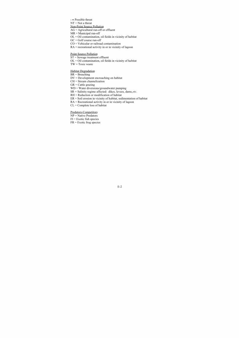
8/3/2019 Recovery Plan for the Tidewater Goby
http://slidepdf.com/reader/full/recovery-plan-for-the-tidewater-goby 150/208
E-2
* = Possible threat NT = Not a threat Non-Point Source PollutionAG = Agricultural run-off or effluentMR = Municipal run-off
OL = Oil contamination, oil fields in vicinity of habitatGC = Golf course run-off CO = Vehicular or railroad contaminationRA = recreational activity in or in vicinity of lagoon
Point Source PollutionST = Sewage treatment effluentOL = Oil contamination, oil fields in vicinity of habitatTW = Toxic waste
Habitat Degradation
BR = BreachingDV = Development encroaching on habitatCH = Stream channelizationGR = Cattle grazingWD = Water diversions/groundwater pumpingSR = Salinity regime affected: dikes, levees, dams, etc.RH = Reduction or modification of habitatER = Soil erosion in vicinity of habitat, sedimentation of habitatRA = Recreational activity in or in vicinity of lagoonCL = Complete loss of habitat
Predators-Competitors NP = Native PredatorsFI = Exotic fish speciesFR = Exotic frog species

8/3/2019 Recovery Plan for the Tidewater Goby
http://slidepdf.com/reader/full/recovery-plan-for-the-tidewater-goby 151/208
Recovery
Unit Sub-Unit
Site
Code
Habitat SizePopulation
DensityPresence
Source of
population
Approximate Distance
from Nearest Extant
Population (miles)
Habi
Restora
Need
a Small Variable Intermittent Historic 8 Som
b Large Abundant Regular Historic 8 Som
c Medium - - - 10 Som
a Medium - Extirpated Historic 3 Muc b Large - Extirpated Historic 2 Muc
c Large Abundant Regular Historic 2 Non
d Large Abundant Regular Historic 2 Non
a Large - - - 20 Som
b Medium Rare Intermittent Historic 3 Som
c Medium Rare Intermittent Recolonized 0.5 Som
d Small Rare Intermittent Historic 0.5 Som
e Medium Abundant Intermittent Historic 0.5
f Medium - Intermittent Historic 6 Som
g Large Rare Regular Historic 20 Som
NC4 a Large Abundant Regular Historic 6 Non
a Medium Abundant Regular Historic 1 Non
b Medium Abundant Regular Historic 1 Muc
a Medium - - - 1 Som b Medium - - Historic 1 Non
c Medium - - Historic 1 Non
a Small - - - 2 Som
b Medium Abundant Regular Historic 12 Som
a Small - - - 9 Som
b Small - Extirpated Historic 9 Som
c Large Variable Regular Historic 15 Som
d Large Abundant Regular Historic 15 Som
e Large - Extirpated Historic 8 Som
a Lagunitas Creek Medium Rare Regular Historic 16 Muc
b Small - - - 14 Som
c Small - - - 0.75 Som
a Large - - - 30 Som
b Large - - - 29 Som
c Large - - - 10 Som
d Medium Abundant Regular Historic 43 Som
e Medium - Extirpated Historic 15 Muc
f Medium - - - 10 Muc
g Medium - Extirpated Historic 30 Muc
h Large - Extirpated Historic 30 Muc
i Small - Extirpated Historic 14 Muc
j Large - - - 18 Muc
k NA - Extirpated Historic 5 Muc
l Large - Extirpated Historic 11 Muc
GRE AT E R
BAY U NI T
GB4
GB3
Lake Earl-Lake Talawa
Estero de San Antonio
Brush Creek
Salmon Creek
Marshall Gulch2
Lagoon Creek
Big Lagoon
Klopp Lake (McDaniel)
Ten Mile River
Location Status1
GB2
GB1
NC3
Fish Hatchery Creek 2
Johnson Gulch2
Cheney Gulch
Estero Americano
Lake Merrit
Cliff House
Novato Creek
Walker Creek
Millerton2
Horseshoe Cove
2
Corte Madera Creek
N ORT H C OA S T U NI T
Virgin Creek
Pudding Creek
NC1
NC2
NC5
Freshwater Slough
Mad River 2
Jacoby Creek/Gannon Slough
KATA Station Site
Eel River
Mad River Slough
Locality
Tillas Slough (Smith River)
Elk Creek 2
Redwood Creek EstuaryFreshwater Lagoon
Stone Lagoon
Mill Creek 2
Lake Merced
Petaluma Creek
Strawberry Creek
Estero de Limantour 2
Bolinas Lagoon2
Rodeo Lagoon
Davis Pond NC6

8/3/2019 Recovery Plan for the Tidewater Goby
http://slidepdf.com/reader/full/recovery-plan-for-the-tidewater-goby 152/208

8/3/2019 Recovery Plan for the Tidewater Goby
http://slidepdf.com/reader/full/recovery-plan-for-the-tidewater-goby 153/208
Recovery
Unit Sub-Unit
Site
Code
Habitat SizePopulation
DensityPresence
Source of
population
Approximate Distance
from Nearest Extant
Population (miles)
Habi
Restora
Need
Location Status1Locality
a Large Variable Intermittent Recolonized 6 Som
b Small Abundant Regular Historic 6 Muc
c Large Rare Regular Historic 11 Muc
a Small Abundant Regular Historic 3 Non
b Large Abundant Regular Historic 3 Non
c Large Abundant Regular Historic 6 Som
d Small Rare Intermittent Recolonized 6 Muc
a Medium Variable Intermittent Recolonized 8 Muc
b Medium Rare Intermittent Historic 3 Som
c Medium Rare Intermittent Historic 1 Som
d Small Abundant Regular Historic 0.5 Muc
e Small Rare Intermittent Recolonized 0.5 Muc
f Small Rare Intermittent Recolonized 0.5 Muc
g Medium Abundant Regular Historic 0.5 Somh Small Abundant Regular Historic 1 Som
i Small Abundant Regular Historic 1 Som
j Medium Variable Regular Historic 1 Som
k Small Rare Intermittent Recolonized 1 Muc
l Small Rare Intermittent Recolonized 1 Muc
m Small Variable Intermittent Recolonized 3 Muc
n Small Rare Intermittent Historic 0.7 Som
o Small Variable Intermittent Recolonized 0.3 Som
p Small Abundant Regular Historic 0.3 Som
q Large - Extirpated Historic 2 Muc
r Medium - Extirpated Historic 4 Muc
s Large - Extirpated - 6 Muc
t Medium Abundant Regular Historic 4 Som
u Large Variable Regular Historic 0.1 Som
v Small Abundant Regular Historic 0.1 Muc
w Small Abundant Intermittent Recolonized 0.2 Muc
x Small Abundant Intermittent Recolonized 0.2 Muc
y Small Abundant Intermittent Recolonized 3 Muc
z Medium - Extirpated Historic 1 Muc
aa Medium Abundant Intermittent Historic 3 Som
ab Small Variable Intermittent Recolonized 3 Muc
C O N C E P T I O N U N
I T
C O N C E P
T I O N U NI T
CO3
San Luis Obispo Creek
Pismo Creek
Santa Maria River
Canada del las Aqujas
Shuman Canyon
San Antonio Creek
Santa Ynez River
Canada Honda
CO3
Arroyo el Bulito
Canada del Aqua
Canada de Santa AnitaCanada de Alegria
Jalama Creek
Canada del Cojo
Canada del Pescado
Winchester CanyonDevereux Slough
CO1
CO2
Arroyo Quemado
Canada de Aqua Caliente
Gaviota Creek
Arroyo Hondo
Refugio Creek
Eagle Canyon
Tecolote Canyon
Rincon Creek
Campus Lagoon
Carpinteria Salt Marsh
Carpinteria Creek
Andree Clark Bird Refuge
Goleta Slough
Sycamore Creek
Arroyo Paredon
Laguna Channel
Arroyo Burro
Mission Creek
E
5

8/3/2019 Recovery Plan for the Tidewater Goby
http://slidepdf.com/reader/full/recovery-plan-for-the-tidewater-goby 154/208
Recovery
Unit Sub-Unit
Site
Code
Habitat SizePopulation
DensityPresence
Source of
population
Approximate Distance
from Nearest Extant
Population (miles)
Habi
Restora
Need
Location Status1Locality
a Large Variable Regular Historic 4 Som
b Large Variable Regular Historic 4 Som
c Large Variable Intermittent Recolonized 8 Muc
d Large - Extirpated Historic 7 Muc
e Small - - - 12 Som
f Small - - - 17 Som
g Small - - - 11 Som
h Large Abundant Intermittent Recolonized 6 Som
i Small Abundant Intermittent Recolonized 6 Muc
j NA - Extirpated Historic - Muc
k Large - - - 10 Muc
a NA - Extirpated - 40 Muc
b Large - - - 42 Muc
c Medium - Extirpated Historic 14 Som
d Large - Extirpated Historic 7 Muc
e Medium Variable Intermittent Recolonized 1 Som
f Medium Variable Intermittent Recolonized 1 Som
a Large Abundant Regular Historic 1 Som
b Large Variable Intermittent Historic 0.2 Som
c Small Variable Intermittent Recolonized 1 Som
d Large Variable Intermittent Recolonized 0.2 Muc
e Small Variable Intermittent Recolonized 0.05 Muc
f Large Variable Intermittent Recolonized 2 Muc
g Large - Extirpated Historic 4 Muc
h Large - Extirpated Historic 7 Muc
i Large - Extirpated Historic 9 Muc
j Large - - - 13 Muc
k Large - - - 20 Muc
l Large - - - 22 Muc
m Large - - - 25 Muc
S O UT HE R N C OA S T U NI T
L A / VE NT URA U NI T
Zuma Canyon2
Malibu Creek
Santa Monica Artesian Spr.
Santa Clara River
Calleguas Creek/Mugu
Sycamore Canyon2
Topanga Creek
Ballona Creek 2
Ventura River
Arroyo Sequit2
Los Peñasquitos Lagoon2
SC1
SC2
LV1
Cockleburr Canyon
San Onofre Creek
Las Pulgas Creek
San Pedro Harbor
Aliso Creek
San Juan Creek
Bolsa Chica2
San Diegito Lagoon2
San Elijo Lagoon2
French Lagoon
San Luis Rey River
Buena Vista Lagoon
Aliso Canyon
Santa Margarita River
San Mateo Creek
J Street Drain/Ormond
1reflects status in year 2004
2indicates a potential introduction site (no historic tidewater goby record)
Hidden Lagoon
Batiquitos Lagoon2
Aqua Hedionda Lagoon
E
6

8/3/2019 Recovery Plan for the Tidewater Goby
http://slidepdf.com/reader/full/recovery-plan-for-the-tidewater-goby 155/208
F-1
Appendix F. Tidewater Goby Survey Protocol
1. Introduction
The tidewater goby ( Eucyclogobius newberryi), a species of fish endemic toCalifornia, has undergone substantial reduction in population size and distributionwithin its range in recent years. Surveys for the species have been conductedusing a variety of methods over the past 2 to 4 decades. We, the U.S. Fish andWildlife Service, seek to increase the scientific information available upon whichto base future management and conservation of the species, including efforts for recovery. Through the survey protocol recommended in this document, we intendto promote survey methods and intensities that ensure sound and supportable presence/absence determinations of species locations, leading to better management decisions based on the best available scientific data.
We provide the following guidance to facilitate the determination of presence or absence of the species in habitats with potential to support it. We anticipate thatthe primary use for this protocol will be for project-level surveys in support of requests for consultation under section 7 of the Endangered Species Act of 1973,as amended. Additionally, this protocol may also be used for section 10(a)(1)(B) permit applications, and to determine general presence-absence for other management purposes.
In general, surveys for wildlife and fish species may be done to meet a variety of management objectives, including but not limited to: 1) confirming the presence
or absence of a species at a particular location, 2) identifying habitats potentiallyoccupied, 3) estimating population size, and 4) determining population trends.For the purposes of this protocol, we have focused primarily on the first objective,determining presence/absence of a species at particular sites. The protocol is alsolikely to provide supporting information in identifying locations and habitat typescurrently occupied by the species. It is not the intent of this protocol to estimate population size or determine population trends.
Section 9 of the Endangered Species Act of 1973, as amended, and Federalregulations pursuant to Section 4(d) prohibit the take1
of endangered andthreatened species fish and wildlife species without special exemption. Virtually
all methods to survey for gobies require the surveyor to enter the species’ habitat,
1 Take is defined by the Act as “to harass, harm, pursue, hunt, shoot, wound, kill, trap, capture,collect, or attempt to engage in any such conduct.” [ESA §3(19)] Harm is further defined by theService to include significant habitat modification or degradation that results in death or injury tolisted species by significantly impairing essential behavioral patterns, including breeding, feeding,or sheltering. Harass is defined as actions that create the likelihood of injury to listed species tosuch an extent as to significantly disrupt normal behavior patterns which include, but are notlimited to, breeding, feeding, or sheltering. [50 CFR §17.3]

8/3/2019 Recovery Plan for the Tidewater Goby
http://slidepdf.com/reader/full/recovery-plan-for-the-tidewater-goby 156/208
F-2
resulting in an unavoidable risk of take of the species should it occur there.Therefore, a final objective of this survey protocol is to minimize the incidentaltake of gobies by implementing survey methods and intensities that are likely tominimize the take of gobies through the survey methodology itself.
2. Background
Habitat Affinity
The tidewater goby inhabits primarily waters of coastal lagoons, estuaries, andmarshes. The species is benthic in nature as an adult (Swift 1980). Its habitat ischaracterized by brackish shallow lagoons and lower stream reaches where thewater is fairly still, but not stagnant (Miller and Lea 1972; Moyle 2002; Swift et
al.1989; Wang 1982; Irwin and Soltz 1984). Tidewater gobies exhibit a preference for a sand substrate component for breeding, but they are also found onrocky, mud, and silt substrates as well. Tidewater gobies have been documented
in waters with salinity levels from 0 to 42 parts per thousand, temperature levelsfrom 8 to 25 degrees Celsius (46 to 77 degrees Fahrenheit), and water depths from25 to 200 centimeters (10 to 79 inches) (Irwin and Soltz 1984; Swift et al. 1989;Worcester 1992; Lafferty 1997; Smith 1998).
In their study, Trihey and Associates (1996) report tidewater gobies concentratedwithin 30 meters of the shore and in waters between 0.5 and 1.0 meter deep. Inaddition, higher densities of tidewater gobies were found in areas containingsubmerged aquatic vegetation than those containing only emergent vegetation or no vegetation.
Tidewater gobies have been reported from estuaries in California ranging fromTillas Slough at the mouth of the Smith River (northern Del Norte County) toAgua Hedionda Lagoon (northern San Diego County). The distribution of thetidewater goby corresponds to the distribution of sand deposition within thelittoral cells along the California coast (Capelli 1997). Apparently, none haveever been found in Mexico or Oregon, based on extensive surveys outside of California.
The tidewater goby appears to spend all life stages in lagoons, in tidallyinfluenced portions of coastal waters, or in freshwater habitats adjacent to thesewater bodies. Tidewater gobies may enter marine environments when flushed outof the estuary/lagoon by breaching of the sandbars following storm events or human manipulation. The tidewater goby generally lives to about 1 year of age,although some variation has been observed (Swift et al. 1989; Wang 1982; Irwinand Soltz 1984). During this single year, it is able to complete its life cycle.
Reproduction occurs year-round, although a distinct peak in spawning occurs inApril and May (Moyle et al. 1989). Detailed information regarding the biology of the tidewater goby can be found in Wang (1982), Irwin and Soltz (1984), Swift et

8/3/2019 Recovery Plan for the Tidewater Goby
http://slidepdf.com/reader/full/recovery-plan-for-the-tidewater-goby 157/208
F-3
al. (1989), Worcester (1992), Swenson (1995), Lafferty et al. (1999), andSwenson (1999).
Swenson (1995) reported that field studies of tidewater gobies in centralCalifornia revealed different patterns in population ecology among different
habitats. Feeding ecology differed for gobies in lagoon, creek and marsh habitats.Tidewater gobies in the marsh were significantly larger, more fecund and potentially longer-lived than tidewater gobies in the lagoon or creek. However,sandy lagoons may be more important than muddy marshes as spawning habitat because males in lab studies preferred to dig spawning burrows in sand rather than mud. Although lagoons are considered the typical habitat of tidewater gobies, brackish marshes can also be important, perhaps due to better foodresources or reduced disturbance regimes. Marshes may serve as refugia, providing a source population for recolonization of the creek and lagoon habitatsafter high-flow events.
Developing monitoring programs to assess abundance patterns can be difficult because tidewater gobies can be patchily distributed within habitats.
2.1 Legal Status
On March 7, 1994, we listed the tidewater goby as endangered throughout itsrange under the Act (U.S. Fish and Wildlife Service 1994). We designatedcritical habitat on November 20, 2000, for the southern California populations(U.S. Fish and Wildlife Service 2000). On June 24, 1999, we published a proposed rule to remove the northern populations of the tidewater goby from theendangered species list (U.S. Fish and Wildlife Service 1999). The proposed ruleto delist was withdrawn on November 7, 2002 (U.S. Fish and Wildlife Service2002), following significant public and species expert comments. Therefore, thecurrent status of the species remains listed as endangered throughout its range,and critical habitat remains as designated in 2000. A recovery plan is indevelopment.
The tidewater goby was listed as a species of special concern by the CaliforniaDepartment of Fish and Game in 1980, and was elevated to fully protected statusin 1987 (Swift et al. 1997).
2.3 Methods Applied to Prior Surveys
This section provides a brief summary of survey methods used in the past, their success, and the recommendations for improvement by those who used them.This information is provided to assist the reader in understanding theeffectiveness of those methods, and the relative efficiency of each. In addition,this information assists the reader in understanding why we recommend themethods in the protocol, described later in this document, rather than other methods that to the uninitiated might seem better or more cost effective. We
8/3/2019 Recovery Plan for the Tidewater Goby
http://slidepdf.com/reader/full/recovery-plan-for-the-tidewater-goby 158/208
F-4
believe that this information adequately supports our proposed protocol, thus promoting consistency among all surveyors. However, any and all methods proposed to conduct surveys for tidewater goby should receive our consideration,as appropriate.
Tidewater goby abundance and distribution can be affected by habitatcharacteristics such as vegetation, substrate and depth (Swift et al. 1989,Worcester 1992, Swenson 1995). These factors can also influence the efficiencyof sampling methods. Tidewater gobies have been successfully collected with both seines (Swift et al. 1989, Swenson 1995) and meter-square throw traps(Worcester 1992, Swenson 1995). Other reported methods include dip nets,minnow traps, ichthyoplankton net, snorkeling/direct observation, and plastictubes. Each is described in more detail below.
2.3.1 Seine Netting
Seine netting is one of the most common methods utilized in tidewater gobysurveys (Wang 1984; Holland 1992; Swift 1994; Swenson 1994; Swenson 1996a,1996b; Lafferty et al. 1997; Fong 1997; Swift 1997) throughout the species range.The technique can be applied over a variety of habitats, but does have limitationsin areas with dense emergent vegetation (Trihey and Associates 1996). Seining isa commonly used collecting method, well suited for near-shore areas with smooth bottoms and little vegetation.
Seine nets used for goby surveys ranged in length from as short as 1.2 meter (Wang 1984; Swenson 1996b; Swift 1997; Wang and Keegan 1998) to 7.3 meter (Swenson 1994; Swenson 1995). Other commonly used lengths include 1.8 meter (Holland 1992; Swift 1997), 2.1 meters (Swenson et al. 1996a), 3 meters (Laffertyet al. 1997; Wang 1984), and 5 meters (Swift 1997). The nets ranged in heightfrom 1.0 meter to 1.8 meter. Equivalent inch mesh seine nets sold in the U.S.range sizes from 6 feet by 4 feet, 10 feet by 4 feet, 6 feet by 10 feet, and 6 feet byseventeen feet.
Various mesh sizes have been used. Reported mesh sizes ranged from 0.5millimeter to greater than 6 millimeters. Commonly used mesh sizes includedthose near 3 millimeters [1/4 inch](Wang 1982; Wang 1984; Fong 1997, Laffertyet al. 1997; Swift 1997; Wang and Keegan 1998), 4 millimeters (Swenson 1995;Swenson 1996b), 3.1 millimeters (Swift et al. 1994), 4.8 millimeters (Fong 1997),and greater than 6 millimeters (Holland 1992; Trihey and Associates 1996; Fong1997). Due to their small size, especially when in the larval or subadult form,tidewater gobies can easily escape from the seine if the mesh size is too large.Fong (1997) selected a 3.1-millimeter delta mesh because gobies were observedsqueezing through the 6.4-millimeter mesh and 4.8-millimeter mesh.

8/3/2019 Recovery Plan for the Tidewater Goby
http://slidepdf.com/reader/full/recovery-plan-for-the-tidewater-goby 159/208
F-5
Swift (1997) used 28.5-gram (1-ounce) weights centered 15.2 centimeters (6inches) apart on the lead line, to ensure the bottom of the seine remain in closecontact with the subsurface, preventing gobies from escaping.
Wang (1982, 1984) used 1.2 x 1.0 meter beach seine with 1.0 millimeter mesh to
larvae, and juveniles in the inshore zones with vegetation. Wang and Keegan(1998) collected specimens with a beach seine with 500 micron (0.5 millimeter)mesh to sample juvenile and adult tidewater goby and other fish species.
Swenson (1994) used a seine (7.3 meters x 1.2 meter, 4 millimeter-square mesh)in shallow water (5 to 80 centimeters deep) to sample adults and juveniles.Swenson (1995) sampled in water 20 to 120 centimeters deep to capture adultsand juveniles.
The distance of each seine haul varied with researcher and application. Holland(1992) used a minimum of three stations to be sampled within the available
aquatic habitat. Each station consisted of five sweeps, each sweep was 10 metersin length, and all sweeps were 2 to 3 meters apart. Wang and Keegan (1998)hauled their seines from 3 to 10 meters along the shoreline, depending on the sizeof the station. Trihey and Associates (1996) hauled the seine perpendicular to theshoreline and landed the net on shore, where possible. Swenson (1995) reported atotal linear distance sampled as approximately 150 meters, but did not report thelength of each haul. Trihey and Associates (1996) recommended shortening theseine's width to approximately 3 meters to reduce total catch and time for netclearing and to minimize stress to captured fish.
2.3.2 Drop or Throw Traps
Drop or throw trapping is an effective method for sampling small fishes invegetated areas or in open water sites that are difficult to seine (Kushlan 1981;Rozas and Odum 1988; Chick et al. 1992; Swenson 1996a). Tidewater gobieshave been successfully collected with meter-square throw traps (Worcester 1992,Swenson 1995).
Trihey and Associates (1996) sampled with throw trap consisting of two l meter square plastic frames (polyvinyl chloride pipe, 1.27 centimeter diameter)connected with net sides (1.6 millimeter Delta mesh) (Worcester 1992). Thelower frame is weighted with water and metal reinforcing bars, and a skirt of netting enclosing a chain is attached to the lower frame to seal the bottom over uneven substrate. Swenson (1995) constructed the drop net with one frame'scorners closed to trap air (the floating top frame) and the other frame's comers leftopen to fill with water when in use (the heavy bottom frame). These frames wereattached to the top and bottom edges of 1.2 meter wide fine netting (1.6millimeter Delta mesh) to form a square tube.

8/3/2019 Recovery Plan for the Tidewater Goby
http://slidepdf.com/reader/full/recovery-plan-for-the-tidewater-goby 160/208
F-6
Setting the drop trap is a two-person task. The two polyvinyl chloride pipeframes are held together and tossed approximately 1 meter away. The two peoplethen moved quickly to the trap to help secure the lower frame to the bottom withtheir feet. After estimating vegetative cover, fish are cleared from the trap withfine-meshed dipnets. The trap is swept until five consecutive passes of the dipnet
yield no additional fish (Trihey and Associates 1996). Worcester (1992)constructed drop nets entirely of 1/16 inch mesh knotless nylon netting or fiberglass screening to prevent larval fish from being lost.
Throw traps are easier to use in vegetated areas than the beach seine and arecapable of capturing smaller fish due to the finer mesh size. A seine with finer mesh could capture smaller fish, although the smaller mesh would increase water resistance, which could affect seine effectiveness (Trihey and Associates 1996).
Drop nets and traps have been used to sample nursery habitats (Kahl 1963;Kjelson and Johnson 1973; Kushland 1974; Turner and Johnson 1974; Kjelson
1977). Kushlan (1974) discussed the difficulties and advantages of various droptrap designs with respect to size, portability, and effectiveness. Chamberlain(1988) designed and constructed 2 m x 2 m traps with wood frames andtransparent plastic panels to avoid attracting or frightening fish by shadowcasting. Trihey and Associates (1996) reported results indicating higher variability among drop trap samples than among seines. Worcester (1992)reported 1/8 inch Delta mesh style knotless nylon netting as too large to containlarval fish. The entire trap was lined with fiberglass window screening to ensurethat no fish would be lost through the netting.
Fong (1997) recommended a sample area of roughly 10 square meters seemed asoptimal; it balanced the variability associated with small sample area that plaguedthe drop traps against greater than 1 hour processing times needed for sampleareas much greater than 10 square meters.
2.3.3 Dip Net
Worcester (1992) used dip nets to remove fish from within the drop traps, both byvisual observation and by blind sweeps of the net. Irwin et al. (1984) employeddip nets where the use of seines was impractical. Swift et al. (1997) used fine-meshed dip nets on occasion. Goldsmith (pers. comm.) found dip nets to beeffective where submergent and emergent vegetation or the small size of the water body makes the use of seine nets difficult.
2.3.4 Hand-towed ichthyoplankton net
Wang (1982) and Wang and Keegan (1998) report successful use of a hand-towedichthyoplankton net with 0.5-meter mouth and 0.5-millimeter mesh to collectlarvae, and juveniles. Planktonic larvae were captured in the shallow areas withan ichthyoplankton net and a fine-meshed beach seine. Juvenile and adult

8/3/2019 Recovery Plan for the Tidewater Goby
http://slidepdf.com/reader/full/recovery-plan-for-the-tidewater-goby 161/208
F-7
tidewater goby inhabit the benthic level. Wang and Keegan (1998) attached thenet to a bridle 2 meters in length and hand-towed it along an approximate 10meter course at each station.
2.3.5 Minnow Traps
Lafferty et al. (1997) sampled using Gee’s minnow traps. Six minnow traps(6millimeter mesh), baited with dry dog-food, were set in the evening in 0.5-2meter water and inspected the following morning. Swift (1997) occasionallycollecting with Gee's minnow traps with either 1/4 inch (6 millimeters) or 1/8 inch(3 millimeters) mesh and fine-meshed dip nets. Although tidewater gobiessometimes occur in unbaited traps with 3 millimeters mesh, it is extremelyunusual to find them in the baited traps with 6 millimeters mesh, even in areaswhere they are extremely abundant Swift (1997), suggesting that gobies escapeeasily from the larger mesh.
2.3.6 Snorkeling and Direct Observation
Worcester (1992) concluded snorkeling is not feasible for the tidewater goby dueto its small size, schooling tendencies, and cryptic nature. The variable nature of the habitat, often with very murky or heavily vegetated water, also precludesdirect observational techniques (Worcester 1992). Swenson (1995) reported somesuccess in observing gobies from the shore in shallow water (40 to 100centimeters) or while snorkeling, but turbidity prevented extensive field studiesusing these methods. Holland (1992) conducted snorkeling surveys toqualitatively assess the numbers and distribution of gobies in standing water ranging from a maximum depth of 0.9 to 1.0 meter in 1990 to a maximum of 0.75meter in 1991. Water turbidity was high in 1990 and effectively precludedsnorkeling, but visibility was greater than 0.6 meters in 1991 and a snorkelingsurvey was successful (Holland 1992). However, Worcester (1992) observed atleast 100 tidewater gobies in water approximately 3 inches deep on top of aconcrete bridge abutment during a snorkeling survey in February, 1990.
Swift et al. (1994) examined some areas by swimming transects about 1.0 meter wide with mask and snorkel. A snorkeled transect 270 meters long and 1.0 meter wide recorded 2 tidewater gobies. However, the resulting density of 0.0074tidewater gobies per square meter and an estimate of 126 fish in the sampledlagoon was much lower than documented with seine hauls. They also report other localities as too turbid for snorkeling. Estimates based on snorkeling were foundto be much lower than those based on seining. All population estimates in their repot are based on seine collections.
2.3.7 Plastic tubes
Swenson (1995, 1996b) collected adult tidewater gobies in artificial burrowsmade of polyvinyl chloride pipe tubes (13 millimeter inner diameter, 13
8/3/2019 Recovery Plan for the Tidewater Goby
http://slidepdf.com/reader/full/recovery-plan-for-the-tidewater-goby 162/208
F-8
centimeters long). Plastic Duraleen (available at art supply stores) or other thin plastic sheet, 13.0 centimeter by 5.5 centimeters, was rolled up inside the tube as aliner to collect the adhesive eggs. McGehee (1989) and Bechler et al. (1990)report gobies readily adopt plastic tubes as artificial burrows, both in lab aquariaand in the field. "Tube trapping" is a useful method to collect breeding fish, to
quantify reproductive output, and to determine the timing and intensity of spawning. The open-ended tubes are shoved into the sediment at an angle of approximately 30 degrees until the lower lip rested at the surface of the substrate(Swenson 1995). Sets of 10 tubes are placed in the sediment in shallow water (less than 1 meter deep, preferably 20 to 50 centimeters deep) at each habitat site(Swenson 1995). Tubes are spaced up to 1 meter apart to minimize territorialinteractions by males. Tubes are left in the substrate 14 to 28 days to allowcolonization by nesting males.
2.3.8 Sample Size
Fong (1997) estimated 48 and 33 beach seine hauls would be required for twosample regions to obtain density estimates within 20 percent of the mean with 90 percent confidence, based on data reported in Trihey and Associates (1996).Assuming that each seine haul would take an average of 45 minutes, a total of 61sampling hours would be required for just two regions. In addition to the amountof time involved, this heavy sampling intensity would result in impacts to thetidewater goby habitat. For their purposes, the sampling effort was generally lessthan 5 seine hauls per region. Trihey and Associates (1996) recommended thatsampling effort should consist of 3 to 5 seine hauls per site and 5 to 10 drop trapsamples. Swift et al. (1997) recommended that to detect seasonal changes in populations, collections in lagoons be repeated bimonthly.
2.3.9 Sampling Season and Timing
Fong (1997) reported that October sampling indicates higher fish abundanceoccurs in the fall rather than the winter sampling period. Overall, mean densitiesof gobies increased from 1.7 per square meter to 35 per square meter.
Swenson (1995) conducted sampling in the morning at high tide (plus 4.7 feet).Because the water was too deep to effectively sample the main creek, a secondsurvey was conducted in the morning during low tide (plus1.8 feet), using a bagseine.
To detect seasonal changes in populations, Swift (1997) collected in lagoons bimonthly. Upstream tributaries were sampled for gobies intermittently to assessthe degree to which tidewater gobies utilized these areas.
8/3/2019 Recovery Plan for the Tidewater Goby
http://slidepdf.com/reader/full/recovery-plan-for-the-tidewater-goby 163/208
F-9
2.3.10 Density
Trihey and Associates (1996) reported tidewater goby density as extremelyvariable both across and within most sampling factors: method, location,vegetation and substrate. Mean density was 12.5 tidewater gobies per square
meter for throw traps (standard deviation = 22.6, range 0 to 91, n = 70) and 2.0tidewater gobies per square meter for seine samples (standard deviation = 3.6,range = 0 to 14.2, n = 26). Although the capture method alone did notsignificantly affect tidewater goby densities, the project's main objective was totest sampling methods and therefore the authors decided to treat trap and seinedata separately for further analyses. Location within the lagoon significantlyaffected tidewater goby density for both methods. Substrate type and vegetationsignificantly affected densities of tidewater gobies caught with the throw traps butnot with seine. Depth and distance from the shoreline also affected tidewater goby density. Tidewater gobies were more abundant in waters 50 to 100centimeters deep and within 30 meters of the shore. Tidewater gobies were not
collected in waters less than 20 centimeters deep or from nearshore sites.Swenson (1995) reported tidewater goby density varied tremendously among thefive drop net samples (0 to 198 tidewater gobies per square decimeter). Densitywas greater in vegetated areas; the difference was not significant but the smallsample size may have been too low to reject the null hypothesis (Swenson 1995).
2.3.11 Salinity
Swenson (1994) reported on the use of an Atago hand refractometer to measuresalinity. Water temperature (degrees Celsius) and salinity (parts per thousand)were measured at the surface and on the bottom (approximately 50 to 70centimeters deep).
2.4 Suitability of Habitat
Lafferty et al. (1999) reported known locations where apparent extirpations werefollowed by evidence of recolonization (Lafferty et al. 1999). Based on thisinformation, we assume that all sites known to be previously occupied by gobieswill be considered suitable and occupied without clear evidence that the site has been modified to the point where recolonization is highly unlikely, barring habitatrestoration that successfully restores habitat conditions and ecosystem functionsto conditions similar to a time of known tidewater goby occupancy.
3. Application of the Recommended Protocol
3.1 General Intent of the Protocol
The general intent of the protocol described in section 4 of this document is to provide a methodology of surveying for tidewater gobies in likely natural andhuman-made habitats at an intensity and effectiveness that ensures a high level of

8/3/2019 Recovery Plan for the Tidewater Goby
http://slidepdf.com/reader/full/recovery-plan-for-the-tidewater-goby 164/208
F-10
confidence in finding gobies should they currently exist at the site. A secondaryintent of the protocol is to prescribe a sampling regime or methodology thatavoids placing an onerous and unreasonable burden on any project proponent whoseeks to work in habitats likely to be suitable to the species.
The methodology described below is intended to document the presence or absence of tidewater gobies to a reasonable level of certainty, and to provide basicinformation on habitat affinity of the species. This methodology is not intendedto be of sufficient intensity to estimate population levels, recruitment rates, or survival rates; habitat affinities more appropriate for research studies; populationviability analyses; or other parameters associated with research-level activities.The parameter of interest in these surveys is a high likelihood of detecting gobiesshould they exist at the site.
We believe the following protocol will provide consistent results with areasonable amount of effort. However, while we strongly recommend that
potential surveyors adopt and implement our proposed protocol, we may consider other methods, on a case by case basis. The action agency or project proponenthas the discretion to use any appropriate survey methodology to determine the presence or absence of tidewater gobies, provided they meet three conditions.First, any proposed protocol must meet or exceed the intended level of surveyintensity and effectiveness of the protocol described herein. Second, surveyors proposing methods or intensities other than as prescribed here should seek concurrence on the proposed changes from our field office having jurisdictionover the proposed survey area. The proponent should seek this concurrence asearly in the survey design as possible, and definitely prior to beginning actualfield surveys. Finally, the surveyors must obtain any and all applicable Federal(described below) and State permits in advance of conducting the surveys.
3.2 Application of the protocol to projects
These guidelines are not intended for long-term monitoring or research projects or for determining the overall status of populations; guidelines for such monitoringand research efforts should be developed with our assistance on a case-by-case basis. We have worked with, and will continue to work with Federal, State, andlocal biologists; scientific and academic institutions; commercial organizations;and other interested parties to collect additional data on the distribution, ecology,and biology of the tidewater goby. We will revise this survey protocol as needed,using the best available data.
This protocol should fulfill the needs of landowners and managers to complete pre-disturbance surveys for tidewater gobies that provide a reasonable basis uponwhich to make effects determinations. Projects resulting in direct or indirecteffects to tidewater gobies or their habitats should conduct surveys consistent withthis protocol to document the presence or absence of tidewater gobies at their proposed project site. In addition, surveys conducted under this protocol may

8/3/2019 Recovery Plan for the Tidewater Goby
http://slidepdf.com/reader/full/recovery-plan-for-the-tidewater-goby 165/208
F-11
provide useful information on the overall distribution of tidewater gobies withintheir range.
Extreme care must be taken when conducting surveys to avoid inadvertentlyinjuring or killing tidewater gobies, or damaging their habitat (see Appendix F-3).
3.3 Peer Review of the Recommended Protocol
This protocol has been developed in conjunction with and reviewed by theTidewater Goby Science Team, a group of agency and independent experts intidewater goby biology and research. The protocol includes their comments. Anysurvey that uses a different methodology from this protocol should include adetailed description of the procedures used and an evaluation as to whether theconclusions drawn constitute the best available scientific and commercialinformation.
4. Recommended Protocol
We recommend the following survey guidelines be used to determine, with somereasonably high level of confidence, the presence or absence of tidewater gobiesin habitat deemed suitable for the species.
4.1 Section 10(a)(1)(A) Recovery Permit Requirements
The survey methods prescribed in the following protocol require work withinhabitat likely to be occupied by tidewater gobies, and involves the handling of individuals for identification purposes. Although there is no requirement to preserve voucher specimens or otherwise directly kill individuals, the capture andhandling of individuals has some risk of incidental mortality. Also, the methods proposed here require the surveyors to enter suitable habitat, and an unavoidableconsequence of such activity is the trampling or other damaging of occupied burrows and mortality of eggs and possibly individuals. Therefore, all surveyorsmust obtain a recovery permit issued by us under section 10(a)(1)(A) of theEndangered Species Act of 1973, as amended. The permit application form andinstructions for completion are available at the website http://forms.fws.gov/3-20055.pdf .
4.2 Survey Equipment
Surveys should be conducted using appropriate equipment. If other equipment isto be used, surveyors should contact our appropriate field office to determine if the other equipment is suitable for use under this protocol. The followingequipment is the minimum necessary for conducting tidewater goby surveysunder this protocol:
U.S. Geological Survey quadrangle 7.5 minute series (topographic)
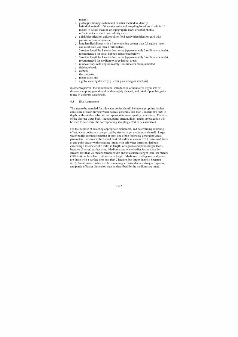
8/3/2019 Recovery Plan for the Tidewater Goby
http://slidepdf.com/reader/full/recovery-plan-for-the-tidewater-goby 166/208
F-12
map(s); global positioning system unit or other method to identify
latitude/longitude of tidewater goby and sampling locations to within 10meters of actual location on topographic maps or aerial photos;
refractometer or electronic salinity meter;
a fish identification guidebook or field-ready identification card with pictures of similar species; long handled dipnet with a frame opening greater than 0.1 square meter
and mesh size less than 3 millimeters; 3 meters length by 1 meter deep seine (approximately 3 millimeters mesh),
recommended for small habitats (described below); 5 meters length by 1 meter deep seine (approximately 3 millimeters mesh),
recommended for medium to large habitat areas; minnow traps with approximately 3 millimeters mesh, unbaited; field notebook; camera;
thermometer; meter stick; and a goby viewing device (e.g., clear plastic bag or small jar).
In order to prevent the unintentional introduction of nonnative organisms or disease, sampling gear should be thoroughly cleaned, and dried if possible, prior to use in different watersheds.
4.3 Site Assessment
The area to be sampled for tidewater gobies should include appropriate habitatconsisting of slow moving water bodies, generally less than 3 meters (10 feet) indepth, with suitable substrate and appropriate water quality parameters. The sizeof the discrete water body (lagoon, pond, stream, ditch) under investigation will be used to determine the corresponding sampling effort to be carried out.
For the purpose of selecting appropriate equipment, and determining samplingeffort, water bodies are categorized by size as large, medium, and small. Largewater bodies are those meeting at least one of the following general physical parameters: streams with channel bankful widths in excess of 20 meters (66 feet)at any point and/or with estuarine (areas with salt water intrusion) habitatsexceeding 1 kilometer (0.6 mile) in length; or lagoons and ponds larger than 2hectares (5 acres) surface area. Medium sized water bodies include smaller streams less than 20 meters bankful width and/or estuaries longer than 100 meters(328 feet) but less than 1 kilometer in length. Medium sized lagoons and pondsare those with a surface area less than 2 hectare, but larger than 0.4 hectare (1acre). Small water bodies are the remaining streams, ditches, sloughs, lagoons,and ponds of lesser dimension than as described for the medium size range.

8/3/2019 Recovery Plan for the Tidewater Goby
http://slidepdf.com/reader/full/recovery-plan-for-the-tidewater-goby 167/208
F-13
Immediately prior to conducting in-water goby sampling activities, surveyorsshould complete the following actions:
1. Take one or more overview photos from a vantage point that provides anoblique view of the sampled habitat (when possible). The location(s)
should be consistent from year to year if future surveys are anticipated.2. Record the percent cover of aquatic vegetation and identify common plantspecies present in the area actually surveyed.
3. Categorize the water body, including size (as defined above).4. Measure the average depth of the water using the meter stick for each
sampling effort.5. Record water temperature at a depth of half the average water depth in the
survey area.6. Take salinity measurements at both surface and bottom depths with the
salinity meter or refractometer.7. Note any unusual characteristics of the environment.
8.
Record all other pertinent information describing date, time, location,names of surveyors, etc.
4.4 In-water Sampling for Tidewater Gobies
Before sampling, we recommend the surveyors review the literature and agencyrecords for historical information and other available resources, and includingcommunication with species experts. This review should determine whether populations have been previously identified at or near the site to be sampled, or whether suitable habitat for tidewater goby exists at the site. This informationshould be summarized in the survey report (see section 5, below).
In the absence of recent survey data, any site known historically to have been populated with tidewater goby should be assumed to be currently occupied by thespecies, unless clear evidence indicates that the habitat has been so modified as to be uninhabitable.
For the purpose of this protocol, the presence of one individual tidewater gobyresulting from surveys constitutes evidence of an extant population. Thisdetermination is based on the annual life cycle of the species, the difficulty indetecting tidewater gobies, and the low likelihood of only one individual to be present in a watershed.
4.5 Survey Methods
Several methods can be effective in identifying, or capturing tidewater gobies.The following methods are recommended for conducting surveys, and each one is best suited to particular types of water bodies.
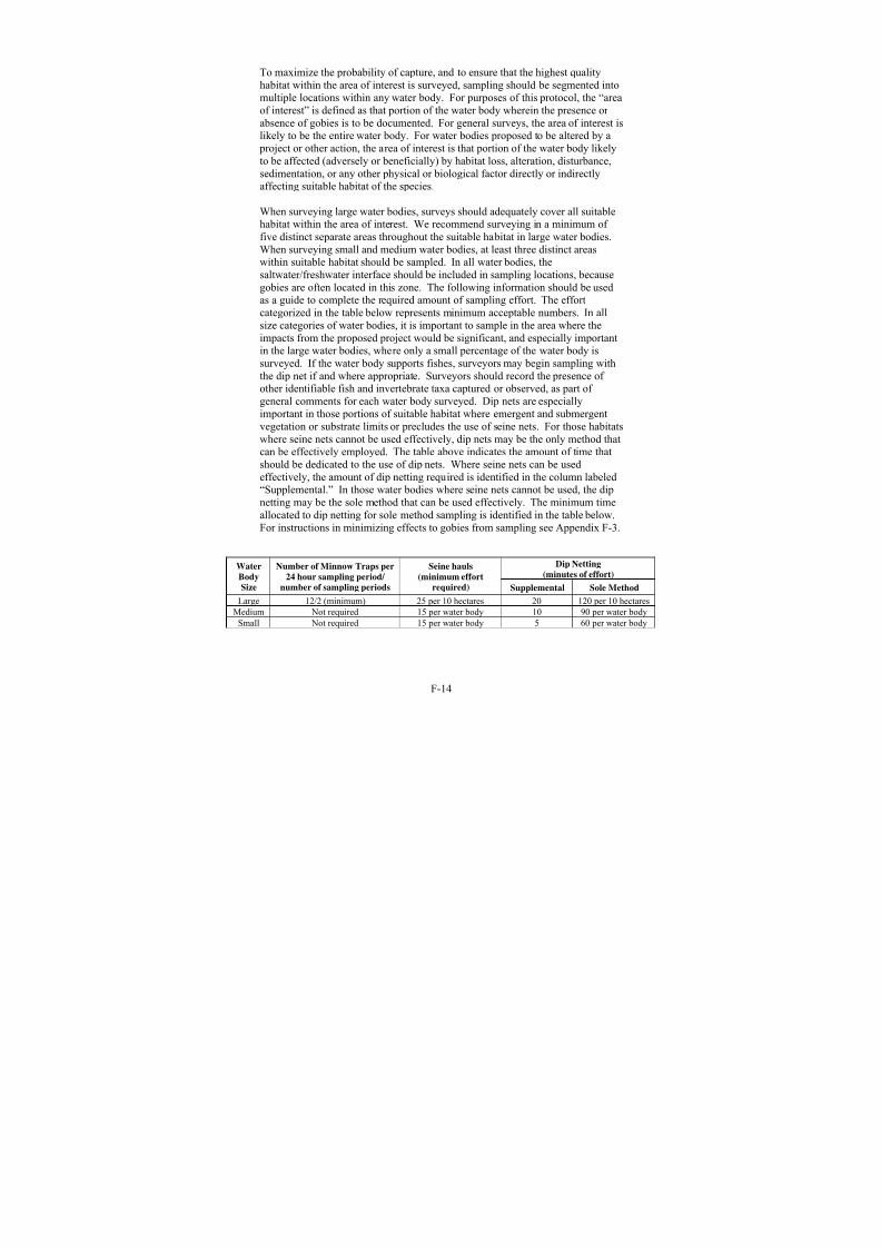
8/3/2019 Recovery Plan for the Tidewater Goby
http://slidepdf.com/reader/full/recovery-plan-for-the-tidewater-goby 168/208
F-14
To maximize the probability of capture, and to ensure that the highest qualityhabitat within the area of interest is surveyed, sampling should be segmented intomultiple locations within any water body. For purposes of this protocol, the “areaof interest” is defined as that portion of the water body wherein the presence or absence of gobies is to be documented. For general surveys, the area of interest is
likely to be the entire water body. For water bodies proposed to be altered by a project or other action, the area of interest is that portion of the water body likelyto be affected (adversely or beneficially) by habitat loss, alteration, disturbance,sedimentation, or any other physical or biological factor directly or indirectlyaffecting suitable habitat of the species.
When surveying large water bodies, surveys should adequately cover all suitablehabitat within the area of interest. We recommend surveying in a minimum of five distinct separate areas throughout the suitable habitat in large water bodies.When surveying small and medium water bodies, at least three distinct areaswithin suitable habitat should be sampled. In all water bodies, the
saltwater/freshwater interface should be included in sampling locations, becausegobies are often located in this zone. The following information should be usedas a guide to complete the required amount of sampling effort. The effortcategorized in the table below represents minimum acceptable numbers. In allsize categories of water bodies, it is important to sample in the area where theimpacts from the proposed project would be significant, and especially importantin the large water bodies, where only a small percentage of the water body issurveyed. If the water body supports fishes, surveyors may begin sampling withthe dip net if and where appropriate. Surveyors should record the presence of other identifiable fish and invertebrate taxa captured or observed, as part of general comments for each water body surveyed. Dip nets are especiallyimportant in those portions of suitable habitat where emergent and submergentvegetation or substrate limits or precludes the use of seine nets. For those habitatswhere seine nets cannot be used effectively, dip nets may be the only method thatcan be effectively employed. The table above indicates the amount of time thatshould be dedicated to the use of dip nets. Where seine nets can be usedeffectively, the amount of dip netting required is identified in the column labeled“Supplemental.” In those water bodies where seine nets cannot be used, the dipnetting may be the sole method that can be used effectively. The minimum timeallocated to dip netting for sole method sampling is identified in the table below.For instructions in minimizing effects to gobies from sampling see Appendix F-3.
Dip Netting
(minutes of effort)Water
Body
Size
Number of Minnow Traps per
24 hour sampling period/
number of sampling periods
Seine hauls
(minimum effort
required) Supplemental Sole Method
Large 12/2 (minimum) 25 per 10 hectares 20 120 per 10 hectares
Medium Not required 15 per water body 10 90 per water body
Small Not required 15 per water body 5 60 per water body

8/3/2019 Recovery Plan for the Tidewater Goby
http://slidepdf.com/reader/full/recovery-plan-for-the-tidewater-goby 169/208
F-15
Where site conditions allow effective use of a seine, surveyors should attempt tocover a minimum of 30 square meters per seine haul, with a recommendedaverage of 50 square meters per seine haul. The number of seine hauls may belimited by suitable sites, and is dependent on the size of the water body.
For small and medium water bodies, conduct enough seine hauls to adequatelycover suitable habitat. A minimum of 15 seine hauls is suggested to adequatelycover these areas. Although some overlap between seine hauls is effective, theyshould have no more than 20 percent overlap in area. For any size water body,once tidewater gobies are detected, sampling may cease. In cases where theamount of suitable habitat within a water body can be covered completely byfewer than the prescribed number of seine hauls, sampling may cease when thewater body is essentially 100 percent covered, or when tidewater gobies are firstcaptured.
For large water bodies (as defined above), the number of seine hauls completed
should be adequate to effectively sample the suitable habitat of interest. Sincelarge water bodies may range from two to several hundred or more hectares, thesewater bodies only need to be sampled in the area of interest (as described above).Within the area of interest, the water body should be generally delineated into 10hectare blocks of suitable habitat. The following survey recommendations applywithin each 10 hectare block. We recommend a minimum of 25 seine haulsthroughout a minimum of five sampling areas in each block. These 25 seine haulsshould be distributed approximately uniformly across the five sampling areas (i.e.,five or more seine hauls across each of five or more sampling areas), or otherwisedistributed among the five sampling areas to optimize the likelihood of detectinggobies within the suitable habitat of interest. For example, if two sampling areasare high quality habitat and three are lesser habitat, it may be best to completeeight seine hauls in each of the two best habitat areas, and three seine hauls ineach of the three lesser habitat areas. Since conducting additional seine hauls in asampling area represents relatively little additional work above that alreadynecessary to do the minimum, additional seine hauls are encouraged whenever aquestion remains as to the possibility of tidewater gobies occupying the habitat.
If small fishes suspected to be tidewater gobies are found, surveyors should placethem in viewing device and confirm the identification of tidewater goby (or other species) by looking for the clear tip of the first dorsal fin. If surveyors are indoubt, they should confirm fish identification by using a fish identificationguidebook, and if possible, take photographs. Surveyors should record thelocation where gobies were sampled and the sampling effort expended to findthem, to the nearest 10 meters. Surveyors should release the gobies promptly atsite of capture and discontinue sampling (vouching new records or collections for other scientific purposes are appropriate if in accordance with the biologist’s permits). Surveyors should also record the location of positive and negativesurvey results.

8/3/2019 Recovery Plan for the Tidewater Goby
http://slidepdf.com/reader/full/recovery-plan-for-the-tidewater-goby 170/208
F-16
4.6 Sampling Period
Tidewater goby abundance fluctuates spatially and seasonally (Swenson 1999),due in part to their predominantly annual life cycle (see Background). Surveysmust be conducted in two sampling periods between July 1 and October 31, due
to this period being the time of highest abundance for the species in general, andtherefore, the period of highest detection. The two sampling periods must beseparated by at least 30 days to accommodate situations where changes in water level, seasonal movements, or other functions result in movement of gobieswithin the survey area. All surveys should be recorded and reported, includingsurveys that do not detect tidewater gobies. Surveyors should return to the samesites in sampling period 2 where tidewater gobies were not found in sampling period 1, but also include any suitable habitat that may have not been suitableduring the first survey period due to changes in water level, etc. If tidewater gobies are found during the first visit, sites do not need to be sampled during thesecond period.
For surveys conducted as part of a project clearance, additional sampling may beneeded prior to initiation of those project activities that may affect the tidewater goby. If gobies are not found within the two survey periods, and the project willnot be completed within 60 days of the last survey, a pre-project survey may berequired for any part of the proposed project area that may affect the tidewater goby. The need for this survey will be evaluated on a case-by-case basis betweenthe applicant and our field office that has jurisdiction over the area of interest.
4.7 Area to Which Survey Protocol is Applicable
The survey protocol may be applied throughout the species range. Survey resultsare specifically applicable only to the actual body of water to which the survey isapplied, but may be generally applied to similar water bodies contiguous to or immediately adjacent to the sampled habitats, provided a reasonable likelihood of connectivity between the sampled site and the sites to which the information is being extrapolated.
4.8 Effective Duration of Survey Results
Survey results are valid for 1 year. Based on input from several tidewater gobyresearch scientists, due to the annual life cycle of the tidewater goby, documented population fluctuations, and their recolonizing ability, survey results are valid for a maximum of 1 year from the date surveys end.
Five consecutive years of negative survey results are needed to establish a historyof absence. Proposed actions that span more than 1 year must be surveyed for each year of activity. Contact our appropriate field office (see Appendix F-1, below) for additional information before conducting surveys.

8/3/2019 Recovery Plan for the Tidewater Goby
http://slidepdf.com/reader/full/recovery-plan-for-the-tidewater-goby 171/208
F-17
Surveys are not needed if surveys completed during the prior 10 years haveconfirmed the presence of gobies in waters with habitat contiguous to the habitatidentified for survey AND the habitat where gobies were earlier found have not been substantially modified or impacted by human activities or natural events.That is, we presume that habitat previously occupied by gobies continues to be
occupied unless clear evidence indicates that gobies have been extirpated.
The converse is not necessarily true. Habitats that have undergone sampling inthe past, regardless of intensity, and been shown to be absent of gobies does notnecessarily mean those habitats are currently devoid of the species. We will,however, consider the merits of scientific analyses on a case-by-case basis toanalyze presumed absence of the species in otherwise suitable habitat. Thoseanalyses should consider any past surveys done in that habitat, the intensity andcoverage of those surveys, any modifications to the habitat since last knownoccupancy by the species, and the potential for the habitat to be recolonized byadjacent populations.
4.9 Other Permits and Permissions
Because this protocol (and tidewater goby surveys in general) involves capture,surveyors must have “take” authorization pursuant to section 7 or 10(a) of the Actto be exempt from the take prohibitions under section 9 of the Act. Surveys must be conducted by individuals possessing a 10(a)1(A) recovery permit from the Fishand Wildlife Service, specific to the tidewater goby. In addition, there may be permit requirements from the California Department of Fish and Game as well asother agencies to conduct surveys for gobies. Finally, surveyors should seek appropriate permissions from landowners or their managers to access or cross properties for their goby survey work, as needed. Nothing within this protocolshould be construed as permission to enter, access, or cross any lands or watersnot under the immediate control of the surveyor without specific permission fromthe affected landowner(s).
5. Reporting Requirements
Any permitted biologist observing a tidewater goby under this protocol is tonotify our appropriate field office by phone (see Appendix F-1 for contactnumbers) within 24 hours of such observation. Within 5 business days, thesurveyor should fax or e-mail a copy of a U.S. Geological Survey quadrangle 7.5minute series (topographic) map to the recovery permit coordinator in our appropriate field office, with the observation site clearly marked. Include adetailed description of the precise location of the tidewater goby(ies).
The permittee shall notify our appropriate field office in writing, at least 10working days prior to the anticipated start date of survey work and receiveapproval prior to beginning work. Surveyors also should prepare a final reportwithin 45 days that includes the following:

8/3/2019 Recovery Plan for the Tidewater Goby
http://slidepdf.com/reader/full/recovery-plan-for-the-tidewater-goby 172/208
F-18
Recovery permit number(s) Names of surveyors Location information, including county, watershed, GPS coordinates in
either Latitude/Longitude or UTM NAD27 or indicated on a copy of a
U.S. Geological Survey 7.5 minute topographic quadrangle map Photographs of the project site (photo points [locations and general
direction] should be indicated on a map) A typed summary providing survey dates and times (both begin and end
times) Habitat description (amount and quality of suitable habitat) The area sampled by a particular method (indicated on a map) Justification for areas not surveyed Effectiveness of seine hauls Number of tidewater gobies captured Photographs of tidewater gobies detected on site to verify species
identification, (collection is not permitted without prior authorization) Other species detected Water temperature Salinity Whether area is currently tidally influenced A description of possible threats to tidewater gobies observed at the site
including nonnative and native predators.
The report should be provided to our appropriate field office (see Appendix F-1).
Based on the results of surveys, we will provide guidance on how tidewater gobies should be addressed. If tidewater gobies are found, we will work with the project proponent through the section 7 (for Federal actions) or section 10 (for non-Federal actions) process. If tidewater gobies are observed but not identifiedto species, additional survey efforts may be recommended. If tidewater gobies arenot found during the field surveys (conducted according to this protocol), we willconsider the tidewater goby not likely to be currently present on the project site.
We may not accept the results of field surveys conducted under this protocol for any of the following reasons: 1) if our appropriate field office was not contacted prior to field surveys being conducted; 2) if field surveys were incomplete, or conducted in a manner that was inadequate for the area to be surveyed; or 3) if thereporting requirements were not fulfilled.
We encourage all surveyors to send any information on tidewater gobydistribution resulting from surveys to the California Natural Diversity Data Baseadministered by the California Department of Fish and Game. Information abouthow to submit information to the California Natural Diversity Data Base is provided in Appendix F-2. Copies of the California Natural Diversity Data Base

8/3/2019 Recovery Plan for the Tidewater Goby
http://slidepdf.com/reader/full/recovery-plan-for-the-tidewater-goby 173/208
F-19
form should mailed in a timely manner to the California Department of Fish andGame, as well as our appropriate field office.
These individual survey reporting results are separate from, and do not replace or supersede, the annual report required of each endangered species recovery
[section 10(a)(1)(A)] permit holder to report activities conducted each year under his/her permit.

8/3/2019 Recovery Plan for the Tidewater Goby
http://slidepdf.com/reader/full/recovery-plan-for-the-tidewater-goby 174/208
F-20
Literature Cited For Appendix F
Capelli, M. 1997. Tidewater goby ( Eucyclogobius newberryi) management inCalifornia estuaries. Proceedings, California and the World OceanConference, San Diego, CA.
Chamberlain, R.H.. 1988. Fish use of a mitigation salt marsh. A ThesisPresented to the Faculty of Humboldt State University. 90 + xii pp.
Chick, J.C., F. Jordan, J.P. Smith, and C.C. McIvor. 1992. A comparison of four enclosure traps and methods used to sample fishes in aquatic macrophytes.Journal of Freshwater Ecology 7:353–361
Fong, D. 1997. Tidewater goby ( Eucyclogobius newberryi) sampling in RodeoLagoon, Golden Gate National Recreation Area, Marin Co. National Park Service, San Francisco. 18 pp.
Holland, D. 1992. The distribution and status of the tidewater goby( Eucyclogobius newberryi) on Camp Pendleton, San Diego County,California. Natural Resources Management Office, United States MarineCorps Base, Camp Pendleton. 58 + iv pp.
Irwin, J.F., and D.L. Soltz. 1984. The natural history of the tidewater goby, Eucyclogobius newberryi, in the San Antonio and Shuman Creek system,Santa Barbara County, California. U.S. Fish and Wildlife Service,Sacramento Endangered Species Office Contract No. 11310-0215-2.
Kjelson, M.A., W.R. Turner, and G.N. Johnson. 1975. Description of astationary drop-net for estimating Nekton abundance in shallow waters.Transactions of the American Fisheries Society 1:46-49.
Kushlan, J.A. 1974. Quantitative sampling of fish populations in shallow,freshwater environments. Transactions of the American Fisheries Society103(2):348-352.
Lafferty, K.D. 1997. Tidewater goby collection report, 1996 and 1997. Reportto U.S. Fish and Wildlife Service, Sacramento, California.
Lafferty, K.D. and C.J. Page. 1997. Predation on the endangered Tidewater Goby, Eucyclogobius newberryi, by the introduced African clawed frog, Xenopus laevis, with notes on the frog’s parasites. Copeia 3:589-592.
Lafferty, K.D., C.C. Swift, and R.F. Ambrose. 1999. Extirpation andrecolonization in a metapopulation of an endangered fish, the tidewater goby.Conservation Biology 13:1447-1453.

8/3/2019 Recovery Plan for the Tidewater Goby
http://slidepdf.com/reader/full/recovery-plan-for-the-tidewater-goby 175/208
F-21
Miller, D.J., and R.N. Lea. 1972. Guide to the coastal marine fishes of California. California Department of Fish and Game Bulletin 157.
Moyle, P.B., J. Williams, and E.D. Wikramanayake. 1989. Fish species of special concern in California. Final Report for California Department of Fish
and Game. Contract No. 7337.
Moyle, P.B. 2002. Inland Fishes of California revised and expanded. Universityof California Press, Berkeley, California. 502 + xv pp.
Smith, J.J. 1998. Report of tidewater goby and California red-legged frogsampling results for 1997 to U.S. Fish and Wildlife Service. Unpublishedmanuscript.
Swenson, R.O. 1994. Survey for the tidewater goby ( Eucyclogobius newberryi)in Novato Creek (Highway 37 Bridges, Marin County, California). Dept of
Integrative Biology, University of California, Berkeley. 11 pp.
Swenson, R.O. 1995. The reproductive behavior and ecology of the tidewater goby Eucyclogobius newberryi (Pisces: Gobiidae). Ph.D. Dissertation,University of California, Berkeley. 230 pp.
Swenson, R.O. 1996a. Capturing tidewater gobies with artificial burrows (“TubeTrapping”). Trihey and Associates, Inc., Concord, California. 2pp.
Swenson, R.O. 1996b. Sex-role reversal in the tidewater goby, Eucyclogobius
newberryi. Environmental Biology of Fishes. Kluwer Academic Publishers, Netherlands. 14pp.
Swenson, R.O. 1999. The ecology, behavior, and conservation of the tidewater goby, Eucyclogobius newberryi. Environmental Biology of Fishes. 55:99-119.
Swift, C.C., J.N. Baskin, and T.R. Haglund. 1994. The status and distribution of the tidewater goby, Eucyclogobius newberryi (Pisces: Gobiidae), on MCBCamp Pendleton, California. Marine Corps Base Camp Pendleton, Reportfor Contract Number M0068193P4385. 69 pp.
Swift, C.C., J. L. Nelson, C. Maslow, and T. Stein. 1989. Biology anddistribution of the tidewater goby, Eucyclogobius newberryi (Pisces:Gobiidae) of California. Natural History Museum of Los Angeles County, No. 404.
Swift, C.C., P. Duangsitti, C. Clemente, K. Hasser, and L. Valle. 1997. Finalreport: biology and distribution of the tidewater goby, Eucyclogobius
newberryi, on Vandenberg Air Force Base, Santa Barbara County, California.

8/3/2019 Recovery Plan for the Tidewater Goby
http://slidepdf.com/reader/full/recovery-plan-for-the-tidewater-goby 176/208
F-22
Dept. Biology, Loyola Marymount University, Los Angeles County, for U.S. National Biological Service, Piedra Blancas Field Station, San Simeon, CACooperative Agreement No. 1445-0007-94-8129..
Trihey & Associates, Inc. 1996. Monitoring of the tidewater goby population in
Rodeo Lagoon, Golden Gate National Recreation Area. Concord, California31 pp.
U.S. Fish and Wildlife Service. 1994. Endangered and threatened wildlife and plants: determination of endangered status for the tidewater goby. FederalRegister 59(24):5494-5498.
U.S. Fish and Wildlife Service. 1999. Endangered and threatened wildlife and plants: proposed rule to remove the northern populations of the tidewater goby from the list of endangered and threatened wildlife. Federal Register 64(121):33816-33825.
U.S. Fish and Wildlife Service. 2002. Endangered and threatened wildlife and plants: withdrawal of proposed rule to remove the northern populations of the tidewater goby from the list of endangered and threatened wildlife.Federal Register 67(216):67803-67818.
Wang, J.C.S. 1982. Early life history and protection of the tidewater goby( Eucyclogobius newberryi)(Girard) in the Rodeo Lagoon of the Golden Gate National Recreation Area. Cooperative National Park Research Study Unit,Technical Report 7, Institute of Ecology, University of California, Davis,CPSU/UCD 022/3.
Wang, J.C.S. 1984. Technical report No. 15 on the ecological status of thetidewater goby, Eucyclogobius newberryi (Girard), in a lagoon and lake of the Golden Gate National Recreation Area, California. Cooperative NationalPark Research Study Unit, Technical Report 15, Institute of Ecology,University of California, Davis.
Wang, J.C.S. and T. P. Keegan. 1988. Technical report no.29 assessment of anoil spill on selected fishes in Rodeo Lagoon and Muir Beach. Cooperative National Park Research Study Unit, Technical Report 7, Institute of Ecology,University of California, Davis. 52 + iv pp.
Worcester, K.R. 1992. Habitat utilization in a central California coastal lagoon by the tidewater goby ( Eucyclogobius newberryi). Masters thesis, CaliforniaPolytechnic State University, San Luis Obispo. 218 + x pp.
8/3/2019 Recovery Plan for the Tidewater Goby
http://slidepdf.com/reader/full/recovery-plan-for-the-tidewater-goby 177/208
F-23
Appendix F-1. USFWS Field Office and Regional Office Contacts Please contact the appropriate Fish and Wildlife Service field office, for thecounties indicated below, to obtain local information about the tidewater goby or application of this survey protocol:
For San Diego or Orange County, or Los Angeles County south of theSanta Monica Pier, contact:
Carlsbad Fish and Wildlife Office
Attn: Recovery Permit Coordinator
6010 Hidden Valley Road
Carlsbad, California 92009
Phone: (760) 431-9440
Fax: (760) 930-0846
For Santa Cruz, Monterey, San LuisObispo, Santa Barbara, or VenturaCounty, or Los Angeles Countynorthwest of the Santa Monica Pier,contact:
Ventura Fish and Wildlife Office
Attn: Recovery Permit Coordinator
2493 Portola Road, Suite B
Ventura, California 93003
Phone: (805) 644-1766
Fax: (805) 644-3958
For Sonoma, Marin, Solano, ContraCosta, Alameda, Santa Clara, SanMateo, or San Francisco County,contact:
Sacramento Fish and Wildlife Office
Attn: Recovery Permit Coordinator
2800 Cottage Way, Suite W-2605
Sacramento, California 95825
Phone: (916) 414-6600
Fax: (916) 414-6713
For Del Norte, Humboldt, or Mendocino County, contact:
Arcata Fish and Wildlife Office
Attn: Recovery Permit Coordinator
1655 Heindon Road
Arcata, California 95521
Phone: (707) 822-7201
Fax: (707) 822-8411
For information on ESA section 10(a)(1)(A) recovery permits, please contact:
Region 1, USFWS
Attn: Recovery Permit Coordinator
Eastside Federal Complex
911 N.E. 11th Avenue
Portland, OR 97232-4181
Phone: (503) 231-6241
Fax: (503) 231-6243

8/3/2019 Recovery Plan for the Tidewater Goby
http://slidepdf.com/reader/full/recovery-plan-for-the-tidewater-goby 178/208
F-24
Appendix F-2. General instructions for filling out California NaturalDiversity Data Base field survey forms
The California Natural Diversity Data Base is the largest, most comprehensivedatabase of its type in the world. It presently contains more than 33,000 site
specific records on California’s rarest plants, animals, and natural communities.The majority of the data collection effort for this has been provided by anexceptional assemblage of biologists throughout the state and the west. The backbone of this effort is the field survey form. We are enclosing copies of California Natural Diversity Data Base field survey forms for species and naturalcommunities. We would greatly appreciate you recording your field observationsof rare, threatened, endangered, or sensitive species and natural communities(elements) and sending them to us on these forms.
We are interested in receiving forms on elements of concern to us; refer to our free publications: Special Plants List, Special Animals List, and Natural
Communities List for lists of which elements these include. Reports on multiplevisits to sites that already exist in the California Natural Diversity Data Base areas important as new site information as it helps us track trends in population/standsize and condition. Naturally, we also want information on new sites. We haveenclosed an example of a field survey form that includes the information we liketo see. It is especially important to include a photo copied portion of a U.S.Geological Survey topographic quad with the population/stand outlined or marked. Without the map, your information will be mapped less accurately, aswritten descriptions of locations are frequently hard to interpret. Do not worryabout filling in every box on the form; only fill out what seems most relevant toyour site visit. Remember that your name and telephone number are veryimportant in case we have any questions about the form. If you are concernedabout the sensitivity of the site, remember that the California Natural DiversityData Base can label your element occurrence “Sensitive” in the computer, thusrestricting access to that information.
The California Natural Diversity Data Base is only as good as the information init, and we depend on people like you as the source of that information. Thank youfor your help in improving the California Natural Diversity Data Base.
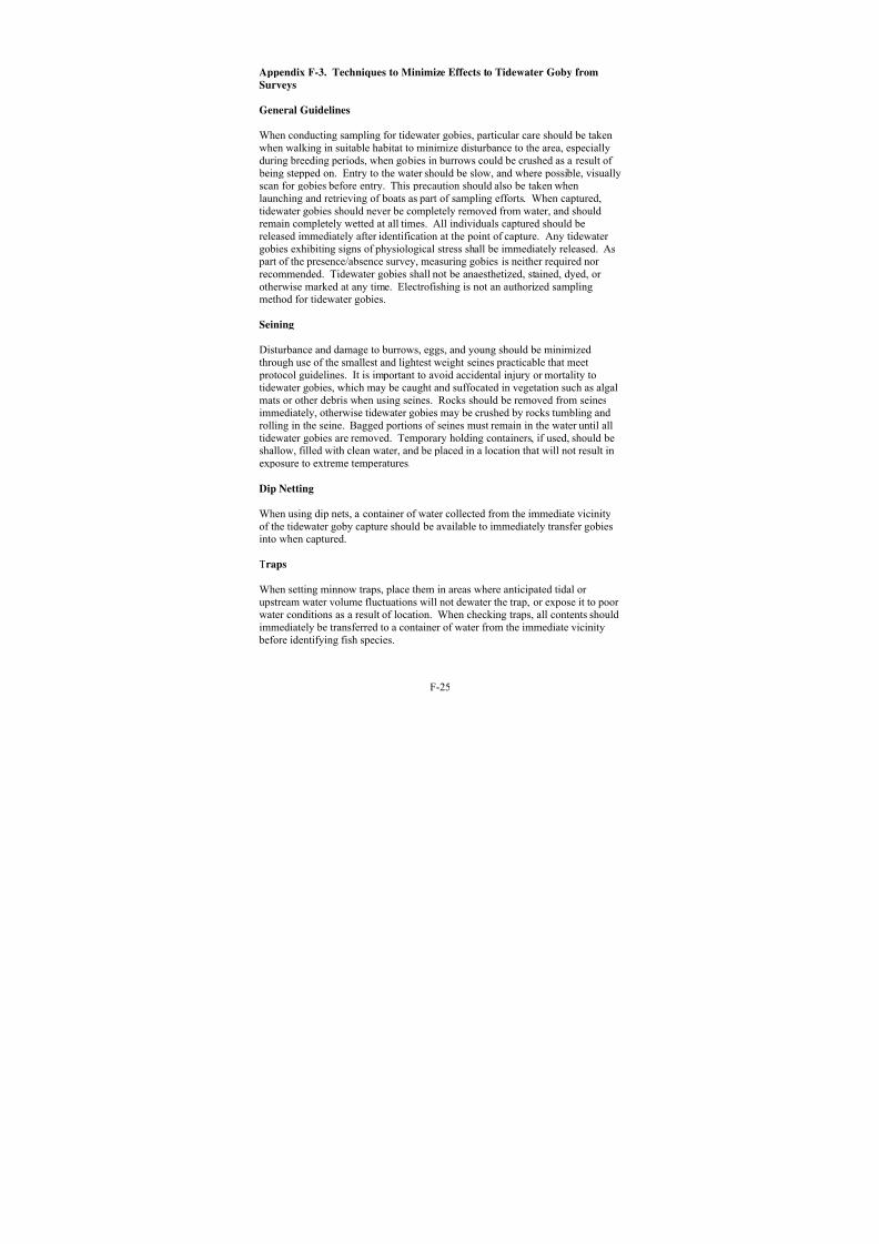
8/3/2019 Recovery Plan for the Tidewater Goby
http://slidepdf.com/reader/full/recovery-plan-for-the-tidewater-goby 179/208
F-25
Appendix F-3. Techniques to Minimize Effects to Tidewater Goby fromSurveys
General Guidelines
When conducting sampling for tidewater gobies, particular care should be takenwhen walking in suitable habitat to minimize disturbance to the area, especiallyduring breeding periods, when gobies in burrows could be crushed as a result of being stepped on. Entry to the water should be slow, and where possible, visuallyscan for gobies before entry. This precaution should also be taken whenlaunching and retrieving of boats as part of sampling efforts. When captured,tidewater gobies should never be completely removed from water, and shouldremain completely wetted at all times. All individuals captured should bereleased immediately after identification at the point of capture. Any tidewater gobies exhibiting signs of physiological stress shall be immediately released. As part of the presence/absence survey, measuring gobies is neither required nor
recommended. Tidewater gobies shall not be anaesthetized, stained, dyed, or otherwise marked at any time. Electrofishing is not an authorized samplingmethod for tidewater gobies.
Seining
Disturbance and damage to burrows, eggs, and young should be minimizedthrough use of the smallest and lightest weight seines practicable that meet protocol guidelines. It is important to avoid accidental injury or mortality totidewater gobies, which may be caught and suffocated in vegetation such as algalmats or other debris when using seines. Rocks should be removed from seinesimmediately, otherwise tidewater gobies may be crushed by rocks tumbling androlling in the seine. Bagged portions of seines must remain in the water until alltidewater gobies are removed. Temporary holding containers, if used, should beshallow, filled with clean water, and be placed in a location that will not result inexposure to extreme temperatures.
Dip Netting
When using dip nets, a container of water collected from the immediate vicinityof the tidewater goby capture should be available to immediately transfer gobiesinto when captured.
Traps
When setting minnow traps, place them in areas where anticipated tidal or upstream water volume fluctuations will not dewater the trap, or expose it to poor water conditions as a result of location. When checking traps, all contents shouldimmediately be transferred to a container of water from the immediate vicinity before identifying fish species.

8/3/2019 Recovery Plan for the Tidewater Goby
http://slidepdf.com/reader/full/recovery-plan-for-the-tidewater-goby 180/208
G-1
Appendix G. Description of Recovery Units and Sub-Units
The 6 Recovery Units and 26 Sub-Units are described below. Informationreviewed includes each Recovery Unit’s and Sub-Units distinguishing
phylogeographical features, location, geological characterization, and tidewater goby morphological descriptions. Primary recovery tasks are also described for each location. In some cases, where data and research are lacking, descriptionsare brief or incomplete. Table G-1, provided below, lists source populations for potential tidewater goby reintroduction and introduction sites.
North Coast Unit (NC)
This Recovery Unit extends from Smith River near the Oregon border to thesouthern end of Mendocino County. It has the greatest geographic extent alongthe coast (approximately 150 miles) of any of the proposed recovery units. This
unit forms a discrete clade in phylogeographic analysis (Dawson et al. 2001) andis also differentiated from other units in that all fish observed have completesupraorbital canal structures (D. Jacobs pers comm. 2004). South of MendocinoCounty for approximately 70 miles to Salmon Creek the coast is rocky and steep,and there appear to be few of the small estuarine habitats preferred by tidewater gobies. No tidewater gobies have been captured or detected within the estuaries,lagoons, and river mouths along this stretch of coast, further supporting our assumption that it is a significant barrier to tidewater goby dispersal.
Only a limited number of mitochondrial sequences have been generated fromwithin the North Coast Recovery Unit. These data alone are insufficient to defineSub-Units in the region. Therefore, Sub-Units are based on distance between sitesand on coastal geomorphology, where differential dispersal over sand and rock,as observed elsewhere (Dawson et al. 2001; Barlow 2002; Lafferty et al. 1999)and discussed above, comes into play.
Sub-Units
The NC1 Sub-Unit is delineated by the extent of the Holocene alluvial surfacealong the coast in the Region of Smith River and Lake Earl/Talawa. This stretchof coast is characterized by low-lying sandy shores. Lake Earl, a large dune-dammed lagoon, likely sustains the largest tidewater goby population in thespecies range. However, Lake Earl is a single locale and is subject to breaching,
which affects the population. In addition, the only other known habitat in the areain Tillas Slough of the Smith River has been difficult to collect at times, implyingscarcity or intermittency of this population. Given the proximity and softsubstrate, it is unlikely that these sites are genetically distinct except perhaps for potential loss of genetic variation in Tillas Slough due to bottlenecks
*or
recolonization. Tidewater gobies are not known from the steeper coast extending30 miles to the south, suggesting that these populations are genetically isolatedfrom the next Sub-Unit to the south. Thus, there is reason to be concerned given
8/3/2019 Recovery Plan for the Tidewater Goby
http://slidepdf.com/reader/full/recovery-plan-for-the-tidewater-goby 181/208
G-2
the presence of only two populations. It is possible that locations in the SmithRiver Estuary other than Tillas Slough might make viable tidewater goby habitator that fish could be transplanted to Elk Creek or other small drainages just to thesouth on contiguous coastal lowlands.
Primary tasks recommended for recovery:1) Monitor 2) Establish degree of genetic isolation of the Sub-Unit.3) Confirm that Lake Earl is the source of genetic variation in the region.4) Transplant Tillas Slough with tidewater gobies from Lake Earl after 3 years of recorded absence.5) Establish populations in Elk Creek.
The NC2 Sub-Unit consists of four occupied tidewater goby localities alongapproximately 15 miles of low-lying coast associated with Holocene alluvium.This region, extending north of Patrick’s Point, is isolated from other regions bysteep coasts. NC2 is primarily defined on the basis of the natural extent of the
species range and geomorphology. The northernmost site, Redwood Creek estuary, is a seasonally breached freshwater estuary with sloughs. The other threesites are large lagoons. Tidewater gobies have often proved difficult to locate inRedwood Creek estuary. One lagoon (Freshwater Lagoon) has high populationsof introduced predators (centrarchids) and populations of tidewater gobies havenot been observed there in over 50 years. The other two lagoons (Stone Lagoon,Big Lagoon) have a more continuous population history although frequency of sampling has been limited.
Primary tasks recommended for recovery:1) Monitor
2) Establish degree of genetic isolation of the Sub-Unit.3) Confirm that Stone and Big Lagoons are the most genetically variable potentialsource populations in the region.4) Restore and transplant Redwood Creek estuary with tidewater gobies fromStone Lagoon after 3 years of recorded absence (Table G-1).
The NC 3 Sub-Unit consists of a region of sandy coast and coastal Holocenealluvium about 25 miles in length from the mouth of the Mad River in the northacross Arcata /Humboldt Bay to the Eel River to the south. Again, this Sub-Unitis defined largely by the isolation of this sandy shoreline limited by rocky shoresto the north and south. Tidewater gobies have been recovered from the margin of
Arcata/Humboldt Bay. Here they occupy high marsh channels. In the case of theMad River Slough (not the Mad River proper) the habitat appears to be a longabandoned tide-gated irrigation channel marginal to the Slough, which in turnempties into Arcata Bay. This elevated habitat appears to be isolated from tidalaction except perhaps during spring tides. This site is atypical in that it is not in atypical seasonally closed coastal setting (although the population in LagunitasCreek that debouches into Tomales Bay and extirpated populations around SanFrancisco Bay may represent similar bay margin habitats). It seems likely that
8/3/2019 Recovery Plan for the Tidewater Goby
http://slidepdf.com/reader/full/recovery-plan-for-the-tidewater-goby 182/208
G-3
geomorphologic modification of this region may have led to less seasonallyclosed habitat over time. Dredging and jetties may also serve to maintain theopen condition of Arcata Bay. Agricultural and transportation activity have alsogreatly modified the bay margins, likely eliminating tidewater goby habitat.
The Mad River Slough is the only location where collections have been predictably successful in recent years. This habitat is small and potentiallysubject to further modification. Tidewater gobies have also recently beenreported from southern Arcata Bay in Jacoby Creek, KATA Station, andFreshwater Slough, all of which are similar small habitat. Nevertheless, the statusof the tidewater goby in the NC3 region seems particularly precarious. Thus, a proactive effort to place tidewater gobies in similar closed high-marsh-channel/bay-margin habitats seems appropriate. To this end, other localities suchas Klopp Lake, Hookton Slough, and White Slough have been mentioned as potential tidewater goby habitat. These sites tend to be small, and it can beargued that, due to the small size and precarious nature of these habitats, a larger number of sites should be identified in which reintroductions should be attempted.Successive reintroductions should be attempted after observation of absence in 2rather than 3 years. This is merited by the small size of sites that permit greater certainty of absence and the precarious nature of the suite of populations(metapopulation) that comprises the unit.
Tidewater gobies have been recently reported from the Eel River (G. Goldsmith, pers. comm.. 2004) . The Eel River has a more open system than tidewater gobiesgenerally prefer; however, this river is part of the low alluvial plain thatconstitutes NC3. It is very likely that the Eel River and for that matter the MadRiver were connected with the Humboldt/Arcata Bay system at various times inthe Holocene either through flooding or channel migration. In short, it is
worthwhile transferring tidewater gobies to the Mad River to see if it can sustain populations despite what appear to be less than perfect conditions.
Primary tasks recommended for recovery:1) Monitor 2) Establish degree of genetic isolation of the Sub-Unit.3) Tidewater gobies should be transferred to the Mad River Estuary, Klopp Lake,Hookton Slough, and White Slough from the Mad River Slough, Jacoby Creek,Gannon Slough, KATA Station, and Freshwater Slough.4) Consider other sites around the margin of Humboldt Bay for transfer of tidewater gobies.
5) Localities should be considered for transfer from persisting sites after 2 yearsof absence (see Table G-1).
The NC4 Sub-Unit consists of Ten Mile River, a large relatively pristine localitythat is seasonally closed. This site is separated by at least 60 miles of steep coastand Cape Mendocino from locations in NC3 to the north. The two small sites of Virgin and Pudding Creek, constituting NC5, are located less than 10 miles to thesouth, albeit over rocky substrate. These units may be isolated due to the rocky

8/3/2019 Recovery Plan for the Tidewater Goby
http://slidepdf.com/reader/full/recovery-plan-for-the-tidewater-goby 183/208
G-4
shore, or they could be sink populations supplied by Ten Mile River. Geneticanalysis to assess the relationship between these units is necessary. As the lagoonis large, transplanting should probably not be conducted until extensive presence/absence surveys have not detected tidewater gobies over 4 years.
Primary tasks recommended for recovery:1) Monitor 2) Establish degree of genetic isolation of the Sub-Unit.3) Ten Mile River should have gobies transferred to it from Virgin or PuddingCreek after 4 years of recorded absence (see Table G-1).
The NC5 Sub-Unit consists of Virgin and Pudding Creeks. These small closedstream habitats near Fort Bragg are separated by less than 10 miles from Ten MileRiver. As discussed above, they may or may not be genetically isolated from thisSub-Unit (NC4). If after genetic analysis NC4 and NC5 are determined to beidentical with Ten Mile River, or if they are determined to be operating as aninteracting metapopulation with Ten Mile River, they should be conjoined and
managed as a single unit. It may be that once the genetic issues have beenaddressed, other small habitats in the region could be identified to raise thenumber of habitats in the unit to support recovery. Virgin Creek and PuddingCreek should have tidewater gobies transferred (one from the other) after 2 yearsof recorded absence as they are small easily surveyed habitats.
Primary tasks recommended for recovery:1) Monitor 2) Establish degree of genetic isolation of the Sub-Unit.3) Virgin and Pudding Creek should be recolonized after 2 years (see Table G-1).4) Other streams suitable for recolonization in the Fort Bragg region should be
identified.
The NC6 Sub-Unit consists of three small localities, Davis Pond, Brush Creek and Lagoon Creek, located on a low sandy shore north of Pt. Arena (Manchester State Beach). It is separated by about 25 miles of rocky coast to the north. Thisstretch of coast between NC5 and NC6 is of interest as it contains a number of modest size streams suggesting the possibility of tidewater goby habitat.However, streams such as the Noyo and Navarro may not close in the summer due to the lack of sandy sediment buildup at their mouths. Thus they may not beadequate tidewater goby habitat or they may only serve as tidewater goby habitatintermittently. The North Coast Unit is separated to the south of Point Arena by
about 60 miles of steep coast where tidewater gobies have not been found. This break in distribution corresponds to a clade break in the Dawson et al. (2001)analysis between the North Coast Unit and the Greater Bay Area Unit. Given thesmall size and isolation of the NC6 habitats, their likelihood of persistence seemssmall. As yet, there is no evidence that they are genetically distinct. If suchevidence were forthcoming, it could prove important to establish still other nearby populations to sustain the viability of this Sub-Unit.

8/3/2019 Recovery Plan for the Tidewater Goby
http://slidepdf.com/reader/full/recovery-plan-for-the-tidewater-goby 184/208
G-5
Primary tasks recommended for recovery:1) Monitor 2) Establish degree of genetic isolation of the Sub-Unit.3) Davis Pond, Brush and Lagoon Creeks should be recolonized after 2 years (seeTable G-1).
4) Identify other streams suitable for recolonization in the Manchester Beachregion.
Greater Bay Unit (GB)
This Recovery Unit extends from Salmon Creek just north of Bodega Head inSonoma County to the Salinas River Valley in Monterey County. It is separatedfrom the North Coast Unit by 60 miles of steep coast and a clade break is evidentin some analyses (Dawson et al. 2001). To the south, this unit is separated fromthe Central Coast Unit by the steep 100 mile long Big Sur Coast which supportslittle estuarine habitat appropriate for tidewater gobies. Again a clade break between the Greater Bay and Central Coast Units is evident in the Dawson et al.(2001) analysis. David Jacobs (pers comm. 2004) reported that the Greater BayUnit has a low frequency of modest reduction of the supraorbital canal, asopposed to the North Coast Unit where no such reduction is observed, and units tothe south where such reduction is more pervasive and instances of reduction aremore substantial.
In the North Coast Unit discussed above, genetic information in hand is limitedand there is no evidence for genetic differentiation. In contrast, in the Greater Bay Unit approximately 240 tidewater gobies from 16 collection localities havemitochondrial control regions sequenced (D. Jacobs pers. comm. 2004; Barlow2002). There are still a few localities in the region such as Scott Creek and
Waddell Creek where interpolation is required. Nevertheless, a reasonablycomprehensive pattern has emerged. This pattern is one of substantial and verylocal genetic differentiation, which is presumed to be a consequence of lack of dispersal around rocky promontories. Of the 15 localities examined by Barlow(2002) only a few closely spaced samples are not highly significantly differentfrom all others in the region on the basis of an AMOVA (Analysis of Molecular Variance) and FST where significance is established by iterative resampling
techniques. David Jacobs (pers. comm. 2004) infers that many of these locationshave been isolated for much of the Holocene in a scenario where sea level rise atthe beginning of the Holocene flooded many small valleys creating large numbersof closely spaced habitats. Subsequently, shoreline retreat due to coastal erosion
eliminated many of these habitats. The remaining populations were then morewidely spaced and evolved in long-term genetic isolation from one another.
Given the degree of differentiation and the possibility of statistically significantdifferences due to loss of genetic variation that may have occurred as a result of recolonization events (in the few places where they occur), we are conservative inthe definition of Sub-Units in this region. Sub-Units are only defined in cases of long term isolation as evidenced by lack of shared haplotypes with other sites,

8/3/2019 Recovery Plan for the Tidewater Goby
http://slidepdf.com/reader/full/recovery-plan-for-the-tidewater-goby 185/208
G-6
unique fixed or nearly fixed differences, or the presence of endemic clades of haplotypes exclusive to the Sub-Unit. Endemic clades of haplotypes stronglysupport a history of in situ evolution and thus are strongly indicative of long periods of isolation. Despite the application of this relatively strict criterion 11Sub-Units are defined in the region are discussed below.
Sub-Units
The GB1 Sub-Unit is located immediately north of Bodega Head in SonomaCounty. Salmon Creek is the only site known to be occupied and fish fromSalmon Creek are highly statistically significant from all other in an AMOVAanalysis, contain related endemic haplotypes (endemic clade) and share nohaplotypes with other localities. No other occupied tidewater localities have beenreported north of Bodega Head and south of the North Coast Unit as discussedabove. However, there is a small stream valley, Marshall Gulch, located a coupleof miles north of Salmon Creek. As Salmon Creek is a unique singleton population*, establishment at this additional site would provide some safeguards.
However, due to small size, Marshall Gulch may prove to be marginal habitat. Itis also in private hands.
Primary tasks recommended for recovery:1) Monitor 2) Survey Marshall Gulch for the presence of tidewater gobies. Assuming theyare absent, attempt to arrange for transfer to there from Salmon Creek. Thisshould include arrangements with landholders, and possibly enhancement to thehabitat.3) Tidewater gobies should be transferred regularly from Salmon Creek toMarshall Gulch in order to maintain the genetic variation of this “backup
population”.
The GB2 Sub-Unit includes the “Esteros” (Estero Americano and Estero SanAntonio), Marin County, where tidewater gobies are generally present, andextirpated sites in Bodega Bay (Cheney Gulch) and Walker Creek in northernTomales Bay, Marin County. Estero Americano and Estero San Antonio aredominated by a diverse clade of haplotypes endemic to this unit. Two other clades of haplotypes are present, one of which is exclusive to Estero Americano.This set of haplotypes is similar, but not identical to those in tidewater gobiesfrom Salmon Creek. Perhaps because of the presence of these haplotypes in
Estero Americano and not in Estero San Antonio, FST analysis documents that theEsteros are distinct from each other at the 5 percent level. Thus even though theyare adjacent to each other gene flow between them does not appear to becontinuous. Nevertheless they are treated in the same unit here.
Given the subtle differences between the Esteros, any attempt to recolonize sitesaround Bodega Harbor should come from Estero Americano. Bodega Harbor has been dredged since World War II, and a jetty to stabilize the opening was

8/3/2019 Recovery Plan for the Tidewater Goby
http://slidepdf.com/reader/full/recovery-plan-for-the-tidewater-goby 186/208
G-7
provided circa 1970. This likely increased the tidal variation in the inner reachesof the Bodega Harbor, which was separated by shallow flats from the opening. Inaddition, during the 1970’s a large road was built along the north and westmargins of the Bay in preparation for a nuclear plant that was never constructed.This alteration of high marsh habitat may have eliminated tidewater gobies.
Water wells in the dune fields north of the bay may also lower the water table andlimit freshwater input, further constraining tidewater goby breeding habitat.Given these factors it is not clear how much potential there is for tidewater gobiesto persist in Bodega Harbor. However, there seems to be little reason not to placetidewater gobies in potential habitats in the harbor on an experimental basis. Theend of Cheney Gulch is one possible location for transfer. Another possibility is aditch/marsh area near the north end of the harbor, which was isolated from theharbor by the construction of the shoreline road mentioned above.
Walker Creek is located just inside Tomales Bay. Tomales Bay is fully tidal. Atthe entrance to the Bay are two sand spits extending from the east side of the Bay.These spits presumably accreted successively in the Holocene as a consequenceof southward transport of sediment along the Bodega Bay shore. As thesefeatures are sand, presumably tidewater gobies could have readily moved aroundthese features from the Esteros. Thus it is assumed that Walker Creek would havehad greater contact with the Esteros than with the Lagunitas/Papermill locality atthe southern terminus of Tomales Bay, as much of the shoreline within the bay isrocky and potentially precludes dispersal. However, it could be argued thatmitochondrial sequences from museum specimens of tidewater gobies fromWalker Creek should be generated to unequivocally establish that these historic populations were like those now in the Esteros. The reason for concern in thisregard is that the Lagunitas tidewater gobies are genetically distinct from all other localities (discussed below), and the distinction between the north and south endsof the bay is based on our general assumption of exclusively adult dispersal over sand. There may be, or may have been historically more sand at depth in the baythan is evident today. In addition the argument for lack of larval dispersal maynot apply to bays to the same degree as to seasonally closed sites on the outer coast. Lenses of freshwater could transport tidewater goby larvae around the bayfollowing the first significant rains in the fall. Thus examination of the geneticaffinities of Walker Creek museum samples may be merited even though this isrelatively difficult to do.
At the mouth of Walker Creek, the creek itself seems to be isolated from a marsh by a flood-generated or possibly man-made levy. Thus the flow of the stream
may be effectively channelized and separated from shallow tidewater goby habitatin the marsh area and a railroad trestle to the south of the creek. Due to thisseparation it is not clear whether good tidewater goby habitat is present.However tidewater gobies could be placed in the adjacent marsh or behind anabandoned railroad trestle adjacent to the marsh.
Primary tasks recommended for recovery:1) Monitor
8/3/2019 Recovery Plan for the Tidewater Goby
http://slidepdf.com/reader/full/recovery-plan-for-the-tidewater-goby 187/208
G-8
2) “Experimental” introduction of Estero Americano tidewater gobies intoBodega Harbor habitats should be conducted at Cheney Gulch and the north endof the harbor.3) In the case of 4 years of monitored absence in either of the Esteros they should be recolonized from the other.
4) The genetics of Walker Creek museum samples should be investigated, and, if appropriate, Estero San Antonio tidewater gobies should be introduced intoWalker Creek. Some modifications to the habitat may be necessary to improvethe habitat.
The GB3 Sub-Unit is located in southern Tomales Bay, Marin County. SouthernTomales Bay is exceptionally muddy, presumably as a result of a phase of erosionand agricultural exploitation following the Gold Rush. The tidal exchange in the bay takes over two weeks to turn the water column, hence the retention of finegrained sediment. Until recently the Lagunitas/Papermill Creek population wasconsidered extirpated. However, this last year a population of tidewater gobieswas discovered by Darren Fong in a small distributary (Tomasini Creek) of Lagunitas Creek. Ten mitochondrial control region sequences were obtainedfrom this population (D. Jacobs pers. comm. 2004). They are all identical anddistinct by several base changes from tidewater gobies in other habitats. This population is isolated and appears to have suffered a bottleneck. This geneticallydistinct population appears to be in a precarious state. We would recommendimmediate action to locate other habitats in Southern Tomales Bay to establishthese fish. Fish Hatchery Creek on the west side of the Bay might be appropriate.Habitat, immediately south of Millerton Point might also be appropriate. Plans toimprove habitat are currently being generated. These plans should beimplemented in a way that allows this genetically unique population to persist.
The GB4 Sub-Unit includes sites on the outer coast from Point Reyes, MarinCounty, south to Point San Pedro, San Mateo County, as well as sites within SanFrancisco Bay, San Francisco, Contra Costa, and Alameda Counties. Tidewater gobies have only persisted in Rodeo Lagoon, presumably due to a history of extensive shoreline modification in the region. This population is highlystatistically distinct from all others; it shares no haplotypes with other localitiesand is dominated by a clade of related haplotypes. It is presumed to berepresentative of tidewater gobies from a large number of extirpated localities inthe region.
Immediately south of Point Reyes in Point Reyes National Seashore, Horseshoe
Lagoon and Estero de Limantour appear to provide good protected habitat. Theabsence of historic records of tidewater gobies in these localities may relate toearly habitat modification for grazing (tide-gating for cattle ponds) andintroduction of exotic sport fish. However, these problems are no longer an issueand placement of tidewater gobies in these localities would be merited.
Many localities in San Francisco Bay and along the outer coast may be no longer viable due to habitat modification. Others may currently be suitable, but lack a
8/3/2019 Recovery Plan for the Tidewater Goby
http://slidepdf.com/reader/full/recovery-plan-for-the-tidewater-goby 188/208
G-9
source of recruits in the bay. As tidewater gobies are abundant at Rodeo Lagoon,there is little reason not to place gobies in a large number of habitats on anexperimental basis. Thus it seems reasonable to survey the habitat in the region(GB4c and e through n, in Figure B-7) to identify localities most likely to providetidewater goby habitat. This might include sites in addition to those listed in
Table G-1. Some historic sites may be judged to be completely nonviable. Insome cases habitat modification or elimination of exotics may be merited toimprove suitability for tidewater gobies.
Primary tasks recommended for recovery:1) Monitor 2) Introduction of tidewater gobies into Horseshoe Lagoon and Estero deLimantour from Rodeo Lagoon.3) Survey coast and bay habitats in the unit for currently viable tidewater gobyhabitat.4) Introduce tidewater gobies to suitable habitats on an experimental basis.
The GB5 Sub-Unit includes three currently occupied sites: San Gregorio,Pescadero, and Bean Hollow, in San Mateo County. Haplotypes in the regionform a single diverse monophyletic clade of haplotypes. All three sites are highlystatistically distinct from all other tidewater goby sites in a resamples FST approach (Barlow 2002). San Gregorio Creek and Bean Hollow are notstatistically differentiated from each other, but the intervening site, PescaderoCreek is. Presumably this is a consequence of extinction/recolonization dynamics between the sites. Despite this local heterogeneity there seems little reason to notto treat all three sites as a single unit as they are all on a relatively continuoussandy coast isolated by steeper coast to the north and south and share manyhaplotypes. Much of this coast is protected in State Parks. One additional estuary
in this area, Pompino Creek, might support tidewater gobies if they wereintroduced.
Primary tasks recommended for recovery:1) Monitor 2) Introduce tidewater gobies into Pompino Creek from Pescadero Creek.3) Reintroduce tidewater gobies after 4 years of monitoring (see Table G-1).
The GB6 Sub-Unit is the first of a number of Sub-Units that are relatively closelyspaced along the steep intermittently rocky shores from north of Santa Cruz to theSalinas Valley, Santa Cruz and Monterey counties. Despite the close spacing of
many of these habitats, steep shores and minor promontories are associated withgenetically distinct entities. There is no genetic information from the mostnortherly samples in this Sub-Unit, Scott and Waddell Creeks. Although they aregrouped here with Laguna Creek, the next site to the south, the geneticrelationship between the sites needs to be determined.
Laguna Creek is highly significantly distinct from all other sites examined in theGreater Bay Unit (Barlow et al. 2002). It is dominated by an endemic clade of
8/3/2019 Recovery Plan for the Tidewater Goby
http://slidepdf.com/reader/full/recovery-plan-for-the-tidewater-goby 189/208
G-10
haplotypes. The most common haplotype found in Laguna Creek has also beenobserved once in Moran and once in Corcoran Lagoon. A common haplotypefrom the Sub-Unit GB7 also occurs once in Laguna Creek (n=16). Based oncurrent sampling, several other haplotypes present in Laguna Creek are unique tothe locality. These haplotypes could also be present in Scott or Waddell Creek to
the north.
Primary tasks recommended for recovery:1) Monitor 2) Waddell Creek, which is currently extirpated, should be supplied withtidewater gobies from Scott Creek.3) Scott Creek should be sampled genetically to determine if it is geneticallydistinct from Laguna Creek, which is substantially to the south.
The GB7 Sub-Unit consists of a suite of closely spaced localities includingBaldwin Creek, Lombardi Creek, Old Dairy Creek, Wilder Creek, Younger Lagoon and Moore Creek, Santa Cruz County. Mitochondrial sequence data are
available for Baldwin Creek, Wilder Creek and Moore Creek. In addition it isknown that both Younger Lagoon and Moore Creek have been extirpated andrecently recolonized. Baldwin Creek and Wilder Creek are not differentiated bythe iterated FST test. Moore Creek is actually statistically distinct from all other samples and shares some haplotypes with Moran/Corcoran in Sub-Unit GB8, buta greater number of haplotypes are shared with Wilder Creek and Baldwin Creek.Hence we place it with this group (Barlow 2002). Given its known extirpation, itappears that Moore Creek received recruits from both sites, Wilder Creek to thenorth and Moran Lake to the south. In these small sites extirpation andrecolonization appear to be ongoing.
Primary tasks recommended for recovery:1) Monitor 2) Assess additional tidewater goby extirpation and recolonization dynamics inthe region.3) Reintroduce tidewater gobies after 4 years of monitoring (see Table G-1).
The GB8 Sub-Unit includes Moran Lake and Corcoran Lagoon, Santa CruzCounty, which are not statistically distinct from each other using an iteratedresampling of data and calculation of FST (Barlow 2002). They are highlysignificantly different from all other sites, and Corcoran Lagoon contains somesmaller clades of endemic haplotypes. Tidewater gobies recently recovered from
the San Lorenzo River, which located west of Corcoran Lagoon, are most likelyrelated to this unit.
Primary tasks recommended for recovery:1) Monitor 2) Assess additional tidewater goby extirpation/recolonization dynamics in theregion. In particular the genetics of fish from the San Lorenzo River need to beassessed,

8/3/2019 Recovery Plan for the Tidewater Goby
http://slidepdf.com/reader/full/recovery-plan-for-the-tidewater-goby 190/208
G-11
3) Improvement of other small habitats in the region so that they can sustaintidewater goby populations.4) Reintroduce tidewater gobies after 2 years of monitoring (see Table G-1).
The GB9 Sub-Unit includes Aptos Creek and Soquel Creek, Santa Cruz County.Aptos Creek is highly statistically distinct from all other localities and it isdominated by a clade of endemic haplotypes suggesting in situ evolution. SoquelCreek is a historic tidewater goby site. If it is modified to support them, tidewater gobies should be reintroduced there.
Primary tasks recommended for recovery:1) Monitor 2) Reintroduce tidewater gobies into Soquel Creek from Aptos Creek population.Reintroduction should take place regularly to maintain a backup population.
The GB10 Sub-Unit includes the Pajaro River, Santa Cruz County, which isisolated from other tidewater goby localities in the region. A concerted effort
should be made to determine if tidewater gobies continue to reside there. If theydo, it should be determined whether or not theses tidewater gobies are distinctfrom tidewater gobies in Bennett Slough to the south. If no tidewater gobies arerecovered or if they prove to be sufficiently similar to those in Bennett Slough,then the GB10 Sub-Unit should be joined with GB11 Sub-Unit. If tidewater gobies are determined to be absent from the Pajaro River, then tidewater gobiesshould be transplanted from Bennett Slough.
Primary tasks recommended for recovery:1) Monitor 2) Survey intensively to confirm status of the tidewater goby.
3) If not present, then improve habitat and introduce tidewater gobies fromBennett’s Slough.
The GB 11 Sub-Unit includes Bennett’s Slough, Monterey County, which is theonly locality where tidewater gobies have been recovered recently in the SalinasValley/Monterey Coastal Plain. These tidewater gobies are highly significantlydifferentiated from all other tidewater gobies in the unit and contain a clade of endemic haplotypes implying long term in situ evolution.
Given the range of interconnected waterways including coastal lagoons as well asagricultural features in the Salinas Valley, it seems that tidewater gobies may persist in other localities in this area. A survey of potential localities in theSalinas Valley/Monterey Coastal Plain should be made to ascertain whether tidewater gobies are present and what other habitat would be appropriate for their reintroduction.
Primary tasks recommended for recovery:1) Monitor

8/3/2019 Recovery Plan for the Tidewater Goby
http://slidepdf.com/reader/full/recovery-plan-for-the-tidewater-goby 191/208
G-12
2) Survey intensively to identify additional tidewater goby habitat in the SalinasValley.3) Reintroduce Bennett Slough tidewater gobies into other appropriate tidewater goby habitat in the Salinas Valley including, but not limited to the Salinas River.
Central Coast Unit (CC)
This Recovery Unit is bounded on the north by the steep Big Sur Coast and on thesouth by Point Buchon immediately south of Morro Bay, and is differentiated by aclade break in the Dawson et al. 2001 data. This unit contains 21 localities fromwhich tidewater gobies have been found at various times. Twenty-ninemitochondrial sequences (D. Jacobs pers. comm. 2004; Dawson et al. 2001) have been obtained. Due to the limited number of samples relative to populations,these data are suggestive, but not conclusive, of subdivision in the region. On the basis of headlands at Point Piedras Blancas and north of Estero Point the region issubdivided into three low coastal regions considered to be Sub-Units. In mostcases these Sub-Units support many small closely spaced coastal estuaries. Oneimportant objective is to understand the degree of genetic differentiation of thethree Sub-Units, and whether the genetic data support this number of units.
Sub-Units
The CC1 Sub-Unit is located north of Piedras Blancas, San Luis Obispo County,and consists of two sites, one of them currently extirpated. If genetic studiessupport the differentiation of these sites, an effort should be made to supplyArroyo del Oso and perhaps other sites in the region with tidewater gobies.
Primary tasks recommended for recovery:
1) Monitor 2) Substantiate Sub-Unit with genetic study.3) Reintroduce Arroyo del Corral tidewater gobies to Arroyo del Oso.4) Examine other sites for potential introduction.
The CC2 Sub-Unit consists of shallow coast line with multiple small estuariessouth of Piedras Blancas and north of the Point Estero Coast. Of the eight smallsites here one seems to be currently extirpated. Given the number of sites and thelack of obvious threats little management may be required.
Primary tasks recommended for recovery:
1) Monitor 2) Substantiate Sub-Unit with genetic study.3) Consider reintroductions if 50 percent of populations are extirpated.
The CC3 Sub-Unit extends south of Estero Point into Morro Bay, San LuisObispo County. This area again involves closely spaced populations similar toCC2. However, it is distinct in that sites in the south adjacent to and withinMorro Bay appear to have been adversely affected by human activity. Currently,

8/3/2019 Recovery Plan for the Tidewater Goby
http://slidepdf.com/reader/full/recovery-plan-for-the-tidewater-goby 192/208
G-13
Morro and Chorro Creek immediately outside and within Morro Bay have beenextirpated, and Los Osos Creek within the Bay may have been recentlyrecolonized. These sites appear to have been adversely affected, bychannelization in the case of Morro Creek. Sites in Chorro Creek and Los OsosCreek in Morro Bay may have been affected by dredging and jetty construction
that increase tidal amplitude as well as the effects of marina construction andother development. This again suggests that bay populations are more subject toextirpation, perhaps due to greater modification of these habitats (e.g. Humboldt/Arcata Bay, Bodega Bay, Tomales Bay, San Francisco Bay). There aresix currently viable localities in the area immediately to the north of Morro Creek.An assessment of habitat quality and threat removal in Morro Creek and MorroBay would seem appropriate as the tidewater gobies appear to have naturallyrecolonized within Morro Bay (Lafferty et al. 1999).
Primary tasks recommended for recovery:1) Monitor 2) Substantiate Sub-Unit with genetic study.3) Improve tidewater goby habitat in Morro Creek and Morro Bay.4) Consider reintroductions if number of occupied sites falls below four.
Conception Unit (CO)
This Recovery Unit begins south of the promontory of Point Buchon and extendsall the way around Point Conception and is bounded to the south and east of theSanta Barbara coast ending at the southern Ventura County line. Both of thesetermini are supported by clade breaks in the Dawson et al. (2001) analysis. It is atfirst surprising that Point Conception does not form a significant barrier.However, unlike other promontories along the coast such as Bodega Head, Point
Reyes or the Big Sur Coast, which are made of Sierran type granite, or a number of other promontories such as Estero Point, which are made of MesozoicFranciscan material, Point Conception is composed of Miocene age sedimentaryrocks, which erode rapidly and supply sediment locally. In addition there is likelya substantial supply of sand from the north at Point Conception. In any case,examination of coastal photos documents that the shoreline at Point Conceptionand Point Arena does not have any long rocky stretches but is regularlyinterspersed with sand. This combination of substrates does not appear to limittidewater goby migration to the same degree as harder substrates. In terms of genetic data, research currently being conducted at the University of California atLos Angeles is in the process of dramatically increasing the amount of
mitochondrial sequence from the region surrounding the City of Santa Barbara(D. Jacobs pers. comm. 2004). There is some suggestion, but not confirmationdue to small sample sizes, of endemic clades of haplotypes to the north of PointConception especially in the Pismo Creek Area. Another issue of concern isHollister Ranch. In this region to the south and east of Point Conception accesshas been difficult to obtain and no tidewater goby samples have been recoveredfor genetic analysis.
8/3/2019 Recovery Plan for the Tidewater Goby
http://slidepdf.com/reader/full/recovery-plan-for-the-tidewater-goby 193/208
G-14
This Recovery Unit is divided into three Sub-Units on the basis of promontoriesat Point Sal and Point Arguello. There is considerable sandy shore north of PointArguello. Along the south - facing coast to the southeast of Point Conceptionthere are many closely spaced habitats with potential rocky shore barriers that arelimited in scale. Thus barriers to dispersal appear to be modest.
Sub-Units
The CO1 Sub-Unit extends between Point San Luis and Point Sal and is a largelysandy shore-line. Three localities currently have tidewater gobies: San LuisObispo Creek, Pismo Creek and the Santa Maria River. Given the apparentdistinction of populations in the region, effort should be made to reestablishtidewater gobies in Oso Flaco Lake.
Primary tasks recommended for recovery:1) Monitor 2) Substantiate Sub-Unit with genetic study.
3) Improve habitat and reduce threats to tidewater gobies in Arroyo Grande andOso Flaco Lake.4) Reintroduce tidewater gobies into Oso Flaco (see Table G-1).
The CO2 Sub-Unit extends from Point Sal to Point Arguello over generally sandycoast. The unit consists of four tidewater goby habitats ranging from largesystems, such as the Santa Ynez River, to Cañada Honda, a frequently extirpated population.
Primary tasks recommended for recovery:1) Monitor
2) Substantiate Sub-Unit with genetic study.3) Improve habitat and remove threats as there only four tidewater goby habitatsin the unit.4) Recolonize (see Table G-1).
The CO3 Sub-Unit extends from Point Arguello to the southeastern terminus of the unit in the steep Seacliff region. This Sub-Unit is a fairly long stretch of coastand contains a large number (28) of small habitats. With the available geographicand genetic data it is not clear that there is any place where the unit should besubdivided. It is possible that Jalama Creek, which lies between Point Arguelloand Point Conception, belongs more appropriately with CO2. An additional
complication is lack of access to Hollister Ranch, where eight populations reside but no monitoring or recovering of tidewater goby samples is currently possible.
Primary tasks recommended for recovery:1) Monitor 2) Substantiate Sub-Unit with genetic study (including Hollister Ranch).4) Consider recolonization if there is a 25 percent reduction in number of inhabited locations.

8/3/2019 Recovery Plan for the Tidewater Goby
http://slidepdf.com/reader/full/recovery-plan-for-the-tidewater-goby 194/208
G-15
LA/Ventura Unit (LV)
This Recovery Unit is bounded on the north by the steep region at Seacliff and isnot subdivided into Sub-Units. The southern terminus is the Palos VerdesPeninsula. The northern terminus is a clade break in Dawson et al. (2001). This
region at Seacliff is unusual in that it is formed by a rapidly uplifted Pleistocenesediment. The cliffs themselves are not indurated. What appears to cause the break is the presence of cobbles rather than sand in the intertidal and shallowsubtidal, which in turn support algal cover. This appears to have been sufficientto isolate this region so that clade formation (coalescence) and reciprocalmonophyly could be established. The southern end of this clade has been hard todefine because of anthropogenic elimination of habitats. The continuity of thisgroup from the Ventura/Santa Clara flood plain around to the Santa Monica Bayis supported by the morphology of classic museum specimens as discussed above. Tidewater gobies in Ormond/J Street Drain site are naturally recolonized, those inMalibu Creek are the product of artificial introduction, and those in Topanga
Creek are naturally recolonized, presumably from Malibu Creek. Barlow (2002)in her thesis examined 30 mitochondrial sequences from each of the five currentlyinhabited sites in the region. Given this history it is perhaps not surprising thatthis region has significantly reduced genetic variation relative to those to the northand that the populations are not genetically differentiated from each other. Theonly statistically significant result identified Topanga Creek as having evengreater reduction in genetic variation, presumably due to founder effect*. Giventhe history of impact in the region it would be beneficial to establish or reestablishadditional sites. Possibilities include the “duck ponds” region of Mugu Lagoon,Big Sycamore Canyon, Arroyo Sequit, Zuma Creek, and perhaps Ballona Creek.Big Sycamore Creek and possibly Zuma Creek might currently support tidewater gobies. But all these sites would benefit from restoration - primarily the removalof fill to make space for lagoon development, as in many cases Pacific CoastHighway and State Parks are built on artificially filled lagoon areas.
Primary tasks recommended for recovery:1) Monitor 2) Substantiate Sub-Unit with genetic study.3) Improve habitat and remove threats to tidewater gobies followed byreintroduction to reconstruct this highly degraded unit.4) Recolonize (see Table G-1).
South Coast Unit (SC)
This Recovery Unit is 4 percent sequence divergent (Dawson et al. 2001), and ismorphologically distinct in that all tidewater gobies observed in the region havesubstantial reduction of the supraorbital canal. Thus these tidewater gobies have been isolated for a substantial period of time, perhaps in excess of the 2 millionyear duration of the Pleistocene. Thus this unit would appear to be distinct at thesubspecific or perhaps even the species level from all the other tidewater gobyunits. This unit also presents a considerable conservation challenge as tidewater

8/3/2019 Recovery Plan for the Tidewater Goby
http://slidepdf.com/reader/full/recovery-plan-for-the-tidewater-goby 195/208
G-16
gobies appear to have been extirpated from much of the region by urbandevelopment. It seems likely that they occupied estuarine habitat from San Pedro,south of Palos Verdes, to La Jolla. Tidewater gobies now occur only on CampPendleton, where they undergo frequent extirpation and recolonization, and fromthe limited mitochondrial sequence data in hand they appear to be severely
bottlenecked (Dawson et al. 2002). From the few observations withmicrosatellites that we have (D. Jacobs pers. comm. 2004) it appears that theremay be a subtle distinction between the two locations in northern Camp Pendletonand the several locations towards the south of the base. These data need to becorroborated by a formal microsatellite study. At the moment, the north and thesouth are treated as separate Sub-Units to facilitate the maintenance of suspectedgenetic variation. In order to aid recovery of the species the tidewater gobyshould be reintroduced into as many localities as possible to the north and southof Camp Pendleton. These localities tend to be larger than those on CampPendleton, and before their modification they were the likely stable source populations in this regional metapopulation. Unfortunately lagoon management
has tended toward complete isolation from the sea or, more frequently, deepdredging for recreational use. This management makes recolonization difficult atsome known historical tidewater goby sites such as San Pedro or Agua Hedionda.Thus sites that have no historic records, but which show every likelihood of having been prime tidewater goby habitat prior to human modification of thesystems, are included as prospective tidewater goby reintroduction sites - e.g.,Bolsa Chica to the north and San Elijo Lagoon, San Diegito Lagoon, LosPeñasquitos Lagoon. These sites should be actively pursued for improvement andreintroduction to augment the number of tidewater goby habitats in this unit asthese locations better approximate the natural semi-closed state than do some of the others.
SC1 and SC2Primary tasks recommended for recovery:1) Monitor 2) Substantiate Sub-Unit with genetic study (microsatellite).3) Improvement habitat and remove threats to tidewater gobies followed byreintroduction to reconstruct this highly degraded unit.4) Recolonize (see Table G-1).

8/3/2019 Recovery Plan for the Tidewater Goby
http://slidepdf.com/reader/full/recovery-plan-for-the-tidewater-goby 196/208
G-17
Table G-1. Tidewater Goby Reintroduction Sites
Recovery
Unit Sub-Unit
Site
Code Recipient population*
Source population(s) if
restorable
Years to wait fromextirpation to re-
introduction**a Tillas Slough (Smith River) NC1b 3
b Lake Earl-Lake Talawa NC1a 3 NC1
c Elk Creek NC1b 0/3
a Redwood Creek estuary NC2b, c 3
b Freshwater Lagoon NC2c 3
c Stone Lagoon NC2d 3 NC2
d Big Lagoon NC2c 3
a Mad River NC3b-f 0/2
b Mad River Slough NC3c-g 2
c Klopp Lake NC3b 0/2
d KATA Station Site NC3f 0/2
e Jacoby Creek/Gannon Slough NC3b 0/2
f Freshwater Slough NC3b 2
NC3
g Eel River NC3b-f 0/2
NC4 a Ten Mile River NC5a 5
a Virgin Creek NC5b 2 NC5
b Pudding Creek NC5a 0
a Davis Pond NC6b 2
b Brush Creek NC6c
N O R T H C O A S T U N I T
NC6
c Lagoon Creek NC6b 2
a Marshall Gulch GB1b 2GB1
b Salmon Creek GB1a
a Johnson Gulch GB2c 0/2
b Cheney Gulch GB2c 0
c Estero Americano GB2d 4
d Estero de San Antonio GB2c 4
GB2
e Walker Creek GB2d 0/2
a Lagunitas Creek GB3b,c 3
b Millerton GB3a GB3
c Fish Hatchery Creek GB3a 0/2
a Horseshoe Lagoon GB4d 0/3
b Estero de Limantour GB4d 0/3
c Bolinas Lagoon GB4d 0/3
d Rodeo Lagoon GB4d 4
e Corte Madera Creek GB4d 0/2
f Mill Creek GB4d 0/2
g Novato Creek GB4d 0/2
h Petaluma Creek GB4d 0/2
i Strawberry Creek GB4d 0/2
j Lake Merrit GB4d
G R
E A T E R
B A Y U
N I T
GB4
k Cliff House/Golden Gate Park GB4d 0/2

8/3/2019 Recovery Plan for the Tidewater Goby
http://slidepdf.com/reader/full/recovery-plan-for-the-tidewater-goby 197/208
G-18
RecoveryUnit Sub-Unit
SiteCode Recipient population*
Source population(s) if
restorable
Years to wait fromextirpation to re-introduction**
l Lake Merced GB4d 0/2
m Laguna Salada GB4d 0/2n San Pedro Creek GB4d 0/2
a San Gregorio Creek GB5d 4
b Pomponio Creek GB5a,c 0/
c Pescadero-Butano Creek GB5b 4GB5
d Bean Hollow Creek GB5a 4
a Waddell Creek GB6c 0/2
b Scott Creek GB6c GB6
c Laguna Creek GB6b 3
a Baldwin Creek GB7b 3
b Lombardi Creek GB7a
c Old Dairy Creek GB7b 4
d Wilder Creek GB7a 4
e Younger Lagoon GB7d 4
GB7
f Moore Creek GB7d 4
a San Lorenzo River GB8b 3
b Corcoran Lagoon GB8c 3GB8
c Moran Lake GB8b 3
a Soquel Creek GB9b 0/2GB9
b Aptos Creek GB9a
GB10 a Pajaro River GB11a 5
a Bennett Slough GB11b 2GB11
b Salinas River GB11a 0
a Arroyo del la Cruz CC1b 0/2
b Arroyo del Oso CC1a 0/2CC1
c Arroyo de Corral CC1a 2
a Oak Knoll Creek CC2b TBD
b Arroyo de Tortuga CC2a TBD
c Broken Bridge Creek CC2a TBD
d Little Pico Creek CC2e TBD
e Pico Creek CC2d TBD
f San Simeon Creek CC2d TBD
g Leffingwell Creek CC2f TBD
CC2
h Santa Rosa Creek CC2f TBD
a Villa Creek CC3c TBD
b San Geronimo Creek CC3a TBD
c Cayucos Creek CC3a TBD
d Little Cayucos Creek CC3c TBD
e Old Creek CC3d TBD
f Willow Creek CC3e TBD
g Toro Creek CC3i,j TBD
C E N T R
A L C O A S T U N I T
CC3
h Morro Creek CC3i,j TBD

8/3/2019 Recovery Plan for the Tidewater Goby
http://slidepdf.com/reader/full/recovery-plan-for-the-tidewater-goby 198/208
G-19
RecoveryUnit Sub-Unit
SiteCode Recipient population*
Source population(s) if
restorable
Years to wait fromextirpation to re-introduction**
i Chorro Creek CC3j TBD
j Los Osos Creek CC3i TBDa San Luis Obispo Creek CO1b 4
b Pismo Creek CO1a
c Arroyo Grande CO1b 0/2
d Oso Flaco Lake CO1b 0/2
CO1
e Santa Maria River CO1b 3
a Shuman Canyon CO2b 3
b San Antonio Creek CO2c 3
c Santa Ynez River CO2b 4CO2
d Canada Honda CO2c 2
a Jalama Creek CO3b TBD
b Canada del Cojo CO3a TBD
c Canada del Pescado CO3b TBD
d Canada del las Agujas CO3b TBD
e Arroyo el Bulito CO3b,d TBD
f Canada del Agua CO3d,e TBD
g Canada de Santa Anita CO3d,e TBD
h Canada de Alegria CO3g TBD
i Canada de Aqua Caliente CO3h TBD
j Gaviota Creek CO3i T
k Arroyo Hondo CO3j TBD
l Arroyo Quemado CO3j TBD
m Refugio Creek CO3j,l TBD
n Eagle Canyon CO3m TBD
o Tecolote Canyon CO3m,p TBD
p Winchester Canyon CO3o TB
q Devereux Slough CO3p TBD
r Campus Lagoon CO3p TBD
s Goleta Slough CO3p TBD
t Arroyo Burro CO3u TBD
u Mission Creek CO3t TBD
v Laguna Channel CO3u TBD
w Sycamore Creek CO3u TBD
x Andree Clark Bird Refuge CO3u TBD
y Arroyo Paredon CO3u TBDz Carpinteria Salt Marsh CO3u,y TBD
aa Carpinteria Creek CO3u,y TBD
C O N C E P T I O N U
N I T
CO3
ab Rincon Creek CO3aa TBD
a Ventura River LV1b 3
b Santa Clara River LV1a 3
c J Street Drain/Ormond LV1a 3
L A / V E N T U
R A U
N I T
LV1
d Calleguas Creek/Mugu LV1b 0/3

8/3/2019 Recovery Plan for the Tidewater Goby
http://slidepdf.com/reader/full/recovery-plan-for-the-tidewater-goby 199/208
G-20
RecoveryUnit Sub-Unit
SiteCode Recipient population*
Source population(s) if
restorable
Years to wait fromextirpation to re-introduction**
e Sycamore Canyon LV1c 0/3
f Arroyo Sequit LV1c 0/3g Zuma Canyon LV1c 0/3
h Malibu Creek LV1a,b 3
i Topanga Creek LV1h 4
j Santa Monica Artesian Springs LV1a,b TBD
k Ballona Creek LV1a,b 3
a San Pedro Harbor SC1f 0/2
b Bolsa Chica SC1f 0
c Aliso Creek SC1f 0/2
d San Juan Creek SC1f 0/2
e San Mateo Creek SC1f 2
SC1
f San Onofre Creek SC1e 2
a Las Pulgas Creek SC2c 2
b Hidden Lagoon SC2a
c Aliso Canyon SC2a 2
d French Lagoon SC2a 2
e Cockleburr Canyon SC2a 2
f Santa Margarita River SC2a 2
g San Luis Rey River SC2a-e 0/2
h Buena Vista Lagoon SC2a-e 0/2
i Aqua Hedionda Lagoon SC2a-e 0/2
j Batiquitos Lagoon SC2a-e 0/2
k San Elijo Lagoon SC2a-e 0/2
l San Diegito Lagoon SC2a-e 0/2
S O U T H E R N C
O A S T U N I T
SC2
m Los Peñasquitos Lagoon SC2a-e 0/2
*see Appendix E threats table for location status as of 2004.
**TBD = to be determined, contact appropriate U.S. Fish and Wildlife Field Office for further direction.
8/3/2019 Recovery Plan for the Tidewater Goby
http://slidepdf.com/reader/full/recovery-plan-for-the-tidewater-goby 200/208
G-21
Literature Cited for Appendix G
Barlow, M. 2002. Phylogeographic structure of the tidewater goby, Eucyclogobius newberryi(Teleostei: Gobiidae), in the San Francisco Bayarea and Ventura County: Implications for Conservation Management. A
thesis submitted in partial satisfaction of the requirements for the degreeMaster of Arts in Biology, University of California at Los Angeles.
Dawson, M. N., J. L. Stanton, and D. K. Jacobs. 2001. Phylogeography of thetidewater goby, Eucyclogobius newberryi (Teleostei, Gobiidae), in coastalCalifornia. Evolution 55(6):1167-1179.
Dawson, M.N., K.D. Louie, M. Barlow, D.K. Jacobs and C.C. Swift. 2002.Comparative phylogeography of sympatric sister species, Clevelandia ios and Eucyclogobius newberryi (Teleostei, Gobiidae), across the CaliforniaTransition Zone. Molecular Ecology 11:1065-1075.
Lafferty, K.D., C.C. Swift, and R.F. Ambrose. 1999. Extirpation andrecolonization in a metapopulation of an endangered fish, the tidewater goby. Conservation Biology 13:1447-1453.

8/3/2019 Recovery Plan for the Tidewater Goby
http://slidepdf.com/reader/full/recovery-plan-for-the-tidewater-goby 201/208
H-1
Appendix H. Summary of Threats and Recommended Recovery Actions.
LISTING
FACTOR THREAT RECOVERY
CRITERIA RECOVERY ACTION NUMBERS
A Loss of marsh habitat due todrainage for coastaldevelopment projects anddredging
I.a, I.b, II 1.2.1, 1.2.4, 1.2.8, 1.2.9, 1.2.10,2.8, 2.12, 3.1, 3.2
A Changes in temperature andsalinity regimes due toupstream water diversions,groundwater overdrafting,dikes and levees insubsidence zones, blockageof connections between
marsh and ocean by roads or railroads, or summer breaching of lagoons
I.a, I.b, II 1.2.2, 1.2.5, 1.2.6, 1.2.8, 1.2.9,1.2.10, 2.2, 2.7, 2.8, 2.12, 3.1,3.2
A Invasion of plants on barelagoon substrates due toupstream water diversions
I.a, I.b, II 1.2.2, 1.2.8, 1.2.9, 1.2.10, 2.2,2.8, 3.1, 3.2
A Water quality reduction dueto siltation, oil field runoff,animal wastes, andagricultural or sewageeffluent
I.a, I.b, II 1.1.3, 1.2.5, 1.2.8, 1.2.9, 1.2.10,2.1, 2.6, 2.8, 3.1, 3.2
A Sedimentation and habitatdegradation due to cattlegrazing and feral pigactivity
I.a, I.b, II 1.1.3, 1.2.5, 1.2.7, 1.2.8, 1.2.9,1.2.10, 2.1, 2.6, 2.8, 3.1, 3.2
A, E Winter floods, exacerbated by river channelization,scouring out sandy habitatand washing gobies out of
lagoons
I.a, I.b, II 1.2.4, 1.2.8, 1.2.9, 1.2.10, 2.5,2.8, 3.1, 3.2
B Not applicable
C Predation by introduced predatory fishes(centrarchids, striped bass,etc.), amphibians, or crayfish
I.a, I.b, II 1.1.2, 1.2.3, 2.3, 2.4, 3.1, 3.2

8/3/2019 Recovery Plan for the Tidewater Goby
http://slidepdf.com/reader/full/recovery-plan-for-the-tidewater-goby 202/208
H-2
LISTING
FACTOR THREAT RECOVERY
CRITERIA RECOVERY ACTION NUMBERS
C Infestation by parasiticflukes (Cryptocotyle lingua)
I.a, I.b, II
D Inadequacy of Clean Water Act, NationalEnvironmental Policy Act,and CaliforniaEnvironmental Quality Actto protect the species
Notapplicable
Beyond scope of recovery plan.
E Deterioration of coastal andriparian habitat due todrought
I.b, II 1.2.2, 1.2.8, 1.2.9, 1.2.10, 2.2
E Competition with
introduced species(rainwater killifish, exoticgoby species)
I.a, I.b, II 1.2.3, 2.3, 3.1, 3.2
E Small population size,stochastic extinction risk and loss of geneticdistinctiveness for recoveryunits and sub-units
I.b, II 1.1.1, 1.2.11, 1.2.12, 2.9, 2.10,2.11, 4.1, 4.2, 4.3
Listing Factors:
A. The Present or Threatened Destruction, Modification, or Curtailment Of Its Habitat or RangeB. Overutilization for Commercial, Recreational, Scientific, Educational Purposes (not a factor)C. Disease or PredationD. The Inadequacy of Existing Regulatory MechanismsE. Other Natural or Manmade Factors Affecting Its Continued Existence
Recovery Critera:
I.a. Individual management plans developed and implemented that address specific threats toeach metapopulation.
I.b. All recovery units are viable, with metapopulation viability analysis projecting multipleindividual sub-units in each recovery unit have 75% chance of persisting for 100 years.
II. All recovery units are viable, with metapopulation viability analysis projecting multipleindividual sub-units in each recovery unit have 95% chance of persisting for 100 years.

8/3/2019 Recovery Plan for the Tidewater Goby
http://slidepdf.com/reader/full/recovery-plan-for-the-tidewater-goby 203/208
I-1
Appendix I. Summary of Comments
On November 18, 2004, we published a Notice of Availability in the FederalRegister of the Draft Recovery Plan for the Tidewater Goby (Draft Plan) for a 60-
day comment period ending on January 18, 2005 for Federal agencies, State andlocal governments, and members of the public (69 FR 67602). Four selected peer reviewers were asked to provide review of the draft plan. Comments werereceived from three peer reviewers.
This section provides a summary of general demographic information includingthe total number of letters from various affiliations. It also provides a summary of major comments. All letters of comment on the draft plan are kept on file in theVentura Fish and Wildlife Office at 2493 Portola Road, Suite B, Ventura,California 93003.
The following is a breakdown of the number of letters received, by affiliation:
Federal agencies 1environmental/conservation organizations 2academia/professional 3 business industry 1individual citizens 2
A total of 9 letters were received, each containing varying numbers of comments.Some of the comments were duplicated between the letters. Most letters providednew information or suggestions for clarity. Where appropriate, new information
was incorporated into the final version of the recovery plan directly. Some letterssimply expressed a desire to work with us in efforts to conserve populations of tidewater goby on lands under the entities’ management. Some comments dealtwith matters of opinion, which did not provide information relevant to therecovery of the tidewater goby and did not result in changes to the draft plan. Afew comments suggested shifts of emphasis or concurred with parts of the draft plan. While these review comments were helpful, they generally did not result inchanges to the recovery plan. We did not receive any comments that weconsidered controversial or significant in the sense of making a difference in thefundamental way that recovery of the tidewater goby is being approached.Information and comments not incorporated into the final version of the recovery plan were considered, noted, and are on file with the entire package of agency and public comments; these may become useful in the future. Major comments thatwere not incorporated or that require clarification in addition to their incorporation are addressed below.
Summary of Comments and Our Responses

8/3/2019 Recovery Plan for the Tidewater Goby
http://slidepdf.com/reader/full/recovery-plan-for-the-tidewater-goby 204/208
8/3/2019 Recovery Plan for the Tidewater Goby
http://slidepdf.com/reader/full/recovery-plan-for-the-tidewater-goby 205/208
I-3
Response: Private and public individuals and agencies have responsibilitiesunder section 9(a)(1) of the Act, which make it unlawful for any person subject tothe jurisdiction of the United States to engage in specific activities with respect toendangered species, including, but not limited to, the take of any such species.Breaching lagoons and estuaries that contain tidewater gobies may result in take
of tidewater gobies.
Recovery plans provide recommendations that guide the Service and others inrecovering listed species. Recovery plans are not land use plans and cannotrestrict activities proposed by other agencies or the public. The Service cannotidentify every potential action that may occur within a species’ range, nor can theService identify every site where those actions might be proposed. Proposedactions will be evaluated under the procedures established by sections 7 and10(a)(1)(B) of the Act. The review, consultation, and permitting processes are theavenues by which those actions may be identified and evaluated, and any negativeeffects avoided or minimized.
Comment: One commenter expressed concern over threats to tidewater gobyhabitat adjacent to, or upstream of, their property over which they have little or nocontrol.
Response: Private and public individuals and agencies have responsibilitiesunder section 9(a)(1) of the Act, which make it unlawful for any person subject tothe jurisdiction of the United States to engage in specific activities with respect toendangered species, including, but not limited to, the take of any such species.Federal and non-Federal actions that may affect or take tidewater gobies and their habitat will be reviewed by the Service under section 7 and section 10 processes,respectively. Liability for unlawful take would be determined on a case-by-case basis.
Comment: One commenter believes that the costs for implementing tidewater goby recovery tasks are unrealistically low.
Response: These estimates are based on similar actions in other recovery plansand adjusted for inflation, and information provided to us by Agencies whoimplemented such actions. As the recovery plan is implemented, the exact costswill become more apparent.
Comment: Several commenters suggested we expand designated critical habitatfor the tidewater goby to include the entire range and to integrate the upcomingre-designation of the tidewater goby designated critical habitat into the finalrecovery plan.
Response: The evaluation of the need for and the designation of critical habitatare accomplished through the listing process under subsections 4(a)(3) and 4(b)(2)of the Act. The development and implementation of a recovery plan is

8/3/2019 Recovery Plan for the Tidewater Goby
http://slidepdf.com/reader/full/recovery-plan-for-the-tidewater-goby 206/208
I-4
accomplished under section 4(f) of the Act, and is a separate process. In addition,recovery plans are different from critical habitat in that they are not legally binding documents. That is, the designation of critical habitat imposes specificlegal requirements on Federal agencies under section 7 of the Act. In comparison,a recovery plan provides guidance that if followed, can achieve the objectives of
the plan (e.g., downlisting of an endangered species). Furthermore, we believethat recovery plans allow the Service to protect identified habitat moresufficiently than formally designating critical habitat. Through recovery planning, appropriate habitat areas can be addressed and protected withoutcreating undue concern among landowners who routinely do not understand themeaning of critical habitat.
Comment: One commenter suggested that the final plan set baseline tidewater goby population numbers for individual localities.
Response: Setting baseline populations is an inappropriate metric for the
tidewater goby and not useful for setting recovery goals because of the extremefluctuations in individual numbers at the local level, which depends on the time of the year and stochastic events.
Comment: One commenter suggested that the final plan recognize thedistinction between coarse and fine sediments, including the need for maintainingexisting sources of coarse sediments and managing the future generation of finesediments. Furthermore, this commenter recommended that the final plan discussspecific techniques for managing stormwater flows from development areas.
Response: The final recovery plan describes the importance of lagoon andestuary dynamics, which includes optimal substrate composition and freshwater input for the tidewater goby. Conditions existing at the lagoons and estuariesalong the California coast are similar in some cases and are unique in others. TheAct (section 4(f)(1)(B)(i)) requires the Service to incorporate in each plan “adescription of site-specific management actions as any be necessary to achieve plan’s goals.” The Service is also expected to develop recovery plansexpeditiously and to revise them as new information becomes available. Thetidewater goby has a sufficiently broad distribution that, while it is practical for the plan to describe what types of measures need to be taken locally and to setgeographically specific recovery criteria, the plan cannot anticipate activities thatwill be planned on specific sites during its lifetime. Site specific tasks, such asmaintaining sources of coarse sediments and managing storm water flows, will bedeveloped based on the guidance presented in the recovery plan, during the planning and permitting processes appropriate for those sites and projects.
Comment: One commenter suggested the final plan recognize the importance of adaptive management in addressing stressors that can potentially affect tidewater goby habitat.
8/3/2019 Recovery Plan for the Tidewater Goby
http://slidepdf.com/reader/full/recovery-plan-for-the-tidewater-goby 207/208
I-5
Response: The recovery plan recognizes the importance of adaptive managementrelative to addressing threats to the tidewater goby and its habitat (see sectionIV.B.2.13.1 of the recovery plan).
Comment: One commenter expressed concern over contention with landowners
regarding any tidewater goby translocation efforts.
Response: Translocation of the tidewater goby is consistent with the goals of theEndangered Species Act. Guidelines for such activities are provided under section 10(j). This section allows the release (and the related transportation) of any population of an endangered species or a threatened species outside thecurrent range of such species if the Secretary of the Department of Interior determines that such release will further the conservation of a species. Re-introduced and introduced tidewater gobies could be designated asexperimental/nonessential populations under section 10(j), thereby reducing the protections of the Endangered Species Act and providing an invaluable tool in
gaining public support. This strategy can facilitate species recovery inappropriate circumstances.
Another tool that could be used to ease any concerns for translocating tidewater gobies is the Safe Harbor program. A Safe Harbor Agreement is a voluntaryagreement between the Service and one or more private or non-Federallandowners to restore, enhance, or maintain habitats for listed species, candidates,or other species of concern. Under the Agreement, the landowner would be provided assurances that we would not impose additional land use actions. If theAgreement provides a net conservation benefit to the covered species and thelandowner meets all the terms of the Agreement, we would authorize theincidental taking of covered species to enable the landowner to return the enrolledlands to agreed upon conditions.
The recovery plan recommends the use of Safe Harbor Agreements for theconservation of the tidewater goby. Such agreements are seen as a valuable toolthat can used to implement the recovery plan.

8/3/2019 Recovery Plan for the Tidewater Goby
http://slidepdf.com/reader/full/recovery-plan-for-the-tidewater-goby 208/208
Region 1
U.S. Fish and Wildlife Service
Ecological Services
911 NE. 11th Avenue
Portland, Oregon 97232-4181
December 2005