Record of Decision for FOSET #2 – No Further Action Sites · 2020-02-05 · This ROD presents the...
128
Record of Decision for FOSET #2 – No Further Action Sites Former McClellan Air Force Base Superfund Site, McClellan, California U.S. Environmental Protection Agency Region 9 San Francisco, California July 2016 Final SEMS-RM DOCID # 1160622
Transcript of Record of Decision for FOSET #2 – No Further Action Sites · 2020-02-05 · This ROD presents the...

Record of Decision for
FOSET #2 – No Further Action Sites
Former McClellan Air Force Base Superfund Site,
McClellan, California
U.S. Environmental Protection Agency Region 9
San Francisco, California
July 2016 Final
SEMS-RM DOCID # 1160622

THIS PAGE INTENTIONALLY LEFT BLANK

McClellan FOSET #2 – No Further Action Sites ROD Final
i
TABLE OF CONTENTS
ACRONYMS AND ABBREVIATIONS ................................................................... iv
1.0 PART 1: THE DECLARATION ......................................................................... 1 1.1 Site Name and Location ...................................................................................................... 1 1.2 Statement of Basis and Purpose .......................................................................................... 3 1.3 Description of Selected Remedy ......................................................................................... 4 1.4 Statutory Determinations .................................................................................................... 4 1.5 Authorizing Signatures ....................................................................................................... 5
2.0 PART 2: THE DECISION SUMMARY ............................................................. 7 2.1 Site Name, Location, and Description ................................................................................ 7 2.2 Site History and Enforcement Activities ............................................................................ 7
2.2.1 Site History ............................................................................................................ 7 2.2.2 Previous Investigations .......................................................................................... 8 2.2.3 Enforcement Activities .......................................................................................... 8 2.2.4 Base Closure and Privatization .............................................................................. 8
2.3 Community Participation .................................................................................................... 9 2.3.1 Community Interviews and Fact Sheet .................................................................. 9 2.3.2 Community Involvement Plan ............................................................................... 9 2.3.3 Public Notifications ............................................................................................... 9 2.3.4 FOSET #2 NFA Sites Proposed Plan..................................................................... 9 2.3.5 FOSET #2 NFA Sites Proposed Plan Outreach ..................................................... 9 2.3.6 FOSET #2 NFA Sites Proposed Plan Public Meeting ......................................... 10 2.3.7 EPA Participation in Outreach Events ................................................................. 10 2.3.8 Restoration Advisory Board ................................................................................ 10 2.3.9 Information Repositories ..................................................................................... 10 2.3.10 Administrative Record ......................................................................................... 11
2.4 Scope and Role of FOSET #2 NFA Sites Response Actions ........................................... 11 2.4.1 Past Removals/Interim Actions ........................................................................... 13
2.5 Site Characteristics ........................................................................................................... 13 2.5.1 Topography, Geology, and Hydrology ................................................................ 14 2.5.2 Ecological Characteristics .................................................................................... 14
2.6 Current and Potential Future Land and Resource Uses .................................................... 14 2.7 Summary of Site Risks ..................................................................................................... 15
2.7.1 Conceptual Site Model ......................................................................................... 16 2.7.2 Human Health Risks ............................................................................................ 17
2.7.2.1 Identification of Contaminants of Concern ......................................... 17 2.7.2.2 Exposure Assessment .......................................................................... 18 2.7.2.3 Toxicity Assessment ............................................................................ 23 2.7.2.4 Risk Characterization .......................................................................... 23
2.7.3 Ecological Risks .................................................................................................. 31 2.7.4 Summary of Site Risks ........................................................................................ 31 2.7.5 Summary of the Rationale for the Selected Remedy ........................................... 31 2.7.6 Expected Outcomes ............................................................................................. 31
2.8 Documentation of Significant Changes ............................................................................ 31
3.0 PART 3: RESPONSIVENESS SUMMARY .................................................... 32

McClellan FOSET #2 – No Further Action Sites ROD Final
ii
3.1 Stakeholder Comments and Lead Agency Responses ...................................................... 32 3.2 Technical and Legal Issues ............................................................................................... 32
4.0 REFERENCES .................................................................................................. 33
5.0 GLOSSARY/ACRONYMS .............................................................................. 36
ATTACHMENT A. PAST FOSET #2 NFA SITES REMOVAL ACTIONS ........... 40
ATTACHMENT B. RATIONALE FOR SELECTED REMEDY AND SITE FIGURES ........................................................................................................... 44
List of Figures
Figure 1-1 FOSET #2 NFA Sites Locations ................................................................................................ 2 Figure 2-1 Conceptual Model for Vapor Intrusion Pathway ..................................................................... 19 Figure 2-2 Exposure Pathway Analysis ..................................................................................................... 21 Figure B-1 AOC 651 Site Features Map ..................................................................................................... 46 Figure B-2 AOC H-4 Site Features Map .................................................................................................... 48 Figure B-3 AOC H-5 Site Features Map .................................................................................................... 50 Figure B-4 AOC H-6 Site Features Map .................................................................................................... 52 Figure B-5 AOC H-7 Site Features Map .................................................................................................... 54 Figure B-6 AOC H-9 (F2) Site Features Map ............................................................................................. 56 Figure B-7 Dudley Blvd. Site Features Map ............................................................................................... 58 Figure B-8 PRL 025 Site Features Map ...................................................................................................... 61 Figure B-9 PRL 039 Site Features Map ...................................................................................................... 63 Figure B-10 PRL B-003 Site Features Map ................................................................................................ 65 Figure B-11 PRL P-008 Site Features Map ................................................................................................ 67 Figure B-12 PRL S-003 Site Features Map ................................................................................................ 69 Figure B-13 PRL S-016 Site Features Map ................................................................................................ 71 Figure B-14 PRL S-020 Site Features Map ................................................................................................ 73 Figure B-15 PRL S-023 Site Features Map ................................................................................................ 75 Figure B-16 PRL T-010 Site Features Map ................................................................................................ 78 Figure B-17 PRL T-018 Site Features Map ................................................................................................ 80 Figure B-18 PRL T-062 Site Features Map ................................................................................................ 82 Figure B-19 SA 034 Site Features Map ...................................................................................................... 84 Figure B-20 SA 046 Site Features Map ...................................................................................................... 86 Figure B-21 SA 052 Site Features Map ...................................................................................................... 88 Figure B-22 SA 054 Site Features Map ...................................................................................................... 90 Figure B-23 SA 056 Site Features Map ...................................................................................................... 92 Figure B-24 SA 061 Site Features Map ...................................................................................................... 94 Figure B-25 SA 065 Site Features Map ...................................................................................................... 96 Figure B-26 SA 070 Site Features Map ...................................................................................................... 99 Figure B-27 SA 074 Site Features Map .................................................................................................... 101 Figure B-28 SA 075 Site Features Map .................................................................................................... 104 Figure B-29 SA 076 Site Features Map .................................................................................................... 106 Figure B-30 SA 084 Site Features Map .................................................................................................... 108 Figure B-31 SA 085 Site Features Map .................................................................................................... 110 Figure B-32 SA 087 Site Features Map .................................................................................................... 113

McClellan FOSET #2 – No Further Action Sites ROD Final
iii
Figure B-33 SA 099 Site Features Map .................................................................................................... 115 Figure B-34 SA 103 Site Features Map .................................................................................................... 117 Figure B-35 SA 106 Site Features Map .................................................................................................... 119
List of Tables
Table 1-1 35 FOSET #2 NFA Sites ............................................................................................................. 1 Table 2-1 Summary of Cancer Risks and Non-carcinogenic Hazards for the FOSET #2
NFA Sites ....................................................................................................................................... 27

McClellan FOSET #2 – No Further Action Sites ROD Final
iv
Acronyms and Abbreviations AFB Air Force Base AFCEC Air Force Civil Engineer Center (also known as AFCEC/CIBW) AFRPA Air Force Real Property Agency AoC Administrative Order on Consent AOC area of concern ARAR applicable or relevant and appropriate requirement AST aboveground storage tank bgs below ground surface Blvd. boulevard BRAC Base Realignment and Closure Cal-EPA California Environmental Protection Agency CDI chronic daily intake CDPH California Department of Public Health Central Valley Water Board Central Valley Regional Water Quality Control Board CERCLA Comprehensive Environmental Response, Compensation, and Liability
Act CERCLIS Comprehensive Environmental Response, Compensation, and Liability Information System CHHSLs California Human Health Screening Levels CIP Community Involvement Plan COC contaminant of concern COPC contaminant of potential concern CS confirmed site CSM Conceptual Site Model CTCL carbon tetrachloride CU consolidation unit DCA dichloroethane DCB dichlorobenzene DCE dichloroethene DLM Designated Level Methodology DRMO Defense Reutilization and Marketing Office DTSC Department of Toxic Substances Control EE/CA engineering evaluation/cost analysis EPA Environmental Protection Agency EPC exposure point concentration ERA ecological risk assessment ESCA Environmental Services Cooperative Agreement F2 the portion of the site within FOSET #2 FFA Federal Facilities Agreement FOSET Finding of Suitability for Early Transfer FOSS Follow-on Strategic Sites FOST Finding of Suitability for Transfer FS feasibility study FSS Focused Strategic Sites GPR ground-penetrating radar HHRA human health risk assessment HI hazard index HQ hazard quotient

McClellan FOSET #2 – No Further Action Sites ROD Final
v
IC (#) investigation cluster (used with a numeral to identify SVE investigation/cleanup areas) ID identification IP initial parcel IRP Installation Restoration Program IWL industrial waste line lbs pounds MBP McClellan Business Park, LLC mg/kg milligrams per kilogram NCP National Oil and Hazardous Substances Pollution Contingency Plan NFA No Further Action No. number NPL National Priorities List NTCRA non-time critical removal action O&M operation and maintenance OU operable unit OWS oil-water separator PAH polycyclic aromatic hydrocarbon PCA tetrachloroethane PCB polychlorinated biphenyl PCE tetrachloroethene PCG preliminary cleanup goal pCi/g picocurie(s) per gram PRL potential release location Ra-226 radium 226 RAB Restoration Advisory Board RAR removal action report RAWP remedial action work plan RD/RA remedial design/remedial action RfD reference dose RI remedial investigation RICS remedial investigation characterization summary RI/FS remedial investigation/feasibility study ROD record of decision ROI radius of influence SA study area SARA Superfund Amendment and Reauthorization Act SF slope factor SMUD Sacramento Municipal Utility District SSG shallow soil gas less than 15 feet below ground surface SVE soil vapor extraction SVOC semi-volatile organic compound SVS Small Volume Sites TCE trichloroethene TMB trimethylbenzene TPH total petroleum hydrocarbons TPH-D diesel-range total petroleum hydrocarbons TPH-G gasoline-range total petroleum hydrocarbons μg/dL microgram per deciliter UST underground storage tank VOC volatile organic compound

McClellan FOSET #2 – No Further Action Sites ROD Final
vi
THIS PAGE INTENTIONALLY LEFT BLANK

McClellan FOSET #2 – No Further Action Sites ROD Final
1
1.0 PART 1: THE DECLARATION
1.1 SITE NAME AND LOCATION
This Record of Decision (ROD) is for 35 Finding of Suitability for Early Transfer (FOSET) #2 sites at the Former McClellan Air Force Base (AFB) Superfund Site in Sacramento, California. The sites in this ROD consist of Installation Restoration Program (IRP) sites grouped geographically in the area to the east and south of the airfield (Figure 1-1). These sites are referred to as the FOSET #2 No Further Action (NFA) Sites. The NFA Sites come from larger site groupings known as the Follow-on Strategic Sites (FOSS) and the Small Volume Sites (SVS). The Remedial Investigation Characterization Summaries (RICS) Addenda and Feasibility Studies (FSs) were completed by the Air Force under these larger site groupings. The IRP sites from these two groups that are located within FOSET #2 are now being addressed through a McClellan Privatization cleanup by McClellan Business Park, LLC (MBP). The remainder of the IRP sites within these groups will continue to be addressed by the Air Force until they are transferred to MBP. This ROD selects an NFA remedy for each of the 35 NFA Sites for soil and shallow soil gas (SSG) at depths to 15 feet below ground surface (bgs) because risk levels are below or within the risk range, and there are no threats to groundwater or surface water quality. The 35 sites included in this ROD are listed in Table 1-1.
Table 1-1 35 FOSET #2 NFA Sites
Follow-on Strategic Sites Small Volume Sites
AOC 651 PRL S-003 Dudley Blvd. SA 034 SA 074
AOC H-4 PRL T-062 PRL 039 SA 046 SA 075
AOC H-5 SA 103 PRL B-003 SA 052 SA 076
AOC H-6 PRL S-016 SA 054 SA 084
AOC H-7 PRL S-020 SA 056 SA 085
AOC H-9 (F2) PRL S-023 SA 061 SA 087
PRL 025 PRL T-010 SA 065 SA 099
PRL P-008 PRL T-018 SA 070 SA 106 Notes: AOC area of concern
Blvd. Boulevard CS confirmed site F2 the portion of the site within FOSET #2 PRL potential release location SA study area
The Former McClellan AFB was listed on the U.S. Environmental Protection Agency’s (EPA) National Priorities List (NPL) on July 22, 1987 and has a Federal Facilities Agreement (FFA) in place that governs investigation and cleanup at this former military facility (EPA, 2007). The National Superfund database identification number is CA4570024337. The primary regulatory agencies overseeing the Former McClellan AFB cleanup are the EPA and the State of California Environmental Protection Agency (Cal-EPA), represented by the Department of Toxic Substances Control (DTSC) and the Central Valley Regional Water Quality Control Board (Central Valley Water Board). As described below, the Air Force has agreed in an amendment to the FFA (the FFA Amendment) that EPA, in consultation with DTSC and the Central Valley Water Board, will select the response action for the FOSET #2 NFA Sites.

McClellan FOSET #2 – No Further Action Sites ROD Final
2
Figure 1-1 FOSET #2 NFA Sites Locations

McClellan FOSET #2 – No Further Action Sites ROD Final
3
1.2 STATEMENT OF BASIS AND PURPOSE
This ROD presents the selected remedy for soil and SSG at depths less than 15 feet bgs for the 35 NFA Sites that were recommended for no further action in the FOSET #2 No Further Action Sites Proposed Plan (Proposed Plan; EPA, August 2015) within 528 acres of the Former McClellan AFB Superfund Site, referred to as the “FOSET #2 Property,” and addresses public comments on the Proposed Plan. EPA issued the Proposed Plan as part of its public involvement responsibility under the Comprehensive Environmental Response, Compensation, and Liability Act (CERCLA) Section 117 and Part 300.430(f)(2) of the National Oil and Hazardous Substances Pollution Contingency Plan (NCP). The Proposed Plan and this ROD address the community involvement requirements of CERCLA.
The FOSET #2 Property was included in the third portion of the Former McClellan AFB selected for early transfer with privatized cleanup (“privatization”). Pursuant to CERCLA and Executive Order 12580, the Air Force is responsible for environmental restoration at its facilities. At facilities which are listed on EPA’s NPL, EPA and the Air Force jointly select the remedy with the concurrence of DTSC and the Central Valley Water Board under the terms of an FFA. Although CERCLA generally requires the Air Force to complete the cleanup of contamination prior to the transfer of property, it also allows the Air Force to transfer property before it has been cleaned up with the approval of EPA and the Governor of the State of California. This process, which is documented in a FOSET, requires the Air Force to provide assurances that the necessary remedial action will be completed. At the Former McClellan AFB, the Air Force entered into an agreement with the County of Sacramento to transfer the property and fund the cleanup. The County of Sacramento then transferred the property to MBP. MBP will conduct the cleanup of contamination within the first 15 feet of soil pursuant to the terms of an Administrative Order on Consent (AoC) with EPA, DTSC, and the Central Valley Water Board. Under the terms of the various agreements, the Air Force has provided funding to the County of Sacramento, and the County of Sacramento in turn provided this funding to MBP for the cleanup of the sites included in FOSET #2. The FFA was amended to suspend the obligation of the Air Force to conduct the cleanup of the FOSET #2 NFA Sites and document the Air Force’s agreement that EPA, in consultation with DTSC and the Central Valley Water Board, shall select remedies for the FOSET #2 NFA Sites. Therefore EPA has selected the remedy for these 35 NFA Sites within the property transferred under FOSET #2.
As described in the 2013 AoC and the 2011 FFA Amendment, the Air Force retains the responsibility for cleanup of groundwater and existing contamination, pollution, or other environmental conditions deeper than 15 feet bgs. Groundwater contamination is present below the FOSET #2 Property, and is being addressed under the 2007 Final Basewide VOC [volatile organic compound] Groundwater Record of Decision (VOC Groundwater ROD; Air Force Real Property Agency [AFRPA], 2007) and the Non-VOC Amendment to the Basewide VOC Groundwater Record of Decision (Non-VOC ROD Amendment; AFRPA, 2009b) and is, therefore, not addressed by this ROD. The threat to groundwater from VOCs at several of the sites in FOSET #2 is currently being addressed through soil vapor extraction (SVE) as selected in the VOC Groundwater ROD, and is therefore not addressed by this ROD (AFRPA, 2007). Potential VOC impacts to groundwater will continue to be addressed at these sites using SVE until an SVE termination and optimization process decision is made per the VOC Groundwater ROD (AFRPA, 2007).
Petroleum hydrocarbons include two primary classes of compounds: total petroleum hydrocarbons (TPH) as diesel (TPH-D) and as gasoline (TPH-G). Petroleum product contamination is exempt from CERCLA; however, EPA guidance states that if petroleum product contamination is commingled with CERCLA-regulated contamination, the petroleum contamination is also addressable under CERCLA. Because the TPH contamination at the FOSET #2 Property was assumed to be commingled with other CERCLA contaminants, the TPH contamination is addressed in this ROD. The Central Valley Water Board intends to administratively close underground storage tanks (USTs) and oil-water separators (OWSs) that have not previously been closed.

McClellan FOSET #2 – No Further Action Sites ROD Final
4
The remedies for the FOSET #2 Property were selected in accordance with CERCLA, as amended by the Superfund Amendment and Reauthorization Act (SARA), and the NCP. The decision documented in this ROD is based on the Administrative Record for the Former McClellan AFB, which has been developed in accordance with §113(k) of CERCLA, 42 U.S.C. §9613(k). The Administrative Record Index identifies all of the items that support the remedy selection. The FOSET #2 NFA Sites ROD will become part of the Administrative Record for the Former McClellan AFB.
1.3 DESCRIPTION OF SELECTED REMEDY
EPA selected the NFA remedy for the FOSET #2 NFA Sites based on the site-specific characterization summaries detailed in the SVS RICS Addenda and FS (CH2MHill, 2011) and the FOSS RICS and FS (CH2MHill, 2012b).
Individual site characteristics and risk summaries for each of the FOSET #2 NFA Sites are presented in Attachment B and Table 2-1. The table highlights site risk values for both the residential and industrial/commercial use scenarios. The FOSET #2 NFA Sites were selected for inclusion in this ROD based on the fact that no further action is needed to protect human health and the environment, including potential threats to surface water and groundwater quality.
1.4 STATUTORY DETERMINATIONS
EPA has selected the NFA remedy for the FOSET #2 NFA Sites specified in Table 1-1 because no further actions are necessary to protect public health or the environment from actual or threatened releases of hazardous substances into the environment and from actual or threatened releases of pollutants. The selected remedy is protective of human health and the environment, complies with federal and state applicable or relevant and appropriate requirements (ARARs), and is cost effective. The selected remedy does not satisfy the statutory preference for treatment as a principal element of the remedy because no treatment is necessary based on available data.

"
McClellan FOSET #2 - No Further Action Sites ROD Final
1.5 AUTHORIZING SIGNATURES
This ROD documents the selected NFA remedy for soil contamination at the FOSET #2 NFA Sites. Pursuant to Section III of the 2011 Federal Facilities Agreement Amendment, EPA is selecting NFA for the FOSET #2 NFA Sites, in consultation with DTSC and the Central Valley Water Board. The Assistant Director of Federal Facilities and Site Cleanup Branch (EPA, Region 9) has been delegated the authority to approve and sign this ROD.
Angeles Henera Assistant Director of Federal Facilities and Site Cleanup Branch Re&ion 9, U.S. Environmental Protection Agency
State Acceptance
07- 2~ -ao r ~ Date
The DTSC and the Central Valley Water Board had an oppo1tunity to review and comment on the FOSET #2 NFA Sites ROD, and their concerns have been addressed.
c~&--~ Charles Ridenour Branch Chief, Sacramento Office Cleanup Program Brownfields and Environmental Restoration Program Department of Toxic Substances Control California Environmental Protection Agency
5
~lcl-11 \o Date

McClellan FOSET #2 – No Further Action Sites ROD Final
6
THIS PAGE INTENTIONALLY LEFT BLANK

McClellan FOSET #2 – No Further Action Sites ROD Final
7
2.0 PART 2: THE DECISION SUMMARY
This Decision Summary provides a description of the site-specific factors and analyses that led to the selection of the NFA remedy for the FOSET #2 NFA Sites. It includes background information and the rationale for the selection of the remedy.
2.1 SITE NAME, LOCATION, AND DESCRIPTION
The Former McClellan AFB, which encompasses 3,452 acres, is located 7 miles northeast of downtown Sacramento, California (Comprehensive Environmental Response, Compensation, and Liability Information System [CERCLIS] Identification [ID] Number CA4570024337 and Superfund Site ID Number 0902759). Following the listing of the Former McClellan AFB on the NPL, EPA, the California Department of Health Services (now DTSC), and the Air Force entered into the FFA on May 2, 1990 (Department of the Air Force, 1990). The FFA identified the Air Force as the lead agency and required the Air Force to identify, perform, and complete all necessary environmental cleanup and response actions, including operation and maintenance (O&M) at the site under CERCLA. Funds to complete the response actions for the FOSET #2 NFA Sites are being provided to MBP by the Air Force through agreements with Sacramento County (AFRPA, 2012b).
The Former McClellan AFB is surrounded by the City of Sacramento to the west and southwest, unincorporated areas of Antelope on the north, Rio Linda on the northwest, and North Highlands on the east.
From 1936 until 2001, McClellan AFB was an aircraft repair depot and supply base. On July 22, 1987, all of McClellan AFB, including the FOSET #2 Property, was added to the NPL as a site with known releases or threatened releases of hazardous substances, pollutants, or contaminants that warranted further investigation and cleanup under CERCLA.
The predominant current land uses at the Former McClellan AFB are industrial, aviation, commercial, and residential. There are also open areas, some of which are relatively large. Land parcels designated for commercial, office, and industrial uses are interspersed around the Property and are used for shopping centers, office complexes, military operations (U.S. Coast Guard), rescue training, schools, and warehouses. There are a variety of schools on McClellan, including schools for children between 5 – 17 years old. The schools for children under 18 are all on lots that have no IRP sites nearby and are known to have no restrictions and no past history of industrial operations or contamination.
The FOSET #2 NFA Sites are located on the eastern and southern portions of the Former McClellan AFB (Figure 1-1). The FOSET #2 NFA Sites do not currently have any residential areas and there are no impacts to ecological habitat.
2.2 SITE HISTORY AND ENFORCEMENT ACTIVITIES
2.2.1 Site History
McClellan AFB was an active industrial facility since its dedication in 1936, when it was called the Sacramento Air Depot. Operations changed from the maintenance of bombers during World War II and the Korean War to the maintenance, repair, modification, and disassembly of jet aircraft in the 1960s. More recently, operations were expanded to include the maintenance and repair of communications equipment and electronics. Hazardous substances were utilized at a number of facilities on-base, including disposal pits, washracks, fuel and oil storage, electronics repair and testing facilities, aircraft painting facilities, wastewater treatment plants, machine shops, and open storage areas. In 1995, the Congressional Base

McClellan FOSET #2 – No Further Action Sites ROD Final
8
Realignment and Closure (BRAC) Commission recommended closure of McClellan AFB, and on July 13, 2001, McClellan AFB was closed as an active military facility.
The FOSET #2 NFA Sites include former aircraft repair, testing, and support facilities; fuel storage and distribution facilities; storage areas; and waste handling and treatment areas. A summary of the history for each site can be found in Attachment B.
2.2.2 Previous Investigations
In response to detections of contaminants in soil and groundwater, the Air Force initiated the first phase of the IRP in 1981. Under the IRP, the investigation and remediation of contamination at the Property has been conducted in accordance with CERCLA as amended by SARA and the NCP. The principal data collection and analysis components of the restoration program are the remedial investigations (RIs) at the IRP sites. The RIs are the primary source of site characterization data for the FOSET #2 NFA Sites.
Several phases of investigation have been conducted at each NFA Site. Generally, the media tested during the sampling events included soil, soil gas, and groundwater. Information on site history, investigations performed, and calculated risk is discussed by site in Attachment B and Table 2-1. The results of all RIs were summarized and potential remedies evaluated in the SVS RICS Addenda and FS (CH2MHill, 2011) and the FOSS RICS and FS (CH2MHill, 2012b).
Removal actions have occurred at some of the FOSET #2 NFA Sites, including a radiological non-time critical removal action (NTCRA) at the Dudley Blvd. site (CH2MHill, 2012a), removal of USTs, and operation of SVE systems to address soil vapor contamination that could impact groundwater. Information regarding past removal actions is summarized in Section 2.4.1 and additional information can also be found in Attachment A.
2.2.3 Enforcement Activities
Following the listing of the Former McClellan AFB on the NPL, EPA, the State of California Department of Health Services (now DTSC), and the Air Force entered into the FFA on May 2, 1990 (Department of the Air Force, 1990). The FFA identified the Air Force as the lead agency and required the Air Force to identify, perform, and complete all necessary environmental cleanup and response actions, including O&M at the site under CERCLA.
2.2.4 Base Closure and Privatization
In general, cleanup for the FOSET #2 Sites is being addressed through the process of privatization. In conjunction with the Early Transfer of the property and the execution of an AoC with the transferee, the FFA was amended on August 23, 2011, to suspend the obligation of the Air Force to conduct the response actions associated with the FOSET #2 Property (AFRPA, 2011a). MBP is the current owner of the property and is responsible under the terms of the 2013 AoC for the implementation of remedial activities associated with SSG, soil, and subsurface soils to a depth of 15 feet bgs at the FOSET #2 property.
Funds to complete the response actions for the FOSET #2 sites are being provided to MBP by the Air Force through agreements with Sacramento County (AFRPA, 2012b). The Air Force retains responsibility for the groundwater and soil contamination below a depth of 15 feet bgs.

McClellan FOSET #2 – No Further Action Sites ROD Final
9
2.3 COMMUNITY PARTICIPATION
The Former McClellan AFB has had an active community relations/public participation program since the beginning of restoration activities in the early 1980s. The purpose of the program is to help community members understand the Former McClellan AFB’s cleanup program and to learn how to become involved in the cleanup decision-making process.
From the initial FOSET #2 planning stages prior to the transfer of the property and cleanup obligations, EPA, DTSC, and the Central Valley Water Board have invited the community to participate in the cleanup decision-making process and have kept the community informed through oral and published communications. In an effort to keep residents and tenants informed of plans, activities, and findings, the following procedures have been or will be implemented to facilitate an ongoing dialogue with the community.
2.3.1 Community Interviews and Fact Sheet
In March 2011, interviews were conducted with individuals representing MBP tenants, residents, the chief of staff for Supervisor Phil Serna, the chief of staff for former U.S. Rep. Dan Lungren, and environmental advocates. The information gathered from these interviews formed the basis for how the community and businesses are informed about privatized cleanup activities. The interviews also helped to identify how to best address the public’s concerns regarding the cleanup. A Fact Sheet was developed and distributed in April 2011.
2.3.2 Community Involvement Plan
The Supplemental Community Involvement Plan (CIP) for Privatized Parcels updates the McClellan Community Relations Plan and was developed to keep the communities and other stakeholders informed of plans, activities, and findings related to the Former McClellan AFB privatized cleanup, including the remedy selection for the FOSET #2 NFA Sites. The update was also aimed at ensuring the public has opportunities to express preferences and concerns. The updated CIP was finalized in October 2013; it identifies numerous opportunities for community dialogue and describes methods to provide the public with consistent, timely, and accurate information.
2.3.3 Public Notifications
On August 24, 2015, EPA ran a print ad in The Sacramento Bee announcing the release of the Proposed Plan (EPA, 2015). The notice invited the surrounding communities to attend an availability session and a public meeting on September 2, 2015, and it announced that comments on the Proposed Plan would be collected during a 30-day comment period. The print ad also identified where copies of the Proposed Plan and the site documents, including the RICS and FS, could be obtained for further information and review.
2.3.4 FOSET #2 NFA Sites Proposed Plan
The Proposed Plan had a two-fold purpose: 1) to present the proposal for NFA to the public for the FOSET #2 NFA Sites and 2) to request public input. The public was requested to submit comments and concerns during the comment period, which opened on August 24, 2015, and closed on September 25, 2015.
2.3.5 FOSET #2 NFA Sites Proposed Plan Outreach
A Fact Sheet summarizing the FOSET #2 NFA Sites Proposed Plan was distributed by mail to residents and businesses within a quarter-mile radius surrounding the FOSET #2 NFA Sites and to persons on the

McClellan FOSET #2 – No Further Action Sites ROD Final
10
EPA’s Former McClellan AFB mailing list. Also contained within the Proposed Plan was an invitation to learn more about the FOSET #2 NFA Sites cleanup at the availability session and public meeting held on September 2, 2015, at the North Highlands Community Center.
The Fact Sheet was mailed to approximately 1,000 on- or near-base recipients and also served to notify the public about the Proposed Plan and the opportunity for public comment.
2.3.6 FOSET #2 NFA Sites Proposed Plan Public Meeting
Representatives from county, state, and federal agencies were available to discuss the Proposed Plan during an Availability Session held on September 2, 2015, at the North Highlands Community Center. EPA formally presented the Proposed Plan and written and oral comments were formally documented during the Public Meeting Session. Comments were collected through September 25, 2015, and considered during development of the ROD. Responses to public comments are found in Section 3.0 – Responsiveness Summary.
2.3.7 EPA Participation in Outreach Events
The EPA attends community events to distribute information about projects and answer questions at an information booth or table. In addition, EPA coordinates with local municipal, environmental, or civic groups to provide information at special events.
The EPA also periodically participates in local and municipalities group meetings to provide the public with updates on the privatized cleanup of McClellan Park.
2.3.8 Restoration Advisory Board
Periodic Restoration Advisory Board (RAB) meetings offer opportunities for the public to learn about environmental restoration and to become involved in the redevelopment process. These meetings are specifically designed for the public to voice concerns, ask questions, and raise issues about the cleanup process. The public is encouraged to serve on the RAB, representing the interests of various parts of the community, such as local residents, students, or environmental groups. Representatives from county, state, and federal agencies, MBP, and other community members also participate in the meetings.
2.3.9 Information Repositories
Information is available to facilitate discussion on environmental cleanup at the following websites.
EPA: https://www3.epa.gov/region9/superfund/mcclellan/index.html
Air Force: http://afcec.publicadmin-record.us.af.mil/
DTSC: www.envirostor.dtsc.ca.gov
Central Valley Water Board: geotracker.waterboards.ca.gov

McClellan FOSET #2 – No Further Action Sites ROD Final
11
2.3.10 Administrative Record
Copies of documentation pertaining to the FOSET #2 Property cleanup are available at the following locations:
EPA Region 9 Superfund Records Center 75 Hawthorne Street, Room 3110 San Francisco, California 94105 Telephone: 415-947-8717 Hours: Monday - Friday 8 a.m. to 5 p.m.
Air Force Repository AFCEC/CIBW 3411 Olson Street McClellan, California 95652-1071 Telephone: 916-643-1742 ext. 201
2.4 SCOPE AND ROLE OF FOSET #2 NFA SITES RESPONSE ACTIONS
For environmental management purposes, the Air Force has subdivided the Former McClellan AFB into the following 11 operable units (OUs): A, B, B1, C, C1, D, E, F, G, H, and Groundwater, which encompasses the entire Property.
However, because of the complexity of different types of contaminants commingling at the Former McClellan AFB, the presence of contamination in the soil, soil gas, sediment, and groundwater, and the large extent of contamination across the Former McClellan AFB, the investigation and remediation of contamination at the Former McClellan AFB has been subdivided into several projects based on geographic areas and/or media. This subdivision allows for more efficient planning and implementation of each project.
Several RODs have been completed at the Former McClellan AFB, as follows:
NFA ROD (AFRPA, 2003) addresses six sites that that have no soil contamination. No remedies were required for these sites.
Local Reuse Authority Initial Parcel (IP) ROD #1 (IP #1 ROD, AFRPA, 2004) addresses non‐VOC contaminants in soil at seven sites. The remedies under the IP #1 ROD have been implemented.
VOC Groundwater ROD (AFRPA, 2007) addresses basewide VOC contamination in groundwater and soil gas in the vadose zone that threatens groundwater. The VOC Groundwater ROD established cleanup requirements for groundwater remedies and SVE that had previously been implemented as removal actions and interim remedies. The remedies specified in the VOC Groundwater ROD have been implemented, and operation and maintenance is ongoing.
Non‐VOC ROD Amendment (AFRPA, 2009b) addresses non‐VOC contamination in groundwater. The remedies under the Non-VOC ROD Amendment have been implemented, and operation and maintenance is ongoing.
Local Reuse Authority IP #2 ROD (IP #2 ROD, AFRPA, 2008) addresses both non‐VOC and VOC contaminants in soil and SSG at 16 sites not previously included in a ROD and VOC contaminants

McClellan FOSET #2 – No Further Action Sites ROD Final
12
in SSG only at seven sites that were included in a prior ROD (the IP #1 ROD). The remedies under the IP #2 ROD have been implemented.
Parcel C‐6 ROD (EPA, 2009) addresses non‐VOC and VOC contaminants in soil and SSG at 12 sites on the first privatization parcel. The remedies under the Parcel C-6 ROD have been implemented.
Area of Concern G‐1 ROD (AOC G-1 ROD, AFRPA, 2010) addresses non‐VOC and VOC contaminants in soil and SSG at site AOC G-1. The remedy under the AOC G-1 ROD has been implemented.
Former Skeet Range ROD (Skeet Range ROD, AFRPA, 2011b) addresses cleanup of lead and polycyclic aromatic hydrocarbons (PAHs) in surface soils at the former skeet range. The remedy under the Skeet Range ROD has been implemented.
Focused Strategic Sites ROD (FSS ROD, AFRPA, 2012c) addresses radiological, non‐VOC, and VOC contaminants in soil and SSG at 11 sites. Collectively, the 11 sites contain the largest volume of wastes at the Former McClellan AFB. The remedies under the FSS ROD are being implemented and will be completed when the Consolidation Unit (CU) is closed in 2020. Under the FSS ROD, a CU is being constructed at the Former McClellan AFB for disposal of contaminated soil and sediment.
Local Reuse Authority IP #3 ROD (IP #3 ROD, EPA, 2012) addresses non‐VOC and VOC contaminants in soil and SSG. The IP #3 ROD covers 49 sites located in the southwestern and eastern portions of the Former McClellan AFB. The remedies under the IP #3 ROD are being implemented and will be completed in 2016.
Ecological Sites ROD (AFCEC, 2013) addresses contaminants in soil and sediment at 12 sites with ecological habitat, such as creeks and vernal pools. The remedies under the Ecological Sites ROD are being implemented and will be completed in 2016.
FOSS ROD (AFCEC, 2014a) was signed in 2014 and addresses non‐VOC and VOC contaminants in soil and SSG at 88 sites located around and to the west of the airfield. The remedies under the FOSS ROD will be implemented after remedial action work plans (RAWPs) are approved, which is currently scheduled for 2016.
FOSET #2 Action Sites ROD (EPA, 2015) was signed in 2015 and addresses non-VOC and VOC contaminants in soil and SSG at 43 sites that are part of the FOSET #2 Property, located east and south of the airfield. The remedies under the FOSET #2 Action Sites ROD are being implemented and should be completed in 2017.
The remaining IRP sites at the Former McClellan AFB are grouped geographically or, because of similar attributes, into the following RODs:
FOSET #2 NFA ROD (this ROD) documents the NFA remedy selected for 35 sites that are part of the FOSET #2 Property, located east and south of the airfield.
FOSET #2 Group 2 Action Sites ROD will address non-VOC and VOC contaminants in soil and SSG at the 45 remaining FOSET #2 sites. The sites are located east and south of the runways. The future FOSET #2 Group 2 Action Sites ROD is planned for completion by EPA in 2017.

McClellan FOSET #2 – No Further Action Sites ROD Final
13
Group 4 ROD will address non‐VOC and VOC contaminants in soil and SSG at 16 sites. The sites are located east of the flight line and north of Palm Avenue. The Group 4 ROD is planned for completion by EPA in 2017.
VOC contamination in groundwater at the FOSET #2 NFA Sites is addressed under the VOC Groundwater ROD that was completed in 2007 (AFRPA, 2007). VOC contamination in the vadose zone that threatens groundwater is also addressed under the VOC Groundwater ROD (AFRPA, 2007). Non‐VOCs that may be present in groundwater at the FOSET #2 NFA Sites are addressed in the Non‐VOC ROD Amendment (AFRPA, 2009b). Deed restrictions specified in the VOC Groundwater ROD and included in the FOSET #2 restrict the use of groundwater, protect the integrity of the groundwater remedial systems at the FOSET #2 NFA Sites, and provide for access to the wells.
The NFA remedy described in this ROD pertains to soil located within the upper 15 feet of the surface and includes sites within OUs A, B, G and H.
2.4.1 Past Removals/Interim Actions
The Air Force has previously undertaken some removal actions to clean up the FOSET #2 NFA Sites and reduce the risks to people and the environment. Radiological contamination in soil (radium 226 [Ra-226]) has been removed at the Dudley Blvd. site (CH2MHill 2012a). Based on the Removal Action Report (RAR), the Air Force has met the Ra-226 cleanup goal of 2 picocuries per gram (pCi/g) at this site. The California Department of Public Health (CDPH) provided an unrestricted release of the Dudley Blvd. site with regard to potential radiological concerns. The Air Force is also conducting ongoing cleanup of groundwater contamination in accordance with the VOC Groundwater ROD (AFRPA, 2007). For additional information regarding removal actions, see Attachment A.
Various USTs have been removed from nine of the FOSET #2 NFA Sites (PRL T-018, PRL T-062, SA 046, SA 052, SA 074, SA 087, SA 099, SA 103, and SA 106). The status of these UST removals is listed in Attachment A. It should be noted that closure has been granted at five of the nine UST removals by the Central Valley Water Board. The remaining USTs will be administratively closed by the Central Valley Water Board. The OWSs remain in place at two FOSET #2 NFA Sites (SA 056 and SA 085). The status of these OWSs is listed in Attachment A.
Bioventing systems were installed and operated by the Air Force at two of the FOSET #2 NFA Sites (PRL T-018 and SA 054). The FOSET #2 NFA Sites are within the radius of influence (ROI) of nine SVE systems (Investigation Cluster [IC] 23, IC 27, IC 29, IC 30, IC 31, IC 34, IC 35, IC 37, and Building 243) that were installed by the Air Force under past CERCLA removal actions to address the potential threat to groundwater from VOCs (CH2MHill, 2011 and 2012b). For bioventing and SVE system details, see Attachment A.
2.5 SITE CHARACTERISTICS
The Air Force conducted multi-year investigations to characterize the contamination and assess whether the FOSET #2 NFA Sites required remediation. Site-specific characterization details are included in the SVS RICS Addenda and FS (CH2MHill, 2011) and the FOSS RICS and FS (CH2MHill, 2012b). EPA, DTSC, and the Central Valley Water Board concurred on these findings.
Individual site characteristic summaries of the FOSET #2 NFA Sites addressed in the ROD are presented in Attachment B. This attachment presents information to support the selection of NFA, including the site features, sources or potential sources of contamination, and a summary of the SSG and soil risks. Generally, contamination sources at the FOSET #2 NFA Sites are related to the routine Air Force activities, aviation support operations, vehicle and facility maintenance activities, accidental spills and releases, and onsite

McClellan FOSET #2 – No Further Action Sites ROD Final
14
storage or disposal of hazardous materials. NFA was selected because no remedial action is necessary to ensure protection of human health and the environment at these sites.
2.5.1 Topography, Geology, and Hydrology
The Former McClellan AFB is located in the Sacramento Valley. The regional topography slopes gently westward toward the Sacramento River. The FOSET #2 Property is located in the central and southeastern sections of the Former McClellan AFB, and the surface elevation in this area is approximately 75 feet above mean sea level.
The vadose zone is the unsaturated soils between the ground surface and the water table. The vadose zone is approximately 95 to 110 feet thick, and the saturated (groundwater) zone is approximately 1,000 feet thick. The vadose zone and the shallow groundwater zone, to 450 feet bgs, are the zones most likely to be affected by contamination (CH2MHill, 2012b).
Groundwater flow directions have varied over the past 80 years, but they have persisted in a south-to-southwesterly direction over the past several decades. Deposits on the east side of the Former McClellan AFB include more fine-grained sediments. In the eastern portions of the Former McClellan AFB in Monitoring Zone A, relatively thinner saturated thicknesses and increased percentages of fine-grained sediments result in relatively lower transmissivity than in the western portions of the Former McClellan AFB. Contaminant transport is inhibited, but not prevented, by lower permeability layers, both in the vadose and saturated zones. The relatively higher transmissivity in the western portions of the Former McClellan AFB results in relatively greater potential for contaminant transport (CH2MHill, 2012b).
2.5.2 Ecological Characteristics
The Air Force evaluated all IRP sites for their potential to affect downgradient habitats, including creeks, wetlands, and vernal pools. The basewide creeks program evaluated potential impacts to creeks, and any IRP site that was identified as having potential to affect downgradient vernal pools was retained for evaluation in the Basewide Vernal Pool Scoping Level/Tier 1 Ecological Risk Assessment (ERA) (Parsons, 2005). Based on the results of the Scoping Level/Tier 1 ERA, the FOSET #2 NFA Sites were determined not to pose significant risks to ecological receptors either onsite or in downgradient habitat (CH2MHill, 2011, 2012b). 2.6 CURRENT AND POTENTIAL FUTURE LAND AND RESOURCE USES
Much of the land surrounding the Former McClellan AFB, particularly to the west, is zoned for low-density residential and agricultural use. Historical land use at the FOSET #2 NFA Sites included industrial and commercial usage. Based on the McClellan Reuse Plan (EDAW, 2000) and the McClellan Park Special Planning Area (Ordinance No. SZC-2002-0029) (County of Sacramento, 2002), all of the FOSET #2 NFA Sites are located within areas designated for industrial or industrial/commercial land use.
There are no current or future planned uses of groundwater at or in the vicinity of any of the FOSET #2 NFA Sites. Groundwater use is prohibited by restrictions described in the VOC Groundwater ROD (AFRPA, 2007). There are no current or future human uses (e.g., drinking water, irrigation, or recreational) of surface waters at or in the vicinity of any of the FOSET #2 NFA Sites. However, in accordance with the tributary rule of the Water Quality Control Plan (the Basin Plan) for the Sacramento River and San Joaquin River Basins, Magpie Creek would have a designated use as drinking water. There are seasonal drainage ditches and creeks, seasonal wetlands, and vernal pools in the vicinity of the FOSET #2 NFA Sites. The seasonal drainage features contribute to downstream receiving waters which empty into the Sacramento

McClellan FOSET #2 – No Further Action Sites ROD Final
15
River. The potential beneficial uses of the receiving waters include drinking, irrigation, and recreational. The seasonal wetlands and vernal pools serve as habitat for various aquatic species.
2.7 SUMMARY OF SITE RISKS
The risks associated with SSG and soil for each of the FOSET #2 NFA Sites are summarized in this ROD and were calculated in the Air Force RICSs (CH2MHill, 2011 and 2012b). The NFA sites can be divided into four categories based on risk values: 1) sites with both residential and industrial risk values below the risk management range and Hazard Indices (HIs) less than 1 for both soil and SSG; 2) sites with risk values within the risk management range and HIs less than 1; 3) sites with residential HI values greater than 1 for soil due to metals with other risk values either within or below the risk management range; and 4) sites with risk values above the risk management range or HIs greater than 1 for soil due to metals and risk values above the risk management range or HIs greater than 1 for SSG. A summary of the sites in each category is included below, while Attachment B describes each of the 35 FOSET #2 NFA sites and summarizes the data supporting the NFA remedy for each site. Risks for SSG and soil are also presented in Table 2-1. As part of the risk data evaluation, the validity of the test method used to analyze the data was also considered. As an example, at the reported concentrations, arsenic and thallium results from SW-846 Method 6010 have been shown to be unreliable (e.g., detected arsenic results reported from Method 6010 were not reproducible when samples were analyzed by Method 7060). Only arsenic and thallium data analyzed using the SW-846 7000 series methods (e.g., arsenic by Method 7060) are considered usable. While the Method 6010 arsenic and thallium data were initially used to consider whether the risk and hazard calculations are representative of site risk and hazard, they have likely biased risk values high. Since these results are not considered reliable and were biasing risk high, it was determined that arsenic and thallium results from Method 6010 would not be used to make decisions or select remedies. Metal concentrations that are within the range of the combined background that was estimated in a background screening report (Appendix E, Radian, 1997) are considered to be naturally occurring. For arsenic, this value was superseded by the 2013 Technical Memorandum, Development of a Revised Background Threshold Value and a Corresponding Risk Management Action Level for Soil-Borne Arsenic at the Former McClellan Air Force Base (Attachment 1, AFCEC, 2014b).
1) Below Risk Range/HI Less Than 1: Risk values for both SSG and soil at AOC 651, AOC H-6, PRL 039, PRL B-003, PRL P-008, PRL S-023, and SA 046 are below the risk management range for both the residential and industrial scenarios, and the HIs for SSG and soil are less than 1 for both the residential and industrial scenarios. No contaminants of concern (COCs) were identified for soil or SSG. Therefore, no further action is necessary for these sites.
2) Within Risk Range/HI Less Than 1: Risk values for both SSG and soil at AOC H-4, AOC H-5, AOC H-7, AOC H-9 (F2), PRL S-003, PRL S-016, PRL T-010, PRL T-018, PRL T-062, SA 052, SA 056, SA 065, SA 070, SA 074, SA 075, SA 084, SA 103, and SA 106 are within or below the risk management range for both the residential and industrial scenarios, and the HIs for SSG and soil are less than 1 for both the residential and industrial scenarios. No COCs were identified for soil or SSG. Therefore, no further action is necessary for these sites.
3) Within or Below Risk Range/HI Greater Than 1 Due to Metals: HI values for soil are greater than 1 for the residential scenario due to metals concentrations at Dudley Blvd, PRL 025, PRL S-020, SA 034, SA 054, SA 085, and SA 099. Risk values for both SSG and soil are within or below the risk management range for both the residential and industrial scenarios. The HIs for SSG are less than 1 for both the residential and industrial scenarios, while the HIs for soil are less than 1 for the industrial scenario. For soil at Dudley Blvd, PRL S-020, SA 034, SA 054, and SA 099, the HIs for the residential scenario are greater than 1 due to metals that were either detected using a method that is unreliable or at concentrations within the range of

McClellan FOSET #2 – No Further Action Sites ROD Final
16
background levels. For soil at PRL 025, the HI for the residential scenario is greater than 1 due to metals that are limited in extent and defined; these isolated concentrations are not believed to be a significant source of contamination. For soil at SA 085, the HI for the residential scenario is greater than 1 due to metals that were limited in extent (e.g., cadmium detected in a single sample) as well as metals that were detected using a method that is unreliable (i.e., arsenic and thallium by Method 6010). Excluding the affected metals for each of these sites, HI values are less than 1 and risk values are below the risk management range. No COCs were identified for soil or SSG at PRL 025, PRL S-020, SA 034, SA 054, SA 085, and SA 099. Ra-226 was identified as a COC in soil for Dudley Blvd., but this contamination was removed during the NTCRA. Therefore, no further action is necessary for these sites.
4) Above Risk Range/HI Greater Than 1: This category can be divided into two subcategories to classify risk exceedances.
a. The HIs for the residential scenario for both soil and SSG are greater than 1 at SA 087. Risk values for both soil and SSG are within or below the risk management range for the residential scenario. The risk values for the industrial scenario are within or below the risk management range and the HIs for the industrial scenario are less than 1 for both soil and SSG.
b. The risk value for the residential scenario is above the risk management range for soil and the soil HI for the residential scenario is greater than 1 at SA 061 and SA 076. All other risk values for soil and SSG are within or below the risk management range and other HIs are less than 1 (i.e., the industrial scenario for soil and both the residential and industrial scenarios for SSG).
The soil HIs for the residential scenario are greater than 1 at SA 061, SA 076, and SA 087 due to metals that were either detected using a method that is unreliable or that were detected at concentrations within the range of background concentrations. The residential risk values for soil are above the risk management range at SA 061 and SA 076 due to arsenic. However, excluding arsenic, the soil HIs are less than 1 and the residential risk is below the risk management range at both SA 061 and SA 076. The soil HI is greater than 1 at SA 087 due to arsenic and aluminum, but both metals are within the range of background. Excluding arsenic and aluminum, the soil HI is less than 1 for SA 087. The SSG HI for the residential scenario is greater than 1 at SA 087. However, the HI is only slightly above 1 and the extent of SSG exceedances is considered isolated. Therefore, no further action is necessary for these sites.
In addition, the 35 FOSET #2 NFA Sites were evaluated for potential impacts to water quality and were determined to pose no threat to surface water or groundwater quality. Available sample data indicate that concentrations in soil and surface soil either do not exceed screening levels for the protection of water quality, are within the range of background concentrations (applicable to metals only), or data were from an unreliable analytical method, such as Method 6010. Site-specific discussion regarding surface water and groundwater quality is included in Appendix B.
Based on the risk information and the available sample data, the 35 FOSET #2 NFA Sites do not pose a threat to human health or the environment, including surface water and groundwater quality.
2.7.1 Conceptual Site Model
A Conceptual Site Model (CSM) was used to develop an understanding of a site and to evaluate potential risks to human health and the environment. CSMs for the 35 FOSET #2 NFA Sites examined VOC

McClellan FOSET #2 – No Further Action Sites ROD Final
17
contamination in shallow soil and SSG, as well as non-VOCs in soil. The VOC and non-VOC components of this model were developed in accordance with EPA guidance and include known and suspected sources of contamination, types of contaminants and affected media, known and potential routes of migration, and known or potential human and ecological receptors. Information for the contaminant sources, transport pathways, and receptors are depicted schematically on Figure 2-1, which presents the conceptual site model for the shallow soil and vapor intrusion pathway and Figure 2-2, which presents the exposure pathway analysis, to aid in remedy selection. Site-specific CSM descriptions can be found in the SVS RICS Addenda and FS (CH2MHill, 2011) and the FOSS RICS and FS (CH2MHill, 2012b).
2.7.2 Human Health Risks
The baseline risk assessment estimates what risks a site would pose if no further action were taken. It provides the basis for taking action and identifies the contaminants and exposure pathways that need to be addressed by the remedial action. This section of the ROD summarizes the results of the baseline risk assessments for the FOSET #2 NFA Sites. As stated in the Risk Assessment Guidance for Superfund, Volume I, Human Health Evaluation Manual (Part A) (EPA, 1989), baseline risk assessments are site‐specific and therefore may vary in both detail and the extent to which qualitative and quantitative analyses are used. There are four elements required in a baseline risk assessment process: identification of COCs, exposure assessment, toxicity assessment, and risk characterization. Baseline human health risk assessments (HHRAs) were conducted for each of the FOSET #2 NFA Sites for which relevant data was collected using the process outlined in the following subsections.
2.7.2.1 Identification of Contaminants of Concern
Analytical data used to identify the COCs for the risk assessment include those from subsurface soil (0 to 10 feet bgs) and VOCs in soil gas (0 to 15 feet bgs) collected within the exposure areas of the various FOSET #2 NFA Sites. The subsurface soil depth intervals are used to represent future conditions if construction activities disturb subsurface soil and bring it to the surface to be mixed with surface soil.
All detected organic compounds in soil were retained as COCs for the risk assessment, with one exception: VOCs in soil were not retained as COCs because VOCs are evaluated in soil gas. Some inorganic compounds are considered to be beneficial to human health or may be present only at naturally occurring levels. For this reason, an inorganic chemical was retained as a contaminant of potential concern (COPC) in the risk assessment for soil if:
It was detected in a depth interval for which at least one exposure pathway was considered to be complete;
It is not an essential human nutrient (EPA, 1989); or
Detected concentrations exceeded recognized ambient levels at the Former McClellan AFB.
No COCs have been identified for the FOSET #2 NFA Sites. However, risk drivers, which are potential COCs that have the greatest impact on the overall risk assessment, are identified in Table 2-1 and discussed in Attachment B. For each site, Table 2-1 summarizes commercial/industrial and residential carcinogenic and non-carcinogenic human health risks. For each potential soil COC, the maximum detected concentration was used as the exposure point concentration (EPC) in the risk assessment. Soil gas data were evaluated on a sample‐by‐sample basis so EPCs are the detected concentrations of VOCs for an individual soil gas location. For the indoor air evaluation, it was assumed that a receptor’s exposure will primarily be at one building. Therefore, rather than generating a single point estimate of exposure or risk across an exposure area (i.e., using 95 percent upper confidence limit EPCs for soil gas or a single point

McClellan FOSET #2 – No Further Action Sites ROD Final
18
represented by the maximum detected concentrations), the VOCs detected in soil gas were evaluated on a sample‐by‐sample basis, in which each sample location represents an exposure point. This approach provides information on the spatial distribution of potential risk across the site, allowing the display of potential risk levels for specific portions of the FOSET #2 NFA Sites that are in the vicinity of buildings or in areas where buildings may be constructed in the future.
Chemical-specific concentrations for each site (i.e., maximum and minimum concentrations, frequency of detection) are presented for each site in the SVS RICS Addenda and FS (CH2MHill, 2011) and the FOSS RICS and FS (CH2MHill, 2012b).
2.7.2.2 Exposure Assessment
The exposure pathways that were included in the calculation of the human health risks are illustrated in Figure 2-1 and Figure 2-2 (CH2MHill, 2012b). For non‐VOCs in soil, the exposure pathways were soil ingestion, skin contact with soil, inhalation, and homegrown produce ingestion. For VOCs in SSG, the only exposure pathway was inhalation of VOCs emitted from soil into indoor air. The potentially exposed populations were hypothetical future residents, current and future outdoor occupational and construction workers, and future indoor occupational workers. Based on the current understanding of land use conditions at and near the site, an occupational worker scenario was considered and evaluated at the FOSET #2 NFA Sites. The commercial/industrial (occupational worker) scenario includes indoor occupational workers, outdoor occupational workers, and construction workers. Although residential land use is not planned for any of the FOSET #2 NFA Sites at this time, residential exposure scenarios (adults and children; indoor and outdoor exposure) were evaluated to provide information for risk management decisions.
Children and families that consume produce grown onsite are considered sensitive subpopulations. Potential exposures of these two groups were considered by including 6 years of childhood exposure and ingestion of homegrown produce in the development of the screening levels for the unrestricted use scenario.

McClellan FOSET #2 – No Further Action Sites ROD Final
19
Figure 2-1 Conceptual Model for Vapor Intrusion Pathway

McClellan FOSET #2 – No Further Action Sites ROD Final
20
THIS PAGE INTENTIONALLY LEFT BLANK

McClellan FOSET #2 – No Further Action Sites ROD Final
21
Figure 2-2 Exposure Pathway Analysis

McClellan FOSET #2 – No Further Action Sites ROD Final
22
THIS PAGE INTENTIONALLY LEFT BLANK

McClellan FOSET #2 – No Further Action Sites ROD Final
23
2.7.2.3 Toxicity Assessment
Chemicals detected at each site were evaluated as two groups based on their effects on human health: carcinogens (cancer causing) and non-carcinogens (may cause adverse health effects other than cancer). Chemicals classified as carcinogens may also exhibit non-carcinogenic health effects, thus these effects were also evaluated. For potential carcinogens, the quantitative risk to human health is expressed in terms of the probability of the chemical causing cancer over an estimated lifetime of 70 years. For non-cancer effects, the likelihood that a receptor will develop an adverse effect is evaluated as a predicted level by comparison to the highest level of exposure that is considered protective. For non-carcinogens, the potential impact to human health is expressed as a hazard quotient (HQ) for each exposure route (e.g. ingestion, dermal contact, and inhalation) and the HI is the sum of all the HQs for all chemicals to which adverse health effects are possible.
Additionally, exposure to lead was evaluated separately by comparison to risk-based levels estimated for occupational workers and residents.
2.7.2.4 Risk Characterization
For carcinogens, risks are generally expressed as the incremental probability of a population of individuals developing cancer over a lifetime as a result of exposure to the carcinogen. Excess lifetime cancer risk is calculated from the following equation:
Risk = CDI × SF
where:
Risk = a unitless probability (e.g., 2x10‐5) of a population of individuals developing cancer
CDI = chronic daily intake averaged over 70 years (milligrams per kilograms per day [mg/kg‐day])
SF = slope factor, expressed as (mg/kg‐day)‐1
These risks are probabilities that are expressed in scientific notation (e.g., 1x10‐6). An excess lifetime cancer risk of 1x10‐6 indicates that a population of individuals experiencing the reasonable maximum exposure estimate has a 1 in 1,000,000 chance of developing cancer as a result of site‐related exposure. This is referred to as an “excess lifetime cancer risk” because it would be in addition to the risks of cancer individuals face from other causes such as smoking or exposure to too much sun. The chance of a population of individuals developing cancer from all other causes has been estimated to be as high as one in three. EPA’s generally acceptable risk range for site‐related exposures is 1x10‐4 to 1x10‐6. Determination of what constitutes acceptable levels of residual risk within this range is made on a site-specific basis.
The potential for non‐carcinogenic effects is evaluated by comparing an exposure level over a specified time period (e.g., lifetime) with a reference dose (RfD) derived for a similar exposure period. An RfD represents a level that a population of individuals may be exposed to that is not expected to cause any deleterious effect. An HQ is the ratio of exposure to toxicity. An HQ less than 1 indicates that a receptor’s dose of a single contaminant is less than the RfD, and that toxic non‐carcinogenic effects from that chemical are unlikely. The HI is generated by adding the HQs for all COCs that affect the same target organ (e.g., liver) or that act through the same mechanism of action within a medium or across all media to which a given population of individuals may reasonably be exposed. An HI less than 1 indicates that toxic non‐carcinogenic effects from all contaminants are unlikely. An HI greater than 1 indicates that site‐related exposures may present a risk to human health.

McClellan FOSET #2 – No Further Action Sites ROD Final
24
The HQ is calculated as follows:
Non‐cancer HQ = CDI/RfD
where:
CDI = chronic daily intake
RfD = reference dose
CDI and RfD are expressed in the same units and represent the same exposure period (i.e., chronic [7 years or more], subchronic [2 weeks to 7 years], or short‐term [less than 2 weeks]).
Uncertainties associated with the calculation of the risk‐based screening levels could affect the risk estimates developed using the screening levels. These uncertainties include the following:
Use of the residential exposure assumptions – The current and reasonably anticipated future land use for the FOSET #2 NFA Sites is industrial or industrial/commercial. However, because NFA is being selected for these sites, any future use is permissible, including construction of day care centers, housing, schools, hospitals, etc. Use of screening levels based on residential exposure assumptions might result in chemicals being identified as COCs that would not be COCs using the industrial exposure parameters. It will tend to overestimate potential risk by including the homegrown produce pathway, increasing exposure times, and including exposures to a child.
Homegrown produce pathway – Plant root uptake of metals was only evaluated for the six metals included in EPA’s Soil Screening Guidance (EPA, 1996) because the soil partition coefficients values available in literature for other metals were not as well defined as the Soil Screening Guidance values. Leaving plant root uptake out of the evaluation of the homegrown produce pathway for some metals will tend to underestimate risk via the homegrown produce pathway for those metals.
Route‐to‐route extrapolation for toxicity factors – For some chemicals, cancer SFs or RfDs have only been established for one exposure route. In those cases, toxicity values were extrapolated across exposure routes. For instance, oral toxicity values were used to evaluate inhalation exposure in some cases. This simple extrapolation method allows a pathway for which no cancer SFs or RfDs have been defined to be evaluated. However, it also introduces uncertainties into the risk estimates because it does not account for differences in “port‐of‐entry” effects or pharmacokinetics (i.e., what the body does to the chemicals). The contribution from the exposure route for which the extrapolated toxicity factor was used might be overestimated or underestimated. The contribution from dermal exposure might be underestimated because no adjustment was made to the oral toxicity values used for the dermal route.
For lead, risks were evaluated by comparing soil concentrations with California Human Health Screening Levels (CHHSLs) by Cal-EPA (2009). The CHHSLs are based on a source‐specific “benchmark change” of 1 microgram per deciliter (μg/dL) blood concentration of lead. The residential CHHSL value of 80 milligrams per kilogram (mg/kg) was adopted as the unrestricted screening level, and the industrial CHHSL of 320 mg/kg was adopted as the industrial screening level.
Results of the quantitative risk assessment conducted for each site are presented in Table 2-1 for both the commercial/industrial occupational worker and future resident. The table presents cancer risks and non-cancer hazards for each site using color codes to indicate the level of concern for consideration of remedial

McClellan FOSET #2 – No Further Action Sites ROD Final
25
action. Green indicates a risk below the risk management range, yellow within the risk management range, and red above the risk management range. Table 2-1 also includes risk drivers.
Individual HHRAs for the FOSET #2 NFA Sites were conducted for exposure to chemicals in soil only. Groundwater characterization was not considered part of the investigation.
In general, calculated cumulative cancer risks greater than 1x10⁻⁴ and HIs greater than 1 require consideration of cleanup alternatives. Cancer risks between 1x10⁻⁴ and 1x10⁻⁶ (between 1 in ten-thousand and 1 in one-million) fall within EPA’s risk management range. Determination of what constitutes acceptable levels of residual risks within this range is decided on a site-specific basis, considering the degree of conservatism and inherent uncertainty associated with the risk assessment. Cumulative incremental lifetime cancer risk related to site contamination below 1x10⁻⁶ is considered a de minimis level and typically does not warrant active risk/exposure mitigation.

McClellan FOSET #2 – No Further Action Sites ROD Final
26
THIS PAGE INTENTIONALLY LEFT BLANK

McClellan FOSET #2 – No Further Action Sites ROD Final
27
Table 2-1 Summary of Cancer Risks and Non-carcinogenic Hazards for the FOSET #2 NFA Sites
Site
Residential Risk Commercial/Industrial Risk Risk Drivers
Soil Shallow Soil Gas Soil Shallow Soil Gas
Carcinogenic Risk
Non-carcinogenic HI
Carcinogenic Risk
Non-carcinogenic HI
Carcinogenic Risk
Non-carcinogenic HI
Carcinogenic Risk
Non-carcinogenic HI
Soil Shallow Soil Gas
AOC 651 -- -- -- -- -- -- -- -- -- --
AOC H-4 6E-05 < 1 1E-05 < 1 4E-06 < 1 7E-07 < 1 arsenic benzene
naphthalene
AOC H-5 9E-06 < 1 1E-06 < 1 1E-06 < 1 7E-08 < 1
benzo(a)anthracene
benzo(a)pyrene
benzo(b)fluoranthene
N/A
AOC H-6 5E-11 < 1 -- -- 2E-11 < 1 -- -- N/A --
AOC H-7 6E-05 < 1 -- -- 4E-06 < 1 -- -- arsenic --
AOC H-9 (F2)
3E-06 < 1 -- -- 4E-07 < 1 -- -- Aroclor-1260
benzo(a)pyrene --
Dudley Blvd. 5E-09 2 8E-06 < 1 3E-09 < 1 5E-07 < 1 cobalt
benzene
naphthalene
TCE
PCE
PRL 025 8E-07 3 1E-06 < 1 7E-08 < 1 7E-08 < 1 aluminum
cadmium N/A
PRL 039a -- -- -- -- -- -- -- -- -- --
PRL B-003a -- -- -- -- -- -- -- -- -- --
PRL P-008 -- -- -- -- -- -- -- -- -- --
PRL S-003 -- -- 5E-06 < 1 -- -- 3E-07 < 1 --
benzene
CTCL
naphthalene
TCE
PRL S-016 -- -- 3E-06 < 1 -- -- 2E-07 < 1 --
benzene
ethylbenzene
PCE
PRL S-020 5E-11 5 6E-07 < 1 2E-11 < 1 4E-08 < 1 thallium N/A
PRL S-023a -- -- -- -- -- -- -- -- -- --
PRL T-010 4E-05 < 1 7E-06 < 1 3E-06 < 1 4E-07 < 1 arsenic
benzene
chloroform
naphthalene

McClellan FOSET #2 – No Further Action Sites ROD Final
28
Site
Residential Risk Commercial/Industrial Risk Risk Drivers
Soil Shallow Soil Gas Soil Shallow Soil Gas
Carcinogenic Risk
Non-carcinogenic HI
Carcinogenic Risk
Non-carcinogenic HI
Carcinogenic Risk
Non-carcinogenic HI
Carcinogenic Risk
Non-carcinogenic HI
Soil Shallow Soil Gas
TCE
vinyl chloride
PRL T-018 2E-07 < 1 3E-05 < 1 8E-08 < 1 2E-06 < 1 N/A
benzene
chloroform
PCE
TCE
PRL T-062 1E-06 < 1 3E-06 < 1 1E-07 < 1 2E-07 < 1 N/A
benzene
chloroform
ethylbenzene
SA 034 5E-05 6 1E-06 < 1 3E-06 < 1 7E-08 < 1
aluminum
arsenic
thallium
vanadium
N/A
SA 046 -- -- -- < 1 -- -- -- < 1 -- N/A
SA 052 3E-11 < 1 5E-06 1 2E-11 < 1 3E-07 < 1 N/A
chloroform
naphthalene
PCE
TCE
SA 054 4E-08 7 -- -- 1E-08 < 1 -- -- cobalt
thallium --
SA 056 3E-11 < 1 4E-06 < 1 1E-11 < 1 3E-07 < 1 N/A naphthalene
SA 061 1E-04 2 7E-07 < 1 9E-06 < 1 4E-08 < 1 arsenic N/A
SA 065 6E-05 < 1 2E-05 < 1 4E-06 < 1 1E-06 < 1 arsenic
benzene
chloroform
PCE
SA 070 1E-08 1 1E-05 < 1 1E-09 < 1 8E-07 < 1 vanadium
CTCL
naphthalene
PCE
TCE
SA 074 -- -- 2E-06 < 1 -- -- 9E-08 < 1 --
benzene
ethylbenzene
naphthalene
PCE

McClellan FOSET #2 – No Further Action Sites ROD Final
29
Site
Residential Risk Commercial/Industrial Risk Risk Drivers
Soil Shallow Soil Gas Soil Shallow Soil Gas
Carcinogenic Risk
Non-carcinogenic HI
Carcinogenic Risk
Non-carcinogenic HI
Carcinogenic Risk
Non-carcinogenic HI
Carcinogenic Risk
Non-carcinogenic HI
Soil Shallow Soil Gas
SA 075 4E-07 < 1 8E-06 < 1 6E-08 < 1 5E-07 < 1 N/A
1,4-DCB
benzene
TCE
SA 076 3E-04 5 1E-05 < 1 2E-05 < 1 7E-07 < 1 aluminum
arsenic
chloroform
CTCL
SA 084 4E-05 < 1 -- -- 3E-06 < 1 -- -- arsenic --
SA 085 5E-05 9 -- -- 3E-06 < 1 -- --
arsenic
cadmium
thallium
vanadium
--
SA 087 5E-05 2 2E-05 2 4E-06 < 1 1E-06 < 1
aluminum
arsenic
vanadium
1,2,4-TMB
benzene
ethylbenzene
naphthalene
SA 099 3E-06 3 -- -- 3E-07 < 1 -- -- benzo(a)pyrene
thallium --
SA 103 4E-05 < 1 -- -- 3E-06 < 1 -- -- arsenic --
SA 106 4E-07 < 1 8E-06 < 1 7E-08 < 1 5E-07 < 1 N/A
1,4-DCB
benzene
TCE
Notes: Green indicates a risk below the risk management range, yellow indicates risk within the risk management range, and red indicates risk above the risk management range. a) No field samples were collected.
-- no risk values calculated AOC area of concern
Blvd. boulevard CS confirmed site CTCL carbon tetrachloride DCB dichlorobenzene DCE dichloroethene F2 the portion of the site within FOSET #2 HI Hazard Index N/A risk is below the risk range so no risk drivers were identified PAH polycyclic aromatic hydrocarbon PCE tetrachloroethene
PRL potential release location SA study area TCE trichloroethene TMB trimethylbenzene VOC volatile organic compound

McClellan FOSET #2 – No Further Action Sites ROD Final
30
THIS PAGE INTENTIONALLY LEFT BLANK

McClellan FOSET #2 – No Further Action Sites ROD Final
31
2.7.3 Ecological Risks
In cooperation with regulatory/resource agencies, the Air Force evaluated all IRP sites for their potential to affect downgradient habitats, including creeks, wetlands, and vernal pools. The basewide creeks program evaluates potential impacts to creeks, and any IRP site that was identified as having potential to affect downgradient vernal pools was retained for evaluation in the Basewide Vernal Pool Scoping Level/Tier 1 Ecological Risk Assessment (ERA) (Parsons, 2005). Based on the results of the Scoping Level/Tier 1 ERA, the FOSET #2 NFA Sites were determined to not pose significant risks to ecological receptors either onsite or in downgradient habitat (CH2MHill, 2011, 2012b).
2.7.4 Summary of Site Risks
The risk is below or within the risk range at all of the 35 FOSET #2 NFA Sites for the anticipated industrial land use (the risk is also below or within the risk range for unrestricted land use for the majority of the NFA Sites), which is the basis for selecting the NFA remedy. For the few sites where risk values exceed the risk range, risk is driven by metals in soil that were either detected using a method that is unreliable, represent isolated detections, or that were detected at concentrations within the range of background concentrations. Based on the data presented in Table 2-1 and Attachment B, no further action is necessary to protect the public health or welfare or the environment from actual or threatened releases of hazardous substances into the environment.
2.7.5 Summary of the Rationale for the Selected Remedy
EPA selected the NFA remedy for the FOSET #2 NFA Sites based on the Air Force FSs (CH2MHill, 2011 and 2012b). As discussed in Section 2.7, the NFA sites can be divided into four categories based on risk: 1) sites with both residential and industrial risk values below the risk management range and HIs less than 1 for both soil and SSG; 2) sites with risk values within the risk management range and HI less than 1; 3) sites with residential HI values greater than 1 for soil due to metals with other risk values either within or below the risk management range; and 4) sites with risk values above the risk management range or HIs greater than 1 for soil due to metals and risk values above the risk management range or HIs greater than 1 for SSG. A discussion of the sites in each category is included in Section 2.7, while Attachment B describes each of the 35 FOSET #2 NFA sites and summarizes the data supporting the NFA remedy for each site. Risks for SSG and soil are also presented in Table 2-1. In addition, an evaluation of available soil and surface soil data indicate that the 35 FOSET #2 NFA Sites do not pose a threat to surface water or groundwater quality. Based on this information, there are no soil or soil gas COCs identified for the FOSET #2 NFA Sites and there are no threats to human health or the environment. There are no principal threat wastes present on these sites. Therefore, no further action is necessary for the FOSET #2 NFA Sites. The 35 FOSET #2 NFA Sites will provide unrestricted land use, and will require no further follow-up. 2.7.6 Expected Outcomes
The NFA remedy requires no implementation and the CERCLA process for FOSET #2 NFA Sites will be complete upon EPA’s signature of this ROD. The 35 FOSET #2 NFA Sites will provide unrestricted land use, and will require no further follow-up. 2.8 DOCUMENTATION OF SIGNIFICANT CHANGES
No changes have occurred subsequent to the FOSET #2 NFA Sites Proposed Plan that was released for public comment in August 2015.

McClellan FOSET #2 – No Further Action Sites ROD Final
32
3.0 PART 3: RESPONSIVENESS SUMMARY
EPA received one oral comment during the public meeting. The comment was supportive of the NFA remedy selection for each of the FOSET #2 NFA Sites and no EPA response was required. There were no written comments received during the public comment period.
3.1 STAKEHOLDER COMMENTS AND LEAD AGENCY RESPONSES
Mr. Frank Miller, Community Member: I’m Frank Miller. I think that the No Further Action plan is appropriate. Thank you.
3.2 TECHNICAL AND LEGAL ISSUES
There are no significant technical changes to the selected remedy. There are no additional significant technical or legal issues.

McClellan FOSET #2 – No Further Action Sites ROD Final
33
4.0 REFERENCES
Air Force Real Property Agency (AFRPA). 2001. Finding of Suitability to Transfer (FOST) McClellan Nuclear Radiation Center. Former McClellan Air Force Base, California. Final. December.
AFRPL. 2003. Record of Decision For No Action For Soil at Six (6) Sites: PRL B‐004, SA 064, SA 039,
SA 050, PRL 035, and SA 017. Former McClellan Air Force Base, California. Final. January. AFRPA. 2004. LRA Initial Parcel Record of Decision #1 (7 Sites) For Soil at PRL S-014, PRL S-033,
PRL S-040, SA 003, SA 035, SA 041, SA 091. Former McClellan Air Force Base, California. Final. June.
AFRPA. 2007. Basewide VOC Groundwater Record of Decision. Former McClellan Air Force Base,
California. Final. August. AFRPA. 2008. Local Reuse Authority Initial Parcel Record of Decision #2. Former McClellan Air Force
Base, California. October. AFRPA. 2009a. Finding of Suitability for Early Transfer (FOSET) #1 Privatized Cleanup Parcels A4, A4a,
A6b, A6d, B3a, C1, C4, C5, C7, C12, C13, and C15. July. AFRPA. 2009b. Non-VOC Amendment to the Basewide VOC Groundwater Record of Decision. Former
McClellan Air Force Base, California. Final. September. AFRPA. 2010. Area of Concern G‐1 Record of Decision. Former McClellan Air Force Base, California.
Final. January. AFRPA. 2011a. McClellan Federal Facility Agreement Amendment No. 3. August. AFRPA. 2011b. SR401 Skeet Range Record of Decision. Former McClellan Air Force Base, California.
Final. June. AFRPA. 2012a. Finding of Suitability for Early Transfer (FOSET) #2 Privatized Cleanup Parcels A4b,
A4c, A4d, B1a, B1b, B1c, B1d, B2, B3, C9, C10, C14, C16, E, and L4. May. AFRPA. 2012b. Environmental Services Cooperative Agreement (ESCA) between the Air Force and
McClellan Business Park. May. AFRPA. 2012c. Focused Strategic Sites Record of Decision. Former McClellan Air Force Base, California.
Final. April. AFCEC. 2013. Ecological Sites Record of Decision. Former McClellan Air Force Base, California. Final.
March. AFCEC. 2014a. Follow-on Strategic Sites Record of Decision. Former McClellan Air Force Base,
California. Final. April. AFCEC. 2014b. Explanation of Significant Differences Updating the Arsenic Cleanup Level in the
Focused Strategic Sites Record of Decision, Former McClellan Air Force Base, California. Final. May.

McClellan FOSET #2 – No Further Action Sites ROD Final
34
California Environmental Protection Agency (Cal-EPA). 2009. Revised California Human Health Screening Levels for Lead. Office of Environmental Health Hazard Assessment. September.
California Regional Water Quality Control Board, Central Valley Region (Central Valley Water Board).
1989. Designated Level Methodology (DLM). Central Valley Water Board. 2004. Letter Regarding Final 2 – Underground Storage Tank (UST) Closure
Report For Building 209, Former McClellan AFB, Sacramento County. June. CH2MHill. 2006. IC 27 Final STOP, Former McClellan Air Force Base. Final. November. CH2MHill. 2011. Small Volume Sites Remedial Investigation Characterization Summaries Addenda and
Feasibility Study, Former McClellan Air Force Base. Final. May. CH2MHill. 2012a. Dudley Blvd. Non-Time Critical Removal Action Completion Report, Former
McClellan Air Force Base. Final. March. CH2MHill. 2012b. Follow-on Strategic Sites Remedial Investigation Characterization Summaries
Addenda and Feasibility Study, Former McClellan Air Force Base. Final. June. CH2MHill. 2012c. Dudley Blvd. Radiological Removal Action Final Status Survey Report. Final.
August. CH2MHill. 2013. Small Volume Sites and Building 252 Non-Time Critical Removal Action Report,
Former McClellan Air Force Base. Final. September. County of Sacramento. 2002. McClellan Park Special Planning Area. Ordinance No. SZC-2002-0029. Department of the Air Force. 1990. The McClellan Air Force Base Interagency Agreement, Amended
Federal Facilities Agreement. May. EDAW. 2000. McClellan Air Force Base Draft Final Reuse Plan. Prepared for the County of Sacramento.
July. Parsons. 2005. Basewide Vernal Pool Scoping Level/Tier 1 Ecological Risk Assessment. May. Radian. 1997. Interim Basewide Remedial Investigation Report Final, Revision 1 Part 1 – General
Framework. June. Tetra Tech, Inc. 2014. Soils Management Manual for Transfer Parcels, Revision 1. Prepared for
McClellan Park, LLC. URS. 2013. 2012 Annual Report, Groundwater and SVE Annual Remediation and Monitoring Report –
Fourth Quarter 2012. March. United States Department of the Interior Fish and Wildlife Service (USFWS). 2010. Biological Opinion
for the Proposed Sanitary Sewer Replacement Project, Sacramento California. August. U.S. Environmental Protection Agency (EPA). 1989. Risk Assessment Guidance for Superfund, Volume
1, Human Health Evaluation Manual (Part A). EPA/540/1‐89/002. December.

McClellan FOSET #2 – No Further Action Sites ROD Final
35
EPA. 1999. A Guide to Preparing Superfund Proposed Plans, Records of Decision, and Other Remedy Selection Decision Documents. Solid Waste and Emergency Response. EPA 540-R-98-031. July.
EPA. 2007. National Priorities List Narrative for McClellan Air Force Base.
http://www.epa.gov/superfund/sites/npl/nar920.htm. Last updated 28 November 2007. EPA 2009. Parcel C-6 Record of Decision. Prepared for the Former McClellan Air Force Base,
California. Final. May. EPA 2012. Record of Decision for Initial Parcel #3 Property. Former McClellan Air Force Base.
September. EPA. 2013. Administrative Order on Consent for RI/FS and RD/RA for Cleanup of Portions of Former
McClellan AFB. Prepared by Region 9. Effective date 20 February. EPA. 2015. Proposed Plan for FOSET #2 – NFA Sites at the Former McClellan Air Force Base. Prepared
by Region 9. August.

McClellan FOSET #2 – No Further Action Sites ROD Final
36
5.0 GLOSSARY/ACRONYMS
Administrative Record—A collection of all the pertinent documents that support the final decisions for each site. This is located at the Former McClellan Air Force Base and at EPA, Region IX.
Air Force Civil Engineer Center (AFCEC or AFCEC/CIBW) —An Air Force unit responsible for real property management and environmental compliance and restoration, among other things. Includes the former Air Force Real Property Agency (AFRPA).
Air Force Real Property Agency (AFRPA)—A former field operating agency activated by the secretary of the Air Force. The mission was to execute the environmental programs and real and personal property disposal for major Air Force bases being closed in the U.S. Incorporated into AFCEC in October 2012.
Applicable or relevant and appropriate requirements (ARARs)— Applicable requirements are those cleanup standards, standards of control, and other substantive environmental protection requirements, criteria, or limitations promulgated under Federal or State law that specifically address a hazardous substance, pollutant, contaminant, remedial action, location, or other circumstance at a CERCLA site. Relevant and appropriate requirements are those cleanup standards, standards of control, and other substantive environmental protection requirements, criteria, or limitations promulgated under Federal or State law that, while not “applicable” to a hazardous substance, pollutant, contaminant, remedial action, location, or other circumstance at a CERCLA site, address problems or situations sufficiently similar to those encountered at the CERCLA site that their use is well suited to the particular site.
Area of Concern (AOC)—An area identified for further investigation during the Installation Restoration Program process.
Biased Locations—Sampling locations selected using professional judgement or other means rather than a random sampling design. At McClellan, biased samples were selected to be at or adjacent to potential sources of contamination that are expected to be the locations of the highest contamination levels or that delineate the extent of contamination.
Bioventing—A process that involves delivering oxygen to contaminated soils through the extraction and/or injection of air. The increased oxygen within the subsurface helps naturally occurring microorganisms within the soil to biodegrade the contamination (typically fuel-related contamination).
Cancer risk—The probability of contracting cancer over the course of a lifetime (assumed to be 70 years).
Cleanup levels—Levels set for the protection of human health, groundwater, or surface water. To protect human health, the set risk level is usually one in a million—an additional person in a million people may contract cancer.
Comprehensive Environmental Response, Compensation, and Liability Act (CERCLA)—Legislation passed in 1980 and designed to respond to the past disposal of hazardous substances. The act was extensively amended in 1986 by the Superfund Amendments and Reauthorization Act, which added many provisions and clarified unclear areas in the original law.
Confirmed Site (CS)—Site identified during the IRP process to have contaminants above the screening levels being used at the time.
Contaminant of concern (COC)—A substance selected for environmental cleanup based on predicted impacts to groundwater resources and a health risk posed by the contaminant.

McClellan FOSET #2 – No Further Action Sites ROD Final
37
Exposure pathway—Ways that people can be exposed to contaminants. Common pathways include breathing, ingestion, or absorption through the skin.
Feasibility Study (FS)—A study of a hazardous waste site that must be completed before a cleanup remedy can be chosen and implemented. The FS identifies and evaluates alternatives for addressing contamination.
Groundwater—Underground water that fills pores between particles of soil, sand, and gravel or openings in rocks to the point of saturation. Where groundwater occurs in significant quantity, it can be used as a source of drinking water.
Hazard index (HI)—The ratio of contaminant concentration divided by the safe exposure level. If the hazard index exceeds 1, people are exposed to contaminants that may pose non-cancer health risks. Non-cancer health risks are contaminant-dependent but may include kidney disease, headaches, dizziness, and anemia. For more information, go to ToxFAQs at http://www.atsdr.cdc.gov/.
Industrial Use—When land is used for industrial, commercial, office, retail, or other occupational purposes.
Installation Restoration Program (IRP)—Program designed to identify, investigate, and cleanup contamination.
Mitigate—The implementation of engineered controls or actions that prevent or make conditions less severe or harsh.
National Oil and Hazardous Substances Pollution Contingency Plan (NCP)—The federal regulation that guides determination of the sites to be cleaned up under the Superfund program. This plan also provides the organizational structure and procedures for preparing for and responding to discharges of oil and releases of hazardous substances in accordance with CERCLA and the Clean Water Act.
National Priorities List (NPL)—The U.S. Environmental Protection Agency’s published list of the highest priority hazardous waste sites in the U.S. for investigation and cleanup, which are subject to the Superfund program.
Non-cancer health risk—Health risks that do not result in cancer and may include kidney disease, headaches, dizziness, and anemia.
Non-volatile organic compounds (non-VOCs)—A group of compounds that do not readily evaporate at room temperature. They include metals, pesticides, SVOCs, petroleum hydrocarbons, dioxins/furans and radionuclides.
Occupational Worker—Includes indoor and outdoor workers who may be exposed to chemicals in soil, air, and water during the course of a workday.
Operable Unit (OU)—The cleanup of a site can be divided into a number of operable units, depending on the complexity of the problems associated with a site. Operable units may address geographic portions of a site, specific site problems, or initial phases of an action, or may consist of any set of actions that are concurrent but located in different parts of a site. The determination of an operable unit may vary over time as a result of change in activity or need. For management purposes, McClellan is subdivided into 11 operable units. Ten operable units correspond to discrete areas of the base where specific industrial operations and/or waste management activities took place: A, B, B1, C, C1, D, E, F, G, and H. The remaining operable unit is the Groundwater OU, which encompasses the entire base.
Polychlorinated Biphenyls (PCBs)—A group of man-made compounds that were widely used, mainly in electrical equipment, but were banned at the end of the 1970s in many countries because of environmental concerns.

McClellan FOSET #2 – No Further Action Sites ROD Final
38
Polycyclic aromatic hydrocarbons (PAHs)—Any of a class of carcinogenic organic molecules that consist of three or more benzene rings.
Potential Release Location (PRL)—A Site identified during the Installation Restoration Program process to have potentially released contaminants.
Preliminary Cleanup Goal (PCG)—A preliminary cleanup value used in the FS to evaluate alternatives and establish target volumes for excavation. This term is replaced by the term “cleanup level” in the ROD. The term “PCG” will appear in the legend of the figures in Attachment B, which were taken from the FS documents.
Privatization—The process where the Department of Defense provides cleanup funds to a new property owner with the goal of speeding up redevelopment.
Proposed Plan—A summary of cleanup alternatives for a contaminated site, including a preferred alternative and the reasons for its selection. This step is the community’s opportunity to review and comment on all cleanup alternatives under consideration. The responses to the comments are presented in the Record of Decision. Any changes from the Proposed Plan are explained in the Record of Decision.
Radionuclides—Radioactive elements that may be naturally occurring or synthetic. There are hundreds of radionuclides, many of which are rarely encountered. People are much more likely to encounter a few that are used routinely for medical, military, or commercial purposes. Twelve radionuclides are most commonly found at Superfund sites, including cesium-137, radium, radon, and thorium.
Record of Decision (ROD)—A document explaining the remedy selected by the lead agency for a site. The Record of Decision is based on information and technical analyses generated during the RI, the FS, and consideration of public comments and community concerns.
Remedial Investigation (RI)—A hazardous waste site study to examine the nature and extent of site contamination.
Residential Receptor—A resident (child or adult) who may be exposed to chemicals through soil, air, and water from indoor and outdoor exposure.
Residential Use—When land is suitable to be used for housing.
Responsiveness Summary—The section within the ROD that summarizes comments received from the public during the public comment period and the responses from the lead agency.
Restoration Advisory Board (RAB)—A board consisting primarily of members of the public. Board members have the opportunity to review cleanup reports and provide advice to decision makers on investigation and cleanup matters. The Restoration Advisory Board is a forum for the exchange of information between community members, regulatory agencies, and Air Force personnel.
Risk Assessment—A study based on the results of the Remedial Investigation to determine the extent to which chemical contaminants found at a Superfund site pose a risk to public health and the environment.
Semi-volatile organic compounds (SVOCs)—A group of chemical compounds that evaporate in air at a slower rate than VOCs. SVOC is a name for a class of compounds and includes PAHs, PCBs, pesticides, and dioxins/furans.
Shallow soil gas (SSG)—Soil gas in the upper 15 feet of soil.
Soil gas—The air between soil particles that may be contaminated by contaminants that have vaporized in the soil.

McClellan FOSET #2 – No Further Action Sites ROD Final
39
Soil Vapor Extraction (SVE)—A method of treating soil contaminants by extracting contaminated soil gas using perforated underground pipes connected to vacuum pumps.
Study Area (SA)—A site identified during the Installation Restoration Program process that requires further study for potential contamination.
Total petroleum hydrocarbons (TPH)—A wide range of liquid hydrocarbons, including gasoline and diesel fuel.
Unrestricted land use—A designation that risk is reduced to such a low level as to allow anything to be built, including homes and public or private schools for persons under 18 years of age.
Vapor inhalation pathway—A pathway used in risk analysis where contaminants in the soil volatilize into soil gas, migrate into buildings, and are inhaled by the occupants.
Volatile organic compound (VOC)—An organic compound containing carbon that evaporates (volatilizes) readily at room temperature. VOCs are used in the manufacturing of paints, pharmaceuticals, and refrigerants. VOCs typically are industrial solvents, such as trichloroethene (TCE). Some VOCs are known carcinogens. For more information, go to ToxFAQs at http://www.atsdr.cdc.gov/.

McClellan FOSET #2 – No Further Action Sites ROD Final
40
ATTACHMENT A. PAST FOSET #2 NFA SITES REMOVAL ACTIONS
Summary of Radiological Removal Actions
Site Removal Descriptions Status
Dudley Blvd.
1997 EE/CA for NW Taxiway and Dudley Blvd. removed 8 cubic yards of soil from an area of elevated radiological activity identified by a scan;
Dudley Blvd. NTCRA conducted between September 2011 and November 2011; o Resulted in residual Ra-226 concentrations suitable
for unrestricted use of the site with respect to radionuclides, using a cleanup level of 2.0 pCi/g;
o A total of 119.5 cubic yards of contaminated soil and asphalt were removed, exceeding the 74 cubic yards estimated.
Complete for Ra-226
Notes: Blvd. boulevard EE/CA engineering evaluation/cost analysis NTCRA non-time critical removal action
NW northwest pCi/g picocurie(s) per gram Ra-226 radium 226
Sources: Dudley Blvd. Non-Time Critical Removal Action Report (CH2MHill, 2012a).

McClellan FOSET #2 – No Further Action Sites ROD Final
41
Summary of Underground Storage Tank and Oil-Water Separator Removal Actions
Site Removal Descriptions Status
PRL T-018 Four 25,000-gallon gasoline USTs removed in 1992. One 500-gallon diesel UST discovered during trenching and removed in 2010.
Closure granted in 1997 for gasoline USTs. Closure granted in 2010 for diesel UST.
PRL T-062 One 550-gallon fuel UST removed in 1988. Closure not yet granted.
SA 046 Two fuel USTs removed in 1988 and 2003, respectively.
Closure not yet granted.
SA 052 Two 12,000-gallon fuel USTs removed in 1991. Closure granted in 1996.
SA 056 One OWS still in place. Closure not yet granted.
SA 074 One 200-gallon gasoline UST removed in 1989. Closure granted in 1996.
SA 085 One OWS still in place. Closure not yet granted.
SA 087 Four lubricating oil USTs and two gasoline USTs removed in 1986.
Closure not yet granted.
SA 099 One 125-gallon diesel UST removed in 1990. Closure not yet granted.
SA 103 One 250-gallon diesel UST removed in 1987. Closure granted in 1996.
SA 106 One 500-gallon diesel UST removed in 1988. Closure granted in 1996.
Notes: OWS oil-water separator PRL potential release location SA study area UST underground storage tank
Sources: Central Valley Water Board UST NFA Letter (Central Valley Water Board, 2004) FOSS RICS Addenda and FS (CH2MHill, 2012b). SVS RICS Addenda and FS (CH2MHill, 2011).

McClellan FOSET #2 – No Further Action Sites ROD Final
42
Summary of SVE and Bioventing Systems
System System Description
FOSET #2 NFA Sites
within ROI of
System
IC 23 SVE System
Status: Decommissioned December 2011
Primary COCs: TCE; 1,1-DCE; 1,2-DCA
Cumulative Mass Removed: 4,260 lbs
PRL B-003
PRL S-016
IC 27 SVE System
Status: Decommissioned December 2006
Primary COCs: TCE; CTCL
Cumulative Mass Removed: 431 lbs
PRL S-020
IC 29 SVE System
Status: Decommissioned December 2011
Primary COCs: TCE; 1,2-DCA; CTCL; 1,1,2,2-PCA; Chloroform; Naphthalene; 1,2,4-TMB
Cumulative Mass Removed: 1,650 lbs
PRL B-003
PRL T-010
PRL T-018
SA 070
IC 30 SVE System
Status: Decommissioned December 2011
Primary COCs: TCE; 1,2-DCA
Cumulative Mass Removed: 125 lbs
PRL T-010
IC 31 SVE System
Status: Shut down and planned for decommissioning in 2015
Primary COCs: TCE; 1,2-DCA; cis-1,2-DCE
Cumulative Mass Removed: 6,356 lbs
SA 061
SA 070
IC 34 SVE System
Status: Decommissioned August 2014
Primary COCs: TCE; 1,2-DCA
Cumulative Mass Removed: 225 lbs
SA 056
SA 087
IC 35 SVE System
Status: Decommissioned August 2014
Primary COCs: cis-1,2-DCE; 1,2-DCA; CTCL; TCE
Cumulative Mass Removed: 1,855 lbs
SA 052
SA 084

McClellan FOSET #2 – No Further Action Sites ROD Final
43
System System Description
FOSET #2 NFA Sites
within ROI of
System
IC 37 SVE System
Status: Currently operational
Primary COCs: TCE; benzene; CTCL; PCE; cis-1,2-DCE; 1,2-DCA
Cumulative Mass Removed: 13,936 lbs
SA 087
SA 106
Building 243 SVE System
Status: Decommissioned August 2014
Primary COCs: TCE; PCE; cis-1,2-DCE
Cumulative Mass Removed: 230 lbs.
AOC H-9 (F2)
PRL T-018 Bioventing System
Status: Decommissioned after NFA status was granted by Water Board in February 1997
Primary COCs: hydrocarbons PRL T-018
SA 054 Bioventing System
Status: Decommissioned after completion of AST removal in 1999
Primary COCs: hydrocarbons SA 054
Notes: AOC area of concern COC contaminant of concern CTCL carbon tetrachloride DCA dichloroethane
DCE dichloroethene F2 the portion of the IRP site within FOSET #2 IC (#) Investigation Cluster lbs pounds PCA tetrachloroethane PCE tetrachloroethene PRL potential release location SA study area SVE soil vapor extraction TCE trichloroethene TMB trimethylbenzene
Sources: IC 27 Final STOP (CH2MHill, 2006). Small Volume Sites RICS Addenda and FS, Appendix I – STOP Analyses (CH2MHill, 2011). 2012 Groundwater and SVE Annual Remediation Monitoring Report (URS, 2013). Final 2014 Soil Vapor Well Decommissioning Report, Sites IC 2, IC 7, IC 21, IC 34, IC 35, Building 243. Building 1036, Biovent Site, and PRL S-039 (URS, 2015a). Final Groundwater and SVE Remediation and Monitoring Report – Second Quarter 2015 (URS, 2015b).

McClellan FOSET #2 – No Further Action Sites ROD Final
44
ATTACHMENT B. RATIONALE FOR SELECTED REMEDY AND SITE FIGURES
The Air Force conducted multi-year investigations to characterize the contamination and assess whether the FOSET #2 NFA Sites required remediation. The Remedial Investigation Characterization Summary/Feasibility Study (RICS/FS) documents contain the detailed data on which the Record of Decision (ROD) remedy selection is based. Site-specific characterization details and data are included in the SVS RICS Addenda and FS (CH2MHill, 2011) and the FOSS RICS and FS (CH2MHill, 2012b). The risks associated with SSG and soil for each of the FOSET #2 NFA Sites are summarized in this ROD and this Attachment B and were calculated in the Air Force RICSs (CH2MHill, 2011 and 2012b). EPA, DTSC, and the Central Valley Water Board concurred on these findings.
The ROD provides the decision and a summary of the site risks, but for RODs like this where there are multiple sites, it is impracticable to include all of the data. The RICS/FS documents are referenced throughout the text of the ROD and are readily accessible to the public via the online administrative record and the information repositories. This approach is consistent with the other multi-site McClellan Privatization RODs.

McClellan FOSET #2 – No Further Action Sites ROD Final
45
AOC 651: This site consists of an area northeast of former Building 651 where TCE was reportedly stored and disposed of onto the ground. The TCE was stored in 55-gallon drums on the eastern side of former Building 651, on an area of bare soil along the edge of the road. TCE was used to clean electronic components. The practice of disposing TCE onto the ground occurred for at least three years in the early 1970s and may have occurred for as long as ten years. Radioactive materials were stored in former Building 651 from approximately 1960 to 1995. It has also been reported that radioactive materials were stored outside the building. However, this has not been confirmed, nor has the exact storage location been identified.
Shallow Soil Gas: No VOCs were detected in any of the 12 soil gas samples collected from three borings at AOC 651. Therefore, no risk calculations were completed for soil gas at this site and no COCs were identified for SSG.
Soil: There is no evidence of impacts to soil from releases of TCE onto the ground at AOC 651. No VOCs were detected in any of the 12 soil gas samples collected from three borings. Therefore, no soil samples were collected, no risk calculations were completed for soil at this site, and no COCs were identified for soil.
Rationale for NFA: The expected future land use for AOC 651 is industrial. Reports of TCE disposal and storage of radioactive materials outside Building 651 do not appear to have significantly impacted soil gas at AOC 651. No VOCs were detected in soil gas. No COCs were identified, and no further action is necessary at AOC 651.

McClellan FOSET #2 – No Further Action Sites ROD Final
46
Figure B-1 AOC 651 Site Features Map FOSET #2 NFA Sites Record of Decision Former McClellan Air Force Base, Sacramento, CA

McClellan FOSET #2 – No Further Action Sites ROD Final
47
AOC H-4: This site is located northeast of Building 877 and consists of an area that served as a revetment between 1946 and 1964. Revetments are U-shaped barricades formed by berms that are designed to protect aircraft from ground or air attacks. In 1953, AOC H-4 became part of the PRL P-001 aircraft engine test facility. The site is currently partly paved and contains roads, parking lots, and buildings.
Shallow Soil Gas: SSG risks are within the risk management range for residential use, and less than the risk management range for commercial/industrial use. The carcinogenic risks for the residential scenario range from 2×10⁻⁶ to 1×10⁻⁵, and the non-carcinogenic HIs are less than 1. For the occupational worker scenario, the carcinogenic risks range from 1×10⁻⁷ to 7×10⁻⁷, and the non-carcinogenic HIs are less than 1 for both scenarios. Benzene and naphthalene, which exceed residential use screening levels for SSG but not industrial use screening levels, are the main risk drivers. The benzene and naphthalene detections appear to be associated with PRL P-001, and no COCs were identified for SSG at AOC H-4.
Soil: Soil risks are within the risk management range for both residential use and commercial/industrial use. The carcinogenic risk for the residential scenario is 6×10⁻⁵, and the non-carcinogenic HI is less than 1. For the occupational worker scenario, the carcinogenic risk is 4×10⁻⁶, and the non-carcinogenic HI is less than 1. Arsenic concentrations, exceeding both residential use and industrial use screening levels, were detected by Method 6010, which is considered unreliable for this metal. Excluding arsenic, the carcinogenic risks for both scenarios are less than 1×10⁻⁶. No other analytes in soil were detected above screening levels (including those for protection of surface water and groundwater quality), and no COCs were identified for soil at AOC H-4.
Rationale for NFA: The expected future land use for AOC H-4 is industrial. AOC H-4 does not appear to have been significantly impacted by surface releases from the former revetment activities. SSG risks are less than the risk management range for industrial use, and detections of benzene and naphthalene above residential use screening levels for SSG appear to be associated with PRL P-001 and not AOC H-4. Soil risks are within the risk management for both residential use and commercial/industrial use due to arsenic; however, arsenic detections by Method 6010 are considered unreliable. Excluding arsenic, the risks for both scenarios are less than the risk management range, and no other analytes were detected above soil screening levels. No COCs were identified, and no further action is necessary at AOC H-4.

McClellan FOSET #2 – No Further Action Sites ROD Final
48
Figure B-2 AOC H-4 Site Features Map FOSET #2 NFA Sites Record of Decision Former McClellan Air Force Base, Sacramento, CA

McClellan FOSET #2 – No Further Action Sites ROD Final
49
AOC H-5: This site is located northwest of Building 877 and overlaps the northeast corner of PRL S-045. AOC H-5 served as a revetment area between 1946 and 1964. Revetments are U-shaped barricades formed by berms that are designed to protect aircraft from ground or air attacks. In 1946, a large engine test revetment (PRL P-001) was located adjacent to AOC H-5. In 1953, AOC H-5 became part of the PRL P-001 aircraft engine test facility. By 1964, the entire aircraft test facility had been dismantled and replaced by an aircraft apron, which partially covered AOC H-5.
Shallow Soil Gas: SSG risks are at the low end of the risk management range for residential use and less than the risk management range for commercial/industrial use. The carcinogenic risks for the residential scenario range from 4×10⁻⁷ to 1×10⁻⁶, and the non-carcinogenic HIs are less than 1. For the occupational worker scenario, the carcinogenic risks range from 2×10⁻⁸ to 7×10⁻⁸, and the non-carcinogenic HIs are less than 1. No VOCs were detected above SSG screening levels at AOC H-5, and no COCs for SSG were identified.
Soil: Soil risks are at the low end of the risk management range for both residential use and commercial/industrial use. The carcinogenic risk for the residential scenario is 9×10⁻⁶, and the non-carcinogenic HI is less than 1. For the occupational worker scenario, the carcinogenic risk is 1×10⁻⁶, and the non-carcinogenic HI is less than 1. The primary risk driver is benzo(a)pyrene, which was detected at concentrations greater than the residential use screening level but less than the industrial use screening level. Benzo(a)anthracene and benzo(b)fluoranthene in a single sample (AH05SB003) were detected at concentrations exceeding the residential use screening level, while benzo(b)fluoranthene and chrysene in the same sample exceed screening levels for the protection of surface water quality. However, PAHs in soil are limited in extent and are addressed as part of PRL S-045. Soil data do not indicate potential impacts to groundwater quality. Therefore, no COCs for soil were identified at AOC H-5.
Rationale for NFA: The expected future land use for AOC H-5 is industrial. AOC H-5 does not appear to have been significantly impacted by surface releases from the former revetment activities. SSG risks are at the low end of the risk management range for residential use and less than the risk management range for commercial/industrial use. Soil risks are at the low end of the risk management range for both residential use and commercial/industrial use. However, the PAHs driving the risk are limited in extent and are addressed as part of PRL S-045. No COCs were identified, and no further action is necessary at AOC H-5.

McClellan FOSET #2 – No Further Action Sites ROD Final
50
Figure B-3 AOC H-5 Site Features Map FOSET #2 NFA Sites Record of Decision Former McClellan Air Force Base, Sacramento, CA

McClellan FOSET #2 – No Further Action Sites ROD Final
51
AOC H-6: This site is located west of Building 877 and consists of an area that served as a revetment between 1946 and 1964. Revetments are U-shaped barricades formed by berms that are designed to protect aircraft from ground or air attacks. In 1946, a large engine test revetment (PRL P-001) was located adjacent to AOC H-6. In 1953, AOC H-6 became part of the PRL P-001 aircraft engine test facility. By 1964, the entire aircraft test facility had been dismantled and replaced by an aircraft apron, which completely covered AOC H-6. The apron is still present and is in good condition.
Shallow Soil Gas: No VOCs were detected in either of the two soil gas samples collected from the boring at AOC H-6. Therefore, no risk calculations were completed for SSG at this site, and no COCs were identified for SSG.
Soil: Soil risks are less than the risk management range for both residential use and commercial/industrial use. The carcinogenic risk for the residential scenario is 5×10-11, and the non-carcinogenic HI is less than 1. For the occupational worker scenario, the carcinogenic risk is 2×10-11, and the non-carcinogenic HI is less than 1. No analytes were detected above soil screening levels (including those for protection of surface water and groundwater quality), and no COCs were identified for soil at AOC H-6.
Rationale for NFA: The expected future land use for AOC H-6 is industrial. Data indicate that AOC H-6 does not appear to have been significantly impacted by surface releases from the former revetment activities. SSG risks were not calculated because no VOCs were detected. Soil risks are less than the risk management range for both residential use and commercial/industrial use. No COCs were identified, and no further action is necessary at AOC H-6.

McClellan FOSET #2 – No Further Action Sites ROD Final
52
Figure B-4 AOC H-6 Site Features Map FOSET #2 NFA Sites Record of Decision Former McClellan Air Force Base, Sacramento, CA

McClellan FOSET #2 – No Further Action Sites ROD Final
53
AOC H-7: This site overlaps the northwest corner of PRL S-045. AOC H-7 served as a revetment area between 1946 and 1964. Revetments are U-shaped barricades formed by berms that are designed to protect aircraft from ground or air attacks. In 1946, a large engine test revetment (PRL P-001) was located east of AOC H-7. In 1953, AOC H-7 became part of the PRL P-001 aircraft engine test facility. By 1964, the entire aircraft test facility had been dismantled and replaced by an aircraft apron, which partially covered AOC H-7. The apron is still present and is in good condition.
Shallow Soil Gas: No source or area of contamination was identified at AOC H-7, so no soil gas samples were collected. Therefore, no risk calculations were completed for SSG at this site, and no COCs were identified for SSG.
Soil: Soil risks are within the risk management range for residential use and at the low end of the risk management range for commercial/industrial use. The carcinogenic risk for the residential scenario is 6×10⁻⁵, and the non-carcinogenic HI is less than 1. For the occupational worker scenario, the carcinogenic risk is 4×10⁻⁶, and the non-carcinogenic HI is less than 1. The arsenic concentration in a single sample exceeded both residential use and industrial use screening levels (and the screening level for protection of groundwater quality). However, the sample was analyzed using Method 6010, which is considered unreliable for this metal. In addition, the result is within the range of background for arsenic. Excluding arsenic, the carcinogenic risks for both scenarios are less than 1×10⁻⁶. No other analytes in soil were detected above screening levels (including those for protection of surface water and groundwater quality), and no COCs were identified for soil at AOC H-7.
Rationale for NFA: The expected future land use for AOC H-7 is industrial. Soil data indicate that no significant releases have occurred as a result of activities at AOC H-7. SSG risks were not calculated because no source or area of contamination was identified at AOC H-7. Soil risks are within the risk management range for residential use and at the low end of the risk management range for commercial/industrial use due to arsenic. However, arsenic detections by Method 6010 are considered unreliable. In addition, the result is within the range of background for arsenic. Excluding arsenic, the risks for both scenarios are less than the risk management range, and no other analytes were detected above soil screening levels. No COCs were identified, and no further action is necessary at AOC H-7.

McClellan FOSET #2 – No Further Action Sites ROD Final
54
Figure B-5 AOC H-7 Site Features Map FOSET #2 NFA Sites Record of Decision Former McClellan Air Force Base, Sacramento, CA

McClellan FOSET #2 – No Further Action Sites ROD Final
55
AOC H-9 (F2): This site is comprised of two sections where stains were observed in aerial photographs from 1953. Buildings 242, 243, and 248, a former IWTP, and a parking lot are located at the northern portion of AOC H-9. A section of the industrial waste line (IWL), PRL L-001 is located immediately east of Building 242. The southern section of the site is a taxiway. The two stains covered an area of approximately 340,000 square feet and most likely resulted from fuel leaks or releases from aircraft operations along the taxiway. The stains are no longer visible due to building construction and paving that have occurred. AOC H-9 is divided into four parts based on transfer parcels. Only the southern portion of the northern section of AOC H-9 is included in FOSET #2 (i.e., southwest of the maroon line denoting the separation of FOSET #1 and FOSET #2). The northeastern portion of the northern section of AOC H-9 was included in FOSET #1. A small central portion of the northern section was included in the UC Davis FOST. The southern section of AOC H-9 is included in FOSET #3 and the remedy for this portion was selected in the FOSS ROD.
Shallow Soil Gas: SSG data were not available in the southern portion of AOC H-9. However, no VOCs were detected at 20 feet bgs in the five borings located in this area, suggesting that SSG is not likely to be impacted. Therefore, no risk calculations were completed for SSG at this site, and no COCs were identified for SSG.
Soil: Soil risks are at the low end of the risk management range for residential use, and less than the risk management range for commercial/industrial use. The carcinogenic risk for the residential scenario is 3×10⁻⁶, and the non-carcinogenic HI is less than 1. For the occupational worker scenario, the carcinogenic risk is 4×10⁻⁷, and the non-carcinogenic HI is less than 1. The primary risk drivers are benzo(a)pyrene and Aroclor-1260, which were detected at concentrations greater than residential use screening levels but less than industrial use screening levels. Aroclor-1260 exceeds screening levels for the protection of surface water quality in two samples, but these concentrations (0.088 mg/kg and 0.0096 mg/kg) are less than the cleanup level for the protection of surface water quality (0.17 mg/kg). Soil data do not indicate potential impacts to groundwater quality. Because the carcinogenic risk is at the low end of the risk management range and contamination is limited and defined, no COCs for soil were identified at AOC H-9 (F2).
Rationale for NFA: The expected future land use for AOC H-9 (F2) is industrial. The stained areas at AOC H-9 do not appear to contain significant levels of contamination. SSG risks were not calculated because no VOCs were detected at 20 feet bgs in the five borings located in this area, suggesting that SSG is not likely to be impacted. Soil risks are at the low end of the risk management range for residential use, but contamination is limited and defined. Soil risks are less than the risk management range for commercial/industrial use. No COCs were identified, and no further action is necessary at AOC H-9 (F2).

McClellan FOSET #2 – No Further Action Sites ROD Final
56
Figure B-6 AOC H-9 (F2) Site Features Map FOSET #2 NFA Sites Record of Decision Former McClellan Air Force Base, Sacramento, CA

McClellan FOSET #2 – No Further Action Sites ROD Final
57
Dudley Blvd.: This site is approximately 10,760 square feet and is located southwest of Dudley Boulevard and Dudley Loop. Previous investigations indicate the presence of radiological contamination. Although the source of the radiological contamination is not known, it is suspected that the area stored radium dials, radium waste, or radium paint. Dudley Blvd. site is at the entrance of a motor pool and at the end of a railroad spur. In 1997, about eight cubic yards of soil were excavated and disposed of offsite to remove an area of elevated radiological activity identified by a scan. Except for this small excavated area, the site is completely paved with several distinct layers of asphalt. The site has been fenced to prevent access since 1996. In 2011, a NTCRA was conducted to remove residual Ra-226 concentrations above a cleanup level of 2.0 pCi/g. A total of 119.5 cubic yards of contaminated soil and asphalt were removed. Additional information regarding the NTCRA is summarized in Attachment A.
Shallow Soil Gas: SSG risks are at the low end of the risk management range for residential use, and less than the risk management range for commercial/industrial use. The carcinogenic risks for the residential scenario range from 4×10⁻⁶ to 8×10⁻⁶, and the non-carcinogenic HIs are less than 1. For the occupational worker scenario, the carcinogenic risks range from 2×10⁻⁷ to 5×10⁻⁷, and the non-carcinogenic HIs are less than 1. Chloroform, carbon tetrachloride (CTCL), and TCE, which exceed residential use screening levels for SSG but not industrial use screening levels, are the main risk drivers. However, detections are isolated and do not represent a source of contamination. There are no known sources of VOCs at the Dudley Blvd site. In one soil gas sample collected on the northwestern side of the site, carbon tetrachloride and chloroform were detected at concentrations slightly greater than unrestricted use screening levels but less than industrial use screening levels. Trichloroethene (TCE) was detected at a concentration greater than the unrestricted use screening level but less than the industrial use screening level in one soil gas sample located approximately 200 feet south of the Dudley Blvd site, but this sample was collected outside the site boundaries. Furthermore, risks for soil gas do not exceed the risk range. Dudley Blvd. site is not considered a source of VOCs, and risks for the residential scenario are at the low end of the risk management range. No COCs were identified for SSG at Dudley Blvd.
Soil: Soil risks are less than the risk management range for both residential use and commercial/industrial use, but the HI for residential use exceeds 1. The carcinogenic risk for the residential scenario is 5×10⁻⁹, and the non-carcinogenic HI is 2. For the occupational worker scenario, the carcinogenic risk is 3×10⁻⁹, and the non-carcinogenic HI is less than 1. Cobalt, which was detected at a concentration greater than the residential use screening level in a single sample, is the primary contributor to the HI of 2. However, the concentration is within the range of background. Cadmium exceeded the screening level for protection of surface water quality in one sample; but the location of the exceedance was excavated during the 2011 NTCRA. Ra-226 was identified as a COC for soil. However, Ra-226 contamination was removed during the 2011 NTCRA. No other analytes in soil were detected above screening levels (including those for the protection of surface water and groundwater quality), and no COCs remain in soil at Dudley Blvd.
Rationale for NFA: The expected future land use for Dudley Blvd. is industrial. Ra-226 contamination was removed during the Dudley Blvd. NTCRA and no other COCs were identified at the site. SSG risks are at the low end of the risk management range for residential use, and less than the risk management range for commercial/industrial use. Detections in SSG are isolated and do not represent a source of contamination. Dudley Blvd. site is not considered a source of VOCs, and risks for the residential scenario are at the low end of the risk management range. Soil risks are less than the risk management range for both residential use and commercial/industrial use. Ra-226 contamination was removed during the 1997 removal action and the 2011 NTCRA. Although the HI for residential use exceeds 1 due to cobalt, the concentration is within the range of background. No COCs were identified, and no further action is necessary at Dudley Blvd.

McClellan FOSET #2 – No Further Action Sites ROD Final
58
Figure B-7 Dudley Blvd. Site Features Map FOSET #2 NFA Sites Record of Decision Former McClellan Air Force Base, Sacramento, CA

McClellan FOSET #2 – No Further Action Sites ROD Final
59
PRL 025: This site was reportedly an unconfirmed burial pit, approximately 315 feet long by 180 feet wide based on an area of disturbed soil detected during a ground-penetrating radar (GPR) survey. The site was reportedly used during the 1940s and early 1950s. No evidence of the burial pit was observed in a review of aerial photographs from 1947, 1949, or 1953. It is thought that the site might have been confused with nearby CS 037 or possibly with the site where a World War II aircraft was reportedly buried. The types of wastes PRL 025 may have received are not known. A portion of the IWL (PRL L-003A) runs beneath the site through the southern and eastern portions of PRL 025. Surface runoff generally drains to the south and north from the center of the site. Currently the site is unpaved and is covered with grassland.
Shallow Soil Gas: SSG risks are at the low end of the risk management range for residential use and are less than the risk management range for commercial/industrial use. The carcinogenic risks for the residential scenario range from 3×10⁻⁷ to 1×10⁻⁶, and the non-carcinogenic HIs are less than 1. For the occupational worker scenario, the carcinogenic risks range from 2×10⁻⁸ to 7×10⁻⁸, and the non-carcinogenic HIs are less than 1. No VOCs were detected above SSG screening levels at PRL 025, and no COCs for SSG were identified.
Soil: Soil risks are less than the risk management range for both residential use and commercial/industrial use, but the HI for residential use exceeds 1. The carcinogenic risk for the residential scenario is 8×10⁻⁷, and the non-carcinogenic HI is 3. For the occupational worker scenario, the carcinogenic risk is 7×10⁻⁸ and the non-carcinogenic HI is less than 1. Aluminum and cadmium are the primary contributors to the HI of 3. Only one of the aluminum detections slightly exceeded the residential use screening level. This isolated exceedance most likely represents natural variations in the background levels. Cadmium was detected at concentrations slightly above the screening level in three samples. Excluding aluminum and cadmium, the non-carcinogenic risk for the residential scenario is less than 1. Arsenic, cobalt, iron, and manganese were also detected at concentrations greater than residential use screening levels. However, the carcinogenic risk does not exceed the risk management range. Arsenic, cadmium, and lead exceed the screening levels for the protection of surface water quality at PL25SS001, but organic compounds were not detected at concentrations greater than screening levels, suggesting the presence of metals in the subsurface is not the result of releases. Arsenic was also detected at levels exceeding the screening level for protection of groundwater quality. However, these samples were analyzed by Method 6010, which is considered unreliable for arsenic. The lateral and vertical distribution of metals within PRL 025 is not representative of contamination. No COCs were identified for soil at PRL 025.
Rationale for NFA: The expected future land use for PRL 025 is industrial. It appears that burial activities did not occur at PRL 025 and that the burial pit was mistakenly identified. Soil profiles from 16 borings advanced within PRL 025 did not encounter evidence of waste or disturbed soil. SSG risks are at the low end of the risk management range for residential use and are less than the risk management range for commercial/industrial use, but no VOCs were detected at concentrations exceeding SSG screening levels. Soil risks are less than the risk management range for both residential use and commercial/industrial use. Although the HI for residential use exceeds 1 due to aluminum and cadmium, the aluminum exceedance is isolated and cadmium detections are isolated and are not considered to represent a source of contamination. It appears that burial activities did not occur at PRL 025 and that the burial pit was mistakenly identified. Soil profiles from 16 borings advanced within PRL 025 did not encounter evidence of waste or disturbed soil. Aluminum was detected at concentrations above combined background in only 5 out of 54 samples, and the levels above combined background likely represent natural variations in the background levels. Other metal exceedances occurred in single soil samples where organic compounds were not detected at concentrations greater than screening levels. These results suggest the presence of metals in the subsurface are not the result of releases. Excluding aluminum and cadmium, the non-carcinogenic risk for the residential scenario is less than 1. Arsenic, cadmium, and lead exceed the screening levels for the protection of surface water quality at PL25SS001. However, organic compounds were not detected at concentrations greater than screening levels, suggesting the presence of metals in the subsurface is not the result of releases. Arsenic was also detected at levels exceeding the screening level for protection of groundwater quality, but

McClellan FOSET #2 – No Further Action Sites ROD Final
60
these samples were analyzed by Method 6010, which is considered unreliable for arsenic. No COCs were identified, and no further action is necessary at PRL 025.

McClellan FOSET #2 – No Further Action Sites ROD Final
61
Figure B-8 PRL 025 Site Features Map FOSET #2 NFA Sites Record of Decision Former McClellan Air Force Base, Sacramento, CA

McClellan FOSET #2 – No Further Action Sites ROD Final
62
PRL 039: It is believed that PRL 039 may have been the original general refuse disposal area for McClellan prior to 1941. The site is defined in the SVS RICS as a 625-foot by 160-foot-wide burn and disposal pit under a large parking lot south of Building 351. Supposedly, the ash was not removed from the site. However, no evidence of a disposal area is visible in aerial photos of the PRL 039 area. The area is currently covered by a parking lot.
Shallow Soil Gas: PRL 039 is apparently not the former location of a disposal or burn pit and there is no source of contamination. Soil in profiles below 1.5 feet bgs was undisturbed; soil above 1.5 feet bgs has likely been disturbed due to construction activities. No evidence of waste or ash was observed in profile borings. Based on the results of the soil profiling, the site was determined not to be a burn or disposal pit, and no samples were collected. Therefore, no risk calculations were completed for soil gas at this site, and no COCs were identified for SSG.
Soil: PRL 039 is apparently not the former location of a disposal or burn pit and there is no source of contamination. Soil in profiles below 1.5 feet bgs was undisturbed; soil above 1.5 feet bgs has likely been disturbed due to construction activities. No evidence of waste or ash was observed in profile borings. Based on the results of the soil profiling, the site was determined not to be a burn or disposal pit, and no samples were collected. Therefore, no risk calculations were completed for soil at this site, and no COCs were identified for soil.
Rationale for NFA: The expected future land use for PRL 039 is industrial. Soil profiles below 1.5 feet bgs were undisturbed, indicating that PRL 039 is not the former location of a disposal or burn pit. No ash was observed in the profile borings completed at the site. There is no source of contamination, so risk calculations were not completed for soil or soil gas. No COCs were identified, and no further action is necessary at PRL 039.

McClellan FOSET #2 – No Further Action Sites ROD Final
63
Figure B-9 PRL 039 Site Features Map FOSET #2 NFA Sites Record of Decision Former McClellan Air Force Base, Sacramento, CA

McClellan FOSET #2 – No Further Action Sites ROD Final
64
PRL B-003: This site was initially identified as a potential release site based on an undocumented report that a possible burial pit was once at the present location of Building 251. Before 1937, the area of PRL B-003 was undeveloped grassland and no structures existed at the Former McClellan AFB. There were no industrial operations at the site prior to the construction of Building 251. Several good-quality aerial photographs taken before, during, and after the construction of Building 251 were reviewed for evidence of a burial pit. None of the photographs show any indication of a burial pit at PRL B-003. PRL B-003 was misidentified as a burial pit.
Shallow Soil Gas: PRL B-003 is not likely the former location of a burial pit and there is no source of contamination associated with the site. Several high-quality aerial photographs taken before, during, and after construction of Building 251 were reviewed for evidence of a burial pit. No photographs showed any indication of a burial pit at this location. An investigation was not performed because no supporting evidence that a burial pit existed was found. Therefore, no risk calculations were completed for soil gas at this site, and no COCs were identified for SSG.
Soil: PRL B-003 is not likely the former location of a burial pit and there is no source of contamination associated with the site. Several high-quality aerial photographs taken before, during, and after construction of Building 251 were reviewed for evidence of a burial pit. No photographs showed any indication of a burial pit at this location. An investigation was not performed because no supporting evidence that a burial pit existed was found. Therefore, no risk calculations were completed for soil at this site, and no COCs were identified for soil.
Rationale for NFA: The expected future land use for PRL B-003 is industrial. Several good-quality aerial photographs indicate that there was no burial pit present at PRL B-003. There is no source of contamination, so risk calculations were not completed for soil or soil gas. No COCs were identified, and no further action is necessary at PRL B-003.

McClellan FOSET #2 – No Further Action Sites ROD Final
65
Figure B-10 PRL B-003 Site Features Map FOSET #2 NFA Sites Record of Decision Former McClellan Air Force Base, Sacramento, CA

McClellan FOSET #2 – No Further Action Sites ROD Final
66
PRL P-008: This site is the suspected location of a former acid-cyanide pit. The site consists of a 750-square-foot grassland area at the southern end of Runway 1634. The only source of historical information available for this site is a 1954 civil engineering drawing showing a 50-foot-by-15-foot pit. The existence of this site is in question because two other pits shown on the drawing were reportedly planned nearby but were never constructed. Interviewees denied the existence of a pit at PRL P-008. No pits were visible in any aerial photographs reviewed for this site. The site was cleared of vegetation in 1955 in preparation for runway construction activities. Currently, PRL P-008 remains undeveloped grassland. During a 1992 site walk, two 2- to 3-foot mounds were discovered: one in the northern portion and one in the southern portion of the site. Because the area was cleared in 1955 for runway activities, the current mounds are unlikely to have been present at the time the suspected pit was being used. In addition, several depressions were noted in the area.
Shallow Soil Gas: PRL P-008 is not likely the former location of a disposal pit and there is no source of contamination associated with the site. Aerial photographs were reviewed for evidence of a disposal pit, but no photographs showed any indication of a disposal pit at this location. In addition, Former McClellan AFB employees were questioned about the existence of a disposal pit at PRL P-008. None of the interviewees recalled a disposal pit at this location. SSG sampling was not performed because no supporting evidence that a disposal pit existed was found. Therefore, no risk calculations were completed for soil gas at this site, and no COCs were identified for SSG.
Soil: Cyanide was not detected in soil, and the pH ranged from 7.7 to 8.3. Because cyanide was not detected and the pH appears to be normal, it is unlikely that PRL P-008 was ever used as an acid-cyanide pit and there is no source of contamination associated with the site. Aerial photographs were reviewed for evidence of a disposal pit, but no photographs showed any indication of a disposal pit at this location. In addition, Former McClellan AFB employees were questioned about the existence of a disposal pit at PRL P-008. None of the interviewees recalled a disposal pit at this location. Soil data do not indicate potential impacts to groundwater or surface water quality. Therefore, no risk calculations were completed for soil as this site, and no COCs were identified for soil.
Rationale for NFA: The expected future land use for PRL P-008 is industrial. Cyanide was not detected in soil, and the pH ranged from 7.7 to 8.3. Because cyanide was not detected and the pH appears to be normal, it is unlikely that PRL P-008 was ever used as an acid-cyanide pit. There is no source of contamination, so risk calculations were not completed for soil or soil gas. No COCs were identified, and no further action is necessary at PRL P-008.

McClellan FOSET #2 – No Further Action Sites ROD Final
67
Figure B-11 PRL P-008 Site Features Map FOSET #2 NFA Sites Record of Decision Former McClellan Air Force Base, Sacramento, CA

McClellan FOSET #2 – No Further Action Sites ROD Final
68
PRL S-003: This site is the location of former Building 401, which was an acid storage warehouse. The boundaries of the site were delineated to coincide with now-demolished Building 401. The site covers an area approximately 60 feet wide by 110 feet long. The building was built between 1941 and 1943 and was demolished between 1972 and 1974. The concrete foundations are still present. No information is available describing the types or quantities of acids stored at Building 401. Furthermore, during three site visits, no odor or visual evidence of contamination was detected. No releases or remedial actions have been reported.
Shallow Soil Gas: SSG risks are at the low end of the risk management range for residential use, and less than the risk management range for commercial/industrial use. The carcinogenic risks for the residential scenario range from 6×10⁻⁷ to 5×10⁻⁶, and the non-carcinogenic HIs are less than 1. For the occupational worker scenario, the carcinogenic risks range from 4×10⁻⁸ to 3×10⁻⁷, and the non-carcinogenic HIs are less than 1. Naphthalene, which was detected at concentrations greater than the residential use screening level but less than the industrial use screening level, is the primary risk driver. The exceedances occurred in two samples from a single boring (PL2SB003) located east of PRL S-003 and are most likely representative of releases from PRL S-002. No COCs were identified for SSG at PRL S-003.
Soil: Benzo(a)pyrene was detected in one soil sample at a concentration greater than the residential use screening level but less than the industrial use screening level. However, the detection is likely the result of releases from PRL S-002. Soil data do not indicate potential impacts to groundwater or surface water quality. Therefore, no risk calculations were completed for soil at this site, and no COCs were identified for soil.
Rationale for NFA: The expected future land use for PRL S-003 is industrial. Data indicate that no significant release occurred at PRL S-003. SSG risks are at the low end of the risk management range for residential use, and less than the risk management range for commercial/industrial use. The naphthalene detections above residential use screening levels occurred in two samples from a single boring located east of PRL S-003 and are most likely representative of releases from PRL S-002. Soil risks were not calculated because the single detection of benzo(a)pyrene above the residential use screening level was attributed to PRL S-002. No COCs were identified, and no further action is necessary at PRL S-003.

McClellan FOSET #2 – No Further Action Sites ROD Final
69
Figure B-12 PRL S-003 Site Features Map FOSET #2 NFA Sites Record of Decision Former McClellan Air Force Base, Sacramento, CA

McClellan FOSET #2 – No Further Action Sites ROD Final
70
PRL S-016: This site consists of Buildings 250M and 250N, which served as the base warehouse and supply shop until 1966. The buildings were converted into aircraft instrument repair shops from 1966 to 1972. Three solvent spray booths, two paint booths, two sealing rooms, and a paint removal room with sinks connected to the IWL were installed in these buildings. Each solvent spray booth was supplied by a 220-gallon aboveground storage tank (AST) between Buildings 250N and 250A. The former AST was covered and located on a concrete pad approximately 4 to 6 feet above grade. Used solvents were piped to a solvent still from 1966 to 1989. The still was moved to Building 237 in 1989. Reports indicated no radium-based paint was used in the buildings.
Shallow Soil Gas: SSG risks are at the low end of the risk management range for residential use, and less than the risk management range for commercial/industrial use. The carcinogenic risks for the residential scenario range from 6×10⁻⁸ to 3×10⁻⁶, and the non-carcinogenic HIs are less than 1. For the occupational worker scenario, the carcinogenic risks range from 4×10⁻⁹ to 2×10⁻⁷, and the non-carcinogenic HIs are less than 1. Benzene, which was detected at a concentration greater than the residential use screening level but less than the industrial use screening level, is the primary risk driver. The exceedance occurred in one (PLS16SB006) of seven samples collected from biased locations and the extent is isolated. Data do not indicate an ongoing source of VOC contamination in the area. No COCs were identified for SSG at PRL S-016.
Soil: Several metals, including silver, cadmium, and thallium, were detected at concentrations greater than the combined background concentrations, but all metal concentrations were less than screening levels. Semi-volatile organic compounds (SVOCs) were not detected in the soil samples. Soil data do not indicate potential impacts to groundwater or surface water quality. Therefore, no risk calculations were completed for soil at this site, and no COCs were identified for soil.
Rationale for NFA: The expected future land use for PRL S-016 is industrial. Data indicates that no significant impacts resulted from past activities at PRL S-016. SSG risks are at the low end of the risk management range for residential use, and less than the risk management range for commercial/industrial use. The extent of VOCs associated with SSG is limited (a single benzene detection above the residential use screening level), and data do not indicate an ongoing source of VOC contamination in the area. Soil risks were not calculated because the metals detected above background levels were at concentrations less than screening levels. No COCs were identified, and no further action is necessary at PRL S-016.

McClellan FOSET #2 – No Further Action Sites ROD Final
71
Figure B-13 PRL S-016 Site Features Map FOSET #2 NFA Sites Record of Decision Former McClellan Air Force Base, Sacramento, CA

McClellan FOSET #2 – No Further Action Sites ROD Final
72
PRL S-020: This site is the location of Building 336, which served as a photographic processing laboratory and audiovisual center beginning in 1972. This was the central collection location for on-base silver waste since an electrolytic silver recovery system was installed in 1974. Prior to 1974, silver wastes were disposed directly into laboratory drains without treatment or recovery. All drains in Building 336 connect to the sanitary sewer system, not to the IWL. The drains were reported to be in good condition. The site is surrounded by a paved parking area.
Shallow Soil Gas: SSG risks are less than the risk management range for both residential use and commercial/industrial use. The carcinogenic risks for the residential scenario range from 2×10⁻⁷ to 6×10⁻⁷, and the non-carcinogenic HIs are less than 1. For the occupational worker scenario, the carcinogenic risks range from 1×10⁻⁸ to 4×10⁻⁸, and the non-carcinogenic HIs are less than 1. No VOCs were detected above SSG screening levels at PRL S-020, and no COCs for SSG were identified.
Soil: Soil risks are less than the risk management range for both residential use and commercial/industrial use, but the HI for residential use exceeds 1. The carcinogenic risk for the residential scenario is 5×10-11, and the non-carcinogenic HI is 5. For the occupational worker scenario, the carcinogenic risk is 2×10-11, and the non-carcinogenic HI is less than 1. Thallium is the primary contributor to the HI of 5. Only one detection of arsenic and thallium at a single location (PLS20HA001) exceed the residential use screening levels. Arsenic at this location also exceeds the industrial use screening level, as well as the screening levels for protection of surface water and groundwater quality. However, this isolated arsenic exceedance is within the range of background. In addition, thallium and arsenic were detected by Method 6010, which is considered unreliable for these metals. Excluding thallium, the non-carcinogenic risk for the residential scenario is less than 1. The lateral and vertical distribution of metals within PRL S-020 is not representative of contamination. No COCs were identified for soil at PRL S-020.
Rationale for NFA: The expected future land use for PRL S-020 is industrial. Data indicates that no significant impacts resulted from past activities at PRL S-020. SSG risks are less than the risk management range for both residential use and commercial/industrial use. Soil risks are less than the risk management range for both residential use and commercial/industrial use. Although the HI for residential use exceeds 1 due to thallium, thallium was detected by Method 6010, which is considered unreliable for this metal. A single detection of arsenic exceeds the screening levels for protection of surface water and groundwater quality. However, the exceedance is isolated and within the range of background. In addition, the result was detected by Method 6010, which is considered unreliable for arsenic. The lateral and vertical distribution of thallium and arsenic within PRL S-020 is not representative of contamination. No COCs were identified, and no further action is necessary at PRL S-020.

McClellan FOSET #2 – No Further Action Sites ROD Final
73
Figure B-14 PRL S-020 Site Features Map FOSET #2 NFA Sites Record of Decision Former McClellan Air Force Base, Sacramento, CA

McClellan FOSET #2 – No Further Action Sites ROD Final
74
PRL S-023: This site consists of Building 358, which was the former Army Air Force warehouse and was built in 1942. It contained a paint spray booth and two small tanks (approximately 10 gallons each). Beginning in 1971, the southern half of the building was used to store paper goods, and the northern half was used by the Screen Printing Unit where solvents were used to clean used printing screens. Liquid waste from the paint spray booth and screen printing was stored in the small tanks. Twice a year, liquid waste was transported to an approved off-site disposal facility. This site was initially identified as an IRP site because Building 358 was incorrectly identified as a plating shop. No COPCs were identified.
Shallow Soil Gas: There is no evidence that PRL S-023 was used as a plating shop, and there is no evidence of releases from the paint spray booth or the area where silk screens were cleaned. Building 358 does not have floor drains and is not connected to the IWL. Therefore, no samples were collected, no risk calculations were completed for soil gas at this site, and no COCs were identified for SSG.
Soil: There is no evidence that PRL S-023 was used as a plating shop, and there is no evidence of releases from the paint spray booth or the area where silk screens were cleaned. Building 358 does not have floor drains and is not connected to the IWL. Therefore, no soil samples were collected, no risk calculations were completed for soil at this site, and no COCs were identified for soil.
Rationale for NFA: The expected future land use for PRL S-023 is industrial. PRL S-023 was not used as a plating shop, and there is no evidence of releases from the paint spray booth or the area where silk screens were cleaned. Building 358 does not have floor drains and is not connected to the IWL. No COCs were identified, and no further action is necessary at PRL S-023.

McClellan FOSET #2 – No Further Action Sites ROD Final
75
Figure B-15 PRL S-023 Site Features Map FOSET #2 NFA Sites Record of Decision Former McClellan Air Force Base, Sacramento, CA

McClellan FOSET #2 – No Further Action Sites ROD Final
76
PRL T-010: This site consists of Building 362, which is divided into Bays A through C. Building 362A is the southern portion of Building 362 and was previously used for van and aircraft maintenance and as a paint, oil, and dope shop. Three paint booths (Paint Booths 1, 2, and 3) and three doping rooms (Doping Rooms 1, 2, and 3) were located along the southern wall of Building 362A (just west of Paint Booth 1), and Paint Booths 4, 5, and 6 were located along the northern wall. A strainer/receiver tank, used in the doping (or lacquering) processes, was located in the southwestern corner of the building, where a small office now stands (the exact location of the tank is unknown). Two Stoddard solvent AST booths and one tetrachloroethene (PCE) AST were located in the northern-central portion of Building 362A. These tanks and most of the associated piping were removed in 1980, and the tanks were moved to Building 362B. This building was also used as a tubing and cable shop. Building 362B is the middle portion of Building 362 and was used as a fabric and clothing shop, a sheet metal shop, and a general storage area. After 1980, the area was used as a tubing and cable shop. Building 362C is the northern portion of Building 362 and was used as an aircraft maintenance shop from the 1940s to the 1980s. An inspection of the building in July 2008 identified two trench drains oriented north-south in Building 362C. A 100-foot by 100-foot concrete pad located west of Building 362C was used to wash aircraft. A drain at the eastern edge of the pad feeds the northern end of the PRL L-002C segment of the IWL. This drain collected both stormwater and rinsate from aircraft washing. Releases from PRL T-010 were indicated by stains in aerial photos and two reports of minor releases. Dark staining was observed on a paved surface east of Building 362C in photos from 1962 and 1966. Soapy, oily water was reportedly discharged by janitorial staff to a drain at Building 362 in 1985. A spill of 2 gallons of PCE was reported in 1989. This spill occurred on a paved surface and was reportedly cleaned up appropriately. Potential contamination sources include surface releases from the ASTs, aircraft wash area, and paint booths, and subsurface releases from the trench drains in Building 363C, including the drainage piping leading to the IWL. A UST reportedly existed in the southwest corner of the building, but location, dates of operation, removal, and contents are unknown. A ground-penetrating radar survey was conducted in 1989 along the north and south sides of the building. Three anomalies were noted along the northern edge of the building. However, none of the anomalies were conclusive of a UST.
Shallow Soil Gas: SSG risks are below or at the low end of the risk management range for residential use, and less than the risk management range for commercial/industrial use. The carcinogenic risks for the residential scenario range from 7×10⁻⁷ to 7×10⁻⁶, and the non-carcinogenic HIs are less than 1. For the occupational worker scenario, the carcinogenic risks range from 4×10⁻⁸ to 4×10⁻⁷, and the non-carcinogenic HIs are less than 1. Benzene, chloroform, naphthalene, and TCE, which were detected at concentrations greater than residential use screening levels, are the primary risk drivers. No VOCs were detected at concentrations exceeding industrial use screening levels. The impacted area is well characterized and does not represent significant contamination. Although benzene and chloroform exceeded the residential use screening levels in borings PT10SB015 and PT10SB016, the risk values for residential use do not exceed the risk management range and the non-carcinogenic HI is less than 1. Therefore, these concentrations do not represent significant contamination that would be a risk to human receptors. No COCs were identified for SSG at PRL T-010.
Soil: Soil risks are within the risk management range for residential use and at the low end of the risk management range for commercial/industrial use. The carcinogenic risk for the residential scenario is 4×10⁻⁵, and the non-carcinogenic HI is less than 1. For the occupational worker scenario, the carcinogenic risk is 3×10⁻⁶, and the non-carcinogenic HI is less than 1. Arsenic is the risk driver and was detected at concentrations exceeding the unrestricted and industrial use screening levels as well as the screening level for the protection of groundwater quality. However, arsenic was detected using Method 6010, which is unreliable for this metal. Arsenic was detected within the range of naturally occurring background concentrations in the sample analyzed by Method 7060. Excluding arsenic, the carcinogenic risks for both scenarios are less than 1×10⁻⁶. Thallium was also detected at concentrations exceeding the unrestricted use screening level. However, thallium was detected using Method 6010, which is unreliable for this metal.

McClellan FOSET #2 – No Further Action Sites ROD Final
77
Soil data do not indicate potential impacts to surface water quality. No COCs were identified for soil at PRL T-010.
Rationale for NFA: The expected future land use for PRL T-010 is industrial. Data indicate that no significant releases occurred at PRL T-010. SSG risks are at the low end of the risk management range for residential use, and less than the risk management range for commercial/industrial use. No VOCs were detected at concentrations exceeding industrial use screening levels. The impacted area is well characterized and does not represent significant contamination. Soil risks are within the risk management range for residential use and at the low end of the risk management range for commercial/industrial use due to arsenic. Arsenic was detected at concentrations exceeding the unrestricted and industrial use screening levels as well as the screening level for the protection of groundwater quality. However, arsenic was detected using Method 6010, which is unreliable for this metal. Arsenic was detected within the range of naturally occurring background concentrations in the sample analyzed by Method 7060. Excluding arsenic, the carcinogenic risks for both scenarios are less than 1×10⁻⁶. No COCs were identified, and no further action is necessary at PRL T-010.

McClellan FOSET #2 – No Further Action Sites ROD Final
78
Figure B-16 PRL T-010 Site Features Map FOSET #2 NFA Sites Record of Decision Former McClellan Air Force Base, Sacramento, CA

McClellan FOSET #2 – No Further Action Sites ROD Final
79
PRL T-018: This site is the location of former Tank Farm #4, which was in operation from 1940 through the late 1980s. It consisted of four 25,000-gallon USTs, a former fuel pump (Building 390), and a truck receiving area. The USTs contained leaded and unleaded gasoline. All components of Tank Farm #4 were removed in 1992, and received closure from the Central Valley Water Board in February 1997. The site was paved and turned into a parking lot following removal of tank farm components. An additional 500-gallon diesel UST was discovered during trenching in the area and was removed in 2010. The diesel UST received closure from Sacramento County in 2010.
Shallow Soil Gas: SSG risks are within the risk management range for residential use and at the low end of the risk management range for commercial/industrial use. The carcinogenic risks for the residential scenario range from 6×10⁻⁷ to 3×10⁻⁵, and the non-carcinogenic HIs are less than 1. For the occupational worker scenario, the carcinogenic risks range from 3×10⁻⁸ to 2×10⁻⁶, and the non-carcinogenic HIs are less than 1. PCE, which exceeds both the unrestricted use and industrial use screening levels for SSG in two samples collected from a single location (SA55SB001), is the main risk driver. A single benzene detection exceeds the unrestricted use screening level. These samples were collected from biased locations and the site is considered sufficiently characterized. The extent is limited and data do not indicate a significant source of VOC contamination in the area. Therefore, no COCs were identified for SSG at PRL T-018.
Soil: Soil risks are less than the risk management range for both residential use and commercial/industrial use. The carcinogenic risk for the residential scenario is 2×10⁻⁷, and the non-carcinogenic HI is less than 1. For the occupational worker scenario, the carcinogenic risk is 8×10⁻⁸, and the non-carcinogenic HI is less than 1. Arsenic concentrations at a single location exceed both the unrestricted and industrial use screening levels as well as the screening levels for protection of surface water and groundwater quality. However, data were obtained by Method 6010, which is considered unreliable for arsenic. Concentrations of arsenic were below the detection limit in samples analyzed by Method 7060. Gasoline-range total petroleum hydrocarbons (TPH-G) and diesel-range TPH (TPH-D) were also detected at concentrations above the screening levels for protection of groundwater quality. However, the samples were collected in 1992 and concentrations have likely been decreased by the bioventing system and the IC #29 SVE system. Aroclor-1260 exceeds the screening level for protection of surface water quality in a single sample, but this concentration (0.052 mg/kg) is less than the cleanup level for protection of surface water quality (0.17 mg/kg). In addition, the site was paved and turned into a parking lot. No COCs were identified for soil at PRL T-018.
Rationale for NFA: The expected future land use for PRL T-018 is industrial. Based on the results from previous investigations, it appears that significant releases from the tank farm did not occur, or potentially contaminated soil was removed during excavation and removal of the USTs. SSG risks are within the risk management range for residential use and at the low end of the risk management range for commercial/industrial use. SSG samples were collected from biased locations and the site is considered sufficiently characterized. The extent of VOCs is limited and data do not indicate a significant source of VOC contamination in the area. Soil risks are less than the risk management range for both residential use and commercial/industrial use. Arsenic was detected above screening levels for protection of surface water and groundwater quality; however, arsenic was detected using Method 6010, which is considered unreliable for arsenic. TPH-G and TPH-D were also detected at concentrations above the screening levels for protection of groundwater quality. However, the samples were collected in 1992 and concentrations have likely been decreased by the PRL T-018 bioventing system (which was decommissioned after NFA status was granted by Water Board in February 1997 and is referenced in Attachment A) and the IC #29 SVE system (which was decommissioned in December 2011 and is referenced in Attachment A). Aroclor-1260 exceeds the screening level for protection of surface water quality in a single sample, but this concentration (0.052 mg/kg) is less than the cleanup level for protection of surface water quality (0.17 mg/kg). In addition, the site was paved and turned into a parking lot. No COCs were identified, and no further action is necessary at PRL T-018.

McClellan FOSET #2 – No Further Action Sites ROD Final
80
Figure B-17 PRL T-018 Site Features Map FOSET #2 NFA Sites Record of Decision Former McClellan Air Force Base, Sacramento, CA

McClellan FOSET #2 – No Further Action Sites ROD Final
81
PRL T-062: This site is part of the Core Aviation/Industrial District and consists of Building 1075 and a small portion of the southern part of Building 1074. Buildings 1074 and 1075, built circa 1957, served as a fire station and pump house, respectively. Building 1074 reportedly stored paint and ammonia, and Building 1075 contained lead-acid batteries associated with the backup generator. A 550-gallon fuel UST (removed in 1988) was formerly located at Building 1075; however, the UST has not yet been granted closure. One diesel AST, which was removed in 1985, was also located at this building. Four 250-gallon diesel ASTs located within concrete bermed area were located west of Building 1075. In 1994, 150 gallons of glycol ether was reportedly released to the ground surface at Building 1074. Emergency fuel dumping was reportedly a common practice in the area surrounding site.
Shallow Soil Gas: SSG risks are at the low end of the risk management range for residential use, and less than the risk management range for commercial/industrial use. The carcinogenic risks for the residential scenario range from 3×10⁻⁷ to 3×10⁻⁶, and the non-carcinogenic HIs are less than 1. For the occupational worker scenario, the carcinogenic risks range from 2×10⁻⁸ to 2×10⁻⁷, and the non-carcinogenic HIs are less than 1. Naphthalene and chloroform, which exceed the residential use screening levels for SSG in a single location, are the main risk drivers. Samples collected from three other SSG locations did not contain VOCs at concentrations greater than screening levels, so the detections are isolated. No COCs were identified for SSG at PRL T-062.
Soil: Soil risks are at the low end of the risk management range for residential use and less than the risk management range for commercial/industrial use. The carcinogenic risk for the residential scenario is 1×10⁻⁶, and the non-carcinogenic HI is less than 1. For the occupational worker scenario, the carcinogenic risk is 1×10⁻⁷, and the non-carcinogenic HI is less than 1. No analytes in soil were detected above screening levels (including those for protection of surface water and groundwater quality), and no COCs were identified for soil at PRL T-062.
Rationale for NFA: The expected future land use for PRL T-062 is industrial. Based on the results from previous investigations, it appears that significant releases did not occur at PRL T-062. SSG risks are at the low end of the risk management range for residential use, and less than the risk management range for commercial/industrial use. VOC detections are isolated (limited to a single location). Soil risks are at the low end of the risk management range for residential use and less than the risk management range for commercial/industrial use. No analytes in soil were detected above screening levels. No COCs were identified, and no further action is necessary at PRL T-062.

McClellan FOSET #2 – No Further Action Sites ROD Final
82
Figure B-18 PRL T-062 Site Features Map FOSET #2 NFA Sites Record of Decision Former McClellan Air Force Base, Sacramento, CA

McClellan FOSET #2 – No Further Action Sites ROD Final
83
SA 034: This site consists of former Building 18 (a former police station, plumbing shop, and electrical maintenance shop built in the early 1940s and demolished in 2008), a small storage area at the north end of the site, and a transformer northwest of Building 18. Acids, bases, fuels, oils, solvents, and heavy metals were handled in Building 18; small quantities of waste were containerized and transported to Building 19 for proper storage and disposal.
Shallow Soil Gas: SSG risks are at the low end of the risk management range for residential use and less than the risk management range for commercial/industrial use. The carcinogenic risks for the residential scenario range from 3×10⁻⁷ to 1×10⁻⁶, and the non-carcinogenic HIs are less than 1. For the occupational worker scenario, the carcinogenic risks range from 2×10⁻⁸ to 7×10⁻⁸, and the non-carcinogenic HIs are less than 1. No VOCs were detected above SSG screening levels at SA 034, and no COCs for SSG were identified.
Soil: Soil risks are within the risk management range for residential use and at the low end of the risk management range for commercial/industrial use. In addition, the HI for residential use exceeds 1. The carcinogenic risk for the residential scenario is 5×10⁻⁵, and the non-carcinogenic HI is 6. For the occupational worker scenario, the carcinogenic risk is 3×10⁻⁶, and the non-carcinogenic HI is less than 1. Arsenic is the main carcinogenic risk driver, while thallium is the primary contributor to the HI. Arsenic detections exceed unrestricted and industrial use screening levels, while thallium detections exceeded the unrestricted use screening level. However, samples were analyzed by Method 6010, which is considered unreliable for these metals. Arsenic samples analyzed by Method 7060 were within the range of background. Arsenic detections and a single thallium detection exceed the screening levels for the protection of groundwater quality. A single arsenic detection also exceeds the screening level for protection of surface water quality. However, all these data were obtained with Method 6010, which is considered unreliable for arsenic and thallium. No COCs were identified for soil at SA 034. Rationale for NFA: The expected future land use for SA 034 is industrial. Data do not indicate releases occurred at SA 034. SSG risks are at the low end of the risk management range for residential use and less than the risk management range for commercial/industrial use. No VOCs were detected above SSG screening levels. Soil risks are within the risk management range for residential use and at the low end of the risk management range for commercial/industrial use. However, the HI for residential use exceeds 1. Arsenic is the main carcinogenic risk driver, while thallium is the primary contributor to the HI. Arsenic detections exceeded unrestricted and industrial use screening levels, while thallium detections exceed the unrestricted use screening level. However, samples were analyzed by Method 6010, which is considered unreliable for these metals. Arsenic samples analyzed by Method 7060 were within the range of background. Arsenic detections and a single thallium detection exceed the screening levels for the protection of groundwater quality. A single arsenic detection also exceeds the screening level for protection of surface water quality. However, all these data were obtained with Method 6010, which is considered unreliable for arsenic and thallium. No COCs were identified, and no further action is necessary at SA 034.

McClellan FOSET #2 – No Further Action Sites ROD Final
84
Figure B-19 SA 034 Site Features Map FOSET #2 NFA Sites Record of Decision Former McClellan Air Force Base, Sacramento, CA

McClellan FOSET #2 – No Further Action Sites ROD Final
85
SA 046: This site consists of Building 209, including former Buildings 209A and 209B, which was used as an administrative building and had two USTs. The UST at Building 209A was located north-northwest of the building and contained gasoline to fuel the building’s boiler. The UST at Building 209B was on the west side of the building and contained diesel for a backup generator. The USTs were removed in 1988 and 2003, respectively, but have not been granted closure.
Shallow Soil Gas: Carcinogenic risks for the residential and occupational worker scenarios were not calculated because the analytes detected in SSG do not have associated carcinogenic toxicity. The HI is less than 1 for both the residential and occupational worker scenarios. Therefore, no COCs were identified for SSG at SA 046.
Soil: Only arsenic and thallium were detected in soil at concentrations greater than screening levels. However, with the exception of one arsenic detection analyzed by Method 7060, arsenic and thallium were detected using Method 6010, which is considered unreliable for these analytes. The arsenic detection by Method 7060 is within the range of background. Soil data do not indicate potential impacts to groundwater or surface water quality. No soil COCs were identified at SA 046. Therefore, no risk calculations were completed for soil at this site, and no COCs were identified for soil.
Rationale for NFA: The expected future land use for SA 046 is industrial. Carcinogenic risks for the residential and occupational worker scenarios were not calculated because the analytes detected in SSG do not have associated carcinogenic toxicity. The SSG HI is less than 1 for both the residential and occupational worker scenarios. No risk calculations were completed for soil. No COCs were identified, and no further action is necessary at SA 046.

McClellan FOSET #2 – No Further Action Sites ROD Final
86
Figure B-20 SA 046 Site Features Map FOSET #2 NFA Sites Record of Decision Former McClellan Air Force Base, Sacramento, CA

McClellan FOSET #2 – No Further Action Sites ROD Final
87
SA 052: This site is the former location of Building 486 (which was used as an auxiliary steam generation facility from 1943 to 1979 and was demolished in 1993), two 12,000-gallon No. 5 bunker fuel USTs, and an underground steam blow-down tank. The USTs were used to heat boilers in Building 486. Both USTs were reportedly leak-tested in 1988 and passed. The underground steam blow-down tank was located beneath the gravel parking lot southeast of Building 486 and was used to collect steam from boilers. Steam condensate from the blow-down tank drained to the IWL. The USTs and blow-down tank were removed in 1991, and the USTs received closure from the Central Valley Water Board in 1996.
Shallow Soil Gas: SSG risks are at the low end of the risk management range for residential use, and less than the risk management range for commercial/industrial use. The carcinogenic risks for the residential scenario range from 6×10⁻⁷ to 5×10⁻⁶, and the non-carcinogenic HIs are less than or equal to 1. For the occupational worker scenario, the carcinogenic risks range from 4×10⁻⁸ to 3×10⁻⁷, and the non-carcinogenic HIs are less than 1. Naphthalene and PCE, which exceed the residential use screening levels for SSG in two samples from a single boring (PLL4ASB007), are the main risk drivers. Hexane is the contributor to the HI of 1, but was only detected in a single SSG sample in one boring (PL4ASB007). No VOCs exceed the industrial use screening levels. The extent is limited and does not represent significant contamination. No COCs were identified for SSG at SA 052.
Soil: Soil risks are less than the risk management range for both residential use and commercial/industrial use. The carcinogenic risk for the residential scenario is 3×10-11, and the non-carcinogenic HI is less than 1. For the occupational worker scenario, the carcinogenic risk is 2×10-11, and the non-carcinogenic HI is less than 1. Arsenic exceeds the unrestricted and industrial use screening levels as well as the screening level for protection of groundwater quality at a single location (PLL4ASB007). However, the arsenic concentration (13 mg/kg by Method 6020) only slightly exceeds background. C10-C28 petroleum hydrocarbons exceed the screening levels for protection of both groundwater and surface water quality at the same sample location. Impacts to surface water are not expected because surface releases are unlikely at a UST site, where most releases occur below the surface. No COCs were identified for soil at SA 052.
Rationale for NFA: The expected future land use for SA 052 is industrial. Based on the results from previous investigations, it appears that significant releases did not occur. SSG risks are at the low end of the risk management range for residential use, and less than the risk management range for commercial/industrial use. Soil risks are less than the risk management range for both residential use and commercial/industrial use. Arsenic exceeds the unrestricted and industrial use screening levels as well as the screening level for protection of groundwater quality at a single location (PLL4ASB007), but the arsenic concentration only slightly exceeds background. No COCs were identified, and no further action is necessary at SA 052.

McClellan FOSET #2 – No Further Action Sites ROD Final
88
Figure B-21 SA 052 Site Features Map FOSET #2 NFA Sites Record of Decision Former McClellan Air Force Base, Sacramento, CA

McClellan FOSET #2 – No Further Action Sites ROD Final
89
SA 054: This site is the location of a former 500,000-gallon steel AST (Tank 318) that stored diesel fuel and bunker oil from 1975 to 1989. Building 319 (the pump house associated with the tank) is in the eastern portion of the site. A portion of underground fuel line (SA 081) crosses the western portion of the site. The AST rested on a concrete pad and was surrounded by a 4-foot-high asphalt berm. Prior to 1975, the area was used for vehicle parking and material storage. The tank and associated aboveground piping were emptied and cleaned in 1989. Concrete around the tank was demolished in 1994. The tank, associated conveyance piping, and underlying pad have also been removed. Impacted soil beneath the tank was excavated and removed in 1999. The excavation was 97 feet by 144 feet with a maximum depth of 23 feet. While the excavation was open, a passive bioventing system was installed beneath an area where soil could not be excavated. The excavation was backfilled, and confirmation soil samples were collected. All impacted soil that was excavated was removed.
Shallow Soil Gas: SSG samples were not collected from SA 054. Potential SSG contamination from the diesel AST was likely addressed by the 1999 soil excavation. Therefore, no risk calculations were completed for SSG at this site, and no COCs were identified for SSG.
Soil: Soil risks are less than the risk management range for both residential use and commercial/industrial use. However, the HI for residential use exceeds 1. The carcinogenic risk for the residential scenario is 4×10⁻⁸, and the non-carcinogenic HI is 7. For the occupational worker scenario, the carcinogenic risk is 1×10⁻⁸, and the non-carcinogenic HI is less than 1. Thallium and cobalt exceed the unrestricted use screening levels and are the primary contributors to the HI of 7. However, excluding these two metals, the HI for the residential scenario is less than 1. Cobalt was only detected at a concentration (21 mg/kg) greater than combined background (17 mg/kg) in one of 18 samples and likely does not represent a source of contamination. Thallium concentrations were detected using Method 6010, which is known to be unreliable for this metal. A single lead detection (SA54HA01) exceeds the unrestricted use screening level, but is considered isolated and does not represent a significant source of contamination. Arsenic exceeded the screening level for protection of groundwater quality while both arsenic and cadmium exceed the screening levels for protection of surface water quality. Arsenic data were obtained with Method 6010, which is considered unreliable for this metal. Cadmium and arsenic were not detected at concentrations greater than screening levels using Methods SW7131 and SW7060, respectively. No COCs were identified for soil at SA 054.
Rationale for NFA: The expected future land use for SA 054 is industrial. Data indicate that no significant releases occurred at SA 054. SSG risks were not calculated because no SSG samples were collected at SA 054. Soil risks are less than the risk management range for both residential use and commercial/industrial use. Although the HI for residential use exceeds 1 due to thallium and cobalt, thallium concentrations were detected using Method 6010, which is known to be unreliable for this metal, and cobalt only exceeds background in a single detection and does not represent a source of contamination. Arsenic exceeds the screening level for protection of groundwater quality while both arsenic and cadmium exceed the screening levels for protection of surface water quality. Arsenic data were obtained with Method 6010, which is considered unreliable for this metal. Cadmium and arsenic were not detected at concentrations greater than screening levels using Methods SW7131 and SW7060, respectively. No COCs were identified, and no further action is necessary at SA 054.

McClellan FOSET #2 – No Further Action Sites ROD Final
90
Figure B-22 SA 054 Site Features Map FOSET #2 NFA Sites Record of Decision Former McClellan Air Force Base, Sacramento, CA

McClellan FOSET #2 – No Further Action Sites ROD Final
91
SA 056: This site consists of former Building 426 (a portable shed), an OWS, a steam cleaning area, a sump, an IWL trench drain, a hazardous waste drum storage area, and a generator storage area. A wash rack within Building 426 was used for cleaning diesel generator units. Wash water passed through the OWS and was then collected in the IWL trench drain. A steel berm surrounded the south and west sides of the wash rack, and another steel berm ran along the north side of the IWL trench drain near the northwest boundary of the site. All steel berms have been removed. If the trench drain overflowed, wastewater flowed north onto the gravel surface or west toward the storm sewer drop inlet to the west.
Shallow Soil Gas: SSG risks are at the low end of the risk management range for residential use, and less than the risk management range for commercial/industrial use, based on two SSG samples from a single boring location. The carcinogenic risks for the residential scenario range from 3×10⁻⁶ to 4×10⁻⁶, and the non-carcinogenic HIs are less than 1. For the occupational worker scenario, the carcinogenic risks range from 2×10⁻⁷ to 3×10⁻⁷, and the non-carcinogenic HIs are less than 1. Naphthalene and benzene, which exceed the residential use screening levels, are the main risk drivers. No VOCs exceed the industrial use screening levels. The extent is limited and does not represent significant contamination. No COCs were identified for SSG at SA 056.
Soil: Soil risks are less than the risk management range for both residential use and commercial/industrial use. The carcinogenic risk for the residential scenario is 3×10-11, and the non-carcinogenic HI is less than 1. For the occupational worker scenario, the carcinogenic risk is 1×10-11, and the non-carcinogenic HI is less than 1. No analytes in soil were detected above screening levels (including those for protection of surface water and groundwater quality), and no COCs were identified for soil at SA 056.
Rationale for NFA: The expected future land use for SA 056 is industrial. Based on the results from previous investigations, it appears that significant releases did not occur at SA 056. SSG risks are at the low end of the risk management range for residential use, and less than the risk management range for commercial/industrial use, based on two samples from a single boring location. The extent of VOCs in SSG is limited and does not represent significant contamination. Soil risks are less than the risk management range for both residential use and commercial/industrial use. No analytes in soil were detected above screening levels. No COCs were identified, and no further action is necessary at SA 056.

McClellan FOSET #2 – No Further Action Sites ROD Final
92
Figure B-23 SA 056 Site Features Map FOSET #2 NFA Sites Record of Decision Former McClellan Air Force Base, Sacramento, CA

McClellan FOSET #2 – No Further Action Sites ROD Final
93
SA 061: This site is the location of Building 344, which was built in 1943. Between 1943 and 1945 this building was used for radar equipment storage. From 1945 to 1986, it was used as a maintenance facility that housed electrical, plumbing, welding, and machine shops. Between 1986 and 1989, this building was a tool crib and laser storage facility. Since 1989, this building has been used as a soil, materials, and metallurgical test laboratory. Laboratory testing operations have involved the use of solvent wash basins. Unused solvents were stored in 55-gallon drums. Spent solvents were transferred back to their original 55-gallon drums and stored in the adjacent hazardous materials storage building. Drums were then picked up by the Defense Reutilization and Marketing Office (DRMO) for appropriate recycling or disposal.
Shallow Soil Gas: SSG risks are less than the risk management range for both residential use and commercial/industrial use. The carcinogenic risks for the residential scenario range from 2×10⁻⁷ to 7×10⁻⁷, and the non-carcinogenic HIs are less than 1. For the occupational worker scenario, the carcinogenic risks range from 1×10⁻⁸ to 4×10⁻⁸, and the non-carcinogenic HIs are less than 1. No VOCs were detected above SSG screening levels at SA 061, and no COCs for SSG were identified.
Soil: Soil risks are greater than the risk management range for residential use and at the low end of the risk management range for commercial/industrial use. In addition, the HI for residential use exceeds 1. The carcinogenic risk for the residential scenario is 1×10⁻⁴, and the non-carcinogenic HI is 2. For the occupational worker scenario, the carcinogenic risk is 9×10⁻⁶, and the non-carcinogenic HI is less than 1. Arsenic exceeds the unrestricted and industrial use screening levels as well as the screening level for the protection of groundwater quality at a single sample location (PLL2DSB015). Arsenic is also the main carcinogenic risk driver and the primary contributor to the HI of 2. Arsenic was detected using Method 7060 at a concentration greater than the background level in one sample, but the extent of arsenic is limited and defined, so the exceedance is considered isolated and does not appear to represent a source of contamination. Excluding arsenic, the carcinogenic risks for both scenarios are less than 1×10⁻⁶ and the HI is less than 1. Aroclor-1260 and TPH-G were detected at concentrations exceeding the screening levels for protection of surface water quality at a single location (SA61SB005), but the concentrations (0.0083 mg/kg Aroclor-1260 and 130 mg/kg TPH-G) are less than the most recent site cleanup levels for protection of surface water quality (0.17 mg/kg and 160 mg/kg, respectively). In addition, the area is paved. No COCs were identified for soil at SA 061.
Rationale for NFA: The expected future land use for SA 061 is industrial. Data indicate that SA 061 has not been significantly impacted. SSG risks are less than the risk management range for both residential use and commercial/industrial use, and no VOCs were detected above SSG screening levels. Soil risks are greater than the risk management range for residential use and at the low end of the risk management range for commercial/industrial use. In addition, the HI for residential use exceeds 1. Arsenic is the main risk driver, but the extent of arsenic is limited and defined, so the exceedance is considered isolated and does not appear to represent a source of contamination. Aroclor-1260 and TPH-G were detected at concentrations exceeding the screening levels for protection of surface water quality at a single location, but the concentrations (0.0083 mg/kg Aroclor-1260 and 130 mg/kg TPH-G) are less than the most recent site cleanup levels for protection of surface water quality (0.17 mg/kg and 160 mg/kg, respectively). In addition, the area is paved. No COCs were identified, and no further action is necessary at SA 061.

McClellan FOSET #2 – No Further Action Sites ROD Final
94
Figure B-24 SA 061 Site Features Map FOSET #2 NFA Sites Record of Decision Former McClellan Air Force Base, Sacramento, CA

McClellan FOSET #2 – No Further Action Sites ROD Final
95
SA 065: This site consists of Building 354 (the base print shop), which had printing presses, lithographic equipment, and photographic equipment that used various chemicals. There are two transformers located on the eastern site of Building 354. The building is surrounded by asphalt, concrete, and a sump adjacent to the west side.
Shallow Soil Gas: SSG risks are within the risk management range for residential use, and at the low end of the risk management range for commercial/industrial use. The carcinogenic risks for the residential scenario range from 1×10⁻⁷ to 2×10⁻⁵, and the non-carcinogenic HIs are less than 1. For the occupational worker scenario, the carcinogenic risks range from 8×10⁻⁹ to 1×10⁻⁶, and the non-carcinogenic HIs are less than 1. Benzene, chloroform, naphthalene, and PCE, which were detected at concentrations greater than residential use screening levels, are the primary risk drivers. Chloroform is present at a concentration exceeding the industrial SSG screening level in a single sample location (SA65SB002). However, overall contamination is from a small volume and SSG risks are within the risk management range. The impacted area is well characterized and does not represent significant contamination. No COCs were identified for SSG at SA 065.
Soil: Soil risks are within the risk management range for residential use and at the low end of the risk management range for commercial/industrial use. The carcinogenic risk for the residential scenario is 6×10⁻⁵, and the non-carcinogenic HI is less than 1. For the occupational worker scenario, the carcinogenic risk is 4×10⁻⁶, and the non-carcinogenic HI is less than 1. Arsenic, which was detected at concentrations exceeding unrestricted and industrial use screening levels, is the primary risk driver. These detections also exceed the screening levels for protection of surface water and groundwater quality. Arsenic was detected in two soil samples at concentrations greater than the industrial use screening level. However, because of the analytical method used (Method 6010), one of the results is not reliable. The other arsenic concentration (by Method 6020) is within the range of concentrations in the background data set, and the detection is considered isolated. Excluding arsenic, the carcinogenic risks for both scenarios are less than 1×10⁻⁶. Aroclor-1260 was detected in one sample (SA65SB004) above the screening level for protection of surface water quality, but was not detected in the sample collected at the next deeper sample interval (2 feet bgs). In addition, the concentration (0.00976 mg/kg) is less than the cleanup level for protection of surface water quality (0.17 mg/kg). The soil in this area is compacted and covered by gravel or concrete. The surrounding site is covered by asphalt, and surface water that does not infiltrate the ground flows into the storm drain system. No COCs were identified for soil at SA 065.
Rationale for NFA: The expected future land use for SA 065 is industrial. Data indicate that no significant releases occurred at SA 065. SSG risks are within the risk management range for residential use, and at the low end of the risk management range for commercial/industrial use. The impacted area is well characterized, represents a small volume, and is not considered significant contamination. Soil risks are within the risk management range for residential use and at the low end of the risk management range for commercial/industrial use due to arsenic. Arsenic is the primary risk driver. However, arsenic detections are less than the combined background value and are not indicative of contamination. Excluding arsenic, the carcinogenic risks for both scenarios are less than 1×10⁻⁶. Aroclor-1260 was detected in one sample (SA65SB004) above the screening level for protection of surface water quality, but was not detected in the sample collected at the next deeper sample interval (2 feet bgs). In addition, the concentration (0.00976 mg/kg) is less than the cleanup level for protection of surface water quality (0.17 mg/kg). The soil in this area is compacted and covered by gravel or concrete. The surrounding site is covered by asphalt, and surface water that does not infiltrate the ground flows into the storm drain system. No COCs were identified, and no further action is necessary at SA 065.

McClellan FOSET #2 – No Further Action Sites ROD Final
96
Figure B-25 SA 065 Site Features Map FOSET #2 NFA Sites Record of Decision Former McClellan Air Force Base, Sacramento, CA

McClellan FOSET #2 – No Further Action Sites ROD Final
97
SA 070: This site consists of Building 368, which was constructed in 1942 and was initially used for radio repair and parachute maintenance. In 1960, a portion of Building 368 was remodeled to accommodate a physical sciences laboratory. During the remodeling, the eastern and northeastern portions of Building 368 were connected to the IWL. The physical sciences laboratory tested hazardous materials, aircraft parts, fuels, industrial waste, soils, and water collected throughout the base. The Air Force operated the physical science laboratory until 1998 when the facility was taken over by a private company, which ran the laboratory until April 2000. While the physical sciences laboratory was active, small quantities of testing solutions were disposed of down the drains connected to the IWL. Larger volume samples, plating solution, and petroleum products were returned to their tanks of origination or were placed into waste containers which were picked up by Former McClellan AFB DRMO. A machine shop was situated in the southeastern corner of Building 368. Building 368 also had a photo development room, which contained an approximately 50-gallon concrete basin located below floor level that was used to collect spent photo developer and fixer solutions. Building 368 also contained a mercury recycling room where mercury work was performed. Documents in the file for Building 368 indicate that multiple mercury spills occurred and that mercury was likely released to the IWL. A transformer is located on the western side of Building 368, but it is not considered to be a potential source of contamination because it is surrounded entirely by concrete. No stains or cracks are evident. Potential sources include releases and spills from the physical sciences laboratory, photo development, machine shop operations, and subsurface leaks from the IWL.
Shallow Soil Gas: SSG risks are within the risk management range for residential use, and less than the risk management range for commercial/industrial use. The carcinogenic risks for the residential scenario range from 2×10⁻⁶ to 1×10⁻⁵, and the non-carcinogenic HIs are less than 1. For the occupational worker scenario, the carcinogenic risks range from 1×10⁻⁷ to 3×10⁻⁷, and the non-carcinogenic HIs are less than 1. Naphthalene, CTCL, and PCE, which exceed the residential use screening levels, are the main risk drivers. No VOCs exceed the industrial use screening levels. The exceedances occurred in four samples collected from two boring locations (PLL2BSB011 and PLL2BSB012), so the extent is limited, defined, and does not represent significant contamination. No COCs were identified for SSG at SA 070.
Soil: Soil risks are less than the risk management range for both residential use and commercial/industrial use, but the HI for residential use is equal to 1. The carcinogenic risk for the residential scenario is 1×10⁻⁸, and the non-carcinogenic HI is equal to 1. For the occupational worker scenario, the carcinogenic risk is 1×10⁻⁹, and the non-carcinogenic HI is less than 1. Vanadium, which exceeds the unrestricted use screening level at a single location (SA70SB013), is the primary contributor to the HI of 1. The detection is isolated and not representative of contamination. The detection is considered isolated because vanadium was only detected in a single soil sample. The vanadium detection was in the sample from 7-7.5 feet at boring SA70SB013, but vanadium was not detected in the other samples (0.5-1.5 feet and 7.5-8 feet) in the same boring. In addition, vanadium was not detected in samples from any other boring location at SA 070. Further, the HI does not exceed 1. Excluding vanadium, the non-carcinogenic HI is less than 1. Arsenic, cobalt, iron, and thallium were detected at concentrations exceeding unrestricted use screening levels, while arsenic also exceeds the industrial use screening level and the screening level for protection of groundwater quality. Arsenic and thallium were detected using Method 6010, which is considered unreliable for these metals. Cobalt detections are likely not indicative of contamination but of natural variation in background concentrations. Iron is considered to be an essential nutrient and was not included in the HHRA. No COCs were identified for soil at SA 070.
Rationale for NFA: The expected future land use for SA 070 is industrial. Based on the results from previous investigations, it appears that significant releases did not occur at SA 070. SSG risks are within the risk management range for residential use, and less than the risk management range for commercial/industrial use. The extent of VOCs in SSG is limited, defined, and does not represent significant contamination. Soil risks are less than the risk management range for both residential use and commercial/industrial use. Although the HI for residential use is equal to 1 due to vanadium, the detection is isolated and not representative of contamination. Arsenic, cobalt, iron, and thallium were detected at

McClellan FOSET #2 – No Further Action Sites ROD Final
98
concentrations exceeding unrestricted use screening levels, while arsenic also exceeds the industrial use screening level and the screening level for protection of groundwater quality. Arsenic and thallium were detected using Method 6010, which is considered unreliable for these metals. Cobalt detections are likely not indicative of contamination but of natural variation in background concentrations. Iron is considered to be an essential nutrient and was not included in the HHRA. No COCs were identified, and no further action is necessary at SA 070.

McClellan FOSET #2 – No Further Action Sites ROD Final
99
Figure B-26 SA 070 Site Features Map FOSET #2 NFA Sites Record of Decision Former McClellan Air Force Base, Sacramento, CA

McClellan FOSET #2 – No Further Action Sites ROD Final
100
SA 074: This site consists of Building 395, which served as a pump house for Base Well 12. Base Well 12 operated from 1942 until 1980. Chlorine contained in cylinders was used to chlorinate the well water. In 1942, a 200-gallon UST was installed west of Building 395 to supply leaded gasoline to the generator used to power pump. The UST was replaced with a diesel AST in 1978 but was not removed until 1989. A fenced concrete berm surrounds the AST and basement of the building. The UST received closure from the Central Valley Water Board in 1996.
Shallow Soil Gas: SSG risks are at the low end of the risk management range for residential use, and less than the risk management range for commercial/industrial use, based on two samples from a single location. The carcinogenic risks for the residential scenario range from 1×10⁻⁷ to 2×10⁻⁶, and the non-carcinogenic HIs are less than 1. For the occupational worker scenario, the carcinogenic risks range from 8×10⁻⁹ to 9×10⁻⁸, and the non-carcinogenic HIs are less than 1. No VOCs were detected above screening levels. No COCs were identified for SSG at SA 074.
Soil: No analytes exceeded screening levels in soil at SA 074. Soil data do not indicate potential impacts to groundwater or surface water quality. Therefore, no risk calculations were completed for soil at this site, and no COCs were identified for soil.
Rationale for NFA: The expected future land use for SA 074 is industrial. Data indicate that no significant release occurred at SA 074. SSG risks are at the low end of the risk management range for residential use, and less than the risk management range for commercial/industrial use. No VOCs were detected above screening levels. Soil risks were not calculated because no analytes exceeded screening levels in soil at SA 074. No COCs were identified, and no further action is necessary at SA 074.

McClellan FOSET #2 – No Further Action Sites ROD Final
101
Figure B-27 SA 074 Site Features Map FOSET #2 NFA Sites Record of Decision Former McClellan Air Force Base, Sacramento, CA

McClellan FOSET #2 – No Further Action Sites ROD Final
102
SA 075: This site consists of a former metal segregation building (constructed in 1943 and dismantled in 1973) and an automotive body repair/tire shop (Building 405, constructed in 1973), which included a paint booth. Unidentified materials were stored next to the metal segregation building from 1953 to 1973. Paint booth and paint storage areas associated with activities in the body shop were located in the southeastern area of Building 405. Paints, thinners, and miscellaneous chemicals were kept in a paint storage locker that was located outside the door of the paint booth in the southwestern area of Building 405. Waste liquid, sandpaper, and rags were containerized in 33-gallon steel drums and disposed of by DRMO. Three floor drains were located in the central portion of Building 405; two drains were located in the body shop, and one drain was located in the paint booth. Small amounts of washwater reportedly flowed into the drains. These floor drains were connected to the IWL. A battery storage shed was located adjacent to the northwestern side of Building 405. Beginning in 1978, drained batteries were stored on wooden pallets and filled batteries were stored in the battery storage shed. Spent batteries were sent to the base battery shop. Heavy metals and acid were handled at the battery storage building. One floor drain that connected to the IWL was located in the battery storage shed. The body shop/tire shop operated until 1994. Building 405 was later dismantled. There is a potential for contamination related to materials stored in the metal segregation building, chemicals used or stored at former Building 405, and potential leaks in IWL drains formerly inside Building 405.
Shallow Soil Gas: SSG risks are at the low end of the risk management range for residential use, and less than the risk management range for commercial/industrial use. The carcinogenic risks for the residential scenario range from 6×10⁻⁸ to 8×10⁻⁶, and the non-carcinogenic HIs are less than 1. For the occupational worker scenario, the carcinogenic risks range from 4×10⁻⁹ to 5×10⁻⁷, and the non-carcinogenic HIs are less than 1. Benzene and TCE, which exceed the residential use screening levels, are the main risk drivers. No VOCs exceed the industrial use screening levels. Samples were collected from biased locations and the extent is defined and does not represent significant contamination. No COCs were identified for SSG at SA 075.
Soil: Soil risks are less than the risk management range for both residential use and commercial/industrial use. The carcinogenic risk for the residential scenario is 4×10⁻⁷, and the non-carcinogenic HI is less than 1. For the occupational worker scenario, the carcinogenic risk is 6×10⁻⁸, and the non-carcinogenic HI is less than 1. Cobalt detections from two locations exceed the unrestricted use screening level and the background level. Cadmium detections from two locations exceed the screening level for protection of surface water quality. However, concentrations are within the range of the background data set and not indicative of contamination. TPH-D was detected at a concentration greater than the screening levels for the protection of surface water and groundwater quality at a single location (SA75SB002B). However, TPH-D was not detected in a deeper sample (10 feet bgs) from the same boring so the detection is isolated. In addition, the concentration (260 mg/kg) is significantly lower than the most recent site cleanup levels for the protection of surface water and groundwater quality (3,200 mg/kg and 3,900 mg/kg, respectively). No COCs were identified for soil at SA 075.
Rationale for NFA: The expected future land use for SA 075 is industrial. Based on the results from previous investigations, it appears that no significant releases occurred at SA 075. SSG risks are at the low end of the risk management range for residential use, and less than the risk management range for commercial/industrial use. No VOCs exceed the industrial use screening levels. Samples were collected from biased locations and the extent is defined and does not represent significant contamination. The RICS/FS indicates that TCE was detected at 5 and 12.5 feet bgs at concentrations exceeding the unrestricted use screening level but less than the industrial use screening level at one boring (PLL4BSB010), which is associated with the adjacent industrial waste line (IWL) at site PRL L-004. In addition, the RICS/FS indicates that benzene was detected at 8 and 15 feet bgs at concentrations exceeding the unrestricted use screening level but less than the industrial use screening level at one boring (SA106SB03), and these levels are also associated with the adjacent IWL site PRL L-004. The VOC concentrations in soil gas will be addressed by the remedy for PRL L-004 in the future Group 2 Sites ROD. Therefore, there is no significant

McClellan FOSET #2 – No Further Action Sites ROD Final
103
soil gas contamination associated with SA 075. Soil risks are less than the risk management range for both residential use and commercial/industrial use. Cadmium detections from two locations exceed the screening level for protection of surface water quality, but concentrations are within the range of background data set and not indicative of contamination. TPH-D was detected at a concentration greater than the screening levels for the protection of surface water and groundwater quality at a single location (SA75SB002B). However, TPH-D was not detected in a deeper sample (10 feet bgs) from the same boring so the detection is isolated. In addition, the concentration (260 mg/kg) is significantly lower than the most recent site cleanup levels for the protection of surface water and groundwater quality (3,200 mg/kg and 3,900 mg/kg, respectively). No COCs were identified, and no further action is necessary at SA 075.

McClellan FOSET #2 – No Further Action Sites ROD Final
104
Figure B-28 SA 075 Site Features Map FOSET #2 NFA Sites Record of Decision Former McClellan Air Force Base, Sacramento, CA

McClellan FOSET #2 – No Further Action Sites ROD Final
105
SA 076: This site consists of former Storage Lot No. 5 and a soil/gravel area. Storage of unknown materials in this area began in 1946 while the site was unpaved. Railroad tracks run along the southeast and southwest edges of the site. A gravel ditch runs along Dudley Blvd. on the northwest side of the site. A draftsman, who was employed at headquarters building, indicated solvents may have been disposed of at this site.
Shallow Soil Gas: SSG risks are within the risk management range for residential use, and less than the risk management range for commercial/industrial use. The carcinogenic risks for the residential scenario range from 7×10⁻⁶ to 1×10⁻⁵, and the non-carcinogenic HIs are less than 1. For the occupational worker scenario, the carcinogenic risks range from 4×10⁻⁷ to 7×10⁻⁷, and the non-carcinogenic HIs are less than 1. CTCL, which exceeds the unrestricted use screening levels for SSG, is the main risk driver, although single detections of benzene (SA76SG19) and chloroform (SA76SG09) also exceed the unrestricted use screening levels. No VOCs were detected above industrial use screening levels. Samples were collected from biased locations and extent is limited. The RICS/FS indicates that carbon tetrachloride and chloroform were detected at 6 feet bgs at concentrations exceeding the unrestricted use screening levels but less than the industrial use screening levels at one boring (SA76SG09). In addition, the RICS/FS indicates that benzene and carbon tetrachloride were detected at 5 feet bgs at concentrations exceeding the unrestricted use screening levels but less than the industrial use screening levels at one boring (SA76SG19). All VOC concentrations in soil gas were less than the depth specific maximum contaminant level (DS MCL) screening levels. The two locations were selected for sampling based on data from 27 screening-level shallow soil gas samples. The screening-level sample data indicate that any shallow soil gas contamination is limited in extent. Data do not indicate a significant source of VOC contamination in the area. Therefore, there is no significant soil gas contamination associated with SA 076. No COCs were identified for SSG at SA 076.
Soil: Soil risks are greater than the risk management range for residential use and within the risk management range for commercial/industrial use. However, the HI for residential use exceeds 1. The carcinogenic risk for the residential scenario is 3×10⁻⁴, and the non-carcinogenic HI is 5. For the occupational worker scenario, the carcinogenic risk is 2×10⁻⁵, and the non-carcinogenic HI is less than 1. Arsenic is the main carcinogenic risk driver and the primary contributor to the HI of 5. Arsenic detections exceed the unrestricted and industrial use screening levels, as well as the screening levels for protection of surface water and groundwater quality. However, arsenic was detected using Method 6010, which is considered unreliable for this metal. Excluding arsenic, the carcinogenic risks for both scenarios are less than 1×10⁻⁶ and the HI for residential use is less than 1. A single detection of lead (SA76HA04) exceeds the screening level for protection of surface water quality, but the extent is limited and considered isolated. No COCs were identified for soil at SA 076.
Rationale for NFA: The expected future use for SA 076 is industrial. Data indicate that significant releases did not occur at SA 076. SSG risks are within the risk management range for residential use and less than the risk management range for commercial/industrial use. No VOCs were detected above industrial use screening levels. Samples were collected from biased locations and extent is limited. Soil risks are greater than the risk management range for residential use and within the risk management range for commercial/industrial use. However, the HI for residential use exceeds 1. Arsenic is the main carcinogenic risk driver and the primary contributor to the HI of 5. Arsenic detections exceed the unrestricted and industrial use screening levels, as well as the screening levels for protection of surface water and groundwater quality. However, arsenic was detected using Method 6010, which is considered unreliable for this metal. Excluding arsenic, the carcinogenic risks for both scenarios are less than 1×10⁻⁶
and the HI for residential use is less than 1. A single detection of lead (SA76HA04) exceeds the screening level for protection of surface water quality, but the extent is limited and considered isolated. No COCs were identified, and no further action is necessary at SA 076.

McClellan FOSET #2 – No Further Action Sites ROD Final
106
Figure B-29 SA 076 Site Features Map FOSET #2 NFA Sites Record of Decision Former McClellan Air Force Base, Sacramento, CA

McClellan FOSET #2 – No Further Action Sites ROD Final
107
SA 084: This site consists of former Building 443, which housed a paint spray booth, soldering booth, and hydrostatic fire extinguisher testing facility. Waste from a concrete-lined hydrostatic testing trench drained to the IWL north of the building. Building 443 was demolished in 1992, and this site is currently an open gravel lot.
Shallow Soil Gas: SSG samples were collected from SA 084, but SSG samples were not evaluated in the HHRA because of their proximity to the ROI of the IC 35 SVE system. Therefore, no risk calculations were completed for SSG at this site, and no COCs were identified for SSG.
Soil: Soil risks are within the risk management range for residential use and at the low end of the risk management range for commercial/industrial use. The carcinogenic risk for the residential scenario is 4×10⁻⁵, and the non-carcinogenic HI is less than 1. For the occupational worker scenario, the carcinogenic risk is 3×10⁻⁶, and the non-carcinogenic HI is less than 1. Arsenic is the primary risk driver. However, no detections of arsenic exceed screening levels and detections (using Method 6020) were less than the combined background level, suggesting the arsenic is not representative of contamination. Single detections of lead and chrysene (SA84SB001) exceeded the screening level for protection of surface water quality. However, the lead concentration is less than the surface soil background level, and chrysene is considered an isolated detection. A single detection of cobalt (SA84SB002) exceeds the unrestricted use screening level and exceeds background. Soil data do not indicate potential impacts to groundwater. No COCs were identified for soil at SA 084.
Rationale for NFA: The expected future land use for SA 084 is industrial. Data indicate that no significant releases occurred at SA 084. SSG risks were not calculated because of the proximity of sample locations to the ROI of the IC 35 SVE system. Soil risks are within the risk management range for residential use and at the low end of the risk management range for commercial/industrial use. Arsenic is the primary risk driver. However, no detections of arsenic exceed screening levels and detections (using Method 6020) were less than the combined background level, suggesting the arsenic is not representative of contamination. Single detections of lead and chrysene (SA84SB001) exceeded the screening level for protection of surface water quality, but the lead concentration is less than the surface soil background level, and chrysene is considered an isolated detection. A single detection of cobalt (SA84SB002) exceeds the unrestricted use screening level. Soil data do not indicate potential impacts to groundwater. No COCs were identified, and no further action is necessary at SA 084.

McClellan FOSET #2 – No Further Action Sites ROD Final
108
Figure B-30 SA 084 Site Features Map FOSET #2 NFA Sites Record of Decision Former McClellan Air Force Base, Sacramento, CA

McClellan FOSET #2 – No Further Action Sites ROD Final
109
SA 085: Prior to 1985, this site was undeveloped and used for vehicle parking. After 1985, this site included Building 450, two 5,000-gallon ASTs, a drum staging area, an OWS, and an industrial waste sump. These facilities were constructed as a utility control unit and were operated by the Sacramento Municipal Utility District (SMUD). Site activities included demineralizing water, cleaning and maintaining small parts, and operating a power generation facility with transformers. The ASTs contained sulfuric acid and sodium hydroxide needed to demineralize the system. SMUD disposed of used solvent off-site. Drums of diesel and hydraulic fluid were stored at the staging area. The OWS collected runoff and surface spills outside of the building. The OWS remains in place and has not yet been granted closure. This site has a total of 29 IWL drains; six within the building that drain to industrial waste sump and then to the IWL, and the remaining 23 drain to the OWS and then to the IWL. Drains were inspected in 1997 and found to be in good condition. A documented surface release of approximately 3,450 gallons of diesel fuel occurred in 1992.
Shallow Soil Gas: SSG samples were collected from SA 085, but no VOCs were detected. Therefore, no risk calculations were completed for SSG at this site, and no COCs were identified for SSG.
Soil: Soil risks are within the risk management range for residential use and at the low end of the risk management range for commercial/industrial use. In addition, the HI for residential use is greater than 1. The carcinogenic risk for the residential scenario is 5×10⁻⁵, and the non-carcinogenic HI is 9. For the occupational worker scenario, the carcinogenic risk is 3×10⁻⁶, and the non-carcinogenic HI is less than 1. Arsenic is the main carcinogenic risk driver, while cadmium and thallium are the primary contributors to the HI of 9. All three metals exceed the unrestricted use screening levels and arsenic exceeds the industrial use screening level. Arsenic and thallium also exceed the screening levels for protection of groundwater quality, while arsenic and cadmium exceed the screening levels for protection of surface water quality. Arsenic and thallium were only detected at concentrations greater than screening levels in samples analyzed using Method 6010, which is considered unreliable for these metals. Arsenic was not detected by SW7060. Cadmium by Method 7131 was only detected at a concentration greater than the screening level in 1 of 10 samples. Cadmium is limited in extent and the extent is defined, so the exceedance is considered isolated and does not appear to represent a source of contamination. Excluding arsenic, cadmium, and thallium, the carcinogenic risks for both scenarios are less than 1×10⁻⁶ and the non-carcinogenic HI for residential use is less than 1. No COCs were identified for soil at SA 085.
Rationale for NFA: The expected future land use for SA 085 is industrial. Data indicate that no significant releases occurred at SA 085. SSG risks were not calculated because no VOCs were detected in SSG samples collected from SA 085. Soil risks are within the risk management range for residential use and at the low end of the risk management range for commercial/industrial use. In addition, the HI for residential use is greater than 1. Arsenic is the main carcinogenic risk driver, while cadmium and thallium are the primary contributors to the HI of 9. All three metals exceed the unrestricted use screening levels and arsenic exceeds the industrial use screening level. Arsenic and thallium also exceed the screening levels for protection of groundwater quality, while arsenic and cadmium exceed the screening levels for protection of surface water quality. Arsenic and thallium were only detected at concentrations greater than screening levels in samples analyzed using Method 6010, which is considered unreliable for these metals. Arsenic was not detected by SW7060. Cadmium by Method 7131 was only detected at a concentration greater than screening level in 1 of 10 samples. Cadmium is limited in extent and the extent is defined, so the exceedance is considered isolated and does not to represent a source of contamination. Excluding arsenic, cadmium, and thallium, the carcinogenic risks for both scenarios are less than 1×10⁻⁶ and the non-carcinogenic HI for residential use is less than 1. No COCs were identified, and no further action is necessary at SA 085.

McClellan FOSET #2 – No Further Action Sites ROD Final
110
Figure B-31 SA 085 Site Features Map
FOSET #2 NFA Sites Record of Decision Former McClellan Air Force Base, Sacramento, CA

McClellan FOSET #2 – No Further Action Sites ROD Final
111
SA 087: This site is 77,000 square feet and is bisected by Dudley Loop Road, which divides the site into northern and southern portions. The southern portion of SA 087 contained former Building 482, which was demolished in 1987, although the concrete pad still remains and is being used to store flagstone by a private tenant. Building 482 was constructed between 1943 and 1946 and was used as an engine testing facility until 1970. In 1976, one of the abandoned test cells in Building 482 was used as an automotive washrack. Wastewater from Building 482 test cells and an automotive washrack drained to an IWL trench (approximately 3 feet deep) to the north of the building. Wastewater flowed to a vapor trap located west of the building. Liquid from the vapor trap was supposed to drain to the IWL line, with overflow discharging to the storm drain. However, in 1984 it was discovered that the line from the vapor trap to the IWL was blocked, and all discharge from the vapor trap went to the storm drain. Six USTs, installed in 1944, were located just west of Building 482. These included two 100-gallon, one 500-gallon, and three 1,000-gallon USTs that were used to support the engine test stand operations conducted within Building 482. Four of the USTs contained lubricating oil; the other two contained gasoline. The USTs were removed in 1986 and have not been granted closure status. The northern section of SA 087 includes an unpaved area with two concrete slabs and an electrical utility box. The past uses of these slabs are unknown. Review of a 1951 aerial photograph indicated a stained soil area in the north-central portion of SA 087, which is likely the result of engine testing. The stained area was not observed in a 1955 aerial photograph. The northern section of SA 087 also includes a SMUD power station built in the 1980s, an office trailer, and transformer.
Shallow Soil Gas: SSG risks are within the risk management range for residential use, and at the low end of the risk management range for commercial/industrial use. The carcinogenic risks for the residential scenario range from 2×10⁻⁷ to 2×10⁻⁵, and the non-carcinogenic HIs range from less than 1 to 2. For the occupational worker scenario, the carcinogenic risks range from 9×10⁻⁹ to 1×10⁻⁶, and the non-carcinogenic HIs are less than 1. Naphthalene, benzene, and ethylbenzene are the main carcinogenic risk drivers, while 1,2,4-trimethylbenzene (1,2,4-TMB) is the primary contributor to the HI. Naphthalene, benzene, ethylbenzene, and 1,2,4-TMB were detected at concentrations greater than residential use screening levels for SSG in a single sample from SA87SB009. No VOCs exceed the industrial use screening levels for SSG. The exceedances are considered isolated and do not represent a significant source of contamination. No COCs were identified for SSG at SA 087.
Soil: Soil risks are within the risk management range for residential use and at the low end of the risk management range for commercial/industrial use. However, the HI for residential use is greater than 1. The carcinogenic risk for the residential scenario is 5×10⁻⁵, and the non-carcinogenic HI is 2. For the occupational worker scenario, the carcinogenic risk is 4×10⁻⁶, and the non-carcinogenic HI is less than 1. Arsenic is the main carcinogenic risk driver, while aluminum, arsenic, and vanadium are the primary contributors to the HI of 2. Detections of arsenic exceed unrestricted and industrial use screening levels, as well as screening levels for the protection of surface water and groundwater quality. Detections of aluminum and vanadium did not exceed screening levels. Concentrations of arsenic (using data from both Method 6010 and Method 6020) and aluminum are consistent with naturally occurring background levels. Excluding arsenic, aluminum, and vanadium, the carcinogenic risks for both scenarios are less than 1×10⁻⁶ and the non-carcinogenic HI for residential use is less than 1. Cadmium and cobalt detections exceed unrestricted use screening levels, while cadmium and lead detections exceed screening levels for protection of surface water quality. Cobalt is within the range of background. Lead was not detected in step-out samples or in the deeper samples from the soil borings, suggesting lead detections are isolated and limited in extent. TPH-D and TPH-G in a single sample (SA87SB009) exceed screening levels for protection of surface water and groundwater quality. However, deeper samples from the same boring did not contain these or other analytes at concentrations exceeding screening levels and the extent is limited. In addition, the TPH-D concentration (350 mg/kg) is significantly less than the most recent site cleanup levels for protection of surface water and groundwater quality (3,200 mg/kg and 3,900 mg/kg) and both TPH-G and TPH-D have likely degraded over time. No COCs were identified for soil at SA 087.

McClellan FOSET #2 – No Further Action Sites ROD Final
112
Rationale for NFA: The expected future land use for SA 087 is industrial. Data indicates that minor releases occurred at SA 087. SSG risks are within the risk management range for residential use, and at the low end of the risk management range for commercial/industrial use. The exceedances occurred in a single sample location. No VOCs exceed the industrial use screening levels for SSG. The exceedances are considered isolated and do not represent a significant source of contamination. Soil risks are within the risk management for residential use and at the low end of the risk management range for commercial/industrial use. However, the HI for residential use is greater than 1. Arsenic is the main carcinogenic risk driver, while aluminum, arsenic, and vanadium are the primary contributors to the HI of 2. Detections of arsenic exceed unrestricted and industrial use screening levels, as well as screening levels for the protection of surface water and groundwater quality. Detections of aluminum and vanadium did not exceed screening levels. Concentrations of arsenic (using data from both Method 6010 and Method 6020) and aluminum are consistent with naturally occurring background levels. Excluding arsenic, aluminum, and vanadium, the carcinogenic risks for both scenarios are less than 1×10⁻⁶ and the non-carcinogenic HI for residential use is less than 1. Lead was not detected in step-out samples or in the deeper samples from the soil borings, suggesting lead detections are isolated and limited in extent. TPH-D and TPH-G in a single sample (SA87SB009) exceed screening levels for protection of surface water and groundwater quality. However, the extent is limited, and the TPH-D concentration (350 mg/kg) is significantly less than the most recent site cleanup levels for protection of surface water and groundwater quality (3,200 mg/kg and 3,900 mg/kg) and both TPH-G and TPH-D have likely degraded over time. No COCs were identified, and no further action is necessary at SA 087.

McClellan FOSET #2 – No Further Action Sites ROD Final
113
Figure B-32 SA 087 Site Features Map FOSET #2 NFA Sites Record of Decision Former McClellan Air Force Base, Sacramento, CA

McClellan FOSET #2 – No Further Action Sites ROD Final
114
SA 099: This site consists of the former domestic sewage transfer facility (i.e., pump station) along the Former McClellan AFB boundary. Raw sewage was chopped, de-gritted, and pumped to an off-base treatment plant. This facility included Building 329 (generator), Building 331 (switching house), a sewage lift station, and a water pumping station. Diesel fuel was stored in an AST and a 125-gallon UST near Building 329. An 80-gallon diesel spill caused by overfilling the UST was reported in February 1990. The diesel spill entered a shallow concrete lined ditch, which flows into an unlined ditch. The spill reportedly reached Magpie Creek but was contained on-base. No staining is evident in the concrete-lined ditch, and only minor cracks in the concrete are present. The UST was removed in 1990, but has not yet been granted closure.
Shallow Soil Gas: SSG samples were collected from SA 099, but no VOCs were detected. Therefore, no risk calculations were completed for SSG at this site, and no COCs were identified for SSG.
Soil: Soil risks are at the low end of the risk management range for residential use and less than the risk management range for commercial/industrial use. In addition, the HI for residential use is greater than 1. The carcinogenic risk for the residential scenario is 3×10⁻⁶, and the non-carcinogenic HI is 3. For the occupational worker scenario, the carcinogenic risk is 3×10⁻⁷, and the non-carcinogenic HI is less than 1. Benzo(a)pyrene is the main carcinogenic risk driver, while thallium is the primary contributor to the HI of 3. Benzo(a)pyrene was only detected at a concentration slightly greater than the unrestricted use screening level in one of 12 (SA99SB003) samples collected from biased locations. A single detection of thallium (SA99SB001) exceeds the unrestricted use screening level. However, the result was obtained using Method 6010, which is considered unreliable for this metal. Excluding benzo(a)pyrene and thallium, the carcinogenic risk for unrestricted use is less than 1×10⁻⁶ and the non-carcinogenic HI for residential use is less than 1. A single detection of arsenic (SA99SB001) exceeds unrestricted and industrial use screening levels, as well as the screening levels for protection of surface water and groundwater quality. However, the result was obtained using Method 6010, which is considered unreliable for this metal. No COCs were identified for soil at SA 099.
Rationale for NFA: The expected future land use for SA 099 is industrial. Data indicate that no significant releases occurred at SA 099. SSG risks were not calculated because no VOCs were detected in SSG samples collected from SA 099. Soil risks are at the low end of the risk management range for residential use and less than the risk management range for commercial/industrial use. In addition, the HI for residential use is greater than 1. Benzo(a)pyrene is the main carcinogenic risk driver, while thallium is the primary contributor to the HI of 3. Benzo(a)pyrene was only detected at a concentration slightly greater than the unrestricted use screening level in one of 12 (SA99SB003) samples collected from biased locations. A single detection of thallium (SA99SB001) exceeds the unrestricted use screening level. However, the result was obtained using Method 6010, which is considered unreliable for this metal. Excluding benzo(a)pyrene and thallium, the carcinogenic risk for unrestricted use is less than 1×10⁻⁶ and the non-carcinogenic HI for residential use is less than 1. A single detection of arsenic (SA99SB001) exceeds unrestricted and industrial use screening levels, as well as the screening levels for protection of surface water and groundwater quality. However, the result was obtained using Method 6010, which is considered unreliable for this metal. No COCs were identified, and no further action is necessary at SA 099.
.

McClellan FOSET #2 – No Further Action Sites ROD Final
115
Figure B-33 SA 099 Site Features Map FOSET #2 NFA Sites Record of Decision Former McClellan Air Force Base, Sacramento, CA

McClellan FOSET #2 – No Further Action Sites ROD Final
116
SA 103: This site consists of the former location of a 250-gallon diesel UST approximately 5 feet northeast of Building 617, which operated between 1962 and 1987. The UST was replaced in 1987 by a 200-gallon diesel AST located northwest of Building 617. The UST was granted closure by the Central Valley Water Board in 1996. Building 617 is a wooden shed that houses an emergency power generator and is connected to the AST by underground fuel lines. The AST has been in use since 1987.
Shallow Soil Gas: No VOCs were detected at concentrations greater than screening levels in soil gas samples collected at SA 103. Therefore, no risk calculations were completed for SSG at this site, and no COCs were identified for SSG.
Soil: Soil risks are within the risk management range for residential use and at the low end of the risk management range for commercial/industrial use. The carcinogenic risk for the residential scenario is 4×10-
5, and the non-carcinogenic HI is less than 1. For the occupational worker scenario, the carcinogenic risk is 3×10⁻⁶, and the non-carcinogenic HI is less than 1. Arsenic is the risk driver and exceeds the unrestricted and industrial use screening levels, as well as the screening levels for protection of surface water and groundwater quality in three samples from a single location (SA103HA01). Cadmium also exceeds the screening level for protection of surface water quality at a single location (SA103HA01). Arsenic was detected by Method 6010 at concentrations greater than the combined background level and exceeding screening levels. However, this method is considered unreliable for this metal. Concentrations did not exceed background for these metals in samples analyzed by Method 6020. In addition, the extent of the exceedances is limited. No COCs were identified for soil at SA 103.
Rationale for NFA: The expected future land use for SA 103 is industrial. Data indicate that no significant releases occurred at SA 103. SSG risks were not calculated since no VOCs were detected at concentrations greater than screening levels in soil gas samples collected at SA 103. Soil risks are within the risk management range for residential use and at the low end of the risk management range for commercial/industrial use. Arsenic is the risk driver and exceeds the unrestricted and industrial use screening levels, as well as the screening levels for protection of surface water and groundwater quality in three samples from a single location (SA103HA01). Cadmium also exceeds the screening level for protection of surface water quality at a single location (SA103HA01). Arsenic was detected by Method 6010 at concentrations greater than the combined background level and exceeding screening levels. However, this method is considered unreliable for this metal. Concentrations did not exceed background for these metals in samples analyzed by Method 6020. In addition, the extent of the exceedances is limited. No COCs were identified, and no further action is necessary at SA 103.

McClellan FOSET #2 – No Further Action Sites ROD Final
117
Figure B-34 SA 103 Site Features Map
FOSET #2 NFA Sites Record of Decision Former McClellan Air Force Base, Sacramento, CA

McClellan FOSET #2 – No Further Action Sites ROD Final
118
SA 106: This 135,000 square-foot site includes the former location of Building 434 and UST 405. Building 434 was constructed in the early 1940s and demolished in 1990. No information is available regarding activities conducted in the building. UST 405 was reportedly a 500-gallon tank used to store diesel and was located northwest of Building 405. The UST was removed in 1988 and was granted closure by the Central Valley Water Board in 1996. The rest of the site was used as a reclamation/salvage yard from 1946 to 1965 and a parking lot for Building T-410 (motor pool). The salvage yard was used to store old pieces of machinery, equipment, metal scraps, and miscellaneous items. The majority of the site is covered with asphalt and concrete.
Shallow Soil Gas: SSG risks are at the low end of the risk management range for residential use, and less than the risk management range for commercial/industrial use. The carcinogenic risks for the residential scenario range from 3×10⁻⁶ to 8×10⁻⁶, and the non-carcinogenic HIs are less than 1. For the occupational worker scenario, the carcinogenic risks range from 2×10⁻⁷ to 5×10⁻⁷, and the non-carcinogenic HIs are less than 1. Benzene, which exceeds the residential use screening level in two samples from a single boring location (SA106SB03), is the main risk driver. No VOCs exceed the industrial use screening levels. The source of these exceedances is likely the IWL (PRL L-004B). No COCs were identified for SSG at SA 106.
Soil: Soil risks are less than the risk management range for both residential use and commercial/industrial use. The carcinogenic risk for the residential scenario is 4×10⁻⁷, and the non-carcinogenic HI is less than 1. For the occupational worker scenario, the carcinogenic risk is 7×10⁻⁸, and the non-carcinogenic HI is less than 1. Cobalt detections in four locations exceed the unrestricted use screening level. Two of these detections were within the range of background, and cobalt was not detected in deeper samples from the same borings. In the other two borings, cobalt was the only analyte exceeding screening levels, suggesting these detections do not represent sources of contamination. Cadmium detections from two locations exceed the screening level for protection of surface water quality and from a single location (SA106SB01) exceed the unrestricted use screening level. Arsenic detections exceed the screening level for protection of groundwater quality and from a single location (SA106SB01) exceed the unrestricted and industrial use screening levels. However, the cadmium and arsenic concentrations were detected using Method 6010, which is unreliable for these metals. No COCs were identified for soil at SA 106.
Rationale for NFA: The expected future land use for SA 106 is industrial. Data indicate that significant releases from the storage activities and the UST did not occur at SA 106 or potentially contaminated soil was removed during the tank removal. SSG risks are at the low end of the risk management range for residential use, and less than the risk management range for commercial/industrial use. No VOCs exceed the industrial use screening levels. Samples were collected from biased locations and the extent is defined and does not represent significant contamination. Soil risks are less than the risk management range for both residential use and commercial/industrial use. Cobalt detections in four locations exceed the unrestricted use screening level. Two of these detections were within the range of background, and cobalt was not detected in deeper samples from the same borings. In the other two borings, cobalt was the only analyte exceeding screening levels, suggesting these detections do not represent sources of contamination. Cadmium detections from two locations exceed the screening level for protection of surface water quality and from a single location (SA106SB01) exceed the unrestricted use screening level. Arsenic detections exceed the screening level for protection of groundwater quality and from a single location (SA106SB01) exceed the unrestricted and industrial use screening levels. However, the cadmium and arsenic concentrations were detected using Method 6010, which is unreliable for these metals. No COCs were identified, and no further action is necessary at SA 106.
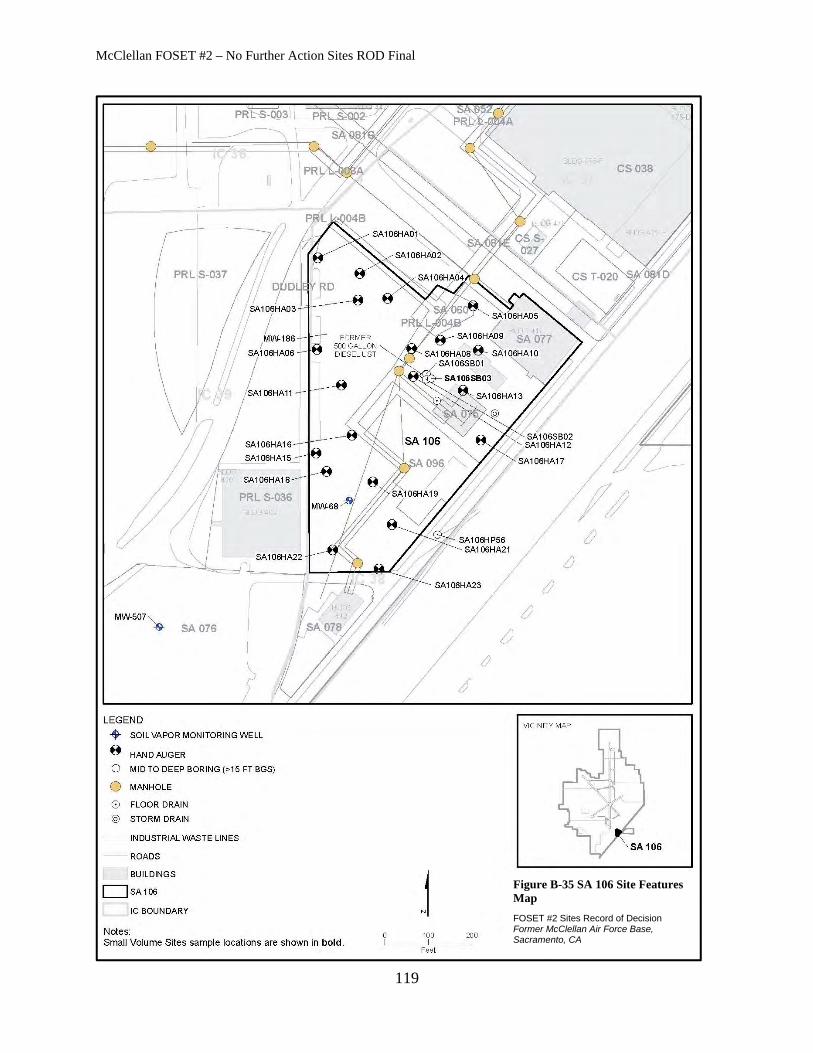
McClellan FOSET #2 – No Further Action Sites ROD Final
119
Figure B-35 SA 106 Site Features Map
FOSET #2 Sites Record of Decision Former McClellan Air Force Base, Sacramento, CA

McClellan FOSET #2 – No Further Action Sites ROD Final
120
THIS PAGE INTENTIONALLY LEFT BLANK