Recap (Chapter 8) Air Masses Source Regions Classifying Air Masses Air Mass Modification Properties...
39
Recap Chapter 8) ir Masses ource Regions lassifying Air Masses ir Mass Modification roperties of North American Air Masses 4/03/01 (Chapter 7) 4/1/03 Outline for Lecture 16 (Chapter 9) Fronts
-
date post
21-Dec-2015 -
Category
Documents
-
view
218 -
download
2
Transcript of Recap (Chapter 8) Air Masses Source Regions Classifying Air Masses Air Mass Modification Properties...
Recap
(Chapter 8)Air MassesSource RegionsClassifying Air MassesAir Mass ModificationProperties of North American Air Masses
4/03/01
(Chapter 7)
4/1/03
Outline for Lecture 16
(Chapter 9)Fronts

L
H
L
H
H
L
H
The Subtropical belts arethe most complicated.
Zonal Precipitation Patterns are Related to Pressure Patterns
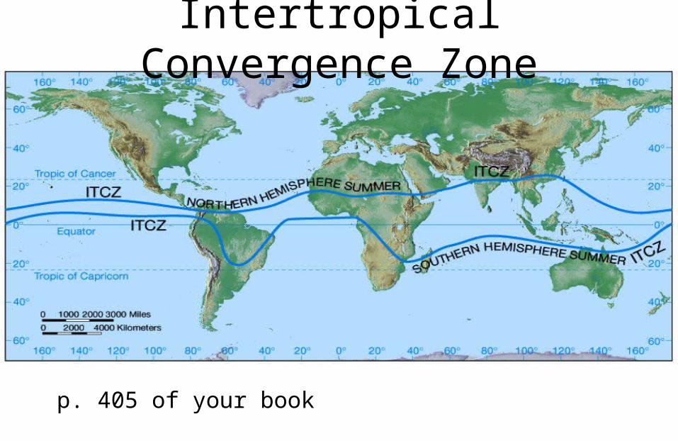
Intertropical Convergence Zone
p. 405 of your book

Subtropical high pressure cells have different characteristics with strong subsidence (which leads to dry regions) on the eastern side of these systems.
Subtropical High Pressure Cells
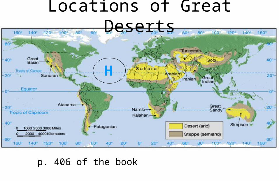
Locations of Great Deserts
p. 406 of the book
H

p. 395 of your book
Glance back at Ch. 15

Air Mass – A large bodyof air, usually 1600 kmor more across, that is characterized by homogenousphysical properties (temperature andmoisture) at any given latitude.
A cold Canadian air mass moving southward bringing very cold air
What is an air mass?

H
Source Regions
Two things are critical for an area to be a source region. • The region must be an extensive area that is physically uniform.
• The region must be characterized by a general stagnation of circulation.
Locations dominated by slow moving or stationary anticyclones are ideal areas for source regions.

Average Surface Pressure Systems and Associated Circulation
Siberian High, Azores High Aleutian Low, Icelandic Low
January
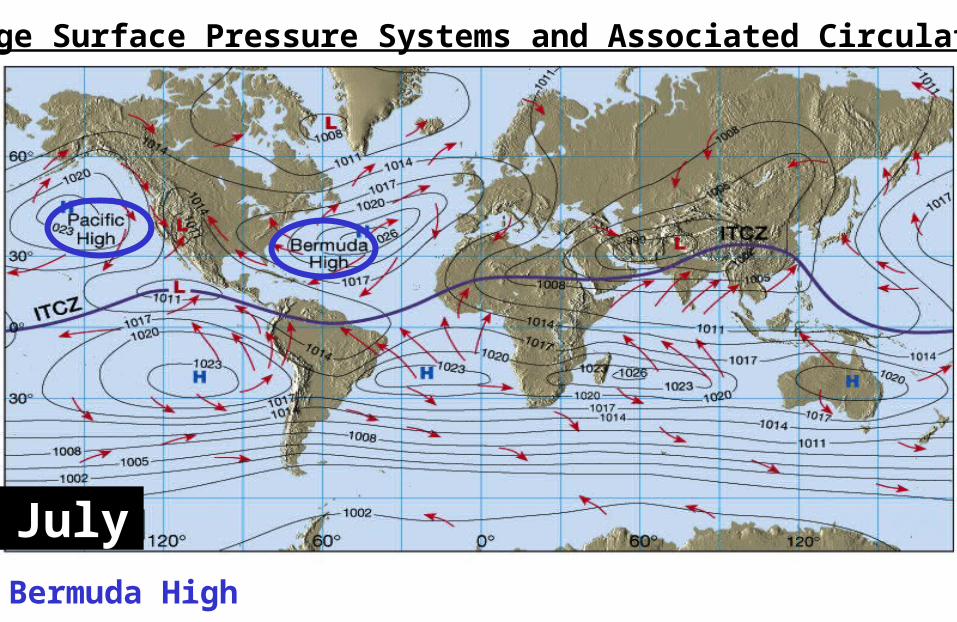
Average Surface Pressure Systems and Associated Circulation
Bermuda High
July
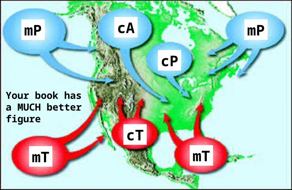
mTmT
cT
mPcAmP
cP
Your book hasa MUCH better figure

Air masses are classified by: the surface over which it formed andits latitude
Air masses are identified by two-letter codes. The first designates the surface of the region:
c continentalm maritime
The second designates latitude/temperature:P PolarA ArcticT Tropical
Classifying Air Masses

Air Masses
cA continental ArcticcP continental PolarcT continental TropicalmT maritime TropicalmP maritime PolarNote: no maritime Arctic!

General Properties
Continental• Drier• More extreme: the hot
is hotter and the cold is colder
Maritime• WET• Smaller temperature
range—hey, it’s over water!


Forms over continents at high latitude. VERY cold and VERY dry.
Source: far north, like Greenland and the Arctic Basin
Continental Arctic Air Masses (cA)
cP
cA

cA
“Arctic Express”VERY coldVERY dryA cold snap

Forms over continents at high latitude. Cold and dry,but not as cold as the continental arctic in the winter time. Source: interior Canada and Alaska, anywhere in the interior north of 50º latitude and covered with snowcA is just cP with an attitude problem.
Continental Polar Air Masses (cP)
cP/cAcP
p. 222 of the Book has a Better figure

Forms over oceans at high latitude. Cool to cold, and moist,but not as cold as the continental polar in the winter time. Unstable and stormy in winter.Two regions are important sources for mP air that influencesNorth America: the North Pacific and the Northwestern Atlantic.
mP mPRain, snow,clouds
nor’easter
Maritime Polar Air Masses (mP)

In summer, mP has different characteristics—it is generally cool,wet and stable. So we have no summer nor’easters.
mP mP
Maritime Polar Air Masses (mP)

mT mT
Copious moisture is transported from the tropics to the midlatitudes when mT air masses move northward over land.
The mT air mass over the Gulf of Mexico and Western Atlantic is important to weather over the eastern half of the nation.
Maritime Tropical Air Masses (mT)
Moist, warm, and stable
Moist, hot, unstable (on the western side of asubtropical high)

Average annual precipitation for the eastern two thirds of the United States. Precipitation decreases with distance from themT source regions.
Isohyets are lines ofequal precipitation

cT
A summertime-only phenomenon in North America. Forms overMexico and the desert southwestern U.S. Tends to be hot, dry, and unstable, though it’s so dry that clouds cannot form. Tends not to roam much, but if it goes over the central plains, itwill produce drought.
Continental Tropical Air Masses (cT)

cT
Dryline
mT
Warm moist airover here
HOT dry airover here
This leads to differences in lapse rates, and explosive thunderstorm Development in the afternoon over West Texas in summer.

Tucson Precip
Monthly Precipitation Data for Tucson Arizona
0
1
2
3
4
5
6
7
8
j f m a m j j a s o n d
Month
Pre
cip
itat
ion
(cm
)
mT
North American Monsoon{
After an air mass forms, it normally migrates from the area whereit acquired its distinctive properties to a region with a different surface characteristics. As the air mass migrates it exchanges physical properties with the surface below it. The type of exchangedetermine cloud types and weather patterns.
Cold air over warm surfaces will result in instability () whereas,warm air over cooler surfaces will result in more stable conditionsand limited vertical motion ().
Air Mass Modification

As continental polar air crosses the Great Lakes in winter, it acquires moisture and is made less stable because of warmingfrom below. A lake-effect snow shower on the lee side of the lakes is often the consequences of the air-mass modification.
Lake Effect Snow

In the winter time, warm, moist air moves over much colderthe land which creates instability ().
The snowbelts of the Great Lakesregion are the zones that most frequentlyexperience lake-effect snowstorms.
Differential Heating of Land and Water
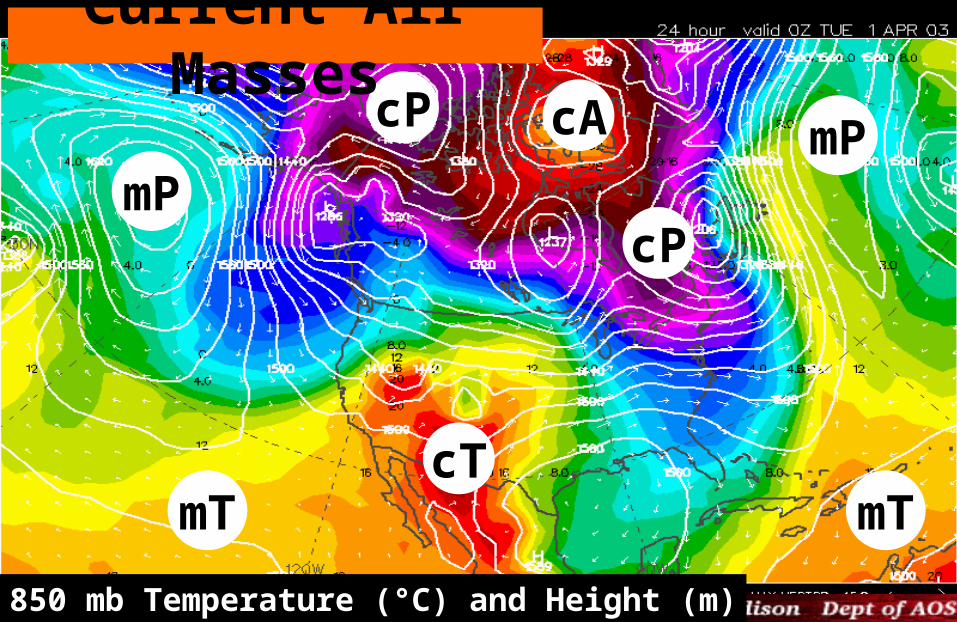
MRF 850 mb Temperature (°C) and Height (m)
cP
cT
mP
Current Air Masses
mT mT
cA mP
cP

(extreme example of two air masses interacting)
A very cold continentalarctic air (cA) mass collided with a warm, moist maritime tropical (mT) airmass from the Gulf of Mexico.
Storm of the century

A series of mid-latitude cyclones forming along the polar front
Polar Front over the U.S.

Fronts are boundaries between air masses.
•One air mass is usually warmer and often contains more moisture than the other.
•Along the zone where the air masses meet, they exchange moisture and temperature characteristics.
Fronts

Warm air rides over colder, more dense air. As the air is lifted it is cooled__________-ly causing moisture in the air to ___________ into clouds.
slope = 1/200
200 mi0
1 mi
Slow-moving warm front and stratus clouds
Warm fronts

Fast moving cold front and cumulonimbus clouds.
Cold air wedging under warm, moist air.The forceful lifting of warm, moist air along the cold front releases________ which adds the ______ of the air to create more lifting. Most often, the air behind a front is continental polar.
slope = 1/100
0100 mi
1 mi
Cold fronts

Thunderstorm development along a cold front over the Great Plains
Lightning results when very strong vertical lifting creates a staticcharge within the cloud.

The air flow on both sides of a front is parallel to the front. This condition is called a stationary front. This will serve as a focal point for storm formation.
Stationary Fronts
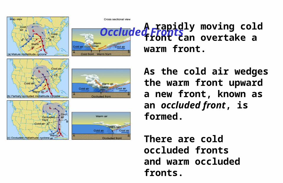
A rapidly moving cold front can overtake a warm front.
As the cold air wedges the warm front upward a new front, known as an occluded front, is formed.
There are cold occluded frontsand warm occluded fronts.
Occluded Fronts

Air is colder than the air itis overtaking. This is a coldoccluded front. Cold occluded fronts are the most common type of occluded front.
It is also possible for air behindthe advancing cold front to be warmer than the cold airit is overtaking. This is a warm occluded front.
Cold and Warm Occluded Fronts

Exam 2
• Will be April 15, as scheduled
• Will cover Chapters 6-10 (mostly)
• Might not include tornadoes if we don’t get to that