Real property cadastre in Baltic countries -...
168
ESTONIAN UNIVERSITY OF LIFE SCIENCES Department of Geomatics LATVIA UNIVERSITY OF AGRICULTURE Department of Land Management and Geodesy ALEKSANDRAS STULGINSKIS UNIVERSITY, Lithuania Land Management Department Velta Parsova, Virginija Gurskiene, Madis Kaing REAL PROPERTY CADASTRE IN BALTIC COUNTRIES
Transcript of Real property cadastre in Baltic countries -...

- 1 -
ESTONIAN UNIVERSITY OF LIFE SCIENCES Department of Geomatics
LATVIA UNIVERSITY OF AGRICULTURE
Department of Land Management and Geodesy
ALEKSANDRAS STULGINSKIS UNIVERSITY, Lithuania Land Management Department
Velta Parsova, Virginija Gurskiene, Madis Kaing
REAL PROPERTY CADASTRE
IN BALTIC COUNTRIES
llufb
Sticky Note
© V.Parsova, V.Gurskiene, M.Kaing, 2012 © Estonian University of Life Sciences, 2012 © Latvia University of Agriculture, 2012 © Aleksandras Stulginskis University, Lithuania, 2012 All rights reserved. Its content may not be copied or emailed to multiple sites or posted to a listserv without the copyright holder's express permission. However, users may save paper for individual use. Users should refer to the original published version of the material for the full abstract.

- 2 -
ESTONIAN UNIVERSITY OF LIFE SCIENCES Department of Geomatics
LATVIA UNIVERSITY OF AGRICULTURE
Department of Land Management and Geodesy
ALEKSANDRAS STULGINSKIS UNIVERSITY, Lithuania Land Management Department
Velta Parsova, Virginija Gurskiene, Madis Kaing
REAL PROPERTY CADASTRE
IN BALTIC COUNTRIES
Jelgava – 2012

- 3 -
ISBN 978-9984-48-064-0 Real Property Cadastre in Baltic Countries The textbook prepared by the team of authors: Chapter I. Real Property Cadastre in Estonia Madis Kaing, PhD, lecturer of Department of Geomatics of Estonian University of Life
Sciences (translation from Estonian into English made by Jane Tammeorg) Chapter II. Real Property Cadastre in Latvia Velta Parsova, Dr.oec., associate professor of Department of Land Management and
Geodesy of Latvia University of Agriculture Chapter III. Real Property Cadastre in Lithuania Virginija Gurskiene, Doctor of technology science, associate professor of Land
Management Department of Aleksandras Stulginskis University, Lithuania
Each author is responsible for content and formation of his/her chapter. The textbook has been reviewed by: Anda Jankava, Dr.oec., professor, Head of Department of Land Management and Geodesy of Latvia University of Agriculture Audrius Aleknavicius, Doctor of technology science, professor, Head of Land Management Department of Aleksandras Stulginskis University (Lithuania) The textbook has been: - prepared considering requirements of statute No. 07/4 “Regulation on development of textbooks and course materials of Latvia University of Agriculture”, adopted on April 25, 2007 by Study Board of the Latvia University of Agriculture - recommended for publishing by Department of Land Management and Geodesy of Latvia University of Agriculture (protocol No.5 of Department meeting, September 5, 2012) and by Land Management Department of Aleksandras Stulginskis University, Lithuania (protocol No.2 of Department meeting, September 18, 2012). The textbook can be used by Master study programme students of universities of Baltic countries and other countries, as well as for distance learning and e-learning. The reference is mandatory in case of republishing or citation.
V.Parsova, V.Gurskiene, M.Kaing, 2012 Estonian University of Life Sciences, 2012
Latvia University of Agriculture, 2012 Aleksandras Stulginskis University, Lithuania, 2012
- 4 -
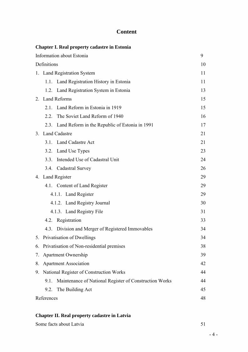
Content
Chapter I. Real property cadastre in Estonia
Information about Estonia 9
Definitions 10
1. Land Registration System 11
1.1. Land Registration History in Estonia 11
1.2. Land Registration System in Estonia 13
2. Land Reforms 15
2.1. Land Reform in Estonia in 1919 15
2.2. The Soviet Land Reform of 1940 16
2.3. Land Reform in the Republic of Estonia in 1991 17
3. Land Cadastre 21
3.1. Land Cadastre Act 21
3.2. Land Use Types 23
3.3. Intended Use of Cadastral Unit 24
3.4. Cadastral Survey 26
4. Land Register 29
4.1. Content of Land Register 29
4.1.1. Land Register 29
4.1.2. Land Registry Journal 30
4.1.3. Land Registry File 31
4.2. Registration 33
4.3. Division and Merger of Registered Immovables 34
5. Privatisation of Dwellings 34
6. Privatisation of Non-residential premises 38
7. Apartment Ownership 39
8. Apartment Association 42
9. National Register of Construction Works 44
9.1. Maintenance of National Register of Construction Works 44
9.2. The Building Act 45
References 48
Chapter II. Real property cadastre in Latvia
Some facts about Latvia 51

- 5 -
1. Objectives and tasks of modern cadastre 53
1.1. Concept of cadastre 53
1.2. Role of cadastre in real property formation 59
1.2.1. Establishment of real property 59
1.2.2. Real property and real property objects 65
1.2.3. System of cadastral designations 67
1.2.4. Real property formation 71
1.3. Role of cadastre in real property taxation 72
2. Registration of real property 75
2.1. Legal registration of real property 75
2.2. Creation and development of cadastral registration
system (1991 – 2006) 80
2.2.1. Registration of textual data 80
2.2.2. Registration of graphical data 89
2.3. Registration of apartments obtained in the accelerated
privatisation process 97
3. Frame of Cadastre information system (since 2006) 100
3.1. Textual part of Cadastre information system 100
3.2. Graphical part (cadastre map) of Cadastre information system 107
3.3. Issuing and use of cadastral data 110
References 112
Chapter III. Real property cadastre in Lithuania
Some facts about Lithuania 115
Introduction 119
Main terms 121
1. The system of real property cadastre 123
1.1. Legal structure 123
1.2. Real property administration system 124
1.3. Formation of the real property objects 128
1.4. Persons, who established cadastral data of objects 129
1.5. Cadastral data of the of real property objects 131
1.6. Establishment of the cadastral data 133
1.6.1. Surveying of parcels 135
1.6.2. Surveying of construction works 138

- 6 -
1.6.3. Plans of parcels 141
1.6.4. Plans of arrangement of construction works and plans of floors 143
1.7. Adjustment of cadastral data of the object of real property 144
1.8. The file of cadastral data of an object of real property 146
1.9. Entering and changing the cadastral data of an object of real
property in the cadastre 148
1.10. Marking of boundaries of the object of real property in
the cadastral map 151
1.11. Making of a mark in the cadastre 153
1.12. Use and safety of cadastral data 154
2. The Real Property Register 155
2.1. Functioning of the Real Property Register 156
2.2. Interaction of the register with other state registers and cadastres 161
2.3. Development of Real Property Cadastre and Register 164
3. Analysis of the real property data 165
References 167

- 7 -
ESTONIAN UNIVERSITY OF LIFE SCIENCES
Department of Geomatics
Madis Kaing
Chapter I
REAL PROPERTY CADASTRE
IN ESTONIA

- 8 -
Content
Information about Estonia 9
Definitions 10
1. Land Registration System 11
1.1. Land Registration History in Estonia 11
1.2. Land Registration System in Estonia 13
2. Land Reforms 15
2.1. Land Reform in Estonia in 1919 15
2.2. The Soviet Land Reform of 1940 16
2.3. Land Reform in the Republic of Estonia in 1991 17
3. Land Cadastre 21
3.1. Land Cadastre Act 21
3.2. Land Use Types 23
3.3. Intended Use of Cadastral Unit 24
3.4. Cadastral Survey 26
4. Land Register 29
4.1. Content of Land Register 29
4.1.1. Land Register 29
4.1.2. Land Registry Journal 30
4.1.3. Land Registry File 31
4.2. Registration 33
4.3. Division and Merger of Registered Immovables 34
5. Privatisation of Dwellings 34
6. Privatisation of Non-residential premises 38
7. Apartment Ownership 39
8. Apartment Association 42
9. National Register of Construction Works 44
9.1. Maintenance of National Register of Construction Works 44
9.2. The Building Act 45
References 48

- 9 -
Information about Estonia
Area: 4,522,700 ha
Population: 1,340,194 (2011)
Density: 30 p/km²
Capital: Tallinn
Official language: Estonian
Currency: Euro
Type of Government: Parliamentary democracy
Land borders: 343.0 km with Latvia and 338.6 km with the Russian Federation
Distance from Tallinn to Helsinki 85 km; to Riga 307 km; to St. Petersburg 395 km; to
Stockholm 405 km.
The Republic of Estonia is divided into 15 counties, 33 towns and 193 rural
municipalities. Each municipality is a unit of self-government with its representative and
executive bodies. The municipalities in Estonia cover the entire territory of the country.

- 10 -
Definitions
Land cadastre (cadastre) – a database consisting of the land register with cadastral maps
and a cadastral archive.
Land register – a collection of data pertaining to cadastral units, which are registered and
maintained.
Cadastral maps – maps in the cadastre for the graphic presentation of information entered
in the register (boundaries, location of objects which give rise to restrictions, data on
quality of land, etc.) Cadastral maps, restrictions maps, land quality and valuation maps.
Cadastral area – an administrative unit or a part thereof, which is determined taking into
consideration the boundaries of local governments.
Settlement – a part of a cadastral area used in the maintenance of the cadastre, which is
determined taking into consideration existing settlement patterns.
Cadastral code – a numeric code, which is used to identify cadastral units and to relate
data to other registers.
Cadastral unit – a plot of land registered in the cadastre as an independent unit.
Plot of land (land unit) – a delimited part of land or water.
Intended use of cadastral unit – the use or uses of a cadastral unit permitted by
legislation and determined pursuant to the procedure provided therein.
Boundary point – a point on the external border of a land unit which has coordinates
determined pursuant to the procedure established by legislation and the location of which
can be determined in the field if necessary.
Boundary marker – a marker of a boundary point in the field, the location of which can
be restored.
Land use type – a part of a cadastral unit, which has the same intended economic use
and/or natural status and which is not delimited by boundary markers.

- 11 -
1. Land Registration System
1.1. Land Registration History in Estonia
Cadastral surveys and valuation of manor lands have been carried out in the territory of
Estonia since the Danish and Swedish times. Documentation on land registration from
1719 to 1944 has been maintained in the Estonian Historical Archives. The total number
of items (depositary units) is ca 155,000, maintained in eight funds of Tartu, Tallinn,
Narva, Võru, Viljandi, Rakvere and Pärnu Land Registry Departments of County Courts.
Review of archival funds “Land Registry Documentation in the State Central Historical
Archives of the Estonian SSR” was compiled in 1975, but the use (accessibility) of the
document was restricted at that period.
The survey on the document mentioned above:
Land registration/title registration (ingrossation) – entry of real estate legal transaction
(landed property, buildings) into the land registry.
Judicial land registration/title registration (corroboration) – entry of ownership rights
into the land registry and also delivery of deed, a certain certificate of ownership about the
execution of ingrossation. Registration of real rights may solely be executed by a
designated judicial body for real property situated within the territorial jurisdiction of the
court.
The principle of the Land Registry is its accessibility and reliability.
The principle of reliability lies in documentation of property ownership and mortgage
system. The Land Registry is obliged to give an exact and truthful overview of the
economic and legal status of the property to anyone making a request. Entries to Land
Registry are therefore not merely informative, but also foresee a judicial obligation to
everybody.
Public Land Registries were introduced in 1747. The main types of registries were:
registries of oral requests comprising oral registration requests in a chronological
sequence;
Land Registry Journals comprising all registration applications and court orders on the
approval or non-approval of submitted requests;
Land Registry Records (Land Registry in a narrower sense) for submitted
applications/documents bound within these together with court orders about approved
and sealed documents;

- 12 -
registries of Landed Property – a separate part was maintained for each property with
entries on each subsequent ingrossation.
The Baltic Private Law Act, enacted in 1864, was of utmost importance, regulating
judicial affirmation of immovable property acquisition and its pledge. The act regulated
purchase and pledge of real estate, and a judicial registration of corresponding
transactions. Pursuant to the Court Reform of 1889, the territory of Estonia was divided
into 34 districts of courts of the first instance, and 5 judicial circuits: Tartu-Võru, Pärnu-
Viljandi, Tallinn-Haapsalu, Rakvere-Paide and Saaremaa.
The official language then was the Russian language. A land registry division was
affiliated to each district court.
During the years of the Republic of Estonia, the practice of land registration was based on
the documentation and procedures determined before 1918. In 1919, the names of land
registry divisions were changed, as the official language in the Republic of Estonia was
the Estonian language. In 1938, land registry divisions were changed into land registry
offices.
During the Soviet occupation in Estonia in 1940-1941, the need for land registry offices
disappeared due to the fact that all land was nationalized in state ownership and could not
be the object of purchase and sale or other conveyance, or pledge. During the German
occupation in 1941-1944, the land ownership and land registry offices were restored.
When the Soviet occupation was restored in 1944, land registry offices were abolished
completely.
In the 1950s, the registers, files, documents and records of the former land registry offices
were gathered into the Estonian Historical Archives in Tartu (address: J. Liivi 4, Tartu).
Since the land registration system in the Republic of Estonia was single-purpose, namely,
the objective of land registry offices was a judicial registration of land ownership and
mortgages, data on other spheres of life are not to be found in their documentation. During
the Soviet period, offices of technical inventory were formed, which later on during the
restoration of independence in Estonia were renamed to building registers.
Land registry offices were reopened in the Republic of Estonia on December 1, 1993. At
present they are included in county courts as land registry departments. Land registry
jurisdiction is the jurisdiction of the court. Land registry jurisdiction may be divided into
land registry divisions where separate land registers are maintained.

- 13 -
1.2. Land Registration System in Estonia
The Republic of Estonia was restored in 1991 on the basis of legal continuity, which
formed the basis of our citizenship policy and underpinned the restoration of ownership
relations. Land ownership relations were changed in the course of transition to market
economy: the private ownership was restored. The state land ownership was converted
into private land ownership. A new real estate registration system was created with three
separate registers (Table 1).
Table 1
Registers in Estonia
Register Land Cadastre Land Register National Register of Construction
Works
Ministry Ministry of
Environment
Ministry of Justice Ministry of Economic Affairs and
Communications
Land Cadastre. The Land Cadastre, held in the Estonian SSR during the Soviet period,
concentrated on the detailed documentation of land use types by different users of land,
and therefore it was not applicable for the needs of new land registration system. Today,
the Land Cadastre is maintained on the basis of the forms of ownership – the state land
ownership, the municipal land ownership and the private land ownership.
The emphasis in cadastral registration is laid on intended use of land units (use of cadastral
units permitted by legislation), land use types are specified only to the extent they may
affect the assessment value of land of a cadastral unit. First and foremost Land Cadastre is
a fiscal register maintained for assessment of land for taxation purposes. The land units
registered in the Land Cadastre are cadastral units.
In the period of the Estonian SSR, the Land Cadastre belonged to the governing area of the
Ministry of Agriculture of the Estonian SSR; now the chief processor of the Land Cadastre
is the Ministry of Environment. The authorised processor of the cadastre (the cadastral
registrar) is the Land Board. The Land Cadastre is a general national register. The
maintenance of the cadastre is financed from the state budget.
Access to Cadastral Data. Cadastral data shall be accessed by way of reviewing cadastral
data and taking their extracts. Cadastral data may be accessed at the cadastral registrar and
through data communications networks, electronic address: www.maaamet.ee.

- 14 -
Land Register. During the period of the Estonian SSR, the concept of real estate was not
in use since all land was nationalised and in state ownership. All land transactions (sale
and purchase, gift, pledge) were forbidden. The rights of use of the state-owned land were
recognized. There was no need for any kind of land register; The Land Register
documentation from the period of the Republic of Estonia had been handed over to
historical archives.
The system of land registers had to be restored; land registration and land registry
offices/departments were created within the responsibility area of the Ministry of Justice
of the Republic of Estonia. The newly created land registers were largely based on the
example of the German registration practice within the German legal system. At present
land registry departments of county courts maintain land registers. A land registry
department shall maintain the land register concerning registered immovables located in
the land registry jurisdiction of the respective land registry department. Land units, which
had been registered in the land cadastre, were subsequently registered in the land register
as registered immovables.
Access to Land Register. Everyone may access the register part and obtain necessary
printouts. Knowledge of the number of the register part or the address of the registered
immovable or the name of the owner is sufficient to be granted access. Access to the Land
Register via the webpage is granted on the electronic address www.eesti.ee. X-Road (X-
tee) – Main Page – Services – For a citizen – Housing - Registered immovables of citizens
– Enter the system. The access to Land Register is free of charge for a citizen viewing the
register part of immovable properties in the citizen’s ownership. In other cases the access
is restricted or a fee is charged.
National Register of Construction Works. During the period of the Soviet regime,
private ownership could be acquired for buildings (a detached house, a summer cottage, a
garden cottage, a garage) with the right of use of the land under those buildings in addition
to the land necessary for maintaining the buildings. These rights were registered in the
Technical Inventory Offices. These buildings were also in civil circulation (sale and
purchase, gift, bequest) with the right of use of the land.
After the restoration of the Republic of Estonia, technical inventory offices were renamed
to building registers. An office of building register worked in each county. The renewal of
the system of registration of buildings in Estonia took place in 2003. The Estonian national
construction works register, the National Register of Construction Works, was established
under the Ministry of Economic Affairs and Communications of the Republic of Estonia.
The local offices were closed down; the register is an electronic register.
- 15 -
Access to the National Register of Construction Works. Everyone can have an access
to the register, free round the clock web access is guaranteed. Certified extracts of register
data are issued by local governments. The electronic address of the register: www.ehr.ee.
2. Land Reforms
2.1. Land Reform in Estonia in 1919
The Republic of Estonia was founded on February 24, 1918, when the Salvation
Committee publicly proclaimed Estonia an independent and democratic republic. On
October 10, 1919 The Estonian Constituent Assembly enacted the Land Act, which
confiscated and redistributed the Baltic-German hereditary manor estates; the land was
declared property of the Republic of Estonia.
The Estonian land reform was the first of its kind in Europe and most radical, involving
2,000,000 hectares of land. In 1920, the territory of Estonia was 4.19 million hectares; the
State land reserve was 2.31 million hectares, i.e. 55% of the total area.
The Land Act, enacted on October 10, 1919, became the basis for the land reform and for
the formation of the state land reserve. The land of the former manor estates was
expropriated together with fixtures, agricultural machinery and equipment. The
expropriated estate land was intended as the land reserve to be distributed among peasants
(mostly Estonian citizens who had participated in the War of Independence) for perpetual
use (hereditable), for educational, municipal, co-operational, commercial, industrial
purposes for long-term use (long leasehold), for co-operative use of labour corps and for
short-term lease to natural persons.
Farm sizes were planned to range from 10 to 50 hectares. The actual area of a farm was
determined according to the quality of arable land, the share of cultivated, semi-natural or
natural pastures within a parcel, prevailing farming methods in the area and proximity to
railway or towns. Before the start of the land reform of the Republic of Estonia, during the
second part of the 19th century and the beginning of the 20th century, 51,640 Estonian
farmers had purchased their family farms into perpetuity from German landlords. Besides
the formation of new family farms during the land reform, a number of settlement farms
were formed in the 1930s. According to the agricultural census of 1939, there were
139,984 farms in Estonia with average size of 22.7 hectares.
The Formation of State Estates (State Farms). The total number of state farms in 1938
was 57, of which 20 were under the jurisdiction of the Ministry of Agriculture, 20 state

- 16 -
farms were under the jurisdiction of the Ministry of Education, and 2 were under the
jurisdiction of the Ministry of Defence. The size of the state farms ranged from 100
hectares to 1,000 hectares. The average productivity of state farms was by 15-20 per cent
higher than that of family farms. Many of the state farms were demonstration farms and/or
practice and training bases for general agricultural colleges.
The Ministry of Agriculture was a designated executor of the implementation of the land
reform in Estonia. The State Land Reserve and Land Readjustment Agency was formed
under the Ministry of Agriculture to implement the reform.
Although 95% of the manor estate lands belonging to Baltic-German nobility had been
expropriated during the years of the land reform, not all applications for land could be
approved.
2.2. The Soviet Land Reform of 1940
The Soviet Occupation of the Republic of Estonia. The Red Army of the Soviet Union
occupied the Republic of Estonia on June 17, 1940. A new puppet government was
appointed on June 21, 1940; the new State Council (later the Supreme Soviet of the ESSR)
proclaimed the formation of the Estonian Soviet Socialist Republic on July 21, 1940,
which was formally incorporated into the Soviet Union according to the decision of the
Supreme Soviet of the SSSR on August 6, 1940. On July 23, 1940, the Supreme Soviet of
the newly formed Estonian SSR declared all land to be in public ownership; the land
was nationalised and proclaimed property of the state. At that point land ownership
relations were abolished and land use relations were introduced; land as a commodity was
removed from commerce.
The maximum size of farms given into the use of working peasants was not more than 30
hectares. All farmland exceeding the limit of 30 hectares were expropriated into state land
reserve with the purpose of providing landless peasants with land. Part of the state land
reserve was divided into new smallholdings of 12 hectares and distributed among
peasants. The land was given into the perpetual use.
The land reform of 1920 and the land reform of 1940 had disparate aims. In 1920, the
lands of the former manor estates were distributed among peasants with the aim of
creating viable family farms. On the other hand, the land reform of 1940 attempted
redistribution of existing farms and creation of smaller holdings. The newly created 12-
hectare small farms would have been classified as pauper-farms in the pre-war Republic of
Estonia.

- 17 -
German Occupation of Estonia during World War II. As a result of the war between
Nazi Germany and the Soviet Union, commenced on June 22, 1941, the Soviet occupation
in the territory of Estonia was replaced by the German occupation. All Soviet legal acts
were repealed; private ownership of land was restored. Land cuttings were returned to the
former, mostly family farm, owners.
Continuation of the Soviet Land Reform in 1944. The Soviet land reform, commenced
in 1940, continued in 1944, after the new Soviet occupation of Estonia. The state land
reserve was restored. Sovkhozes (state-owned agricultural farms) were formed on the
basis of the former state estates, also auxiliary farms, machine-and-tractor stations and
horse-lending stations. Creation of new small farms continued. Deeds for perpetual use of
the land were issued. The land reform was accomplished by July 1, 1947.
Collectivisation. The formation of the first kolkhozes in the territory of Estonia started in
the autumn of 1947. The policy of collectivisation created a thorough crisis in the minds
and lives of Estonian people. While joining a kolkhoz, a farmer was forced to voluntarily
change the ownership of his land, animals, agricultural machinery and other assets and
hand them over to the kolkhoz to form fixed assets of the kolkhoz. The farmer was
allowed to use 0.6 hectares of land as a kitchen garden plot, tools for its cultivation and the
animals prescribed for in the statutes of the kolkhoz. The former independent owner and
producer was forced into the status of a farm labourer. On January 1, 1949, there were 455
kolkhozes in the territory of Estonia, but by November 1, 1949, as a direct result of
extensive deportations in March of 1949, the number of kolkhozes had drastically risen to
3,002. During the following years the newly created small kolkhozes were joined and
incorporated into larger, more viable enterprises.
Restoration of Family Farms. Some years before the re-establishment of the Republic of
Estonia, on December 6, 1989, the Supreme Soviet of the Estonian SSR passed the Farm
Act. Accordingly, a farm was constituted of the land given to a farmer by the state or on
the basis of a lease contract. It was not restitution or change of land ownership relations.
Land remained in state ownership; it was given to farmers for perpetual use.
2.3. Land Reform in the Republic of Estonia in 1991
The adoption of the legal acts pertaining to reorganisation of ownership relations was an
integral part of the re-establishment of the Republic of Estonia. The Republic of Estonia
Principles of Ownership Reform Act (ORAS) and the Land Reform Act (MaarS)
determined the basis for restructuring relations regarding land (land reform). The Land
- 18 -
Reform Act was enacted by the Parliament (Riigikogu) of the Republic of Estonia on
October 17, 1991 and entered into force on November 1, 1991.
Objective of Land Reform. Based on the continuity of rights of former owners and the
interests of current land users that were protected by law, and to establish preconditions
for more effective use of land, the objective of land reform was to transform relations
based on state ownership of land into relations primarily based on private ownership of
land.
Content of Land Reform. According to the land reform, the unlawfully expropriated land
was returned to its former owners or their legal successors or they were compensated
therefor, the land was transferred for or without any charge into the ownership of persons
in private law, legal persons in public law or local governments; the land to be retained in
state ownership was determined.
According to the land reform, the right of superficies was constituted for the benefit of
owners of structures, or the right of commercial lease or usufruct was established on land
in the cases provided by law.
Return of and Compensation for Land. The right to claim return of or compensation for
land had: natural persons whose land was unlawfully expropriated if they were citizens of
the Republic of Estonia on June 16, 1940 or if they resided permanently in the territory of
the Republic of Estonia on June 20, 1991; other persons who had the right to claim return
of or compensation for land were determined by “MaarS”, § 5.
Return of Land. Land was returned according to its former boundaries unless otherwise
provided by planning and land readjustment requirements or by agreement between
adjacent neighbours who were entitled subjects.
Based on planning and land readjustment requirements, the area of plot of land to be
returned might differ from the area of land subject to return by up to +/- 8 per cent but not
more than 5 hectares. Upon return of land, reallotment or planning might be carried out
pursuant to law, and the land had to be returned on the basis of the reallotment plan or the
adopted detailed plan.
Compensation for land. If land was not returned in part or in whole, the land was
compensated for pursuant to the procedure provided for in the Land Valuation Act.
The price of land was determined on the basis of the land valuation documentation, 1993.
Privatisation of Land. The land which was not returned, or which was not retained in
state ownership or which was not transferred into municipal ownership, is subject to
privatisation. A natural person who applies for the privatisation of the land with the right
of pre-emption has the right of pre-emption to the land.

- 19 -
Methods of Privatisation of Land. Methods of privatisation of land are: privatisation of
land by a right of pre-emption, a usufruct established on vacant agricultural land and
privatisation of vacant forestland.
Persons who have been granted land for perpetual use pursuant to the Estonian SSR Farm
Act or who have the right to purchase land as the owner of a structure or a plantation may
privatise land by a right of pre-emption; residential building, apartment, garage, cottage or
gardening associations may privatise land which is in the common use of members of the
association by a right of pre-emption. The selling price of land to be privatised by a right
of pre-emption is the assessed value of the land. The total selling price may be paid in
privatisation vouchers.
A usufruct is established on vacant agricultural land for the benefit of an Estonian citizen
or an Estonian legal person in private law. A usufruct may be established for the benefit of
one person on up to 250 hectares of vacant agricultural land which, taking into account the
land readjustment requirements, may include up to 15 hectares of forest land. Land on
which a usufruct is established shall not be subject to a commercial lease or granted for
use to another person.
Estonian citizens are the entitled subjects of privatisation of vacant forest land. One person
may privatise up to 20 hectares of vacant forest land. The area of land to be privatised may
be up to 10 hectares larger, depending on the land readjustment requirements. A person
who has privatised forest land shall not transfer such forest land before full payment of the
redemption price and in any case not before five years have passed since the contract of
purchase and sale was entered into.
For seven years after Estonia's accession to the European Union, a land unit with an area
of more than 2 ha containing a land use type of agricultural land or a land use type of
forest land may be privatised or a usufruct may be established on such land unit with a
preferred right to privatisation to only Estonian citizens or citizens of the Contracting
States who have permanently resided in Estonia for at least the last three years.
Municipal Land. Transfer of land into municipal ownership shall be decided by the
county governor on the application of the local government council, or by the Government
of the Republic. Transfer of land is specified in clause 28 of the Land Reform Act.
Land to be transferred into municipal ownership is mostly land under buildings and
constructions retained in municipal ownership and the land for servicing them, and/or
public land. Land is transferred into municipal ownership without any charge.
State Land. Land is retained in state ownership by a resolution of the Government of the
Republic or of a government agency authorised by the Government of the Republic. The

- 20 -
area and boundaries of land retained in state ownership is determined in compliance with
planning and land readjustment requirements without the preparing of a detailed plan.
Land to be retained in state ownership is specified in section 31 of the Land Reform Act.
Granting Land for Use by Contract. Use of land retained in state ownership is granted
on the bases of and pursuant to the procedure provided for in the State Assets Act.
A usufruct may be established for the benefit of a person who was granted use of land
pursuant to the Estonian SSR Farm Act and who uses the land during application for
establishment of a usufruct and does not wish to acquire the land.
Constitution of Right of Superficies for Benefit of Owner of Structure. The right of
superficies may be constituted pursuant to the procedure established by the Government of
the Republic on state land for the benefit of the owner of a structure who does not wish or
who does not have the right to acquire the land.
Land Reform Statistics. Statistics have been produced on land reform since 1993, when
registration of land units into the Land Cadastre of the Estonian Land Board started;
although the first cadastral units had been registered in December of 1992.
The total area of Estonia is 4,552.7 thousand hectares, 88% of the territory has been
registered in the Land Cadastre of the Estonian Land Board as of December 31, 2011. The
number and area of land units registered in the Land Cadastre of the Estonian Land Board
are given in Table 2.
Table 2
Number and Area of Land Units Registered in Land Cadastre of Estonian Land Board as
of December 31, 2011
Nr. Legal basis for formation of a land unit Number/ Area %
1. Cadastral units registered in the cadastre (number) 614,756 -
2. Area registered in the cadastre (hectares), including: 3, 977,341,0 100.0
2.1. Land retained in state ownership (hectares) 1,458,545,1 36.7
2.2. Land in municipal ownership (hectares) 34,857,8 0.9
2.3. Land privatised with pre-emption (hectares) 636,956,2 16.0
2.4. Land privatised by auction (hectares) 89,962,4 2.3
2.5. Land privatised as vacant arable land (hectares) 150,765,6 3.8
2.6. Land privatised as vacant forest land (hectares) 104,494,5 2.6
2.7. Restituted land (hectares) 1,501,759,4 37.7
Source: Estonian Land Board

- 21 -
3. Land Cadastre
3.1. Land Cadastre Act
Land Cadastre (Cadastre). The Land Cadastre (cadastre) is a database consisting of the
land register with cadastral maps and the cadastral archive. The cadastre is a general
national register. Maintenance of the cadastre is financed from the state budget. The
cadastre is maintained as a uniform single-level computerised database and maps for the
entire territory of Estonia.
The objective of the maintenance of the cadastre is to register information in the cadastre
reflecting the value of land, the natural status of land and the use of land, and to ensure the
quality of such information and that it is preserved and made available to the public.
Cadastral data shall be the basis for the creation and development of information systems
containing spatial data. The cadastre is maintained in Estonian. The chief processor of the
cadastre is the Ministry of the Environment. The authorised processor of the cadastre, i.e.
the cadastral registrar, is the Land Board.
Cadastral Registrar. The function of the cadastral registrar is to register cadastral units,
register restrictions and rights of use of land, and collect and process data necessary for the
valuation of land. The cadastral registrar shall ensure the access to and preservation of
original documents and maps in the land register. The cadastral registrar and the land
registry department of the court exchange data electronically through inter-base cross-
usage of data from the cadastre and the land registry department databases. The exchange
of data between the cadastral registrar and the land registry department of the court is free
of charge.
The cadastral registrar and local governments exchange data electronically, free of charge.
In order to organise inter-base cross-usage of data, the chief processor of the cadastre and
the chief processor of the corresponding local government database shall enter into a
contract.
Plot of land (land unit) is a delimited part of land or water and shall be registered in the
cadastre according to the Land Cadastre Act regardless of the form of ownership.
Cadastral unit is a plot of land registered in the cadastre as an independent unit. The
minimum size of a cadastral unit is 30 m2.
Access to Cadastral Data. Every person may access cadastral data and receive its
extracts. Cadastral data may be accessed at the cadastral registrar and through data

- 22 -
communications networks. Cadastral data may be accessed if the cadastral register
number, location (address) of a cadastral unit and the name of the cadastral unit (if the
cadastral unit has a name) are known. The home page of the Estonian Land Board should
be opened: www.maaamet.ee. to access cadastral data. The desired cadastral unit may be
accessed through Geoportal and Cadastral Register Query, entering either the cadastral
code or the address (short address).
Cadastral Code. Cadastral code (attribute) is a numeric code, which is used to identify
cadastral units and to relate data to other registers. This is a 12 digit numeric code, which
consists of 12 numbers and is divided into three parts. For example: 79514:023:0004,
wherein the three first numbers indicate the local government (municipality) (795 – the
city of Tartu). The next two numbers (14) indicate the part of the city, 023 indicate the
quarter, and 0004 indicate the sequence of registration within the quarter.
Land Register. The land register is a collection of data pertaining to cadastral units,
which are registered and maintained. The land register contains the following data
pertaining to a cadastral unit: the cadastral code; the location; the name of the local
government; the date, month and year of registration in the cadastre; the register part
number of the immovable property; the date of registration in the land register; the name
of the owner; the restrictions on use; the intended use; the total area; the area by land use
type; the data pertaining to boundary points; the assessed value; the cadastral code or
codes from which the cadastral unit is formed.
The Database of Transactions. The database of transactions shall contain the following
information on transactions for transfer of immovables and of structures as movables or
their parts: the identification number of the transaction; the type of transaction; the
cadastral register number(s); the share in the ownership of the object of the transaction; the
intended use of the object of the transaction; data on buildings or structures; information
concerning the existence of encumbrances; the date of entry into the transaction; the price
of the transaction; information concerning the parties to the transaction.
Cadastral Maps. Cadastral maps are maps in the cadastre for the graphic presentation of
information entered in the register (boundaries, location of objects which give rise to
restrictions, data on quality of land, etc.); cadastral plans, cadastral maps, restrictions maps
and land quality and valuation maps.
Cadastral Area. Cadastral area means an administrative unit or its part, which is
determined taking into consideration the boundaries of local governments. Settlement is a
part of a cadastral area used in the maintenance of the cadastre, which is determined taking
into consideration existing settlement patterns.

- 23 -
3.2. Land Use Types
Land Use Type. Land use type is a part of a cadastral unit, which has the same intended
economic use and/or natural status and which is not delimited by boundary markers.
Regulation No. 101 of the Government of the Republic of Estonia, of March 8, 1995,
established a classification of land-use types and sub-types, as well as the procedures for
compilation of land use maps and land quality and valuation maps. Land use types are
classified as follows (Table 3).
Table 3
Land Use Types
Agricultural land Non-agricultural land
1. Cultivated land 1. Forest and woodland
1. A. Arable land 2. Yard land
2. Natural grassland 3. Other land
Cultivated land – land used for growing crops, also former arable land (fallow land).
Arable land includes regularly cultivated mineral soil land under temporary crops,
greenhouses, seed-beds, cold frames (high tunnels), tree nurseries, strawberry and
raspberry permanent plantations, temporary meadows for mowing or for pasture,
improved grasslands and pastures, land under orchards, market or kitchen gardens.
Natural grassland - meadows suitable for mowing and pasturing, tree canopy cover up to
30% (in regularly mown wooded meadows, up to 50% of tree canopy cover), or
shrublands and scrubs, covered with shrubs up to 50%; also semi-improve grasslands,
which have been managed to improve their productivity (fertilisation, reseeding); and
former arable land (fallow land) with natural turf grass cover or with insufficient drainage,
which cannot be reused as arable land without cultivation.
Forest land - land covered with forest or, formerly covered with forest, which is
temporarily deforested due to natural causes or human actions, with timber production
capability of at least 1 cubic metre per hectare per year and which is not used for other
purposes (wooded meadows). Forest is a plot of land, with an area of at least 0.1 hectares
and woody plants, renewed either by natural forest renewal or by planting, with the height
of at least 1.3 metres and with the canopy density of at least 30 per cent, on mown wooded
meadows of at least 50 per cent; and also clear cutting.

- 24 -
Yard land – land under structure or land necessary for servicing the structure. For
assessment purposes, the cadastral plan legend contains the area of land under structure in
square metres.
Other land – land not used as arable land, natural grassland, forest land or yard land.
These may be natural green areas, shrubs, swamps, bogs, waste land, land under bodies of
water, and land under roads.
3.3. Intended Use of Cadastral Unit
Regulation No 155 “Categories of Intended Use of Cadastral Units and the Procedure for
Designation thereof” of the Government of the Republic of Estonia of October 23, 2008,
determined the intended uses of cadastral units. Intended use of cadastral unit is the use or
uses of a cadastral unit permitted by legislation and determined pursuant to the procedure
provided therein; shown in Table 4.
Table 4
Categories of Intended Use of Cadastral Units
Intended Use Code Index
1. Residential land 001 E
2. Commercial land 002 Ä
3. Industrial land 003 T
4. Water bodies 006 V
5. Transport land 007 L
6. Waste disposal land 008 J
7. National defence land 009 R
8. Protected land 010 H
9. Profit yielding land 011 M
10. Vacant land 012 S
11. Mining land 014 Mt
12. Peat extraction land 015 Tt
13. Public land X X
13.1. Public buildings land 016 Üh
13.2. Public space 017 Üm
Explanation of Categories of Intended Use of Cadastral Units:

- 25 -
Residential land (001; E) – land designated for residential buildings prescribed for
permanent or temporary residence and land under garages. The land under dwelling
houses (also apartment houses), summer cottages, garden cottages, farm buildings,
outbuildings and the land necessary for servicing these buildings.
Commercial land (002; Ä) – land designated for commercial purposes. Land under office
buildings, retail stores, service buildings, business buildings and land necessary for
servicing these buildings.
Industrial land (003; T) – land designated for industrial purposes. Land under industrial
facilities, warehouses and manufacturing plants, and land necessary for servicing these
buildings.
Land under water bodies (006; V) – land under natural and artificial water bodies
(reservoirs, harbours) or part thereof.
Transport land (007; L) – land designated for traffic and transport, also land under road
protection zone, land under road/traffic safety and road management constructions and
land necessary for servicing these constructions.
Waste disposal land (008; J) – land of domestic/municipal and industrial waste disposal
sites, land under landfills, waste management and waste water treatment facilities and land
necessary for servicing thereof.
National defence land (009; R) – land designated for the purposes of national defence,
border guard and rescue service.
Protected land (010; H) – areas under protection pursuant to the legislation, also land
under and around protected objects and monuments, wherein economic activities are
prohibited.
Profit yielding land (011; M) – land designated for agricultural production and forestry
and land potentially usable for agriculture or forestry.
Vacant land (012; S) – land not designated for a specific purpose, an area of land
temporarily in reserve; a registered plot of land without a planning permission,
formulating an independent cadastral unit, wherein designation of intended use is not
possible or reasonable.
Mining land (014; Mt) – land under mines and quarries (except peateries); areas
designated for extraction and processing of mineral resources.
Peat extraction land (015; Tt) – industrial peat extraction, processing and manufacturing
fields.

- 26 -
Public land – land not designated for profit yielding. Intended use sub-categories of
public land are the public buildings land and the public spaces. Upon determining the
intended use of public land, the sub-category of the land shall be determined.
Public buildings land (016; Üh) – land designated for institutional buildings, without
pursuit of profits, and land necessary for servicing thereof.
Public space (017; Üm) – publicly used land, formulating an independent cadastral unit,
mostly vacant, permitted only outbuildings on the plot.
The local government shall determine the intended use of cadastral units and also decides
on the alteration of the intended use or uses of cadastral units on the basis of the
application of owners of the registered immovable. The local government shall inform the
cadastral registrar of a decision on the basis of which the intended use or uses of a
cadastral unit is changed and it shall submit the data pertaining to the changed intended
use or uses of the registered immovable or its part to the cadastral registrar. Several
intended uses may be determined for a cadastral unit. A cadastral unit may have up to
three intended uses, with minimal share of 5%.
3.4. Cadastral Survey
Cadastral surveys have been carried out throughout the period of the Land Reform in
Estonia. Currently the work is carried out pursuant to Regulation No. 264 “The Procedure
for Execution and Monitoring of Cadastral Surveys” of the Government of the Republic of
Estonia of October 23, 2003, which entered into force on November 3, 2003.
Preliminary Work. Preliminary work for a cadastral survey comprises the compilation of
a layout plan. The layout plan is drawn on a cadastral base map (the map on which the
cadastral maps are based) extract as follows: for high-density areas M 1: 2,000 and for
low-density areas M 1: 10,000. The layout shall comprise: boundaries of the adjacent
cadastral units, buildings, access roads, objects giving rise to restrictions.
Terms of Reference. The cadastral registrar or a person authorised by the cadastral
registrar shall deliver terms of reference to the surveyor. The terms of reference shall
comprise the name of a surveyor, the number of the corresponding licence; location of a
land unit, scale of the plan, coordinate system, coordinates of starting points, data
pertaining to objects giving rise to restrictions. The terms of reference are valid for six
months as of its day of issue.
Determination of Boundaries of Land Units and Marking their Location in the Field.
Determination of boundaries of land units on natural or artificial landscape objects: in the

- 27 -
sea – according to the shore line of the sea on the cadastral base map (the map on which
the cadastral maps are based); on other water bodies – the part of a water body within the
boundaries of several immovables which belongs to each shore-owner shall be between
the perpendicular imaginary lines drawn from an imaginary line in the middle of the water
body to the shore boundary markers of the corresponding owner, or between the imaginary
lines drawn from the centre of the water body to the shore boundary markers of the
corresponding owner, unless otherwise provided by law or the agreement; on a
watercourse of width not less than 3 metres – on the centre line of the water body; on a
road – up to the edge of the road area. Cutting of boundary lines in forest and other
wooded areas – boundary lines of width not more than 2 metres. The owner of the
registered immovable is responsible for cutting and management of boundary lines.
Boundary markers are used to mark the boundaries in the field. The land surveyor shall
mark the boundaries of a land unit in the field on the basis of the layout plan or other
document. The existent boundary markers should be located and their situation examined
as preliminary part of fieldwork.
Boundary markers are:
granite rocks – of weight not less than 80 kg;
steel pipes, wooden stakes or concrete posts – equipped with an anchor or a catch;
nails in asphalt or concrete and specific wall signs.
The owner of the registered immovable may erect a mound of stone around the boundary
marker, with a diameter of 2 metres. The land surveyor shall erect boundary markers. A
boundary marker may be put under the ground surface or remain not erected, whereas the
location of the boundary marker shall be connected to not less than three natural or
artificial permanent objects perceivable in the field in the way that the location of all
boundary points can be restored.
Cadastral Plan. A certified land surveyor or a person with a corresponding licence
constructs a cadastral plan. One copy of such a plan shall be included in the cadastral unit
formation file.
The borders of a cadastral unit are drawn in the cadastral plan according to their
coordinates, scale 1 : 500; 1 : 1,000; 1 : 2,000; 1 : 5,000; 1 : 10,000. The legend for the
cadastral plan shall be constructed, comprising the following: for high-density areas – the
area of the land unit and separately, the area under buildings; for low-density areas – the
total area of the land unit and separately, the area under cultivation, the area under natural
grasslands, forestland, yard land (separately, the area under buildings). For areas from M
1 : 500 to M 1 : 2,000 - precision of 1 m² and for others - precision 0.001 ha.

- 28 -
The total area of the land unit shall be determined analytically on the basis of the
coordinates of the boundary points. The areas by land use type shall be determined
analytically and the sum of these areas shall be connected to the total area of the land unit.
Drafting of the Cadastral Plan. The boundaries of a cadastral unit, situation, structures
(buildings and constructions), address, scale, four crosses of the coordinate grade,
explanation of symbols used, legend, a table of boundary data, coordinate system, the time
of the survey, the name of the surveyor and the number of the corresponding licence,
location of land use types, location of objects which give rise to restrictions and data on
the area of each land use type shall be marked on a cadastral plan. A cadastral plan shall
be drawn in format A3 (on A3 size sheet). A cadastral plan is the source document upon
the making of an entry in the cadastre for the proof of the location of boundaries and
objects which cause restrictions.
Cadastral Map. A common mathematical basis and cartographic projection shall be used
for cadastral maps and the base map. The scale of cadastral maps shall be 1:10000, and the
scale of cadastral maps in high density areas determined pursuant to the procedure
provided by legislation shall be 1:500 or 1:2000.
The cadastral registrar shall make markings on cadastral maps. The state border, the
administrative boundaries of counties, rural municipalities and cities, the boundaries of
towns, small towns, villages, cadastral areas, settlements and cadastral units, and their
cadastral codes shall be marked on the cadastral map.
Administrative boundaries are marked and amended on maps based on the boundaries
confirmed by legislation. If the map on which cadastral maps are based is altered in the
course of maintenance of the cadastre, and if the administrative boundary on the map to be
adopted does not coincide with the situational elements on the map previously used, the
cadastral registrar is permitted to specify the administrative boundary on the basis of
cadastral data.
Boundary Report. A certified land surveyor shall prepare a boundary report which
comprises the following: marking the boundary points in the field, showing the boundaries
of the land unit in the field and informing an owner or other entitled/authorised person, of
the obligation to maintain boundary markers.
Ascertainment of Restrictions. Ascertainment of restrictions on the use of a cadastral
unit is the determination of location of objects, which cause restrictions in order to register
such objects in the cadastre. In order to ascertain the restrictions, the owner of an object
which causes restrictions shall order a cadastral survey which shall be performed pursuant
to the procedure established by the government of the republic. The cadastral registrar

- 29 -
shall issue terms of reference that stipulate the location of a plot or object that is the cause
of restrictions, type of an object etc. The cadastral registrar registers restrictions on the use
of a cadastral unit.
4. Land Register
4.1. Content of Land Register
The Land Register Act provides for the procedure of maintenance of land register. The
system of land register in Estonia was renewed starting from December 1, 1993. Land
Registry Departments of County Courts maintain land registers. The land registry
jurisdiction is the jurisdiction of the court. All immovables shall be entered in the Land
Register unless otherwise provided by the law. An independent registry part is opened for
each immovable entered into the Land Register and a separate number (registered
immovable number) is assigned to it. Real estate rights related to immovables are entered
in the Land Register.
Registered Immovable. A registered immovable is an immovable entered in the Land
Register as an independent unit. The registered immovables may be registered under the
following sub-types:
an immovable (plot of land);
the right of superficies;
apartment ownership;
the right of superficies in apartments.
Content of Land Register. The Land Register is a general notion. The Land Register is
composed of:
a register;
a land registry journal;
a land registry file.
4.1.1. Land Register
Entries are made in the Land Register. Registered immovables have a standard
numeration. The register part has a title and four divisions.
Title of Register Part. The title of register shall contain:
the land registry jurisdiction;

- 30 -
the land registry division if it exists;
the registered immovable number;
the name of the registered immovable if it exists;
supplementary pages.
First Division of Register Part. The following is entered in the first division
“Composition of Registered immovable” of the register part:
the cadastral code of the registered immovable;
the specific purpose of the registered immovable;
the location of the registered immovable;
the restricted real rights established for the benefit of the registered immovable;
the area of the registered immovable;
the merger and division of registered immovables.
Second Division of Register Part. The following is entered in the second division
“Owner” of the register part:
an owner (the name and Estonian personal identification code of the natural person; in
case of a legal person, the name and the registry code);
if the registered immovable is in shared ownership, the names of the owners, their
identification or registry codes, the size of the shares of co-owners and the legal basis
for the entry.
Third Division of Register Part. The following is entered in the third division
“Encumbrances and Restrictions” of the register part:
restricted real rights encumbering the registered immovable;
restrictions of the right of disposal of the owner of the registered immovable.
Fourth Division of Register Part. The following is entered in the fourth division
“Mortgages” of the register part:
the mortgagee;
the monetary amount of the mortgage (the sum of the mortgage);
notations concerning a mortgage.
4.1.2. Land Registry Journal
Registration applications which express the desire for an entry to be made are registered in
land registry journal. The date of acceptance of the application, the number of the
registered immovable concerned, the date the ruling was made, the duration of the ruling,

- 31 -
the dates of arrival of supporting documents, the dates of making, entry and notification of
the court ruling on entry, the signatures of the persons performing the registration, the
value of the transaction and the state fee are also entered in the land registry journal.
4.1.3. Land Registry File
For each registered immovable, a land registry file bearing the number of the registered
immovable concerned is opened. Documents in a land registry file are numbered
sequentially. The land registry file is composed of:
a copy of the register part;
all documents concerning the registered immovable.
Register Entries. Entries shall be made concerning real rights and notations. An
application for the entry of a notation shall be notarised unless otherwise provided by law.
An entry is made in a register on the basis of a ruling on entry.
Everyone may access the register part and obtain its printouts. Knowledge of the number
of the register part or the address of the registered immovable or the name of the owner is
sufficient to be granted access. No identification is required. The land registry file can be
accessed and printouts obtained upon existence of a legitimate interest, and identity
verification (ID-card) is required. The land register and land registry file may be accessed
at the land registry department, notary office or via a corresponding web page. Land
registry journal is intended for internal use and access to it is not allowed.
Electronic Land Register. The Land Register departments maintain electronic land
registers concerning their own land registry jurisdiction. An electronic land register shall
consist of the land register, a land registry file and a land registry journal. All information
of the electronic land register is recorded and stored in one data processing centre. The
data processing centre ensures the electronic recording, storage in the permanently
unaltered state and reproduction of the information of the Land Register. In the processing
of land register, the possibilities for smooth reproduction of land register information on
screen and on printout shall be ensured, measures against loss of information shall be
taken, and all inquiries to the Land Register shall be recorded.
The Land Register and the Land Cadastre exchange data specified by legal acts and
pursuant to the procedure established by law and the Government of the Republic of
Estonia. The Land Register and The Land Cadastre are electronically connected;
information is exchanged through electronic inter-base cross-usage of data by automatic
retrieval of data from the Land Cadastre to the Land Register and vice versa.

- 32 -
Everyone may access the electronic land register and obtain its printouts. Access to the
following digitally stored data on a registered immovable is free of charge: the cadastral
code of an immovable, the intended use, the location and its area.
The owner of a registered immovable or registered immovables may independently access
the Land Register through a web page: on the Estonian eGovernment Website
www.eesti.ee. X-Road (X-tee) – Main Page – Services – For a citizen – Housing -
Registered immovables of citizens – Enter the system. Entering the website is possible
with the ID-card or using the online banking code card delivered to the citizen by a bank.
The web page “Registered immovables of citizens” enables an access by reproduction of
the register part on screen as well as printouts, free of charge. The target group includes
private persons; all official forms are in Estonian. Output entails the data of registered
immovables, including: a number of registered immovable, land registry division, the
name of registered immovable, links to extracts from the Land Register, cadastral register
number, and its location. The X-Road was launched in 2001 as an environment for making
queries to different databases.
The archives of the land registry department are maintained digitally. The list and time
limits for preservation of information and documents to be kept in the archives of the land
registry department, as well as procedure for maintenance and preservation of the archives
and the requirements for the archives shall be established by the regulation of the Minister
of Justice.
Statistics on Register Parts. Statistics on register parts is published annually. Statistics on
register parts for the year 2011 is shown in Table 5. The total number of register parts
opened is 944,119, the majority of which are register parts for apartment ownerships (ca
50%).
Table 5
Statistics on Register Parts (year 2011)
Type of property Number
Immovable (plot of land) 464,569
Apartment ownership 473,826
Right of superficies 4,474
Right of superficies in apartments 1,250
- 33 -
4.2. Registration
The competence of a judge and assistant judge upon registration is provided in the Code of
Civil Procedure. A land registry secretary is competent to review registration applications
and prepare draft rulings on entry.
Registration. Registration is the making of an entry in the land register, including
amendment or deletion of an entry on the basis of a ruling of a person with registration
competence. Submission of a copy of a cadastre plan, issued and certified by the registrar
of the State Land Cadastre is required for entering an immovable (a plot of land) into the
Land Register.
Submission of Registration Applications. Any person whose rights are affected by an
entry or for whose benefit the entry is made has the right to submit a registration
application. A registration application shall be notarised or digitally signed.
Documents Necessary for Registration. The following documents shall be appended to a
registration application:
a standard format disposition;
required consents;
a copy of the court decision or a statement of the compulsory auction;
information which allows to verify payment of the state fee;
other documents provided by law, which are necessary for registration.
Submission of Plan. A copy of the cadastre plan or a sketch map of the registered
immovable issued by the registrar of the state land cadastre shall be submitted to the land
registry department if this is necessary for understanding the entry.
The language of the Land Register is Estonian. Documents in foreign languages shall be
submitted together with a notarised translation into Estonian. Sums of money shall be
transferred to the Land Register in Euros.
A registration application which arrives in the land registry department is immediately
registered in the land registry journal and numbered according to the time of arrival of the
application. After the review of a registration application, the person with registration
competence shall make a ruling on entry within three months. An entry is made in the
register on the basis of the ruling of entry.
Entering Right of Superficies in the Land Register. Upon encumbrance of a registered
immovable with a right of superficies, an independent register part shall be ex officio
opened for the right of superficies. A number is assigned to the register part opened for the

- 34 -
right of superficies in the general order. The title of the register part shall indicate that the
register part is opened for the right of superficies. The following is entered in the first
division of the register part:
the word “right of superficies”;
the content of the right of superficies;
the owner of the registered immovable encumbered.
4.3. Division and Merger of Registered Immovables
Division of Registered Immovables. Registered immovables may be divided. If upon
division of a registered movable the formation of a new registered immovable from a
separated part is desired, the land register department shall open a new register part. The
former register part shall indicate the decrease in area as a result of the division and the
new registered immovable number. If encumbrance of a part of a registered immovable is
desired, the part shall be separated from the registered immovable and entered as an
independent registered immovable. Division is not required upon encumbrance of a part of
a registered immovable with servitude unless the confusion happens. The encumbered part
shall be indicated on the copy of the plan or the sketch map of the registered immovable
annexed to the registration application.
Joining Part of Registered Immovable with Other Registered Immovable. If part of a
registered immovable is joined with another registered immovable, an amendment is made
to both registered immovable entries and the numbers of both registered immovables are
noted therein.
Merger of Registered Immovables. Registered immovables may be merged. Upon
merger of several registered immovables into one registered immovable, the register part
for a registered immovable being merged is closed in the register, and the registered
immovable with which the registered immovable is merged is noted in the closed part.
Registered immovables located in the same land registry jurisdiction or, if the land registry
divisions exist, in the same land registry division, may be merged.
5. Privatisation of Dwellings
The Dwellings Reform in Estonia was made in two stages: the Privatisation of Dwellings
Act was enacted on May 6, 1993, and the Non-Residential Premises Privatisation Act was
enacted on June 14, 1995.

- 35 -
Privatisation of Dwellings. The Act of Privatisation of Dwellings regulates the relations,
which arise in connection with the privatisation of dwelling houses and dwelling
units/apartments (hereinafter “dwellings”) in the ownership of the state, local governments
or other obligated subjects determined by law; determines the object and the subjects of
privatisation, the conditions and the procedure for privatisation.
The Aim of Privatisation. The aim of privatisation of dwellings is to enable natural and
legal persons gain ownership of the dwellings previously rented by them, or of the
dwellings not inhabited, and ensure thereby better maintenance, management and
preservation thereof.
The Object of Privatisation. The object of privatisation is a dwelling house or an
apartment (dwelling unit) with the corresponding other part of the building, or a dwelling
house or a dwelling unit under construction in the ownership of the state or a state
company, or of a local government or a public limited company. The area of the
corresponding other part of the building to the dwelling unit being privatised, is
determined according to the proportion of the area of the dwelling unit or the non-
residential unit in the total area of all dwelling and non residential units in the building.
The corresponding other part of the building is determined as a legal share.
Ancillary premises, located in the building or on the same plot of land, are to be privatised.
Ancillary premises are premises in the dwelling house or premises in other buildings on
the same plot of land, which according to the building design documentation are designed
to serve the dwelling house, or for the common or individual use of tenants. Ancilliary
premises are also former dwelling unitts, which have not been classified by the local
governments as non-residential premises, regardless of their actual/current usage.
Dwellings - subject to provatisation;
Dwellings - not subject to privatisation.
Entitled Subject of Privatisation of Dwellings. Entitled subjects of the privatisation of
dwellings; tenant of the dwelling on the basis of lease contract; citizen of the Republic of
Estonia, at least 18 years of age; a legal person registered in the Republic of Estonia.
Right of Pre-Emption for Purchase of Dwellings:
Tenant of a dwelling under residential lease contract, with application having been
submitted before March 1, 1995;
For vacant dwellings – either an entitled subject for the ownership reform, with
application submitted for restitution of land on which the dwelling is located; a tenant
of a dwelling provided by employer; secondarily – natural persons.

- 36 -
Privatiastion by Public Auction. A vacant dwelling may be privatised by public auction,
also a dwelling vacated by the previous tenant, or vacant through eviction or death of
previous tenants.
Obligated Subject for Privatisation of Dwellings:
In the case of dwellings in state ownership, the obligated subject of privatisation of
dwellings is the local government or the body in whose administrative area the
dwelling is located.
In the case of dwellings in municipal ownership, the obligated subject of privatisation
of dwellings is the legal person in whose possession the dwelling being privatised is.
As from January 1, 2004: Privatisation of dwellings and dwelling units in shared
ownership, a fractional owner thereof being the state or a local government, an
undertaking, agency or organisation maintaining the dwelling, may be performed with the
consent of the ministry, state agency, or executive body of a local government.
Determination of Price. The price for the dwellings being privatised shall be determined
by the value coefficient, whereas the difference of the value of one square metre of the
area of e specified dwelling unit, from the value of a square metre of a standard dwelling
is determined and taken into consideration, as well as the natural wear and tear of the
dwelling, its maintenance and the location.
In privatisation of dwelling units, public capital bonds were used. One working year of a
citizen was considered equal to the price of a square metre of dwelling area in a 9-storey
panel building (type 121-02-E), the book value of one working year being 300 EEK.
Procedure for Payment and Formalisation. Payment for privatised dwelling units shall
be processed by means of public capital bonds (EVP), bonds issued as compensation for
unlawfully expropriated property, and money (EEK). Privatisation of dwellings shall be
formalised by means of a purchase and sale contract between the purchaser (entitled
subject) and the vendor (obligated subject). The contract of purchase and sale shall be
notarised and submitted for registration by the notary.
Land Grant to the Privatised Dwelling. Land under, and necessary for servicing the
dwellings being privatised, shall be privatised or given into contractual use. In case the
area of the land necessary for servicing the building was not determined at erection of the
dwelling, the city government or the local municipality shall determine the land under the
building as being the land necessary for servicing the building. The area necessary for
servicing a building may be determined on the basis of desk surveys.
Establishment of Apartment Ownership. The owner of an apartment as a movable may
become the owner of the established apartment ownership. The obligated subject of
- 37 -
privatisation of dwellings shall submit an application for privatisation, with the application
for determining the area of the land necessary for servicing the apartment, to the local
government. The application may also be submitted by the apartment association, or by
the owners of dwelling units as movables in a dwelling. The due date appointed for
submission of applications for establishment of apartment ownership was 31 December
2001. In case the applications are not issued by a specified date, the land shall be
transferred into municipal ownership, or left in state ownership.
As from 1 January 2004: For registration of dwelling units, the obligated subject of
privatisation of dwellings shall submit to the land register a notarised application and a
document (floor plan) on the building, dwelling units and non-residential premises, the
size and location of physical and legal shares, and other documents stipulated by law.
Registration fees and other related expenses are borne by the entitled subject of
privatisation pursuant to the procedure established by the Government of the Republic.
The notary who certified the registration application shall submit information to register of
construction works within one day as of notarial certification. The owner of a dwelling
unit as a movable shall be registered in the Land Registry as the owner of the apartment
ownership.
Real Encumbrance in Public Law. On opening a registry part for an apartment
ownership acquired by a person as a movable, an encumbrance in public law for the
benefit of the state shall be established on the apartment ownership in the part, which, as
the total area of land as legal share attached to all apartment ownerships in the residential
building, surpasses the area of land under the residential building, except for the cases
when the price for the land as legal shares has been paid in total.
In order to enter a real encumbrance in public law in the land register, an obligated subject
of privatisation of a dwelling shall submit a notarised unilateral petition together with the
other documents and a document, which specifies the duration, monetary value and size of
the annual payment of the real encumbrance.
Formation of Apartment Ownerships in Buildings of Housing Associations
(Cooperatives). A housing association (Cooperative) has the right, based on the decision
of the general meeting of apartment possessors, to privatise the land under the building
and the land necessary for servicing the building. The price for the land shall be
determined on the basis of the assessed value of land.
Until entry of the land under a residential building in the land register, a meeting of the
apartment possessors of the residential building belonging to a housing association
(cooperative) may decide to separate from the current housing association (cooperative)

- 38 -
and found an apartment association or a new housing association based on the residential
building. On the foundation of a new association, all apartment possessors of the
residential building shall be considered to be members of the new association.
Upon the termination of the activities of a housing association, the owners may found an
apartment association for the joint maintenance of the residential building or select any
other form of maintenance of the legal shares of the object of apartment ownership.
6. Privatisation of Non-Residential Premises
Object of Privatisation – non-residential premises and corresponding other parts of the
dwelling, in the ownership of the state, or the local government, or a state company, or a
public limited company the shares of which are owned by the local government, or a
private limited company the single share of which is owned by the local government unit.
Residential building (dwelling) for the purposes of the Non-Residential Premises
Privatiosation Act, is a building where the total area of dwellings (apartments) is equal to
the size of non-residential premises in the building.
Non-residential premises – For the purposes of this Act, non-residential premises are
deemed to be office premises, premises intended for cultural activities, studios
(workrooms of persons engaged in creative activities), commercial premises, household
premises, storage premises, industrial premises and other premises located in residential
buildings which, pursuant to the building design documentation, the permit for use or the
permission of the rural municipality or city government, are prescribed for permanent use
as non-residential premises. Prior to the privatisation of non-residential premises, the
information concerning such premises shall be entered in the state register of construction
works.
Ancillary premises, located in the building, which are designed to serve the residential
building, or for individual or common use of the tenants, are not considered to be non-
residential premises for the purposes of this Act. Non-residential premises shall be
privatised as objects of apartment ownership. Prior to entering the corresponding
apartment ownership in the land registry, non-residential premises are privatised as
movables.
Organisation of Privatisation. Non residential premises are privatised through public
auction. Starting price for non-residential premises being privatised is the market value
determined by comparison of recent sales prices of neighbouring properties having similar
characteristics. In privatisation at the starting price, the right of pre-emtion (first priority)

- 39 -
is assigned to the Art Studio, the second priority is assigned to the person using the non-
residential premises on the basis of lease contract, the third priority is assigned to the
apartment association or the tenants of the residential building.
7. Apartment Ownership
Apartment Ownership Act was passed on 15 November 2000, and entered into force on
1 July 2001.
Apartment ownership means ownership of the physical share of a structure together with
a legal share of common ownership to which the physical share belongs. Provisions of the
Law of Property Act concerning immovable property ownership apply to apartment
ownership in issues not regulated by the Apartment Ownership Act.
The objects of common ownership are a plot of land and such parts and equipment of a
structure which are not part of the physical share of any apartment ownership and are not
in the ownership of a third person. The physical share of a structure and the legal share of
common ownership which are objects of apartment ownership cannot be separately
transferred, encumbered or bequeathed. An apartment ownership shall be restricted to one
immovable.
The physical share of an object of apartment ownership (entered into force on January
1, 2003) is a delimited dwelling or non-residential premises and parts of the structure
belonging thereto, which enable separate use and which can be altered, removed or added
without violating common ownership or the rights of other apartment owners and without
altering the external form of the structure. A part of a garage with a permanent marking
may also be part of a physical share of an object of apartment ownership.
Separate space, meaning space separate from the dwelling, located in the same building
and necessary for servicing the dwelling, or space separate from the non-residential
premises, located in the same building and necessary for servicing the non-residential
premises, or part of a construction works which is separate from the delimited part of the
construction works and necessary for servicing part of the construction works, is also
included in the physical share of the apartment ownership.
Division of Immovable Property Ownership into Apartment Ownerships. Immovable
property ownership the object of which is a plot of land together with a structure or a
structure to be built thereon may be divided into apartment ownerships. Immovable
property ownership may be divided into apartment ownerships only in its entirety. Upon
division of immovable property ownership into apartment ownerships, some dwellings or

- 40 -
non-residential premises may remain in common ownership. Upon division of immovable
property ownership into apartment ownerships, each legal share of common ownership
shall have a physical share of an apartment ownership.
Creation of Apartment Ownership. The owner may divide immovable property
ownership into apartment ownerships on the basis of a notarially authenticated unilateral
registration application. Apartment ownership is created by entry in the land register.
Upon registration of apartment ownerships, an independent land register part shall be
opened concurrently for each apartment ownership.
Termination of Apartment Ownership. Apartment ownership terminates by deletion of
the entry from the land register or by closure of the apartment ownership register parts.
Administration. Community of Apartment Owners. On the basis of an agreement,
apartment owners may organise legal relationships concerning the object of common
ownership in the form of a community of apartment owners.
Use of Apartment Ownership. Apartment owners may regulate the use of legal shares of
apartment ownership and the object of common ownership by an agreement.
Within the limits of normal use, apartment owners may decide issues by majority vote.
Obligations of Apartment Owners. An apartment owner is required to: maintain the
physical share of the apartment ownership and use the physical share and the object of
common ownership in a manner not exceeding the effects produced on other apartment
owners by the normal use of the property.
Apartment owners shall pay taxes incumbent on common ownership, bear real
encumbrances in public law and the expenses arising from the management of the
common ownership and receive the fruit arising from the management of the common
ownership in proportion to the size of the share of common ownership belonging to them.
Apartment owners may derogate from such proportions on the basis of an agreement. An
object of common ownership shall be jointly administered by the apartment owners unless
otherwise prescribed by law or an agreement between the apartment owners. The
agreement may be: the internal rules regulating the use of the object of common
ownership; entry into a non-life insurance contract by the apartment owners on the basis of
the reinstatement value of the object of common ownership, and insurance of the liability
of the apartment owners; a sufficient repair fund and/or a management plan.
General Meeting of Apartment Owners. Decisions made by majority vote pursuant to
the Apartment Ownership Act or an agreement of the apartment owners shall be adopted
by the general meeting of the apartment owners. An administrator shall call a general
meeting of apartment owners at least once a year. Each apartment owner has one vote
- 41 -
regardless of the number of apartment ownerships belonging to him or her. If an apartment
ownership belongs to several persons, they shall exercise the voting right jointly and one
vote represents all such persons. A general meeting has a quorum if the apartment owners
participating in the meeting hold more than one-half of the shares of common ownership
entered in the land register.
Appointment and Removal of Administrator. Appointment and removal of an
administrator shall be decided by a majority of the votes of the apartment owners. An
administrator may be appointed to office for a term of up to five years. The consent of a
candidate for the office of administrator is required for his or her appointment.
Restrictions on removal of an administrator may be applied according to which he or she
may be removed only with good reason.
An administrator is entitled and required to implement the decisions of the apartment
owners and monitor compliance with the internal rules. An administrator shall prepare a
management plan for one calendar year. Following the end of each calendar year, an
administrator shall submit a report to the apartment owners indicating , inter alia,
adherence to the management plan and proprietary rights and obligations relating to
common ownership. Management plans and reports shall be approved by a majority of the
votes of the apartment owners.
House Council. Apartment owners may, by a decision, appoint a house council consisting
of apartment owners. A house council shall consist of the chairman and two members.
A house council shall assist the administrator in the performance of his or her duties and
monitor the activities of the administrator.
Right of Superficies in Apartments. A superficiary may divide a right of superficies
belonging to the superficiary into a right of superficies in apartments with the consent of
the owner of the plot of land. A plot of land shall not concurrently be an object of
apartment ownership and be encumbered with a right of superficies in apartments.
The object of a right of superficies is a delimited dwelling or non-residential premises of a
structure and the parts of the structure belonging thereto which enable separate use,
together with a legal share in the right of superficies to which the apartment belongs. The
provisions concerning the legal share in a plot of land which is an object of apartment
ownership apply with respect to a legal share in a right of superficies which is the object of
a right of superficies in apartments.

- 42 -
8. Apartment Association
Apartment Associations Act was passed 27 June 1995.
An apartment association is a non-profit association established by:
apartment owners for the purpose of shared management of the legal shares of the
buildings and plot of land which are part of the object of apartment ownership and
representation of the shared interests of the members of the apartment association;
by the owners of a right of superficies in apartments for the purpose of shared
management of the legal shares of the right of superficies which is part of the object of
the rights of superficies in apartments.
Foundation of Apartment Association. An apartment association shall be founded
pursuant to the procedure prescribed in the Non-profit Associations Act on the basis of a
majority resolution of the apartment owners of an immovable divided into apartment
ownerships if the greater part of the building and plot of land belongs to that majority
through the legal shares of the object of apartment ownership. A memorandum of
association shall not be entered into. An apartment association shall be registered in the
Non-profit Associations and Foundations Register. An apartment association may be
formed for the management of the apartment ownerships of one or several houses.
Articles of Association. The articles of association of an apartment association are
adopted by the foundation meeting and amended by the general meeting of the members.
More than one half of the total number of votes shall be in favour of adoption or
amendment of the articles of association.
Members of Apartment Association. All apartment owners of an immovable or
immovables divided into apartment ownerships are members of the apartment association.
Other persons shall not be members of the apartment association.
Upon transfer of the apartment ownership, the date of transfer of the right of ownership
shall be deemed to be the date the acquirer becomes a member of the apartment
association.
The date of opening of a succession shall be deemed to be the date a successor who
accepts the succession becomes a member of the apartment association. If an apartment
ownership belongs to several owners, one owner becomes member of the apartment
association according to a written agreement between the owners.
Assets of Apartment Association. An apartment association as a non-profit association
may acquire assets necessary for performance of the functions in the articles of
- 43 -
association. The assets of an apartment association are created by the contributions of the
members thereof, income received from the activities of the association and other revenue.
Share Capital. An apartment association shall have share capital. The share capital of an
apartment association shall be comprised of contributions of the members of the apartment
association and shall not be less than one month’s expenditure forecast in the annual
operations plan of the apartment association in its founding year.
Contribution. The amount of contribution of a member of an apartment association to the
assets of the apartment association shall be proportional to the size of the member’s legal
share of the building and plot of land which is part of the object of apartment ownership
unless otherwise provided for in the articles of association of the apartment association.
Payment of contribution is mandatory. Contribution is determined to all members of an
apartment association on equal bases.
Apartment owners may make advance payments to the apartment association for the repair
of the legal shares in the possession of the apartment association and in order to cover
other costs prescribed in the articles of association of the apartment association.
Securing Right of Claim of Apartment Association. The members of an apartment
association shall secure the claims for expenditure made for management of the legal
shares of the objects of apartment ownership by a mortgage equal to six times the
contribution, for the benefit of the apartment association, entered in the first vacant
ranking of the apartment ownership. An apartment association may demand satisfaction of
a claim secured by a mortgage after expiry of a three month advance notice term.
Participation in General Meeting. An apartment association member or representative of
a member who is granted an unattested proxy may participate and vote in the general
meeting. Each apartment ownership has one vote at a general meeting of the members of
an apartment association unless otherwise provided by the articles of association of the
apartment association.
Annual Operations Plan and Annual Report. Each year, an apartment association board
shall prepare and present an annual operations plan for the apartment association to the
general meeting of the members of the apartment association for approval, which contains:
forecast revenue and expenditure for management of the legal shares of the object of
apartment ownership; and obligations of the members of the apartment association for
bearing earmarked expenses and encumbrances.

- 44 -
9. National Register of Construction Works
9.1. Maintenance of National Register of Construction Works
The National Register of Construction Works was established on 1 January 2003, on
the day the former Building Register was closed. The National Register of Construction
Works was created and is maintained pursuant to the procedures provided for in the
Government of the Republic of Estonia Regulation Nr 405 of 17 December 2002 “
Statutes for the Establishment and Maintenance of the National Register of Construction
Works”.
The main function of the National Register of Construction Works is to compile and
maintain records of construction works which are being built or which are being used. The
entries in the register of construction works concern construction works under construction
or in use. The chief processor of the Register of construction works is the Ministry of
Economic Affairs and Communications. The register of construction works consists of a
data base of source documents and of registry archives, and is kept as a single-level
electronic database.
Information in the Register of Construction Works. Information shall be submitted to
the Registry of Construction Works by: local authorities, the Estonian Technical
Surveillance Authority, the Heritage Conservation Inspectorate, notaries public, the
Ministry of Economic Affairs and Communications. the Railway Administration.
The information in the Register of Construction works is (1-78 items): construction works
registry code, date of submission of information, information concerning the location of
the construction work, including the cadastral code etc.; essential technical specifications
of the construction work are (9 items): technical specifications of the construction work,
classification of water supplies, types of washing facilities, electricity supply, sewerage,
heating system, types of fuel, gasuous fuel installations, types of usable floor space of
residential building. Informtion to be submitted is also: techincal information on dwelling
units, technical information on non-residential premises, technical information on parts of
construction works, types of foundation, classes and types of building materials used.
Access to Information Recorded in the Register of Construction Works. The
information recorded in the register of construction works is public and shall be made
publicly accessible on the website of the Registry of Construction Works; ; www.her.ee.
Certified extracts of the information in the register of construction works are issued by

- 45 -
local authorities. All users can search for information recorded on construction works and
the submitted documentation thereon, and have access to them.
In the electreonic webpage of the Registry of Construction Works, a user needs to start
with: Find a construction work (Otsi ehitis); insert either the address of the desired
construction works, the cadastral code or the registration number in the Registry of
Construction Works. The following information about the construction work may be
opened; Building Materials, Registration Number, Utility Systems, Parts of the
Construction Work, Documents submitted, Geometry, etc.
9.2. The Building Act
The Building Act (Ehitusseadus – EhS) provides the requirements for construction works
and building design, and establishes the basis and procedure for design work, building
work, the use and the registration of construction works.
A construction work is a completed structure which is constructed as a result of human
action and which is attached to a specific area of the ground.
Construction works are divided into buildings and civil engineering works:
A building is a construction work which has an interior space that is separated from
external environment by a roof and other parts of the building envelope. A building
that uses energy to ensure the quality of indoor air, including to maintain, increase or
reduce indoor temperature, is a building with indoor climate control.
A civil engineering work is any construction work other than a building. A complex
which comprises several civil engineering works that form a functional whole can be
regarded as a single civil engineering work. Adventure parks, playgrounds as well as
shipping channels constructed by way of dredging the sea bed or the bottom of an
inland water body are also civil engineering works.
Design work means:
architectural and structural designing of a construction work or part thereof;
designing of utility systems of a construction work;
designing of the technology used in a construction work;
technological and economic assessment of required use and maintenance of a
construction work, based on the service life of this construction work.
The product of design work is building design documentation. Building design
documentation is a set of documents which are necessary for the construction and use of a

- 46 -
construction work or part thereof, including technical drawings, specifications,
instructions on maintenance and other relevant documents.
Building work means:
erection of a construction work;
adding an extension to a construction work;
modification of utility systems of a construction work or part
thereof or complete replacement of a utility system;
demolition of a construction work.
Erection of a construction work means erection of a new separate (detached)
construction work on a building plot. Adding an extension to a construction work means
construction of an annex adjacent to the existing construction work, overlying the
construction work or underlying the construction work (i.e. expansion of a construction
work).
Reconstruction of a construction work means modification of its envelope elements and
modification or replacement of its loadbearing or stiffening elements. Reconstruction is
deemed to be significant if its cost exceeds one third of the average building cost of a
construction work that is equivalent to the construction work that is being reconstructed.
A utility system of a construction work means the set of equipment or communications
located within the boundaries of the construction work and required for the functioning of
the construction work and for ensuring its safety, including all structural elements required
for the functioning of such equipment or communications.
Construction works shall be designed and built according to good building practices and
pursuant to legislation concerning building work and building design documentation, and
may not present a threat to the life, health or property of individuals or to the environment.
A small construction work is a construction work which is entirely confined to one
registered immovable and which occupies an area of up to 60m2 and is designed to have a
height of up to 5m above ground level, and which serves no public function. Building
design documentation is not required for building a small construction work.
A temporary construction work is a construction work built for a limited period of time
but not for longer than five years. If a temporary construction work is built, the local
authority shall determine the period of use of the construction work and set it out in the
written approval, building permit or the use and occupancy permit.
A written approval of the local authority or a building permit must be obtained to carry out
building work, except for building a small construction work.

- 47 -
Written Approval. A written approval of the local authority is required in the case of:
building a small construction work that occupies a ground surface area of 20–60 m2 and
modifying the utility system of a construction work or replacing the entire utility system
with an equivalent system.
The owner of an immovable that abuts on the shore of a public water body shall be entitled
to build on the immovable a civil engineering work that rests on the bottom of the public
water body, that is designed to be used for berthing water craft and that occupies a ground
surface area of no more than 60m2. Such a civil engineering work may be built such that a
part of it extends over the boundary of the immovable and it must not obstruct the traffic
of water craft.
Building Permit. A building permit is an authorisation granted by a local authority or the
government for: the erection of a construction work, and of any civil engineering work
necessary to service the construction work, on the land or in the water body specified in
the building permit; building an extension to a construction work or part thereof as
specified in the building permit; the reconstruction of a construction work or part thereof
as specified in the building permit; the demolition of a construction work or part thereof as
specified in the building permit. A building permit is granted for an unspecified term.
Owner Oversight. Before building commences, the owner of the construction work shall
appoint a person who is authorised to perform owner oversight to act as the performer of
owner oversight, and this person shall not be the person who designed the construction
work or the person who is building it.
The objective of owner oversight is to ensure: that building work is performed according
to building design documentation; that technical documentation regarding the building
operations is drawn up; the requisite quality of the construction work.
Occupancy and Use Permit for a Construction Work. An occupancy and use permit for
a construction work (the ‘occupancy and use permit’) means approval by the local
authority or the government of the completed construction work or part thereof as
conforming to the requirements established for such construction works and as fit to be
used for its intended purpose. An occupancy and use permit is granted for an unspecified
term. An occupancy and use permit is required in order to use a construction work, except
where the construction work relates to a state secret or to classified information of a
foreign state or serves national defence purposes or where the construction work is a small
construction work which is not used as a dwelling.
National Register of Construction Works. The main function of the National Register of
Construction Works (‘the register of construction works’) is to maintain records of

- 48 -
construction works which are being built or which are being used. The entries in the
register of construction works concern construction works under construction or in use.
The register of construction works is kept as a single-level electronic database. The
information stored in the register of construction works is for information and statistical
purposes only. The information recorded in the register of construction works is public
and shall be made publicly accessible on the website of the National Register of
Construction Works.
Construction Oversight. The exercise of construction oversight on the administrative
territory of a local authority is within the competence of the local authority. Oversight
authorities in charge of heritage conservation, health protection, environmental protection
and other areas shall inform the body which exercises construction oversight authority in
respect of a construction work of the results of public oversight inspections carried out in
respect of that construction work. Public oversight of the requirements established by this
Act and the legislation enacted on its basis shall be performed by the Estonian Technical
Surveillance Authority. The Estonian Technical Surveillance Authority shall scrutinise
register information for accuracy.
References
1. Aasmäe V. Kinnisvaraomaniku ABC. Tallinn, 1999.
2. Ehitusseadus. RT I 2002, 47, 297.
3. Ilsjan V. Kinnisvara turuväärtus. Tallinn, 2003.
4. Jacobus C. Real estate principles. Eighth edition. USA, 1999.
5. Kaing M. Kinnisvara alused. Tartu, 2011.
6. Kinnistusraamatuseadus. RT I 1993, 65, 922.
7. Maakatastriseadus. RT I 1994, 74, 1324.
8. Maakorraldusseadus. RT I 1995, 14, 169.
9. Maareformi seadus. RT 1991, 34, 426.
10. Tiivel R. Asjaõiguse loengukonspekt. Tallinn, 2003.
11. Virma F. Maasuhted, maakasutus ja maakorraldus Eestis. Tartu, 2004.

- 49 -
LATVIA UNIVERSITY OF AGRICULTURE
Department of Land Management and Geodesy
Velta Parsova
Chapter II
REAL PROPERTY CADASTRE
IN LATVIA

- 50 -
Content
Some facts about Latvia 51
1. Objectives and tasks of modern cadastre 53
1.1. Concept of cadastre 53
1.2. Role of cadastre in real property formation 59
1.2.1. Establishment of real property 59
1.2.2. Real property and real property objects 65
1.2.3. System of cadastral designations 67
1.2.4. Real property formation 71
1.3. Role of cadastre in real property taxation 72
2. Registration of real property 75
2.1. Legal registration of real property 75
2.2. Creation and development of cadastral registration
system (1991 – 2006) 80
2.2.1. Registration of textual data 80
2.2.2. Registration of graphical data 89
2.3. Registration of apartments obtained in the accelerated
privatisation process 97
3. Frame of Cadastre information system (since 2006) 100
3.1. Textual part of Cadastre information system 100
3.2. Graphical part (cadastre map) of Cadastre information system 107
3.3. Issuing and use of cadastral data 110
References 112

- 51 -
Some facts about Latvia
The name “Latvija” comes from the ancient Latgallians, one of four Indo-European
Baltic tribes, who along with Couronians, Selonians and Semigallians formed the ethnic
core of today’s Latvian people.
Division into regions: Kurzeme (western part of Latvia), Zemgale (southern part),
Vidzeme (middle and northern part), Latgale (eastern part)
Official name: Latvijas Republika (The Republic of Latvia)
Government: Democratic parliamentary republic. Legislative power is in the hands of the
single chamber Saeima (the parliament), which has 100 deputies. Parliamentary elections
are held every 4 years. Latvia’s head of state, the President, is elected by the Saeima for a
period of 4 years. The President signs laws, chooses the Prime Minister (who heads the
government) and performs representative functions.
Memberships: European Union, NATO, United Nations Organisation, Council of Europe,
World Trade Organisation, Organisation for Security and Co-operation in Europe, Council
of the Baltic Sea States, etc.
Official language: Latvian.
Latvian is a Baltic language that belongs to the Indo-European language family. Its only
linguistic relative is Lithuanian, and it is considered to be among the oldest and least
changed of all living Indo-European languages in the world. It is estimated that 1.5 million
people worldwide use Latvian as their primary language. English and Russian are widely
spoken throughout Latvia, while German, French and the Scandinavian languages are also
frequently heard.
Capital: Riga (706,413)
Largest Towns and Cities: Daugavpils (103,922), Liepāja (84,074), Jelgava (64,898),
Jūrmala (55,858), Rēzekne (35,074), Ventspils (42,734), Valmiera (27,217), Jēkabpils
(26,284). Of 77 towns and cities in Latvia, 23 cities have the population of over 10,000.
Largest Religious Confessions: Evangelic Lutheran, Roman Catholic, and Russian
Orthodox. Since the 16th century Reformation, the Lutheran church has played a leading
role in Latvia.
National currency: Lats (LVL), 1 lats consists of 100 santims
Time: GMT +2 (GMT +3 in summer)
Population: in 2010: 2,248 374 people, urban 68%, rural 32%
Ethnic composition: 59.4% Latvian, 27.6% Russian, 3.6% Belorussian, 2.5% Ukrainian,
2.3% Polish, 1.3% Lithuanian, 3.3% other nationalities

- 52 -
Independence Day: 18th of November, the date of the proclamation of Latvia’s
independence in 1918
History: Latvia was ruled by Germans, Swedes, Poles and Russians from 1200 to 1918;
the Republic of Latvia was founded on November 18, 1918. It has been continuously
recognised as a sovereign state since 1920 despite occupations and rule by the Soviet
Union (1940-1941, 1945-1991) and Nazi Germany (1941-1945). On August 21, 1991
Latvia declared the restoration of its de facto independence, re-established international
diplomatic ties, and joined the United Nations. Latvia joined the WTO in 1998 and in
2004 it became a member of the European Union and NATO.
Area: 64,589 sq.km or 24,937 sq.miles
Geography: Latvia is the central country of the Baltic States (Estonia, Latvia and
Lithuania) and it is located in north-eastern Europe on the east coast of the Baltic Sea. It
consists of fertile lowland plains and moderate hills, with most of its territory less than 100
metres above the sea level. It has an extensive network of rivers, thousands of lakes and
hundreds of kilometres of undeveloped seashore lined by pine forests, dunes, and
continuous white sand beaches.
Total national border length – 1,862 km; length of Latvia's Baltic coastline – 494 km; the
largest lake – Lubāns, 80.7 sq.km; the deepest lake – Drīdzis, 65.1 metres; the longest
river within Latvia’s territory – the Gauja, 452 km; the largest river to flow through
Latvia’s territory – the Daugava, total length 1,005 km, of which 352 km within Latvia’s
territory; the highest point – Gaiziņkalns, 311.6 metres.
Location: Latvia is bordered by Estonia to the north, Russia to the east, Lithuania to the
south and the Baltic Sea to the west.
Climate: Latvia’s weather features a temperate maritime climate, with mild summers,
moderate winters and frequently high levels of humidity and precipitation. The average
temperature in summer is 16ºC, in winter – 4ºC. The average precipitation amount in
summer is 195 mm, in winter – 116 mm.
Nature: With over 44 percent of its territory covered by forests, a vast network of free
flowing rivers and thousands of lakes, Latvia is one of Europe’s best preserved havens for
a wide variety of wildlife.

- 53 -
1. Objectives and tasks of modern cadastre
1.1. Concept of cadastre
There was a feudal society in the 9th – 11th century in the territory of the Baltic States.
Main engagement of inhabitants was farming. There was plough agriculture; the main
tools were wooden ploughs and harrows. Inhabitants lived in farmsteads and villages.
Clearance crop-growing and farming system gradually was replaced by the fallow system,
large-scale landowners or feudal lords developed. Dues were collected on the field in 1/10
of amount of yield. Collection of feudal rent or “vakas” was gradually introduced.
In the 11th – 12th century the territory of present Latvia became subject to attacks of
Crusaders. Formally the land, conquered by Crusaders, was managed by the Pope. His
deputy in the Baltic region was the Bishop, who later represented the secular power. The
power of the Bishop was ensured by the troops consisting of knights, who were given the
rights to receive and manage the conquered land, suzerain (lēnis), and the rights to impose
and collect dues and require corvee (klaušas) from peasants.
Already in the 13th century knights turned into landlords, and since the 15th century
documents contain the term “serfs”. Although formally the period from the 1184 to 1561
(the date of the Livonian War) is considered to be “German Times” in Latvia, the German
landlords retained their power long time after. Baltic peoples suffered a lot from frequent
and destructive wars. Feudal farming system in the Baltic region was based on hard
taxation system, which was imposed mainly on the peasantry by the ruling class.
Subordinating the local people, the Crusaders introduced Western European tax
determination and collection system.
In the territory of Latvia, then Livonia, the beginning of land cadastre is linked with tax
collection. The cadastre served for legal strengthening of tax system. Taxes and corvee
were determined on the basis of the land area used by each peasant. For a long time
landlords’ land was not an object of taxation. The first unit of measurement which led to
taxation was a plough. A plough as a measure of affiliation was known by many peoples:
Latin – “uncus”, German – “haken”, Russian – “gak”, etc. There was an assumption that if
somebody had a horse and a plough, he worked on the land, he had his own household and
income, and therefore he was able to pay a tax. Historians consider that in land relations in
Latvia such a legal and economic concept as “plough” played a significant role. It affected

- 54 -
the size of a household, as well as taxes, corvee and other obligations to the landlord and
the country.
At first “plough” was not a strictly defined area of the land, but only designation of the
affiliation of household and land. The term “plough” indicated the area of land, which was
managed by a single horse, a wooden plough and a harrow. The cultivated land only could
be divided into ploughs; this measurement served as a unit for land inventory and taxation.
Rights of plough regarding forests and meadows were determined by specific quotas (a
number of mowers and wood-axes). Besides “plough”, other units of the land were widely
used. Gradually, different sizes of ploughs were established which later, implementing the
cadastre, were equalized. For taxation purposes the census of ploughs, the so-called audit,
was carried out frequently, but later – assessment of ploughs, too. Since the 15th century
all land ploughs were recorded in special Record Books (vaku grāmatas). These books can
be considered to be the first written documents of the land cadastre.
In 1629, after the Polish-Swedish War as a result of the Treaty of Altmark, the territory of
Latvia was divided by foreign powers. The Duchy was established in Kurzeme, Latgale
was added to Poland, but Vidzeme came under Swedish rule. Swedes wanted to convert
Vidzeme into their granary in order to have food for its large army. In 1683-1693 the first
land cadastre was implemented in Vidzeme which was based on unified land surveying
and valuation, at the same time making reduction of manor properties (muiža). For the first
time in Latvia the Swedish cadastre carried out a partial estimation of the quality of land,
following a common assessment methodology and system.
After the Great Northern War (1700-1721) as a result of the Treaty of Nystad, Russia
received Estonia, Vidzeme and a part of Finland. After the partition of Poland, Latgale
(1772) and Kurzeme (1795) were added to Russia. The restitution of manor houses was
carried out in the territory of Latvia, the ownership rights of manor houses were
consolidated, dues and corvee exceeded peasants’ ability to pay. Gradually the importance
of the cadastre and Record Books (vaku gramatas) lost their primary importance. The tax
system in the 18th and 19th century in Vidzeme was based on old-fashioned data of the
Swedish cadastre. New laws made changes in the implementation of the cadastre,
determining the status of peasants and separating landlords’ land from peasants’ land.
“Further a peasant shall be deemed a person, not a thing. He will not be subject to the
landlord, but will be linked to land. Relations with the landlord shall be established on the
basis of a contract”. Re-measurement and re-assessment of the land was realised to
establish the legal system of dues and corvee. As a result of Judiciary Reform of 1889,
- 55 -
Land Book offices were established in the Baltic province (gubernia) to register land
maps, contracts and taxation data.
The implementation of changes had not been finished yet when the proposed system of
reforms collapsed and liberation of peasants started after Napoleon's invasion of Russia.
Peasants formally gained freedom and the process of selling the land to peasants began.
The tasks of the cadastre included preparation of information for calculation of land’s buy-
out price, registration of the area of farmsteads, adjustment of ownership rights and
preparation of registration of properties.
At the end of the 19th century the living conditions of peasants and landlords had radically
changed. It caused the need to reform the existing system of tax calculation and collection.
An entirely new principle – equality and participation of all types of land properties in tax
payment was recognized and created. The necessity for cadastral data for mortgage loan
increased. According to the Law on Cadastre, adopted in 1901, real property appraisal was
based on the normative net income of land and buildings.
The independent state of Latvia (1918–1940) was established in the conditions of
completely shattered economy. Proclaiming the Latvian state on November 18, 1918, it
was stated that Latvia consists of Kurzeme, Vidzeme and Latgale; the territory and borders
of the country were defined. The major political and agrarian reform was implemented in
the interests of the majority of the people by selling land for a symbolic price to new
farmers and owners of smallholdings. The first task of the cadastre at that time was to
prepare the cadastral information for implementation of the agrarian reform, to identify
and register land distribution and current situation of the properties: abandoned land,
desolated farmsteads and forest stands, bunkers and trenches arranged in time of the war,
destroyed roads, bridges, and other constructions; it was necessary to manage land and its
owners. The State Land Fund, including 52% of the total area of Latvia, was established
for the purpose of the agrarian reform. An ambitious land reform started in Latvia in 1920,
the land buyout was foreseen for the time period of 41 years.
In 1920 the Law on Land Book Offices was adopted, stipulating that the land boundaries
determined during the Russian tsarist regime should be valid before any new land data are
obtained. The national cadastre system on the basis of information of the Vidzeme
cadastre was developed from the beginning of the independent state of Latvia. In 1931 the
Law on Cadastre and other legislative acts were adopted on surveying and valuation of
real property. The aim of cadastre was to obtain information on land, the current situation
of real properties throughout the country, to clarify and determine their legal status. The
value of land was calculated on the basis of estimated normative income, current natural

- 56 -
and economic conditions, and compactness and location of the land. The value of land was
rated according to 100-point scale, the cadastral value of one point was 7 lats. In 1937 the
Land Book Law was passed, determining the procedure of real property registration and
transactions.
Latvia lost its independence in 1940, when the Soviet power was established, the land was
nationalized and the ownership of land belonged to the state. After having initiated World
War II, Nazi Germany occupied the whole territory of Latvia in 1941. The independence
of Latvia was not restored and the nationalization of land was not abolished.
The Soviet power was repeatedly established in Latvia in 1945. The legislation of the
USSR was attributed to the territory of Latvia. The cadastre was not recognized at all,
however, after 1968 it was determined in legislative acts on land that the land cadastre is
necessary for management of planned economy. The cadastre included:
land registration;
recording of the amount and quality of land;
quality assessment of the soil;
economic valuation of the land.
In the Soviet period the primary recording of the land, inventory of ameliorated land, as
well as updating of cartographic material by aerial methods were carried out within the
cadastre on a regular basis.
After the restoration of independence of Latvia in 1991, the land reform was performed in
the whole territory of Latvia. During the reform, the former landowners or their heirs, all
the existing land users as well as others persons could apply for land use rights and were
entitled to resume their former land ownership rights or privatise the assigned land for a
charge. The institution, called State Land Service, was established in 1992 for the
implementation of the land reform.
It was clear that Latvia was in transition period from the Soviet system, where a
comparatively small number of agriculture enterprises with large territories played an
important role in the country’s economy, to the market economy characterised by an
enormous number of land properties of comparatively small territories. The process of the
reform during the transition period was characterized by very changeable and multiform
patterns of land use and land ownership. At the same time boundaries of land parcels
changed constantly. Reliable information was necessary to get an overview of the land
reform process, namely, the distribution of land between groups of land users and
landowners and national economy sectors, municipalities and state institutions.

- 57 -
It indicated that it was necessary to develop a new national cadastre system. For this
purpose, the experience gained during the previous years of independence of Latvia and
the experience of some developed countries had to be studied. In 1991 the Parliament
adopted the Law “On Land Use and Land Surveying”, which provided that the
Government should organise and maintain the national land cadastre (State Land
Cadastre). It was determined that the state land cadastre should contain the following: the
register of land use, cartographic materials, land registration and valuation data. Starting
from the beginning of 1991 surveying divisions of regional governments started to register
land users and land areas assigned for use.
It means that a legal basis was created in Latvia both for the development of the national
land cadastre and the land register. The land register was defined as a component of the
state land cadastre. In those days the normative acts regulated only matters relating to
land. Only later buildings and apartments were recognized as an independent real
property, and maintenance of such data in the cadastre was considered important.
Proposals on the renewal of the cadastral system were put forward after some staff
members of State Land Service had made a study visit to the Overseas Agency of the
National Land Survey of Sweden (Swedsurvey) in 1990. Co-operation between the two
organisations continued, and in 1991 “Swedsurvey” organised training for experts from
the Baltic countries – Estonia, Latvia and Lithuania on cadastral and land information
systems of Sweden. The aim of the training was to provide theoretical and practical
information on the cadastral system of Sweden, purposes of cadastre as well as managerial
and technical problems in its maintenance. The participants were interested to investigate
the cadastral system of Sweden and find what experience Latvia could borrow from
Sweden for the renewal and development of Latvia’s cadastral system during the period of
transition to the market economy.
It was clear that the land reform should be implemented without delay and in a limited
timescale, and the registration system could be based only on the use of computers,
because the system should be able to update a great number of rapidly changing data.
While developing the new system, the positive and the negative aspects of the Soviet land
cadastral system had to be evaluated to decide what could be borrowed from the former
system.
Investigation and analysis enabled to formulate the first proposals on the development of
the cadastral system of Latvia at the end of 1991:
one unified cadastral system both for rural and urban areas;
only one register for registration of cadastral data and property rights;

- 58 -
register that would contain both textual and graphical data;
computer network to connect the central office with regional centres.
The cadastre was designed as a set of data on real property location, its boundaries, size,
legal form, cadastral value, as well as their owners and users.
The result was foreseen as a computerised real property register (cadastre) and a cadastral
map in digital form covering the whole territory of Latvia. Looking back, we can say that
in 1991 the right guidelines were adopted for the development of a modern cadastre
register, and initial ideas had been implemented. It means that the authors of the concept
had properly evaluated Latvia’s situation and had borrowed foreign experience that was
suitable for Latvia’s conditions.
The task of the State Cadastre of Latvia was provision of:
formation of real properties for their registration;
consolidation of use and tenure rights of real properties, legal possessions and land
uses;
unified cadastral designation system of real properties and real property objects;
representation of real property objects on cadastre map;
activities of land cadastral surveying;
land classification and registration;
cadastral evaluation of the land and buildings;
national statistics, spatial planning institutions, as well as natural and legal persons
with necessary information for efficient use of land and buildings.
The cadastre in Latvia is divided into national cadastre and sector cadastre. Legislation
determines such sector cadastres - cadastre of mineral deposits, cadastre of land
amelioration, national cadastre of natural resources, national cadastre of protected areas,
State Register of Forests (Forest cadastre), cadastre of fishery resources of water bodies of
Latvia, etc.
Either each economic sector or state and local government may establish and maintain
respective sector cadastre for fulfilling their functions. Such a cadastre should be made
using the basic data of the national cadastre supplementing them with specific necessary
information.
The National Cadastre provides updated cadastre information for the following purposes:
formation of new real property, specification of real property object and cadastral
assessment (valuation);
registration of the rights of ownership in the Land Register;
planning of the development and management of real property;

- 59 -
administration of real property tax;
planning of the economic development, protection of territories and the environment,
performance of land survey works, preparation of the state statistics information;
provision of operation of other information systems;
calculation of the amount of mortgages and state taxes (fees);
calculation of the amount of management of real property transactions (purchase, sale,
donation, exchange and inheritance);
spatial planning and land use planning;
national and regional economic planning;
construction and environmental and cultural heritage protection.
To ensure implementation of these tasks, the State Cadastre should follow the principles
of:
unity – cadastre is maintained in accordance with the legislative requirements, it covers
all real properties and real property objects;
legality – cadastre shall be legally enforceable;
obligation – cadastral activities are mandatory for all state institutions, local
governments, property owners, as well as all natural and legal persons;
objectivity – cadastral data have to be true, sufficient and current;
openness – cadastral data must be available;
continuity – cadastral information is stored and maintained in accordance with legal,
operational and actual situation, and its acquisition is continuous;
economy – the methods and techniques selected for retrieval, processing, storage and
use of cadastral information must be economical, meeting technical, legal and other
requirements at the same time.
1.2. Role of cadastre in real property formation
1.2.1. Establishment of real property
In the 20th century, due to the changes in legal, political and economic conditions, real
property was handled in different ways. In this regard it is necessary to describe individual
types of real property as determined in accordance with Latvian legislation.
The classical form of real property is land including buildings on it. In compliance with
the Civil Code of Latvia (1937 – 1940) only rights to land as real property were
corroborated in the Land Book. Article 968 of the Civil Code states that “a building built

- 60 -
on land and permanently fixed to the land shall be regarded part of land”. It was a matter-
of-course that rights to both land and buildings on it belonged to the same person or, in
case of a common property – to several persons. No situation was allowed that rights to
land and rights to building on it could belong to different persons. Indivisibility of land
and buildings on it is the general legal regulation defining that the owner of the buildings
is the owner of the land. However, during 50 years of the Soviet jurisdiction land was
determined as real property exclusively owned by the state, but people could own only
buildings. Official legal institutions, mainly building inventory bureaus and municipalities,
had the right to register ownership of buildings. The generally accepted concept of real
property was ignored.
Already at the end of the Soviet period with its planned management system the processes
that were focused on restructuring of production relations and possibilities to workers of
large collective farms to get the status of individual land user began. The law adopted in
1989 declared that the land was still an exclusive state ownership, but farmers were able to
receive the land for eternal use with inheritance rights. Such creation of peasant farms
corresponded to the political, economic and social relations of that time, and actually
created a prerequisite for the subsequent conversion of state ownership.
Ownership relations changed substantially after the restoration of independence of Latvia.
As a result of the Land Reform and privatisation, different persons became owners of land
and buildings. However, the principles of indivisibility of land and buildings were
followed in 1993-1997, when buildings had to be registered in the Land Book together
with land, except when buildings were legally recognised as an independent property and
were located on another person’s land. If land and buildings were registered in the Land
Book as a single real property, it was impossible to separate buildings from land.
Land as real property. The rearrangement of relationship to the land was proposed as
one of the challenges of the property reform. For this purpose the Supreme Council of
Latvia adopted a decision in 1990 on the need for an agrarian reform, and in the frame of it
– need for a land reform.
The aim of the land reform in rural and urban areas was a step-by-step process of state
property privatization, denationalisation, conversion, and restitution of illegally
expropriated land to reorganize legal, social and economic relations of land use and
ownership in order to promote Latvian traditional rural lifestyle, to provide sustainable use
and protection of natural and other resources, as well as to develop of built-up territories
according to public interests.

- 61 -
During the land reform, from the first corroboration of the land in the Land Book,
formation of land properties, as well as shape and boundaries, size and mutual location of
land parcels were regulated by the land reform and other special laws. During land
privatisation process gradual transfer of state-owned land in ownership of natural and legal
persons on the basis of decisions of Land Commissions established by local governments
occurred.
Land Commissions made their decisions according to approved regional land use projects
on the basis of personal application. Land properties formation activities included:
formation of land parcels, confirming shape and size of land parcels designed on
graphical material, establishing easements (servitudes) and encumbrances;
formation of land properties, prescribing which land parcels were included in specific
land property (land property may consist of one or several land parcels), as well as
giving a title to property, etc.
The aim of regional land use projects was:
to create preconditions for rational use and protection of land and other natural
resources, preserving priority of agriculture and forestry to suitable for this purpose
land;
to create a favorable organizational and territorial preconditions for successful
development of production, as well as for ensuring work culture and social life of
people;
to create conditions for permanence of acreage and boundaries, typically allocating
them in compliance with natural elements of situation – roads, rivers, streams, ditches
and other permanent elements of the situation;
not to leave small areas between land parcels, allocation of which to other land users is
difficult;
to respect and ensure legitimate interests of all claimants as much as possible.
Due to the fact that the land ownership rights were restored not only to the former owners,
but also to their heirs, in many cases land fragmentation occurred, setting up several
properties of small size instead of one former property.
Buildings as real property. In the Land Reform of the 1990s, ownership rights of the
former landowners and their heirs were restored, but buildings very often remained to be
the property of another person. In such circumstances it was very important to ensure a
full set of rights to building owners. In market economy, building owners are interested to
buy, sell, exchange, grant or mortgage their property in order to obtain bank loans for
extending their businesses, for improving their buildings, etc. For this purpose it is

- 62 -
necessary to corroborate rights to buildings in the Land Book. The owner of a building has
established his rights in regard to the third persons after the property registration in the
Land Book.
Unfortunately, the Latvian legislation did not permit Land Book registration of buildings
alone until 1995 and prescribed that buildings may be regarded as independent property
and registered only if the respective land has been registered. In such cases buildings were
registered as encumbrances to land properties.
The legislator was forced to amend the registration procedure concerning building
properties. Recognition of building properties means non-compliance with the provisions
of the Civil Code which defines real property as land and buildings on it, and building as
part of the land.
Therefore in 1997 amendments to the Law “On the Procedure and Terms of Enforcement
of the Renewed Civil Code (1937) of the Republic of Latvia Concerning its Introductory
Part, Inheritance Rights and Rights in Things” were made. Article 14 of the above
mentioned law determines in which cases provisions of Article 968 of the Civil Code are
not applicable for reasons of social justice. Before consolidation of buildings and land in
one real property, buildings shall be regarded as independent properties under the
following conditions:
buildings have been constructed on land that has been legally allotted for building
purposes, acquired as a result of transaction or in some other legally valid way before
September 1, 1992, but the right to the land has been or may be renewed to a former
owner or his heir, or if the land may be registered or has been registered on behalf of
the state or the local government;
buildings as objects of state-owned or municipal enterprises have been acquired in the
privatisation process;
buildings have been constructed on state-owned or municipal land, or on the land that
may be registered on behalf of the state or municipality, if the land has been allotted
for use to the owner of the building during the Land Reform;
the owner of the building has constructed buildings as auxiliary buildings of a
privatised enterprise;
buildings have been constructed on leased land, and a lease contract has been
concluded for a term of at least ten years and includes the condition that the lessee has
the right to construct buildings as independent properties.

- 63 -
Formation and registration of building properties is prescribed in the Law “On
Registration of Real Property in the Land Book”. Building property may consist of one or
several buildings.
When a building is registered in the Land Book as an independent real property, a separate
folio is opened and property data are recorded according to the general procedure. When
the owner of building property acquires land under his building property, buildings are
subjoined to the land property and the folio of the building property is closed.
The reason why owners of buildings are interested in the formation and registration of
building properties is the prohibition to transact buildings that have not been registered in
the Land Book since 2000.
Situations when buildings are located on another owner’s land are rather common in
Latvia, especially in urban areas. Relations between the building owner and the landowner
have to be regulated by a lease contract. Unfortunately, conclusion of lease contracts is
only a voluntary act, and no special regulations in this matter exist. If owners cannot reach
an agreement about the land area to be leased and the amount of rent to be paid, a claim
may be brought to the court. Issues of easements and encumbrances are not properly
regulated either. This creates a lot of problems and leads to conflicts between owners of
buildings and landowners.
Although in some cases buildings are formed as independent real property objects,
nevertheless the principle of indivisibility of land and buildings is maintained, making it as
temporary solution until merging them into one real property, unfortunately without
setting specific deadlines. As an instrument for guaranteeing the principle of indivisibility
of land and buildings, the right of the first refusal (preemption right) or redemption right is
prescribed in the legislation of Latvia. If a building is independent property, the landowner
has the right of first refusal. The right of first refusal is granted to the building owner when
land is transferred. The law on renewal of ownership rights and privatisation of real
property ensures the right of first refusal to the former owner or his heir. Municipalities
may use their rights only after the exercise of the above mentioned right of first refusal.
Residential property. Another important reform in the field of real property is splitting of
apartment houses into apartments and their privatisation. Splitting of apartment houses
into apartments should be done in compliance with the law, court judgement, contract or
testament. Privatisation of dwelling houses is widely spread and takes place both in urban
and rural areas. The aim of apartment privatisation is to transfer the public housing fund to
private owners, to facilitate the real property market, and to promote good management of
residential properties in the interests of their inhabitants.

- 64 -
Residential property arises on the basis of the Law “On Apartment Property” accepted in
1995. The Law states that residential property is independent real property and consists of
individual property together with a share in the indivisible part of a dwelling house and
land (Fig.1).
Fig.1. Components of residential property
The individual property is a constructively segregated space or a set of such spaces (an
apartment, non-residential space or an artist’s workshop/studio) of an apartment house.
Each individual property shall be marked on the inventory file of the apartment house.
Walls, internal partitions, ceiling, floors, windows, doors, pipes and flues, and other
components necessary for the functioning of the apartment, as well as auxiliary rooms and
buildings located outside the apartment but functionally linked with it, belong to
individual property.
The share in the indivisible part of a dwelling house belonging to any residential property
is calculated in proportion to the size of the individual apartment. If the apartment house is
located on the land owned by the owner of the apartment house, a share in the land parcel
is added to each apartment property.
Residential property arises on the basis of the Law “On Apartment Property” accepted in
1995. The Law states that residential property is independent real property and consists of
an individual property together with a share in the indivisible part of a dwelling house and
land (Table 1).
Local Housing Privatisation Committees were responsible for the process of privatisation
of apartments. Before registration of any residential property in the Land Book, the
dwelling house itself shall be registered in the Land Book.
When the dwelling house is located on the land owned by a natural or a legal person,
legislation provides that owners of privatised apartment properties and landowners have to
conclude a land lease contract.
Residential property
share in the indivisible part of the land
share in the indivisible part of a dwelling
house
individual property (an apartment, non-residential premises or artist’s workshop)

- 65 -
Table 1
Legal basis of formation of residential property
Owner of the dwelling house The Law Process Condominium “On Privatisation of Condominiums”
Privatisation
Collective farm and state agriculture enterprise
“On Privatisation of Agricultural Enterprises and Fishermen’s Collective Farms”
State and municipality “On Privatisation of Dwelling Houses Owned by the State and Municipalities”
Natural or legal person
“On Registration of Real Property in the Land Book”
Splitting into residential properties
In case of residential property Latvian legislators did not succeed to solve the regulation
which states that co-ownership is only entitled to the undivided share in accordance with
Civil Law. Regulations of the law shows that residential property is such independent
matter of property rights, where the person has exclusive rights to the individual property,
but other parts of the building and the land are jointly owned by owners of all residential
properties. Because undivided share of residential property is located in the dwelling
house, which is an indivisible co-ownership, actions with the undivided part are
problematic.
1.2.2. Real property and real property objects
Legislation adopted in the Republic of Latvia provides that there are the following types of
real properties:
land property (land without buildings or land together with buildings, belonging to the
landowner, on it),
building property;
residential property, which may be:
- obtained in the planned privatisation process, or
- obtained in the accelerated privatisation process (before the planned privatisation
process).
The real property in the laws and regulations on cadastre is defined as independent land
parcel or building; or set of land parcels or buildings; units of land and buildings.
Residential property and apartment, artist’s workshop, unoccupied premises, which has
been given into ownership up to the privatisation of the residential house shall also be
regarded as immovable property (Table 2).
Due to the fact that the real property objects, especially buildings and sets of premises are
very different in their size, configuration, constructional solution, intended purpose of use,

- 66 -
value and other parameters, it is often very difficult to determine in practice which of the
terrain objects can be considered as real property object.
Table 2
Types and objects of real property
Nr. Types of real property Real property objects 1. Land property Land parcels
Buildings owned by landowner 2. Building property Buildings, located on land, owned by another person 3. Residential property Set of premises property together with an undivided
share of the relevant commonhold of the building and land parcel
Therefore, the Cadastre Law clearly defines terrain objects which can and which cannot be
formed as the real property object. This means that real property can be composed only of
terrain objects, which are real property objects (Table 3).
Table 3
Classification of terrain objects into real property objects
Nr. Terrain objects as real property objects
Except for
1. Land parcel Part of land parcel, which is added to an adjacent land parcelPart of land parcel
2.
Building
Building, which is movable from one place to another without disassembling thereof or otherwise not damaging it externally (movable building) Temporary building Basement, attic, stairwells, communication system, equipment and other elements of common use present in the structure and connected with the exploitation of the building, which are not able to be detached functionally, if the constructive reconstruction has not been performed, by modifying them as a set of premises Annexes to buildings, projections, engineered equipment and other buildings Fence, brick wall, rail bank, sleepers and tracks, vegetation covering the land surface, boundary sign, as well as other installations connected with the unit of land or building
3. Set of premises Room within a set of separate premises, if the set of premises consists of several premises
As specific cadastral object by the laws and regulations on cadastre is defined part of land
parcel, which is specified for rent purposes. It is not an independent object of real
property, but if it is located on the land owned by the state or municipality, it is an object

- 67 -
subject to real property tax. Therefore formation and registration of part of land parcel is
compulsory.
1.2.3. System of cadastral designations
In 1992 the development of a registration system of land properties and land use purpose
started, and the problem of adopting a unique identification system concerning land
parcels was recognised. There were exclusively discussed problems related to the
development of a cadastral identification system of land parcels, because buildings and
apartments were not recognised as real property at that time.
In the middle of 1993 the regulations establishing the procedure for assigning cadastral
designations were approved. It was stated that each land parcel in the territory of Latvia
should be assigned by a unique cadastral designation. Cadastral designations of land
parcels have to be used in documents, registers, on maps and plans, and they have to serve
as a key linking the cadastre with other registers and information systems. The approved
procedure for assigning cadastral designations prescribed the use of numerical and textual
record. Later, when digital techniques were introduced in practice, just numerical record
form remained.
Creation of cadastral designations is based on the principle of hierarchy – in the beginning
the cadastral designation of land parcel is created, further it is used for creation of
cadastral designation of building. Cadastral designation of building is used for creation of
cadastral designation of set of premises (Fig.2). The system is developed using existing
administrative division of Latvia.
Fig.2. Principle of hierarchy used for creation of cadastral designations
The cadastral designation of a land parcel consists of eleven digits e.g., 01000020001,
which represent codes and numbers as follows:
4-digit administrative unit (rural municipality, city, town) code according to classifier
ATK;
Cadastral designation of building
Cadastral designation of set of premises
Cadastral designation of land parcel

- 68 -
3-digit number of the cadastral group within the administrative unit (001 through 999);
4-digit number of the land parcel within the cadastral group (0001 through 9999).
The cadastral group was defined as a territory within the administrative unit, marked as a
definitive line on the cadastral map. New parcel designations were created by continuing
the existing number of land parcels within the same cadastral group or, in some urban
areas, within the same street block.
In cases of land parcel partition and amalgamation, cadastral designations are assigned
according to a standard procedure. When a new land parcel is formed, it is assigned to a
new cadastral designation. If land parcels are amalgamated, cadastral designations of the
attached land parcels have to be deleted and are not further used, but the cadastral
designation of the basic land parcel has to be kept. If one land parcel is split into several
land parcels, each subdivided land parcel gets a new cadastral designation, but the
remaining land parcel keeps the existing one.
The land parcel cadastral identification system exists since 1993 and since 1996 the State
Land Service was obliged by the Cabinet of Ministers to assign cadastral designations.
It is very important to note that the administrative division of Latvia was stable at the time
when the land parcel cadastral identification system was developed. Problems appeared
when the State Land Service realised that the government changed boundaries of some
administrative units. To solve this problem, it was decided to set up cadastral territories
and not to use administrative divisions for the purpose. In 1998 it was decided to use
cadastral territory instead of administrative unit. According to classifier KTK 4-digit code
denoted the respective rural or urban municipality. It means that changes in the
administrative unit boundaries do not affect the established cadastral identification system.
It is often is necessary to assign cadastral designations to large, functionally linked objects
located in several administrative territories or cadastral territories. The following should
be regarded as large, functionally linked objects:
land parcels of linear geometry – railway lines, public highways, municipal roads,
electrical power lines, gas and oil pipe-lines, utility service lines, rivers etc.;
land parcels of non-linear geometry – lakes, forest areas, etc.
When a non-linear land parcel is located within one administrative territory and in more
than one cadastral territory, it is identified as belonging to one territory. It is given a
cadastral designation chosen from one of the cadastral territories where it belongs to.
Where linear land parcels overlap, some hierarchy of priorities should be observed in their
formation:
water bodies (rivers, lakes, etc.);

- 69 -
railway lines;
public and municipal roads, where a higher class of road has a higher priority.
When such linear objects intersect, the object of a higher priority is formed as a solid land
parcel.
In 1997 the need appeared to identify unequivocally any buildings and sets of spaces
within a building, because legislative acts prescribed conditions when buildings
(structures) shall be regarded as independent property and the Law “On recording of real
property in the Land registers”, which prescribed the procedure for corroboration of rights
to buildings (structures) and residential properties in the Land Book.
It was decided to allot cadastral designations to buildings. Each building in the territory
of Latvia should be given a unique cadastral designation irrespective of their ownership
status. It consists of fourteen digits, e.g., 01000020001001. The cadastral designation is
composed combining the following:
11-digit number denoting the cadastral designation of the land parcel on which the
building is located;
3-digit number of the building located on the same land parcel (001 through 999).
Every building is assigned to a cadastral designation only once when the building data are
entered in the Cadastre Register. The building designation is never changed, even when
the respective land parcels are divided or amalgamated. If the building is demolished or
destroyed, the cadastral designation of this non-existing building is deleted and is not used
further on.
A cadastral designation is given to each set of spaces within a building.
The cadastral designation of a set of spaces consists of seventeen digits, e.g.,
84260020001001013. It is composed combining the following:
a 14-digit number, which is the cadastral designation of the building where the set of
spaces is located, and
3-digit number of the set of spaces within the same building (001 through 999).
Looking at the existing cadastral identification system of land parcels, buildings and sets
of spaces within a building, we can conclude: a comparatively simple, secure, reliable and
functioning system has been developed in Latvia. Changes in boundaries of administrative
units do not affect this system. This is very important, considering the reform of
administrative divisions, because cadastral designations will be kept, and it is not
necessary to re-register them in the Cadastre Register and in the Land Book.
In the process of the Land Reform, Land Commissions formed real properties by
combining one or several land parcels. If the buildings belonged to the landowner, they

- 70 -
were included in the real property. In this case a unique identification of this entity (real
property) required that the real property a cadastral identifier – a cadastral number should
be given.
An 11-digit numerical code, e.g. 01000030002 – the cadastral designation of one land
parcel belonging to the property, was used as a cadastral number for the identification of
land property.
The necessity to identify building properties appeared after the adoption of the
legislation, which defined some buildings as independent property. In this case buildings
did not belong to a landowner. One or several buildings were included in the structure of
one entity – building property. It was necessary to assign the building property to its
cadastral identifier, a cadastral number for unique identification of such real property. One
cadastral number is assigned to the whole building property regardless of the number of
buildings it contains.
The procedure for assigning a cadastral number to building property is the following: each
building property is given an 11-digit cadastral number, e.g., 96485920033, which consists
of the following parts:
4-digit code of the cadastral territory;
3-digit code obtained by adding 500 to the cadastral group code;
4-digit ordinary number denoting a building property within the cadastral group.
If, through a transaction, the building property is combined with the land and building
property, the cadastral number of the land and building property is given to the joined real
property.
The procedure for assigning cadastral numbers to residential properties was set by the
State Land Service with a certain delay, i.e., at the end of 1998. The cadastral number of
any residential property consists of 11 digits, e.g., 01009000023, and includes the
following parts:
4-digit code of the cadastral territory, and
7-digit ordinary number denoting apartment property within the cadastral territory
(9000001 through 9999999).
The classification of designations of real property objects is regarded as classification of
national importance and is mandatory for all state and municipal institutions in any
reference to real property or separate real property object.
To fulfil the requirements of the Law “On Real Property Tax” adopted in 1997, it was
necessary to register the state and municipality land or free, unclaimed land, granted on
lease. Cadastral designation has to be assigned to each leasehold object for this purpose.
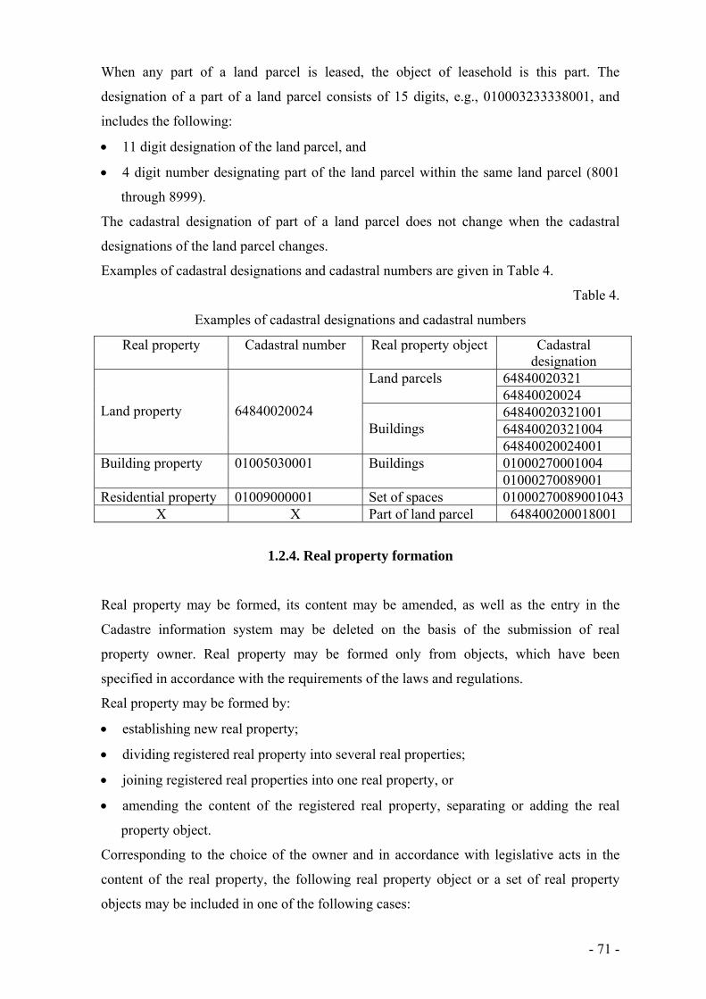
- 71 -
When any part of a land parcel is leased, the object of leasehold is this part. The
designation of a part of a land parcel consists of 15 digits, e.g., 010003233338001, and
includes the following:
11 digit designation of the land parcel, and
4 digit number designating part of the land parcel within the same land parcel (8001
through 8999).
The cadastral designation of part of a land parcel does not change when the cadastral
designations of the land parcel changes.
Examples of cadastral designations and cadastral numbers are given in Table 4.
Table 4.
Examples of cadastral designations and cadastral numbers
Real property Cadastral number Real property object Cadastral designation
Land property
64840020024
Land parcels 64840020321 64840020024
Buildings
64840020321001 64840020321004 64840020024001
Building property 01005030001 Buildings 01000270001004 01000270089001
Residential property 01009000001 Set of spaces 01000270089001043X X Part of land parcel 648400200018001
1.2.4. Real property formation
Real property may be formed, its content may be amended, as well as the entry in the
Cadastre information system may be deleted on the basis of the submission of real
property owner. Real property may be formed only from objects, which have been
specified in accordance with the requirements of the laws and regulations.
Real property may be formed by:
establishing new real property;
dividing registered real property into several real properties;
joining registered real properties into one real property, or
amending the content of the registered real property, separating or adding the real
property object.
Corresponding to the choice of the owner and in accordance with legislative acts in the
content of the real property, the following real property object or a set of real property
objects may be included in one of the following cases:

- 72 -
individual land parcel or land parcels and the buildings thereon owned by landowner
which are located in one administrative territory;
individual building or buildings which are located on foreign land in the territory of
one land parcel;
individual set of premises or sets of premises which are located in one dwelling house,
have a mutual border on the horizontal or vertical side, together with an undivided
share of the joint property.
If the land parcel and buildings belonging to a landowner are registered in the Cadastre
information system as a single real property, dividing such real property, the separation of
the building from the land parcel on which it is located is impossible.
If all real property objects are merged with another real property objects or individual real
property is merged with another real property, or all real property is destroyed, the real
property has to be deleted from the Cadastre information system.
In some cases it is necessary to transform all residential properties within one dwelling
house into different type or real property – building property. Such activity may be
performed: new building property shall be registered and all entries regarding the
residential properties in the Cadastre information system shall be deleted.
In establishing a new real property or deleting the entry regarding the real property, the
building of the registered real property, to which the real property or the real property
object is added or separated from, shall be amended at the same time, as well as the data
characterising thereof, and the data shall be updated in the Cadastre information system.
1.3. Role of cadastre in real property taxation
From 1990 to 1997 inhabitants of Latvia were obliged to pay land tax and the tax was
imposed on land only. Taxes are imposed according to the law "On Taxes and Duties" and
one of the following taxes is real property tax (hereafter – tax), which is determined by the
law "On Real Property Tax". Since 1998 the tax is imposed on real property as set of real
property objects - tangible things which are located in the territory of the Republic of
Latvia and which cannot be transferred from one place to another without being externally
damaged. For this purpose cadastral data of Cadastre information system are used.
Payers of the tax are Latvian or foreign physical and legal persons and groups of such
persons, formed on the basis of a contract or other agreement, who have ownership or
legal possession of real property. As the owner of real property person whose ownership
rights have been confirmed in the Land Book is considered.

- 73 -
Tax rate on the land, buildings or parts thereof and engineering constructions is 1.5
percent of the cadastral value of real property.
Tax rate on residential buildings, regardless of whether or not they are divided into
residential properties, residential parts of the set of premises in non-residential buildings,
the functional use of the accommodation, as well as set of premises, the functional use is
associated with living (garages, car parks, basements, storage and utility rooms), if they
are not used for economic activities is:
0.2 per cent of those which cadastral value do not exceed 40,000 LVL;
0.4 per cent of those which cadastral value is from 40,000 LVL to 75,000 LVL;
0.6 per cent of those which cadastral value exceeds 75,000 LVL.
1.5 per cent additional tax rate is imposed on unused agriculture land.
The taxation period is the calendar year. Cadastral valuation is a set of operations in order
to specify the value of a cadastre object. The process of cadastral valuation includes:
development of a cadastral value base;
calculation of cadastral value.
Valuation methods specified in the standards for valuation of real property are used in
development of the base of cadastral values – the method of comparing transactions,
income capitalisation method and the method of costs.
The State Land Service performs cadastral valuation according to procedures determined
by The Cabinet. Information regarding real property transactions is used at least for last
two years. The State Land Service registers and analyses the prices of the real property
market and lease payments and determines the price level. In order to accumulate and
process information regarding real property transactions, the Cadastre information system
maintains the database of the real property market.
The cadastral value is calculated taking into account the following data registered in the
Cadastre information system:
the base of cadastral value;
data characterising the cadastre object;
purposes of use of the real property;
encumbrances of the real property object.
The local government has to administer the tax therefore the State Land Service in the
Cadastre information system is performing the following operations:
maintenance of data regarding the object of real property;
entering the information regarding the payer of the tax.
- 74 -
The cadastral value does not include the value of forest stands, but the value of forest
stands is taken into account for taxation purposes, too. Calculation of forest value is made
by the State Forest Service.
Local governments and the State authorities have a duty to provide the data to the State
Land Service, which are necessary for the calculation of the total amount of foreseen
values of real property objects. Since 1997 the forecast of foreseen values of real property
tax is necessary in order to calculate contribution of local municipalities into Equalisation
Fund, as well as cost of it to insufficient municipalities. In early stage this calculation was
made by simplified methods, using information accumulated in Cadastre information
system. Presently data submitted to local governments are prepared of value-based
modelling system, which may perform automated conversion and obtain foreseen values
considering different bases of cadastral values.
Calculation of the tax on the basis of the last determined cadastral value is responsibility
of the local government, and it is one of the most important ways of the use of cadastral
value.
Every taxpayer is obligated to pay a tax on the basis of payment notice, issued by the local
government. A payment notice regarding a tax is an administrative act. If a payer of real
property tax has not received a payment notice by 15 February of the current assessment
year, he has an obligation to inform the local government within one month. The tax shall
be paid once in each quarter – not later than 31 March, 15 May, 15 August and 15
November – in the amount of one quarter of the yearly tax sum. The tax may also be paid
once a year by advance payment.
For real property tax abatements may be determined and amount of tax may be reduced for
politically repressed persons - by 50 per cent, if the immovable property is not used for
economic activity. The local governments may accept regulations, which provide
abatements for separate categories of taxpayers in the amount of 90 per cent, 70 per cent,
50 per cent or 25 per cent of the tax amount.
Amount of 90 per cent of abatement may be granted to persons, having status of low-
income persons or family.
Information systems, maintained by the State Land Service, provide data for
administration of real property tax by:
calculation of the cadastral value for real property taxation;
gathering information on taxpayers;
preparing lists of objects imposed on real property tax and taxpayers;
calculation of the total amount of foreseen values of real property objects.

- 75 -
Since 2010 State Land Service is responsible only for calculation of the cadastral value,
but it still regularly transfers to municipalities about 80 per cents of data, stored in the
Cadastre information system.
2. Registration of real property
2.1. Legal registration of real property
In the course of time two systems of real property registration have been developed in the
world: cadastral and legal registration. These systems mainly serve two purposes:
as “fiscal” records, primarily for the public sector, they have served as the basis for full
and accurate taxation of land;
as “legal” records, primarily for the private sector, they have served as registers of
ownership and other rights to the land.
Two independent cadastral and legal registration systems exist in such European countries
as Austria, Croatia, Poland, Slovenia, etc. Unique, single registration system exists in such
European countries as Czech Republic, Hungary, Lithuania, Slovakia, Moldova, etc.
At the end of 1992 and in 1993 some laws were passed that introduced essential changes
in the land cadastre. Firstly, at the end of 1992 there were preconditions for the
functioning of the real property market. To facilitate real property transactions it was
necessary to ensure registration of real property rights. For such purpose in 1993 the
legislator adopted a new law “On the Enforcement Procedure of the Land Book Law of
December 22, 1937” and re-enacted “The Land Book Law”. Consequently, the idea about
the development of a single register of cadastral information and property rights was not
implemented. Due to historical circumstances two independent registration systems has
been introduced in Latvia:
Cadastral Register as fiscal registration system (Property Register);
Land Book as legal registration system (Land Register) (Fig. 3).
Concerning registration of real property after 1990s, the system that existed before 1940
was re-established. The cadastral system is basically intended for real property taxation
purposes, it also serves as a tool for the registration of property use and tenure rights as
well as for storage of technical data, whereas the Land Book system offers corroboration
of property rights and registration of any restrictions related to the property.

- 76 -
Fig. 3. Registration of the data in Cadastre register and Land Book
Under Latvian law, there are two authorities responsible for maintaining the real
property registration system, namely, the State Land Service and the Land Book
Department (Fig.4).
The State Land Service is subordinated to the Ministry of Justice, which issues
methodological guidelines. The Land Book is an independent institution working within
the system of regional courts and supervised by the Ministry of Justice.
The Land Book offices are located in 28 regions, including larger cities of Latvia. All
databases of 28 Land Book Offices are unified in the Sate Unified Computerised Land
Register, which can be regarded as centralised database from where the information about
all real properties registered in Latvia can be obtained. The State Unified Computerised
Land Register is the only computerised land register information which is institutionalised
and legally recognised. The owner of the State Unified Computerised Land Register and
its software is the state of Latvia. The Ministry of Justice performs functions of the holder
(http://www.zemesgramata.lv/default.asp?ln=lv).
Anyone can obtain data from the Land Book on all real properties located in the Republic
of Latvia, which are registered in the Land Book, and may have access to data stored in
the subdivisions of the Land Book by entering one of these: division number, cadastral
number, property name, or property address.
Rights in real property are corroborated in the Land Book, and these rights include both
privileges and restrictions. Judges who have the power to take decisions head Land Book
offices. Land Book judges are appointed by the Parliament of the Republic of Latvia. Land
Book judges have the same professional status as judges serving in district courts or city
courts. In decision-making, judges are independent and only have to abide by provisions
Data submitted by real property
owners, cadastral surveyers, local municipalities
and state information
systems
Cadastre
Register
Land Book
Data submitted by real property
owners
Information and documents handed out to physical and legal persons
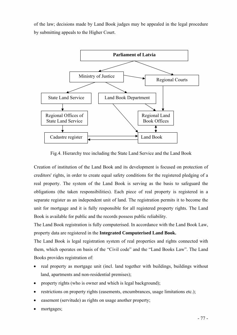
- 77 -
of the law; decisions made by Land Book judges may be appealed in the legal procedure
by submitting appeals to the Higher Court.
Fig.4. Hierarchy tree including the State Land Service and the Land Book
Creation of institution of the Land Book and its development is focused on protection of
creditors' rights, in order to create equal safety conditions for the registered pledging of a
real property. The system of the Land Book is serving as the basis to safeguard the
obligations (the taken responsibilities). Each piece of real property is registered in a
separate register as an independent unit of land. The registration permits it to become the
unit for mortgage and it is fully responsible for all registered property rights. The Land
Book is available for public and the records possess public reliability.
The Land Book registration is fully computerised. In accordance with the Land Book Law,
property data are registered in the Integrated Computerised Land Book.
The Land Book is legal registration system of real properties and rights connected with
them, which operates on basis of the “Civil code” and the “Land Books Law”. The Land
Books provides registration of:
real property as mortgage unit (incl. land together with buildings, buildings without
land, apartments and non-residential premises);
property rights (who is owner and which is legal background);
restrictions on property rights (easements, encumbrances, usage limitations etc.);
easement (servitude) as rights on usage another property;
mortgages;
Parliament of Latvia
Ministry of Justice Regional Courts
State Land Service Land Book Department
Regional Offices of State Land Service
Regional Land Book Offices
Land Book Cadastre register

- 78 -
other rights connected to the property (lease holders, will agreements etc.).
The Civil Code states that only after registration into the Land Book, the rights get
mandatory status in relation to third persons. The Land Book also contains historical
information about real properties.
In early stage the computerised registration system consisted of 28 separate regional
systems and all operations were based on registration system, containing data from
corroboration journals, land book folios and alphabetic indexes according requirements
stated by “Land Books Law”. The technical solution of each regional system was based on
ORACLE 7.3 database server (Windows NT platform) and Windows 95 workstations as
working sites (Fig.5). This technical solution fulfilled all the requirements for registration
of rights, printing of registration certificates and performing other duties of Land Book
offices.
The main entities of the Land Book database are:
Corroboration journal entries, where data about each application for corroboration of
rights are entered;
Land Book folios, where general information (folio number, cadastral number of
property, property name and/or property address) on real properties is stored;
Records in Land Book folios, subdivided into chapters and sections, which describe
corroborated rights;
Persons or companies with the data about persons/companies, who has any interests to
the real property (ownership rights, lease holder rights, mortgage rights etc.); person
list or company list serves as an index of persons in relation to the real properties;
Documents, where reference to deeds, agreements, etc. on which basic rights are
corroborated, are stored;
Refusals, which contain decisions of the Land Book office judge to refuse application
corroboration rights;
Territories – a list of administrative territories to support organization of the Land
Book according to territories.
The main identifiers for these entities are: folio number, journal entry number and ID code
of person.

- 79 -
Persons
Documents
Corroborationjournalentries
Records inLand book
folios
Land bookfolios
Refusals
Territories
Person ID code
Journal No.
Journal No.Journal No.
Journal
No.
PersonID code
Folio No.
Folio No.
TerritoryID code
Rec. No. Doc. No.
Fig.5. Generalized structure of Land Book database
In 1998 the Parliament passed amendments in the “Land Books Law”. The new edition of
the “Land Books Law” defined the following requirements for storing information into
database:
establishment of central database as storage of national-wide Land Books information;
only central data base contains adjudged information and is responsible for data
security;
exclusive property rights on data and software for computerised Land Books belong to
the state;
cross-checking of data with other public registers;
central storing of electronic images of corroboration documents;
standard application forms for corroboration;
electronic confirmation (authorisation) of judge’s decisions;
registration of residential property as separate property;
computerised printout of the Land Book Act, judges’ decisions and other certificates;
online search on public information only by folio number, cadastral number of
property, address or name of property;
system for accounting of distributed information to ensure payment of proper fees;
distribution system for delivery of information;
control of access for different parts of land books information;
downloading of information to the State Land Service and municipalities;
having enough flexibility to perform data exchange with other public registers/
institutions.

- 80 -
The main goal for making changes into existing system was to establish national wide
Land Book information system with different services for external customers. There was
also a task to establish state level information infrastructure by integration of Land Books
with other national registers in accordance with principles of national program
“Information Systems of State Importance”. It ensures information exchange between state
registers at high quality level and performs needed data collection in the most effective
way.
The new legislation requires a new functionality of the Land Book system, which should
include:
storage of all legally valid Land Book data into central data base;
security improvement of registration system;
data distribution system separate from registration system due to security
requirements;
tools for overall system administration;
cross-checking with auxiliary registers – Register of Citizens, Register of Enterprises,
Taxpayers’ register, Cadastre register, Address Register, etc.
data downloading to the State Land Service and municipalities.
Information from the computerised Land Book may be received in a Land Book office in
an electronic form, in the form of an uncertified computer printout or in the form of a
computer printout certified by a judge of a Land Register office.
2.2. Creation and development of cadastral registration system (1991 – 2006)
2.2.1. Registration of textual data
Land property registration in Latvia started with the introduction of Registration
journals of land users in each region. The registration was based on decisions on the
approval of land use rights. The purpose was to register the following data:
number of the land parcel in the land use project;
name of land user;
title (name) of the property;
total area of the property, area of agriculture land and area of forest land.
It means that already at the beginning of 1992 the legislator had actually determined:
the obligation of registration;
property subject to registration;

- 81 -
the organisational structure of the authorities responsible for registration.
Registration journals, however, did not acquire great significance; they never assumed the
function of an official register and were short-lived for the following reasons:
the State Land Service was established in 1993 for the purpose of implementing the
Land Reform, and all the relevant institutions were included in its structure;
orientation towards the development of a computerised registration system was already
approved;
allotment and surveying of land parcel boundaries was the responsibility of the
company “Zemesprojekts”, which formed an essential part of the State Land Service;
all boundary surveying documents were stored in one place in Riga, therefore
“Zemesprojekts” could start the development and maintenance of a simplified
registration system.
Thus, in the middle of 1992 “Zemesprojekts”, having concluded an agreement with the
Ministry of Agriculture, began the initial development of a registration system. It was
decided to develop software using the program design language DataFlex and financed by
Sweden.
This registration system has remained in history of the cadastre as the Preliminary Register
of Land Parcels or the Preliminary Register. It was a united temporary registration
system with a simplified data structure. It was designed to be run manually as a
registration book for each municipality, finally to be transformed into a computerised
register.
In the middle of 1992, “Zemesprojekts”, guided by preliminary specifications, started to
run the manual Preliminary Register. But the life of this register was rather short: as soon
as the technical environment could be improved, data input in a computerised system
started.
The computerised Preliminary Register was developed with the aim of accumulating
surveying data of boundaries collected by “Zemesprojekts”. Such a computerised system
improved and facilitated the registration process and ensured certain checking and
supervision of boundary surveying work. The Preliminary Register was not a juridical
register. Data accumulated in this register were intended only for controlling the process
and statistics of the Land Reform. It served as an intermediate stage in the development of
a reliable land information system.
The Preliminary Register was composed of the following parts:
3 basic blocks of information (information about land parcels, land properties and land
users or landowners);

- 82 -
3 subsidiary blocks of information (list of local municipalities, list of regions and list
of purposes of land use).
The data input and data adjustment were realised only in the basic blocks. The volume of
data was not large: the registration number and date, land parcel cadastral designation,
area of land parcel and land property, number and date of the Land Commission decision,
title of land property, purpose(s) of land use, name and address of the land user or
landowner, etc.
The Preliminary Register was maintained only in one place in the Land Cadastre Centre of
the State Land Service in Riga. The reason was that between 1992 and 1994 the State
Land Service did not have enough hardware and software, and the technical solutions for
digital technologies had to be concentrated in one place. Computerisation of the regional
offices of the State Land Service was undertaken later.
Only about 13 employees provided the maintenance of the Preliminary Register. They
were responsible for programming, cadastral registration, maintenance of blocks of
information, and administration. Only 8 simple computers and a low-capacity server were
at their disposal. The first operating computer network was composed of 5-10
workstations, a couple of printers and a server. Regardless of the restricted technical and
financial resources already 39.5 thousand land use units, including 50 thousand land
parcels, had been registered by the end of 1993 in the Preliminary Register.
At the end of 1992 and in 1993 some laws were passed that introduced essential changes
in the process of the state land cadastre. The following responsibilities in relation to
cadastre were assigned to the State Land Service under the Law “On State Land Service”:
to perform formation of real properties for registration;
to develop, introduce and run the cadastre of land and other real properties;
to co-ordinate and supervise the development of the land cadastre information system;
to issue cadastral information to natural and juridical persons, municipalities and state
institutions.
The law also determined the following:
registration of real property is the responsibility Land Book offices, and cadastral
information should be incorporated into the Land Book information;
exclusively the cadastral information submitted by the State Land Service should be
recognised as official information regarding land and other real properties;
the State Land Service is the only developer and manager of the cadastral system.
It means that the State Land Service should develop both the cadastral system and separate
registration system for accumulation of the cadastral information. In 1993 the company

- 83 -
“Zemesprojekts” worked out the basic regulations of cadastral registration on the basis of
the above-mentioned legislative acts and experience obtained in the field of registration. It
was an accepted instruction which prescribed an order of maintenance of:
Cadastre Register in textual form;
A cadastral map in graphical form.
The textual part of the Cadastre Register initially was performed manually. The
registration book was introduced for every rural and urban municipality in the form of a
Cadastre Register of manual entries, where each real property was registered on a separate
sheet. Data were entered concerning every real property and the respective land parcels;
any changes in the cadastral data were reflected. The Cadastre Register of manual entries
replaced the registration journals and became official registers of cadastral data.
Between 1993 and 1995 the registration system was based on a very close co-operation
between regional offices of the State Land Service maintaining the Cadastre Register in
textual form on the regional level, and Land Cadastre Centre of the State Land Service
maintaining the Preliminary Register in digital form at the central level.
The staff of the Land Cadastre Centre entered boundary surveying data into the central
computerised Preliminary Register, assigned the registration numbers and, on a regular
(monthly) basis made printouts from the Preliminary Register and submitted them to the
regional offices. Only after real property registration in the Land Book the regional offices
registered the received information in the Cadastre Register of manual entries. Land
parcels were assigned cadastral designations, a record in the Cadastre Register was made
and the Preliminary Register registration number was entered. This process was very
important, because information accumulated in the Preliminary Register was further
recorded in the computerised Cadastre Register and the Preliminary Register registration
number served as a key between the two registers.
When the regional offices of the State Land Service began to deal with boundary
surveying, boundary surveying data were stored in the local offices, the regional offices
every month submitted lists of newly surveyed land parcels to the Land Cadastre Centre
for registration in the central computerised Preliminary Register. At the end of 1995 data
on nearly 90 thousand land properties consisting of approximately 125 thousand land
parcels had been accumulated in the central computerised Preliminary Register.
In 1994, in order to upgrade the registration system, to increase its efficiency and to bring
registration offices nearer to the landowners and to the main customers, i.e., the
municipalities, the Land Cadastre Centre started decentralisation of the computerised
Preliminary Register. In the future, cadastral registration should be the responsible for the

- 84 -
regional offices of the State Land Service. In this regard, considering the available
financing, it was planned gradually to equip regional offices with the necessary
equipment, to set up small local computer networks and to train the staff, at the same time
continuing the work with the Cadastre Register of manual entries.
It was planned that at the regional level the computerised Preliminary Register should
serve the following functions:
collection, input and processing of the data;
maintenance and upgrading of the registration system on the regional level;
preparation and issuing of juridical documents (certificates);
providing of customers with cadastral information on the regional level;
data exchanges with municipality information systems;
preparation of updates for central data storage.
At the beginning of 1995 the regional offices of the State Land Service took over the
maintenance of the computerised Preliminary Register. It means that at the same time they
also maintained the Cadastre Register of manual entries. The Land Cadastre Centre started
to develop the central data storage in order to control data quality and supervise the
registration process. The regional offices sent cadastral information to the central data
storage in digital form on floppy disks.
The decentralised Preliminary Register existed for about one year, and it was gradually
replaced by the computerised Cadastre Register in the regional offices. In the course of
time the equipment of the State Land Service was improved, and in 1997 a local computer
network consisting of 5-20 computers was created in each regional office. The
maintenance of the Preliminary Register stopped in the middle of 1996.
In April 1996 the Government issued “Regulations for the State Cadastre of Real
Properties”. The Cabinet of Ministers established the legal basis of the Cadastre Register
with this document, determining the following procedures:
geodetic and cartographic work, formation and classification of real property, its
cadastral valuation and registration in the Cadastre Register;
storage and use of cadastral data; the range of cadastral data users;
rights and responsibilities of both of landowners and performers of cadastral activities.
Consequently the Cadastre Register became the official register of cadastral information,
and it was especially necessary to develop and implement the computerised Cadastre
Register. Legally the Preliminary Register served only as an auxiliary means and an
intermediate stage in the transition from the Cadastre Register of manual entries to a
computerised Cadastre Register.

- 85 -
In this regard, the preliminary work for the development of the computerised Cadastre
Register started in 1995. The software for the Cadastre Register was developed using the
program design language DataFlex.
The Cadastre Register was composed of 15 basic blocks of information and 16 subsidiary
blocks. The data input and data adjustment took place only in the basic blocks (files),
including the following lists: addresses of land parcels; buildings; changes made in the
register; documents registered in the register; encumbrances; documents issued by Land
Book; map sheets of the cadastral map; landowners (land users); land parcels; land
properties (land uses); restrictions on property; easements; cadastral surveying activities;
cadastral value of the land, mutual reference between landowner and land property as well.
The service software provided the facilities to enter, correct and change the data, to search
and output them in the necessary manner. The Cadastre Register did not contain any
software enabling data selection and generalisation and processing of inquiries. Special
software generated by the company Data Access served for this purpose.
The Cadastre Register was a relational database where data files were connected by
mutual references. It means that one entry in one data file corresponds to one or several
entries in another data file. Such a solution takes into consideration a condition where land
property consists of several land parcels. The cadastral value of land was entered from
outputs of the Land valuation register. The software of the Cadastre Register was
improved continuously in accordance with changes or modifications in legislation. The
Cadastre Register was a decentralised system – registration took place in the regional
offices of the State Land Service.
At the end of 1996, two or three employees in each regional office were able to maintain
the Cadastre Register. These offices were provided with some 40 computers, 30 graphic
workstations for the maintenance of the cadastral map, and 3 servers for data accumulation
and data processing. As a result, 28 mutually unconnected computer networks were
created with different kinds of network topology, which functioned in the regional offices
of the State Land Service. After 1997 the number of computers in the regional offices of
the State Land Service continued to increase. In some of the regional offices the number of
computers reached 15-40, but Riga offices had even 50-150 computers at their disposal.
State Land Service had a united computer network and data transmission system
connecting 28 local computer networks.
Already in 1996 the State Land Service started to work on data transmission by joining the
data transmission network of the State Information Network Agency VITA.

- 86 -
Intensive work has been going on to accumulate data in the Cadastre Register, while the
interest of state institutions and the general public about the Land Reform, its outcomes
and cadastral information was increasing. As a result, the State Land Service was not able
to meet this growing demand fully. Also, the Law “On Real Property Tax” led to an acute
demand for information about real properties in all Latvia to be obtained from the
Cadastre Register. Therefore, as of 1997, the State Land Service made a great effort to
register all the land parcels, and already in 1998 this task was fulfilled. In 1999 the State
Land Service started intensive and massive activities to register also buildings in the
Cadastre Register.
The Cadastre Register was developed using ORACLE database management software and
the relational principle of databases, and was based on SQL programming language. In
fact, the usage of ORACLE software was a very significant step because it opened up new
opportunities and provided:
maintenance of large databases;
storage of large volumes of data;
safety against data damage;
immediate regeneration of the damaged section;
an opportunity to link and integrate several data bases quickly.
A disadvantage of the ORACLE software was the high price of the licenses and the
complicated maintenance; highly qualified experts in programming, administration and
maintenance were required.
The information in the textual part of the Cadastre Register was divided according to
sections, namely:
property section containing data on the type of property and the owner, Land Book
information, encumbrances and documents related to the property formation and
alteration; to maintain this information, exchanges with the Land Book information
was made;
land parcel section containing more technical information - explication of the types of
land use (arable land, forest, etc.), purpose of use of the property, encumbrances,
surveying data etc.; the technical data help to calculate the cadastral value of the land;
section of buildings and sets of spaces;
cadastral value section;
section of archived files.
The section of buildings and sets of spaces take up a large part of the Cadastre Register.
In Latvia the registration of buildings and other structures has been delegated to the State

- 87 -
Land Service, which is responsible for registration and maintenance of such data.
Depending on the type and purpose of data collection, the section of buildings/structures
of the Cadastre Register is divided into two parts:
full amount of building inventory data;
partial building inventory data.
The first part includes technical data gathered by external and internal inspection of
buildings. Full technical inspection is made when a building is commissioned for use or
when a repeated technical inventory is required. Inspection for full technical inventory is
required when an updated cadastral value has to be recorded.
The second part involves external inspection and exterior measurements of the building
and it is required for calculation of the cadastral value for the purpose of real property
taxation.
Data about sets of spaces are gathered simultaneously with full technical inspection of the
building. Inventory data of sets of spaces are valid for five years, and this information has
to be updated in cases when more than five years have passed since the last technical
inspection.
The cadastral valuation section is organised so that it helps to calculate the cadastral
value of the land and buildings using the data registered in the Cadastre Register. By law,
the State Land Service is responsible for cadastral valuation of land. By the beginning of
the year 2000 a special computer program was developed to be used for the calculation of
cadastral values and for the maintenance of valuation data. The final cadastral value was
entered in the Cadastre Register. Programs for cadastral valuation of urban and rural land
were kept apart; they were based on different methodologies and application of different
software. As a result, it was difficult to make them compatible with the Cadastre Register.
Early in 2000, to avoid duplication of data and incompatibility of computer programs and
cadastral data, the cadastral valuation of land became the function of the Cadastre
Register.
Within the integrated cadastral valuation section the following has been achieved:
cadastral values are automatically calculated by the Cadastre Register software;
cadastral values are automatically re-calculated each year by January 1 for the needs of
real property taxation;
forest values provided by the State Forestry Service are automatically downloaded into
the Cadastre Register;
land value zones are automatically selected.

- 88 -
Cadastral valuation of buildings is made using the actual technical inventory data stored in
the Cadastre Register. Cadastral valuation of buildings is based on the following data:
type of building;
number of floors above the ground level;
size of the building: built-up area (sq. m), volume (cu.m), and length (m);
degree of physical deterioration;
material used for external walls.
The archived files section was introduced in the Cadastre Register facilitate the
administration of the wide-scale archive materials of the State Land Service, to control the
circulation of the archived files, and to simplify document processing.
Cadastre Register provides the production and printing of the required cadastral
documents.
The development of national cadastral registration system is shown in table 5, but
development of the content of the Real Property Register is shown in table 6.
Table 5
Development of national cadastral registration system
Year Registration system Data registration and processing
Level of maintenance
1991 Registration journal of land use
Manual Regional
1992 Temporary Cadastre Central 1993 Digital, Data Flex Regional 1993 Cadastre Register Regional 1998 National Real property
information system Digital, Oracle (28 data bases) Regional
2003 Digital, Oracle (8 data bases) Regional since 2007 Digital, Oracle (1 data base) Central
Table 6
Development of content of Cadastral information system
Year Textual part Cadastral map 1992 Land properties, land parcels and
encumbrances X
1995 X Cadastral areas and land parcels
1997 Incomplete extent of building inventory data X 1998 Building properties X 1999 X Buildings 2000 Full extent of building inventory data,
valuation of the land and buildings, apartment properties, leasehold, tax administration data and archive
X
2003 X Encumbrances
- 89 -
2.2.2. Registration of graphical data
Until 1990 the company “Zemesprojekts” mapped all the existing land uses – collective
farms, individual farms, forestry enterprises, schools, cemeteries, roads, railways, etc. on
cadastral cartographic materials. In planned economy cartographic information about
land use was necessary for overviews, state statistics, physical planning, development of
projects and for other purposes. Such cartographic materials were:
manual photomaps produced using air photography methods (of a 1:10000 scale);
manual land use boundary maps of the respective regions (of a 1:75000 scale).
With the initiation of the land reform, the existing cartographic materials become useless
because they were unsuitable for mapping of the land allotted for use, mainly for the
following reasons:
the cartographic materials covered only rural areas but not the whole territory of
Latvia;
from the technical point of view, photomaps were not suitable for continued alteration
and modification of land parcel boundaries and therefore soon become useless;
the land use boundary map was drawn up in a small scale (1:75000), therefore it could
not represent a great number of land parcels.
It meant that for the needs of the land reform it was necessary to make new cartographic
materials. In 1991, during their study visit in Sweden, specialists from the company
“Zemesprojekts” found that it was useful to make a special map for mapping land parcel
boundaries. Such a map should show an overview of the geometry of land parcel
boundaries, their location, and also relative location. The maintenance of the map was
possible using only digital technologies. As the State Land Service just started to use
computers and the specialists were not adequately trained, a transition period with the use
of manual technologies was necessary.
We may consider that land use projects were the first cadastral cartographic materials
that were made for each rural municipality. The local Land Commission made decisions
on the allocation of land on the basis of these land use projects.
At the early stage of the land reform, land parcel boundaries in rural areas were mainly
allocated without instrumental measurement. The land parcel boundaries thus allocated
were mapped on the existing manual rural area photomaps (of a 1:10000 scale). But in
cities, towns and in other densely populated areas land parcel boundaries were surveyed
using geodetic instruments. For land parcel boundary mapping, so-called urban cadastral

- 90 -
survey map was created. This map was maintained in digital form. Alongside with the
land parcel boundary information, also topographical information acquired during the
surveying process was stored in the database of the map. It should be remarked, however,
that the State Land Service did not prescribe the procedure for the creation and
maintenance of such a map. As a result, each regional office of the State Land Service
developed this map at its discretion.
Already in 1996 the Government started drafting a law on the completion of the Land
Reform both in rural and urban areas. For this purpose, it was necessary to arrange and
map all information about the land allotted during the land reform, i.e., ownership and
land use information as well as data on free unclaimed land. In 1997 the State Land
Service drew up the Land use and real property map (of a 1:10000 scale) for each
administrative division. Further the State Land Service updated this map in accordance
with the decisions taken by Land Commissions. Land use and real property maps served as
the basis for cadastral surveying of land parcel boundaries. Later, however, land use maps
lost their significance.
Development of the manual cadastral map started in 1993 when the State Land Service
established the procedure for the maintenance of the cadastral map in graphical form. The
prescribed procedure was as follows:
the cadastral map should cover the whole territory of Latvia and should show the
geometry, location, including relative location, of land parcels;
boundary points and boundaries of land parcels and their cadastral designations as well
as boundaries of the cadastral groups and administrative division units should be
shown on the cadastral map;
the cadastral map should be maintained in a manual way in a scale not larger than
1:10000 and not smaller than 1:500;
land parcels should be depicted on the cadastral map after their registration in the Land
Book;
regional offices of the State Land Service are responsible for the maintenance of the
cadastral map.
Sheets of the cadastral map had to be drawn on special transparent material suitable for the
maintenance of the cadastral map. A rectangular control network should be made to
conform to the co-ordinate system of Latvia (LKS-92). Every map sheet showed the
previously used control network grid and was compatible with manual photomaps and
topographic maps. Land parcel boundaries from photomaps should be copied on the
cadastral map.

- 91 -
Before starting the maintenance the cadastral map, it was necessary to provide regional
offices of State Land Service with cadastral map sheets. Software for the division of the
cadastral map into map sheets was developed and separate *.dgn file for each map sheet
was created. In these files information about boundaries of cadastral groups and
administrative division units was included. The corresponding text file to each *.dgn file
was created where titles (names) of administrative division units and numbers of cadastral
groups were stored.
Cadastral group was defined as a territory inside the administrative division unit, marked
on the cadastral map with a conventional line. The territory of a cadastral group was
formed as compact as possible.
Cadastral map sheets produced on specific transparent material were supplied to regional
offices of the State Land Service in the middle of 1995, and we can say that this date
marks the beginning of the cadastral map in Latvia.
Practically the manual cadastral map in a 1:10 000 scale covered only the rural areas of
Latvia, whereas no cadastral map was made at that time for cities, towns and other densely
populated areas due to the lack of finances. The accuracy of the cadastral map depended
on the accuracy of cadastral surveying.
The maintenance of the manual cadastral map was discontinued in 1999. In accordance
with the existing regulations, the manual cadastral maps are stored in the State Land
Service archives.
The Latvian specialists started to appreciate the significance of the digital cadastral map
after a study visit in Sweden in 1991 and also when Swedish specialists started to provide
training in a new field – digital photogrammetry. As a result of this co-operation, digital
orthophoto map of a 1:10000 scale of Latvia was created for several territories. The
orthophoto map opened up completely new possibilities to maintain the digital Cadastral
map in Latvia. Already in 1993 the State Land Service undertook the preparation for
transition to the maintenance of the cadastral map in a digital way, and in co-operation
with Swedsurwey national cadastral mapping program was developed.
The graphics software appeared in Latvia in the 90s of the last century. Digital technology
in the maintenance of the cadastral map was introduced comparatively late, but it
immediately conquered a permanent position. The State Land Service introduced digital
technology in field surveying as soon as the modern surveying instruments appeared in
Latvia. Such instruments were able to capture surveying data in a magnetic storage device
directly in field conditions in the countryside; these instruments provided obtaining of the
data in digital form and clearly demonstrated the advantages of digital technology. Land

- 92 -
surveyors started to produce land parcel boundary maps in a digital way by using
MicroStation *.dgn files or digital cadastral survey maps.
The first modern instruments for cadastral mapping appeared in Latvia in 1993 when, by
way of humanitarian aid, the Danish surveyors presented the State Land Service a few
computers and licensed MicroStation 4.0 software for training purposes.
Land parcel boundaries could be entered in the digital cadastral map by using co-ordinates
of boundary points shown on the land parcel boundary maps but this was inefficient and
laborious work. For technical reasons, the existing manual rural area photomaps with
allotted land parcel boundaries were not available for the digitisation of their graphic data.
As a matter of fact, fact preconditions necessary for the maintenance of the digital
cadastral map both in rural and urban area appeared in 1994 when the first orthophoto
maps were introduced and gradually covered whole territory of Latvia.
Graphics software, specification of the cadastral map, trained specialists and a separate
*.dgn file for each administrative division unit were necessary for the maintenance of the
digital cadastral map. The State Land Service decided that MicroStation software should
be used for the maintenance of the digital cadastral map.
In 1994, the first specification of the digital cadastral map was approved. This document
described how to draw up and to maintain the Cadastral map with the aid of computers.
Cartographic data in the database should be stored in a system of files, and theses files
should be grouped into catalogues and subcatalogues on different levels. The document
specified the following:
parameters of accuracy of the cadastral map;
sources of graphic data;
requirements applicable to the software of the cadastral map;
systems of co-ordinates to be used;
format of cadastral map printout;
updating of the cadastral map;
principles of data storage;
list of groups of objects to be reflected on the cadastral map;
codes of groups of objects and parameters of objects (level, colour, style of the lines,
etc.)
Later the specification of the digital cadastral map was further improved and
supplemented. In 1996, specific KZIS software was developed, linking the textual part of
the Cadastre Register with the cadastral map. This software fulfilled some functions of

- 93 -
data quality control, i.e. it precluded duplication of cadastral designations of land parcels
as well as warned about overlaps of adjoining land parcels.
Depending on the required accuracy, graphic data for the maintenance of the cadastral
map were captured from the following data sources:
cadastral surveying linked with the national geodetic network;
cadastral surveying not linked with national geodetic network;
allotment of land parcel boundaries by using digital orthophoto maps;
allotment of land parcel boundaries by using manual photomaps of rural areas;
design of land parcel boundaries by using various cartographic materials.
For the development of the cadastral map basic data were captured by cadastral surveying
and allotment of land parcel boundaries, but at the same time various cartographic support
materials (orthophoto maps, manual rural area photomaps, land use and real property
plans, building overview plans, graphic appendices of leasehold agreements, etc.) were
used.
The data on the surveyed land parcel boundaries were included in the cadastral map using
the “*.dgn” file containing land parcel boundaries, which is used for the production of the
land parcel boundary map, or co-ordinates of boundary points shown on Land parcel
boundary map.
Allocated land parcel boundaries were shown on the cadastral map:
using the *.dgn file containing land parcel boundaries, which was used for the
production of the land parcel boundary map, or
using sketches drawn by surveyors, which showed the location of boundary points,
together with the “*.dgn” file containing topographic information as a background file,
or
scanning and drawing anew the manual cadastral map.
The designed land parcel boundaries were shown on the cadastral map drawing its
boundaries in MicroStation software environment and using scanned land use maps and
real property maps, manual photomaps of rural areas, keeping orthophoto maps as a
background file.
The maintenance and quality of the cadastral map as well as data protection is the
responsibility of the of State Land Service regional offices. Central office of the State
Land Service supervised the maintenance and quality of the cadastral map and ensured
methodological guidance and analysis.
A transition from the manual cadastral map to the digital cadastral map was made step-by-
step, simultaneously maintaining the manual cadastral map and accumulating graphic data

- 94 -
in the cadastral map database. The transition depended on the available technical and
financial resources. One very restrictive factor was the lack of skilled cadastral
cartographers; therefore the digital cadastral map was introduced very slowly. However, in
1997 nearly half of the State Land Service regional offices maintained the digital Cadastral
map. After 1998 the maintenance of the Cadastral map was completely digitised (Table 7).
Table 7
Development of Cadastral map
Year Registration system Data registration and processing
Level of maintenance
1991 Land use projects Manual Regional 1992 Photomaps for rural area
Cadastral survey map for urban area Digital, MicroStation 1995 Cadastral map Manual since 1997
Digital, MicroStation Regional
since 2000
Central data storage Digital, MicroStation Central
2001 was a milestone in the maintenance of the cadastral map as the State Land Service
approved “Regulations for the Cadastral Map” and “Cadastral Map Standards”. These
documents defined a new approach to the maintenance of the cadastral map and
adjustment of the accumulated graphic data. The main purpose of the documents was to
systematize and unify graphic data in accordance with the cadastral map standards.
The cadastral map is a visual representation of graphic data obtained by data selection
from the cadastral map database. The cadastral map, in accordance with the accepted
cadastral map standards and approved conventional symbols, represents land parcels,
buildings, encumbrances and parts of land parcels. The legislative acts issued by the
Cabinet of Ministers contains the following definition of cadastral map: “a map that shows
the location of land parcels in a territory and provides information about boundaries,
designations and the features of real property objects”.
The cadastral map was developed according to the principles of the topographic map
system adopted in the Republic of Latvia in 1993 (TKS-93). It is based on the plane
determined by the Latvian system of co-ordinates of 1992 (LKS-92), the Riga meridian
(24 degrees eastern longitude), the image scale of 0.9996, and transverse Mercator’s
projection. The Cadastral map is part of the Latvian map system and covers the whole
administrative area of Latvia.
Special designations are used to show the following features on the cadastral map:
boundaries of the administrative division units of Latvia;

- 95 -
boundaries of cadastral territories and cadastral groups;
boundaries of land parcels and their cadastral designations;
external contours of buildings and their cadastral designations;
restricted and encumbered areas of land parcels and their designations.
Land parcel boundaries on the cadastral map are aligned within definite limits so that
overlaps or gaps are excluded. The cadastral map gives an overview of location of land
parcels, buildings and encumbered areas in a definite territory. The purpose of the
cadastral map is to present these elements in an updated way.
Land parcel boundaries on the cadastral map are shown in the following order of
priorities:
land parcel boundaries surveyed by instruments, where data are captured from
electronic data files or are transferred directly from co-ordinates of boundary points
fixed on the land parcel boundary map;
land parcel boundaries allocated by simplified methods (without using surveying
instruments, by reference to landscape features that are shown on orthophoto maps and
photomaps), according to hand-made sketches drawn by the surveyor and by using
simplified topographic maps, orthophoto maps or photomaps as background material;
designed land parcels, where the decision on allocation of land for permanent use or
privatisation has been made, but where no surveying or boundary allocation work has
been done yet.
Graphic data of various degrees of accuracy are included in the cadastral map database.
Graphical data are obtained by various methods of cadastral surveying of a defined
priority:
surveying by reference to the national geodetic network;
photogrammetric surveying;
surveying without any reference to the national geodetic network, where land parcels
are surveyed in a free system of co-ordinates and later adjusted to orthophoto and
photomap material;
boundary allocation on the basis of an orthophoto map;
boundary allocation on the basis of a photomap;
design of parcel boundaries on the basis of an orthophoto map, photomap or other
cartographic material;
technical inventory (inspection) maps of buildings.
When adjoining land parcel boundaries overlap or form gaps, land parcel contours on the
cadastral map are adjusted. In the adjustment process, the priority order of boundaries is

- 96 -
taken into account. The boundaries that do not conform to the standards of accuracy are
considered to be erroneous and are stored as such in a special storage place of inaccurate
data. A statement is drawn up to record the inaccurately measured land parcels, and
various ways are sought to correct the data.
The external contours of buildings are entered on the Cadastral map in a generalised way.
Buildings are marked on the cadastral map only when the respective land parcel has
already been marked, and again some priorities have to be observed as to the sources of
contour data:
surveying, where buildings are shown according to boundary measurement and
topographic measurement data;
stereo-vectorisation, where buildings are shown according to topographic (simplified)
rural or urban maps obtained by stereo digitisation;
mono-vectorisation, where buildings are marked according to the simplified
topographic maps, orthophoto maps or other available materials obtained by mono-
digitisation.
The cadastral map standards defined how the cadastral map database should be used to
produce the cadastral map and various thematic maps containing cadastral information.
Using the link between the databases of the textual part of the Cadastre Register and the
cadastral map, textual data input into the thematic map is possible. Methods and
parameters for making cadastral map printouts are defined (Fig.6.).
Currently the digital cadastral map fully covers the whole territory of Latvia; it shows all
the existing land parcels and buildings, while an intensive process to enter data on
encumbered areas inside land parcels is going on.
Today the cadastral map has great significance; it is a marketable product for national
economy planning, physical planning, designing and other purposes.
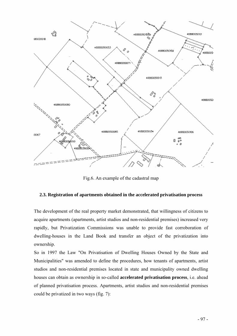
- 97 -
Fig.6. An example of the cadastral map
2.3. Registration of apartments obtained in the accelerated privatisation process
The development of the real property market demonstrated, that willingness of citizens to
acquire apartments (apartments, artist studios and non-residential premises) increased very
rapidly, but Privatization Commissions was unable to provide fast corroboration of
dwelling-houses in the Land Book and transfer an object of the privatization into
ownership.
So in 1997 the Law "On Privatisation of Dwelling Houses Owned by the State and
Municipalities" was amended to define the procedures, how tenants of apartments, artist
studios and non-residential premises located in state and municipality owned dwelling
houses can obtain as ownership in so-called accelerated privatisation process, i.e. ahead
of planned privatisation process. Apartments, artist studios and non-residential premises
could be privatized in two ways (fig. 7):
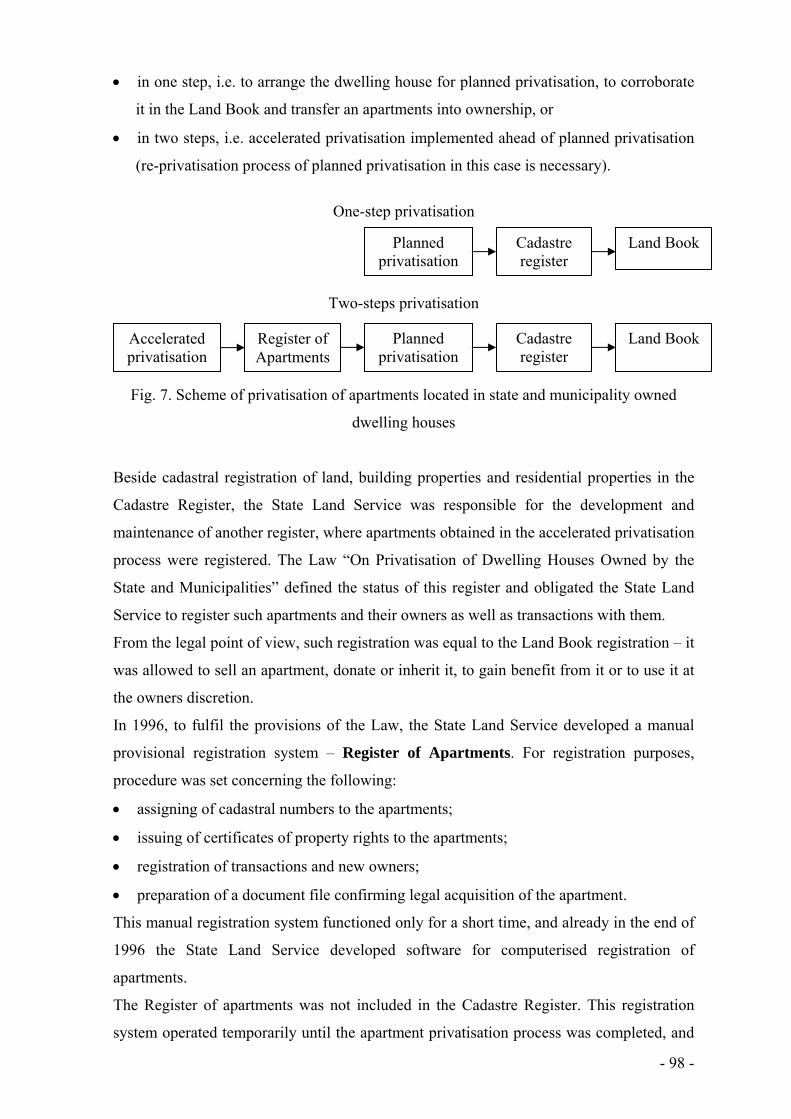
- 98 -
in one step, i.e. to arrange the dwelling house for planned privatisation, to corroborate
it in the Land Book and transfer an apartments into ownership, or
in two steps, i.e. accelerated privatisation implemented ahead of planned privatisation
(re-privatisation process of planned privatisation in this case is necessary).
One-step privatisation
Two-steps privatisation
Fig. 7. Scheme of privatisation of apartments located in state and municipality owned
dwelling houses
Beside cadastral registration of land, building properties and residential properties in the
Cadastre Register, the State Land Service was responsible for the development and
maintenance of another register, where apartments obtained in the accelerated privatisation
process were registered. The Law “On Privatisation of Dwelling Houses Owned by the
State and Municipalities” defined the status of this register and obligated the State Land
Service to register such apartments and their owners as well as transactions with them.
From the legal point of view, such registration was equal to the Land Book registration – it
was allowed to sell an apartment, donate or inherit it, to gain benefit from it or to use it at
the owners discretion.
In 1996, to fulfil the provisions of the Law, the State Land Service developed a manual
provisional registration system – Register of Apartments. For registration purposes,
procedure was set concerning the following:
assigning of cadastral numbers to the apartments;
issuing of certificates of property rights to the apartments;
registration of transactions and new owners;
preparation of a document file confirming legal acquisition of the apartment.
This manual registration system functioned only for a short time, and already in the end of
1996 the State Land Service developed software for computerised registration of
apartments.
The Register of apartments was not included in the Cadastre Register. This registration
system operated temporarily until the apartment privatisation process was completed, and
Register of Apartments
Planned privatisation
Cadastre register
Accelerated privatisation
Land Book
Planned privatisation
Cadastre register
Land Book

- 99 -
the data in a separate database were stored. Since 2003 this database is linked to the
Cadastre Register. It is very important because it is necessary to identify any apartment in
both registers and to update information in the Cadastre Register.
Analysis of the information stored in the Cadastre Register shows that by 2004 the
accelerated privatisation process in the country, except Riga City, was completed. This
means that any further information about residential properties is maintained only in the
Cadastre Register.
The State Land Service is responsible for the storage of the closed Register of Apartments
and document files in the archives. These documents have great historical significance
because they confirm legal acquisition of apartments.
Regulations in regard to apartments obtained in the accelerated privatisation process apply
both to condominium apartments and apartments privatised for shares.
Privatisation of condominium apartments started already in 1992, when the Government
obligated state building inventory authorities to create a simple preliminary registration
system and to issue certificates confirming property rights to condominium apartments.
Condominium apartments were registered in registration books.
Regulations did not obligate any institution to register the apartments privatised for shares;
therefore there is no generalized information about the number of such apartments.
To corroborate rights to condominium apartments and apartments privatised for shares in
the Land Book, first the respective dwelling house and the land should be registered in the
Land Book. It is not specified in any regulations which institution is responsible for the
registration of condominiums; therefore the residents themselves have to register the house
in the Land Book. This explains why the registration process is so slow.
The registration scheme of apartments and residential properties is shown in fig.8.

- 100 -
Fig. 8. Registration scheme of apartments and residential properties
3. Frame of Cadastre information system (since 2006)
3.1. Textual part of Cadastre information system
The Cadastre information system is developed considering general requirements of the
Law on State Information Systems. The main task of the Law is to determine unified
procedures by which State information systems are created, registered, maintained, used,
reorganised or liquidated. The main operating principles for State information systems are:
State information systems shall be merged within an integrated State information
system;
data which are accessible in the integrated State information system must not be
collected from data subjects;
information regarding to the data subject and his/ her cognisable objects to be
registered shall be registered only once in the relevant register – for the identification
of objects to be registered in the integrated State information system ensuring the
updating of data;
Condominium apartments
Apartments privatised for shares
Apartments obtained in accelerated privatisation
Apartments obtained in full privatisation procedure
Register of Apartments
Registration books
Apartments obtained by splitting the dwelling house owned by natural or legal persons into apartment
properties
Cadastre register

- 101 -
system manager has the duty to create the publicly accessible division of the State
information system for ensuring general accessibility to informative services.
The Law prescribes responsibility of the keeper of the State information system for:
data collection, registration, input, processing, storage, utilisation, transmission,
publication of data, compliance with data submitted, updating, correcting, as well as
the quality of data;
use of data and its exchange among State information systems by electronic means;
access to information in circulation in the electronic form;
opportunity for users of the State information system to receive informative services
accessible in the electronic form, utilising information technologies.
Cadastre information system is one of the State information systems and is developed on
the base of Real Property State Cadastre Law and by the Regulation “Regulations for the
Registration of a Cadastre Object and Updating of Cadastre Data” (No.636 adopted on 1st
of August, 2006 and No.193 adopted on 23rd of February, 2010 by Cabinet). The purpose
of the Law is to ensure society with updated cadastre information regarding all real
properties in the territory of Latvia, all real property objects, their owners, lawful
possessors, users, renters, as well as objects of real property tax and taxpayers.
The State Cadastre of Real Property (hereinafter – the Cadastre) is a single registration
system which by effecting administrative, organisational and technological processes
ensures the obtaining of cadastre data, as well as maintaining and use of the referred to
data. In order to ensure operation of the Cadastre, the information system of the State
Cadastre of Real Property (hereinafter – Cadastre information system) is maintained and
improved.
The Cadastre information system is the State information system. The manager and holder
thereof is the State Land Service. The State Land Service operates in this field in
accordance with the State Information System Law, Electronic Documents Law, Personal
Data Protection Law and the Law on Archives. In the Cadastre information system are
registered and maintained cadastre text and spatial data keeping the historical data at the
same time. Data regarding the cadastre subjects, objects of real property tax and taxpayers
are entered into the Cadastre information system. Until 2011 State Land Service prepared
the information regarding objects and payers of real property tax from the Cadastre
information system and submit it to local governments, but since 2011 data regarding
objects of real property tax and taxpayers are not maintained in Cadastre information
system.

- 102 -
To ensure the functions and tasks of the State Land Service, there is a range of information
systems depending on the functions and technological solutions are interconnected,
integrated, and closely related to each other, which are maintained by the State Land
Service:
Cadastre information system;
software of graphic data of Cadastre information system;
Real property market information system;
the forecasting system of cadastral values;
software for preparation of standardized data blocks of Cadastre information system;
State address register information system;
information system of processing of orders.
Regulation of Cabinet prescribes registration of a cadastre object and updating of cadastre
data in Cadastre information system, as well as content of cadastre data and the procedures
for correction and maintaining thereof.
The cadastral registration may be initiated by the owner, lawful possessor or user of real
property. In specific cases an initiator of registration may be local government.
A cadastre object is registered in the Cadastre information system by assigning an
identifier, entering the information from the specification documents and other State
information systems. Registration in the Cadastre information system includes:
pre-registration;
registration of the data provided in the documents;
recording of the data from other State information systems, also in an digital format.
Pre-registration is performed in the Cadastre information system before the cadastral
survey of a new real property object. As a result of pre-registration a cadastral designation
is assigned real property object; initial data regarding real property object are entered, and
information for the cadastral survey is prepared.
Registration of real property includes:
assigning of the cadastre number;
registration of the additional data provided in the specification documents;
inclusion of the real property object in the real property.
Cadastral value of real property object is calculated and registered in the Cadastre
information system.
For administration of real property tax in Cadastre information system such objects are
registered:

- 103 -
leased real property object or part of land parcel owned by the State or local
municipality, indicating the renter;
real property object owned by the State or local municipality and given for use,
indicating the user.
To maintain Cadastre information system, the cadastre subjects, local governments, State
authorities and cadastral surveyors provide necessary data to the State Land Service.
Cadastral surveyor is obligated to submit the surveying documents in a written and digital
form.
Real property owners involved in the transactions, local governments and state authorities,
as well as the Land Book are obligated to submit information to Cadastre information
system regarding the transactions with real property or real property object and amount of
the transaction.
Textual part of Cadastre information system consists of several logical sections, which are
closely linked, and ensure non-duplication of data. Main logical sections are: Real
properties; Cadastral surveying of buildings; Apartments obtained in accelerated
privatisation; Cadastral valuation; Archives; Real property tax (historical); System of data
maintenance; Auditing; Technical data; Historical data.
To describe textual part of Cadastre information system at the technical level, it has to be
remarked that it contains approximately 150 tables of data, 80 tables of the classificators
and 100 tables, which store historical information from tables of the actual data.
Textual part of Cadastre information system consists of several groups of cadastre data
(fig.9)
Fig.9. Groups of cadastre data in Cadastre information system
1. Land parcel
2. Part of land parcel
3. Cadastre data, describing land
parcel and part of land parcel
4. Building
5. Set of premises 6. Real property
7. Value zoning for specification of base
indicators of cadastral values
8. Cadastral value base
9. Spatial cadastre map data of
cadastral territories and cadastre groups
Groups of cadastre data in Cadastre information system

- 104 -
Legislative acts prescribe to register and maintain data (Table 8).
Table 8
Data to be registered and maintained in Cadastre information system
1. Land parcel 1.1.
Data on land parcel
cadastral designation address and its code code of classification of administrative territorial unit code and description of land parcel ownership status code and description of land parcel acquisition type mark “not to be imposed by a tax” cadastral value value of forest stand reference to the real property, which includes land parcel reference to the cadastral territory and cadastral group mark “special economic zone or free port” reference to the cadastral map
1.2.
Data on pre-registration of planned land parcel
number cadastral designation planned area reference to the land parcel
1.3.
Cadastral map data
cadastral designation boundary boundary points reference to the spatial data file of land cadastral survey
1.4. Spatial data file of land cadastral survey 2. Part of land parcel
2.1.
Data on part of land parcel
cadastral designation cadastral value mark “not to be imposed by a tax” reference to the land parcel reference to the cadastral map
2.2.
Cadastral map data
cadastral designation boundary boundary points reference to the spatial data file of land cadastral survey
2.3. Spatial data file of land cadastral survey 3. Cadastre data, describing land parcel and part of land parcel
3.1.
Breakdown of the total area according to the types of land use (explication)
total area agriculture land, incl. arable land, orchards, pastures and meadows forests, bushes, swamps, land under water, fish ponds, buildings and yards, other non-agriculture land drained agriculture land reference to the land parcel, part of land parcel or intended use of real property
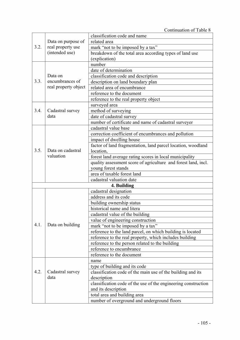
- 105 -
Continuation of Table 8
3.2.
Data on purpose of real property use (intended use)
classification code and name related area mark “not to be imposed by a tax” breakdown of the total area according types of land use (explication)
3.3.
Data on encumbrances of real property object
number date of determination classification code and description description on land boundary plan related area of encumbrance reference to the document reference to the real property object
3.4.
Cadastral survey data
surveyed area method of surveying date of cadastral survey number of certificate and name of cadastral surveyer
3.5.
Data on cadastral valuation
cadastral value base correction coefficient of encumbrances and pollution impact of dwelling house factor of land fragmentation, land parcel location, woodland location, forest land average rating scores in local municipality quality assessment score of agriculture and forest land, incl. young forest stands area of taxable forest land cadastral valuation date
4. Building 4.1.
Data on building
cadastral designation address and its code building ownership status historical name and litera cadastral value of the building value of engineering construction mark “not to be imposed by a tax” reference to the land parcel, on which building is located reference to the real property, which includes building reference to the person related to the building reference to encumbrance reference to the document
4.2.
Cadastral survey data
name type of building and its code classification code of the main use of the building and its description classification code of the use of the engineering construction and its description total area and building area number of overground and underground floors

- 106 -
Continuation of Table 8
4.2.
Cadastral survey data
exterior wall material and its code number of sets of premises in the building physical conditions of the building date of building cadastral survey code and title of classification type of the building name and material of constructional element number, name, material and volume of element of engineering construction breakdown of the total area of the building according types of premises
4.3.
Data on cadastral valuation
cadastral value base of the buildings and engineering constructions coefficient of encumbrances cadastral valuation date
4.4. Cadastral map data cadastral designation external contours of buildings reference to the spatial data file of building cadastral survey 4.5. Spatial data file of building cadastral survey
5. Set of premises 5.1.
Data on set of premises
cadastral designation address and its code reference to the building, in which set of premises is located reference to residential property, object of is which set of premises is located mark “not to be imposed by a tax” cadastral value
5.2.
Cadastral survey data
name classification code of the use and its description floor, in which set of premises is located number of rooms in set of premises, their total area average height of set of premises date of cadastral survey
5.3.
Rooms of which consists set of premises
serial number of the room in set of premises and reference to the floor name, type, area and height of the room
5.4.
Cadastral map data
cadastral designation reference to the building reference to the spatial data file of cadastral survey
5.5. Spatial data file of cadastral survey 6. Real property
6.1.
Data on real property
cadastral number and name Land Book data on corroboration of the real property into Land Book composition of real property type of real property undivided share in building and land cadastral value reference to the person related to real property reference to the document

- 107 -
Continuation of Table 8
6.2.
Data on person related to real property
personal identification number or company registration number share in joint ownership owned by the person status of the person (owner, legal possessor, user) reference to the person – real property taxpayer mark "politically repressed person" or "insolvent company”
6.3. Data on document date, number, publisher and description of the document 6.4.
Data on leased objects
reference to the objects to be leased personal identification number or company registration number of lessee date of beginning and end of the lease reference to the document
6.5.
Data on real property transactions
date and amount of the transaction reference to the real property object which is object of transaction
6.6.
Data on archive file
reference to the real property or real property object reference to the type of archive file and archival storage number of archive file date of handing over for storage number of pages in the file date and justification of cancellation of the file
3.2. Graphical part (cadastral map) of Cadastre information system
The Real Property State Cadastre Law prescribes to display spatially the cadastre objects
(land parcels, buildings and sets of premises) on a cadastral map, and land parcels
boundary data may be aligned in the cadastral map within the permissible non-binding
limits.
Cartographic material reduced and generalized some parts of the earth's surface images in
digital or analogue form, where the mutual location of natural or artificial terrain objects is
displayed. The cadastral map is a visual image, which is obtained from graphical part of
Cadastre information system as result of data selection.
Procedures for creating a cadastral map, content of data to be displayed on it,
determination of the scale, procedures for displaying and maintaining permissible non-
binding limits, aligning the boundary data of land parcels are regulated by the Regulation
“Regulations for the Registration of a Cadastre Object and Updating of Cadastre Data”
(No. 193 adopted on February 23, 2010 by the Cabinet).
Registration of land parcel in graphical part of the Cadastre information system includes:
pre-registration of planned land parcel, which includes assignation of cadastral
designation; display of planned boundary of land parcel on a cadastral map in

- 108 -
accordance with the detailed plan or land survey project; preparation of the information
from the Cadastre information system for cadastral survey of the land parcel;
entering of the spatial vector data file of the cadastral survey of land parcel in the
Cadastre information system; and
representation of the land parcel in the cadastral map.
The cadastral survey data are displayed on a cadastral map from cadastral survey
documents and land parcel files.
If part of land parcel is registered in graphical part of the Cadastre information system
the following activities are performed:
granting of a cadastral designation to the part of land parcel;
entering of the data from initiator’s submission and graphical Annex;
displaying of part of land parcel on the cadastral map.
Registration of building in graphical part of the Cadastre information system includes:
pre-registration of the building, which includes assignation of cadastral designation;
entering of the spatial vector data file of cadastral survey of the building in the
Cadastre information system;
displaying of the building on the cadastral map.
The State Land Service determines cadastral territories that are divided into cadastre
groups for ensuring the identifier for cadastre objects. Cadastral territory is a relative
territory registered in the Cadastre information system and displayed on the cadastral map
in accordance with the administratively territorial allotment of the Republic of Latvia as of
May 1, 1996. Cadastre group is part of cadastral territory.
A cadastral map is made as a digital overview map regarding the mutual location of the
land parcels, buildings, encumbrances of the real property objects in the territory and
location of the groups of premises in the structure. The digital cadastral survey data in
form of vector data are used for the creation of cadastral maps. The network of right angle
co-ordinates of the map complies with the Latvian Geodesic Coordinate System LKS-92.
All cadastre objects are displayed on the cadastral map in accordance with cadastral
survey accuracy. Certainty of the cadastral map scale in cities and villages is 1:2000 and in
rural areas – 1:10000.
Cadastral designations of the cadastre object and following spatial data are indicated in the
cadastral map:
boundaries and boundary points of land parcels;
outline of the buildings and their location on the land parcels;
outline of the sets of premises and their location in the building;

- 109 -
boundaries and boundary points of parts of land parcels;
boundaries of the territories covered by encumbrances and their identifiers.
Cadastral territories and their boundaries, names, codes and numbers of the cadastre
groups are displayed on cadastral maps, too.
Up to the cadastral survey of all land parcels, in displaying them on a cadastral map, the
boundaries of land parcels are updated taking into account the high precision data of the
cadastral survey and observing the following priorities:
land parcel is surveyed;
land parcel is determined;
land parcel is designed.
Sets of premises are displayed in cadastral maps since July 1, 2008.
Official graphical data, obtained by cadastral surveying, are stored in the graphical part of
the Cadastre information system. Graphical materials may be stored in digital form as lists
of coordinates, raster images or vector images.
Cadastral maps are created using such software:
MicroStation;
MicroStation GeoGraphics;
KZIS, which is operating in MicroStation Geographics environment, provides the link
between cadastre map and textual data.
All objects are stored in MicroStation (*. dgn) vector files, working units of which are
defined: master units – m; sub-units – cm; resolution – 100 cm per m; number of units in 1
cm (10 Pos U) – units per centimetre.
The advantage of MicroStation Geographic software to display each graphic element as an
object (feature) is used for development of a cadastral map. Each group of objects on the
cadastral map is represented by different parameters that allow distinguishing objects –
level, colour, style, thickness, font, type, height of text, etc.
Graphical data are divided into vector files which are grouped into interconnected data
repositories.
It is possible to obtain a cadastral map and a variety of thematic maps containing cadastre
information from the Cadastre information system. It is possible to incorporate textual data
into thematic maps using links between textual and graphical part.

- 110 -
3.3. Issuing and use of cadastral data
As of January 1, 2012 the Cadastre information system contained approximately 5.5
million cadastral objects, hereof 1.3 million real properties, 1 million land parcels, 1.4
million buildings, 1.8 million sets of premises.
The State Land Service prepares the cadastre information necessary for performance of the
functions of State direct administration authorities and local governments and issues it in
the amount and type of standardised information (also in digital) free of charge.
Data of Cadastre information system may be used by state and municipal authorities, as
well as by natural and legal persons. Current cadastral information is used for new real
property formation, real property object formation, cadastral valuation, corroboration of
rights in real property into the Land Book, planning of real property development and
management, administration of real property tax, economic development, spatial planning
and environmental protection, implementation of land use planning activities, performance
of official statistical information, and maintenance of other information systems.
Data exchange system is developed for maintenance of the Cadastre information system as
important information technology infrastructure component. Data exchange is realised
both as data transfer from Cadastre information system to other information systems and
registers, and data reception from other information systems and registers (fig.10).
Besides the above mentioned authorities, information systems and registers, data exchange
takes place between the Cadastre information system and Integrated national information
system (e-services: “persons declared in ownership”, "My data in cadastre", " declaration
place of residence ", "Electronic application for studies"); Register of Farms and Register
of Buildings of Central Statistical Bureau; National Service of Plant Protection; Board of
Nature Protection; State Revenue Service; Corruption Prevention and Combating Bureau;
Electronic Communications office; Information Centre of Ministry of Interior; State
Environmental Service; Emergency Service; Ministry of Transport; State Regional
Development Agency; State Inspection for Heritage Protection; Culture information
system; State Education Development Agency; Agriculture data centre; Information
system of court administration, etc.
The owner of real property or in the absence thereof – a lawful possessor or in the absence
thereof – a user is entitled to request once in a calendar year and receive the actual
cadastre data regarding his or her cadastre object free of charge.

- 111 -
Fig.10. Electronic Data receiving from other State IS
Data distribution website of the State Land Service (https://www.kadastrs.lv) is a very
important part of publishing of cadastral data where different data maintained in the
Cadastre information system in different amounts are available both for professional users
(cadastral surveyors, law enforcement officers, notaries, etc.) and every member of
society. The fee for data preparation and issue is paid in accordance with the Regulations
of Cabinet. In specific cases external laws and regulations provide that a person is entitled
to receive the information service free of charge.
Besides, it is possible to receive cadastral data in the form of printouts, where data are
grouped in specific blocks.
Due to the fact that a cadastral map is obtained by boundary adjustment method, its
information may be used for observation of land parcels, buildings, encumbrances and
objects of leasehold and their mutual location in the territory.
Official information of a cadastral map is issued on:
boundaries of land parcels and parts of land parcels, and their cadastral designations;
external contours of building and their cadastral designations;
territories of encumbrances and their designations.
Cadastral map information can be used for the following purposes:
Local government information
systems State Forest
Service
Construction, Energy and
Housing State Agency
Land Book
Register of Enterprises
National Address Register
Market information
system
Cadastre information
system
Central Statistical Bureau
Rural Support Service
State Inspection
for Heritage Protection
Latvian Geospatial Information
Agency
Population Register

- 112 -
detection of location of a specific real property object;
overview on mutual location of cadastral objects in the determined territory;
spatial planning needs;
planning of administrative-territorial changes;
other purposes, where a cadastral map obtained by boundary adjustment method may
be used.
Cadastral map information can be issued:
in digital form; issuing format has to be agreed with a client;
as a printout in analogue form.
According to clients’ demand, cadastral map information can be merged with other
graphical information and issued in the form of various thematic maps.
References
1. Cadastral surveys and records of rights in land, revised by Peter F,Dale, Food and
Agriculture Organization of the United Nations, Rome, 1995, pp.88.
2. Kapostins E. Benchmarking the Cadastral registration system in Latvia - international
symposium “Reforming the Cadastre: Benchmarking cadastral systems”, FIG
Commission 7 – Cadastre and Land Management, Finland, 2002, 60 - 65pp.
3. Law of Republic of Latvia “Land Register law”, 1993,
http://www.vvc.gov.lv/advantagecms/LV/meklet/meklet_dokumentus.html?query=Lan
d+Register+law&Submit=Mekl%C4%93t&resultsPerPage=10
4. Law of Republic of Latvia “National Real Estate Cadastre Law”, 2005, available at:
http://www.vvc.gov.lv/advantagecms/LV/meklet/meklet_dokumentus.html?query=Im
movable+Property+State+Cadastre+Law&Submit=Mekl%C4%93t&resultsPerPage=1
0
5. Jansone A, Paršova.V. Evaluation of Vector Data Quality of Cadastral Map in Latvia.
Proceedings of the international scientific methodical conference „Baltic Surveying –
2010”, Kaunas, 2010, 66. – 72.pp.
6. Parsova V., Boruks A. Computerised Data Recording in the State Cadastre of Latvia:
Theoretical and Practical Aspects. Transactions of the Estonian University of Life
Sciences, 225, Land surveying and land management, Tartu, 2009, 29. – 36. pp.
7. Williamson I., Enemark S., Wallace J., Rajabifard A. Land administration for
sustainable development. Esri press, Redlands, California, 2010, 487 pp.

- 113 -
ALEKSANDRAS STULGINSKIS UNIVERSITY, Lithuania
Land Management Department
Virginija Gurskiene
Chapter III
REAL PROPERTY CADASTRE
IN LITHUANIA

- 114 -
Content
Some facts about Lithuania 115
Introduction 119
Main terms 121
1. The system of real property cadastre 123
1.1. Legal structure 123
1.2. Real property administration system 124
1.3. Formation of the real property objects 128
1.4. Persons, who established cadastral data of objects 129
1.5. Cadastral data of the of real property objects 131
1.6. Establishment of the cadastral data 133
1.6.1. Surveying of parcels 135
1.6.2. Surveying of construction works 138
1.6.3. Plans of parcels 141
1.6.4. Plans of arrangement of construction works and plans of floors 143
1.7. Adjustment of cadastral data of the object of real property 144
1.8. The file of cadastral data of an object of real property 146
1.9. Entering and changing the cadastral data of an object of real
property in the cadastre 148
1.10. Marking of boundaries of the object of real property in
the cadastral map 151
1.11. Making of a mark in the cadastre 153
1.12. Use and safety of cadastral data 154
2. The Real Property Register 155
2.1. Functioning of the Real Property Register 156
2.2. Interaction of the register with other state registers and cadastres 161
2.3. Development of Real Property Cadastre and Register 164
3. Analysis of the real property data 165
References 167

- 115 -
Some facts about Lithuania
The name Lithuania “Lietuva” comes from affluent of Neris river – rivulet Lietava.
Name of Lithuania first time was mentioned in 1009 at Annals of Quedlinburg (in
Germany).
Division into regions: Aukstaitija (Aukštaitija – middle, eastern and northern part of
Lithuania), Dzukija (Dzūkija – southern part), Suvalkija (southern and western part),
Samogitia (Žemaitija – northern and western part).
Administrative Division: the territory is divided into 10 counties: Alytus (centre – Alytus
town); Kaunas (centre – Kaunas city); Klaipėda (centre – Klaipėda city); Marijampolė
(centre – Marijampolė town); Panevėžys (centre – Panevėžys city); Šiauliai (centre –
Šiauliai city); Tauragė (centre – Tauragė town); Telšiai (centre – Telšiai town); Utena
(centre – Utena town); Vilnius (centre – Vilnius city). Counties are subdivided into 60
municipalities. Municipalities consist of 546 elderships.
Official name: Lietuvos Respublika (The Republic of Lithuania)
Government: Lithuania is an independent democratic republic with a multi-party
parliament. Our state's legislative power is vested in the Seimas (as we call our
Parliament), which has 141 deputies, the executive – in the Government. The President
and the Government carry out Lithuania’s foreign policy. The President’s term of office in
our country is 5 years. Parliamentary elections are held every 4 years. The Government is
composed of Prime Minister, acting as its head, and a cabinet of 14 ministers – the
country’s executive body.
Memberships: European Union, NATO, United Nations Organisation, Council of Europe,
World Trade Organisation, Organisation for Security and Co-operation in Europe, Council
of the Baltic Sea States, etc.
Official language: Lithuanian is a Baltic language that belongs to the Indo-European
language family. The Lithuanian language is an official language of the State, is one of the
23 official languages of the EU. Just four million people use it across the world, including
our closest neighbours.
Capital: Vilnius (542,932) 01-01-2011
Largest Towns and Cities 01-01-2011: Kaunas (336,912), Klaipėda (177,812), Šiauliai
(120,969), Panevėžys (109,028), Alytus (63,642), Marijampolė (44,885), Mažeikiai
(38,819), Utena (31,139), Telšiai (29,107), Tauragė (26,429). Of the 103 towns and cities
in Lithuania, 35 cities have a population of over 10,000.

- 116 -
Largest Religious Confessions: Most Lithuanians belong to Roman Catholic Church.
There are also Eastern Orthodox, Evangelical Lutheran, Reformed Church, Eastern
Orthodox, Judaism, Islam and other religions.
National currency: Litas (3.45 LTL are 1€), 1 litas consists of 100 cents
Time: GMT +2 (GMT +3 in summer)
Population: in 01-01-2011: 3,244,601, urban – 67%, rural – 33%
Ethnic composition: 83.9% Lithuanians, 6.6% Poles, 5.4% Russians, 1.3% Belorussians,
0,6% Ukrainians, 0.1% Latvians, 0.1% Jews, 0.1% Tatars, 0.1% Germans, 0.1% Romanies
and 0.2% other nationalities (1.5% not indicated). The total number of nationalities living
in Lithuania is 115.
Independence Day: 16th of February, the date of the proclamation of Lithuania’s
independence in 1918; 11th of March, the date of the restoration of independence in 1990.
History: For centuries, the southeast shore of the Baltic Sea was inhabited by various
Baltic tribes. In the 1230s the Lithuanian lands were united by Mindaugas, who was
crowned as King of the Grand Duchy of Lithuania, the first Lithuanian state, on July 6,
1253. During the 14th century, Grand Duchy of Lithuania was the largest country in
Europe: present-day Belarus, Ukraine, and parts of Poland and Russia were territories of
the Grand Duchy of Lithuania. With the Lublin Union of 1569, Lithuania and Poland
formed a voluntary two-state union, the Polish–Lithuanian Commonwealth. The
Commonwealth lasted more than two centuries, until neighbouring countries
systematically dismantled it from 1772 to 1795, with the Russian Empire annexing most
of Lithuania's territory. The Republic of Lithuania was founded on February 16, 1918. It
has been continuously recognised as a sovereign state since 1920 despite occupations and
rule by the Soviet Union (1940-1941, 1945-1991) and Nazi Germany (1941-1945). On
March 11, 1990, Lithuania declared the restoration of its de facto independence. Lithuania
joined the WTO in 1998 and in 2004 became a member of the European Union and
NATO.
Area: 65,300 sq.km or 25,212 sq.miles. Total length of the state border with the territorial
sea is 1,763 km.
Geography: Lithuania is a Middle European state at the shore of the Baltic Sea.
Lithuania’s territory extends 373 km from East to West and 276 km from North to South.
There are 6129 km from the geographical centre of Lithuania to the equator and 3873 km
to the North Pole. The Geographic Centre of Europe (54°54′N 25°19′E54.9°N 25.317°E)
is located in Lithuania, specifically 26 km (16 mi) north of its capital city, Vilnius.
Lithuania’s is a flat land with plains covering approximately 75 % of the country. Our

- 117 -
highest hill is Aukstojas rising 293.8 m above the sea level. There are no mountains in
Lithuania. More than a half of Lithuania’s land is suitable for agriculture. About one third
of our land area is occupied by forests. Lithuania is commonly called the land of rivers and
lakes with inland waters making up 4% of its territory. The total number of rivers and
rivulets is 22,200 (the longest river – Nemunas – 359 km in Lithuanian territory), and the
number of lakes is well over 2,830. The deepest of them is Tauragnas (62.5 m deep).
Location: Lithuania shares borders with five neighbouring states: in the North - 588 km
with Latvia, in the East and South – 679 km with Belarus, in the South West - 104 km
with Poland and 273 km - the Russian Federation. More than three fourths of Lithuania’s
borders stretch along rivers and lakes. Lithuania’s economic zone in the Baltic Sea (with
and area around 6,400 km²) reaches the waters of Sweden. We are proud of our beautiful
coastline, which stretches for over 100 kilometres.
Climate: Lithuania's climate, which ranges between maritime and continental, is relatively
mild. In recent decades the climate of Lithuania has become warmer – the average annual
temperature in the whole territory is 6.5-7.9° C. The warmest month of the year is July
(with an average temperature – about 19.7° C, and a maximum – over 30° C), and the
coldest is January (with an average temperature – about –2.9° C, its lowest temperature
during severe frosts may occasionally drop below –30° C). The most rainfall is recorded
from April to October (60-65% of annual rainfall). The average annual precipitation is 800
mm on the coast, 900 mm in the Samogitia highlands and 600 mm in the eastern part of the
country.
Nature: Flora of Lithuania is made from forest, field, swamp, sands and water mines and
their communities of coast flora. The total number of plant species recorded in Lithuania is
near 2,000. The number of vertebrate animals found in Lithuania is over 500. Among them
70 are mammals, 369 – birds, 100 – fish. The total number of Lithuania’s invertebrate
species is estimated at over 200,000. Among them 150,000 are insects, about 1,200 –
arachnids and about 170 – molluscs. Lithuania is in the mixed forest zone. The most part
of forests is growing on southeast and eastside parts of the country. In the forests are
mostly growing these trees: pines (38%), spruces (24%), birches (20%), alders, ashes, and
oaks. In the forests are living many animals, such as hedgehogs, hinds, elks, boars, foxes,
martens, also there are some lynxes and wolfs. In the rivers are living many beavers. Also
there are aplenty of forest birds, like tits, jays, thrushes, woodpeckers, cuckoos, orioles,
nightingales and many others. In the water mines is big possibility to find many ducks,
gooses, and swans. In the fields are breeding hares, pewits, larks, storks.

- 118 -
Trade: The EU is the biggest trade partner of Lithuania with a 58% of total imports and
64% of total exports during the first ten months of the year 2009. The Commonwealth of
Independent States is the second economic union that Lithuania trades the most with, with
a share of imports of 34% and a share of exports of 23% during the same period. The vast
majority of commodities, including oil, gas and metals have to be imported, mainly from
Russia. For this reason, Russia is the biggest import partner of Lithuania. Some sectors are
directed mainly at export markets. Transport and logistics export 2/3 of their products
and/or services; the biotechnology industry exports 80%; plastics export 52%; laser
technologies export 86%; metal processing, machinery and electric equipment export
64%; furniture and wood processing export 55%; textile and clothing export 76%; and the
food industry exports 36%.

- 119 -
Introduction
A balanced development of all areas is and always has been one of the most important
factors for the development of human welfare. Ensuring the desirable development
requires reliable information about all sectors of society and real property, data about
which is collected, stored and provided by a functioning Real Property Cadastre and
Register System.
In Lithuania, the concept of cadastre is derived from the medieval times, when the land
was considered a symbol of wealth. At that time, the land-based relationships were fixed
by a customary law; a little later, they were governed by the regulation of privileges of the
great dukes and, finally, by the Statute of Lithuania of the sixteenth century. In the
sixteenth century, Lithuania carried out a major land reform, which included the partition
of land in accordance with its ownership (into land governed by the nobles, peasants and
the Grand Duke of Lithuania). Update of these cadastral data was carried out in the
nineteenth century, when after the serfdom, the peasants were granted the right to own the
land. This new allotment of land allowed the improvement of the use of land, setting the
limits and updating the mapping material. In the early twentieth century, all parcels were
formed by means of the new cadastral measurement methods. In 1940, when Lithuania
was declared the Soviet Republic, all land was declared state property. Only buildings and
apartments were owned on the basis of private property rights. In Soviet times, technical
inventory and service offices administered and registered buildings and flats.
Following the restoration of independence of the Republic of Lithuania in 1991, the laws
legalizing private ownership of land and other real property as well as regulating the
process of the land reform were adopted. Restoration of ownership rights to real property
started in 1992. In 1992, computerized land parcel registration system was launched and
land cadastre was legalized. Buildings, flats and premises were registered in another
institution. The year 1997 is considered the beginning of a modern real property
management system, when after the establishment of the Real Property Register, data on
parcels, buildings and premises began to be collected, stored and managed in a single
database. The development of the system employed the latest technologies based on cost
effectiveness, simplicity and durability, and experience of foreign countries.
These latter decades are of the highest importance to the development of the Real Property
Cadastre.

- 120 -
Thus, the most important stage of the development of this system began with the
incorporation of information about the land and other real property in a single system,
creation of a common database and computerization of the processes. According to R.
Kasperavičius, Lithuania has developed a legal basis for the implementation of the real
property administration reform by 2004. To manage the Real Property Cadastre and
Register System and to ensure its proper functioning, the most advanced methods are
applied. The Real Property Cadastre System is still undergoing consolidation.
The aim of the study is to review the Lithuanian Real Property Cadastre System, the basic
requirements of the collection, management of data of the Real Property Cadastre objects,
the conditions for the provision of such data. Since the Real Property Cadastre and
Register are managed by the state enterprise Center of Registers, the enterprise activities
related to the management of the cadastre are briefly discussed.
In Lithuania, the Real Property Cadastre System has not been widely analyzed. It was
described in most detail by the state enterprise Center of Registers deputy director R.
Kasperavičius (2006, 2012); besides, it was analyzed by other authors: P. Aleknavičius
(1989, 2007), A. Gogelis, J. Jasinskas ir kt. (1989), A. Gasilionis (2006), V. Atkocevičienė
(2008), V. Gurskienė (2008) and others.
The study made use of the laws of the Republic of Lithuania governing the Real Property
Cadastre and Register, other normative documents, information of the Center of Registers,
publications by other authors on the subject, statistical information provided by the
National Land Service, other institutions and other sources.
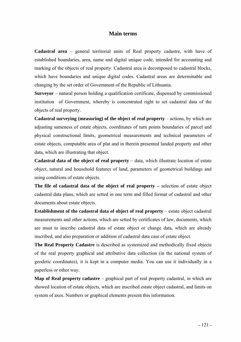
- 121 -
Main terms
Cadastral area – general territorial units of Real property cadastre, with have of
established boundaries, area, name and digital unique code, intended for accounting and
marking of the objects of real property. Cadastral area is decomposed to cadastral blocks,
which have boundaries and unique digital codes. Cadastral areas are determinable and
changing by the set order of Government of the Republic of Lithuania.
Surveyor – natural person holding a qualification certificate, dispensed by commissioned
institution of Government, whereby is concentrated right to set cadastral data of the
objects of real property.
Cadastral surveying (measuring) of the object of real property – actions, by which are
adjusting sameness of estate objects, coordinates of turn points boundaries of parcel and
physical constructional limits, geometrical measurements and technical parameters of
estate objects, computable area of plat and in therein presented landed property and other
data, which are illustrating that object.
Cadastral data of the object of real property – data, which illustrate location of estate
object, natural and household features of land, parameters of geometrical buildings and
using conditions of estate objects.
The file of cadastral data of the object of real property – selection of estate object
cadastral data plans, which are setted in one term and filled format of cadastral and other
documents about estate objects.
Establishment of the cadastral data of object of real property – estate object cadastral
measurements and other actions, which are setted by certificates of law, documents, which
are must to inscribe cadastral data of estate object or change data, which are already
inscribed, and also preparation or addition of cadastral data case of estate object.
The Real Property Cadastre is described as systemized and methodically fixed objects
of the real property graphical and attributive data collection (in the national system of
geodetic coordinates), it is kept in a computer media. You can use it individually in a
paperless or other way.
Map of Real property cadastre – graphical part of real property cadastral, in which are
showed location of estate objects, which are inscribed estate object cadastral, and limits on
system of axes. Numbers or graphical elements present this information.

- 122 -
The Real Property Register established for objects of the real property, property and
other real rights to these objects, for the restriction of rights, for the law established legal
facts recording, to provide the official information provided in the register.
Building – means a construction works with the roof, which contains one or more rooms
or other premises.
Premise – part of setted purpose building (flat, cantor and etc.), which is isolated by
constructions from accommodation of common using, other flats or uninhabited
accommodation.
Boundary mark – mark of land parcel, which is marking limits in locality and he consists
of definite standard of accredited institution of government and is saving by the set order
of laws.
Construction work – building or engineering construction, which has retentive
constructions, which all of them (or just a part) are mounted in building place performing
jobs of building, and which is object of real property.
Plan of parcel – drawing, which is prepared by the set order of accredited institution of
government of the measurements in locality and in which are noted limits of land parcel
and cadastral data.

- 123 -
1. The system of real property cadastre
1.1. Legal structure
The Real Property Cadastre and Register System are related to a number of public areas,
therefore the area of its legal regulation is also quite broad.
The Constitution of the Republic of Lithuania firms main freedoms and rights of
individuals, also the property law’s protection to the real property. The Constitution
identifies who can qualify the right to purchase a real property.
Civil Code shall govern all civil law relations, among them the relations involved with real
property. It has set that the proprietary right to a land parcel also involves the right to
buildings and other construction works in that parcel. This Civil Code has cancelled the
compulsory registration of the real property and the rights to it; however unregistered
transactions cannot be used against the third persons. The owner fully disposes his
property, only when this property is registered in the declared register.
The Law on Land of the Republic of Lithuania from 1994 is the primary grand law, which
regulates the property, its management and use.
The Law on State Registers of the Republic of Lithuania sets the order of the
establishment, management, use and cancellation of the state registers. It also sets the
order of their updates, the rights of the responsible institutions, and the duties to their
users.
The Law on the Real Property Cadastre of the Republic of Lithuania shall govern the data
collection, renewal, order of the registration into the database of the real property data of
parcels, buildings and other real property, defines their legal status.
The Law on Real Property Register of the Republic of Lithuania shall govern the
registration of land, buildings, other objects of the real property and the right to it. It
defines the Real Property Register status, its’ establishment and management, the
presentation of data and information.
Since 1998 real property mortgage registration was incorporated in the Mortgage Register.
The establishment Law of the Mortgage Register defines mortgage objects, mortgage
kinds, and the order of check in and check out, debt recovery.
There are a few valid laws in the country related to the valuation and taxation of land and
property. The Law on Appraisal of Property and Business of the Republic of Lithuania
shall govern the principles and methods of evaluation, estimator rights, duties and

- 124 -
responsibilities. The property tax law regulates the taxes to the inherited property
considering the taxpayer’s residential status.
The basis of the Lithuanian cadastral system is a measured parcel. In this system graphic
and attributive data, which are connected with objects of real property, are being fixated.
The main dimensional and recordable real property cadastre and register unit is the real
property id est. parcels, buildings, flats, premises, engineering constructions.
The main document, which describes real property data, which is needed for the
accounting of this property, is Law on the Real Property Cadastre of the Republic of
Lithuania (hereinafter – Law on the Real Property Cadastre). This law shall govern real
objects, which are registered in the Real Property Cadastre, cadastre data establishment,
their recording into Real Property Cadastre, Real Property Cadastre status, the institution
of this cadastre, its’ management, reorganization and liquidation, land surveyors’
proceeding conditions, their rights, duties and responsibilities.
1.2. Real property administration system
Following the restoration of independence of Lithuania, the real property management
system has been developed and improved each year. Currently, this process involves a
large group of institutions (Fig.1).
The Ministry of Agriculture carries out the state administration functions related to land,
food industry, fisheries and rural development, implements state policies and strategies in
these areas. The National Land Service implements the state policy in the areas of public
land management and administration, land reform, cadastre, geodesy and cartography.
Private and public enterprises prepare maps, land reform projects and parcels formation as
well as rearrangement projects, conclude topographic maps.
Cadastral surveying of parcels, buildings and premises are carried out by public and
private land surveyor companies, which operate under the surveyor certificates issued by
the National Land Service.
The Ministry of Environment forms the country’s policy in the areas of environmental
protection, forestry, utilization of natural resources, geology and hydrometeorology,
territorial planning, construction, housing and utilities, as well as coordinates the
implementation of this policy. The Territorial Planning and Construction Inspectorate
carries out the state supervision of territorial planning and construction, and prepares
documentation relating to the state supervision and enforcement of the provisions.

- 125 -
Fig. 1. Organizational structure of the State real property administration system
Source: State Enterprise Centre of Registers
SERVICE OF POPULATION
REGISTER
GOVERNMENT
MINISTRY OF INTERIOR
MINISTRY OF AGRICULTURE
MINISTRY OF ENVIRONMENT
MINISTRY OF JUSTICE
MINISTRY OF FINANCE
SURVEYORS (JURIDICAL PERSONS)
NATIONAL LAND
SERVICE
STATE INSPECTION OF CONSTRUCTION AND TERRITORY
PLANING
NOTARIES
CENTRAL MORTGA-
GE OFFICE
INSPEC-TION OF
TAXES
STATE ENTERPRISE STATE LAND
FOUND
MUNICIPALITIES STATE ENTERPRISE
CENTER OF REGISTERS
FUNDATOR METODICAL MANAGEMENT CHANGE OF INFORMATION

- 126 -
The Ministry of Justice drafts projects of laws and the Government resolutions, organizes
the implementation of legal reforms, supervises activities of other institutions such as the
state enterprise Centre of Registers, the Central Mortgage Office and notaries.
The Central Mortgage Office manages the Mortgage Register, the Register of Property
Seizure Acts, and the Register of Marriage Agreements, collects data on the lease, hire
purchase agreements, manages the Register of Wills and provides information from these
registers. Mortgage divisions under the district courts register mortgages and property
seizure acts.
Notaries prepare the documents, approve transactions and mortgages, document copies and
extracts as well as signatures, issue succession certificates, and approve information
submitted to the Register of Legal Entities.
State enterprise Centre of Registers carries out the following functions: manages the Real
Property Cadastre and Real Property Register, Registers of Legal Entities and Addresses,
performs an assessment of real property for the purposes of tax calculation (mass rating),
cadastral surveying, issues to natural and legal persons the official information stored in the
registers, updates the cadastral map.
The Ministry of the Interior ensures public security, border protection, civil protection,
migration control, public administration and state reforms, municipal and regional
development, as well as supervises activities of the Population Register Office.
The Ministry of Finance prepares the state budget and municipal budgets, supervises the
policy of country’s investments, tax collection, national coordination of the EU financial
assistance, fiscal policy and its administration, as well as other issues.
The State Tax Inspectorate is the central tax administrator.
Municipalities issue permits for construction, perform the functions of territorial planning,
assignment and alteration of addresses.
Harmonious activities of these institutions, adequate legal regulation of the processes,
timely problem solving ensure efficient functioning of the real property administration
system.
The reliability of the data of real property objects, the safety of property rights to this
property and the availability of information needed for the management of the country
ensures the effectively functioning system of this data management. The system consists of
four closely related and mutually supportive parts:
Real Property Formation;

- 127 -
Real Property Cadastre;
Real Property Valuation
Real Property Register.
Real Property Formation – a legislative framework based on the rules, measures and
actions that enables the emergence or creation of real property, as the property law object.
Real Property Cadastre system describes objects of the real property – parcels,
construction works and premises. It should help to clarify – where the object of the real
property is and what quantitative of its characteristics.
Real Property Valuation system should ensure the quality of objects of the real property
document in collection and evaluation and explain why such qualitative characteristics of the
objects of the real property are and what their value is.
Real Property Register system ensures the legal status of objects of the real property and
rights to them and presents data about, who manages these objects and how.
The Real Property Cadastre is described as systemized and methodically fixed objects of
the real property graphical and attributive data collection (in the national system of geodetic
coordinates), it is kept in a computer media. You can use it individually in a paperless way or
in other way. It is relevant when collecting cadastral data that have to be correct, reliable; that
the security of these data should be secured and also that interested institutions could use it.
According to the Civil code objects of real property are land and other objects, which are
related to land and which you cannot move from one place to another without changing its
purpose and essentially minimizing its value (buildings, devices, gardens and other objects,
which are immovable according to their purpose and nature).
Commodities of buildings are considered to be separate secondary objects that are used to
serve the main object. According to their characteristics they are constantly bound with the
main object. The connection of two or more objects does not make any of them pertinent,
only if there isn’t any evidence indicated to the object of real property.
In Lithuania an integrated multi-purpose Real Property Cadastre and Register system is
created, where the cadastre and register data are stored in one Central Databank. This system
was started up in 1992 after the implementation of a computerized land registration. Since
1997 this system functions in one unit – the state enterprise the Centre of Registers
(hereinafter – the Centre of Registers). In this company data about parcels, construction
works, premises and flats are integrated into a single real property information system. The
system guarantees the protection of the rights to the objects of real property, supports the
- 128 -
legitimate transfer of the real property; it can also contribute to the national real property
development policy establishment and to promote real property and credit market
development in the country.
The Centre of Registers is responsible for the registration of objects of the real property and
rights to them; it manages the Real Property Cadastre and the Real Property Register. Also,
the company successfully operates the Address Register and Register of Legal entities.
1.3. Formation of the real property objects
Objects of the real property shall be formed in the ways provided for the Law on Real
Property Cadastre.
The formation of objects of the real property – a legislative framework based on the rules,
measures and actions that enables the emergence or creation of real property, as the property
law object. As mentioned above, the most important objects of the real property are parcels,
construction works and premises. Formation of parcels is mostly carried out by the state and
public institutions – the National Land Service under the Ministry of Agriculture (hereinafter
– National Land Service), its divisions, municipalities and only slightly affected by private
entities – natural and legal persons. When forming construction works and equipment that
meet the needs of society, and state authorities have approved construction documents,
building permits and allows them to recognize them as suitable for use.
Construction works, especially the constructions of buildings, are usually carried out by
private sector initiative, and therefore most of the responsibility lies with individuals and
legal entities – the builders. The state and local authorities approve construction projects,
provide the building permit and recognize them as suitable for use, id est. perform control
functions.
Objects of the real property formation methods:
forming a new object of the real property;
dividing in the Real Property Register registered object into individual items of objects of
the real property;
separating in the Real Property Register registered common property ownership owned
by objects share and forming them as separate items of objects of the real property;
combining several objects registered in the real property register into a single object of
the real property;
- 129 -
the amalgamation of the objects of the real property.
Construction works are formed in accordance with the Law on Construction of Republic of
Lithuania.
1.4. Persons, who established cadastral data of objects
Cadastral data of objects of the real property are determined by individuals, specified in the
Law on Real Property Cadastre of the Republic of Lithuania. Surveying objects of the real
property detection works in the territory of the Republic of Lithuania have to be performed
by the citizens of the Republic of Lithuania, citizens of other member states, other private
persons, using the European Union law that gives them rights of movement in the member
state, or in the Republic of Lithuania or in another Member State, a legal person or other
organization, or their units (hereinafter – the Executors). These individuals can perform
objects of real property cadastral data determination works if they have issued certificates or
other documents of competency, which confirm the right to make determination works of
objects of the real property.
Cadastral data of parcels and construction works are determined, and land surveyors who
have qualification certificates necessary to carry out these works prepare files of these
objects. A natural person wishing to obtain a land surveyor qualification certificate must
meet the following requirements:
have university or further education received after the completion of study programs
(objects) which include Geodesy, Real Property Cadastre, Land Management, Territorial
Planning, Topography, Cartography, Geoinformation Systems, Building Construction,
Engineering Networks, Communications Subjects, the number of credits of which are
established by the Government;
have at least two years of work experience in the field of determining the cadastral data
of objects of real property;
having completed a qualification course of no less than thirty hours agreeably to
programs approved by the authority authorized by the Government and having passed the
qualifying examination at least three years prior to issuing the land surveyor qualification
certificate.
A natural person wishing to obtain a land surveyor qualification certificate shall submit to the
authority authorized by the Government an application and documents evidencing the

- 130 -
qualification compliance. The land surveyor qualification certificate shall be issued or written
reasoned refusal to issue the qualification certificate shall be delivered to the applicant not
later than 30 days after the date of receipt of documents necessary to issue the qualification
certificate. The land surveyor qualification certificate shall be issued in accordance with the
procedure established by the authority authorized by the Government. If no reply to the
correctly submitted application to issue the qualification certificate together with all the
documents necessary to issue the qualification certificate is received within the period
specified in this paragraph, it shall be considered that such certificate has been issued.
The fee for the issue of the land surveyor qualification certificates or their duplicates as well
as for adjustment of qualification certificates shall be charged in accordance with the
procedure established by the Law on Fees.
In accordance with the law land surveyors have the right to:
form associations freely;
access an object of real property owned or managed by a person wishing to determine
cadastral data in order to determine such cadastral data;
upon the consent of the owners of adjacent parcels, to carry out determination of
cadastral data in adjacent parcels as well, if it is necessary to determine the cadastral data.
In this case, the owners of the parcels shall be notified about the works to be carried out
in accordance with the procedure established in the Regulations of Real Property
Cadastre;
to obtain the Real Property Cadastre data and documents necessary for determination of
the Real Property Cadastre data;
to obtain territorial planning documents and data necessary for determination of the Real
Property cadastral data;
to obtain other information, data or documents necessary for determination of the Real
Property cadastral data in accordance with the procedure established by the law.
Having prepared the Real Property Cadastre documents provided for by the law and other
legislative acts, the land surveyor shall sign them and thus certify that the documents
prepared meet the requirements of the laws and other legislative acts governing the cadastral
measurements of real property.
The land surveyor must:
follow the laws and other legislative acts of the Republic of Lithuania;
be impartial;

- 131 -
improve qualification;
to provide information to interested persons concerning the Real Property Cadastre
documents prepared by him (her) in accordance with the procedure established by the
Government;
to perform other duties provided for in legislative acts.
The parcel will be completed to form to the manager of the National Land Service or his
authorized territorial division supervisor after the decree to approve the cadastral data (to
form a parcel).
1.5. Cadastral data of the of real property objects
The basis of the establishment of the data of an object of real property shall be a contract
between the Customer and the Executor, unless otherwise provided in laws and other legal
acts.
The Cadastre shall contain cadastral data of an object of real property referred to in the Law
on Real Property Cadastre of the Republic of Lithuania. Two or more methods and sub-
methods for using land may be established for one parcel, if it is provided for in the detailed
plan.
Cadastral data of the parcel shall be entered in the Real Property Cadastre:
code and name of the cadastral locality, number of the cadastral block, number of the
parcel (cadastral number of the parcel);
unique number of the parcel granted by the Manager of the Cadastre and which does not
change the whole time of the existence of the parcel;
main purpose of the parcel;
method and sub-method of use of land of the parcel;
area of the parcel;
the composition of the parcel area under the land use types: farming areas consisting of
arable soil, gardens, fields and natural pastures; forests, roads, built up territories; waters;
other land, composed of: plantations of trees, bushes, swamps, damaged soil and other
unused soil;
land area with drainage facilities: drained soil, irrigable soil;
quality assessment of farming areas, estimated of productivity of score;
special conditions for land use and regulations of protection of protected areas;

- 132 -
data of the protected area, where is a monument of culture and cultural heritage;
values of the parcel shall be established by the Government; dates of valuations;
price and date of the purchase;
coordinates of the turning points of the boundaries of parcels in the national system of
geodetic coordinates;
date of the establishment of the cadastral data of parcel;
other data.
The cadastral data of construction works shall be entered in the Real Property Cadastre:
object: building, premise, engineering constructions;
unique number of the construction works (also unfinished), provided by the Manager of
the Cadastre in accordance with Regulations of the Real Property Cadastre, without
changing the whole construction works' length of the stay;
unique number of the premises which are formed as separate objects of real property;
main purpose and name of the construction works;
parameters of the construction works: total area, size, length, width, diameter, cross
section, height, depth, perimeter, or other construction characteristic geometrical
parameters;
construction material of the building;
characteristics of the equipment inside the building;
values of construction works shall be established by the Government; dates of valuations;
percentage of physical reduction and finish of the construction works;
price and date of purchase;
year of beginning and end of construction (reconstruction) of the construction works;
information on the status of construction;
location of the construction works within the parcel (unique number of the parcel where
the construction works is situated);
location of the premise which is formed as a separate object of real property, in the
building (unique number of the construction works in which the premises are);
number of floors of the construction work;
number of premises which are formed as separate objects of real property;
number of the residential premises which are formed as separate objects of real property;
number of rooms of the residential premises which are formed as separate objects of real
property;

- 133 -
floor where is a premise which is formed as a separate object of real property;
data of a monument of culture and cultural heritage;
digital graphical information of contours of the construction work and digital graphic data
of internal layout of the construction work;
date of establishment of the cadastral data of construction work;
other statutory information.
While including the cadastral data of the object of real property in the Real Property
Cadastre, an address shall be entered for a real object in accordance with the government
requirement (names of the residential locality, of the street and number of the building).
1.6. Establishment of the cadastral data
For one parcel may be determined one or more land uses and characteristic it provides
planning document.
Cadastral surveying of parcels in the determination of the coordinates of the turning points
and boundary marks of the parcels in the national system of geodetic coordinates or local
system of coordinates related to this system shall be carried out:
during the division, separation, joining, and amalgamation of the parcels registered in the
Register of Real Property;
during the change of main purpose, method and sub method of the use of land of the
parcels registered in the Register of Real Property, the coordinates of the turning points
and boundary marks of which are not established within the national system of geodetic
coordinates or local system of coordinates related to this system;
during the formation of parcels of state-owned land;
transferring ownership to other persons in urban areas of private parcels (their parts)
which outside the turning points and boundary coordinates undetermined in the national
system of geodetic coordinates or local system of coordinates;
if the parcel was constructed, reconstructed, with capital repair works or dug ponds, built
roads or installed other engineering constructions. In this case, the cadastral data of
parcels must be replaced no later than until the static registration or cadastral data
structure modification in the Real Property Register;
following the request of an owner of the parcel or user of land.

- 134 -
Cadastral surveying of construction works shall be performed following the execution of the
works of construction, reconstruction, major repair or other rearrangement, in case the Law
on Construction of the Republic of Lithuania provides a requirement to have a construction
permit and/or recognition as being fit for use, or in case the owner or the user of the
construction works requests so.
Object of the real property is considered to be completed to form when its cadastral data is
set and, according to the laws, adopted by the administration of public entity's decision to
form the objects of the real property.
The parcel containing construction works may be divided or separated in case the Law on
Protected Areas of the Republic of Lithuania does not prohibit it or other legal acts, only in
such way that after the division or separation the land necessary for the exploitation of the
construction works would be formed as separate parcel. The parcel may not be formed in
such way that the boundary of the parcel crosses the construction work which is formed as
one separate object of real property, except engineering constructions (engineering networks,
communications, etc.).
Boundaries of parcel between the turning points, including those, which border with the
natural contours, must form one closed contour, under the coordinates of turning points of
boundaries thereof the area of the parcel must be calculated. Area of parcel calculated after
the cadastral surveying may differ from the Real Property Register registered area of parcel
or territorial planning document designed (not registered in the registry) area of parcel not
exceeding the maximum permissible (trigger) area of uncertainty. When the space difference
is bigger than the fixed and (or) boundaries of parcel (configuration) does not fit designed
boundaries of parcel (configuration), the Executor shall notify in writing the Customer and
the Land Management Division of the National Land Service (hereinafter – the Land
Management Division) under the parcel location.
When the cadastral surveying of the parcel was performed, from the national Geodetic base
Global Positioning System (hereinafter – the GPS) 1, 2 and 3 classes network points or the
global positioning system network of the Republic of Lithuania permanent stations
(hereinafter – LitPOS) or from the national geodetic base linking other global positioning
system network permanent stations, area of parcel cannot be different from previous geodetic
instruments in conditional and local coordinate systems fixed area of parcel more than the
permitted area of cadastral surveying of relative tolerance 1/1000.

- 135 -
Parcels, separated by main roads, domestic, region, public and local roads, streets, railway
and non-privatized hydrographical objects, as well areas occupied by roads, not calculated
within the total area of the parcel to be privatized, shall be formed as separate parcels.
Separate objects of real property (flats, offices, etc.) constituting the construction works shall
be formed only following the establishment of cadastral data of the whole construction
works, the formation of file of cadastral data of the object of real property and entering of
cadastral data into the Cadastre under the Regulations.
The Executor having concluded a contract with the Customer on the establishment of the
cadastral data of the object of real property shall be entitled to receive the primary cadastral
data of the object of real property from the Manager of the Cadastre necessary for the
execution of work.
1.6.1. Surveying of parcels
During the establishment of the cadastral data of the parcel, the following different actions
should be performed.
The boundaries of the parcel or renewed boundary marks of the previously marked
boundaries of the parcel which later were destroyed shall be established and marked by
boundary marks (if it was not performed before). The boundaries of the parcel in the locality
shall be marked in presence of the owner of the parcel (current or future) or persons
authorised by him, as well the interested persons – owners of the neighbouring parcels or
persons authorised by them (hereinafter referred to as “the external persons”):
in case the parcel borders with the parcel previously measured with the geodetic devices,
the coordinates of the turning points and boundary marks thereof are established within
the system of state coordinates, and when the common boundary is consistent, the
external person shall be invited only in case it is necessary to renew the destroyed
boundary marks;
summons to the external persons shall be delivered personally or not later than 10
calendar days before the marking of boundaries shall be sent by registered letter. The
Contract between the Customer and Executor shall specify who shall be held responsible
for the delivery (dispatch) of this summons. The summons shall contain address, under
which the external person must send notification in case he is unable to participate during
the marking of the boundaries of the parcel not later than 2 days before the beginning of

- 136 -
the works, and as well shall state that in case of failure to arrive or to inform of absence,
the works shall be continued. In case the external persons cannot be found neither under
the addresses of the neighbouring parcels, nor under the addresses referred to in the
Population Register of the Republic of Lithuania, the Executor may publish information
on the planned cadastral surveying of the parcel in local newspaper and notice board of
the ward of the territory where the works are planned, indicating the address of the parcel,
cadastral numbers of the neighbouring parcels.
in case the external persons specify in writing the reason of absence, it shall be recorded
in the act of the marking-showing of the boundaries of a parcel. In case the external
persons do not inform in writing of the reason of their absence within the time limit
specified in the summons or in case the summons was not delivered under the addresses
of the neighbouring parcels, therefore these persons are not participating in the process of
marking of the boundaries of the parcel, the works are being carried out without the
external persons.
having marked the boundaries of the parcels, an act of the marking-showing of the
boundaries of a parcel shall be drawn up. The act shall be signed by the external persons,
the Executor and the Customer or a person authorised by him, who were participating
during the marking of the boundaries of the parcel. The cadastral data of the parcel
registered in the Register of Real Property, i.e. the changes within the parcel (the changes
of the use of land or changes due to the newly built or reconstructed construction works,
etc.) shall be adjusted;
upon the reception of remarks from the external persons either orally or in writing, the
Executor shall under the documents of the formation of the parcels registered in the
Register of Real Property (the ones that are bordering, and the measured parcel) (the
plans of the parcel, abstracts of the outdoor surveying, acts of the marking-showing of the
boundaries of a parcel, etc.) examine the remarks and within 5 working days shall adopt a
decision on the necessity to adjust the location of the turning points and boundary marks
of the parcels. The cadastral works shall not be stayed due to the submission of remarks.
in case the boundaries of the parcel shall not be adjusted (shall not be re-established), the
act of the marking-showing of the boundaries of a parcel shall not be drawn up, and the
external persons shall not be invited. In such case only cadastral data shall be adjusted;

- 137 -
if the labelled parcel boundary is determined hydrographical object (stream, drainage
ditch or similar) middle, with the overall limit (s) of other the parcel (s) to participate in
the labelling of the owners of land are not invited;
parcel boundary turning points, labelled boundary markers or overlapping with stable
areas objects, are photographed in cases of the National Land Service.
By cadastral surveying the coordinates of turning points and boundary marks of the
boundaries of the parcel, as well, not less than two coordinates of corners of every
construction works situated within the parcel (except the temporary construction works) shall
be established within the national system of coordinates or within the local coordination
systems related to this system, ensuring that the construction's surveying shall be possible to
determine its outer contour. At least two boundary marks of the parcel must be linked to the
state geodetic basis or to the local systems of coordinates related to this system. If cadastral
surveying is made by LitPOS, the surveying session, joining LitPOS, time is stated.
Surveying must be performed using the devices of the Global Positioning Systems
(hereinafter referred to as “the GPS”), planimetric movements, linear angular intersections,
microtriangulation and other surveying, if their precision complies with these requirements:
performing linking with the geodetic base using the GPS devises, the average square
error must not exceed 0.1 metre, in the case of linking parcels of agricultural and forestry
purpose and parcels in villages and small towns, and 0.05 metre in case of linking of
parcels in towns. The GPS points shall be used as primary points. The same precision
requirements shall be applied as well performing linking by angular or linear
intersections, microtiangulation, combined nets;
in case the parcels bordering the parcels measured previously using geodetic devices are
being measured, the difference between the coordinates of common boundary marks (in
respect of points of geodetic basis) must not exceed 0.1 metres in towns and 0.3 metres –
in other areas. The common boundary marks are linked to the coordinates established
both during the previous, and during the later measurements;
coordinates of the coordinated points shall be calculated with the precision of 0.01
metres.
During the cadastral surveying actual farming land areas shall be cartographed within the
locality:
boundaries of the built-up territory (land occupied with buildings, yards, squares, other
land used for direct exploitation of construction works);
- 138 -
construction works for transport engineering (communications), other roads (not formed
as construction works);
boundaries of water bodies and hydrographical net;
contours of forest, arable soil, gardens, fields and natural pastures, other land containing
plantations of trees and bushes, contours of swamps;
damaged soil – areas of quarries of mineral resources, peat bogs and landfill sites under
exploitation and already exploited.
Objects subject to special terms of land and forest use and other restrictions upon use of land
shall be cartographed, and areas of these territories shall be calculated. Engineering networks
shall be cartographed in case they are not marked in the topographic plans of large scale. The
formation of plan of parcel must involve an entry on what material was used marking the
engineering networks.
Total area of the parcel and area of farming land shall be calculated. Value of the parcel shall
be calculated:
under the Methodology for the Evaluation of Land approved by Resolution No 205 of the
Government of the Republic of Lithuania of February 24, 1999 (Valstybės žinios (Official
Gazette) No 21-597, 1999); No 102-4574, 2002)
average market price according to the maps of the land value.
According to the data, received from the Manager of the State Forestry Cadastre of the
Republic of Lithuania, calculated the average market value of forest stands, located in the
parcel.
The plan of the parcel is prepared which must be consistent with the Land Management
Division.
The form of the cadastral data of the parcel shall be formed using the classifications prepared
and approved by the Manager of the Cadastre following the arrangement thereof with the
National Land Service.
File of the cadastral data of the object or real property shall be prepared (in two copies) or
already formed file shall be supplemented.
1.6.2. Surveying of construction works
There are two main types of construction works: buildings and engineering constructions.

- 139 -
Buildings. The building is allocated to one or the other purpose group (subgroup), if its total
area, most part or at least half of the gross floor area is used for this purpose. In cases where a
building consists of various-purpose premises, formed as separate property objects (catering,
sports, science, etc.) The purpose of the building is determined by the most common area of
the premises as a separate real property.
The building may consist of: above-ground floors, basement (ground floor), basement, attic
space (attic, mezzanine), atrium, mezzanine, gallery, extensions, glazed (enclosed) porch,
unglazed (open) porch, terrace, bay window, loggia, balcony, platform and portico.
For its intended purpose buildings are divided into two main groups:
residential buildings;
non-residential buildings.
Engineering constructions. Engineering constructions for its intended purpose are divided
into groups:
transport communications;
engineering networks;
other constructions.
For the establishment of the cadastral data of construction works performed cadastral
surveying of buildings, data are written to forms, prepared file of cadastral data.
In cases when cadastral surveying of the parcel was not carried out, all the construction
works situated within the parcel shall be linked together and the plan of arrangement of
construction works shall be prepared.
In cases when the cadastral surveying of the parcel were carried out the plan for the
arrangement of construction works shall be prepared under the data of the cadastral
surveying of the parcel, indicating the origin of the data used. In cases when the coordinates
of the corners of buildings are not established, the plan for the arrangement of construction
works shall be prepared under data of the cadastral surveying of the parcel, the measured
construction works shall be drawn within it.
The coordinates of the central point of the building formed as a separate object of real
property shall be established graphically or by cadastral measurements in the national system
of coordinates.
Physical boundaries of the construction works shall be measured, construction products of
the main constructions of the construction works, engineering systems of the construction
works (water supply, draining, heating, hot water, electricity, gas, ventilation and

- 140 -
conditioning) and other technical data necessary for the entering of data of the object of real
property into the Real Property Cadastre shall be established:
the coordinates of the contours and (or) axis of engineering constructions within the
national system of coordinates shall be established graphically or by cadastral surveying.
The cadastral data of engineering constructions shall be established under the topographic
or cartographic material collected by the Customer or the Executor and the material used
for the formation thereof under the bilateral agreements;
the unfinished construction works shall be measured when it is possible to establish their
area, size or other parameters. The file of the cadastral data of the separate objects of real
property (flats, offices, etc) within the unfinished construction works may be prepared
when the construction works is constructed to the extent that it is possible to calculate the
total area and value of the separate objects of the construction works, to describe them in
the manner prescribed by the Regulations and in case the cadastral data of the whole
construction works have been established, the file of cadastral data of this construction
works have been prepared, the cadastral data have been entered into the Cadastre.
The construction works shall be photographed. The aim of the photography is to show the
construction works of part thereof in detail and visually. The National Land Service shall
establish the technical requirements for photography of the construction works.
The main functional purpose of use and the name of the construction works shall be
established, as well the address (number of the construction works, name of street and name
of locality) shall be established under the submitted documentation, the year of the beginning
and the end of construction (reconstruction) of the construction works shall be determined.
The classification of the main functional purpose of use of the buildings, premises and
engineering constructions. Area, size and other parameters necessary for the entering of
cadastral data of the object of real property into the Cadastre shall be calculated. Plans of the
storeys of the buildings shall be prepared.
Forms of cadastral data of construction works shall be filed in under the classifications
prepared (following the arrangement with the National Land Service) and approved by the
Manager of the Cadastre.
Values of the construction works shall be calculated:
the expenditure of recovery (value of construction);
recoverable value;
average market price and date of its establishment.

- 141 -
File of cadastral data of the object of real property shall be prepared (in two copies) or the
file already prepared shall be supplemented.
Technical requirements for the correction of technical errors of cadastral data, cadastral
measurements of lofts, formation of objects of real property into new cadastral objects and
procedure of change of purpose of construction works shall be determined by the National
Land Service.
Plans of the object of real property must be prepared in such way that using the data of
national system of coordinates it would be possible to establish the location of the object of
real property in the territory of Republic of Lithuania. Plans of objects of real property shall
be prepared and forms of cadastral data shall be filed in using computers (in analogical and
digital forms).
1.6.3. Plans of parcels
Plans of parcels must comply with the following requirements. Plans of parcels must be
prepared using the following cartographic material:
orthophoto maps at scale 1:10000 in analogical form ORT10LT or orthophoto maps of
towns or villages at scale 1:5000 in analogical form;
orthophoto maps at scale 1:10000 in digital form ORT10LT. In such case plans at scale
1:10000, 1:5000 or 1:2000 shall be prepared;
topographic plans of residential localities of towns and rural areas at scale 1:500–
1:1000 in analogical or digital forms, as well topographic maps of towns, small towns and
residential localities at scale 1:2000 in analogical or digital forms;
the georeferential basis of the territory of Lithuania.
Plans of parcels at scale 1:10000 must be prepared using orthophoto maps only.
The plan of the parcel (except the parcels of the members of gardeners’ societies) must
contain not less than three intersection points of the axes of coordinate grid drawn in and not
less than one value of the coordinates of intersection in coordination grid specified.
Boundaries of parcel and their turning points must be drawn in.
Lengths of boundaries of parcel between the turning points must be specified.
Using the data collected during the cadastral surveying and using the available cartographic
material a plan of the parcel shall be prepared on a separate sheet. The plan shall be designed
having drawn a coordinate grid at the following scale: within the built up territories in towns

- 142 -
– 1:500, other territories of towns and urbanized territories in rural areas – 1:500–1:2000, in
other rural areas – 1:500–1:10000. The scale depends on the area of the parcel and the
information available. The format of the plan must match a sheet of paper of standard A0–
A3, which shall ensure the sufficient arrangement of the drawings, tables and entries.
The coordination grid shall be oriented to a direction of North-South. With a view to
achieving better configuration arrangement of the parcel the orientation of the coordinate grid
may be changed; in such case an arrow shall specify the direction of North-South. The plan
must contain not less than three intersection points of the axes of coordinate grid and not less
than one value of the coordinates of intersection point in coordination grid must be specified.
The plan of the parcel shall contain the following data drawn in by arbitrary signs and
symbols:
points of state or local geodetic basis situated within the parcel or situated near it, that
may be signed within the format of a sheet (names or numbers shall be specified);
boundary marks (numbers shall be specified);
other turning points of the boundaries (numbers shall be specified);
linear situation elements, matching with the boundaries of the parcels;
lines of the boundaries of the parcels between the boundary marks (their length shall be
specified in metres with two decimals);
carthographed areas of farming land and situation elements;
object and territories subject to the special terms of use of land and forest, other
restrictions on use of land;
contours of buildings (except temporary and simple ones, not subject to obligation to
have a construction permit) and of other construction works (numbers of coordinated
corners and types of construction works shall be specified);
design lines of the designed streets and other communication systems according to the
approved detailed plans.
The content of the plan of parcel shall comply with the requirements established by the
Regulations, and the arbitrary signs and symbols – with the requirements established by
Order No 45 of the Director of the State Geodetic and Cartographic Service under the
Government of the Republic of Lithuania of 19 June 2000 (Valstybės žinios (Official
Gazette) No 52-1518, 2000) on Arbitrary Signs and Symbols of Topographic Plans at Scales
1:500, 1:1000, 1:2000 and 1:5000 and Order No 27 of 7 July 1999 (Valstybės žinios

- 143 -
(Official Gazette) No 61-2030, 1999) on Approval of Regulation of Technical Requirements
for Topographic Maps Scale 1:10000.
1.6.4. Plans of arrangement of construction works and plans of floor
Data for the preparation of plans of the arrangement of construction works shall be received
by the methods of horizontal images (linear, angular and combined measurements). The aim
of the surveying shall be the reception of data needed for the preparation of plans of needed
scale of the arrangement of objects of real property and to link these objects
interdependently. For the outdoor surveying the data of geodetic measurements of the parcels
(their plans) shall be used.
For the arrangement plan of construction works, for which no parcel has been formed or it
cannot be formed, the arrangement plan shall contain all objects of real property, for which
cadastral surveying are being performed.
Arrangement plans for construction works shall be drawn at scale 1:500–1:2000, taking
account to the size, particularity and complexity of the object.
Arrangement plans for construction works shall be drawn as follows:
abstracts and other available auxiliary cartographic material shall be used; the plans shall
be drawn on sheets of paper of A4 format; the basic scale of the plan shall be M 1:500;
taking account to the size, particularity and complexity of the object the scale may be
1:1000 or 1:2000;
the plan shall be set out in the middle of the sheet and oriented to the direction of North;
for the arrangement plan of construction works, all buildings shall be marked as symbols:
the first symbol (number) shall specify the number of building within the parcel, the
second symbol (capital letter) shall describe the purpose of the building, the numerator of
fraction (number) shall specify the number of storeys of the building, the denominator
thereof (small letter) – the products of construction of walls;
Engineering construction works shall be drawn pursuant to the regulation of technical
requirements “Arbitrary Signs and Symbols of Topographic Plans at Scales 1:500,
1:1000, 1:2000 and 1:5000” under the outdoor surveying or making copies from the
cartographic material;
In the right bottom corner of the arrangement plan of construction works the requisites of
the Executor shall be referred.

- 144 -
Plans of storeys shall be prepared for the main buildings only. The plans of storeys of
auxiliary buildings shall be prepared if the Customer requests so. In case plans of storeys of
auxiliary buildings are being prepared, all the cadastral data on this building shall be
collected and described in the same manner as for the main building.
During the outdoor works for the preparation of plans of storeys of buildings, all the
component parts of the building must be measured and described.
Plans of storeys of buildings shall be drawn according to the abstract at scale 1:100–1:200,
taking account to the size, particularity and complexity of the object and using arbitrary signs
and symbols. Plans of storeys of buildings shall be drawn in the following manner:
external contours of building;
interior retaining walls;
walls of extensions to buildings;
screens, heaters, interior and exterior doors and windows;
other elements of building.
During the preparation of drawings referred to the Regulations in the right bottom corner of
the arrangement plan of construction works the requisites of the Executor shall be referred as
well. The National Land Service shall establish technical requirements for the preparation of
plans for objects of real property.
1.7. Adjustment of cadastral data of the object of real property
Recording of changes of cadastral data of an object of real property shall be activity of
establishment of changes of the cadastral data of an object of real property registered in the
Real Property Cadastre and following by the established order with the National Land
Service the renewal of the file of cadastral data of an object of real property. Recording of
change of cadastral data shall include:
cartography of areas of farming land, necessary for the establishment of cadastral data of
land, referred to in Article 6 of the Law on the Cadastre of Real Property of the Republic
of Lithuania, and recording of other changes;
preparation of plan of the parcel;
calculation of total area of the parcel, preparation of explication of areas of farming land;
calculation of values of the parcel;
preparation of form of cadastral data of the parcel;

- 145 -
renewal of file of cadastral data of the object of real property.
The changed situation of areas of farming land shall be adjusted using orthophoto maps and
performing cartography in the locality under the Regulations of Real Property Cadastre.
Recording of change of cadastral data of construction works shall include the following
works:
buildings, separate storeys shall be checked and compared with the existing plans. Final
measurements shall be performed; in case there no pictures of facades of the main
buildings or the facades have been changed, photography of them shall be made;
changes in data detected during the check and measuring shall be included into the
abstract;
in case it is detected during the check of cadastral data that the purpose of the used
premises has been changed, they shall be explicated according to the actual purpose;
cadastral data of the newly build extensions to the buildings, superstructures shall be
collected and processed under the general requirements for the cadastral surveying of
buildings;
the marking of changes of a building in the plans shall be subject to general principles
and arbitrary signs and symbols of collection and entering of cadastral data;
having recorded the changes of cadastral data, all the newly established construction
elements, plumbing devices and all the other elements shall be marked in the plans of the
storeys of the building, as it is being recorded in respect of general cadastral data;
new plans of storeys of buildings shall be drawn; the areas thereof shall be calculated
according to the newly established surveying, irrespective of the change of the area of the
premises;
area of premises which was not calculated before (glazed loggias, glazed balconies,
glazed terraces, larders in cold enlargements, superstructures, etc.); these premises shall
be measured and the area thereof shall be calculated;
form of the cadastral data shall be prepared;
file of the cadastral data of the object of real property shall be renewed.
Technical requirements of the procedure of the adjustment of cadastral data of the object of
real property, the filling in of the prepared files of cadastral data, the renewal of the cadastral
data of a building, in case of change of data of an object of real property – cadastral data of a
premise, shall be established by the National Land Service.

- 146 -
If during formation of a parcel (in territories, in which parcels have not been formed prior to
the approval of territorial planning documents) special land use conditions applicable to that
particular parcel have not been indicated in the file of cadastral data of an object of real
property and (or) entered in the Cadastre as well as the Real Property Register, the entering
of these parcel cadastre data – special land use conditions applicable at the time of formation
of the parcel – in the Cadastre and Real Property Register is organized by the Land
Management Division. Documentation for supplementing the file of cadastral data of an
object of real property shall be prepared by the Executor.
1.8. The file of cadastral data of an object of real property
The following documentation shall be kept in the file of cadastral data of an object of real
property:
plan of the parcel (in digital and printed form);
form of cadastral data of the parcel (in digital and printed form);
act of the marking-showing of boundaries of the parcel;
numbers of points of state or local geodetic network used, names or codes and
coordinates thereof (extract from registration documents of these points), referring the
origin;
scheme of geodetic measurements – of the chosen scale, referring length of lines and
angles, except the cases when the measurements have been performed using GPS devices;
plans of construction works (in digital and printed form);
forms of cadastral data of the construction works (in digital and printed form);
photos of the buildings (in digital and printed form);
sheets of establishment of value (in digital and printed form);
documentation referred to in the Law on the Real Property Cadastre of the Republic of
Lithuania, under which the cadastral data of the object of real property has been entered
or changed in the Cadastre;
invitation to participate in the marking of boundaries of the parcel;
other documentation, under which cadastral measurements have been performed.
In cases when cadastral measurements of the parcel have been performed, the Executor shall
transfer the file of cadastral data of the object of real property prepared under the

- 147 -
requirements of the Regulations to the Land Management Division and shall inform thereof
the Customer.
The Land Management Division, having checked the file of cadastral data of the object of
real property, shall draw an act on the inspection of the file, the form whereof shall be
approved by the National Land Service.
Having inspected the file of cadastral data of an object of real property, the Land
Management Division shall coordinate a plan of the parcel prepared or shall return the file to
the Executor together with written indication of defects.
Having eliminated the defects, the Executor shall submit the file to the Land Management
Division for repeated coordination. In the absence of defects, the plan of the parcel shall be
coordinated. In case the cadastral measuring of the construction works has been performed,
the Executor shall transfer to the Customer the file of cadastral data of the object of real
property.
The Executor, having concluded a contract with the Customer on the establishment of
cadastral data of the object of real property, may submit the prepared plan of the parcel or the
file of cadastral data of the object of real property to the Manager of the Cadastre for the
preliminary check. The plan of the parcel or the file of cadastral data of the object of real
property, or the documentation prepared for the supplementation of this file shall be
submitted to the Manager of the Cadastre for the preliminary check in case it is provided in
the contract concluded between the Executor and the Customer, or if the Executor requests
so.
If the plan of the parcel is submitted to the Manager of the Cadastre for preliminary check,
the act of the marking-showing of boundaries of the parcel must be also submitted. Within 3
working days, the Manager of the Cadastre shall inspect the documentation submitted. If a
preliminary check involves the plan of the parcel or documentation of the file of cadastral
data of an object of real property signed by the Executor with electronic signature, the
preliminary check shall be carried out within 2 working days and repeated check – within 1
working day.
Following the preliminary check, the Manager of the Cadastre, having determined that the
plan of the parcel meets the applicable requirements, shall put a stamp and mark the map of
the Real Property Cadastre.
If the check reveals that the plan of the parcel fails to meet the requirements, the documents
submitted shall be returned to the Executor together with written indication of defects.
- 148 -
Having eliminated the defects, the Executor shall submit the plan of the parcel to the
Manager of the Cadastre for repeated check. The Manager of the Cadastre shall check the
plan of the parcel re-submitted within 2 working days after receiving the documentation.
The same procedure as that carried out when the file of cadastral data of an object of real
property is submitted to the Manager of the Cadastre for preliminary check shall be carried
out.
Together with an application to enter or change the cadastral data of an object of real
property the Executor shall submit to the Manager of the Cadastre the file of cadastral data of
the object of real property as well as the required documents prepared in digital form.
1.9.Entering and changing the cadastral data of an object of real property in the
cadastre
The owner or actual user submits applications concerning entering of objects of real property
in the Cadastre to the Manager of the Cadastre. Together with the application to enter or
change the cadastral data of an object of real property, documents referred to in the Law on
Real Property Cadastre of the Republic of Lithuania and the file of cadastral data of the
object of real property must be submitted.
Having analyzed the documents submitted and confirmed their correctness and compliance
with applicable requirements, an employee of the Manager of the Cadastre shall pass a
decision concerning the entering of the data in the Cadastre.
Upon submission of the application to enter or change cadastral data of a parcel to the
Manager of the Cadastre, the following documents are to be submitted:
decision to determine or change the cadastral data of the parcel of the Director of
National Land Service or the Director of the Land Management Division authorized
thereof, and (or), in some cases, decision to change the main land use purpose, manner,
order of Municipal Council or Director of Municipal Administration authorized thereof
must be submitted, when cadastral data of newly formed parcels or parcels reformed in
accordance with territorial planning documentation are to be determined or cadastral data
of formed parcel indicated in the Regulations are to be changed;
the file of cadastral data of the object of real property.
Upon submission of the application to enter cadastral data of a building (premise) formed as
a separate object of the Real Property Cadastre or change the data after restoration, major
- 149 -
repairs, ordinary repairs, renovation (modernization), change of purpose or any other
rearrangement of the building (premise), the file of cadastral data of the building and, in
specific cases, the necessary documents must be submitted to the Manager of the Cadastre:
construction Completion Act (when required by law) or Declaration of Construction
Completion;
court judgment, decision, ruling on recognition of the right to a person submitting the
request to manage the building as well as other decisions of public administrative bodies;
certificate of suitability for use for the intended purpose of newly formed object of the
Real Property Cadastre (premise or building);
certificate of unfinished or physically damaged construction work, when unfinished or
physically damaged construction work is to be registered in the Real Property Register or
the percentage of completion of the building is to be changed.
A certificate of destructed construction work to remove destructed (rundown) construction
work from the Register is required only if Construction Permit or Declaration of
Construction Completion approved by the State Territorial Planning and Construction
Inspectorate was required to construct the construction work. In such case, the file of
cadastral data of the construction work is not required.
The Manager of the Cadastre, having received an application to enter the cadastral data of the
object real property into the Cadastre or to change it, shall register it in the computer register
of applications, specifying the date of the reception of application (year, month, day), time
(hours and minutes), the documents submitted together with the application, the person who
has accepted the application and shall provide it with a number.
The computer register of application as well shall contain a mark on the decision of the
Manager of the Cadastre to dismiss the application or to stay the adoption of the decision.
Upon request of the person who has submitted the application, he shall be provided with a
certificate on the fact, date and time of the registration of the application. The Manager of the
Cadastre shall approve the form of the certificate.
Having considered the application within 5 working days, the Manager of the Cadastre may
pass one of the decisions provided for in the Law on Real Property Cadastre of the Republic
of Lithuania: 1) to satisfy the application, 2) to reject the application (with reasons thereof),
3) to postpone passing of the decision (with time-limit not exceeding 1 month to eliminate
the defects). Decision to reject the application or postpone passing of the decision must be
written and reasoned.

- 150 -
The documentation proving the entering of cadastral data of the objects of real property shall
be delivered personally to the applicants or upon their request shall be sent by mail.
In cases when circumstances hindering from the marking of the boundaries of the object of
real property in the cadastral map are detected, the Manager of the Cadastre must check the
boundaries of the neighbouring objects of real property under the available data marked in
the cadastral map. Having established, that the boundaries of the objects of real property
marked in the cadastral map are imprecise, the Manager of the Cadastre must adjust them.
The data entered into the Cadastre shall be changed on a proposal of state institutions in cases
established in the Law on the Real Property Cadastre of the Republic of Lithuania.
Cadastral data of the object of real property shall be entered to the Cadastre by the
subdivision, in the territory of service provision of which is the object of real property. The
data entered into the Cadastre shall be stored and saved in the Central Databank of the
Register of Real Property (hereinafter referred to as “the Central Databank”).
It shall be prohibited to enter the cadastral data of the object of real property without having
checked whether the boundaries of this object can be marked in the cadastral map.
Upon the entering of cadastral data of the object of real property, the subdivisions of the
Manager of the Cadastre shall provide every object – a parcel, a construction works and the
premises, formed as separate object of real property, – with identification code.
A parcel shall be provided with a following identification code:
cadastral number of the parcel shall be formed of twelve digits of three parts:
“XXXX/YYYY:ZZZZ” (XXXX shall mean the code of locality, YYYY shall mean the
code of cadastral block, ZZZZ shall mean the number of parcel within the cadastral
block);
unique number of the parcel shall be formed of twelve digits: “XXXX-XXXX-XXXX”,
which shall not change during the entire period of the existence of the parcel.
A construction works (buildings and engineering constructions, among them –
uncompleted) shall be provided with a unique number of construction works of twelve digits
“XXXX-XXXX-XXXX-XXXX”, which shall not change during the entire period of
existence of the construction works.
The premises, formed as separate object of real property, shall be provided with a unique
number of sixteen digits “XXXX-XXXX-XXXX-XXXX-XXXX” which shall not change
during the entire period of existence of the premise.

- 151 -
Upon the division, separation, or joining of several objects or real property, the newly created
objects of real property, which are to be entered into the Cadastre, shall be provided with new
identification codes, and the former identification codes shall be sent to archive.
Identification codes of the amalgamated objects of real property registered in the Register of
Real Property shall not be changed. In such case, only the cadastral data of the object of real
property in the database of the Cadastre shall be adjusted.
Cadastral data of objects or real property shall be held entered into the Cadastre from the
moment of the reception of the approval of the Central Databank within the subdivision of
the Manager of Cadastre.
The subdivision of the Manager of the Cadastre, having received a confirmation, that
cadastral data of the object of real property has been entered into the Central Databank, shall
issue an extract of a form specified by the Manager of the Cadastre on the cadastral data of
the object of real property entered into the database of the Cadastre.
1.10. Marking of boundaries of the object of real property in the cadastral map
Officers of the Manager of the Cadastre shall mark the boundaries of the object of real
property within the national system of geodetic coordinates using the programme measures
of Geographic Information Systems (GIS), the latest cartographic material and the basic
georeferential data of the Republic of Lithuania.
The National Land Service shall submit to the National Land Service the basic cartographic
material and coordinates of points of state geodetic basis and of local geodetic basis, related
to the system of state coordinates, and other information describing them, necessary for the
cadastral map. Subdivisions of the Manager of the Cadastre shall mark the following details
in the cadastral map:
coordinates of the turning points of boundaries of the parcel within the national system of
coordinates, established during the cadastral measuring or during the vectorization of
plans;
coordinates of contours of buildings or of central points of buildings within the national
system of coordinates;
coordinates of contours of engineering constructions of axial lines, the beginning, end
and turning points thereof within the national system of coordinates.

- 152 -
Subdivision of the Manager of the Cadastre, upon the marking of the boundaries of the object
of real property in the cadastral map, shall enter identification code in respect of every object
of real property.
Prior to the marking of the boundaries of the object of real property in the cadastral map, the
subdivisions of the Manager of the Cadastre shall verify whether there are any circumstances
which may hinder from the marking of boundaries of the object of real property, provided for
in the Law on the Real Property Cadastre of the Republic of Lithuania.
The marking of boundaries of the object of real property in the cadastral map shall be
certified by the stamp of the subdivision of the Manager of the Cadastre in the plan of the
object of real property. The form and content of this stamp shall be established and approved
by the Manager of the Cadastre.
Cadastral map shall include marking of boundaries of administrative units, residential areas
of towns, cadastral areas or block.
In case the boundaries of the parcel to be marked in the cadastral map, measured during the
cadastral measuring in the national system of coordinates do not match to the boundaries of
the parcel already marked in the cadastral map (there is a gap or lapping over), as well with
the ones measured in the national system of coordinates, the boundaries shall be marked in
the cadastral map, in case they do not correspond in towns – up to 0.1 metre, other areas – up
to 0.3 metre. In case of greater differences the boundaries of the parcel shall not be marked in
the cadastral map, and the imprecision shall be corrected in the manner prescribed by
Regulations of Real property.
If the parcel boundaries do not coincide with the boundaries in the map of the Real Property
Cadastre, or there are impermissible discrepancies of boundaries, or it is impossible to
determine which boundaries are incorrect, or if the error of the parcel area is impermissible,
or parcel configuration has been changed, the boundaries of the parcel in the map of the Real
Property Cadastre shall not be marked. Upon passing a decision to specify the cadastral data
of the parcel the Land Management Division shall draw up the specification act of the
cadastral data of the parcel and, on its basis, the new plan of the parcel shall be prepared. The
inaccuracies shall be corrected by legal entity that has prepared the plan of the parcel.
When the Land Management Division determines that the plan of the parcel is correct and
passes a decision to specify the plans of adjacent parcel(s), it shall inform in writing the
owner(s) of the parcel(s) the plans of which are to be specified. Moreover, the Land
Management Division must submit to the Manager of the Cadastre a written conclusion as to
correctly prepared plan of the parcel. Having received the written conclusion of the Land

- 153 -
Management Division, the Manager of the Cadastre marks the boundaries of the parcel in the
map of the Cadastre within 3 working days after receiving the conclusion.
Having determined that there are inaccuracies in the map of the Cadastre, the Manager of the
Cadastre shall specify the boundaries of the parcel previously drawn in the map and shall
draw the boundaries of newly formed parcel in accordance with the Regulations.
1.11. Making of a mark in the cadastre
A division of the Manager of the Cadastre shall make a mark in the Cadastre upon receiving
notices of authorities indicated in Article 10 of the Law on Real Property Cadastre of the
Republic of Lithuania and Article 28 of the Law on Territorial Planning of the Republic of
Lithuania. The authorities responsible for the forming of objects of real property, granting of
special status to these objects, etc., must inform the Manager of the Cadastre within 14
calendar days, when actions related to objects of real property are carried out:
the authority issuing the permit to construct a new building, reconstruct a building,
renovate (modernize) a building or carry out maintenance construction works of a cultural
heritage building;
the State Territorial Planning and Construction Inspectorate under the Ministry of
Environment (commission instituted by it), having approved a Construction Completion
Act, Declaration of Construction Completion or other documents;
the authority which has passed a decision to recognize the residential premises untenable;
the authority which, in the events provided for in legislative acts, has passed a decision to
declare an object of real property protected or, agreeably to a decision passed by the
Government of the Republic of Lithuania, declares a natural or cultural object a cultural
monument.
Having received a decision of the authority, which has passed the decision to restore the
ownership rights to the object of real property, as well as the file of restoration of property
rights, the Manager of the Cadastre shall enter the cadastral data in the Cadastre.
Having registered the documents of territorial planning, the managers of Territorial planning
document register of the Republic of Lithuania shall notify the Manager of the Cadastre
within 15 working days.
The form, submission and other conditions of such notices are to be established in the
agreements between the Manager of the Cadastre and authorities issuing the notices.

- 154 -
1.12. Use and safety of cadastral data
Cadastral data are rendered from the central data bank in accordance with the provisions of
the Law of Real Property Register of the Republic of Lithuania and the Real Property
Register.
Summary and analytical cadastral data is prepared by the Manager of the Cadastre upon the
request of data recipients. Summarized and systematized cadastral data, various statistics and
analysis are rendered in accordance with agreements between the Manager of the Cadastre
and data recipients.
To the order of the National Land Service, the Manager of the Cadastre shall prepare and
annually, by 1 March, submit to it data on statistics of the Land Cadastre on the condition by
1 January.
To the order of the National Land Service, the Manager of the Cadastre shall annually by 15
February submit to it cumulative data of buildings situated within territories of municipalities
and counties on the condition by 1 January, grouped under the purpose of use, year of
construction, construction products of walls and other indicators of cadastral measurements.
The Manager of the Cadastre: carries out mass evaluation of parcels, prepares maps of land
values, carries out mass evaluation of construction works, specifies priced catalogues of Real
property restoration (construction value) and standards of medium duration of use and
approves area correction coefficients.
The Manager of the Cadastre, acting pursuant to the requirements of the General
Requirements for the Safety of Data and the Standard Regulations for the Safety of Data,
shall establish and ensure administrative, technical, organizational, programme and other
measures for the protection of data of the Cadastre from the illegal destruction, change or
use.
The Manager of the Cadastre shall be held liable for the safety of the data of the Cadastre.
The Manager of the Cadastre and the data recipients shall be liable for the infringements of
the safety requirements of data in the manner prescribed by legal acts of the Republic of
Lithuania.

- 155 -
2. The Real Property Register
The State Register creation, management, reorganization and liquidation shall govern the
Law on State registers of the Republic of Lithuania [18] and subordinate legislation. This law
was passed in 1996 in order to establish a unifying and efficient all country's objects
registration system, restructuring existing records and establishing of new.
State Register (Cadastre) is considered to be the entirety of the legal, the organizational and
the technical mean, designated to the registration of statutory register of objects, to collect, to
store, to process, to organize, to save and to provide for physical and legal persons registered
objects’ quantitative, qualitative, geographical and other data and documents.
The main registers and register interaction principles. In the main registers the country's
most important objects and data are recorded. The main State registers are:
Register of Legal Entities;
Population Register;
Real property and rights to it recording register;
objects, whose geographical position does not change, Address registering Register;
Registers of Legal Acts;
objects and property rights in mortgage register.
The base of the registry system constitutes main registers, whose data is used in associated
registers. Associated registers – are registers that use both their own and other registers data
to describe an object.
The base of the registry system is the interaction of registers. Registers are to be suitable for
use throughout the information infrastructure of the Republic of Lithuania and international
registers. Related registry data is prohibited to re-elect from their original sources or to
correct it in any other way. Registers must use according to the laws recognized international
and national classifiers. If there aren’t any classifiers for the register to work, a register of
specific classifications is being created.
Registers’ data and computer software used for registers to manage is owned by the state.
Departmental registers establish the state or municipal institution or agency.
State registers Integral system development. That with the help of information technology
means is possible to show the real condition, interactions and dynamics of the main objects
of the state, all major object classes register is being developed and in accordance with the

- 156 -
existing object connections they are connected into the integral system. Like this the
country's national wealth recording and accounting system is being developed, which is
designed to register, record, to provide recording data set in the legal acts and it will become
one of the sources of the official information about the country's major objects.
Integral system of state registers is the main source of information to public authorities and
the judicial information systems, to business and public information systems, and is
Lithuania's image-building basis. Through a common object identification and classification
effectively integrate information systems must be capacitated, providing opportunities for
everyone to get all the information stored in various sources about that particular object.
One of the main national registers is being more detailed examined – items of real property
and rights to them recording, real property register.
2.1. Functioning of the Real Property Register
The purpose of the Real Property Register and the manager of this Register. Real
property register established for objects of the real property, property and other real rights to
these objects, for the restriction of rights, for the law established legal facts recording, to
provide the official information provided in the register. Real property objects, rights to
them, the restriction of these rights, legal facts are regarded as registered when the relevant
data is recorded in the real property register. The managing register management institution –
Ministry of Justice and register management institution – State Enterprise Centre of
Registers, shall maintain real property. The primary function of the Centre of Registers is the
administration of three main state registers, such as Real Property Register and Cadastre, the
Register of Legal Entities, and the Address Register. Real property Register manager consist
of:
central Unit – Central Office;
territorial units – Branch offices and Local Divisions.
Central Office administers the Real Property Cadastre and Register, real property valuation,
registration of legal entities, designs, installs and uses the information system of the Real
Property Register, supervises and monitors the work of the Branch Offices and to perform
other functions.
Territorial units – 10 Branch Offices, located in county centres and one district centre, collect
cadastre and register data, carry out cadastral surveys, property research, register immovable

- 157 -
objects, collect cadastral GIS data, keep the archive of property formation. The Branch
Offices guide the operation of Local Divisions. 40 Local Divisions located in district centres
and towns accept the documents for registration of real property, register immovable objects
and rights of ownership or possession of immovable objects, provide information services to
owners or users of real property.
Objects of real property recorded in the register. Objects of real property are recorded in
the register if Law on the Real Property Cadastre forms them as separate items of property
and they have a unique number:
parcels,
construction works,
flats,
premises.
Registration of immovable object in the Real Property Register is considered to be recording
of Real Property Cadastre by the order of the Law on Real Property Cadastre of the Republic
of Lithuania. Data recording moment is considered to be the approval about the data
registration by the Central recorder into the Central Databank.
All data that is in the Real Property Register from the recording is considered to be right and
comprehensive as long as the laws contest them.
Register data suppliers are naturals and legal persons or legal persons or subjects without a
legal personal status, established in the European Union Member States, their subsidiaries or
branch offices (hereinafter – legal persons), for them the data provision is provided in the
legal acts.
The registration of property rights and legal facts. These objective rights into an
immovable object are registered in the real property register:
ownerships' right;
property trust law;
management as an independent property right;
easement;
usufruct;
mortgage law (superficies);
long-term lease (emphyteusis).
When a building is divided into premises or suites that are registered as separate immovable
objects, property register rights are recorded only in the suites and premises, but not in the

- 158 -
construction works. These legal facts that are related to immovable properties, property rights
to them and restraints of these rights, are being registered in the Real Property Register:
transactions and decisions that change the recording of the real property legal status or
substantially change its management, use and disposal options;
recording of the real property contracts for the overall co-object;
inheritance of the registered real property;
the arrest of the registered real property;
the changes of the registered real property (in size, purpose, and so on.), also changes of
individuals’ names, surnames, legal persons’ names to that property;
the raising of legal status of civil proceedings related to recording of real property;
court decisions and court orders, affecting the recording of real property legal form;
property administration;
the formation of a new real property or the collapse of the former real property.
In the Real Property Register the objective rights to real property, the restriction of these
rights, legal facts can be recorded only in the case when the immovable property it self is
registered in the real property register. Only after the registration of the ownership right to
that real property, objective rights to that object, the restriction of rights and legal facts can
be registered. This provision does not apply when registering a management as an
independent objective right and real property, property rights to it, or separate components of
this right – the possession, use or disposition arrest as a legal fact.
Objective rights to an immovable object are registered with real property register entry where
contains details of objective right holder, and any evidence of registration right there.
In the Real Property Register registered immovable property is deregistered when the
statutory documents are provided, that prove, that the property law has expired or the
objective right holder has changed.
Provision of information to the Real Property Register. Notary, after verifying ownership
to the real property transfer transaction, not later than within 24 hours after transaction
approval must transfer all the main data of the transaction to the real property register
manager.
The real property court shall notify the Registrar of the nomination of civil proceedings
related to registration of real property of legal status. Of the legal fact the court informs the
real property register manager about the trial no later than the next working day.
- 159 -
The registration of common ownership right to a real property. When registering
collective right into a real property object, in the register of real property as owners must
be reported both spouses.
When common partial ownership to a real property is registered, real property register shall
include all co-owners and their property right shares. The document, whose basis in the
register of real property is registered of common shared ownership of real property, must
specify what are the object parts belonging to each of the co-owners. If the document, under
which the application to register is required, each of the co-owners common partial property
right of a specific size is not specified, equal co-owners property right shares are registered in
the real property register.
The legal bases of the registration. The emergence of the objective rights to immovable
object, legal documents confirming the facts, under which these rights and their limitations,
and legal facts recorded in the real property register, are:
public authority's decision;
court decision, ruling, resolution, verdict;
decision established by laws institutions or their official decision to seize the property,
and after the inure of the Register of Property Seizure Law – property register arrest acts
documents;
real property object owners marriage divorce, name, name change and death certificate;
certificate of inheritance;
judicial notice of a civil action for the real property immovable object's nomination of the
legal status;
written contracts;
real property objects for sale in biddings, at auctions agreement (the Act);
other state cadastres and registers documents;
other statutory documents.
Application for registration of ownership right to immovable object is filed by a person who
has acquired it, and when the other objective rights are recorded, as well as the rights to
immovable objects restrictions, – the rights holder or a person with an interest in their
registration. Application for registration of legal facts is filed by an authorized authority or a
person interested in the registration. The request is filed by a person himself or through his
representative with a mandate issued by the laws.

- 160 -
The claim must be accompanied by the documentary evidence requested by the registration
of property rights, the rights of the constraints, the occurring of legal facts.
In cases where an objective right into an immovable object, restrictions of these rights, legal
facts appear from the notary form approved by the transaction or when certificate of
inheritance and (or) a certificate of ownership is issued, written request to the territorial
registrar of the person's request may be transferred from the notary's office with distant
communication means (hereinafter referred to as – through notary office), or by mail.
All documents must be submitted in Lithuanian language. If the transaction is concluded or
any other documents listed not in Lithuanian language, translation must be added. The
translation shall be certified by a signature from an interpreter who carried it out.
Application for registration of ownership of real property must be examined, decision on it
shall be accepted and data should be recorded in the Real Property Register Databank no
later than within 10 working days after the date of the request. A request for registration of
other objective right, restrictions of this right, legal facts must be examined, decision on it
shall be accepted and data should be recorded in the real property register database no later
than within 5 working days after the date of the request.
The examination of applications and decisions are taken by authorized personnel of the
Territorial Registrar. After examining the application, territorial registrar authorized
employee may take one of the following decisions:
to satisfy the request – objective rights in the real property, restrictions on these rights,
legal facts to register in the real property register;
to refuse the application – to refuse of the objective rights into an immovable object,
restrictions on these rights, legal facts to register in the real property register;
decision to postpone because of circumstances, which prevent to register the real rights of
real property in the Real Property Register, restrictions on these rights, legal facts. In this
Decision, the territorial registrar authorized employee determines no longer than in one
month's time to eliminate the circumstances, which hinder to register real rights,
restrictions on these rights, legal facts.
When a decision is taken to satisfy the request, no later than within 24 hours after the
decision, authorized staff of the territorial registrar in the property register central data bank
records data of the registered real rights to the real property, restrictions on these rights, legal
facts.

- 161 -
Real property object is registered under the location of the object. In one entry in the Register
shall contain data about the following items of objects of real property:
parcel (if it does not contain any construction works);
parcel and the buildings in it;
construction works (in the case of if there is no formed parcel by them);
premises (flats);
engineering construction works, whose functions are not directly related to the parcel.
Real Property Register entries is assigned a unique state-wide registry number, the structure
of it determines the Central Registrar.
Real property Registrar, after registering real rights to the real property, restrictions on these
rights, legal facts, submits or sends (in the request given address) an extract of the real
property register to a person who has filed an application for registration.
2.2. Interaction of the register with other state registers and cadastres
For the register to function this information about the state registers and cadastres is used:
Real Property Cadastre – real property cadastral data, to define in the Republic of
Lithuania Law on Real Property Cadastre;
Territorial Planning Documents Register – data on the approved planning documents;
Population Register – personal identification number, name(s), surname (surnames) of a
natural person, date of birth, nationality (citizenship), marital status and the change in
date, death date, place of residence and its development history, personal type of
document, its date of issue or date of which the identity document is not valid. These
data, other than an individual number, birth date, name, is not to be put to the register of
the data recipients and are used in the register management office to identify the property
right holder's legal status and its changes in its history during the time of the property
right registration (revision or removal);
Register of Legal Entities – legal code, name, office address, and persons who may enter
into transactions on behalf of a legal person;
Foreigners Register – in the register provided foreigner's identification code, name (s) of
the person, surname (surnames), date of birth, nationality (citizenship), marital status and
the change in date, death date, place of residence and its development history, personal

- 162 -
type of document, if it was issued and the personal identification number granted by the
foreign country if foreigner has it and it is a proof of the identity;
Forestry Cadastre –cadastral address of forestry land parcel;
Entrails Cadastre – restrictions of real property use, related to underground resources;
Cadastre of Protected Areas – restrictions on the use of real property, related to protected
areas or the protection of contracts, as well as digital maps of protected areas;
Register of Cultural Heritage – restrictions on use of real property, related to the objects
of cultural heritage, as well as the graphical data of real property cultural objects;
Address Register – municipal code and name, ward code and name, residential area code
and the name, street number and name, number in the street or residential area, the hull
number, flat or non-residential premises in the building number, on the addresses of the
objects of real property;
Arrest Acts of the Property Register – data registration on property arrest acts;
Mortgage Register – data about real property mortgages.
Order of data exchange between the Cadastre and other state registers (cadastres,
classifications) shall be established by Contracts concluded between the Managers of
Registers. Registers are changing needed data one between the other (Fig. 2).
Fig. 2. Responsibility of State Enterprise Centre of Registers in the system of State registers
Source: State Enterprise Centre of Registers
Register of Legal entities
Population register
Real property cadastre
and register
Register of movable property
Address register
Information about addresses buildings,
constructions, premises and flats
Information about a director or other responsible person
Data on the owner –
natural person
Information about owner –
legal entity
Domicile address
Address of residential
place

- 163 -
Content of Real Property Register data. In the first paragraph of the Real Property
Register shall be added textual real property cadastre data. In the second paragraph of Real
Property Register shall be inserted graphic Real Property Cadastre data about the real
property situation in the state coordinate system – Real Property Cadastre map. In the third
paragraph of the Real Property Register legal rights to real object and data about holders of
these rights shall be entered. In the fourth paragraph of the Real Property Register provided
marks are made and other additional data is added.
Central registry of Real Property Databank statements or other documents, developed on the
basis of this Databank data, is the only official information, proving the fact of the
immovable object, property rights to it, restrictions on these rights and the facts and legal
registration of the Real Property Register.
Formation of the file of cadastral data Real Property Registers. After registering a real
property, a Real Property Register data file shall be formed. In the files of the Real Property
Register shall be kept:
applications for registration or deregistration of real rights to real property, the restriction
of these rights, legal facts;
requests to withdraw an application for registration or deregistration of real rights to real
property, restrictions of these rights, legal facts;
decisions to refuse registration of real rights to real property, restrictions of these rights,
legal facts or to postpone the decision-making;
documents or by the laws to be certified copies thereof, under which registered and
deregistered real rights in immovable objects, the restriction of rights, legal facts.
other documents as determined by the Central Registrar in relation to real rights to real
property, restrictions of these rights, legal facts.
Real Property Register files are stored in the territorial registrar archive, in which a real
object was registered in the in the Real Property Register.
The data in the Central Register Databank of the real property is public, except for statutory
restrictions.
Copies of documents, with reference to real property register were registered immovable
object real rights in them, the restriction of rights, legal facts, are declared only if:
rights-holders – those referred to in these documents;
tax administration bodies;
courts and law enforcement authorities;

- 164 -
persons entitled to inherit the deceased person's real rights in this object.
Central registry Databank based on prepared data may be provided to recipients, who are
entitled to receive this information in person, by mail or by means of distance
communication. Public administration bodies (other than the courts) registry central bank
data, the data based on prepared data and information required by law for carrying out
functions are provided only by the remote means of communication.
European Union Member States’, other European Economic Area States and third countries’
natural or legal persons, legal persons without the status of entities, their branches and
representations of register data are reported in the same manner as the Republic of Lithuania
natural persons, legal entities, unless it contradicts the laws of the Republic of Lithuania,
international agreements and other legal acts.
2.3. Development of Real Property Cadastre and Register
Multi-purpose real property register data information system is recognized as one of the most
advanced in Eastern and Central Europe. The Lithuanian Land Information System even
before the accession to the European Union have been included in the most advanced
European countries common project EULIS (European Union Land Information System),
which was supported by the EU. The centre of Registers participated in the project in 2002-
2004 together with institutions from Sweden, Finland, Norway, Great Britain, the
Netherlands and Austria. Currently, the company has signed a real estate cadastre and
registry information contracts in accordance with EULIS program with Ireland, England and
Wales, the Netherlands, Norway and Sweden, agencies and organizations. For consumers,
including Lithuania, which use national real property registers provided direct (on-line)
services, have access to other real property cadastre and registry information about the
property and its legal status.
Real Property Cadastre and Register Information System is the oldest and most developed,
public institution's the Centre of Registers managed area. Real property cadastre and Register
has the highest cumulative amount of data.

- 165 -
3. Analysis of the real property data
The analysis of statistical data of real property objects has been carried out. More than
6082800 real property objects have been registered in the Real Property Register of Lithuania
(Table 1). Most part of objects – more than 1 million – are registered in Vilnius and Kaunas
counties.
Table 1 The number of registered property objects in counties (on 01.01.2012)
Objects
\ Counties
Parcels Buildings (without auxiliary buildings)
Auxiliary buildings
Premises Engineering constructions
Total
Alytus 150847 49231 126897 46638 37456 411069 Kaunas 322869 139724 247821 216656 106946 1034016 Klaipėda 199179 64078 112680 136786 46902 559625 Marijampolė 153469 46070 124861 41025 39884 405309 Panevėžys 235451 72944 196263 76094 56441 637193 Šiauliai 253786 84158 219211 91671 64969 713795 Tauragė 124087 33685 96459 24247 25379 303857 Telšiai 126112 39224 115763 43513 31224 355836 Utena 166028 55363 169420 46510 43862 481183 Vilnius 344770 146312 274637 333753 81441 1180913 Total in Lithuania
2076598 730789 1684012 1056893 534504 6082796
Source: State Enterprise Centre of Registers, 2012
Parcels, auxiliary buildings and premises make up the largest share in the Real property
records (Fig. 3).
Buildings (without auxiliary buildings)
12%
Auxiliary buildings28%
Premises17%
Engineering constructions
9% Parcels34%
Fig. 3. Structure of real property objects registered in the Real Property Register in the
Republic of Lithuania in percents, January 1, 2012

- 166 -
The amount of real property objects registered in different counties during the past 8 years
was overviewed (Table 2).
Table 2 The number of registered property objects in counties as of January 1, 2004-2012
Counties
Date Change from 2004-01-01 to 2012-01-01
01-01-2004 01-01-2006 01-01-2008 01-01-2010 01-01-2012
Alytus 346,660 377,797 381,798 399,620 411,069 +64,409 Kaunas 852,622 934,683 951,619 1,001,520 1,034,016 +181,394 Klaipėda 445,869 498,214 506,152 538,246 559,625 +113,756 Marijampolė 364,976 398,309 382,739 396,285 405,309 +40,333 Panevėžys 533,213 590,507 598,338 620,605 637,193 +103,980 Šiauliai 590,171 657,135 674,305 696,518 713,795 +123,624 Tauragė 243,114 271,215 282,459 294,790 303,857 +60,743 Telšiai 308,253 333,023 336,937 347,287 355,836 +47,583 Utena 378,370 420,158 436,380 463,764 481,183 +102,813 Vilnius 964,777 1,068,318 1,067,374 1,143,363 1,180,913 +216,136 Total in Lithuania
5,028,025 5,549,359 5618101 5901998 6,082,796 +1,054,771
Source: State Enterprise Centre of Registers, 2012
From January 1, 2004 to January 1, 2012, the number of registered objects increased by
more than one million. During this period, the highest number of objects was registered in
Vilnius, Kaunas and Šiauliai counties.
The land covering the entire territory of the Republic of Lithuania constitutes the Land Fund
and amounts to 6,530 thousand ha. The use of the Land Fund of the Republic of Lithuania is
based on the laws, the special conditions of land and forest use established by the
Government. Thus, the requirements of land use purposes, operational restrictions, land
easements and territorial management, which are established by the planning projects, other
documents, regulations of territorial planning, etc. are complied with.
The Land Fund of the Republic of Lithuania is divided in accordance with the main land use
purpose, landed property, forms of ownership, etc. The main land use purpose is the most
appropriate direction of economic or other activities established for particular territories,
which is indicated in legal documents of land acquisition. It consists of land of agricultural,
forestry, conservative, water economy, and other purposes. Territories, the main land purpose
of which has not been established, are attributed to the fund of vacant state land.

- 167 -
The division of the Lithuanian Land Fund in accordance with the land use purpose and forms
of ownership is presented (Fig. 4).
49
10,3
1,7
11,5
19,9
2,6 0,74,2
0,105
101520253035404550%
Agr
icul
tura
l
For
estr
y
Oth
er
Agr
icul
tura
l
For
estr
y
Wat
erec
onom
y
Con
serv
ativ
e
Oth
er
FS
LS*
Private land State land
Purpose of land and ownership form
Fig. 4. Structure of the Land Fund of the Republic of Lithuania in percents, January 1, 2012
* - Free state-owned land stock Source: National Land Service and Centre of Registers, 2012
More than 60 percent of the territory of the Republic of Lithuania is the land of agricultural
purpose and as much as 5/6 of this land is owned on the basis of private ownership. One third
of Lithuania’s territory consists of the land of forestry purpose (2/3 of this land is owned by
the state) and about 6 percent involves the land of other purpose.
The land reform, privatization process, new constructions and the need to certify the legal
status of the possessed real property result in the constantly growing number of the Register
records and increasing flows of the Register data.
The system analyzed combines methodically arranged state database and is adequately
legally regulated. One of the major goals for the future in the management of the Real
Property Cadastre and Register is to implement the principle of a “single window”. This can
be achieved only by ensuring the necessary interaction between the main state registers and
other institutions involved in this process.
References
1. ALEKNAVIČIUS, P. Žemės teisė. Kaunas: Ardiva, 2007.
- 168 -
2. ATKOCEVIČIENĖ, V. Žemės kadastras. Kaunas: Ardiva, 2008.
3. GASILIONIS, A; KASPERAVIČIUS, R. Nekilnojamojo turto administravimas. Vilnius,
2006, 172 p.
4. GURSKIENĖ, V. Nekilnojamojo turto kadastras ir registras. Kaunas: Ardiva. 2008.
5. KASPERAVIČIUS, R. Nekilnojamojo turto administravimo sistema: ištakos, plėtra,
tarptautinė patirtis ir perspektyvos. Vilnius: Registrų centras, 2012, 256 p.
6. LARSON, G. Land registration and cadastral system. 1991. 175 p.
7. Lietuvos Respublikos civilinis kodeksas. Valstybės žinios, 2000, Nr. 74-2262.
8. Lietuvos Respublikos nekilnojamojo turto kadastro įstatymas (2000-06-27, Nr. VIII-
1764, nauja redakcija nuo 2010 m. spalio 1 d. (2010-07-02, Nr. XI-998). Valstybės
žinios, 2000, Nr. 58-1704; 2003, Nr.57-2530; 2010, Nr. 84-4407.
9. Lietuvos Respublikos nekilnojamojo turto kadastro nuostatai (2002-04-15, Nr. 534; nauja
redakcija – nuo 2008 m. gruodžio 7 d. (2008-12-06, Nr. 1256). Valstybės žinios, 2002,
Nr. 41-1539; 2008, Nr. 140-5552.
10. Lietuvos Respublikos nekilnojamojo turto registro įstatymas (1996-09-24 Nr. I-1539).
Valstybės žinios, 1996, Nr. 100-2261; 2001, Nr. 55-1948.
11. Lietuvos Respublikos nekilnojamojo turto registro nuostatai (2002-07-12 Nr. 1129; nauja
redakcija – nuo 2010 kovo 3 d. (2010-03-09, Nr .28-1325). Valstybės žinios, 2002, Nr.
72-1539.
12. Lietuvos Respublikos valstybės registrų įstatymas. Valstybės žinios, 1996, Nr. 86-2043;
2004, Nr.124-4488.
13. Lietuvos Respublikos žemės įstatymas (1994-04-26, Nr. I-446) nauja redakcija nuo 2004
m. vasario 21 d. Valstybės žinios, 2004, Nr. 28-868.
14. Lietuvos Respublikos statybos įstatymas (1996-03-19, Nr.I-1240); nauja redakcija nuo
2010 -10-01 d. Valstybės žinios, 2001 Nr.101-3597.
15. Nekilnojamojo turto kadastras ir registras/statistinės suvestinės, 2012. Source:
http://www.registrucentras.lt/ibi_apps/WFServlet
16. Real Property Cadastre and Register, 2012. Source:
http://www.registrucentras.lt//ntr/apie/
17. Statistics of buildings. Source:
http://www.nzt.lt/nzt/selectPage.do?docLocator=044F4BDD0DFC11E086007461646173
73&inlanguage=lt&pathId=641
18. Žemės kadastras/ ALEKNAVIČIUS, P., GOGELIS, A., JASINSKAS, J. ir kt. Vilnius,
1989.