Reading a METAR Report - W5GWw5gw.com/images/Reading a METAR Report.pdf · Reading a METAR Report...
13
Reading a METAR Report METARs are WX Observation Reports disseminated hourly, or more often, if WX conditions change. They are valuable in the flight planning process to ensure both a legal and safe flight.
Transcript of Reading a METAR Report - W5GWw5gw.com/images/Reading a METAR Report.pdf · Reading a METAR Report...

Reading a METAR Report
METARs are WX Observation Reports disseminated hourly, or more often, if WX conditions change. They are valuable in the flight planning process to ensure both a legal and safe flight.

Obtain the Report.
• The following uses a METAR showing weather conditions at the United States Air Force Academy. The Report referred to is:
• METAR KAFF 212355Z COR VRB05KT 15SM FEW040 SCT060 SCT075 SCT090 BKN220 15/M01 A2957 RMK ACSL DSNT SE-S SLP960 SHRA DSNT N-E-SE AND DSNT NW 60001 55000 LAST COR 0043

Assess the Type of Report (METAR)
• It will be either: METAR = Routine Hourly report; or
• SPECI = Special, unscheduled report
• Note: This is an Hourly Report

Note the Station Identifier (KAFF)
• K is the prefix for location Identifiers in the Continental US. AFF = Air Force Academy airfield. The international specifications for METARs are published by the World Meterological Organization (WMO). For example, EGLL is used for London Heathrow and RJAA for Tokyo Narita airports

Note the Date/Time (212355Z)
• The first two numbers are the day of the month followed by the time in Zulu (aka Universal or Greenwich Mean Time). In this case, the report was made on the 21st day of the month at 2355 Zulu (1755 local time). Note: The report gives no indication of the month or year – also, METARS (observations) are typically taken 5 minutes before each hour

Look for the Modifier (COR)
• If present, it will be either: AUTO = automated station; or COR = corrected automated report.

Check the Wind Information (VRB05KT)
• The first three numbers are the direction the wind is from (true heading) or "VRB" for variable, followed by the speed in knots. If the wind is gusting, the highest gust will be displayed after the wind speed. For example, winds from the North at a speed of 7 knots with a gust up to 15 knots would be displayed "36007G15KT".

Check the Visibility (15SM)
• The prevailing visibility in statute miles (SM). Fractions are displayed with a space, 1 1/2SM. Additional visibility for a runway may also appear in the report as R (for runway) followed by the selected runway, a slash (/), and the visibility in feet for that runway. For example R36L/2400FT would denote a visibility of 2400FT for runway 36 left.

View the Present Weather (it's absent in this example)
• This may include one or more of the following: Intensity, Descriptor, Precipitation, Obscuration, and other phenomenon. See table below:

Note the Sky Condition (FEW040 SCT060 SCT075 SCT090 BKN220)
• The first three letters tell the amount of sky covered. • SKC = Clear (manual report); • CLR = Clear (automated report); • FEW = Few (1/8 to 2/8 of sky covered); • SCT = Scattered (3/8 to 4/8 of sky covered); • BKN = Broken (5/8 to 7/8 of sky covered); • OVC = Overcast (total sky coverage). The following
numbers indicate the height of the base of the clouds in hundreds of feet above the ground. The ceiling is the lowest cloud deck reported as either BKN or OVC. In the example, the ceiling is at 22,000ft.

View the Temperature/Dew Point (15/M07)
• This is the temperature reported in C° and the dewpoint, also in C°. An 'M' means Minus

Check the Altimeter Setting (A2957).
• This is the equivalent sea level pressure in inches of Mercury ("Hg). For example, A2957 = 29.57"Hg. Pilots use this information to ensure their altimeter is displaying the correct altitude.
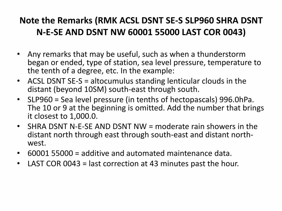
Note the Remarks (RMK ACSL DSNT SE-S SLP960 SHRA DSNT N-E-SE AND DSNT NW 60001 55000 LAST COR 0043)
• Any remarks that may be useful, such as when a thunderstorm began or ended, type of station, sea level pressure, temperature to the tenth of a degree, etc. In the example:
• ACSL DSNT SE-S = altocumulus standing lenticular clouds in the distant (beyond 10SM) south-east through south.
• SLP960 = Sea level pressure (in tenths of hectopascals) 996.0hPa. The 10 or 9 at the beginning is omitted. Add the number that brings it closest to 1,000.0.
• SHRA DSNT N-E-SE AND DSNT NW = moderate rain showers in the distant north through east through south-east and distant north-west.
• 60001 55000 = additive and automated maintenance data. • LAST COR 0043 = last correction at 43 minutes past the hour.