Reactivation of the Pleistocene trans-Arabian Wadi … et al 2016...1 1 Reactivation of the...
43
1 Reactivation of the Pleistocene trans-Arabian Wadi ad 1 Dawasir fluvial system (Saudi Arabia) during the 2 Holocene humid phase 3 4 Albert Matter a , Ayman Mahjoub b , Eike Neubert c , Frank Preusser d,e * , Antje Schwalb f , Sönke Szidat g , 5 Gerwin Wulf e 6 7 a Institute of Geological Sciences, University of Bern, Balterzerstrasse 1+3, 3012 Bern, Switzerland 8 b Saudi Geological Survey, P.O.Box 54141, Jeddah 21514, Kingdom of Saudi Arabia 9 c Natural History Museum Bern, Bernastrasse 15, 3005 Bern, Switzerland 10 d Previously at: Department of Physical Geography and Quaternary Geology, Stockholm University, 10690 Stockholm, Sweden 11 e Institute of Earth and Environmental Sciences, University of Freiburg, Albertstraße 23b, 79104 Freiburg, Germany 12 f Institut für Geosysteme und Bioindikation, Technische Universität Braunschweig, 38106 Braunschweig, Germany 13 g Department of Chemistry and Biochemistry & Oeschger Centre for Climate Change Research, University of Bern, Freiestrasse 3, 14 3012 Bern, Switzerland 15 *corresponding author. E-mail: [email protected] 16 17 18 Accepted version 19 20 Published in 21 Geomorphology 270 (2016) 88–101 22 http://dx.doi.org/10.1016/j.geomorph.2016.07.013 23 24 source: https://doi.org/10.7892/boris.85894 | downloaded: 25.4.2020
Transcript of Reactivation of the Pleistocene trans-Arabian Wadi … et al 2016...1 1 Reactivation of the...

1
Reactivation of the Pleistocene trans-Arabian Wadi ad 1
Dawasir fluvial system (Saudi Arabia) during the 2
Holocene humid phase 3 4 Albert Matter a, Ayman Mahjoub b, Eike Neubert c, Frank Preusser d,e *, Antje Schwalb f, Sönke Szidat g, 5 Gerwin Wulf e 6 7 a Institute of Geological Sciences, University of Bern, Balterzerstrasse 1+3, 3012 Bern, Switzerland 8 b Saudi Geological Survey, P.O.Box 54141, Jeddah 21514, Kingdom of Saudi Arabia 9 c Natural History Museum Bern, Bernastrasse 15, 3005 Bern, Switzerland 10 d Previously at: Department of Physical Geography and Quaternary Geology, Stockholm University, 10690 Stockholm, Sweden 11 e Institute of Earth and Environmental Sciences, University of Freiburg, Albertstraße 23b, 79104 Freiburg, Germany 12 f Institut für Geosysteme und Bioindikation, Technische Universität Braunschweig, 38106 Braunschweig, Germany 13 g Department of Chemistry and Biochemistry & Oeschger Centre for Climate Change Research, University of Bern, Freiestrasse 3, 14 3012 Bern, Switzerland 15 *corresponding author. E-mail: [email protected] 16
17 18 Accepted version 19
20
Published in 21
Geomorphology 270 (2016) 88–101 22
http://dx.doi.org/10.1016/j.geomorph.2016.07.013 23 24
source: https://doi.org/10.7892/boris.85894 | downloaded: 25.4.2020

2
Abstract – The Wadi ad Dawasir fluvial system in central Saudi Arabia is investigated using 25 remote sensing and sedimentology, in combination with bio-proxy analyses (molluscs and 26 ostracods). Age control is provided by radiocarbon as well as luminescence dating, using both 27 quartz and feldspar grains. It is shown that the fluvial system was active from the Asir 28 Mountains across the partially sand-covered interior of the Arabian Peninsula to the Arabian 29 Gulf during the Holocene humid period. Sedimentology and faunal analysis reveal the 30 presence of perennial streams and a permanent freshwater lake in the distal reach of the 31 Dawasir system that are synchronous with fluvial accumulation in the headwaters of its major 32 tributary, Wadi Tathlith. The increased runoff during the Holocene led to a re-activation of 33 streams that largely followed pre-existing Late Pleistocene courses and eroded into older 34 sediments. The absence of Holocene lakes in most of the Rub’ al-Khali implies that trans-35 Arabian rivers were mainly fed by precipitation in the Asir Mountains. Monsoonal rainfall was 36 apparently stronger there as well as in the northern, south-eastern and southern part of the 37 Arabian Peninsula (southern Yemen and Oman), but it apparently did not directly affect the 38 interior during the Holocene. The palaeoenvironmental reconstruction shows a narrow trans-39 Arabian green freshwater corridor as the result of phases of sustained flow lasting up to several 40 centuries. The permanent availability of water and subsistence for wildlife provided a 41 favourable environment for human occupation as documented by Neolithic stone tools that are 42 found all along Wadi ad Dawasir. 43
Keywords: Fluvial, Holocene, Arabia, Humid period 44

3
1. Introduction 45
Four major sand seas (Ar Rub’ al-Khali, Ad Dahna, Al Jafura, and An Nafud) cover an 46
area of 765,000 km2 on the Arabian Peninsula (Wilson, 1973), by this comprising 36 % 47
of the territory of the Kingdom of Saudi Arabia. They are the most prominent evidence 48
of the present arid to hyper-arid climate, with rainfall of less than 100 mm a-1 in the 49
interior of the peninsula. Higher rainfall levels are restricted to the Hedjaz-Asir Plateau 50
and the Yemeni highlands (Almazroui et al., 2012). This pattern is tied to the Hadley 51
cell circulation and its local manifestation, the monsoon system, which are key 52
components responsible for the climate of Arabia (Webster, 2005). At present, the 53
source of rainfall reaching SW Arabia and the coast of Dhofar is the African summer 54
monsoon rather than the Indian Ocean Summer Monsoon as previously assumed 55
(Fleitmann et al., 2007; Bosmans et al., 2014; Enzel et al., 2015; Jennings et al., 2015). 56
The winter months are characterized by a stable high pressure system, clear skies and 57
mild temperatures. During this time of the year Mediterranean cyclones track across 58
the Arabian Peninsula and reach as far as Oman, giving rise to low levels of rainfall. 59
Little palaeoclimate research was carried out in Saudi Arabia until recently, although 60
the joint mapping project of the Kingdom of Saudi Arabia and the U.S. Geological 61
Survey revealed compelling geomorphologic evidence of much wetter episodes during 62
the Quaternary (Brown et al., 1989). A fluvial-style drainage network with large gravel 63
accumulations east of the Hejaz-Asir Mountains (Holm, 1960) and lake deposits within 64
the dunes of the Rub’ al-Khali and the Nafud were investigated subsequently in detail 65
by McClure (1976, 1984) and Schulz and Whitney (1986), respectively. The 66
observation of gravel plains and aquatic molluscs in the lower reaches of Wadi ad 67
Dawasir had already led Philby (1933) to conclude that this river system and possibly 68
others had reached the Arabian Gulf. Brown (1960) argued that gravel terraces 20 to 60 69
m above the present thalweg of Wadi Sahba and Wadi Batin represent remnants of 70
approximately 1 km wide Pleistocene river courses. Despite their low gradient of about 71
1 m km-1, these rivers transported coarse clasts indicating a high stream power. For 72
example, Holm (1961, cited in Edgell, 2006) reported quartzite boulders measuring up 73
to 25 cm in size in a palaeochannel of Wadi Sahba ca. 95 km from the coast, i.e. about 74
600 km downstream of the source terrain in the Arabian Shield. Furthermore, these 75
palaeorivers built-up conglomerate megafans before entering the Arabian Gulf (Hötzl 76
4
et al., 1978a; Edgell, 2006). Based on K-Ar ages of two basalt flows encasing a gravel 77
layer in the Wadi ad Dawasir, Anton (1984) argued that the major trans-Arabian wadis 78
depicted in his palaeohydrological map were incised between 3 and 1 million years 79
ago. 80
However, systematic knowledge about these obvious palaeoenvironmental changes 81
resulted from studies carried out mainly in the adjacent countries (Oman, United Arab 82
Emirates, Yemen) on stalagmites (Burns et al., 2001; Fleitmann et al., 2003a,b, 2004, 83
2005, 2007, 2011; Neff et al., 2001), lake sediments (Parker et al., 2004, 2006; Lézine 84
et al., 1998; Radies et al., 2005; Petit-Maire et al., 2010; Rosenberg et al., 2011a; 85
Catlett, 2014), aeolian dunes (e.g. Juyal et al., 1998; Goudie et al., 2000; Preusser et 86
al., 2002; Radies et al., 2004) and fluvial deposits (Blechschmidt et al., 2009; Berger et 87
al., 2012; Hoffmann et al., 2015; Parton et al., 2015). Advances in geochronology, 88
especially Optically Stimulated Luminescence (OSL) and Uranium-Thorium 89
(234U/230Th) methods, now permit dating these archives beyond the dating limit of 90
radiocarbon and, hence, reconstruction of the temporal and spatial framework of the 91
environmental history. The climate record derived from the previously mentioned 92
archives reveals significant hydrological changes with pronounced humid periods in 93
southern Arabia during Marine Isotope Stages (MIS) 1, 5a, 5e, 7 and 9, and further 94
though less well-documented humid phases during MIS 3 and 11. It is assumed that 95
high summer insolation during these periods strengthened the monsoon and pulled the 96
associated rainfall belt northward into the interior of Arabia. 18O data from stalagmites 97
suggest that the highest precipitation levels occurred during MIS 5e and the lowest 98
during MIS 1 (Fleitmann et al., 2011). 99
In the past decade, the number of studies on the palaeoenvironment of Saudi Arabia 100
has increased markedly due to a more open political situation allowing access to 101
remote areas such as the Rub’ al-Khali. Many of these studies have been carried out in 102
the context of investigating the human dispersal Out-of-Africa models because 103
knowledge of the palaeohydrology and the timing of humid phases is essential for 104
understanding the migration of anatomically modern humans (AMH) into Arabia and 105
beyond (e.g. Petraglia et al., 2011). This range expansion was only possible when the 106
Arabian deserts, which represented a barrier for AMH, turned into a 'Green Arabia' 107
with sufficient surface water and nutrition available during pluvial phases. Research 108
5
has focused mainly on palaeolakes in the Rub’ al-Khali (Rosenberg et al., 2011b; 109
Crassard et al., 2013; Matter et al., 2015, Groucutt et al., 2015), the Nafud (Petraglia et 110
al., 2012, Rosenberg et al., 2013; Hilbert et al., 2014; Scerri et al., 2015; Stimpson et 111
al., 2015) and Tayma (Ginau et al., 2012; Engel et al., 2012), whereas only two modern 112
studies have dated stalagmites and fluvial deposits, respectively. The stalagmites of 113
central and northern Saudi Arabia turned out to be 400 ka old or older, indicating that 114
rainfall was too low or sporadic to allow growth of stalagmites in the past 400 ka 115
(Fleitmann et al., 2004). The first luminescence-dated fluvial sediments in the 116
headwaters of Wadi as Sahba were interpreted to reflect humid events at ca. 54 ka, ca. 117
39 ka (corresponding to MIS 3), and ca. 0.8 ka (McLaren et al., 2009). 118
Breeze et al. (2015) demonstrated the potential of combined remote sensing and 119
geographic information system (GIS) techniques to map palaeodrainage networks and 120
palaeolakes across vast areas in much greater detail and with improved accuracy 121
compared to earlier palaeodrainage maps of Anton (1984) and Edgell (1990, 2006). 122
Furthermore, climate model simulations provide useful information when validated 123
against field data to better understand the functioning of climate change. The results of 124
a set of simulations carried out by Jennings et al. (2015) confirm that the Arabian 125
Peninsula was wettest during MIS 5e and that lesser amounts of precipitation occurred 126
during MIS 5c and MIS 3. Moreover, they support the results of earlier simulation 127
experiments by Herold and Lohmann (2009) that the African monsoon rather than the 128
Indian Summer Monsoon was the source of higher rainfall. This is in accord with the 129
spatial and temporal distribution of lakebeds in southern Arabia. The fact that 130
Pleistocene but no Holocene palaeolakes occur in the interior of the Rub’ al-Khali 131
suggests that the monsoonal rainfall belt migrated farther onto the Peninsula in the 132
Pleistocene than during the Holocene (e.g. Rosenberg et al., 2011b; Matter et al., 133
2015). Enzel et al. (2015) challenge this interpretation based on a re-analysis of 134
published Holocene lacustrine records. They argue that: a) the palaeolakes represent 135
marsh environments requiring a much lesser annual rainfall to be sustained than open 136
lakes, and b) the intensification of rainfall is not related to a northward shift of the 137
Intertropical Convergence Zone (ITCZ) and the Indian Summer Monsoon but to a 138
slight landward expansion of the African Monsoon across the Red Sea with uplift of 139
the moist air over the Yemeni – Asir highlands associated with modest rains feeding 140

6
the downstream wetlands. If this was the case, then the drainage systems must have 141
experienced a major reactivation. 142
In this study, we investigate this hypothesis using a multi-proxy approach to 143
reconstruct the evolution of the palaeodrainage of Wadi ad Dawasir, one of the major 144
trans-Arabian wadis. As palaeodrainage systems respond sensitively to climate 145
changes that affect precipitation, runoff and fluvial style, we first determine the 146
catchment area and reconstruct the drainage pattern by remote sensing techniques. In 147
order to get a more complete view of the area, the adjacent Wadi as Sahba system is 148
included in the analysis. We then investigate selected sedimentary sections in the 149
proximal and distal reaches of the Wadi ad Dawasir system and determine their facies, 150
fossil content (molluscs and ostracods), and age (radiocarbon and luminescence 151
dating). The ultimate goal is to establish a relationship between geomorphology, facies 152
and runoff within a robust geochronological framework. With the above, we aim to 153
better understand the environmental conditions in the central part of the Arabian 154
Peninsula, for which very little information is available at the moment. The newly 155
gathered information will be crucial for cross-checking atmospheric circulation models 156
as well as for better characterization of past environments as important in the context 157
of early human habitation and dispersal through the region. 158
159
2. Methods 160
2.1. Remote sensing and field methods 161
A GIS environment was implemented to analyse the Wadi ad Dawasir and Wadi as 162
Sahba palaeodrainage systems and related catchment areas. ArcGIS 10 was applied for 163
geospatial analyses of digital elevation models (DEMs) and to analyse multispectral 164
data for further mapping. Digital elevation data from the Shuttle Radar Topography 165
Mission (SRTM; Farr and Kobrick, 2000; Rabus et al., 2003; Farr et al., 2007) with a 166
resolution of 3 arc-second (~90 m at the equator) are provided by the Global Land 167
Cover Facility (GLCF) for download. SRTM 2.1 data were used as base data to create 168
a DEM mosaic of the Arabian Peninsula with a cell size of 90 x 90 m (Fig. 1A). 169
During processing, SRTM data voids were filled with elevation data from the 170
Advanced Spaceborne Thermal Emission and Reflection Radiometer (ASTER) Global 171

7
Digital Elevation Model Version 2 (GDEM V2) (Abrams et al., 2010, 2015; 172
Tachikawa et al., 2011). To avoid possible discontinuous drainage networks in the 173
following processing steps, all sinks within the resulting DEM were removed to get a 174
DEM without depressions. Flow direction and flow accumulation were then derived 175
using the eight-direction (D8) flow model by Jenson and Domingue (1988). A drainage 176
network was delineated by applying a threshold value to the flow accumulation raster 177
that defines a minimum required contributing upstream area of a cell as a stream. With 178
regard to the large area of interest (Fig.1B), a contributing catchment area of 150 km² 179
was found appropriate to show only major stream systems while maintaining clarity. 180
SRTM-derived drainage in large sand seas, such as the Rub’ al-Khali, often shows 181
particularly dense channel networks in interdune depressions although no fluvial 182
landforms are visible (e.g. Petraglia et al., 2012; Crassard et al., 2013; Stimpson et al., 183
2015; Breeze et al., 2015). Considering the potential for errors, such peculiar dune field 184
drainage patterns were removed from the drainage network. The western part of the 185
area of interest is characterized by the depression of Sahl Rakbah, an internal drainage 186
basin that is considered to be an area of rift-related subsidence (Camp and Roobol, 187
1989, 1991). Such large sink areas deliver erroneous, straight-running stream lines 188
within the derived drainage network and thus were also removed. The resulting 189
modified drainage system will be termed the ‘calculated drainage’ in the following. In 190
addition, watersheds and catchment areas of the complete Wadi ad Dawasir and Wadi 191
as Sahba systems were determined by combining the derived flow direction with 192
defined outlet points of the watersheds (pour points) (Fig. 1B). 193
In areas with only minor or incomplete sand coverage, palaeodrainage systems can be 194
traced using multispectral image data (Fig. 2A-C). Landsat 7 Enhanced Thematic 195
Mapper Plus (ETM+) data with a spatial resolution of 30 m (e.g. Goward et al., 2001) 196
were used to determine and map recent and palaeostream systems in addition to the 197
calculated drainage. True and false colour composites (FCC) were generated. In the 198
process, composites were created in such a way that the different Landsat bands were 199
assigned to the intensities of red, green and blue (RGB) components of a colour image. 200
A band combination of 7, 4, 2 (7 = Red, 4 = Green, 2 = Blue) were found to be most 201
suitable to detect palaeochannels within the mapping area (Fig. 2B, C). 202

8
Digital elevation data and derived hillshade images were additionally used to retrace 203
drainage systems that could not be unequivocally determined by Landsat images, for 204
example if underlying palaeochannels led to a region of inverted topography (Fig. 2D). 205
As a result, unambiguously identified stream systems were classified as ‘mapped’, 206
whereas incomplete or patchy channels with still recognizable flow directions were 207
classified as ‘inferred’ (Fig. 1B, 2C). It has to be considered that the mapped 208
palaeodrainage system was inferred in a qualitative fashion and thus does not allow 209
any quantitative conclusions concerning contributing catchment areas or relative age 210
determinations. 211
Sedimentary characteristics were determined on six measured sections in the distal part 212
of Wadi ad Dawasir and two outcrops in the proximal part of Wadi Tathlith, which is 213
one of the major tributaries (Fig. 1B, 3). The sections in the distal reach were logged 214
using standard sediment techniques in hand-dug pits, in a trench bulldozed across a 215
palaeochannel at site 4213.3, and at an outcrop site 4214.3 shown in Fig. 1B. Grain 216
size was estimated with a visual comparator. The collected macrofossil specimens are 217
housed in the malacological voucher collection of the Natural History Museum in 218
Bern, Switzerland. Ostracods were extracted by washing sediment samples through a 219
sieve with a mesh width of 0.2 mm. The residue was dried and the specimens picked 220
under a binocular microscope. 221
222
2.2. Radiocarbon dating 223
Radiocarbon dating was performed on shells of Melanoides tuberculata and Unio 224
tigridis from four samples as well as one sample of Bulinus sp. with the accelerator 225
mass spectrometer (AMS) MICADAS at the Laboratory for the Analysis of 226
Radiocarbon with AMS (LARA) at the University of Bern (Szidat et al., 2014). 227
Potential contaminants on the surface of the shells, including organic impurities and 228
recrystallized carbonates, were removed by sequential treatment with 30% hydrogen 229
peroxide and 0.12 mol/L hydrochloric acid at room temperature. Afterwards, the 230
samples were acidified with concentrated phosphoric acid and transformed into AMS 231
target material using automated graphitization equipment connected to a carbonate 232
handling system (Wacker et al., 2013). A 14C-free material (IAEA-C1) and a standard 233

9
with a certified 14C value (IAEA-C2) were measured together with the unknown 234
samples for normalization. Measurement results were corrected for background from 235
the chemical treatment using shells from a sediment sample with an age ~100 ka 236
according to luminescence dating. Calendar ages were deduced from uncalibrated 14C 237
ages using the IntCal13 calibration curve (Reimer et al., 2013) and the results are 238
shown on Table 1. The ages derived from the two species are within the statistical error 239
for all samples except sample 4213.3. 240
XRD measurements were performed on a Panalytical XPertPRO MPD with Cu 241
radiation at 40 mA / 40 kV using aliquots of the fine ground material prepared for 14C 242
analysis mounted on silica plates. The purpose of these analyses is to verify if the 243
aragonitic shells had undergone recrystallization that would have altered their real age. 244
All samples consist of >99% aragonite, except the shell of Melanoides tuberculata of 245
sample 4213.3 that included 2.3% calcite. This sample is considered as an outlier in the 246
discussion of the results. 247
248
2.3. Luminescence dating 249
Samples for dating by OSL, Infrared Stimulated Luminescence (IRSL) and post-IR 250
IRSL (pIR) were taken from sandy beds by forcing a steel tube into a cleaned exposure 251
surface. The material from the steel tubes was transferred into opaque plastic bags and 252
sent to the laboratory at Stockholm University. Sample preparation followed standard 253
procedures including removal of carbonates using HCl, sieving (retrieving 200-250 254
μm) and density separation of a K-feldspar (δ < 2.58 g cm-3) and quartz (δ < 2.70 g cm-255 3, δ > 2.58 g cm-3) fraction, the latter being subsequently etched by 40% HF (60 min), 256
followed by HCl treatment (> 120 min) to dissolve fluorites. The final separates were 257
fixed on stainless steel discs using silicon spray covering an area of a diameter of ca. 1 258
mm. This represents a few dozen grains on each aliquot. As the amount of grains with 259
suitable grain size was relatively low, only 12 feldspar and 24 quartz aliquots have 260
been prepared per sample. 261
Measurements were conducted using a Freiberg Instruments Lexsyg Research 262
luminescence reader (Richter et al., 2013). Stimulation was provided by LEDs with an 263

10
emission peak at 458 nm for quartz (60 mW cm-2) and a laser diode at 850 nm for 264
feldspar (150 mW cm-2). For quartz, detection was at 380 nm with the combination of a 265
Hoya U-340 (2.5 mm) and a Delta DP 365/50 interference filter (5 mm). Detection for 266
feldspar was centred at 410 nm using a Schott BG-39 (3 mm) together with an AHF 267
BrightLine HC 414/46 interference filter (3.5 mm). Determination of Equivalent Dose 268
(De) followed the Single Aliquot Regenerative Dose (SAR) protocol of Murray and 269
Wintle (2000) for quartz, with a preheat at 230°C for 10 s and stimulation at 125°C for 270
60 s. The first 0.4 s of the OSL signal were integrated with the integral 50-60 s 271
subtracted as background. For feldspar, the pIR protocol of Reimann and Tsukamoto 272
(2012) was used, with a preheat at 180°C for 30 s followed by an initial IR stimulation 273
for 100 s at 50°C (IRSL) and a subsequent stimulation for 200 s at 150°C (pIR). Here, 274
the integral 0-20 s was used for De determination after subtracting the last 20 s as 275
background. 276
The usual rejection criteria have been applied (Wintle and Murray, 2006), and most 277
samples show good luminescence properties. While most quartz emissions are 278
dominated by the fast component (Fig. 4A), the samples from site 4216 show low OSL 279
intensity and the presence of a medium component (Fig. 4B). The latter are hence 280
considered not suitable for dating. The feldspar exhibits bright signals for both IRSL 281
(Fig. 4C) and pIR (Fig. 4D). For samples 4214.1/1 and 4214.2/1, the OSL signal is at 282
saturation, therefore only minimum ages have been determined (Fig. 4E), the feldspar 283
growth curves of the same samples, however, do not show any indication of saturation 284
(Fig. 4F). For all samples, De distributions have been investigated (Fig. 5A, B) and 285
based on the observed spread of data, in particular the overdispersion value, either the 286
Central Age Model (CAM) or the Minimum Age Model (MAM) as described by 287
Galbraith et al. (1999) have been applied to account for the effect of differential 288
bleaching of the luminescence signal prior to deposition (Table 2). 289
The concentration of dose rate relevant elements (K, U, Th) was measured by high-290
resolution gamma spectrometry at the University of Bern (cf. Preusser and Kasper, 291
2001). We did not observe any clear indication for radioactive disequilibrium in any of 292
the samples using the approach described by Zander et al. (2007) (Table 2). Age 293
calculations were performed with ADELE-v2015 (v.021a beta) using the dose 294
conversion factors of Guérin et al. (2011), assuming an a-value of 0.07 ± 0.02 for 295

11
feldspar and average sediment moisture content between 0-4 %. Cosmic dose rate was 296
calculated using present day depth after Prescott and Hutton (1994). For feldspar, an 297
internal K-content of 12.5 ± 0.5 % has been used (Huntley and Baril, 1997). 298
Considering that IRSL ages might be affected by signal instability (fading), these are 299
reported here only for completeness. While the pIR signal is expected to show less 300
fading, the use of relatively low stimulation temperatures, as done in this study to 301
minimize problems with regard to partial bleaching, may still show some instability. 302
However, we abstained from carrying out storage tests as the suitability of such 303
experiments to carry-out fading corrections is highly controversial (e.g., Wallinga et 304
al., 2007; Lowick et al., 2012; Preusser et al., 2014). Hence, in the discussion of the 305
age of sediment deposition we will only rely on OSL and pIR ages that are consistent 306
for all of our samples. 307
308
3. Results 309
3.1. Geomorphological setting and drainage systems 310
The present-day geological and geomorphological setting is of fundamental importance 311
to the understanding of the climate and the evolution of the drainage of Saudi Arabia 312
which is geologically divided in four distinct terrains. The Arabian Shield with its 313
crystalline rocks crops out in the western part of the Kingdom over a large area (ca. 314
770’000 km2) including the orographically highest terrain of the country. It is overlain 315
by the homoclinal Phanerozoic sedimentary cover rocks, which dip slightly eastwards 316
away from the shield and form a 400 km wide belt. This region is bordered by the flat 317
lying sediments of the Interior Platform and the Neogene Rub’ al-Khali basin (Vincent, 318
2008). The distribution of these units is mirrored by the topography, as shown in Fig. 319
1A. 320
The geographic configuration led to the establishment of a two-part drainage network 321
separated by a water divide following the edge of the Red Sea escarpment. The first 322
part comprises the short and steep wadi systems that drain onto the Tihama coastal 323
plain. The second and major part consists of confluent wadis such as Wadi ad Dawasir 324

12
that flow down-dip on the beds of the sedimentary cover and across the interior to the 325
Arabian Gulf. 326
The Wadi ad Dawasir and Wadi as Sahba drain large catchments of 354,050 km2 and 327
130,145 km2, respectively, with complex distributary patterns (Fig. 1B). The Wadi ad 328
Dawasir system comprises several major tributaries including Wadi at Tathlith that 329
drain the crystalline terrain of the Asir Mountains. Wadi ad Dawasir breaches the 330
Jurassic carbonates of the Tuwayq Mountains at As Sulayyil to flow in a north-easterly 331
direction across the southern end of the Dahna desert and the Rub’al-Khali. At the pour 332
point, it is joined from the northwest by the downstream trunk of Wadi Maqran and 333
Wadi al Jadwal that drain the sedimentary cover. In this part of the catchment the As 334
Sahba fan acts as barrier forcing the channels of the Dawasir system to flow eastwards 335
(Fig. 1B, 3). 336
The drainage system displays a trellis pattern in the upper catchment indicative of steep 337
slopes, and channel gradients range from 1.7 to 3.8 m km-1. This changes downstream 338
to a parallel pattern on the plain, with the gradient of the trunk channel less than 0.7 m 339
km-1 (Fig. 1). The width of the wadi narrows downstream from almost 30 km wide to 340
the west of As Sulayyil to about 1.5 km a few kilometres downstream of this village. 341
Further downstream the braided channel tapers out and is covered by dunes of the 342
Dahna desert (Fig. 2A). With remote sensing techniques, however, the channel can be 343
followed across the Dahna and Rub’ al-Khali. In addition to this calculated channel, 344
other river courses can be inferred from the flow direction in areas with intermittent 345
dune coverage. The pattern of these inferred channels indicates large-scale movement 346
of the river course across the fluvial plain due to avulsion. Downstream of the pour 347
point, the main channel runs east of a ridge of Tertiary rocks along the western margin 348
of Sabkha Matti (Fig. 1B). It is incised into older gravel deposits that can be followed 349
along its course to the coastline (Bramkamp et al., 1961). Runoff in the Wadi ad 350
Dawasir basin is restricted to the tributaries in the Asir where the majority of discharge 351
occurs after storm events. However, the mean annual runoff is low with 0.95 m3 sec-1 352
in Wadi at Tathlith (Vincent, 2008). Episodic floods may reach As Sulayyil, but the 353
water dissipates within days to weeks due to very high transmission loss into the 354
alluvium and high evaporation rate. 355

13
The Wadi as Sahba catchment is drained by the larger Wadi Birk system, which 356
comprises several tributaries in the crystalline basement terrain and the smaller Wadi 357
Hanifah system that has its headwaters in the Tuwayq Mountains. They cross the 358
Tuwayq escarpment to continue downstream of their confluence as Wadi as Sahba. 359
Channel incision in Wadi Birk and Wadi Hanifah has exposed up to 6 m of the terrace 360
gravels. McLaren et al. (2009) dated fluvial deposits in the upper Sahba catchment to 361
ca. 54 ka and 39 ka. A silt bed in the terrace sequence in Wadi Hanifah yielded a 362
freshwater gastropod fauna with a radiocarbon age of 8400 ± 140 14C yr BP (Hötzl et 363
al., 1978b), corresponding to 9650-9020 cal. yr BP. However, the most conspicuous 364
geomorphic feature of Wadi as Sahba is its large gravel fan, which is of Late Pliocene 365
to Early Pleistocene age according to Hötzl et al. (1978a). Its distributaries entered the 366
Gulf to the east and west of the Qatar Peninsula (Fig. 3). The apex of the fan is located 367
at the end of the incised channel at the edge of the Tertiary plateau from where the 368
confined flows expanded (Bramkamp and Ramirez, 1959). The DEM of the fan shown 369
in Fig. 3 reveals the older distributary channels in inverted relief due to deflation of the 370
finer inter-channel deposits, and it also shows several channels that cross the coastal 371
plain to the coast. The large areal extent of the fan and the coarse clast size of the 372
conglomerates reveal a high erosion rate, high runoff and transport capacity during the 373
Pleistocene pluvial events. The present-day channel runs across the fan towards Al 374
Humr lake which, however, is fed by an artesian spring in the Tertiary rocks on its 375
eastern shore. 376
377
3.2. Field observations, fauna, facies analysis, and dating results 378
The study sites are located in the lower reaches of the Wadi ad Dawasir system and in 379
its far back hinterland in Wadi at Tathlith (Fig. 1B). The measured and dated sections 380
from the unconfined floodplain of Wadi ad Dawasir (Fig. 6) are all situated in 381
interdunal areas where deflation has exposed a dense braided channel network with 382
main and auxiliary channels. These channels, which drained the floodplain visualized 383
by satellite imagery have a low sinuosity and a width up to 50 m (Fig. 7A). As they 384
lack topographic expression, however, they can be identified in the field only by thin 385
veneers of pebbles mixed with coarse sand and aquatic fossils (Fig. 6). The sub-angular 386
to sub-rounded clasts are mostly of igneous and metamorphic origin with abundant 387

14
quartzite and vein quartz of maximum sizes ranging from less than 1 cm up to 10 cm 388
(Fig. 7B). The outcrop at site 4213.2 appears as a narrow light grey band stretching a 389
few tens of meters across the barren, tan sand-covered plain (Fig. 7C). It is littered with 390
Melanoides tuberculata and Unio tigridis as well as Corbicula fluminalis and Radix 391
natalensis. Many of the specimens of U. tigridis are preserved with both valves, resting 392
in-situ embedded in the calcareous sand (Fig. 7B). This indicates that the shells were 393
not transported by the river but remained in the original position after death. 394
In sections 4213.1 and 4213.3 the gravel lag rests on unfossiliferous quartz sand, 395
whereas in sections 4213.2, 4214.1 and 4214.2 it overlies fossiliferous calcareous sand, 396
clayey sand or marl (Fig. 6). The basal unit consists of structureless or faintly 397
laminated bimodal coarse quartz sand. The grains are very well rounded and most of 398
them show a frosted surface. Cailleux (1952) described this grain type as RM (French 399
'Ronds-Mats' = round and dull), and he attributed this appearance to cavities covering 400
the surface. According to SEM imaging by Krinsley and Doornkamp (1973), these 401
dish-like concavities are formed by grain collisions during strong winds. The presence 402
of grains with this morphology, however, does not necessarily imply that the sands in 403
the studied sections represent aeolian deposits. Sequence 4213.3, recorded in a trench 404
excavated with a bulldozer across a fluvial channel, bottomed in hard unfossiliferous 405
marl, probably of Neogene age. The channel is filled with well-rounded quartz sand 406
that had been reworked by Wadi ad Dawasir along its course across the Dahna and 407
Rub’ al-Khali deserts. In contrast, the basal sand unit of none of the other sections 408
mentioned above was bottomed. These sands lack facies with diagnostic sedimentary 409
structures other than faint lamination. According to OSL/pIR dating, the sands in 410
sections 4213 are of Holocene age (dated between 7900 ± 600 a and 3700 ± 300 a by 411
luminescence, with discrepancies compared to radiocarbon dated discussed below), 412
whereas 4214.1 and 4214.2 date to the early Late Pleistocene (pIR ages of 90 ± 6 ka 413
and 109 ± 11 ka, OSL ages being minimum estimates due to signal saturation). We 414
speculate that sands of Holocene age are fluvial and those of Pleistocene age are 415
aeolian deposits (Fig. 6). This interpretation is supported by the channel geometry at 416
site 4213.3, the lighter colour of the Holocene sands and a palaeosol with a sharp 417
erosional surface that separates the Pleistocene basal sand from the overlying Holocene 418

15
fluvio-lacustrine marl in section 4214.2 indicating a period of non-sedimentation. This 419
site is located on the floodplain and the section was measured in a hand-dug pit. 420
The beds of section 4214.3 occur as a low mesa remnant with a relief of about 2 m 421
located about 200 m eastwards of site 4214.2. The sequence is of Holocene age 422
according to OSL/pIRL (6100 ± 300/5600 ± 300 a) and radiocarbon (8400-8700 cal. yr 423
BP) dating. It consists of alternating 5 to 10 cm-thick beds of fossiliferous calcareous 424
sands and marl with a 40 cm-thick marl at the top (Figs 6, 7D). These beds contain a 425
rich freshwater malacofauna with Unio tigridis, Corbicula fluminalis, Melanoides 426
tuberculata, Radix natalensis and Bulinus sp., and rests on loose sand of Holocene age. 427
This consists of very well rounded quartz grains with the frosted surface texture 428
characteristic of aeolian abrasion. 429
The freshwater malacofauna of the lower Dawasir basin is congruent with the findings 430
of Hötzl et al. (1978b), with the only exception that these authors did not find any 431
freshwater bivalves, while in our assemblage the pulmonate Biomphalaria pfeifferi is 432
missing. 433
The ostracod fauna found in four out of six sections of the lower Wadi ad Dawasir 434
basin (Fig. 6) consists of eight species, four of which were identified to genus level. 435
Abundance varies from very low (four valves in 4213.2/2) to high (161 valves in 436
4214.3/2), whereas other samples yield moderate abundances (33-45 valves). The most 437
prominent species in four out of five samples is Cyprideis torosa which mainly occurs 438
in marine brackish waters down to a water depth of 30 m, but also occurs in freshwater 439
(McClure and Swain, 1980; Meisch, 2000). The second most abundant species is 440
Pseudocandona marchica, which inhabits permanent and temporary water bodies, and 441
the littoral zone of lakes, to a depth of 30 m (McClure and Swain, 1980; Meisch, 442
2000). The following species are present in low abundance: Hemicypris sp., Ilyocypris 443
sp., Cypretta sp., Cyprinotus, Cypridopsis vidua and Cypris pubera. These species 444
thrive in a broad variety of aquatic environments from small and shallow permanent 445
ponds to creeks. The presence of Cypris pubera indicates a salinity of <4‰ (Meisch, 446
2000). 447
Wadi at Tathlith carved its valley in the crystalline rocks of the Arabian shield. The up 448
to 200 m-wide floodplain is occupied by coarse grained gravel platforms and sand bars 449

16
that are moved as bedload during ephemeral floods. Older deposits, possibly of 450
Pleistocene age (Whitney, 1983), are exposed where the river has incised into the 451
lowest gravel terrace which is ca. 6 m above the wadi’s floodplain. Two outcrop 452
sections were measured on the eastern bank of the wadi (Fig. 8). Section 4216.2 453
consists of weakly cemented sandy polymict gravels showing poor sorting, 454
stratification and layers with imbricated angular to sub-rounded clasts up to 10 cm in 455
size (Fig. 8; Whitney 1983 Fig. 14). The pIR age of 29.8 ± 1.6 ka dates the section to 456
late MIS 3. About 2.5 km downstream, section 4216.1 was logged in the same terrace 457
but in sandy facies with rare gravel pockets. The sequence consists of three units 458
separated by dark palaeosols with iron stained grains (Figs. 7E, 8). These must record 459
hiatuses in sedimentation, as palaeosol development requires landscape stability with 460
neither deposition nor erosion. The sample that was taken at the base of the middle unit 461
revealed an pIR age of 7100 ± 700 a. Due to ponding behind a constriction of the wadi 462
about 17 km upstream of site 4216.2, extensive fine-grained alluvium was deposited 463
(Fig. 7F). It is characterized by tan laminated silts, cross-bedded fine-grained sands and 464
occasional gravel interbeds. Radiocarbon dating of charcoal from the top of the 465
sequence reported originally by Whitney (1983) gave ages of 6120 ± 110 14C yr BP 466
(7260-6740 cal. yr BP) and 5700 ± 250 14C yr BP (7160-5990 cal. yr BP). The fine-467
grained alluvium contrasts sharply with the older coarse-grained sediments indicating a 468
decrease of flow intensity at the end of the Holocene pluvial. This change towards 469
increased aridity is further supported by the occurrence of abundant displacive 470
lenticular as well as swallow-tailed twinned gypsum crystals in the uppermost silts 471
indicating an evaporitic environment. 472
473
4. Discussion 474
4.1. Timing of fluvial activity 475
Considering the age of fluvial deposition, there is an obvious discrepancy between 476
radiocarbon (of shell material) and luminescence ages (Fig. 6, 9). For the four sites 477
where both methods have been applied, the radiocarbon ages are systematically older, 478
though these have been measured for shells collected above the horizons dated by 479
luminescence. All radiocarbon ages are between 7 and 9 ka, but the luminescence ages 480
are mainly several thousand years younger (up to 4 ka). Age underestimation of 481

17
luminescence ages could be caused by signal instability but the OSL signal of the 482
samples is clearly dominated by the fast component that is stable over millions of years 483
(e.g., Preusser et al., 2009). Furthermore, the OSL ages agree very well with the pIR 484
ages that have different physical properties. There is also no indication for radioactive 485
disequilibrium in the samples that could have led to miscalculation of dose rate. 486
On the other hand, radiocarbon samples could have been re-worked, but this appears 487
unlikely as the material is well preserved and embedded. Rather, shell material could 488
be affected by the hardwater effect, i.e. an up-take of dissolved ancient carbonates. In 489
this case the 14C level is lower than the atmosphere and the basic assumption of 490
radiocarbon dating that a sample incorporates carbon in equilibrium with the 491
atmosphere is no longer fulfilled. A hardwater effect between 0 and almost 6000 years 492
is possible in freshwater systems (Clark and Fritz, 1997; Philippsen, 2013). This effect 493
is well known from several studies in Arabia, with the radiocarbon ages from shell 494
carbonate being a few hundred to 1500 years older than the age of associated organic 495
material (Davies, 2006; Rosenberg et al., 2011b; Dinies et al., 2015). However, the 496
pIR/OSL ages for site 4213.3 are almost 4.0 ka older than its radiocarbon age of about 497
7300 cal. yr BP (Unio tigridis). To achieve the almost double as old radiocarbon age, 498
carbon taken up by the mussel should be composed of ~1/3 fossil and ~2/3 499
contemporary material, which appears quite high. Nevertheless, the samples under 500
consideration here are from the context of a river system that crosses through areas 501
with abundant limestone that will be dissolved in the water. Hence, the hardwater 502
effect should indeed be much higher than in samples from Mundafan, where non-503
carbonate bearing basement and volcanic rocks are outcropping. Interestingly, we 504
found almost identical ages for U. tigridis and M. tuberculata at several sites, which is 505
unexpected as their habitats and their diets are different and this should be reflected by 506
differences in the hardwater effect. 507
In summary, there is no unequivocal explanation for the observed offset between pIR 508
and OSL ages on the one hand, and radiocarbon ages on the other hand. Despite this, a 509
certain offset caused by hardwater uptake must be expected from the environmental 510
setting (creatures living in and feeding from resources associated to carbonate-rich 511
water). Hence, we are relying on the luminescence ages in the later chronological 512
interpretation. 513

18
514
4.2. Palaeoenvironmental inferences 515
The narrow width of the channels in the lower reach of the Wadi ad Dawasir system in 516
combination with a gravel lag consisting of well-rounded pebble-sized clasts indicate a 517
rather sluggish regime of the Holocene rivers. This is supported by the preservation of 518
U. tigridis with both valves intact. However, no conclusive inference is possible with 519
regards to channel depth as sequence thickness has been reduced by strong aeolian 520
deflation in this area. Inverted fluvial channels (Fig. 2D) are further evidence of this 521
process. The section at site 4214.3 composed of alternating 5 to 10 cm-thick 522
fossiliferous sand and marl beds with planar contacts is interpreted as flood deposits 523
and low-energy homogeneous fines, respectively deposited in a shallow lake. 524
The fauna comprising gastropods, bivalves, ostracodes and rare charophytes is 525
identical in both the fluvial and lacustrine deposits. The composition of the fossil 526
freshwater malacofauna is typical for the area and similar to present day populations 527
(Neubert, 1998; Neubert et al., 2015). All species recorded are extant besides the large 528
freshwater mussel U. tigridis. Until now, this species has not been recorded from the 529
Arabian Peninsula; however, our results demonstrate that its extinction was a quite 530
recent event. Remarkably, this species is not recorded from the nearby oasis Al Hasa, 531
even though this oasis has an enormous permanent freshwater supply. This might be 532
due to the fact that this oasis belongs to a separate drainage system receiving its water 533
from groundwater wells, and it thus was not connected to the Dawasir or the Sahba 534
system. 535
Today, U. tigridis lives in the lentic, i.e. relatively still water, shore area of large to 536
medium-sized rivers and larger lakes in the Euphrates-Tigris basin in Turkey, Syria, 537
Iraq and probably Iran (Al-Bassam and Hassan, 2006; Lopes-Lima and Seddon, 2014). 538
These bivalves need freshwater fish species as intermediate hosts for their larvae, and 539
thus require a stable, perennial habitat with relatively large water bodies (Matter et al., 540
2015). In the investigated area, these mussels have been the most abundant fossils 541
representing a large and well-established population. From resettlement experiments in 542
Europe we know that Unio species are extremely sensitive concerning the quality of 543
their habitats. It may take 10-20 years of insertion of infected fish specimens until a 544
19
first population is established. After that, hatchlings need between 4-10 years until 545
reaching maturity. This demonstrates that habitats need to be stable for 30 years at least 546
to support a single generation of mussels. We frequently observed mussels of differing 547
sizes in our fossiliferous layers, which we interpret as several subsequent generations 548
of mussels, and thus as evidence of stable habitat conditions in the order of magnitude 549
of one to several centuries. A short-termed fluctuation in habitat conditions such as in 550
an ephemeral flow regime with subsequent re-settlement of a rich mussel fauna is very 551
unlikely. The remaining species can be considered more euryoecious, i.e. they are able 552
to survive in short-lived habitat and re-colonise it after desiccation given there are 553
surviving populations in the surroundings. Only M. tuberculata, which has a 554
parthenogenetic mode of reproduction, is able to colonise even small (and also 555
brackish) water bodies from a single specimen. For this reason it can be found as a 556
tramp-species in all tropical and subtropical biomes. The palaeoecological information 557
of the ostracod fauna is less conclusive because all of the species are typical of a 558
variety of permanent and temporary aquatic habitats and most of them tolerate 559
moderate to high salinities. The occurrence of Cyprideis torosa, however, indicates 560
warm, shallow and permanent water bodies as its eggs cannot withstand desiccation 561
(Anadón et el., 1986; Pint et al., 2012). It develops characteristic nodes in low-salinity 562
waters with Ca2+ deficiency (Frenzel et al., 2012). The Dawasir samples yielded 563
smooth shells, which may only suggest saline conditions rather than freshwater as 564
indicated by U. tigridis. However, according to Frenzel et al. (2012), the use of nodes 565
as a proxy for palaeowater chemistry requires further study of the relationships of 566
water chemistry and shell morphology; they find that both ionic composition and 567
salinity may influence morphological response (Pint et al., 2012). Therefore, the 568
morphology of C. torosa should be used with caution as a palaeosalinity indicator of 569
athalassic waters (Pint et al., 2012). 570
The geomorphologic, sedimentological and biological observations suggest that the 571
lower reach of the Dawasir system in Holocene times was a fluvial plain with several 572
river channels and floodplain lakes. The alternation of sand and marl beds in the 573
lacustrine sequence indicates flooding of the lake from overtopping river channels as a 574
result of fluctuating discharge. The re-interpretation by Enzel et al. (2015) of Holocene 575
palaeolakes in Arabia as marshes neglects the biological evidence that unionid mussels 576
20
and Cyprideis torosa need permanent water and are unable to survive in a marsh 577
environment. 578
The presence of flowing rivers and permanent lakes in Wadi ad Dawasir during the 579
Holocene wet period raises the question as to the source of the rainfall. Many studies 580
carried out during the past decade associated the observed environmental fluctuations 581
with a shift in the latitudinal position of the ITCZ and associated monsoonal rainfall 582
belt, but there is surprisingly little information on its position across the Peninsula at 583
different times. Increased precipitation during the Early to Middle Holocene appears to 584
be restricted to North Arabia, the south-eastern, southern and western margins of the 585
Peninsula from the Emirates to the Yemeni Highlands, and the Asir Mountains. Central 586
Arabia and the Rub’ al-Khali seem to have remained arid, lacking widespread 587
Holocene lake deposits. Thus, the perennial Dawasir river represents a trans-Arabian 588
lifeline across a hostile desert environment during the Holocene. This is further 589
supported by the occurrence of Neolithic stone tools along the wadi course indicating 590
that is was a favourable habitat for humans (Crassard et al., 2013). This 591
palaeohydrological situation implies that the main source area of water feeding Wadi 592
ad Dawasir in the Holocene must have been the Asir Mountains that received high 593
amounts of rainfall due to the eastern movement of the African Summer Monsoon. 594
Increased precipitation in this area is documented by the accumulation of river 595
sediments, for example, in Wadi Tathlith dated to 7.1 ka and 6.1-5.7 ka and a Holocene 596
lake at Mundafan fed by river channels draining these mountains (Rosenberg et al., 597
2011b). Radiocarbon dating of phytoclasts (plant particles) revealed that Lake 598
Mundafan existed from 9600 to 7900 cal. yr BP, whereas the activity of Wadi ad 599
Dawasir is documented in this work from ca. 7.9 to 4.0 ka according to luminescence 600
dating. Fluvial accumulation at 5.9-5.3 ka, 4.8-4.5 ka and 4.0-2.7 ka in southern 601
Yemen reveals that the rainfall regime in this area did not end with the so-called 602
'classic' Holocene wet period though the last lake dated to 7.3 ka (Lézine et al., 2010; 603
Berger et al., 2012). This decrease in precipitation is in accord with the Qunf cave 604
stalagmite record, which shows a concomitant decrease of δ18O after 7 ka to modern 605
values at 2.6 ka (Fleitmann et al., 2007). 606
607

21
5. Conclusions 608
Remote sensing methods allowed fluvial channels of the Sahba and Dawasir systems to 609
be mapped from the Asir mountainous watershed across the partially sand covered 610
interior of the Arabian Peninsula to the Arabian Gulf, facilitating the analysis of the 611
palaeoenvironmental archives deposited during the Holocene wet phase. 612
Sedimentological and faunal analyses reveal the presence of a stable habitat with 613
perennial rivers and a permanent freshwater lake in the distal reach of the Dawasir 614
system lasting up to several hundred years, which are synchronous with fluvial 615
accumulations in the headwaters of its major tributary Wadi Tathlith. As there are no 616
indications of Holocene lakes in most of the Rub’ al-Khali it appears that the Dawasir, 617
Sahba and possibly other trans-Arabian rivers were fed by precipitation in the Asir 618
Mountains as a result of an intensified African summer monsoon. Hence, the general 619
climatic setting was different from today, likely with higher summer rainfall in the Asir 620
Mountains compared to the present, possibly accentuated by topographic effects. 621
However, rainfall was likely not ubiquitous across the peninsula. The direct influence 622
of the monsoonal rainfall belt was apparently limited to the south-eastern, southern and 623
western margin as well as the northern part of the Arabian Peninsula, but did not reach 624
into its interior. Increased runoff during the Holocene wet phase led to a re-activation 625
of the Dawasir river, largely following its Late Pleistocene course and eroding into its 626
previously deposited gravels and the sands of the Rub’ al-Khali. The 627
palaeoenvironmental reconstruction suggests a narrow, trans-Arabian green freshwater 628
corridor as a result of presumably seasonal flooding similar to that of the River Nile. 629
The permanent availability of water and subsistence for wildlife provided a favourable 630
environment for human occupation as documented by Neolithic stone tools found 631
along the length of Wadi ad Dawasir. 632
633
Acknowledgements 634
We thank Dr. Zohair A. Nawab, President of the Saudi Geological Survey (SGS), Dr. 635
Abdullah M. Al-Attas, Assistant President for Technical Affairs and Saleh Al-Ghamdi, 636
Director of Desert Studies of SGS for their interest and support. We thank Siddiq 637
Habibullah and Abdulaziz Al-Solami for assistance in the field, and Dr. Urs 638

22
Eggenberger for the XRD analysis of the shell material, and Cornelia Fischer for 639
assistance in ostracod analysis. Prof. Dominik Fleitmann kindly provided the isotope 640
data used in Fig. 9. Dr. Laine Clark-Balzan is thanked for her comments on a previous 641
version of the manuscript. Prof. Martin Williams, two anonymous reviewers and the 642
editor Andrew Plater are thanked for their useful and constructive comments. 643
644
References 645
Abrams, M., Bailey, B., Tsu, H., Hato, M., 2010. The ASTER global DEM. 646
Photogrammetric Engineering and Remote Sensing 76, 344-348. 647
Abrams, M., Tsu, H., Hulley, G., Iwao, K., Pieri, D., Cudahy, T., Kargel, J., 2015. The 648
Advanced Spaceborne Thermal Emission and Reflection Radiometer (ASTER) after 649
fifteen years: Review of global products. International Journal of Applied Earth 650
Observation and Geoinformation 38, 292–301. 651
Al-Bassam, K.S., Hassan, K.M., 2006. Distribution and ecology of recent molluscs in 652
the Euphrates river – Iraq. Iraqi Bulletin of Geology and Mining 2, 57-66. 653
Almazroui, M., Islam, M.N., Athar, H., Jones, P.D., Rahman, M.A., 2012. Recent 654
climate change in the Arabian Peninsula: annual rainfall and temperature analysis of 655
Saudi Arabia for 1978-2009. International Journal of Climatology 32, 953-966. 656
Anadón, P., De Dekker, P., Julià, R., 1986. The Pleistocene lake deposits of the NE 657
Baza Basin (Spain): salinity variations and ostracod succession. Hydrobiologia 143, 658
199-208. 659
Anton, D., 1984. Aspects of geomorphological evolution; Paleosols and dunes in Saudi 660
Arabia. In: Jado, A.R., Zötl, J.G. (eds.): Quaternary Period in Saudi Arabia 2, 275-661
296. 662
Berger, J.-F., Bravard, J.-P., Purdue, L., Benoist, A., Mouton, M., Braemer, F., 2012. 663
Rivers of the Hadramawt watershed (Yemen) during the Holocene: Clues of late 664
functioning. Quaternary International 266, 142-161. 665
Blechschmidt, I., Matter, A., Preusser, F., Rieke-Zapp, D., 2009. Monsoon triggered 666
formation of Quaternary alluvial megafans in the interior of Oman. Geomorphology 667
110, 128-137. 668
23
Bramkamp, R.A., Ramirez, L.F., 1959. Geology of the Northwestern Rub’ al-Khali 669
Quadrangle. Kingdom of Saudi Arabia, USGS, Misc. Geol. Investigations Map I-670
213A, 1 : 500,000. Washington. 671
Bramkamp, R.A., Ramirez, L.F., 1961. Geologic Map of the Central Persian Gulf 672
Quadrangle. Kingdom of Saudi Arabia, USGS, Misc. Geol. Investigations Map I-673
214A, 1 : 500,000. Washington. 674
Bosmans, J.H.C., Drijfhout, S.S., Tuenter, E., Hilgen, F.J., Lourens, L.J., 2014. 675
Response of the North African summer monsoon to precession and obliquity 676
forcings in the EC-Earth GCM. Climate Dynamics 44, 279-297. 677
Breeze, P., Drake N.A., Groucutt, H.S., Parton, A., Jennings, R.P., White, T.S., Clark-678
Balzan, L., Shipton, C., Scerri, E.M.L., Stimpson, C.M., Crassard, R., Hilbert, Y., 679
Alsharekh, A., Al-Omari, A., Petraglia, M.D., 2015. Remote sensing and GIS 680
techniques for reconstructing Arabian palaeohydrology and identifying 681
archaeological sites. Quaternary International 382, 98-119. 682
Brown, G.F., 1960. Geomorphology of central and western Saudi Arabia. 21st 683
International Geological Congress 150-159. 684
Brown, G.F., Schmidt, D.L., Huffman, Jr., A.C., 1989. Geology of the Arabian 685
Peninsula – Shield Area of Western Saudi Arabia. U.S. Geological Survey 686
Professional Paper 560A, 199pp. 687
Burns, S.J., Fleitmann, D., Matter, A., Neff, U., Mangini, A., 2001. Speleothem 688
evidence from Oman for continental pluvial events during interglacial periods. 689
Geology 29, 623-626. 690
Cailleux, A., 1952. Morphoskopische Analyse der Geschiebe und Sandkörner und ihre 691
Bedeutung für die Paläoklimatologie. Geologische Rundschau 40, 11-19. 692
Camp, V.E., Roobol, M.J., 1989. The Arabian continental alkali basalt province: Part 693
1. Evolution of Harrat Rahat, Kingdom of Saudi Arabia. Bulletin of the Geological 694
Society of America 101, 71-95. 695
Camp, V.E., Roobol, M.J., 1991. Geologic map of the Cenozoic lava field of Harrat 696
Rahat, Kingdom of Saudi Arabia. Saudi Arabian Directorate of Mineral Resources 697
Geosciences Map GM-123, scale 1 : 250,000, with text 37 pp. 698
Catlett, G.A., 2014. Pluvial deposits in Mudawwara, Jordan and their implications for 699
Mediterranean and monsoonal precipitation in the Levant. M.Sc. Thesis, Miami 700
University, Oxford, Ohio, 32 pp. 701
24
Clark, I.D., Fritz, P., 1967. Environmental Isotopes in Hydrogeology. New York, Boca 702
Raton, Lewis Publishers, CRC Press LLC, 352 pp. 703
Crassard, R., Petraglia, M.D., Drake, N.A., Breeze, P., Gratuze, B., Alsharekh, A., 704
Arbach, M., Groucutt, H.S., Khalidi, L., Michelsen, N., Robin, C.J., Schiettecatte, J., 705
2013. Middle Palaeolithic and Neolithic occupations around Mundafan palaeolake, 706
Saudi Arabia: Implications for climate change and human dispersal. PLOS One 8, 707
e69665. 708
Davies, C.P., 2006. Holocene paleoclimates of southern Arabia from lacustrine 709
deposits of the Dhamar highlands, Yemen. Quaternary Research 66, 454-464. 710
Dinies, M., Plessen, B., Neef, R., Kürschner, H., 2015. When the desert was green: 711
Grassland expansion during the early Holocene in northwestern Arabia. Quaternary 712
International 382, 293-302. 713
Edgell, H.S., 1990. Evolution of the Rub’ al Khali desert. Journal of King Abdulaziz 714
University: Earth Sciences, vol. 3, Special Issue, 1st Saudi Symposium on Earth 715
Sciences 1989, 81-93, Jeddah. 716
Edgell, H.S., 2006. Arabian Deserts. Nature, Origin and Evolution. Springer, 717
Dordrecht, 592 pp. 718
Engel, M., Brückner, H., Pint, A., Wellbrock, K., Ginau, A., Voss, P., Grottker, M., 719
Klasen, N., Frenzel, P., 2012. The early Holocene humid period in NW Saudi Arabia 720
– Sediments, microfossils and palaeo-hydrological modelling. Quaternary 721
International 266, 131-141. 722
Enzel, Y., Kushnir, Y., Quade, J., 2015. The middle Holocene climatic records from 723
Arabia: Reassessing lacustrine environments, shift of ITCZ in Arabian Sea, and 724
impacts of the southwest Indian and African monsoon. Global and Planetary Change 725
129, 69-91. 726
Farr, T.G., Kobrick, M., 2000. Shuttle radar topography mission produces a wealth of 727
data. Eos, Transactions American Geophysical Union 81, 583. 728
Farr, T.G., Rosen, P.A., Caro, E., Crippen, R., Duren, R., Hensley, S., Kobrick, M., 729
Paller, M., Rodriguez, E., Roth, L., Seal, D., Shaffer, S., Shimada, J., Umland, J., 730
Werner, M., Oskin, M., Burbank, D., Alsdorf, D., 2007. The Shuttle Radar 731
Topography Mission. Reviews of Geophysics 45, RG2004. 732

25
Fleitmann, D., Burns, S.J., Neff, U., Mangini, A., Matter, A., 2003a. Changing 733
moisture sources over the last 330,000 years in Northern Oman from fluid-inclusion 734
evidence in speleothems. Quaternary Research 60, 223-232. 735
Fleitmann, D., Burns, S.J., Mudelsee, M., Neff, U., Kramers, J., Mangini, A., Matter, 736
A., 2003b. Holocene forcing of the Indian monsoon recorded in a stalagmite from 737
Southern Oman. Science 300, 1737-1739. 738
Fleitmann, D., Matter, A., Pint, J., Al-Shanti, M.A., 2004. The speleothem record of 739
climate change in Saudi Arabia. Open-File Report, SGS-OF-2004-8. Saudi 740
Geological Survey. 40 pp. 741
Fleitmann, D., Burns, S.J., Neff, U., Mudelsee, M., Mangini, A., Kramers, J., Matter, 742
A., 2005. Holocene records of rainfall variation and associated ITCZ migration from 743
stalagmites from northern and southern Oman. In: Diaz, H.F., Bradley, R.S. (eds.), 744
The Hadley Cell Circulation: Present, past and future, 259-287. Kluwer Academic 745
Publishers. Dordrecht, The Netherlands. 746
Fleitmann, D., Burns, S.J., Mangini, A., Mudelsee, M., Kramers, J., Villa, I., Neff, U., 747
Al-Subbary, A.A., Buettner, A., Hippler, D., Matter, A., 2007. Holocene ITCZ and 748
Indian monsoon dynamics recorded in stalagmites from Oman and Yemen (Socotra). 749
Quaternary Science Reviews 26, 170-188. 750
Fleitmann, D., Burns, S.J., Pekala, M., Mangini, A., Al-Subbary, A., Al-Aowah, M., 751
Kramers, J., Matter, A., 2011. Holocene and Pleistocene pluvial periods in Yemen, 752
southern Arabia. Quaternary Science Reviews 30, 783-787. 753
Frenzel, P., Schulze, I., Pint, A., 2012. Noding of Cyprideis torosa valves (Ostracoda) 754
– a proxy for salinity? New data from field observations and a long-term microcosm 755
experiment. International Review of Hydrobiology 97, 314-329. 756
Galbraith, R.F., Roberts, R.G., Laslett, G.M., Yoshida, H., Olley, J.M., 1999. Optical 757
dating of single and multiple grains of quartz from Jinmium rock shelter, northern 758
Australia, part 1, Experimental design and statistical models. Archaeometry 41, 339-759
364. 760
Ginau, A., Engel, M., Brückner, H., 2012. Holocene chemical precipitates in the 761
continental sabkha of Tayma (NW Saudi Arabia). Journal of Arid Environments 84, 762
26-37. 763
26
Goward, S.N., Masek, J.G., Williams, D.L., Irons, J.R., Thompson, R.J., 2001. The 764
Landsat 7 mission. Remote Sensing of Environment 78, 3–12. 765
Goudie, A.S., Colls, A., Stokes, S., Parker, A., White, K., Al-Farraj, A., 2000. Latest 766
Pleistocene and Holocene dune construction at the north-eastern edge of the Rub’ al 767
Khali, United Arab Emirates. Sedimentology 47, 1011-1021. 768
Groucutt, H.S., White, T.S., Clark-Balzan, L., Parton, A., Crassard, R., Shipton, C., 769
Jennings, R.P., Parkar, A.G., Breeze, P.S., Scerri, E.M.L., Alsharekh, A., Petraglia, 770
M.D., 2015. Human occupation of the Arabian Empty Quarter during MIS 5: 771
evidence from Mundafan Al-Bahayrah, Saudi Arabia. Quaternary Science Reviews 772
119, 116-135. 773
Guérin, G., Mercier, N., Adamiec, G., 2011. Dose-rate conversion factors: update. 774
Ancient TL 29, 5-8. 775
Herold, M., Lohmann, G., 2009. Eemian tropical and subtropical African moisture 776
transport: an isotope modelling study. Climate Dynamics 33, 1075-1088. 777
Hilbert, Y.H., White, T., Parton, A., Clark-Balzan, L., Crassard, R., Groucutt, H.S., 778
Jennings, R.P., Breeze, P., Parker, A., Shipton, C., Al-Omari, A., Alsharekh, A., 779
Petraglia, M.D., 2014. Epipalaeolithic occupation and palaeoenvironments of the 780
southern Nefud desert, Saudi Arabia, during terminal Pleistocene and Early 781
Holocene. Journal of Archaeological Science 50, 460-474. 782
Hoffmann, G., Rupprechter, M., Rahn, M., Preusser, F., 2015. Fluvio-lacustrine 783
deposits reveal precipitation pattern in SE Arabia during early MIS 3. Quaternary 784
International 382, 145-153. 785
Holm, D.A., 1960. Desert geomorphology in the Arabian Peninsula. Science 132, 786
1369-1379. 787
Hötzl, H., Maurin, V., Zötl, J.G., 1978a. Geologic history of the Al Hasa area since the 788
Pliocene. In: Al-Sayari, S.S., Zötl, J.G. (eds.): Quaternary Period in Saudi Arabia, 789
58-77. Wien, Springer-Verlag. 790
Hötzl, H., Felber, H., Maurin, V., Zötl, J.G., 1978b. Accumulation terraces of Wadi 791
Hanifa and Wadi Al Luhy. In: Al-Sayari, S.S., Zötl, J.G. (eds.): Quaternary Period in 792
Saudi Arabia, 202-209. Wien, Springer-Verlag. 793
Huntley, D.J., Baril, M.R., 1997. The K content of the K-feldspars being measured in 794
optical dating or in thermoluminescence dating. Ancient TL 15, 11-14. 795

27
Jennings, R.P., Singarayer, J., Stone, E.J., Krebs-Kanzow, U., Khon, V., Nisancioglu, 796
K.H., Pfeiffer, M., Zhang, X., Parker, A., Parton, A., Groucutt, H.S., White, T.S., 797
Drake, N.A., Petraglia, M.D., 2015. The greening of Arabia: Multiple opportunities 798
for human occupation of the Arabian Peninsula during the Late Pleistocene inferred 799
from an ensemble of climate model simulations. Quaternary International 382, 181-800
199. 801
Jenson, S. K., Domingue, J. O., 1988. Extracting topographic structure from digital 802
elevation data for Geographic Information System Analysis. Photogrammetric 803
Engineering and Remote Sensing 54, 1593–1600. 804
Juyal, N., Singhvi, A.K., Glennie, K.W., 1998. Chronology and palaeoenvironmental 805
significance of Quaternary desert sediment in southeastern Arabia. In: Alsharan, 806
A.S., Glennie, K.W., Whittle, G.L., Kendall, C.G.St.C. (eds.), Quaternary Deserts 807
and Climate Change, 315-325, Rotterdam, Balkema. 808
Krinsley, D.H., Doornkamp, J.C., 1973. Atlas of quartz sand surface textures. 809
Cambridge, University Press, 91pp. 810
Lézine, A.-M., Saliège, J.-F., Robert, C., Wertz, F., Inizan, M.-L., 1998. Holocene 811
lakes from Ramlat as-Sab’atayn (Yemen) illustrate the impact of monsoon activity 812
in southern Arabia. Quaternary Research 50, 290-299. 813
Lézine, A.-M., Robert, C., Cleuziou, S., Inizan, M.-L., Braemer, F., Saliège, J.-F., 814
Sylvestre, F., Tiercelin, J.-J., Crassard, R., Méry, S., Carpentier, V., Steimer-Herbst, 815
T., 2010. Climate change and human occupation in the Southern Arabian lowlands 816
during the last deglaciation and the Holocene. Global and Planetary Change 72, 412-817
428. 818
Lopes-Lima, M., Seddon, M.B., 2014. Unio tigridis. The IUCN red list of threatened 819
species, version 2015.2. www.iucnredlist.org. Downloaded on 28 August 2015. 820
Lowick, S.E., Trauerstein, M., Preusser, F. 2012. Testing the application of post IR-821
IRSL dating to fine grain waterlain sediments. Quaternary Geochronology 8, 33-40. 822
Matter, A., Neubert, E., Preusser, F., Rosenberg, T.M., Al-Wagdani, K., 2015. Palaeo-823
environmental implications derived from lake and sabkha deposits of the southern 824
Rub’ al-Khali, Saudi Arabia and Oman. Quaternary International 382, 120-131. 825
McClure, H.A., 1976. Radiocarbon chronology of Late Quaternary lakes in the 826
Arabian desert. Nature 263, 755-756. 827

28
McClure H. A., 1984. Late Quaternary palaeoenvironments of the Rub’al Khali. PhD 828
thesis, London, University of Central London (unpublished), 245pp. 829
McClure, H.A., Swain, F.M., 1980. Fresh-water and brackish-water fossil Quaternary 830
Ostracoda from the Rub’ al Khali (“Empty Quarter”), Saudi Arabia. Actes du VIe 831
Colloque Africain de Micropaléontologie, Tunis, 1974. Annales des Mines et de la 832
Géologie, Tunis, 28, tome III, 427-441. 833
McLaren, S.J., Al-Juaidi, F., Bateman, M.D., Millington, A.C., 2009. First evidence for 834
episodic flooding in the arid interior of central Saudi Arabia over the last 60 ka. 835
Journal of Quaternary Science 24, 198-207. 836
Meisch, C., 2000. Freshwater ostracoda of western and central Europe. 837
Süsswasserfauna von Mitteleuropa, vol. 8 Crustacea. Schwoerbel, J., Zwick, P. 838
(eds.). Spektrum Akademischer Verlag, 522pp. 839
Murray, A.S., Wintle, A.G., 2000. Luminescence dating of quartz using an improved 840
single-aliquot regenerative-dose protocol. Radiation Measurements 32, 57-73. 841
Neff, U., Burns, S.J., Mangini, A., Mudelsee, M., Fleitmann, D., Matter, A., 2001. 842
Strong coherence between solar variability and the monsoon between 9 and 6 kyr 843
ago. Nature 411, 290-293. 844
Neubert, E., 1998. Annotated checklist of the terrestrial and freshwater Molluscs of the 845
Arabian Peninsula. Fauna of Arabia, 17, 333–461. Basel/Riyadh. 846
Neubert, E., Amr, Z., van Damme, D., 2015. Chapter 4: The status and distribution of 847
freshwater molluscs in the Arabian Peninsula. In: Garcìa, N., Harrison, I., Cox, N., 848
Tognelli, M.F. (compilers): The status and distribution of the freshwater biodiversity 849
in the Arabian Peninsula: 30-38, Appendix 2. Gland, Switzerland, Cambridge, UK., 850
Arlington, USA:IUCN. 851
Parker, A.G., Eckersley, L., Smith, M.M., Goudie, A.S., Stokes, S., Ward, S., White, 852
K., Hodson, M.J., 2004. Holocene vegetation dynamics in the north-eastern Rub’ al-853
Khali desert, Arabian Peninsula: a phytolith, pollen and carbon isotope study. 854
Journal of Quaternary Science 19, 665-676. 855
Parker, A.G., Goudie, A.S., Stokes, S., White, K., Hodson, M.J., Manning, M., Kennet, 856
D., 2006. A record of Holocene climate change from lake geochemical analyses in 857
southeastern Arabia. Quaternary Research 66, 465-476. 858
29
Parton, A., Farrant, A.R., Leng, M.J., Telfer, M.W., Groucutt, H.S., Petraglia, M.D., 859
Parker, A., 2015. Alluvial fan records from southeast Arabia reveal multiple 860
windows for human dispersal. Geology 43, 295-298. 861
Petit-Maire, N., Carbonel, P., Reyss, J.L., Sanlaville, P., Abed, A., Bourrouilh, R., 862
Fontugne, M., Yasin, S., 2010. A vast palaeolake in Southern Jordan (29 N). 863
Global and Planetary Change 72, 368-373. 864
Petraglia, M.D., Alsharekh, A.M., Crassard, R., Drake, N.A., Groucutt, H., Parker, 865
A.G., Roberts, R.G., 2011. Middle Palaeolithic occupation on a Marine Isotope 866
Stage 5 lakeshore in the Nefud Desert, Saudi Arabia. Quaternary Science Reviews 867
30, 1555-1559. 868
Petraglia, M.D., Alsharekh, A., Breeze, P., Clarkson, C., Crassard, R., Drake, N.A., 869
Groucutt, H.S., Jennings, R., Parker, A.G., Parton, A., Roberts, R.G., Shipton, C., 870
Matheson, C., Al-Omari, A., Veal, M.-A., 2012. Hominin dispersal into the Nefud 871
desert and middle Palaeolithic settlement along the Jubbah palaeolake, northern 872
Arabia. PLoS ONE 7, e49840, doi: 10.371/journal.ponr,0049840. 873
Philby, H.St.J.B., 1933. The Empty Quarter. Constable & Company Ltd, London, 874
433pp. 875
Philippsen, B., 2013. The freshwater reservoir effect in radiocarbon dating. Heritage 876
Science 1, 24pp. 877
Pint, A., Frenzel, P., Fuhrmann, R. Scharf, B., Wennrich, V., 2012. Distribution of 878
Cyprideis torosa (Ostracoda) in Quaternary athalassic sediments in Germany and its 879
application for palaeoecological reconstructions. International Review of 880
Hydrobiology 97, 330-355. 881
Prescott, J., Hutton, J.T., 1994. Cosmic ray contributions to dose rates for 882
luminescence and ESR dating: Large depths and long-term time variations. 883
Radiation Measurements 23, 497-500. 884
Preusser, F., Kasper, H.U., 2001. Comparison of dose rate determination using high-885
resolution gamma spectrometry and inductively coupled plasma-mass spectrometry. 886
Ancient TL 19, 19-24. 887
Preusser, F., Radies, D., Matter, A., 2002. A 160,000-year record of dune development 888
and atmospheric circulation in southern Arabia. Science 296, 2018-2020. 889

30
Preusser, F., Chithambo, M.L., Götte, T., Martini, M., Ramseyer, K., Sendezera, E.J., 890
Susino, G.J., Wintle, A.G., 2009. Quartz as a natural luminescence dosimeter. Earth 891
Science Reviews 97, 196–226. 892
Preusser, F., Muru, M., Rosentau, A., 2014. Comparing different post-IR IRSL 893
approaches for the dating of Holocene foredunes from Ruhnu Island, Estonia. 894
Geochronometria 41, 342-351. 895
Rabus, B., Eineder, M., Roth, A., Bamler, R., 2003. The shuttle radar topography 896
mission-a new class of digital elevation models acquired by spaceborne radar. 897
Journal of Photogrammetry & Remote Sensing 57, 241-262. 898
Radies, D., Preusser, F., Matter, A., Mange, M., 2004. Eustatic and climatic controls 899
on the development of the Wahiba sand sea, Sultanate of Oman. Sedimentology 51, 900
1359-1385. 901
Radies, D., Hasiotis, S.T., Preusser, F., Neubert, E., Matter, A., 2005. Paleoclimatic 902
significance of Early Holocene faunal assemblages in wet interdune deposits of the 903
Wahiba sand sea, Sultanate of Oman. Journal of Arid Environments 62, 109-125. 904
Reimann, T., Tsukamoto, S., 2012. Dating the recent past (<500 years) by post-IR 905
IRSL feldspar - Examples from the North Sea and Baltic Sea coast. Quaternary 906
Geochronology 10, 180-187. 907
Reimer, P. J., Bard, E., Bayliss, A., Beck, J. W., Blackwell, P. G., Bronk Ramsey, C., 908
Buck, C. E., Cheng, H., Edwards, R. L., Friedrich, M., Grootes, P. M., Guilderson, 909
T. G., Haflidason, H., Hajdas, I., Hatté, C., Heaton, T. J., Hoffmann, D. L., Hogg, A. 910
G., Hughen, K. A., Kaiser, K. F., Kromer, B., Manning, S. W., Niu, M., Reimer, R. 911
W., Richards, D. A., Scott, E. M., Southon, J. R., Staff, R. A., Turney, C. S. M., van 912
der Plicht, J., 2013. IntCal13 and Marine13 radiocarbon age calibration curves 0–913
50,000 years cal References BP. Radiocarbon 55, 1869-1887. 914
Richter, D., Richter, A., Dornich, K., 2013. Lexsyg - A new system for luminescence 915
research. Geochronometria 40, 220-228. 916
Rosenberg, T.M., Preusser, F., Blechschmidt, I., Fleitmann, D., Jagher, R., Matter, A., 917
2011a. Late Pleistocene palaeolake in the interior of Oman: a potential key area for 918
the dispersal of anatomically modern humans out-of-Africa? Journal of Quaternary 919
Science 27, 13-16. 920
Rosenberg, T.M., Preusser, F., Fleitmann, D., Schwalb, A., Penkman, K., Schmid, 921
T.W., Al-Shanti, M.A., Kadi, K., Matter, A., 2011b. Late Pleistocene pluvial periods 922
31
in southern Arabia: windows of opportunity for modern human dispersal. Geology 923
39, 1115-1118. 924
Rosenberg, T.M., Preusser, F., Risberg, J., Plikk, A., Kadi, K.A., Matter, A., 925
Fleitmann, D., 2013. Middle and late Pleistocene humid periods recorded in 926
palaeolake deposits of the Nafud desert, Saudi Arabia. Quaternary Science Reviews 927
70, 109-123. 928
Scerri, E.M.L., Breeze, P., Parton, A., Groucutt, H.S., White, T.S., Stimpson, C., 929
Clark-Balzan, L., Jennings, R., Alsharekh, A., Petraglia, M.D., 2015. Middle to late 930
Pleistocene human habitation in the western Nefud desert, Saudi Arabia. Quaternary 931
International 382, 200-214. 932
Schulz, E., Whitney, J.W., 1986. Upper Pleistocene and Holocene lakes in the An 933
Nafud, Saudi Arabia. Hydrobiologia 143, 175-190. 934
Stimpson, C., Breeze, P., Clark-Balzan, L., Groucutt, H.S., Jennings, R., Parton, A., 935
Scerri, E., White, T.S., Petraglia, M.D., 2015. Stratified Pleistocene vertebrates with 936
a new record of jaguar-sized pantherine (Panthera cf. gombaszogensis) from 937
northern Saudi Arabia. Quaternary International 382, 168-180. 938
Szidat, S., Salazar, G. A., Vogel, E., Battaglia, M., Wacker, L., Synal, H.-A., Türler, 939
A., 2014. 14C analysis and sample preparation at the new Bern Laboratory for the 940
Analysis of Radiocarbon with AMS (LARA). Radiocarbon 56, 561-566. 941
Tachikawa, T., Kaku, M., Iwasaki, A., Gesch, D., Oimoen, D., Zhang, Z., Danielson, 942
J., Krieger, T., Curtis, B., Haase, J., Abrams, M., Crippen, R., and Carabajal, C., 943
2011. ASTER Global Digital Elevation Model Version 2 – Summary of Validation 944
Results. METI & NASA, 26pp. 945
Vincent, P., 2008. Saudi Arabia: An Environmental Overview. London, Taylor & 946
Francis Group, 309pp. 947
Wacker, L., Fülöp, R.-H., Hajdas I., Molnár, M., Rethemeyer, J., 2013. A novel 948
approach to process carbonate samples for radiocarbon measurements with helium 949
carrier gas. Nucl. Instrum. Methods B 294, 214-217. 950
Wallinga, J., Bos, A.J.J., Dorenbos, P., Murray, A.S., Schokker, J., 2007. A test case 951
for anomalous fading correction in IRSL dating. Quaternary Geochronology 2, 216–952
221. 953

32
Webster, P.J., 2005. The elementary Hadley circulation. In: Diaz, H.F., Bradley, R.S. 954
(eds.), The Hadley Cell Circulation: Present, Past and Future, 9-60. Kluwer 955
Academic Publishers, Dordrecht, The Netherlands. 956
Whitney, J.W., 1983. Erosional history and surficial geology of Western Saudi Arabia. 957
Technical Record, USGS-TR-03-1, 90pp. 958
Wilson, I. G., 1973. Ergs. Sedimentary Geology 10, 77-106. 959
Wintle, A.G., Murray, A.S., 2006. A review of quartz optically stimulated 960
luminescence characteristics and their relevance in single-aliquot regeneration 961
dating protocols. Radiation Measurements 41, 369-391. 962
Zander, A., Degering, D., Preusser, F., Kasper, H.U., Brückner, H., 2007. Optically 963
stimulated luminescence dating of sublittoral and intertidal sediments from Dubai, 964
UAE.: Radioactive disequilibria in the uranium decay series. Quaternary 965
Geochronology 2, 123-128. 966
967

33
Table 1. Radiocarbon dating results. Uncalibrated 14C ages are given with one sigma 968 uncertainty. They are calibrated using the IntCal13 dataset (Reimer et al., 2013) and 969 presented as age ranges representing 2σ confidence limits. * Significant calcite 970 contribution indicates post-depositional precipitation of carbonates, age is considered 971 as minimum estimate. 972
973
Sample Material Lab Code Uncalibrated 14C age
(yr BP)
Calendar age range (2σ)
(yr BP)
4213.1 Unio tigridis BE-2751 6630 ± 50 7430-7590
4213.1 Melanoides tuberculata BE-2752 6600 ± 60 7420-7580
4213.2 Unio tigridis BE-2753 7740 ± 60 8410-8610
4213.2 Melanoides tuberculata BE-2754 7640 ± 70 8350-8580
4213.3 Unio tigridis BE-2755 6360 ± 50 7170-7420
4213.3 Melanoides tuberculata BE-2756 7430 ± 70* (8050-8380)
4214.2 Bulinus BE-2757 7930 ± 60 8610-8990
4214.3 Unio tigridis BE-2758 7770 ± 60 8410-8650
4214.3 Melanoides tuberculata BE-2759 7760 ± 70 8400-8700
974
975
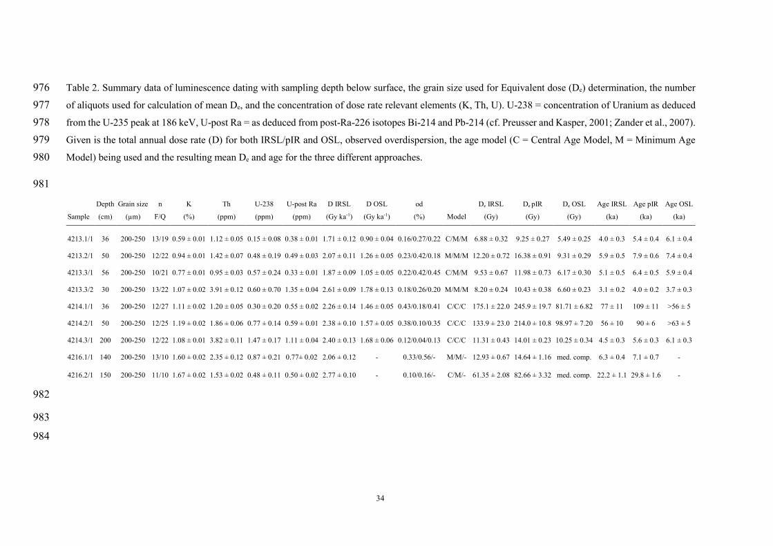
34
Table 2. Summary data of luminescence dating with sampling depth below surface, the grain size used for Equivalent dose (De) determination, the number 976 of aliquots used for calculation of mean De, and the concentration of dose rate relevant elements (K, Th, U). U-238 = concentration of Uranium as deduced 977 from the U-235 peak at 186 keV, U-post Ra = as deduced from post-Ra-226 isotopes Bi-214 and Pb-214 (cf. Preusser and Kasper, 2001; Zander et al., 2007). 978 Given is the total annual dose rate (D) for both IRSL/pIR and OSL, observed overdispersion, the age model (C = Central Age Model, M = Minimum Age 979 Model) being used and the resulting mean De and age for the three different approaches. 980
981
Sample
Depth
(cm)
Grain size
(µm)
n
F/Q
K
(%)
Th
(ppm)
U-238
(ppm)
U-post Ra
(ppm)
D IRSL
(Gy ka-1)
D OSL
(Gy ka-1)
od
(%)
Model
De IRSL
(Gy)
De pIR
(Gy)
De OSL
(Gy)
Age IRSL
(ka)
Age pIR
(ka)
Age OSL
(ka)
4213.1/1 36 200-250 13/19 0.59 ± 0.01 1.12 ± 0.05 0.15 ± 0.08 0.38 ± 0.01 1.71 ± 0.12 0.90 ± 0.04 0.16/0.27/0.22 C/M/M 6.88 ± 0.32 9.25 ± 0.27 5.49 ± 0.25 4.0 ± 0.3 5.4 ± 0.4 6.1 ± 0.4
4213.2/1 50 200-250 12/22 0.94 ± 0.01 1.42 ± 0.07 0.48 ± 0.19 0.49 ± 0.03 2.07 ± 0.11 1.26 ± 0.05 0.23/0.42/0.18 M/M/M 12.20 ± 0.72 16.38 ± 0.91 9.31 ± 0.29 5.9 ± 0.5 7.9 ± 0.6 7.4 ± 0.4
4213.3/1 56 200-250 10/21 0.77 ± 0.01 0.95 ± 0.03 0.57 ± 0.24 0.33 ± 0.01 1.87 ± 0.09 1.05 ± 0.05 0.22/0.42/0.45 C/M/M 9.53 ± 0.67 11.98 ± 0.73 6.17 ± 0.30 5.1 ± 0.5 6.4 ± 0.5 5.9 ± 0.4
4213.3/2 30 200-250 13/22 1.07 ± 0.02 3.91 ± 0.12 0.60 ± 0.70 1.35 ± 0.04 2.61 ± 0.09 1.78 ± 0.13 0.18/0.26/0.20 M/M/M 8.20 ± 0.24 10.43 ± 0.38 6.60 ± 0.23 3.1 ± 0.2 4.0 ± 0.2 3.7 ± 0.3
4214.1/1 36 200-250 12/27 1.11 ± 0.02 1.20 ± 0.05 0.30 ± 0.20 0.55 ± 0.02 2.26 ± 0.14 1.46 ± 0.05 0.43/0.18/0.41 C/C/C 175.1 ± 22.0 245.9 ± 19.7 81.71 ± 6.82 77 ± 11 109 ± 11 >56 ± 5
4214.2/1 50 200-250 12/25 1.19 ± 0.02 1.86 ± 0.06 0.77 ± 0.14 0.59 ± 0.01 2.38 ± 0.10 1.57 ± 0.05 0.38/0.10/0.35 C/C/C 133.9 ± 23.0 214.0 ± 10.8 98.97 ± 7.20 56 ± 10 90 ± 6 >63 ± 5
4214.3/1 200 200-250 12/22 1.08 ± 0.01 3.82 ± 0.11 1.47 ± 0.17 1.11 ± 0.04 2.40 ± 0.13 1.68 ± 0.06 0.12/0.04/0.13 C/C/C 11.31 ± 0.43 14.01 ± 0.23 10.25 ± 0.34 4.5 ± 0.3 5.6 ± 0.3 6.1 ± 0.3
4216.1/1 140 200-250 13/10 1.60 ± 0.02 2.35 ± 0.12 0.87 ± 0.21 0.77± 0.02 2.06 ± 0.12 - 0.33/0.56/- M/M/- 12.93 ± 0.67 14.64 ± 1.16 med. comp. 6.3 ± 0.4 7.1 ± 0.7 -
4216.2/1 150 200-250 11/10 1.67 ± 0.02 1.53 ± 0.02 0.48 ± 0.11 0.50 ± 0.02 2.77 ± 0.10 - 0.10/0.16/- C/M/- 61.35 ± 2.08 82.66 ± 3.32 med. comp. 22.2 ± 1.1 29.8 ± 1.6 -
982
983
984

35
Figures 985
Fig. 1. a) Digital elevation model of the Arabian Peninsula derived from SRTM data. 986
b) Palaeodrainage network and catchment areas of Wadi ad Dawasir and Wadi as 987
Sahba systems, including the locations of sites and Figs. 2 and 3 (superimposed over 988
SRTM elevation data, DEM on shaded-relief map). The DEM-derived drainage 989
network (contributing area of >150 km²) was combined and complemented by other 990
river courses than were inferred from the flow directions in areas with intermittent 991
dune coverage (see examples in Fig. 2). Large sink areas and dune-dominated areas 992
with interdune depressions deliver erroneous stream lines within the derived drainage 993
network and were removed. 994
995
996 997
998

36
Fig. 2. Example areas with only minor or incomplete sand coverage. Landsat 7 FCCs 999
clearly show a stark contrast between sand coverage and underlying palaeodrainage 1000
systems that were used to determine (A) and map (C) recent and palaeostream systems 1001
as well as flow directions (B) (RGB composites with a band combination of 7/4/2 and 1002
3/2/1, histograms are stretched to display extent). Digital elevation data and derived 1003
hillshade images were additionally used to retrace drainage systems if underlying 1004
palaeochannels lead to inverse topography (D) (SRTM DEM on shaded-relief map). 1005
1006
1007 1008

37
Fig. 3. Map of drainage network and catchment areas of downstream areas of Wadi ad 1009
Dawasir and Wadi as Sahba systems (superposed over SRTM elevation data, DEM on 1010
shaded-relief map). The Sahba fan acts as barrier forcing the Dawasir channels to flow 1011
eastwards into the western margin of the Sabkha Matti. The present day channel of 1012
Wadi as Sahba runs across the fan towards the Al Humr lake, but the large extent of 1013
the Sahba fan indicate a high erosion rate, high runoff and transport capacity in former 1014
times. 1015
1016
1017 1018
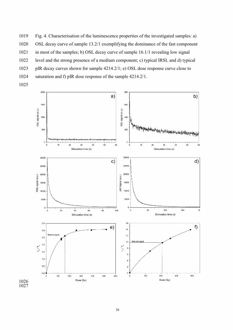
38
Fig. 4. Characterisation of the luminescence properties of the investigated samples: a) 1019
OSL decay curve of sample 13.2/1 exemplifying the dominance of the fast component 1020
in most of the samples; b) OSL decay curve of sample 16.1/1 revealing low signal 1021
level and the strong presence of a medium component; c) typical IRSL and d) typical 1022
pIR decay curves shown for sample 4214.2/1; e) OSL dose response curve close to 1023
saturation and f) pIR dose response of the sample 4214.2/1. 1024
1025
1026 1027

39
Fig. 5. Two examples of OSL De distributions for samples a) 4213.1/1 and b) 4213.3/3. 1028
1029
1030 1031
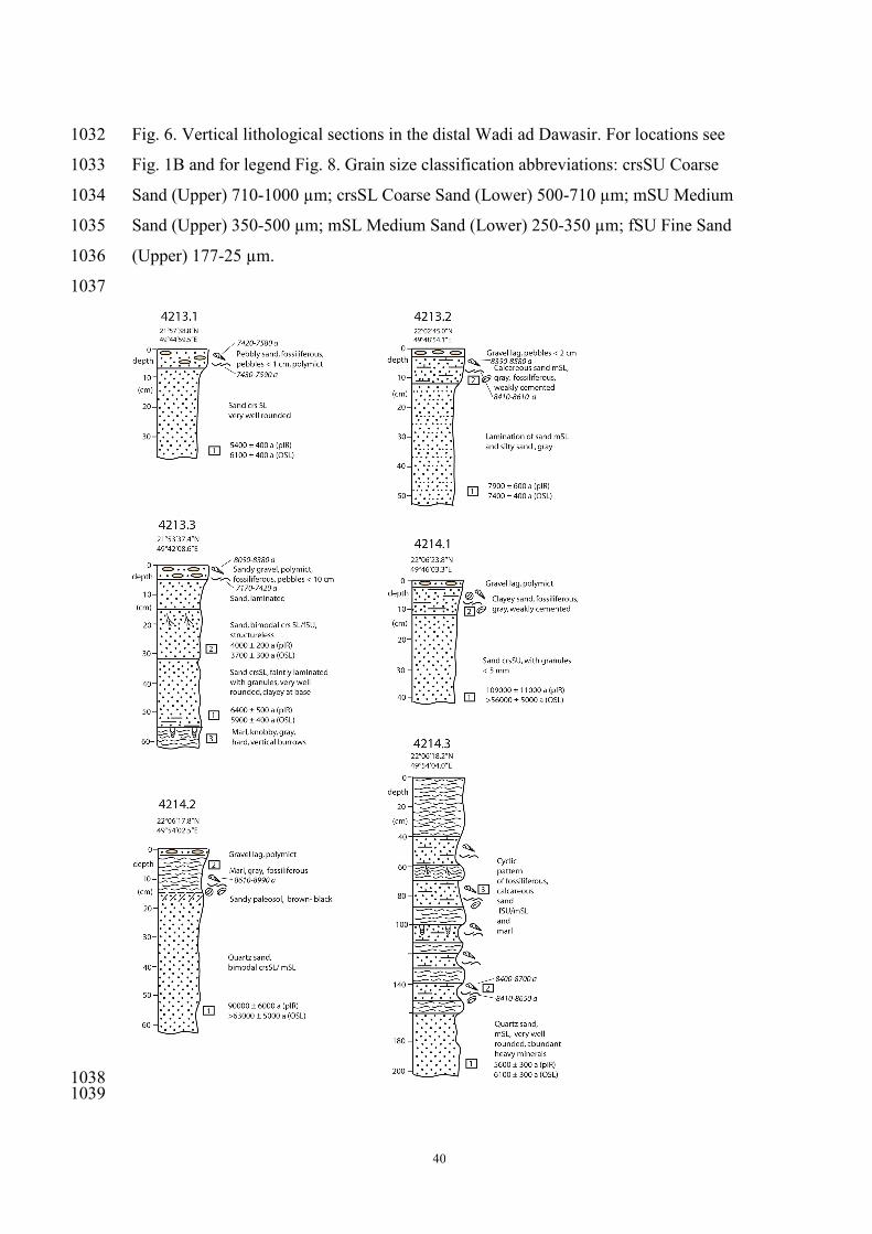
40
Fig. 6. Vertical lithological sections in the distal Wadi ad Dawasir. For locations see 1032
Fig. 1B and for legend Fig. 8. Grain size classification abbreviations: crsSU Coarse 1033
Sand (Upper) 710-1000 µm; crsSL Coarse Sand (Lower) 500-710 µm; mSU Medium 1034
Sand (Upper) 350-500 µm; mSL Medium Sand (Lower) 250-350 µm; fSU Fine Sand 1035
(Upper) 177-25 µm. 1036
1037
1038 1039

41
Fig. 7. Bing map satellite view showing location of site 4213.3 in Holocene channel 1040
partly covered by younger linear dune (A), photographs showing surface with pebble 1041
lag, M. tuberculata and U. tigridis in-situ position measuring 4 cm (B) of relict channel 1042
at site 4213.2 (C). Outcrop view of relict lacustrine section site 4214.3 measuring 2 1043
metres (D). Photograph of vertical fluvial section in lower terrace at site 4216.1 in 1044
Wadi at Tathlith with pedogenic horizons. Note hammer for scale (E). Panoramic view 1045
looking E across ponded Holocene alluvial sandy silts in Wadi at Tathlith, 30 km 1046
upstream of site 4216.1 (F). 1047
1048
1049 1050
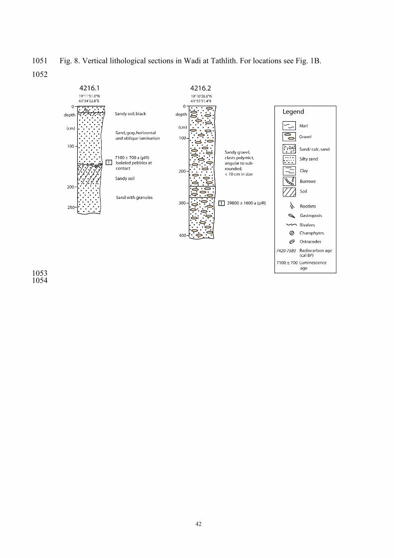
42
Fig. 8. Vertical lithological sections in Wadi at Tathlith. For locations see Fig. 1B. 1051
1052
1053 1054

43
Fig. 9. OSL and pIR ages plotted in comparison to radiocarbon ages and revealing the 1055
substantial off-set between the methods. A significant calcite contribution indicates 1056
post-depositional precipitation of carbonates for sample 4213.3 Melanoides 1057
tuberculata. The curve on top is the isotope signature of a stalagmite from Qunf cave 1058
(Fleitmann et al., 2007), showing the gradual decrease in precipitation in southern 1059
Arabia during the middle Holocene. 1060
1061
1062