Re-evaluation for I-75 Widening and Reconstruction · PDF file1 Re-evaluation for I 75...
33
1 Re-evaluation for I-75 Widening and Reconstruction Project December 17, 2015 The Michigan Department of Transportation (MDOT), in consultation with the Federal Highway Administration (FHWA), is conducting an administrative re-evaluation of the Environmental Impact Statement (EIS) for the modernization of I-75 from M-102 to M-59 in Oakland County, Michigan, per 23 CFR 771.129(c). General Project Description & NEPA History The I-75 Modernization Project is the culmination of over 20 years of planning and design. The purpose and need for the widening and reconstruction of 18 miles of freeway in Oakland County is to improve and increase the capacity of the I-75 roadway, interchanges and ramps to support the mobility needs of local and interstate commerce as well as national and civil defense; and to accommodate existing and future traffic, population and employment growth, land use changes, safety issues and to reduce congestion along the I-75 corridor. The proposed project is in Southeast Michigan Council of Governments (SEMCOG) 2040 Regional Transportation Plan and the 2014- 2017 Transportation Improvement Program (TIP). Current plans are for the entire I-75 Modernization project to be constructed in 8 segments. The I-75 Modernization Project improvements include: Constructing a new lane in each direction on I-75 between M-102 and South Boulevard. The new lane would be dedicated to high-occupancy vehicles (HOV) for use during morning and afternoon peak travel periods, and then operate as a regular lane in the remaining hours. Reconstructing the remaining three lanes of pavement. Upgrading and adding ITS technologies. Reconstructing ramp improvements at the I-696 on ramp and 11 Mile Road exit ramp with I-75 northbound (I-696 on-ramp braids over the 11 Mile Road off-ramp). Reconstructing the interchanges at 12 Mile Road and 14 Mile Road. Modernizing the Square Lake Road interchange. Upgrading road geometrics. Constructing a new storm water sewer system. Replacing pedestrian bridges to meet ADA requirements. Replacing all vehicular bridges. Incorporating community developed aesthetics. The first segment to be constructed is I-75 from north of Coolidge Road to north of South Boulevard in Bloomfield Township, Oakland County, which is 2.69 miles in length. Construction is expected to start in 2016. The planned improvements for the first segment include: Constructing an additional HOV Lane.
-
Upload
nguyennguyet -
Category
Documents
-
view
215 -
download
0
Transcript of Re-evaluation for I-75 Widening and Reconstruction · PDF file1 Re-evaluation for I 75...
1
Re-evaluation for I-75 Widening and Reconstruction Project
December 17, 2015
The Michigan Department of Transportation (MDOT), in consultation with the Federal Highway
Administration (FHWA), is conducting an administrative re-evaluation of the Environmental
Impact Statement (EIS) for the modernization of I-75 from M-102 to M-59 in Oakland County,
Michigan, per 23 CFR 771.129(c).
General Project Description & NEPA History
The I-75 Modernization Project is the culmination of over 20 years of planning and design. The
purpose and need for the widening and reconstruction of 18 miles of freeway in Oakland County
is to improve and increase the capacity of the I-75 roadway, interchanges and ramps to support the
mobility needs of local and interstate commerce as well as national and civil defense; and to
accommodate existing and future traffic, population and employment growth, land use changes,
safety issues and to reduce congestion along the I-75 corridor. The proposed project is in Southeast
Michigan Council of Governments (SEMCOG) 2040 Regional Transportation Plan and the 2014-
2017 Transportation Improvement Program (TIP).
Current plans are for the entire I-75 Modernization project to be constructed in 8 segments. The
I-75 Modernization Project improvements include:
Constructing a new lane in each direction on I-75 between M-102 and South Boulevard.
The new lane would be dedicated to high-occupancy vehicles (HOV) for use during
morning and afternoon peak travel periods, and then operate as a regular lane in the
remaining hours.
Reconstructing the remaining three lanes of pavement.
Upgrading and adding ITS technologies.
Reconstructing ramp improvements at the I-696 on ramp and 11 Mile Road exit ramp with
I-75 northbound (I-696 on-ramp braids over the 11 Mile Road off-ramp).
Reconstructing the interchanges at 12 Mile Road and 14 Mile Road.
Modernizing the Square Lake Road interchange.
Upgrading road geometrics.
Constructing a new storm water sewer system.
Replacing pedestrian bridges to meet ADA requirements.
Replacing all vehicular bridges.
Incorporating community developed aesthetics.
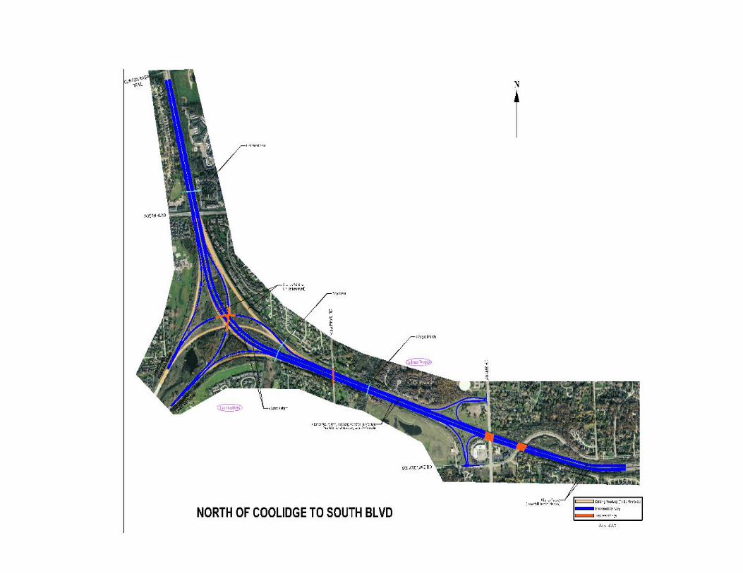
The first segment to be constructed is I-75 from north of Coolidge Road to north of South
Boulevard in Bloomfield Township, Oakland County, which is 2.69 miles in length. Construction
is expected to start in 2016.
The planned improvements for the first segment include:
Constructing an additional HOV Lane.

2
Reconfiguring Square Lake Road interchange to include right off- and on-ramps and
removal of the left off- and on-ramps.
Reconstructing existing freeway lanes.
Replacing bridges (Adams Road, Squirrel Road and Square Lake Road).
Upgrading existing Adams Road carpool lot.
Improving the drainage system.
Connecting the sidewalk with safety paths on Squirrel Road.
Incorporating community developed aesthetic improvements.
The project’s NEPA history includes:
Approval of a Draft Environmental Impact Statement (DEIS) by FHWA in December
2003.
Final EIS was approved by FHWA in May 2005.
FHWA issued a Record of Decision (ROD) in January 2006.
Engineering Report (ER) for I-75 from South Boulevard to 12 Mile Road was completed
for the selected alternative in 2009.
Engineering Report for I-75 from M-102 to 12 Mile Road was completed for the selected
alternative in 2010.
Interstate Access Justification Report (IAJR) was approved in 2006.
IAJR Report for Square Lake Interchange Modernization was prepared in November 2015.
Basis for the Re-Evaluation
MDOT is required to perform a re-evaluation of the I-75 EIS before each phase of the project. Per
23 CFR 771.129, a re-evaluation of the NEPA EIS is required prior to FHWA taking an action on
the project. A re-evaluation considers changes in the project’s design, laws and regulations, and
determines as to whether the NEPA document is still valid or needs to be supplemented.
Purpose and Need for the Project ROD
The purpose and need for widening and reconstructing the I-75 Freeway in Oakland County is still
valid. The freeway was built in the 1960s and has not received comprehensive corridor
improvements since that time. The project’s purpose and need is to improve the condition and
capacity of the I-75 roadway, interchanges and ramps to support the mobility needs of local and
interstate commerce as well as national and civil defense; and to accommodate existing and future
traffic within the corridor, population and employment growth, land use changes, safety issues and
to reduce congestion along the I-75 corridor.
Condition
The condition of the existing pavement on I-75 varies from fair to poor condition from north of
Coolidge Road to north of South Boulevard in the project corridor. The existing conditions are
based on the Remaining Service Life (RSL) pavement analysis that was conducted in 2014. The
existing pavement will need to be replaced in the future.
3
The existing structures that will be replaced as part of the first construction segment include:
NB I-75 over Square Lake Road
SB I-75 over Square Lake Road
NB I-75 over Adams Road
SB I-75 over Adams Road
Squirrel Road over I-75
Square Lake Road (I-75 BL) Interchange
The condition ratings for these structures are based on the National Bridge Inventory (NBI) rating
scale. The rating scale ranges from 0 to 9, with 0 - being failed condition, 5- being fair condition
and 9- being excellent condition. The Northbound and Southbound I-75 structure over Square
Lake Road has a rating of 5, while the Northbound and Southbound I-75 structure over Adams
Road has a rating of 6. The Squirrel Road structure over I-75 has a rating of 7, while the Square
Lake Road (I-75 BL) Interchange has a rating of 5. The structures were last inspected in 2013.
Capacity
Based on a recent traffic analysis (2014) which included a capacity review of the I-75 corridor, the
proposed lane addition/HOV lane and other safety improvements are still needed in order
to provide additional capacity to support the mobility needs of local and interstate commerce; and
to accommodate population and employment growth, address safety issues and reduce congestion
along the I-75 corridor. Several tables are included in Appendix B which shows the Existing, No-
Build and Build scenarios. The Average Daily Traffic (ADT) has increased with the Build
scenario; and the Level of Service (LOS) at I-75 and Square Lake Road Interchange has improved.
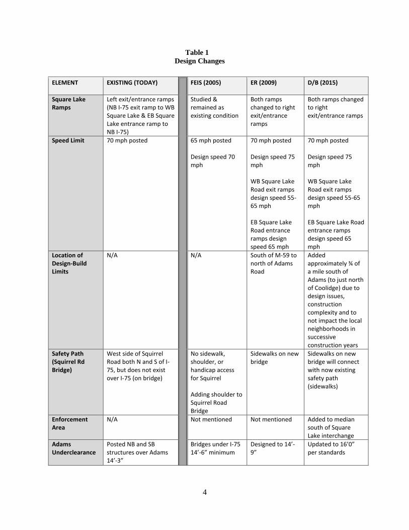
Changes in Design
Since the completion of the EIS/ROD and ER, MDOT has made several design changes that will
address safety concerns on the Square Lake Ramps. Two of the Square Lake Road interchange
ramps will be modernized from left-on and left-off to right-on and right-off. In the FEIS, the right-
on and right-off ramps were studied; however, based on information from that initial review, it
was decided to keep the left-on and left-off ramps due to potential right-of-way concerns at the
time. However, during the ER, a more in-depth analysis has occurred and the right-on and right-
off ramps were studied in depth, and it was determined that additional right-of-way would not be
needed and the interchange could be modernized. Based on the results of this analysis, the right-
on and right-on ramps were documented in the ER and further studied and updated in the recently
submitted IAJR (2015) for approval. The 2035 traffic was updated and is included in Appendix C.
On Squirrel Road, a safety path (sidewalk) will be added to the new bridge and will connect to an
existing safety path (sidewalk) on the west side of the roadway to accommodate non-motorized
pedestrians. The history of the design changes are shown in Table 1.
4
Table 1
Design Changes
ELEMENT EXISTING (TODAY) FEIS (2005) ER (2009) D/B (2015)
Square Lake Ramps
Left exit/entrance ramps (NB I-75 exit ramp to WB Square Lake & EB Square Lake entrance ramp to NB I-75)
Studied & remained as existing condition
Both ramps changed to right exit/entrance ramps
Both ramps changed to right exit/entrance ramps
Speed Limit 70 mph posted 65 mph posted Design speed 70 mph
70 mph posted Design speed 75 mph WB Square Lake Road exit ramps design speed 55- 65 mph EB Square Lake Road entrance ramps design speed 65 mph
70 mph posted Design speed 75 mph WB Square Lake Road exit ramps design speed 55-65 mph EB Square Lake Road entrance ramps design speed 65 mph
Location of Design-Build Limits
N/A N/A South of M-59 to north of Adams Road
Added approximately ¾ of a mile south of Adams (to just north of Coolidge) due to design issues, construction complexity and to not impact the local neighborhoods in successive construction years
Safety Path (Squirrel Rd Bridge)
West side of Squirrel Road both N and S of I-75, but does not exist over I-75 (on bridge)
No sidewalk, shoulder, or handicap access for Squirrel Adding shoulder to Squirrel Road Bridge
Sidewalks on new bridge
Sidewalks on new bridge will connect with now existing safety path (sidewalks)
Enforcement Area
N/A Not mentioned Not mentioned Added to median south of Square Lake interchange
Adams Underclearance
Posted NB and SB structures over Adams 14’-3”
Bridges under I-75 14’-6” minimum
Designed to 14’-9”
Updated to 16’0” per standards
5
Right of way
The first segment of the I-75 Modernization Project will not require fee right-of-way.
Wetland Impacts and Mitigation
In the Square Lake Road interchange, between 0.41 to 0.87 acres of Palustrine Emergent
(PEM) and Palustrine Shrub/Scrub (PSS) wetlands will be directly affected by the project.
The impacted wetlands will be mitigated at a 1.5 to 1 ratio. Approximately 0.62 acres of wetlands
have been credited to a mitigation site that was constructed in Armada Township in Macomb
County, Michigan. The Michigan Department of Environmental Quality (MDEQ) approved the
use of the Armada site in a letter dated December 21, 2004. The letter was included in the FEIS
(Section 6.4, Letter 6c). The permit was issued by MDEQ in September 2015.
Culvert Replacement
Two existing culverts within the Sprague Drain and Amy Drain will need to be removed and
replaced. The removal and replacement of the culverts was included in the Final Environmental
Impact Statement and are included in the permit that MDEQ issued.
Tree Removal
Mature trees that are determined to be desired and healthy will be preserved within MDOT’s
right-of-way (principally at fence lines), where safety requirements are met. Property
owners will be notified before any trees in front of their residences are removed and will
be offered replacement trees. Native vegetation will be considered in plantings, wherever
possible.
Maintaining Traffic during Construction
During construction of the first segment, two lanes of traffic on I-75 will remain open
in each direction.
Air Quality
The re-evaluation of the Air Quality analysis was conducted for the entire I-75 Corridor.
A re-analysis of the I-75 Modernization air quality analysis (2003) was completed to confirm that
it meets current conformity requirements as defined in the 1990 Clean Air Act, as amended. There
had been significant regulation and air emissions model changes for determining project level air
quality conformity since the signing of the Final Environmental Impact Statement (FEIS) in May
2005. The details of the analysis are presented in the accompanying Air Quality Report.
The EPA introduced a new emissions model titled the Motor Vehicle Emissions Simulator
(MOVES) in 2010 and mandated its use after December 20, 2012 for coarse and fine particulate
matter (PM10 and PM2.5 respectively) and carbon monoxide (CO) quantitative hot-spot analysis.
6
Interagency consultation is a necessary element in determining whether a project is one of local
air quality concern and, if so, to choose the methods and models in the hot-spot analyses. The
EPA simultaneously mandated quantitative mobile source air toxics (MSAT) project level analysis
using the MOVES model. FHWA’s “Interim Guidance Update on Mobile Source Air Toxics
Analysis in NEPA” provides procedures for conducting an MSAT analysis. The reanalysis
considered carbon monoxide (CO), fine particulate matter (PM2.5) and mobile source air toxics
(MSAT).
For the CO analysis, the intersections with the highest traffic volumes and the worst Level of
Service (LOS) were analyzed using the Federal Highway Administration (FHWA) “CO Tool.”
The results were found to be within the acceptable range, meaning there could be a categorical
finding that CO is not an issue. This means a more detailed quantitative hotspot analysis using
CAL3QHC modeling is not needed. The Southeast Michigan Council of Governments
(SEMCOG) Inter-Agency Working Group (IAWG)1 determined on May 27, 2014 that the use of
the CO categorical hot-spot finding is appropriate for the project, verifying the analysis. This
finding is consistent with the finding in the FEIS.
PM2.5 represents a class of fine particulate matter that is a health risk. At its meeting on October
29, 2013, the IAWG determined the I-75 Modernization Project to be “not of local air quality
concern.” As a consequence of the IAWG finding, no PM2.5 hot-spot analysis is required. PM2.5
was not subject to analysis at the time of the FEIS.
The MSAT emissions analysis followed the procedures outlined in FHWA’s “Interim Guidance
Update on Mobile Source Air Toxics Analysis in NEPA.” The analysis concludes that reductions
in MSAT emissions will occur in the project area regardless of whether the project is
constructed. Small differences in emissions will occur between the Build and No-Build
scenarios. However as compared to 2010 levels, emissions are reduced by 86 percent in the Build
scenario and 82 percent in the No-Build scenario. At the time of the FEIS no method had yet been
developed to calculate air toxics.
With the addition of capacity, geometric design improvements and general modernization of the
corridor, the I-75 Modernization Project will not degrade air quality within the project corridor,
which is supported by the results of the federally required analyses completed and reevaluated.
The improvements will allow traffic to move more efficiently with less congestion, resulting in
improved air quality within the corridor.
1 1 The SEMCOG transportation conformity process is overseen by the Inter-Agency Working Group (IAWG). This group is composed of representatives from the Federal Highway Administration, the Federal Transit Administration, the U.S. Environmental Protection Agency, the Michigan Department of Environmental Quality, the Michigan Department of Transportation and The Southeast Michigan Council of Governments (SEMCOG). Whenever SEMCOG’s long-range plan or Transportation Improvement Program is developed or amended, the IAWG meets to determine whether a new conformity analysis is needed and, if so, which specific projects must be analyzed. The final determination on whether any particular project must be analyzed rests with the IAWG.
7
Noise
The re-evaluation of the noise analysis was conducted for the entire I-75 Corridor. In the first
construction segment there will be no additional noise walls built and the existing noise walls will
not be impacted.
A reevaluation of the I-75 Modernization noise abatement analysis (Traffic Noise Analysis Report
- January 2015) was completed to confirm that the abatement recommended in the January 2006
Record of Decision (ROD) met the revised 23 CFR 772 (2010) and MDOT Highway Noise
Analysis and Abatement Handbook (MDOT Noise Handbook), implemented in July 2011. The
most noteworthy changes in 23 CFR 772 included expanding the Noise Abatement Criteria from
five to seven land use categories, how dwelling unit equivalents (DUE) are calculated, how
“feasibility and reasonableness” are determined, and the required use of the FHWA Traffic Noise
Model version 2.5 (TNM2.5). The details of the reevaluation analysis are presented in the
accompanying Traffic Noise Analysis Report and conform to the MDOT Noise Handbook.
This updated analysis used a newer version of the Transportation Noise Model (TNM), Version
2.5, rather than Version 2.1. The newer version has been widely vetted and found to be more
accurate than the earlier version. The horizontal and vertical clearance of the design has been
refined since the FEIS, and traffic projections have changed, but not significantly. The speed limit
is higher in the north end of the corridor than the previous 2005 analysis.
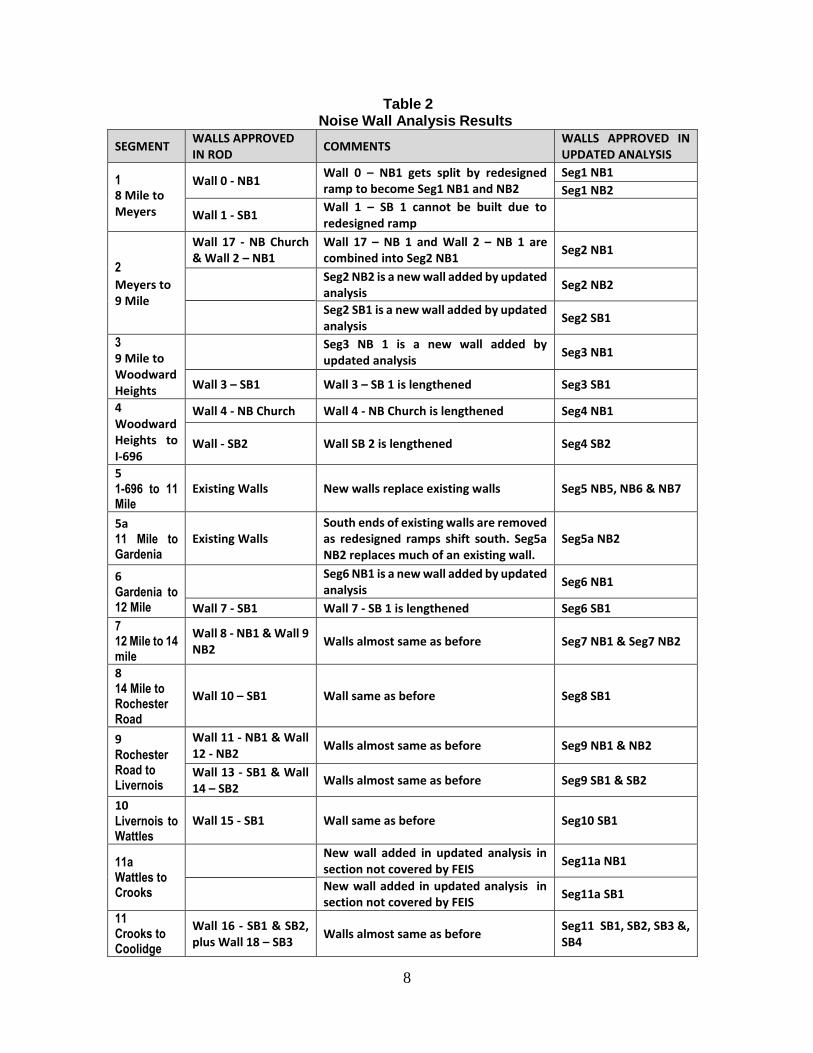
This analysis found earlier walls are still feasible and reasonable. Exceptions include locations
where post ROD engineering shifted ramps in such a way that the ramps occupy the space where
a wall had previously been planned. Table 2 (next page) illustrates the abatement changes in the
re-evaluation from the FEIS/ROD. The table lists the noise walls found to be feasible and
reasonable in the ROD in the second column. The next column explains why a change occurred.
The last column provides the current status with the updated analysis.
The total noise wall construction length at the time of the ROD was 4.9 miles. With this analysis,
the wall length has increased to 7.3 miles. In some cases, new walls were identified and some
walls formerly considered separately were combined in a way that abatement criteria are still met.
The revised 23 CFR 772.13(g) (3) requires the inclusion of the following statement of likelihood
with the recommended abatement.
Statement of Likelihood
Based on the studies thus far accomplished, the Michigan Department of Transportation
intends to install highway traffic noise abatement in the form of barriers listed in Table 2.
The preliminary indications of likely abatement measures are based on preliminary design
for barrier costs and noise reduction as reported in Section 5 of the accompanying Traffic
Noise Analysis Report. If it subsequently develops during final design that these
conditions have substantially changed, the abatement measures might not be provided. A
final decision of the installation and aesthetics of the abatement measures will be made
upon completion of the project’s final design and the Context Sensitive Design process.
8
Table 2
Noise Wall Analysis Results
SEGMENT WALLS APPROVED IN ROD
COMMENTS WALLS APPROVED IN UPDATED ANALYSIS
1 8 Mile to Meyers
Wall 0 - NB1 Wall 0 – NB1 gets split by redesigned ramp to become Seg1 NB1 and NB2
Seg1 NB1
Seg1 NB2
Wall 1 - SB1 Wall 1 – SB 1 cannot be built due to redesigned ramp
2
Meyers to 9 Mile
Wall 17 - NB Church & Wall 2 – NB1
Wall 17 – NB 1 and Wall 2 – NB 1 are combined into Seg2 NB1
Seg2 NB1
Seg2 NB2 is a new wall added by updated analysis
Seg2 NB2
Seg2 SB1 is a new wall added by updated analysis
Seg2 SB1
3
9 Mile to Woodward Heights
Seg3 NB 1 is a new wall added by updated analysis
Seg3 NB1
Wall 3 – SB1 Wall 3 – SB 1 is lengthened Seg3 SB1
4 Woodward Heights to I-696
Wall 4 - NB Church Wall 4 - NB Church is lengthened Seg4 NB1
Wall - SB2 Wall SB 2 is lengthened Seg4 SB2
5 1-696 to 11 Mile
Existing Walls New walls replace existing walls Seg5 NB5, NB6 & NB7
5a 11 Mile to Gardenia
Existing Walls South ends of existing walls are removed as redesigned ramps shift south. Seg5a NB2 replaces much of an existing wall.
Seg5a NB2
6 Gardenia to 12 Mile
Seg6 NB1 is a new wall added by updated analysis
Seg6 NB1
Wall 7 - SB1 Wall 7 - SB 1 is lengthened Seg6 SB1
7 12 Mile to 14 mile
Wall 8 - NB1 & Wall 9 NB2
Walls almost same as before Seg7 NB1 & Seg7 NB2
8 14 Mile to Rochester Road
Wall 10 – SB1 Wall same as before Seg8 SB1
9 Rochester Road to Livernois
Wall 11 - NB1 & Wall 12 - NB2
Walls almost same as before Seg9 NB1 & NB2
Wall 13 - SB1 & Wall 14 – SB2
Walls almost same as before Seg9 SB1 & SB2
10 Livernois to Wattles
Wall 15 - SB1 Wall same as before Seg10 SB1
11a Wattles to Crooks
New wall added in updated analysis in section not covered by FEIS
Seg11a NB1
New wall added in updated analysis in section not covered by FEIS
Seg11a SB1
11 Crooks to Coolidge
Wall 16 - SB1 & SB2, plus Wall 18 – SB3
Walls almost same as before Seg11 SB1, SB2, SB3 &, SB4
9
Northern Long-Eared Bat and the Indiana Bat
The first segment of the I-75 Modernization Project will require the removal of tree(s) that could
provide roosting habitat for the listed Indiana Bat (Myotis sodalis) and the Northern Long Eared
Bat, consultation under Section 7 of the Endangered Species Act of 1973, as amended is required.
(See Appendix D for Consultation letter to the United States Fish and Wildlife Service (USFWS).
Based upon previous discussions with the FWS and the information known about the species,
threshold for “likely to affect, but not adversely affect” have been established. MDOT has
recommended the following guidance be used for tree removals:
1.) No more than 10% of the suitable habitat for the species will be cut within a half
mile buffer surrounding the project.
2.) Cutting of more than 10 acres per project is not allowed.
By following these restrictions, potential impacts to the species will be eliminated.
MDOT’s Environmental Specialist and Mitigation Follow-up Specialist will be responsible for
tracking the mitigation measures listed below:
Assume that all trees within the project ROW would be removed.
All tree removals would be undertaken between the dates of October 1 and March 31 of
the year(s) the project is under construction.
Tree removals would not represent more than 10% of the total forested cover within the
ROW and 0.5 mile buffer from the project limits.
Tree removals will not be greater than a total of 10 acres for any single project.
MDOT has received concurrence from the USFWS indicating that the proposed project “is not
likely to adversely affect” the Indiana Bat and the Northern Long-eared Bat under information
conference (See Appendix D – Concurrence letter from the USFWS).
Community Developed Aesthetic Improvements
A series of workshops were held with the community in identifying various types of aesthetic
improvements for the first phase of the I-75 Modernization Project. Public workshops were held
in November 2013, February 2014, and June 2014. Steering Committee meetings were also held
with the communities adjacent to the I-75 corridor, on August 2013, October 2013, November
2013, December 2013, March 2014, and May 2014.
Aesthetic improvements for the first phase of I-75 include the following:
Cross street bridges with decorative wing walls, railings, fencing, pilasters, sidewalks and
identifiers.
Main line bridges with ornamented columns, barrier railings, wing walls, decorative
abutment faces, underpass slope paving and sidewalks under roadways.
10
Flyover bridge (Square Lake) which is similar to a main line bridge, but with a hammer
head style pier.
Carpool lot with enhancements such as perimeter decorative walls and/or fencing,
identifier signing and HOV enhancement/sculpture.
Corridor landscaping within the freeway right-of-way for interchanges with significant
green space and carpool lots.
Color palette of medium browns and greys.
Changes in Laws or Regulations
There had been significant regulation and air emissions model changes for determining project
level air quality conformity since the signing of the Final Environmental Impact Statement (FEIS)
in May 2005. In 2010, EPA introduced a new emissions model titled the Motor Vehicle Emissions
Simulator (MOVES) and mandated its use after December 20, 2012 for coarse and fine particulate
matter (PM10 and PM2.5 respectively) and carbon monoxide (CO) quantitative hot-spot analysis.
Interagency consultation is a necessary element in determining whether a project is one of local
air quality concern and, if so, to choose the methods and models in the hot-spot analyses. The
EPA simultaneously mandated quantitative mobile source air toxics (MSAT) project level analysis
using the MOVES model. FHWA’s “Interim Guidance Update on Mobile Source Air Toxics
Analysis in NEPA” provides procedures for conducting an MSAT analysis. The reanalysis
considered carbon monoxide (CO), fine particulate matter (PM2.5) and mobile source air toxics
(MSAT).
In February 2011, Code of Federal Regulations Title 23 Part 772 (23 CFR 772), Procedures for
Abatement of Highway Traffic Noise and Construction Noise, was revised. This revision in noise
policy and procedures was implemented on July 13, 2011, through revised FHWA guidance and
MDOT’s Highway Noise Analysis and Abatement Handbook. The new regulations require a noise
impact and abatement analysis for new or significantly altered highway projects (i.e., new
interchange or adding capacity to the interstate).
Since the publication of the EIS and Re-evaluation, the U.S. Fish and Wildlife Service (USFWS)
listed the northern long-eared bat (Myotis septentrionalis); NLEB) as a threatened species under
the Endangered Species Act (ESA). In April 2015, the northern long-eared bat was listed as
threatened species, where the protections and requirements of the ESA would be effective within
30 days of publication of the Final Rule.

12
Page intentionally left blank

13
APPENDIX A
Aerial Map of First Segment

14
Page intentionally left blank
2

16
Page intentionally left blank
17
APPENDIX B
I-75 Traffic Information
For
First Segment

18
Page intentionally left blank
19
The following tables contain traffic information for I-75 from mile point 14.967 to mile point
17.132 in Oakland County. Current traffic volumes were calculated from hose counts taken
between 2000 and 2014 and 2013 Sufficiency Guide data. A growth rate of 0.5% was used
to calculate future traffic volume. This number is based on past growth, regression analysis
and population projections
in Oakland County.
I-75 Rigid Flexible
Growth Rate 0.85% 0.85%
Growth Type Compound Compound
Initial Yearly 18-kip ESAL (both directions) 2,232,970 1,435,480
Direction Distribution Factor 51% 51%
Lane Distribution Factor 86% 86%
Total 18 Kip Axle Loadings 21,252,970 13,662,620
The following tables contain the traffic information for the ramps on I-75 in Oakland County.
Current traffic volumes were calculated from hose counts taken between 2011 and 2014. A
growth rate of 0.5% was used to calculate future traffic volume. This number is based on
past growth, regression analysis and population projections in Oakland County.
Adams Rd NB On 2014 2016 2035
Total Average Daily Traffic (ADT) 3,825 3,850 4,225
Adams Rd NB Off 2014 2016 2035
Total Average Daily Traffic (ADT) 2,600 2,625 2.875
Adams Rd SB On 2014 2016 2035
Total Average Daily Traffic (ADT) 3,600 3,625 3,975
Adams Rd SB Off 2014 2016 2035
Total Average Daily Traffic (ADT) 2,950 2,975 3,275
I-75 2014 2016 2035
Total Average Daily Traffic (ADT) 112,050 113,175 124,425
Directional ADT 56,025 56,600 62,225
% Commercial of ADT 6.5%
20
Square Lake Rd NB On 2014 2016 2035
Total Average Daily Traffic (ADT) 27,250 27,525 30,275
Square Lake Rd NB Off 2014 2016 2035
Total Average Daily Traffic (ADT) 9,100 9,200 10,100
Square Lake Rd SB On 2014 2016 2035
Total Average Daily Traffic (ADT) 7,575 7,650 8,425
Square Lake Rd SB Off 2014 2016 2035
Total Average Daily Traffic (ADT) 18,475 18,675 20,525
Major Diverge Analysis of Existing, No Build and Build
21
APPENDIX C
2015 Traffic Update

22
Page intentionally left blank
23
Memorandum
To: Sue Datta, AICP
From: Barbara Arens, PE, PTOE
Lauren Warren, PE, PTOE
Date: October 8, 2014
Subject: I-75 at Square Lake Road Interchange Access Justification Report – 2035 Updates
The I-75 at Square Lake Road Interchange Access Justification Report (IAJR) was written by URS Corporation in December 2009. The IAJR was written as a supplement to the FEIS document and documented the proposed modifications to interstate access at the I-75/Square Lake interchange. The FEIS document and calculations utilized a build out year of 2025. However, based on required approval from the Federal Highway Administration (FHWA), MDOT and the Southeast Michigan Council of Governments (SEMCOG) the future design year was revised to a build out year of 2035 for an update. Thus, all subsequent reports have used 2035 as the design year. As a result, the original reported volumes and LOS presented in the IAJR need to be compared with those from the approved build year of 2035 to ensure that the analysis remains valid.
The following two tables present the comparisons for mainline and ramps within the I-75/ Square Lake interchange area for the original build year 2025 and the approved build year 2035. The existing 2012 results are also presented for reference. The 2025 results utilized HCS2000 software. However, the 2035 results utilized updated HCS2010 software for the analysis. Very few conclusions changed as a result of this software update.
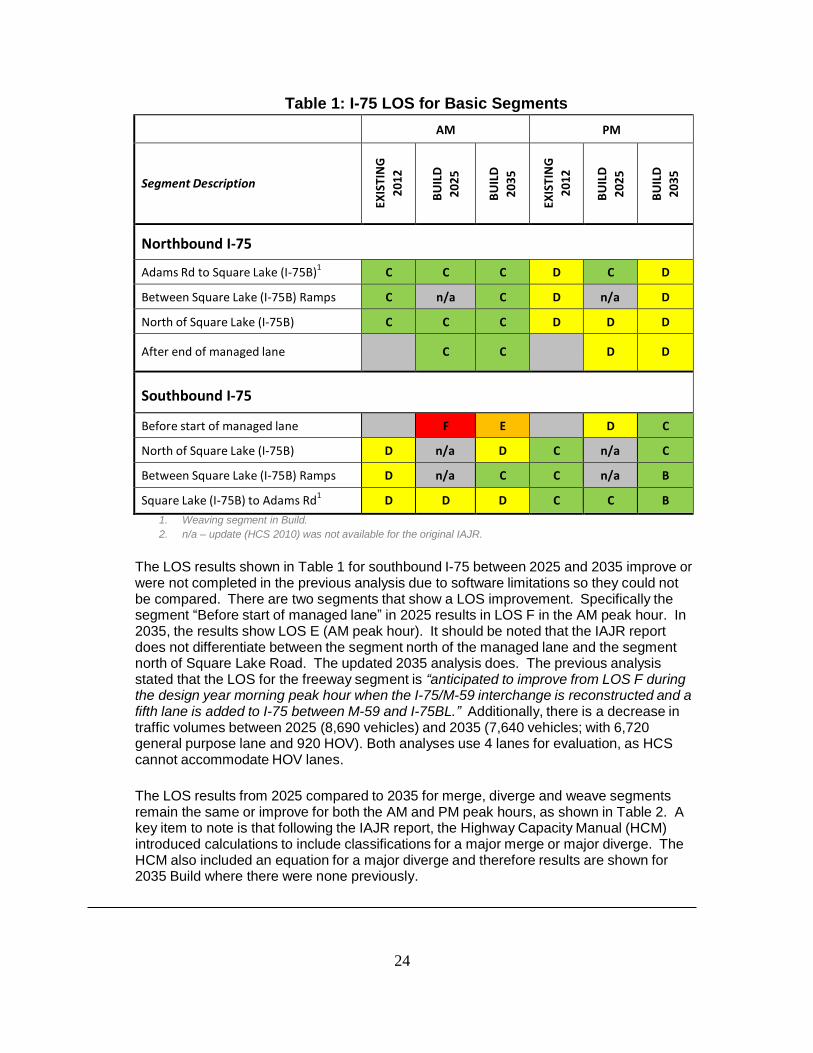
Table 1 provides the I-75 level of service (LOS) results for the basic freeway segments for the existing 2012, Build 2025, and Build 2035 traffic volumes in the AM and PM peak hours of the day. The LOS results for northbound I-75 between 2025 and 2035 remain the same in both the AM and PM peak hours, with the exception of one segment from northbound I-75 Adams Road to Square Lake Road. In 2025 it was calculated to have a LOS C. In the updated 2035 it is calculated as a LOS D in the PM peak hour. However, it should be noted that the existing 2002 and 2012 calculations also show LOS D. Therefore, the 2035 condition remains the same as the existing condition. The reason for the discrepancy is the original HCS software assessed it as a basic segment. In the updated HCS software it was analyzed as a weave segment. Also traffic volumes between 2025 and 2035 increased. The 2025 northbound traffic projections were for 5,830 vehicles in 2025. The 2035 northbound traffic projections have 6,670 general purpose vehicles and 890 HOV vehicles, resulting in a change in LOS from C to D.
24
Table 1: I-75 LOS for Basic Segments
AM PM
Segment Description
EXIS
TIN
G
201
2
B
UIL
D
20
25
BU
ILD
20
35
EXIS
TIN
G
201
2
BU
ILD
20
25
BU
ILD
20
35
Northbound I-75
Adams Rd to Square Lake (I-75B)1
C C C D C D
Between Square Lake (I-75B) Ramps C n/a C D n/a D
North of Square Lake (I-75B) C C C D D D
After end of managed lane
C
C
D
D
Southbound I-75
Before start of managed lane F E D C
North of Square Lake (I-75B) D n/a D C n/a C
Between Square Lake (I-75B) Ramps D n/a C C n/a B
Square Lake (I-75B) to Adams Rd1
D D D C C B
1. Weaving segment in Build.
2. n/a – update (HCS 2010) was not available for the original IAJR.
The LOS results shown in Table 1 for southbound I-75 between 2025 and 2035 improve or were not completed in the previous analysis due to software limitations so they could not be compared. There are two segments that show a LOS improvement. Specifically the segment “Before start of managed lane” in 2025 results in LOS F in the AM peak hour. In 2035, the results show LOS E (AM peak hour). It should be noted that the IAJR report does not differentiate between the segment north of the managed lane and the segment north of Square Lake Road. The updated 2035 analysis does. The previous analysis stated that the LOS for the freeway segment is “anticipated to improve from LOS F during the design year morning peak hour when the I-75/M-59 interchange is reconstructed and a fifth lane is added to I-75 between M-59 and I-75BL.” Additionally, there is a decrease in traffic volumes between 2025 (8,690 vehicles) and 2035 (7,640 vehicles; with 6,720 general purpose lane and 920 HOV). Both analyses use 4 lanes for evaluation, as HCS cannot accommodate HOV lanes.
The LOS results from 2025 compared to 2035 for merge, diverge and weave segments remain the same or improve for both the AM and PM peak hours, as shown in Table 2. A key item to note is that following the IAJR report, the Highway Capacity Manual (HCM) introduced calculations to include classifications for a major merge or major diverge. The HCM also included an equation for a major diverge and therefore results are shown for 2035 Build where there were none previously.
25
Table 2: I-75 LOS for Merge, Diverge, and Weave Segments
AM PM
Segment Description
Existing / No-Build Segment
Type EXIS
TIN
G
201
2
BU
ILD
202
5
BU
ILD
203
5
EXIS
TIN
G
201
2
BU
ILD
202
5
BU
ILD
203
5
Build
Segment Type
Northbound I-75
Adams Rd Loop Exit Ramp Diverge C C C D D D Diverge
Adams Rd Entrance Ramp Merge C
C
C
D
n/a3
D
Weave
Square Lake (I-75B) Exit Ramp1
Major
Diverge
C
E
Square Lake (I-75B) Entrance Ramp
2
Major Merge
Major Merge
Southbound I-75
Square Lake (I-75B) Exit Ramp1
Major
Diverge
D
n/a
D
C
n/a
C Major
Diverge
Square Lake (I-75B) Entrance Ramp
2
Major Merge
n/a
D
n/a
B
Weave
Adams Rd Exit Ramp Diverge D n/a C n/a
Adams Rd Loop Entrance Ramp Merge D D C C C B Merge
Notes:
1. Segment is a Major Diverge. LOS manually calculated per HCM 2010 Equation 13-26
2. Segment is a Major Merge. No effective LOS models for deriving LOS in the HCM 2010
3. *Missing from IAJR report
n/a = not available at the time the original IAJR was analyzed
Overall upon comparing the IAJR results from 2025 to the updated build year 2035, the IAJR analysis remains valid as the LOS calculated saw no change or improved, with the exception of one segment where it is predicted a LOS decline back to the existing condition of 2012 and this includes an increase in volumes. This is specifically located at:
• NB I-75 - Adams Road to Square Lake (I-75B) in the PM peak hour; LOS C in 2025 and
LOS D in 2035. Existing 2002 and 2012 results also show LOS D.
Therefore, it is recommended that this information be added to the IAJR, as it is not necessary to conduct a new analysis at this time, as the results would remain the same or improve.

26
Page intentionally left blank
27
APPENDIX D
U.S. FISH &WILDLIFE SERVICE
(Consultation and Concurrence Letters)

28
Page intentionally left blank
29
RICK SNYDER GOVERNOR
STATE OF MICHIGAN
DEPARTMENT OF TRANSPORTATION LANSING
KIRK T. STEUDLE
DIRECTOR
5 March 2015
Scott Hicks, Supervisor Fish
and Wildlife Service East
Lansing Field Office
2651 Coolidge Road, Suite 101
East Lansing, Michigan 48823-6360
Dear Mr. Hicks,
The Michigan Department of Transportation, on behalf of the Federal Highway Administration is
requesting consultation under section 7 of the Endangered Species Act of 1973, as amended (ACT)
for the referenced projects. These projects involve the removal of trees that could provide roosting habitat
for the listed Indiana Bat (Myotis sodalis) and Northern Long-eared Bat (Myotis septentrionalis). The
Northern Long-eared Bat (NLEB) is currently proposed for listing under the Act. At present critical
habitat has not been designated in Michigan for this species.
The following projects are included for review: 116123. This project includes three bridge
replacements at Square Lake Road, Squirrel Road, and Adams Road. These bridges are located in an
urbanized area of Oakland County (mostly residential).
Based upon previous discussions with the USFWS and information known about the species, thresholds
for “likely to affect, but not adversely affect” have been established. Guidance provided to MDOT
recommended that:
1.) No more than 10% of the suitable habitat for the species be cut within a half mile buffer surrounding
the project.
2.) Cutting of more than 10 acres per project is not allowed.
By following these restrictions the USFWS believes that potential impacts to the species will be
eliminated.
MDOT Project Analysis Process
It will be assumed that all trees within the project right-of-way (ROW) would be
removed.
All tree removals would be undertaken between the dates of October 1 and March 31 of the
year(s) the project is under construction.
Tree removals would not represent more than 10% of the total forested cover within
the ROW and 0.5 mile buffer from the project limits; or
LH-LAN-0 (01/03)
MURRAY D. VAN WAGONER BUILDING • P.O. BOX 30050 • LANSING, MICHIGAN 48909 www.michigan.gov • (517) 373-2090
30
Tree removals will not be greater than a total of 10 acres for any single project. NEPA
and Documentation Constraints Mapping.
The analysis will be based upon growing season imagery of the project area.
A 0.5 mile buffer will be added to the project limits.
The ROW lines will be added to the project corridor.
Suitable habitat for the species will be identified within the buffer area using aerial
maps (summer and winter) to determine and delineate forested canopy areas.
Overlap between the ROW lines and adjacent forested areas within MDOT ROW will
be considered as full tree removals.
The GIS file will be used to calculate the acreage for: potential habitat, habitat to be
cut, and the percentage of remaining habitat. This will serve as the determination of
potential impact for these bat species.
In addition to the established thresholds and constraints, a habitat assessment
report is attached that was performed by Dr. Allan Kurta The results and conclusions of
his investigation can be found on pages 5 and 6.
MDOT requests concurrence with a finding of “may affect, is not likely to adversely affect” for project
116123 for the Indiana Bat, and for the NLEB under informal conference. If you have any questions
or additional comments, please contact me at 517-335-2633.
Sincerely,
CC: Lori Noblet
Patrick Marchman
Mike O’Malley
31
IN REPLY REFER TO:
United States Department of the Interior
FISH AND WILDLIFE SERVICE East Lansing Field Office (ES)
2651 Coolidge Road, Suite 101
East Lansing, Michigan 48823-6316
March 6, 2015
Mr. Jeff Grabarkiewicz
Environmental Services Section
Michigan Department of Transportation
P.O. Box 30050
Lansing, MI 48909
Re: Endangered Species Act Section 7 Informal Consultation for Michigan Department of
Transportation Right-Of-Way Projects
Dear Mr. Grabarkiewicz:
Thank you for your letter of March 5, 2015 requesting consultation under section 7 of the Endangered
Species Act of 1973, as amended (Act) for Michigan Department of Transportation (MOOT) right-of
way (ROW) projects. The proposed project consists of vegetation removal from project ROW and
replacement of three bridges at one location in Oakland County (Job #116123).
Your analysis addressed potential effects to the Indiana bat (Myotis sodalis) and northern long-eared
bat (Myotis septentrionalis). You have determined that the proposed project is not likely to adversely
affect the Indiana bat or northern long-eared bat and request our concurrence with your determination.
Northern Long-eared Bat
During the summer, northern long-eared bats (NLEB) typically roost singly or in colonies underneath
bark or in cavities, crevices, or hollows of both live and dead trees and/or snags (typically >3 inches
dbh). This species has also been found roosting in structures, such as barns, sheds and bridges,
occasionally (particularly when suitable tree roosts are unavailable). These bats forage for insects in
upland and lowland woodlots and tree-lined corridors. During the winter, NLEBs hibernate
predominantly in caves and abandoned mine portals.
The NLEB is currently proposed for listing under the Act. Critical habitat has not been proposed at this
time. Pursuant to section 7(a) (4) of the Act, Federal action agencies must confer with the U.S. Fish
and Wildlife Service if their proposed action is likely to jeopardize the continued existence of
a species proposed for listing [50 CPR 402.10(a)]. Action agencies may also voluntarily confer with
the Service if the proposed action may affect a proposed species.
Species proposed for listing are not afforded protections under the Act; however as soon as a listing
becomes effective, the prohibitions against "take" and jeopardizing the species' continued existence
apply, regardless of an action's stage of completion. Should the NLEB become listed and construction
32
Mr. Jeff Grabarkiewicz 2
of the proposed project occur after the final listing decision, this concurrence can be used to complete
Section 7 consultation for this species, provided the project scope has not changed and all measures to
avoid direct take of the NLEB were incorporated into the project. The final listing decision for the
NLEB is expected in April 2015.
According to your email, the proposed project may contain suitable habitat for the NLEB, and tree
removal will be necessary to maintain the ROW. We concur that the proposed actions are not likely to
adversely affect NLEB for the following reasons:
• As concluded by Dr. Kurta, the project area is absent of suitable forested habitat, with roosting
and foraging opport1111ities "both few and low in quality," and therefore, NLEB are unlikely to
be affected. Additionally, all trees will be cleared between October 1 and March 31, when
NLEB are not present on the landscape. Finally, no more than 10 acres per project will be cut,
and no more than 10% of suitable habitat for the species will be removed within a half-mile
buffer surrounding the project.
• All three bridges to be replaced are located in an urbanized, predominantly residential area
lacking suitable forested habitat; therefore, effects to NLEB would be discountable.
Indiana Bat
In Michigan, summering Indiana bats roost in trees in riparian, bottomland, and upland forests from
approximately April through October. Indiana bats may summer in a wide range of habitats, from
highly altered landscapes to intact forests. Roost trees vary considerably in size, but those used by
Indiana bat maternity colonies are typically greater than 9 inches dbh. Male Indiana bats have been
observed roosting in trees as small as 3 inches dbh.
We concur that the proposed actions are not likely to adversely affect the Indiana bat for the following
reasons:
• As concluded by Dr. Kurta, the project area is absent of suitable forested habitat, with roosting
and foraging opportunities "both few and low in quality," and therefore, Indiana bats are
unlikely to be affected. Additionally, all trees will be cleared between October I and March 31,
when Indiana bats are not present on the landscape. Finally, no more than I 0 acres per project
will be cut, and no more than 10% of suitable habitat for the species will be removed within a
half-mile buffer surrounding the project.
• All three bridges to be replaced are located in an urbanized, predominantly residential area
lacking suitable forested habitat; therefore, effects to Indiana bats would be discountable.
This precludes the need for further action on this project as required by section 7 of the Act. If the
project is modified or new information about the project becomes available that indicates listed species
or critical habitat may be affected in a manner or to an extent not previously considered, you should
reinitiate consultation with this office.
33
Mr. Jeff Grabarkiewicz 3
We appreciate the opportunity to cooperate with you in conserving endangered species. If you have any
questions regarding these comments, please contact Jenny Bohrman, of this office, at (517) 351-7261 or
Sincerely,
Field Supervisor
cc: Dan Kennedy, MDNR, Wildlife Division, Lansing
Patrick Marchman, Environment and ROW Manager, FHWA, Lansing