Rapid Watershed Assessment Rio Puerco … Puerco Watershed (HUC8 13020204) 2 The U.S. Department of...
37
Rio Puerco Watershed (HUC8 13020204) 1 Rapid Watershed Assessment Rio Puerco Watershed
Transcript of Rapid Watershed Assessment Rio Puerco … Puerco Watershed (HUC8 13020204) 2 The U.S. Department of...

Rio Puerco Watershed (HUC8 13020204)
1
Rapid Watershed Assessment Rio Puerco Watershed

Rio Puerco Watershed (HUC8 13020204)
2
The U.S. Department of Agriculture (USDA) prohibits discrimination in all its programs and activities on the basis of race, color, national origin, age, disability, and where applicable, sex, marital status, familial status, parental status, religion, sexual orientation, genetic information, political beliefs, reprisal, or because all or a part of an individual's income is derived from any public assistance program. (Not all prohibited bases apply to all programs.) Persons with disabilities who require alternative means for communication of program information (Braille, large print, audiotape, etc.) should contact USDA's TARGET Center at (202) 720-2600 (voice and TDD). To file a complaint of discrimination write to USDA, Director, Office of Civil Rights, 1400 Independence Avenue, S.W., Washington, D.C. 20250-9410 or call (800) 795-3272 (voice) or (202) 720-6382 (TDD). USDA is an equal opportunity provider and employer.

Rio Puerco Watershed (HUC8 13020204)
3
Table of Contents Overview ......................................................................................................................................... 5 Physical Setting ............................................................................................................................... 7 Precipitation .................................................................................................................................. 11 Land Ownership ............................................................................................................................ 12 Land Use / Land Cover ................................................................................................................. 14 Hydrology ..................................................................................................................................... 18 Threatened and Endangered Species ............................................................................................ 26 Invasive Species ............................................................................................................................ 26 Common Resource Areas ............................................................................................................ 27 Conservation ................................................................................................................................. 30 Soil Resource Inventory ................................................................................................................ 32 Socioeconomic Data ..................................................................................................................... 36 References ..................................................................................................................................... 37 List of Tables Table 1. Rio Puerco watershed acreage distribution. ...................................................................... 6 Table 2. Land ownership in the Rio Puerco watershed. ............................................................... 13 Table 3. Extent of NLCD classes in the Rio Puerco watershed. ................................................... 15 Table 4. SW Region Gap analysis ecosystem acreages. ............................................................... 17 Table 5. NHD Water Course Type and Extents ........................................................................... 19 Table 6. Listed Uses. NS = Not Supporting, NA = not assessed, x = Fully Supporting ............ 22 Table 7. Threatened and Endanged Plant and Animal Species. .................................................. 26 Table 8. Invasive Species Recognized by the SWEMP. .............................................................. 26 Table 9. 5 Year Trends in Applied Conservation Practices. Reported in Acres. ........................ 30 Table 10. 5 Year Trends in Location Specific Applied Conservation Practices. Reported in Feet if Linear (i.e. fence) ...................................................................................................................... 31 Table 11. Criteria Used for Soil Ersion Susceptibility Model. .................................................... 33 Table 12. Soil Erosion Potential Model Results. A greater rank indicates greater potential for erosion. .......................................................................................................................................... 35 Table 13. Socioeconomic Data of the Counties in the Watershed (2000). .................................. 36

Rio Puerco Watershed (HUC8 13020204)
List of Figures Figure 1. Rio Puerco Watershed Overview ................................................................................... 5 Figure 2. Hydrologic Soil Groups of the Rio Puerco...................................................................... 9 Figure 3. Rio Puerco Watershed Shaded Relief ........................................................................... 10 Figure 4. Rio Puerco Watershed Annual Precipitation. ............................................................... 11 Figure 5. Rio Puerco Watershed Land Ownership. ..................................................................... 12 Figure 6. National Land Cover Dataset over the Rio Puerco Watershed. ................................... 14 Figure 7. Subset of the SWREGAP over the Rio Puerco Watershed. The 12 dominant ecosystems are displayed in the legend. ....................................................................................... 16 Figure 8. National Hydrologic Dataset (NHD) of the Rio Puerco. .............................................. 18 Figure 9. Gauging Stations in the Rio Puerco Watershed ........................................................... 20 Figure 10. Monthly Average of Mean Daily Flow on the Rio Puerco near Bernardo, NM. Period of observation: 1940-2010. .......................................................................................................... 21 Figure 11. 303(d) Impaired Waters. ............................................................................................. 23 Figure 12. Declared Groundwater Basins of the Rio Puerco. ...................................................... 25 Figure 13. Common Resource Areas of the Rio Puerco. ............................................................. 27 Figure 14. National Cooperative Soil Survey coverage of the Rio Puerco Watershed. .............. 32 Figure 15. Rio Puerco Watershed Erosion Potential. .................................................................. 34

Rio Puerco Watershed (HUC8 13020204)
5
Overview
Figure 1. Rio Puerco Watershed Overview .

Rio Puerco Watershed (HUC8 13020204)
6
Overview The Rio Puerco Watershed is located in west central New Mexico. It covers 1,351,499 total acres (5,469 sq. km). Portions of the Rio Puerco watershed extend into Rio Arriba, Sandoval, McKinley, Cibola, Bernalillo, Valencia, and Socorro counties. Table 1 summarizes the distribution of the Rio Puerco watershed.
Table 1. Rio Puerco watershed acreage distribution.
County Acres Total
Acres in HUC
% of HUC in County
% of County in HUC
Bernalillo 747,774 203,058 15 27
Cibola 2,909,925 62,822 5 2
McKinley 3,496,292 31,065 2 1
Rio Arriba 3,772,816 14,158 1 <1
Sandoval 2,377,011 591,972 44 25
Socorro 4,255,339 191,060 14 4
Valencia 683,583 257,364 19 38
Sum 1,351,499 100

Rio Puerco Watershed (HUC8 13020204)
7
Physical Setting
Geology1: The watershed lies along the east-southeast margin of the Colorado Plateau, along a transition zone with the Río Grande Rift (Basin and Range Province). Soft upper Paleozoic, Mesozoic, and lower Cenozoic sedimentary strata dominantly characterize the geologic setting of the area, displaying Permian through Tertiary age continental and marine sandstones, shales, mudstones, and carbonate rocks. Strata are generally flat lying, often faulted, and carved into broad valleys flanked by mesas and mountains. The mountainous areas along the margins of the northeast and west-central watershed are made up of intrusive igneous rocks (granitic plutonic rocks, gneiss, and schists). Younger Tertiary or Quaternary volcanic rocks intrude the sediments and occasionally cap high standing mesas. Tertiary and Quaternary valley fill, pediment gravels, talus, and alluvial deposits mantle the geologic section. Water quality in the Río Puerco has long been of concern both within and outside of the State of NM. It has been known for over forty years that the Río Puerco contributes only a tiny fraction of the Río Grande’s total water volume yet contributes well over half of the total sediment load entering Elephant Butte Reservoir. (SWQB, 2007). In some local segments the stream bed is now five to ten feet below its original floodplain, while adjacent reaches remain relatively stable. At and below the Village of Cuba, flows from a series of small streams draining the west face of the Sierra Nacimiento Range on the Santa Fe National Forest combine with effluent from the Cuba WWTP to provide perennial flow in the Río Puerco downstream towards the confluence with Arroyo Chijuilla. This reach of the Río Puerco, as well as the downstream reach, flows through a complex mixture of private, State and Federal lands in a wide, deeply incised, vertical-walled canyon with banks up to 35 feet high. Erosional processes within this reach of the stream are extensive. Significant landscape and channel erosion, and channel incision are unfortunate realities throughout the majority of the Rio Puerco Watershed. Groundwater quality and quantity is a concern. Depth to groundwater is a concern if the shallow unconfined aquifer does not produce enough water for the resource or increased population demands are ‘mining’ the water. Groundwater in the igneous rocks and volcanics is usually along fracture zones which are hard to intercept with water wells. Groundwater quality ranges from fair to poor for livestock or crops.

Rio Puerco Watershed (HUC8 13020204)
Soils: Hydrologic soil groups are based on estimates of runoff potential. Soils are assigned to one of four groups according to the rate of water infiltration when the soils are not protected by vegetation, are thoroughly wet, and receive precipitation from long-duration storms. The soils in the Rio Puerco are assigned to four groups (A, B, C, and D).
Group A. Soils having a high infiltration rate (low runoff potential) when thoroughly wet. These consist mainly of deep, well drained to excessively drained sands or gravelly sands. These soils have a high rate of water transmission.
Group B. Soils having a moderate infiltration rate when thoroughly wet. These consist chiefly of moderately deep or deep, moderately well drained or well drained soils that have moderately fine texture to moderately coarse texture. These soils have a moderate rate of water transmission.
Group C. Soils having a slow infiltration rate when thoroughly wet. These consist chiefly of soils having a layer that impedes the downward movement of water or soils of moderately fine texture or fine texture. These soils have a slow rate of water transmission.
Group D. Soils having a very slow infiltration rate (high runoff potential) when thoroughly wet. These consist chiefly of clays that have a high shrink-swell potential, soils that have a high water table, soils that have a claypan or clay layer at or near the surface, and soils that are shallow over nearly impervious material. These soils have a very slow rate of water transmission.

Rio Puerco Watershed (HUC8 13020204)
Figure 2. Hydrologic Soil Groups of the Rio Puerco.

Rio Puerco Watershed (HUC8 13020204)
Figure 3. Rio Puerco Watershed Shaded Relief

Rio Puerco Watershed (HUC8 13020204)
Precipitation 2
Figure 4. Rio Puerco Watershed Annual Precipitation.

Rio Puerco Watershed (HUC8 13020204)
12
Land Ownership 3
Figure 5. Rio Puerco Watershed Land Ownership.

Rio Puerco Watershed (HUC8 13020204)
13
Land Ownership
COUNTY BLM
FS
FWS
Indian Lands Private State
State Game and
Fish
State Parks
Bernalillo 6,746 -- -- 131,457 57,900 6,644 -- 307
Cibola 3,740 -- -- 23,654 27,860 7,287 268 --
McKinley 733 3,982 -- -- 15,317 -- 11,024 --
Rio Arriba -- 14,082 -- -- 77 -- -- --
Sandoval 157,295 65,134 -- 110,574 223,754 32,024 3,160 --
Socorro 71,703 -- 19,316 -- 88,101 11,923 -- --
Valencia 24,178 -- -- 49,818 165,332 18,022 -- --
Watershed (∑) 264,396 83,198 19,316 315,503 578,342 75,901 14,451 307
% Watershed 20 6 1 23 43 6 1 <1
Table 2. Land ownership in the Rio Puerco watershed.

Rio Puerco Watershed (HUC8 13020204)
14
Land Use / Land Cover 4, 5
Figure 6. National Land Cover Dataset over the Rio Puerco Watershed.

Rio Puerco Watershed (HUC8 13020204)
15
Land Use / Land Cover
Table 3. Extent of NLCD classes in the Rio Puerco watershed.
Land use / Land cover Acres % of Watershed
Shrubland 817,387 60%
Grasslands, Herbaceous 290,207 21%
Evergreen Forest 198,778 15%
Bare Rock/Sand/Clay 36,021 3%
Pasture/Hay 4,388 < 1%
Mixed Forest 1,301 < 1%
Woody Wetlands 1,161 < 1%
Quarries/Strip Mines/Gravel Pits 815 < 1%
Commercial/Industrial/Transportation 766 < 1%
The U.S. Geological Survey (USGS) produced the National Land Cover Dataset (NLCD) as part of a cooperative project between the USGS and the U.S. Environmental Protection Agency (USEPA). The goal of this project was to produce a consistent land cover data layer for the conterminous United States. The Multiresolution Land Characterization (MRLC) Consortium collected the data used to compile the NLCD. The MRLC Consortium is a partnership of Federal agencies that produce or use land cover data; partners include the UNITED STATES GEOLOGICAL SURVEY (National Mapping, Biological Resources, and Water Resources Divisions), USEPA, the U.S. Forest Service, and the National Oceanic and Atmospheric Administration.
Rio Puerco Watershed (HUC8 13020204)
Land Use / Land Cover
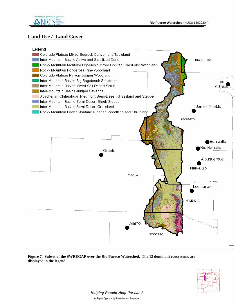
Figure 7. Subset of the SWREGAP over the Rio Puerco Watershed. The 12 dominant ecosystems are displayed in the legend.

Rio Puerco Watershed (HUC8 13020204)
17
Land Use / Land Cover
Ecosystem Acres % of Watershed
Inter-Mountain Basins Semi-Desert Grassland 495,175 37 Colorado Plateau Pinyon-Juniper Woodland 228,751 17 Inter-Mountain Basins Semi-Desert Shrub Steppe 156,420 12 Inter-Mountain Basins Mixed Salt Desert Scrub 132,403 10 Rocky Mountain Ponderosa Pine Woodland 53,389 4 Inter-Mountain Basins Active and Stabilized Dune 43,593 3 Apacherian-Chihuahuan Piedmont Semi-Desert Grassland and Steppe 41,968 3 Inter-Mountain Basins Juniper Savanna 28,342 2 Rocky Mountain Lower Montane Riparian Woodland and Shrubland 21,560 2 Rocky Mountain Montane Dry-Mesic Mixed Conifer Forest and Woodland 21,206 2 Inter-Mountain Basins Big Sagebrush Shrubland 19,465 1 Colorado Plateau Mixed Bedrock Canyon and Tableland 18,327 1 Colorado Plateau Mixed Low Sagebrush Shrubland 17,714 1 Inter-Mountain Basins Greasewood Flat 17,398 1 Chihuahuan Mixed Salt Desert Scrub 6,396 < 1 Apacherian-Chihuahuan Mesquite Upland Scrub 5,957 < 1 Inter-Mountain Basins Shale Badland 5,391 < 1 Rocky Mountain Cliff and Canyon 4,652 < 1 Rocky Mountain Gambel Oak-Mixed Montane Shrubland 4,283 < 1 Southern Rocky Mountain Pinyon-Juniper Woodland 4,037 < 1 Rocky Mountain Montane Mesic Mixed Conifer Forest and Woodland 3,955 < 1 Western Great Plains Riparian Woodland and Shrubland 3,592 < 1 North American Warm Desert Bedrock Cliff and Outcrop 3,414 < 1 Rocky Mountain Alpine-Montane Wet Meadow 2,220 < 1
Table 4. SW Region Gap analysis ecosystem acreages.
The landcover mapping effort for the Southwest Region Gap Analysis Project was a coordinated multi-institution endeavor. This dataset was created for regional terrestrial biodiversity assessment. Additional objectives were to establish a coordinated mapping approach to create detailed, seamless maps of land cover, all native terrestrial vertebrate species, land stewardship, and management status, and to analyze this information to identify those biotic elements that are underrepresented on lands managed for their long term conservation.

Rio Puerco Watershed (HUC8 13020204)
18
Hydrology 6 , 7, 8, 9, 10 The National Hydrography Dataset (NHD) is a comprehensive set of data that encodes information about naturally occurring and constructed bodies of water, paths through which water flows, and related entities. The NHD identifies 4,834miles (7,780 km) of water courses in the Rio Puerco River Watershed. The majority of these courses typically flow intermittently in summer months during periods associated with high intensity convective thunderstorms.
Figure 8. National Hydrologic Dataset (NHD) of the Rio Puerco.

Rio Puerco Watershed (HUC8 13020204)
Water Course Type Miles
Artificial path 400
Connector <1
Canal / Ditch 17
Intermittent Stream / River 4,289
Perennial Stream / River 127
Sum (∑) 4,834
Table 5. NHD Water Course Type and Extents

Rio Puerco Watershed (HUC8 13020204)
There are 15 water gauging stations in the watershed. USGS Site 08353000 is near the SE corner of the watershed on the Rio Puerco near Bernardo, NM. During the period 1940 – 2010, this site has had mean annual discharge of 39.52 cubic feet per second ranging from 4.8 (2000) to 170.5 (1941) cubic feet per second.
Figure 9. Gauging Stations in the Rio Puerco Watershed

Rio Puerco Watershed (HUC8 13020204)
Hydrology
Figure 10. Monthly Average of Mean Daily Flow on the Rio Puerco near Bernardo, NM. Period of observation: 1940-2010.
0
20
40
60
80
100
120
140
160
180
200
Jan Feb Mar Apr May Jun Jul Aug Sep Oct Nov Dec
CFS
Rio Puerco Watershed (HUC8 13020204)
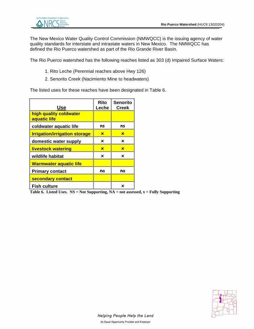
The New Mexico Water Quality Control Commission (NMWQCC) is the issuing agency of water quality standards for interstate and intrastate waters in New Mexico. The NMWQCC has defined the Rio Puerco watershed as part of the Rio Grande River Basin.
The Rio Puerco watershed has the following reaches listed as 303 (d) Impaired Surface Waters:
1. Rito Leche (Perennial reaches above Hwy 126)
2. Senorito Creek (Nacimiento Mine to headwaters)
The listed uses for these reaches have been designated in Table 6.
Use Rito
Leche Senorito
Creek high quality coldwater aquatic life
coldwater aquatic life ns ns
Irrigation/irrigation storage x x
domestic water supply x x
livestock watering x x
wildlife habitat x x
Warmwater aquatic life
Primary contact na na
secondary contact
Fish culture x Table 6. Listed Uses. NS = Not Supporting, NA = not assessed, x = Fully Supporting

Rio Puerco Watershed (HUC8 13020204)
Figure 11. 303(d) Impaired Waters.
Rio Puerco Watershed (HUC8 13020204)
24
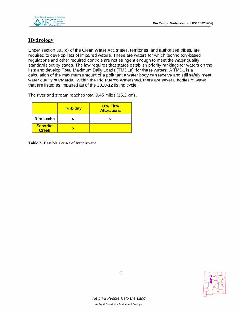
Hydrology Under section 303(d) of the Clean Water Act, states, territories, and authorized tribes, are required to develop lists of impaired waters. These are waters for which technology-based regulations and other required controls are not stringent enough to meet the water quality standards set by states. The law requires that states establish priority rankings for waters on the lists and develop Total Maximum Daily Loads (TMDLs), for these waters. A TMDL is a calculation of the maximum amount of a pollutant a water body can receive and still safely meet water quality standards. Within the Rio Puerco Watershed, there are several bodies of water that are listed as impaired as of the 2010-12 listing cycle. The river and stream reaches total 9.45 miles (15.2 km) . Table 7. Possible Causes of Impairment
Turbidity Low Flow
Alterations
Rito Leche x x
Senorito Creek x

Rio Puerco Watershed (HUC8 13020204)
Figure 12. Declared Groundwater Basins of the Rio Puerco. A declared groundwater basin is an area of the state proclaimed by the State Engineer to be underlain by a groundwater source having reasonably ascertainable boundaries. By such proclamation the State Engineer assumes jurisdiction over the appropriation and use of groundwater from the source. The Rio Puerco watershed is completely within the Middle Rio Grande Underground Water Basin. The surface watershed in NM covers 1,351,500 of the approximately 11.8 million acres of the underground water basin in NM.

Rio Puerco Watershed (HUC8 13020204)
26
Threatened and Endangered Species 11 Endangered species are those that are at risk of extinction throughout all or a significant portion of its native range. A threatened species is one that is likely to become endangered in the foreseeable future. The New Mexico Natural Heritage program tracks the status of threatened and endangered species which are listed on both federal and state lists. Table 8 lists those species which are currently listed and tracked in the Rio Puerco River Watershed.
Table 7. Threatened and Endanged Plant and Animal Species. Invasive Species 12
Invasive species are those which have been introduced into a region or ecosystem and have the ability to out-compete native species for resources (i.e. water, nutrients, sunlight, etc.) The Southwest Exotic Plant Mapping Program (SWEMP) is a collaborative effort between the United States Geological Survey and federal, tribal, state, county and non-government organization partners in the southwest which maintains ongoing efforts to compile and distribute regional data on the occurrence of non-native invasive plants in the southwestern United States. Within the Rio Puerco watershed, the SWEMP has identified 7 species of invasive plants (Table 9). Each of these species is defined as non-native by the USDA PLANTS database.
Scientific Name Common Name Fabaceae (Pea Family) Camelthorn
Scrophylariaceae (Figwort Family) Dalmatian Toadflax Brassicaceae (Mustard Family) Hoary Cress (Whitetop) Asteraceae (Sunflower Family) Musk Thistle Brassicaceae (Mustard Family) Perennial Pepperweed (Tall Whitetop)
Lythraceae (Loosestrife Family) Purple Loosestrife Asteraceae (Sunflower Family) Russian Knapweed Asteraceae (Sunflower Family) Spotted Knapweed
Table 8. Invasive Species Recognized by the SWEMP.
Common Name Scientific Name Tax.Class Family Fed Status
State Status
Rio Grande Cutthroat Trout
Oncorhynchus clarkii virginalis
Actinopterygii Salmonidae C
Jemez Mountains Salamander
Plethodon neomexicanus Amphibia Plethodontidae E
Mexican spotted owl Strix occidentalis lucida Aves Strigidae LT
Gray Vireo Vireo vicinior Aves Vireonidae T
Parish's Alkali Grass Puccinellia parishii Monocotyledoneae Poaceae E

Rio Puerco Watershed (HUC8 13020204)
27
Common Resource Areas 13
A Common Resource Area (CRA) is defined as a geographical area where resource concerns, problems, or treatment needs are similar. It is considered a subdivision of an existing Major Land Resource Area (MLRA) designation. Landscape conditions, soil, climate, human considerations, and other natural resource information are used to determine the geographic boundaries of a Common Resource Area.
Each Common Resource Area will have multiple Conservation System Guides associated with it. A Conservation System Guide associates, for a given CRA and land use, different components of Resource Management Systems and their individual effect on conserving soil and water resources.
Figure 13. Common Resource Areas of the Rio Puerco.

Rio Puerco Watershed (HUC8 13020204)
Common Resource Areas 35.1 – Colorado Plateau Mixed Grass Plains This unit occurs within the Colorado Plateau Physiographic Province and is characterized by flat to gently dipping sedimentary rocks eroded into plateaus, valleys and deep canyons. Volcanic fields occur in places. Elevations range from 5100 to 6000 feet. Precipitation averages 10 to 14 inches per year. The soil temperature regime is mesic. The soil moisture regime is ustic aridic. Vegetation includes Stipa, Indian ricegrass, galleta, blue grama, fourwing saltbush, and scattered juniper. 35.8 - Colorado Plateau Ponderosa Pine Forests This unit occurs within the Colorado Plateau Physiographic Province and is characterized by gently dipping sedimentary rocks eroded into plateaus, valleys and deep canyons. Volcanic fields occur in places. Elevations range from 6800 to 8500 feet. Precipitation averages 17 to 25 inches per year. The soil temperature regime ranges from mesic to frigid. The soil moisture regime is typic ustic. Vegetation includes ponderosa pine, white fir, aspen, pinyon, juniper, Gambel oak, and big sagebrush. 36.2 – Southwest Plateaus, Mesas, and Foothills – Warm Semiarid Mesas and Plateaus This area encompasses the lower elevation mesas and plateaus. The temperature regime is mesic and the moisture regime is transitional from ustic to aridic. Vegetation is typically twoneedle pinyon, Utah juniper, and big sagebrush. Cropland is a significant land use in parts of this area, particularly on soils formed in thick deposits of eolian material. Precipitation ranges from 10 to about 16 inches. Elevations range from about 6,000 to 7.000 feet. 42.1 - Upper Rio Grande Rift Valley This unit occurs within the Basin and Range Physiographic Province and contains the upper Rio Grande Rift Valley. Elevations range from 4500 to 5500 feet. Precipitation ranges from 8 to 11 inches per year. The soil temperature regime ranges thermic to mesic. The soil moisture regime is typic aridic. Indian ricegrass, New Mexico feathergrass, galleta, blue grama and bottlebrush squirreltail characterize vegetation in the cooler portions. Warmer portions include black grama and tobosa. Alkali sacaton, dropseed and threeawns are common. 42.2 - Chihuahuan Desert Shrubs This unit occurs within the Basin and Range Physiographic Province and is characterized by valley plains, alluvial fans, and mountains. Sediments are from fluvial, lacustrine, colluvial and alluvial deposits. Igneous and metamorphic rock dominate the mountain ranges. Elevations range from 3800 to 5200 feet. Precipitation ranges from 8 to 10 inches per year. The soil temperature regime is thermic. The soil moisture regime is typic aridic. Vegetation includes Creosote, tarbush, soaptree yucca, torrey yucca, tobosa, and alkali sacaton.
Rio Puerco Watershed (HUC8 13020204)
48.1 – Southern Rocky Mountains – High Mountains and Valleys This area is best characterized by steep, high mountain ranges and associated mountain valleys. The temperature regimes are mostly frigid and cryic; moisture regimes are mainly ustic and udic. Vegetation is sagebrush-grass at low elevations, and with increasing elevation ranges from coniferous forest to alpine tundra. Elevations range from 6,500 to 14,400 feet.
Rio Puerco Watershed (HUC8 13020204)
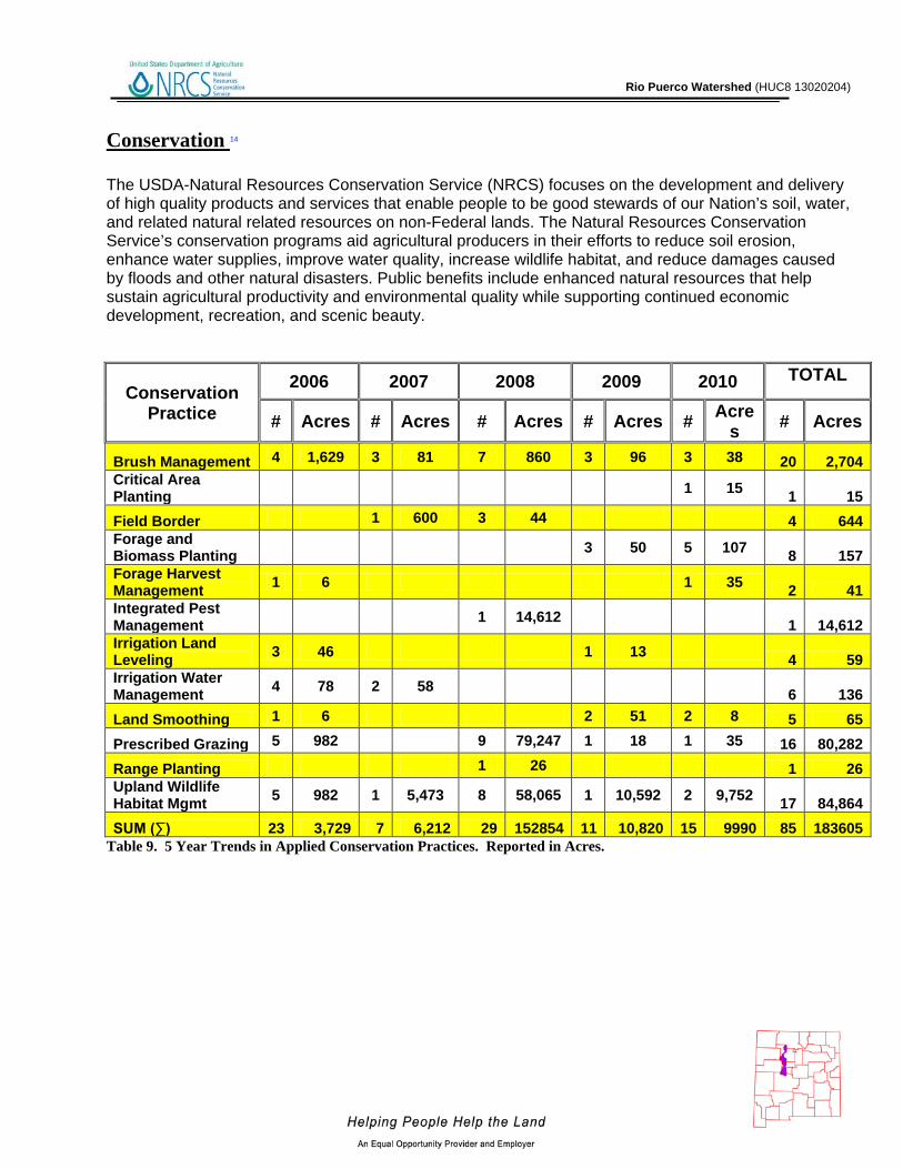
Conservation 14 The USDA-Natural Resources Conservation Service (NRCS) focuses on the development and delivery of high quality products and services that enable people to be good stewards of our Nation’s soil, water, and related natural related resources on non-Federal lands. The Natural Resources Conservation Service’s conservation programs aid agricultural producers in their efforts to reduce soil erosion, enhance water supplies, improve water quality, increase wildlife habitat, and reduce damages caused by floods and other natural disasters. Public benefits include enhanced natural resources that help sustain agricultural productivity and environmental quality while supporting continued economic development, recreation, and scenic beauty.
Conservation Practice
2006 2007 2008 2009 2010 TOTAL
# Acres # Acres # Acres # Acres # Acres # Acres
Brush Management 4 1,629 3 81 7 860 3 96 3 38 20 2,704 Critical Area Planting 1 15 1 15 Field Border 1 600 3 44 4 644 Forage and Biomass Planting 3 50 5 107 8 157 Forage Harvest Management 1 6 1 35 2 41 Integrated Pest Management 1 14,612 1 14,612 Irrigation Land Leveling 3 46 1 13 4 59 Irrigation Water Management 4 78 2 58 6 136 Land Smoothing 1 6 2 51 2 8 5 65 Prescribed Grazing 5 982 9 79,247 1 18 1 35 16 80,282 Range Planting 1 26 1 26 Upland Wildlife Habitat Mgmt 5 982 1 5,473 8 58,065 1 10,592 2 9,752 17 84,864 SUM (∑) 23 3,729 7 6,212 29 152854 11 10,820 15 9990 85 183605
Table 9. 5 Year Trends in Applied Conservation Practices. Reported in Acres.

Rio Puerco Watershed (HUC8 13020204)
Conservation Practice
2006 2007 2008 2009 2010 TOTAL # Feet # Feet # Feet # Feet # Feet # Feet
Above-Ground, Multi-Outlet Pipeline 1 550 1 550
Dam, Diversion 10 10 0 Diversion 2 2,300 3 1,076 1 300 6 3,676 Fence 3 22,712 2 18,360 2 3,513 7 44,585 Grade Stabilization Structure 6 9 15 0
Irrigation Water Conveyance, Pipeline, High-Pressure, Underground, Plastic
4 5,245 1 26,532 2 1,321 7 33,098
Pipeline 1 25,000 3 1,040 4 26,040
Pond 8 4 3 3 18 0
Pumping Plant 1 1 2 0 Structure for Water Control 4 2 6 0
Watering Facility 3 5 7 5 20 0 SUM (∑) 23 2,300 19 5,245 20 75,320 19 19,981 15 5,103 96 107,949
Table 10. 5 Year Trends in Location Specific Applied Conservation Practices. Reported in Feet if Linear (i.e. fence)

Rio Puerco Watershed (HUC8 13020204)
32
Soil Resource Inventory 15
Figure 14. National Cooperative Soil Survey coverage of the Rio Puerco Watershed.
The Rio Puerco Watershed has a number of certified National Cooperative Soil Survey (NCSS) inventories. The National Forests in New Mexico are not covered, but have soils information available through their Terrestrial Ecosystem Unit Inventories. These will be integrated with the National Cooperative Soil Survey (NCSS) inventories in the next few years.

Rio Puerco Watershed (HUC8 13020204)
33
Soil Resource Inventory
In order to evaluate the susceptibility of erosion within the Rio Puerco watershed, a model was developed using Soil Survey Geographic Database (SSURGO) information. The soil properties saturated hydraulic conductivity, soil loss tolerance, and wind erodibility group were used in conjunction with slope to assess soil mapunit potential for erosion. Saturated hydraulic conductivity and slope are reported in SSURGO databases as interval/ratio data whereas wind erodibility and soil loss tolerance are ordinal data. Data transformations for the model are listed -
Table 11. Criteria Used for Soil Ersion Susceptibility Model.
SSURGO Value Nominal Description Model Rank
Saturated Hydraulic Conductivity
µm / s 705.0 - 100.0 Very High 0 100.0 - 10.0 High 1
10.0 - 1.0 Moderately High 2 1.0 - 0.1 Moderately Low 3 0.1 - 0.01 Low 4 Slope %
0 - 5 0 5 - 10 1
10 - 15 2 15 - 25 3
> 25 4 Soil Loss Tolerance
5 High Tolerance For loss 0 4 ↓ 1 3 ↓ 2 2 ↓ 3 1 Low Tolerance For Loss 4
Wind Erodibility Group 1 Very High 4 2 Very High 4 3 High 3 4 High 3 4L High 3 5 Moderate 2 6 Moderate 2 7 Moderate 1 8 Slight 0

Rio Puerco Watershed (HUC8 13020204)
34
Soil Resource Inventory For each soil map unit (discrete delineation), the soil properties (named above) of the dominant soil type was used as the condition to be evaluated in the susceptibility to erosion model. Miscellaneous areas such as gravel pits, water, riverwash, etc. were excluded from evaluation. Possible range of values for each map unit are 0 – 16. Increasing values represent a higher susceptibility to soil erosion. Forest Service Soils are not able to be included in the model at this time.
Figure 15. Rio Puerco Watershed Erosion Potential.

Rio Puerco Watershed (HUC8 13020204)
35
Soil Resource Inventory
Table 12. Soil Erosion Potential Model Results. A greater rank indicates greater potential for erosion.
Rank Acres 2 2,808
3 2,565
4 163,462
5 402,950
6 167,168
7 110,362
8 79,042
9 102,013
10 90,726
11 33,914
12 83,133
13 11,388
14 3,900
15 1,207
Sum( ∑) 1,254,638

Rio Puerco Watershed (HUC8 13020204)
36
Socioeconomic Data 16
COUNTY
Total population:
Total
Total population:
Urban
Total population:
Rural
Total Pop,: Rural Farm
Total Pop.: Rural
Nonfarm
Total population: Hispanic or Latino
Total population:
White alone
Total population:
Black or African
American alone
Total population: American Indian and
Alaska Native alone
Total population:
Asian alone
Total population:
Native Hawaiian and Other
Pacific Islander
alone
Total population:
Some other race
alone
Total population:
Two or more races
Families: Median family
income adj. 2009
Bernalillo 556,678 532,555 24,123 134 23,989 286,081 434,450 19,377 30,513 14,097 220 106,143 22,022 $58,314
Cibola 25,595 10,279 15,316 194 15,122 9,076 12,501 105 11,662 81 0 2,048 723 $40,818
McKinley 74,798 29,404 45,394 548 44,846 9,897 14,358 792 51,162 423 32 2,264 1,357 $38,520
Rio Arriba 41,190 17,678 23,512 544 22,968 30,025 23,320 143 5,717 56 47 10,554 1,353 $41,387
Sandoval 89,908 68,906 21,002 161
20,841 26,437 58,512 1,535 14,634 894 98 11,118 3,117 $56,479
Socorro 18,078 8,422 9,656 340 9,316 8,634 13,664 188 1,934 410 30 1,278 659 $41,839
Valencia 66,152 53,074 13,078 366 12,712 39,695 43,045 1,066 2,746 590 67 20,449 3,011 $48,393
Table 13. Socioeconomic Data of the Counties in the Watershed (2000).
Rio Puerco Watershed (HUC8 13020204)
37
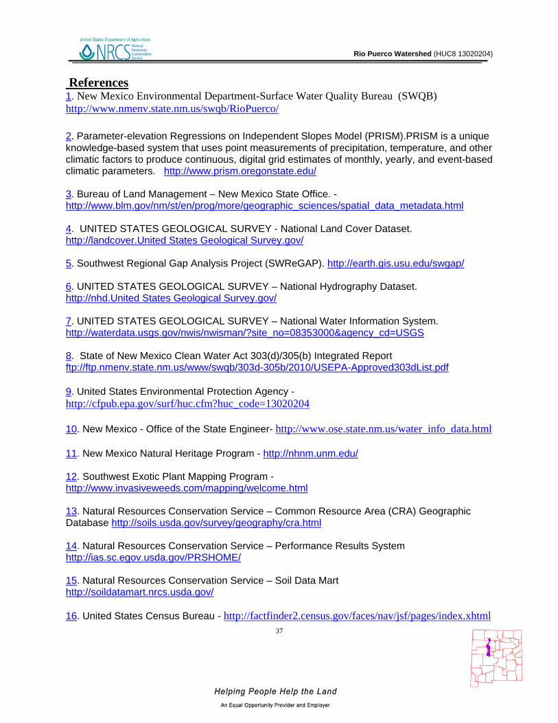
References 1. New Mexico Environmental Department-Surface Water Quality Bureau (SWQB) http://www.nmenv.state.nm.us/swqb/RioPuerco/ 2. Parameter-elevation Regressions on Independent Slopes Model (PRISM).PRISM is a unique knowledge-based system that uses point measurements of precipitation, temperature, and other climatic factors to produce continuous, digital grid estimates of monthly, yearly, and event-based climatic parameters. http://www.prism.oregonstate.edu/ 3. Bureau of Land Management – New Mexico State Office. - http://www.blm.gov/nm/st/en/prog/more/geographic_sciences/spatial_data_metadata.html 4. UNITED STATES GEOLOGICAL SURVEY - National Land Cover Dataset. http://landcover.United States Geological Survey.gov/ 5. Southwest Regional Gap Analysis Project (SWReGAP). http://earth.gis.usu.edu/swgap/ 6. UNITED STATES GEOLOGICAL SURVEY – National Hydrography Dataset. http://nhd.United States Geological Survey.gov/ 7. UNITED STATES GEOLOGICAL SURVEY – National Water Information System. http://waterdata.usgs.gov/nwis/nwisman/?site_no=08353000&agency_cd=USGS 8. State of New Mexico Clean Water Act 303(d)/305(b) Integrated Report ftp://ftp.nmenv.state.nm.us/www/swqb/303d-305b/2010/USEPA-Approved303dList.pdf 9. United States Environmental Protection Agency - http://cfpub.epa.gov/surf/huc.cfm?huc_code=13020204 10. New Mexico - Office of the State Engineer- http://www.ose.state.nm.us/water_info_data.html 11. New Mexico Natural Heritage Program - http://nhnm.unm.edu/ 12. Southwest Exotic Plant Mapping Program - http://www.invasiveweeds.com/mapping/welcome.html 13. Natural Resources Conservation Service – Common Resource Area (CRA) Geographic Database http://soils.usda.gov/survey/geography/cra.html 14. Natural Resources Conservation Service – Performance Results System http://ias.sc.egov.usda.gov/PRSHOME/ 15. Natural Resources Conservation Service – Soil Data Mart http://soildatamart.nrcs.usda.gov/ 16. United States Census Bureau - http://factfinder2.census.gov/faces/nav/jsf/pages/index.xhtml


![[RIO PUERCO MONITORING PROGRAM EXECUTIVE SUMMARY] · 2020. 11. 15. · Puerco at the border is predominantly determined by the mine dewatering discharges. Analyses of Rio Puerco water](https://static.fdocuments.us/doc/165x107/60d3f5680c2e0768544e8e80/rio-puerco-monitoring-program-executive-summary-2020-11-15-puerco-at-the.jpg)