Rapid Watershed Assessment Lower Big Sioux … Watershed Assessment Lower Big Sioux River HUC...
15
The U.S. Department of Agriculture (USDA) prohibits discrimination in all its programs and activities on the basis of race, color, national origin, age, disability, and where applicable, sex, marital status, familial status, parental status, religion, sexual orientation, genetic information, political beliefs, reprisal, or because all or a part of an individual's income is derived from any public assistance program. (Not all prohibited bases apply to all programs.) Persons with disabilities who require alter- native means for communication of program information (Braille, large print, audiotape, etc.) should contact USDA's TARGET Center at (202) 720-2600 (voice and TDD). To file a complaint of discrimination write to USDA, Director, Office of Civil Rights, 1400 Independence Avenue, S.W., Washington, D.C. 20250-9410 or call (800) 795-3272 (voice) or (202) 720-6382 (TDD). USDA is an equal opportunity provider and employer. Rapid Watershed Assessment Lower Big Sioux River HUC 10170203 This project is supported by the Iowa Department of Agriculture and Land Stewardship, Division of Soil Conservation, through a grant from the U.S. Department of Agriculture, Natural Resources Conservation Service. Technical assistance is provided by the U.S. Department of Agriculture, Natural Resources Conservation Service.
Transcript of Rapid Watershed Assessment Lower Big Sioux … Watershed Assessment Lower Big Sioux River HUC...
The U.S. Department of Agriculture (USDA) prohibits discrimination in all its programs and activities on the basis of race, color, national origin, age, disability, and where applicable, sex, marital status, familial status, parental status, religion, sexual orientation, genetic information, political beliefs, reprisal, or because all or a part of an individual's income is derived from any public assistance program. (Not all prohibited bases apply to all programs.) Persons with disabilities who require alter-native means for communication of program information (Braille, large print, audiotape, etc.) should contact USDA's TARGET Center at (202) 720-2600 (voice and TDD). To file a complaint of discrimination write to USDA, Director, Office of Civil Rights, 1400 Independence Avenue, S.W., Washington, D.C. 20250-9410 or call (800) 795-3272 (voice) or (202) 720-6382 (TDD). USDA is an equal opportunity provider and employer.
Rapid Watershed Assessment
Lower Big Sioux River
HUC 10170203
This project is supported by the Iowa Department of Agriculture and Land Stewardship, Division of Soil Conservation, through a grant from the U.S. Department of Agriculture, Natural Resources Conservation Service. Technical assistance is provided by the U.S. Department of Agriculture, Natural Resources Conservation Service.
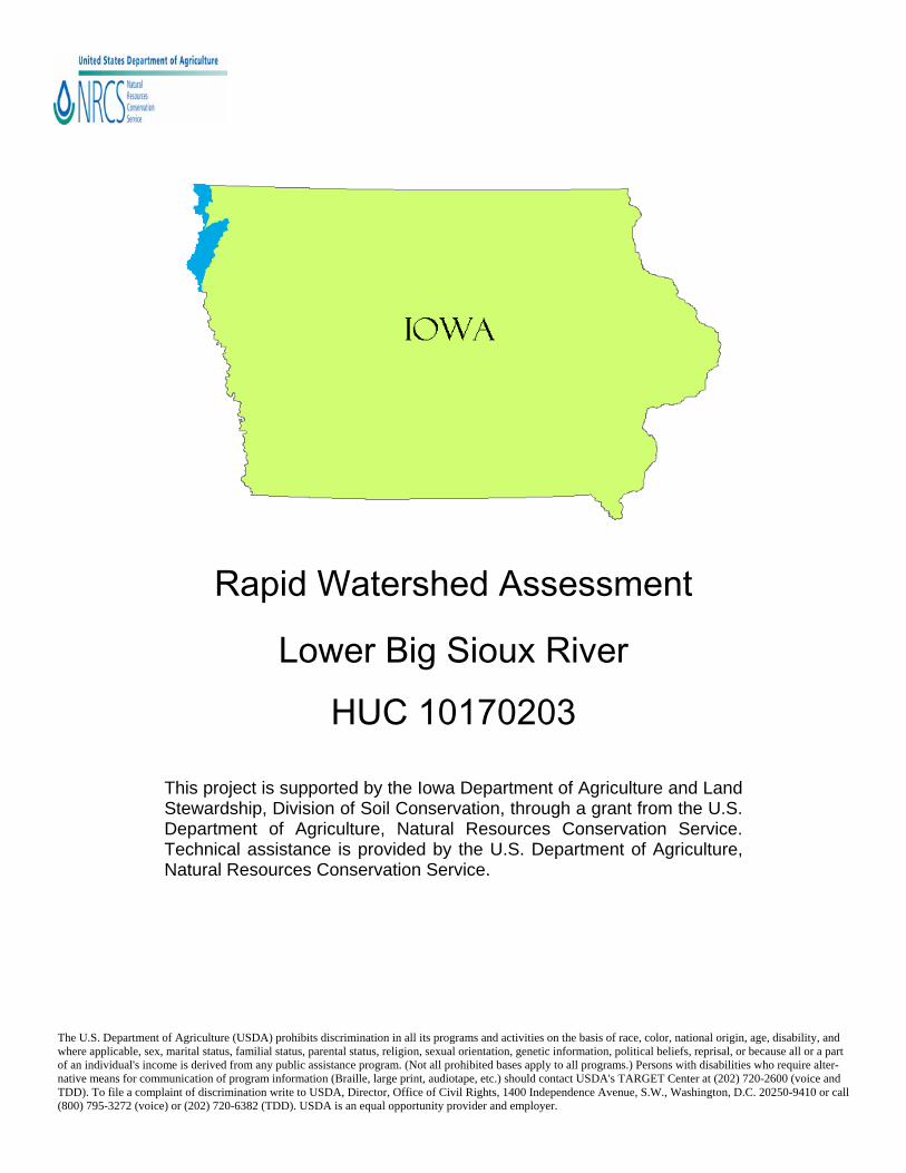
Lower Big Sioux River—10170203 8-Digit Hydrologic Unit Profile
Introduction The Lower Big Sioux River 8-Digit Hydrologic Unit Code (HUC) sub-basin is comprised of approximately 384,037 acres in northwestern Iowa. The majority of this sub-basin in Iowa is located in Lyon (20% or 76,807 acres), Sioux (39% or 149,774 acres), and Plymouth (41% or 157,455 acres) counties. The are 137 miles of river and 486 miles of tributary streams in this sub-basin. Thirty-five percent of the land area is C-slope or greater (from 5 - 45+%).
Lower Big Sioux River HUC - 10170203
Lower Big Sioux River—10170203 8-Digit Hydrologic Unit Profile
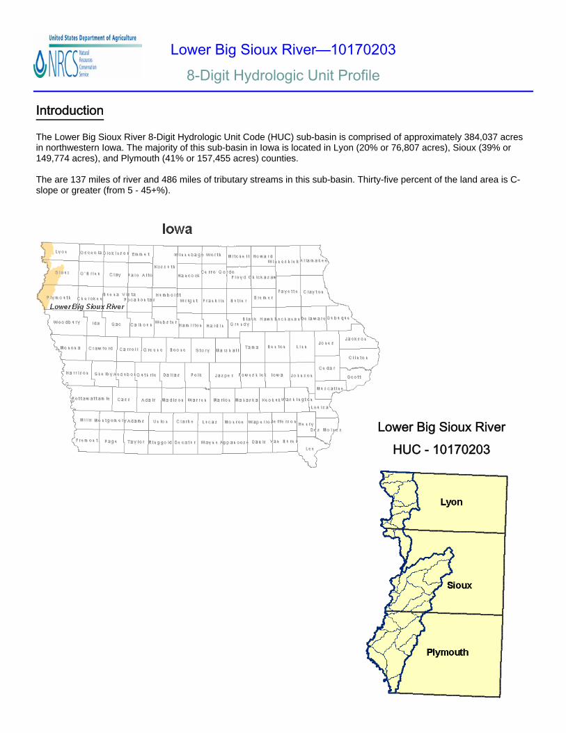
Physical Description The physical description on the Lower Big Sioux River sub-basin provides detailed information so the user can better understand the natural resources associated with this geographical land unit.
Subwatershed Acres Beaver Creek 10,484
Big Ditch Creek 14,728
Blood Run Creek 14,148
Broken Kettle Creek -Upper 23,470
Broken Kettle Creek - Lower 29,297
Bull Run Creek 10,569
Dry Creek 32,191
Indian/Dubois Creek 29,767
Indian/Unnamed Creek 10,212
Inwood Creek 11,593
Klondike Creek 26,625
Sixmile Creek - Upper 22,935
Sixmile Creek - Middle 21,123
Sixmile Creek - Lower 24,990
Westfield Creek 18,763
Big Sioux River 83,142 Total Area 384,037
The majority of the watershed is geologically located in the Northern Iowa Plains landform region; however, the southernmost reach of the watershed consists of the Loess Hills, a 200 mile stretch of extremely erodible hills created by wind blown silt over many thousands of years. This is a very unique and dy-namic landscape that contains many en-dangered plant and animal species. The uniqueness of the landscape and biota led to recognition of portions of the Loess Hills as a National Natural Landmark in 1986 by the U.S. Department of the Inte-rior.11
The Lower Big Sioux Watershed contains 16 HUC 12 subwater-sheds. Concentrating on these subwatersheds will help make conservation planning and imple-mentation activities more man-ageable.
Lower Big Sioux River—10170203 8-Digit Hydrologic Unit Profile
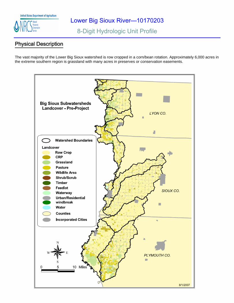
Physical Description The vast majority of the Lower Big Sioux watershed is row cropped in a corn/bean rotation. Approximately 6,000 acres in the extreme southern region is grassland with many acres in preserves or conservation easements.
Lower Big Sioux River—10170203 8-Digit Hydrologic Unit Profile
Physical Description
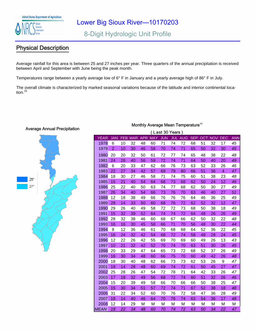
Average Annual Precipitation
Average rainfall for this area is between 25 and 27 inches per year. Three quarters of the annual precipitation is received between April and September with June being the peak month. Temperatures range between a yearly average low of 6° F in January and a yearly average high of 86° F in July. The overall climate is characterized by marked seasonal variations because of the latitude and interior continental loca-tion.15
YEAR JAN FEB MAR APR MAY JUN JUL AUG SEP OCT NOV DEC ANN 1978 6 10 32 48 60 71 74 72 68 51 32 17 45 1979 2 10 30 46 58 70 74 71 65 50 32 30 45 1980 20 20 32 50 61 72 77 74 65 48 38 22 48 1981 24 26 40 56 59 72 74 71 64 50 40 20 49 1982 6 20 33 47 62 66 76 73 63 52 33 26 46 1983 22 27 34 42 57 69 79 80 66 51 36 4 47 1984 18 30 27 46 58 71 74 75 60 51 38 23 48 1985 15 21 40 54 64 68 73 68 62 50 24 12 46 1986 25 22 40 50 63 74 77 68 62 50 30 27 49 1987 26 34 40 54 66 73 76 70 63 46 40 27 51 1988 12 18 38 49 66 76 76 76 64 46 36 25 49 1989 28 14 33 50 60 68 76 72 62 52 32 12 47 1990 29 26 40 49 58 72 72 73 68 50 38 18 49 1991 15 32 39 52 64 74 74 72 64 48 26 26 49 1992 28 32 38 46 60 68 67 66 62 50 32 22 48 1993 16 16 30 45 58 66 71 70 56 48 30 22 44 1994 8 12 36 46 61 70 68 68 64 52 36 22 45 1995 16 24 32 42 54 68 72 74 58 48 28 24 45 1996 12 22 26 42 55 69 70 69 60 49 26 13 43 1997 10 21 32 42 52 70 74 70 63 51 30 26 45 1998 20 33 29 47 64 65 73 72 68 52 37 26 49 1999 16 30 34 48 60 66 75 70 60 49 42 26 48 2000 18 30 40 48 62 66 73 73 62 53 26 9 47 2001 19 14 28 48 60 69 74 72 61 50 45 27 47 2002 25 28 26 47 54 72 78 71 64 42 33 26 47 2003 17 18 32 49 56 68 72 74 60 51 32 26 46 2004 15 20 39 49 58 66 70 66 66 50 38 25 47 2005 15 30 34 51 57 72 74 71 67 52 38 18 48 2006 31 22 34 52 60 70 76 72 58 47 36 28 49 2007 18 14 40 46 64 70 76 74 63 54 36 17 48 2008 12 14 29 M M M M M M M M M M
MEAN 18 22 34 48 60 70 74 72 63 50 34 22 47
Monthly Average Mean Temperature17
( L ast 30 Years )
Lower Big Sioux River—10170203 8-Digit Hydrologic Unit Profile
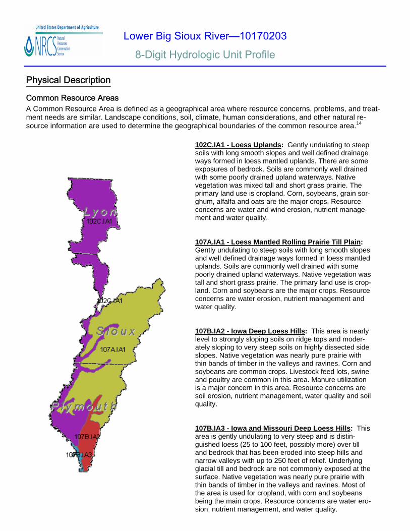
Common Resource Areas
102C.IA1 - Loess Uplands: Gently undulating to steep soils with long smooth slopes and well defined drainage ways formed in loess mantled uplands. There are some exposures of bedrock. Soils are commonly well drained with some poorly drained upland waterways. Native vegetation was mixed tall and short grass prairie. The primary land use is cropland. Corn, soybeans, grain sor-ghum, alfalfa and oats are the major crops. Resource concerns are water and wind erosion, nutrient manage-ment and water quality. 107A.IA1 - Loess Mantled Rolling Prairie Till Plain: Gently undulating to steep soils with long smooth slopes and well defined drainage ways formed in loess mantled uplands. Soils are commonly well drained with some poorly drained upland waterways. Native vegetation was tall and short grass prairie. The primary land use is crop-land. Corn and soybeans are the major crops. Resource concerns are water erosion, nutrient management and water quality. 107B.IA2 - Iowa Deep Loess Hills: This area is nearly level to strongly sloping soils on ridge tops and moder-ately sloping to very steep soils on highly dissected side slopes. Native vegetation was nearly pure prairie with thin bands of timber in the valleys and ravines. Corn and soybeans are common crops. Livestock feed lots, swine and poultry are common in this area. Manure utilization is a major concern in this area. Resource concerns are soil erosion, nutrient management, water quality and soil quality. 107B.IA3 - Iowa and Missouri Deep Loess Hills: This area is gently undulating to very steep and is distin-guished loess (25 to 100 feet, possibly more) over till and bedrock that has been eroded into steep hills and narrow valleys with up to 250 feet of relief. Underlying glacial till and bedrock are not commonly exposed at the surface. Native vegetation was nearly pure prairie with thin bands of timber in the valleys and ravines. Most of the area is used for cropland, with corn and soybeans being the main crops. Resource concerns are water ero-sion, nutrient management, and water quality.
Physical Description
A Common Resource Area is defined as a geographical area where resource concerns, problems, and treat-ment needs are similar. Landscape conditions, soil, climate, human considerations, and other natural re-source information are used to determine the geographical boundaries of the common resource area.14
Lower Big Sioux River—10170203 8-Digit Hydrologic Unit Profile
Physical Description
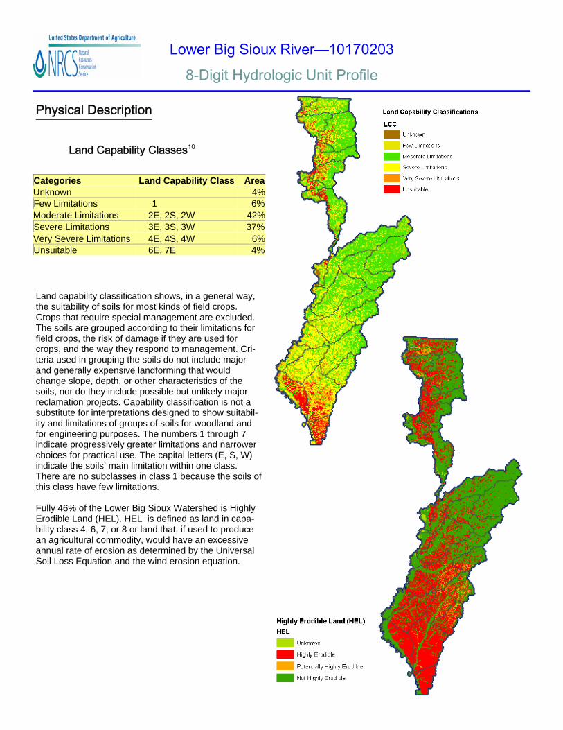
Land Capability Classes10
Land capability classification shows, in a general way, the suitability of soils for most kinds of field crops. Crops that require special management are excluded. The soils are grouped according to their limitations for field crops, the risk of damage if they are used for crops, and the way they respond to management. Cri-teria used in grouping the soils do not include major and generally expensive landforming that would change slope, depth, or other characteristics of the soils, nor do they include possible but unlikely major reclamation projects. Capability classification is not a substitute for interpretations designed to show suitabil-ity and limitations of groups of soils for woodland and for engineering purposes. The numbers 1 through 7 indicate progressively greater limitations and narrower choices for practical use. The capital letters (E, S, W) indicate the soils’ main limitation within one class. There are no subclasses in class 1 because the soils of this class have few limitations. Fully 46% of the Lower Big Sioux Watershed is Highly Erodible Land (HEL). HEL is defined as land in capa-bility class 4, 6, 7, or 8 or land that, if used to produce an agricultural commodity, would have an excessive annual rate of erosion as determined by the Universal Soil Loss Equation and the wind erosion equation.
Categories Land Capability Class Area Unknown 4% Few Limitations 1 6% Moderate Limitations 2E, 2S, 2W 42% Severe Limitations 3E, 3S, 3W 37% Very Severe Limitations 4E, 4S, 4W 6% Unsuitable 6E, 7E 4%
Lower Big Sioux River—10170203 8-Digit Hydrologic Unit Profile
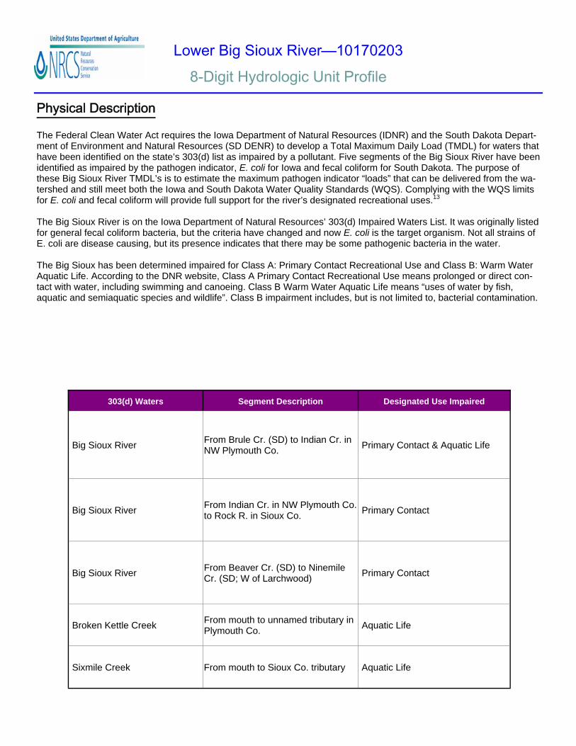
303(d) Waters Segment Description Designated Use Impaired
Big Sioux River From Brule Cr. (SD) to Indian Cr. in NW Plymouth Co. Primary Contact & Aquatic Life
Big Sioux River From Indian Cr. in NW Plymouth Co. to Rock R. in Sioux Co. Primary Contact
Big Sioux River From Beaver Cr. (SD) to Ninemile Cr. (SD; W of Larchwood) Primary Contact
Broken Kettle Creek From mouth to unnamed tributary in Plymouth Co. Aquatic Life
Sixmile Creek From mouth to Sioux Co. tributary Aquatic Life
Physical Description The Federal Clean Water Act requires the Iowa Department of Natural Resources (IDNR) and the South Dakota Depart-ment of Environment and Natural Resources (SD DENR) to develop a Total Maximum Daily Load (TMDL) for waters that have been identified on the state’s 303(d) list as impaired by a pollutant. Five segments of the Big Sioux River have been identified as impaired by the pathogen indicator, E. coli for Iowa and fecal coliform for South Dakota. The purpose of these Big Sioux River TMDL’s is to estimate the maximum pathogen indicator “loads” that can be delivered from the wa-tershed and still meet both the Iowa and South Dakota Water Quality Standards (WQS). Complying with the WQS limits for E. coli and fecal coliform will provide full support for the river’s designated recreational uses.13
The Big Sioux River is on the Iowa Department of Natural Resources’ 303(d) Impaired Waters List. It was originally listed for general fecal coliform bacteria, but the criteria have changed and now E. coli is the target organism. Not all strains of E. coli are disease causing, but its presence indicates that there may be some pathogenic bacteria in the water. The Big Sioux has been determined impaired for Class A: Primary Contact Recreational Use and Class B: Warm Water Aquatic Life. According to the DNR website, Class A Primary Contact Recreational Use means prolonged or direct con-tact with water, including swimming and canoeing. Class B Warm Water Aquatic Life means “uses of water by fish, aquatic and semiaquatic species and wildlife”. Class B impairment includes, but is not limited to, bacterial contamination.
Lower Big Sioux River—10170203 8-Digit Hydrologic Unit Profile
Farm Operator Age Groups(In Years)
25 or less
55 - 59
60 - 64
65 - 6970 + 25 - 34
45 - 54
35 - 44
Ave. 50.8 years
Years on Present Farm
10 +
2 or less
3 or 4
5 - 9
Ave. 23.2 years
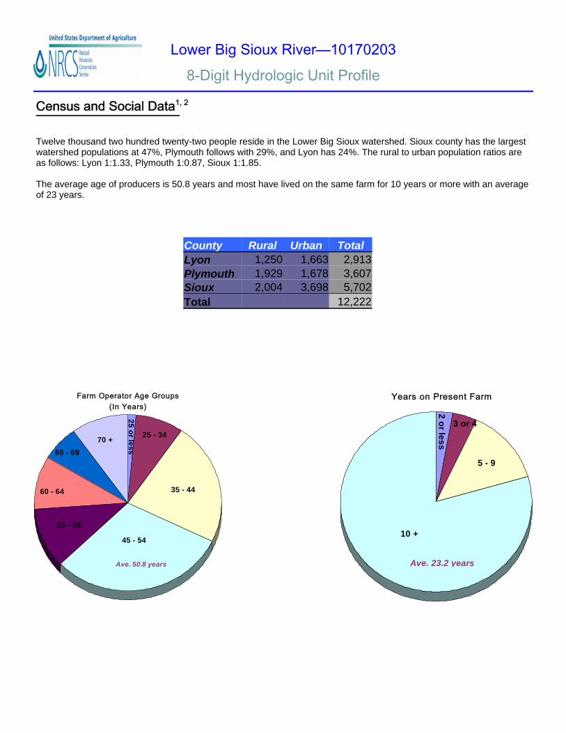
Census and Social Data1, 2
Twelve thousand two hundred twenty-two people reside in the Lower Big Sioux watershed. Sioux county has the largest watershed populations at 47%, Plymouth follows with 29%, and Lyon has 24%. The rural to urban population ratios are as follows: Lyon 1:1.33, Plymouth 1:0.87, Sioux 1:1.85. The average age of producers is 50.8 years and most have lived on the same farm for 10 years or more with an average of 23 years.
County Rural Urban Total Lyon 1,250 1,663 2,913 Plymouth 1,929 1,678 3,607 Sioux 2,004 3,698 5,702 Total 12,222
Lower Big Sioux River—10170203 8-Digit Hydrologic Unit Profile
Census and Social Data1, 2
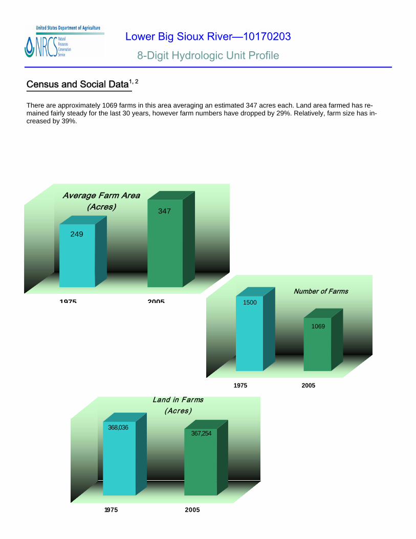
There are approximately 1069 farms in this area averaging an estimated 347 acres each. Land area farmed has re-mained fairly steady for the last 30 years, however farm numbers have dropped by 29%. Relatively, farm size has in-creased by 39%.
1500
1069
1975 2005
Number of Farms
249
347
1975 2005
Average Farm Area (Acres)
368,036367,254
1975 2005
Land in Farms (Ac res )
Lower Big Sioux River—10170203 8-Digit Hydrologic Unit Profile
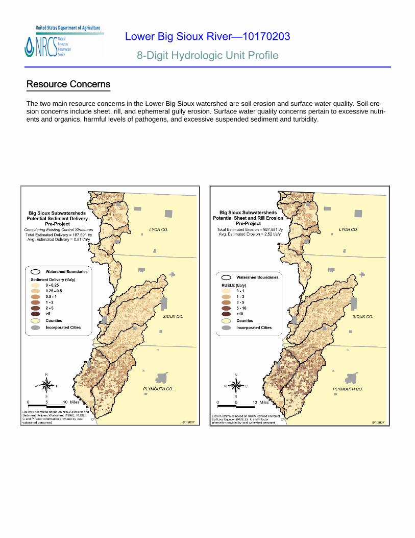
Resource Concerns The two main resource concerns in the Lower Big Sioux watershed are soil erosion and surface water quality. Soil ero-sion concerns include sheet, rill, and ephemeral gully erosion. Surface water quality concerns pertain to excessive nutri-ents and organics, harmful levels of pathogens, and excessive suspended sediment and turbidity.
Lower Big Sioux River—10170203 8-Digit Hydrologic Unit Profile
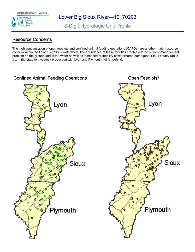
Resource Concerns The high concentration of open feedlots and confined animal feeding operations (CAFOs) are another major resource concern within the Lower Big Sioux watershed. The abundance of these facilities creates a large nutrient management problem on the ground and in the water as well as increased probability of waterborne pathogens. Sioux county ranks # 1 in the state for livestock production with Lyon and Plymouth not far behind.
Confined Animal Feeding Operations Open Feedlots9
Lower Big Sioux River—10170203 8-Digit Hydrologic Unit Profile
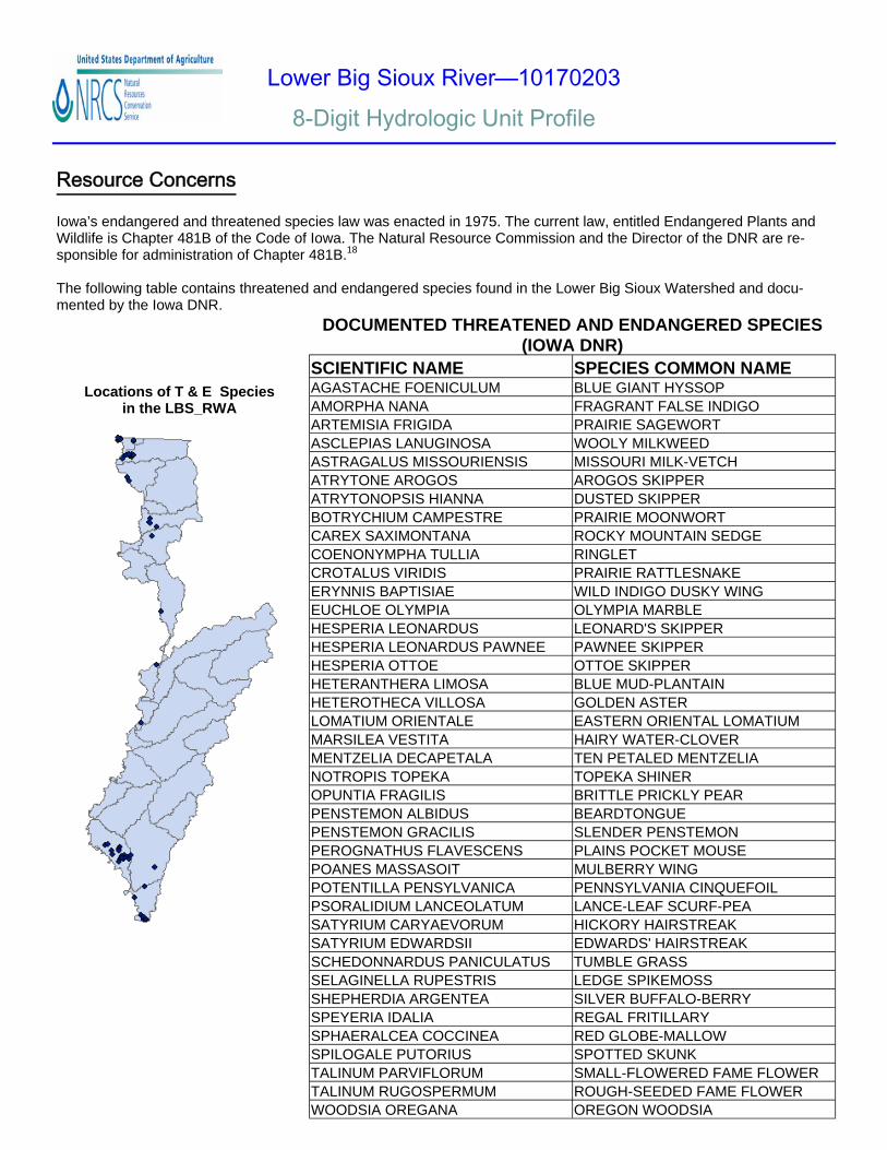
Resource Concerns Iowa’s endangered and threatened species law was enacted in 1975. The current law, entitled Endangered Plants and Wildlife is Chapter 481B of the Code of Iowa. The Natural Resource Commission and the Director of the DNR are re-sponsible for administration of Chapter 481B.18
The following table contains threatened and endangered species found in the Lower Big Sioux Watershed and docu-mented by the Iowa DNR.
DOCUMENTED THREATENED AND ENDANGERED SPECIES
(IOWA DNR) SCIENTIFIC NAME SPECIES COMMON NAME AGASTACHE FOENICULUM BLUE GIANT HYSSOP AMORPHA NANA FRAGRANT FALSE INDIGO ARTEMISIA FRIGIDA PRAIRIE SAGEWORT ASCLEPIAS LANUGINOSA WOOLY MILKWEED ASTRAGALUS MISSOURIENSIS MISSOURI MILK-VETCH ATRYTONE AROGOS AROGOS SKIPPER ATRYTONOPSIS HIANNA DUSTED SKIPPER BOTRYCHIUM CAMPESTRE PRAIRIE MOONWORT CAREX SAXIMONTANA ROCKY MOUNTAIN SEDGE COENONYMPHA TULLIA RINGLET CROTALUS VIRIDIS PRAIRIE RATTLESNAKE ERYNNIS BAPTISIAE WILD INDIGO DUSKY WING EUCHLOE OLYMPIA OLYMPIA MARBLE HESPERIA LEONARDUS LEONARD'S SKIPPER HESPERIA LEONARDUS PAWNEE PAWNEE SKIPPER HESPERIA OTTOE OTTOE SKIPPER HETERANTHERA LIMOSA BLUE MUD-PLANTAIN HETEROTHECA VILLOSA GOLDEN ASTER LOMATIUM ORIENTALE EASTERN ORIENTAL LOMATIUM MARSILEA VESTITA HAIRY WATER-CLOVER MENTZELIA DECAPETALA TEN PETALED MENTZELIA NOTROPIS TOPEKA TOPEKA SHINER OPUNTIA FRAGILIS BRITTLE PRICKLY PEAR PENSTEMON ALBIDUS BEARDTONGUE PENSTEMON GRACILIS SLENDER PENSTEMON PEROGNATHUS FLAVESCENS PLAINS POCKET MOUSE POANES MASSASOIT MULBERRY WING POTENTILLA PENSYLVANICA PENNSYLVANIA CINQUEFOIL PSORALIDIUM LANCEOLATUM LANCE-LEAF SCURF-PEA SATYRIUM CARYAEVORUM HICKORY HAIRSTREAK SATYRIUM EDWARDSII EDWARDS' HAIRSTREAK SCHEDONNARDUS PANICULATUS TUMBLE GRASS SELAGINELLA RUPESTRIS LEDGE SPIKEMOSS SHEPHERDIA ARGENTEA SILVER BUFFALO-BERRY SPEYERIA IDALIA REGAL FRITILLARY SPHAERALCEA COCCINEA RED GLOBE-MALLOW SPILOGALE PUTORIUS SPOTTED SKUNK TALINUM PARVIFLORUM SMALL-FLOWERED FAME FLOWER TALINUM RUGOSPERMUM ROUGH-SEEDED FAME FLOWER WOODSIA OREGANA OREGON WOODSIA
Locations of T & E Species in the LBS_RWA
Lower Big Sioux River—10170203 8-Digit Hydrologic Unit Profile
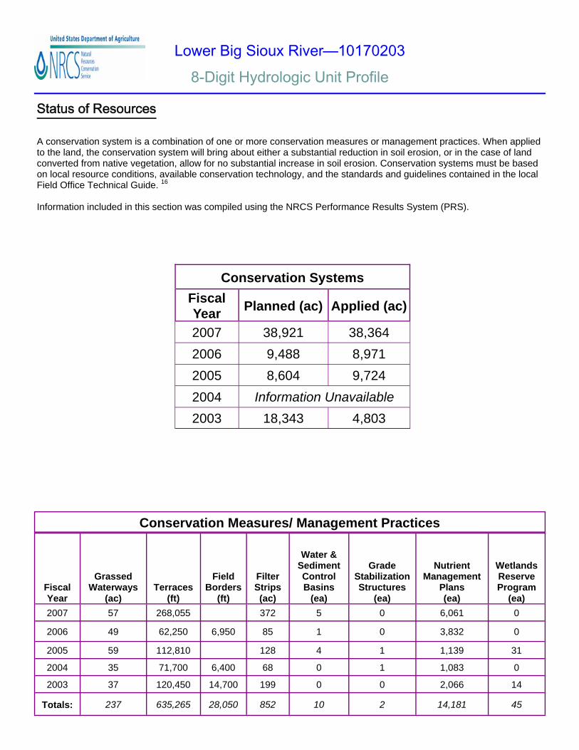
Status of Resources
A conservation system is a combination of one or more conservation measures or management practices. When applied to the land, the conservation system will bring about either a substantial reduction in soil erosion, or in the case of land converted from native vegetation, allow for no substantial increase in soil erosion. Conservation systems must be based on local resource conditions, available conservation technology, and the standards and guidelines contained in the local Field Office Technical Guide. 16
Information included in this section was compiled using the NRCS Performance Results System (PRS).
Fiscal Year Planned (ac) Applied (ac)
2007 38,921 38,364 2006 9,488 8,971 2005 8,604 9,724 2004 Information Unavailable 2003 18,343 4,803
Conservation Systems
Fiscal Year
Grassed Waterways
(ac) Terraces
(ft)
Field Borders
(ft)
Filter Strips (ac)
Water & Sediment Control Basins
(ea)
Grade Stabilization Structures
(ea)
Nutrient Management
Plans (ea)
Wetlands Reserve Program
(ea) 2007 57 268,055 372 5 0 6,061 0
2006 49 62,250 6,950 85 1 0 3,832 0
2005 59 112,810 128 4 1 1,139 31
2004 35 71,700 6,400 68 0 1 1,083 0
2003 37 120,450 14,700 199 0 0 2,066 14
Totals: 237 635,265 28,050 852 10 2 14,181 45
Conservation Measures/ Management Practices
Lower Big Sioux River—10170203 8-Digit Hydrologic Unit Profile
Footnotes and References
All data is provided “as is”. There are no warranties, express or implied, including the warranty of fitness for a particular purpose, accompanying this document. Use for general planning purposes only.
1. National Agricultural Statistics Service. http://www.nass.usda.gov/. Data were obtained by adjusting the 2006 average numbers per county by the percent of each county in the HUC.
2. The Census of Agriculture. http://www.agcensus.usda.gov/. Data obtained were from 1975, 1997, 2002, 2005, and 2006 Census Quick Stats.
3. State Data Center of Iowa. http://www.iowadatacenter.org. 4. Iowa Department of Natural Resources (DNR) Interactive Mapping. http://csweb.igsb.uiowa.edu/imsgate/maps. 5. Multi-Resolution Land Characteristics (MRLC) Consortium. National Land Cover Dataset (2002).http://www.mrlc.gov/
zones/show_data.asp?szone=11. 6. Soil Data Mart. http://soildatamart.nrcs.usda.gov/. 7. NRCS Electronic Field Office Technical Guide. http://efotg.nrcs.usda.gov/. 8. Common Resource Area (CRA) Geographic Database.
ftp://ftp-fc.sc.egov.usda.gov/NSSC/CRA/national_cra_legend_v1.2_011604.xls. 9. Iowa DNR Natural Resources Geographic Information Systems Library. http://www.igsb.uiowa.edu/nrgislibx/. 10. Iowa State University Iowa Agriculture and Home Economics Experiment Station University Extension Service. Iowa
Soil Properties and Interpretations Database (ISPAID) Version 7.0. 30 January 2004. http://icss.agron.iastate.edu/ispaid70man.pdf.
11. U.S. Geological Survey. Geology of the Loess Hills, Iowa. 1999. http://pubs.usgs.gov/info/loess. 12. U.S. Geological Survey National Water Information System: Web Interface. http://waterdata.usgs.gov/nwiss. 13. Iowa Department of Natural Resources (DNR). Total Maximum Daily Loads For Pathogen Indicators Big Sioux
River, Iowa and South Dakota. http://www.iowadnr.gov/water/watershed/tmdl/files/draft/big_sioux_07.pdf. 14. NRCS General Manual. GM.450.401.C - Subpart C - Resource Management System Quality Criteria and Guidance
Documents. Section 401.21 - Definitions. http://policy.nrcs.usda.gov/viewDirective.aspx?id=2589. 15. National Oceanic and Atmospheric Administration. Climate of Iowa. 2001. http://crh.noaa.gov/images/dvn/
downloads/Clim_IA_01.pdf. 16. USDA NRCS eDirectives. Manuals: Title 180—Conservation Planning and Application: National Food Security Act
Manual, Fouth Edition: Part 512—Conservation Systems and Plans: Subpart A—Conservation Systems. April 2004. http://policy.nrcs.usda.gov/viewRollUp.aspx?id=2246.
17. Iowa State University Department of Agronomy. Iowa Environmental Mesonet: Climatology. http://mesonet.agron.iastate.edu/climodat/.
18. Iowa Department of Natural Resources (DNR). Iowa’s Threatened and Endangered Species Program. www.iowadnr.com/other/threatened.html.