Railway Sustainability Design Guide
57
OFFICIAL This document is the property of Network Rail. It shall not be reproduced in whole or part nor disclosed to a third party without the written permission of Network Rail. © Copyright 2018 Network Rail. Uncontrolled copy once printed from its electronic source. Published and Issued by Network Rail, 2nd Floor, One Eversholt Street, London, NW1 2DN. OFFICIAL Railway Sustainability Design Guide Habitat Design and Management Guidance Note
Transcript of Railway Sustainability Design Guide

OFFICIAL
This document is the property of Network Rail. It shall not be reproduced in whole or part nor disclosed to a third
party without the written permission of Network Rail.
© Copyright 2018 Network Rail.
Uncontrolled copy once printed from its electronic source.
Published and Issued by Network Rail, 2nd Floor, One Eversholt Street, London, NW1 2DN.
OFFICIAL
Railway Sustainability Design Guide
Habitat Design and Management Guidance Note

Page 2 of 57
OFFICIAL
Disclaimer
In issuing this standard/control document for its stated purpose, Network Rail Infrastructure Limited makes no warranties, expressed or implied, that compliance with all or any standards/control documents it issues is sufficient on its own to
provide safety or compliance with legislation. Users are reminded of their own duties under legislation.
Compliance with a Network Rail standard/control document does not, of itself, confer immunity from legal obligations.
Where Network Rail Infrastructure Limited has granted permission to copy extracts from Network Rail standards or control documents, Network Rail Infrastructure Limited accepts no responsibility for, nor any liability in connection with, the use of such extracts, or any claims arising there from.
This disclaimer applies to all forms of media in which extracts from Network Rail standards and control documents might be reproduced.
Supply
Copies of standards/control documents are available electronically, within Network Rail’s organisation. Hard copies of this document might be available to Network Rail people on request to the relevant controlled publication distributor. Other
organisations can obtain copies of this standard/control document from an approved distributor.
Issue record
Issue Date Comments
0.1 June 2021 First release in advance of online edition
Reference documentation
NR/L2/ENV/122 Managing Biodiversity
NR/L2/ENV/122/01 Biodiversity
NR/L2/ENV/122/02 Habitat Management Plan
NR/L2/OTK/5201/01 Lineside vegetation inspection and risk assessment
NR/L2/OTK/5201/02 Lineside Vegetation Management Requirements
NR/L2/OTK/5201/03 Route Vegetation Management Plans
NR/L3/OTK6202 Protecting railway assets during vegetation work
Page 3 of 57
OFFICIAL
Contents
1 Purpose ........................................................................................................................ 5
2 Scope ............................................................................................................................ 6
3 Definitions .................................................................................................................... 7
4 Introduction ............................................................................................................... 10
4.1 Document structure ................................................................................................. 11
5 Habitat Classification ............................................................................................... 12
5.1 Introduction............................................................................................................... 12
5.2 How to use the classification ................................................................................... 12
5.2.1 Primary Habitat Types .......................................................................................... 14
6 Baseline Studies ....................................................................................................... 19
6.1 Introduction............................................................................................................... 19
6.2 Ecosystem services ................................................................................................. 20
6.2.1 Desk study ............................................................................................................ 22
6.2.2 Fieldwork ............................................................................................................... 22
6.2.3 Recording the results............................................................................................ 23
6.2.4 Site appraisal ........................................................................................................ 24
6.2.5 Applying the data .................................................................................................. 26
7 Appraising Operational Requirements.................................................................. 27
7.1 Introduction............................................................................................................... 27
7.2 Appraising operational requirements ...................................................................... 28
8 Defining the Preferred Habitat Objective .............................................................. 29
8.1 Introduction............................................................................................................... 29
8.2 Decision making process ........................................................................................ 30
8.3 Ecosystem services ................................................................................................. 31
9 Habitat Design and Management ........................................................................... 32
9.1 Delivering Preferred Habitat Objectives ................................................................. 32
9.1.1 Considering Protected Species, Priority Habitats and Designated Sites .......... 32
9.1.2 The Habitat Design and Management Process .................................................. 32
9.2 Habitat Management Plans and Lineside Vegetation Management Plans .......... 34
9.2.1 Defining a management intervention................................................................... 35
9.3 Habitat management implementation ..................................................................... 36
9.4 Monitoring and Evaluation ....................................................................................... 36
10 Case Studies............................................................................................................ 38
10.1 Habitat Management Objective Category: Conserve .......................................... 39
10.1.1 Site Background ................................................................................................. 39
Page 4 of 57
OFFICIAL
10.1.2 Management Decision Process ......................................................................... 39
10.1.3 Managing Vegetation ......................................................................................... 40
10.1.4 Measuring success ............................................................................................. 40
10.2 Habitat Management Category: Enhance ............................................................ 42
10.2.1 Site Background ................................................................................................. 42
10.2.2 Management Decision Process ......................................................................... 42
10.2.3 Managing Vegetation ......................................................................................... 43
10.2.4 Measuring Success ............................................................................................ 43
10.3 Habitat Management Category: Restore .............................................................. 45
10.3.1 Site Background ................................................................................................. 45
10.3.2 Management Decision Process ......................................................................... 45
10.3.3 Managing Vegetation ......................................................................................... 46
10.3.4 Measuring Success ............................................................................................ 46
10.4 Habitat Management Category: Transform .......................................................... 48
10.4.1 Site Background ................................................................................................. 48
10.4.2 Management Decision Process ......................................................................... 48
10.4.3 Managing Vegetation ......................................................................................... 49
10.4.4 Measuring Success ............................................................................................ 49
Appendix A - Habitat and Site Analysis Work Sheet.............................................. 51
Appendix B: Illustrative costings and routine maintenance schedule ............... 52
Appendix C: Schedule for routine management and inspections for habitats.. 55
11 Sources of further information ............................................................................. 57
11.1 References ............................................................................................................. 57
11.2 Figure references................................................................................................... 57

Page 5 of 57
OFFICIAL
1 Purpose
Successful habitat management of the lineside will contribute to safe and efficient rail operation and the increase of natural-capital value of the lineside. This note provides guidance on:
a) best practice habitat management for Regional, Route and Central teams, to showcase what good habitat and biodiversity management looks like.
b) why vegetation management decisions are made in certain situations including important considerations and implications.
c) risk reduction e.g. delays and unplanned costs from unforeseen / inadequately considered ecological and lineside constraints.
d) benefits of the application of this guidance note e.g. enhanced biodiversity of the lineside and increased stakeholder confidence.

Page 6 of 57
OFFICIAL
2 Scope
This guidance note provides an overview of habitat types found along the lineside
and includes summary information on their identification and attributes. It provides aids, templates and proformas that help with informing preferred habitat management objectives and deciding appropriate habitat interventions. The application of the decision-making process, outlined in this guidance note, are illustrated using case
studies.
All of the information provided within the guidance note is applicable to Network Rail,
Network Rail’s supply chain and 3rd parties working on Network Rail owned land.
This guidance note complies with and support the following documents:
a) Biodiversity Standards (NR/L2/ENV/122); and
b) Lineside Vegetation Management Manual (NR/L2/OTK/5201).
NOTE: Additional guidance notes providing more detailed habitat specific management guidance are
available.
This guidance note informs:
c) The production of Habitat Management Plans.
NOTE: Habitat management plans are described in NR/L2/ENV/122 Module 02
d) The production of Route Vegetation Management Plans (RVMP) and Sectional Asset Plans.
NOTE: Route vegetation management plans and Sectional Asset Plans are described in
NR/L2/OTK/5201 Module 03.

Page 7 of 57
OFFICIAL
3 Definitions
Term Definition
Action Zone The zone situated between the edge of the Immediate Action Zone and 6m from the nearest line.
Alert Zone The zone situated 6m from the nearest line (edge of the Action Zone) to the Network Rail land boundary.
Biodiversity Action Plan (BAP)
A BAP sets our targets at a local, regional or national level that help support the recovery of species and habitats considered a priority.
Bog woodland Coniferous or broadleaved woodland situated on humid to wet peaty substrate with water levels permanently high and even higher than the surrounding water table.
Botanical Relates to botany, which refers to the plant life of a particular region.
Coppice-with-standards A traditional system of woodland management whereby timber trees are grown above a coppiced woodland.
Coppicing The practice of cutting back a tree or shrub to above ground level periodically. This practice stimulates re-growth.
Condition (habitat) The ecological condition of a particular habitat parcel. Condition relates to the standard of a habitat parcel relative to other parcels of that particular habitat type. Habitat
condition within this note relates to Natural England’s Biodiversity Metric 2.0’s habitat condition scores which range from ‘Poor’ to ‘Good’ (Natural England, 2019a and 2019b). Refer to relevant SNCO’s adopted biodiversity
metric if outside of England.
Distinctiveness (habitat) The ecological value, or value to biodiversity, of a given habitat type that considers species richness, rarity (at local, regional, national and international scales), and the degree to which a habitat supports species rarely found in other
habitats (fauna or flora). Habitat distinctiveness relates to Natural England’s Biodiversity Metric 2.0’s habitat distinctiveness scores and ranges from ‘Very Low’ to ‘Very High’ (Natural England, 2019a). Refer to relevant SNCO’s
adopted biodiversity metric if outside of England.
Dwarf shrub Shrub species which are abnormally small for a given species or genus.
Page 8 of 57
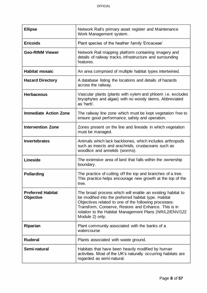
OFFICIAL
Ellipse Network Rail's primary asset register and Maintenance Work Management system.
Ericoids Plant species of the heather family ‘Ericaceae’
Geo-RINM Viewer Network Rail mapping platform containing imagery and details of railway tracks, infrastructure and surrounding features.
Habitat mosaic An area comprised of multiple habitat types intertwined.
Hazard Directory A database listing the locations and details of hazards across the railway.
Herbaceous Vascular plants (plants with xylem and phloem i.e. excludes bryophytes and algae) with no woody stems. Abbreviated
as ‘herb’.
Immediate Action Zone The railway line zone which must be kept vegetation free to ensure good performance, safety and operation.
Intervention Zone Zones present on the line and lineside in which vegetation must be managed.
Invertebrates Animals which lack backbones, which includes arthropods such as insects and arachnids, crustaceans such as woodlice and annelids (worms).
Lineside The extensive area of land that falls within the ownership boundary.
Pollarding The practice of cutting off the top and branches of a tree. This practice helps encourage new growth at the top of the
tree.
Preferred Habitat Objective
The broad process which will enable an existing habitat to be modified into the preferred habitat type. Habitat Objectives related to one of the following processes: Transform, Conserve, Restore and Enhance. This is in
relation to the Habitat Management Plans (NR/L2/ENV/122 Module 2) only.
Riparian Plant community associated with the banks of a watercourse
Ruderal Plants associated with waste ground.
Semi-natural Habitats that have been heavily modified by human activities. Most of the UK’s naturally occurring habitats are regarded as semi-natural.
Page 9 of 57
OFFICIAL
Statutory Nature Conservation Organisation (SNCO)
The SNCOs for England, Wales and Scotland are:
- Natural England
- Scottish Natural Heritage
- Natural Resources Wales
Thinning This is the practice of reducing the density of trees in a stand. This practice can improve the quality and growth of the remaining trees.
UK Habitat Classification A comprehensive classification system for the UK’s habitats. UK Habitat Classification is a 5-tier hierarchical
system which allows for habitats to be classified and identified to differing levels of detail (level 1 being ecosystems and level 5 sub-habitats). UK Habitat Classification can be used when identifying and recording
habitat distribution. It is also the habitat classification system used within Natural England’s Biodiversity Metric 2.0.
Wet woodland Also known as carr woodland, wet woodlands occur on a range of soil types which are poorly drained or seasonally
wet.
Table 1 – Terms and Definitions
Page 10 of 57
OFFICIAL
4 Introduction
This document is intended to inform the preparation and application of:
• Habitat Management Plans (see NR/L2/ENV/122 Module 02);
• Route Vegetation Management Plans (see NR/L2/OTK/5201 Module 03); and
• Sectional Assets Plans (see NR/L2/OTK/5201 Module 03).
Together these documents set out the requirements for the management of habitats
within the lineside.
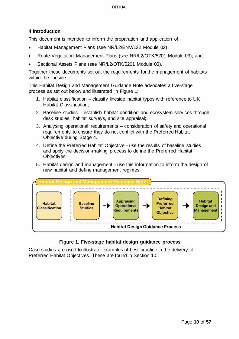
This Habitat Design and Management Guidance Note advocates a five-stage
process as set out below and illustrated in Figure 1:
1. Habitat classification – classify lineside habitat types with reference to UK
Habitat Classification;
2. Baseline studies – establish habitat condition and ecosystem services through
desk studies, habitat surveys, and site appraisal;
3. Analysing operational requirements – consideration of safety and operational
requirements to ensure they do not conflict with the Preferred Habitat Objective during Stage 4.
4. Define the Preferred Habitat Objective - use the results of baseline studies and apply the decision-making process to define the Preferred Habitat Objectives;
5. Habitat design and management - use this information to inform the design of new habitat and define management regimes.
Figure 1. Five-stage habitat design guidance process
Case studies are used to illustrate examples of best practice in the delivery of
Preferred Habitat Objectives. These are found in Section 10.

Page 11 of 57
OFFICIAL
4.1 Document structure
Figure 2. shows the relationship and hierarchy of the Habitat Design and
Management Guidance Note and other Level 1, Level 2 and Level 3 Network Rail guidance notes, manuals and modules.
Figure 2. Document hierarchy

Page 12 of 57
OFFICIAL
5 Habitat Classification
This section provides an introduction to the five primary habitats types encountered
along the lineside and outlines the process which should be undertaken to identify and classify them according to the primary habitat type. Details on identifying and classifying sub-habitats are outlined within the respective habitat specific design and management guidance notes.
5.1 Introduction
The first step in defining the Preferred Habitat Objective for a piece of land is to
classify the existing habitat according to one of the five primary habitat types outlined below.
NOTE: Refer to Section 7 of the Habitat Management Plan Module (NR/L2/ENV/122 Module 2) for further detail on Preferred Habitat Objectives
Network Rail has adopted the UK Habitat Classification (UK Hab), which utilises a hierarchical system to classifying habitats. This system comprises of 5 levels, ranging in detail from ecosystem scale (Level 1) to the level of detail required to classify
priority habitats and sub-habitats (e.g. Level 4 and 5).
NOTE: UK Hab documents are available at: https://ecountability.co.uk/ukhabworkinggroup-ukhab/
This guidance note is concerned with terrestrial habitats (UK Hab Level 1) and
outlines the five primary habitat types (UK Hab Level 2) according to which all land within the lineside can be classified. These habitat types are set out and described on the following pages, with further detail provided in separate habitat specific design and management guidance notes:
• Grassland;
• Woodland;
• Heathland and Shrub;
• Wetland; and
• Urban and Brownfield.
5.2 How to use the classification
This document provides the following information as an introduction to each primary habitat type:
• A definition of the primary habitat type;
• Key attributes; and
• Sectional illustration of lineside application.
This classification should be used to help classify habitats to UK Hab Level 2 as part
of a desk study assessment using aerial images of a route section or lineside site.
Once identified, all habitats must then be classified using baseline data collected
from a UK Hab field survey undertaken by a suitably experienced ecologist. Where
Page 13 of 57
OFFICIAL
possible, habitats should be classified to Level 4, using the methodology outlined within the UK Habitat Classification User Manual (2018a) and the UK Habitat Field Key (2018b). This reflects the level of detail needed to undertake a biodiversity net gain assessment using most biodiversity metrics, including Natural England’s Metric
2.0. It will also inform the Preferred Habitat Objective and the production of a site Habitat Management Plan.
NOTE: Ecological competence of ecologists who can undertake this work is detailed in Section 4 of the L2 Biodiversity Manual & Modules NR/L2/ENV/122

Page 14 of 57
OFFICIAL
5.2.1 Primary Habitat Types
Broad definitions and attributes for each of the five primary habitat types are provided
below. These should not be used to classify habitats. Habitat Classification should be done using a combination of the UK Hab and the Habitat Classification sections featured within the Design and Management Guidance Note for each respective primary habitat type.
5.2.1.1 Woodland (UK Hab code - w)
5.2.1.1.1 Definition:
Woodland is defined as vegetation dominated by trees at least 5m high when mature, forming a distinct canopy covering at least 25% of the total
woodland area. Woodland includes recently planted, semi natural or planted woodland, recently felled woodland,
coppice-with-standards, lines of trees,
wet woodland and bog woodland.
5.2.1.1.2 Attributes:
• Tree canopy covers at least 25% of the woodland habitat’s total coverage.
• Can be managed in a variety of ways, including coppicing, pollarding and thinning.
• Plantation is woodland which has been obviously planted, whereas semi-natural woodland occurs naturally.
• Semi-natural coniferous woodland typically only occurs in the highlands, but conifer plantations are frequently planted in both the lowlands and uplands for forestry
Figure 4. Examples of ideal lineside woodland communities
Figure 3. Typical example of a managed lineside
woodland

Page 15 of 57
OFFICIAL
5.2.1.2 Grassland (UK Hab code - g)
5.2.1.2.1 Definition
Vegetation not on permanently waterlogged soils, with more than 75% cover of herbaceous species (grasses, sedges, rushes and wildflowers). Grasslands cover
40% of the UK and grow on soils where scrub and trees are absent or infrequent e.g. on embankments and cutting slopes, pasture, along field margins and woodland
edges.
5.2.1.2.2 Attributes
• Habitat dominated by grasses and other herbaceous plants e.g. wildflowers.
• A well-managed grassland should typically have few trees and no more than 10-25% scrub coverage.
• Managed through mowing or grazing to prevent a transition to scrub or woodland.
• Species composition can differ depending on underlying soil type, e.g. chalk, neutral or acid and soil fertility.
• Can be modified by ‘agricultural improvement’ i.e. adding fertiliser increases the nutrient content of the soil and reduces species-richness.
Figure 6. Examples of lineside grassland habitats
Figure 5. Grassland typical of rail side habitat
Page 16 of 57
OFFICIAL
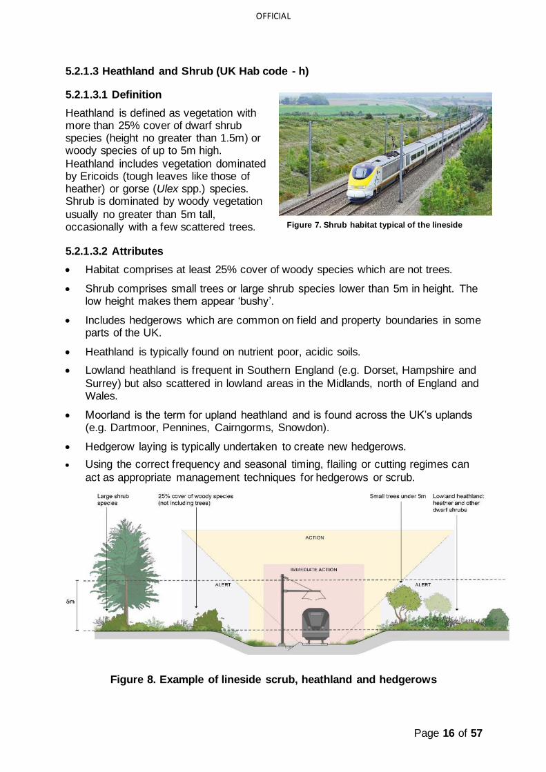
5.2.1.3 Heathland and Shrub (UK Hab code - h)
5.2.1.3.1 Definition
Heathland is defined as vegetation with more than 25% cover of dwarf shrub species (height no greater than 1.5m) or woody species of up to 5m high.
Heathland includes vegetation dominated by Ericoids (tough leaves like those of heather) or gorse (Ulex spp.) species. Shrub is dominated by woody vegetation
usually no greater than 5m tall, occasionally with a few scattered trees.
5.2.1.3.2 Attributes
• Habitat comprises at least 25% cover of woody species which are not trees.
• Shrub comprises small trees or large shrub species lower than 5m in height. The low height makes them appear ‘bushy’.
• Includes hedgerows which are common on field and property boundaries in some parts of the UK.
• Heathland is typically found on nutrient poor, acidic soils.
• Lowland heathland is frequent in Southern England (e.g. Dorset, Hampshire and
Surrey) but also scattered in lowland areas in the Midlands, north of England and Wales.
• Moorland is the term for upland heathland and is found across the UK’s uplands (e.g. Dartmoor, Pennines, Cairngorms, Snowdon).
• Hedgerow laying is typically undertaken to create new hedgerows.
• Using the correct frequency and seasonal timing, flailing or cutting regimes can
act as appropriate management techniques for hedgerows or scrub.
Figure 8. Example of lineside scrub, heathland and hedgerows
Figure 7. Shrub habitat typical of the lineside

Page 17 of 57
OFFICIAL
5.2.1.4 Wetland (UK Hab code - f)
5.2.1.4.1 Definition:
Wetland is defined as any habitat that is waterlogged, where the water table is at surface or standing water between 50% and 70% of the year. This may not be
immediately obvious during summer.
5.2.1.4.2 Attributes
• Predominantly found adjacent to watercourses, ponds and lakes, where the water table is high.
• Natural springs can give rise to wetlands in the uplands.
• Habitat which is wet at least half of a typical year; usually autumn to spring.
• Includes reedbeds and fenland, bog, wet heathland, wet grassland, swamp and
marshland.
• Wetland type is dependent on hydrology, soil type and the type of vegetation
growing.
Figure 10. Examples of lineside wetland habitats
Figure 9. Wetland scrapes nearby a railway line

Page 18 of 57
OFFICIAL
5.2.1.5 Urban (UK Hab code - u)
5.2.1.5.1 Definition
Urban habitats are defined as constructed, industrial and other artificial habitat, such as grey infrastructure and brown field habitats. Such habitats typically support
novel or unique assemblages of plant species, that have adapted to thrive in urban locations. Urban habitats commonly work in mosaics and may include aspects
of grasslands and scrublands combined.
5.2.1.5.2 Attributes
• Typically found along railway corridors in towns and cities, although left spoil heaps in rural settings, if colonised by vegetation can provide urban style habitat.
• Includes vegetation established on ballast and hard substrates or growing on disturbed or modified soil e.g. ruderals.
• On disturbed sites, where substrate structure varies, open mosaic habitats can form, which can be of high value to invertebrates.
• Artificial structures can be created in urban areas to mimic these habitats for wildlife e.g. living walls, artificially created open mosaic habitats.
• Includes mosaics of urban habitats which can are occasionally high in biodiversity value e.g. open mosaic habitat.
Figure 12. Ideal urban lineside habitats
Figure 11. Typical urban railway

Page 19 of 57
OFFICIAL
6 Baseline Studies
This section provides an overview of how to gather the baseline information to inform
and help define the Preferred Habitat Objectives within Section 8.
6.1 Introduction
Once the existing habitat type has been classified, the second step in defining the Preferred Habitat Objectives and resulting habitat intervention for a piece of land is to:
• Consider the constraints and opportunities for habitats presented and biodiversity through a habitat study:
o Understand the current condition and distinctiveness of the existing habitat through a habitat survey;
o Understand the existing and potential ecosystem services;
• Consider the constraints and opportunities for habitats presented by the land and surrounding landscape context through a site appraisal and appraisal of railway operations.
Inputs from habitat study and site appraisals can then be combined to help determine the Sectional Asset Plan Habitat Status and subsequently the Preferred Habitat
Objectives (see Figure 13). This process should be undertaken by appropriately qualified specialists.
NOTE: Checklist templates for recording the results of desk studies and fieldwork are provided in Appendix A. Checklists should only be filled in once assessments have been undertaken by competent specialists.
Figure 13. Process for informing the habitat study and site appraisal
Figure 13 illustrates how information feeds into the habitat study and site appraisal. The items illustrated in Figure 13 which influence these two stages are examples of things that require consideration during the process and are not intended to be an exhaustive list. For example, BAP Priority Species of Habitat are likely to overlap with considerations relating to habitat type or protected species. Input into the habitat

Page 20 of 57
OFFICIAL
study and site appraisal requires specialist consideration. For example, inputs into the habitat study will require detailed knowledge from suitably experienced ecologist.
6.2 Ecosystem services
Land within the lineside can provide a range of ecosystem services, which support human well-being and quality of life. Habitat management has the potential to increase or decrease the range and quality of ecosystem services. Data on
ecosystem services should therefore be gathered and assessed as part of a site appraisal.
The ecosystem services outlined below have been informed by DEFRA’s Enabling a Natural Capital Approach (DEFRA, 2020). They have been selected due to their relevance to lineside habitat. This list is not intended to be definitive or exhaustive; if relevant, other ecosystem services should be considered.
NOTE: Ecosystem services of the land should be identified when fieldwork is undertaken. This should be determined by a suitably experienced environmental specialist, using DEFRA’s Enabling a Natural Capital Approach Guidance (DEFRA, 2020).
Biodiversity (B*):
Biodiversity is the variety of all life on Earth and is considered as a core component
of natural capital that provides a multitude of environmental services including agricultural pest control, soil recovery, habitat connectivity and nutrient cycling. As biodiversity underpins so many other ecosystem services, it should be the first consideration in all decision processes.
For example, many railway corridors act as essential corridors for biodiversity and allow integration with wider nature networks. They can link places where habitat
fragmentation is a problem (e.g. dense urban area) and underpin vital ecosystem services such as temperature regulation, health and wellbeing and water regulation. Lineside vegetation also supports habitat connectivity within the wider landscape.
Pollination (P*):
Although directly linked to biodiversity, pollination is vital for agricultural production and provides a substantial economic benefit nationally. As much of our wider landscape has become impoverished for wildlife, railway corridors that span across the United Kingdom provide a linked-up network of habitats that could provide refuge
and foraging space that can help maintain or enhance pollinator populations vital for natural and agricultural pollination.
Air pollution removal (AP*):
Air pollution presents a major risk to human health and emanates from a variety of
sources including railway services, road traffic, landfill sites and power stations. Broadly speaking, vegetation helps limit the impact air pollution has on human health by dispersing pollutants away from public areas and by pollutants depositing on vegetation. Lineside vegetation has the potential to mitigate air pollution deriving from
the railway and from external sources.
Landscape (L*):
Landscape refers to the socio-cultural benefits that habitats provide opposed to environmental services, such as aesthetics and visual amenity. Lineside habitats
may also be integral to the wider landscape character, providing better integration into the landscape setting.

Page 21 of 57
OFFICIAL
Water regulation (WR*):
Vegetation can slow the rate at which water enters waterbodies and watercourses,
reducing flash flood events downstream. Water drawn up through plant roots is released back into the atmosphere through evapotranspiration, supporting healthy ecosystems. Lineside vegetation has the potential to regulate waterflow and prevent flooding in surrounding settlements and landscapes, even in urban areas.
Noise mitigation (NM*):
Noise pollution is associated with adverse health outcomes through lack of sleep and disturbance and is known to detrimentally effect wildlife. Vegetation can protect against noise pollution by acting as a physical buffer between the source of the noise
and those living nearby. Lineside vegetation can act as a noise barrier, limiting the noise disturbance that travels beyond the railway corridor.
Carbon sequestration (CS*):
A natural function of habitats is to sequester carbon dioxide from the atmosphere and
store it. This varies between broad habitats. Any change in land-use, restoration or enhancement of ecosystems has a measurable effect on the quantity of greenhouse gas (GHG) emissions. For example, tree planting will lead to increased sequestration, reducing GHGs emissions in the atmosphere. Lineside habitats have
the potential to sequester a large amount of carbon dioxide.
Local temperature regulation (TR*):
Urban economic activity and human health in urban areas can be negatively impacted by hot summers, exacerbated by the heat island effect caused
predominantly by grey infrastructure such as buildings and hardstanding surfaces.
In urban areas, lineside vegetation can counteract this effect, helping to regulate
local temperatures. It is anticipated that temperature regulation will become of greater importance as a result of climate breakdown.
Health and wellbeing (HW*):
Green space provides space for physical exercise but also positively contributes to
mental health. Lineside habitat may have enhanced access or contribute to community and workforce enjoyment, providing physical and mental health benefits such as reduced stress and anxiety. It may also contribute positively to the mental health of railway passengers.
Habitat study
It is important to understand the type, condition and distinctiveness of existing habitats, as this can have a bearing on future management decisions. This section explains what information can be particularly helpful and provides references to
additional sources.
NOTE: Habitats should be classified to Level 4 of the UK Hab once data is collected with a UK Hab field survey, undertaken by a suitably experienced ecologist.
NOTE: Management plans for protected sites can be sourced from the route environmental specialist.
NOTE: Identifying habitats and their condition requires botanical and habitat expertise. Therefore, surveys and assessments that determine these should be undertaken by a suitably experienced ecologist.
NOTE: A description and the value attributed to both habitat and associated ecosystem services should be recorded within the RVMP.
Page 22 of 57
OFFICIAL
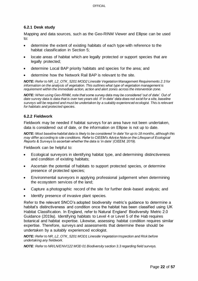
6.2.1 Desk study
Mapping and data sources, such as the Geo-RINM Viewer and Ellipse can be used to:
• determine the extent of existing habitats of each type with reference to the habitat classification in Section 5;
• locate areas of habitat which are legally protected or support species that are legally protected;
• determine Local BAP priority habitats and species for the area; and
• determine how the Network Rail BAP is relevant to the site.
NOTE: Refer to NR_L2_OTK_5201 MOD2 Lineside Vegetation Management Requirements 2.3 for information on the analysis of vegetation. This outlines what type of vegetation management is requirement within the immediate action, action and alert zones across the intervention zone.
NOTE: When using Geo-RINM, note that some survey data may be considered ‘out of date’. Out of date survey data is data that is over two years old. If ‘in date’ data does not exist for a site, baseline surveys will be required and must be undertaken by a suitably experienced ecologist. This is relevant for habitats and protected species.
6.2.2 Fieldwork
Fieldwork may be needed if habitat surveys for an area have not been undertaken,
data is considered out of date, or the information on Ellipse is not up to date.
NOTE: Most baseline habitat data is likely to be considered ‘in date’ for up to 18 months, although this may differ according to site conditions. Refer to CIEEM’s Advice Note on the Lifespan of Ecological Reports & Surveys to ascertain whether the data is ‘in date’ (CIEEM, 2019).
Fieldwork can be helpful to:
• Ecological surveyors in identifying habitat type, and determining distinctiveness and condition of existing habitats;
• Ascertain the potential of habitats to support protected species, or determine presence of protected species;
• Environmental surveyors in applying professional judgement when determining the ecosystem services of the land;
• Capture a photographic record of the site for further desk-based analysis; and
• Identify presence of invasive plant species.
Refer to the relevant SNCO’s adopted biodiversity metric’s guidance to determine a habitat’s distinctiveness and condition once the habitat has been classified using UK
Habitat Classification. In England, refer to Natural England’ Biodiversity Metric 2.0 Guidance (2019a). Identifying habitats to Level 4 or Level 5 of the Hab requires botanical and habitat expertise. Likewise, assessing habitat condition requires similar expertise. Therefore, surveys and assessments that determine these should be
undertaken by a suitably experienced ecologist.
NOTE: Refer to NR_L2_OTK_5201 MOD1 Lineside Vegetation Inspection and Risk before undertaking any fieldwork.
NOTE: Refer to NR/LN/ENV/122 MOD 01 Biodiversity section 3.3 regarding field surveys.

Page 23 of 57
OFFICIAL
NOTE: Refer to NR/L2/ENV/122 MOD 01 and MOD 02 regarding data gathering, the identification of existing habitats and species (e.g. SSSI) or protected species recorded on site.
6.2.3 Recording the results
The results of the desk study and fieldwork can be combined to assess each habitat
individually and on its own merit, using Table 2 as a guide.
Desk Study
Existing habitat types
Classify the habitat using UK Hab Field Key (2018b) to Level 4 or Level 5.
Are there any protected species on site?
Note from any previous assessment or from Ellipse or Geo-RINM Viewer whether protected species have been recorded on or near the site. An ecological appraisal may need to be undertaken for the site if data is limited, out of date or non-existent.
Are BAP Priorities applicable?
Record Local BAP priorities and Network Rail BAP Priority habitats and species relevant to the area. Reference should be made to relevant local plans, planning documents and local BAPs.
Fieldwork
Habitat
Distinctiveness
Habitat distinctiveness is defined by its type, with reference
to the UK Habitat Classification. Details on how to look up habitat distinctiveness for different habitat types can be found within the adopted biodiversity metric for the relevant SNCO. In England, this is the Metric 2.0 Biodiversity
Calculation Tool (Natural England, 2019b). The distinctiveness scores must be researched by a suitably experienced ecologist (scores range very low, low, medium, high or very high).
Habitat Condition Baseline habitat and botanical data should be used to determine condition, using Natural England’s Biodiversity Metric 2.0 – Technical Supplement (Natural England, 2019c) or equivalent if using an adopted biodiversity metric of a
SNCO. It is important that the correct condition assessment guide is used as there are several for different habitats. This step should be undertaken by a suitably experienced ecologist and scored between NA – agriculture, NA – other,
very low, low, moderate, high or very high. The condition score assigned to a habitat should be justified. A robust justification highlighting how the condition assessment criteria have been met should be provided.
Habitat status Recorded as unassigned, existing, transitioning, preferred or
unpreferred in the Sectional Asset Plan (see NR/L2/OTK/5201/03)
Table 2 – Habitat surveys

Page 24 of 57
OFFICIAL
6.2.4 Site appraisal
It is important to understand the key constraints and opportunities presented by the land, which may have a bearing on the Preferred Habitat Objective.
Consideration needs to be given to the impact on other assets where management or maintenance activities are being considered. Consult with other asset groups regarding how management of lineside vegetation will help with optimal performance for their respective areas.
Tables 3 and Table 4 provide an example of some factors such as health and safety risks and the physical attributes of the site.
NOTE: Refer to NR_L2_OTK_5201 MOD2 Lineside Vegetation Management Requirements regarding assessing the impact of management operations.
Lineside considerations
Health and Safety Do the risks to health and safety prohibit lineside work? e.g. proximity to running line, Overhead Line Equipment (OLE), employee welfare.
Refer to the Hazard Directory which lists the locations and details of known hazards across the railway.
High Risk Medium Risk Manageable Risk
Reliability of service Are there habitat types that could impact on the reliability of
railway services?
Network type What type of network could be affected by the works, main line, secondary network or local rail?
Table 3 – Lineside appraisal
If a site is considered high risk from a health and safety point of view, it does not necessarily mean a Preferred Habitat Objective option is not feasible. This may highlight a need for further consideration and refinement of specific habitat
objectives. The attributes listed in table 3 provide an example in what potential variables which are likely to impact the range of Preferred Habitat Objectives that could be feasibly implemented on site.
NOTE: Refer to NR_L2_OTK_5201 MOD2 Lineside Vegetation Management Requirements regarding safe working before undertaking any fieldwork.
The cost of implementing and maintaining habitats may be a factor in considering the feasibility of different habitat management objectives. Refer to Appendix D for
detailed costing information.
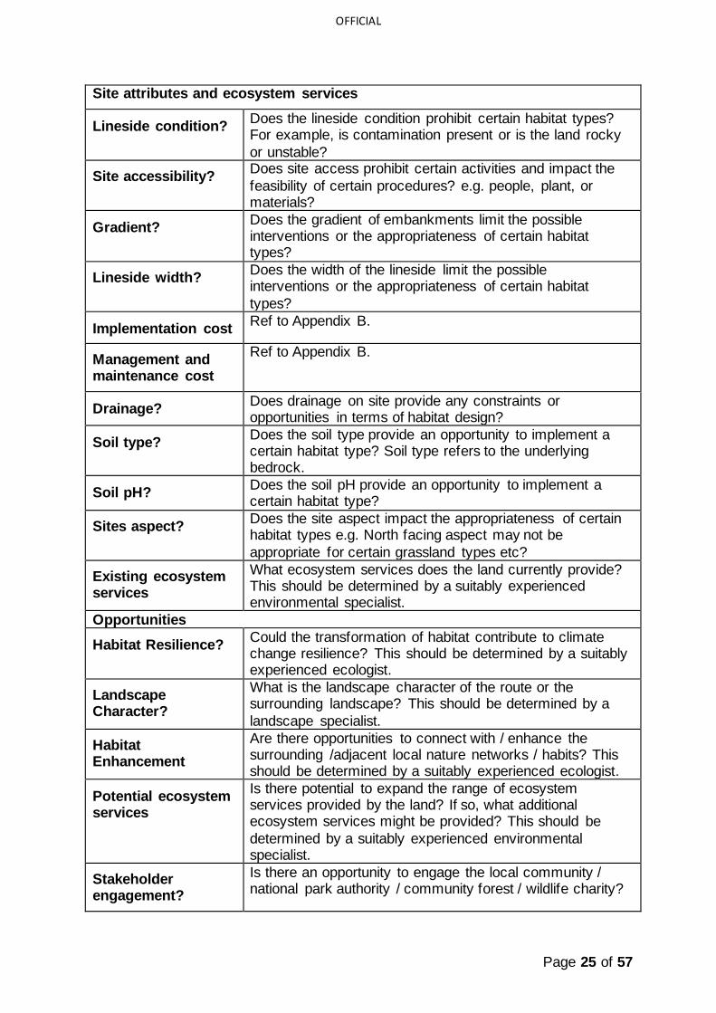
Table 4 provides an overview of potential site attributes and should only be used as a
summary once all necessary assessments have been completed by appropriate specialists. Site attributes and ecosystem services, such as those listed in Table 4, may restrict which Preferred Habitat Objective and thus which habitats can feasibly be created on site. Table 4 provides examples of site attributes that are not directly
associated with safety and performance considerations.
Many of the example attributes outlined in Table 4 are unlikely to be available on
Geo-RINH, Ellipse or other Network Rail datasets. They should therefore be assessed during site surveys by collecting quantifiable data or through observations.
Page 25 of 57
OFFICIAL
Site attributes and ecosystem services
Lineside condition? Does the lineside condition prohibit certain habitat types? For example, is contamination present or is the land rocky
or unstable?
Site accessibility? Does site access prohibit certain activities and impact the
feasibility of certain procedures? e.g. people, plant, or materials?
Gradient? Does the gradient of embankments limit the possible interventions or the appropriateness of certain habitat types?
Lineside width? Does the width of the lineside limit the possible interventions or the appropriateness of certain habitat
types?
Implementation cost Ref to Appendix B.
Management and maintenance cost
Ref to Appendix B.
Drainage? Does drainage on site provide any constraints or opportunities in terms of habitat design?
Soil type? Does the soil type provide an opportunity to implement a certain habitat type? Soil type refers to the underlying bedrock.
Soil pH? Does the soil pH provide an opportunity to implement a certain habitat type?
Sites aspect? Does the site aspect impact the appropriateness of certain habitat types e.g. North facing aspect may not be
appropriate for certain grassland types etc?
Existing ecosystem services
What ecosystem services does the land currently provide? This should be determined by a suitably experienced environmental specialist.
Opportunities
Habitat Resilience? Could the transformation of habitat contribute to climate change resilience? This should be determined by a suitably experienced ecologist.
Landscape Character?
What is the landscape character of the route or the surrounding landscape? This should be determined by a
landscape specialist.
Habitat Enhancement
Are there opportunities to connect with / enhance the surrounding /adjacent local nature networks / habits? This should be determined by a suitably experienced ecologist.
Potential ecosystem services
Is there potential to expand the range of ecosystem services provided by the land? If so, what additional ecosystem services might be provided? This should be
determined by a suitably experienced environmental specialist.
Stakeholder engagement?
Is there an opportunity to engage the local community / national park authority / community forest / wildlife charity?
Page 26 of 57
OFFICIAL
Table 4 – Site attributes and ecosystem services
6.2.5 Applying the data
NOTE: Detailed rail-side assessments are undertaken as part of Route Vegetation Management Plans which takes into account a variety of constraints to define a ‘Habitat Status’, which is explained within section 7. Appraising Operational Requirement for further information.
NOTE: Refer to the Sectional Asset Plan as defined in NR/L2/OTK/5201 MOD 03 Route Vegetation Management Plans which sets out the habitat status relevant to the habitat in its current form, as defined in table 6 within section 7.
The data and information gathered as part of the baseline studies will help inform which of the Preferred Habitat Objectives may feasibly be implemented on any given site. Whilst there is a set process for determining Preferred Habitat Objectives (using
a combination of the methodologies outlined in Section 7 and Section 8), it may be that site conditions, the presence of a particular protected species or habitat, or other factors mean that certain habitat management interventions cannot be undertaken on site.

Page 27 of 57
OFFICIAL
7 Appraising Operational Requirements
7.1 Introduction
This section provides guidance on how to consider operational requirements to ensure that it does not conflict with the Preferred Habitat Objective. This stage ensures that operational requirements can be met against the Preferred Habitat Objective by aligning the Habitat Status and the Management Intervention as set out
in the Sectional Asset Plan with the Preferred Habitat Objective. Each of these must be detailed for the site within the Habitat Management Plan to inform the appropriate habitat intervention. Table 5 and 6 outline the definitions used relating to habitats in an operational context. Section 7.2 details and illustrates the process which must be
taken to ensure the operational and biodiversity requirements align.
The Sectional Asset Plan (see NR/L2/OTK/5201 MOD 03 Route Vegetation
Management Plans) sets out the habitat status relevant to the habitat in its current form, as defined in table 5 below. The definitions outlined in table 6 refer to the habitat status in relation to operational constraints only.
Habitat status Definition
Unassigned Habitat data does not exist for the site in question. Habitat surveys undertaken by a suitably experienced ecologist will be required.
Existing Habitat data has been collected for the site, the habitat type is static and a preferred or unpreferred state hasn’t been decided.
Transitioning Habitat that is transitioning from one habitat type to another e.g. grassland
to scrub to woodland.
Preferred The habitat is already in the preferred state for safety and operation.
Unpreferred The habitat isn’t in the preferred state for safety and operation.
Table 5. Definition of habitat status
The Sectional Asset Plan also sets out the management interventions applicable to vegetation within the lineside, as defined in table 6 below.
Intervention Application
Reactive Locations where none of the other interventions are currently in place and reactive maintenance is only undertaken.
Replace and Maintain
Locations where a safety risk is present and the habitat is not preferred, or where the habitat type alone is not suitable.
Re-profile and
Maintain
Locations where a safety risk is present within the preferred habitat. Not
changing the habitat just an aspect/feature within the habitat.

Page 28 of 57
OFFICIAL
Maintain Locations where the preferred risk levels and habitat have been achieved.
Enhanced Maintenance
Locations where the preferred risk levels and habitat have been achieved and there are opportunities to improve the habitat.
Table 6. Definition of management interventions
7.2 Appraising operational requirements
Where baseline data exists and once the baseline studies are complete, the next
step is to appraise the site’s operational requirements. Once the habitat is classified, the Habitat Status can be determined (Figure 14). If the habitat type’s Habitat Status is preferred from an operational perspective, then the decision tree (Figure 16) is used to determine the Preferred Habitat Objective (see Section 8); this process
enables biodiversity value to be maximised whilst adhering to operational requirements. Whilst linked to the Preferred Habitat Objective, the management intervention must next be determined. The outputs of this process must be detailed within the Habitat Management Plan for the site, reviewed and reassessed at set
future intervals (see Section 9). As an example, woodlands comprising high leaf fall tree species are likely to have an unpreferred habitat status; under this scenario, the only option would be to transform the woodland to a preferred habitat type e.g. grassland.
For sites where no baseline habitat exists, the habitat is automatically listed as ‘unassigned’ (Figure 15) and reactive management is undertaken to prevent the
habitat from transitioning. Whilst no data exists for a site, the site cannot be effectively managed for biodiversity. The habitat status ‘unassigned’ is intended only for habitats where baseline data is absent. It is therefore important that a site does not remain as unassigned and that baseline surveys and studies are undertaken for
the site to determine its Habitat Status and Preferred Habitat Objective. Where a site has been unassigned, this should be raised internally with a suitably experienced ecologist so that data collection is prioritised.
Figure 14. Process of determining the preferred habitat intervention
Figure 15. Process of determining the preferred habitat intervention without data

Page 29 of 57
OFFICIAL
8 Defining the Preferred Habitat Objective
This section provides guidance on defining Preferred Habitat Objectives.
8.1 Introduction
Information gathered and reviewed as part of the baseline studies must be used to
determine Preferred Habitat Objective for a site’s habitats. Once the baseline studies are complete, the site’s habitats will be assigned a habitat status (see Section 8.2). The habitat status relates to operational requirements and is an essential component in determining the Preferred habitat Objective. During this process, one of four
Preferred Habitat Objectives will be selected which will help determine the habitat interventions (Table 7).
Preferred Habitat Objective
Description
Conserve Managing the habitat so it continues to function as its current habitat type, distinctiveness and condition. Typically, habitats of high or very high distinctiveness, which are well suited to the site and provide a range of ecosystem services. Management is required to preserve the habitat.
Enhance Undertake management or intervention to improve the habitat’s condition, distinctiveness and ecosystem service functioning e.g. enhancing a grassland from species-poor to species-rich. Enhancement can be applied to all habitats, including those with very high distinctiveness. Enhancement helps to increase habitat condition and presents opportunities for increasing the range of ecosystem services. Enhancement can also occur to accelerate the natural transition of one habitat to another e.g. grassland to scrub or woodland.
Restore Managing to assist recovery of habitat that has been degraded, damaged, destroyed or has naturally transitioned into another habitat type with a lower distinctiveness. The original habitat remains the preferred habitat and the site conditions are appropriate e.g. grassland that has transitioned to scrubland where the preferred management objective is to restore to grassland.
Transform Process of establishing a primary habitat different to that currently present in order to increase distinctiveness or due to health and safety or operational constraints. The Preferred Habitat Objective may be to establish a habitat type not previously present within the site e.g. grassland to woodland.
Table 7 Habitat objectives

Page 30 of 57
OFFICIAL
8.2 Decision making process
Figure 16 describes the decision process which should be undertaken once the
baseline information has been reviewed to arrive at the Preferred Habitat Objective. The first step is to assess whether any information gathered during the baseline studies has the potential to override the decision process i.e. presence of protected species, a designated site for nature conservation or priority habitats means that the
Preferred Habitat Objective may be restricted. If these are absent on site, the Preferred Habitat Objective is largely defined by habitat distinctiveness and condition, providing the Sectional Asset Plan’s habitat status is considered ‘Preferred’. The primary aim of the decision process illustrated in Figure 16 is to enhance biodiversity
across as many sites as possible.
Figure 16. Preferred Habitat Objective decision process
Page 31 of 57
OFFICIAL
NOTE: If a site is encompassed by a designated site, priority habitat or supports protected species, then management options will be restricted and determined at an earlier stage. Ecosystem services should be considered during survey, data interpretation and during site appraisal (see section 6).
8.3 Ecosystem services
Where ecosystem services, as referred to in section 6.2, are the key consideration
for habitat management, professional judgement must be used to determine the appropriate Preferred Habitat Objective utilising DEFRA’s Enabling a Natural Capital Approach (DEFRA, 2020). For example, if improving carbon sequestration is the key consideration for habitat management on a site that supports a grassland, enhancing
or restoring the grassland to a scrubland or woodland is likely to be the most suitable approach.
Enhancement of an ecosystem service doesn’t necessarily equate to biodiversity enhancement. As such, if ecosystem services are the key consideration for a site, the decision process (Figure 16) should be used in conjunction with the qualitative approach used for ecosystem services to ensure that biodiversity is not adversely
impacted.

Page 32 of 57
OFFICIAL
9 Habitat Design and Management
The following section provides a guide to the implementation and delivery of the
Preferred Habitat Objective. Professional expertise will be required during this process; a suitably experienced ecologist and/or environmental specialists should therefore be consulted.
9.1 Delivering Preferred Habitat Objectives
9.1.1 Considering Protected Species, Priority Habitats and Designated Sites
As detailed in Section 8, presence of protected species, priority habitats or designated sites for nature conservation is likely to restrict the available Preferred Habitat Objectives for a site.
If surveys establish that protected species are on site, the Preferred Habitat Objective and management interventions are not only likely to be limited but a protected species licence may be required to undertaken habitat management. If
protected species are found to be present, additional surveys may need to be undertaken to establish the population size. Acquiring a protected species licence and undertaking the necessary surveys to inform the licence can be both time- consuming and costly.
NOTE: Protected species surveys and filing of protected species licences must be undertaken by a Natural England licence holder for the protected species in question. Protected species that could be encountered lineside include but are not limited to great crested newts (Triturus cristatus), hazel dormice (Muscardinus avellanarius) and bats.
There are likely to be management requirements for habitats in designated sites. A suitably experienced ecologist must therefore determine appropriate management
interventions during the process outlined in Figure 17 to conserve or enhance priority habitats or to adhere to the requirements of a designated site.
NOTE: The requirements of a designated site are dependent on the type of designation. For example, a SSSI will require an agreement from Natural England, whilst local designations will require agreements with local planning authorities.
9.1.2 The Habitat Design and Management Process
The process of habitat design and implementation of management interventions is
illustrated in Figure 17. This includes co-ordination with specialists and other stakeholders.
NOTE: Refer to the Network Rail Stakeholder Engagement guidance note for detailed information.
NOTE: Specialist input into the Habitat Management Plan should be sought throughout this process.

Page 33 of 57
OFFICIAL
Figure 17. Implementing Habitat Management Objectives
Further guidance on applying this process follows:
1. Engage additional specialist input: identify specialists, such as Arboriculturists, landscape architects and soil scientists, whose input is required to ensure that the design of management interventions is appropriate.
2. Define S.M.A.R.T. management objectives: mechanisms for assessing the success of the Habitat Management Plan should be considered. This may include objectives which are Specific, Measurable, Achievable, Realistic and
Timebound by a suitably experienced specialist. If used, S.M.A.R.T. objectives should be linked to a quantifiable mechanism e.g. Key Performance Indicators (KPIs) which will measure the success of the management technique implemented over 0-5 years, 6-15 years and 16+ years. S.M.A.R.T objectives
should be reassessed at least every five years in response to monitoring and evaluation.
3. Seek necessary approval from Network Rail management: approval is required to undertake the proposed management technique.
4. Appointing competent contractors: a competent contractor should be appointed to undertake the management interventions. A detailed brief of the

Page 34 of 57
OFFICIAL
work required must be outlined prior to appointment and must include expectations regarding monitoring.
5. Habitat Management Plan: the Habitat Management Plan should outline a vegetation management and ecological monitoring plan for the site as per the requirements set out in Habitat Management Plan Module (NR/L2/ENV/122 Module 2). If being used, S.M.A.R.T objectives and KPIs should be embedded
in this report. The frequency of monitoring will depend upon the habitat or feature to which it applies and must consider time to target condition or distinctiveness for habitat creation or enhancement. However, as a minimum it should be carried out once in each control period.
6. Implementation: instructions developed from the Habitat Management Plan should be clear and be derived from the Preferred Habitat Objective. Once the
Habitat Management Plan has been approved, management interventions can be implemented.
7. Monitoring and evaluation: If used, the success of a management technique in relation to the S.M.A.R.T objectives and KPIs outline in the Habitat Management Plan should be reviewed regularly. The review will depend upon monitoring of the habitats or features proposed within the Habitat
Management Plan, and, where possible, input from stakeholders (Refer to: Habitat Management Plan Module NR/L2/ENV/122 Module 2 for further information). If S.M.A.R.T objectives and KPIs are not used, alternative mechanisms for assessing the success of a Habitat Management Plan should
be considered.
9.2 Habitat Management Plans and Lineside Vegetation Management Plans
Habitat Management Plan Module NR/L2/ENV/122 Module 2 sets out what should be included within a Habitat Management Plan, whilst the L2 Lineside Vegetation Management Module (NR/L2/OTK/5201) outlines the requirements for route asset managers to develop vegetation management plans and sectional asset plans.
These plans are essential in supporting the design and implementation of lineside habitat creation and management. Figure 18 illustrates the key considerations.
Figure 18. Habitat Management Plan Process

Page 35 of 57
OFFICIAL
The inputs outlined in Figure 18 provide an example only and are not intended to be an exhaustive list.
NOTE: Refer to environmental professionals (e.g.: environment manager, environmental specialist, ecologist or health safety environment advisor) for the location and classification of habitat types.
9.2.1 Defining a management intervention
Refer to habitat specific design and mangement notes for detailed management and maintenance guidance.
The appropriate habitat management regime will be defined by:
• the existing habitat type;
• the Preferred Habitat Objective;
• the ability to carry out the works safely;
• Context/location; and
• Achievability.
The types of interventions that are appropriate to achieve a preferred habitat should be judged on a case-by-case basis. However, interventions should fall broadly into the following categories as outlined within the Habitat Management Plan (NR/L2/ENV/122 Module 2):
1. Habitat Restoration – a process whereby existing habitat that has been damaged or degraded is established into an improved condition;
2. Habitat Creation – the creation of new habitat or features; or
3. Natural Regeneration – letting nature ‘take its own course’ to establish habitats.
These categories will differ in the amount of effort or numbers of tasks that are required. The Habitat Management Plan should provide the detail of how the interventions to achieve the preferred habitat will be carried out.
Habitats will require the greatest investment in maintenance during the establishment period, after which detailed operations can be revised and adjusted as required.
It is recommended that mangement plans set out Short-term (year 0 to 5), Medium-term (year 6 to 15), and Long-term objectives, action plans and work plans.
The types of management interventions applied to primary habitats and sub-habitats are set out and described in separate habitat specific design and management
guidance notes:
• Grassland;
• Woodland;
• Heathland and Shrub;
• Wetland; and
• Urban and Brownfield.
NOTE: Vegetation management with regards safety within the ‘immediate action zone’ is described in NR/L2/OTK/5201/02.

Page 36 of 57
OFFICIAL
9.3 Habitat management implementation
Habitat management should adhere to the seasonal periods in which different
practices should be undertaken following best practice. For example, potential presence of protected and/or notable species can present time delays and introduce additional risk when implementing habitat management. In addition, protected species licences or mitigation may be required; these should be determined by a
suitably experienced ecologist.
If protected species are present, habitat management may be able to take place
providing that a method statement, toolbox talk and/or watching brief are implemented, to ensure the safety of the protected species.
NOTE: Refer to habitat specific design and mangement notes for detailed management and maintenance guidance.
9.4 Monitoring and Evaluation
Monitoring should be undertaken to assess the success of the habitat intervention on biodiversity, and where applicable, for ecosystem services.
Figure 19. Monitoring and evaluation
The purpose of monitoring and evaluation is to measure the relative success of the habitat intervention in line with the expected aims. Due to the wide range of habitats, abiotic and environmental conditions that are present across the network, bespoke KPIs should be considered for each site. This section therefore only outlines the
framework for defining mechanisms for assessing the success of a Habitat Management Plan e.g. KPIs.
The Habitat Management Plan (NR/l2/ENV/122 Module 2) sets out the following monitoring requirements:
1. Biodiversity Net Gain: the condition of a habitat must be reassessed frequently to determine whether the habitat is on track to reach its desired
target habitat and condition. In order to reassess habitat condition, habitat surveys must be updated ensuring that the data required for the condition assessment criteria are collected. This can be found by referring to the relevant SNCO’s adopted biodiversity metric guidance.

Page 37 of 57
OFFICIAL
In addition to the monitoring requirements, additional KPIs should be considered and directly link to appropriate monitoring methods, including:
2. Botanical: desirable target botanical indicator species and undesirable species, directly linked to the target habitat, should be outlined within the Habitat Management Plan for each habitat. This will need to be bespoke due to the variation in botanical species present in different habitats and
environmental settings. It is recommended that the relative abundance of indicator species is surveyed for on annual basis. This method can act as a proxy for biodiversity whilst reducing survey effort. In addition, percentage cover could be used. For example, percentage cover of ground flora within
woodlands indicates less dense canopies, and higher percentage cover of wildflowers in grasslands generally indicates greater species-richness.
3. Invertebrate sampling: sampling methods such as sweep netting could be considered to collect invertebrate data. Species or taxa richness of invertebrates could be used as proxy measure for biodiversity change.
Undertaking monitoring will allow for comparisons against baseline ecological data, providing information about how a habitat’s type and condition is progressing in line with the site’s objectives.
If the review acknowledges that the management regime is no longer suitable or the habitat objective for the site is no longer preferred, the Preferred Habitat Objective
may need to be reassessed through the decision process outlined in Section 8, following a cyclical process.
Note: Habitat records in Ellipse should be updated where there has been a change to the habitat type.

Page 38 of 57
OFFICIAL
10 Case Studies
This section provides examples of Network Rail case studies where habitat
management has been successful and details the decision-making process of selecting habitat management types. The examples relate to the four Preferred Habitat Objective categories (conserve, enhance, restore and transform). The Management Decision Process outlined for each case study has been retrospectively
applied to each project example to illustrate how the process and Preferred Habitat Objectives should be applied.
Each case study includes:
• A description of the background of the scheme;
• Why the site’s habitat management is important;
• The decision process as outlined in Figure 16 ‘Habitat Design and Management Decision Process’ to determine the aim of the Preferred Habitat Objective and associated management intervention could have; and
• Details for how the vegetation management has achieve its objectives.
Figure 20. Case studies structure

Page 39 of 57
OFFICIAL
10.1 Habitat Management Objective Category: Conserve
Avon Gorge SSSI, Bristol
Managed by: Network Rail Approximate area of land managed: 11.5 ha running through SSSI and SAC protected areas Management period: July 2018 – June 2023
10.1.1 Site Background
• The Avon Gorge Site of
Special Scientific Interest (SSSI) lies on the edge of Bristol. The Portishead (POD) Line runs through the SSSI which overlaps with the
Avon Gorge Woodlands Special Area of Conservation (SAC).
• The Avon Gorge supports several protected and rare plant species which have grown above or beside the railway track causing
overhanging vegetation. The competition for light has affected the way some protected species have grown, including whitebeams
(Sorbus spp.), one of the most important plant species within the Gorge.
• The aim of Network Rail’s maintenance operations is to permit the safe and easy passage of trains
through the site, however due to the site being designated as a SSSI, legal imperatives imposed a bespoke method of vegetation management.
10.1.2 Management Decision Process
• The main driver for ‘conserve’ was the fact that the site has multiple nature conservation designations. As the site is a SSSI, there is a legal imperative for the site to be conserved, therefore bypassing the decision tree process. Habitat
interventions were therefore restricted in line with Natural England requirements. Whilst there is scope to enhance habitat in SSSIs, particularly where they are of poor condition, this was not the case in this example.
Figure 21. Avon Gorge Site Plan

Page 40 of 57
OFFICIAL
Figure 22. Conserve decision process
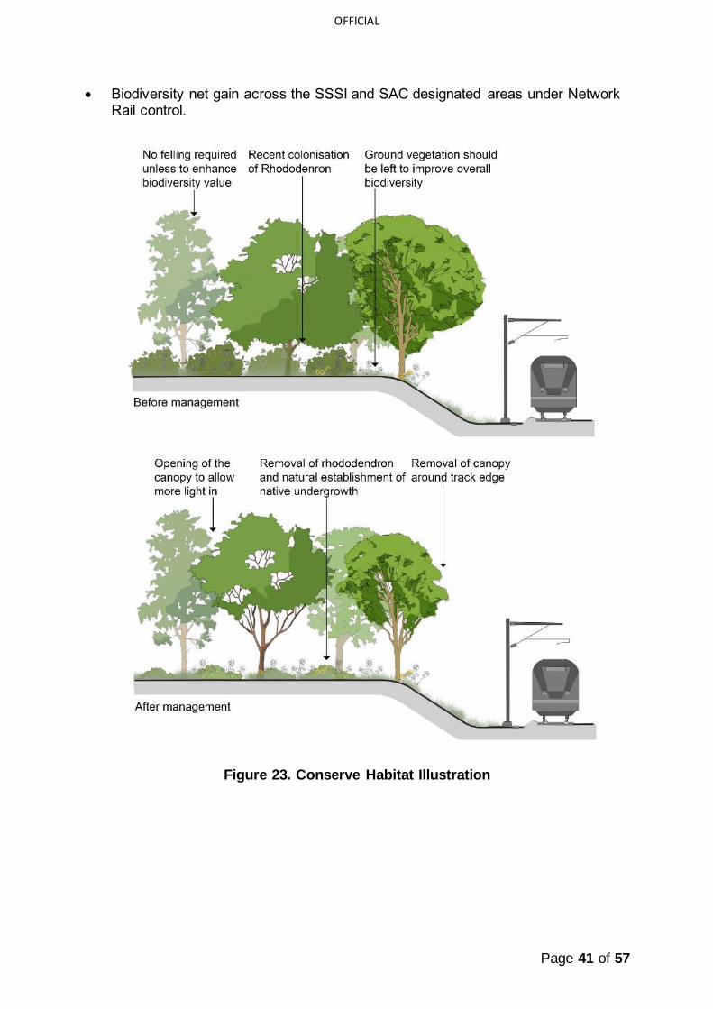
10.1.3 Managing Vegetation
Managing vegetation within the Avon Gorge was programmed to take place over a 5-year period with routine maintenance of perceived risks to railway operations taking
place annually. The following Scenarios for managing vegetation that require a different response relate to the SSSI designation afforded to the site:
• Qualifying feature species but safety critical: avoidance of felling where possible, controlling limb growth or applying coppice management to promote regeneration. Removal of any rare species requires prior notification and consent from Natural England;
• Qualifying/non-qualifying feature species and non-safety critical: vegetation should be left to improve overall biodiversity;
• Non-qualifying feature species and safety critical: removal and plugging of stumps using herbicide application. Limb reduction or pollarding applied to
ensure safety to infrastructure or immediate surrounding species;
• Invasive Non Native Species (INNS): safety critical species will be felled, and
non-safety critical species will be added to an itinerary for removal where possible.
10.1.4 Measuring success
The aim of the vegetation management is to conserve and enhance the qualifying features of the SAC and SSSI. This is hoped to be achieved through:
• Reduction of INNS and seed source.
• Opening of the canopy to allow more light in and removal of canopy around track edges to provide more favourable conditions for the succession of whitebeams.
• Removal of scrub and competing species from grasslands.
Page 41 of 57
OFFICIAL
• Biodiversity net gain across the SSSI and SAC designated areas under Network Rail control.
Figure 23. Conserve Habitat Illustration

Page 42 of 57
OFFICIAL
10.2 Habitat Management Category: Enhance
Bermondsey Dive-Under, London
Managed by: Network Rail Approximate area of land managed:
<1ha Management period: 2012 - 2017
10.2.1 Site Background
• Bermondsey Dive Under, which forms part of the Thameslink Programme, was a joint project by
Network Rail and partners Skanska and Ramboll, which involved the development of a new railway junction.
• The Thameslink Programme, part of Network Rail’s Railway Upgrade
Plan, is committed to biodiversity net gain on its projects. Prior to the beginning of construction in 2012, the Bermondsey site had limited
botanical diversity and low conservation value; it was scattered with the previous tenant’s debris and the soil was heavily contaminated with asbestos, Japanese knotweed (Reynoutria japonica) and hydrocarbons.
• As part of the construction process, the site’s habitats were enhanced, significantly increasing the site’s value to biodiversity.
10.2.2 Management Decision Process
• In order to achieve biodiversity net gain for the development, and by retrospectively applying the decision tree, it was determined that many of site’s habitats should be enhanced. This was done via the removal of contaminated
materials and eradication of the invasive Japanese knotweed.
• Whilst enhancement was undertaken for many of the habitats, habitat creation
was also undertaken to help increase the net gain in biodiversity e.g. installation of green walls. The habitats created and enhanced were restricted to what was feasible within a densely urban area.
Figure 24. Bermondsey Dive-Under - Site Plan

Page 43 of 57
OFFICIAL
Figure 25. Enhance Decision Process
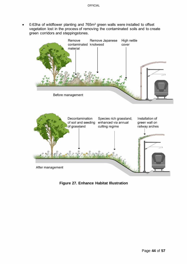
10.2.3 Managing Vegetation
• Decontamination of existing soils
followed by ground preparation and sowing of wildflower seed mixes on embankments.
• Installation of green walls on sides of railway arches.
10.2.4 Measuring Success
The aim of the vegetation management was to enhance the site’s biodiversity value post-development. This was achieved through:
• Achieving a net gain in biodiversity of 113%.
• Removal of 21,900 tonnes of contaminated material.
• Eradication the Japanese knotweed.
Fig. 26 Bermondsey Dive-Under wildlife
embankment
Page 44 of 57
OFFICIAL
• 0.63ha of wildflower planting and 765m2 green walls were installed to offset vegetation lost in the process of removing the contaminated soils and to create green corridors and steppingstones.
Figure 27. Enhance Habitat Illustration

Page 45 of 57
OFFICIAL
10.3 Habitat Management Category: Restore
Perth to Inverness Line, Cairngorms National Park
Managed by: Network Rail and Butterfly Conservation Approximate area of land managed: 2ha
Management period: 2016
10.3.1 Site Background
• In a joint operation between Network Rail and Butterfly Conservation a section of railway embankment on the Highland
main line, just south of Newtonmore, once favoured by the small dark yellow underwing (Coranarta cordigera) and netted
mountain moth (Macaria carbonaria) because of the presence of bearberry (Arctostaphylos uva-ursi) – the
only foodplant of the moth’s caterpillar – habitat was restored to encourage one of the rarest British moth species to
recolonise the area.
• The small dark yellow underwing
can only be found in Scotland and 90% of all sightings are recorded within the Cairngorms National Park, but numbers are dwindling, and no adult moths were seen between 2011 and 2014. The caterpillar feeds on
bearberry during the summer, but as they overwinter as a pupa, it will take at least two years before any increase in the population will be seen as a result of this recent conservation work.
• Volunteers and Network Rail’s operations cleared scrub from the area to restore the moorland with the hope of encouraging bearberry to re-establish, and thus encourage the recolonisation of the two rare moth species.
10.3.2 Management Decision Process
• Considering the aim of making the site suitable for small dark yellow underwing,
the decision tree was utilised to determine what method of management could help achieve the aims. As scrub is unsuitable for small dark yellow underwing larva, it was decided that the best option was to restore the habitat to moorland to enable bearberry to re-establish. Upland heathland is a high distinctiveness
habitat. Therefore, using the decision tree, restoration would be advised as scrub has a lower distinctiveness.
Figure 28. Perth to Inverness Line Site Plan

Page 46 of 57
OFFICIAL
Figure 29. Restore Decision Process
10.3.3 Managing Vegetation
• Vegetation management involved clearance of broom
(Cytisus scoparius) and birch (Betula sp.) using hand tools to prevent bearberry being shaded out.
10.3.4 Measuring Success
The aim of the vegetation management was to restore the site to a habitat of a high distinctiveness (upland heathland) that is suitable for the small dark yellow underwing.
• Ultimately, recolonisation of the small dark yellow underwing will determine success. This will be achieved by
undertaking surveys to determine whether the moth has recolonised the site.
• Submissions of sightings are encouraged from wildlife enthusiasts visiting the site.
Figure 30. Small
yellow dark
underwing

Page 47 of 57
OFFICIAL
Figure 31. Restore Habitat Illustration
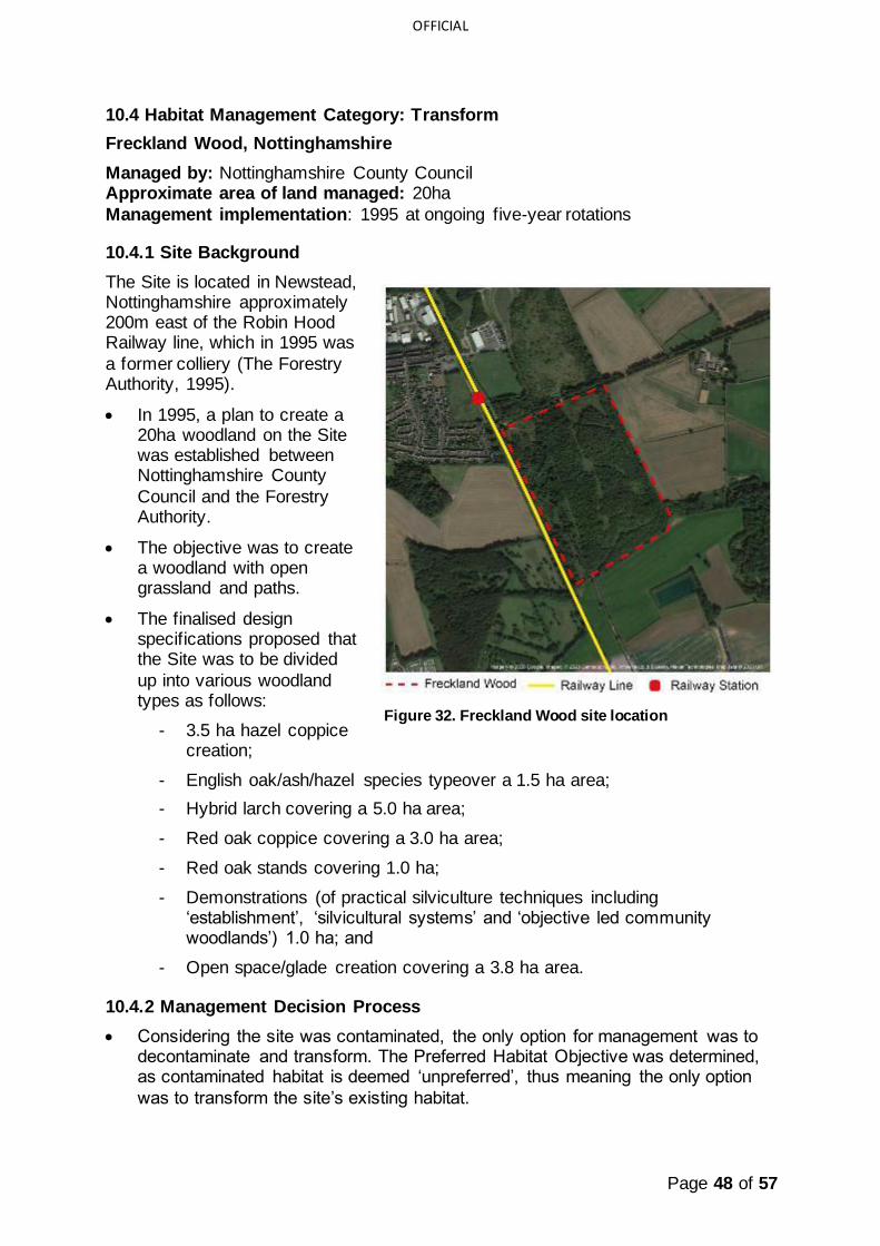
Page 48 of 57
OFFICIAL
10.4 Habitat Management Category: Transform
Freckland Wood, Nottinghamshire
Managed by: Nottinghamshire County Council Approximate area of land managed: 20ha
Management implementation: 1995 at ongoing five-year rotations
10.4.1 Site Background
The Site is located in Newstead, Nottinghamshire approximately 200m east of the Robin Hood Railway line, which in 1995 was
a former colliery (The Forestry Authority, 1995).
• In 1995, a plan to create a 20ha woodland on the Site was established between Nottinghamshire County
Council and the Forestry Authority.
• The objective was to create a woodland with open grassland and paths.
• The finalised design specifications proposed that the Site was to be divided
up into various woodland types as follows:
- 3.5 ha hazel coppice creation;
- English oak/ash/hazel species typeover a 1.5 ha area;
- Hybrid larch covering a 5.0 ha area;
- Red oak coppice covering a 3.0 ha area;
- Red oak stands covering 1.0 ha;
- Demonstrations (of practical silviculture techniques including ‘establishment’, ‘silvicultural systems’ and ‘objective led community woodlands’) 1.0 ha; and
- Open space/glade creation covering a 3.8 ha area.
10.4.2 Management Decision Process
• Considering the site was contaminated, the only option for management was to decontaminate and transform. The Preferred Habitat Objective was determined, as contaminated habitat is deemed ‘unpreferred’, thus meaning the only option
was to transform the site’s existing habitat.
Figure 32. Freckland Wood site location

Page 49 of 57
OFFICIAL
• Once decontaminated, it was decided the creation of woodland within the Network Rail boundary was suitable. Trees were not planted within 7m of the railway line and high leaf fall species were avoided when planting.
10.4.3 Managing Vegetation
The prescriptions for establishment included:
• Planting 3,000 trees/ha using the best quality plants;
• Weed control on 1m2 points at each tree base for 5 years using approved herbicides;
• Using a slow release fertiliser in the April of the second season (and following seasons if necessary);
• At the end of the first and second year, bulking up plant density. In the following years, bulking up plant density if it falls below 2,222 trees/ha; and
• Mowing rides and fire breaks when required.
10.4.4 Measuring Success
Following a desk-based assessment in 2020, Freckland Wood creation has been successfully achieved. The following features demonstrate the successful
establishment of Freckland Wood:
• Freckland Wood is now an established deciduous woodland interspersed with
open space habitats;
• Plant species in these areas include knapweed, St John’s wort, birdsfoot trefoil,
wild carrot and orchid;
• The habitat also supports birds and butterfly activity;
• The woodland exceeds a 50% canopy cover;
• Open spaces and rides have been created and maintained;
• A diverse range of tree species and age classes is present (species include field maple, larch, silver birch, oak and beech); and
• Graded (e.g. informal) woodland edges and rides have been maintained.
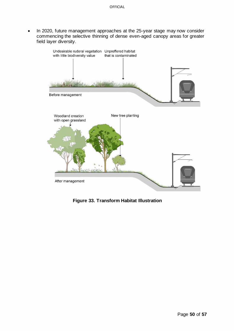
Page 50 of 57
OFFICIAL
• In 2020, future management approaches at the 25-year stage may now consider commencing the selective thinning of dense even-aged canopy areas for greater field layer diversity.
Figure 33. Transform Habitat Illustration

Page 51 of 57
OFFICIAL
Appendix A - Habitat and Site Analysis Work Sheet
Desk Study
Which Habitat types on Site?
Are there any protected Species on site?
Yes Notes:
No
Are BAP Priorities applicable?
Yes Notes:
No
Does the information dictate habitat prescription?
Yes Notes:
No
Field Study Work
Habitat Condition Very Low Low Medium High Very High
Notes:
Ecosystem Services (Existing)
Primary Secondary Tertiary
Ecosystem Services (Opportunities)
Biodiversity Landscape and Visual
Cultural
Are there any designations, protected
species etc. on site which impact on the Ecosystem Services (Existing and
Opportunities)
Yes Notes:
No

Page 52 of 57
OFFICIAL
Appendix B: Illustrative costings and routine maintenance schedule
The purpose of this section is to provide information on indicative costs and a
schedule of routine operations. This will help inform management decisions, for example an inaccessible site; a habitat type with fewer required scheduled inspections may influence a habitat prescription.
The following tables provide a summary of costs and a schedule of site visits in relation to the creation, routine maintenance and inspection of the habitat types.
These costs are indicative and are based on Spon's External Works and Landscape Price Book 2020.
Assumptions
The following assumptions have been made in preparing these indicative costs:
• All figures are based on current (2020) costs and do not allow for inflation;
• Costs have been rounded up or down to the nearest £500;
• All figures require additional uplift for works in London;
• The figures are based on the anticipated cost per year of new woodland and existing woodlands over 20-year life cycles
• All figures require additional uplift for works in London
• The frequency of visits for routine maintenance could be reduced by carrying out
multiple tasks in a single visit. This would be down to the discretion of the contractor. Therefore, for simplicity in the figures below it is assumed each task will require a separate visit and this figure could be rationalised.
• It is assumed the weather conditions are checked before visiting site
• Felling cost is per day so it is assumed that 10 trees would be felled a day. This does not account for location, access or size of trees
• Veteran tree - considers trees of special age and value verified by a specialist.
• 0.5 hectare is the minimum size for a woodland. (Ref Forestry Commission
hence all figures are by 0.5 hectares)
• The focus of activity is on a 20-year life cycle
• 1/8 mile figures are based on 201m (1/8mile in meters) x 20m (minimum depth of woodland WT) = 4000m2
• 4 trees per 0.5ha is 10 cubic meters of timber (assumes 15m high tree, girth 40-50cm produces 2.5 cubic meters of timber)
• All figures are rounded up or down to the nearest £500.
Exclusions
The following exclusions apply to the costs and routine maintenance set out in the illustrative costs tables:
• The cost of securing the site (diverting trains etc)
• The cost of clearing the track of debris (eg leaf litter)
• The cost of bringing equipment and materials to the rail side

Page 53 of 57
OFFICIAL
• The cost of obtaining and maintain access to the site
• The cost of ensuring biosecurity measures
• The additional costs and risks of working near water
• The cost of removing vegetation debris from waterbodies
• The cost for earthworks or reinforcements
• The figures do not consider the effects of embankment or land instability
• The cost of structural works
• The works associated with maintain drainage features
• Health and safety costs are not included
• The cost of soil testing/analysis
• The cost of any ecological assessment in relation to protected species and habitats.
Table 1: Grassland Rates Summary: anticipated costs per 1/8 mile
Grassland (UK Hab code – g)
Costs
Creation £6,000
Routine Maintenance £27,500
Inspection £500 Schedule (number of site visits) Total number of visits over
20-year life cycle
Grassland Creation (year 1) 12 Grassland Management 37
Grassland Inspection 2
Table 2: Woodland Rates summary: anticipated costs per 1/8 mile
Woodland (UK Hab code - w) Costs
Creation £25,500
Routine Maintenance £10,000
Inspection £500
Schedule (number of site visits) Total number of visits over 20 year life cycle
Woodland Creation (year 1) 16
Woodland Management 11
Woodland Inspection 4
Table 3: Heathland and Shrub Rates: anticipated costs per 1/8 mile
Heathland and Shrub (UK Hab code - h)
Costs
Creation £23,500
Routine Maintenance £3,000
Inspection £1,000

Page 54 of 57
OFFICIAL
Schedule Total number of visits over 20 year life cycle
Heathland and Scrub Creation (year 1) 14
Heathland and Scrub Management 29
Heathland and Scrub Inspection 6
Table 4: Wetland Rates Summary: anticipated costs per 1/8 mile
Wetland (UK Hab code - f)
Costs
Creation £11,500
Routine Maintenance £10,000
Inspection £1,000
Schedule Total number of visits over 20-year life cycle
Wetland Grassland Creation (year 1) 9
Wetland Management 6
Wetland Inspection 4
Table 5: Urban Rates Summary: anticipated costs per 1/8 mile
Urban (UK Hab code - u)
Costs
Creation £2,500 Routine Maintenance £3,500
Inspection £1,000
Schedule Total number of visits over 20-year life cycle
Urban Creation (year 1) 12
Urban Management 5
Urban Inspection 4
Table 6: Miscellaneous Rates Summary: anticipated costs per 1/8 mile
Miscellaneous
Costs
Fencing £4,500
Inspection of invasive species £500
Inspection for disease £1,000
Schedule Total number of visits over 20-year life cycle
Inspection of Invasive Species 8
Inspection of Diseases 2
NOTE: Figures within the preceding tables have been rounded up / rounded down
NOTE: Implementation and ongoing management and maintenance costs (approximate costs for 1/8 mile – derived from NR sources, SPONS and the Woodland Trust)

Page 55 of 57
OFFICIAL
Appendix C: Schedule for routine management and inspections for habitats
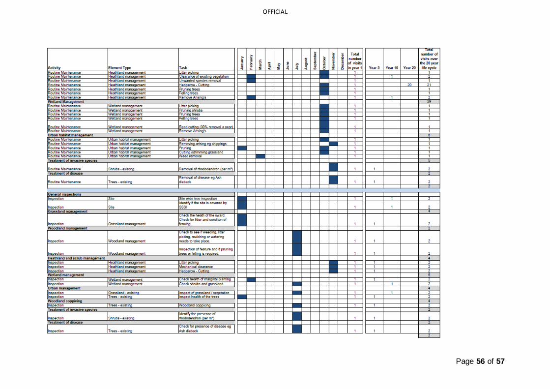
Page 56 of 57
OFFICIAL

Page 57 of 57
OFFICIAL
11 Sources of further information
11.1 References
DEFRA (2020). Enabling a Natural Capital Approach – Services Databook. Department for Environment, Food and Rural Affairs. February 2020.
CIEEM (2019). Advice Note on the Lifespan of Ecological Reports & Surveys. Chartered Institute of Ecology and Environmental Management. April 2019.
Natural England (2019a). The Biodiversity Metric 2.0 – User Guide – Beta Test. December 2019.
Natural England (2019b). The Biodiversity Metric 2.0 - Calculation Tool – Beta Test December 2019 Update.
Natural England (2019c). The Biodiversity Metric 2.0 – Technical Supplement – Beta Test. December 2019.
SPON’s (2020) Woodland Trust, A guide to creating small native woods in England.
The UK Habitat Classification Working Group (2018a). The UK Habitat Classification User Manual, Version 1.0. May, 2018.
The UK Habitat Classification Working Group (2018b). The UK Habitat Classification Field Key. May, 2018.
11.2 Figure references
All images used within this report are copyright of Network Rail.