
RADARSAT Constellation Mission Update - ESA...
29
1 Proprietary Information to the Crown or a third party RADARSAT Constellation Mission Update Stéphane Chalifoux Canadian Space Agency POLinSAR 2015 &1st BIOMASS Science Workshop January 26, 2015 Frascati, Italy Proprietary Information to the Crown or a third party
Transcript of RADARSAT Constellation Mission Update - ESA...

1 Proprietary Information to the Crown or a third party
RADARSAT Constellation Mission Update
Stéphane Chalifoux
Canadian Space Agency
POLinSAR 2015 &1st BIOMASS Science Workshop January 26, 2015
Frascati, Italy
Proprietary Information to the Crown or a third party

2 Proprietary Information to the Crown or a third party
Outline
Mission & Satellite Description
Enhancements
Ground Segment
Data Products
Data Policy
Data Acquisition & Capacity
Applications
© MDA

3 Proprietary Information to the Crown or a third party
Key Mission Drivers
• Ensure continuity of C-Band SAR data, available to Canadian operational users since 1995
• Daily coverage of Canadian land and waters, enabling daily
monitoring of Canada’s maritime approaches for detection of illegal vessel activity and pollution
• Supports northern development through surveillance of the
North West passage, ice monitoring and mapping
• Supports response to natural disasters with an average daily global access
• Greater revisit capability for a more efficient monitoring and management of natural resources and sensitive ecosystems.
• Design addresses the increasing requirement for radar imagery in support of existing and new operational Canadian government programs

4 Proprietary Information to the Crown or a third party
The RADARSAT Constellation
5 Proprietary Information to the Crown or a third party
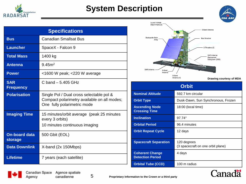
System Description
Specifications Bus Canadian Smallsat Bus
Launcher SpaceX - Falcon 9
Total Mass 1400 kg
Antenna 9.45m2
Power <1600 W peak; <220 W average
SAR Frequency
C band – 5.405 GHz
Polarisation Single Pol / Dual cross selectable pol & Compact polarimetry available on all modes; One fully polarimetric mode
Imaging Time 15 minutes/orbit average (peak 25 minutes every 3 orbits) 10 minutes continuous imaging
On-board data storage
500 Gbit (EOL)
Data Downlink X-band (2x 150Mbps)
Lifetime 7 years (each satellite)
Drawing courtesy of MDA
Orbit Nominal Altitude 592.7 km circular
Orbit Type Dusk-Dawn, Sun Synchronous, Frozen
Ascending Node Crossing Time
18:00 (local time)
Inclination 97.74°
Orbital Period 96.4 minutes
Orbit Repeat Cycle
12 days
Spacecraft Separation 120 degrees (3 spacecraft on one orbit plane)
Coherent Change Detection Period
4 days
Orbital Tube (CCD) 100 m radius

6 Proprietary Information to the Crown or a third party
SAR Imaging Modes
7 Proprietary Information to the Crown or a third party
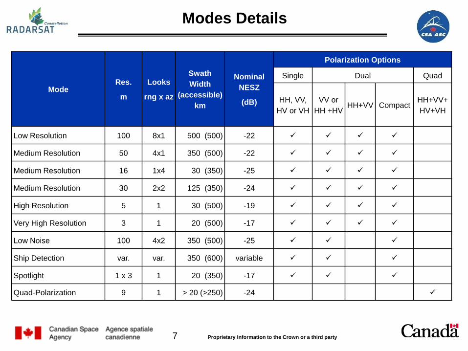
Modes Details
Mode Res.
m
Looks
rng x az
Swath Width
(accessible) km
Nominal NESZ
(dB)
Polarization Options
Single Dual Quad
HH, VV, HV or VH
VV or HH +HV HH+VV Compact HH+VV+
HV+VH
Low Resolution 100 8x1 500 (500) -22
Medium Resolution 50 4x1 350 (500) -22
Medium Resolution 16 1x4 30 (350) -25
Medium Resolution 30 2x2 125 (350) -24
High Resolution 5 1 30 (500) -19
Very High Resolution 3 1 20 (500) -17
Low Noise 100 4x2 350 (500) -25
Ship Detection var. var. 350 (600) variable
Spotlight 1 x 3 1 20 (350) -17
Quad-Polarization 9 1 > 20 (>250) -24
8 Proprietary Information to the Crown or a third party
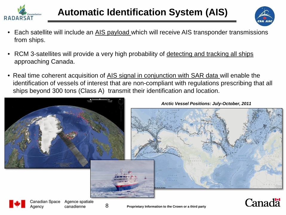
• Each satellite will include an AIS payload which will receive AIS transponder transmissions from ships.
• RCM 3-satellites will provide a very high probability of detecting and tracking all ships approaching Canada.
• Real time coherent acquisition of AIS signal in conjunction with SAR data will enable the identification of vessels of interest that are non-compliant with regulations prescribing that all ships beyond 300 tons (Class A) transmit their identification and location.
Automatic Identification System (AIS)
Arctic Vessel Positions: July-October, 2011

9 Proprietary Information to the Crown or a third party
Project Status
• Design completed – Mission Critical Design Review held in Nov 2012
• Project approved and funded (phase D, launch and operations)
• The Government of Canada will own the RCM satellites and data, and will control data dissemination. CSA is the prime authority for its operation and management.
• Phase D ongoing. All units are in full flight manufacturing as per plan.
• Spacecraft assembly, integration and test plan are being finalized.
• Ground segment system level preliminary design review completed.
• Planned for launch in Q3 2018.
10 Proprietary Information to the Crown or a third party
Outline
© MDA
Mission & Satellite Description
Enhancements
Ground Segment
Data Products
Data Policy
Data Acquisition & Capacity
Applications

11 Proprietary Information to the Crown or a third party
RADARSAT-1 RADARSAT-2 RCM Mass 2750 kg 2280 Kg 1400 Kg
Complete Coverage 2-3 days 2-3 days Daily coverage Exact Revisit1 24 days 24 days 4 days (12/sat)
Imaging time /orbit 28 min 28 min 15 min /sat1
Antenna Span 15 m 15 m 6.75 m Polarization Single HH Single, Dual,
Polarimetric Single, Dual, Compact Pol,
Polarimetric (exp) Altitude 800 km 800 km 600 km
RADARSAT Satellites
(1) Non-eclipse period.

12 Proprietary Information to the Crown or a third party
• 3 satellite constellation flying in the same orbit plane equally spaced (32 minutes). Will be controlled to fly in an “orbital tube” of radius 100 meters.
• 4-day displacement detection (CCD using SAR interferometry)
• Multi-polarization including Compact Polarisation.
• Average daily access to 95% of any point on the globe.
• Fast tasking capability; Imaging requirement can be uploaded to the satellite in less than 4 hours.
• Phase Preserving ScanSAR Processing.
• Includes a vessel Automatic Identification System (AIS) on each satellite.
RCM advancement from previous RADARSAT missions

13 Proprietary Information to the Crown or a third party
Current coverage with RADARSAT-2
• 4 days required to complete coverage of
Canadian AOI • Major gaps in maritime approaches • Northwest West Passage coverage also
incomplete.
Coverage with RCM
• Complete daily coverage of Canadian AOI
• Increased maritime probability of detection
• Coverage of North West Passage up to 4 times daily
Satellite Daily Coverage
14 Proprietary Information to the Crown or a third party
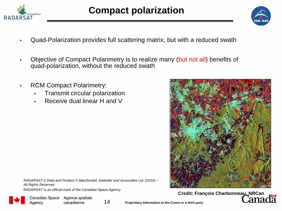
Compact polarization
• Quad-Polarization provides full scattering matrix, but with a reduced swath
• Objective of Compact Polarimetry is to realize many (but not all) benefits of quad-polarization, without the reduced swath
• RCM Compact Polarimetry: • Transmit circular polarization • Receive dual linear H and V
Credit: François Charbonneau, NRCan
RADARSAT-2 Data and Product © MacDonald, Dettwiler and Associates Ltd. (2010) – All Rights Reserved RADARSAT is an official mark of the Canadian Space Agency
15 Proprietary Information to the Crown or a third party
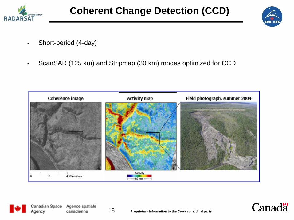
Coherent Change Detection (CCD)
• Short-period (4-day)
• ScanSAR (125 km) and Stripmap (30 km) modes optimized for CCD

16 Proprietary Information to the Crown or a third party
Outline
© MDA
Mission & Satellite Description
Enhancements
Ground Segment
Data Products
Data Policy
Data Acquisition & Capacity
Applications

17 Proprietary Information to the Crown or a third party
Ground Stations Mask

18 Proprietary Information to the Crown or a third party
Outline
© MDA
Mission & Satellite Description
Enhancements
Ground Segment
Data Products
Data Policy
Data Acquisition & Capacity
Applications

19 Proprietary Information to the Crown or a third party
Raw Products • Raw Radar data in Framed Raw
Expanded Data (FRED) format
Image Products Variety of processing levels
• single-look complex products (SLC); equivalent to a SLC product for RADARSAT-1 or RADARSAT-2.
• multi-looked power-detected geo-referenced products (GRD, GRC); equivalent to an SGX, SCN or SCW product for RADARSAT-1 or RADARSAT-2.
• geo-coded products (GCD, GCC); equivalent to an SSG or SPG product for RADARSAT-1 or RADARSAT-2.
Same format as RADARSAT-2: GeoTIFF images with XML meta-data + NITF
2.1 format.
GCC = GeoCoded Complex GCD = GeoCoded Detected GRC = Ground range georeferenced Complex GRD = Ground range georeferenced Detected
Image Products

20 Proprietary Information to the Crown or a third party
Outline
© MDA
Mission & Satellite Description
Enhancements
Ground Segment
Data Products
Data Policy
Data Acquisition & Capacity
Applications

21 Proprietary Information to the Crown or a third party
RCM Data Policy Principles
• Canadian Interests First • Give priority to GoC requirements in support of sovereignty, security and safety
• Fuel prosperity and advance foreign policy objectives
• Economic Growth
• Strengthen Canadian industry’s capacity to commercialize value added application products and services, at home and abroad
• Support Partnerships
• Enable cooperation with allies/partners to meet socio-economic and security objectives
• Support international organizations related to safety, humanitarian programs and other initiatives of benefit to Canadians
• Commercial distribution of RCM data
• Enable the commercial distribution of RCM data, while being compliant with the Open Government Strategy
Next Step: • Baseline Policy currently within internal approval chain • Initiate work on the Data Policy Implementation document for SAR and AIS data
As approved by Deputy Ministers Governance Committee on Space (February 2014):
22 Proprietary Information to the Crown or a third party
Outline
© MDA
Mission & Satellite Description
Enhancements
Ground Segment
Data Products
Data Policy
Data Acquisition & Capacity
Applications

23 Proprietary Information to the Crown or a third party
Standard Coverage Concept
Situation in Canada • Large geographic and temporal overlaps in users and applications requirements • Various preferred imaging modes
Approach
• Analyse user imaging requirements spatially and temporally over the annual cycle to determine a "feasible" imaging scenario, with agreed upon plans in overlapping zones
Result Standard Coverage
• Collections of data acquired routinely in harmonized and de-conflicted imaging modes intended to optimize and maximize the utility of the data across all User requirements.
Fast Tasking Capability. If a fast tasking request is received at the command and control centre, it shall be possible to analyze the request, generate commands, contact the satellite, supersede planned operations if necessary and upload request in less than 4 hours, regardless of where the satellite is in its orbit. This capability will only be used exceptionally, e.g. for emergency situations.

24 Proprietary Information to the Crown or a third party
Maritime Operational User Needs Coverage Areas
Ice
Arctic Weekly – Dec.- May Daily – June – Nov.
Inland Lakes Weekly – Oct. to June
GL, East Coast & Nfld. Daily – Dec. - August
West Coast Daily -- Year Round
GL & East Coast Daily -- June-November
Arctic Daily -- June – Nov. Open Water Areas
Oil Pollution
West Coast Daily -- Year Round
GL & East Coast Daily -- May-November
Arctic Daily -- June – Nov. Open Water Areas
Marine Winds Vessel Detection

25 Proprietary Information to the Crown or a third party
Outline
© MDA
Mission & Satellite Description
Enhancements
Ground Segment
Data Products
Data Policy
Data Acquisition & Capacity
Applications

26 Proprietary Information to the Crown or a third party
Applications
Sovereignty and Security – RCM will provide enhanced coverage of Canada and abroad to assure the safety and security of Canadians to contribute satellite images for international security. Combining space-based radar images and AIS signals will provide a powerful surveillance capacity over Canada’s maritime approaches. Maritime monitoring - The daily coverage of marine areas will support activities such as fisheries monitoring, ice and iceberg monitoring, oil pollution monitoring and integrated ocean and coastal zone management. Northern Development - The regular and comprehensive imaging of Canada’s North and maritime approaches will be a direct contribution to the Arctic sovereignty, pillar of Canada’s Northern Strategy.

27 Proprietary Information to the Crown or a third party
Disaster management - RCM will provide critical data in a timely manner to support disaster mitigation, warning, response and recovery activities, as well as contributing to Canada’s obligations to international disaster relief. Environmental monitoring - RCM will provide data for wide area change detection. RCM data will contribute to the production of more accurate weather forecasts, marine conditions, ice condition and ecosystems. Management of natural resources - RCM data will be a source of information on Canada’s agriculture, forestry and wildlife habitat. In addition, RCM data will be used to support mining and energy sectors for explorations operations to ensure that infrastructure is monitored properly for safety and its integrity.
Applications

28 Proprietary Information to the Crown or a third party
• The following collaboration items are discussed: Joint / integrated pre-defined observation plans (complementarities in observations /
modes, increased revisit, etc.) Harmonisation of catalogue interface Development of common tools Harmonised communication, joint publications etc.
• A joint calibration working group has been set up
• Canadian users data requirement assessed and defined
• Collaborative Ground Segment process In addition, cooperation to support international activities should be continued to
set up complementary observations (GFOI, PSTG, etc)
Sentinel-1 / RCM Joint Activities

29 Proprietary Information to the Crown or a third party
Thank You!


![Moving to the RADARSAT Constellation Mission: Comparing ......for mapping seasonal changes in wetlands, as RADARSAT-2 has shown promising results [36]. Circular-linear CP SAR systems](https://static.fdocuments.us/doc/165x107/60f430820e93d50954786907/moving-to-the-radarsat-constellation-mission-comparing-for-mapping-seasonal.jpg)