RADAR for Biomass Mapping - GOFC-GOLD LC-IT Office · RADAR for Biomass Mapping Josef Kellndorfer...
31
RADAR for Biomass Mapping RADAR for Biomass Mapping Josef Kellndorfer Josef Kellndorfer Wayne Walker, Katie Kirsch, Greg Wayne Walker, Katie Kirsch, Greg Fiske Fiske The Woods Hole Research The Woods Hole Research Center Center GOFC-GOLD Biomass Workshop GOFC-GOLD Biomass Workshop Missoula, Missoula, 15-June-2009 15-June-2009
Transcript of RADAR for Biomass Mapping - GOFC-GOLD LC-IT Office · RADAR for Biomass Mapping Josef Kellndorfer...

RADAR for Biomass MappingRADAR for Biomass Mapping
Josef KellndorferJosef Kellndorfer
Wayne Walker, Katie Kirsch, Greg Wayne Walker, Katie Kirsch, Greg FiskeFiske
The Woods Hole ResearchThe Woods Hole Research CenterCenter
GOFC-GOLD Biomass WorkshopGOFC-GOLD Biomass Workshop
Missoula,Missoula, 15-June-200915-June-2009

15-Jun-09 Josef Kellndorfer, Biomass Workshop, Missoula 2
OutlineOutline
•• Some RadarSome Radar principlesprinciples
•• Measurements and Methods forMeasurements and Methods for biomassbiomass
retrieval withretrieval with radarradar
•• Current and Planned SAR MissionsCurrent and Planned SAR Missions
•• The U.S. National Biomass and CarbonThe U.S. National Biomass and Carbon
Dataset 2000: Example of large scaleDataset 2000: Example of large scale
biomass mapping involving radarbiomass mapping involving radar

15-Jun-09 Josef Kellndorfer, Biomass Workshop, Missoula 3
EM Spectrum for Imaging RadarEM Spectrum for Imaging Radar
15-Jun-09 Josef Kellndorfer, Biomass Workshop, Missoula 4
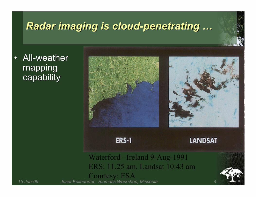
Waterford –Ireland 9-Aug-1991
ERS: 11.25 am, Landsat 10:43 am
Courtesy: ESA
Radar imaging is cloud-penetrating Radar imaging is cloud-penetrating ……
•• All-weatherAll-weathermappingmappingcapabilitycapability

15-Jun-09 Josef Kellndorfer, Biomass Workshop, Missoula 5
From: Manual of Remote Sensing Third Edition, Vol 2
Review of Radar Remote SensingReview of Radar Remote Sensing
Role of FrequencyRole of Frequency

15-Jun-09 Josef Kellndorfer, Biomass Workshop, Missoula 6
Radar
Scattering
Intensity
Short
Wave
Long
Wave
C
T T
C
T C T C
C = Crown
T = Trunk
Review of Radar Remote SensingReview of Radar Remote Sensing
Role of PolarizationRole of Polarization

15-Jun-09 Josef Kellndorfer, Biomass Workshop, Missoula 7
The radar illuminates the vegetation with microwave energy (at an angle) that interacts
with vegetation structure and ground in a way that is related to above ground biomass.
Scattering Mechanisms in VegetationScattering Mechanisms in Vegetation

15-Jun-09 Josef Kellndorfer, Biomass Workshop, Missoula 8
Synthetic Aperture RadarSynthetic Aperture Radar
•• To achieve highTo achieve highresolution fromresolution fromspace, a largespace, a large radarradarantenna size needsantenna size needsto be synthesizedto be synthesized
•• ImageImage formation isformation istypically performedtypically performedthrough Dopplerthrough Dopplerrange processingrange processing
•• Leads to Leads to ““specklespeckleeffectseffects””

15-Jun-09 Josef Kellndorfer, Biomass Workshop, Missoula 9
•• ItIt’’s simples simpletrigonometrytrigonometry
Surface
What is Radar What is Radar Interferometry Interferometry anyway?anyway?

15-Jun-09 Josef Kellndorfer, Biomass Workshop, Missoula 10
Measurements forMeasurements for Biomass Retrieval withBiomass Retrieval with RadarRadar
•• Aboveground Biomass:Aboveground Biomass:
–– SAR Backscatter measurementsSAR Backscatter measurements•• Single and multi-frequency SARSingle and multi-frequency SAR
•• Single and Single and mutli-polarization mutli-polarization SARSAR
–– Interferometric Interferometric MeasurementsMeasurements•• Coherence measurementsCoherence measurements
•• Interferometric Interferometric height retrievalheight retrieval
•• Polarimetric Polarimetric interferometry interferometry ((PolInSARPolInSAR))
•• Multi-baseline Multi-baseline interferometryinterferometry
•• SAR tomographySAR tomography
•• Belowground biomass:Belowground biomass:
–– Ground penetrating radar backscatterGround penetrating radar backscatter

15-Jun-09 Josef Kellndorfer, Biomass Workshop, Missoula 11
Biomass RetrievalBiomass Retrieval Methods withMethods with RadarRadar
•• Regression modelsRegression models
–– Biomass = a · e Biomass = a · e b(sigma-0, coherence, b(sigma-0, coherence, ……))
•• Semi-Emperical Semi-Emperical modelsmodels
–– Combining Combining radiative radiative transfer models with biomass-transfer models with biomass-backscatter calibrationbackscatter calibration
–– Macro-ecology modelingMacro-ecology modeling
•• Statistically based estimation modelsStatistically based estimation models
–– Bayesian MLEBayesian MLE
–– Ensemble learningEnsemble learning regression treesregression trees
•• Fusion of radar-based forest changeFusion of radar-based forest changemeasurements into emissions modelsmeasurements into emissions models
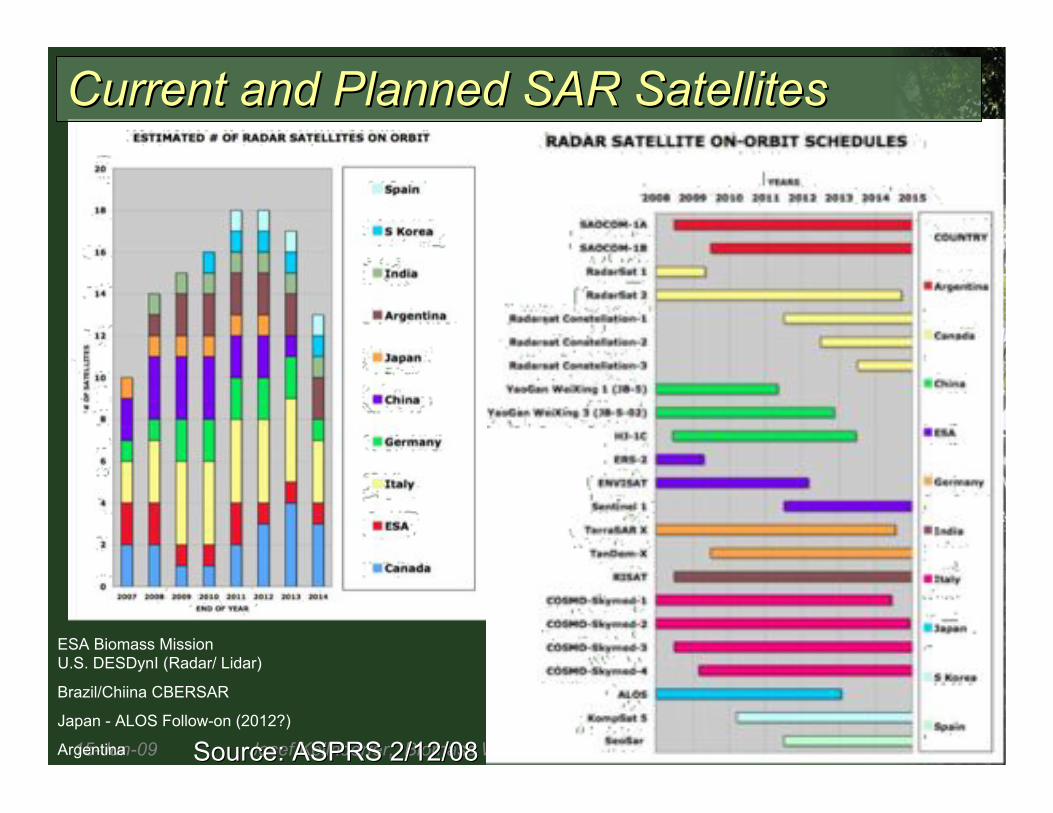
15-Jun-09 Josef Kellndorfer, Biomass Workshop, Missoula 12Source: ASPRS 2/12/08Source: ASPRS 2/12/08
ESA Biomass Mission
U.S. DESDynI (Radar/ Lidar)
Brazil/Chiina CBERSAR
Japan - ALOS Follow-on (2012?)
Argentina
Current and Planned SAR SatellitesCurrent and Planned SAR Satellites

15-Jun-09 Josef Kellndorfer, Biomass Workshop, Missoula 13
A Global Mission:A Global Mission:
The Shuttle Radar Topography MissionThe Shuttle Radar Topography Mission
•• Flown in February 2000Flown in February 2000during mission STS-99 onduring mission STS-99 onSpace Shuttle Space Shuttle EndeavorEndeavor
•• First mission of its kindFirst mission of its kindusing using radarradarinterferometryinterferometry
•• Covered 119 millionCovered 119 millionsquare kilometers in 11square kilometers in 11daysdays
•• Goal: Best global 3-DGoal: Best global 3-Ddata set of Earthdata set of Earth

15-Jun-09 Josef Kellndorfer, Biomass Workshop, Missoula 14
•• A fundamental law ofA fundamental law ofscience applies to thescience applies to theSRTM data:SRTM data:
““One scientistOne scientist’’ssnoise is anothernoise is anotherscientistscientist’’sssignal!signal!””
Mean Canopy
Height
Mean Scattering
Phase Center
Height
SRTM Resolution Cell
Surface
Mean Radar
Measured
Height
Mean Canopy
Height
Ground
Elevation
SRTM Vegetation ResponseSRTM Vegetation Response
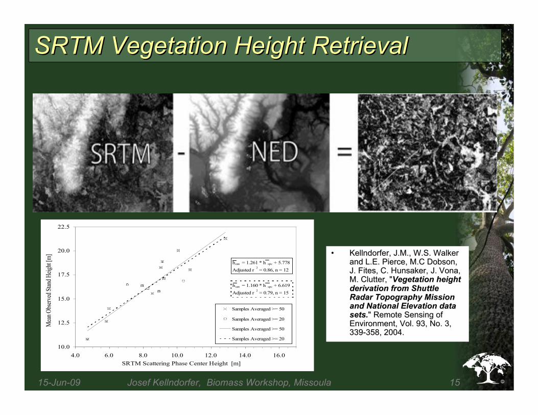
15-Jun-09 Josef Kellndorfer, Biomass Workshop, Missoula 15
hcan = 1.261 * h spc + 5.778
Adjusted r2 = 0.86, n = 12
hcan = 1.160 * h spc + 6.619
Adjusted r2 = 0.79, n = 15
10.0
12.5
15.0
17.5
20.0
22.5
4.0 6.0 8.0 10.0 12.0 14.0 16.0
SRTM Scattering Phase Center Height [m]
Mea
n O
bser
ved
Stan
d H
eigh
t [m
]
Samples Averaged >= 50
Samples Averaged >= 20
Samples Averaged >= 50
Samples Averaged >= 20
SRTM Vegetation Height RetrievalSRTM Vegetation Height Retrieval
•• Kellndorfer, J.M., W.S. WalkerKellndorfer, J.M., W.S. Walkerand L.E. Pierce, M.C Dobson,and L.E. Pierce, M.C Dobson,J. J. FitesFites, C. , C. HunsakerHunsaker, J. , J. VonaVona,,M. Clutter, "M. Clutter, "Vegetation heightVegetation heightderivation from Shuttlederivation from ShuttleRadar Topography MissionRadar Topography Missionand National Elevation dataand National Elevation datasets.sets." Remote Sensing of" Remote Sensing ofEnvironment, Vol. 93, No. 3,Environment, Vol. 93, No. 3,339-358, 2004.339-358, 2004.

15-Jun-09 Josef Kellndorfer, Biomass Workshop, Missoula 16
Principal InvestigatorPrincipal Investigator::
Josef KellndorferJosef Kellndorfer
Woods Hole Research CenterWoods Hole Research Center
Research Team:Research Team:
Wayne Walker, Katie Kirsch,Wayne Walker, Katie Kirsch,
Greg Greg FiskeFiske
Woods Hole Research CenterWoods Hole Research Center
Elizabeth LaPoint, Mike Hoppus,Elizabeth LaPoint, Mike Hoppus,
Jim WestfallJim Westfall
USDA Forest Service FIA Program:USDA Forest Service FIA Program:
Collaboration:Collaboration:
Dean Dean GeschGesch, National Elevation Dataset, USGS, National Elevation Dataset, USGS
Collin HomerCollin Homer, National Land Cover Database, National Land Cover Database2001 / MRLC, USGS2001 / MRLC, USGS
Zhi-Liang Zhi-Liang ZhuZhu, LANDFIRE, USGS, LANDFIRE, USGS
Funding and Support:Funding and Support:
NASA Terrestrial Ecology ProgramNASA Terrestrial Ecology Program
LANDFIRELANDFIRE
PCI PCI GeomaticsGeomatics
Definiens Imaging/eCognitionDefiniens Imaging/eCognition
Four year project to produce
-Forest vegetation height
-Biomass and
-Carbon Estimates
-Conterminous U.S.
-First attempt at 30 m
resolution ever

15-Jun-09 Josef Kellndorfer, Biomass Workshop, Missoula 17
NLCD 2001 NLCD 2001
Land Cover Land Cover
NLCD 2001 NLCD 2001
Canopy DensityCanopy Density
NED ElevationNED Elevation
SlopeSlope
SRTM - NEDSRTM - NED
MRLC Landsat MRLC Landsat
Tasseled Cap Tasseled Cap
Predicted HeightPredicted Height
Predicted BiomassPredicted Biomass
Validation
Response
Variables
FIA Data
Height
Biomass
Biomass
Predictor
Layers
Height
Predictor
Layers
Regression Tree
Modeling
15-Jun-09 Josef Kellndorfer, Biomass Workshop, Missoula 18
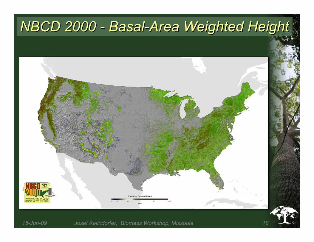
NBCD 2000 - Basal-Area Weighted HeightNBCD 2000 - Basal-Area Weighted Height
15-Jun-09 Josef Kellndorfer, Biomass Workshop, Missoula 19
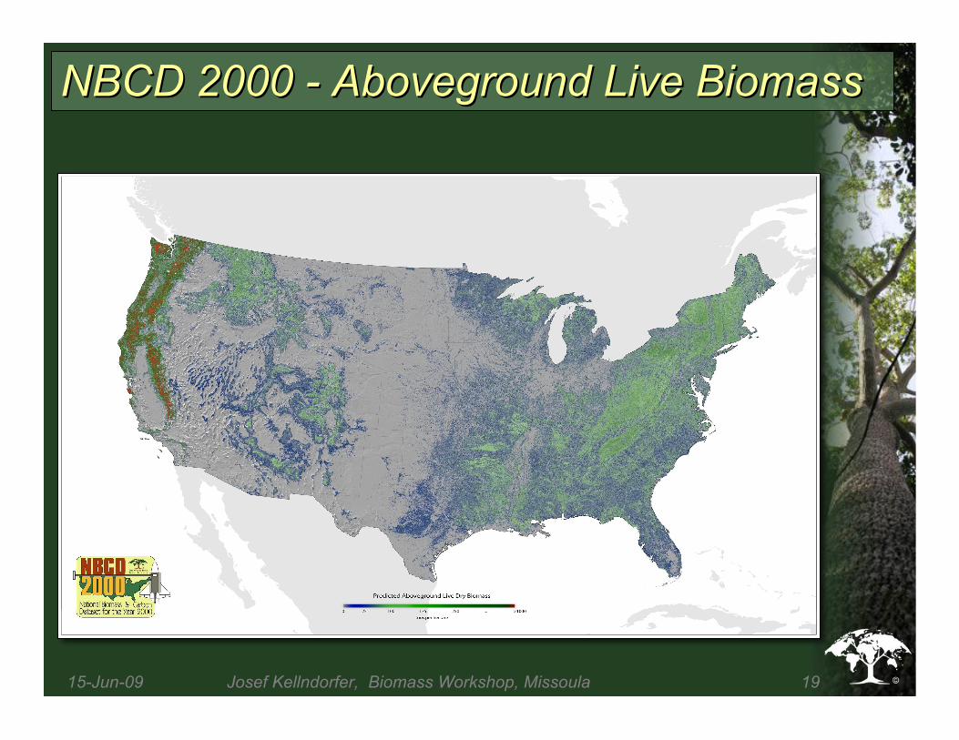
NBCD 2000 - Aboveground Live BiomassNBCD 2000 - Aboveground Live Biomass

15-Jun-09 Josef Kellndorfer, Biomass Workshop, Missoula 20
ComparisonComparison
with otherwith other
ApproachesApproaches
What is theWhat is the
truth?truth?

15-Jun-09 Josef Kellndorfer, Biomass Workshop, Missoula 21
The ALOS SatelliteThe ALOS Satellite
•• Launched by JAXA January on 24Launched by JAXA January on 24thth 2006 2006
•• Three sensors: PRISM, AVNIR-2 and PALSARThree sensors: PRISM, AVNIR-2 and PALSAR
•• PALSAR: First polarimetric L-band sensor onPALSAR: First polarimetric L-band sensor on
free-flying Earth RS satellitefree-flying Earth RS satellite
(PALSAR = Phased Array L-band SAR)(PALSAR = Phased Array L-band SAR)

15-Jun-09 Josef Kellndorfer, Biomass Workshop, Missoula 22
ALOS PALSAR Observation PlanALOS PALSAR Observation Plan
Fine Beam ModeFine Beam Mode
HH/HV HH Polarimetric

15-Jun-09 Josef Kellndorfer, Biomass Workshop, Missoula 23
Pan-Tropical FBD DataPan-Tropical FBD Data SetSet
•• Baseline: 2007 FBD Data,Baseline: 2007 FBD Data, Gaps filled with 2008 Data (15,000 FBDGaps filled with 2008 Data (15,000 FBDFrames)Frames)
•• Yellow: First target area currentlyYellow: First target area currently ordered, 5,500 Framesordered, 5,500 Frames
•• Green: RemainingGreen: Remaining data, 9,500data, 9,500 FramesFrames
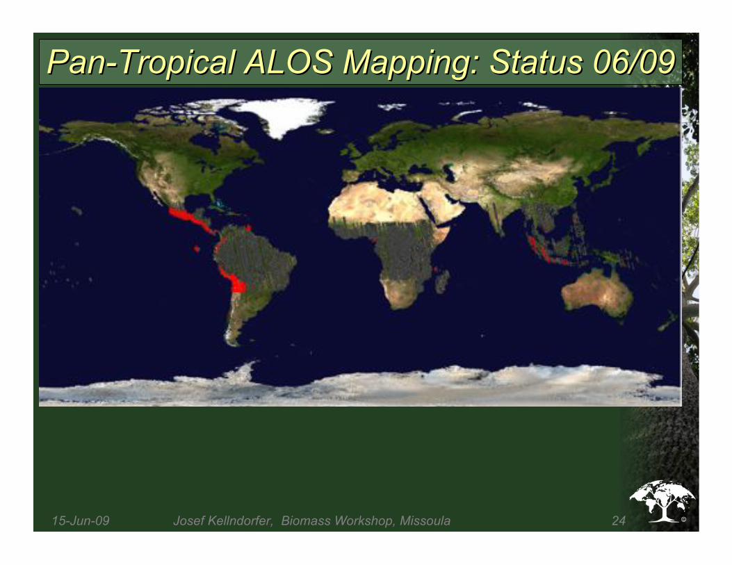
15-Jun-09 Josef Kellndorfer, Biomass Workshop, Missoula 24
Pan-Tropical ALOS Mapping: Status 06/09Pan-Tropical ALOS Mapping: Status 06/09

15-Jun-09 Josef Kellndorfer, Biomass Workshop, Missoula 25
ALOS/ALOS/
PALSARPALSAR
Radar ImageRadar Image
Mosaic of theMosaic of the
XinguXingu
WatershedWatershed
Data Acquistion:
6/8-7/22 2007
Number of Scenes:
116
Spacing: 25 m
15-Jun-09 Josef Kellndorfer, Biomass Workshop, Missoula 26
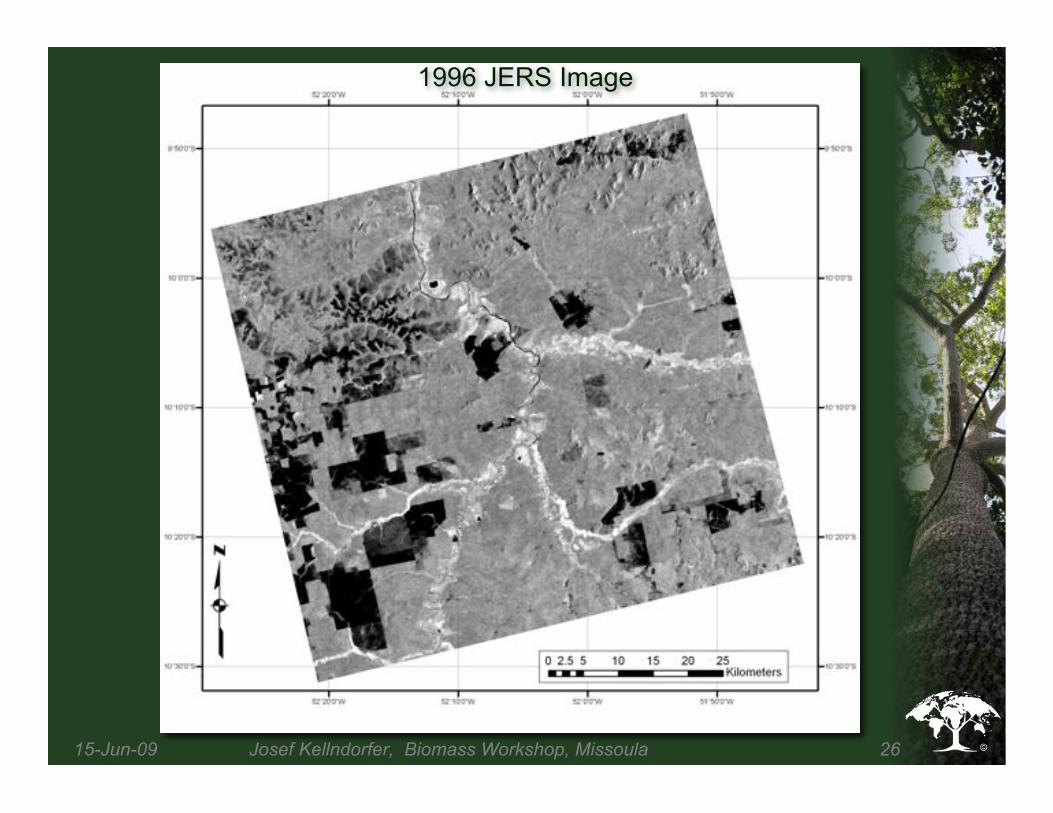
1996 JERS Image

2006 ALOS-PALSAR Image

15-Jun-09 Josef Kellndorfer, Biomass Workshop, Missoula 28
Color Composite Image (R-G-B = JERS-ALOS-Difference)

15-Jun-09 Josef Kellndorfer, Biomass Workshop, Missoula 29
Recent Logging
1996-2006 Forest Cover Change Map

15-Jun-09 Josef Kellndorfer, Biomass Workshop, Missoula 30
ConclusionConclusion
•• Advances in recent years in radar remoteAdvances in recent years in radar remotesensingsensing
–– Processing largelyProcessing largely solvedsolved
–– Global DEM data available for Global DEM data available for orthorectification orthorectification andandradiometric correctionradiometric correction
•• ALOS is the first L-Band multi-polarimetricALOS is the first L-Band multi-polarimetricoperational free-flyeroperational free-flyer
–– ALOS-2 is approvedALOS-2 is approved
•• Continuation of operational C-Band missionsContinuation of operational C-Band missions((RadarsatRadarsat, Sentinel), Sentinel)
•• Tandem-X will provideTandem-X will provide single-passsingle-passinterferometric interferometric data similar to SRTMdata similar to SRTM
•• Biomass missions on the horizon: BIOMASSBiomass missions on the horizon: BIOMASS(ESA), (ESA), DESDynI DESDynI (NASA)(NASA)

15-Jun-09 Josef Kellndorfer, Biomass Workshop, Missoula 31
Forest VisualizationForest Visualization NBCD Height DataNBCD Height Data
THANK YOU!THANK YOU!