R V ANCIENT RISTLECONEA 3 B 2 LAWS … · Midnight Lake Hungry Packer Lake Treasure Lakes South...
2
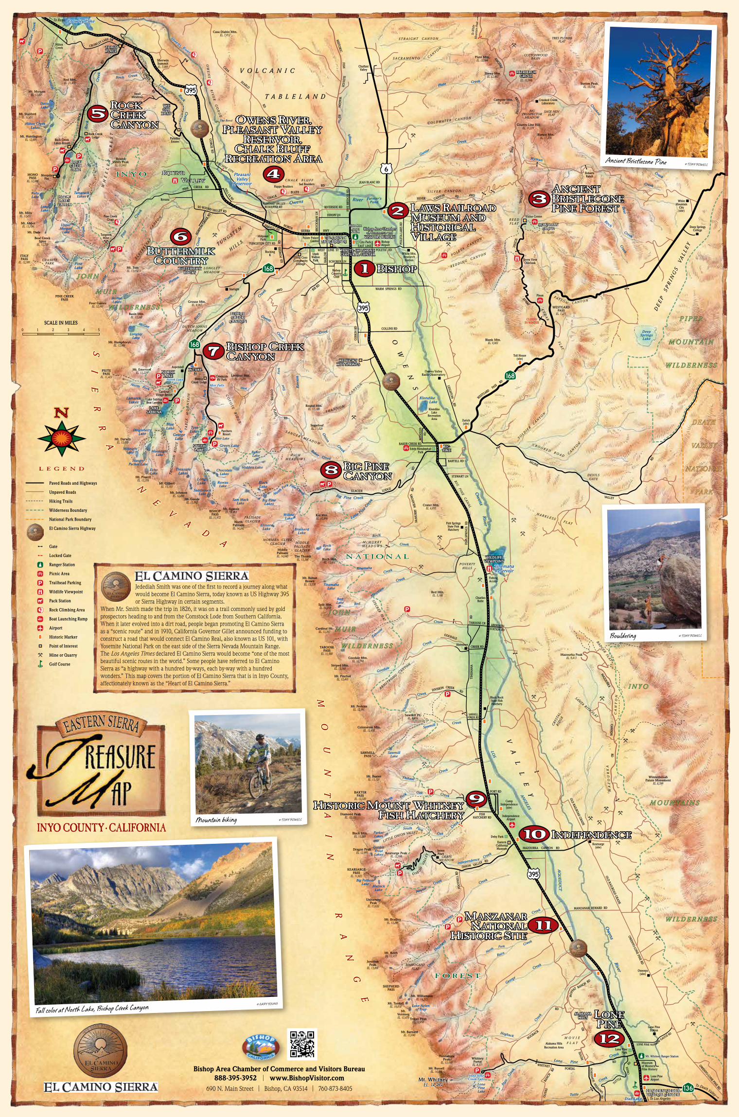
DEATH VALLEY NATIONAL PARK PIPER MOUNTAIN WILDERNESS JOHN MUIR WILDERNESS INYO MOUNTAINS WILDERNESS JOHN MUIR WILDERNESS INYO NATIONAL FOREST 10 B ISHOP BISHOP LAWS RAILROAD MUSEUM AND HISTORICAL V ILLAGE ANCIENT BRISTLECONE PINE F OREST OWENS RIVER, PLEASANT V ALLEY RESERVOIR, CHALK BLUFF RECREATION AREA ROCK CREEK CANYON B UTTERMILK C OUNTRY BUTTERMILK COUNTRY BISHOP CREEK CANYON 10 INDEPENDENCE 1 1 11 . . . . . . . S A W M I L L RD . . S I E R R A N E V A D A M O U N T A I N R A N G E Mist Falls Owens River . . EASTERN SIERRA VISITOR CENTER . z c p v ^ ? k . Creek Crowley Lake 168 168 168 136 395 6 Owens River Creek Rock Hilton Davis Lake Hilton Creek Lakes McGee Creek Ruby Lake MONO PASS EL. 12,000 Mt. Abbot EL. 13,704 Bear Creek Spire EL. 13,720 Mt. Tom EL. 13,652 ITALY PASS EL. 12,300 Long Lake Pleasant Valley Reservoir Creek Rock Lower GORGE RD Rock Creek Lakes Resort . ^ Swall Meadows LOWER ROCK CREEK RD Paradise Estates ROCK CREEK RD W H E E L E R C R E S T Tamarack Lakes . ^ p ^ . ^ . ^ . ^ . k . p . p . p . p . p . p . p . c . k . k . p . p . p . p . ^ . ^ . p Rovana Bishop Creek Lodge Aspendell Cardinal Village Resort Starlight Parchers Resort Owens Valley Radio Observatory White Mtn. Research Station TABOOSE PASS EL. 11,500 North Palisade EL. 14,242 PINE CREEK PASS PIUTE PASS EL. 11,423 Mt. Humphreys EL. 13,986 BISHOP PASS EL. 11,972 Mt. Gilbert EL. 13,103 Split Mtn. EL. 14,058 Mt. Pinchot EL. 13,495 Mt. Whitney EL. 14,494 SAWMILL PASS Mt. Baxter EL. 13,125 BAXTER PASS EL. 12,320 KEARSARGE PASS EL. 11,823 Mt. Williamson EL. 14,375 SHEPHERD PASS Whitney Portal EL. 8,371 Mt. Barnard EL. 13,990 Chalfant Valley Hilton Creek RD CREEK PINE Pine Creek Upper Morgan Lake Horton Lakes Pine Lake GRANITE PARK Tungsten Mine LONGLEY MEADOW Four Gables EL. 12,691 Creek Horton RD CHALK BLUFF Rock Creek Lodge Izaak Walton Park WEST LINE ST Bishop Airport Millpond Park SOUTH LAKE 7 6 ROCK CREEK LAKE 5 LITTLE LAKES VALLEY C R O W L EY L A K E D R NORTH LAKE LAKE SABRINA . v SCHULMAN GROVE . c PATRIARCH GROVE . c Visitor Center Crooked Creek Laboratory Sierra View Overlook . v Piute Mtn. EL. 12,564 Sheep Mtn. EL. 12,497 Campito Mtn. EL. 11,543 White Mountain City (site) Deep Springs College . c CLOSED IN WINTER WESTGARD PASS EL. 7,271 Pinon Roberts Ranch McGee Creek Longley Lake Basin Mtn. EL. 13,240 DUTCH JOHNS MEADOW Blue Lake George Lake Tyee Lakes Lamarck Lakes INTAKE 2 Dingleberry Lake Moonlight Lake Echo Lake Midnight Lake Hungry Packer Lake Treasure Lakes South Fork North Fork Mt. Emerson EL. 13,225 Birch Creek Grouse Mtn. EL. 8,067 Creek Coyote Bishop Creek Rocking K Lookout Mtn. EL. 11,261 Green Lake Chocolate Lakes Long Lake Ruwau Lake Saddlerock Lake Mt. Agassiz EL. 13,893 Middle Palisade EL. 14,040 Mt. Goode EL. 13,092 Hidden Lake Baker Lake Black Lake Big Pine Lakes Sam Mack Lake N o r th F o r k P i n e C reek Willow Lake Elinore Lake Brainerd Lake Big P in e Creek L ittl e P i n e Cre e k Birch Creek Kid Mtn. EL. 11,896 Baker Creek Klondike Lake Klondike Lake Recreation Area Zurich (site) Edith Mendenhall Park Creek Rawson West Fork Fork East Round Mtn. EL. 11,188 Creek Onion BARLOW DIXON LN BROCKMAN LN CHALK BLUFF POLETA-LAWS RD O W E N S V A L L E Y EAST LINE POLETA RD NORTH SIERRA HWY Gable Creek River Owens COLLINS RD GERKIN RD SCHOBER LN VOLCANIC TABLELAND Fish Slough FISH SLOUGH RD Station Peak EL. 10,316 County Line Hill EL. 11,229 Wyman Creek Blanco Mtn. EL. 11,278 BIG PROSPECTOR MEADOW SAGE HEN FLAT TRES PLUMAS FLAT COTTONWOOD BASIN Crooked Creek Birch DEEP SPRINGS VALLEY Deep Springs Lake REED FLAT SILVER CANYON COLDWATER CANYON Gunter Creek Creek Piute STRAIGHT CANYON CANYON SACRAMENTO Beer Creek POLETA CANYON Toll House (site) Blank Mtn. EL. 9,083 CEDAR FLAT PAYSON CANYON REDDING CANYON . c PINE SCENIC BYWAY COYOTE RIDGE ELDERBERRY CANYON Red Mtn. EL. 11,472 Mt. Morgan EL. 13,005 Mt. Stanford EL. 12,851 Mt. Huntington EL. 12,405 Mt. Mills EL. 13,451 Creek Birch Mt. Dade Birney Creek Creek Morgan Sugarloaf EL. 11,026 SANGER MEADOW HIGH MEADOWS Crater Mtn. EL. 6,055 BARTELL RD STEWART LN CANYON SHANNON GLACIER LODGE RD Fish Springs State Fish Hatchery McMURRY MEADOWS MEADOWS McMURRY RD FISH SPRINGS RD Charlies Butte Tinemaha Lake Tinemaha Creek Creek Red Mountain Red Lake Red Mtn. EL. 5,188 Mt. Bolton Brown EL. 13,538 The Thumb EL. 13,388 Birch Lake STECKER FLAT Birch Mtn. EL. 13,655 Cardinal Mt. EL. 13,397 Striped Mtn. EL. 13,160 Goodale Mtn. EL. 12,790 Creek Taboose Goodale Creek ARMSTRONG CANYON HARKLESS FLAT DEVILS GATE SOLDIER CANYON SALINE VALLEY RD CANYON CROOKED ROAD Fishing Access Tinemaha Reservoir TABOOSE CR ABERDEEN STATION RD Black Rock State Fish Hatchery Mazourka Peak EL. 9,413 CREEK RD GOODALE Aberdeen SAWMILL CREEK RD CREEK RD DIVISION Creek Sawmill Sawmill Lake Mt. Perkins EL. 12,591 Division Creek Colosseum Mtn. EL. 12,450 Thibaut Creek Sawmill Pt. EL. 9,416 FISH HATCHERY RD FORT RD MAZOURKA CANYON RD ONION VALLEY RD FOOTHILL RD . p . p MANZANAR REWARD RD HOGBACK WHITNEY RD M O F F A T R A NCH RD PORTAL RD MOVIE RD H O R S E S H O E M E A D O W S RD OLIVAS RANCH RD OWENYO-LONE PINE RD OWENYO-LONE PINE RD OLD RAILROAD GRADE OLD RAILROAD GRADE MAZOURKA CANYON RD Winnedumah Paiute Monument EL. 8,369 BADGER FLAT POVERTY HILLS MAZOURKA CANYON MOVIE FLAT MAHOGANY FLAT GRAYS MEADOW O N I O N V A LLEY LITTLE O NIO N VALLE Y CRYSTAL RIDGE SANTA RITA FLAT North Creek Oak Fork Parker Lakes Golden Trout Lakes Creek Oak South Fork Creek Independence Creek Symmes Pinyon Creek Matlock Lake Big Pothole Lake Shepherd Creek Williamson Creek Lake Helen of Troy North Fork Creek Bairs George Creek Creek Hogback Lone Pine Lake Creek Inyo Lone Pine Creek Diaz Lake Owens River LOS ANGELES AQUEDUCT Owens River Lone Pine Station Lone Pine Park Owenyo (site) Alabama Hills Recreation Area . c Independence Airport Lone Pine Airport Dehy Park Kearsarge (site) Eastern California Museum Camp Independence (site) Mt. Whitney Ranger Station Black Mtn. EL. 13,289 Mt. Bradley EL. 13,289 University Peak EL. 13,632 Mt. Keith EL. 13,977 Junction Peak EL. 13,888 Mt. Tyndall EL. 14,018 Mt. Versteeg EL. 13,470 Trojan Peak EL. 13,950 Tunnabora Peak EL. 13,565 Mt. Russell EL. 14,086 TINEMAHA RD . c REYNOLDS RD TUNGSTEN HILLS TABLE MOUNTAIN Casa Diablo Mtn. EL. 7,912 Sherwin Summit EL. 7,000 Round Valley Peak EL. 11,943 Seven Pines Kearsarge Peak EL. 12,598 Diamond Peak EL. 13,126 Dragon Peak EL. 12,995 Mt. Johnson EL. 12,868 Mt. Powell EL. 13,356 Mt. Darwin EL. 13,830 BIRCHIM CYN M I L L C K R D OWENS RIVER GORGE City Park 1 THOMPSON RIDGE PALISADE GLACIER NORMAN CLYDE GLACIER MIDDLE PALISADE GLACIER BIG PINE CANAL T U T T L E C R E E K R D Creek Tuttle Mosquito Flat . z ED POWERS RD SO R O UND V A L L E Y R D . z W E STGARD PASS R D B R I S T L E C O N E A N C I E N T N A T I O N A L Paved Roads and Highways Unpaved Roads Hiking Trails Wilderness Boundary National Park Boundary El Camino Sierra Highway Gate Locked Gate Ranger Station Picnic Area Trailhead Parking Wildlife Viewpoint Pack Station Rock Climbing Area Boat Launching Ramp Airport Historic Marker Point of Interest Mine or Quarry Golf Course SCALE IN MILES 0 5 White Mtn. Ranger Station Lake Sabrina Boat Landing LEGEND Weir Lake To White Mountain Peak 2 1 3 4 To D e a t h V alley . h Creekside RV Park LONE PINE N A R R O W G AUGE RD Cerro Coso Community College Bishop Country Club Paiute Palace Casino Museum of Western Film History 2 3 Creek 4 8 BIG PINE CANYON 9 HISTORIC MOUNT WHITNEY FISH HATCHERY MANZANAR NATIONAL HISTORIC SITE 1 2 12 LONE PINE RIVERSIDE RD FIVE BRIDGES RD JEAN BLANC RD To Los Angeles . . . To Reno EASTERN SIERRA VISITOR CENTER HORTON CREEK RD BAKER CREEK RD Lone Pine Creek Falls Lone Pine Creek Falls R OUND V ALLEY ROUND V ALLEY . v PLEASANT VALLEY RESERVOIR RD The Bend 395 395 HISTORIC WAGON Happy Boulders Sad Boulders Farmer’s Pond . k . Pine Creek Crags . ? . ? 4WD BIR RD WARM SPRINGS RD ? 4WD SILVER CANYON RD . ? ? PAIUTE-SHOSHONE CULTURAL CENTER Bishop Area Chamber of Commerce and VISITORS BUREAU North Lake Falls North Lake Falls Mist Falls Mist Falls EL. 11,300 EL. 10,000 LEIGHTON RD CASA DIABLO RD TUNGSTON CITY RD COYOTE FLATS RD S I E R R A N E V A D A M O U N T A I N R A N G E Bishop Area Chamber of Commerce and Visitors Bureau 888-395-3952 I www.BishopVisitor.com 690 N. Main Street I Bishop, CA 93514 I 760-873-8405 Fall color at North Lake, Bishop Creek Canyon © GARY YOUNG Ancient Bristlecone Pine © TONY ROWELL Mountain biking © TONY ROWELL Jedediah Smith was one of the first to record a journey along what would become El Camino Sierra, today known as US Highway 395 or Sierra Highway in certain segments. When Mr. Smith made the trip in 1826, it was on a trail commonly used by gold prospectors heading to and from the Comstock Lode from Southern California. When it later evolved into a dirt road, people began promoting El Camino Sierra as a “scenic route” and in 1910, California Governor Gillet announced funding to construct a road that would connect El Camino Real, also known as US 101, with Yosemite National Park on the east side of the Sierra Nevada Mountain Range. The Los Angeles Times declared El Camino Sierra would become “one of the most beautiful scenic routes in the world.” Some people have referred to El Camino Sierra as “a highway with a hundred by-ways, each by-way with a hundred wonders.” This map covers the portion of El Camino Sierra that is in Inyo County, affectionately known as the “Heart of El Camino Sierra.” Bouldering © TONY ROWELL
-
Upload
truonghanh -
Category
Documents
-
view
214 -
download
0
Transcript of R V ANCIENT RISTLECONEA 3 B 2 LAWS … · Midnight Lake Hungry Packer Lake Treasure Lakes South...
DEATH
VALLEY
NATIONAL
PARK
P I P E R
M O U N T A I N
W I L D E R N E S S
J O H N
M U I R
W I L D E R N E S S
I N Y O
M O U N T A I N S
W I L D E R N E S S
J O H N
M U I R
W I L D E R N E S S
I N Y O
N A T I O N A L
F O R E S T
10
BISHOPBISHOP
LAWS RAILROADMUSEUM AND HISTORICAL VILLAGE
ANCIENTBRISTLECONE PINE FOREST
OWENS RIVER,PLEASANT VALLEY
RESERVOIR, CHALK BLUFF
RECREATION AREA
ROCKCREEKCANYON
BUTTERMILKCOUNTRY
BUTTERMILKCOUNTRY
BISHOP CREEKCANYON
10 INDEPENDENCE
1111
.
.
.
.
.
.
.
SAW MILL RD
.
.
S
IE
RR
A
N
EV
AD
A
MO
UN
TA
IN
RA
NG
E
Mist Falls
Owens River
.
.
EASTERN SIERRAVISITOR CENTER
.zcpv^?k.
Cre
ek
Crowley Lake
168
168
168
136
395
6
Owens River
Cre
ek
Roc
k
Hilt
on
DavisLake
Hilton CreekLakes
McG
eeC
reek
RubyLake
MONOPASS
EL. 12,000
Mt. AbbotEL. 13,704
Bear CreekSpire
EL. 13,720
Mt. TomEL. 13,652
ITALYPASS
EL. 12,300
LongLake
PleasantValley
Reservoir
Creek
Rock
Lower
GO
RGE RD
Rock CreekLakes Resort
.̂
SwallMeadows
LOWER
ROCKCREEK
RD
ParadiseEstates
ROCK
CREE
K
RDW
HE
EL
ER
CR
ES
T
TamarackLakes
.̂
p^
.̂
.̂
.̂
.k
.p
.p
.p
.p
.p
.p
.p.c
.k
.k .p
.p
.p.p
.̂
.̂.p
Rovana
BishopCreek Lodge
Aspendell
CardinalVillage Resort
Starlight
ParchersResort
Owens ValleyRadio Observatory
White Mtn.ResearchStation
TABOOSEPASS
EL. 11,500
NorthPalisadeEL. 14,242
PINE CREEKPASS
PIUTEPASS
EL. 11,423
Mt. HumphreysEL. 13,986
BISHOPPASS
EL. 11,972
Mt. GilbertEL. 13,103
Split Mtn.EL. 14,058
Mt. PinchotEL. 13,495
Mt. WhitneyEL. 14,494
SAWMILLPASS
Mt. BaxterEL. 13,125
BAXTERPASS
EL. 12,320
KEARSARGEPASS
EL. 11,823
Mt. WilliamsonEL. 14,375
SHEPHERDPASS
WhitneyPortal
EL. 8,371
Mt. BarnardEL. 13,990
ChalfantValley
HiltonCreek
RDCREEKPINE
Pine
Cree
k
UpperMorgan
Lake
HortonLakes
PineLake
GRANITEPARK
TungstenMine
LONGLEYMEADOW
Four GablesEL. 12,691
Cre
ek
Horton
RD
CHALKBLUFF
Rock CreekLodge
IzaakWaltonPark
WEST LINE ST
BishopAirport
MillpondPark
SOUTHLAKE
7
6
ROCKCREEKLAKE
5
LITTLELAKES
VALLEY
CROWLEY LAKE DR
NORTHLAKE
LAKESABRINA
.v
SCHULMANGROVE
.c PATRIARCHGROVE
.cVisitor Center
Crooked CreekLaboratory
Sierra ViewOverlook
.v
Piute Mtn.EL. 12,564
Sheep Mtn.EL. 12,497
Campito Mtn.EL. 11,543
WhiteMountain
City(site)
Deep SpringsCollege
.c
CLOSEDIN WINTER
WESTGARDPASS
EL. 7,271
Pinon
RobertsRanch
McGee
Cre
ek
LongleyLake
Basin Mtn.EL. 13,240
DUTCH JOHNSMEADOW
BlueLake
GeorgeLake
TyeeLakes
LamarckLakes
INTAKE2
DingleberryLake
MoonlightLake
EchoLake
MidnightLake
HungryPacker Lake
TreasureLakes
Sout
hFo
rk
North Fork
Mt. EmersonEL. 13,225
Birc
h
Creek
Grouse Mtn.EL. 8,067
Creek
Coyote
Bishop
Creek
RockingK
Lookout Mtn.EL. 11,261
Green Lake
ChocolateLakes
LongLake Ruwau
LakeSaddlerock
Lake
Mt. AgassizEL. 13,893
MiddlePalisadeEL. 14,040
Mt. GoodeEL. 13,092
Hidden Lake
BakerLake
BlackLake
Big PineLakes
Sam MackLake
North Fo
rk Pine Creek
WillowLake
ElinoreLake Brainerd
Lake
Big Pine Creek
Little Pin
e Cre
ek
Birch
Creek
Kid Mtn.EL. 11,896
BakerCreek
Klondike Lake
KlondikeLake
RecreationArea Zurich
(site)
Edith MendenhallPark
Creek
Raw
son
WestFo
rk
Fork
East
Round Mtn.EL. 11,188
Creek
Onion
BARL
OW
DIXON LN
BRO
CKM
AN L
N
C H A L K B L U F F
POLE
TA-L
AWS
RD
OW
EN
S
VA
LL
EY
EAST LINEPOLETA RD
NORTHSIERRA HWY
Gab
le
Cre
ek
RiverOwens
COLLINS RD
GER
KIN
RD
SCHOBER LN
V O L C A N I C
T A B L E L A N D
Fish
Slou
gh
FISHSLO
UG
HRD
Station PeakEL. 10,316
County Line HillEL. 11,229
Wyman
Creek
Blanco Mtn.EL. 11,278
BIGPROSPECTOR
MEADOW
SAGE HENFLAT
TRES PLUMASFLAT
COTTONWOODBASIN
Crooked
Creek
Birch
DE
EP
S
PR
I NG
S
VA
LL
EY
DeepSprings
Lake
R E E DF L A T
S I L V E R C A N Y O N
C O L D WA T E R C A N Y O N
Gunter
Creek
CreekPiute
S T R A I G H T C A N Y O N
C A NY O
N
S A C R A M E N T O
Beer
Creek
P O L E TA CA N Y O N
Toll House(site)
Blank Mtn.EL. 9,083
CE
DA
R F
LA
T
PAY S O N C A N Y O N
R E D D I N G C A N Y O N.c
PINE
SCENIC
BYWAY
CO
YO
TE
RI D
GE
EL D
ER
BE
RR
YC
AN
YON
Red Mtn.EL. 11,472
Mt. MorganEL. 13,005
Mt. StanfordEL. 12,851
Mt. HuntingtonEL. 12,405
Mt. MillsEL. 13,451
CreekBirch
Mt. Dade
Birney
Creek
Cre
ekM
orga
n
SugarloafEL. 11,026
S A N G E R M E A D O W
H I G HM E A D O W S
Crater Mtn.EL. 6,055
BARTELL RD
STEWART LN
C A NY O
N
S H A N N O N
GLACIER LODGE
RD
Fish SpringsState FishHatchery
M c M U R R YM E A D O W S
MEA
DOW
S
McM
URR
YRD
FISH
SPR
ING
S R
D
CharliesButte
TinemahaLake
TinemahaCreek
Creek
Red
Mountain
RedLake
Red Mtn.EL. 5,188
Mt. BoltonBrown
EL. 13,538
The ThumbEL. 13,388
BirchLake
STECKER FLAT
Birch Mtn.EL. 13,655
Cardinal Mt.EL. 13,397
Striped Mtn.EL. 13,160
Goodale Mtn.EL. 12,790
Creek
Tabo
ose
Goodale
Creek
ARMSTRONG C
ANYON
H A R K L E S S F L A T
DEVILSGATE
S OL D
I ER
CA N
Y ON
SALINE
VALLEY
RD
CA N
Y ONC R O O K E D R O A D
FishingAccess
TinemahaReservoir
TABOOSE CR ABERDEENSTATION RD
Black RockState FishHatchery
Mazourka PeakEL. 9,413
CREEK RD
GOODALE
Aberdeen
SAWMILLCREEK RD
CREEKRDDIVISION
CreekSawmill
SawmillLake
Mt. PerkinsEL. 12,591 D
ivis
ion
Creek
Colosseum Mtn.EL. 12,450
Thibaut
Creek
Sawmill Pt.EL. 9,416
FISHHATCHERY RD
FORT RD
MAZOURKA CANYON RD
ONION VALLEY RD
FOO
THIL
L RD
.p.p
MANZANAR REWARD RD
HOGBACK
WHITNEY
RD
MOF
FAT RANCH RD
PORTAL
RD
MO
VIE
RD
HO
RSESHO
E MEADOWS RDO
LIVA
SRA
NCH
RD
OWENYO-LONE PINE RD
OWENYO-LONE PINE RD
OLD RAILROAD GRADE
OLD RAILROAD GRADE
MAZOURKA
CANYO
NRD
WinnedumahPaiute Monument
EL. 8,369
BAD
GER FLAT
POVERTYHILLS
MA
ZO
UR
KA
CA
NY
ON
M O V I E
F L A T
MAHOGANYFLAT
GRAYSMEADOW
O N I ON
VA
LLE
Y
LITTLE ONION VALLEY
CRY
STA
LR
IDG
E
SANTA RITA FLAT
NorthCreek
OakFork
ParkerLakes
GoldenTroutLakes
Creek
OakSouth Fork
Creek
Independence
Creek
Symmes
PinyonCreek
MatlockLake
Big PotholeLake
Shep
herd
Creek
Will
iam
son
Creek
Lake Helenof Troy
NorthFork Creek
Bairs
George
Creek
Creek
Hogback
LonePineLake
Creek
Inyo
Lone PineCreek
Diaz Lake
Ow
ensRiver
LOS
ANG
ELES
AQ
UED
UC
T
Ow
ensR
iver
Lone PineStation
Lone PinePark
Owenyo(site)
Alabama HillsRecreation Area
.c
IndependenceAirport
Lone PineAirport
Dehy Park
Kearsarge(site)
EasternCaliforniaMuseum
CampIndependence
(site)
Mt. Whitney Ranger Station
Black Mtn.EL. 13,289
Mt. BradleyEL. 13,289
UniversityPeak
EL. 13,632
Mt. KeithEL. 13,977
JunctionPeak
EL. 13,888
Mt. TyndallEL. 14,018
Mt.VersteegEL. 13,470 Trojan Peak
EL. 13,950
TunnaboraPeak
EL. 13,565
Mt. RussellEL. 14,086
TIN
EMAH
ARD
.c
REYN
OLD
S
RD
T U N G S T E N
H I L L S
TA
BL
E
MO
UN
TA
I N
Casa Diablo Mtn.EL. 7,912
SherwinSummitEL. 7,000
RoundValley Peak
EL. 11,943
SevenPinesKearsarge Peak
EL. 12,598
Diamond PeakEL. 13,126
Dragon PeakEL. 12,995
Mt. JohnsonEL. 12,868
Mt. PowellEL. 13,356
Mt. DarwinEL. 13,830
BIRCHIM CYN
MILL CK RD
OW
EN
SR
I VE
RG
OR
GE
City Park
1
TH
OM
PS
ON
R
IDG
E
PALISADEGLACIER
NORMAN CLYDEGLACIER MIDDLE
PALISADEGLACIER
BIG
PINE
CA
NA
L
TUTTLE
C
REEK
R
D
Creek
Tuttle
MosquitoFlat
.z
ED P
OW
ERS
RD
SO ROUND VALLEY RD
.z
WESTGARD PASS
RD
BRISTLECONE
ANCIENT
NATION
AL
Paved Roads and Highways
Unpaved Roads
Hiking Trails
Wilderness Boundary
National Park Boundary
El Camino Sierra Highway
Gate
Locked Gate
Ranger Station
Picnic Area
Trailhead Parking
Wildlife Viewpoint
Pack Station
Rock Climbing Area
Boat Launching Ramp
Airport
Historic Marker
Point of Interest
Mine or Quarry
Golf Course
SCALE IN MILES0 5
White Mtn.RangerStation
Lake SabrinaBoat Landing
L E G E N D
Weir Lake
To W
hite
Mou
ntai
n Pe
ak
21 3 4
To Death Valley
.hCreeksideRV Park
LONE PINE NARROW GAUGE RD
Cerro CosoCommunity
College
BishopCountry
Club
Paiute PalaceCasino
Museum of Western Film History
23
Creek
4
8 BIG PINECANYON
9HISTORIC MOUNT WHITNEYFISH HATCHERY
MANZANARNATIONAL
HISTORIC SITE
1212
LONEPINE
RIVERSIDE RD
FIVE
BRI
DGES
RD
JEAN BLANC RD
To Los Angeles
..
..
..
To Reno
EASTERN SIERRAVISITOR CENTER
HORT
ON CR
EEK
RD
BAKER CREEK RD
Lone PineCreek FallsLone Pine
Creek Falls
ROUND VALLEY
ROUND VALLEY.v
PLEASANT VALLEY RESERVOIR RD
The Bend
395
395
HISTO
RICW
AGO
N
Happy BouldersSad Boulders
Farmer’sPond
.k
.Pine Creek
Crags
.?
.?
4WD BIR RDWARM SPRINGS RD
?
4WDSILVER CANYON RD
.??
PAIUTE-SHOSHONECULTURAL CENTER
Bishop Area Chamberof Commerce and
VISITORS BUREAU
North LakeFalls
North LakeFalls
Mist FallsMist Falls
EL. 11,300
EL. 10,000
LEIGHTON
RD
CASA
DIABLO
RD
TUNGSTON CITY RD
COYO
TEFLATS
RD
S
IE
RR
A
N
EV
AD
A
MO
UN
TA
IN
RA
NG
E
Bishop Area Chamber of Commerce and Visitors Bureau888-395-3952 I www.BishopVisitor.com
690 N. Main Street I Bishop, CA 93514 I 760-873-8405
Fall color at North Lake, Bishop Creek Canyon © GARY YOUNG
Ancient Bristlecone Pine © TONY ROWELL
Mountain biking © TONY ROWELL
Jedediah Smith was one of the first to record a journey along what would become El Camino Sierra, today known as US Highway 395 or Sierra Highway in certain segments.
When Mr. Smith made the trip in 1826, it was on a trail commonly used by gold prospectors heading to and from the Comstock Lode from Southern California. When it later evolved into a dirt road, people began promoting El Camino Sierra as a “scenic route” and in 1910, California Governor Gillet announced funding to construct a road that would connect El Camino Real, also known as US 101, with Yosemite National Park on the east side of the Sierra Nevada Mountain Range. The Los Angeles Times declared El Camino Sierra would become “one of the most beautiful scenic routes in the world.” Some people have referred to El Camino Sierra as “a highway with a hundred by-ways, each by-way with a hundred wonders.” This map covers the portion of El Camino Sierra that is in Inyo County, affectionately known as the “Heart of El Camino Sierra.”
Bouldering © TONY ROWELL

© 2017 Bishop Area Chamber of Commerce and Visitors Bureau / Design, illustration and cartography by Laura Patterson Design 760-934-7609 / All rights reserved
CerroGordoPeak
EL. 9184
190
190
190
178
127
95
95
127
127
178178
395
A T HTD E A T H
V A L L E Y V A L L E Y
O N A LL N A T I O O N A LLN A T I O N A
P A R KA R RRA R KRAAP AAP A R K
Jubilee PassEL. 1290
Salsberry PassEL. 3315
SaratogaSpring
FuneralPeak
EL. 6384
SmithMountain
EL. 5912
EagleMountainEL. 3806EL. 5475
Sentinel PeakEL. 9636
TelescopePeak
EL. 11,049
WildrosePeak
EL. 9064
Emigrant PassEL. 5318
Towne PassEL. 4956
DryMountain
EL. 8674
HunterMountain
EL. 7454
TinMountain
EL. 8953
PalmettoMountain
EL. 8960
MagruderMountain
EL. 9046
MountJacksonEL. 6411
GrapevinePeak
EL. 8738
Mount PalmerEL. 7979
DaylightPassEL. 4316
Winters PeakEL. 5033
AguereberryPoint Day use onlyEL. 6433
PyramidPeak
EL. 6703
136
NorthHaiweeReservoir
SouthHaiweeReservoir
OWENS LAKE(dry)
ManlyPeak
EL. 7196
RACE
TRAC
K
PANAMINT
VALLEYRO
AD
EMIGRAN
TCANYON
ROAD
BADWATER
ROAD
HARRY WADE
ROAD
STATE LINE ROAD
BEATTYCU
TOFF
BIGPIN
EROAD
SCOTTY’S
CASTLEROAD
SEARLESLAKE
BrownMountainEL. 5125
BALLARATGHOST TOWNBALLARATGHOST TOWN
ARTIST’S DRIVEARTIST’S DRIVE
ONE WAY
ONE WAY
ARTIST’SPALETTE
DEVIL’S GOLFCOURSEDEVIL’S GOLFCOURSE
DANTE’SVIEW
DANTE’SVIEW
PANAMINT CITYGHOST TOWNPANAMINT CITYGHOST TOWN
B A D W A T E R B A S I NB A D W A T E R B A S I N
FURNACE CREEK VISITOR CENTER& DEATH VALLEY MUSEUMFURNACE CREEK VISITOR CENTER& DEATH VALLEY MUSEUM
ZABRISKIE POINTZABRISKIE POINTTWENTY MULETEAM CANYON
HARMONYBORAXWORKS
HARMONYBORAXWORKS
FURNACE CREEKFURNACE CREEKGolden Canyon
Interpretive Trail
Information
WILDROSECHARCOAL
KILNS
WILDROSECHARCOAL
KILNS
Lowest elevation in U.S.282 ft. below sea level
ROAD
WEST
SIDE
CHINA LAKE NAVALWEAPONS CENTER
TEAKETTLEJUNCTION
RACETRACK PLAYARACETRACK PLAYAMESQUITE FLAT DUNESMESQUITE FLAT DUNES
HistoricStovepipe Well InformationInformation
Devil’sCornfield
STOVEPIPEWELLSSTOVEPIPEWELLSMosaic
Canyon
SaltCreekInterpretiveTrail
RHYOLITEGHOST TOWN
RHYOLITEGHOST TOWN
LEADFIELDGHOST TOWN
LEADFIELDGHOST TOWN
TITUS CANYON
DAYL
IGH
T
PASS
ROAD
HellsGate
Information
Two-way traffic tomouth of Titus Canyon
One-way
NELLIS AIR FORCE BOMBING AND GUNNERY RANGE
SCOTTY’SCASTLE
SCOTTY’SCASTLE
UBEHEBECRATER
UBEHEBECRATER
GRAPEVINEGRAPEVINE
MesquiteSpring
EurekaDunes
Gold Point
Deep SpringsLake
EU
RE
KA
VA
LL
EY
SA
LI N
E V
AL
LE
Y
SalineValleyDunesMount Inyo
EL. 11,107
SA
LI N
E
RA
NG
E
CrankshaftJunction
Amargosa Opera House
373
374
DARWIN
DarwinFalls
FatherCrowley
Vista
EasternSierraVisitorCenter
PANAMINTSPRINGS
PANAMINTSPRINGS
168
266
266
266
267
SHOSHONESHOSHONE
.c
.z
.c.o
....
....zHIiarƒo
D
E
A
T
H
V
A
L
L
E
Y
...HIo
...HIo
..Ho
..rƒ
..
..HIr.
......HIrƒo.
.
.a
.a
.a
.a
LONE PINE
......HIrƒo.
....zoId
PanamintDunes
...z
od..ai
Lida Junction
To Tonopahand Reno
To Dyer
To Big Pine
ToLakeIsabella
....HIar
ToTecopa
andLas
Vegas
ToPahrump
andLas
Vegas
ToLas
Vegas
IN
YO
M
OU
NT
AI
NS
WaucobaMountainEL. 11,125
INYO
NATIONAL
FOREST
BIGPINE
ROAD
PA
NA
MI
NT
VA
LL
EY
SI
ER
RA
NE
VA
DA
...
...HIrƒo.
1313 DEATH VALLEYNATIONAL PARK
LA
ST
CH
AN
CE
RA
NG
E
Last ChanceMountain
EL. 8456
Ubehebe PeakEL. 5678
Badwater–282 ft.
InterpretiveTrail
RA
NG
E
GR
EE
NW
AT
ER
Deadman PassEL. 3263
F I S H L A
KE
VAL L E
Y
To Big Pine
Visitor Centerand Museum
ROAD
L E G E N D
Paved Road or Highway
Unpaved Road
Unpaved Road – High-Clearance Vehicles Recommended
Unpaved Road – Four-Wheel Drive
Hiking Trail
Death Valley National Park
El Camino Sierra Highway
Ranger Station
Campground
Picnic Area
Sanitary Disposal Station
Lodging
Dining
Gas Station
Store
Public Telephone
Wheelchair Accessible
Airstrip
Historic Marker
Point of Interest
Mine or Quarry
Golf Course
..
.
.
.
.
.
.
.
.
.
.
.zaciHIrƒod.
SCALE IN MILES
0 1 10 Miles
0 1 10 Kilometers
Skidoo (townsite)Day use only
.z
Conditions on unpaved roads may varyand can be dangerous.
Always check with National Park Servicebefore you travel.
www.nps.gov
TRONATRONA
DEATH VALLEYJUNCTIONDEATH VALLEYJUNCTION
KEELERKEELER
BEATTYBEATTY
LIDALIDA
SCOTTY’SJUNCTIONSCOTTY’SJUNCTION
LATHROPWELLS
LATHROPWELLS
AmargosaValley
AmargosaValley
C O S O R A N GE
W I L DERNES S
A REA
FUNERAL
MOUNTAINS
WILDERNES S
AREA
O W E N S L A K EB I R D H A B I TA T
A R E A
Cerro GordoMining Camp
1
2
3
6
5
4
7
8
1010
1111
9
1212
1313
1
2
3
6
5
4
7
8
1010
1111
9
1212
1313
BUTTERMILK COUNTRY This rising upland of meadows and boulder fields lies beneath
Mount Tom and Basin Mountain. Named for the dairy farms that once drew stagecoach travelers for a refreshing drink of buttermilk, this area is now famous for exploring and climbing the weathered granite rock formations and giant, solitary boulders. From Bishop, drive west on Line Street (Highway 168) for about seven miles, then turn right onto Buttermilk Road (well graded dirt road). You can stop anywhere along the way, but the largest boulders are about three miles from the Buttermilk Road entrance.
BISHOP CREEK CANYONFrom downtown Bishop, follow Line Street (Highway 168) west
about 15 miles. You will climb into the mountains from the valley floor to elevations over 9,000 feet on a well maintained highway. In summer months, locals and visitors enjoy trout fishing, camping, hiking, horseback riding, and just relaxing in the cool mountain air. Popular locations include South Lake, North Lake, Lake Sabrina, the historic Rainbow Pack Station and Cardinal Gold Mine. The canyon is a real find in autumn, with blazing colors igniting the landscape. There are dozens of USFS campsites and great picnic locations. Several resorts including Parchers, Bishop Creek Lodge, Creekside RV, Cardinal Village and Aspendell Cabins offer cabin rentals, camping, dining and general stores to stock up. Boat rentals are available at South Lake Boat Landing and Lake Sabrina Boat Landing.
BIG PINE CANYON High above Big Pine Creek is the Palisade Glacier, the
southernmost permanent glacier in North America. It is accessible by foot and horseback from the Glacier Lodge Trailhead. Big Pine Canyon is popular spring through fall and recreational opportunities include camping, fishing, hiking, photography, horseback riding, bird watching and wildlife viewing.
HISTORIC MOUNT WHITNEYFISH HATCHERY
A structural marvel built to “match the mountains, last forever, and be a showplace for all time,” this 1917 hatchery is a beautiful and unique building with hand-laid stone walls and hand-hewn timbers. The shady grounds and main pond are excellent for relaxing, picnicking and fish viewing. Kids of all ages love to get trout food from the coin operated dispenser and watch the feeding frenzy! There is a nice gift shop and displays featuring many species of Eastern Sierra Wildlife. Volunteers have done much to restore the facility following devastation by fire and flood several years ago. Volunteers now serve as caretakers and give tours inside the hatchery. Access is just off US Highway 395 about two miles north of Independence. Open year round. Grounds open daily. Gift Shop and hatchery tours Thursday through Monday (summer) and Friday through Sunday (winter).
MANZANAR NATIONALHISTORIC SITE
Manzanar War Relocation Center was one of ten camps where Japanese American Citizens were interned during World War II. Approximately 10,000 people lived here from 1942-1945. Today, the Manzanar Interpretive Center features extensive exhibits, a scale model of the camp and an award-winning documentary film shown every 30 minutes. Several barracks and other buildings have recently been reconstructed and visitors are encouraged to tour the entire site to see the historic orchards, rock gardens and cemetery. Manzanar is open daily year-round. Admission is free and the National Park Service regularly offers ranger led programs.
LONE PINEThis frontier town sits in the shadow of majestic Mount
Whitney, the highest peak in the contiguous US at 14,494 feet. Hiking to the top requires a US Forest Service permit (www.recreation.gov). Even if you don’t hike the trail, a drive up to Whitney Portal, 12 miles west of downtown, is highly recommended in summer months. It’s a popular place for camping, picnicking, fishing, wildlife viewing and just general relaxation with amazing views. The general store serves great burgers and pizza size pancakes just steps away from a cascading waterfall and glistening trout pond. Lone Pine is known as Hollywood’s “back lot.” Since the 1920s, hundreds of movies, especially westerns and sci-fi thrillers, have been filmed in the region. Be sure to visit the Lone Pine Museum of Western Film History to see props, costumes and a great collection of movie memorabilia. Take a drive along Movie Flat Road to explore the weathered granite boulders and arches in the Alabama Hills. Lone Pine is also known as the gateway to Death Valley and the town has a good selection of lodging, dining and retail shops. The Eastern Sierra Visitor Center (one mile south of Lone Pine at the intersection of US Highway 395 & State Route 136) is staffed by friendly, knowledgeable people and features informative displays and a good selection of maps, books and souvenirs. Wilderness permits and passes may also be picked up there, open daily year-round.
1
2
3
6
5
4
7
8
1010
1111
9
1212
1313
DEATH VALLEY NATIONAL PARK
It’s the hottest, driest and lowest – this is the land of extremes! Vast and hulking mountain ranges frosted with winter snow tower over the valley floor; Telescope Peak is 11,049’ and Badwater is 282’ below sea-level. The steady drought and record summer temperatures create a unique and strikingly beautiful environment. On the northern end of the valley, Ubehebe Crater and Scotty’s Castle are popular destinations. In the center of the park, Furnace Creek offers lodging, camping, dining, golf and more. The Furnace Creek Visitor Center offers great educational exhibits, expert advice and ranger-led programs. Stovepipe Wells Village is another good option for lodging and camping, located near the Mesquite Flat Sand Dunes. There are several “must see to believe” places in Death Valley, including Zabriskie Point, Artist’s Drive, Golden Canyon and the Amargosa Opera House. At the south-east edge of Death Valley, you’ll find Shoshone Village, a popular stop for artists, photographers and geology buffs.
1
2
3
6
5
4
7
8
1010
1111
9
1212
1313
1
2
3
6
5
4
7
8
1010
1111
9
1212
1313
1
2
3
6
5
4
7
8
1010
1111
9
1212
1313
Wild iris in Round Valley, just north of Bishop © TONY ROWELL
INDEPENDENCEOur county seat is home to the
Historic Courthouse (1921), designed by famed architect William H. Weeks. Take a walking tour to see many historic buildings including the 1872 Commander’s House (corner of US Highway 395 & Main Street), the 1863 Edwards House which is the oldest building in the Owens Valley (124 Market Street), and the Mary Austin House (253 Market Street). History buffs must stop at the Eastern California Museum (155 N. Grant Street). The museum is open daily year-round and houses a unique and eclectic mix of artifacts and photos. The exhibits highlight the Owens Valley’s rich history including agriculture, mining, recreation, water, Manzanar and more. One of the museum’s greatest treasures is the largest collection of Owens Valley Paiute-Shoshone and Death Valley Panamint-Shoshone basketry in the country. Just outside the museum, you’ll find the Mary DeDecker Native Plant Garden. In the Sierra above Independence, Onion Valley is very popular in summer months for camping, fishing, backpacking and day hiking. From Independence, turn west on Market Street and continue for about 15 miles – you’ll climb to an elevation of 9,600 ft. and the views below are endless. The road is paved, a bit windy, but well maintained and usually open May through November depending on snow conditions.
Laws Railroad Museum © RON NICKERSON / LAWS MUSEUM
Sierra wave clouds © ED NAHIN
Historic Mount Whitney Fish Hatchery © INYO COUNTY
Alabama Arch © TONY ROWELL
Badwater, Death Valley National Park © DESSOLIERS
Zabriskie Point, Death Valley National Park © GARY YOUNG
Palisade Glacier © TOM GRUNDY / SHUTTERSTOCK
Independence Court House © TOM WILMER
Welcome to the Eastern Sierra – land of endless treasure and remarkable wonder! This Treasure Map highlights many outdoor venues you can savor and experience. Known as “The Other Side
of California,” this region is world renowned for its beauty, scenery, and solitude. You can spend a lifetime hunting down many riches the area offers.
With this map, you’ll discover geographic features and many fascinating points of interest located in east-central California. They include attractions in Death Valley National Park and the Eastern Sierra area where continental US Highway 395 threads up “The Deepest Valley” of North America. This side of the map descriptively highlights many notable features and landmarks throughout this vast area. From world-class mountainscape treasures to multi-faceted gems of history, this map presents diverse, unique, and exciting adventures for you, your family, and friends.
For in-depth information and exceptional guest hospitality, visit the Bishop Chamber of Commerce & Visitor Center: 690 N. Main Street, Bishop CA 93514 • 760-873-8405 • www.bishopvisitor.com
1
2
3
6
5
4
7
8
1010
1111
9
1212
1313
1
2
3
6
5
4
7
8
1010
1111
9
1212
1313
BISHOPBishop’s official slogan is “Small Town with a Big
Backyard.” It’s fitting, because while Bishop is the biggest city in the region, it still retains genuine old-fashioned charm and friendliness – a great place to call home while you explore the Eastern Sierra. Bishop offers an excellent selection of lodging, camping, dining and retail options. Bishop has many boutiques and specialty shops, sporting goods, antiques, art and more. Mountain Light Gallery, in the historic First National Bank building, features amazing scenic and wildlife photography of world-famous Galen Rowell. A series of colorful murals adorn downtown buildings, depicting the region’s unique history – mining, agriculture, mule packing and western traditions. Stop at the Bishop Area Chamber of Commerce & Visitors Bureau for maps, brochures, souvenirs and friendly, knowledgeable advice (690 N. Main Street). The Bishop City Park is truly a treasure! Dozens of tree species in the arboretum provide wonderful shade for picnicking or just relaxing on the grass. The park offers some-thing for everyone – a swimming pool, tennis courts, baseball and soccer fields, a bike/skate park, playground equipment, outdoor gym, sand volleyball courts and bocce ball. There is even an area for your furry friends – Bishop’s Dog Park is popular with locals and visitors alike. The Bishop Country Club is a challenging 18-hole golf course with amazing mountain views. The Paiute Palace Casino offers 24-hour gaming, live entertainment, a full bar and restaurant. The Owens Valley Paiute-Shoshone Cultural Center features Native American exhibits and prehistoric artifacts from the region. The historic Keough’s Hot Springs (est. 1919) is a free flowing mineral hot springs located about 7 miles south of Bishop, just off US Highway 395. The swimming pool is 86° to 90° and the shallow soaking pool is 104° – the perfect place to relax after a day of hiking, climbing or skiing! The facility is open year-round; fees range from $4 to $12.
LAWS RAILROAD MUSEUM AND HISTORIC VILLAGE
Eleven acres and 30 buildings of indoor and outdoor exhibits transport you back to the pioneer days. Climb aboard Steam Engine #9 and ring the bell, step into the original depot and the agent’s house, visit the 1909 school house and more. The museum is open year-round daily from 10 am to 4 pm.
ANCIENT BRISTLECONE PINE FOREST
Schulman Grove is home to the world’s oldest known specimens of bristlecone pine; some are more than 4,000 years old! The secret to longevity is its adaptation to this unique environment high up in the White Mountains. The Ancient Bristlecone Pine Forest is about 45 minutes from the town of Big Pine; take Highway 168 east 13 miles to White Mountain Road, turn left and drive 10 miles to the parking area. At Schulman Grove, you’ll find a visitor center, picnic area and loop trails for hiking: Discovery Trail is one mile and Methuselah Trail is a 4.5 mile round trip. The cost is $3 per adult or $6 maximum per vehicle. Children under 18 are free. It is open from mid-May through the end of November, weather permitting. On your way to or from Schulman Grove, be sure to stop at Sierra View Overlook (about 2.5 miles below the visitor center). A short path around a knobby hill next to the parking lot brings you to an observation point with a breathtaking view encompassing 10 miles of the Sierra Range.
OWENS RIVER, PLEASANT VALLEY RESERVOIR, CHALK BLUFF RECREATION AREA
For great year-round fishing or a fun family outing, head north eight miles on US Highway 395 to the Pleasant Valley Reservoir turnoff, and then loop back toward Bishop following Chalk Bluff Road (well-graded dirt road). Here, the Owens River winds lazily, its lush banks shading many a favorite fishing hole. The Volcanic Tableland, along the north edge of Chalk Bluff Road, formed 750,000 years ago by enormous eruptions of glowing volcanic ash. Today, the Tableland and Chalk Bluff offer abundant treasures – exploring, hiking, birding, photography and bouldering. The Happy and Sad Boulders have become popular with boulderers from around the globe. The Owens River runs along the base of the Tableland and is open year-round for trout fishing. A certain section of the river is designated as a Wild Trout Area and has special fishing regulations.
ROCK CREEK CANYON AREA
Truly a four-season treasure! From Bishop, drive about 25 miles north on US Highway 395, then turn off at Tom’s Place Resort. In summer months enjoy camping, fishing and hiking. Fall is a popular time to visit when photographers marvel at the red, gold and orange aspen groves. In winter, the area is popular with cross-country skiers and snowmobilers. There are several USFS camp-grounds, cabin rentals and other great services at Rock Creek Lakes Resort and Rock Creek Lodge. Looking for a great scenic drive? Just below Toms Place, take Lower Rock Creek Road (it’s the old US Highway 395). You’ll wind through stands of aspens, studded with gigantic Jeffrey pine. It’s a popular route for mountain bikers, so please remember to share the road. As you descend into Round Valley, you’ll see lush meadows, cottonwood trees and many ranches sitting peacefully at the base of majestic Mount Tom.
1
2
3
6
5
4
7
8
1010
1111
9
1212
1313
1
2
3
6
5
4
7
8
1010
1111
9
1212
1313
1
2
3
6
5
4
7
8
1010
1111
9
1212
1313
1
2
3
6
5
4
7
8
1010
1111
9
1212
1313
1
2
3
6
5
4
7
8
1010
1111
9
1212
1313