R. Ayres and A. Kitchingman - ccmaknowledgebase.vic.gov.au
26
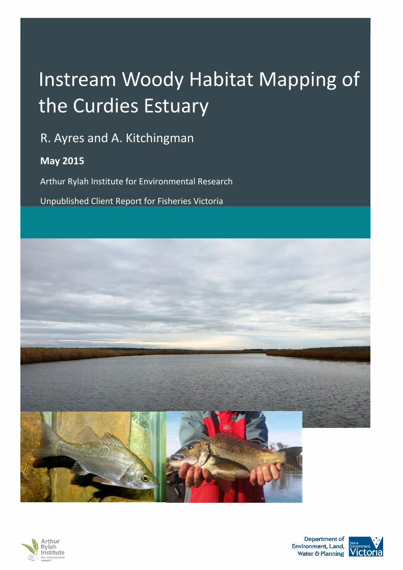
Instream Woody Habitat Mapping of the Curdies Estuary R. Ayres and A. Kitchingman May 2015 Arthur Rylah Institute for Environmental Research Unpublished Client Report for Fisheries Victoria
Transcript of R. Ayres and A. Kitchingman - ccmaknowledgebase.vic.gov.au
Instream Woody Habitat Mapping of
the Curdies Estuary
R. Ayres and A. Kitchingman
May 2015
Arthur Rylah Institute for Environmental Research
Unpublished Client Report for Fisheries Victoria

© The State of Victoria Department of Environment, Land, Water and Planning 2015
This work is licensed under a Creative Commons Attribution 3.0 Australia licence. You are free to re-use the work under that licence, on the
condition that you credit the State of Victoria as author. The licence does not apply to any images, photographs or branding, including the Victorian
Coat of Arms, the Victorian Government logo and the Department of Environment, Land, Water and Planning logo. To view a copy of this licence,
visit http://creativecommons.org/licenses/by/3.0/au/deed.en
Accessibility
If you would like to receive this publication in an alternative format, please telephone the DELWP Customer Service Centre on 136186, email
[email protected] or via the National Relay Service on 133 677 www.relayservice.com.au.
Disclaimer
This publication may be of assistance to you but the State of Victoria and its employees do not guarantee that the publication is without flaw of any
kind or is wholly appropriate for your particular purposes and therefore disclaims all liability for any error, loss or other consequence which may
arise from you relying on any information in this publication.
Report produced by
Arthur Rylah Institute for Environmental Research
Department of Environment, Land, Water and Planning
PO Box 137
Heidelberg, Victoria 3084
Phone (03) 9450 8600
Website: www.delwp.vic.gov.au/ari
Citation
Ayres R and Kitchingman A. (2015). Instream woody habitat mapping of the Curdies Estuary. Unpublished client report for Fisheries Victoria,
Department of Economic Development, Jobs, Transport and Resources. Arthur Rylah Institute for Environmental Research, Department of
Environment, Land, Water and Planning, Heidelberg, Victoria.
Front cover
Curdies Estuary downstream of Curdievale (Renae Ayres); Estuary Perch (Tarmo A. Raadik); Black Bream (Jeremy Hindell).

Instream woody habitat mapping of the Curdies Estuary
Renae Ayres1 and Adrian Kitchingman
1
1Arthur Rylah Institute for Environmental Research
Department of Environment, Land, Water and Planning, 123 Brown Street, Heidelberg, Victoria 3084
May 2015


Instream woody habitat mapping of the Curdies Estuary
1
Contents
Acknowledgements 2
Summary 3
1. Introduction 4
2. Methods 6
2.1 Study location 6
2.2 Instream woody habitat mapping and analysis 8
2.3 Water depth mapping and analysis 8
2.4 Mapping of other infrastructure 8
2.5 Water quality 8
3. Results 10
3.1 IWH density 10
3.2 Water depth and channel width 10
3.3 Location of other infrastructure 10
3.4 Water quality 10
4. Discussion 16
5. Recommendations 19
References 20

Instream woody habitat mapping of the Curdies Estuary
2
Acknowledgements
The project was funded by the Victorian Government through the Recreational Fishing Initiative, with
contributions from Recreational Fishing Licence Fees and the Arthur Rylah Institute for Environmental
Research, Department of Environment, Land Water and Planning (ARI, DELWP). We thank Fishcare Victoria
Inc., the Association of Geelong and Districts Angling Clubs Inc., Warrnambool Offshore and Light Game
Fishing Club Inc. and Corangamite Catchment Management Authority for supporting the project and
Duncan Hill from Fisheries Victoria for assistance initiating the project. Joanne Kearns and Phil Papas from
ARI are thanked for their valuable comments on a draft version of this report.

Instream woody habitat mapping of the Curdies Estuary
3
Summary
The sustainability of fisheries resources is dependent on the diversity, complexity, availability and
connectivity of habitats to support the survival, growth and reproduction of fish populations. The Curdies
Estuary, in south-west Victoria, is a popular fishing destination containing key recreational fisheries, despite
its environmental condition being very poor and a history of habitat loss and degradation. In the early to
mid-1900s, instream woody habitat (IWH) was removed from the Curdies Inlet upstream towards Timboon
to facilitate boat navigation and support water carriage of farming resources and passengers. Removal of
IWH and damage to native riparian vegetation are now listed as potentially threatening processes in the
Victorian Flora and Fauna Guarantee Act 1988. Waterway management activities, including installation of
IWH and replanting riverbanks, are now actively carried out to improve waterway health and habitats that
support production of fish resources.
In this study, we mapped and assessed current IWH distribution and density in the Curdies Estuary to
inform reinstatement of IWH. The spatial location of IWH masses and their size and complexity, water
depth, boat ramps and jetties were surveyed along 19.3 km from the Curdies Estuary mouth to upstream of
Curdievale. This data was used to produce an IWH density map and an interpolated water depth map for
the study reach.
IWH were generally small and isolated in volume and distribution in the Curdies Estuary. The Curdies Inlet,
the reach between the Curdies Inlet and Curdievale, and the reach upstream of Curdievale had no IWH to
low densities of IWH. The most upstream 3 km of the study reach had relatively higher densities of IWH.
Riparian vegetation was intact in this section and likely contributed to the IWH inputs observed. Seagrass
and rocky outcrops were observed in the Curdies Estuary and these also provide important instream
habitats for fish. Water depth varied across the study reach, but was relatively deeper in the reach above
Curdies Inlet and just upstream of Curdievale. Curdies Inlet was consistently shallow. The Curdies Estuary
had lower average IWH density compared to average densities recorded in other Victorian estuaries that
have also been desnagged.
Identifying the locations for IWH installation can be informed by combining the IWH density and water
depth data. Deeper areas with low IWH densities could be targeted to provide refuge areas for fish during
low tide or low water flows. Installing IWH in sections upstream and downstream of Curdievale would
increase IWH available for fish populations in the Curdies Estuary, as well as improve ecological
connectivity between the upper estuary and Curdies Inlet. Rather than installing IWH in the Curdies Inlet,
restoring and expanding seagrass beds could be considered.
Rehabilitating IWH in the Curdies Estuary will improve the availability and connectivity of habitat for fish
species that occupy or utilise the estuary, including key recreational fish, such as Estuary Perch and Black
Bream. We predict that increasing IWH densities will benefit fish communities and the fishery, and provide
overarching ecosystem advantages; however our knowledge of how fish populations utilise and respond to
IWH installation is limited. Therefore, monitoring is recommended to inform future actions in an adaptive
management framework.
Other factors, such as permits and approvals, water flows, riparian vegetation condition, land tenure,
infrastructure (such as boat ramps and jetties), and waterway use and user groups, should also be taken
into account when making decisions on IWH installation.

Instream woody habitat mapping of the Curdies Estuary
4
1. Introduction
Waterways and riparian zones provide habitats essential for the survival, growth and reproduction of water
dependent fauna, such as fish, frogs, aquatic invertebrates and waterbirds. The diversity, complexity,
availability and connectivity of these habitats influences waterway condition and ecosystem function.
Furthermore, the sustainability of fisheries resources is dependent on the integrity of instream and riparian
habitats to support healthy fish populations.
Instream woody habitat (IWH), otherwise known as instream woody debris, large woody debris or ‘snags’,
consists of trees, branches and logs that fall in or are washed into waterways. IWH is important habitat for
fish and other water dependent fauna. For fish in particular, it provides shelter and refuge areas to avoid
predators and fast water flow, feeding sites and food resources, spawning sites and nursery areas, and
markers for territorial or migratory species (Crook and Robertson 1999; Nicol et al. 2002). Additionally, IWH
provides other structural and chemical functions by protecting the stream bed and banks, helping develop
scour pools, and contributing to organic enrichment through their decay and trapping of other organic
debris (Nicol et al. 2002).
However, there is a long history of IWH removal from many waterways in Victoria and elsewhere
throughout south-eastern Australia. Snagging operations were undertaken from the late 1800s in many
waterways, including the Murray, Goulburn, Curdies, Gellibrand, Tarwin, Tambo and Snowy Rivers (The
Argus 1891). During the early to mid-1900s, IWH was removed from the Curdies Inlet upstream towards
the Timboon railway river crossing (Camperdown Chronicle 1911; Camperdown Chronicle 1950). Clearing
of the river of obstructions was expected to facilitate easy and cheap water carriage of farming produce
and passengers to the railway at Timboon, as well as downstream shipment of agricultural lime from the
Curdies River Lime Company (Camperdown Chronicle 1911). IWH removal and other threats have
contributed to the current very poor environmental condition rating of the Curdies Estuary (DEPI 2013).
Despite the perceived benefits of historical snagging operations, the detrimental impacts of removing IWH
on waterway health are now recognised. Removal of instream woody debris increases water flow velocity,
degrades streambeds, increases channel width, causes a loss of habitat, and reduces the productivity and
diversity of aquatic ecosystems (Gippel et al. 1996; Maddock 1999; Erskine and Webb 2003; Brooks et al.
2004). Removal of wood debris from Victoria streams and Degradation of native riparian vegetation along
Victorian rivers and streams are listed as potentially threatening processes in the Victorian Flora and Fauna
Guarantee Act 1988. Reinstating IWH is accepted as an integral component of rehabilitating waterways and
this is achieved by manually installing individual logs, root-balls or complex log structures into the
waterway channel and/or replanting native riparian vegetation to encourage longer term, natural inputs of
IWH (Rutherfurd et al. 2000; Saddlier 2008).
To help target IWH rehabilitation efforts more effectively, Kitchingman et al. (2013) developed a method to
map IWH density. This information can inform IWH installation locations. This approach has since been
applied to map densities of IWH in many Victorian waterways (Ayres et al. 2013; Kitchingman et al. 2013b;
Ayres et al. 2014; Kitchingman et al. submitted; Tonkin et al. submitted).
The aim of this study was to map and identify IWH density and distribution in the Curdies Estuary to inform
decisions about reinstating IWH to support healthy waterways and fisheries and enhance fishing
opportunities. The Curdies Estuary is a popular recreational fishing, boating and tourism destination. The
environmental values of the Curdies Estuary are a drawcard underpinning its social and economic values.
The Curdies Estuary supports various large and small bodied fish species, including several key recreational
fish species, such as Estuary Perch (Macquaria colonorum) and Black Bream (Acanthopagrus butcheri)
(Nicholson et al. 2009; Warry and Reich 2010; Kent 2011). An output of the study will be a high resolution
IWH density map of the Curdies Estuary to understand current IWH densities and distribution and assist
identification of potential installation locations for IWH. The output will complement seagrass and riparian
vegetation mapping data recently collected for the Curdies Estuary by Monash University and Corangamite
Catchment Management Authority, respectively.

Instream woody habitat mapping of the Curdies Estuary
5
This project informs priorities in the Corangamite Waterway Strategy 2014-2022 (Corangamite CMA 2014),
which identifies the Curdies Estuary as a priority waterway and notes that improving its riparian and
instream habitat and bank stability is a fishery management priority. The project also has synergies with the
Curdies Estuary management plan (Water Technology 2008) and past fish habitat assessments by Fisheries
Victoria’s Fish Habitat Assessment Group (Nicholson et al. 2009; Kent 2011).

Instream woody habitat mapping of the Curdies Estuary
6
2. Methods
2.1 Study location
The Curdies River is located in the Otway Coast Basin in coastal, south-west Victoria (Figure 1). The Curdies
River begins near Lake Purrumbete in the north and flows in a south westerly direction, passing the
township of Peterborough before discharging into the Southern Ocean. Its main tributaries are Scotts, Black
Glen and Cooriemungle Creeks. The Curdies Estuary extends for ~17 km from the estuary mouth near
Peterborough to above Boggy Creek Road, Curdievale (Figure 2). The Curdies Inlet forms part of the
Peterborough Coastal Reserve and borders Port Campbell National Park and the Bay of Island Coastal Park.
Figure 1. The Curdies River catchment within the Otway Coast Basin (insert: shaded grey), Victoria

Instream woody habitat mapping of the Curdies Estuary
7
Figure 2. The Curdies Estuary within the Otway Coast Basin (insert: shaded grey), Victoria
CURDIES INLET

Instream woody habitat mapping of the Curdies Estuary
8
2.2 Instream woody habitat mapping and analysis
IWH was mapped along 19.3 km of the Curdies Estuary from the estuary mouth upstream towards Timboon
(Figure 2). Mapping occurred between May 18th
to 21st
, 2015 via boat and followed methods described in
Kitchingman et al. (2013). During the sampling period the estuary mouth remained closed. IWH was
defined as individual or aggregations of dead wood greater than 1 m in length and 10 cm diameter, and
located below the high bank level (excluding the floodplain). IWH was geo-located using a Trimble®
GeoExplorer® 6000 series handheld Global Navigation Satellite System (GNSS) coupled with a laser
rangefinder. A geo-referenced side imaging system (Hummingbird® 998c SI side imaging sonar) was used to
identify completely submerged IWH.
Individual IWH masses were assigned a size (relative area of structural coverage: < 5 m2, < 10 m
2, < 20 m
2 or
> 20 m2) and complexity (1 trunk, 2 trunks, 3 trunks or complex) category. Each IWH mass was assigned a
volume based on conversion of categories to wood volumes (Kitchingman et al. 2013).
For quality control, field collected IWH data were visually checked prior to analysis. Data were then used to
calculate the average IWH density for the study reach and generate a map of IWH density (volume per
metre squared (m3m
-2) for each map pixel). IWH density was calculated using a Kernel Density Estimate
(KDE) function on the geo-located IWH masses (O’Sullivan and Unwin 2010). The KDE was performed with a
100 m radius and weighted by an average IWH volume attributed to the various size and complexity
combinations. The IWH density map of the study reach can be used as a baseline measure for any
subsequent additions of IWH.
2.3 Water depth mapping and analysis
Water depths were recorded using the geo-referenced side imaging system (Hummingbird® 998c SI side
imaging sonar) at 3 second intervals. Longitudinal and latitudinal water depths were recorded by boating in
a broad, zig-zag fashion across the navigable channel at a speed maintained at about 5 km/hour.
Field collected water depth recordings were checked for erroneous readings prior to analysis. Any
erroneous readings identified were filtered out. Using GIS software, water depth points were interpolated
(Inverse Distance Weighting) across the channel width to give a relative indication of water depth changes
along the study reach.
The distance between left and right banks (channel width) was measured at random points throughout the
survey reach using the laser rangefinder.
2.4 Mapping of other infrastructure
Geo-locations of fishing platforms, public boat ramps and private jetties were also collected using the
Trimble® GeoExplorer® 6000 series handheld Global Navigation Satellite System (GNSS) and laser
rangefinder.
2.5 Water quality
Water quality was measured primarily to characterise the salinity profile of the Curdies Estuary and to
identify the uppermost extent of the estuary. Water quality data were collected at approximately 1 m
depth intervals from the surface to the bottom at seven sites within the estuary, including two
Estuarywatch water quality monitoring locations at Peterborough and Curdievale (Figure 3). Temperature
(°C), dissolved oxygen (mg/L), electrical conductivity (mS), pH and turbidity (NTU), measurements were
collected using a calibrated field-laboratory analyser (TPS 90-FLT: TPS, Brisbane, Australia).

Instream woody habitat mapping of the Curdies Estuary
9
Figure 3. Locations in the Curdies Estuary where water quality was measured (numbered yellow
triangles). Locations 1 and 3 correspond to EstuaryWatch monitoring sites. The ski zone is denoted by
diagonal black lines.

Instream woody habitat mapping of the Curdies Estuary
10
3. Results
3.1 IWH density
IWH density ranged from 0 to 0.01 m3m
-2 along the study reach (Figures 4 and 5), with an average IWH
density of 0.00004806 m3m
-2. IWH densities were relatively higher in the most upstream 3 km of the study
reach. An isolated occurrence of high IWH density occurred upstream of Curdievale in the ski zone.
Elsewhere in the study reach, IWH densities were low.
3.2 Water depth and channel width
Water depth varied across the study reach up to 8 m (Figures 6 and 7). The Curdies Inlet was consistently
shallow, with maximum water depths between 0.5 to 0.9 m. Channel width varied between approximately
0.5 to 1.5 km. Upstream of the Curdies Inlet to Curdievale, water depths were relatively deeper, often
between 5 to 8 m and channel width varied between 35 to 45 m. Above Curdievale, water depth decreased
and was frequently between 4 – 6 m; channel width gradually narrowed as moving upstream from 20 m to
10 m.
3.3 Location of other infrastructure
Public boat ramps and fishing platforms are displayed in Figures 4 to 7. A public boat ramp, fishing
platform, seal the loop bin and fish cleaning table are located on the west bank of Curdies Inlet upstream of
the Great Ocean Road, Peterborough. At Boggy Creek Road, Curdievale, there is a public boat ramp, 4
fishing platforms, 2 fish cleaning tables and a seal the loop bin, as well as a water skiing zone downstream
and upstream of this location. A private jetty occurs on the east bank further upstream at Emu District
Scout Camp.
3.4 Water quality
Water quality results are listed in Table 1. Water clarity was high throughout the study reach. Salinity
stratification was present in the upper estuary (Sites 4 - 7), whereas in the lower estuary (Sites 1 – 3) there
was more even vertical distribution of electrical conductivity. Oxygen depletion occurred with increasing
water depth at sites 4 to 7. The salinity data indicates that the extent of the upper estuary limit was further
upstream of the study reach.

Instream woody habitat mapping of the Curdies Estuary
11
Figure 4. Instream woody habitat (IWH) density (m3m
-2) map of the Curdies Estuary between
Peterborough and Curdievale. Locations of boat ramps and platforms are denoted by green stars. The ski
zone is denoted by diagonal black lines.

Instream woody habitat mapping of the Curdies Estuary
12
Figure 5. Instream woody habitat (IWH) density (m
3m
-2) map of the Curdies Estuary upstream of
Curdievale. Locations of boat ramps and platforms are denoted by green stars. The ski zone is denoted by
diagonal black lines.

Instream woody habitat mapping of the Curdies Estuary
13
Figure 6. Water depths (m) of the Curdies Estuary between Peterborough and Curdievale. Locations of
boat ramps and platforms are denoted by green stars. The ski zone is denoted by diagonal black lines.

Instream woody habitat mapping of the Curdies Estuary
14
Figure 7. Water depths (m) of the Curdies Estuary upstream of Curdievale. Locations of boat ramps and
platforms are denoted by green stars. The ski zone is denoted by diagonal black lines.

Instream woody habitat mapping of the Curdies Estuary
15
Table 1. Summary of water quality measurements; Temp, temperature; EC, electrical conductivity; DO,
dissolved oxygen. Locations correspond to Figure 3. Bold EC values indicate where surface water was
relatively fresh.
Location Water depth (m) Temp (°C) EC (mS/cm) DO (mg/L) pH Turbidity (NTU)
1 0.5 15.6 28.3 9.99 8.62 1.4
1.0 15.4 28.0 10.24 8.63 1.5
1.5 15.3 28.1 10.48 8.63 1.6
2.0 15.2 28.5 10.22 8.63 2.7
2 0.5 14.6 22.1 9.61 8.27 2.2
1.0 14.6 23.3 8.48 8.25 -
3 0.5 16.3 25.4 6.98 8.42 0.4
1.0 15.6 27.0 6.45 8.41 0.3
1.5 15.3 28.1 4.79 8.37 0.9
4 0.5 14.6 5.6 2.06 7.69 2.4
1.0 15.6 27.5 7.30 8.13 0.4
1.5 15.3 27.7 7.16 8.18 0.4
2.0 15.6 28.1 3.42 7.99 0.7
3.0 16.5 28.7 1.14 7.85 3.6
4.0 16.8 29.0 1.00 7.84 4.3
5 0.5 14.9 3.3 11.84 7.91 5.1
1.0 16.3 26.4 5.15 8.23 0.8
1.5 16.2 27.7 5.09 8.23 0.6
2.0 16.2 27.4 5.39 8.30 0.6
3.0 16.2 27.9 4.40 8.24 1.0
4.0 16.4 28.3 3.52 8.20 0.8
6 0.5 14.3 2.6 5.40 7.80 1.3
1.0 15.5 25.8 7.71 7.73 1.8
1.5 16.5 27.1 2.37 7.80 1.4
2.0 16.8 27.7 2.69 7.89 1.2
3.0 16.7 27.8 1.53 7.91 1.8
7 0.5 14.1 0.2 5.62 7.93 1.1
1.0 14.7 21.9 0.61 7.71 6.8
1.5 17.2 27.0 0.13 7.78 3.8
2.0 17.6 27.0 0.07 7.77 4.3

Instream woody habitat mapping of the Curdies Estuary
16
4. Discussion
IWH removal has occurred historically in the Curdies River, including throughout the entire study reach
(Camperdown Chronicle 1911). We found that IWH densities were variable in the Curdies Estuary. In
general, relatively higher densities of IWH occurred in most upstream 3 km of the study reach. Figure 8
shows submerged instream woody habitat observed in this section of the study via the side scan sonar.
Riparian vegetation in this reach included established woody trees and shrubs that likely contributed
natural inputs of IWH (Figure 9). IWH densities were relatively low or absent from the estuary mouth to
upstream of Curdievale. The Curdies Inlet is extremely wide (Figure 10) and thus, we expected to find IWH
closer near the riparian zone rather than the middle of the inlet. The IWH located in Curdies Inlet appeared
to be logs from an old platform extending from the east bank and also a snag near the top of Curdies Inlet
which had possibly been transported from further upstream. These structures are not likely to provide
significant shelter for fish. Upstream and downstream of Curdievale, there were isolated occurrences of
low to medium IWH densities, including one instance where a large tree had recently fallen into the ski
zone. The Curdies Inlet and the Curdies estuary to upstream of Curdievale are adjacent to farmland, lack
woody trees and shrubs in riparian zones, and river banks are often impacted by stock access, thus the
potential for natural IWH input is limited. Other instream habitat was observed in the Curdies Estuary that
provide important habitat for fish, namely seagrass and rocky reef in the Curdies Inlet and rock substrates
(Figure 11) in the reach upstream to Curdievale.
The range of IWH densities observed in the Curdies Estuary was low compared to data collected from other
Victorian estuaries. Average IWH density in the Curdies Estuary was lower than that recorded in the
Gellibrand Estuary (0.00007491 m3m
-2; Ayres et al. 2014c), Anglesea Estuary (0.00024 m
3m
-2; Kitchingman
et al. 2013b), Tarwin Estuary (0.000141 m3m
-2; Ayres et al. 2014) and Merri Estuary (0.00022 m
3m
-2; Ayres
et al. 2014b). The variation among estuaries may be attributed to differences in historical waterway
management practices, catchment and landscape scale pressures, such as catchment clearing, flow
extraction and impoundment (Lester and Boulton 2008), and characteristics of different bioregions (VRHS
2002). The Curdies, Gellibrand and Tarwin Estuaries were heavily desnagged in the late 1800s (The Argus
1891), while little information could be found about historical management practices in the Merri and
Anglesea Estuaries. These estuarine IWH densities are much lower than IWH densities recorded in
freshwater river reaches in Victoria (Kitchingman et al. submitted; Tonkin et al. submitted) where near-
pristine IWH densities were on average 0.03 m3m
-2 and current IWH densities were on average 0.01 m
3m
-2.
The availability and connectivity of IWH for fish in the Curdies Estuary could be improved by installing IWH
in reaches where IWH densities were relatively low, particularly upstream and downstream of Curdievale in
locations outside of the water ski zone. Water depths were relatively deeper in these sections, thus
allowing opportunity for complex structures to be installed whilst maintaining a navigable river. These
deeper sections of the Curdies Estuary are also likely to provide important refuge areas for fish during low
water flows or low tide. Complex structures may consist of several logs, root balls or fish havens positioned
collectively across multiple sites. The shallowness of Curdies Inlet means that it’s likely only suitable for
single log installations, and even then, the process of installing structures may be too difficult.
Rehabilitating and expanding the seagrass beds may be a more appropriate action to enhance instream
habitat for fish in Curdies Inlet. Seagrass restoration projects have occurred elsewhere in Australia and
overseas (Fonseca et al. 1988; Butler and Jernakoff 1999; Seddon 2004; BMT Oceanica 2013). Between
Curdies Inlet and upstream of Curdievale, managing stock access and native replanting of riparian areas will
also provide for longer term, natural inputs of IWH and help protect floodplain environments, which also
are vital habitats for fish when inundated.
To enhance habitats to support sustainable fisheries resources, any installation or natural input of IWH
would increase the availability of habitat for its fish community, as well as other water-dependent fauna,
and is expected to provide other overarching ecosystem benefits. For example, instream habitat
rehabilitation may also stabilise riverbanks and reduce flow intensity depending on the placement of such
structures (Rutherfurd et al. 2000). Increases in IWH are expected to improve biofilm production which

Instream woody habitat mapping of the Curdies Estuary
17
provides a food source for invertebrates that support fish populations (Rutherfurd et al. 2000). However,
our knowledge of fish responses to IWH rehabilitation is limited. Monitoring is necessary to measure the
response of fish communities to IWH additions and inform future actions following an adaptive
management approach. Fish species and their life stages inhabiting the Curdies Estuary prefer and occupy
different aquatic habitats (Drew 2008; Nicholson et al. 2009). IWH is a key habitat requirement for juvenile
and adult Black Bream and Estuary Perch (Drew 2008; Nicholson et al. 2009; Douglas et al. 2010), which are
popular recreational fish species in the Curdies Estuary. These estuarine species are expected to utilise
IWH in estuaries for structural refuge and food resources, providing the IWH is accessible and partially or
permanently submerged.
Other factors, in addition to current IWH densities and average water depth, that may need to be taken
into account when installing IWH include:
• Gaining permits and approval from appropriate government agencies. Various management
agencies have responsibilities for the Curdies Estuary and its surrounds (Nicholson et al. 2009).
Whilst the Corangamite Catchment Management Authority manages the catchment and rivers,
Parks Victoria, Moyne Shire and Transport Safety Victoria may have management responsibilities or
interests relating to the Peterborough Coastal Reserve, local infrastructure and maritime safety.
Government agencies need to agree with and approve the proposed activities before they can
progress to the implementation phase.
• Works access. Heavy machinery is used to install IWH from the river bank or a barge. Areas with
intact native riparian vegetation should be avoided to prevent damage. Barge access may also limit
IWH placement.
• Adjacent land tenure and land use. Permission from landholders will be required if machinery
access is via private property.
• Local community input. The community will have local knowledge of the area and their suggestions
and support may influence the location of IWH installation. Nicholson et al. (2009) lists relevant
stakeholder groups.
• Waterway uses and user groups. Waterways have a variety of values and are utilised for differing
recreational and commercial activities. The Curdies Estuary is popular with recreational fishers,
boaters, water-skiers, canoeists, kayakers, commercial fishers (eel fishery), local community
members, beach-goers and tourists. The opinion and input from these groups is also important. For
example, recreational fishers are increasingly aware that habitat is critical to support healthy,
sustainable fisheries. Rather than installing habitat as fish attracting devices near popular angling
locations, recreational fishers also support establishing quality habitat away from high fishing
pressure to provide habitat for fish. Nicholson et al. (2009) lists relevant stakeholder groups.
• Water flows. Minimising movement of IWH installations by securing IWH installations to withstand
extreme water velocity and positioning IWH in slow flow. Positioning of IWH within the channel
width to ensure water coverage during low water flows or low and high tide.
• Infrastructure. Location of public and private infrastructure, such as bridges, jetties and boat ramps.

Instream woody habitat mapping of the Curdies Estuary
18
Figure 8. Side scan sonar image of submerged instream woody habitat located upstream of Curdievale.
Figure 9. Complex riparian vegetation in upper sections of the study reach.
Figure 10. The Curdies Inlet looking downstream towards the Great Ocean Road Bridge and Peterborough
(Photograph: Renae Ayres).
Bo
at
dir
ecC
on
→
Submerged IWH →

Instream woody habitat mapping of the Curdies Estuary
19
Figure 11. Side scan sonar image of rock substrates located upstream of the top of Curdies Inlet.
5. Recommendations
Our research of IWH in the Curdies Estuary indicated a lack of IWH, except for in the upper estuary. We
recommend installation of IWH to improve fish habitat and increase fish abundances and the productivity
of the Curdies Estuary fishery. These IWH installations may be best targeted in the reach upstream of
Curdies Inlet to above Curdievale because this reach is likely a refuge area for fish in low water flows or low
tides given its higher channel depth and width, and IWH installations here will help improve connectivity of
instream habitats in the upper estuary to seagrass habitats in Curdies Inlet. This reach is also easily
accessible to recreational fishers, with boat launching facilities available at Curdievale. Other factors should
also be considered when selecting IWH installation locations, such infrastructure, machinery access,
riparian vegetation condition, land tenure and community support. IWH installations would be best
coupled with actions that improve riparian vegetation to encourage longer term, natural IWH inputs. We
also recommend implementing a monitoring program to assess fish responses to IWH installations and
inform an adaptive management approach.
Bo
at
dir
ecC
on
→
← Rocky
substrate

Instream woody habitat mapping of the Curdies Estuary
20
References
Ayres R, Kitchingman A and Lieschke J. (2014). Instream woody habitat mapping of Tarwin River estuary.
Arthur Rylah Institute for Environmental Research, Unpublished Client Report for West Gippsland
Catchment Management Authority, Department of Environment and Primary Industries,
Heidelberg, Victoria.
Ayres R, Kitchingman A and Lieschke J. (2014b). Pre-works survey of instream woody habitat and fish in the
Merri Estuary. Arthur Rylah Institute for Environmental Research, Unpublished Client Report for
Glenelg Hopkins Catchment Management Authority, Department of Environment and Primary
Industries, Heidelberg, Victoria.
Ayres R, Kitchingman A and Lieschke J. (2014c). Instream woody habitat mapping of Gellibrand Estuary.
Unpublished client report for Corangamite Catchment Management Authority. Arthur Rylah
Institute for Environmental Research, Department of Environment, Land, Water and Planning,
Heidelberg, Victoria.
Ayres R, Tonkin Z, Kitchingman A and Hollier C. (2013). Habitat mapping of the Gunbower Lagoons System.
Arthur Rylah Institute for Environmental Research Unpublished Client Report for North Central
Catchment Management Authority, Department of Sustainability and Environment, Heidelberg,
Victoria.
BMT Oceanica (2013). Transplanting Posidonia seagrass in temperate Western Australian waters: A
practical ‘How to” guide, First edition, July 2013. BMT Oceanica PTY LTD.
Brooks AP, Gehrke PC, Jansen JD and Abbe TB. (2004). Experimental reintroduction of woody debris on the
Williams River, NSW: geomorphic and ecological responses. River Research and Applications 20,
513-536.
Butler A and Jernakoff P. (1999). Seagrass in Australia: Strategic review and development of an R&D plan.
Fisheries Research and Development Corporation Project 98/223. CSIRO Publishing, Collingwood,
Victoria.
Camperdown Chronicle. (1911). Opening up Curdies River: Facilities for transport ensure good future for
large area of rich country. Thursday 11 May, page 1.
Camperdown Chronicle. (1950). Heytesbury Shire Works Engineer’s report. Tuesday 20 June, page 4.
Corangamite CMA. (2014). Corangamite waterway strategy: 2014 - 2022. Corangamite Catchment
Management Authority, Colac, Victoria.
Crook DA and Robertson AI. (1999). Relationships between riverine fish and woody debris: implications for
lowland rivers. Marine and Freshwater Research 50, 941-953.
DEPI. (2013). Index of stream condition: The third benchmark of Victorian river condition. Department of
Environment and Primary Industries, East Melbourne.
Douglas J. (2010). Estuary perch movement and habitat use in the Snowy River. Recreational Fishing Grant
Program – Research report. Fisheries Victoria, Victoria.
Drew MM. (2008). A guide to the management of native fish: Victorian coastal, rivers, estuaries and
wetlands. Department of Sustainability and Environment and Corangamite Catchment
Management Authority, Victoria.
Erskine WD and Webb AA. (2003). Desnagging to resnagging: new directions in river rehabilitation in
Southeastern Australia. River Research and Applications 19, 233-249.
Fonseca MS, Kenworthy WJ and Thayer GW. (1998). Guidelines for the conservation and restoration of
seagrasses in the United States and adjacent waters. NOAA Coastal Ocean Program Decision
Analysis Series No. 12. NOAA Coastal Ocean Office, Silver Spring, Maryland.

Instream woody habitat mapping of the Curdies Estuary
21
Gippel CJ, Finlayson BL and O'Neill IC. (1996). Distribution and hydraulic significance of large woody debris
in a lowland Australian river. Hydrobiologia 318, 179-194.
Kent J. (2011). Corangamite estuaries fish habitats 2008. Complied by the Fish Habitat Assessment Group.
Fisheries Victoria Assessment Report Series. Report No. 32.
Kitchingman A, Tonkin Z and Lyon J. (2013). A novel approach to spatially assessing instream woody habitat
densities across large areas. Journal of Environmental Management 128, 555-560.
Kitchingman A, Tonkin Z and Lyon J. (2013b). Anglesea River Estuary Instream Woody Habitat Mapping.
Arthur Rylah Institute for Environmental Research Unpublished Client Report for Corangamite
Catchment Management Authority, Department of Environment and Primary Industries,
Heidelberg, Victoria.
Kitchingman A, Tonkin Z, Ayres RM, Lyon J, Stout JC, Rutherfurd ID and Wilson P. (submitted). A method for
understanding natural instream woody habitat distributions across large spatial scales: a case
study in south-eastern Australia.
Lester RE and Boulton AJ. (2008). Rehabilitating agricultural streams in Australia with wood: a review.
Environmental Management 42, 310-326.
Maddock I. (1999). The importance of physical habitat assessment for evaluating river health. Freshwater
Biology 41, 373-391.
Nicholson G, Gunthorpe L and Hamer P. (Eds.) (2009). South-Western minor inlets fish habitats 2000.
Complied by the Fish Habitat Assessment Group. Fisheries Victoria Assessment Report Series.
Report No. 31.
Nicol S, Lieschke J, Lyon J and Hughes V. (2002). Resnagging revolution: River habitat rehabilitation through
resnagging. Department of Sustainability and Environment, Heidelberg, Victoria, Australia.
O’Sullivan D and Unwin DJ. (2010). Geographic information analysis, second edition. John Wiley and Sons
Inc., New Jersey, USA.
Rutherfurd ID, Jerie K and March M. (2000). A rehabilitation manual for Australian streams, vol 1 and 2.
Land and Water Resources Research and Development Corporation and Cooperative Research
Centre for Catchment Hydrology, Canberra, ACT.
Saddlier S. (2008). Techniques for reinstating instream habitat. Arthur Rylah Institute for Environmental
Research. Department of Sustainability and Environment, Heidelberg, Victoria.
Seddon S. (2004). Going with the flow- facilitating seagrass rehabilitation. Ecological Management and
Restoration 5(3): 167-176.
The Argus. (1891). The River of Victoria, Snagging operations, wasteful expenditure. Friday 13 March, page
9.
Tonkin Z, Kitchingman A, Ayres RM, Lyon J, Stout JC, Rutherfurd ID and Wilson P. (submitted). A catchment
scale approach to assessing instream woody habitat condition across south-eastern Australian
Rivers.
VRHS. (2002). Healthy rivers, healthy communities and regional growth: Victorian River Health Strategy.
Department of Natural Resources and Environment: Victoria, Australia.
Warry F and Reich P. (2013). Development of a methodology for fish assessment to support the Victorian
Index of Estuarine Condition: 2010-2012. Arthur Rylah Institute for Environmental Research,
Unpublished client report for Melbourne Water, Department of Environment and Primary
Industries, Heidelberg, Victoria.
Water Technology. (2008). Curdies estuary management plan, Report No. J624/R02, September 2008.
Water Technology, Notting Hill, Victoria.

www.delwp.vic.gov.au