Quick Guide to Online Maps and Mapping -...
8
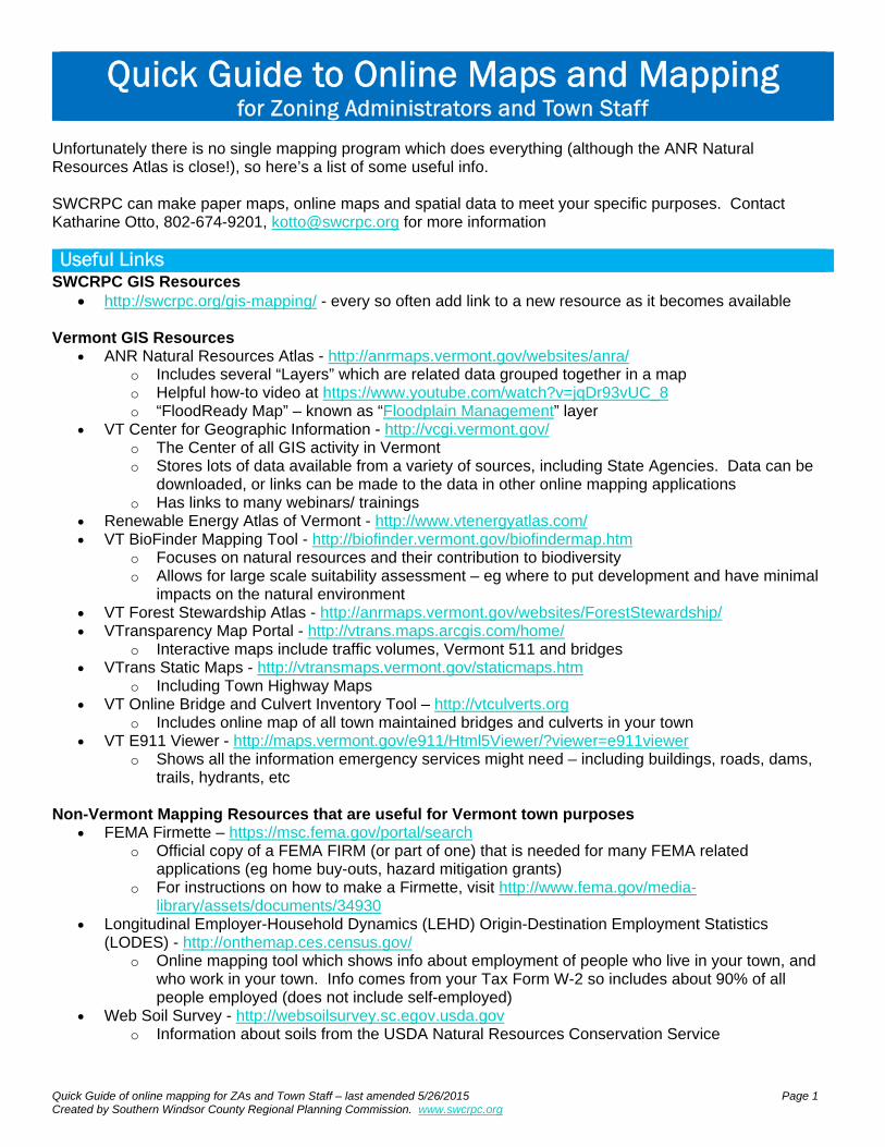
Quick Guide of online mapping for ZAs and Town Staff – last amended 5/26/2015 Page 1 Created by Southern Windsor County Regional Planning Commission. www.swcrpc.org Quick Guide to Online Maps and Mapping for Zoning Administrators and Town Staff Unfortunately there is no single mapping program which does everything (although the ANR Natural Resources Atlas is close!), so here’s a list of some useful info. SWCRPC can make paper maps, online maps and spatial data to meet your specific purposes. Contact Katharine Otto, 802-674-9201, [email protected] for more information Useful Links SWCRPC GIS Resources http://swcrpc.org/gis-mapping/ - every so often add link to a new resource as it becomes available Vermont GIS Resources ANR Natural Resources Atlas - http://anrmaps.vermont.gov/websites/anra/ o Includes several “Layers” which are related data grouped together in a map o Helpful how-to video at https://www.youtube.com/watch?v=jqDr93vUC_8 o “FloodReady Map” – known as “Floodplain Management” layer VT Center for Geographic Information - http://vcgi.vermont.gov/ o The Center of all GIS activity in Vermont o Stores lots of data available from a variety of sources, including State Agencies. Data can be downloaded, or links can be made to the data in other online mapping applications o Has links to many webinars/ trainings Renewable Energy Atlas of Vermont - http://www.vtenergyatlas.com/ VT BioFinder Mapping Tool - http://biofinder.vermont.gov/biofindermap.htm o Focuses on natural resources and their contribution to biodiversity o Allows for large scale suitability assessment – eg where to put development and have minimal impacts on the natural environment VT Forest Stewardship Atlas - http://anrmaps.vermont.gov/websites/ForestStewardship/ VTransparency Map Portal - http://vtrans.maps.arcgis.com/home/ o Interactive maps include traffic volumes, Vermont 511 and bridges VTrans Static Maps - http://vtransmaps.vermont.gov/staticmaps.htm o Including Town Highway Maps VT Online Bridge and Culvert Inventory Tool – http://vtculverts.org o Includes online map of all town maintained bridges and culverts in your town VT E911 Viewer - http://maps.vermont.gov/e911/Html5Viewer/?viewer=e911viewer o Shows all the information emergency services might need – including buildings, roads, dams, trails, hydrants, etc Non-Vermont Mapping Resources that are useful for Vermont town purposes FEMA Firmette – https://msc.fema.gov/portal/search o Official copy of a FEMA FIRM (or part of one) that is needed for many FEMA related applications (eg home buy-outs, hazard mitigation grants) o For instructions on how to make a Firmette, visit http://www.fema.gov/media- library/assets/documents/34930 Longitudinal Employer-Household Dynamics (LEHD) Origin-Destination Employment Statistics (LODES) - http://onthemap.ces.census.gov/ o Online mapping tool which shows info about employment of people who live in your town, and who work in your town. Info comes from your Tax Form W-2 so includes about 90% of all people employed (does not include self-employed) Web Soil Survey - http://websoilsurvey.sc.egov.usda.gov o Information about soils from the USDA Natural Resources Conservation Service
Transcript of Quick Guide to Online Maps and Mapping -...
Quick Guide of online mapping for ZAs and Town Staff – last amended 5/26/2015 Page 1 Created by Southern Windsor County Regional Planning Commission. www.swcrpc.org
Quick Guide to Online Maps and Mapping for Zoning Administrators and Town Staff
Unfortunately there is no single mapping program which does everything (although the ANR Natural Resources Atlas is close!), so here’s a list of some useful info. SWCRPC can make paper maps, online maps and spatial data to meet your specific purposes. Contact Katharine Otto, 802-674-9201, [email protected] for more information Useful Links
SWCRPC GIS Resources http://swcrpc.org/gis-mapping/ - every so often add link to a new resource as it becomes available
Vermont GIS Resources
ANR Natural Resources Atlas - http://anrmaps.vermont.gov/websites/anra/ o Includes several “Layers” which are related data grouped together in a map o Helpful how-to video at https://www.youtube.com/watch?v=jqDr93vUC_8 o “FloodReady Map” – known as “Floodplain Management” layer
VT Center for Geographic Information - http://vcgi.vermont.gov/ o The Center of all GIS activity in Vermont o Stores lots of data available from a variety of sources, including State Agencies. Data can be
downloaded, or links can be made to the data in other online mapping applications o Has links to many webinars/ trainings
Renewable Energy Atlas of Vermont - http://www.vtenergyatlas.com/ VT BioFinder Mapping Tool - http://biofinder.vermont.gov/biofindermap.htm
o Focuses on natural resources and their contribution to biodiversity o Allows for large scale suitability assessment – eg where to put development and have minimal
impacts on the natural environment VT Forest Stewardship Atlas - http://anrmaps.vermont.gov/websites/ForestStewardship/ VTransparency Map Portal - http://vtrans.maps.arcgis.com/home/
o Interactive maps include traffic volumes, Vermont 511 and bridges VTrans Static Maps - http://vtransmaps.vermont.gov/staticmaps.htm
o Including Town Highway Maps VT Online Bridge and Culvert Inventory Tool – http://vtculverts.org
o Includes online map of all town maintained bridges and culverts in your town VT E911 Viewer - http://maps.vermont.gov/e911/Html5Viewer/?viewer=e911viewer
o Shows all the information emergency services might need – including buildings, roads, dams, trails, hydrants, etc
Non-Vermont Mapping Resources that are useful for Vermont town purposes
FEMA Firmette – https://msc.fema.gov/portal/search o Official copy of a FEMA FIRM (or part of one) that is needed for many FEMA related
applications (eg home buy-outs, hazard mitigation grants) o For instructions on how to make a Firmette, visit http://www.fema.gov/media-
library/assets/documents/34930 Longitudinal Employer-Household Dynamics (LEHD) Origin-Destination Employment Statistics
(LODES) - http://onthemap.ces.census.gov/ o Online mapping tool which shows info about employment of people who live in your town, and
who work in your town. Info comes from your Tax Form W-2 so includes about 90% of all people employed (does not include self-employed)
Web Soil Survey - http://websoilsurvey.sc.egov.usda.gov o Information about soils from the USDA Natural Resources Conservation Service

Quick Guide of online mapping for ZAs and Town Staff – last amended 5/26/2015 Page 2 Created by Southern Windsor County Regional Planning Commission. www.swcrpc.org
Other Free Mapping Resources (often do not have data pre-loaded) ArcGIS online - www.arcgis.com – online GIS Software from ESRI Google Maps and Google Earth – https://www.google.com/maps
http://www.google.com/earth/index.html DraftSight - https://www.3ds.com/products-services/draftsight-cad-software/
o Allows you to open .dwg files that are created in AutoCAD (often by engineers and surveyors) QGIS – Quantum GIS – free desktop mapping software http://www.qgis.org/en/site/ .
o Helpful webinars about using it at http://vcgi.vermont.gov/events/archive Wide variety of mapping apps for your tablets/ smartphone
o For examples see http://vcgi.vermont.gov/sites/vcgi/files/event_archive/Webinar_Smartphones_Dec2013.pdf
Key Words
ArcGIS/ ArcMap – A type of mapping software created by ESRI. Widely used across the USA. Paper/ printed maps are often created using this software Base Maps – the map shown behind all the data – aerial/ orthophoto, topographic, simple grey canvas (with roads) Current Extent – What area the map is currently showing FIRM – Flood Insurance Rate Map – produced by FEMA Filter – In basic terms it is a “search”. GIS – Geographic Information Systems – a general name often used for mapping things. There are some variations on the definition. kml/ kmz – data file with spatial information primarily designed for the google mapping environments, but is also a rather universal file type that can be used in other places Layer – Can mean two things – either a group of data in a map (eg ANR Natural Resources Atlas) or how data is viewed (usually referring to a GIS type .lyr). Legend – Also known as the “Key” – ie the color/ symbols on the map explained Metadata – Data about the data – ie information about what your data shows, who collected it, when it was last updated, and other things you might want to know Orthophoto – commonly known as aerial photo Shapefile – data file with spatial information primarily designed for the ESRI mapping environments, but can also be used in other places. When you see this file on the computer it will appear to be 4-8 files of the same name but with different endings such as .shx, .shp, .dbf, .prf. Some online systems allow you to either upload a zipped version of this file (eg ArcGIS online) or particular parts of this file (eg LODES). Toggle Toolbar – Useful toolbar which appears at the top of the Atlas, including ability to print, identify data and measure Theme – A group of data that are useful to see together
Quick Guide of online mapping for ZAs and Town Staff – last amended 5/26/2015 Page 3 Created by Southern Windsor County Regional Planning Commission. www.swcrpc.org
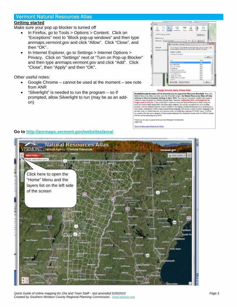
Vermont Natural Resources Atlas Getting started Make sure your pop up blocker is turned off
In Firefox, go to Tools > Options > Content. Click on “Exceptions” next to “Block pop-up windows” and then type anrmaps.vermont.gov and click “Allow”. Click “Close”, and then “OK”.
In Internet Explorer, go to Settings > Internet Options > Privacy. Click on “Settings” next ot “Turn on Pop-up Blocker” and then type anrmaps.vermont.gov and click “Add”. Click “Close”, then “Apply” and then “OK”.
Other useful notes:
Google Chrome – cannot be used at the moment – see note from ANR
“Silverlight” is needed to run the program – so if prompted, allow Silverlight to run (may be as an add-on)
Go to http://anrmaps.vermont.gov/websites/anra/
Click here to open the “Home” Menu and the layers list on the left side of the screen

Quick Guide of online mapping for ZAs and Town Staff – last amended 5/26/2015 Page 4 Created by Southern Windsor County Regional Planning Commission. www.swcrpc.org
Exploring the tool Finding the toolbar:
To see the Google street view, you can right click on a line which is slightly yellow (major roads and some other town roads) and then select “Open Google Street View Here”
To find layers
Click here to open the toolbar (Shown above)
Click this symbol to open the toolbar (Shown above)
1. Click on “Map Layers” 2. Select “All Available Layers”
1. Click on “filter” 2. Write in what you are looking for under “filter” and click enter 3. You then will see only a selection of the layers, according to your search word.

Quick Guide of online mapping for ZAs and Town Staff – last amended 5/26/2015 Page 5 Created by Southern Windsor County Regional Planning Commission. www.swcrpc.org
Distance, Coordinates, and area To measure a distance or area:
To find out coordinates:
1. Click on the “Measurement” Tab at the top
2. Click on “Measure distance” or “Measure area”
2. Click on the map from point to point where you want to measure.
3. Double click on the final point to stop drawing.
4. Double click somewhere else on the map to clear that line/ area and start again.
1. Click on “Plot Coords”
2. Click on place on map
Tip: Click here to change the type of coordinates eg Lat-Long DD (Decimal Degrees), Lat-Long DMS (Degrees Minutes Seconds), State Plane
Quick Guide of online mapping for ZAs and Town Staff – last amended 5/26/2015 Page 6 Created by Southern Windsor County Regional Planning Commission. www.swcrpc.org
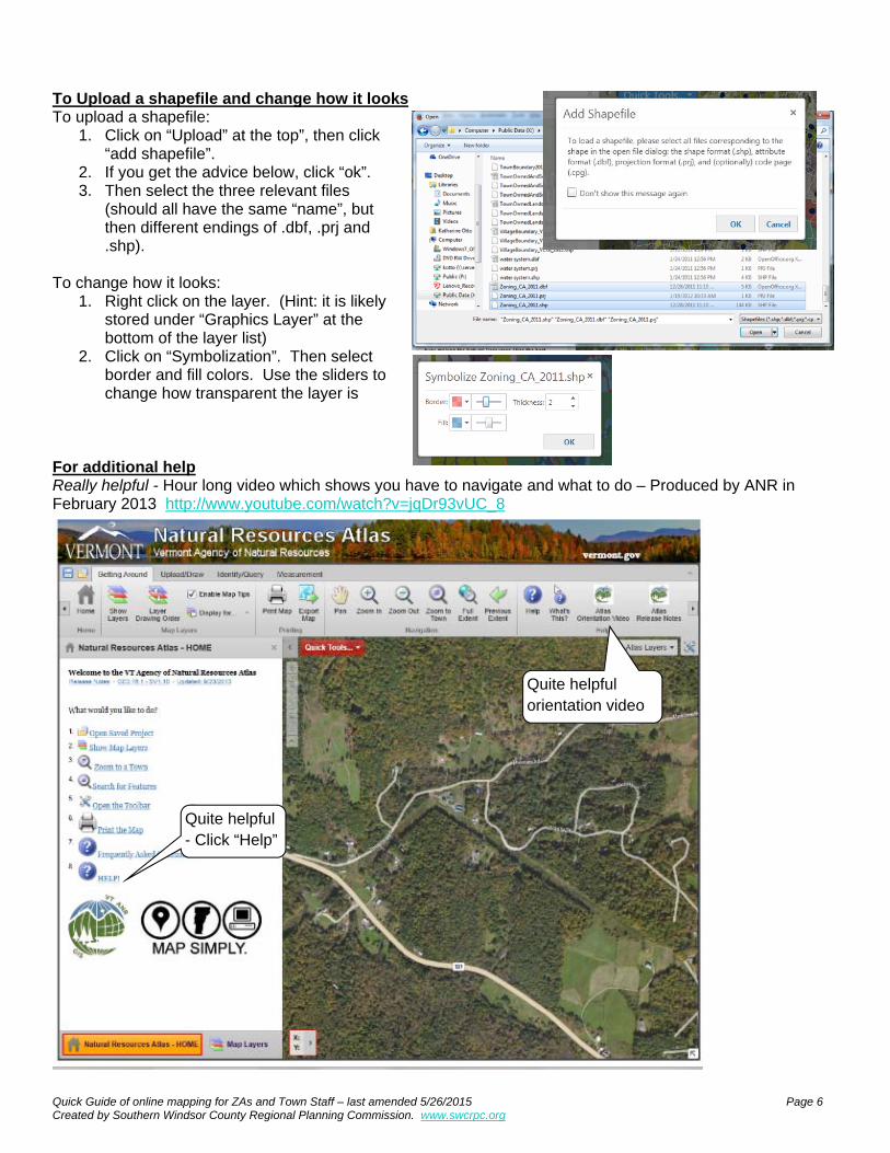
To Upload a shapefile and change how it looks To upload a shapefile:
1. Click on “Upload” at the top”, then click “add shapefile”.
2. If you get the advice below, click “ok”. 3. Then select the three relevant files
(should all have the same “name”, but then different endings of .dbf, .prj and .shp).
To change how it looks:
1. Right click on the layer. (Hint: it is likely stored under “Graphics Layer” at the bottom of the layer list)
2. Click on “Symbolization”. Then select border and fill colors. Use the sliders to change how transparent the layer is
For additional help Really helpful - Hour long video which shows you have to navigate and what to do – Produced by ANR in February 2013 http://www.youtube.com/watch?v=jqDr93vUC_8
Quite helpful - Click “Help”
Quite helpful orientation video

Quick Guide of online mapping for ZAs and Town Staff – last amended 5/26/2015 Page 7 Created by Southern Windsor County Regional Planning Commission. www.swcrpc.org
FEMA maps Getting started http://msc.fema.gov/portal To make an official copy of the map “ie “Firmette”) 1. Type in location 2. Click on “View map” 3. Click on “Make a firmette”
1. Click on “Print area” and this box will be red. 2. Drag this box to the relevant point on the map. (It can be helpful to have a google map open in another tap so you flick back to it and check you are selecting the right area)
3. If necessary, click on “Scale and North Arrow” and “Title Block” to change what they look at. 4. Click on “Adobe PDF” and it will create the official copy of the map.
Click “Save Map” for it to automatically download the entire map square.

Quick Guide of online mapping for ZAs and Town Staff – last amended 5/26/2015 Page 8 Created by Southern Windsor County Regional Planning Commission. www.swcrpc.org
To explore the flood hazard areas in closer detail 1. Type in location 2. Click on “Interactive Map” 3. Then explore! The default base map is from a USGS service and conforms to FEMA's specification for horizontal accuracy. This base map is composed of the orthoimagery used when the Flood Insurance Rate Maps (FIRMs) were initially created combined with standard imagery products managed by USGS. This map should be considered the best online resource to use for official National Flood Insurance Program (NFIP) purposes when determining locations in relation to regulatory flood hazard information. If a different base map is used with the NFHL, the accuracy specification may not be met and the resulting map should be used for general reference only, and not official NFIP purposes.
1. Click this symbol to find a list of the potential “layers” you can show
2. Click on the check-boxes to select which layers to show. 3. Click this symbol to show the “legend”
of what data has been selected