“QUANTITATIVE PRECIPITATION FORECAST · 4 Institute of Meteorology and Climate Research (IMK),...
59
NEW APPLICATION FOR A GRANT WITHIN THE FOCAL POINT PROGRAM 1167 “QUANTITATIVE PRECIPITATION FORECAST” SCIENTIFIC PREPARATION AND COORDINATION OF THE SPP 1167 INTENSIVE OBSERVATIONS PERIOD Code name: „SPP IOP“ Prof. Dr. Volker Wulfmeyer Institute of Physics and Meteorology University of Hohenheim Email: [email protected] Prof. Dr. Christoph Kottmeier Institute of Meteorology and Climate Research University of Karlsruhe/Forschungszentrum Karlsruhe Email: [email protected] September 30, 2003
Transcript of “QUANTITATIVE PRECIPITATION FORECAST · 4 Institute of Meteorology and Climate Research (IMK),...

NEW APPLICATION FOR A GRANT WITHIN THE
FOCAL POINT PROGRAM 1167
“QUANTITATIVE PRECIPITATION FORECAST”
SCIENTIFIC PREPARATION AND COORDINATION OF THE
SPP 1167 INTENSIVE OBSERVATIONS PERIOD
Code name: „ SPP IOP“
Prof. Dr. Volker Wulfmeyer
Institute of Physics and Meteorology
University of Hohenheim
Email: [email protected]
Prof. Dr. Christoph Kottmeier
Institute of Meteorology and Climate Research
University of Karlsruhe/Forschungszentrum Karlsruhe
Email: [email protected]
September 30, 2003

2
3
1. General information
Application for a grant, new proposal
1.1 Applicants
Project leader:
Institute of Physics and Meteorology (IPM), University of Hohenheim, Germany
Name: Wulfmeyer
Surname: Volker
Academic degree: C4 University Professor
Position: Director
Date of birth: 08. October 1965
Nationality: German
Institution: University of Hohenheim (UHOH)
Work address: Institute of Physics and Meteorology (IPM)
University of Hohenheim
Garbenstr. 30
D-70599 Stuttgart
Phone (work): +49 (0)711/459-2150
Fax (work): +49 (0)711/459-2461
Email: [email protected]
Private address: Mohnweg 9
D-70599 Stuttgart
Germany
Resume: appendix 1
Publications: appendix 2

4
Institute of Meteorology and Climate Research (IMK), University of Kar lsruhe/
Forschungszentrum Kar lsruhe, Germany
Name: Kottmeier
Surname: Christoph
Academic degree: C4 University Professor
Position: Head of Department
Date of birth: 23. April 1952
Nationality: German
Institution: University of Karlsruhe
Work address: Universität Karlsruhe
Institut für Meteorologie und Klimaforschung
Postfach 6980
D-76128 Karlsruhe
Germany
Phone (work): + 49 (0)721 6086370
Fax (work): + 49 (0)721 6086102
Email: [email protected]
Private address: Helmholtzstr. 4
D-76133 Karlsruhe
Germany
Resume: appendix 3
Publications: appendix 4

5
1.2 Topic
Scientific preparation and coordination of the Schwerpunktprogramm (SPP) 1167
Intensive Observations Per iod (IOP)
1.3 Code name
SPP IOP
1.4 Scientific discipline and field of work
Atmospheric Physics, Meteorology, Numerical Weather Prediction, Quantitative Precipi-
tation Forecast (QPF), Meteorological Measurement Technique, Atmospheric Remote
Sensing.
1.5 Scheduled duration in total
a) Not applicable
b) Not applicable
c) 6 years (periods 1, 2 and 3 of the SPP 1167)
d) 6 years (periods 1, 2 and 3 of the SPP 1167)
1.6 Application per iod
April 1, 2004 till March 31, 2006 (24 month)
1.7 First applications
April 1, 2004

6
1.8 Summary
In contrast to their advances in other areas, weather forecast models have not been suc-
cessful in improving the Quantitative Precipitation Forecast during the last 16 years. One
reason for this stagnation is the lack of comprehensive, high-quality data sets usable for
model validation as well as for data assimilation, thus leading to improved initial fields in
numerical models. Theoretical analyses have identified the requirements measured data
have to meet in order to close the gaps in process understanding. In field campaigns, it
has been shown that the newest generation of remote sensing systems has the potential to
yield data sets of the required quality. It is therefore time to combine the most powerful
remote sensing instruments with proven ground-based and airborne measurement tech-
niques in an Intensive Observations Period (IOP). Its goal is to serve as a backbone for
the SPP 1167 by producing the demanded data sets of unachieved accuracy and resolu-
tion. This requires a sophisticated scientific preparation and a careful coordination be-
tween the efforts of the institutions involved. For the first time, the pre-convective envi-
ronment, the formation of clouds and the onset and development of precipitation as well
as its intensity will be observed in four dimensions simultaneously in a region of suffi-
cient size. This shall be achieved by combining the IOP with international programs and
by collaboration between leading scientists in Europe, US and other countries. Thus, the
IOP is a unique opportunity to make Germany the setting of an international field cam-
paign featuring the newest generation of measurement systems such as scanning radar and
lidar and leading to outstanding advances in atmospheric sciences.
2. State of the ar t, preliminary work
2.1 State of the ar t
2.1.1 Quantitative Precipitation Forecast
The accurate prediction of the onset, location, duration and amount of precipitation is of
utmost importance for society. For instance, damages, economic losses and deaths due to
flooding and storms represent about 90 % of the losses by natural hazards in Germany
during the last 30 years (Berz, 2002). Hence, progress in Quantitative Precipitation Fore-
cast (QPF) remains a challenging goal for Meteorology in spite of advances in atmos-
pheric modeling of other variables such as temperature. During the last 16 years no sig-

7
nificant improvement of QPF has been reported for the models of the Deutscher Wetter-
dienst (DWD) (DWD, 2002).
There are mainly four reasons for the poor performance of models in connection with
QPF. Firstly, initial fields of the most important atmospheric variables such as water in its
all three phases and wind still suffer from large gaps due to data unavailability as well as
errors and low resolution caused by a lack of suitable instrumentation for operational use.
Secondly, the process understanding particularly in connection with the initiation of con-
vection and the formation of clouds and of precipitation is poor. Up to now, small-scale
processes have been parameterized in numerical models leading to additional sources of
errors. Parameterizations are often derived using high-resolution models under homoge-
neous conditions or during a few field campaigns where homogeneous surface conditions
were present (Businger et al., 1971; Clark et al., 1971). However, surface forcing is usu-
ally inhomogeneous and the largest errors in the modeling of precipitation occur in terrain
with significant orography.
Thirdly, the forecast is also hindered by limited capabilities to assimilate data of remote
sensing instruments in models. Several approaches will be investigated within the scope
of the Schwerpunktprogramm (SPP).
Fourthly, the final limit is the predictability. Even in the case where excellent initial data
are assimilated in models and processes are well represented, the ** time duration for an
acceptable forecast will be limited by the non-linear and chaotic interactions in the at-
mospheric flow.
For research on these topics, comprehensive data sets are not routinely available. They
must be collected by coordinated efforts of the atmospheric sciences community. There-
fore right from the beginning, a General Observations Period (GOP) and an Intensive Op-
erations Period (IOP) have been included in the proposal for the SPP and accepted by the
DFG. This proposal is requesting support for the scientific and logistic preparation as
well as the coordination of the SPP IOP.
2.1.2 Lokal-Modell
The Lokal-Modell (LM) of the DWD will have a triple-function within the SPP. To the
community participating in the SPP it will be provided including an operational environ-
ment for model validation, data assimilation and for testing QPF hypothesis. A detailed

8
analysis of LM results can be used for identifying weaknesses in the model system lead-
ing to strategies for future improvements. In spite of shortcomings of the LM, it is one of
the best tools for predicting precipitation events so that it can be used for the preparation
of the IOP. Therefore it is important to discuss the current performance of the LM.
Since December 1999, this model has been the basis for high-resolution short-range
weather forecasting at the DWD. LM is a fully elastic non-hydrostatic model, suitable for
forecasting atmospheric processes down to the meso-gamma scale. Prognostic variables
of LM are the three-dimensional wind vector, temperature, pressure deviation, specific
humidity, specific cloud water content, specific cloud ice content, and turbulent kinetic
energy. A version with prognostic treatment of the precipitation components rain and
snow is under investigation. The Arakawa C-grid is used for horizontal differencing on a
rotated latitude/longitude grid. The horizontal resolution is 7 km, versions with 14 km,
2.8 km and 1 km are used for research purposes. The number of vertical layers in a
generalized terrain following coordinate is 35. The lowest km of the atmosphere is
resolved by 7 layers.
The comprehensive physics package of LM includes: a) A turbulence and surface layer
scheme using a prognostic turbulent kinetic energy equation on the basis of the level 2.5
of Mellor and Yamada (1982) with extensions by Raschendorfer (2001). b) A two-
category bulk model cloud microphysics scheme with optional prognostic treatment of
precipitation (Doms and Schättler, 1999; Gaßmann, 2002). c) A mass flux convection
scheme based on Tiedtke (1989). d) Radiation calculation by the scheme of Ritter and
Geleyn (1992). e) A two-layer soil model on the basis of Jacobsen and Heise (1982) with
optional use of an improved multi-layer version (Heise et al., 2003).
Decisive improvements in the prediction of surface pressure systems have been achieved
in the large scale models of DWD since the start of the first baroclinic model in 1968.
This was accompanied during the last 16 years by a considerable increase in the quality of
the prediction of surface weather elements as temperatures, wind and - to a lesser degree -
cloud cover (Fig. 1). But there was virtually no improvement in precipitation prediction.
Typical problems are: errors in the position of precipitation structures, large errors in the
case of high precipitation rates, convective precipitation peaks at noon which is incorrect,
low correlation between areas of observed and predicted convection. These problems can
be confirmed by a statistical evaluation presented in Figure 2: Values of the probability of
detection (POD) decrease and values of the false alarm rate (FAR) increase significantly

9
with increasing precipitation intensity. It is obvious from this figure that the quality of the
precipitation prediction is lower in summer than in winter.
0
10
20
30
40
50
60
MIN dd ff T MAX B fx RR
RV
in 1
6 Ja
hren
(%
)
extrapoliert
Fig. 1: Improvement of forecast quality (as issued to the public) from 1984 to 2000, given in values of the reduction of error variance. (T, MIN, MAX are the temperatures, dd, ff, fx are wind direction, wind speed and gusts, B is cloud cover and RR precipitation). The dashed variables are not available over the full 16 years, therefore some extrapolation was necessary (DWD, 2003).
Fig.2: Monthly mean values of statistical verification of precipitation forecasts of the global model GME (blue dotted lines), of the assimilation run of LM (purple lines) and of LM forecasts (red dashed lines) for the period September 2002 to August 2003. The statistical measures are: probability of de-tection POD (first row), false alarm rate FAR (second row), true skill statistic TSS (third row), and frequency bias (last row). The threshold values are: 0 mm/24h (1st column), 1 mm/24h (2nd column), 2 mm/24h (3rd column), 5 mm/24h (4th column) and 10 mm/24hours (last column), (DWD, 2003).

10
A variety of reasons is apparently responsible for the problems: a) Despite of the progress
in predicting the dynamical systems, comparably small errors in the structure and position
of pressure systems may cause large errors in precipitation. b) The system of prognostic
equations used operationally in LM does not include the horizontal transport of precipita-
tion, which can be significant on the meso-gamma scale. c) The initial fields of atmos-
pheric variables are of insufficient accuracy for simulating smaller scale processes. d)
Cloud formation and precipitation generating processes can be active on very small scales
which cannot be resolved by the operational observation network. Therefore, relevant
structures of the moisture and wind fields are not well-represented in the initial analyses
of LM. This problem is aggravated in the case of convective processes. e) The operation-
ally used closure for the convection parameterization relies on the large-scale moisture
convergence and on turbulent fluxes of latent heat at the surface. Both processes, pro-
vided they are in fact decisive for the onset and intensity of convection, can hardly be de-
termined correctly in the model. f) In certain cases, the coarse operational observation
network can also be responsible for a bad verification of a good prediction of precipita-
tion. The area-wide winter rain can cause remarkable damage in flooding expanded re-
gions. However, flash floods triggered by heavy rainfall in convective storms in summer
can be even more dangerous for the area affected, because the time frame for forecasting
(nowcasting) and warning is much shorter. While in the first case a flood develops during
days or weeks, flash floods appear within hours or minutes. This makes a strong point to
develop precise short-term precipitation forecasts for heavy rainfall caused by convection
and convective systems. The shortcomings of present day precipitation forecasts with LM
(above items d) and e)) are significantly related to the representation of atmospheric con-
vection. Based on recent comparisons of LM output with observational data, three types
of convection are to be considered in detail.
A) Convection over complex terrain
The relevant scale of this type of convection is up to about 20 km in the horizontal and
0.5 to 2 hours in time. The process investigated is the development of convection over
mountainous regions, especially low mountain ranges. This is a highly QPF-related proc-
ess because rapidly growing deep convection is often accompanied by sudden heavy rain-
fall in a very narrow area. Flash floods and damages can occur. Secondary circulation sys-
tems developing during daytime in the larger valley systems seem to be responsible for

11
triggering of convection and subsequent precipitation. The 7 km LM-version using the
Tiedke scheme for convection parameterization does not correctly resolve the convection
initiation forced by valley winds as well as time, amount and location of precipitation.
This has been demonstrated in a case study in the northern Black Forest using data of the
VERTIKATOR project (Fiedler, 2002; Kottmeier and Corsmeier, 2002; Fiedler 2003).
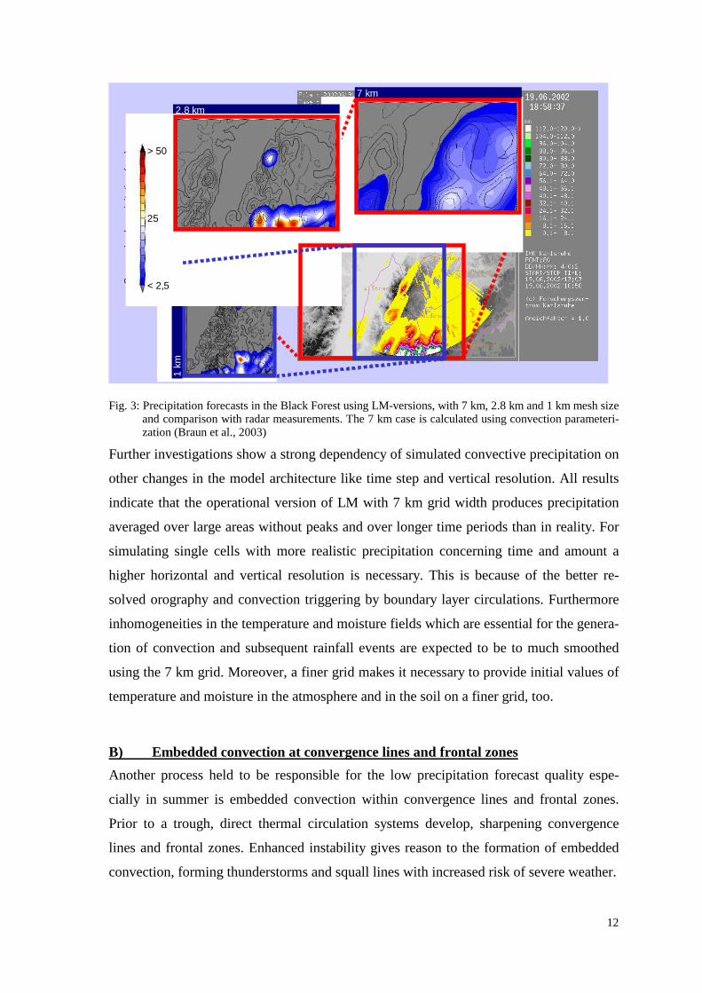
Figure 3 shows simulated accumulated precipitation rates of three LM model runs with
different horizontal resolution of the numerical grid (1 km, 2.8 km and 7 km) in the north-
ern part of the Black Forest (Braun et al., 2003). Furthermore the precipitation measured
by the IMK precipitation radar (Handwerker, 2002) located at the Forschungszentrum
Karlsruhe is shown. The simulated precipitation and radar measurements are summarized
from 0.00 UTC to 17.00 UTC. The convective cell above the Murg valley, east of Stras-
bourg in the middle of the 1 km simulation area is discussed. The cell develops at 13.30
UTC and ceases one hour later. The rainfall measured by radar is up to 40 mm in the cen-
ter of the cell. The area of rainfall is less than 5 km by 7 km in size.
The simulation with 7 km resolution, including the Tiedke scheme for parameterization
of convection, shows only 15 mm rainfall in that region, whereas in wide areas around
with no precipitation measured, rainfall is simulated. Moreover simulated precipitation
starts at 10.00 UTC which is much too early. The run using the 2.8 km grid without
convection parameterization fits the measured precipitation much better: the simulated
amount of 25 mm is only little below the measurement and the center of the cell is shifted
only a few kilometers to the west. Nevertheless in this case precipitation starts much too
late (at 16.00 UTC), compared to radar measurements. The duration of about one hour fits
the measured values quite well. In the vertical cross section, cutting the Black Forest in
the latitude of the detected cell during its most powerful evolution no convective cloud is
found, no secondary circulation has developed over the smoothed orography and the ver-
tical wind in the PBL is less than 0.5 ms-1 (Fig. 4).
The best result concerning the time of precipitation onset is achieved by using a 1 km
mesh size without convection parameterization. In this case precipitation starts at 14.00
UTC and ends about one hour later. However the rainfall (14 mm) is less than half meas-
ured by radar. The simulated cell is only slightly shifted to the east. The cross section
(Fig. 5) gives an impression of the circulation systems developing over the much more re-
alistic orography. The vertical wind in the core of the cell is more than 1.0 ms-1 and the
cloud reaches 6 km height what is about 1.5 km less than observed by radar and aircraft.
12
2,8 km
7 km
Sum
mar
ized
pre
cipi
tatio
n (m
m) > 50
25
< 2,5
1 km
2,8 km
7 km
Sum
mar
ized
pre
cipi
tatio
n (m
m) > 50
25
< 2,5
1 km
Fig. 3: Precipitation forecasts in the Black Forest using LM-versions, with 7 km, 2.8 km and 1 km mesh size and comparison with radar measurements. The 7 km case is calculated using convection parameteri-zation (Braun et al., 2003)
Further investigations show a strong dependency of simulated convective precipitation on
other changes in the model architecture like time step and vertical resolution. All results
indicate that the operational version of LM with 7 km grid width produces precipitation
averaged over large areas without peaks and over longer time periods than in reality. For
simulating single cells with more realistic precipitation concerning time and amount a
higher horizontal and vertical resolution is necessary. This is because of the better re-
solved orography and convection triggering by boundary layer circulations. Furthermore
inhomogeneities in the temperature and moisture fields which are essential for the genera-
tion of convection and subsequent rainfall events are expected to be to much smoothed
using the 7 km grid. Moreover, a finer grid makes it necessary to provide initial values of
temperature and moisture in the atmosphere and in the soil on a finer grid, too.
B) Embedded convection at convergence lines and frontal zones
Another process held to be responsible for the low precipitation forecast quality espe-
cially in summer is embedded convection within convergence lines and frontal zones.
Prior to a trough, direct thermal circulation systems develop, sharpening convergence
lines and frontal zones. Enhanced instability gives reason to the formation of embedded
convection, forming thunderstorms and squall lines with increased risk of severe weather.

13
Fig. 4: LM simulation of horizontal and vertical wind speed and cloud water content using 2.8 km grid size and no convection parameterization. A vertical cross section cutting the Black Forest from west to east in the latitude of the convective cell of Fig. 4 is shown.
Fig. 5: The same as Fig. 5 but 1 km grid size. The vertical cross section is located at the same position.

14
The scale of this process is between 20 km and 100 km. The numerical simulation of such
a development by operational models is challenging because of the limited scale of the
process, the fast development within some hours only and the coarse observation net-
work. Therefore the QPF is often unsatisfactory in these cases. Figure 6 show the concep-
tual model of the process. While under the cloud layer of a cold front associated with
rainfall the daily temperature amplitude is quite weak, there is a prefrontal zone with clear
sky and high incoming radiation resulting in high air temperatures. This causes the hori-
zontal temperature gradient to increase significantly during the day. A thermal circulation
develops while the wind, humidity and temperature fields are modified by soil surface
variables. This gives reason for the triggering of embedded convection at the convergence
line which may lead to the appearance of squall lines. The precipitation and gusts accom-
panied are heavy and in most cases unforeseen because even if the prediction of the con-
vergence or front is correct, the smaller scale inhomogeneities in the fields of the relevant
meteorological variables which are responsible for the convection generation are not re-
corded by the operational network and not predicted by the models.
Fig. 6:
Conceptual model of the development of a ther-mally direct circulation pattern on the fringes of cloud and precipitation zones. Within a few hours, resulting convergence zones may rapidly lead to squall lines combined with heavy precipitation (Kurz, 1984).
C) Convection tr iggered by lifting within areas of potential instability
On a larger scale at the transition zone between a ridge and a trough, lifting can be trig-
gered by upper tropospheric divergence. If the lifted air mass is potentially instable, con-
vection can be triggered very rapidly over a wide area. In this case a large number of pre-
cipitation events with high amount of rainfall of limited extent is typical. The scale of the
area affected may be up to several hundreds of kilometers. LM simulations show that in
such cases the rainfall starts too early on the day and again is too much area averaged.

15
2.1.3 Previous field campaigns of similar scope
A) Ver tical Exchange and Orography (VERTIKATOR)
Within the framework of the German AFO 2000 Program on Atmospheric Research the
project “Vertical Exchange and Orography” (VERTIKATOR) was funded by the Federal
Ministry of Education and Research. This program includes two large field campaigns
conducted in Black Forest and the Alps in 2002 which are both coordinated by the Insti-
tute of Meteorology and Climatology (IMK) in Karlsruhe, Germany. The investigation of
vertical convective transport processes initiated by orographically structured terrain,
which are not well described by numerical atmospheric models is the goal of the project
(Fiedler, 2003).
VERTIKATOR aims at the experimental investigation of vertical transport of momen-
tum, energy, water and trace gases by deep convection over complex terrain of different
scales. First VERTIKATOR results indicate a decisive dependency of convection devel-
opment on the terrain structure and technical model parameters such as grid size, time
step and number of layers (Braun et al., 2003). The research within VERTIKATOR is
linked to the SPP 1167 via the identification of precipitation generating processes of con-
vective type and via experiences made in scientific and logistic preparation of such a so-
phisticated program as VERTIKATOR. For further information see:
http://www.vertikator-afo2000.de
B) Mesoscale Alpine Program (MAP)
The Mesoscale Alpine Program (MAP) has been initiated in 1994. It aims to extend the
basic understanding and forecast capabilities of the physical and dynamical processes that
govern flow modification and subsequent precipitation generation over major complex
topography. Three-dimensional circulation pattern in the vicinity of large mountain
ranges shall be determined. It is focused on key orographic-related mesoscale effects that
are exemplified in the Alpine region. MAP consists of three phases, a preparatory period,
a 13-month field campaign including a intensive special observing period of three months
followed by an evaluation period. During the special observing period, in autumn 1999,
several state-of-the-art remote sensing systems have been applied such as the NCAR S-
Pol radar and the NCAR airborne scanning radar ELDORA.

16
Though the scientific goals of MAP and the SPP IOP are different, as the IOP will focus
on precipitation events in low mountain regions, the logistic set up is very similar. Also
the SPP contains an IOP embedded in a General Observations Period (GOP) surrounded
by a suitable amount of preparation time and time for data analysis. Therefore the scien-
tific and logistic planning of the IOP will benefit from the expertise of MAP scientists.
Contacts to MAP scientists have already been initiated.
C) International H2O Project (IHOP)
The largest field campaign so far dedicated to the improvement of QPF was the Interna-
tional H2O Project (IHOP_2002). Details concerning IHOP science are found in IHOP,
2000. Further documentation and results are collected in
http://www.atd.ucar.edu/dir_off/projects/2002/IHOP.html.
The central hypothesis which was investigated reads “ Improved characterization of the
water vapor field will result in significant, detectable improvements in warm-season QPF
skill.” Several sensitivity studies and previous result supported this hypothesis (e.g.
Crook, 1996; Koch et al. 1997; Weckwerth, 2000), but during IHOP_2002 the first dedi-
cated, comprehensive study was performed in this direction.
IHOP research is divided in four subgroups focusing on QPF, Convective Initiation (CI),
Atmospheric Boundary Layer (ABL), and Instrumentation. The QPF component seeks to
determine the improvement in forecast skill due to better characterization of the humidity
fields. The CI component seeks to understand and to eventually predict the processes that
determine where and when convection forms. The ABL component seeks to improve un-
derstanding of the relationship between atmospheric water vapor and surface and bound-
ary layer processes and QPF. Finally, the instrumentation component seeks to determine
the optimal mix of water vapor instrumentation to better predict warm season rainfall.
During the IHOP 2002 planning phase, it was realized that differential absorption lidar
(DIAL) systems have the potential to map 3-d water vapor fields with high resolution and
accuracy. These systems were combined with other water vapor instrumentation which
resulted in the application of an extraordinary combination of water vapor remote sensing
systems. An impression of the logistic effort during IHOP is given in Fig. 7. Proposed
flight tracks of a CI mission are presented. Figure 7 demonstrates that simultaneously

17
Fig.7: Flight tracks and location of ground-based systems for a CI mission. Six aircraft carrying in-situ as well as remote sensing systems were involved mapping the water vapor and wind field.
three DIAL systems have been applied. Furthermore, a suite of ground-based mobile ra-
dar systems was available to complement the DIAL measurements with observations of
cloud and rain distributions.
The field phase of IHOP_2002 was conducted in spring 2002. A unique data set of at-
mospheric and surface variables was collected. The data analysis is ongoing and first re-
sults have already been presented (Weckwerth et al., 2003; Parsons and Weckwerth,
2003). The research components of IHOP_2002 have strong links to SPP 1167. Also the
logistic set up of the experiment including advanced active remote sensing systems is
very instructive for the SPP. The data can be used to get experience with instrument per-
formance and their applications. However, the data set collected during IHOP cannot be
applied directly for achieving the goals of the SPP IOP, as during the SPP research will
concentrate on orographically induced precipitation. Additionally, using ground-based
cloud radars the development and distribution of 4-d cloud fields shall be observed within
the SPP IOP. During IHOP, ground-based scanning cloud radars were not applied leaving
18
gaps between the observation of the initiation of convection using lidar systems and the
observation of precipitation using rain radars. Also the measurement of microphysical pa-
rameters of cloud and aerosol particles shall be extended during the SPP IOP.
2.1.4 Proposed field projects of similar scope
Currently, several programs have been initiated which are related to the SPP IOP. As the
logistic and financial effort of experiments in atmospheric sciences is significant, it is rea-
sonable to coordinate these efforts. Programs of interest are A) CSIP (Convective Storms
Initiation Project; established in the UK), B) TRACKS (Transport and Chemical
Conversion in Convective Systems; prepared in Germany by the Helmholtz Centers), and
C) The Observing-System Research and Predictability Experiment THORPEX.
A) CSIP
A study of the initiation of precipitating convection in the south of England has been
funded. The project is organized in two parts: a field campaign and a simulation/data as-
similation phase. The field campaign will be held in the summer (June - August) of 2005
with a pilot project in the summer of 2004. It will be centered around Chilbolton in
Southern England to make use of a new clear-air radar (1290 MHz). There will also be
the opportunity to measure refractometry using a 3 GHz radar. The new UK Universities'
Facility for Atmospheric Measurement (UFAM) mobile instruments will be applied
within the range of the radar: three sodars, a scanning Doppler lidar, a wind profiler and
ozone lidar, a number of mobile radiosonde stations and an aircraft with a tunable diode
laser (TDL). A mesonet system will be placed in an array within the range of the radar.
The UK Met Office radar and wind profiler network will be used for the larger scale. In-
ternational interested parties are the Atmospheric Technology Division (ATD) of the Na-
tional Center for Atmospheric Research (NCAR), the German Aerospace Agency (DLR)
and IMK. Experience gained within CSIP will be applied for the design of the SPP IOP.
B) TRACKS
Within TRACKS the German Helmholtz Centers plan to study processes in the atmos-
phere, which are of crucial importance to climate and environmental research. The con-

19
cept of a three-stage large-scale experiment was developed to close substantial know-
ledge of gaps regarding convective processes in the atmosphere (see: http://www.imk.uni-
karlsruhe.de/fi/fzk/imk/download/tracks-eng-150dpi.pdf). TRACKS addresses to atmos-
pheric convection in respect to its transport and diffusion capabilities and to its role in
shaping regional climate, water cycle and air quality. The focus of TRACKS is on
��Transport processes and precipitation formation in convective systems;
��Influence of convection on the trace gas balance of the PBL;
��Influence of deep convection on the budget of climatically active constituents in
the upper troposphere.
At IMK, the Free Line Sensing Technology of area averaging soil moisture measurement
as a controlling parameter for evaporation and convection generation is performed. An
innovative Doppler-Lidar system for three-dimensional wind-vector measurements of
high spatial resolution, performed in cooperation with University of Hohenheim, NCAR
and NOAA, will be developed. The Lidar will provide information about convective flow
structure in cloud-free regions, such as on orographic control of convection.
A close cooperation with scientists from German universities, from Max-Planck-Institutes
and the DWD is essential for TRACKS. The expertise of these partners is indispensable
for a success of TRACKS. International cooperation is important to minimize overlap
with similar on-going research initiatives in and outside Europe and to involve the best
instrumentation for airborne and ground-based experiments. Combining experimental ac-
tivities of TRACKS and SPP-IOP will result in a valuable surplus for both programs.
C) THORPEX
THORPEX is the weather research program in atmospheric sciences which is expected to
play a key role in the improvement of large scale QPF in the future. THORPEX has been
accepted as part of the World Weather Research Program (WWRP) of the World Mete-
orological Organization (WMO). The major goal is the improvement of forecasts of high-
impact weather on time scales from 1-14 days. THORPEX subprograms are comprised of
a Predictability and Dynamical Processes, an Observing Systems, a Data Assimilation
and Observing Strategies and a Societal and Economic Applications component. More
details are found on http://www.wmo.ch/web/arep/wwrp/THORPEX/THORPEXV2.pdf.

20
Several pioneering concepts will be explored during THORPEX. Targeted observations
will be performed in data sensitive regions of global NWP models. Sensitivity studies in-
dicate that these observations have a large potential to improve QPF (Bergot, 2001). Sev-
eral targeting techniques have been developed and the optimal strategy is subject of re-
search (Majumdar et al., 2001). Advanced data assimilation strategies like ensemble
Kalman filtering and 4-d variational analysis will be applied.
Three kinds of field studies are considered for testing and evaluating remote sensing and
in-situ observing systems. THORPEX Observing-System Tests (TOSTs) are smaller field
campaigns demonstrating innovative uses of operational observing systems. THORPEX
Regional Campaigns (TReCs) are research and quasi-operational regional forecast dem-
onstrations for duration of 1-3 months. The THORPEX Global Prediction Campaign will
deploy the full suite of experimental and operational observing systems for a season up to
one year. Obviously, THORPEX has strong links to SPP 1167. Particularly, the SPP IOP
can be considered as a TReC so that forces can be joined to extend the scope and the im-
pact of the IOP on atmospheric sciences.
2.1.5 Related activities of space agencies
Passive systems
Several passive remote sensing systems have been launched or are in preparation, which
are interesting for the SPP. The Atmospheric Infrared Sounder (AIRS) is an infrared
sounder measuring spectrally resolved radiation from 3.7-15.4 µm. The radiance data can
be used for assimilation in global models improving the boundary conditions for nested
models such as the LM. AIRS may also be used for assimilation in the LM however, this
application will be limited by the observing cycle of 12 h and the limited coverage of a
single track. A similar role can be played by the Infrared Atmospheric Sounding Interfer-
ometer (IASI) which is scheduled to be launched in 2005.
The satellite ENVISAT which was launched in 2002 has not been proposed as an NWP
instrument but it can also provide valuable information such as water vapor and surface
measurements as well as cloud and aerosol observations.
A beneficial new satellite system is Meteosat Second Generation (MSG). MSG provides
measurements of several atmospheric variables with high temporal (15 min) and horizon-
tal resolution (1-10 km x 1-10 km). Water vapor and surface variables are observed. Also
21
unique information on cloud variables is available such as cloud optical thickness, effec-
tive droplet size, liquid water content and cloud phase. Retrievals of precipitation are un-
der development at the European Organisation for the Exploitation of Meteorological
Satellites (EUMETSAT). New satellite systems and retrievals will continuously be moni-
tored with respect to their usage within the SPP.
Active systems
At the European Space Agency (ESA), several Earth Explorer Missions have been initi-
ated which have strong links to SPP 1167. The Atmospheric Dynamics Mission (ADM)
has the goal to measure globally one line-of-sight (LOS) wind component using an inco-
herent Doppler lidar (ESA, 1999). The launch of ADM is scheduled in 2008. ADM does
not have direct impact on the SPP, however, data collected in the SPP IOP can be used
for improved impact studies. Another interesting topic are studies of the influence of
small-scale wind and backscatter variabilities on ADM performance.
The other mission which is linked to SPP 1167 is the Water Vapour Lidar Experiment in
Space (WALES) (ESA, 2001). The goal of this mission is an accurate and highly-
resolved measurement of global water vapor fields. The system is based on the DIAL
method. Currently, WALES is being investigated with respect to its technical feasibility
and its expected performance. Again, SPP water vapor DIAL instrumentation applied
during the IOP can be used to refine performance analyses of WALES and to perform ad-
vanced impact studies such as Observing-System Simulation Experiments (OSSEs).
Finally, the Cloud Satellite (CloudSat) in combination with the Cloud-Aerosol Lidar and
Infrared Pathfinder Satellite Observations (CALIPSO) of the National Aeronautics and
Space Administration (NASA) and the Earth, Clouds, Aerosol and Radiation Explorer
(EarthCARE) of ESA, which is another suggested Earth Explorer Mission, can provide
nearly simultaneous lidar backscatter and cloud radar measurements. These data may be
interesting for the investigation of cloud properties and variability at high vertical and
horizontal resolution.
2.1.6 Relevant observing systems
A short summary of relevant instrumentation is found in section 3.2 of the SPP proposal.
A detailed and comprehensive study of state-of-the-art systems will be an important sub-

22
ject of this project (see section 3). Here we are highlighting some advanced remote sens-
ing systems which are relevant for innovative field studies.
For the IOP, surface measurements, the observation of water vapor in its three phases, of
atmospheric dynamics, of the microphysical properties of aerosols and clouds as well as
of precipitation are most important. For clear-air profiling of water vapor, passive or ac-
tive remote sensing can be used. Whereas passive systems can observe several variables
simultaneously (Feltz et al., 2003), active systems measure a few variables but with
higher accuracy and resolution. Active water vapor profilers are based on the DIAL or the
Raman lidar technique. Raman lidar systems are operated on ground (e.g. Ansmann et al.,
1992, Bock et al., 2003), can have scanning capability (Whiteman et al., 2003), and
reached nearly an operational status (Goldsmith et al., 1998). After calibration, they pro-
vide accurate water vapor profiles with an range of up to the tropopause during nighttime
and of about 3 km during daytime. DIAL systems have been developed for ground-based
(Wulfmeyer, 1998; Wulfmeyer and Bösenberg, 1998; Machol et al., 2003) and airborne
applications (Browell et al., 1996; Ehret et al., 1999; Bruneau et al., 2001). For the first
time ever, a ground based, mobile, scanning DIAL system will be available during the
IOP (Wulfmeyer and Walther, 2001a,b). This system will have a range of 20 km horizon-
tally and will be capable of mapping horizontal water vapor fields within a minute. We
expect major insights in the initiation of convection and cloud processes using this sys-
tem.
These instruments shall be collocated with scanning incoherent (e.g. McGill et al., 1997;
Gentry et al., 2000) and/or coherent Doppler lidar systems (e.g. Brewer et al., 1998;
Grund et al., 2002) for observing atmospheric dynamics. These systems can also be oper-
ated on aircrafts (Reitebuch et al., 2001; Hardesty et al., 2003). Scanning aerosol lidar
systems (Mayor et al., 2003) are capable of investigating the 3-d distribution of aerosol
particles. The limited quantitative information about aerosol microphysical properties can
be extended by adding multi-wavelength (Althausen et al., 2000) and depolarization
measurements (Sassen, 2000). Future improvements of lidar systems have been initiated
within the expert network “Lidar Research Water Vapor and Wind” which has been
founded in Hohenheim (Wulfmeyer et al., 2003).
Nowadays, combined Raman lidar systems exist which have the capability of measuring
water vapor, temperature, aerosol particle extinction and backscatter simultaneously
(Behrendt et al., 2002). Therefore, the co-location of all these lidar instruments provides

23
for a unique clear-air measurement component. Another important instrument is the
Global Positioning System (GPS) measuring integrated water vapor fields (IWV) from
ground-based networks (Gendt et al., 2001).
For the observation of clouds, advanced ground-based and airborne radars are available in
Europe and the US (Pazmany et al., 1994; Danne et al., 1999; Kilburn et al., 2000). Their
signals extend the information gathered with lidar systems. Cloud variables and – by us-
ing Doppler wind measurements - dynamics within the clouds can be observed. Some of
the instruments, e.g. the new IMK cloud radar, operational in 2005, are mobile and have
scanning capabilities. These systems can be combined with lidar (Donovan et al., 2001)
and passive systems (Crewell et al., 2000) for improved measurements of cloud micro-
physical parameters.
Finally, scanning rain radars will be added. These shall have the capability of measuring
depolarization for improving the Z(R)-relationship for rain rate estimation, for particle
identification and for observing the 3-d structure of precipitation. If the location of these
systems is carefully chosen, also surface refractivity fields can be measured (Fabry et al.,
1997). Mobile systems are available at NCAR and DLR Oberpfaffenhofen and an air-
borne system, the Electra Doppler Radar (ELDORA), exists at NCAR. Application of
two ground-based systems allows for dual Doppler measurements of horizontal wind
fields. The operation of these active systems shall be complemented using passive infra-
red and microwave sensors, if possible with scanning capability.
A mesoscale network of ground-based instruments as well as of aerologic and wind
sounding stations needs to be established during the IOP by common efforts of involved
groups. Additionally, several remote sensing instruments and in-situ sensors are available
on aircrafts. Their capabilities of mapping larger domains with high resolution will be
combined with the higher resolution but range-restriction of ground-based instrumenta-
tion. Finally, the big picture will be provided by the new generation of satellite remote
sensing systems (see section 2.1.5).
2.1.7 Conclusions
An IOP during SPP 1167 is indispensable to collect a comprehensive data set for the
process studies, data assimilation and model validation. Only one IOP during the SPP
shall be performed for optimal and efficient use of all resources.

24
Though still large deficiencies exist, the detailed analysis of the LM presented in section
2.1.2 demonstrates that the model is able to predict precipitation in mountainous regions.
Therefore, for designing the IOP, high-resolution LM runs are one of the tools for inves-
tigating orographically induced convection. These results shall be combined with rain ra-
dar and rain gauge measurements to get the best picture possible on the temporal/spatial
distribution of precipitation.
In sections 2.1.5 and 2.1.6 it has been demonstrated that remote sensing systems will
make the most important contribution to the SPP IOP. Only by using these systems the
spatial and temporal structure of QPF related processes can be studied. It is also clear that
a single instrument is inadequate to observe all important processes simultaneously.
Therefore, an innovative synergy of multi-wavelength, scanning active and passive re-
mote sensing systems must be applied during the SPP IOP. These remote sensing systems
will be complemented by ground-based and airborne in-situ measurements. The time is
right to perform such an IOP and to take advantage of the recent advances in remote sens-
ing. Multi-wavelength, scanning systems will be available at the time of the experiment
and can be synergistically combined and operated using mobile networks. These systems
will be capable to enhance significantly our knowledge of the 3-d distribution of atmos-
pheric variables which are relevant for the improvement of QPF. The analysis of the op-
timal synergy of remote sensing systems during the IOP shall be carried out within this
project using state-of-the-art performance models.
Taking into account the complexity of the involved processes, an international collabora-
tion within the IOP should be initiated as soon as possible. This seems to be feasible, as
several similar efforts are ongoing and it is reasonable to collect forces for performing an
international field experiment in Germany in 2007. During this campaign, financial and
logistical efforts of several research programs can be combined. To perform such an IOP,
a strong scientific and logistic effort is required. This shall be achieved by coordinating
the efforts using the expertise of the Institute of Physics and Meteorology (IPM) in
Hohenheim and the IMK.
2.2 Preliminary work
The expertise of IPM includes the design, the development of in-situ sensors for aerosol
particle measurements (Gieray et al., 1997; Engelhardt et al., 2000) and the application of

25
unique active remote sensing systems. Previously, IPM scientists were involved in the
improvement of a coherent Doppler lidar system with respect to average power and fre-
quency stability which made first airborne measurements possible (Wulfmeyer et al.,
2000; Hardesty et al., 2003). Currently, in cooperation with the Atmospheric Technology
Division (ATD) of NCAR and supported by DFG, a ground-based, scanning water vapor
DIAL system is under development (Wulfmeyer and Walther, 2001a; Wulfmeyer and
Walther, 2001b). A horizontal range of 20 km is expected with an averaging time of 10 s
and a range resolution of 300 m. Water vapor mapping using Polar-Plane Indicator (PPI)
scans will be possible within this range within 1 min. This is shown in Fig. 8. This scan
speed will allow for the first volume imaging of water vapor fields. Using an averaging
time of 10 min, this system will also be able to measure water vapor profiles from ground
to the lower stratosphere even during daytime. This system shall be applied for the first
time during the IOP and we expect that the system will make major contributions to the
SPP providing water vapor data of previously unachieved accuracy, resolution and range.
Fig.8: Simulation of the performance of a ground-based PPI-scanning water vapor DIAL with an average power of 10 W. Shown is the expected resolution in dependence of range maintaining a noise error of less than 5 %. The water vapor measurement is performed in a square which has the same width in line-of-sight and horizontal direction (Wulfmeyer and Walther 2001b).
The IMK operates various ground-based remote sensing instruments continuously or in
specific campaigns. A C-Band Doppler radar continuously scans precipitation within a
range of 120 km around Karlsruhe. A RADAR performance simulator is currently under

26
development by IMK. A new mobile 35 GHz cloud radar will become available in 2004
for targeted studies of cloud development in specific regions. Vertical profiles of wind
and temperature are measured using a mobile FM-CW-Doppler RADAR. Temperature
profiles are derived from the RASS (Radio Acoustic Sounding System) signal. Both from
the clear air and the RASS-signal, redundant wind profiles of high resolution are obtained
for tropospheric studies. A newly Doppler Lidar system optimized for studies of bound-
ary layer wind shear and convective motion will complement the remote sensing capabili-
ties in 2004.
IMK played a leading role in several large research projects on the national and European
level (TRACT, REKLIP, KONVEX, BABII, VERTIKATOR) and provided major contri-
butions to the large-scale projects of EFEDA, BERLIOZ, EVA, SANA, SLOPE, and
ESCOMPTE. The most recent and most relevant field campaign has been
VERTIKATOR, described in detail under 2.1.3.
IPM actively participated in the scientific preparation of IHOP_2002 (IHOP, 2000) and in
the design of flight pattern for intercomparisons. IPM participated with three scientists
during the field phase of IHOP. Wulfmeyer was member of the Mission Selection Team
(MST) and Principle Investigator (PI) for the Falcon aircraft. IPM scientists mainly con-
tributed to the design and performance of intercomparisons and ABL missions. They col-
laborated with DLR Oberpfaffenhofen and the Environmental Technology Laboratory
(ETL) of the National Oceanic and Atmospheric Administration (NOAA) and helped to
operate the High-Resolution Doppler-Lidar (HRDL) instrument on the Falcon aircraft.
Within the scope of IHOP_2002 and WALES, IPM scientists are currently contributing to
the intercomparison of water vapor differential absorption lidar systems. This project is
funded by the European Space Agency (ESA). First results have been presented
(Behrendt et al., 2003). En example of the comparison of two DIAL systems during a
formation flight is shown in Fig. 9. This figure demonstrates the outstanding horizontal
and vertical resolution as well as coverage of water vapor DIAL systems.
Furthermore, first steps in the direction of the assimilation of IHOP water vapor DIAL in
the LM have been undertaken at IPM (Bauer and Wulfmeyer, 2003). The impact of DIAL
data assimilation in NWP models has also been studied (Gérard et al., 2003). Further ef-
forts are planned within SPP 1167.

27
IPM has long-term expertise in the application of high-end lidar systems. Mainly contri-
butions have been made using Doppler lidar (Wulfmeyer et al., 2000b) and DIAL systems
(Wulfmeyer, 1998) and combined Raman lidar systems (Behrendt et al,. 2002). DIAL
systems have been used for the validation of radiosondes (Wulfmeyer and Bösenberg,
1998). Turbulent variables such as water vapor variance and water vapor flux have been
measured in the convective boundary layer (Wulfmeyer, 1999a; Wulfmeyer, 1999b).
Doppler lidar systems have been applied over land (Lenschow et al., 2000) and over the
sea (Wulfmeyer et al., 2000a) for turbulence measurements.
Fig. 9: Water vapor mixing ratio measured during a formation flight of the French LEANDREII DIAL and the DLR DIAL during IHOP_2002. The layering is very-well reproduced between both systems. Some deviations seem to appear close to the ground.
Very important tools for the preparation of field projects are available or under develop-
ment at IPM such as performance models for water vapor DIAL systems. They can also
be modified to investigate backscatter lidar and Doppler lidar systems. These models can
be used to optimize the operation modus and the location of lidar systems during field
campaigns. Within this project, we propose to use these performance models for optimiz-
ing the application of high-end lidar systems during the IOP. To our knowledge this per-

28
formance model is only available at IPM, Universitá della Basilicata in Potenza, Italy, and
at DLR Oberpfaffenhofen in Germany (Di Girolamo et al., 2003).
IPM and IMK played a leading role in the preparation of the SPP, particularly in the in-
corporation of the IOP. Both institutions realized that pioneering remote sensing systems
must be applied in collaboration with universities and research institutes in Europe and
the US. In order to get first results and consensus concerning the design of the IOP, al-
ready during the preparation phase of the SPP proposal, a first IOP workshop took place
at IPM. It was concluded that an IOP must be a key component of the SPP 1167. This is
expressed on p. 9-10 of the SPP proposal and in the structure of the SPP (Figure 3 of SPP
proposal). The main results of this workshop have been incorporated in the SPP proposal
in section 3.5 (see section 3 of this proposal).
After the SPP 1167 was accepted by DFG, some actions have been taken in order to im-
plement the IOP as soon as possible as an important activity of the atmospheric sciences
community. At an SPP workshop in Bonn in September 2003, the IOP was unanimously
acknowledged as an activity which can lead to major advances in atmospheric sciences.
After this workshop and due to this response, IPM and IMK invited several international
groups to collaborate in the planned IOP. Particularly, support of NCAR ATD has a very
high priority due to the unique instrumentation available and due to the major contribu-
tions ATD scientists can make to this campaign. Furthermore, the lidar groups of NASA
Langley and NASA Goddard Space Flight Center (GSFC) expressed interest in this cam-
paign. Also the Centre National de la Recherche Scientifique (CNRS) in France and UK
institutions have been contacted. The SPP IOP was already a subject of many discussions
at the 6th International Symposium of Tropospheric Profiling (ISTP) in Leipzig, Septem-
ber 2003.
It has also been suggested by Wulfmeyer, who is German THORPEX representative, to
combine the IOP with THORPEX activities. The huge data set collected during the IOP
will be unique to investigate some THORPEX goals. Particularly, the IOP can be consid-
ered as a TReC (THORPEX Regional Campaign) if the size of the campaign becomes
large enough. It is also proposed to merge one of the TRACKS experiments with the IOP
to get German Helmholtz Centers involved.

29
Relevant literature (blue: copy attached)
Althausen, D., D. Müller, A. Ansmann, U. Wandinger, H. Hube, E. Clauder and S. Zörner, 2000: Scanning 6-wavelength 11-channel aerosol lidar, J. Atmos. Oceanic Technol. 17, 1469-1482.
Ansmann, A., M. Riebesell, U. Wandinger, C. Weitkamp, E. Voss, W. Lahmann and W. Michaelis, 1992: Combined Raman elastic-backscatter lidar for vertical profiling of moisture, aerosol extinction, back-scatter and lidar ratio, Appl. Phys. B 55, 18-28.
Bauer, H.-S. and V. Wulfmeyer, 2003: Representation of components of the hydrological cycle in the Lo-kal-Model with and without data assimilation. 6th International Symposium on Tropospheric Profiling, Leipzig, Germany, September 15-19, 2003.
Behrendt, A., T. Nakamura, M. Onishi, R. Baumgart, T. Tsuda, 2002: Combined Raman lidar for the meas-urement of atmospheric temperature, water vapor, particle extinction coefficient, and particle backscat-ter coefficient. Appl. Opt. 41, 7657-7666.
Behrendt, A., T. Schaberl, C. Kiemle, G. Poberaj, G. Ehret, C. Flamant, E. Browell, S. Ismail, R. Ferrare, and V. Wulfmeyer, 2003: Intercomparison of airborne water vapor DIAL measurements during IHOP_2002. 6th International Symposium on Tropospheric Profiling, Leipzig, Germany, September 15-19, 2003.
Berz, G., 2002: Weltweite Zunahme der Naturkatastrophen: Auswirkungen der Klimaänderung? In: Natur-katastrophen in Mittelgebirgsregionen (Hrsg. Fiedler, Nestmann, Kohler), Verlag für Wissenschaft und Forschung, Berlin.
Bergot, T., 2001: Influence of the data assimilation scheme on the efficiency of adaptive observations. Q. J. R. Meteorol. Soc., 127 635.
Bock, O., J. Tarniewicz, J. Pelon, C. Thom, and A. Dabas, 2003: Night-time water vapor profiles retrieved with a mobile Raman lidar and radiosondes during the AIRS calibration field campaign. 6th International Symposium on Tropospheric Profiling, Leipzig, Germany, September 15-19, 2003.
Brewer, W. A., V. Wulfmeyer, R. M. Hardesty, and B. Rye, 1998: Combined wind and water-vapor meas-urements using the NOAA Mini-MOPA Doppler lidar. NASA/CP-1998-207671/PT1, 19th International Laser Radar Conference, Annapolis, Maryland, Juli 1998, 565-568.
Browell, E.V., S. Ismail, W.M. Hall, A.S. Moore, Jr., S.A. Kooi, V.G. Bracket, M.B. Clayton, J.D.W. Bar-rick, F.J. Schmidlin, N.S. Higdon, H.S. Melfi, and D.N. Whiteman, 1996: LASE validation experiment. Advances in Atmospheric Remote Sensing with lidar, edited A. Ansmann, R. Neuber, R. Rairoux, and U. Wandinger, Springer Verlag, New York, Berlin, Heidelberg, 289-295.
Bruneau, D., P. Quaglia, C. Flamant, and J. Pelon, 2001: Airborne Lidar LEANDRE II for Water-Vapor Profiling in the Troposphere. II. First results. Appl. Opt. 40, 3462-3475.
Businger, J.A., J.C. Wyngaard, Y. Izumi, and E.F. Bradley, 1971: Flux-profile relationships in the atmos-pheric surface layer. J. Atmos. Sci. 28, 181-189.
Braun, F., F. Fiedler, G. Adrian, 2003: Convection modeling with varying model architecture – a case study, 5th International SRWP-Workshop on non-hydrostatic modeling, Bad Orb, October 27 -29, 2003.
Clarke, R.H., A.J. Dyer, R.R. Brook, D.G. Reid, and A.J. Troup, 1971: The Wangara Experiment: Bound-ary Layer Data. Div. Meteor. Phys. Tech. Paper No. 19, CSIRO, Melbourne, Australia, p. 341.
Corsmeier, U., R. Hankers, A. Wieser, 2001: Airborne turbulence measurements in the lower troposphere onboard the research aircraft Dornier 128-6, D-IBUF. Meteorol. Z. 10, 315-29.
Corsmeier, U., N. Kalthoff, B. Vogel, M.U. Hammer, F. Fiedler, Ch. Kottmeier, A. Volz-Thomas, S. Kon-rad, K. Glaser, B. Neininger, M. Lehning, W. Jaeschke, M. Memmesheimer, B. Rappenglück, G. Jakobi, 2002: Ozone and PAN formation inside and outside of the Berlin plume. Process analysis and numerical process simulation. J. Atmos. Chem. 42, .289-321.
Crook, N. A., 1996: Sensitivity of moist convection forced by boundary layer processes to low-level ther-modynamic fields. Mon. Wea. Rev. 124, 1767-1785.
Crewell, S., U. Löhnert, A. van Lammeren, and M. Quante, 2000: Cloud remote sensing by combining synergetic sensor information. Phys. Chem. Earth (B) 25 (10-12), 1043-1048.
Danne, O., M. Quante, E. Raschke, and C. Weitkamp, 1999: Investigations of cloud layer base and top heights from 95 GHz radar reflectivity data. Phys. Chem. Earth (B) 24 (3), 167-171.

30
Deutscher Wetterdienst (DWD), 2002: Wie gut sind unsere Wettervorhersagen? Report DWD, Geschäfts-bereich Basisdienste, Januar 2002.
Di Girolamo, P, D. Summa, H. Bauer, V. Wulfmeyer, H.-S. Bauer, G. Ehret, B. Mayer and M. Wirth, 2003: Development of an end-to-end model for simulating the performance of WALES. 6th International Symposium on Tropospheric Profiling, Leipzig, Germany, September 15-19, 2003.
Doms, G. and U. Schättler, 1999: The nonhydrostatic limited-area model LM (Lokal-Modell) of DWD, Part I: Scientific documentation. Deutscher Wetterdienst, Geschäftsbereich Forschung und Entwicklung.
Donovan, D.P., A.C.A.P. van Lammeren, R.J. Hogan, H.W.J. Russchenberg, A. Apituley, P.Francis, J. Testud, J. Pelon, M. Quante and J. Goddard, 2001: Cloud effective particle size and water content pro-file retrievals using combined lidar and radar observations - 2. Comparison with IR radiometer and in situ measurements of ice clouds. J. Geophys. Res. 106 (D21), 27449-27464.
Ehret, G., K.P. Hoinka, J. Stein, A. Fix, C. Kiemle and G. Poberaj, 1999: Low stratospheric water vapor measured by an airborne DIAL. J. Geophys. Res. 104, 31,351-31,359.
Engelhardt, T., G.Lammel, A.Leip, C.Neusüß, A.Röhrl, F.Schneider und P.H. Wieser 2000: Changes of the aerosol chemical composition during transport over a metropolitan area. J. Aerosol Sci. 31, 751-752.
ESA (EUROPEAN SPACE AGENCY), 1999: The Four Candidate Earth Explorer Core Missions: Atmos-pheric Dynamics Mission. ESA SP-1233 (4).
ESA, 2001: Report for Assessment - The WALES Candidate Earth Explorer Core Mission, ESA SP-1257(2).
Fabry, F., C. Frush, I. Zawadzki and A. Kilambi, 1997: On the extraction of near-surface index of refraction using radar phase measurements from ground targets. J. Atmos. Oceanic Technol. 14, 978-987.
Feltz, W.F., W.L. Smith, H.B. Howell, R.O. Knuteson, H.M. Woolf and H.E. Revercomb, 2003: Near-continuous profiling of temperature, moisture, and atmospheric stability using the Atmospheric Emitted Radiance Interferometer (AERI). J. Appl. Meteorol. 42, 584-597.
Fiedler, F., 2002: VERTIKATOR – vertical exchange and orography, AFO 2000 Statusseminar, Schliersee, October 7-9, 2002.
Fiedler, F., 2003: VERTIKATOR – vertical exchange and orography, AFO 2000 Newletter 3, GFS-Forschungszentrum München, http://www.afo2000.de
Gaßmann, A., 2002: Numerische Verfahren in der nichthydrostatischen Modellierung und ihr Einfluß auf die Güte der Niederschlagsvorhersage. Berichte des Deutschen Wetterdienstes, 221, 96 pp.
Gendt, G, C. Reigber, and G. Dick, 2001: Near real-time water vapor estimation in a German GPS network – first results from the ground program of the HGF GASP Project, Phys. Chem. Earth 26, 413-416.
Gentry, B., H. Chen, and S.X. Li, 2000: Wind measurements with a 355 nm molecular Doppler lidar. Opt. Lett. 25, 1231-1233.
Gérard, É., D.G.H. Tan, L. Garand, V. Wulfmeyer, G. Ehret, P. DiGirolamo, 2002: Major advances fore-seen in humidity profiling from WALES (Water Vapour Lidar Experiment in Space), accepted for pub-lication in Bull. Amer. Meteor. Soc.
Gieray, R., P.H. Wieser, T. Engelhardt, E. Swietlicki, H.-C. Hansson, B. Mentes, D. Orsini, B. Martinsson, B. Svenningsson, K.J. Noone und J. Heintzenberg 1997: Phase Partitioning of Aerosol Constituents in Cloud based on Single Particle and Bulk Analysis. Atmos. Environ. 31, 2491-2502.
Goldsmith, J.E.M., F.H. Blair, S.E. Bisson and D.D. Turner, 1998: Turn-key Raman lidar for profiling at-mospheric water vapor, clouds, and aerosols. Appl. Opt. 37, 4979-4990.
Grund, C.J., R.M. Banta, J.L. George, J.N. Howell, M.J. Post, R.A. Richter and A.M. Weickmann, 2000: High-resolution Doppler lidar for boundary layer and cloud research. J. Oceanic Atmos. Technol. 18, 376-393.
Handwerker, J., 2002: Cell tracking with TRACE3D – a new algorithm, Atmos. Res. 61, 15-34.
Hardesty, R.M., W.A. Brewer, S.P. Sandberg, C.J. Senff, B.J. Mc Carty, A.M. Weickmann, G. Ehret, A. Fix, G. Poberaj, M. Wirth, and C. Kiemle, 2003: Airborne measurement of horizontal wind and mois-ture transport using co-deployed Doppler and DIAL lidars. 6th International Symposium on Tropo-spheric Profiling, Leipzig, Germany, September 15-19, 2003.

31
Heise, E., M. Lange, B. Ritter, and R. Schrodin, 2003: Improvement and validation of the multi-layer soil model. COSMO Newsletter No. 3, Deutscher Wetterdienst, P.O. Box 100465, 63004 Offenbach am Main, 198-203.
IHOP, 2000: Scientific Overview Document for the International H2O Project. Eds. D. Parsons, T. Weck-werth and R.M. Hardesty based on contributions by K. Davis, V. Wulfmeyer, C. Ziegler and other members of the IHOP_2002 Science Team.
Jacobsen, I. and E. Heise, 1982: A new economic method for the computation of the surface temperature in numerical models. Contr. Atmos. Phys. 55, 128-141.
Kilburn, C. A. D., D. Chapman, A. J. Illingworth and R. J. Hogan, 2000: Weather observations from the Chilbolton Advanced Meteorological Radar. Weather 55(10), 352-355.
Koch, S. E., A. Aksakal, and J. T. McQueen, 1997: The influence of mesoscale humidity and evaporation fields on model forecast of a cold-frontal squall line. Mon. Wea. Rev. 125, 384-409.
Koßmann, M., R. Vögtlin, H.-J. Binder, F. Fiedler, U. Corsmeier, N. Kalthoff, 1997: Vermischungsvor-gänge in der unteren Troposphäre über orographisch strukturiertem Gelände – Ein Beitrag zum EUROTRAC-Teilprojekt TRACT, Institut für Meteorologie und Klimaforschung, Forschungszentrum Karlsruhe/Universität Karlsruhe, Wissenschaftliche Berichte FZKA 5897, 112 pp.
Kottmeier, C., T. Reetz, P. Ruppert, and N. Kalthoff, 2001: A new aerological sonde for dense meteoro-logical soundings. J. Atmos. Oceanic Technol. 18,1495-1502.
Kottmeier, C., H. Höller, K. Beheng, E. Raschke, M. Quante, B. Rockel, C. Lüpkes, H. Smit, and A. Hofzumahaus, Transport and chemical conversion in convective systems (TRACKS), conception of a three-stage large-scale experiment of six Helmholtz-Center, 2001.
Kottmeier, Ch., U. Corsmeier, 2002: Vertical transport by deep convection, AFO 2000 Statusseminar, Schliersee, October 7-9, 2002.
Kurz, M., 1984: Leitfäden für die Ausbildung im Deutschen Wetterdienst, Nr. 8: Synoptische Meteorologie. Selbstverlag des Deutschen Wetterdienstes, Offenbach am Main.
Lenschow, D. H., V. Wulfmeyer, and C. Senff, 2000: Measuring second-through fourth-order moments in noisy data. J. Atmos. Oceanic Technol. 17, 1330-1347.
Machol, J., T. Ayers, K.T. Schwenz, K.W. Koenig, R.M. Hardesty, C.J. Senff, M.A. Krainak, J.B. Abshire, H.E. Bravo and S.P. Sandberg, 2003: Preliminary measurements with an automated compact differential absorption lidar for profiling water vapor. Submitted to Appl. Opt.
Majumdar, S.J., C.H. Bishop, B.J. Etherton, I. Szunyogh, and Z. Toth, 2001: Can an ensemble transform Kalman filter predict the reducting in forecast-error variance produced by targeted observations? Q. J. R. Meteorol. Soc. 128, 2803-2820.
Mayor, S.D., G.J. Tripoli and E.W. Eloranta, 2003: Evaluating large-eddy simulations using volume imag-ing lidar data. Mon. Weath. Rev. 131, 1428-1452.
McGill, M.J., W.R. Skinner and T.D. Irgang, 1997: Validation of wind profiles measured using incoherent Doppler lidar. Appl. Opt. 36, 1928-1939.
Mellor, G. L. and T. Yamada, 1982: Development of a turbulence closure model for geophysical flow prob-lems. Rev. Geophys. Space Phys. 20, 831-875.
Parsons, D., and T. Weckwerth, 2003: An Overview of the International H2O Project (IHOP_2002), Preprints, 6th International Symposium on Tropospheric Profiling, 14-20 September 2003, Leipzig, Germany.
Pazmany, A., R. McIntosh, R. Kelly, and G. Vali, 1994: An airborne 95 GHz dual -polarized radar for cloud studies. IEEE Trans. Geosci. Rem. Sens. 32, 731-739.
Raschendorfer, M., 2001: The new turbulence parameterization of LM. COSMO Newsletter No. 1, Deutscher Wetterdienst, P.O. Box 100465, 63004 Offenbach am Main, 89-97.
Reitebuch, O., Ch. Werner, I. Leike, P. Delville, P.H. Flamant, A. Cress and D. Engelbart, 2001: Experi-mental Validation of Wind Profiling Performed by the Airborne 10µm-Heterodyne Doppler Lidar WIND. J. Atmos. Oceanic Technol. 18, 1331-1344.
Ritter, B. and J.F. Geleyn, 1992: A comprehensive radiation scheme for numerical weather prediction mod-els with potential applications in climate simulations. Mon. Weath. Rev. 120, 303-325.Sassen, K., 2000:
32
Lidar backscatter depolarization technique for cloud and aerosol research. In: Light Scattering by Non-spherical particles: Theory, Measurements, and Geophysical Applications. Eds: M.L. Mischenko, et al., Academic Press, pp. 393-416.
Tiedtke, M., 1989: A comprehensive mass flux scheme for cumulus parameterization in large-scale models. Mon. Weath. Rev. 117, 1779-1800.
Vihma, T.; Ch. Kottmeier, 2000: A modelling approach for optimizing flight patterns in airborne meteoro-logical measurements. Boundary -Layer Meteorol. 95, .211-30.
Weckwerth, T.M., 2000: The effect of small-scale moisture variability on thunderstorm initiation. Mon. Wea. Rev. 128, 4017-4030.
Weckwerth, T. M., D. B. Parsons, S. E. Koch, J. A. Moore, M. A. LeMone, B. B. Demoz, C. Flamant, B. Geerts, J. Wang and W. F. Feltz, 2003c: An overview of the International H2O Project (IHOP_2002) and some preliminary highlights. Bull. Amer. Meteor. Soc., submitted.
Whiteman, D., B. Demoz, P. Di Girolamo, Z. Wang, K. Evans and R.-F. Lin, 2003: NASA/GSFC scanning Raman lidar measurements of water vapor and clouds during the International H2O Project (IHOP) field campaign. 6th International Symposium on Tropospheric Profiling, Leipzig, Germany, September 15-19, 2003.
Wulfmeyer, V., 1998: Ground-based differential absorption lidar for water-vapor and temperature profiling: Requirements, development, and specifications of a high-performance laser transmitter. Appl. Opt. 37, 3804-3824.
Wulfmeyer, V., and J. Bösenberg, 1998: Ground-based differential absorption lidar for water-vapor profil-ing: Assessment of accuracy, resolution, and meteorological applications. Appl. Opt. 37, 3825-3844.
Wulfmeyer, V., 1999a: Investigation of turbulent processes in the lower troposphere with water-vapor DIAL and Radar-RASS. J. Atmos. Sci. 56, 1055-1076.
Wulfmeyer, V., 1999b: Investigations of humidity skewness and variance profiles in the convective bound-ary layer and comparison of the latter with large eddy simulation results. J. Atmos. Sci. 56, 1077-1087.
Wulfmeyer, V., M. Randall, C. Walther, R. Newsom, A. Brewer, and R. M. Hardesty, 2000a: High-performance 2-µm Doppler lidar and its shipborne applications in the tropical marine boundary layer. 20th International Laser Radar Conference, Vichy, June 2000.
Wulfmeyer, V., M. Randall, A. Brewer, and R.M. Hardesty, 2000b: 2µm Doppler lidar transmitter with high frequency stability and low chirp. Opt. Lett. 25, 1228-1230.
Wulfmeyer, V., and C. Walther, 2001a: Future performance of ground-based and airborne water vapor dif-ferential absorption lidar. I: Overview and theory. Appl. Opt. 40, 5304-5320.
Wulfmeyer, V., and C. Walther, 2001b: Future performance of ground-based and airborne water vapor dif-ferential absorption lidar. II: Simulations of the precision of a near-infrared, high-power system. Appl. Opt. 40, 5321-5336.
Wulfmeyer et al., 2003: Lidar Research Network Water Vapor and Wind. Meteorol. Z. 12, 5-24.
VERTIKATOR and TRACT documents
Fiedler, F., Ch. Kottmeier, K. Kuntze, K. Schmidt, U. Corsmeier, N. Kalthoff, 2002: VERTIKATOR Op-erationsplan, Institut für Meteorologie und Klimaforschung, Forschungszentrum Karlsruhe/Universität Karlsruhe, 79 pp.
Wachs, P., U. Corsmeier, F. Fiedler, 1992: EUREKA Environmental project TRACT: Aircraft Operational Plan, Institut für Meteorologie und Klimaforschung, Forschungszentrum Karlsruhe/Universität Karlsru-he, 73 pp.
Mohnen, V., U. Corsmeier, F. Fiedler, 1992: EUREKA Environmental project TRACT : Quality Assurance Project Plan – Aircraft Measurement Systems, Institut für Meteorologie und Klimaforschung, For-schungszentrum Karlsruhe/Universität Karlsruhe, 184 pp.

33
3. Goals and work schedule
One of the main goals of the SPP 1167 is the identification of the processes which are re-
sponsible for deficits in QPF. Hypotheses for improvements of QPF shall be suggested
and tested. The potential of existing and new data sets as well as the impact of advanced
process understanding for the improvement of QPF shall be explored. Finally, the pre-
dictability of QPF related processes using NWP models shall be investigated using statis-
tical-dynamical analyses. For all of these topics, a comprehensive, high-resolution data
set is essential. This shall be provided by the IOP.
3.1 Goals
The goal of this project is to foster a variety of scientific projects within the SPP by the
scientific preparation and coordination of the SPP IOP. During this IOP, a comprehensive
data set of unique quality will be provided. The data set will close significant gaps in our
understanding of atmospheric processes from the initiation of convection to the formation
and development of clouds to the formation and development of precipitation. The data
will also be used for model validation and for testing advanced data assimilation systems.
The data set shall consist of four-dimensional fields of atmospheric variables providing
highly accurate and high-resolution initial fields for models. For the IOP, the observation
of water vapor in its three phases, of dynamics, of the microphysical properties of aerosol
particles and clouds as well as of precipitation are most important. Also surface data,
such as temperature as well as local and regional evapotranspiration, and the transport of
humidity and heat shall be measured.
To achieve this goal, two scientific efforts are essential and shall be performed within this
project. This scientific preparation of the IOP shall be shared between IPM and IMK.
IPM will be responsible for the first scientific effort which is the analysis of the current
and future potential of remote sensing systems. It will be studied what instruments are
most relevant for the IOP. These systems must be combined in an innovative way to get
results of relevant atmospheric variables under almost all conditions (clear-air, clouds and
precipitation). Ground-based networks, airborne and space borne systems – some of these
have been recently developed or launched and have not been applied yet in field cam-
paigns -must be used to cover relevant processes from small to large scales. State-of-the-
34
art performance models simulating retrievals of various atmospheric parameters are
available and/or under development and will be applied for this purpose.
The understanding of the instruments is important for the selection of their location and
operation mode. It is also important for decisions concerning the design of ground-based
networks and their combination with airborne and space borne systems. Only by these
analyses the maximum benefit of the used instrumentation to the goals of the IOP can be
achieved.
Several preliminary decisions concerning the IOP have been made within the SPP pro-
posal. Already major LM deficiencies in connection with orographic induced rainfall
have been identified which are largest in summer (see also section 2.1.2). Additionally, in
regions with significant orography the largest amount of precipitation is found. Conse-
quently, it has been suggested that the IOP takes place in summer in a low mountain
range.
The second scientific effort within this project is the refinement of these results. IMK will
be responsible for a detailed investigation of the performance of the LM in orographic re-
gions. The results shall be compared with radar and rain gauge results. These results will
be used to identify critical regions where and when the deficiencies in QPF are the largest
so that location, time and time duration of the IOP can be proposed. As demonstrated in
section 2.1.2, LM running in the high resolution mode can be used for this purpose.
After the performance of these tasks, the results merged for an optimized concept for a
field campaign. This concept shall be developed by cooperation between leading scien-
tists from international research institutions.
The coordination between different institutions for designing and performing the IOP has
to be carefully organized. It can only be successful if personnel is made available which is
dedicated to this project. Therefore, the position of a coordinator is requested within this
proposal. The coordinator will be responsible for the overall planning and the logistic
preparation of the IOP. The coordinator will also be responsible for the first scientific ef-
fort. For the coordination of the IOP and for its international visibility it is essential that a
project office is set up. Based on the efforts put into the IOP preparation so far and being
supported during a meeting of 60 participants of a SPP 1167, it is proposed to establish
the project office with the coordinator at IPM. Within this proposal affirmation of the
DFG of the project office location is requested.

35
The following clear goals have been set within this proposal:
1. The IOP data set must be applicable for advanced
a) process studies,
b) data assimilation,
c) validation of model results and scientific hypotheses.
2. World leading institutes must be contacted and informed about this unique oppor-
tunity of collaboration. Already, the PIs of this proposal initiated contacts to
NCAR’s ATD and Mesoscale & Microscale Meteorology (MMM) Division,
NOAA’s ETL and Forecast Systems Laboratory (FSL), CNRS, CSIP PIs, as well
as THORPEX and US Weather Research Program (USWRP) representatives.
3. International collaboration must be immediately initiated and optimized by setting
up a scientific steering committee for the IOP.
4. Efforts must be coordinated with TRACKS and THORPEX.
5. The location, time and time duration of the IOP must be proposed after careful in-
vestigation of LM results in low mountain regions and its validation.
6. The duration of the IOP should be as long as possible to improve statistics of the
results. This shall be achieved by setting up flexible operation teams using mobile
and operational instrumentation. Aircrafts should be assessable as long as possi-
ble.
7. Scientific instrumentation must be requested as soon as possible for the IOP. The
synergetic effects of this instrumentation must be investigated and optimized.
8. A scientific overview document (SOD) must be developed. With this document,
the location and dimensions of the target area as well as the duration of the ex-
periment must be set up as soon as possible.
9. After availability of the SOD, an operations plan (OP) must be developed for stra-
tegic and logistic planning of the IOP.
3.2 Work schedule
The overall work within this proposal can be separated in several work packages along
three paths which are followed simultaneously. The first path corresponds to the first sci-

36
entific effort: the evaluation of existing remote sensing systems which are relevant for the
IOP. The second path is dealing with the international cooperation and logistic prepara-
tion of the IOP which is essential for its success. The third path corresponds to the second
scientific effort: the LM analysis of orographic-induced precipitation. Table 1 shows the
corresponding work packages, the tasks, the duration and the time schedule. Strong
collaboration and continuous exchange of results between the project partners for the
whole duration of the project is ensured and interfaces are also indicated. The name of the
work package indicates the performing institution, the path number and the work package
(WP) number.
Path 1 Analysis of instrumentation
WP_IPM_P1_1: List of national and international instrumentation
Task: A list of instrumentation which is relevant for the IOP is developed. All
known research institutes which can potentially contribute to the campaign
with instruments will be contacted. This list will be continuously updated
during this project.
Duration: 2 years from Month (M) 1-M24.
Interface: This list will be continuously exchanged with IMK in order to provide in
formation on measurement strategies.
WP_IPM_P1_2: Investigate characteristics of remote sensing systems
Task: All relevant instruments will be evaluated in detail with respect to their
performance. After collection of general information such
as availability, costs, mobility, operation platform, operation mode (scan-
ning or pointing), special logistic needs,
instrument specifications are derived. These include
�� measured variables and conditions/limitations of operation,
�� range (to estimate overlap with other instruments),
�� observing cycles (for satellites or scanning systems),
�� noise errors in dependence of range and time resolution. These de- termine the range and coverage of the instrument which are impor- tant for the experimental design,

37
�� systematic errors which set a final limit of the corresponding measurement technique (the accuracy of the measurement which cannot be removed by averaging). This is an important parameter required for assessing the scientific impact of the instrument and the design of the experiment,
�� the development and/or the improvement performance models for lidar and radar systems,
�� confirmation of the specifications using performance models in or- der to get a consistent picture of the instrument measurement capa- bility,
�� the use of these models for the simulation of IOP measurements in order to optimize the operation mode and location of the instru- ments.
Duration: 2 years, M1-M24, continuously updated during the project.
Interface: Continuously exchanged with IMK
WP_IPM_P1_3: Study of synergy of multi-wavelength scanning remote sensing systems
Task: Current and future active and passive remote sensing systems are investi-
gated with respect to their synergetic use during the IOP. Retrievals of
relevant variables are developed and proposed. Emphasis is also laid on
the application of new satellite sensors. Suggestions for the combination
and operation of these instruments are derived.
Duration: 2 years, M1-M24
Interface: Continuous exchange with IMK and other interested parties
Path 2 International coordination and design of the IOP
WP_IPM_P2_1: Initiate international collaboration, set up of Project Office
Task: Leading research institutes, universities and weather services are invited to
participate in the IOP. A Science Steering Committee for the IOP will be
announced as soon as possible.
A project office and the required infra structure for the coordination of the
IOP is set up. A web site is installed to inform the research community and
the public about the status of the IOP. A logo for the IOP will be designed.

38
Outreach is also considered very important. The project office will also
work as an interface for the interested public.
Duration: 1 year, M1-M12
Interface: Coordination with SPP GOP
WP_IPM_P2_2: Organization of international workshops
Task: Workshops of leading scientists will evaluate the role of remote sensing
systems and models for the design and performance of the IOP. Working
groups will be set up to coordinate research activities in these directions.
They will decide about the location and the duration of the IOP as well as
about the application of remote sensing systems (see path 1). Right from
the beginning also an optimal application of atmospheric models will be
considered. Atmospheric models will be developed which can be used in
the forecast mode for the IOP planning (see path 3). Another set of atmos-
pheric models will be designed for performing model validations, process
studies and data assimilation efforts during the IOP or as soon as possible
after the campaign.
The workshops will take place twice a year to ensure rapid progress in the
planning of the IOP. The locations will be either IPM or IMK and the dura-
tion will be approximately three days each. The coordinator will be re-
sponsible for writing reports about the workshops and for updating the web
site to exchange quickly the workshop results.
Duration: 1 year, M4-6, M10-12, M16-18, M M22-24; 2 workshops per year
Interface: LM results from IMK, as planning base for the design of the IOP, coordi-
nation with GOP
WP_IPM_P2_3: Investigate previous campaigns
Task: Previous campaigns such as MAP and IHOP_2002 are analyzed with re-
spect to their role model for the IOP. An evaluation of strategies, designs
and logistical efforts will be performed which are also suitable for the IOP

39
Duration: 1 year, M1-M12
Interface: Exchange of information concerning Vertikator and CSIP with IMK, con
tact to MAP scientists
WP_IPM_P2_4: Development of a Scientific Overview Document (SOD)
Task: A SOD for the IOP shall be developed giving the participating scientists
an overview of the research goals of the IOP. It will be discussed how
these research goals will be met. A consensus between different research
organizations concerning these goals must be achieved.
Duration: 2 years, M1-M24
Interface: N.A.
WP_IPM_P2_5: Development of an Operations Plan (OP)
Task: An operations plan is essential to coordinate all activities during the IOP.
This OP will be continuously updated during the preparation of the IOP, to
include additional interested parties. In the OP also efforts to ensure data
quality control will be considered. Another important subject is the set up
of a data policy to ensure safe and rapid exchange of data between the par-
ticipating groups. The schedule for the data analysis and for intercompari-
sons will be developed. The archiving of the data will be organized.
Duration: 2 years, M1-M24, will be completed after finishing the SOD
Interface: N.A.
Path 3 Analysis of LM-QPF shor tcomings to optimize IOP design
WP_IMK_P3_1: Statistical investigation of past LM-QPF
Task: Classification of weather condition with regard to LM-QPF errors over the
time interval of the last 2 years.
Quantification of QPF quality depending on atmospheric processes, which
are mainly involved in precipitation generation.

40
Developing of a classification scheme to quantify QPF skills with regard
to onset, duration, location, amount and area of precipitation.
Duration: 2 years from M1 – M24
Interface: Close collaboration with DWD concerning observational data and LM-
analyses.
WP_IMK_P3_2: Detailed studies for typical QPF failure cases as detected in P3_1
Task: Measurements of former field campaigns (e.g. VERTIKATOR) during
weather conditions being recognized as cases with great risk of QPF errors,
mainly connected with different generating schemes for convection, are se-
lected and detailed investigations of the daily precipitation development
and corresponding LM forecasts are made. The goal is to identify lacks in
observational data being responsible for QPF failure and therefore to de-
sign a measurement concept for the IOP to close those data lacks.
Duration: 1.5 years from M7 – M24
Interface: Cooperation with other applicants in SPP (bundle CONVECTION).
WP_IMK_P3_3: Validation of precipitation forecasts using enhanced observations.
Task: QPF quality may be underestimated by problems resulting from insuffi-
cient forecast validation. This is due to missing operational data. The po-
tential of different precipitation observation networks in the Federal State
Baden-Württemberg are used to compare the quality of the LM forecasts
derived only from operational data with that from data from additional net-
works. These are non operational DWD measurements, commercial
weather observation networks, the network of the “Hochwasservorher-
sagezentrale Baden-Württemberg” (Flood Alert Center) and Radar obser-
vations from different radars in southwest Germany.
Duration: 2 years from M1 – M24
Interface: Collaboration with non-operational networks and with IPM in order to
discuss on measurement strategies.

41
WP_IMK_P3_4: Identification of critical regions and decisive weather conditions.
Task: We can expect that the precipitation forecast quality will depend, among
others, on the kind of precipitation generating processes (e.g. convection).
Therefore cases with severe problems in QPF mainly develop in preferred
regions e.g. characterized by low mountain ranges. This QFP critical re-
gion will be detected using the results of P3_1, P3_2 and P3_3.
Duration: 1.5 years from M7 – M24
Interface: The results will be continuously exchanged with IPM in order to provide
information on measurement strategies and experiment design.
WP_IMK_P3_5: Cooperation and information exchange with DWD.
Task: Intensive collaboration is agreed between the principal investigators and
Dr. Erdmann Heise, leading scientist of the research department of the
DWD. The DWD has valuable statistical information about deficits of LM
precipitation forecasts and its dependency from certain weather conditions.
This information will be available for the statistical and case study related
investigations in the project and help to choose the most challenging mete-
orological conditions for the performance of the field program.
Duration: regularly during the application period
WP_IMK_P3_6: Cooperation with IPM in IOP design and preparation.
Task: Assistance in preparation of the IOP measuring program. Especially scien-
tific and logistic preparation of the aircraft operation program and writing
of the specific chapters op the IOP Operations Plan including data quality
goals, data analysis procedures, and aircraft intercomparisons.
Duration: regularly during the application period
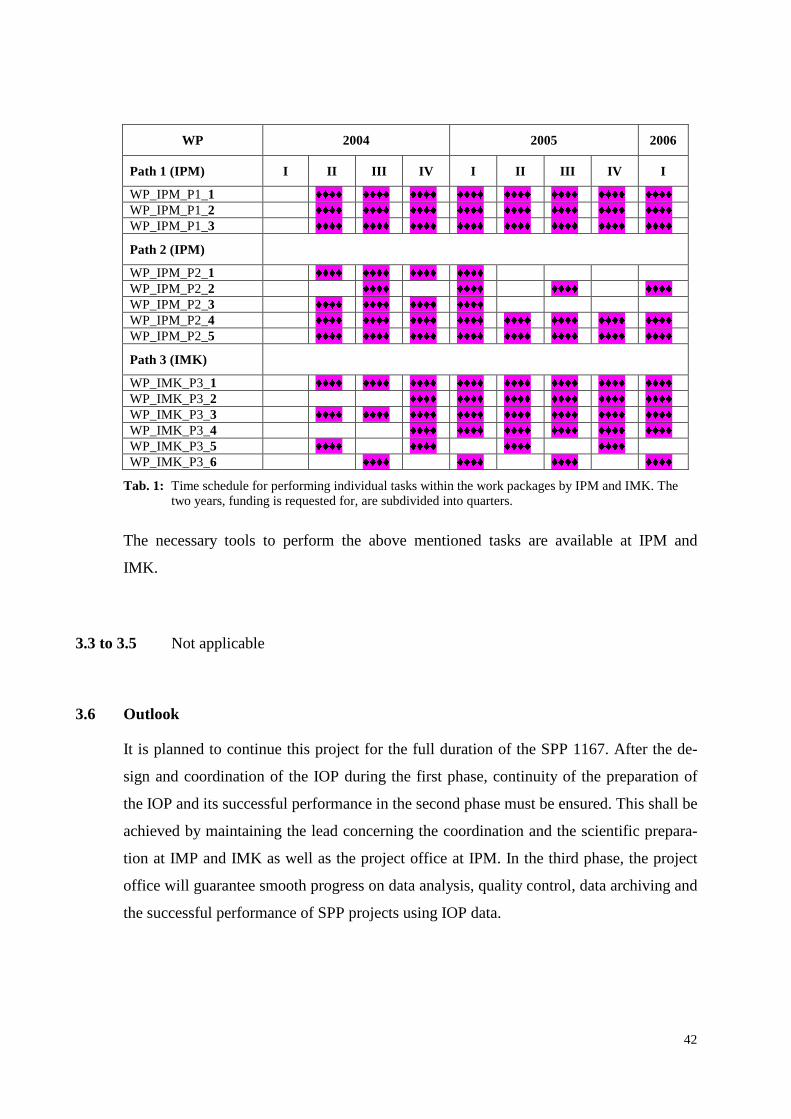
42
WP 2004 2005 2006
Path 1 (IPM) I I I I I I IV I I I I I I IV I
WP_IPM_P1_1 �������
�������
�������
�������
�������
�������
�������
�������
WP_IPM_P1_2
�������
�������
�������
�������
�������
�������
�������
�������
WP_IPM_P1_3 �������
�������
�������
�������
�������
�������
�������
�������
Path 2 (IPM)
WP_IPM_P2_1 �������
�������
�������
�������
WP_IPM_P2_2
�������
�������
�������
�������
WP_IPM_P2_3 �������
�������
�������
�������
WP_IPM_P2_4
�������
�������
�������
�������
�������
�������
�������
�������
WP_IPM_P2_5 �������
�������
�������
�������
�������
�������
�������
�������
Path 3 (IMK)
WP_IMK_P3_1 �������
�������
�������
�������
�������
�������
�������
�������
WP_IMK_P3_2
�������
�������
�������
�������
�������
�������
WP_IMK_P3_3 �������
�������
�������
�������
�������
�������
�������
�������
WP_IMK_P3_4
�������
�������
�������
�������
�������
�������
WP_IMK_P3_5 �������
�������
�������
�������
WP_IMK_P3_6
�������
�������
�������
�������
Tab. 1: Time schedule for performing individual tasks within the work packages by IPM and IMK. The two years, funding is requested for, are subdivided into quarters.
The necessary tools to perform the above mentioned tasks are available at IPM and
IMK.
3.3 to 3.5 Not applicable
3.6 Outlook
It is planned to continue this project for the full duration of the SPP 1167. After the de-
sign and coordination of the IOP during the first phase, continuity of the preparation of
the IOP and its successful performance in the second phase must be ensured. This shall be
achieved by maintaining the lead concerning the coordination and the scientific prepara-
tion at IMP and IMK as well as the project office at IPM. In the third phase, the project
office will guarantee smooth progress on data analysis, quality control, data archiving and
the successful performance of SPP projects using IOP data.

43
3.7 Outreach and education
The performance of the IOP will be of great public interest. In order to present properly
the design and the goals of the IOP, the project office shall also be responsible for public
relations. We consider this project as a unique opportunity for demonstrating the impor-
tant role of atmospheric sciences for the well-being of society.
The preparation of the IOP and its performance is also an excellent chance to involve stu-
dents in key research projects in atmospheric sciences. IPM and IMK will strive for the
immediate incorporation of results in connection with this project into lectures and pres-
entations for students. If possible, students shall also be actively involved in the logistic
and scientific preparation of the IOP.
4. Funds requested
All administrative work and financial affairs of the participating institutes IPM and IMK
will be managed at the corresponding universities. Funds are requested for the 24 month
period 1 as indicated in 1.6. A subsequent request for funding for the phases 2 and 3 of
the SPP, dealing with the realization of the IOP and data analysis is to be expected.
4.1 Staff
IPM:
The work shall be supervised and led by Prof. Dr. Volker Wulfmeyer. This project shall
be supported by a postdoc with outstanding knowledge in active and passive remote sens-
ing as well as the preparation of field campaigns. International contacts to leading insti-
tutes in atmospheric sciences are also essential. The tasks of the postdoc correspond to
path 1 and 2 of the work program.
1 Postdoc BATI Ia for 2 years (wage area west, funding per iod see 1.6)
Path 1 and 2 include a large number of work packages which can only be performed if an
experienced postdoc is dedicated to this project. The availability of the postdoc will en-
sure that the preparation of the IOP will be successful and that the campaign will have
significant impact on atmospheric sciences. The postdoc will also document the scientific
output during the preparation of the IOP. The scientific path 1 includes several topics
which can be subjects for publications.

44
It is planned to have an international advertisement of the postdoc job offer.
IMK:
The scientific preparation of the IOP using LM analyses and predictions and the appro-
priate precipitation observations in complex terrain shall be supervised by Prof. Dr.
Christoph Kottmeier. Dr U. Corsmeier with profoundly expertise in large international
field campaigns will transform the model results and the statistical analyses into a field
measuring program. The work shall be supported by a PhD student doing the LM model
runs and the statistical analysis for seasonal periods of certain weather situations gov-
erned by convective activity as well as for special observation periods of the
VERTIKATOR campaign. This corresponds to path 3 of the work program.
1 PhD student BAT I Ia/2 for 2 years (wage area west, funding per iod see 1.6)
4.2 Scientific equipment
IPM: Not required
IMK: Not required
4.3 Consumables
IPM:
Costs for printing the “Scientific Operational Plan”
and the “Quality Assurance/Quality Control Plan” 1.500 �
Costs for printing flyers, programs, posters and invitations
for the IOP preparation workshops 500 �
IMK:
Fees for information and maps from German Air Traffic Control Agency
(DFS) for planning the IOP flight program 500 �
-------------------------------------------------------------------------------------------------------
Subtotal 2.500 �

45
4.4 Travel expenses and workshops
IPM:
Conference (7th ISTP in Boulder), 5 days one person 2.000 �
Organization of workshops (2 per year), travel support for scientists 20.000
�
Travel to project partner for meetings (3 per year) 600 �
Travel to Kick-Off meeting, meeting SPP-DWD (2 persons, 2 days per meeting, 2 meetings) 800
�
In preparation of the IOP, several workshops are essential for interna-
tional preparation and coordination of the IOP. The workshops will also
be required for the drafting of a scientific document and the operations
plan for the IOP. The workshops shall take place twice a year. To ensure
the participation of international experts we allocated an amount of ������������������ ����������
-day workshop. This amounts includes travel from
the project partner (probably 2-3 overseas), hotel costs, logistics and ca-
tering.
We estimated travel costs of ����������������� �����������
l of project partners be-
tween IMK and IPM. This amount includes one overnight stay.
-------------------------------------------------------------------------------------------------------------
Subtotal 23.400 �
IMK:
1 Conference (EGS 2005), 5 days, 1 person 2.000 �
Travel to project partners (3 per year) 600 �
Travel to Kick-Off meeting, meeting SPP-DWD (2 persons, 2 days per meeting, 2 meetings) 800
�
-------------------------------------------------------------------------------------------------------------
Subtotal 3.400 �

46
4.5 Publication costs
IPM:
Publication costs 750 ������� ���
1.500 �
IMK
Publication costs 750 ������� ���
1.500 �
4.6 Other costs
IPM:
Not required
IMK:
Data acquisition from commercial precipitation networks 1.000 �
4.7 Cost overview
Costs IPM IMK Total
Staff 1.0 BAT II a, west 0.5 BAT II a, west 1.5 BAT II a, west
Scientific Equipment --- ---
Consumables 2.000 � 500
� 2.500
�
Travel/workshops 23.400 � 3.400
� 26.800
�
Publications 1.500 � 1.500
� 3.000
�
Others --- 1.000 � 1.000
�
Total 26.900 ������ �������
6.400������ �������
33.300 ������ �������
5. Preconditions for car rying out the project
5.1 Research Teams
This research proposal is focusing on the preparation of an essential part of the SPP 1167,
the IOP. The long-term experience in active and passive remote sensing as well as in-situ
measurements and mesoscale atmospheric modeling at IPM and IMK will be synergisti-
cally used. The work shall be performed within a collaboration of IPM and IMK:

47
1) The Institute of Physics and Meteorology (IPM) at Hohenheim University (UHOH) in
Stuttgart, Germany, headed by Prof. Dr. Volker Wulfmeyer.
http://www.uni-hohenheim.de/~www120/index.shtml
2) The Institute of Meteorology and Climate Research (IMK-TRO) at the University of
Karlsruhe (TH) and the Forschungszentrum Karlsruhe, Germany, headed by Prof. Dr.
Christoph Kottmeier.
http://www-fzk.imk.uni-karlsruhe.de/fi/fzk/imk/
1) Institute of Physics and Meteorology (IPM), Hohenheim University:
The IPM is organized in four working groups: Modeling and field experiments, Lidar,
Spectroscopy and Particle Analysis and consists of 15 scientists and research assistants.
The research objective of the IPM is the development and the application of unique laser
remote sensing systems and in-situ sensors for weather and climate research. For this pur-
pose, advanced lidar systems are under development such as a ground-based scanning
water vapor DIAL system. Also state-of-the-art performance models for lidar systems and
forward operators for lidar data assimilation are under development or have been devel-
oped. The institute is collaborating and exchanging scientists and students with several
international research institutes such as NCAR, NOAA/ETL and Universitá della Basili-
cata in Potenza, Italy.
Data collected during field campaigns are used to validate and improve global scale,
mesoscale and large eddy simulation models. Another subject of research is the develop-
ment of data assimilation systems for mesoscale models such as the LM of the DWD.
The Project Team consists of the following members:
Project leader: Prof. Dr. Volker Wulfmeyer
Scientist: Dr. Andreas Behrendt, Postdoc, experience with the performance
of field campaigns and applications of advanced active remote
sensing systems
Scientist: Dipl.-Phys. Heinz Bauer, expert on the development of lidar per-
formance models
Technical engineer: Olaf Tapfer, software and electronics

48
2) The Institute of Meteorology and Climate Research (IMK-TRO) at the Univer-
sity of Kar lsruhe (TH) and the Forschungszentrum Kar lsruhe
In the area of troposphere research, studies are performed with regard to the climate, wa-
ter cycle, and trace substance budgets. For this purpose, atmospheric processes, such as
turbulence, convection, cloud formation, aerosol physics, precipitation formation, and ex-
change processes on the Earth’s surface are investigated by measurements and theoretical
methods. The results are incorporated in models of the atmosphere to adequately repre-
sent processes in climate system and weather phenomena. Research activities focus on in-
fluences of orography on the wind and precipitation distribution, transports and conver-
sions of water, energy, trace gases, and aerosols in convective systems, regional climate
variability, and weather hazards due to storms, heavy rains, and thunderstorms. Particular
attention is paid to the further development of own model systems and instruments.
Work at the IMK is currently being carried out by 39 scientists and 15 technicians organ-
ized in 8 working groups. These groups cover both experimental meteorology and nu-
merical simulation. The teams of Dr. Ulrich Corsmeier “Convective Systems” and Dr.
Norbert Kalthoff “Land Surfaces and Boundary Layer” are prior involved in the project.
Both scientists have long term experiences in the scientific preparation of large interna-
tional field research programs such as REKLIP (1992-1998), TRACT (1992), EFEDA
(1991, 1994), BERLIOZ (1998), ESCOMPTE (2001) and VERTIKATOR (2002). Dr.
Frank Braun is a specialist in numerical weather forecast modeling. He is working with
the research version of the LM developed and operated by the DWD.
Project leader: Prof. Dr. Christoph Kottmeier
IOP development and field campaigns: Dr. Ulrich Corsmeier
Dr. Norbert Kalthoff
Modeling: Dr. Frank Braun
Undertaking the task of preparation and executing the ambitious SPP IOP both institutes
IPM and IMK will gain attractiveness to scientists and students from Germany and from
abroad to collaborate in this and in subsequent projects. Future students, scientific and

49
technical staff will benefit from knowledge and experience extracted from the project
over a long range of time.
5.2 Co-operation with other scientists
In the last year, the project leader of this proposal founded a transdisciplinary expert net-
work “Lidar Research Water Vapor and Wind” (Wulfmeyer et al., 2003). IPM organized
2 workshops with about 40 participants, where the knowledge of laser and lidar experts as
well as experts in atmospheric sciences was exchanged. The SPP 1167 was one of the key
topics in atmospheric sciences discussed within this network. The knowledge developed
within this research proposal will be made available to the community.
Intensive collaboration is agreed between the principal investigators of this proposal and
Dr. Erdmann Heise, leading scientist of the research department of the DWD. The DWD
has valuable statistical information about deficits of LM precipitation forecasts and its
dependency from certain weather conditions. This information will be available for the
statistical and case study related investigations in the project and help to choose the most
challenging meteorological conditions for the performance of the field program.
The coordination of the IOP efforts with the GOP will be ensured by continuous ex-
change of information with Dr. Susanne Crewell at the Institute of Meteorology in Bonn
who coordinates the GOP activities.
5.3 Foreign contacts and co-operations
The SPP IOP has already been announced to several research institutions. These include
CNRS, ESA, NCAR/ATD, NCAR/MMM, NOAA/ETL, NOAA/FSL, NASA Langley,
NASA GSFC, as well as MAP, THORPEX and IHOP scientists. Representatives of all
these institutions will be invited to the IOP workshops. The contacts will be extended to
other interested parties during the planning stage of the IOP.
Additionally IMK will take part in the “Convective Storms Initiation Project” (CSIP)
conducted in the UK in 2004 and 2005. Precipitation initiation in the model and the real
atmosphere will be investigated over slightly rolling terrain, differences quantified and
the cause of the differences will be analyzed. From this results as well as from the field
phase we can expect valuable hints for the design and scientific concept of the SPP-IOP.
50
5.4 Scientific equipment available
The required infrastructure to perform the modeling of remote sensing systems and the
investigation of the DWD-LM are available at IPM and IMK. Personal computers and ac-
cess to high-speed supercomputers are available for detailed simulations at both insti-
tutes.
5.5 Institution’s general contr ibutions
The technical infrastructure and the human resources of the IPM and IMK are well pre-
pared for the successful realization of the proposed project and the performance of inter-
national workshops. At IPM two scientists and one technical assistant will be involved in
this fundamental project.
At IMK three scientists will cooperate up to about 25 % of their available time with the
PhD student funding is asked for. If the extent of the field measurements in the 2nd phase
of the SPP gets clearer during the cause of this 1st funding period, the technical staff of
IMK will start the preparation of the wide ground based and air based measurement sys-
tems for the field campaign.
5.6 Other requirements
Not applicable
51
6. Declarations
6.1 “A request for funding of this project has not been submitted to any other address. In case
I submit such a request I will inform the Deutsche Forschungsgemeinschaft immedi-
ately.”
6.2 The Vertrauensdozent of Hohenheim University, Prof. Dr.-Ing. Dr. h.c. H. D. Kutzbach
has been informed about the submission of this proposal.
The Vertrauensdozent of the University of Karlsruhe (TH), Prof. Dr. Hans Buggisch has
been informed about the submission of this proposal.
6.3 Not applicable
7. Signatures
Prof. Dr. Volker Wulfmeyer Prof. Dr. Christoph Kottmeier
Institut für Physik und Meteorologie Institut für Meteorologie und Klimaforschung
Universität Hohenheim Universität Karlsruhe

52
8. L ist of appendages
2 Resumes A1, A3
2 Lists of publications A2, A4

53
Appendix 1
Resume
Volker Wulfmeyer, IPM
Personal
Information
Name:
Year of Birth:
Company:
Education:
Pos. In Company:
Assigned for:
Volker Wulfmeyer
1965
UHOH
1991 Diploma in Physics, University Göttingen, Germany
1995 PhD in Meteorology
1999 Habilitation in Meteorology
2000 Venia Legendi in Meteorology
Since 2001: C4-Professor of Physics and Meteorology
Director of Institute of Physics and Meteorology at UHOH
Exper ience
1988-1991
Since 1991
Since 1997
1996-2002
Since 2000
Since 2001
Research Assistant at the Max-Planck-Institut für Strömungsforschung in
Göttingen, Germany, research project:
Molecular spectroscopy, laser development
Research Associate at the Max-Planck-Institut für Meteorologie, research projects:
- DIAL methodology, water vapor in-situ, passive and active remote sensing
measurements
- Water vapor DIAL system development and applications
Research Scientist at NCAR and NOAA, Boulder, CO, USA, research
projects:
- Coherent Doppler lidar system development and applications
- Analysis of turbulent transport processes in the convective boundary layer
Several field campaigns in Europe, Tropical Pacific and US
PI of IHOP_2002
Director of IPM at UHOH:
Development of a water vapor DIAL system in collaboration with NCAR Atmospheric
Technology Division

54
Committees
Since 1996
02/99-02/02
Since 2001
2001
2002-2004
Since 03/2003
Since 07/2003
Since 06/2003
GVaP Working Group on Science and Data
Committee on Laser Atmospheric Studies of the American Meteorological Society
Science Steering Committee of SPP 1167
WALES Scientific Preparatory Group
WALES Mission Advisory Group
International Science Steering Committee of The Observing-system Research and
Predictability Experiment (THORPEX)
Scientific Advisory Committee of the German Weather Service
NCAR Affiliate Scientist
Awards and
Patents
07/1996
Patents
Chairman
General Chair
Invited talks
Award from the German Meteorological Society for the “best meteorological
application of a lidar system” awarded at the 18th. International Laser Radar
Conference, Berlin
- German patent G9410659.2 for a variable attenuator for lidar signals, 7/94
- US Patent pending for a laser frequency stabilization
- 3th International Symposium on Humidity and Moisture, 04/98
- 4th International Symposium on Tropospheric Profiling, 09/98
- 80th AMS Annual Meeting, 01/00
- 5th International Symposium on Tropospheric Profiling, 12/00
- 5th International Symposium on Tropospheric Profiling, 12/00
- 6th International Symposium on Tropospheric Profiling, 09/03
- CLEO 1997
- IGARSS 1998
- 80th AMS Annual Meeting 2000
- IGARSS 2000
- ILRC 2002
55
Appendix 2
List of publications (blue: copy attached)
Volker Wulfmeyer, IPM
Selected Reports and Scientific Documents:
IHOP, 2000: Scientific Overview Document for the International H2O Project. Eds. D. Parsons, T. Weckwerth and R.M. Hardesty based on contributions by K. Davis, V. Wulfmeyer, C. Ziegler and other members of the IHOP_2002 Science Team.
European Space Agency, 2001: WALES – Water Vapour Lidar Experiment in Space. The Five Candidate Earth Explorer Core Missions, European Space Agency, Report for Assessment, ESA SP-1257(2), September 2001.
Selected Peer-Reviewed Publications:
Wulfmeyer, V., 1998: Ground-based differential absorption lidar for water-vapor and temperature profiling: Re-quirements, development, and specifications of a high-performance laser transmitter. Appl. Opt. 37, 3804-3824.
Wulfmeyer, V., and J. Bösenberg, 1998: Ground-based differential absorption lidar for water-vapor profiling: As-sessment of accuracy, resolution, and meteorological applications. Appl. Opt. 37, 3825-3844.
Steinhagen, H., S. Bakan, J. Bösenberg, H. Dier, D. Engelbart, J. Fischer, G. Gendt, U. Görsdorf, J. Güldner, F. Jansen, V. Lehmann, U. Leiterer, J. Neisser, and V. Wulfmeyer, 1998: Field campaign LINEX96/1 - Possi-bilities of water vapor observations in the free atmosphere. Meteorol. Zeitschrift N.F. 7, 377-391.
Wulfmeyer, V., 1999: Investigation of turbulent processes in the lower troposphere with water-vapor DIAL and Radar-RASS. J. Atmos. Sci. 56, 1055-1076.
Wulfmeyer, V., 1999: Investigations of humidity skewness and variance profiles in the convective boundary layer and comparison of the latter with large eddy simulation results. J. Atmos. Sci. 56, 1077-1087.
Weckwerth, T. M., V. Wulfmeyer, R. M. Wakimoto, R. M. Hardesty, J. W. Wilson, and R. M. Banta, 1999: NCAR/NOAA lower tropospheric water vapor workshop. Bull. Amer. Meteor. Soc. 80, 2339-2357.
Wulfmeyer, V., and G. Feingold, 2000: On the relationship between relative humidity and particle backscattering coefficient in the marine boundary layer determined with differential absorption lidar. J. Geophys. Res. 105 D4, 4729-4741.
Wulfmeyer, V., M. Randall, A. Brewer, and R.M. Hardesty, 2000: 2µm Doppler lidar transmitter with high fre-quency stability and low chirp. Opt. Lett. 25, 1228-1230.
Lenschow, D. H., V. Wulfmeyer, and C. Senff, 2000: Measuring second-through fourth-order moments in noisy data. J. Atmos. Oceanic Technol. 17, 1330-1347.
Wulfmeyer, V., and C. Walther, 2001a: Future performance of ground-based and airborne water vapor differential absorption lidar. I: Overview and theory. Appl. Opt. 40, 5304-5320.
Wulfmeyer, V., and C. Walther, 2001b: Future performance of ground-based and airborne water vapor differential absorption lidar. II: Simulations of the precision of a near-infrared, high-power system. Appl. Opt. 40, 5321-5336.
Gérard, É., D.G.H. Tan, L. Garand, V. Wulfmeyer, G. Ehret, and P. Di Girolamo, 2003: Major advances foreseen in humidity profiling from WALES. Submitted for publication in Bull. Amer. Meteor. Soc.
Wulfmeyer et al., 2003: Lidar Research Network Water Vapor and Wind. Meteorol. Z. 12, 5-24.

56
Selected Conference Contr ibutions:
Wulfmeyer, V., 1997 (invited): Ground-based water-vapor measurements with differential absorption lidar. OSA Technical Digest Series Vol. 11, Conference on Lasers and Electro-Optics, Baltimore, Maryland, May 1997, 471-472.
Wulfmeyer, V., 1998 (invited): On the contribution of water-vapor DIAL to atmospheric sciences. 1998 Interna-tional Geoscience and Remote Sensing Symposium, Seattle, Washington, July 1998.
Wulfmeyer, V., 1998: On the contribution of water-vapor DIAL to the investigation of turbulent transport processes. NASA/CP-1998-207671/PT1, 19th International Laser Radar Conference, Annapolis, Maryland, July 1998, 473-476.
Brewer, W. A., V. Wulfmeyer, R. M. Hardesty, and B. Rye, 1998: Combined wind and water-vapor measurements using the NOAA Mini-MOPA Doppler lidar. NASA/CP-1998-207671/PT1, 19th International Laser Radar Conference, Annapolis, Maryland, July 1998, 565-568.
Wulfmeyer, V., W. A. Brewer, C. Senff, S. Mayor, R. Marchbanks, J. Howell, A. Weickmann, R. Richter, C. Grund, and R. M. Hardesty, 1998: Performance and applications of the NOAA 2 µm High Resolution Doppler Lidar. NASA/CP-1998-207671/PT1, 19th International Laser Radar Conference, Annapolis, Maryland, July 1998, 573-576.
Wulfmeyer, V., A. Brewer, A. Weickmann, R. Richter, J. Vanandel, J. Howell, R. Richter, C. Grund, M. Hardesty, and P. Hildebrand, 1998: NCAR/NOAA high-resolution Doppler lidar for wind measurements and its poten-tial for water-vapor differential absorption lidar. Book of Abstracts, Vol. 2, Fourth International Symposium on Tropospheric Profiling, Snowmass, Colorado, September 1998, 341-343.
Wulfmeyer, V., 1998: On the relation between relative humidity and particle backscatter coefficient in the marine boundary layer determined with differential absorption lidar. Book of Abstracts, Vol. 2, Fourth International Symposium on Tropospheric Profiling, Snowmass, Colorado, September 1998, 344-346.
Wulfmeyer, V., 1998: On the contribution of water-vapor DIAL to the investigation of turbulent transport processes. Fourth International Symposium on Tropospheric Profiling, Snowmass, Colorado, September 1998.
Dabas, A., Ph. Drobinski, R. M. Hardesty, A. Brewer, and V. Wulfmeyer, 1999: Measuring turbulence parameters with coherent lidars. 10th Coherent Laser Radar Conference, Mount Hood, Oregon, June 1999.
Brewer, A., V. Wulfmeyer, and R. M. Hardesty, 1999: Wind and water vapor measurements with the NOAA Mini-MOPA. 10th Coherent Laser Radar Conference, Mount Hood, Oregon, June 1999.
Wulfmeyer, V., 1999: Water Vapor Differential Absorption Lidar: A Reference Standard for Water Vapor Profiling in the Atmosphere. Chapman Conference on Water Vapor in the Climate System, Potomac, Maryland, Octo-ber 1999.
Wulfmeyer, V., 2000 (invited): Recent advances and the future potential of ground-based lidar in climate research. Lidar Symposium, 80th Annual Meeting of the American Meteorological Society, Long Beach, California, January 2000.
Wulfmeyer, V., 2000: The contribution of ground-based water vapor differential absorption lidar to climate research. Lidar Symposium, 80th Annual Meeting of the American Meteorological Society, Long Beach, California, January 2000.
Wulfmeyer, V., M. Randall, C. Walther, R. Newsom, A. Brewer, and R. M. Hardesty, 2000: High-performance 2-µm Doppler lidar and its shipborne applications in the tropical marine boundary layer. 20th International Laser Radar Conference, Vichy, June 2000.
Dabas, A., A. Brewer, V. Wulfmeyer, V., and P. Drobinski, 2000: Measuring wind turbulence with high-resolution coherent Doppler lidars. 20th International Laser Radar Conference, Vichy, June 2000.
Wulfmeyer, V., 2000 (invited): Design and expected performance of a ground-based, scanning water vapor differen-tial absorption lidar system. International Geoscience and Remote Sensing Symposium, Honolulu, Hawaii, July 2000.
Wulfmeyer, V., D. Parsons, C. Walther, and T. Weckwerth: Design and expected performance of a multi-platform, scanning water vapor remote sensing system. Fifth International Symposium on Tropospheric Profiling, Ade-laide, December 2000.

57
Wulfmeyer, V., Rob K. Newsom, C. J. Senff, and R. M. Hardesty: Investigations of the structure of the tropical marine boundary layer using shipborne Doppler lidar. Fifth International Symposium on Tropospheric Profil-ing, Adelaide, December 2000.
Weckwerth, T., C. Flamant, V. Wulfmeyer, 2001: Clear-air boundary layer observations from radar and water vapor DIAL, 30th International Conference on Radar Meteorology, Munich, July 2001.
Wulfmeyer, V. 2002: Satellitengestützte Fernerkundung des wichtigsten Treibhausgases: Der Beitrag der Universität Hohenheim. Plenarvortrag, Hohenheimer Umwelttage, January 2002.
Wulfmeyer, V. 2002 (invited): Lidar - The next generation. Current and future applications due to recent techno-logical advance. 21th International Laser Radar Conference, Quebec City, Canada, July 2002.
Wulfmeyer, V., P. Di Girolamo, G. Ehret, L. Garand, E. Gérard, E.V. Holm, D.G.H. Tan, and R. Toumi, 2003: Key technological and scientific issues of the WALES mission. 6th International Symposium on Tropospheric Pro-filing, Leipzig, Germany, September 15-19, 2003.
Ehret, G., M. Wirth, C. Kiemle, B. Mayer, E. Gérard, D.G.H. Tan, L. Garand, V. Wulfmeyer, P. Di Girolamo, E.V. Holm, and R. Toumi, 2003: WALES (Water Vapour Lidar Experiment in Space): A new space borne active humidity profiler. 6th International Symposium on Tropospheric Profiling, Leipzig, Germany, September 15-19, 2003.
Behrendt, A., T. Schaberl, C. Kiemle, G. Poberaj, G. Ehret, C. Flamant, E. Browell, S. Ismail, R. Ferrare, and V. Wulfmeyer, 2003: Intercomparison of airborne water vapor DIAL measurements during IHOP_2002. 6th In-ternational Symposium on Tropospheric Profiling, Leipzig, Germany, September 15-19, 2003.
Di Girolamo, P., D. Summa, H. Bauer, V. Wulfmeyer, H.-S. Bauer, G. Ehret, B. Mayer, and M. Wirth, 2003: Devel-opment of an end-to-end model for simulating the performance of WALES. 6th International Symposium on Tropospheric Profiling, Leipzig, Germany, September 15-19, 2003.
Bauer, H.-S., and V. Wulfmeyer, 2003: Representation of components of the hydrological cycle in the Lokal-Model with and without data assimilation. 6th International Symposium on Tropospheric Profiling, Leipzig, Ger-many, September 15-19, 2003.
Ehret, G., A. Fix, M. Wirth, É. Gérard, V. Wulfmeyer, and P. Di Girolamo, 2003: Water vapour lidar experiment in space (WALES), 54th International Astronautical Congress, Bremen, Germany, September 29, 2003.
Patents:
Lehmann, S., V. Wulfmeyer, and J. Bösenberg, 1994: A variable attenuator for lidar signals. German Patent Nr. G9410659.2, 1. July 1994.
Wulfmeyer, V. and M. Randall, Frequency stabilization of a Doppler lidar using phase modulation, US Patent pend-
ing.

58
Appendix 3
Resume
Chr istoph Kottmeier , IMK
Personal
Information
Name:
Year of Birth:
Company:
Education:
Pos. In Company:
Assigned for:
Chr istoph Kottmeier
1952
University of Kar lsruhe
1977 Diploma in Meteorology, University of Hannover, Germany
1981 PhD (Dr. rer. nat.)
1988 Habilitation in Meteorology with venia legendi
1990 Hochschuldozent at the University Bremen, (C2) Physics of Atmosphere; Head of Meteorological Group at Alfred Wegener Institute, Bremerhaven
1997 Professor of Meteorology, University Karlsruhe, (C3)
Since 2003: C4-Professor of Meteorology, University of Karlsruhe
Head of Institute of Meteorology and Climate Research, University of Karlsruhe/Research Center Karlsruhe
Exper ience
1978 - 1983
1983 – 1989
1989 – 1997
Since 2003
Research Assistant at the Institute of Meteorology and Climatology, University of Han-nover
Hochschulassistent, University of Hannover
Senior scientist, Alfred Wegener Institut, Bremerhaven
Head of Institute of Meteorology and Climate Research, University of Karlsruhe/Research Center Karlsruhe
Committees
1994 - 2000
1990 - 1997
since 2000
WCRP – International Programme for Antarctic buoys
Technical Committee and User advisory board ,,Polar aircraft’ ’
Landesausschuss SCAR/IASC
Steering Committee SPP 1167 “Quantitative precipitation forecast”
Steering Committee TRACKS “Transport and Chemical Conversion in Convective Systems”
Awards and
Patents
Patents
Chairman
Dropsonde Nr. 198 52 797
WCRP – International Programme for Antarctic Buoys

59
Appendix 4
L ist of publications (Extract of important papers of the last 5 years) (blue: copy attached)
Chr istoph Kottmeier , IMK
Kottmeier, Ch.; K. Frey, M. Hasel, O. Eisen, 2003: Sea ice growth in the eastern Weddell Sea in winter. Journal of Geophysical Research, 108, NO. C4, 3125, doi:10.1029/200IJC001087
Corsmeier, U., N. Kalthoff, B. Vogel, M.U. Hammer, F. Fiedler, Ch. Kottmeier, A. Volz-Thomas, S. Konrad, K. Glaser, B. Neininger, M. Lehning, W. Jaeschke, M. Memmesheimer, B. Rappenglück, G. Jakobi, 2002: Ozo-ne and PAN formation inside and outside of the Berlin plume. Process analysis and numerical process simula-tion. Journal of Atmospheric Chemistry, 42, .289-321.
Cros, B., P. Durand, E. Frejafon, Ch. Kottmeier, P.E. Perros, V.-H. Peuch, J. L. Ponche, D. Robin, F. Said, G. Tou-pance, and H. Wortham, The ESCOMPTE program, An Overview, Atmos. Environ., in press, 2002.
Kalthoff, N. U. Corsmeier, K. Schmidt, Ch. Kottmeier, F. Fiedler, M. Habram, F. Slemr, 2002: Emissions of the city of Augsburg determined using the mass balance method. Atmospheric Environment, 36, Suppl.No.1, S.S19-S31.
Corsmeier, U., R. Hankers, A. Wieser, 2001: Airborne turbulence measurements in the lower troposphere onboard the research aircraft Dornier 128-6, D-IBUF. Meteorologische Zeitschrift, 10, S.315-29.
Kottmeier, C., T. Reetz, P. Ruppert, and N. Kalthoff, 2001: A new aerological sonde for dense meteorological soundings, J. Atmos. Oceanic Technol., 18,1495-1502, 2001.
Kottmeier, C., H. Höller, K. Beheng, E. Raschke, M. Quante, B. Rockel, C. Lüpkes, H. Smit, and A. Hofzumahaus, 2001: Transport and chemical conversion in convective systems (TRACKS), conception of a three-stage large-scale experiment of six Helmholtz-Center.
Veihelmann, B., F.S. Olesen, Ch. Kottmeier, 2001: Sea ice surface temperature in the Weddell Sea (Antarctica), from drifting buoy and AVHRR data. Cold Regions Science and Technology, 33, S.19-27.
Eisen, O., Ch. Kottmeier, 2000: On the importance of leads in sea ice to the energy balance and ice formation in the Weddell Sea. Journal of Geophysical Research C, 105 C6, .14045-60.
Kottmeier, C., P. Palacio-Sese, N. Kalthoff, U. Corsmeier, F. Fiedler, 2000: Sea breezes and coastal jets in south-eastern Spain, J. Climatol., 20,1791-1808.
Padman, L., Ch. Kottmeier, 2000: High-frequency ice motion and divergence in the Weddell Sea, J. Geophys. Res., 105, 3379-3400.
Vihma, T., Ch. Kottmeier, 2000: A modeling approach for optimizing flight patterns in airborne meteorological measurements. Boundary -Layer Meteorology, 95,.211-30.
Handorf, D., T. Foken, Ch. Kottmeier, 1999: The stable atmospheric boundary layer over an Antarctic ice sheet. Boundary -Layer Meteorology, 91, 165-89, 1999.
McPhee, M.G., Ch. Kottmeier, J.H. Morison, 1999: Ocean heat flux in the central Weddell Sea during winter. Jour-nal of Physical Oceanography, 29, 1166-79.
Timmermann, R., P. Lemke, Ch. Kottmeier, 1999: Formation and maintenance of a polynya in the Weddell Sea. Journal of Physical Oceanography, 29, 1251-64.
Freese, D., Ch. Kottmeier, 1998: Radiation exchange between stratus clouds and polar marine surfaces. Boundary -Layer Meteorology, 87, 331-56.
Kottmeier, C., B. Fay, 1998: Trajectories in the Antarctic lower troposphere. Journal of Geophysical Research, 103, No.D9, S.10947-10959.
Kwok, R.; Schweiger, A.; Rothrock, D.A.; PANG, S.; Kottmeier, Ch. Sea ice motion from satellite passive micro-wave imagery assessed with ERS SAR and buoy motions. Journal of Geophysical Research, 103, No.C4, S.8191-8214, 1998.