Q2 quarter guide - Dutch Lowlands
32
DUTCH LOWLANDS 1st Edition – Fall 2010 QUARTER GUIDE Q2 2010–2011
-
Upload
sven-van-oosten -
Category
Documents
-
view
231 -
download
3
description
Quarter guide for the mastertrack Landscape Architecture, Delft university of technology. quarter 2 - version 1 - nov 2010
Transcript of Q2 quarter guide - Dutch Lowlands
DUTCH LOWLANDS
1st Edition – Fall 2010
QUARTER GUIDE Q2
2010–2011
2
QUARTER GUIDE 2010-2011 DUTCH LOWLANDS
Published by: Chair of Landscape Architecture, Department of Urbanism,TU Delft Faculty of Architecture
Published for:MSc1 track Landscape Architecture, Q2 – Dutch Lowlands 1st edition - autumn 2010
Responsible Chair © copyrights:Prof. dr. Ir. C.M. Steenbergen (Landscape Ar-chitecture)Ir. Bobbink (associate professor, coordinator education)
Quarter coordinator:Ir. I. Bobbink
Student Assistants:S. van OostenE. Ottevanger
Design:H. Gremmen
Lay-out: S. van Oosten
CONTENT
Q2 Dutch lowlands5 Overview quarter 2
New Dutch Waterscape: Design of a Leisure Landscape6 introduction8 assignment9 schedule10 site: midden-delfl and12 method12 design aspects15 learning objectives15 fi nal product15 criteria and discussion
Landscape Architecture 2: Dutch Landscape Architecture16 introduction18 lectures20 assignment20 method20 products20 evaluation criteria
Refl ecting ideas on Landscape:Contemporary Theory22 introduction24 method and assignment25 learning objectives25 criteria for grading25 literature and study materials
Landscape Component: the Form of the Dutch Polder Water26 introduction29 assignment30 method30 learning objectives30 products30 criteria
Msc track in landscape architectureLandscape Architecture is a design discipline in the changing fi elds between Architecture and Landscape and between the city and the landscape. The landscape architect is a designer of space; the design process itself is a synthesis of art and technology in which considerations of topography, the natural processes that shape a landscape over time, and the formal, material and cultural qualities of a locality all play essential roles. Each project is a unique refl ection of geometry and geomorphology, artefact and nature, form and function.
Theory and practiceThe MSc Track in Landscape Architecture focuses on the full scope of the discipline – from design to planning, from theoretical considerations to practical exercises, and from research to policymaking. It examines crucial topics such as the subtle interaction between architecture and landscape and the urban realm through a scientifi c lens, and it is linked to a parallel research programme through methods, projects and researchers. Landscape architecture requires design knowledge of spaces of different types and scales of history, media and design instruments, of plants and vegetation, soils, hydrology, ecology, human sciences and technical constructions and materials. The relationship between the Landscape Architecture track and Architecture and Urbanism is evident in its focus on the architectonic form and the urban question.
CurriculumThe Master’s programme is offered once a year but students can start in September or January. The fi rst three quarters of the programme are complementary to each other and introduce the student to the specifi c domains and instruments of Landscape Architecture. In the fourth quarter students are encouraged to focus on current topics in Landscape Architecture in order to extend their core knowledge and skills. The 3rd semester graduation studios are structured around projects within the research programme. Students contribute to research projects in the form of design research, comparative analysis, and design experiments. They develop a study plan and a proposal for a graduation thesis to be undertaken in the fourth semester. Developing a critical position in relation to the discipline, to history and current architectonic and urban debate is an important objective of the graduation year. Once every quarter students go on an excursion to a specifi c site or design in the Netherlands, and participate in an international excursion once a year.
3
4
Dutch Lowlands explores the landscape as an experimental fi eld of collective cultural endeavour. The term Dutch Lowlands covers the constructed water and polder spaces in the cultivated landscape and the cityscape of Holland. The appearance of the Dutch landscape is linked to its position in the Rhine and Meuse delta and to the geomorphology of this area between the mainland and the sea. The Fine Dutch Tradition is the result of numerous historical transformations, and it is defi ned by a set of characteristics: usefulness of programme; modest resources; meaning and clarity of form. How can we explore this Fine Dutch Tradition in new design experiments?
The theme of this quarter is to design a signifi cant landscape architectonic articulation of the Dutch polder landscape on different scales.
The quarter is built around 4 different courses:The design studio, entitled New Dutch Waterscape, designing a leisure landscape is the core activity in this quarter. The lecture series Landscape Architecture 2: Dutch Landscape Architecture explains the techniques and materials used in the lowland design and the specifi c forms and qualities of Dutch Landscape Architecture that emerged from the lowland conditions. The Refl ecting Ideas on Landscape seminar discusses the theoretical approaches to landscape design. The Landscape components workshop focuses on the form and sustainability of water structures and elements in the polder.
Q2
DUTCH LOWLANDS
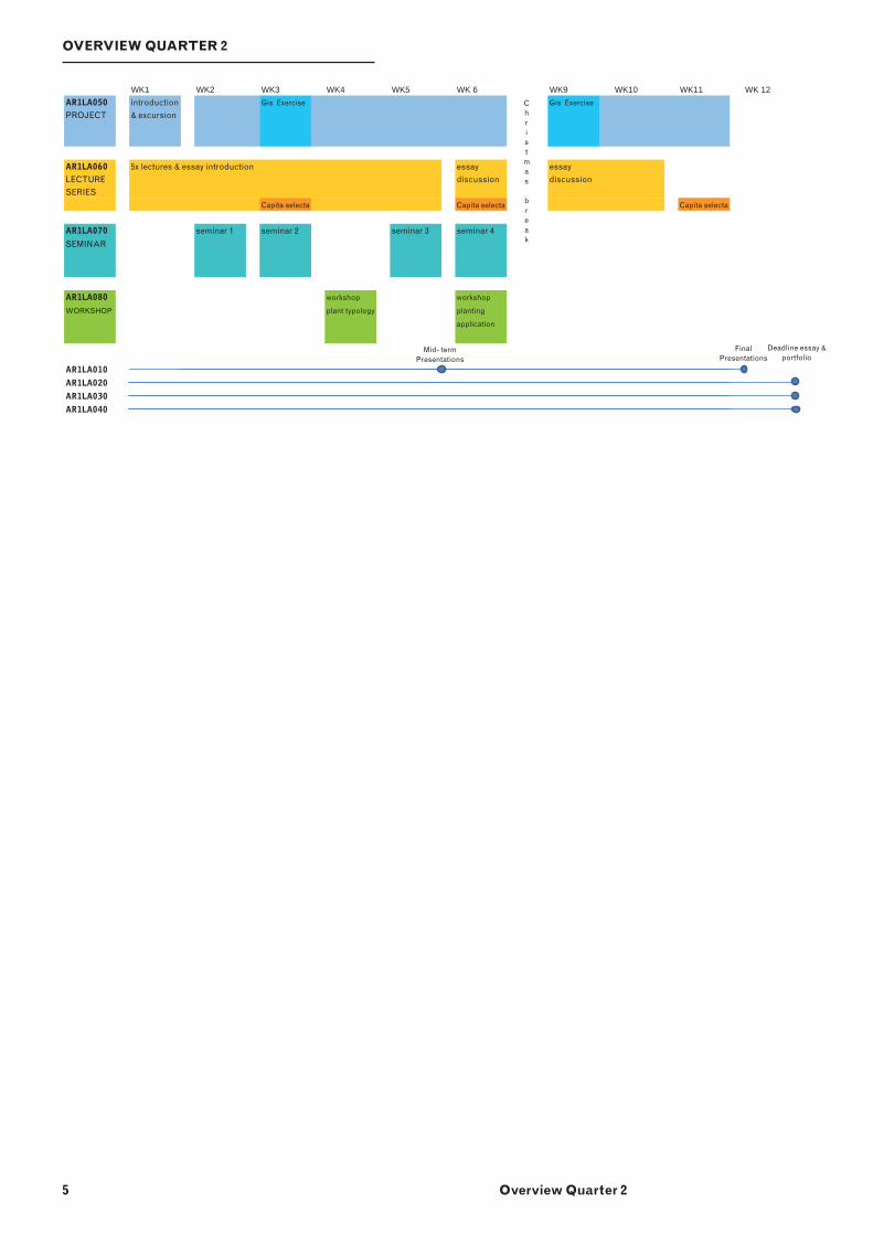
OVERVIEW QUARTER 2
5 Overview Quarter 2
WK1 WK2 WK3 WK4 WK5 WK 6 WK9 WK10 WK11 WK 12AR1LA050 introduction Gis Exercise Gis Exercise
PROJECT & excursion
AR1LA060 5x lectures & essay introduction essay essay
LECTURE discussion discussion
SERIES
Capita selecta Capita selecta Capita selecta
AR1LA070 seminar 1 seminar 2 seminar 3 seminar 4
SEMINAR
AR1LA080 workshop workshop
WORKSHOP plant typology planting
application
AR1LA010
AR1LA020
AR1LA030
AR1LA040
Mid- term Presentations
Final Presentations
Deadline essay & portfolio
Christ
mas break
6
STUDIO AR1LA050 - INTRODUCTION
The Dutch landscape is the result of a long struggle with nature. The inhabitants of Holland have, for centuries, worked with care and devotion on the cultivation of their delta, turning it into a landscape where they feel at home, an inalienable heritage.
The landscape is a product of organisational talent, business acumen, enterprise, science, technology, artistic feel and a love of nature. This Fine Dutch Tradition has been famous since the 17th century and is based on a dynamic approach to landscape, emphasised by the constant adaption of the Dutch water system. Today the polder water system that gets rid of undesired water by pumping it off risks becoming a victim of its own success as ground levels subside, sea levels rise, and prolonged periods of drought become more commonplace.
As research shows, there is a need to fi nd space for more water retention capacity in order to diminish the threat of the ‘boezem’ or outlet waterway system not having suffi cient capacity to discharge the water peak load. At the same time, water retention in the polder provides easy access to clean storage water during dry summers.
There are, moreover, many other questions such as the marginalisation and scale increases of agricultural areas and the expansion of urban areas leading to disintegration of the landscape.
Questions of how the urban world is going to deal with the logic of the polder landscape and its landscape architectonic qualities and how (new)programmes can be integrated into that landscape in a sustainable way are highly relevant for today’s development of new technical models and planning.
As designers our main contribution to this discussion will be research into and the design of the landscape architectonic form as a vehicle for generating this new landscape. The mission is to design a signifi cant landscape architectonic articulation of the Dutch polder landscape and more precisely in this studio - for a specifi c polder. The task is to revise the water system, to integrate water retention and to deal with the programmatic transformation of urban fragments: a highway and leisure functions in an existing agricultural polder landscape.
NEW DUTCH WATERSCAPE:
DESIGN OF A LEISURE
LANDSCAPE
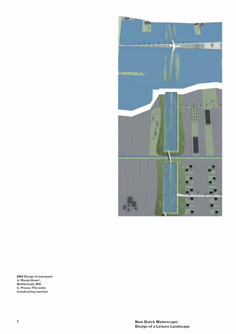
7 New Dutch Waterscape: Design of a Leisure Landscape
EMU Design of waterpark in ‘Ronde Venen’, Netherlands, 2010 C. Pisano: The water broadcasting machine
8
ASSIGNMENT
The leisure landscape (public landscape) assignment will emphasise the understanding of Landscape Architecture as an idea and as a process. It addresses the question of the changing accessibility of today’s landscape and the idea and meaning of the landscape in a densely populated delta. The theme of experiencing the Dutch lowlands through different kinds of movement (bike, skates, horseback, boat, canoe etc.) on the edge of the city, and the landscape will play an important role in the design. On the one hand, the term leisure landscape will challenge the designer to experience the Dutch polder landscape. On the other hand, the design research on ‘leisure landscape’ needs to fi nd programme whose capacity to create an architectonic meaningful landscape has to be tested.
Step 1An introduction to the typical Dutch landscape, the polder landscape, is the starting point for the studio work. Students work in small groups in order to understand the cultivated landscape, to analyse its transformation processes through the last thousand years, and become familiar with its ingenious water system that forms the basic structure of each polder.With the help of existing examples, students build up a reference portfolio of relevant projects and design elements for leisure: park landscapes, waterscapes, agricultural fi elds as part of a park, parkways, recreational programmes, woodlands, energy landscapes etc. and use this knowledge to research the given site by projecting some of these elements and structures on it. The projections are used to establish the potentiality of the site and at the same time they function as a stepping stone to the design.
Step 2As a second portal, we ask students to consider a quote by N. Hazendonk (Greetings from Europe: landscape & leisure). He reminds us, that without any inspiration and imagination no ‘new’ developments in landscape architecture would have been invented.…..Both Brown and Kent created gardens like landscape paintings, using temples, ruins, winding paths, hills, water, trees and carefully planned perspectives to make ‘natural’ scenes such as would never have occurred in nature.We ask students to start the design with a free composition of a strong vision on the Dutch landscape.
Step3The precise programme of the leisure programme will be formulated as a result of students’ own research from interesting existing leisure plans (examples).
The leisure programme was chosen because of its contrasting meaning with respect to the agricultural landscape. Leisure or free time is a period of time spent out of work and essential domestic activity (day-to-day stress). It covers the meaning of otium, a term taken from Villa Architecture. Otium not only means seclusion, serenity, relaxation, but also an opportunity to engage, often intensely, in worthwhile physical and mental pursuits: re-creation (S. de Wit, Q1 guide).The polder landscape itself is the product of centuries of hard work and represents the negotium. We would like students’ designs to mediate between negotium and otium, and by doing so, many questions have to be discussed:
How can we transform the Dutch polder -landscape into a balanced leisure and agricultural (water)landscape while integrating it in the Dutch city landscape?What is the role and signifi cance of the -water system for future transformations?How can the spatial qualities of the -manmade landscape be protected and at the same time transformed and developed for future uses?How can a new programme reinforce the -latent architectonic aspect of the Dutch Lowlands?What are spatial conditions for landscape -(waterscape) as a public domain?Which processes determine the actual -landscape and what is the role of the design in it?
New Dutch Waterscape: Design of a Leisure Landscape
SCHEDULE
Week 1Site excursion – - group work (whole)Analysis of the polder - - group work (small)
Week 2Presentation: imaginary leisure landscape -in the polder.Analysis of the site - - group work (small) Investigation of relevant projects and -the design elements of: park landscapes, waterscapes, agricultural fi elds as part of a park, parkways, recreational programme, woodlands, energy landscapes etc. – group work (whole)resulting in a group-made leisure catalogue. -
Week 3Presentation: site analysis and collection of -relevant projects - two bookletsStart experimental projections of crucial -landscape architectonic elements of the chosen projects onto the site - individual
Weeks 4 through 8Presentation: draft composition, developed -from experimental projections and site analysis - individual Design (plan, sections, water system, -routing, programme): Special attention to articulation of the water system, layout of different movements (walking, biking, skating, horse riding, driving slowly and fast) in relation to the surrounding cities (regional scale) in 2D, sections and spatial 3D drawings
Week 5 Presentation of the design (Tuesday) -Draft drawing -site analysis -design (draft) -plan, sections, working of water system, -routing, programmethrough all scales (1:2000 - 1:1000 – 1:500 – 1:200 and 1:10)
Week 11fi nal presentation including GIS -development from your fi rst imaginary -landscape to the composition developed from experimental projections and the site analysis to the fi nal design consisting of:plan, sections, working of water system, -routing, programme – spatial plan (bird’s eye view)through all scales (1:2000 - 1:1000 – 1:500 – -1:200 and 1:10)special attention to presentation qualities – -drawing, writing and verbal
9
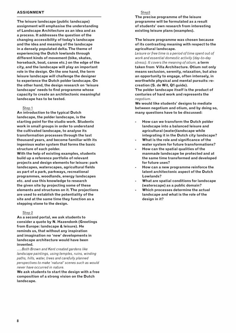
Top:West Wycombe,Buckin Ghamshire,18th century, by W. Kent
Bottom:Kent West Wycombe,Buckin Ghamshire.Imagination,18th century, by W. Kent
10
SITE: MIDDEN-DELFLAND
In Landscape Architecture the site forms the point of departure - the source of inspiration.
Some factsMidden-Delfl and is a municipality in the province of South Holland in the Netherlands. It is home to 17,500 inhabitants and covers an area of 49.38 km2 polder land of which 1.93 km2 is covered by water. The name Midden-Delfl and refers to the green area surrounded by the cities of Delft, Schiedam and Rotterdam, and the horticultural area of the Westland. Small villages (Schipluiden and Maasland) dot the polder landscape , whose origins date back to the Middle Ages. Over many centuries, the Midden-Delfl and area has been transformed from a wetland in the delta to a varied polder landscape. The eastern part of Delfl and was covered by peat in the Middle Ages. The western part consisted of high sandy soils (geestgronden). The sand was brought in by the creeks coming in from the North Sea and the River Meuse. Traces of the river channels can still be seen, as evidenced by the slopes that are visible in the meadows.
Sources:- http://en.wikipedia.org/wiki/Midden-Delfl and
- http://www.hhdelfl and.nl/wat-doet-delfl and/historie/
- http://www.middendelfl and.nl
- http://www.geschiedenisvanzuidholland.nl/verhalen/geografi schelocatie/32/gemeente-midden-delfl and
The region’s inhabitants traditionally lived from livestock and to a lesser extent from agriculture and horticulture. Through reclamation (water drainage) and cultivation of the land, the soil started to subside. The area was hit by severe fl ooding In the second quarter of the 12th century and in the last quarter of the 16th century. The Delfl and water board has always played an important role in the area’s water management. As a result of more extreme rainfall, the area is currently struggling to protect the open polder land against high water levels.
Today the area is one of the last open, unbuilt polder landscapes in the Randstad still used for agricultural purposes. 1977 reconstruction legislation Midden-Delfl and attempted to protect the area from city sprawl and the glasshouses of the Westland. The legislation did create awareness but did not put an end to endless claims being made on the area. In addition to the development of new neighbourhoods on the outskirts of Schiedam, many recreational functions (golf course, park, harbour etc.) were introduced. The latest example of the ongoing clutter is the decision, fi nally taken in September 2010 after 20 years’ discussion, to construct the A4 highway which will cut right through the middle of Midden-Delfl and.
New Dutch Waterscape: Design of a Leisure Landscape
11
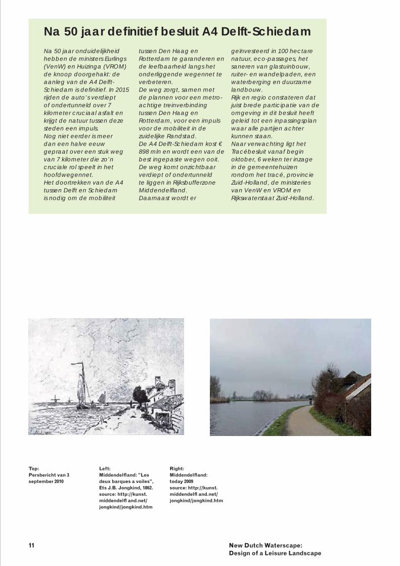
Top:Persbericht van 3 september 2010
Left:Middendelfl and: ”Les deux barques a voiles”, Ets J.B. Jongkind, 1862.source: http://kunst.middendelfl and.net/jongkind/jongkind.htm
Right:Middendelfl and: today 2009source: http://kunst.middendelfl and.net/jongkind/jongkind.htm
Na 50 jaar onduidelijkheid hebben de ministers Eurlings (VenW) en Huizinga (VROM) de knoop doorgehakt: de aanleg van de A4 Delft-Schiedam is defi nitief. In 2015 rijden de auto’s verdiept of ondertunneld over 7 kilometer cruciaal asfalt en krijgt de natuur tussen deze steden een impuls.Nog niet eerder is meer dan een halve eeuw gepraat over een stuk weg van 7 kilometer die zo’n cruciale rol speelt in het hoofdwegennet.Het doortrekken van de A4 tussen Delft en Schiedam is nodig om de mobiliteit
tussen Den Haag en Rotterdam te garanderen en de leefbaarheid langs het onderliggende wegennet te verbeteren.De weg zorgt, samen met de plannen voor een metro-achtige treinverbinding tussen Den Haag en Rotterdam, voor een impuls voor de mobiliteit in de zuidelijke Randstad.De A4 Delft-Schiedam kost € 898 mln en wordt een van de best ingepaste wegen ooit. De weg komt onzichtbaar verdiept of ondertunneld te liggen in Rijksbufferzone Middendelfl and.Daarnaast wordt er
Na 50 jaar defi nitief besluit A4 Delft-Schiedamgeïnvesteerd in 100 hectare natuur, eco-passages, het saneren van glastuinbouw, ruiter- en wandelpaden, een waterberging en duurzame landbouw.Rijk en regio constateren dat juist brede participatie van de omgeving in dit besluit heeft geleid tot een inpassingsplan waar alle partijen achter kunnen staan.Naar verwachting ligt het Tracébesluit vanaf begin oktober, 6 weken ter inzage in de gemeentehuizen rondom het tracé, provincie Zuid-Holland, de ministeries van VenW en VROM en Rijkswaterstaat Zuid-Holland.
12
METHOD
We believe the solution to many spatial problems lies in the landscape itself: the landscape harbours a wealth of information from which instruments can be developed. By investigating the Dutch landscape, and the lowlands in particular, from a design point of view, we can recover spatial knowledge and approaches in its specifi c geographic and cultural context. By transforming this knowledge we learn how to deal with contemporary design issues.
Analysis of the existing:
mapping of transformation process/ -topographiestechnical structure of water system -spatial form -visual structure -of existing programme -and new programme by projecting -parkways, water forms and systems of reference material onto the site.
imagination and concept a self-made imaginary landscape sketch -plus a strong image (Waterweg A4 by W. van -Winden) is given as a starting pointThese images have to be combined into one starting document.
Research by designsite, scale, composition and programme -research.Research the hidden formal qualities of the polder landscape by projecting leisure design fragments of well-known examples (architectonic prototypes) onto the site.
Design elaboration concept, sketch design and spatial design -of plan, sections and details
The design intervention – in plan – should be drawn into the existing topography. In the spatial elaboration - sections, axometric drawings, perspectives and in model the landscape architectonic treatment of the three-dimensional space should become visible. The water system and the leisure programme in particular should be displayed as part of the polder identity (negotium and otium) in detailed drawings on technique and materialisation.
Drawing techniquesThe design course includes an introduction to and exercises on Geographic Information Systems (GIS) as an instrument that provides new ways of representation; analysis and modelling in landscape architectonic research and design. The focus lies on using GIS as a tool for landscape architectonic design. GIS is presented as a platform, which generates new insights through advanced spatial analysis and helps increase effi ciency and fl exibility in the design process.
A set of drawings (group work) has to be produced as part of the digital ‘polderkaart’. The ‘polderkaart’ will be presented during the course.
one or two polders projected on natural -landscape
technical plan of the polder water system and the outlet waterway system (boezem) spatial drawing of the polder including the architectonic elements: ditches, canal dike, pump, weir, bridge etc.
DESIGN ASPECTS
The following aspects should be central in the design:
architectonic expression of the - genius loci of the polder landscape;renewal, awareness and expression of the -water system and the water form; integration of urban elements (highway) -into the landscape;combining, integrating negotium (work) and -otium (free time/leisure);spatial relationship between city and rural -landscape: inventing of new programme and routing;the relationship between private and public. -How public is the landscape?double use of space; -the role of time and process development -(transformation processes).
13 New Dutch Waterscape: Design of a Leisure Landscape
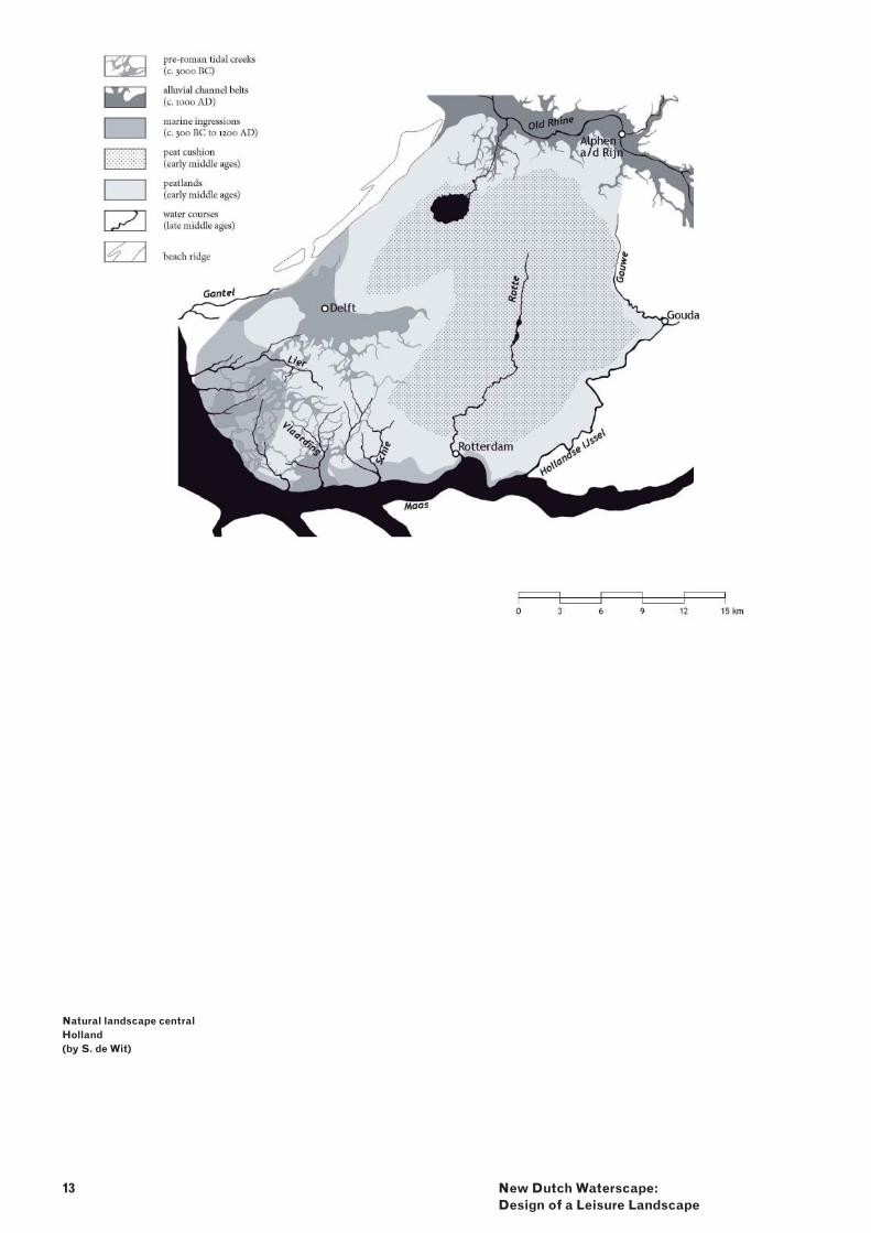
Natural landscape central Holland(by S. de Wit)
14
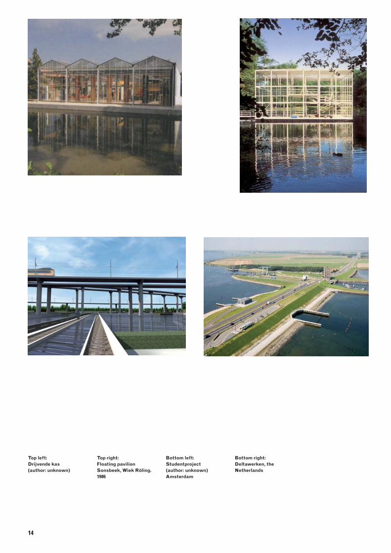
Top left: Drijvende kas(author: unknown)
Top right:Floating pavilion Sonsbeek, Wiek Röling. 1986
Bottom left:Studentproject(author: unknown) Amsterdam
Bottom right:Deltawerken, the Netherlands
LEARNING OBJECTIVES
Knowledge of:- form, construction, function and typology of the Dutch Lowlands;- mapping of landscape and landscape elements;- landscape engineering techniques (planting and water);- landscape development processes and related design strategies;- landscape architectonic design and materialisation of large scale area.
Ability:- to make a landscape analysis;- to recognise critical features and processes of a landscape and use them in a design proposal;- to research the feasibility of different programmes;- to integrate cultural and visual elements into a landscape design proposal;- to use landscape architectural instruments for large-scale landscapes;- to create a landscape architectonic design from regional scale to detail.
FINAL PRODUCT
3 A1 panels containing:- imaginary landscape plus A4: drawing, collage or painting of an attractive landscape (colour – no computer);
analysis of the landscape in layers: natural -layer, cultivated layer, with special attention to the water system and urban layer (black and white), the landscape architectonic elements have to be identifi ed in the analysis; conceptual drawing of your design (black -and white);situation drawing of the leisure -interventions 1:1000 / 1:500;spatial plan of the design, the total -composition;zoom in plan 1:500 / 1:200; -sections 1:500 / 1: 200 and 1/20; -detail(s) and materialisation of highway, -routing and water element 1: 50 / 1:20;bird’s eye view of the total plan; -short text and keywords clarifi cation of your -design.
CRITERIA AND DISCUSSION
explicit relationship between specifi c -context and design (external coherence);consistency within the design (internal -coherence);inventiveness; -unity in design methods (methodical -coherence); consistency from concept to fi nal design;clarity of design ; -emphasis and tension; -choice and implementation of programme; -control of landscape architectural -design tools; technical and landscape architectonic;analytical research attitude; -preciseness and conciseness; -authority in relation to references, image -types, existing design methods, history;presentation techniques and clarity of -presentation by drawings (particularly the black and white ones) and orally.
15 New Dutch Waterscape: Design of a Leisure Landscape
16
LECTURE SERIES AR1LA060 -INTRODUCTION
In the lecture series the development of the Dutch land-making process and Dutch landscape architectonic design will be explained and analysed against the background of updating land use and the new interrelationship between landscape and city.The proposition that the landmaking process (the condition of the Dutch Lowlands) produced a specifi c Dutch Landscape Architecture will be discussed.
LANDSCAPE ARCHITECTURE
2:
DUTCH LANDSCAPE
ARCHITECTURE
17 Landscape Architecture 2: Dutch Landscape Architecture
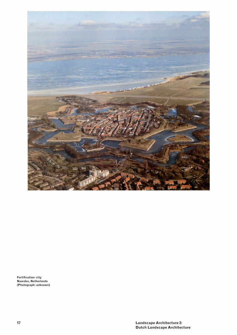
Fortifi cation- city Naarden, Netherlands(Photograph: unknown)
18
LECTURES
Water inSight – Inge Bobbink1. The dynamics of river and sea on sand, clay and peat formed the Dutch delta. On a journey through time this development of the Dutch landscape will be described. By explaining the landmaking process as a landscape architectonic action the discussion, if reclamation of land generates typical Dutch landscape architectonic design will be opened. Fundamental research on the polder landscape conducted by the chair of Landscape Architecture will reveal the ongoing process of designed and not designed landscape transformations.
Grand Work – Eric Luiten2. Dutch landscape architecture stands on two legs: fi rstly, the tradition of the virtuoso that developed in the context of garden and park construction, and secondly, the tradition of the utilitarian that had its origins in large-scale land reclamation, land protection and land re-allotment projects. This second ‘leg’ will be covered in more detail in a lecture in which we see a timid and servile planting profession develop into a self-assured comprehensive design expertise. Three historical phases will be presented:
land reclamation: adding a green third -dimension;land re-allotment: serving historical and -natural values;land adjustment: comprehensive rural -development.
Leisure Landscapes – Dirk Sijmons3. Leisure can be seen as the oldest motive and indeed the oldest commissioner for garden, park and landscape architecture. In the late 19th century parts of the natural landscape, such as the beach, forest, and river were developed and cultivated as leisure landscapes. Today Leisure and Tourism are the biggest single economic sector in the world. Landscapes are an important factor in the tourist product. How does leisure infl uence the European Landscapes?
Achievable landscape of the Netherlands4. (Maakbaar Nederland) - Fransje HooimeyerAfter the Second World War when welfare started, a new generation of landscape architects emerged. They all worked on large-scale themes: agriculture, city green, recreation, infrastructure and new nature – commissioned by the state. Names like: Hans Warnau, Pieter Buys, Wim Boer, Mien Ruys, Harry de Vroome and Nico de Jonge founded the profession of landscape architect in the Netherlands.
Practice 5. Today, young Dutch landscape architects, educated by these people are commissioned for projects around the world. We will invite guest speakers to display their recent work and refl ect on their position within the tradition of Dutch landscape architects.
19 Landscape Architecture 2: Dutch Landscape Architecture
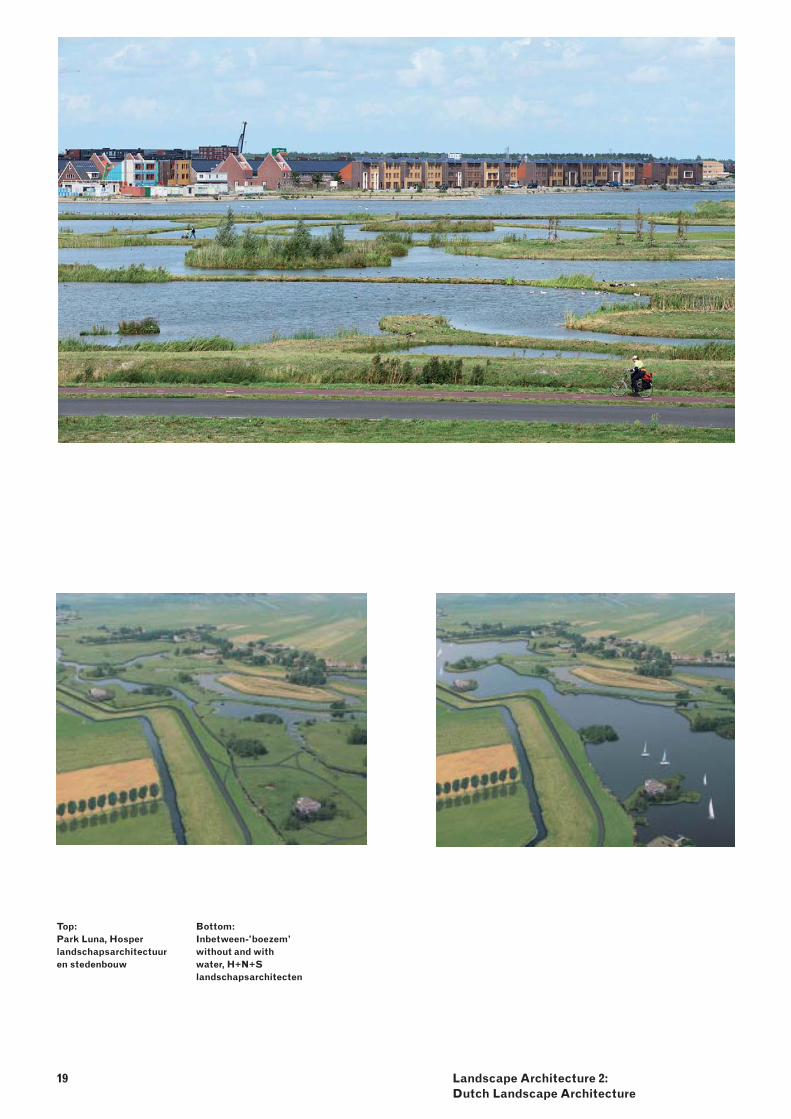
Top:Park Luna, Hosper landschapsarchitectuur en stedenbouw
Bottom:Inbetween-’boezem’ without and with water, H+N+S landschapsarchitecten
20
ASSIGNMENT
keywords: mapping, polder landscape, typology, transformation, water management, Fine Dutch Tradition, Dutch design, scale
Using the input of the lectures students are asked to write a concluding essay about their idea of ‘typical Dutch’ landscape architecture. Does it still exist today in our global world? The essay should be a critical refl ection on the transformation of the cultivated landscapes into architectonic landscape design. Students are asked to choose three or four designs to discuss in this essay as being exemplary to underpin their ideas about landscape architecture in the Netherlands.
The following issues should be discussed in the essay:
history and development of the Dutch -landscape Architecture and its topography;tradition, development and form of land -reclamation;water management and landscape -refurbishment ;the form and development of manmade -landscapes; landscape development and design -instruments;landscape and public open space; -landscape and new programme, -possibilities of double use;landscape and sustainability. -
schedule weeks 1- 6 lectures -summarise each lecture after the -presentation
weeks 7 and 8 discussion meetings determine theme (context and subject) -research question -structure the assignment (contents) -select examples -state aim -make a plan -writing, documentary and analytical -drawingsbibliography -
METHOD
lecture and essayThe concluding essay demands a critical attitude towards the relationship between Dutch landscape and Dutch landscape architecture, and is the basis for a lively discussion on the topic.
LEARNING OBJECTIVES
Understanding:the difference between landscape -development and landscape design;the relationship between infrastructure -(water and roads) and landscape development;landscape analysis methods; -the formative principles of landscape and -Dutch landscape architecture;the relationship between water -management and landscape form.
Ability: to distinguish the various types of natural -and manmade forms and processes in the landscape;to distinguish various landscapes, -landscape elements and types;to select criteria and instruments for -landscape design.
PRODUCTS
The essay should contain critical refl ections on Dutch landscape architecture.
approximately 3000 words, -including images and own analytical -drawings.
EVALUATION CRITERIA
structure (unity, coherence, sequence, -tension);style of writing (clarity, conciseness, -preciseness, depth, landscape architectonic terminology);authority (link between opinion and existing -literature, argumentation);understanding of landscape architectonic -theories and history (contents, examples);presentation (layout, use of text and -images).
21 Landscape Architecture 2: Dutch Landscape Architecture
Screen- print google ‘Dutch Landscape Architecture’ – images
22
SEMINAR AR1LA070 - INTRODUCTION During the seminar different seminal texts in contemporary landscape architectural theory and practice will be examined and discussed. The course focuses on the study of relationships among architecture, landscape, art and urbanism from a landscape architectonic point of view. Refl ecting ideas on landscape is an examination of how contemporary (urban) landscapes are designed, constructed, and culturally valued by landscape architects. The course addresses the theoretical backgrounds of architectural composition of the Dutch and international urban landscape, dealing with the contemporary spatial demands derived from the social, economic and technological development of society, as well as new methods and instruments for landscape research and design. The central question is: How do contemporary landscape architects deal with landscape development in terms of landscape architectural theory and practice?
In the course students learn the different professional ways of viewing landscapes and investigate them as designed constructions. Among other things, the landscape architectural theory and practice of the “Delft approach” will be introduced and examined. In this approach the landscape is seen as an object of design, approaching it through study of form and composition. The focus is not only on what (urban) architecture does with the landscape, but also what infl uence the landscape exerts on architecture, thereby exposing how the point of departure for a genuine design culture lies in a merger of the two.
REFLECTING IDEAS ON
LANDSCAPE:
CONTEMPORARYTHEORY
23 Refl ecting ideas on Landscape:Contemporary Theory
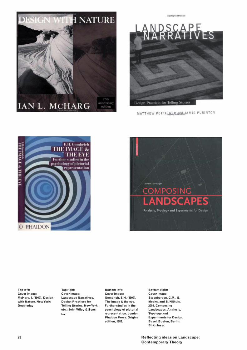
Top left:Cover image:McHarg, I. (1969), Design with Nature. New York: Doubleday
Top right:Cover image: Landscape Narratives. Design Practices for Telling Stories. New York, etc.: John Wiley & Sons
Inc.
Bottom left:Cover image: Gombrich, E.H. (1999), The image & the eye. Further studies in the psychology of pictorial representation. London: Phaidon Press. Original edition, 1982.
Bottom right:Cover image: Steenbergen, C.M., S. Meeks, and S. Nijhuis. 2008. Composing Landscapes. Analysis, Typology and Experiments for Design. Basel, Boston, Berlin: Birkhäuser.
METHOD AND ASSIGNMENT
The course consists of different assignments that deliver material that can be discussed in the group and helps to develop an individual design attitude. In this quarter, theory, method and technique in landscape architecture will be examined by analysing different texts selected and focussed on the themes:
Paradigms in landscape architecture1. Form, meaning and experience of landscape2. Graphic knowledge representation,3. Quality of space, 4. Ecological design and aesthetics of 5. sustainability, and Landscape Urbanism. 6.
We address the fi rst three themes in this quarter.
1. Paradigms in landscape architecture Fundamental theories and knowledge of landscape architecture:
Hubbard, H.V., T. Kimball (1935), An Introduction -to the study of Landscape Design. Revised ed. New York: The Macmillan CompanySteenbergen, C.M., W. Reh (2003), Architecture -and landscape. The Design Experiment of the Great European Gardens and Landscapes. Revised and expanded edition. Basel, Boston, Berlin: BirkhäuserVrijlandt, P., K. Kerkstra (1976), Mergelland. -Landschap en mergelwinning (3 dln.). Wageningen: Vakgroep Landschapsarchitectuur, Landbouwhogeschool Wageningen
2. Form, meaning and experience of landscapeInterpretations of landscape, and related ideas of site, place, region as if they were a language, text, or narrative:
McHarg, I. (1969), Design with Nature. New York: -DoubledayPotteiger, M. (1998), Landscape Narratives. -Design Practices for Telling Stories. New York, etc.: John Wiley & Sons Inc.Spirn, A.W. (1998), The Language of Landscape. -New Haven / London: Yale University Press.
24
3. Graphic knowledge representationExploring the landscape by means of drawings, text, images and designed landscapes themselves:
Corner, J. (1992), ‘Representation and -Landscape: Drawing and making in the landscape medium’, in: Word & Image 8(3), 243-275Cross, N. (2006), Designerly Ways of Knowing. -London: Springer-Verlag.Gombrich, E.H. (1999), The image & the eye. -Further studies in the psychology of pictorial representation. London: Phaidon Press. Original edition, 1982.
Every week there will be a thematic session of three verbal presentations. Three groups of two students will prepare a verbal presentation of 10-15 minutes addressing the assigned text. During the presentation the text will be summarised, analysed, discussed and illustrated with examples (e.g. plans, images, fi lm, literature) . Two other students will be required to pose questions and give a critical refl ection.
Finally, every student is expected to write an essay that refl ects the in-depth understanding, critical refl ection and scientifi c attitude towards theory in landscape architecture. This critical refl ection will lead to a sharper understanding of their own abilities and knowledge, makes the individual way of working more transparent, and helps to develop an individual design attitude and adopt a position.
scheduleWeek 2 introduction and assignment -Week 3 Presentations paradigms in -landscape architectureWeek 4 Presentations form, meaning and -experience of landscapeWeek 5 Presentations graphic knowledge -representationWeek 6 Submit essay of 1500-2000 words -
(secretariat Urbanism, Margo v/d Helm)
25 Refl ecting ideas on Landscape:Contemporary Theory
LEARNING OBJECTIVES
knowledge: of the theory, methods and instruments of -landscape architecture; of the fi ne arts in relation to landscape and -landscape architecture; of other disciplines involved in spatial -design, namely architecture and urbanism.
skills : in communicating a plan to others using -visual, written and verbal methods.
refl ection: on the relationship architecture/urbanism - -landscape architecture; understanding the profession of the -landscape architect and the role of the landscape architect in society.
CRITERIA FOR GRADING
the amount and quality of in-depth -understanding, critical refl ection and scientifi c attitude towards landscape architectural theory; the clarity in which the work comes across -in images and verbal explanation; depth of understanding of theoretical -knowledge and critical attitude by means of a written essay; the clarity, structure and scientifi c attitude -refl ected in the written text.
LITERATURE AND STUDY MATERIALS
Compulsory:Steenbergen, C.M., and W. Reh. 2003. -Architecture and landscape. The Design Experiment of the Great European Gardens and Landscapes. Revised and expanded edition. Basel, Boston, Berlin: Birkhäuser.
Reader: Landscape Architectural Theory and Practice -(provided)
Recommended:Steenbergen, C., Mihl, H., Reh, W., Aerts, -F. (eds.) 2002. Architectural Design and Composition. Bussum, THOTH Publishers.Corner, J., (ed.) 1999. Recovering Landscape. -Essays in Contemporary Landscape Architecture. New York: Princeton Architectural Press.Institute for Landscape Architecture, ETH -Zurich. 2005. Landscape Architecture in Mutation. Essays on urban landscapes. Zurich: gta Verlag.Steenbergen, C.M., S. Meeks, and S. Nijhuis. -2008. Composing Landscapes. Analysis, Typology and Experiments for Design. Basel, Boston, Berlin: Birkhäuser.Swaffi eld, S., (ed.) 2002.Theory in Landscape -Architecture. A Reader. Philadelphia: University of Pennsylvania Press.Treib, M., (ed.) 1993. Modern Landscape -Architecture: A critical review. Cambridge and London: The MIT Press.
26
WORKSHOP AR1LA080 - INTRODUCTION
In the workshop students research, through different design experiments, the spatial and visual landscape architectonic effects of the polder water. The existing polder water and water works have to be detected and by adding extra (storage)water and water related buildings the identity of the polder landscape is tested and determined. Water has always been one of the most important formative forces of the Dutch landscape. It is an inseparable part of the polder landscape and accounts for its general identity. The polder water is more visible in the rural area than in the urban fi eld, despite the fact that both areas are based on polder (water)structures. In history the water design used to be the starting point for each settlement, unavoidable: exploitation of land meant managing the water. Typical Dutch water cities built centuries ago (described in ‘Atlas of Dutch watercities’ by H. Meyer and F. Hooimeyer and A. Nienhuis) are today still valued for their beauty and heritage of the Dutch identity. These cities, as well as some of the lake-bed and peat polders, bear witness to the water design knowhow among the Dutch.However, in the last sixty years, water design was practically reduced to water management, left to the technical approach of civil engineers. The water table, even in a polder, was highly manipulated in order to maximise agricultural output. Water in the urban area was hidden underground.In the past, water in the polder, in addition to its drainage function, used to have many more purposes: a structure to situate a farm or a house on; an element of transport; a place for specifi c plants and animals. Its drainage function was expressed by visible waterworks, which could be understood by the inhabitants.Luckily, interest in water as part of a design is shifting as a result of increased concern about climate change. Today’s climate is more extreme (more heavy rainfall and more dry periods) and this means more problems for polders (‘bath tubs’). The polder water system has not been designed to cope with these conditions and needs to be adapted to this new reality.Architects, urban planners and landscape architects are challenged to develop new designs whereby the links between water technique, water structure (pattern), water form and program interconnects are forged again.
LANDSCAPE COMPONENT:
THE FORM OF THE DUTCH
POLDER WATER
27 Landscape Component: the Form of the Dutch Polder Water
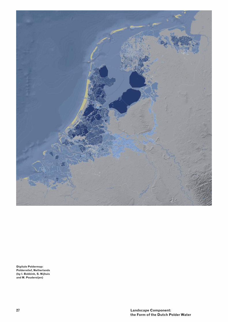
Digitale Poldermap: Polderrelief, Netherlands(by I. Bobbink, S. Nijhuis and M. Pouderoijen)
28
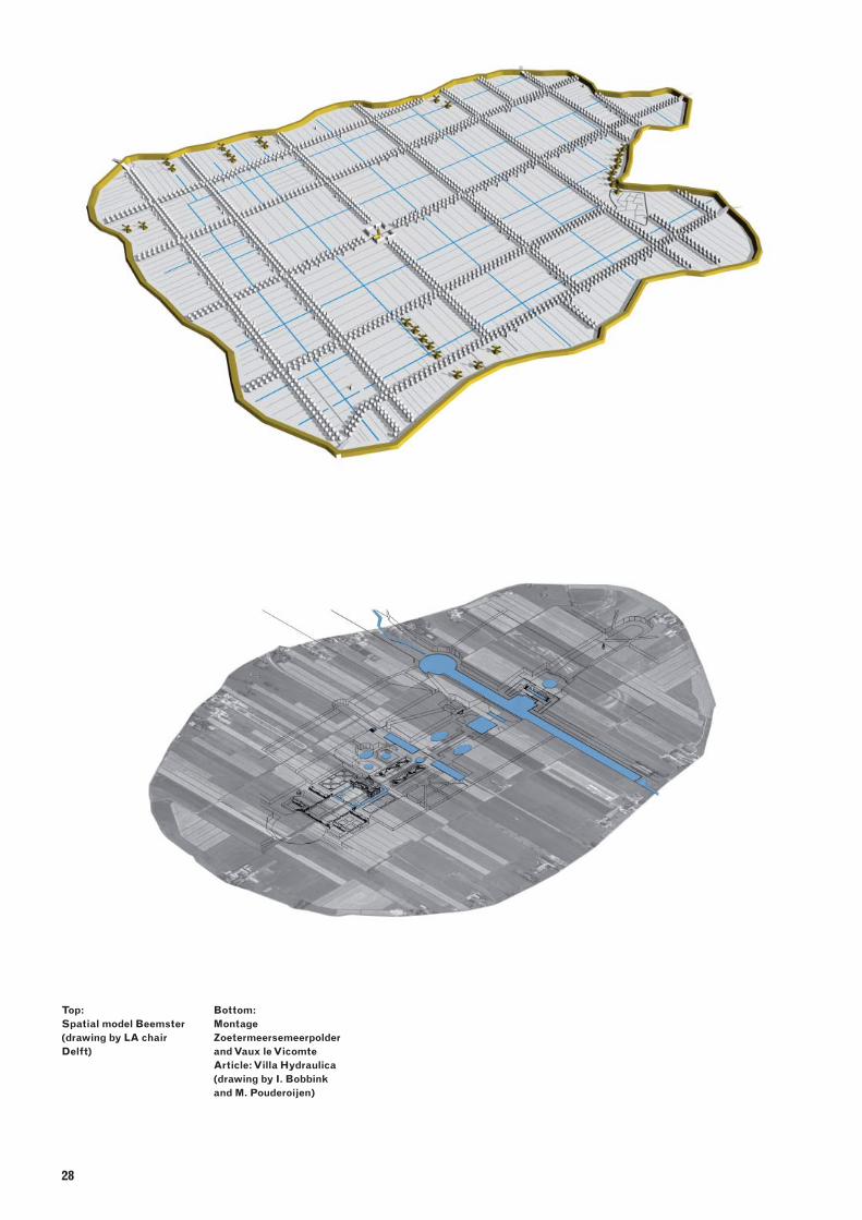
Top:Spatial model Beemster (drawing by LA chair Delft)
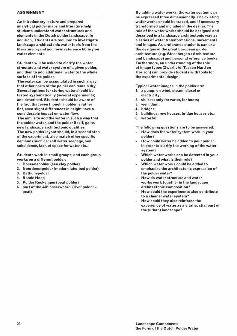
Bottom:Montage Zoetermeersemeerpolder and Vaux le VicomteArticle: Villa Hydraulica (drawing by I. Bobbink and M. Pouderoijen)
29 Landscape Component: the Form of the Dutch Polder Water
ASSIGNMENT
An introductory lecture and prepared analytical polder maps and literature help students understand water structures and elements in the Dutch polder landscape. In addition, students are required to investigate landscape architectonic water tools from the literature or/and your own reference library on water elements.
Students will be asked to clarify the water structure and water system of a given polder, and then to add additional water to the whole surface of the polder. The water can be accumulated in such a way that other parts of the polder can remain dry. Several options for storing water should be tested systematically (several experiments) and described. Students should be aware of the fact that even though a polder is rather fl at, even slight differences in height have a considerable impact on water fl ow.The aim is to add the water in such a way that the polder water, and the polder itself, gains new landscape architectonic qualities.The new polder layout should, in a second step of the experiment, also match other specifi c demands such as: salt water seepage, soil subsidence, lack of space for water etc..
Students work in small groups, and each group works on a different polder:
Borsselepolder (sea clay polder)1. Noordoostpolder (modern lake-bed polder)2. Bethunepolder 3. Ronde Hoep 4. Polder Kockengen (peat polder) 5. part of the Alblasserwaard (river polder – 6. peat)
By adding water works, the water system can be expressed three dimensionally. The existing water works should be traced, and if necessary transformed and included in the design. The role of the water works should be designed and described in a landscape architectonic way as a series of water transformations, movements and images. As a reference students can use the designs of the great European garden architecture (e.g. Steenbergen : Architecture and Landscape) and personal reference books. Furthermore, an understanding of the role of image types (Zwart v/d: Tussen Hard en Horizon) can provide students with tools for the experimental design.
Typical water images in the polder are:a pump: on wind, steam, diesel or 1. electricity;sluices: only for water, for boats;2. weir, dam;3. bridges;4. buildings: row houses, bridge houses etc.;5. waterfall.6.
The following questions are to be answered:How does the water system work in your -polder? How could water be added to your polder -in order to clarify the working of the water system?Which water works can be detected in your -polder and what is their role? Which water works could be added to -emphasise the architectonic expression of the polder water?How do water structure and water -works work together in the landscape architectonic composition?How could the experiments also contribute -to a cleaner water system? How could they also reinforce the -experience of water as a vital spatial part of the (urban) landscape?
LEARNING OBJECTIVES
Understanding: the landscape architectonic dimension of -scale, space and material.
Knowledge:of the technical aspects of water systems. -of the ecological (including plants) aspects -of a water system.
Skills:different methods of scientifi c research on -landscape architecture.communication using visual, written and -verbal means.
PRODUCTS
Portfolio contains:technical drawings (explanation) of the -existing and the new water system;series of experiments on additional water in -plan and section on the scale of the polder as a whole;selection of classical garden water -elements and a translation of them into polder water works;3D drawing of existing and extra water and -water works on the scale of the polder as a whole;3D in close-up detail of a water work in plan, -section and 3D drawing (1:200).
CRITERIA
link between context and design; -clarity of technical drawing; -methodological approach (series of -experimental drawings);command of landscape architectonic design -tools (water works);external coherence: problem analysis -refl ected in the design;internal coherence: creativity, consistency -and logic in the design;structure of portfolio (unity, coherency and -sequence);presentation of the work: verbal, drawings -and other.
30
METHOD
The work is part of the research on ‘Articulating the form of the Dutch polder water’.
interpretation 1. the basic form In the given map the plan of the polder is confronted with an abstraction of the natural landscape.- description and interpretation of the map.
analyses2. By reading the water map (from the water board) and the map of the basic form students can make a technical drawing of how the drainage and the inlet system work.
experiment: adding water 3. - testing different water plan compositions step by step;- adding problems inherent to the polder to the plan.
comparative study: the classical garden as 4. referencemetaphorical fromThe spatial design of the polder can be articulated even more strongly by using knowledge of the classical garden.- draw the archetypes of the metaphorical elements and possible translations of the polder water.
design: water plan and water works spatial form5. The architectonic form and the spatial effect of the polder water should be revealed in 3-D drawings.
visualisation6. bird’s eye view of the whole polder and of some details.

NOTES
31 Landscape Component: the Form of the Dutch Polder Water
Dutch Lowlands - Required literature
Reader: Landscape -Architectural Theory and Practice (provided)Steenbergen, C.M., and -W. Reh. 2003. Architecture and landscape. The Design Experiment of the Great European Gardens and Landscapes. Revised and expanded edition. Basel, Boston, Berlin: Birkhäuser.Steenbergen C. and Reh W. -(2009) , The polderatlas, Thoth
Dutch Lowlands-Recommended literature
Corner, J., (ed.) 1999. -Recovering Landscape. Essays in Contemporary Landscape Architecture. New York: Princeton Architectural Press.Institute for Landscape -Architecture, ETH Zurich. 2005. Landscape Architecture in Mutation. Essays on urban landscapes. Zurich: gta Verlag.Lohrer, A. 2008. Designing wih -water. Basel, Boston, Berlin: Birkhäuser.Luiten, E. Grand Work: in -Bolhuis van P; (2007) Invented Land, Uitgeverij Blauwdruk, WageningenMeyer, H. Bobbink, I. Nijhuis, -S. 2010. Delta Urbanism, the Netherland. Chicago, APA planners press.Moens R., Map study: in Jong -T.M. de and Voordt D.J.M. van der; eds. (2002) Ways to study and research, Delft University PressSijmons D., a. o. (2008), -Greetings from Europe, landscape @ leisure, 010 Publishers
Steenbergen, C.M., S. -Meeks, and S. Nijhuis. 2008. Composing Landscapes. Analysis, Typology and Experiments for Design. Basel, Boston, Berlin: Birkhäuser.Steenbergen, C., Mihl, H., -Reh, W., Aerts, F. (eds.) 2002. Architectural Design and Composition. Bussum, THOTH Publishers.Swaffi eld, S., (ed.) 2002. -Theory in Landscape Architecture. A Reader. Philadelphia: University of Pennsylvania Press.Treib, M., (ed.) 1993. Modern -Landscape Architecture: A critical review. Cambridge and London: The MIT Press.Wit S. de . (2009), Dutch -Lowlands, SUN
Dutch Lowlands - contact information
Design projectInge [email protected] -Silvia [email protected] [email protected]
Lecture seriesInge [email protected] [email protected]
SeminarSteffen [email protected]
WorshopInge [email protected] -Thorsten Schütze [email protected]
Student assistantSven van [email protected] [email protected]
Secretary UrbanismMargo v/d [email protected]
Disclaimer:Some of the authors of the used images are unknown. For copyright please contact the publishing organisation.
32