Sea Lamprey Dissection Sea Lamprey Dissection Petromyzon maPetromyzon marinus.
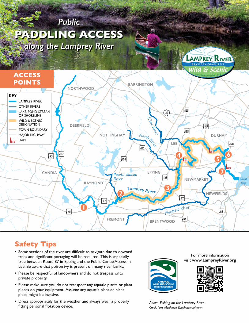
LAMPREY RIVER
OTHER RIVERS
LAKE, POND, STREAMOR SHORELINE
WILD & SCENIC DESIGNATION
TOWN BOUNDARY
MAJOR HIGHWAY
DAM
KEY
NOTTINGHAM
BARRINGTON
LEE
DURHAM
NEWMARKET
NEWFIELDS
EPPING
DEERFIELD
FREMONT BRENTWOOD
RAYMOND
CANDIA
NORTHWOOD
GreatGreatBayBay
GreatBay
0 1 4 8
LLiittttllee RRiivveerr
PPiissccaassssiicc RRiivveerr
LLaammpprreeyy RRiivveerr
NNoorrtthh RRiivveerr
PawtuckawayPawtuckawayRiverRiverPawtuckawayRiver
Little River
Piscassic River
Lamprey River
North River
4
43
125
125
101
101
152
107
108
8727
85
155
155A
156
ACCESS POINTS
PublicPADDLING ACCESS
along the Lamprey River
PublicPADDLING ACCESS
along the Lamprey River
Safety Tips• Some sections of the river are difficult to navigate due to downed
trees and significant portaging will be required. This is especially true between Route 87 in Epping and the Public Canoe Access in Lee. Be aware that poison ivy is present on many river banks.
• Please be respectful of landowners and do not trespass onto private property.
• Please make sure you do not transport any aquatic plants or plant pieces on your equipment. Assume any aquatic plant or plant piece might be invasive.
• Dress appropriately for the weather and always wear a properly fitting personal flotation device.
For more information visit www.LampreyRiver.org
Above: Fishing on the Lamprey River. Credit: Jerry Monkman, Ecophotography.com

Welcome!The Lamprey River flows 49 miles, from Northwood to Newmarket and out to Great Bay. The entire river and its major tributaries are protected under the N.H. Rivers Management and Protection Program. Twenty three miles of the main stem Lamprey River (from West Epping to the confluence of the Lamprey and Piscassic rivers in Newmarket) are also part of the National Wild and Scenic Rivers System, making this section significant not only to New Hampshire but also to the United States.
Access PointsRaymond
Raymond Eco-center/Carroll Lake BeachLOCATION: Behind Lamprey River Elementary School, 33 Old Manchester Rd. N43.034190, W71.193750PARKING: 5–6 cars off road. No trailer turn-around. Launch is about 300 feet from parking area.RULES/NOTES• Open only when school is not is session. When school
is in session, evening hours and weekends only. • Carry-in only.• Sandy beach, launch into slow, open water.
Epping Mary Blair Park
LOCATION: Near Lamprey River crossing with Route 27 in West Epping. N43.0407, W71.1274 PARKING: 40–50 cars off road. Trailer turn-around if park-ing area isn’t crowded for baseball games. Launch is about 75 feet from closest parking.RULES/NOTES• Carry-in only. • Launch is gravel with moderate slope.• White water is just upstream of launch. Slow, open
water downstream. • Starting point of Lamprey River Canoe Race.
Tilton Conservation AreaLOCATION: Route 87 crossing. N43.049525, W71.032489PARKING: 8 cars off road. No trailer turn-around. Launch is about 20 feet from parking. RULES/NOTES• Carry-in only. • Official launch is eroded rip-rap. Informal launch is a
dirt path.• Downstream: Caution is needed to avoid entrapment
in downed trees or portaging up steep slopes with poison ivy.
• End point of Lamprey River Canoe Race.
DurhamLOCATION: Flat-water paddling upstream from Schoppmeyer and Piscassic boat launches in Newmarket to the Packers Falls area. PARKING: Not applicable.
Lee Lee Public Canoe Access
LOCATION: Route 152 near Wadleigh Falls. N43.091561, W71.010061PARKING: 8 cars along road. Launch is within 20 feet. RULES/NOTES• Carry-in only. • Launch is made of granite steps. No railing or boat slide
available. • Dangerous falls are 1/8 mile downstream. Upstream
is clear for about 1 mile, then marked by numerous downed trees. No public portage at falls.
Newmarket Piscassic Park
LOCATION: Elm St. to Beech St. to Salmon St., N43.08839200, W70.94180600PARKING: 8–10 cars. Trailer turn-around available. Launch is about 20 feet from parking.RULES/NOTES• Carry-in and trailer launch.• Launch into open, slow water. • This is where the Piscassic and the Lamprey join. • Kayaks on site available to rent. Reserve & get key
in advance from Newmarket Rec. 603-659-8581; [email protected]
Schoppmeyer Memorial ParkLOCATION: Behind Newmarket Community Church Thrift Store, 10 North Main St. (Rte. 108). N43.087494, W70.934331PARKING: 7–8 cars. Launch is about 1/10 mile (530 feet) down a mowed grass path from park-ing area. Please do not trespass onto the gravel roadway. RULES/NOTES
• Carry-in only.• Boats must be launched from a floating dock; kayak
entry and exit assistance device available. • Kayaks on site available to rent. Reserve & get key in
advance from Newmarket Rec. 603-659-8581; [email protected]
Schanda ParkLOCATION: Schanda Park, end of Water St. N43.077925, W70.935617PARKING: 12 cars. Designated trailer parking.RULES/NOTES• Carry-in and trailer launch. • Launch into tidal water. Be sure to check tides if
heading out to Great Bay. • Public toilets normally available in summer. • Kayaks on site available to rent. Reserve & get key in
advance from Newmarket Rec. 603-659-8581; [email protected]
USE Mowed Path
Access
DO NOT USEPrivate
Driveway