
Public Draft CEQA Initial Study/Mitigated Negative Declaration
159
2775 North Ventura Road, Suite 100 Oxnard, California 93036 805-973-5700 FAX: 805-973-1440 Public Draft CEQA Initial Study/Mitigated Negative Declaration City of Ventura Eastside to Westside Waterline Interconnection Project June 2020 Prepared for City of San Buenaventura Public Works Department 501 Poli Street Ventura, CA 93001 K/J Project No. 1844210*00
Transcript of Public Draft CEQA Initial Study/Mitigated Negative Declaration
2775 North Ventura Road, Suite 100 Oxnard, California 93036
805-973-5700 FAX: 805-973-1440
Public Draft CEQA Initial Study/Mitigated Negative Declaration
City of Ventura
Eastside to Westside Waterline Interconnection Project
June 2020
Prepared for
City of San Buenaventura Public Works Department
501 Poli Street Ventura, CA 93001
K/J Project No. 1844210*00

ii Eastside to Westside Waterline Interconnection, CEQA IS/MND g:\projects\2018\1844210 00_ventura environmental review e w waterline interconnection\09-reports\9.09-reports\public draft is_mnd\ventura east to west waterline is_mnd report_public draft.doc
Table of Contents
List of Tables ................................................................................................................................. v
List of Figures............................................................................................................................... vi
List of Appendices ........................................................................................................................ vi
List of Acronyms .......................................................................................................................... vii
Section 1: Mitigated Negative Declaration ................................................... 1
1.1 Organization of this IS/MND ................................................................... 6
Section 2: Project Description ....................................................................... 7
2.1 Overview of the Proposed Project .......................................................... 7 2.2 Project Objectives .................................................................................. 8 2.3 Project Location ..................................................................................... 8 2.4 Project Components ............................................................................. 20
2.4.1 Eastside to Midtown Pipeline Segment ..................................... 20 2.4.2 Midtown to Westside Pipeline Segment .................................... 20
2.5 Project Construction and Operation Activities ...................................... 21 2.5.1 Construction Activities ............................................................... 21 2.5.2 Construction Schedule .............................................................. 25
2.6 Operation and Maintenance of New Facilities ...................................... 26 2.7 Purpose and Intended Uses of the IS/MND ......................................... 26 2.8 Project Design Features/Applicant Proposed Measures ...................... 26
2.8.1 Permits Potentially Required to Implement the Project ............. 28
Section 3: Environmental Checklist ............................................................ 29
3.1 Initial Study Checklist ........................................................................... 29 3.1.1 AESTHETICS ............................................................................ 29
3.1.1.1 Environmental Setting ............................................. 29 3.1.1.2 Regulatory Setting .................................................. 30 3.1.1.3 Impact Analysis ....................................................... 30 3.1.1.4 Mitigation Measures ................................................ 32 3.1.1.5 Significance After Mitigation ................................... 32
3.1.2 AGRICULTURAL AND FORESTRY RESOURCES ................. 33 3.1.2.1 Environmental Setting ............................................. 33 3.1.2.2 Regulatory Setting .................................................. 33 3.1.2.3 Impact Analysis ....................................................... 35 3.1.2.4 Mitigation Measures ................................................ 37 3.1.2.5 Significance After Mitigation ................................... 37
3.1.3 AIR QUALITY ............................................................................ 38 3.1.3.1 Environmental Setting ............................................. 38 3.1.3.2 Regulatory Setting .................................................. 38

Table of Contents (cont'd)
Eastside to Westside Waterline Interconnection, CEQA IS/MND iii
3.1.3.3 Impact Analysis ....................................................... 40 3.1.3.4 Mitigation Measures ................................................ 45 3.1.3.5 Significance After Mitigation ................................... 46
3.1.4 BIOLOGICAL RESOURCES ..................................................... 47 3.1.4.1 Environmental Setting ............................................. 47 3.1.4.2 Regulatory Setting .................................................. 56 3.1.4.3 Impact Analysis ....................................................... 58 3.1.4.4 Mitigation Measures ................................................ 63 3.1.4.5 Significance After Mitigation ................................... 64
3.1.5 CULTURAL RESOURCES ....................................................... 65 3.1.5.1 Environmental Setting ............................................. 65 3.1.5.2 Regulatory Setting .................................................. 65 3.1.5.3 Impact Analysis ....................................................... 67 3.1.5.4 Mitigation Measures ................................................ 70 3.1.5.5 Significance After Mitigation ................................... 71
3.1.6 ENERGY ................................................................................... 72 3.1.6.1 Environmental Setting ............................................. 72 3.1.6.2 Regulatory Setting .................................................. 72 3.1.6.3 Impact Analysis ....................................................... 72 3.1.6.4 Mitigation Measures ................................................ 74 3.1.6.5 Significance After Mitigation ................................... 74
3.1.7 GEOLOGY AND SOILS ............................................................ 75 3.1.7.1 Environmental Setting ............................................. 75 3.1.7.2 Regulatory Setting .................................................. 75 3.1.7.3 Impact Analysis ....................................................... 77 3.1.7.4 Mitigation Measures ................................................ 80 3.1.7.5 Significance After Mitigation ................................... 80
3.1.8 GREENHOUSE GAS EMISSIONS ........................................... 81 3.1.8.1 Environmental Setting ............................................. 81 3.1.8.2 Impact Analysis ....................................................... 81 3.1.8.3 Mitigation Measures ................................................ 84 3.1.8.4 Significance After Mitigation ................................... 84
3.1.9 HAZARDS AND HAZARDOUS MATERIALS ........................... 85 3.1.9.1 Environmental Setting ............................................. 85 3.1.9.2 Regulatory Setting .................................................. 85 3.1.9.3 Impact Analysis ....................................................... 87 3.1.9.4 Mitigation Measures ................................................ 90 3.1.9.5 Significance After Mitigation ................................... 90
3.1.10 HYDROLOGY AND WATER QUALITY .................................... 91 3.1.10.1 Environmental Setting ............................................. 91 3.1.10.2 Regulatory Setting .................................................. 91 3.1.10.3 Impact Analysis ....................................................... 93 3.1.10.4 Mitigation Measures ................................................ 97 3.1.10.5 Significance After Mitigation ................................... 97
3.1.11 LAND USE AND PLANNING .................................................... 98

Table of Contents (cont'd)
iv Eastside to Westside Waterline Interconnection, CEQA IS/MND
3.1.11.1 Environmental Setting ............................................. 98 3.1.11.2 Regulatory Setting .................................................. 98 3.1.11.3 Impact Analysis ....................................................... 98 3.1.11.4 Mitigation Measures ................................................ 99 3.1.11.5 Significance After Mitigation ................................... 99
3.1.12 MINERAL RESOURCES ........................................................ 100 3.1.12.1 Environmental Setting ........................................... 100 3.1.12.2 Regulatory Setting ................................................ 100 3.1.12.3 Impact Analysis ..................................................... 100 3.1.12.4 Mitigation Measures .............................................. 101 3.1.12.5 Significance After Mitigation ................................. 101
3.1.13 NOISE ..................................................................................... 102 3.1.13.1 Environmental Setting ........................................... 102 3.1.13.2 Regulatory Setting ................................................ 106 3.1.13.3 Impact Analysis ..................................................... 109 3.1.13.4 Mitigation Measures .............................................. 115 3.1.13.5 Significance After Mitigation ................................. 115
3.1.14 POPULATION AND HOUSING ............................................... 116 3.1.14.1 Environmental Setting ........................................... 116 3.1.14.2 Regulatory Setting ................................................ 116 3.1.14.3 Impact Analysis ..................................................... 116 3.1.14.4 Mitigation Measures .............................................. 117 3.1.14.5 Significance After Mitigation ................................. 117
3.1.15 PUBLIC SERVICES ................................................................ 118 3.1.15.1 Environmental Setting ........................................... 118 3.1.15.2 Regulatory Setting ................................................ 118 3.1.15.3 Impact Analysis ..................................................... 118 3.1.15.4 Mitigation Measures .............................................. 120 3.1.15.5 Significance After Mitigation ................................. 120
3.1.16 RECREATION ......................................................................... 121 3.1.16.1 Environmental Setting ........................................... 121 3.1.16.2 Regulatory Setting ................................................ 121 3.1.16.3 Impact Analysis ..................................................... 121 3.1.16.4 Mitigation Measures .............................................. 122 3.1.16.5 Significance After Mitigation ................................. 122
3.1.17 TRANSPORTATION ............................................................... 123 3.1.17.1 Environmental Setting ........................................... 123 3.1.17.2 Regulatory Setting ................................................ 123 3.1.17.3 Impact Analysis ..................................................... 123 3.1.17.4 Mitigation Measures .............................................. 128 3.1.17.5 Significance After Mitigation ................................. 129
3.1.18 TRIBAL CULTURAL RESOURCES ........................................ 130 3.1.18.1 Environmental and Regulatory Setting ................. 130 3.1.18.2 Impact Analysis ..................................................... 130 3.1.18.3 Mitigation Measures .............................................. 131

Table of Contents (cont'd)
Eastside to Westside Waterline Interconnection, CEQA IS/MND v
3.1.18.4 Significance After Mitigation ................................. 131 3.1.19 UTILITIES AND SERVICES SYSTEMS ................................. 132
3.1.19.1 Environmental Setting ........................................... 132 3.1.19.2 Regulatory Setting ................................................ 132 3.1.19.3 Impact Analysis ..................................................... 133 3.1.19.4 Mitigation Measures .............................................. 135 3.1.19.5 Significance After Mitigation ................................. 135
3.1.20 WILDFIRE ............................................................................... 136 3.1.20.1 Environmental Setting ........................................... 136 3.1.20.2 Regulatory Setting ................................................ 136 3.1.20.3 Impact Analysis ..................................................... 136 3.1.20.4 Mitigation Measures .............................................. 138 3.1.20.5 Significance After Mitigation ................................. 138
3.2 Mandatory Findings of Significance ................................................... 139
Section 4: Mitigation Monitoring and Reporting Plan ............................... 141
Section 5: List of Preparers ....................................................................... 142
Section 6: References ................................................................................ 144
List of Tables
1-1 Summary of Major Construction Activities
1-2 Equipment Anticipated in Construction Areas – Open Cut Method
1-3 Equipment Anticipated in Construction Areas – Trenchless Method
1-4 Project Schedule
1-5 Potentially Required Permits
3.1.2-1 Agricultural Soils Criteria to Determine Significance
3.1.2-2 Evaluate for All Non-Agricultural or Non-Agricultural Operations Projects
3.1.3-1 Construction Emissions
3.1.8-1 Estimated GHG Emissions
3.1.9-1 Schools Within the Vicinity of the Project
3.1.13-1 Noise Measurements
3.1.13-2 City of Ventura Noise Ordinance

Table of Contents (cont'd)
vi Eastside to Westside Waterline Interconnection, CEQA IS/MND
3.1.13-3 Construction Noise Sensitive Receptors
3.1.13-4 Estimated Construction Noise at Sensitive Receptors
3.1.13-5 Vibration Damage Criteria for Buildings
3.1.13-6 Groundborne Vibration General Assessment Standards
3.1.13-7 Typical Vibration Levels General by Construction Equipment
List of Figures
2-1 City of Ventura Water Service Area
2-2A Overall Project
2-2B Eastside to Midtown Alignment
2-2C Midtown to Westside Alignment
2-3 City of Ventura Pressure Zones
3.1.4-1 Project Alignment Assessed for Biological Resources
3.1.4-2 Eastside to Midtown Alignment Assessed for Biological Resources
3.1.4-3 Midtown to Westside Alignment Assessed for Biological Resources
3.1.13-1 Noise Measurement Locations
List of Appendices
A Air Quality/Greenhouse Gas Emissions CalEEMod Modeling Data
B Biological Resources
Desktop Literature Review
Biological Resources Project Photographs
Biological Resources Special-Status Species in Project Alignment
C Cultural Resources
Cultural Resources Study
Cultural Resources Records Search
Cultural Resources Native American Outreach
D Compiled Noise Data

Table of Contents (cont'd)
Eastside to Westside Waterline Interconnection, CEQA IS/MND vii
List of Acronyms
AB Assembly Bill ACI American Concrete Institute ADT average daily trip AEP Association of Environmental Professionals AFY Acre-Feet per Year AMSL Above Mean Sea Level AQMP Air Quality Management Plan AWWA American Water Works Association BAT Best Available Technology BMO Basin Management Objective BMP Best Management Practice BPS Booster Pump Station CAAQS California Ambient Air Quality Standards CAP Climate Action Plan CAPCOA California Air Pollution Control Officers Association CARB California Air Resources Board Casitas Casitas Municipal Water District CBC California Building Code CDFW California Department of Fish and Wildlife CERCLA Comprehensive Environmental Response, Compensation, & Liability Act CESA California Endangered Species Act CEQA California Environmental Quality Act CFGC California Fish and Game Code CGP Construction General Permit CH4 methane City City of SanBuenaventura CMP congestion management plan CNDDB California Natural Diversity Database CNPS California Native Plant Society CO carbon monoxide CO2 carbon dioxide CPD Commercial Planned Development CRHR California Register of Historic Resources CUPA Certified Unified Program Agencies CWA Clean Water Act cy cubic yard dB decibel dBA A-weighted decibel DBH diameter at breast height DOC California Department of Conservation DTSC California Department of Toxic Substances Control EIR Environmental Impact Report

Table of Contents (cont'd)
viii Eastside to Westside Waterline Interconnection, CEQA IS/MND
ESA Endangered Species Act FCGMA Fox Canyon Groundwater Management Agency FTA Federal Transit Association FWHA Federal Highway Administration GHG greenhouse gas HFC hydrofluorocarbon HP horsepower IFI Important Farmland Inventory IS Initial Study ISAG Initial Study Assessment Guidelines LACM Natural History Museum of Los Angeles County Leq equivalent noise level LOS level of service MBTA Migratory Bird Treaty Act MG Million gallons MGD Million gallons per day MLD most likely descendant MMRP Mitigation and Monitoring Reporting Plan MND Mitigated Negative Declaration mph miles per hour MT metric ton MTBA Migratory Bird Treaty Act NAAQS National Ambient Air Quality Standards NAHC Native American Heritage Commission N2O nitrous oxide NM noise measurement NOx nitrogen oxide NPDES National Pollutant Discharge Elimination System NRCS Natural Resources Conservation Service NRHP National Register of Historic Places PFC perfluorocarbon PHT Peak-Hour Trip PM particulate matter PO Professional Office PPV Peak Particle Velocity PRC Public Resources Code Project Eastside to Westside Waterline Interconnection Project PVC polyvinyl chloride Qhf quaternary alluvial fan deposits RCNM Roadway Construction Noise Model RMS root mean squared ROC reactive organic gases RPD Residential Planned Development RWQCB Regional Water Quality Control Board SB Senate Bill

Table of Contents (cont'd)
Eastside to Westside Waterline Interconnection, CEQA IS/MND ix
SCADA Supervisory Control and Data Acquisition SCAQMD South Coast Air Quality Management District SCE Southern California Edison SCAG Southern California Association of Governments SCG Southern California Gas Company SF6 sulfur hexafluoride SGMA Sustainable Groundwater Management Act SLF Sacred Lands File SMARA Surface Mining and Reclamation Act SOAR Save Open Space and Agricultural Resources Sq. Square SCAQMD South Coast Air Quality Management District SSC Species of Special Concern SWP State Water Project SWPPP Stormwater Pollution Prevention Plan SWRCB State Water Resources Control Board TMDL Total Maximum Daily Load UBC Uniform Building Code UCMP University of California Museum of Paleontology USACE United States Army Corps of Engineers USFWS United States Fish and Wildlife Service USGS United States Geological Survey VCAPCD Ventura County Air Pollution Control District VCEHD Ventura County Environmental Health Division VCWPD Ventura County Watershed Protection District VdB vibration decibels VOC volatile organic compound VWRF Ventura Water Reclamation Facility


Eastside to Westside Waterline Interconnection, CEQA IS/MND Page 1 g:\projects\2018\1844210 00_ventura environmental review e w waterline interconnection\09-reports\9.09-reports\public draft is_mnd\ventura east to west waterline is_mnd report_public draft.doc
Section 1: Mitigated Negative Declaration
1. Project Title:
Eastside to Westside Waterline Interconnection
2. Lead Agency/Project Sponsor Name and Address: City of San Buenaventura (City) Public Works Department 501 Poli Street Ventura, CA 93001
3. Contact Person and Phone Number:
Travis Gonsalves, Associate Engineer, 805-654-7765, [email protected]
4. Project Location:
The majority of the proposed project would be located within the City limits, with a small portion in the unincorporated Ventura County (see Figure 2-1).
The project will be conducted in two main pipeline segments; one to bring water from the eastern most portion of the city to the midtown area (Eastside to Midtown), and one to bring the water from the midtown area to the western side (Midtown to Westside). The Eastside to Midtown pipeline would follow Foothill Road between Kimball Road and Elizabeth Road, with a small portion in Kimball Road. The Midtown to Westside pipeline would follow Telegraph Road between Mills Road and Hill Road. See Figures 2-2 A-C (see Section 2).
5. General Plan Designation:
The Eastside to Westside Waterline Interconnection project alignments traverse the following General Plan (2005) designations:
Neighborhood Low up to 8 Units/Acre Neighborhood Medium 9-20 Units/Acre Neighborhood High 21-54 Units/Acre Commerce Public/Institutional Parks & Open Space Agriculture Specific Plan

Page 2 Eastside to Westside Waterline Interconnection, CEQA IS/MND
6. Zoning:
The Eastside to Westside Waterline Interconnection project alignments traverse and run adjacent to the following zoning designations:
C-1 - Limited Commercial C-1A - Intermediate Commercial C-2 - General Commercial CPD - Commercial Planned
Development H - Hospital R-1 - Single Family R-2 - Two-Family
R-3 - Multiple Family RPD - Residential Planned
Development PO - Professional Office T5 - Urban Neighborhood Center T4 - Urban General A - Agriculture AE - Agricultural Exclusive
Zoning is not proposed to change due to this project.
7. Description of Project:
The City of San Buenaventura (City) is proposing to construct the infrastructure necessary to move water from the east end of the City to the west, primarily during westside supply outages and peak demand scenarios. Currently the City’s water system does not have a way to move a sufficient amount of water from the eastside to the westside of the City. The project will be conducted through the installation of close to three miles (15,100 linear feet) of pipeline in two separate alignments. One segment would follow Foothill Road between Kimball Road and Elizabeth Road, with a small portion in Kimball Road. Another segment would follow Telegraph Road between Mills Road and Hill Road. The pipelines would be installed within the existing right-of-way. A detailed project description is provided in Section 2 of this Initial Study.
8. Surrounding Land Uses and Setting:
Land uses along the pipeline alignments are primarily urban (residential and commercial), with some agricultural areas on the eastern end of the City and within County limits. The alignment segments are located within established rights-of-way adjacent to areas zoned as Single-, Two-, and Multiple Family Residential (R-1, R-3), Residential Planned Development (RPD), Professional Office (PO), Commercial (C-1, C-1A, C-2), Commercial Planned Development (CPD), Hospital (H), and Limited Industrial (M-1). A portion of the Eastside to Midtown alignment segment runs adjacent to areas zoned as Agricultural, both within City and unincorporated Ventura County limits. Surrounding land uses include a mix of urban, residential, commercial, and open space areas.

Eastside to Westside Waterline Interconnection, CEQA IS/MND Page 3
9. Public Review:
Copies of the Draft and Final Mitigated Negative Declaration (MND) and Initial Study (IS) are available for public review at:
City of San Buenaventura, Public Works Department 501 Poli Street, Ventura, CA 93001
The documents can also be downloaded in digital format from the City’s website at https://www.cityofventura.ca.gov/450/Current-Environmental-Documents-for-Revi
Hardcopies of the draft document were provided to the following libraries for viewing:
E.P. Foster Library 651 E. Main Street Ventura, CA 93001
Saticoy Library 1292 Los Angeles Avenue
Ventura, CA 93004
It is possible that at the time of this document’s release to the public that the local libraries may still be closed due to the COVID-19 outbreak. The libraries however are accessible online (https://www.vencolibrary.org/elibrary) and every attempt will be made to post this document online through their respective websites.
The public review period for the IS/MND began on July 13, 2020 and closed on August 13, 2020 after a 30-day review period. See Section 2.8.1 for other public agencies whose approval is required.
10. Other Public Agencies Whose Approval is Required
This Initial Study has been prepared in accordance with the 2019 CEQA Guidelines and relevant provisions of the California Environmental Quality Act (CEQA) of 1970, as amended. Further, the Project would comply with the 2005 Ventura General Plan, Municipal Code, Zoning Code, City policies, Uniform Building Code (UBC), California Building Code (CBC), Fire Code and other applicable state regulations. The Project would also use the Best Management Practices (BMP) and is subject to the National Pollution Discharge Elimination System (NPDES), the Regional Water Quality Control Board (RWQCB), the Ventura County Watershed Protection District (VCWPD), and Ventura County Air Pollution Control District (VCAPCD) regulations.
11. Consultation with Native American Tribes
California Public Resources Code section 21080.3.1 and Assembly Bill (AB) 52 establish a formal consultation process for California tribes regarding tribal cultural resources. The consultation process must be completed before a CEQA document can be certified or adopted. Under AB 52, lead agencies are required to “begin consultation with a California Native American tribe that is traditionally and culturally affiliated with the geographic area of the proposed project.” Native American tribes to be included in the process are those that have requested notice of projects proposed within the jurisdiction of the lead agency. The City has

Page 4 Eastside to Westside Waterline Interconnection, CEQA IS/MND
complied with the consultation process for the project. Details are provided in the IS/MND Section 3.1.18 and Appendix C.
12. Mitigation Measures:
All mitigation measures identified in the Initial Study are prepared for adoption as conditions of the project and will be implemented through a mitigation monitoring and reporting program adopted with the MND.

Eastside to Westside Waterline Interconnection, CEQA IS/MND Page 5
ENVIRONMENTAL FACTORS POTENTIALLY AFFECTED:
The environmental factors checked below would potentially be significantly affected by this Project as indicated by the checklist on the following pages.
Aesthetics Agricultural & Forestry Resources Air Quality Biological Resources Cultural Resources Energy Geology and Soils Greenhouse Gas Emissions Hazards & Materials Hydrology & Water Quality Land Use and Planning Mineral Resources Noise Population and Housing Public Services Recreation Transportation/Traffic Tribal Cultural Resources Utilities & Service Systems Wildfire Resources Mandatory Findings of Significance
DETERMINATION: (To be completed by the Lead Agency)
On the basis of this initial evaluation:
I find that the proposed project COULD NOT have a significant effect on the environment, and a NEGATIVE DECLARATION will be prepared.
I find that although the proposed project could have a significant effect on the environment, there will not be a significant effect in this case because revisions in the project have been made by or agreed to by the project proponent. A MITIGATED NEGATIVE DECLARATION will be prepared.
I find that the proposed project MAY have a significant effect on the environment, and an ENVIRONMENTAL IMPACT REPORT is required.
I find that the proposed project MAY have a "potentially significant impact" or
"potentially significant unless mitigated" impact on the environment, but at least one effect 1) has been adequately analyzed in an earlier document pursuant to applicable legal standards, and 2) has been addressed by mitigation measures based on the earlier analysis as described on attached sheets. An ENVIRONMENTAL IMPACT REPORT is required, but it must analyze only the effects that remain to be addressed.
I find that although the proposed project could have a significant effect on the
environment, because all potentially significant effects (a) have been analyzed adequately in an earlier EIR or NEGATIVE DECLARATION pursuant to applicable standards, and (b) have been avoided or mitigated pursuant to that earlier EIR or NEGATIVE DECLARATION, including revisions or mitigation measures that are imposed upon the proposed project, nothing further is required.
Signature Date Title For
12-8-2020
Assistant Community Development Director
Neda Zayer
tgonsalves
Typewritten Text
City of San Buenaventura

Page 6 Eastside to Westside Waterline Interconnection, CEQA IS/MND
1.1 Organization of this IS/MND This IS/MND is comprised of six sections and technical appendices:
Section 1 – Mitigated Negative Declaration. This section provides a summary of the project and the City’s determination pursuant to CEQA.
Section 2 – Project Description. This section provides a discussion of the project
location, a summary of the existing environmental conditions, and a detailed description of the proposed project.
Section 3 – Environmental Checklist. This section contains the CEQA checklist form
(i.e., IS) that provides an overview of the project’s potential impacts, as well as detailed analyses of the anticipated project-related and cumulative environmental impacts. Mitigation measures have been identified to eliminate potential significant effects or reduce them to a level that is considered less than significant. This section also includes the mandatory findings of significance, as required by CEQA.
Section 4 – Mitigation Monitoring and Reporting Plan. This section includes a
program for reporting on or monitoring the changes which the City has either required in the project or made a condition of approval to mitigate or avoid significant environmental effects, as required by CEQA Section 15074(d). Adoption of the monitoring and reporting plan by the City must occur at the same time it considers adoption of the IS/MND.
Section 5 – List of Preparers. This section lists report authors and reviewers, including
staff from the City, Kennedy/Jenks Consultants, and Rincon Consultants, Inc.
Section 6 – References. This section identifies those references used in preparation of this IS/MND.

Eastside to Westside Waterline Interconnection, CEQA IS/MND Page 7
Section 2: Project Description
The City of San Buenaventura (City) is proposing to construct the infrastructure necessary to move water from the east end of the City to the west, primarily when westside supply sources have been reduced or are otherwise less available and during peak demand scenarios. Currently the City’s water system does not have a way to move enough water from the eastside to the westside of the City. This Initial Study evaluates the environmental impacts associated with construction and operation of the Eastside to Westside Waterline Interconnection Project (Project).
2.1 Overview of the Proposed Project The City is located 62 miles northwest of Los Angeles and 30 miles southeast of Santa Barbara along the California coastline. The City is located within the County of Ventura and is bound by the City of Oxnard to the south, by unincorporated Ventura County to the east and north, and by the Pacific Ocean to the west (see Figure 2-1). Currently the City provides potable water service to a population of approximately 113,500 persons and has approximately 32,000 water service connections (City of Ventura, 2019). Potable water is provided to residential, commercial, industrial, institutional, and irrigation customers. This includes a small number of customers in unincorporated Ventura County receiving City water. In addition, untreated water is provided to an industrial user and a few irrigation customers in the vicinity of an untreated water pipeline system in the North Ventura Avenue area. Recycled water is provided for irrigation of two golf courses, a City park, and landscaping. There are presently six distinct water sources providing water to the City water system.
Casitas Municipal Water District (Casitas) Ventura River Foster Park Area (Foster Park) Mound Groundwater Basin Oxnard Plain Groundwater Basin (Fox Canyon Aquifer) Santa Paula Groundwater Basin Reclaimed water and reuse from the Ventura Water Reclamation Facility
The City also has a 10,000 acre-foot per year (AFY) allocation from the California State Water Project (SWP). However, the City has not received any of this water because there are no existing facilities to get the water directly into the City’s distribution system1. The City water system is a complex system of 16 pressure zones, 10 active wells, 21 booster stations, approximately 380 miles of pipelines ranging from 4- to 36-inches in diameter, and capable of storing approximately 52 million gallons (MG) in 32 tanks and reservoirs. The system delivers water from sea level to a maximum elevation of over 1,000 feet. Since the water supply
1 The City, in partnership with Casitas Municipal Water District, United Water Conservation District, and
Calleguas Municipal Water District, is currently conducting the studies necessary to enable the delivery of SWP to its service area. This is the subject of a separate CEQA evaluation.

Page 8 Eastside to Westside Waterline Interconnection, CEQA IS/MND
is primarily located in the lowest hydraulic gradients, the City relies on an extensive amount of pumping to move water to the higher gradients. The City’s water system does not have a way to move enough water from the eastside of the City to the westside of the City in times when westside supply sources (Casitas and Ventura River) have been reduced or are otherwise less available. Therefore, the City is proposing to implement improvements which would bring water from the City’s eastside (pressure zone 430), all the way to the westside (pressure zones 210 and 260) (see Figure 2-3). The Project would have two main components, a pipeline from the eastside of the City to midtown, and a pipeline from midtown to the westside of the City. The Eastside to Midtown pipeline will allow water to be transported from the furthest eastern point of the 430-pressure zone to other, hydraulically separated areas of the same zone. The Midtown to Westside pipeline will allow the 210- and 260-pressure zones to receive water from the 330-pressure zone. This will meet build out demands and reduce or eliminate the pumping requirements from the 210-pressure zone to the 260- and 330-pressure zones. See Figures 2-2A, 2-2B, 2-2C for proposed pipeline alignments. See Figure 2-3 for City pressure zones. These project components are described in more detail in Section 2.4.
2.2 Project Objectives The project is designed to achieve the following objectives:
Enable the City to deliver water from the eastside of the City to the westside of the City; and
Improve City water supply reliability.
2.3 Project Location Most of the proposed project would be located within the City, with a small portion of the project in the unincorporated areas of Ventura County (see Figure 2-1).
The Eastside to Midtown pipeline would follow Foothill Road between Kimball Road and Elizabeth Road, with a small portion constructed in Kimball Road. The Midtown to Westside pipeline would follow Telegraph Road between Mills Road and Hill Road. See Figures 2-2A, 2-2B, and 2-2C.

Ojai
Ventura
Oxnard
³ Eastside to Westside Waterline InterconnectionCity of Ventura, CA
City f Ventura Water Service Area
1844210*00June 20
Figure -1
Kennedy/Jenks Consultants
Pat
h: \\
sfoi
sgda
ta\z
_dri
ve\P
roje
cts\
City
OfV
entu
ra\E
vent
s\20
1806
18_
Wat
erlin
e\F
ig1-
1_W
ater
Ser
vise
Are
a.m
xd
by:
mar
ioo
0 7,000 14,000
Scale: Feet
Legend
Water Service Area
Service Layer Credits: Sources: Esri, DeLorme, NAVTEQ, TomTom,Intermap, increment P Corp., GEBCO, USGS, FAO, NPS, NRCAN,GeoBase, IGN, Kadaster NL, Ordnance Survey, Esri Japan, METI, EsriChina (Hong Kong), swisstopo, and the GIS User CommunitySource: Esri, DigitalGlobe, GeoEye, Earthstar Geographics, CNES/AirbusDS, USDA, USGS, AeroGRID, IGN, and the GIS User Community
WaterService
Area
Cali for ni a
VenturaCounty

Eastside to Westside Waterline Interconnection, CEQA IS/MND Page 11
This page intentionally left blank.

_̂
Midtown to Westside(approx. 11,150 ft)
Eastside to Midtown(approx. 6,600 ft)S
ANJON
BAR
RANCA ONDULANDO
DRAIN
BROWNBARRANCA
RE
SE
RVOIR
BA
RR
AN
CA
CLARK
BARRANCA
ARUNDELL
BARRANCA
SUD
DEN
BAR
RAN
CA
MIL
LS
RO
AD
DR
AIN
PRINCE
BARRANCA
SANTA CLARA
RIVER
B AR
LOW
BAR
RA
NC
A
TELEPHONE ROAD DRAIN
FRANKLIN
BARRANCA
MOONDITCH
WASO
N
BARRA
NC
A
EAST FORK
HALL CANYON
HA
LL
CANYO
N
HA
RM
ON
BA
RR
AN
CA
LAKECANYO
N
5-Points BoosterPump Station
Eastside to Westside Waterline InterconnectionCity of Ventura, CA
Overall Project
Figure 2-2A
Kennedy/Jenks Consultants
³0 3,0001,500
Scale: Feet
Z:\
Pro
ject
s\C
ityO
fVe
ntu
ra\E
ven
ts\2
02
00
10
7_
Wa
terl
ine
\Fig
2-2
A_
Ove
rallP
roje
ct.m
xd
P
rin
ted
by:
jen
nife
rjo
ern
Sources: Esri, HERE, Garmin, USGS, Intermap, INCREMENT P, NRCan, Esri Japan, METI, Esri China (Hong Kong), Esri Korea, Esri (Thailand), NGCC, (c) OpenStreetMap contributors, and the GIS User Community
Legend
_̂5-Points Booster Pump StationRepurposed
Existing 24" Discharge Pipeto be Repurposed
New 16" Pipe
New 24" Pipe
New 12" Pipe
KernCounty
LosAngelesCounty
SantaBarbaraCounty
VenturaCounty
Project
1844210*00
2020

Eastside to Westside Waterline Interconnection, CEQA IS/MND Page 13
This page intentionally left blank.

Eastside to Midtown(approx. 6,600ft)
ONDULANDODRAIN
BROWN BARRANCA
SANTA CLARA
RIVER
CLARK BARRANCA
SUDDEN
BARRANCA
FOOTHILL
ROAD DRAIN
HA
RM
ON
BA
RR
AN
CA
Eastside to Westside Waterline InterconnectionCity of Ventura, CA
Eastside to Midtown
1844210*00
Figure -2B
Kennedy/Jenks Consultants
³0 1,250625
Scale: Feet
Z:\
Pro
ject
s\C
ityO
fVe
ntu
ra\E
ven
ts\2
01
80
61
8_
Wa
terl
ine
\Fig
1-2
B_
Ea
sts
ide
ToM
idto
wn
.mx
d
P
rin
ted
by
: M
ari
oO
Sources: Esri, HERE, DeLorme, USGS, Intermap, INCREMENT P, NRCan, Esri Japan, METI, Esri China (Hong Kong), Esri Korea, Esri (Thailand), MapmyIndia, NGCC, © OpenStreetMap contributors, and the GIS User CommunitySource: Esri, DigitalGlobe, GeoEye, Earthstar Geographics, CNES/Airbus DS, USDA, USGS, AeroGRID, IGN, and the GIS User Community
Legend
New 24" Pipe
KernCounty
LosAngelesCounty
SantaBarbaraCounty
VenturaCounty
Project

Eastside to Westside Waterline Interconnection, CEQA IS/MND Page 15
This page intentionally left blank.

_̂
Midtown to Westside(approx. 11,150 ft)
RESERVOIR
BARRANCA
ARUNDELL
BARRANCA
MIL
LS
RO
AD
DR
AIN
BAR
LO W
BA
RR
AN
CA
TELEPHONEROAD DRAIN
PRINCE
BARRANCA
HA
LL
CA
NY
ON
5-Points BoosterPump Station
Eastside to Westside Waterline InterconnectionCity of Ventura, CA
Midtown to Westside
1844210*00 2020
Figure 2-2C
Kennedy/Jenks Consultants
³0 1,250625
Scale: Feet
Z:\
Pro
ject
s\C
ityO
fVe
ntu
ra\E
ven
ts\2
02
00
10
7_
Wa
terl
ine
\Fig
2-2
C_
Mid
tow
nTo
We
stsi
de
.mxd
Pri
nte
d b
y: je
nn
iferj
oe
rn
Sources: Esri, HERE, Garmin, USGS, Intermap, INCREMENT P, NRCan, Esri Japan, METI, Esri China (Hong Kong), Esri Korea, Esri (Thailand), NGCC, (c) OpenStreetMap contributors, and the GIS User CommunitySource: Esri, DigitalGlobe, GeoEye, Earthstar Geographics, CNES/Airbus DS, USDA, USGS, AeroGRID, IGN, and the GIS User Community
Legend
_̂5-Points Booster Pump StationRepurposed
Existing 24" Discharge Pipeto be Repurposed
New 24" Pipe
New 24" Pipe
New 12" Pipe
KernCounty
LosAngelesCounty
SantaBarbaraCounty
VenturaCounty
Project

Eastside to Westside Waterline Interconnection, CEQA IS/MND Page 17
This page intentionally left blank.

Kennedy/Jenks Consultants
Eastside to Westside Waterline Interconnection
City of Ventura, CA
Figure 2-3
1844210*00
June 2020
City of Ventura Pressure Zones
Z:\
\\sfo
isg
da
ta\z
_d
rive
\Pro
jects
\CityO
fVe
ntu
ra\E
ve
nts
\20
18
06
18
_W
ate
rlin
e\
Pri
nte
d b
y: m
ari
oo

Eastside to Westside Waterline Interconnection, CEQA IS/MND Page 19
This page intentionally left blank.

Page 20 Eastside to Westside Waterline Interconnection, CEQA IS/MND
2.4 Project Components The project will be conducted in two main pipeline segments; one to bring water from the eastern most portion of the city to the midtown area (Eastside to Midtown), and one to bring the water from the midtown area to the western side (Midtown to Westside). For both segments, an average of 5 feet of soil cover over the top of pipe is assumed, except at those locations where trenchless construction is used and where necessary to avoid existing utilities.
The pipelines will be equipped with blow-offs (small pipeline connections to the bottom of the pipeline at low points in the alignment that allow water to be drained or pumped out of the pipeline) along the alignments as identified during final design.
Isolation valves will be installed to allow portions of the pipelines to be isolated for maintenance or repair. Valves would also be placed at the connection points between the new pipeline and the existing water systems. Isolation valves are essentially in-line with the pipeline and will be equipped with a stack and cover per City standard detail 004 (City of Ventura, 2016).
2.4.1 Eastside to Midtown Pipeline Segment This segment shall consist of approximately 6,600 linear feet of 24-inch diameter pipeline connecting the transmission mains in the 430-pressure zone. The alignment follows Foothill Road between Kimball Road and Elizabeth Road, 1,200 linear feet will be installed in Kimball Road (see Figure 2-2B). The locations of the transmission mains to be connected are in Kimball Road and Saticoy Avenue.
2.4.2 Midtown to Westside Pipeline Segment This segment shall consist of approximately 11,150 linear feet of pipeline connecting the 330-pressure zone to the 210-, 260-, and 430-pressure zones. The alignment follows Telegraph Road between Mills Road and Hill Road (see Figure 2-2A). The major components of this segment include:
Abandoning the Five-Points Booster Pump Station (BPS) that currently pumps water from the 210-pressure zone to the 430-pressure zone.
Repurposing the existing 24-inch 430 zone pump discharge line, located in Telegraph Road, to serve as the new 330 zone Midtown to Westside Pipeline.
Installing approximately 7,500 feet of polyvinyl chloride (PVC) pipelines (16-inches) in
Telegraph Road, between Ashwood Avenue and Victoria Avenue, to serve 430 zone customers currently connected to the “repurposed” 24-inch pipeline.
Installing approximately 1,000 feet of 24-inch diameter steel pipe, between Victoria
Avenue and Hill Road. This pipeline will connect the existing discharge line to the 330 zone and complete the Midtown to Westside interconnect.

Eastside to Westside Waterline Interconnection, CEQA IS/MND Page 21
Installing approximately 2,650 feet of 12-inch diameter PVC pipe, between Mills Road and Ashwood Avenue. This pipeline will provide redundant flow path and water quality looping to the 430-pressure zone in the adjacent neighborhoods north and south of Telegraph Road.
Utilizing the abandoned Five-Points BPS for the recommended 330- to 210- and 330- to 260-pressure reducing stations.
This segment will also be built in stages according to the following:
Stage 1 – Take Five-Points BPS and ductile iron pipe portion of discharge line out of service and complete condition assessment of the pipeline. Repair pipeline as needed.
Stage 2 – Construct 16-inch PVC in Telegraph Road between Ashwood Avenue and
Victoria Avenue to allow the steel portion of the BPS discharge line to be taken out of service.
Stage 3 – Perform a condition assessment on remaining steel portion of the BPS
discharge line. Repair pipeline as needed.
Stage 4 – Construct 24-inch diameter steel pipe between Victoria Avenue and Hill Road connecting the repurposed pump stations discharge line to the 330-pressure zone. Remove pumps, unused equipment, and piping from the BPS. Install pressure reducing stations in the former pump station structure.
Stage 5 – Construct 12-inch PVC in Telegraph Road between Mills Road and Ashwood Avenue to provide redundant flow path and water quality looping to 430 zone the adjacent neighborhoods north and south of Telegraph Road.
2.5 Project Construction and Operation Activities This section contains a description on construction and operation activities to implement the project.
2.5.1 Construction Activities Most of the project pipeline would be placed underground and the ground surface restored to its pre-project condition. Construction of the proposed project would involve open cut construction and trenchless construction.
Open Cut Construction. Most of the pipeline would be installed using open cut construction/trenching, measuring 5-feet in width. Construction would vary but it is expected that at any time approximately 700 to 1,000 feet of pipeline would be in the construction zone, with about 300 feet in active construction and a buffer on each side. The buffer would be used for the traffic control (placement of cones, lane closure, signage) necessary to move vehicles safely around the construction area. The width of the construction zone would vary but is anticipated to be 25 to 50 feet. Construction would progress along the alignment at about 150-250 feet a day, meaning any given location would not be in or adjacent to the construction zone for more than approximately 9 days. Dewatering may be required along portions of the alignments. If required,

Page 22 Eastside to Westside Waterline Interconnection, CEQA IS/MND
dewatering equipment would be installed along the active construction area. The quality of the water collected during dewatering operations will be tested prior to discharge. It is anticipated that dewatering water would be of adequate quality and the only treatment required prior to discharge to a local stream channel would be use of a sedimentation tank. However, if water quality testing indicates that the water collected in dewatering operations does not meet Regional Water Quality Control Board (RWQCB) standards for stream discharge, the water will be collected and trucked offsite. It has been assumed that one open cut segment would be built at a time. Staging areas would be located adjacent to or in the vicinity of the pipeline corridors. Each crew performing open cut construction is anticipated to involve the following construction workers:
1 inspector
1 superintendent
1 foreman
6 workers
3 heavy equipment operators
1 truck driver
Up to 2 flaggers (dependent on segment)
Each segment of open cut construction would involve up to 20 truck hauls per day (for pipeline delivery, delivery of equipment, removal of spoils, and delivery of backfill materials) and up to 30 worker vehicle trips per day.
Trenchless Construction. Bore and jack trenchless2 construction will be used for crossing two barrancas along the Eastside to Midtown alignment, two barrancas along the Midtown to Westside alignment, and four (4) large box culverts. Bore and jack trenchless construction requires excavation of a bore pit and a receiving pit, and then tunneling occurs between the two pits (and beneath the feature to be avoided). The bore pits would be roughly 14 feet wide, 30 to 40 feet long and, depending on the depth of the feature being tunneled under, could be 20 to 25 feet deep. Pits and equipment for bore and jack construction would occur in the near vicinity of the pipeline alignments; for the purposes of this Initial Study 100 feet on each side of the pipeline alignments are being analyzed and captures the construction staging areas for bore and jack activities.
Dewatering may be required at the bore and receiving pits. If required, dewatering wells and well pumps would be installed around the pits. The quality of water collected during dewatering operations will be tested prior to discharge. It is anticipated that dewatering water would be of adequate quality and the only treatment required prior to discharge to a local stream channel would be use of a sedimentation tank. However, there is the potential that the water quality does not meet RWQCB standards for stream discharge and the water will have to be trucked offsite.
Depending on the tunneling length and geologic complexity, the duration for tunneling activities would be up to 20 days. To the extent feasible, tunneling activities would be located to avoid impacts to roadways and sensitive habitat. Staging areas would be located adjacent to or in the vicinity of the jacking and receiving pits. Each crew undertaking trenchless construction is anticipated to involve the following construction workers:
2 Bore and jack is a common form of trenchless construction and its use has been assumed throughout
this document. However, a contractor could utilize an alternative trenchless construction method.

Eastside to Westside Waterline Interconnection, CEQA IS/MND Page 23
1 inspector
1 superintendent
1 foreman
4 workers
2 heavy equipment operators
1 truck driver
Up 2 flaggers (dependent on segment)
Trenchless construction would involve up to 3 truck hauls per day (for pipeline delivery, delivery of equipment, removal of spoils, and delivery of backfill materials) and up to 24 worker vehicle trips per day.
Tables 1-1, 1-2, and 1-3 summarize the major construction activities related to the project and the type of equipment anticipated to be used. To estimate project impacts it is assumed that an open cut construction crew and a trenchless construction crew could be present at any time.
TABLE 1-1 SUMMARY OF MAJOR CONSTRUCTION ACTIVITIES
Construction Activity Quantity Ground Disturbance 2.04 acres
Eastside to Midtown 33,000 sq. feet (0.76 acres) Midtown to Westside 55,750 sq. feet (1.28 acres)
Estimated Excavation 1 26,300 cubic yards
Material Disposal 1 5,400 cubic yards
Maximum Daily Construction Personnel 15 persons 2
External Vehicle Trips per Day 20 truck trips 3
30 worker vehicle trips 4 1. Assumes 5-foot trench, maximum 24-inch pipeline, with 1 foot of pipeline bedding depth.
2. Open cut assumptions: 14 workers plus 1 inspector per day x 1 crew = 15 construction personnel. Trenchless assumptions: 11 workers plus 1 inspector per day x 1 crew = 12 construction personnel. Open cut and trenchless construction will not occur at the same time, therefore maximum anticipated construction personnel at a given time is 15.
3. Open cut assumptions: 20 hauls per day x 1 crew = 20 truck trips. Trenchless assumptions: 3 truck hauls per day x 1 crew = 3 truck trips. Open cut and trenchless construction will not occur at the same time, therefore maximum anticipated truck trips at a given time is 20.
4. Open cut assumptions: 1 crew x 14 workers per day x 2 trips (AM and PM) + 1 inspector (makes a roundtrip) = 1*14*2+2 = 30 worker vehicle trips. Trenchless assumptions: 1 crew x 11 workers per day x 2 trips (AM and PM) + 1 inspector (makes a roundtrip) = 1*11*2+2 = 24 worker vehicle trips. Open cut and trenchless construction will not occur at the same time, therefore maximum anticipated worker trips at a given time is 30.

Page 24 Eastside to Westside Waterline Interconnection, CEQA IS/MND
TABLE 1-2 EQUIPMENT ANTICIPATED IN CONSTRUCTION AREAS – OPEN CUT METHOD
Type of Equipment Quantity
Used Duration (days) 1
Maximum Daily Use (hours)
Grubbing and Pavement Removal
Concrete saw 1 150 8
Loader 1 150 8
Water Truck 1 150 8
Backhoe 1 150 8
Pipeline Excavation & Installation
Excavator 1 160 8
Loader 1 160 8
Welders 2 160 8
Water Truck 1 160 8
Sheepsfoot Compactor 1 160 8
Backhoe 1 160 8
Trailer Mounted Generator 1 160 24
Sump Pump 2 160 24
Pipe Deliver Truck 1 40 4
AC/Base/Bedding Delivery Truck 1 40 8
Concrete Truck 1 40 8
Road Restoration
Paver 1 32 8
Roller 1 32 8
Dump Truck 1 32 8
Street Sweeper 1 32 8 1. Total use duration for all construction (both segments).

Eastside to Westside Waterline Interconnection, CEQA IS/MND Page 25
TABLE 1-3 EQUIPMENT ANTICIPATED IN CONSTRUCTION AREAS – TRENCHLESS METHOD
Type of Equipment Quantity
Used Duration (days) 1
Maximum Daily Use (hours)
Jack and Bore Construction
Pit Excavation
Excavator 1 160 8
Loader 1 160 8
Backhoe 1 160 8
Auger Rig 1 160 8
Trailer Mounted Generator 1 160 24
Well Pump 1 160 24
10 Wheel Dump Truck 2 160 8
Casing Installation
Excavator 1 40 8
Backhoe 1 40 8
Welder 1 40 8
Trailer Mounted Generator 1 40 24
Well Pump 1 40 24
Backfill
Excavator 1 40 8
Loader 1 40 8
Sheepsfoot Compactor 1 40 8
10 Wheel Dump Truck 1 40 8
Water Truck 1 40 8
1. Total use duration for all construction (both segments).
2.5.2 Construction Schedule The construction schedule for each segment of the Project is provided in Table 1-4. Construction will occur during workdays (i.e., 5-day work week) during the hours of 7AM to 4PM.

Page 26 Eastside to Westside Waterline Interconnection, CEQA IS/MND
TABLE 1-4 PROJECT SCHEDULE
Eastside to Midtown Interconnection
Task Start Date End Date Design May 2017 October 2020
Construction December 2020 August 2021 Ground Disturbance/Demolition January 2021 July 2021
Excavation/Trenching January 2021 July 2021 Pipeline Installation January 2021 July 2021
Paving July 2021 August 2021 Midtown to Westside Interconnection
Design May 2017 January 2022 Construction March 2022 November 2022
Ground Disturbance/Demolition April 2022 October 2022 Excavation/Trenching April 2022 October 2022 Pipeline Installation April 2022 October 2022
Paving October 2022 November 2022
2.6 Operation and Maintenance of New Facilities Several pump stations controls will need to be adjusted to work with the newly constructed pipelines and pressure reducing stations. There are no new pumps planned for this project; the pipeline improvements will overall reduce the pumping required from the current pump stations. Additionally, each pressure reducing station shall have its own controls and be connected to SCADA (supervisory control and data acquisition) equipment. Maintenance trips will be once per year to turn valves and ensure they are working properly.
2.7 Purpose and Intended Uses of the IS/MND The City is the Lead Agency under CEQA. Other agencies will rely on information in this IS/MND to inform their decisions over the issuance of specific permits related to project construction or operation.
This IS/MND is an informational document for decision-makers and the public that identifies any significant environmental impacts and mitigation measures to avoid or reduce those significant impacts. This IS/MND is also intended to support the permitting processes of all agencies whose discretionary approvals must be obtained for this project.
2.8 Project Design Features/Applicant Proposed Measures The proposed project includes, either as part of the project design or consistent with standard City practices, certain features and measures that would be implemented during project construction and/or operation to minimize potential environmental impacts. Additionally, there are applicable regulatory requirements to which the project will be required to adhere. These project design features, applicant proposed measures, and regulatory requirements are presented below.

Eastside to Westside Waterline Interconnection, CEQA IS/MND Page 27
Construction/Traffic
Construction will occur between the hours of 7:00AM to 4:00PM, Monday through Friday. No construction activities would occur on weekends, including Saturday, or federal holidays.
The project shall develop procedures to notify the following governmental agencies and public:
a. Emergency services affected by construction in the study area of possible lane and local access closures and the potential for traffic delays during construction.
i. Ventura County Fire Department, 311 Main Street, Ventura, CA ii. Ventura Fire Department, 1425 Dowell Drive, Ventura, CA iii. Ventura Fire Station 6, 10797 Darling Road, Ventura, CA iv. Ventura Fire Station 5, 4225 E. Main Street, Ventura, CA v. Ventura Fire Station 4, 8303 Telephone Road, Ventura, CA vi. Ventura Fire Station 3, 5838 Telegraph Road, Ventura, CA
b. City of Ventura Police Department.
c. City of Ventura Department of Transportation to assist in moderating congestion on local streets and notification of road work.
d. Ventura Unified School District of possible temporary traffic congestion.
e. Transit providers of possible temporary traffic congestion (Gold Coast Transit Bus Service Routes 6, 10, 16, and 21 and Ventura Intercity Transit Authority, Coastal Express, East-West Connector).
f. The community-at-large of the construction limits/duration and timing.
The project should require the construction workers to park at a predetermined off-street parking area.
Geology/Soils
All proposed facilities will be designed and built in accordance with all applicable seismic design provisions set forth by both the current California Building Code (CBC), the American Water Works Association (AWWA), and the American Concrete Institute (ACI). Additionally, all facets of excavation, trenching, construction, and design will meet the standards established during final engineering design. Specifically, this will include measures such as the over-excavation of an identified unsuitable base soils and geologic units; the proper composition, placement, and compaction of all construction fill; the use of additional foundation design techniques, as necessary; and the utilization of appropriate construction materials and methods.

Page 28 Eastside to Westside Waterline Interconnection, CEQA IS/MND
Hazards/Hazardous Materials
Hazardous materials will not be disposed of or released onto the ground, the underlying groundwater, or any surface water. Totally enclosed containment will be provided for all trash. All construction waste, including trash and litter, garbage, or other solid waste, petroleum products, and other potentially hazardous materials, will be removed to a waste facility permitted to treat, store, or dispose of such materials.
Hydrology/Water Quality
The proposed project will be subject to the typical restrictions (e.g., best management practices [BMPs]) and requirements that address erosion and runoff, including those of the Federal and State Clean Water Act (CWA). Construction and operational BMPs will be implemented, as necessary, according to the Construction Stormwater Pollution Prevention Plan (SWPPP) that the Contractor will need to furnish for the project. These may include stormwater and sediment source control and treatment control BMPs and will be employed to address erosion, siltation, stormwater, drainage, and water quality issues.
Noise
The City will require the employment of numerous noise mitigation techniques to ensure that noise levels within the site, primarily affecting workers and staff, will be controlled. Methods to be used will include quieter equipment, best available technology (BAT), isolated foundations for vibrating equipment, acoustic panels on walls and ceilings, and isolation connectors for machinery and equipment which has a propensity to vibrate.
2.8.1 Permits Potentially Required to Implement the Project Table 1-5 lists the permits that are anticipated to be necessary to implement the project.
TABLE 1-5 POTENTIALLY REQUIRED PERMITS
Agency Permits/Approvals Potentially Needed
to Implement the Project City of Ventura Public Works Encroachment Permit Los Angeles Regional Water Quality Control Board (RWQCB)
General National Pollutant Discharge Elimination System (NPDES) Permit for Discharges of Groundwater from Construction and Project Dewatering to Surface Waters in Coastal Watersheds of Los Angeles and Ventura Counties (General NPDES Permit No. CAG994004)
California State Water Resources Control Board (SWRCB)
NPDES General Permit for Storm Water Discharges Associated with Construction and Land Disturbance Activities
Ventura County Public Works Agency Encroachment Permit Ventura County Watershed Protection District (VCWPD)
Watercourse Permit

Eastside to Westside Waterline Interconnection, CEQA IS/MND Page 29
Section 3: Environmental Checklist
3.1 Initial Study Checklist The City, as the CEQA Lead Agency, has prepared this IS/MND to identify potential environmental impacts associated with the proposed project. This document includes a checklist for each resource topic, supporting explanations, and a discussion of mitigation measures that have been incorporated into the proposed project design to minimize potential impacts in each resource area. The IS/MND uses the 2019 CEQA Guidelines to evaluate resource impacts within the City. The County of Ventura has developed Initial Study Assessment Guidelines (ISAG) (Ventura County, 2011) to evaluate project impacts within the its jurisdiction. Where appropriate, the following analyses use the ISAG thresholds to determine the significance of project impacts related to County resources.
3.1.1 AESTHETICS
3.1.1.1 Environmental Setting
The project pipelines will be constructed along Telegraph Road near the ‘midtown’ region and Foothill Road at the east end of the City in the Saticoy area; mostly within the City limits. A portion of the Eastside to Midtown segment will be located within unincorporated County limits. Scenic resources in the vicinity and within the viewshed of the project area range from urban uses (mainly residential and commercial) to open spaces and/or agricultural landscapes. Land uses along the alignments are primarily residential neighborhoods, commercial uses (schools, business parks, etc.), and agricultural areas.
The City’s General Plan (City of Ventura, 2005a) identifies eight key urban corridors: Ventura Avenue, Main Street, Thompson Boulevard, Loma Vista Road, Telegraph Road, Victoria Avenue, Johnson Drive, and Wells Road. The Telegraph Road corridor may experience impacts to aesthetics during active construction and is therefore described in more detail in the following. These descriptions are consistent with those provided in Section 4.1, Aesthetics and Community Design of the 2005 Ventura General Plan EIR (City of Ventura, 2005b).
The Telegraph Road corridor is characterized primarily by suburban-scale commercial development, with some single-family and multi-family residences, as well as a mobile home park located near Ashwood Avenue. Some portions of this corridor are characterized by “zero lot line” development with on-street parking, while other portions have large front setbacks occupied by surface parking lots between the street and commercial uses. Buildings vary from one to two stories in height with no common architectural theme, setback, or layout. The Project area is located within about 0.7 miles of Highway 101 which is eligible for Scenic Highway designation in parts of Ventura County and has local scenic value. However, the Project area would not be visible from the Highway.
Nighttime lighting in the project area results primarily from streetlights within the residential areas and vehicle headlights on nearby roadways.

Page 30 Eastside to Westside Waterline Interconnection, CEQA IS/MND
3.1.1.2 Regulatory Setting
Development within the City of Ventura and the County unincorporated areas is subject to various regulatory guidelines that aim to preserve the community’s scenic resources and visual character, as described in the following.
City of Ventura General Plan. There is one primary policy applicable to aesthetic resources:
o Policy 4D: Protect views along scenic routes.
City of Ventura Zoning Ordinance. The Zoning Ordinance establishes setback, parking and sign standards, building height limits, hillside development restrictions, and building densities. Though facilities for the production, transmission, and storage of water are exempt from local zoning the City will follow its own policies related to zoning standards.
Ventura County General Plan. Applicable goals and policies include the following:
o Goal 1.7.1-1: Preserve and protect the significant open views and visual resources of the County.
o Goal 1.7.1-2: Protect the visual resources within the viewshed of lakes and State and County designated highways, and other scenic areas as may be identified by an area plan.
o Goal 1.7.1-3. Enhance and maintain the visual appearance of buildings and developments.
o Policy 1.7.2-1: Notwithstanding Policy 1.7.2-2, discretionary development which would significantly degrade visual resources or significantly alter or obscure public views of visual resources shall be prohibited unless no feasible mitigation measures are available and the decision-making body determines there are overriding considerations.
o Policy 1.7.2-2: Scenic Resource Areas, which are depicted on the Resource Protection Map [there are no Scenic Resources Areas within the vicinity of the project], shall be subject to the Scenic Resource Protection Overlay Zone provisions and standards set forth in the Non-Coastal Zoning Ordinance.
3.1.1.3 Impact Analysis
3.1.1.3.1 Significance Thresholds
This evaluation assesses the visual resources existing within the project area against anticipated changes and compatibility of the project with the visual character of the area.
City of Ventura
Pursuant to CEQA Guidelines, potentially significant impacts would occur if implementation of the project would:

Eastside to Westside Waterline Interconnection, CEQA IS/MND Page 31
a) Have a substantial adverse effect on a scenic vista;
b) Substantially damage scenic resources, including, but not limited to, trees, rock outcroppings, and historic buildings within a state scenic highway;
c) In non-urbanized areas, substantially degrade the existing visual character or quality of public views of the site and its surroundings;
d) If the project is in an urbanized area, would the project conflict with applicable zoning and other regulations governing scenic quality; and/or
e) Create a new source of substantial light or glare which would adversely affect day or nighttime views in the area.
County of Ventura
The ISAG states the significance of an impact to a scenic resource, including impacts from daytime glare, is materially impaired when a project:
f) Is located within an area that has a scenic resource that is visible from a public viewing location and would physically alter the scenic resource either individually or cumulatively when combined with recently approved, current, and reasonably foreseeable future projects; or
g) Substantially obstructs, degrades, or obscures a scenic vista, either individually or cumulatively when combined with recently approved, current, and reasonably foreseeable future projects.
h) Is inconsistent with scenic resource policies of the Ventura County General Plan Goals, Policies and Programs or policies of the applicable Area Plan.
i) Causes daytime glare.
3.1.1.3.2 Project-Specific Impacts
Scenic Vistas (Significance Threshold a):
Less than Significant Impact. The pipelines would be constructed within the existing roadway, along Telegraph Road and Foothill Road. There are no rights-of-way within the Project area with designated scenic value. Open spaces and/or agricultural landscapes within the Project area may have scenic value. Construction of the project would not substantially alter views from those rights-of-way, except temporarily during active construction. The pipelines would be placed underground and the ground surface restored to its pre-project condition. As a result, the project pipelines would not be visible or otherwise have potential to impact scenic vistas upon installation.

Page 32 Eastside to Westside Waterline Interconnection, CEQA IS/MND
Scenic Resources and Highways (Significance Threshold b):
Less than Significant Impact. Project implementation would not result in substantial damage to scenic resources, including trees, rock outcroppings, or historic buildings within a state scenic highway, nor within corridors of scenic value. The pipelines would be installed within existing rights-of-way in an urbanized area, thereby reducing potential for damage of scenic resources. Installation of the pipelines at major streams and stormwater crossings would occur via jack and bore, thereby reducing potential impacts to those water resources that may be considered as having scenic value.
Visual Character and Quality (Significance Thresholds c, d, f, g, h):
Less than Significant Impact. The pipelines would be installed within existing rights-of-way within urbanized areas. Upon installation, the ground surface would be restored to its pre-construction condition. Impacts to the visual quality along the alignments are possible during active construction but are not anticipated to be substantial and would only be temporary. Impacts to the visual quality along the alignment are possible during active construction but are not anticipated to be substantial and would be temporary. After construction, the pipeline and appurtenances would be located underground and no longer visible. The Project would not conflict with applicable zoning or other regulations governing scenic quality.
Lighting and Glare (Significance Threshold e, i):
No Impact. The Project would not result in a new source of light or glare. The pipelines would be placed underground, and the ground surface restored to its pre-project condition. Construction would occur during the daylight hours of 7:00AM to 4:00PM. No nighttime lighting would be installed during construction.
3.1.1.4 Mitigation Measures
Not applicable. Impacts would be less than significant; therefore, mitigation is not required.
3.1.1.5 Significance After Mitigation
Not applicable.

Eastside to Westside Waterline Interconnection, CEQA IS/MND Page 33
3.1.2 AGRICULTURAL AND FORESTRY RESOURCES
3.1.2.1 Environmental Setting
Ventura County is one of the principal agricultural counties in the state. In 2015, the gross value for Ventura County agriculture was nearly $2.1 billion (County of Ventura, 2017). Strawberries, lemons, celery, nursery stock, and raspberries are among those most valuable crops in the County and were the top five crops in 2017. Total acreage of irrigated cropland in Ventura County is approximately 96,000 acres, most of which is in the southern portion of Ventura County (County of Ventura, 2017).
The Midtown to Westside pipeline alignment, which follows Telegraph Road from Mills Road to Hill Road, is within an existing roadway that traverses urban and residential land uses, void of agriculture. The Eastside to Midtown pipeline alignment, running along Foothill Road, will be adjacent to privately held agricultural land to the North of Foothill Road and along residential and agricultural land uses to the South of Foothill Road. Farmland designations within this area, according to the California Resources Agency Farmland Mapping and Monitoring Program (NRCS, 2016), are Prime Farmland and Farmland of Statewide Importance.
3.1.2.2 Regulatory Setting
Various regulatory programs and mechanisms are in place to preserve farmland and agricultural activity and apply to the project area.
City of Ventura General Plan. There is one primary policy applicable to agriculture and forestry resources, with three actions applicable to the project.
o Policy 3D: Continue to preserve agricultural and other open space lands within the City’s Planning Area. Action 3.20: Pursuant to SOAR [Save Open Space and Agricultural Resources initiative], adopt development code provisions to “preserve agricultural and open space lands as a desirable means of shaping the City’s internal and external form and size”, and “continue to preserve agricultural and other open space lands within the City’s Planning Area. Action 3.21: Adopt performance standards for non-farm activities in agricultural areas that protect and support farm operations, including requiring non-farm uses to provide all appropriate buffers as determined by the Agriculture Commissioner’s Office. Action 3.22: Offer incentives for agricultural production operations to develop systems of raw product and product processing locally.
Important Farmland Inventory (IFI). The County of Ventura uses the Federal IFI system to inventory County farmlands. The IFI system evaluates farmland based on overall productive capabilities, using soils data and land use information. These classes are similar to California’s Department of Conservation Farmland Mapping and Monitoring Program mentioned above, and include five classifications: Prime Farmland, Farmland of Statewide Importance, Unique Farmland, Farmland of Local Importance, and Grazing Land.

Page 34 Eastside to Westside Waterline Interconnection, CEQA IS/MND
Ventura County General Plan. Multiple policies are outlined in the County General Plan (County of Ventura 2016) for farmland protection:
o Policy 1.6.2.1: Discretionary development located on land designated as Prime or Statewide Importance shall be planned and designed to remove as little land from agricultural production as possible and minimize impacts on topsoil.
o Policy 1.6.2.2: Hillside agricultural grading shall be regulated by the Public Works Agency through the Hillside Erosion Control Ordinance.
o Policy 1.6.2.3 Land Conservation Act contracts shall be encouraged on irrigated farmlands.
o Policy 1.6.2.4 The Public Works Agency shall plan transportation capital improvements so as to mitigate impacts to important farmlands to the extent feasible.
o Policy 1.6.2.5 The County shall preserve agricultural land by retaining and expanding the existing Greenbelt Agreements and encouraging the formation of additional Greenbelt Agreements.
o Policy 1.6.2.6 Discretionary development adjacent to Agriculture-designated lands shall not conflict with agricultural use of those lands.
Save Open Space and Agricultural Resources (SOAR) Initiative. Initially approved in 1995 in the City of Ventura, a total of nine SOAR initiatives have been enacted to protect open space and agricultural land across Ventura County. The initiative blocks the Ventura County Board of Supervisors from rezoning unincorporated open space, agricultural, or rural land for development without a vote of the people. City SOAR initiatives require voter approval before rezoning agricultural land or allowing urban development beyond a City Urban Restriction Boundary.
Williamson Act/Land Conservation Act. The California Land Conservation Act of 1965, also known as the Williamson Act, enables local governments to enter into contracts with private landowners to restrict specific land parcels to agricultural or related open space use. Landowners are incentivized by reduced property tax assessments. The minimum contract term is 10 years and is renewed automatically each year unless a nonrenewal process is initiated by the landowner or local government or the contract is cancelled. No segments of the project alignments intersect or conflict with Williamson Act lands.
Ventura County Right to Farm Ordinance. Adopted by the Ventura County Board of Supervisors in the late 1970s, the Right to Farm Ordinance is intended to protect the farming community from legal action taken by new property owners or occupants that would inhibit their ability to continue agricultural production. The ordinance protects farmers engaged in agricultural activity from public nuisance claims that may arise due to agricultural wind machines, odors, dust, or noise. In addition, the ordinance requires disclosure to new purchasers of adjacent properties of potential conflicts with agricultural activities.

Eastside to Westside Waterline Interconnection, CEQA IS/MND Page 35
Ventura County Programs. Additional programs that the County has adopted for preserving farmland, include the following:
o Agricultural land use designation, which established a 40-acre minimum parcel size and Agriculture-Exclusive zoning;
o Participation in water resources development and conservation programs to ensure long-term water availability for agriculture.
3.1.2.3 Impact Analysis
3.1.2.3.1 Significance Thresholds
City of Ventura
Pursuant to CEQA Guidelines, potentially significant impacts would occur if implementation of the project would:
a) Convert Prime Farmland, Unique Farmland, or Farmland of Statewide Importance (Farmland), as shown on the maps prepared pursuant to the Farmland Mapping and Monitoring Program of the California Resources Agency, to non-agricultural use;
b) Conflict with existing zoning for agricultural use, or a Williamson Act contract;
c) Conflict with existing zoning for, or cause rezoning of, forest land (as defined in Public Resources Code section 12220(g)), timberland (as defined by Public Resources Code section 4526), or timberland zoned Timberland Production (as defined by Government Code section 51104(g));
d) Result in the loss of forest land or conversion of forest land to non-forest use; and/or
e) Involve other changes in the existing environment which, due to their location or nature, could result in conversion of Farmland, to non-agricultural use or conversion of forest land to non-forest use.
County of Ventura
ISAG states the significance of an agricultural resource, including soils and land use compatibility, is materially impaired as follows:
Agricultural Resources – Soils
f) Any project that would result in the direct and/or indirect loss of soils designated Prime, Statewide Importance, Unique or Local Importance will have an impact;
g) Any project that would result in the direct and/or indirect loss of agricultural soils meeting or exceeding the criteria identified in Table 3.1.2-1 will be considered as having a significant project impact:

Page 36 Eastside to Westside Waterline Interconnection, CEQA IS/MND
TABLE 3.1.2-1 AGRICULTURAL SOILS CRITERIA TO DETERMINE SIGNIFICANCE
General Plan Land Use Designation
Important Farmland Inventory Classification Acres Lost
Agricultural: Prime/Statewide: 5 acres
Unique: 10 acres Local: 15 acres
Open Space/Rural: Prime/Statewide: 10 acres
Unique: 15 acres Local: 20 acres
All Others: Prime/Statewide: 20 acres
Unique: 30 acres Local: 40 acres
Agricultural Resources – Land Use Incompatibility
h) Project Impacts - Any land use or project that is not defined as Agriculture or Agricultural Operations (which includes animal husbandry, agricultural contractors’ service and storage yards and buildings, crop and orchard production, and related accessory uses and structures) in the zoning ordinances will be evaluated for effects on adjacent classified farmland. Analysis is based on the distance between new non-agricultural structures or uses and any common lot boundary line adjacent to off-site classified farmland. Any project that is closer than the distances set forth in Table 3.1.2-2 will be considered to have a potentially significant environmental effect on agricultural resources, unless justification exists for a waiver or deviation from these:
TABLE 3.1.2-2 EVALUATION FOR ALL NON-AGRICULTURE OR NON-AGRICULTURAL OPERATIONS
PROJECTS
Distance from Non-Agricultural Structure or Use and Common Boundary Line Adjacent to
Classified Farmland Without vegetative screening 300 feet With vegetative screening 150 feet New K-12 School 1,320 feet
3.1.2.3.2 Project-Specific Impacts
Conversion of Farmland (Significance Threshold a):
No Impact. The Eastside to Midtown pipeline alignment, running along Foothill Road would be adjacent to privately held agricultural land on either side of the roadway, from Saticoy Avenue to South Petit Avenue and adjacent to agricultural land to the North of Foothill Road, starting at Petit Avenue and extending to Kimball Road. Farmland designations within this area, according to the California Resources Agency Farmland Mapping and Monitoring Program (NRCS, 2016), are Prime Farmland and Farmland of Statewide Importance. Project activities would not occur within adjacent agricultural lands, nor would they require converting land uses within the Project

Eastside to Westside Waterline Interconnection, CEQA IS/MND Page 37
area. The pipelines would be installed within the existing rights-of-way along Telegraph Road and Foothill Road and would be installed underground. As such, the Project has no potential to convert such lands to a non-agricultural use. Therefore, no impacts would occur.
Conflict with Existing Zoning or Williamson Act Contract (Significance Thresholds b, h):
No Impact. No portions of the alignments are located within an area designated as being a Williamson Act contract, nor would the project conflict with existing land use zoning (City of Ventura 2005 General Plan Environmental Impact Report [EIR], Section 4.2 Figure 4.2-3). All construction would occur within the existing roadway and would not result in changes to the existing land uses or otherwise impact agricultural lands in the Project area. Potential Impacts to Forestry Resources (Significance Thresholds c, d):
No Impact. The City of Ventura does not contain land that is in current timberland production, nor are any lands designated as forest land or timberland. The pipelines would be installed within the existing right-of-way along Telegraph Road and Foothill Road and would be installed underground. Therefore, the Project would not affect or convert any forest land resources, and there would be no impacts.
Other Changes Resulting in Conversion of Farmland or Forest Land (Significance Threshold e):
No Impact. The project would not result in changes to the existing environment that could result in conversion of farmland to non-agricultural use. The pipelines would be placed underground within established rights-of-way and would not impact adjacent agricultural operations or land uses. Road surfaces would be returned to pre-construction conditions. Operation and maintenance activities would not prevent continued agricultural operations on adjacent parcels. In addition, the County SOAR initiative would prevent conversion or modification of current agricultural practices at existing farmlands. Similarly, the project would not involve other changes to the environment that could impact forest lands or result in their conversion. Therefore, there would be no impacts.
Loss of Agricultural Soils (Significance Thresholds f, g):
No Impact. The pipelines would be installed within the existing rights-of-way along Telegraph Road and Foothill Road. No construction activities would take place directly within agricultural lands. There would be no loss of agricultural soils.
3.1.2.4 Mitigation Measures
Not applicable. Impacts would be less than significant; therefore, mitigation is not required.
3.1.2.5 Significance After Mitigation
Not applicable.

Page 38 Eastside to Westside Waterline Interconnection, CEQA IS/MND
3.1.3 AIR QUALITY
3.1.3.1 Environmental Setting
The project site is located in the South Central Coast Air Basin (Basin), which covers San Luis Obispo, Santa Barbara, and Ventura Counties. The Ventura County Air Pollution Control District (VCAPCD) monitors and regulates the local air quality in Ventura County and manages the Air Quality Management Plan (AQMP). The analysis presented in this section is based upon information found in the Ventura County Air Quality Assessment Guidelines (Guidelines), adopted by the VCAPCD in 2003 (VCAPCD, 2003).
Air quality is affected by stationary sources (e.g., industrial uses and oil and gas operations) and mobile sources (e.g., motor vehicles). Air quality at a given location is a function of several factors, including the quantity and type of pollutants emitted locally and regionally, and the dispersion rates of pollutants in the region. Primary factors affecting pollutant dispersion are wind speed and direction, atmospheric stability, temperature, the presence or absence of inversions, and topography. The project site is located in the southeastern portion of the Basin, which has moderate variability in temperatures, tempered by coastal processes. The air quality within the Basin is influenced by a wide range of emission sources, such as dense population centers, heavy vehicular traffic, industry, and weather.
Air Quality Standards and Attainment The VCAPCD is required to monitor air pollutant levels to ensure that National Ambient Air Quality Standards (NAAQS) and California Ambient Air Quality Standards (CAAQS) are met. If the standards are met, the Basin is classified as being in “attainment.” If the standards are not met, the Basin is classified as being in “nonattainment,” and the VCAPCD is required to develop strategies to meet the standards. According to the California Air Resources Board (CARB) Area Designation Maps, the project site is located in a region identified as being in nonattainment for ozone NAAQS and CAAQS and nonattainment for particulate matter less than 10 microns in diameter (PM10) CAAQS (CARB, 2015). In February 2017, the VCAPCD adopted the 2016 Ventura County AQMP, which provides a strategy for the attainment of federal ozone standards (VCAPCD, 2017).
San Joaquin Valley Fever (formally known as Coccidioidomycosis) is an infectious disease caused by the fungus Coccidioides immitis. San Joaquin Valley Fever (Valley Fever) is a disease of concern in the Basin. Infection is caused by inhalation of Coccidioides immitis spores that have become airborne when dry, dusty soil or dirt is disturbed by natural processes, such as wind or earthquakes, or by human-induced ground-disturbing activities, such as construction, farming, or other activities (VCAPCD, 2003). From 2011 to 2015, the number of cases of Valley Fever reported in California averaged 3,611 per year, with an average of 50 cases per year reported in Ventura County (California Department of Public Health [CDPH], 2016).
3.1.3.2 Regulatory Setting
City of Ventura
There is one primary policy applicable to air resources in the City of Ventura General Plan, with three actions applicable to the project. City Policy 7D states, “Minimize exposure to air pollution

Eastside to Westside Waterline Interconnection, CEQA IS/MND Page 39
and hazardous substances.” Action 7.20 requires that air pollution point sources be located a safe distance from sensitive sites such as homes and schools. Action 7.21 requires analysis of individual development projects in accordance with the current VCAPCD Air Quality Assessment Guidelines and implementation of feasible mitigation measures if significant impacts are identified. Action 7.23 requires individual contractors to implement the construction mitigation measures included in the most recent version of the VCAPCD Air Quality Assessment Guidelines.
County of Ventura
The County of Ventura General Plan goals and policies related to air quality include:
Requiring projects be consistent with the AQMP (Policy 1.2.2-1).
Evaluating project impacts using the APCD Guidelines (Policy 1.2.2-2).
Using mitigation to minimize air pollutant emissions (Policy 1.2.2-3).
Complying with applicable APCD rules (Policy 1.2.2-5).
The VCAPCD implements rules and regulations for emissions that may be generated by various uses and activities. The rules and regulations detail pollution-reduction measures that must be implemented during construction and operation of projects. Relevant rules and regulations to the project include those listed below.
Rule 50 (Opacity) This rule sets opacity standards on the discharge from sources of air contaminants. This rule would apply during construction of the proposed project.
Rule 51 (Nuisance) This rule prohibits any person from discharging air contaminants or any other material from a source that would cause injury, detriment, nuisance, or annoyance to any considerable number of persons or the public or which endangers the comfort, health, safety, or repose to any considerable number of persons or the public. The rule would apply during construction and operational activities.
Rule 55 (Fugitive Dust) This rule requires fugitive dust generators, including construction and demolition projects, to implement control measures limiting the amount of dust from vehicle track-out, earth moving, bulk material handling, and truck hauling activities. The rule would apply during construction and operational activities.
Rule 55.1 (Paved Roads and Public Unpaved Roads) This rule requires fugitive dust generators to begin the removal of visible roadway accumulation within 72 hours of any written notification from the VCAPCD. The use of blowers is expressly prohibited under any circumstances. This rule also requires controls to limit the amount of dust from any construction activity or any earthmoving activity on a public unpaved road. This rule would apply throughout all construction activities.

Page 40 Eastside to Westside Waterline Interconnection, CEQA IS/MND
Rule 55.2 (Street Sweeping Equipment) This rule requires the use of PM10 efficient street sweepers for routine street sweeping and for removing vehicle track-out pursuant to Rule 55. This rule would apply during all construction activities.
Rule 74.4 (Cutback Asphalt) This rule sets limits on the type of application and volatile organic compound (VOC) content of cutback and emulsified asphalt. The proposed project is required to comply with the type of application and VOC content standards set forth in this rule.
3.1.3.3 Impact Analysis
3.1.3.3.1 Significance Thresholds
This evaluation assesses potential impacts to air quality resulting from the proposed project.
City of Ventura
Pursuant to CEQA Guidelines, potentially significant impacts would occur if implementation of the project would:
a) Conflict with or obstruct implementation of the applicable air quality plan;
b) Result in a cumulatively considerable net increase of any criteria pollutant for which the project region is non-attainment under an applicable federal or state ambient air quality standard;
c) Expose sensitive receptors to substantial pollutant concentrations; and/or
d) Result in other emissions (such as those leading to odors) adversely affecting a substantial number of people.
County of Ventura
The ISAG do not contain specific air quality emissions thresholds, but instead reference the thresholds adopted by the VCAPCD (County of Ventura, 2011).
The VCAPCD’s Guidelines recommend specific air emission thresholds for determining whether a project may have a significant adverse impact on air quality within the Basin. The proposed project would have a significant impact if its mobile source emissions exceed 25 pounds per day of Reactive Organic Compounds (ROC) or 25 pounds per day of Nitrogen Oxides (NOX). The 25 pounds per day threshold for ROC and NOX is not intended to be applied to construction emissions since such emissions are temporary. However, VCAPCD’s Guidelines do state that construction-related emissions should be mitigated if estimates of ROC or NOx emissions from heavy-duty construction equipment exceed this threshold.
The VCAPCD has not established quantitative thresholds for particulate matter for either operation or construction. However, the VCAPCD indicates that a project that may generate fugitive dust emissions in such quantities as to cause injury, detriment, nuisance, or annoyance

Eastside to Westside Waterline Interconnection, CEQA IS/MND Page 41
to any considerable number of persons, or which may endanger the comfort, repose, health, or safety of any such person, or which may cause or have a natural tendency to cause injury or damage to business or property, would have a significant air quality impact. This threshold is applicable to the generation of fugitive dust during construction grading and excavation activities. The VCAPCD Guidelines recommend fugitive dust mitigation measures that should be applied to all dust-generating activities. Such measures include minimizing the project disturbance area, watering the site prior to commencement of ground-disturbing activities, covering all truck loads, and limiting on-site vehicle speeds to 15 miles per hour (mph) or less.
3.1.3.3.2 Project-Specific Impacts
Conflict with Air Quality Plan (Significance Threshold a):
No Impact. According to the VCAPCD’s Guidelines, a project may be inconsistent with the applicable air quality plan if it would cause the existing population to exceed forecasts contained in the most recently adopted AQMP. The VCAPCD adopted the 2016 Ventura County AQMP to demonstrate a strategy for and reasonable progress toward attainment of the federal 8-hour ozone standard. The 2016 Ventura County AQMP relies on the Southern California Association of Governments’ 2016 Regional Transportation Plan/Sustainable Communities Strategy forecasts of regional population growth in its projections for managing Ventura County’s air quality.
The proposed project would involve installation of two pipeline segments to deliver water from the eastside to the westside of the city. The pipelines are intended to improve reliability of the current water system by delivering water during peak demand and supply outage scenarios on the city’s westside. The proposed project would not expand system capacity, nor would it generate new housing or businesses. Consequently, it would not contribute directly or indirectly to population growth and would not cause exceedances of the growth forecasts employed in the 2016 Ventura County AQMP. The proposed project would comply with all applicable regulatory standards. The project would adhere to VCAPCD Rule 55 (Fugitive Dust) and Rule 74.2 (Architectural Coatings). No impact would occur.
Cumulatively Considerable Increase of Criteria Pollutant (Significance Threshold b):
Less than Significant Impact. Impacts resulting from long-term operation of the project and from project construction would result in less than significant impacts as discussed below.
Long Term Operational Impacts The proposed project would not expand the capacity of the existing water system or increase energy demands associated with pumping. Operational trips associated with maintenance of the proposed pipeline segments would be negligible, estimated at approximately one trip per year. The project would generate negligible operational emissions. Therefore, the analysis below focuses on short-term construction emissions associated with installation of the proposed pipeline segments.

Page 42 Eastside to Westside Waterline Interconnection, CEQA IS/MND
Construction Impacts Methodology Construction project emissions were estimated using the California Emissions Estimator Model (CalEEMod) version 2016.3.2. CalEEMod was developed by the South Coast Air Quality Management District (SCAQMD) and is used by jurisdictions throughout California to quantify criteria pollutant emissions.
For the purposes of modeling, the analysis relied upon the following assumptions:
Trenchless Construction. The majority of the pipeline would be constructed via open trench measuring five feet in width. Trenchless jack and bore construction would be used to cross barrancas and box culverts along the proposed alignments. These barrancas and the estimated length of trenchless construction for each are as follows:
o Reservoir Barranca (230 feet)
o Arundell Barranca (360 feet)
o Clark Barranca (200 feet)
o Sudden Barranca (200 feet)
Trenchless construction segments were modeled separately from the rest of the proposed project to estimate construction emissions associated with each construction method. For the purposes of this analysis, it was assumed that open trench and jack and bore construction would not occur simultaneously.
Disturbance Area. Construction of the proposed project would disturb approximately 2.04 acres in total, with approximately 150-250 linear feet (0.02-0.03 acres) of pipeline constructed per day.
Material Export and Import. For open trench construction, approximately 26,300 cubic yards (cy) of material would be excavated, with 5,400 cy of material disposed of off-site. For trenchless construction, approximately 4,150 cy of material would be exported, and 4,150 cy of material would be imported, based on two 14-foot by 40-foot by 25-foot bore pits per tunneled segment and an assumption of 100 percent imported fill.
Construction Haul and Vendor Trips. Trenchless jack and bore construction would require up to three haul/vendor trips per day. Open trench construction would involve up to 20 haul trips per day. For the purposes of this analysis, haul trips were incorporated into each phase of project construction. On-road construction equipment (e.g., water truck, delivery truck) was also modeled using daily vendor trips.
Construction Schedule and Phases. Construction would take place between December 2020 and August 2021(for the Eastside to Midtown Interconnection) and from March 2022 to November 2022 (for the Midtown to Westside Interconnection), with crews working five days per week. Since the pipelines would be constructed in segments along their alignments, individual construction phases (e.g., demolition, excavation/trenching, pipeline installation) would occur repeatedly throughout the construction period. However, the construction phases were modeled consecutively in CalEEMod to provide more accurate emissions information. For open trench construction, construction phase lengths were based on days of equipment usage.

Eastside to Westside Waterline Interconnection, CEQA IS/MND Page 43
Construction phases for the trenchless construction model assume a 20-day schedule for pit excavation, casing installation, and backfill. A 10-day demolition phase was added to account for potential demolition/site preparation at bore pit sites for an overall 30-day trenchless construction schedule.
Pumps and Generators. Continuous (24-hour) pumps and generators may be needed during excavation and pipeline installation. Equipment would include sump pumps for open trench construction, a well pump for trenchless jack and bore construction, and generators for both construction types. Sump pump specifications, including horsepower (HP), were based on NorthStar Self-Priming Cast Iron Full Trash Water Pumps (approximately 5.5 HP; Northern Tool and Equipment 2018). Well pump specifications were based on Model 2P5X 2-inch Engine Driven Portable High Pressure Pumps (approximately 5 HP class; AMT 2012). Generator horsepower was based on Generac MLG8K Mobile Diesel Generator (approximately 13.5 HP; Generac Mobile Products 2018).
Construction Emissions Project construction would generate temporary air pollutant emissions. These impacts are associated with fugitive dust and exhaust emissions from heavy construction vehicles. The excavation phase of the project would involve the largest use of heavy equipment and generation of fugitive dust. Table 3.1.3-1 summarizes maximum daily pollutant emissions during construction of the project.
TABLE 3.1.3-1 CONSTRUCTION EMISSIONS
Estimated Maximum Daily Emissions (pounds/day)
ROC NOX CO SOX PM10 PM2.5
Open Trench Construction
Maximum 2.4 20.9 18.8 <0.1 2.1 1.0
Trenchless (Jack and Bore) Construction Sections
Maximum 2.1 19.8 16.5 <0.1 1.0 0.8
ROC: reactive organic compounds; NOX: nitrogen oxides; CO: carbon monoxide; SOX: sulfur oxides; PM10: particulate matter less than 10 microns in diameter; PM2.5: particulate matter less than 2.5 microns in diameter See Appendix A for modeling details and CalEEMod results. Notes: Emissions presented are the highest of the winter and summer modeled emissions. Emissions data is sourced from “mitigated” results, which incorporate emissions reductions from measures that would be implemented during project construction, such as watering of soils during construction required under VCAPCD Rule 55.
The VCAPCD’s 25 pounds per day thresholds for ROC and NOX do not apply to construction emissions since such emissions are temporary. Section 7.4.3 of the VCAPCD Guidelines includes recommended standard emissions reduction measures for ROC and NOx. These measures, as described below, include reducing equipment idling times, maintaining equipment engines per manufacturer specifications, and using alternatively fueled equipment, when

Page 44 Eastside to Westside Waterline Interconnection, CEQA IS/MND
feasible. Incorporation of these measures into the project description would further reduce the ROC and NOx emissions presented in Table 3.1.3-1.
With respect to fugitive dust emissions, the VCAPCD states that significant construction-related air quality impacts result if fugitive dust emissions are generated in such quantities as to cause injury, detriment, nuisance, or annoyance to any considerable number of persons or to the public, or which may endanger the comfort, repose, health, or safety of any such person or the public. For construction impacts, the VCAPCD recommends minimizing fugitive dust through dust control measures.
Fugitive dust control measures are required by VCAPCD Rule 55. Such measures include securing tarps over truck loads, removing vehicle track-out using particulate matter 10 microns in size (PM10) efficient sweepers, and watering bulk material to minimize fugitive dust. As a result, compliance with Rule 55 would ensure that construction emissions would not be generated in such quantities as to cause injury, detriment, nuisance, or annoyance to any considerable number of persons or to the public, or that may endanger the comfort, repose, health, or safety of any such person or the public.
The population of Ventura has been and would continue to be exposed to Valley Fever from agricultural and construction activities occurring throughout the region. The fungal spores responsible for Valley Fever generally grow in virgin, undisturbed soil. Soils along the project alignments are already disturbed from construction of roadways, commercial structures, and residences, as well as activities associated with agricultural production. Due to the previous amount of disturbance along the alignments, disturbance of soils during construction activities is unlikely to pose a substantial risk of infection. Substantial increases in the number of reported cases of Valley Fever tend to occur only after major ground-disturbing events such as the 1994 Northridge earthquake (VCAPCD, 2003). Construction of the proposed project would not result in a comparable amount of ground disturbance. Furthermore, the standard construction measures, listed above, required by the City would reduce fugitive dust generation, which would further minimize the risk of infection. Therefore, construction of the proposed project would not significantly increase the risk to public health above existing background levels. Because the project site does not pose a substantial risk for Valley Fever, Valley Fever-specific mitigation measures detailed in the VCAPCD Guidelines would not be required.
Given the temporary nature of construction emissions, incorporation of fugitive dust reduction measures, and through compliance with existing VCAPCD regulations, and the negligible operational emissions, this impact would be less than significant.
Expose Sensitive Receptors (Significance Threshold c):
Less than Significant Impact. The VCAPCD defines sensitive receptors as facilities or land uses that include members of the population that are particularly sensitive to the effects of air pollutants, such as children, the elderly, and people with illnesses. Examples of sensitive receptors listed in the VCAPCD Guidelines include schools, hospitals, and daycare centers (VCAPCD, 2003). The pipeline alignments follow Telegraph Road, Kimball Road, and Foothill Road through a largely urbanized portion of the city; a portion of the proposed alignment follows Foothill Road through an agricultural portion of Ventura County. Potential sensitive receptors within 0.25 mile of the project construction alignments include nine schools, four daycares/preschools, four nursing/convalescent homes, and one hospital/medical office.

Eastside to Westside Waterline Interconnection, CEQA IS/MND Page 45
As discussed under items (b) and (c) above, project construction would result in emissions of criteria pollutants, including fugitive dust, ROC, and NOx. However, such emissions would be temporary in nature and reduced through compliance with existing regulations, such as VCAPCD Rule 55. Furthermore, emissions at a given sensitive receptor would occur for only a limited portion of the overall construction period. Construction activities would install approximately 150-250 linear feet of pipeline per day before moving to the next segment of pipeline. Sensitive receptors would therefore be in the vicinity of active construction along the project alignments (i.e., within approximately 900 feet) for up to nine days.
Traffic-congested roadways and intersections have the potential to generate elevated localized carbon monoxide (CO) levels (i.e., CO hotspots). In general, CO hotspots occur in areas with poor circulation or areas with heavy traffic. Existing CO levels in Ventura County have been historically low enough that VCAPCD monitoring stations throughout the county ceased monitoring ambient CO concentrations in March and July 2004 (VCAPCD, 2010). The proposed project would not require regular maintenance trips, with approximately one trip per year anticipated to ensure valves are working properly. Therefore, the project would not result in CO hotspots on adjacent roadways. The project would not expose sensitive receptors to substantial pollutant concentrations and impacts would be less than significant.
Other Emissions Adversely Affecting a Substantial Number of People (Significance Threshold d):
Less than Significant Impact. The proposed pipelines would be installed below ground and would not create objectionable odors during project operation. Project construction could generate odors associated with heavy-duty equipment operation and earth-moving activities. Such odors would be temporary in nature and limited to the duration of construction in the vicinity of a given site along the project alignments. This would amount to approximately nine days at any point along the project alignments, given anticipated construction of 150-250 linear feet of pipeline per day. Therefore, this impact would be less than significant.
3.1.3.4 Mitigation Measures
The project would not result in significant impacts to Air Quality; no mitigation measures are required. The following standard emission reduction measures are recommended for the proposed project.
In order to reduce impacts associated with NOX emissions (a precursor to ozone), the following measures shall be implemented:
o Equipment idling time should be minimized.
o Equipment engines should be maintained in good condition and in proper tune, as per manufacturer’s specifications.
o During the smog season (May through October), the construction period should be lengthened so as to minimize the number of vehicles and equipment operating at the same time.
o Alternatively fueled construction equipment, such as compressed natural gas, liquefied natural gas, or electric, should be used if feasible.

Page 46 Eastside to Westside Waterline Interconnection, CEQA IS/MND
Area disturbed by clearing, grading, earth moving, or excavation operations shall be minimized to prevent excessive amounts of dust.
Pre-grading/excavation activities shall include watering the area to be graded or excavated before commencement of such operations. Application of water should penetrate sufficiently to minimize fugitive dust during grading activities.
Fugitive dust produced during grading, excavation, and construction activities shall be controlled by the following activities:
o All trucks shall be required to cover their loads as required by California Vehicle Code §23114.
o All graded and excavated material, exposed soil areas, and active portions of the construction site, including unpaved roadways on-site, should be treated to prevent fugitive dust. Measures may include watering, application of environmentally-safe soil stabilization materials, and/or roll-compaction as appropriate.
Graded and/or excavated inactive areas of the construction site should be monitored at least weekly for dust stabilization. If a portion of the site is inactive for over four days, soil on-site should be stabilized.
Signs should be posted limiting on-site traffic to 15 mph.
All clearing, grading, earth moving, or excavation activities shall be curtailed during periods of high winds (i.e., wind speed sufficient to cause fugitive dust impacts to adjacent properties) so as to prevent excessive amounts of dust.
Adjacent streets and roads shall be swept at least once per day, preferably at the end of the day, if visible soil material is carried over to adjacent streets and roads.
Respiratory protection shall be used by all employees in accordance with California Division of Occupational Safety and Health regulations.
Measures pertaining to fugitive dust control—including watering exposed areas, reducing vehicle speeds to 15 mph on unpaved roads, and cleaning/sweeping paved roads—were incorporated into the modeling of construction emissions as “mitigation”. Other measures, such as those reducing emissions of ozone precursors, were not incorporated into the modeling of construction emissions, but would further reduce construction emissions beyond those presented in this analysis.
The City also requires implementation of standard construction measures included in the most recent version of the VCAPCD’s Guidelines pursuant to Mitigation Measure AQ-3 of the 2005 General Plan Final EIR.
3.1.3.5 Significance After Mitigation
Not applicable.

Eastside to Westside Waterline Interconnection, CEQA IS/MND Page 47
3.1.4 BIOLOGICAL RESOURCES
3.1.4.1 Environmental Setting
3.1.4.1.1 Methodology
Data used for this analysis included a desktop survey and a field survey. Further information about the desktop data used can be found in Appendix B. Data obtained from an initial field survey conducted on July 16, 2018 and from a secondary field survey conducted on September 18, 2018 was utilized for this analysis.
The field reconnaissance surveys assessed potentially significant impacts, either directly or through habitat modifications, on species identified as a candidate, sensitive, or special-status in local or regional plans, policies, or regulations, or by the California Department of Fish and Wildlife (CDFW) or United States Fish and Wildlife Service (USFWS). Special-status species are those plants and animals: 1) listed, proposed for listing, or candidates for listing as Threatened or Endangered by the USFWS and National Marine Fisheries Service under the Federal Endangered Species Act; 2) listed or proposed for listing as Rare, Threatened, or Endangered by the CDFW under the California Endangered Species Act; 3) recognized as Species of Special Concern (SSC) by the CDFW; 4) afforded protection under Migratory Bird Treaty Act and/or California Fish and Game Code (CFGC); and 5) occurring on lists 1 and 2 of the CDFW California Rare Plant Rank system.
Rincon biologist, Danielle Yaconelli conducted both reconnaissance surveys. The survey area consisted of the project site (Eastside to Midtown and Midtown to Westside alignments) and a 100-foot surrounding buffer (Figure 3.1.4-1, Figure 3.1.4-2, and Figure 3.1.4-3). Where portions of the survey area were inaccessible on foot (e.g., private property and fenced areas), the biologist visually inspected these areas with binoculars.
3.1.4.1.2 Regional and Project Site Setting
The project site occurs in highly developed, residential neighborhoods in the City of Ventura, with a small portion of the project located in unincorporated Ventura County.
The project alignments are relatively flat in elevation. Paved road and sidewalk occur within the Eastside to Midtown and Midtown to Westside project alignments (Appendix B, Project Photographs). The alignments are located within a developed urban area and are completely surrounded by disturbed/developed parcels. The Eastside to Midtown alignment is surrounded primarily by orchards, but also includes suburban neighborhoods and religious establishments. The Midtown to Westside alignment is surrounded by roads, suburban neighborhoods, retail establishments, schools, disturbed lots, parking lots, and religious establishments.
The parcels surrounding the alignments contain mostly ornamental trees and shrubs, landscaped vegetation, and orchards. The alignments are generally located within an area of existing residential development that is fully surrounded by urban/suburban development with no direct connection to broad areas of natural habitat.

FIGURE 3.1.4-1 PROJECT ALIGNMENT ASSESSED FOR BIOLOGICAL RESOURCES

Eastside to Westside Waterline Interconnection, CEQA IS/MND Page 49
This page intentionally left blank.

FIGURE 3.1.4-2 EASTSIDE TO MIDTOWN ALIGNMENT ASSESSED FOR BIOLOGICAL RESOURCES

Eastside to Westside Waterline Interconnection, CEQA IS/MND Page 51
This page intentionally left blank.

FIGURE 3.1.4-3 MIDTOWN TO WESTSIDE ALIGNMENT ASSESSED FOR BIOLOGICAL RESOURCES

Eastside to Westside Waterline Interconnection, CEQA IS/MND Page 53
This page intentionally left blank.

Page 54 Eastside to Westside Waterline Interconnection, CEQA IS/MND
Soils Along the Midtown to Eastside alignment, mapped soil units primarily consist of Garretson loam, 2 to 9 percent slopes and Sorrento silty clay loam, 2 to 9 percent slopes. For the Midtown to Westside alignment, mapped soil units consist primarily of Sorrento silty clay loam, 2 to 9 percent slopes. Mocho loam, 2 to 9 percent slopes and Gullied land are also found along this alignment. Sorrento loam, 2 to 9 percent slopes; Huerhuero very fine sandy loam, 9 to 30 percent slopes; soper gravelly loam, 30 to 50 percent slopes; and Gullied land are also found onsite.
Concrete-lined Ephemeral Drainages Several potentially jurisdictional water features (concrete-lined ephemeral drainages) that are likely subject to the jurisdiction of the United States Army Corps of Engineers (USACE) and/or Regional Water Quality Control Board (RWQCB were observed during the surveys. The features channelize and convey stormwater to the Pacific Ocean. These concrete-lined ephemeral drainages are located under the roads within or adjacent to the project alignment (Telegraph Road, Kimball Road, and Foothill Road) and are referred to as Barlow Barranca, Reservoir Barranca, Arundell Barranca, Clark Barranca, Sudden Barranca, Foothill Road Drain, and an unnamed drainage feature (Figure 3.1.4-1, 3.1.4-2, and 3.1.4-3). Flow through the concrete-lined ephemeral drainages is from north to south, with the exception of the Foothill Road Drain, which channelizes water flow from west to east. All concrete-lined ephemeral drainages observed during the July 16, 2018 and September 18, 2018 surveys lacked water. When water flows through these ephemeral drainages, it originates from the south-facing foothills within unincorporated Ventura County, then flows though the cities of Ventura and Oxnard to the Pacific Ocean. All of the observed concrete-lined ephemeral drainages are engineered below ground level and the roads and sidewalks within the project alignments, varying between 5 to 15 feet deep (Appendix B, Project Photographs). All of the observed ephemeral drainages were concrete-lined and had steep, vertical sides. Hard-packed gravel containing non-native trees/shrubs lined the adjacent areas of a majority of the concrete-lined ephemeral drainages, with the exception of Arundell Barranca which is discussed in more detail below. Plant species observed near these channels include horseweed (Erigeron sp.), Mexican fan palm (Washingtonia robusta), castor bean (Ricinus communis), Russian thistle (Salsola australis), tree tobacco (Nicotiana glauca), common groundsel (Senecio vulgaris), ripgut brome (Bromus diandrus), curleydock (Rumex crispus), and black mustard (Assica nigra).
Barlow Barranca traverses the project north to south between Palomares Avenue and Ashwood Avenue, perpendicular to Telegraph Road. The barranca is subsurface within the project area and daylights approximately eight feet north and south of Telegraph Road. The ephemeral drainage is a concrete-lined, rectangular channel with no observed vegetation; however, nonnative plant species were observed along the northern reach of the barranca, while the southern reach of the barranca lacked vegetation. All vegetation surrounding the barranca was nonnative.
Reservoir Barranca traverses the project north to south between West Campus Way and Central Campus Way along Telegraph Road. The concrete-lined ephemeral drainage is subsurface and does not daylight within the survey area.
Arundell Barranca is located between Teloma Drive and Bryn Mawr Street and traverses the project perpendicular to Telegraph Road. The barranca is subsurface along the alignment and daylights approximately 65 feet to the north and 15 feet to the south of Telegraph Road. The

Eastside to Westside Waterline Interconnection, CEQA IS/MND Page 55
ephemeral drainage is a concrete-lined rectangular channel devoid of vegetation. The land immediately adjacent to the barranca and the road contains compacted gravel, with few vegetated species. Multiple coast live oak trees (Quercus agrifolia) occur adjacent to the west side of the barranca south of Telegraph Road (Appendix B, Project Photographs). Additionally, tall eucalyptus (Eucalyptus sp.) were observed lining a private property fence adjacent on the east side of the barranca south of Telegraph Road approximately 30 feet south of the alignment.
An unnamed drainage feature conveys flows north to south between Wake Forest Avenue and Victoria Avenue perpendicular to Telegraph Road. North of Telegraph Road, the concrete-lined ephemeral drainage is underground. The unnamed drainage feature daylights beginning ten feet south of Telegraph Road. The ephemeral drainage is a rectangular, concrete lined channel. All vegetation adjacent to the drainage feature is nonnative.
Foothill Road Drain is mapped between El Dorado Street and Foothill Road, perpendicular to North Kimball Road. The concrete-lined ephemeral drainage occurs subsurface and was not observed during the surveys.
Clark Barranca is mapped between Imperial Avenue and North Petit Avenue, perpendicular to Foothill Road. The barranca occurs subsurface and was not observed during the surveys.
Sudden Barranca is located between North Petit Avenue and North Saticoy Avenue, perpendicular to Foothill Road. North of Foothill Road, the barranca traverses subsurface and continues subsurface beneath Foothill Road. The barranca daylights approximately five feet south of Foothill Road. The barranca is a concrete-lined rectangular channel devoid of vegetation. Nonnative plant species occur adjacent to the barranca.
Vegetation Plant species observed within the survey area were mostly nonnative and ornamental and include horseweed, castor bean, Russian thistle, tree tobacco, common groundsel, ripgut brome, curleydock, black mustard, slender wild oat (Avena barbata), lavender (Lavandula sp.), agave (Agave sp.), and paradise palm (Howea forsteriana) (Appendix B, Project Photographs). Within the City of Ventura (City) jurisdiction, a number of ornamental shrubs were observed within the median (adjacent to the road) and adjacent to the alignments. All vegetation was observed outside of the roadways proposed for construction.
Trees Trees observed within the survey area include coast live oak, western sycamore (Platanus racemosa) as well as many ornamental trees including European olive (Olea europaea), eucalyptus (Eucalyptus sp.), maple (Acer sp.), tree of heaven (Ailanthus altissima), Norfolk island pine (Araucaria heterophylla), and Mexican fan palm. Several orchards are located immediately adjacent to the Eastside to Midtown alignment and contained avocado (Persea americana) and citrus (Citrus sp.) trees. Within the City jurisdiction, a number of trees were observed within the median (immediately adjacent to the road) and adjacent to the alignments (Appendix B, Project Photographs). Coast live oak and western sycamore (Platanus racemosa) trees occur adjacent to the Midtown to Westside alignment. The coast live oak trees are located south of the alignment between Teloma Drive and Bryn Mawr Street. The western sycamore trees were observed south of the alignment between Day Road and West Campus Way. The coast live oak and western sycamore species are located outside of the alignment.
Page 56 Eastside to Westside Waterline Interconnection, CEQA IS/MND
Special-Status Species A database search was conducted on September 17, 2018 for special-status plant and animal species with potential to occur onsite. Search criteria were developed based on a 5-mile radius review of CNDDB (CDFW, 2018a) and a 9-quad search of the California Native Plant Society (CNPS) (2016) online Inventory of Rare and Endangered Vascular Plants of California surrounding the project alignments. Appendix B provides the result of the search and an evaluation of the potential for special-status species to occur within the project alignments. Special-status species have specialized habitat requirements, including plant community types, soils, and other components. The project alignments contain developed lands with planted ornamental and ruderal (weedy) species and generally lack these requirements.
3.1.4.2 Regulatory Setting
Federal Endangered Species Act (ESA)
Enacted in 1973, the ESA provides for the conservation of threatened and endangered species and their habitat. The Act prohibits the “take” of threatened and endangered species except under certain circumstances and only with authorization from the U.S. Fish and Wildlife Service (USFWS) through a permit under Section 4(d), 7, or 10(a) of the Act. The ESA requires federal agencies to make a finding on all federal actions, including approval by an agency of a public or private action, as to the potential to jeopardize the continued existence of any listed species. As there is no Federal nexus for the project, Section 10 of the ESA applies, and a habitat conservation plan would be required for any potential take of listed species.
Migratory Bird Treaty Act
Congress passed the Migratory Bird Treaty Act (MBTA) in 1918 to prohibit the pursuit, hunt, kill, capture, possession, purchase, barter, or transport of native migratory birds, or any part, nest, or egg of any such bird unless allowed by another regulation adopted in accordance with the MBTA. The USFWS has jurisdiction over migratory birds. No permit is issued under the MBTA; however, project construction and operation should be conducted to avoid take of migratory birds.
Federal Water Pollution Control Act (Clean Water Act)
The Federal Water Pollution Control Act was first passed by Congress in 1948. The Act was later amended and became known as the Clean Water Act (CWA). The CWA establishes the basic structure for regulating discharges of pollutants into the waters of the U.S. It gives the USEPA the authority to implement pollution control programs, including setting wastewater standards for industry and water quality standards for contaminants in surface waters. The CWA makes it unlawful for any person to discharge any pollutant from a point source into navigable waters, without a permit under its provisions.
California Fish and Game Code
The California Fish and Game Code, administered by the California Department of Fish and Wildlife (CDFW) regulates the taking or possession of birds, mammals, fish, amphibians, and reptiles, as well as natural resources such as wetlands and waters of the state. It includes Streambed Alteration Agreement regulations (Sections 1600-1616), provisions for legal hunting and fishing, and tribal agreements for activities involving take of native wildlife. The California

Eastside to Westside Waterline Interconnection, CEQA IS/MND Page 57
Fish and Game Code also includes Sections 3503 and 3513 which prohibit take or destruction of bird nests and eggs and take of migratory birds.
California Endangered Species Act
This Act generally parallels the main provisions of the Federal ESA and is administered by the CDFW. California Endangered Species Act (CESA) prohibits take of any species that the California Fish and Game Commission determines to be a threatened or endangered species. CESA allows for take incidental to otherwise lawful development projects upon approval from the CDFW. California also has identified wildlife species of special concern. These species are rare, restricted in geographic distribution, or declining throughout their geographic range. Having been so designated, sensitive species are also considered in resource planning and management. Any project-related impacts to State-listed species may require an incidental take permit under CESA.
City of Ventura
The City’s 2005 General Plan includes policies to reduce beach and hillside erosion, protect open space, and protect native plants and animals. The four primary goals related to biological resources include:
Policy 1A. Reduce beach and hillside erosion threats to coastal ecosystem health
Policy 1B. Increase the area of open space protected from development impacts
Policy 1C. Improve protection for native plants and animals
Policy 1D. Expand use of green practices (Policy 1D)
County of Ventura
The Ventura County General Plan includes two elements related to the protection of biological resources: Resources Appendix and Goals, Policies and Programs document. The Resources Appendix provides an overview of the County’s biological resources, including vegetation, fish, and wildlife resources; endangered, threatened and rare species; and locally unique habitats. The Goals, Policies and Programs document identifies goals, policies, and programs to protect biological resources, including:
Policy 1.5.2.1. Discretionary development which could potentially impact biological resources shall be evaluated by a qualified biologist to assess impacts and, if necessary, develop mitigation measures.
Policy 1.5.2.2 Discretionary development shall be sited and designed to incorporate all feasible measures to mitigate any significant impacts to biological resources. If the impacts cannot be reduced to a less than significant level, findings of overriding considerations must be made by the decision-making body.
Policy 1.5.2.3. Discretionary development that is proposed to be located within 300 feet of a marsh, small wash, intermittent lake, intermittent stream, spring, or perennial stream (as identified on the latest USGS 7½ minute quad map) shall be evaluated by a County

Page 58 Eastside to Westside Waterline Interconnection, CEQA IS/MND
approved biologist for potential impacts on wetland habitats. Discretionary development that would have a significant impact on significant wetland habitats shall be prohibited, unless mitigation measures are adopted that would reduce the impact to a less than significant level; or for lands designated "Urban" or "Existing Community", a statement of overriding considerations is adopted by the decision-making body.
Policy 1.5.2.4. Discretionary development shall be sited a minimum of 100 feet from significant wetland habitats to mitigate the potential impacts on said habitats. Buffer areas may be increased or decreased upon evaluation and recommendation by a qualified biologist and approval by the decision-making body. Factors to be used in determining adjustment of the 100-foot buffer include soil type, slope stability, drainage patterns, presence or absence of endangered, threatened or rare plants or animals, and compatibility of the proposed development with the wildlife use of the wetland habitat area. The requirement of a buffer (setback) shall not preclude the use of replacement as a mitigation when there is no other feasible alternative to allowing a permitted use, and if the replacement results in no net loss of wetland habitat. Such replacement shall be "in kind" (i.e., same type and acreage), and provide wetland habitat of comparable biological value. On-site replacement shall be preferred wherever possible. The replacement plan shall be developed in consultation with CDFW.
Policy 1.5.2.5. The CDFW, the USFWS, National Audubon Society, and the CNPS shall be consulted when discretionary development may affect significant biological resources.
3.1.4.3 Impact Analysis
3.1.4.3.1 Significance Thresholds
City of Ventura
Pursuant to CEQA Guidelines, potentially significant impacts would occur if implementation of the project would:
a) Have a substantial adverse effect, either directly or indirectly or through habitat modifications, on any species identified as candidate, sensitive, or special status in local or regional plans, policies, or regulations, or by the California Department of Fish and Wildlife or the U.S. Fish and Wildlife Service;
b) Have a substantial adverse effect on any riparian habitat or other sensitive natural community identified in local or regional plans, policies, or regulations, or by the California Department of Fish and Wildlife or U.S. Fish and Wildlife Service;
c) Have a substantial adverse effect state or federally protected wetlands (including, but not limited to, marsh, vernal pool, and coastal) through direct removal, filling, hydrological interruption, or other means;
d) Interfere substantially with the movement of any native resident or migratory fish or wildlife species or with established native resident or migratory wildlife corridors, or impede the use of native wildlife nursery sites;
Eastside to Westside Waterline Interconnection, CEQA IS/MND Page 59
e) Conflict with any local policies or ordinances protecting biological resources, such as a tree preservation policy or ordinance; and/or
f) Conflict with the provisions of an adopted Habitat Conservation Plan, Natural Community Conservation Plan, or other approved local, regional, or state habitat conservation plan.
County of Ventura
The ISAG are incorporated into the analysis below and build upon the State’s CEQA Guidelines.
3.1.4.3.2 Project-Specific Impacts
Adversely Affect a Candidate, Sensitive or Special Status Species (Significance Threshold a):
Less than Significant with Mitigation Incorporated. As stated above, the project alignments contain developed roads. The alignments provide limited habitat for wildlife species. Avian species observed/detected on or adjacent to the alignment during the field surveys include black phoebe (Sayornis nigricans), mourning dove (Zenaida macroura), house sparrow (Passer domesticus), house finch (Haemorhous mexicanus), gull (Larus sp.), European starling (Sturnus vulgaris), turkey vulture (Cathartes aura), and Eurasian collared-dove (Streptopelia decaocto).
Review of the CNDDB and existing literature identified historical occurrences of 43 special-status plant species and 28 special-status wildlife species within five miles of the project alignment (Appendix B). Special-status plant and wildlife species typically have specific habitat requirements; therefore, the potential presence of any special-status species is dependent on the type of habitat available.
No special-status species were observed during the on July 16, and September 18, 2018 site surveys.
The Ventura County ISAG state that all projects shall be evaluated for significant impacts (population reduction, reduction of species habitat, restriction of reproductive capacity) to endangered, threatened, or rare species. The evaluation for significant impacts is discussed below. Plants All habitats onsite or adjacent to the alignments are highly developed and contain little to no native vegetation. No impacts to special-status plant species would occur.
Fish Although concrete-lined ephemeral drainages exist onsite, the features are used to move water quickly out of the developed portion of Ventura and do not provide adequate spawning substrates, vegetation, cover, or food sources for special-status fish species (Appendix B, Project Photographs). No impacts to special-status fish species would occur.
Insects The monarch butterfly California overwintering population (Danaus plexippus pop. 1) has historically roosted in eucalyptus trees occurring adjacent to the Midtown to Westside alignment (CDFW 1999). Overwintering season occurs between October 1 and March 15. The population
Page 60 Eastside to Westside Waterline Interconnection, CEQA IS/MND
clustered approximately 300 feet north of the alignment in past observations (CDFW 1999). Due to the distance from the historical roosting location to the alignments, project activities are unlikely to affect this species. No impact to special-status insects would occur.
Reptiles The project alignments do not contain adequate habitat for any of special-status reptile species. In addition, the developed nature and active agricultural use along the alignments precludes the development of burrows. Therefore, no impacts to special-status reptile species would occur.
Birds Bird nesting typically occurs between February 1 and August 31 but varies depending upon the species and climatic conditions. Nesting birds and raptor nests are protected by CFGC Section 3503 and 3503.5. Most birds are also regulated under the Federal Migratory Bird Treaty Act (MBTA) of 1918. Under the provisions of the MBTA, it is unlawful “by any means or manner to pursue, hunt, take, capture (or) kill” any migratory birds except as permitted by regulations issued by the USFWS. The term “take” is defined by USFWS regulation to mean to “pursue, hunt, shoot, wound, kill, trap, capture or collect” any migratory bird or any part, nest or egg of any migratory bird covered by the conventions, or to attempt those activities. In addition, the CFGC extends protection to non-migratory birds identified as resident game birds (CFGC Section 3500) and any birds in the orders Falconiformes or Strigiformes, i.e. birds-of-prey (CFGC Section 3503).
The adjacent ornamental vegetation and orchards along the alignments provide suitable nesting habitat for avian species. Specifically, the eucalyptus trees adjacent to the Midtown to Westside alignment contain suitable habitat for raptor species. The proposed project may result in the disturbance of nesting habitat. Shrub and ground nesting species may be directly and/or indirectly impacted by project activities if they occur during the nesting season. Impacts to nesting birds or raptor nests as a result of construction of the proposed project are potentially significant.
Mitigation Measure BIO-1 requires pre-construction/grading surveys if vegetation clearing or other project construction is initiated during the bird breeding season. This would reduce impacts to nesting birds to a level of less than significant with mitigation incorporated.
Mammals The western mastiff bat (Eumops perotis californicus) has low potential for presence within the ephemeral drainages that occur within the project alignments. However, it is unlikely the species would roost within the ephemeral drainages because the habitat on and surrounding the alignments does not contain adequate woodland, scrub, grassland, or chaparral foraging habitat. Therefore, impacts to this species are not anticipated.
Adversely Affect Riparian Habitat or Other Sensitive Natural Communities (Significance Threshold b):
No Impact. No riparian or other sensitive natural community is present within the alignments. The sensitivity status of vegetation communities is determined by multiple criteria including restricted range, cumulative losses throughout the region, and a high number of endemic sensitive plant and wildlife species that occur in the vegetation communities or are particularly susceptible to disturbance. These communities are considered sensitive whether or not they

Eastside to Westside Waterline Interconnection, CEQA IS/MND Page 61
have been disturbed. CDFW ranks sensitive communities as “threatened” or “very threatened” and keeps records of their occurrences in the CNDDB. Similar to special-status plant and wildlife species, vegetation alliances are ranked 1 through 5 based on NatureServe's (2010) methodology, with those alliances ranked globally (G) or statewide (S) with 1 through 3 considered sensitive.
The majority of vegetation surrounding the alignments are ruderal/developed and includes ornamental landscapes and orchards. In less developed areas, nonnative species dominate, including Mexican fan palm, castor bean, tree tobacco, curley dock, slender wild oat, ripgut brome, Russian thistle, poison hemlock, tree tobacco, common groundsel, black mustard, and curleydock. Orchards surround a majority of the of the Eastside to Midtown alignment (Appendix B, Project Photographs).
No sensitive vegetation communities are present within or adjacent to the project alignments. Thus, no impact would occur.
The ISAGs do not contain sensitive community habitat thresholds. However, it does state that projects should be evaluated for impacts to wetland and coastal habitats. Wetland habitats and coastal habitats are not present onsite. No impacts would occur.
Adversely Affect a State or Federally Protected Wetlands (Significance Threshold c):
Less than Significant with Mitigation Incorporated. As stated above, several potentially jurisdictional water features that are likely subject to the jurisdiction of the USACE, and RWQCB, and CDFW were observed during the surveys. Barlow Barranca, Reservoir Barranca, Arundell Barranca, Clark Barranca, Sudden Barranca, Foothill Road Drain, and an unnamed water feature are located within the project alignments. Bore and jack trenchless construction is proposed for pipeline installation. This method requires excavation of a bore pit and a receiving pit and tunneling occurs between the two pits. Based on this method, direct impacts to the concrete-lined ephemeral drainages and associated culverts would not occur.
Indirect impacts from construction materials (e.g. stockpiled materials) that may be stored onsite could adversely affect water quality (e.g., increased turbidity, altered pH, decreased dissolved oxygen levels, etc.) within the concrete-lined ephemeral drainages if runoff were to occur during storm events. Therefore, the measures outlined below shall be implemented to avoid potential indirect impacts.
The ISAG states that projects should be evaluated for impacts to wetland habitats; the discussion above addresses this issue. The implementation of Mitigation Measures BIO-2, BIO-3, and BIO-4 will avoid and/or minimize potential indirect impacts to potentially jurisdictional waters.
Interfere with the Movement of Any Native Resident Migratory Fish or Wildlife Species (Significance Threshold d):
No Impact. The proposed alignments are not located within any known regional wildlife movement corridors (e.g., Essential Connective Area or Natural Landscape Block identified in Spencer et al. 2010). The surrounding area consists primarily of developed landscapes. Given the developed nature of the surroundings, the pipelines would not function as wildlife corridors or linkages, nor as a wildlife nursery sites.

Page 62 Eastside to Westside Waterline Interconnection, CEQA IS/MND
Barlow Barranca, Reservoir Barranca, Arundell Barranca, Clark Barranca, Sudden Barranca, Foothill Road Drain, and an unnamed water feature intersect the alignments and could act as movement corridors for common wildlife species. Fully developed properties are present adjacent to the alignments and common wildlife adapted to urban and suburban areas (e.g., raccoon [Procyon lotor] and striped skunk [Mephitis mephitis]) could use the concrete-lined ephemeral drainages for local movement. However, the proposed project would not modify any of these features, nor substantially increase the level of disturbance beyond that which is present under ambient conditions. Therefore, no impacts would occur.
The ISAG states that projects should be evaluated for impacts to migration corridors for fish or wildlife. Impacts include elimination of native vegetation, erection of physical barriers, or intimidation of fish or wildlife through the introduction of noise, light, development, or increased human presence. The alignments occur within highly developed transportation corridors with noise, light, development, and humans present; construction of the pipelines would not increase the level of disturbance significantly. Therefore, no impacts would occur.
Conflict with Policies or Ordinances Protecting Biological Resources (Significance Threshold e):
Less Than Significant Impact. Within the City of Ventura Code of Ordinances, Section 20.150.210, it is unlawful for any person to plant, prune, deface, destroy, or remove or in any manner injure any tree or shrub on any street in the city without first obtaining a permit from the Parks Manager to do so. The City does not have an established ordinance to protect specific trees (e.g. California native trees); however, it typically follows the County of Ventura (County) protected tree ordinance in instances where heritage, historical, oak, or sycamore trees may be impacted. This ordinance is detailed below.
Protected trees are defined by the County Municipal Code as Historical, Heritage, Oak, Sycamore (collectively referred to as “Protected Trees”), denoted by their species or diameter at breast height (also known as “caliper”) as follows:
“Heritage tree” is considered any species of tree with a single trunk of ninety (90) or more inches in girth or with multiple trunks, two of which collectively measure seventy-two (72) inches in girth or more. In addition, species with naturally thin trunks when full grown (such as Washington Palms), species with naturally large trunks at an early age (such as some date palms), or trees with unnaturally enlarged trunks due to injury or disease (e.g., burls and galls) must be at least sixty feet tall or 75 years old to be considered as a heritage tree.
“Historical tree” is any tree or group of trees identified by the County or a city as a landmark, or identified on the Federal or California Historic Resources Inventory to be of historical or cultural significance, or identified as contributing to a site or structure of historical or cultural significance.
“Oak tree” shall mean any species of tree of the genus Quercus.
“Sycamore tree” shall mean the species Platanus racemose.
Per the County Code, no person shall alter, fell, or remove a Protected Tree except in accordance with the provisions of Section 8107-25 et seq. If tree alteration, felling, or removal is

Eastside to Westside Waterline Interconnection, CEQA IS/MND Page 63
part of a project requiring a discretionary permit, then the tree permit application and approval process should accompany the parent project discretionary permit. (Sec. 8107-25.3).
Per the County’s Municipal Code, the County may require replacement or transplanting (onsite or offsite) of trees proposed to be removed.
Within the City jurisdiction, a number of trees and shrubs were observed within the median (adjacent to the proposed work area) and adjacent to the alignments (Appendix B, Project Photographs). Construction is limited within the existing right-of-way and no tree or shrub removal is proposed along either pipeline alignment. Therefore, the proposed project would not substantially affect these resources.
Coast live oak and western sycamore, potentially protected species within the County Municipal Code, were observed adjacent to the project alignments within the City jurisdiction. No potentially protected species were observed within the County jurisdiction. Because construction is limited to the road, construction activities would not affect these trees. Therefore, the proposed project would not conflict with local policies or ordinances protecting biological resources and impacts would be less than significant. Conflict with Habitat Conservation Plan, Natural Community Conservation Plan, or Others (Significance Threshold f):
No Impact. The project is not subject to an adopted habitat conservation plan, natural community conservation plan, or other approved local, regional, or state habitat conservation plan. No impact would occur.
3.1.4.4 Mitigation Measures
The following mitigation measures would be required to reduce impacts to a less than significant level:
BIO-1 Nesting Birds If vegetation clearing or other project construction that affects potentially suitable nesting habitat must be initiated during the bird breeding season (February 1 through August 31), pre-construction/grading surveys must be conducted by a qualified biologist. Surveys must be conducted no more than three days prior to the initiation of clearance/construction work. If any active non-raptor bird nests are found, a suitable buffer area (varying from 250-300 feet depending on the particular species found), must be established from the nest, and that area must be avoided until the nest becomes inactive (vacated). If any active raptor bird nests are found, a suitable buffer area of typically 250-500 feet from the nest must be established, and that area must be avoided until the nest becomes inactive (vacated). The limits of construction to avoid a nest will be established in the field with flagging and stakes or construction fencing. Construction personnel must be instructed on the sensitivity of the area by a qualified biologist (either hired by the City or hired by the contractor and approved by the City). Encroachment into buffers around active nests must be conducted at the discretion of the qualified biologist. Results of the recommended protective measures described above shall be recorded to document compliance with applicable State and federal laws pertaining to the protection of nesting birds.

Page 64 Eastside to Westside Waterline Interconnection, CEQA IS/MND
BIO-2 Avoidance and Minimization Any material/spoils from project activities shall be located and stored 25 to 50 feet from potential jurisdictional areas (Barlow Barranca, Reservoir Barranca, Arundell Barranca, Clark Barranca, Sudden Barranca, Foothill Road Drain, and an unnamed water feature) as practicable. Construction materials and spoils shall be protected from stormwater run-off using temporary perimeter sediment barriers such as berms, silt fences, fiber rolls, covers, sand/gravel bags, and straw bale barriers, as appropriate.
BIO-3 Materials Storage Materials shall be stored on impervious surfaces or plastic ground covers to prevent
any spills or leakage. Material storage shall be at least 25 feet from Barlow Barranca, Reservoir Barranca, Arundell Barranca, Clark Barranca, Sudden Barranca, Foothill Road Drain, and the unnamed water feature.
BIO-4 Responding to Spilled Materials Any spillage of material will be stopped if it can be done safely. The contaminated
area will be cleaned, and any contaminated materials properly disposed. For all spills, the project foreman or other designated liaison will notify the project’s biologist immediately.
3.1.4.5 Significance After Mitigation
Less than significant.

Eastside to Westside Waterline Interconnection, CEQA IS/MND Page 65
3.1.5 CULTURAL RESOURCES
3.1.5.1 Environmental Setting
The project alignment is situated along the southern edge of the Ventura foothills. The Ventura River flows to the west along the northwestern boundary of the City with the Santa Clara River running to the south. The hills of northern Ventura and adjacent open areas outside of the City contain some isolated pockets of remnant native habitat. Elevations along the Eastside to Midtown segment range from 420 feet to 370 feet above mean sea level (AMSL) with the Midtown to Westside segment characterized by elevations between 184 feet and 270 feet AMSL.
The project site is located within the Santa Clara River Valley within the Transverse Ranges Geomorphic Province of California (California Geological Survey, 2002; Yerkes et al., 1987). The geology of the project alignments and vicinity are mapped at a scale of 1:24,000 by Tan et al. (2004). The entire project is immediately underlain by one geologic unit: Quaternary alluvial fan deposits (Qhf). The Quaternary alluvium was deposited during the Holocene and is composed of unconsolidated brown to tan fine gravel, sand, and silt sediments derived from alluvial fan drainage and nearby streams (Tan et al. 2004). The Holocene deposits are underlain at depth by older Pleistocene alluvium. According to the USGS (2011), the accumulation of Quaternary alluvial sediments in the Santa Clara River Valley has reached a substantial thickness and is up to 200 feet thick in some locations. Closer to the margins of the Santa Clara River Valley, along the flanks of the hills below Sulphur Mountain, the Holocene alluvium overlies older Pleistocene boulder to cobble fanglomerate deposits (Qog) at moderate to shallow depth (Dibblee and Ehrenspeck 1992; Yerkes et al. 1987). The fanglomerate is also exposed at ground surface immediately adjacent to the Eastside to Midtown segment, near the mouth of Harmon Canyon.
3.1.5.2 Regulatory Setting
CEQA State Guidelines include procedures for identifying, analyzing, and disclosing potential adverse impacts to historical resources, which include all resources listed in or formally determined eligible for the California Register of Historical Resources (CRHR) or local registers. CEQA further defines a “historical resource” as a resource that meets any of the following criteria:
A resource listed in, or determined to be eligible for listing in, the CRHR;
A resource included in a local register of historical resources, as defined in Section 5020.1(k) of the Public Resources Code, unless the preponderance of evidence demonstrates that it is not historically or culturally significant;
A resource identified as significant (i.e., rated 1-5) in a historical resource survey meeting the requirements of Public Resource Code Section 5024.1(g) (Department of Parks and Recreation Form [DPR] 523), unless the preponderance of evidence demonstrates that it is not historically or culturally significant; or
Any object, building, structure, site, area, place, record or manuscript, which a lead agency determines to be historically significant or significant in the architectural, engineering, scientific, economic, agricultural, educational, social, political, military or
Page 66 Eastside to Westside Waterline Interconnection, CEQA IS/MND
cultural annals of California, provided the determination is supported by substantial evidence in light of the whole record. Generally, a resource is considered “historically significant” if it meets the criteria for listing on the CRHR (CEQA Guidelines Section 15064.5).
The CRHR is a listing of California resources that are significant within the context of California’s history. The CRHR is a state-wide program of similar scope to the National Register Historic Places. In addition, properties designated under municipal or county ordinances are eligible for listing in the CRHR. A historic resource must be significant at the local, state, or national level under one or more of the following criteria that are defined in the California Code of Regulations Title 14, Chapter 11.5, Section 4850:
It is associated with events or patterns of events that have made a significant contribution to the broad patterns of local or regional history, or the cultural heritage of California or the United States; or
It is associated with the lives of persons important to local, California, or national history; or
It embodies the distinctive characteristics of a type, period, region, or method of construction, or represents the work of a master, or possesses high artistic values; or
It has yielded, or has the potential to yield, information important to the prehistory or history of the local area, California or the nation.
City of Ventura General Plan The proposed project is consistent with applicable City General Plan policies because:
An archeological assessment has been conducted (Policy 9D, Action 9.14).
Mitigation measures have been provided to suspend work when archeological resources are discovered and have a qualified archeologist oversee handling of resources (Policy 9D, Action 9. 15).
County Ventura General Plan Cultural resource policies of the Ventura County General Plan Goals, Policies and Programs document are applicable to the proposed project and include:
Discretionary developments shall be assessed for potential paleontological and cultural resource impacts, except when exempt from such requirements by CEQA. Such assessments shall be incorporated into a Countywide paleontological and cultural resource data base.
Discretionary development shall be designed or re-designed to avoid potential impacts to significant paleontological or cultural resources whenever possible. Unavoidable impacts, whenever possible, shall be reduced to a less than significant level and/or shall be mitigated by extracting maximum recoverable data. Determinations of impacts, significance, and mitigation shall be made by qualified archaeological (in consultation with recognized local Native American groups), historical, or paleontological consultants, depending on the type of resource in question.

Eastside to Westside Waterline Interconnection, CEQA IS/MND Page 67
Mitigation of significant impacts on cultural or paleontological resources shall follow the Guidelines of the State Office of Historic Preservation and the State Native American Heritage Commission and shall be performed in consultation with professionals in their respective areas of expertise.
Confidentiality regarding locations of archaeological sites throughout the County shall be maintained in order to preserve and protect these resources from vandalism and the unauthorized removal of artifacts.
During environmental review of discretionary development, the reviewing agency shall be responsible for identifying sites having potential archaeological, architectural, or historical significance and this information shall be provided to the County Cultural Heritage Board for evaluation.
The Building and Safety Division shall utilize the State Historic Building Code for preserving historic sites in the County.
The proposed project is consistent with cultural resources policies because the proposed project has been assessed for potential cultural resources impacts as part of preparation of this EIR; mitigation measures have been developed by a qualified archeologist to modify the pipeline alignment to minimize impacts to cultural resources or recover data through subsurface testing; confidentiality of the locations of archeological sites has been maintained; and the proposed project would not affect historic sites or structures within unincorporated Ventura County, such that contact with the County Cultural Heritage Board or the Building and Safety Division is not necessary.
3.1.5.3 Impact Analysis
3.1.5.3.1 Significance Thresholds
City of Ventura
Pursuant to CEQA Guidelines, potentially significant impacts would occur if implementation of the project would:
a) Cause a substantial adverse change in the significance of a historical resource as defined in §21804.1;
b) Cause a substantial adverse change in the significance of an archaeological resource as defined in §15064.5;
c) Disturb any human remains, including those interred outside of formal cemeteries; and/or
d) Directly or indirectly destroy a unique palentological resource or site or unique geological feature.
Ventura County
The ISAG are incorporated into the analysis below and build upon the State’s CEQA Guidelines.

Page 68 Eastside to Westside Waterline Interconnection, CEQA IS/MND
3.1.5.3.2 Project-Specific Impacts
Adversely Change Significance of a Historical Resource (Significance Threshold a):
Less Than Significant with Mitigation Incorporated. Section 21084.1 of CEQA requires that a lead agency determine whether a project could have a significant effect on historical resources. A historical resource is a resource listed in or determined to be eligible for listing in the CRHR (Section 21084.1), a resource included in a local register of historical resources (Section 15064.5[a][2]), or any object, building, structure, site, area, place, record, or manuscript that a lead agency determines to be historically significant (Section 15064.5[a][3]).
On July 26, 2018 and September 12, 2018, Rincon Consultants performed a cultural records search of the project site and vicinity (within a 0.5-mile radius) at the California Historical Resources Information System Information Center at California State University, Fullerton (Appendix C). Results of the cultural resources records search indicate that no known historical resources are located within the project site. Four historic period built-environment resources are situated adjacent to the project. These resources include a transmission tower structure (P-56-153099) and three buildings (P-56-150097, P-56-152855, and P-56-153003). P-56-150097 is listed on the NRHP and P-56-152855 is considered eligible for the NRHP. Because these two resources are listed, or have been determined eligible for listing, on the NRHP, they are automatically included in the CRHR as historical resources. P-56-153003 and P-56-153099 are both ineligible for the NRHP and are not listed on the CRHR; these built-environment resources are not considered historical resources for the purposes of CEQA.
A field survey of the pipeline alignments was conducted on September 13, 2018 (Dodds and Clark, 2018). Results of the survey indicate that neither P-56-150097 nor P-56-152855 extend into the project site. Furthermore, the survey identified no previously unknown historical resources within the project alignments.
As P-56-150097 and P-56-152855 are not located within the project site, neither resource should be directly impacted by the project. Furthermore, because the pipelines would be installed beneath existing roadways, the project would not introduce visual intrusions that could indirectly impact the two historical resources. Although the project will not result in impacts to known historical resources, there is the potential for buried historical resources to be discovered during project construction. Should historical resources be discovered, compliance with Mitigation Measure CUL-1 would reduce impacts to a less than significant level. This finding is consistent with the County of Ventura’s ISAG for the current project (County of Ventura, 2010).
Adversely Change Significance of an Archaeological Resource (Significance Threshold b):
Less Than Significant with Mitigation Incorporated. Section 15064.5 of the State CEQA Guidelines defines significant archaeological resources as resources that meet the criteria for historical resources or resources that constitute unique archaeological resources. A project-related significant impact could occur if the proposed project would significantly affect archaeological resources that fall under either of these categories.
The records search conducted for this study did not identify any known archaeological resources within the project site or vicinity. Results from the Sacred Land File search submitted

Eastside to Westside Waterline Interconnection, CEQA IS/MND Page 69
to the Native American Heritage Commission did not indicate any known Native American resources near the project alignments (Appendix C). No prehistoric or historical period cultural resources were observed during the field survey of the project site on September 13, 2018 (Dodds and Clark, 2018).
The pipeline alignments are located within existing rights-of-way and are completely developed by roadway and surrounding urban and agricultural development. Although development within the project site likely resulted in disturbances to surficial sediment, there is a low potential for intact archaeological resources to be discovered during project site activities. Should archaeological resources be discovered, compliance with Mitigation Measure CUL-1 would reduce impacts to a less than significant level. This finding is consistent with the County of Ventura’s ISAG for the current project (County of Ventura, 2010).
Disturb any human remains, including those interred outside of formal cemeteries (Significance Threshold c):
Less Than Significant. The records search conducted for this study identified no prehistoric or historic cultural resources within the project area or vicinity that contained human remains. A search of the sacred lands file (SLF) housed at the NAHC and outreach to local Native American groups also resulted in negative findings. Finally, no cultural resources were identified during the field survey of the project alignments (Dodds and Clark, 2018).
A significant impact would occur if previously interred human remains are disturbed during excavation of the project site. While no formal cemeteries, other places of human interment, or burial grounds or sites are known to occur in the project site or vicinity, there is always a possibility that human remains could be encountered during project construction. If human remains are found, the State of California Health and Safety Code Section 7050.5 states that no further disturbance may occur until the county coroner has made a determination of origin and disposition pursuant to Public Resources Code Section 5097.98. In the event of an unanticipated discovery of human remains, the County Coroner must be notified immediately. If the human remains are determined to be prehistoric, the Coroner will notify the Native American Heritage Commission, which will determine and notify a most likely descendant (MLD). The MLD would complete the inspection of the site and provide recommendations for treatment to the landowner within 48 hours of being granted access. With adherence to existing regulations, impacts to human remains would be less than significant.
Destroy a unique palentological resource or site or unique geological feature (Significance Threshold d):
Less Than Significant. Rincon evaluated the paleontological sensitivity of the geologic units that underlie the project area using the results of the paleontological locality search and review of existing information in the primary literature concerning known fossils within those geologic units. Rincon submitted a request to the Natural History Museum of Los Angeles County (LACM) for a list of known fossil localities within the project area and immediate vicinity (i.e., localities recorded on the USGS Saticoy, 7.5-minute topographic quadrangle), and reviewed fossil collections records from the University of California Museum of Paleontology online database, which contains known fossil localities in Ventura County.

Page 70 Eastside to Westside Waterline Interconnection, CEQA IS/MND
Following the literature review and museum record search a paleontological sensitivity classification was assigned to the geologic units within the project area. The potential for impacts to significant paleontological resources is based on the potential for ground disturbance to directly impact paleontologically sensitive geologic units. The Society of Vertebrate Paleontology (SVP, 2010) has developed a system for assessing paleontological sensitivity and describes sedimentary rock units as having high, low, undetermined, or no potential for containing scientifically significant nonrenewable paleontological resources. This criterion is based on rock units within which vertebrate or significant invertebrate fossils have been determined by previous studies to be present or likely to be present.
A search of the paleontological locality records at the LACM resulted in no previously recorded fossil localities within the project area. According to LACM collection records, the closest vertebrate locality (LACM [CIT] 211) was recorded within Pleistocene sedimentary deposits in Sexton Canyon, north of the project’s proposed Midtown to Westside pipeline segment (McLeod 2018). The locality yielded a fossil specimen of goose (Chendytes lawi), with depth of recovery unreported. A search of the paleontological locality records on the UCMP online database resulted in no previously recorded vertebrate fossil localities within Holocene sedimentary deposits within the project vicinity.
Holocene sedimentary deposits, particularly those younger than 5,000 years old, are generally too young to contain fossilized material. Therefore, the Holocene alluvial sediments mapped at the surface and present in the shallow subsurface of the project area have been assigned a low paleontological sensitivity, in accordance with SVP (2010) guidelines.
The Holocene alluvium mapped along the Midtown to Westside segment is likely underlain at substantial depth by older Pleistocene alluvium, which has produced significant vertebrate fossils elsewhere in Ventura County (McLeod 2018). However, project excavation is not expected exceed more than 25 feet below ground surface and excavation would likely not impact the underlying Pleistocene deposits. The Holocene alluvium mapped along the Eastside to Midtown segment is underlain by coarse Pleistocene fanglomerate deposits at shallow to moderate depth. Project excavation may reach the underlying fanglomerate; however, due to the coarse lithology, boulder to cobble fanglomerate does not generally preserve fossilized remains and has a low potential for buried paleontological resources. Therefore, impacts to paleontological resources would be unlikely as a result of the proposed project and as a result would be less than significant.
3.1.5.4 Mitigation Measures
The following mitigation measures would reduce impacts to a less than significant level:
CUL-1 Unanticipated Discovery of Cultural Resources If cultural resources are encountered during ground-disturbing activities, work in the immediate area shall be halted, and an architectural historian or archaeologist meeting the Secretary of the Interior’s Professional Qualification Standards (National Park Service 1983) should be contacted immediately to evaluate the find. If necessary, the evaluation may require preparation of a treatment plan for CRHR eligibility. If the discovery proves to be significant under CEQA and cannot be

Eastside to Westside Waterline Interconnection, CEQA IS/MND Page 71
avoided by the project, additional work may be warranted to mitigate any significant impacts to historical resources.
3.1.5.5 Significance After Mitigation
Less than Significant.

Page 72 Eastside to Westside Waterline Interconnection, CEQA IS/MND
3.1.6 ENERGY
3.1.6.1 Environmental Setting
Electricity in the City of Ventura and most parts across the County is produced by the Southern California Edison (SCE) Company. Transmission lines and a substation (Santa Clara Substation) are located within the Project area, in the vicinity of the Eastside to Midtown segment.
The Southern California Gas Company (SCG) provides natural gas service to all the cities and communities in Ventura County. Transmission and high pressure distribution lines run along Telegraph Road, within the Project area, and a transmission line crosses Foothill Road, running along a portion of the Road where the Eastside to Midtown segment will be installed.
Besides electricity and natural gas, gasoline fuel, and renewable energy sources (e.g., photovoltaic [solar] electrical energy generation) are also utilized in Ventura County.
3.1.6.2 Regulatory Setting
City of Ventura
The City of Ventura General Plan does not have specific energy policies.
County of Ventura
It is County of Ventura policy to promote the efficient distribution of public utility facilities and transmission lines to assure that public utilities are adequate to service existing and projected land uses, avoid hazards, and are compatible with the natural environment and human resources (County of Ventura, 2020). Further, discretionary development shall be conditioned to place utility service lines underground wherever feasible.
3.1.6.3 Impact Analysis
3.1.6.3.1 Significance Thresholds
City of Ventura
Pursuant to CEQA Guidelines, potentially significant impacts would occur if implementation of the project would:
a) Result in a potentially significant environmental impact due to wasteful, inefficient, or unnecessary consumption of energy, or wasteful use of energy resources, during project construction or operation; and/or
b) Conflict with or obstruct a state or local plan for renewable energy or energy efficiency;
County of Ventura
The ISAG state that any project that would have a significant impact if it would individually or cumulatively:

Eastside to Westside Waterline Interconnection, CEQA IS/MND Page 73
c) cause a disruption or re-routing of an existing utility facility; or
d) increase demand on a utility that results in expansion of an existing utility facility which has the potential for secondary environmental impacts.
3.1.6.3.2 Project-Specific Impacts
Wasteful Energy Use (Significance Threshold a):
No Impact. The Project does not result in potentially significant environmental impact due to wasteful, inefficient, or unnecessary consumption of energy, or wasteful use of energy resources during project operation. The Eastside to Midtown pipeline would allow water to be transported from the furthest eastern point of the 430-pressure zone to other, hydraulically separated areas of the same zone. The Midtown to Westside pipeline would allow the 210- and 260-pressure zones to receive water from the 330-pressure zone. This would reduce or eliminate the pumping requirements from the 210-pressure zone to the 260- and 330-pressure zones.
During construction, equipment and vehicles utilized by construction workers would utilize fuel and other energy resources. However, the contractor and workers are incentivized to not be wasteful or inefficient with energy resources as this increases their cost of doing business and diminishes profits. Therefore, it is anticipated that the project construction would not result in wasteful, inefficient, or unnecessary consumption of energy. Conflict with or Obstruct a State or Local Plan for Renewable Energy or Energy Efficiency (Significance Threshold b):
No Impact. The proposed project would not prevent or conflict with any statewide or local plans for renewable energy.
Disrupt or Require Re-Routing of Utilities (Significance Threshold c):
Less than Significant Impact. No re-routing of energy facilities is anticipated. If geological conditions or incorrect data result in project facilities conflicting with utilities, standard procedures would be used to adjust the alignments of either the pipeline or utility. This may result in a temporary disruption of utilities. Any adjustments to utility locations are anticipated to be minor and within the construction corridor of the proposed project.
In those instances where the pipeline must cross a utility, this is noted in all contract documents. Prior to excavation, as required by California law, Underground Service Alert will be contacted to mark utility locations in the project area. The contractor will be required to provide appropriate support and protective measures to maintain the utility during construction. This prevents disruption of utility services during construction. Increase Utility Demand Such that Utility Expansion Needed (Significance Threshold d):
No Impact. The Eastside to Midtown pipeline would allow water to be transported from the furthest eastern point of the 430-pressure zone to other, hydraulically separated areas of the same zone. The Midtown to Westside pipeline would allow the 210- and 260-pressure zones to receive water from the 330-pressure zone. This will reduce or eliminate the pumping

Page 74 Eastside to Westside Waterline Interconnection, CEQA IS/MND
requirements from the 210-pressure zone to the 260- and 330-pressure zones. As a result, the Project will reduce overall pumping requirements and would not result in increased utility demands.
3.1.6.4 Mitigation Measures
Not applicable. Impacts would be less than significant; therefore, mitigation is not required.
3.1.6.5 Significance After Mitigation
Not applicable.

Eastside to Westside Waterline Interconnection, CEQA IS/MND Page 75
3.1.7 GEOLOGY AND SOILS
3.1.7.1 Environmental Setting
The project site is located in southern California, a seismically active region. Ventura County falls within the Transverse Ranges geomorphic province, which is characterized by west-trending folds, thrust faults, and fault-bounded valleys. The project area lies within the Ventura Basin. The Ventura Basin is considered a large trough that extends east-west, from the San Gabriel Mountains to the Pacific Ocean and whose axis generally coincides with the Santa Clara River valley and Santa Barbara Channel. The Basin is characterized in part by a more than 58,000 foot thick section of marine sedimentary rocks (County of Ventura, 2016). The structural framework of the region is considered to be a result of compression and rotation caused by the San Andreas Fault, which is located about 40 miles northeast of the project site (CGS 2003).
The alignments fall within the Saticoy quadrangle. The alignments run nearly parallel to the Ventura Fault, a thrust fault whose 7-mile long inferred trace extends from the eastside of Ventura, near Petit Avenue, to the westside of Ventura, near Ventura Avenue, running between Telegraph Road and Foothill Road at the eastern end, and then continuing on north of Main Street. The closest the fault comes within approximately 0.1 miles of the project, near the intersection of Victoria Avenue Road and Telegraph Road. This fault is identified as an Official Earthquake Fault Zone (CGS, 2003).
Rupture or groundshaking along the local faults has the potential to trigger liquefaction within the alluviated areas in the area, particularly where depth to groundwater is 40 feet or less. Liquefaction zones within the project site are primarily along and at the bottoms of creek canyons, including Brown and Harmon barrancas to the East and extending from the Arundel Barranca at Aurora Drive westward. The project area is located outside of the landslide zone which extends across the hillsides to the North of Foothill Road, according to maps available for the area (DOC, 2018).
3.1.7.2 Regulatory Setting
The following regulatory programs and policies are in place to address hazards of fault rupture, landslides, and other ground failure or seismic impacts.
State Alquist-Priolo Act. The Alquist-Priolo Earthquake Fault Zoning Act was passed in 1972 to
mitigate the hazard of surface faulting to structures for human occupancy. The Act requires a geological investigation to be conducted to demonstrate that proposed buildings will not be constructed across active faults before a project can be permitted. Earthquake Fault Zones are required to be delineated by the State Geologist, in this case the California Geological Survey, along faults that are “sufficiently active and well defined” as defined in the Act.
Seismic Hazards Mapping Act. This Act was passed in 1990 to reduce the threat to public health and safety from seismic hazards, including strong ground shaking, liquefaction, landslides, or other ground failure. Site-specific hazard investigations are

Page 76 Eastside to Westside Waterline Interconnection, CEQA IS/MND
required when a development project is located within one of the Seismic Hazard Mapping Zones defined as a zone of required investigation.
Building Codes. The California Building Code, included in Title 24 of the California Code of Regulations, establishes minimum requirements to safeguard public health, safety, and general welfare through structural strength, egress facilities, building stability, and other requirements for the built environment. The CBC is a compilation of three major sources of building criteria: standards adopted by state agencies based on national model codes, national model codes adopted to meet California conditions, and standards passed by the California legislature that address concerns specific to California. A city or county may establish more restrictive building standards reasonably necessary due to local climatic, geological, or topographical conditions. The CBC has been adopted and amended by the County of Ventura and the City of Ventura to address local conditions.
City of Ventura General Plan
The City’s General Plan (2005a) includes various actions under its policy to minimize risks from geologic and flood hazards (Policy 7B):
Action 7.7. Require project proponents to perform geotechnical evaluations and implement mitigation prior to development of any site:
o with slopes greater than 10 percent or that otherwise have potential for landsliding,
o along bluffs, dunes, beaches or other coastal features,
o in Alquist-Priolo earthquake fault zone or within 100 feet of an identified active or potentially active fault,
o in areas within 100-year flood zones, in conformance with all Federal Emergency Management Agency regulations.
Action 7.8: To the extent feasible, require new critical facilities (hospital, police, fire, and emergency service facilities, and utility “lifeline” facilities) to be located outside of fault and tsunami hazard zones, and require critical facilities within hazard zones to incorporate construction principles that resist damage and facilitate evacuation on short notice.
The proposed project is consistent with the City General Plan. To the extent feasible, the proposed alignment will be located outside the fault zone.
County of Ventura General Plan
The Ventura County General Plan includes the several policies aimed at minimizing effects of geologic hazards and erosion, including the following:
Policy 2.1.2.3: Essential facilities shall be designed and constructed to resist forces generated by earthquakes, gravity, precipitation, fire, and winds.

Eastside to Westside Waterline Interconnection, CEQA IS/MND Page 77
Policy 2.2.2.3: All development projects involving construction within Earthquake Fault Hazard Zones (as depicted on the State of California, Earthquake Fault Hazards Map for County of Ventura; Figure 2), shall be reviewed by the Public Works Agency Certified Engineering Geologist in accordance with the requirements of the Alquist-Priolo Earthquake Fault Zoning Act and the policies and criteria established by the State pursuant to said Act.
Policy 2.2.2.5: Roads, streets, highways, utility conduits, and oil and gas pipelines shall be planned to avoid crossing active faults where feasible. When such location is unavoidable, the design shall include measures to reduce the effects of any fault movement as much as possible.
Policy 2.7.2.1: Development in mapped landslide/mudslide hazard areas shall not be permitted unless adequate geotechnical engineering investigations are performed, and appropriate and sufficient safeguards are incorporated into the project design.
Policy 2.7.2.2: In landslide/mudslide hazard areas, there shall be no alteration of the land which is likely to increase the hazard, including concentration of water through drainage, irrigation or septic systems; removal of vegetative cover; or undercutting of the bases of slopes or other improper grading methods.
Policy 2.8.2.1: Construction must conform to established standards of the Ventura County Building Code, adopted from the California Building Code.
Policy 2.8.2.2: A geotechnical report, prepared by a registered civil engineer and based upon adequate soil testing of the materials to be encountered at the sub-grade elevation, shall be submitted to the County Surveyor, Environmental Health Division, and Building and Safety for every applicable subdivision and Building Permit application (as required by the California Building Code).
The proposed project would be consistent with the County General Plan. The project would be designed consistent with City, County, and State building codes (to the extent applicable) and would incorporate safeguards to limit impacts due to groundshaking, landslide, and liquefaction, and other potential unstable soil conditions. The project, prior to construction, would receive applicable reviews and permits from the County.
3.1.7.3 Impact Analysis
3.1.7.3.1 Significance Thresholds
City of Ventura
Pursuant to CEQA Guidelines, potentially significant impacts would occur if implementation of the project would:
a) Directly or indirectly cause potential substantial adverse effects, including the risk of loss, injury, or death involving:
i. Rupture of a known earthquake fault, as delineated on the most recent Alquist-Priolo Earthquake Fault Zoning Map issued by the State Geologist for the area or based on other substantial evidence of a known fault;

Page 78 Eastside to Westside Waterline Interconnection, CEQA IS/MND
ii. Strong seismic ground shaking;
iii. Seismic-related ground failure, including liquefaction; and/or
iv. Landslides;
b) Result in substantial soil erosion or the loss of topsoil;
c) Be located on a geologic unit or soil that is unstable, or that would become unstable as a result of the project, and potentially result in on- or off-site landslide, lateral spreading, subsidence, liquefaction or collapse;
d) Be located on expansive soil, as defined in Table 18-1-B of the Uniform Building Code (1994), creating substantial direct or indirect risks to life or property; and/or
e) Have soils incapable of adequately supporting the use of septic tanks or alternative waste water disposal systems where sewers are not available for the disposal of waste water;
f) Directly or indirectly destroy a unique paleontological resource or site or unique geologic feature.
County of Ventura
The ISAG generally apply the same thresholds of significance as CEQA Appendix G for seismic groundshaking and fault rupture, unstable geologic units (landslide laterally spreading, subsidence, and liquefaction), and expansive soils. The ISAG contains unique criteria specific to seiche and tsunami hazards:
g) if the proposed project is located within about 10 to 20 feet of vertical elevation from an enclosed body of water such as a lake or reservoir OR is located in a mapped area of tsunami hazard as shown on the County General Plan maps it is at risk of seiche and tsunami.
3.1.7.3.2 Project-Specific Impacts
Seismic, Liquefaction, and Landslide Risk (Significance Threshold a):
a(i), a(ii), a(iii): Less than Significant Impact with Mitigation. There is potential for rupture of local faults in the vicinity of the project, including the Ventura Fault which lies in closest proximity to the proposed alignments. In addition, there is potential for strong seismic ground shaking throughout the area, which can be amplified within active fault zones found near the project site. Further, strong ground shaking or fault movement has the potential to trigger seismic-induced liquefaction. The Project would be implemented in compliance with all local building and safety codes, which incorporate by reference the California Building Code. Compliance with those requirements will ensure safety in the event of an earthquake. Potential seismic impacts would be reduced to less than significant with incorporation of Mitigation Measure GEO-1. a(iv): No Impact. Potential earthquake-induced landslide zones are found in the foothills north of Foothill Road where the Eastside to Midtown segment will be installed. However, neither segment of the Project is located within or directly adjacent to a landslide zone. Therefore, landslides are not considered a potential impact.

Eastside to Westside Waterline Interconnection, CEQA IS/MND Page 79
Soil Erosion and Loss of Topsoil (Significance Threshold b):
Less than Significant Impact. Installation of the pipelines would involve excavation activities which would result in soil disturbance. Excavated materials would be stockpiled and stabilized during construction. Following construction, the excavated areas would be returned to pre-project conditions. Dewatering may be required along portions of the pipelines. Standard BMPs, such as use of dissipation devices at discharge points, would be used to avoid scour and erosion impacts at the point of discharge. Overall, the potential for erosion from these activities is low.
The proposed project would include preparation and implementation of a Stormwater Pollution Prevention Plan (SWPPP) in compliance with the NPDES California Construction General Permit (Order 2009-0009-DWQ, as amended by 2010-0014-DWQ and 2012-0006-DWQ). The Stormwater Resources Pollution Prevention Plan (SWPPP) would include BMPs such as erosion control measures, proper dewatering procedures and other practices that would reduce overall soil erosion and sediment mobilization from the project area. Implementation of the SWPPP will ensure impacts to soil erosion and loss of topsoil are less than significant.
Location on Unstable Geologic Unit or Soil (Significance Threshold c):
Less than Significant Impact with Mitigation. The alignments run through or in proximity to areas classified as a liquefaction zone which includes the areas along Brown and Harmon barrancas and extending from the Arundel Barranca at Aurora Drive westward past the project area. The project area is not located within a landslide zone. As noted above, the project is susceptible to seismic-induced liquefaction. However, ground failure is not anticipated to occur as a result of the project itself. Mitigation Measure GEO-1 would help minimize potential impacts related to seismic activity and potential associated ground failure.
Expansive Soils (Significance Threshold d):
Less than Significant Impact. As shown on Figure 4.6-5–Expansive Soil Areas within the Ventura County 2005 General Plan EIR, the Project site is located within a “Low” expansive soil zone. In addition, onsite development would comply with applicable Code requirements. As part of final design, a site-specific geotechnical study would be performed for areas where trenchless construction is proposed and any recommendations related to expansive soils incorporated into design. For these reasons, Project impacts are considered less than significant. Impacts on Septic Systems (Significance Threshold e):
No Impact. The Project does not involve septic tanks or alternative wastewater disposal systems.
Seiche and Tsunami Impacts (Significance Threshold f):
No Impact. According to the California Department of Conservation, the Project site is not located in a tsunami zone. The Project would not expose people or structures to a significant risk of loss, injury or death involving flooding as a result of inundation by seiche, tsunami or mudflow.

Page 80 Eastside to Westside Waterline Interconnection, CEQA IS/MND
3.1.7.4 Mitigation Measures
Implementation of the following mitigation measures would reduce impacts to less than significant levels:
GEO-1 A site specific geotechnical study will be prepared by a qualified geotechnical engineer or engineering geologist and will include recommendations to be incorporated into project design and construction. The report recommendations would be based on a comprehensive evaluation of slope stability, seismic, and soil conditions that may affect construction of the pipelines and related facilities. The report recommendations would be consistent with provisions of California Code of Regulations, Title 8, Construction Safety Orders. As is standard, at regular intervals the pipeline will be equipped with flexible couplings (or something similar) to allow some movement during a seismic event and limit the risk of pipeline breakage. The pipeline will also be equipped with valves that would allow portions of the pipeline to be isolated and would stop water from flowing to areas where a pipeline break has occurred.
3.1.7.5 Significance After Mitigation
Less than significant.

Eastside to Westside Waterline Interconnection, CEQA IS/MND Page 81
3.1.8 GREENHOUSE GAS EMISSIONS
3.1.8.1 Environmental Setting
Climate change is the observed increase in the average temperature of the earth’s atmosphere and oceans along with other substantial changes in climate (such as wind patterns, precipitation, and storms) over an extended period of time. Climate change is the result of numerous, cumulative sources of greenhouse gases (GHGs) that contribute to the “greenhouse effect,” a natural occurrence that takes place in Earth’s atmosphere to help regulate the temperature of the planet. The majority of radiation from the sun hits Earth’s surface and warms it. The surface, in turn, radiates heat back towards the atmosphere in the form of infrared radiation. Gases and clouds in the atmosphere trap and prevent some of this heat from escaping into space and re-radiate it in all directions. However, anthropogenic activities since the beginning of the industrial revolution (approximately 250 years ago) are adding to the natural greenhouse effect by increasing the gases in the atmosphere that trap heat. Emissions resulting from human activities thereby contribute to an average increase in Earth’s temperature.
GHGs occur both naturally and as a result of human activities, such as fossil fuel burning, methane generated by landfill wastes and raising livestock, deforestation activities, and some agricultural practices. GHGs produced by human activities include carbon dioxide (CO2), methane (CH4), nitrous oxide (N2O), hydrofluorocarbons (HFC), perfluorocarbons (PFC), and sulfur hexafluoride (SF6). Since 1750, estimated concentrations of CO2, CH4, and N2O in the atmosphere have increased over by 36 percent, 148 percent, and 18 percent, respectively, primarily due to human activity. Potential climate change impacts in California may include loss of snow pack, sea level rise, more extreme heat days per year, more high ozone days, more large forest fires, and more drought years (California Energy Commission [CEC] 2009).
In response to climate change, California implemented Assembly Bill (AB) 32, the “California Global Warming Solutions Act of 2006.” AB 32 requires achievement by 2020 of a statewide GHG emissions limit equivalent to 1990 emissions (essentially a 15 percent reduction below 2005 emission levels) and the adoption of rules and regulations to achieve the maximum technologically feasible and cost-effective GHG emissions reductions. On September 8, 2016, the governor signed Senate Bill (SB) 32 into law, extending AB 32 by requiring the State to further reduce GHGs to 40 percent below 1990 levels by 2030 (the other provisions of AB 32 remain unchanged). On December 14, 2017, CARB adopted the 2017 Scoping Plan, which provides a framework for achieving the 2030 target. As with the 2013 Scoping Plan Update, the 2017 Scoping Plan does not provide project-level thresholds for land use development. Instead, it recommends local governments adopt policies and locally-appropriate quantitative thresholds consistent with a statewide per capita goal of six metric tons (MT) CO2e by 2030 and two MT CO2e by 2050 (CARB, 2017).
3.1.8.2 Impact Analysis
This evaluation assesses potential impacts to greenhouse gases resulting from the proposed project.
Page 82 Eastside to Westside Waterline Interconnection, CEQA IS/MND
3.1.8.2.1 Significance Thresholds
The vast majority of individual projects do not generate sufficient GHG emissions to directly influence climate change. However, physical changes caused by a project can contribute incrementally to cumulative effects that are significant, even if individual changes resulting from a project are limited. The issue of climate change typically involves an analysis of whether a project’s contribution towards an impact would be cumulatively considerable. “Cumulatively considerable” means that the incremental effects of an individual project are significant when viewed in connection with the effects of past projects, other current projects, and probable future projects (CEQA Guidelines, Section 15064[h][1]).
According to CEQA Guidelines, projects can tier off of a qualified GHG reduction plan, which allows for project-level evaluation of GHG emissions through the comparison of the project’s consistency with the GHG reduction policies included in a qualified GHG reduction plan. This approach is considered by the Association of Environmental Professionals (AEP) in its white paper, Beyond Newhall and 2020, to be the most defensible approach presently available under CEQA to determine the significance of a project’s GHG emissions (AEP, 2016). Ventura County includes a climate change chapter in its 2040 General Plan Background Report (Chapter 12) (County of Ventura 2017). The chapter includes findings and discussion of countywide emissions, as well as potential localized effects of climate change in the County. While both the City and County have taken steps toward development and adoption of a Climate Action Plan (CAP), neither the City nor the County have formally adopted a CAP or other GHG reduction plan that addresses community-wide emissions to date. Thus, this approach is not currently feasible for this analysis.
To evaluate whether a project may generate a quantity of GHG emissions that may have a significant impact on the environment, a number of operational bright-line significance thresholds have been developed by state and regional agencies. Significance thresholds are numeric mass emissions thresholds which identify the level at which additional analysis of project GHG emissions is necessary. Projects that attain the significance target, with or without mitigation, would result in less than significant GHG emissions. Many significance thresholds have been developed to reflect a 90 percent capture rate tied to the 2020 reduction target established in AB 32, such as SCAQMD’s bright-line threshold of 3,000 MT CO2e per year for development projects. These targets have been identified by numerous lead agencies as appropriate significance screening tools for projects with horizon years of 2020.
VCAPCD has not established quantitative significance thresholds for evaluating GHG emissions in CEQA analyses. Instead, VCAPCD recommends using the California Air Pollution Control Officers Association CEQA and Climate Change: Addressing Climate Change through California Environmental Quality Act white paper and other resources when developing GHG evaluations (VCAPCD, 2006). The CEQA and Climate Change paper provides a common platform of information and tools to support local governments and was prepared as a resource, not as a guidance document. However, CEQA Guidelines section 15064.4 expressly provides that a “lead agency shall have discretion to determine, in the context of a particular project,” whether to “[q}uantify greenhouse gas emissions resulting from a project” and/or “[r]ely on a qualitative analysis or performance based standard.” Updates to CEQA Guidelines Section 15064.4 that went into effect in 2019 further state that a lead agency should “focus its analysis on the reasonably foreseeable incremental contribution of the project’s emissions to the effects of climate change” and the analysis should “reasonably reflect evolving scientific knowledge and

Eastside to Westside Waterline Interconnection, CEQA IS/MND Page 83
state regulatory schemes.”In light of the lack of a specific GHG threshold from VCAPCD, it is appropriate to refer to guidance from other agencies when discussing GHG emissions. The project involves construction of necessary infrastructure to move water from the eastside of the City to the westside to serve an existing service population with existing water supplies. Therefore, because the project would neither directly nor indirectly generate new population, comparison to a per capita or per service population threshold is not appropriate. Thus, for the purposes of this analysis, the bright-line threshold developed by the SCAQMD (3,000 MT CO2e per year for development projects) is considered to determine the significance of GHG emissions. However, this threshold is intended to evaluate a project for consistency with GHG targets established in AB 32, particularly for emissions occurring by 2020. Because the project construction would extend beyond 2020 through November 2022, the 3,000 MT CO2e per year threshold has been adjusted to demonstrate consistency with 2030 GHG targets established pursuant to SB 32. SB 32 requires the State to further reduce GHG emissions to 40 percent below 1990 levels. Therefore, for the purposes of this analysis, a commensurate 40 percent reduction has been applied to the 3,000 MT CO2e per year bright-line threshold to reflect the most applicable GHG reduction target based on the project’s operational year. This reduction results in a bright-line threshold of 1,800 MT CO2e per year.
Because the project involves pipeline installation, the vast majority of the project’s GHG emissions would be from construction and operational emissions would be negligible. Although construction activity is addressed in this analysis, the California Air Pollution Control Officers Association (CAPCOA) does not discuss whether any threshold approaches adequately address impacts from temporary construction activity. As stated in the CEQA and Climate Change white paper, “more study is needed to make this assessment or to develop separate thresholds for construction activity” (CAPCOA 2008). Nevertheless, air districts such as the SCAQMD (2008) have recommended that GHG emissions from construction be amortized over 30 years and added to operational GHG emissions to determine the overall impact of a proposed project.
Pursuant to CEQA Guidelines, potentially significant impacts would occur if implementation of the project would:
a) Generate greenhouse gas emissions, either directly or indirectly, that may have a significant impact on the environment; and/or
b) Conflict with any applicable plan, policy, or regulation adopted for the purposes of reducing the emissions of greenhouse gases.
3.1.8.2.2 Project-Specific Impacts
Generate Greenhouse Gas Emissions (Significance Threshold a):
Less than Significant Impact. Project construction would generate GHG emissions from the operation of heavy machinery for pipeline construction and installation, motor vehicles, and worker trips to and from the site. Construction GHG emissions would be temporary, however, and would cease upon completion of construction. Operation of the project would generate negligible vehicle trips, estimated at one maintenance trip per year to rotate valves. The project would reduce overall pumping demands of the water system, resulting in a reduction in indirect GHG emissions from electricity generation by the electric service provider. Therefore, project

Page 84 Eastside to Westside Waterline Interconnection, CEQA IS/MND
operation would not result in a substantial net increase in power consumption or GHG emissions.
Construction GHG emissions were estimated using CalEEMod version 2016.3.2. Table 3.1.8-1 shows the breakdown of annual GHG emissions anticipated to result from construction and operation of the proposed project. SCAQMD recommends that GHG emissions from construction be amortized over 30 years and added to operational GHG emissions to determine the overall impact of the proposed project.
TABLE 3.1.8-1 ESTIMATED GHG EMISSIONS
Year Emissions (MT CO2e) Total Open Trench Construction Emissions 564.4 Total Trenchless (Jack and Bore) Construction Emissions 31.3 Total Construction Emissions (2020-2022)1 595.7 Amortized Construction Emissions (over 30 years) 19.9 per year Annual Operational Emissions Negligible Total Annual Emissions 19.9 SCAQMD Recommended Threshold2 1,800 Threshold Exceeded? No CO2e: carbon dioxide equivalent; MT: metric tons; SCAQMD: South Coast Air Quality Management District 1See Appendix A for CalEEMod results. 2 SCAQMD recommended threshold of 3,000 MT CO2e adjusted to demonstrate consistency with 2030 greenhouse gas emissions reduction target established pursuant to Senate Bill 32. Values are approximations and have been rounded.
Both the project’s total construction emissions (595.7 MT of CO2e) and amortized annual construction emissions (19.9 MT of CO2e) fall below the bright-line significance threshold of 1,800 MT of CO2e per year, which is based on SCAQMD’s interim recommended bright-line significance threshold and a 40 percent reduction applied for consistency with 2030 GHG reduction goals established pursuant to SB 32. Therefore, impacts related to operational and construction GHG emissions would be less than significant.
Conflict with Policies to Reduce Greenhouse Gas Emissions (Significance Threshold b):
Less than Significant Impact. Because the proposed project would not result in a significant increase in GHG emissions, it would not be in conflict with any applicable plans, policies or regulations for the purpose of reducing GHG emissions. The VCAPCD, City, and County have not adopted any plans, policies, or regulations for the purpose of reducing the emissions of GHGs. Therefore, this impact would be less than significant.
3.1.8.3 Mitigation Measures
Not applicable. Impacts would be less than significant; therefore, mitigation is not required.
3.1.8.4 Significance After Mitigation
Not applicable.

Eastside to Westside Waterline Interconnection, CEQA IS/MND Page 85
3.1.9 HAZARDS AND HAZARDOUS MATERIALS
3.1.9.1 Environmental Setting
The project alignments will be constructed along Foothill Road at the east end of the City in the Saticoy area and Telegraph Road near the ‘midtown’ region. Land uses along the alignments are dominated by residential neighborhoods, commercial uses (schools, business parks, etc.), and agricultural areas. The Midtown to Westside pipeline alignment, which follows Telegraph Road from Mills Road to Hill Road, is within existing roadway that traverses urban and residential land uses. The Eastside to Midtown pipeline alignment, running along Foothill Road will be adjacent to privately held agricultural land to the north and adjacent to residential and agricultural land uses to the south of the alignment.
3.1.9.2 Regulatory Setting
The following section provides an overview of applicable regulatory guidelines relating to the use, storage, and disposal of hazards and hazardous substances.
Federal Laws/Regulations
Federal Water Pollution Control Act of 1972 (Clean Water Act, CWA). The CWA governs water quality protection in the United States. This Act includes the National Pollutant Discharge Elimination System (NPDES) program, which requires that permits be obtained for point source discharges of pollutants to waters of the United States.
Resource Control and Recovery Act of 1974 (RCRA). RCRA creates the framework for the proper management of hazardous and non-hazardous solid waste, including tracking those wastes from point of origin to ultimate disposal. California EPA’s Department of Toxic Substances Control (DTSC) has the responsibility for implementing RCRA statewide.
Comprehensive Environmental Response, Compensation and Liability Act of 1980 (CERCLA). The purpose of CERCLA is to identify sites where hazardous materials threaten the environment and/or public health as a result of leakage, spillage, or general mismanagement of hazardous substances and then to identify the responsible party. CERCLA, also known as Superfund, established a fund for the assessment and remediation of the worst hazardous waste sites in the nation. Exceptions are provided for crude oil wastes that are not subject to CERCLA.
California Laws/Regulations
Porter-Cologne Water Quality Control Act (California Water Code, Division 7). The Porter-Cologne Act is the principal law governing water quality regulation in California and establishes a comprehensive program to protect water quality and beneficial uses of the State’s waters. The Porter-Cologne Act also established the SWRCB and nine RWQCBs as the main state agencies responsible for protecting water quality in California. Discharges of wastes (including spills, leaks, or historical disposal sites) where they may impact the waters of the state are prohibited under the Porter-Cologne

Page 86 Eastside to Westside Waterline Interconnection, CEQA IS/MND
Act, including the discharge of hazardous wastes and petroleum products. Discharges are regulated by the RWQCBs primarily through the issuance of NPDES permits for point source discharges and waste discharge requirements for nonpoint discharges. The Los Angeles RWQCB is responsible for Region 4, which encompasses the project area.
Title 22, California Code of Regulations. Title 22, division 4.5 of the California Code of Regulations outlines regulations on the use and disposal of hazardous substances in California, implemented by the California DTSC. It contains regulatory thresholds for hazardous wastes which are more restrictive than the federal hazardous waste regulations.
California Health and Safety Code Sections 25500 et seq. The California community right-to-know hazardous material law applies to any facility that handles any hazardous material (chemical, chemical-containing products, hazardous wastes, etc.) in a quantity that exceeds reporting thresholds. The most common thresholds that trigger regulation based on that state statute are 500 pounds of solid, 55 gallons of liquid, and 200 cubic feet of compressed gas, but ultimately depend on the substance involved.
Unified Hazardous Waste and Hazardous Materials Management Regulatory Program. This Program was created to consolidate, coordinate, and make consistent the administrative requirements, permits, inspections, and enforcement activities for environmental and emergency management programs. The Program is implemented at the local government level by Certified Unified Program Agencies (CUPAs). The Ventura County Environmental Health Division (VCEHD) serves locally as a CUPA.
City of Ventura General Plan
The City’s General Plan (2005) includes various actions under its policy to minimize exposure to air pollution and hazardous substances (Policy 7B). Those actions applicable to the project related to hazardous substances are listed below. Air pollution is addressed in Section 2.3.
Action 7.27: Require proponents of projects on or immediately adjacent to lands in industrial, commercial, or agricultural use to perform soil and groundwater contamination assessments in accordance with American Society for Testing and Materials standards, and, if contamination exceeds regulatory action levels, require the proponent to undertake remediation procedures prior to grading and development under the supervision of the County Environmental Health Division, Department of Toxic Substances Control, or RWQCB (depending upon the nature of any identified contamination).
Action 7.30: Require all users, producers, and transporters of hazardous materials and wastes to clearly identify the materials that they store, use, or transport, and to notify the appropriate City, County, State and Federal agencies in the event of a violation.
County of Ventura General Plan
The following County General Plan (2016) policies are applicable to hazardous wastes and materials and to the project:

Eastside to Westside Waterline Interconnection, CEQA IS/MND Page 87
Policy 2.15.2-4: Applicants shall provide a statement indicating the presence of any hazardous wastes on a site, prior to development. The applicant must demonstrate that the waste site is properly closed, or will be closed before the project is inaugurated.
3.1.9.3 Impact Analysis
3.1.9.3.1 Significance Thresholds
City of Ventura
Pursuant to CEQA Guidelines, potentially significant impacts would occur if implementation of the project would:
a) Create a significant hazard to the public or the environment through the routine transport, use, or disposal of hazardous materials;
b) Create a significant hazard to the public or the environment through reasonably foreseeable upset and accident conditions involving the release of hazardous materials into the environment;
c) Emit hazardous emissions or handle hazardous or acutely hazardous materials, substances, or waste within one-quarter mile of an existing or proposed school;
d) Be located on a site which is included on a list of hazardous materials sites compiled pursuant to Government Code Section 65962.5 and, as a result, create a significant hazard to the public or the environment;
e) For a project located within an airport land use plan or, where such a plan has not been adopted, within two miles of a public airport or public use airport, would the project result in a safety hazard or excessive noise for people residing or working in the project area;
f) Impair implementation of or physically interfere with an adopted emergency response plan or emergency evacuation plan; and/or
g) Expose people or structures, either directly or indirectly, to a significant risk of loss, injury, or death involving wildland fires.
County of Ventura
The ISAG generally follow the same thresholds of significance as CEQA Appendix G related to hazards and hazardous materials.
3.1.9.3.2 Project-Specific Impacts
Transport, Use, Disposal of Hazardous Materials (Significance Threshold a):
Less than Significant Impact. The project would involve temporary use of lubricants, coatings, and other materials that could be considered hazardous, during the construction phase. Following construction there would be no routine transport or use of hazardous materials associated with the project. Use and disposal of hazardous and/or toxic materials would be conducted in accordance with existing laws and regulations, including the Unified Hazardous

Page 88 Eastside to Westside Waterline Interconnection, CEQA IS/MND
Waste and Hazardous Materials Management Regulatory Program, to prevent hazardous conditions to the public and environment.
All spills or leakage of hazardous wastes during construction shall be remediated in compliance with applicable state and local regulations regarding cleanup and disposal of the contaminant released. All contaminated material shall be delivered to a licensed treatment, disposal or recycling facility that has the appropriate systems to manage the contaminated material without significant impact on the environment.
All construction equipment shall be regularly inspected for leaks per the SWPPP.
A prevention and response plan shall be prepared that will incorporate BMPs designed to minimize the potential for accidental release of hazardous materials or wastes. The developed plan shall assess the potential accidental release scenarios and identify the equipment and response capabilities required to provide immediate containment, control and collection of any released material, and assess potential exposure pathways.
Therefore, potential impacts from the use of hazardous materials are anticipated to be less than significant.
Accidental Release of Hazardous Materials (Significance Threshold b):
Less than Significant Impact. Potential exists for accidental release of hazardous materials during construction of the proposed project. However, such accidental releases of hazardous materials are readily controlled to a less than significant level of hazard through control or remediation of the material accidentally released as dictated by existing law such as the Unified Hazardous Waste and Hazardous Materials Management Regulatory Program.
As mentioned above, a prevention and response plan as well as a construction SWPPP will be prepared for the project. All spills or leakage of hazardous wastes during construction will be remediated in compliance with applicable state and local regulations regarding cleanup and disposal of the contaminant released. All contaminated material shall be delivered to a licensed treatment, disposal or recycling facility that has the appropriate systems to manage the contaminated material without significant impact on the environment.
These actions will prevent any significant exposures of hazardous or toxic materials to the public or the environment and are sufficient to control or limit the adverse impact of accidental releases to a less than significant impact level.
Hazardous Materials in Proximity to Schools (Significance Threshold c):
Less than Significant Impact. There are multiple schools located adjacent to or in the vicinity of the proposed alignments along Telegraph Road and Foothill Road. The following Table 3.1.9-1 lists schools within approximately 0.25 miles of the proposed alignments, from West to East.
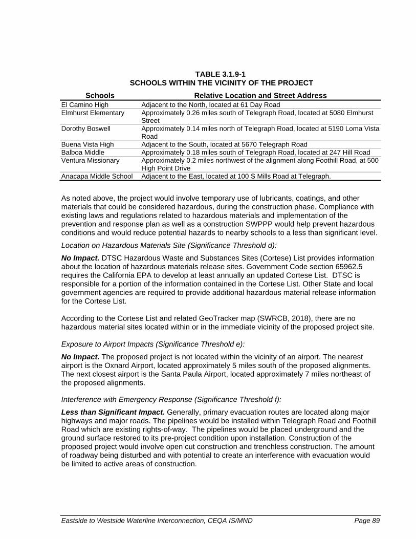
Eastside to Westside Waterline Interconnection, CEQA IS/MND Page 89
TABLE 3.1.9-1 SCHOOLS WITHIN THE VICINITY OF THE PROJECT
Schools Relative Location and Street Address El Camino High Adjacent to the North, located at 61 Day Road Elmhurst Elementary Approximately 0.26 miles south of Telegraph Road, located at 5080 Elmhurst
Street Dorothy Boswell Approximately 0.14 miles north of Telegraph Road, located at 5190 Loma Vista
Road Buena Vista High Adjacent to the South, located at 5670 Telegraph Road Balboa Middle Approximately 0.18 miles south of Telegraph Road, located at 247 Hill Road Ventura Missionary Approximately 0.2 miles northwest of the alignment along Foothill Road, at 500
High Point Drive Anacapa Middle School Adjacent to the East, located at 100 S Mills Road at Telegraph.
As noted above, the project would involve temporary use of lubricants, coatings, and other materials that could be considered hazardous, during the construction phase. Compliance with existing laws and regulations related to hazardous materials and implementation of the prevention and response plan as well as a construction SWPPP would help prevent hazardous conditions and would reduce potential hazards to nearby schools to a less than significant level.
Location on Hazardous Materials Site (Significance Threshold d):
No Impact. DTSC Hazardous Waste and Substances Sites (Cortese) List provides information about the location of hazardous materials release sites. Government Code section 65962.5 requires the California EPA to develop at least annually an updated Cortese List. DTSC is responsible for a portion of the information contained in the Cortese List. Other State and local government agencies are required to provide additional hazardous material release information for the Cortese List. According to the Cortese List and related GeoTracker map (SWRCB, 2018), there are no hazardous material sites located within or in the immediate vicinity of the proposed project site. Exposure to Airport Impacts (Significance Threshold e):
No Impact. The proposed project is not located within the vicinity of an airport. The nearest airport is the Oxnard Airport, located approximately 5 miles south of the proposed alignments. The next closest airport is the Santa Paula Airport, located approximately 7 miles northeast of the proposed alignments.
Interference with Emergency Response (Significance Threshold f):
Less than Significant Impact. Generally, primary evacuation routes are located along major highways and major roads. The pipelines would be installed within Telegraph Road and Foothill Road which are existing rights-of-way. The pipelines would be placed underground and the ground surface restored to its pre-project condition upon installation. Construction of the proposed project would involve open cut construction and trenchless construction. The amount of roadway being disturbed and with potential to create an interference with evacuation would be limited to active areas of construction.

Page 90 Eastside to Westside Waterline Interconnection, CEQA IS/MND
Short-term increased truck and car traffic associated with the construction phases are not anticipated to create significant interference to potential emergency roadways. Construction vehicles have the potential to use the same routes as first response vehicles, however this impact would be temporary and emergency services affected by construction in the study area would be notified of construction schedules and access routes prior to construction. In addition, road surfaces would be restored to pre-construction conditions. As a result, the potential is low for interference or impairment of an emergency response plan or emergency evacuation plan. Impacts would be less than significant. Exposure to Risk of Loss, Injury, Death Involving Wildland Fires (Significance Threshold g):
Less than Significant Impact. The Midtown to Westside segment, which would be located within Telegraph Road, is not located within a wildland-urban interface, in proximity to wildlands, or otherwise within an area of elevated wildfire risk, according to CalFire Fire Hazard Severity Zone Maps (2007). The Eastside to Midtown segment would be installed within Foothill Road. The western end of that segment falls within local and State responsibility areas classified as very high fire severity zones, and a zone of moderate fire severity extends to the East, north of Foothill Road, adjacent to where the pipelines would be installed. Potential exposure to wildland fires by people as a result of the Project could only occur during the construction phase. However, the potential for exposure and related risks of loss, injury or death are considered to be less than significant given that only a very small portion of the Eastside to Midtown segment would be within a high fire severity zone. Further, construction would occur within a major right-of-way that could serve as an evacuation route if needed. Once constructed, the project does not have the potential to expose people or structures to an elevated risk related to wildland fires. The pipelines would be installed below ground and road surfaces would be restored to pre-construction conditions upon installation.
3.1.9.4 Mitigation Measures
Not applicable. Impacts would be less than significant; therefore, mitigation is not required.
3.1.9.5 Significance After Mitigation
Less than significant.

Eastside to Westside Waterline Interconnection, CEQA IS/MND Page 91
3.1.10 HYDROLOGY AND WATER QUALITY
3.1.10.1 Environmental Setting
The proposed project falls within the Ventura River and Santa Clara River watersheds, extending from the North Ventura Subwatershed at the eastern end to the Lower Santa Clara River Subwatershed at the western end. The project pipelines will be constructed within established rights-of-way, along Telegraph Road and Foothill Road, with land uses dominated by residential neighborhoods, commercial (schools, business parks, etc.), and agricultural uses. The Midtown to Westside segment will cross two barrancas: Reservoir Barranca and Arundell Barranca. The Eastside to Midtown segment will cross two barrancas: the Clark Barranca and Sudden Barranca, and it will come into close proximity to the Brown Barranca to the East. The Eastside to Midtown segment comes within approximately 2 miles of the Santa Clara River, which runs to the Southeast of the segment. The project area falls within the boundary of the Mound groundwater basin.
For the Midtown to Westside segment, unnamed stormwater crossings will be crossed using open trench construction with the exception of two box culverts at an existing unnamed drainage at the intersection of Telegraph Road and Victoria Avenue, where trenchless construction will be employed. One pipe casing will be installed to cross both box culverts at the existing barrancas utilizing jack and bore installation. Trenchless construction will also be used for crossing the two barrancas along the Midtown to Westside segment. Dewatering may be required at the bore and receiving pits. If required, dewatering wells and well pumps would be installed around the pits. It is anticipated that dewatering water will be of adequate quality and the only treatment required prior to discharge to a local stream channel will be use of a sedimentation tank.
3.1.10.2 Regulatory Setting
The purpose of the Federal Water Pollution Control Act of 1972 (CWA) is to restore and maintain the chemical, physical, and biological integrity of the nation’s waters in order to achieve a level of water quality suitable for beneficial uses, including water recreation and protection and propagation of fish and wildlife. The CWA requires all states to conduct water quality assessments of their water resources. Water bodies that do not meet water quality standards are placed on a list of impaired waters pursuant to the requirements of Section 303(d) of the CWA. The list identifies the pollutant or stressor causing the impairment and establishes a schedule for developing a related control plan, typically a total maximum daily load (TMDL).
Pursuant to Section 404 of the federal CWA, the USACE regulates discharges of dredged and/or fill material into waters of the United States, which by definition include waters that are navigable in the traditional sense, adjacent wetlands and tributaries to navigable waters of the United States, and other waters, the degradation or destruction of which could affect interstate or foreign commerce.
The CWA prohibits discharge to waters of the United States unless the discharge is in compliance with a NPDES permit. Discharges addressed through the program include wastewater treatment facilities and industrial waste dischargers, in addition to stormwater from municipal separate sewer systems, construction activities, and industrial activities. The

Page 92 Eastside to Westside Waterline Interconnection, CEQA IS/MND
regulations require that stormwater and non-stormwater runoff associated with construction activity, which discharges either directly to surface waters or indirectly through municipal separate storm sewer systems, be regulated by an NPDES permit.
California Laws/Regulations The Porter-Cologne Act is the principal law governing water quality in California and establishes a comprehensive program to protect water quality and protect beneficial uses of the State’s waters. The Porter-Cologne Act also established the SWRCB and nine RWQCBs as the main state agencies responsible for protecting water quality in California. Each RWQCB is directed to develop water quality control plans addressing beneficial uses to be protected, water quality objectives that protect those uses, and a program of implementation needed to achieve the water quality objectives. The Water Quality Control Plan for the Los Angeles Region (Basin Plan) identifies beneficial uses for surface and groundwaters, includes narrative and numerical water quality objectives that must be attained or maintained to protect the designated beneficial uses and conform to the State’s anti-degradation policy, and describes implementation programs and other actions necessary to achieve established water quality objectives. The act applies to surface water, groundwater, wetlands, and both point and nonpoint sources of pollution. Discharges of wastes (including spills, leaks, or historical disposal sites) where they may impact the waters of the state are prohibited under the Porter-Cologne Act, including the discharge of hazardous wastes and petroleum products. Discharges are regulated by the RWQCB primarily through the issuance of NPDES permits for point source discharges and waste discharge requirements (WDRs) for nonpoint discharges. The Los Angeles RWQCB is responsible for Region 4, which encompasses the project area. Management of California’s NPDES program is delegated to the SWRCB and the nine RWQCBs. The SWRCB administers the NPDES General Permit for Storm Water Discharges associated with Construction and Land Disturbance Activities (Order No. 2009-0009-DWQ; as amended by Order No. 2012-006-DWQ; NPDES General Permit No. CAS000002); projects that disturb one or more acres are required to obtain coverage under the Construction General Permit (CGP). The CGP requires the development of a SWPPP which outlines BMPs, such as erosion control measures, proper dewatering procedures, and other practices to reduce overall soil erosion, sediment mobilization, and pollutant runoff.
The Statewide General NPDES Permit for Drinking Water Systems (Order WQ 2014-0194-DWQ, NPDES NO. CAG140001) was adopted by the SWRCB in 2014. The Order sets forth waste discharge requirements applicable to discharges from drinking water systems to surface waters in California, which include, but are not limited to, discharges from supply wells, transmission systems, water treatment facilities, water distribution systems, and storage facilities. Among the discharges authorized under the Order are unplanned discharges due to drinking water system and distribution system failures and repair and water used for hydrostatic testing of water pipelines.
The Statewide General NPDES Permit for Discharges of Groundwater from Construction and Project Dewatering to Surface Waters in Coastal Watersheds of Los Angeles and Ventura Counties (NPDES NO. CAG994004) is currently tentative, with the latest draft out for public review as of September 2018. The Order is intended to authorize discharges of treated or untreated groundwater generated from permanent or temporary dewatering operations or other

Eastside to Westside Waterline Interconnection, CEQA IS/MND Page 93
applicable wastewater discharges not specifically covered in other general or individual NPDES permits.
Local Regulations The Fox Canyon Groundwater Management Agency (FCGMA) manages several of the groundwater basins in Ventura County with the objective to preserve groundwater resources for agricultural, municipal, and industrial uses in the best interests of the public for the common benefit of all water users. The FCGMA Groundwater Management Plan (2007) outlines specific, measurable management objectives for each basin and identifies strategies to reach those goals and objectives.
The Sustainable Groundwater Management Act (SGMA) was enacted in 2014 as comprehensive legislation aimed at strengthening local control and management of groundwater basins throughout California. SGMA requires local groundwater sustainability agencies to be formed and groundwater management plans to be developed for all medium and high priority basins. Preparation of these plans are underway.
City of Ventura General Plan
Action 5.16: Require new developments to incorporate stormwater treatment practices that allow percolation to the underlying aquifer and minimize offsite surface runoff utilizing methods such as pervious paving material for parking and other paved areas to facilitate rainwater percolation and retention/detention basins that limit runoff to pre-development levels.
County of Ventura General Plan
Maintain and, where feasible, restore the chemical, physical and biological integrity of surface and groundwater resources.
Protect and, where feasible, enhance watersheds and aquifer recharge areas.
3.1.10.3 Impact Analysis
3.1.10.3.1 Significance Thresholds
City of Ventura
Pursuant to CEQA Guidelines, potentially significant impacts would occur if implementation of the project would:
a) Violate any water quality standards or waste discharge requirements or otherwise substantially degrade surface or ground water quality;
b) Substantially decrease groundwater supplies or interfere substantially with groundwater recharge such that the project may impede sustainable groundwater management of the basin;
c) Substantially alter the existing drainage pattern of the site or area, including through the alteration of the course of a stream or river or through the addition of impervious surfaces, in a manner which would:

Page 94 Eastside to Westside Waterline Interconnection, CEQA IS/MND
i. result in substantial erosion or siltation on- or offsite;
ii. substantially increase the rate or amount of surface runoff in a manner which would result in flooding on- or offsite;
iii. create or contribute runoff water which would exceed the capacity of existing or planned stormwater drainage systems or provide substantial additional sources of polluted runoff; or
iv. impede or redirect flood flows.
d) In flood hazard, tsunami, or seiche zones, risk release of pollutants due to project inundation; and/or
e) Conflict with or obstruct implementation of a water quality control plan or sustainable groundwater management plan.
County of Ventura
The ISAG provide direction on understanding impacts to groundwater quantity and quality, surface water quantity and quality, water supply quantity and quality and fire flow requirements:
Groundwater Quantity
f) Any land use or project that will directly or indirectly decrease, either individually or cumulatively, the net quantity of groundwater in a groundwater basin that is overdrafted or creates an overdrafted groundwater basin;
g) In groundwater basins that are not overdrafted, or are not in hydrologic continuity with an overdrafted basin, net groundwater extraction that will individually or cumulatively cause overdrafted basin(s);
h) In areas where the groundwater basin and/or hydrologic unit condition is not well known or documented and there is evidence of overdraft based upon declining water levels in a well or wells, any proposed net increase in groundwater extraction from that groundwater basin and/or hydrologic unit;
Regardless of items above, any land use or project which would result in 1.0 acre-feet, or less, of net annual increase in groundwater extraction is not considered to have a significant project or cumulative impact on groundwater quantity.
Groundwater Quality
i) Any land use or project proposal that will individually or cumulatively degrade the quality of groundwater and cause groundwater to exceed groundwater quality objectives set by the Basin Plan;
j) A land use or project where there is evidence that the proposed land use or project could cause the quality of groundwater to fail to meet the groundwater quality objectives set by the Basin Plan;
k) Any land use or project that proposes the use of groundwater in any capacity and is located within two miles of the boundary of a former or current test site for rocket engines;

Eastside to Westside Waterline Interconnection, CEQA IS/MND Page 95
Surface Water Quantity
l) Any project that will increase surface water consumptive use (demand), either individually or cumulatively, in a fully appropriated stream reach as designated by SWRCB or where unappropriated surface water is unavailable;
m) Any project that will increase surface water consumptive use (demand) including but not limited to diversion or dewatering downstream reaches, either individually or cumulatively, resulting in an adverse impact to one or more of the beneficial uses listed in the Basin Plan.
Surface Water Quality
n) Any land use or project proposal that is expected to individually or cumulatively degrade the quality of Surface Water causing it to exceed water quality objectives as contained in Chapter 3 of the applicable Basin Plans;
o) Any land use or project development that directly or indirectly causes stormwater quality to exceed water quality objectives or standards in the applicable MS4 Permit or any other NPDES Permits.
3.1.10.3.2 Project-Specific Impacts
Impacts to Surface Water and Groundwater Quality (Significance Threshold a, i-k, n-o):
Less than Significant Impact. Construction activities would result in total ground disturbance of 2.04 acres, while only portions of the pipelines would be in active construction at once. Following trenching activities, ground surfaces would be restored to pre-project conditions. The disturbance and exposure of soils during construction activities, including trenching and trenchless construction, creates the potential for sediments and other construction-related pollutants to mobilize from the project site and enter receiving waters where it can result in water quality degradation.
The proposed project is subject to the Construction General Permit, which requires preparation and implementation of a project-specific SWPPP. In compliance with the General Permit, the SWPPP would identify potential sources of pollution and specify BMPs to be implemented in order to minimize the discharge of polluted stormwater runoff to local surface waters from construction activities. BMPs would include measures for erosion and sediment control, proper site management, as well as post-construction pollution prevention. The SWPPP and related BMPs would be applicable to all construction activities, including trenching and trenchless construction.
Trenchless construction would be used for crossing barrancas and for large box culverts within the project area. Necessary BMPs would be implemented to address potential risk associated with construction activities adjacent to surface waters, and these measures will be incorporated into the SWPPP.
BMPs implemented as part of the SWPPP would also help protect groundwater resources by ensuring proper handling of construction-related materials and reducing and preventing polluted runoff which could infiltrate into the ground. Overall, project implementation is not anticipated to have groundwater quality impacts. Full implementation of the SWPPP during construction and compliance with existing regulations during and after construction would ensure that project impacts on water quality are less than significant.

Page 96 Eastside to Westside Waterline Interconnection, CEQA IS/MND
Groundwater Quantity (Significance Thresholds b, f-h):
No Impact. No impacts are anticipated from the proposed project on groundwater resources, including related to supplies, recharge or sustainable management. Project implementation does not involve the use of groundwater sources, which could decrease supplies. In addition, the project would not increase impervious surfaces within the project area as the pipelines would be installed within Telegraph Road and Foothill Road, which are already paved roads.
Alteration of Drainage Patters, Resulting in Erosion, Runoff, Floods (Significance Threshold c):
Less than Significant Impact. Trenchless construction methods would be used to install the pipeline at barranca crossings. No stream course would be altered with implementation of the project. Further, the project would not result in substantial impacts to drainage patterns in or around the project site resulting from the addition of impervious surfaces because the project would not increase imperviousness of the project area. The pipelines would be installed within an already paved right-of-way, Telegraph Road, and road surfaces would be returned to pre-project conditions upon installation.
Project implementation is not anticipated to increase erosion, surface runoff or contribute to elevated flooding potential.
Potential for transportation of sediments offsite and/or polluted runoff exists temporarily during construction activities would be controlled through the implementation of the SWPPP.
Project Inundation (Significance Threshold d):
Less than Significant Impact. The project area is not located within a tsunami inundation area, according to the Ventura County Tsunami Inundation maps for the project area (DOC, 2017). Seiches are freestanding or oscillatory waves associated with large enclosed or semi-enclosed bodies of water. There is no record of a seiche occurring in Ventura County and the project area is not located near a water body susceptible to seiches.
According to available FEMA Flood Insurance Rate Maps (FEMA, 2010), the proposed alignment segments along Telegraph Road and Foothill Road are located within an “Area of Minimal Flood Hazard,” outside of the 0.2% annual chance floodplain. Pollutants could be released during active construction in the rare chance of flooding, but the risk of release of pollutants due to project inundation is minimal.
Conflict with Water Quality Control Plan or Sustainable Groundwater Management Plan (Significant Threshold e):
Less than Significant Impact. The water quality control plan applicable to the proposed project is the Los Angeles Basin Plan, which is designed to preserve and enhance water quality and protect the beneficial uses of all regional waters.
The proposed project is not anticipated to substantially contribute to water quality impairments within the project area which could in conflict with the Basin Plan. As previously discussed, construction activities have the potential to impact water quality, but a SWPPP will be implemented to address the risk of increased erosion, siltation and/or polluted runoff during construction activities. The project would cross the Arundell Barranca, which was assessed for

Eastside to Westside Waterline Interconnection, CEQA IS/MND Page 97
the 2014/2016 California Integrated Report and is listed on the 303(d) List as impaired by indicator bacteria. Neither construction activities nor operations are anticipated to contribute to the listed impairment.
As mentioned previously, the project is not anticipated to have impacts on groundwater resources and would not conflict or hinder implementation of a groundwater management plan applicable to the project area. BMPs implemented as part of the SWPPP will contribute to protecting the quality of groundwater resources by ensuring proper handling of construction-related materials and reducing and preventing polluted runoff which could infiltrate into the ground. Further, the project would not result in use of local groundwater that could impact those resources.
Surface Water Quantity (Significance Thresholds l, m):
No Impact. The Project is proposed to improve the City’s water system reliability by allowing water to be moved from the east end of the City to the west end in times when westend supplies are reduced or less available. Implementation of the Project would not result in increased water demands but would rather improve overall water supply reliability.
3.1.10.4 Mitigation Measures
Not applicable. Impacts would be less than significant; therefore, mitigation is not required
3.1.10.5 Significance After Mitigation
Not applicable.
Page 98 Eastside to Westside Waterline Interconnection, CEQA IS/MND
3.1.11 LAND USE AND PLANNING
3.1.11.1 Environmental Setting
The proposed project site is located primarily within the City of Ventura, with a portion of the Eastside to Midtown portion located within unincorporated County limits. Land uses are primarily urban (residential and commercial), with some agricultural areas on the eastern end of the City and within County limits (City of Ventura 2017 and County of Ventura 2016). The alignment segments are located within established rights-of-way adjacent to areas zoned as Single-, Two-, and Multiple Family Residential (R-1, R-3), Residential Planned Development (RPD), Professional Office (PO), Commercial (C-1, C-1A, C-2), Commercial Planned Development (CPD), Hospital (H), and Limited Industrial (M-1). A portion of the Eastside to Midtown alignment segment runs adjacent to areas zoned as Agricultural, both within City and County limits.
3.1.11.2 Regulatory Setting
City of Ventura General Plan. The City of Ventura’s General Plan, adopted in 2005, provides goals, policies, and actions developed to guide future development in the City through the 2025 planning horizon.
Save Open Space and Agricultural Resources (SOAR) Initiative. With the intent to protect open space and agricultural land across Ventura County, this initiative blocks the Ventura County Board of Supervisors from rezoning unincorporated open space, agricultural, or rural land for development without a vote of the people. City SOAR initiatives require voter approval before rezoning agricultural land or before allowing urban development beyond a City Urban Restriction Boundary.
Ventura County Zoning Ordinance – Non-Coastal Zoning Ordinance. The County’s Non-Coastal Zoning Ordinance, last amended in 2018 (County of Ventura), includes comprehensive zoning regulations applicable to the unincorporated area of the County of Ventura, excluding the Coastal Zone. Zones and minimum lot areas are established with the Ordinance to classify, regulate, restrict, and segregate uses of land and buildings; regulate the height and size of buildings; regulate the area of yards and other open spaces around buildings; and regulate the density of population. The Agricultural Exclusive Zone, within which the majority of the proposed project crosses, is intended to preserve and protect agricultural lands as a limited and irreplaceable resource and preserve agriculture. The Open Space Zone is intended to provide for the preservation of natural resources and outdoor recreation and formation and continuation of cohesive communities by preventing urban sprawl.
3.1.11.3 Impact Analysis
3.1.11.3.1 Significance Thresholds
City of Ventura
Pursuant to CEQA Guidelines, potentially significant impacts would occur if implementation of the project would:

Eastside to Westside Waterline Interconnection, CEQA IS/MND Page 99
a) Physically divide an established community; and/or
b) Cause a significant environmental impact due to a conflict with any land use plan, policy, or regulation adopted for the purpose of avoiding or mitigating an environmental effect.
County of Ventura
The ISAG state the significance of to community character, is materially impaired when a project:
c) is inconsistent with any of the policies or development standards relating to community character of the Ventura County General Plan Goals, Policies and Programs or applicable Area Plan; and/or
d) would introduce physical development that is incompatible with existing land uses, architectural form or style, site design/layout, or density/parcel sizes within the community in which the project site is located.
3.1.11.3.2 Project-Specific Impacts
Division of a Community, Disruption of Community Character (Significance Thresholds a, c-d):
No impact. The pipelines would be placed underground, primarily within public rights of way. The ground surface would be restored to pre-project conditions upon installation of the pipelines. Additionally, the proposed project would be consistent with existing zoning and would not result in changes in land use patters. Overall, the project would not have the potential to physically divide an established community or conflict with an applicable land use plan, policy or regulation.
Conflict with Land Use Plan, Policy or Regulation (Significance Threshold b):
No impact. The proposed project would be consistent with existing zoning and would not result in changes in land use patters, nor would it conflict with existing policies or regulations intended to avoid or mitigate environmental effects.
3.1.11.4 Mitigation Measures
Not applicable. Impacts would be less than significant; therefore, mitigation is not required.
3.1.11.5 Significance After Mitigation
Not applicable.

Page 100 Eastside to Westside Waterline Interconnection, CEQA IS/MND
3.1.12 MINERAL RESOURCES
3.1.12.1 Environmental Setting
Ventura County is located within the Transverse Ranges geomorphic province, which is characterized in part by petroleum-rich sedimentary rocks, making the region an important oil and gas-producing area. The highest density of active oil and gas development is found north of the City of Ventura, west of the City of Ojai, and by South Mountain, near the City of Santa Paula. Another principal mineral resource found within the County is aggregate, principally sand and gravel. Most of the extraction sites are located within and adjacent to the Santa Clara River floodplain.
The project alignments are not located in a known aggregate region or petroleum field, per Figure 4.9-1–Petroleum Resources and Figure 4.9-2–Aggregate Resources within the 2005 General Plan EIR (City of Ventura, 2005).
3.1.12.2 Regulatory Setting
The Surface Mining and Reclamation Act (SMARA) of 1975 has the primary goals of ensuring proper reclamation of surface mining operations, protecting access to mineral resources of regional and Statewide significance, and reducing residual hazards to public health and safety. The County of Ventura is the lead agency for enforcing SMARA regulations on all mining operations within the County.
Ventura County’s mechanism for carrying out SMARA’s objective of safeguarding access to mineral resources is the designation of appropriate areas as a Mineral Resource Area on the Resource Protection Map (County of Ventura 2005b). These areas are subject to the Mineral Resource Protection Overlay Zone for purposes of safeguarding future access to the resource, facilitating long term supply of aggregate, minimizing land use conflicts, and providing notice to landowners and the general public of the presence of the resource. Aggregate resources are classified in the County General Plan by Mineral Resource Zones based on the relative knowledge of the resource’s presence and quality of the material. The MRZ-2 areas are where adequate information indicates that significant mineral deposits are present or are likely to be present.
The only County General Plan (2016) policy relevant to the proposed project is 1.4.2-7, which states that all discretionary developments shall be evaluated for their individual and cumulative impacts on access to and extraction of recognized mineral resources in compliance with CEQA.
3.1.12.3 Impact Analysis
3.1.12.3.1 Significance Thresholds
City of Ventura
Pursuant to CEQA Guidelines, potentially significant impacts would occur if implementation of the project would:

Eastside to Westside Waterline Interconnection, CEQA IS/MND Page 101
a) Result in the loss of availability of a known mineral resource that would be of value to the region and the residents of the state; and/or
b) Result in the loss of availability of a locally-important mineral resource recovery site delineated on a local general plan, specific plan or other land use plan.
County of Ventura
The ISAG state the significance of a mineral resource is materially impaired when a project:
c) is proposed to be located on or immediately adjacent to land zoned Mineral Resource Protection (MRP) overlay zone, or adjacent to a principal access road to an existing aggregate Conditional Use Permit (CUP), and which has the potential to hamper or preclude extraction of or access to the aggregate resources
3.1.12.3.2 Project-Specific Impacts
Loss of Availability of Known Mineral Resources and/or Recovery Site (Significance Thresholds a-c):
No impact. The Project site is not located in an area that would result in the loss of availability of known mineral resources that would be of value to the region and the residents of the State. Nor is the Project site located in an area that would result in the loss of availability of a locally-important mineral resource recovery site. Therefore, no impacts are anticipated.
3.1.12.4 Mitigation Measures
Not applicable. Impacts would be less than significant; therefore, mitigation is not required.
3.1.12.5 Significance After Mitigation
Not applicable.

Page 102 Eastside to Westside Waterline Interconnection, CEQA IS/MND
3.1.13 NOISE
3.1.13.1 Environmental Setting
Noise Background Noise is unwanted sound that disturbs human activity. Environmental noise levels typically fluctuate over time, and different types of noise descriptors are used to account for this variability. Noise level measurements include intensity, frequency, and duration, as well as time of occurrence. Noise level (or volume) is generally measured in decibels (dB) using the A-weighted sound pressure level (dBA). Because of the way the human ear interprets sound level, a sound must be about 10 dBA greater than the reference sound to be judged as twice as loud. In general, a 3 dBA change in community noise levels is noticeable, while 1 to 2 dBA changes are typically not perceived. Quiet suburban areas generally have noise levels in the range of 40 to 50 dBA, while arterial streets are in the 50 to 60+ dBA range. Normal conversational levels are in the 60 to 65 dBA range, and ambient noise levels greater than 65 dBA can interrupt conversations.
Noise levels typically attenuate (or drop off) at a rate of about 6 dBA per doubling of distance from point sources (such as construction equipment). Noise from lightly traveled roads typically attenuates at a rate of about 4.5 dBA per doubling of distance, while noise from heavily traveled roads typically attenuates at about 3 dBA per doubling of distance. Noise levels may also be reduced by the introduction of intervening structures. For example, a single row of buildings between the receptor and the noise source reduces the noise level by about 5 dBA, while a solid wall or berm that breaks the line-of-sight reduces noise levels by 5 to 10 dBA. Based on the Federal Highway Administration’s (FHWA) Highway Traffic Noise: Analysis and Abatement Guidance, typical building construction generally provides a reduction of exterior-to-interior noise levels of about 20 to 35 dBA with closed windows (FHWA 2011).
In addition to the instantaneous measurement of sound levels, the duration of sound is important since sounds that occur over a long period of time are more likely to be an annoyance or cause direct physical damage or environmental stress. One of the most frequently used noise metrics that considers both duration and sound power level is the equivalent noise level (Leq). The Leq is defined as the single steady A-weighted level that is equivalent to the same amount of energy as that contained in the actual fluctuating levels over a period of time (essentially, the average noise level). Typically, Leq is summed over a one-hour period. The highest root mean squared (RMS) sound pressure level within the measuring period is the Lmax. The lowest RMS sound pressure level within the measuring period is the Lmin.
Vibration Background Vibration is a unique form of noise because its energy is carried through buildings, structures, and the ground, whereas noise is simply carried through the air. Thus, vibration is generally felt rather than heard. Some vibration effects can be caused by noise (e.g., the rattling of windows from passing trucks). This phenomenon is caused by the coupling of the acoustic energy at frequencies that are close to the resonant frequency of the material being vibrated. Typically, groundborne vibration generated by manmade activities attenuates rapidly as distance from the source of the vibration increases. The ground motion caused by vibration is measured as particle velocity in inches per second and is referenced as vibration decibels (VdB) in the United States.

Eastside to Westside Waterline Interconnection, CEQA IS/MND Page 103
The vibration velocity level threshold of perception for humans is approximately 65 VdB. A vibration velocity of 75 VdB is the approximate dividing line between barely perceptible and distinctly perceptible levels for many people. Most perceptible indoor vibration is caused by sources inside buildings such as the operation of mechanical equipment, movement of people, or the slamming of doors. Typical outdoor sources of perceptible groundborne vibration are construction equipment, steel-wheeled trains, and traffic on rough roads.
Project Site Setting The project is located in a developed, predominantly commercial and residential area of the City. The Eastside to Midtown alignment extends along Foothill Road, from Elizabeth Road on the east to Kimball Road on the west and continues south along Kimball Road to El Dorado Street. The eastern portion of the Eastside to Midtown alignment from Elizabeth Road to Petit Avenue is located in unincorporated Ventura County. The Midtown to Westside alignment extends along Telegraph Road, from Hill Road on the east to Mills Road on the west. Both alignments are near or adjacent to single-family and multi-family residences along Foothill Road, Kimball Road, or Telegraph Road. Although the project area is largely urbanized, agricultural land lines both sides of the Eastside to Midtown alignment between Elizabeth Road and Petit Avenue and is adjacent to the Midtown to Westside alignment east of Hill Road. The nearest highways are State Route 126, located approximately 0.4 mile south of the project alignment, and U.S. 101, located approximately 0.6 mile south of the western terminus of the Midtown to Westside alignment.
Noise levels at the project site are typical of residential and commercial areas. Primary sources of noise can be attributed to roadway traffic along Foothill Road and Telegraph Road and busier cross streets, such as Kimball Road, Victoria Avenue, Petit Avenue, and Mills Road. Traffic in these areas ranges from infrequent in the residential neighborhoods to moderate frequencies in the commercial portions of Telegraph Road. Telegraph Road and Foothill Road along the project alignment have posted speed limits of up to 50 mph.
There are three airports in the vicinity of the project site, including Oxnard Airport, Camarillo Airport, and Santa Paula Airport. Oxnard Airport is approximately 5.3 miles south of the project alignment, Camarillo Airport is approximately 6.7 miles southeast, and Santa Paula Airport is approximately 7.2 miles northeast of the proposed alignment. Due to the project alignment’s distance from these airports, airport noise does not contribute to noise levels along the proposed alignment.
Four 15-minute noise measurements were taken at points along the project alignment on Tuesday, September 18, 2018 during the morning peak hour. One noise measurement (Noise Measurement [NM] 1) was collected along Foothill Road near its intersection with Kimball Road to characterize ambient noise near residences and preschools along the proposed Eastside to Midtown alignment. Three noise measurements were also collected along Telegraph Road at points along the proposed Midtown to Westside alignment. NM 2 characterizes noise near Buena High School and residences north of Telegraph Road. NM 3 characterizes noise near Ventura College and an assisted living facility along Telegraph Road. NM 4 characterizes noise near Ventura College, the Ventura College Child Development Center, and residences to the south of Telegraph Road. All noise measurement locations were selected to avoid walls or structures that could interfere with collection of noise measurements. Figure 3.1.13-1 shows the locations of the measurements and Table 3.1.13-1 shows the recorded noise measurements.

FIGURE 3.1.13-1 NOISE MEASUREMENT LOCATIONS

Eastside to Westside Waterline Interconnection, CEQA IS/MND Page 105
This page intentionally left blank.

Page 106 Eastside to Westside Waterline Interconnection, CEQA IS/MND
TABLE 3.1.13-1 NOISE MEASUREMENTS
Measurement Number Measurement Location Sample Times
15-minute
Leq (dBA)1
Lmin (dBA)2
Lmax (dBA)3
NM 1 Foothill Road and Kimball Road
6:57 a.m. – 7:12 a.m.
67.7 45.4 85.8
NM 2 Telegraph Road at Buena High School
7:23 a.m. – 7:38 a.m.
70.0 56.0 93.5
NM 3 Telegraph Road and Day Road
7:45 a.m. – 8:00 a.m.
68.1 54.0 84.9
NM 4 Telegraph Road and West Campus Way
8:06 a.m. – 8:21 a.m.
68.1 54.2 81.6
1 A-weighted decibel (dBA) is defined as a decibel (dB) adjusted to be consistent with human response. The equivalent noise level (Leq) is defined as the single steady A-weighted level that is equivalent to the same amount of energy as that contained in the actual fluctuating levels over a period of time (essentially, the average noise level).
2 Lmin is the minimum sound level experienced within the recorded measurement with A-weighted frequency response
3 Lmax is the maximum sound level experienced within the recorded measurement with A-weighted frequency response
Source: Rincon Consultants, field visit on Tuesday, September 18, 2018 using ANSI Type 2 Integrating sound level meter. See Appendix D for noise monitoring data.
Sensitive Receptors Some land uses are more sensitive to ambient noise levels than other uses due to the amount of noise exposure and the types of activities involved. The City’s General Plan Noise Element identifies particular land uses as sensitive to noise, including homes, schools, hotels, and hospitals (City of Ventura 2005). Sensitive receptors along the project alignments include single-family and multi-family residences along Telegraph Road, with property lines approximately 45 feet north or south of the proposed alignment centerline, and single-family residences south of Foothill Road, with property lines approximately 35 feet south of the proposed alignment centerline. Other noise sensitive receptors adjacent to the project site include Buena High School (approximately 110 feet south), Vista Real Charter High School (approximately 130 feet south), the Ventura College Child Development Center (approximately 120 feet north), Children’s World Nursery School and Temple Beth Torah Synagogue and Preschool (approximately 150 feet south), Coastal View Healthcare Center (approximately 130 feet south), and Ventura College Sciences and Mathematics Buildings (approximately 140 feet north), and Anacapa Middle School (approximately 215 feet south).
3.1.13.2 Regulatory Setting
City of Ventura General Plan Chapter 7 of the City’s General Plan contains the City’s Noise Element. The chapter includes land use compatibility requirements for siting of various proposed land uses, as well as specific

Eastside to Westside Waterline Interconnection, CEQA IS/MND Page 107
policies and actions intended to reduce noise impacts within the city (City of Ventura 2005). The following policy and action would apply to the project:
Policy 7E: Minimize the harmful effects of noise.
Action 7.37: Use rubberized asphalt or other sound reducing material for paving and re-paving of city streets.
City of Ventura Municipal Code The City’s Noise Ordinance (Municipal Code Section 10.650) prohibits unnecessary, excessive, or annoying noise in the city. The Ordinance defines noise sensitive properties as any property designated in the City’s General Plan Noise Element, including schools, hospitals, convalescent care, boarding, and rest homes. Furthermore, Section 10.650.130 establishes noise levels for properties within designated noise zones. Table 3.1.13-2 shows the noise levels associated with each designated noise zone.
TABLE 3.1.13-2 CITY OF VENTURA NOISE ORDINANCE
Designated Zone Time Interval Exterior Noise Level
(dBA)
Zones I and II
Noise sensitive and residential properties 7 a.m. – 10 p.m. 50
10 p.m. – 7 a.m. 45
Zone III
Commercial properties 7 a.m. – 10 p.m. 60
10 p.m. – 7 a.m. 55
Zone IV
Industrial and agricultural Anytime 70
Source: City of Ventura Municipal Code § 10.650.130
Pursuant to Section 10.650.130(B)(2), noise level limits for each designated noise zone are as follows:
The exterior noise levels for a given land use, as specified in Table 3.1.13-2 above, for a total period of more than 30 minutes in any consecutive 60 minutes
The exterior noise levels plus five dB for a total period of more than 15 minutes in any consecutive 60 minutes
The exterior noise levels plus ten dB for a total period of more than five minutes in any consecutive 60 minutes
The exterior noise levels plus 15 dB for a total period of more than one minute in any consecutive 60 minutes

Page 108 Eastside to Westside Waterline Interconnection, CEQA IS/MND
The exterior noise levels plus 20 dB for any period of time
Section 10.650.150(D) specifies that construction activities exceeding the noise limits established in the Noise Ordinance are permitted between 7 a.m. and 8 p.m. However, the Planning Commission and City Council retain the right to impose more restrictive construction hours as conditions of project approval.
Ventura County General Plan Section 2.16 of the County of Ventura (County) General Plan Hazards Appendix contains the County’s Noise Element (County of Ventura, 2013). The Noise Element identifies primary noise sources in the county, develops noise contours for existing transportation, industrial, and miscellaneous sources, and provides mitigation strategies to reduce noise impacts in the county through the year 2020.
The Noise Element defines noise sensitive receptors by land use and time of sensitivity. According to the County’s Noise Element, noise sensitive receptors include residences at any time, parks and other outdoor recreation areas, primarily during the day, and the interior of schools, churches, libraries, prisons, correctional facilities, and group shelters during the day. None of these noise sensitive receptors are located near the proposed alignments within the county.
Ventura County Code of Ordinances Article 11 of the County’s Code of Ordinances prohibits loud or raucous noise within any residential zone which is audible to the human ear during the hours of 9 p.m. to 7 a.m. at a distance of 50 feet from the property line of the noise source or 50 feet from any such noise source if the source is in a public right-of-way. While the ordinance indicates that “loud or raucous noise” can include operation of riding tractors or other mechanical or electrical devices or hand tools, which could be used during construction activities, Section 6299-2(a) exempts any government entity or public utility from the provisions of the ordinance.
Construction Noise Threshold Criteria and Control Plan The County’s Construction Noise Threshold Criteria and Control Plan describes noise thresholds for noise sensitive receptors in the county (County of Ventura, 2010). Table 3.1.13-3 shows noise sensitive receptors and their respective typical sensitive time period, as defined in the plan.
The plan defines construction activity noise threshold criteria for daytime, evening, and nighttime construction activities. These thresholds only apply to noise sensitive receptors for their typically sensitive time periods. There are no noise sensitive receptors in the vicinity of the portion of the proposed alignments located in the county, and these thresholds would not apply to the agricultural land along the project alignment in the county.

Eastside to Westside Waterline Interconnection, CEQA IS/MND Page 109
TABLE 3.1.13-3 CONSTRUCTION NOISE SENSITIVE RECEPTORS
Receptor Typical Sensitive Time Period1
Hospitals, Nursing Homes (quasi-residential) 24 hours
Single Family and Multi-Family Dwellings (residential)
Evening/Night
Hotels/Motels (quasi-residential) Evening/Night
Schools, Churches, Libraries (when in use) Daytime/Evening 1Daytime hours are defined as 7 a.m. – 7 p.m. Monday through Friday, and 9 a.m. – 7 p.m. on Saturdays, Sundays, and local holidays. Evening hours are defined as 7 p.m. – 10 p.m. daily. Nighttime hours are defined as 10 p.m. – 7 a.m. Monday through Friday, and 10 p.m. – 9 a.m. on Saturdays, Sundays, and local holidays.
Source: County of Ventura 2010.
3.1.13.3 Impact Analysis
3.1.13.3.1 Significance Thresholds
City of Ventura
Pursuant to CEQA Guidelines, potentially significant impacts would occur if implementation of the project would:
a) Generation of a substantial temporary or permanent increase in ambient noise levels in the vicinity of the project in excess of standards established in the local general plan or noise ordinance, or applicable standards of other agencies;
b) Generation of excessive groundborne vibration or groundborne noise levels;
c) For a project located within the vicinity of a private airstrip or an airport land use plan or, where such a plan has not been adopted, within two miles of a public airport or public use airport, would the project expose people residing or working in the project area to excessive noise levels;
County of Ventura
The ISAG are incorporated into the analysis below and build upon the State’s CEQA Guidelines.
3.1.13.3.2 Project-Specific Impacts
Generate Substantial Temporary or Permanent Increase in Ambient Noise Levels in Excess of Standards(Significance Threshold a):
Less than Significant.

Page 110 Eastside to Westside Waterline Interconnection, CEQA IS/MND
Long-Term Project Operation Pipelines would be installed underground and require approximately one maintenance trip per year to rotate valves. Operation of the pipeline, including the negligible trip generation, would not perceptibly increase noise levels on the project site above existing conditions. Conversion of the Five Points Booster Pump Station to a pressure reducing station would reduce operational noise of this facility.
On-Site Construction Equipment Construction activities associated with the project would result in temporary and intermittent noise increases at sensitive receptors along the proposed alignments. Construction noise for the nearest sensitive receptors was estimated using the Federal Highway Administration’s (FHWA) Roadway Construction Noise Model (FHWA, 2006) and the equipment list contained in the project description.
Table 3.1.13-4 summarizes anticipated construction noise at sensitive receptors along the project alignments for each phase of open trench construction. Given the substantial overlap between the open trench and trenchless construction equipment lists, construction noise at adjacent sensitive receptors would be effectively similar for both construction methods.
As indicated in Table 3.1.13-4, construction noise at the nearest sensitive receptor, single family residences south of Foothill Road, would reach approximately 89 dBA Leq during the pipeline excavation and installation phase. Barrier walls line the yards of all single-family residences along Telegraph Road, Foothill Road, and Kimball Road in the project area, which would reduce noise at residential receptors by approximately 5-10 dBA (FTA, 2018). Therefore, the noise levels presented in Table 3.1.13-4 serve as a conservative estimate of potential construction noise impacts. Furthermore, construction activity would not occur along the entire project alignment for the duration of the project but rather would move along either alignment at a rate of approximately 150-250 linear feet per day. As a result, noise-generating construction activities would be in the vicinity (i.e., within approximately 900 feet) of individual noise sensitive receptors for up to nine days.
Construction noise would exceed the 50 dBA daytime exterior noise level limit for noise sensitive and residential properties established in the City’s Noise Ordinance (Table 3.1.13-2). However, pursuant to Section 10.650.150(D), construction activities exceeding such noise limits are permitted between 7 a.m. and 8 p.m. Project construction would be limited to between the hours of 7 a.m. and 4 p.m. and would, therefore, be permitted under the Noise Ordinance.
The portion of the project alignment through the county runs along Foothill Road, from North Petit Avenue to Elizabeth Road. This portion of the alignment is surrounded by agricultural fields, with no noise sensitive receptors in the vicinity of the alignment. As with the portion of the project alignment in the city, construction activities would be limited to daytime hours, between 7 a.m. and 4 p.m. Therefore, the project would not exceed any of the noise threshold criteria for daytime, evening, or nighttime noise sensitive receptors described in the County’s Construction Noise Threshold Criteria and Control Plan.

Eastside to Westside Waterline Interconnection, CEQA IS/MND Page 111
TABLE 3.1.13-4 ESTIMATED CONSTRUCTION NOISE AT SENSITIVE RECEPTORS
Construction Phase Combined Hourly Leq (dBA)
Single Family Residential (south of Foothill Road, 35 feet from closest construction)
Grubbing and Pavement Removal
87
Pipeline Excavation and Installation
89
Road Restoration 82
Single Family Residential (north of Telegraph Road, 45 feet from closest construction)
Grubbing and Pavement Removal
85
Pipeline Excavation and Installation
87
Road Restoration 80
Buena High School (110 feet from closest construction)
Grubbing and Pavement Removal
77
Pipeline Excavation and Installation
79
Road Restoration 72
Ventura College Child Development Center (120 feet from closest construction)
Grubbing and Pavement Removal
76
Pipeline Excavation and Installation 78
Road Restoration 71
Anacapa Middle School (215 feet from closest construction)
Grubbing and Pavement Removal
71
Pipeline Excavation and Installation
73
Road Restoration 66
Source: FHWA 2006. See Appendix D for Roadway Construction Noise Model worksheets.

Page 112 Eastside to Westside Waterline Interconnection, CEQA IS/MND
Off-Site Construction Traffic Construction-related worker and haul trips would add traffic to area roadways, which could increase traffic noise. Open trench construction would involve up to 20 daily haul and vendor trips to remove spoils and deliver backfill material, equipment, and pipeline. Trenchless construction would require up to 3 daily haul trips for similar purposes. Additionally, the project would require up to 30 round-trip construction worker trips per day during open trench construction (or up to 24 worker trips per day during trenchless construction). Open trench and trenchless construction would not occur simultaneously.
Generally, a 10 percent increase in the number of vehicles on a roadway would result in a noise increase of approximately 0.4 dBA, a 30 percent increase in vehicles would result in a 1.1 dBA increase, and a doubling of traffic (i.e. 100 percent traffic increase) would increase noise levels by approximately 3 dBA. According to the most recently available city-wide average daily traffic counts conducted by the City’s Public Works Department, traffic volumes along the project alignment range from 3,768 average daily trips (ADT) along Kimball Road south of Foothill Road to 32,428 ADT along Telegraph Road west of Victoria Avenue (City of Ventura, 2007). Based on these traffic counts, worker and haul trips associated with project construction would temporarily increase daily traffic along these roadways by 0.2 to 1.3 percent. As a result, construction-related traffic would increase roadway noise by less than 0.4 dBA and would not be perceptible.
The project would result in a temporary increase in ambient noise levels due to the operation of heavy construction equipment along the project alignments. Construction noise would be temporary in nature and limited to daytime hours in accordance with the City’s Noise Ordinance. Project construction would not affect any noise sensitive receptors in the county. Therefore, this impact would be less than significant.
Result in the Generation of Excessive Groundborne Vibration or Groundborne Noise Levels (Significance Threshold b):
Less Than Significant with Mitigation Incorporated. Neither the City’s General Plan nor the Municipal Code include standards for construction-related groundborne vibration. The County’s ISAG document states that projects that, either individually or cumulatively, include construction activities involving blasting, pile-driving, vibratory compaction, demolition, and drilling or excavation which exceed the thresholds established in Section 12.2 of the FTA’s (2018) Transit Noise and Vibration Impact Assessment would result in a potentially significant impact3. While the project would not involve major groundborne vibration-inducing activities, such as pile driving or blasting, vibration associated with compaction, drilling, and excavation activities could affect structures along the proposed alignments.
In most cases, the primary concern regarding groundborne vibration is the potential for damage to buildings and structures (FTA, 2018). The FTA Guidelines provide damage criteria for buildings (reported as Peak Particle Velocity [PPV]) subject to groundborne vibration, presented in Table 3.1.13-5.
3 The Federal Transit Administration’s (FTA) Transit Noise and Vibration Impact Assessment Manual was
updated in September 2018 (“2018 Manual”). Ventura County’s ISAG continue to reference the earlier iteration of the Manual (“2006 Manual”). No change in the vibration damage criteria or

Eastside to Westside Waterline Interconnection, CEQA IS/MND Page 113
TABLE 3.1.13-5 VIBRATION DAMAGE CRITERIA FOR BUILDINGS
Building Category PPV (in/sec) Lv
(RMS Velocity in VdB)
Reinforced concrete, steel or timber (no plaster)
0.5 102
Engineered concrete and masonry (no plaster) 0.3 98
Non-engineered timber and masonry buildings 0.2 94
Buildings extremely susceptible to vibration damage
0.12 90
Source: FTA 2018
Lower levels of groundborne vibration can also interfere with certain vibration-sensitive activities at different land uses. The FTA Guidelines establish general assessment groundborne vibration standards for various land use classifications based on their sensitivity to vibration impacts. These standards are presented in Table 3.1.13-6 below.
TABLE 3.1.13-6 GROUNDBORNE VIBRATION GENERAL ASSESSMENT STANDARDS
Land Use Category
Groundborne Vibration Impact Levels (VdB)
Frequent Events1
Occasional Events2
Infrequent Events3
Category 1: Buildings where vibration would interfere with interior operations
65 65 65
Category 2: Residences and buildings where people normally sleep
72 75 80
Category 3: Institutional land uses with primarily daytime use
75 78 83
1More than 70 vibration events of the same source per day. 2Between 30 and 70 vibration events of the same source per day. 3Fewer than 30 vibration events of the same kind per day. Source: FTA 2018
The Midtown to Westside alignment runs along Telegraph Road, adjacent to the Ventura College campus. Project construction would occur approximately 140 feet south of the college’s Sciences and Mathematics Buildings, which house the college’s science classrooms and laboratories and are located on the southeastern side of the campus. Because university laboratory equipment can be highly sensitive to groundborne vibration, impacts to buildings hosting such operations are assessed relative to the Category 1 thresholds presented in Table 3.1.13-6. Table 3.1.13-7 shows estimated groundborne vibration associated with various pieces
standards were included in the 2018 update to the Manual. As such, this analysis cites the 2018 Manual, as appropriate.

Page 114 Eastside to Westside Waterline Interconnection, CEQA IS/MND
of construction equipment at the nearest Ventura College Sciences and Mathematics Building (a Category 1 structure) and residential structures along the project alignment.
TABLE 3.1.13-7 TYPICAL VIBRATION LEVELS GENERATED BY CONSTRUCTION EQUIPMENT
Equipment1
Approximate VdB 25 feet from
Source
Approximate VdB at Ventura College Sciences and Mathematics Building2
Approximate VdB at Nearest Residential
Structures3
Vibratory Roller 94 72 87
Hoe Ram 87 65 79
Large Bulldozer
87 65 79
Small Bulldozer
58 35 50
Loaded Trucks 86 63 78
Jackhammer 79 56 71
VdB = vibration decibels 1List not comprehensive of all equipment that would be used during the project. 2The Ventura College Sciences and Mathematics Building is approximately 140 feet north of the project alignment. 3The nearest residential structures are homes south of Foothill Road, approximately 45 feet from the project alignment. Source: FTA 2018
As shown in Table 3.1.13-7, vibration levels at these structures would remain below damage criteria for all buildings (Table 3.1.13-5). Groundborne vibration could exceed the 65 VdB standard for sensitive Category 1 land uses at the Ventura College Sciences and Mathematics Building. While vibration would exceed the FTA Guidelines’ standard of 72 VdB for buildings where people normally sleep at residences closest to the project alignments, project construction would be limited to daytime hours between 7 a.m. and 4 p.m. and would not occur at times during which people normally sleep. Nevertheless, because groundborne vibration could exceed standards for buildings with sensitive laboratory equipment at the Ventura College Sciences and Mathematics Building, this impact would be potentially significant.
Implementation of Mitigation Measure NOI-1 would reduce groundborne vibration impacts to sensitive land uses in proximity to the project alignments to less than significant levels.
For a project located within the vicinity of a private airstrip or an airport land use plan or, where such a plan has not been adopted, within two miles of a public airport or public use airport, would the project expose people residing or working in the project area to excessive noise levels (Significance Threshold c):
No Impact. The nearest airports to the project alignments are the Oxnard Airport (approximately 5.3 miles to the south), the Camarillo Airport (approximately 6.7 miles to the southeast), and the

Eastside to Westside Waterline Interconnection, CEQA IS/MND Page 115
Santa Paula Airport (approximately 7.2 miles to the northeast). The project alignments are not located in the airport land use plan for any of these airports and is located outside of all delineated airport noise contours. There are no private airstrips in the vicinity of the project alignments. The project would result in no impact related to excessive noise at or near an airport.
3.1.13.4 Mitigation Measures
Implementation of the following mitigation measures would reduce impacts to less than significant levels.
NOI-1 Use of Non-Vibratory or Pneumatic Tired Rollers
The City shall coordinate with Ventura College to determine the exact location of vibration-sensitive equipment on campus. Construction activities shall use non-vibratory smooth wheel rollers or pneumatic tired rollers or equivalent equipment instead of vibratory rollers within 250 feet of any vibration sensitive equipment identified as a result of this coordination. This will reduce vibration below 65 VdB at these locations.
3.1.13.5 Significance After Mitigation
Less than significant.

Page 116 Eastside to Westside Waterline Interconnection, CEQA IS/MND
3.1.14 POPULATION AND HOUSING
3.1.14.1 Environmental Setting
The project is proposed to construct the infrastructure necessary to move water from the eastside of the City to the westside, primarily when westside supply sources have been reduced or are otherwise less available and during peak demand scenarios. Currently the City’s water system does not have a way to move a sufficient amount of water from the eastside to the westside of the City. The City does not plan to increase groundwater production, expand recycled water, or import additional surface water as a result of this project. Only existing supplies, used to meet existing demands, would be impacted by the project, when supplies on the westside of the city (Lake Casitas and Ventura River) are otherwise less available.
3.1.14.2 Regulatory Setting
City of Ventura General Plan
The City’s General Plan Housing Element provides policies for future growth are directed toward ‘Infill First’ with an emphasis on encouraging more dense development of housing alongside commercial uses.
County of Ventura General Plan
The primary goal outlined in the County General Plan in relation to housing and population is consistency with Public Facilities and Services Capacity Goal. This goal focuses on ensuring that the rate and distribution of growth within the County does not exceed the capacity of public facilities and services to meet the needs of the County's population and to protect the public health, safety, and welfare.
3.1.14.3 Impact Analysis
3.1.14.3.1 Significance Thresholds
City of Ventura
Pursuant to CEQA Guidelines, potentially significant impacts would occur if implementation of the project would:
a) Induce substantial unplanned population growth in an area, either directly (for example, by proposing new homes and businesses) or indirectly (for example, through extension of roads or other infrastructure); and/or
b) Displace substantial numbers of existing people or housing, necessitating the construction of replacement housing elsewhere.
County of Ventura
The ISAG state the significance of housing is materially impaired when a project:
c) Eliminates existing dwelling units; and

Eastside to Westside Waterline Interconnection, CEQA IS/MND Page 117
d) Results in 30 or more new full-time-equivalent lower-income4 employees (as there is potentially insufficient land to develop low-income housing). The ISAG thresholds exclude the impact of construction worker employees as this work is short-term and there is a large pool of construction workers in Ventura County.
3.1.14.3.2 Project-Specific Impacts
Population Growth Impacts (Significance Thresholds a - d):
No Impact. The Project is proposed to improve the City’s water system reliability by allowing water to be moved from the eastside of the City to the westside when westside supplies are reduced or otherwise less available. The Project would not directly or indirectly induce population growth. As the Project would not induce population growth, it would also not require the construction of replacement housing.
Further, the Project would not directly result in new employment or destination opportunities that would result in impacts on housing resources. No new structures or buildings would be constructed, and no undeveloped or vacant areas would be affected by this Project. No existing houses or residential areas would be disrupted or displaced by the project. Thus, no impact is anticipated.
3.1.14.4 Mitigation Measures
Not applicable. Impacts would be less than significant; therefore, mitigation is not required.
3.1.14.5 Significance After Mitigation
Not applicable.
4 The Ventura County General Plan Land Use Appendix (10-22-13 Edition) defines “low-income” as
earning 50-80% of a median household income (MHI), assumed to be $86,700.

Page 118 Eastside to Westside Waterline Interconnection, CEQA IS/MND
3.1.15 PUBLIC SERVICES
3.1.15.1 Environmental Setting
The Project constitutes an underground water pipeline intended to enhance the City’s supply reliability by facilitating transport of water supplies from the eastside of the City to the westside when westside supplies are reduced or otherwise less available. The pipelines will be constructed within existing rights-of-way, extending from the east end of the City in the Saticoy area to the ‘midtown’ region. The Midtown to Westside segment will be installed within Telegraph Road and the Eastside to Midtown segment will be installed within Foothill Road. Land uses along the alignments are dominated by residential neighborhoods, commercial uses (schools, business parks, etc.), and open space and/or agricultural areas.
3.1.15.2 Regulatory Setting
Regulations and guidance on public services are outlined in general plans and include the following items that may be applicable to the proposed project.
City of Ventura General Plan
Action 5.8: Locate new development in or close to developed areas with adequate public services, where it will not have significant adverse effects, either individually or cumulatively, on coastal resources.
Ventura County General Plan
Policy 4.1.2.1: Discretionary development shall be conditioned to contribute land, improvements or funds toward the cost of needed public improvements and services related to the proposed development.
Policy 4.1.2.2: Development shall only be permitted in those locations where adequate public services are available (functional), under physical construction or will be available in the near future.
3.1.15.3 Impact Analysis
3.1.15.3.1 Significance Thresholds
City of Ventura
Pursuant to CEQA Guidelines, potentially significant impacts would occur if implementation of the project would:
a) Would the project result in substantial adverse physical impacts associated with the provision of new or physically altered governmental facilities, need for new or physically altered governmental facilities, the construction of which could cause significant environmental impacts, in order to maintain acceptable service ratios, response times or other performance objectives for any of the public services:
i. Fire protection

Eastside to Westside Waterline Interconnection, CEQA IS/MND Page 119
ii. Police protection
iii. Schools
iv. Parks
v. Other public facilities
County of Ventura
The ISAG state the significance to law enforcement, fire protection services, and education as:
Law Enforcement/Emergency Services
Certain categories of projects have the potential to increase demand for law enforcement or emergency services, including government buildings. The ISAG state that this category of project should include security measures to address potential increases in theft, vandalism, disturbances, and/or substance abuse that could affect public safety in the surrounding area. Projects that include adequate security measures would have a less than significant project-specific and cumulative impact on law enforcement and emergency services. A significant impact would occur if a project: b) Does not include adequate security measures
Fire Protection Services – Distance and Response
Distance from fire services is also a County of Ventura concern. A significant impact is considered to occur if:
c) Project distance from a full-time paid fire department is in excess of 5 miles, measured from the apron of the fire station to the structure or pad of the proposed structure.
d) Project would require a new fire facility be built or new equipment acquired
Educational Facilities
A significant impact on educational facilities is considered to occur if: e) A project would substantially interfere with the operations of an existing school facility.
f) A project would substantially interfere with operations of an existing public library facility or put additional demands on a public library facility deemed overcrowded, or limit access to the library facility
3.1.15.3.2 Project-Specific Impacts
Increase Demand for Public Services (Significance Thresholds a-d):
No Impact. Public services are typically required to be augmented as a result of population growth within an area. The proposed Project is not anticipated to change land uses, increase the number of housing units, cause an increase in population or otherwise create activities that would increase demand for public services beyond that existing and anticipated for the project

Page 120 Eastside to Westside Waterline Interconnection, CEQA IS/MND
area. As the Project would not induce population growth, this Project would not require or result in new or physically altered governmental facilities, or otherwise result in impacts to or altered demands on public services, including fire protection, police protection, schools, parks, or other public facilities. Limit Access to Public Services (Significance Thresholds e-f):
Less than Significant Impact. Project construction may result in temporary traffic delays and detours, which could occur near schools. Construction may also temporarily increase noise in the vicinity of schools. However, this impact is temporary and no given location is expected to be affected by construction for more than 9 days. Traffic detours and delays do not constitute a “substantial” interference to operations of a school.
3.1.15.4 Mitigation Measures
Not applicable. Impacts would be less than significant; therefore, mitigation is not required.
3.1.15.5 Significance After Mitigation
Not applicable.

Eastside to Westside Waterline Interconnection, CEQA IS/MND Page 121
3.1.16 RECREATION
3.1.16.1 Environmental Setting
The pipelines will be installed within public rights-of-way which cross through areas dominated by urban uses, including residential and commercial, and some agriculture.
Neither segment of the alignments will cross through or be located directly adjacent to any established parks or recreational facilities. Nearest parks are located approximately 0.3 miles of either segment, including Camino Real Park, near the Midtown to Westside segment and Juanamaria Park, near the Eastside to Midtown segment (County of Ventura, 2016).
3.1.16.2 Regulatory Setting
City of Ventura General Plan
Policy 6B: Ensure equal access to facilities and programs.
Policy 6C: Provide additional gathering spaces and recreation opportunities.
County of Ventura General Plan
4.10.2.1: The County shall maintain and enforce the local parkland dedication requirements (Quimby Ordinance) to acquire and develop neighborhood and community recreation facilities. Parkland dedication shall be based on a standard of five acres of local parkland per thousand population, including neighborhood and community parks.
4.10.2.2: Discretionary development which would obstruct or adversely impact access to a publicly-used recreation resource shall be conditioned to provide public access as appropriate.
4.10.2.3: Developers shall be encouraged to make unused open space available for recreation.
4.10.2.4: The County shall require reservation of land for public purchase, pursuant to the County Subdivision Ordinance, where requested by a recreation agency.
4.10.2.5: County facilities (e.g., flood control channels and easements) shall be made available for recreational use as appropriate.
4.10.2.6: New recreation facilities shall be consistent with the General Plan and Zoning Ordinance.
3.1.16.3 Impact Analysis
3.1.16.3.1 Significance Thresholds
City of Ventura

Page 122 Eastside to Westside Waterline Interconnection, CEQA IS/MND
Pursuant to CEQA Guidelines, potentially significant impacts would occur if implementation of the project would:
a) Increase the use of existing neighborhood and regional parks or other recreational facilities such that substantial physical deterioration of the facility would occur or be accelerated; and/or;
b) Include recreational facilities or require the construction or expansion of recreational facilities which might have an adverse physical effect on the environment.
County of Ventura
The ISAG state the significance of recreation is materially impaired when a project would:
c) Result in less than 5 acres of developable local park land per 1000 population;
d) Result in less than 5 acres of developable regional park land per 1000 population;
e) Result in less than 2.5 miles trails and recreational corridors per 1000 population; or
f) Impede future development of recreational park facilities or trails and corridors.
3.1.16.3.2 Project-Specific Impacts
Increased Use or Need for Recreational Facilities (Significance Thresholds a-e):
No Impact. The Project is proposed to improve the City’s water system reliability by allowing water to be moved from the eastside of the City to the westside of the City when westside supplies are reduced or otherwise less available and during peak demand scenarios. The proposed project is not anticipated to cause an increase in population or otherwise create activities that would increase use of existing neighborhood or regional parks or other recreational facilities. As a result, the Project would also not require construction or expansion of recreational facilities nor would it include recreational facilities that could result in adverse impacts on the environment.
Impede Development of Recreational Facilities (Significance Threshold f):
No Impact. The pipelines would be installed underground, within existing rights-of way, and surfaces would be returned to the pre-project condition. As a result, implementation of the Project is not anticipated to impede development of recreational facilities in the future.
3.1.16.4 Mitigation Measures
Not applicable. Impacts would be less than significant; therefore, mitigation is not required.
3.1.16.5 Significance After Mitigation
Not applicable.

Eastside to Westside Waterline Interconnection, CEQA IS/MND Page 123
3.1.17 TRANSPORTATION
3.1.17.1 Environmental Setting
The Eastside to Midtown pipeline would follow Foothill Road between Kimball Road and Elizabeth Road, with a small portion constructed in Kimball Road. The Midtown to Westside pipeline would follow Telegraph Road between Mills Road and Hill Road. Refer to Figure 2-2A for the proposed alignments. The proposed project would be constructed primarily within these existing roadways. Open trench and trenchless construction methods would be employed for the pipeline installation. Open trench construction will vary but it is expected that at any time approximately 700 to 1,000 feet of pipeline would be in the construction zone, with about 300 feet in active construction and a buffer on each side. The buffer would be used for the traffic control (placement of cones, lane closure, signage) necessary to move vehicles safely around the construction area. The width of the construction zone will vary but is anticipated to be 25 to 50 feet. Construction will move along the alignments at about 150 to 250 feet a day.
Bore and jack trenchless construction will be used for crossing four barrancas. Depending on the tunneling length and geologic complexity, the duration for tunneling activities would be up to 20 days. To the extent practicable, tunneling activities would be located to avoid impacts to roadways. Anticipated construction-related vehicle trips include construction workers traveling to and from the project work areas, haul trucks (including for import and export of excavated materials, as needed), and other trucks associated with equipment and material deliveries. Each segment of open cut construction would involve up to 20 round-trip truck hauls per day (for pipeline delivery, delivery of equipment, removal of spoils, and delivery of backfill materials) and up to 30 round-trip worker vehicle trips per day. Trenchless construction would involve up to 3 round-trip truck hauls and 24 round-trip worker vehicle trips per day.
3.1.17.2 Regulatory Setting
The City of Ventura and County of Ventura both have General Plan policies to ensure there is an adequate provision of transportation and circulation as it relates to the roadway system, public transit, and bicycle and pedestrian facilities prior to approval of specific projects.
3.1.17.3 Impact Analysis
3.1.17.3.1 Significance Thresholds
City of Ventura
Pursuant to CEQA Guidelines, potentially significant impacts would occur if implementation of the project would:
a) Conflict with a program, plan, ordinance or policy addressing the circulation system, including transit, roadway, bicycle, and pedestrian facilities;

Page 124 Eastside to Westside Waterline Interconnection, CEQA IS/MND
b) Conflict with or be inconsistent with CEQA Guidelines Section 15064.3, subdivision (b);
c) Substantially increase hazards due to a geometric design feature (e.g., sharp curves or dangerous intersections) or incompatible use (e.g., farm equipment); and/or
d) Result in inadequate emergency access.
Ventura County
The ISAG base the determination of the significance of traffic impacts to a road segment or intersection Level of Service (LOS) on policies 4.2.2-4 and 4.2.2-5 of the Ventura County General Plan. A potentially significant adverse project-specific traffic impact is assumed to occur on any road segment:
e) If the project would cause the existing LOS on a roadway segment to fall to an unacceptable level, or
f) If the project will add one or more Peak-Hour Trip (PHT) to a roadway segment that is currently operating at an unacceptable LOS (County of Ventura, 2005b).
3.1.17.3.2 Project-Specific Impacts
Conflict with a Program, Plan, Ordinance or Policy Addressing the Circulation System, Including Transit, Roadway, Bicycle and Pedestrian Facilities (Significance Threshold a):
Less than Significant Impact with Mitigation Incorporated. The proposed project involves operation of water infrastructure that would not conflict with adopted policies, plans, or programs regarding public transit, bicycle, or pedestrian facilities. Construction activities associated with the proposed project may cause temporary impacts to public transit, bicycle routes, and pedestrian routes.
The proposed project would be constructed primarily within existing roadways. Open trench and trenchless construction methods would be employed for the pipeline installation. Open trench construction will vary but it is expected that at any time approximately 700 to 1,000 feet of alignment would be in the construction zone, with about 300 feet in active construction and a buffer on each side. The buffer would be used for the traffic control (placement of cones, lane closure, signage) necessary to move vehicles safely around the construction area. The width of the construction zone will vary but is anticipated to be 25 to 50 feet. Construction will move along the alignment at about 150 to 250 feet a day.
Jack and bore trenchless construction will be used to cross four barrancas. Depending on the tunneling length and geologic complexity, the duration for tunneling activities would be up to 20 days. To the extent practicable, tunneling activities would be located to avoid impacts to roadways.
Traffic impacts during project construction would be associated primarily with worker vehicles and haul trucks, and with lane reductions caused by construction activity in the roadways. The increased traffic could result in a reduction of roadway capacities due to slower movements and larger turning radii of the trucks compared to passenger vehicles. In addition, lane closures

Eastside to Westside Waterline Interconnection, CEQA IS/MND Page 125
associated with pipeline construction would occur along streets and intersections during construction. Lane reductions could further reduce the roadway capacities, especially during peak hours and near school zones. For most pipeline segments, construction would use the open-trench method, and thus only a short segment or roadway would be closed at any one-time during construction activities.
Anticipated construction-related vehicle trips include construction workers traveling to and from the project work areas, haul trucks (including for import and export of excavated materials, as needed), and other trucks associated with equipment and material deliveries. Each segment of open cut construction would involve up to 20 round-trip truck hauls per day (for pipeline delivery, delivery of equipment, removal of spoils, and delivery of backfill materials) and up to 32 round-trip worker vehicle trips per day. Trenchless construction would involve up to 3 round-trip truck hauls and 26 round-trip worker vehicle trips per day.
The traffic generated by construction workers would be spread out within the project area and would vary depending on which segment is under construction. The trips associated with hauling of material off site for disposal and delivery of equipment/material would occur throughout the day. Any construction-related traffic occurring between 7:00 a.m. and 9:00 a.m. or between 4:00 p.m. and 6:00 p.m. would coincide with peak hour traffic and could temporarily impede traffic and transit flow. Travel during these timeframes would primarily consist of workers traveling to and from the project area, because deliveries would likely occur throughout the day. Access to the construction area would vary depending on where the installation is occurring.
According to the most recently available city-wide average daily traffic counts conducted by the City’s Public Works Department, traffic volumes along the project alignment range from 3,768 average daily trips (ADT) along Kimball Road south of Foothill Road to 32,428 ADT along Telegraph Road west of Victoria Avenue (City of Ventura 2007). Based on these traffic counts, worker and haul trips associated with project construction would temporarily increase daily traffic along these roadways by 0.2 to 2.1 percent. The project’s contribution to daily traffic would be short-term and limited to the duration of the construction period, from May 2019 to January 2020, and would move along the alignments as construction progresses.
Because traffic flow on urban arterials is most constrained at intersections, the City uses intersection “Levels of Service” (LOS) as a basis for determining the significance of traffic impacts. LOS designations range from A, representing free-flow operations, to F, corresponding to congested operations. Principal intersections, which are intersections regularly monitored by the City as a gauge of the City’s circulation system, have a LOS standard of D. According to the City of Ventura’s General Plan Environmental Impact Report (2005), the intersections within the project alignment operate at LOS A and LOS B levels.
The City does not have a LOS standard for non-principal intersections, except for those located on the County’s congestion management plan (CMP) network, at which the CMP standard of LOS E is applicable. The intersection between Telegraph Road and Victoria Avenue is located on the County’s CMP network. In 2009, the County’s monitoring effort identified this intersection as operating at LOS B standards in peak morning and evening traffic conditions.
Worker and haul trips associated with project construction would temporarily increase daily traffic at the intersections within the project corridor by approximately 81 vehicles per day. The

Page 126 Eastside to Westside Waterline Interconnection, CEQA IS/MND
anticipated construction traffic may result in a temporary, short-term decrease in intersection LOS, however, given the limited increase in the amount of construction traffic generated (up to 2% of daily ADT) and the fact that it would be spread throughout the work day, it is unlikely that degradation of intersection LOS from A or B to below the City standards of LOS D or E would occur. Impacts to individual intersections would also change as constructions moves along the alignments and between the Eastside to Midtown and Midtown to Westside segments throughout the duration of the project.
The County’s ISAG document bases the determination of the significance of traffic impacts to bus, pedestrian, and bicycle facilities on policies 4.2.1-1, -6, and -8 through -10 of the Ventura County General Plan. A project may have a significant impact if it causes actual or potential barriers to existing or planned bus, pedestrian, or bicycle facilities or routes; if it creates a substantial increased demand for additional or new bus transit facilities or services; or if it generates or attracts pedestrian/bicycle traffic volumes meeting requirements for protected highway crossings or pedestrian and bicycle facilities. The proposed project would not generate bus, pedestrian, or bicycle traffic. Construction activities may present temporary barriers, but these would be short-term and would move along the project alignment as construction progresses.
In addition, implementation of Mitigation Measure TRA-1, which requires development and implementation of a Traffic Management Plan, would include specific traffic control measures to include barricades and cones to provide safe passage of bicycle and pedestrian traffic, as well as recommendations to temporarily relocate transit stops and transit and bicycle routes, if necessary. After construction, the roadways would be restored to match the surrounding road type. With implementation of the mitigation measure, potential impacts to public transit, bicycle, or pedestrian facilities during construction would be less than significant.
The County’s ISAG document bases the determination of the significance of traffic impacts to a road segment or intersection LOS on policies 4.2.2-4 and 4.2.2-5 of the Ventura County General Plan. A potentially significant adverse project-specific traffic impact is assumed to occur on any road segment: 1. If the project would cause the existing LOS on a roadway segment to fall to an unacceptable level, or 2. If the project will add one or more Peak-Hour Trip (PHT) to a roadway segment that is currently operating at an unacceptable LOS (County of Ventura 2010).
The portion of the project alignment through the county runs along Foothill Road, from North Petit Avenue to Elizabeth Road. As a County-maintained local road, the minimum acceptable LOS is C, which is defined as: “Stable flow but with speed and maneuverability restricted by higher traffic volumes. Satisfactory operating speed for urban locations with some delays at signals” (County of Ventura 2005) The portion of the project alignment on Foothill Road constitutes as a two-lane Class I roadway with a minimum LOS of C, which means the road segment has an average daily traffic LOS threshold of 10,000 vehicles (County of Ventura 2005). In 2017, traffic volumes on the road segment within the project alignment in the county (Foothill Road east of Saticoy Avenue) were 4,100 vehicles per day (County of Ventura 2017). Based on these traffic counts, worker and haul trips associated with project construction would temporarily increase daily traffic along this roadway by approximately two percent to 4,181 vehicles per day. The County’s LOS threshold would not be exceeded.
Given the short-term nature of construction and because impacts would move as work progresses (rather than one area being shut down for an extended period), construction-related

Eastside to Westside Waterline Interconnection, CEQA IS/MND Page 127
traffic impacts would not be substantial. Vehicle trips associated with operation of the proposed project would be negligible. Impacts would be less than significant. Potential less than significant impacts would be further reduced by Mitigation Measure TRA-1.
Conflict with or be Inconsistent with CEQA Guidelines Section 15064.3, Subdivision (b) (Significance Threshold b):
No Impact. CEQA Guidelines Section 15064.3(b) identifies criteria for evaluating transportation impacts. Specifically, the guidelines state vehicle miles traveled (VMT) exceeding an applicable threshold of significance may indicate a significant impact. According to CEQA Guidelines Section 15064.3(b)(3), a lead agency may include a qualitative analysis of operational and construction traffic. Pursuant to CEQA Guidelines Section 15064.3(c), the provisions of this section do not apply statewide until July 1, 2020, although a lead agency may elect to immediately apply the provisions of the updated guidelines. Currently, official measures and significance thresholds related to VMT are still being developed and have not yet been adopted by the City of Ventura or the County of Ventura. However, as discussed below, the project is not expected to permanently affect VMT in the study area.
A VMT calculation is typically conducted on a daily or annual basis, for long-range planning purposes. As discussed previously, traffic on local roadways would be temporarily increased during project construction due to the presence of construction vehicles and equipment. Increases in VMT from construction would be short-term, minimal, and temporary. During project operation, project-related traffic would include one trip per year to turn valves and ensure they are working properly. The project would contribute negligible operational vehicle trips. No impact associated with VMT per CEQA Guidelines Section 15064.3 would occur.
Increase Hazards Due to a Geometric Design Feature (Significance Threshold c):
Less than Significant Impact with Mitigation Incorporated. Project facilities consist primarily of underground water transmission pipelines. Upgrades to the Booster Pump Station would take place inside the existing pump station structure. Operation of the proposed project’s facilities would therefore have no impact on street design.
The proposed project may temporarily change the configuration of intersections and roadways within the project area if lane closures are required during pipeline installation. The County’s ISAG document bases the methodology for determining impacts related to safety and design of public roads on policies 4.2.1-1 through 5 of the Ventura County General Plan. A project is considered to have a less-than-significant impact on the design of a public road if the existing road complies with current County Road Standards and the encroachment associated with the proposed project also complies with County Road Standards. The project site is not located in a Substandard Impact Area (County of Ventura, 2010). In the portion of the project that runs through the county, construction activities would comply with Ventura County Public Road Standards (County of Ventura, 2013).
Construction of the pipeline would occur at a rate of approximately 150 to 250 feet per day, limiting lane closures to the affected segment. Because lane closures could increase conflicts between vehicles, bicyclists, and pedestrians, potential impacts are considered significant and would require mitigation. Implementation of Mitigation Measure TRA-1 would require the development and implementation of a Construction Staging and Traffic Management Plan. The

Page 128 Eastside to Westside Waterline Interconnection, CEQA IS/MND
mitigation measure would reduce safety hazards and require notification of emergency service providers. With implementation of the mitigation measure, hazardous impacts related to street design would be less than significant.
Inadequate Emergency Access (Significance Threshold d):
Less than Significant Impact with Mitigation Incorporated. Temporary lane closures and other potential traffic impacts caused by construction activities associated with the proposed project would have potential to impede emergency response to those areas, or to areas accessed via those routes. Implementation of Mitigation Measure TRA-1, which requires development and implementation of a Traffic Management Plan, would include specific traffic control measures to address emergency access routes and notify emergency service providers of road closures and detours. With implementation of the mitigation measure, potential impacts to emergency access during construction would be less than significant. This finding is consistent with the County of Ventura’s ISAG for the segment of the Eastside to Midtown alignment located in unincorporated Ventura County (County of Ventura, 2010).
3.1.17.4 Mitigation Measures
The following mitigation measures will be made part of the project and would reduce potential impacts to traffic and circulation to a less than significant level.
TRA-1. Develop and Implement Construction Staging and Traffic Management Plan
Prior to construction or the issuance of applicable permits, the contractor shall submit a Traffic Management Plan to the City of Ventura for review and approval. This plan shall:
Show the impact of various construction stages, including proposed lane closures, detours, staging areas, and routes of construction vehicles.
Describe traffic control measures that will be implemented to manage traffic and reduce potential traffic impacts in accordance with stipulations of the most recent version of the California Manual of Uniform Traffic Control Devices. Traffic control measures may include, but are not limited to, flag persons, warning signs, lights, barricades and cones to provide safe passage of vehicular (including cars and buses), bicycle and pedestrian traffic, and access by emergency responders.
Identify an off-street parking area in which construction workers shall park.
Demonstrate the location of transit stops and transit and bicycle routes that would be temporarily impacted by construction activities and shall recommend places to temporarily relocate transit stops and transit and bicycle routes, if necessary.
Require written notification of the timing, location, and duration of construction activities, and the location of lane closures or detours (if any) to all emergency service providers (fire, police, and ambulance) prior to road closure. Emergency service vehicles shall be given priority for access. Emergency providers to be notified shall include, but not be limited to:
o Ventura County Fire Department, 311 Main Street, Ventura

Eastside to Westside Waterline Interconnection, CEQA IS/MND Page 129
o Ventura Fire Department, 1425 Dowell Drive, Ventura
o Ventura Fire Station 6, 10797 Darling Road, Ventura
o Ventura Fire Station 5, 4225 E. Main Street, Ventura
o Ventura Fire Station 4, 8303 Telephone Road, Ventura
o Ventura Fire Station 3, 5838 Telegraph Road, Ventura
o City of Ventura Police Department, 1425 Dowell Drive, Ventura
Require written notification of possible temporary traffic congestion to Ventura Unified School District and the following local transit providers:
o Gold Coast Transit (Bus Service Routes 6, 10, 16, and 21)
o Ventura Intercity Transit Authority (Coastal Express, East-West Connector)
3.1.17.5 Significance After Mitigation
Less than significant.

Page 130 Eastside to Westside Waterline Interconnection, CEQA IS/MND
3.1.18 TRIBAL CULTURAL RESOURCES
3.1.18.1 Environmental and Regulatory Setting
As of July 1, 2015, California Assembly Bill 52 of 2014 (AB 52) was enacted and expands CEQA by defining a new resource category, “tribal cultural resources.” AB 52 establishes that “A project with an effect that may cause a substantial adverse change in the significance of a tribal cultural resource is a project that may have a significant effect on the environment” (Public Resource Code [PRC] Section 21084.2). It further states that the lead agency shall establish measures to avoid impacts that would alter the significant characteristics of a tribal cultural resource, when feasible (PRC Section 21084.3).
PRC Section 21074 (a)(1)(A) and (B) defines tribal cultural resources as “sites, features, places, cultural landscapes, sacred places, and objects with cultural value to a California Native American tribe” and is:
1. Listed or eligible for listing in the California Register of Historical Resources, or in a local register of historical resources as defined in PRC Section 5020.1(k), or
2. A resource determined by the lead agency, in its discretion and supported by substantial evidence, to be significant pursuant to criteria set forth in subdivision (c) of PRC Section 5024.1. In applying these criteria, the lead agency shall consider the significance of the resource to a California Native American tribe.
AB 52 also establishes a formal consultation process for California tribes regarding those resources. The consultation process must be completed before a CEQA document can be certified or adopted. Under AB 52, lead agencies are required to “begin consultation with a California Native American tribe that is traditionally and culturally affiliated with the geographic area of the proposed project.” Native American tribes to be included in the process are those that have requested notice of projects proposed within the jurisdiction of the lead agency.
AB 52 notification letters for the project were sent out by the City on September 25, 2018 to 20 contacts (Appendix C) from a list provided by the City. Only one response to the notification letters was received by the City within the 30-day response period. Freddie Romero of the Santa Ynez Tribal Elders Council contacted the City on October 23, 2018 to verify that the local Tribes had received a letter and were made aware of the project. The City confirmed with Mr. Romero on October 30, 2018 that the local Tribes had received a letter and been informed about the project. Mr. Romero had no other concerns at the time and did not request AB 52 consultation for the project. The City received no other responses requesting AB 52 consultation for the project, and no tribal cultural resources have been identified.
3.1.18.2 Impact Analysis
3.1.18.2.1 Significance Thresholds
City of Ventura
Pursuant to CEQA Guidelines, potentially significant impacts would occur if implementation of the project would:
Eastside to Westside Waterline Interconnection, CEQA IS/MND Page 131
a) Cause a substantial adverse change in the significance of a tribal cultural resource as defined in Public Resources Code 21074 that is listed or eligible for listing in the California Register of Historical Resources, or in a local register of historical resources as defined in PRC section 5020.1(k), and/or
b) A resource determined by the lead agency, in its discretion and supported by substantial evidence, to be significant pursuant to criteria set forth in subdivision (c) of Public Resources Code Section 5024.1, the lead agency shall consider the significance of the resource to a California Native American tribe.
County of Ventura
The County of Ventura’s ISAG does not have guidelines specific to tribal/cultural resources.
3.1.18.2.2 Project-Specific Impacts
Adversely Affect a Tribal Cultural Resource Eligible for Listing in CA Register or Historical Resources (Significance Threshold a):
No Impact. No tribal cultural resources listed or eligible for listing in the California Register of Historical Resources or in a local register of historical resources were identified within the project alignments. Therefore, the project will not cause a substantial adverse change. The project would have no impact to the criteria set forth in subdivision (k) of Public Resources Code Section 5020.1.
Adversely Affect a Tribal Cultural Resource Determined to be Significant (Significance Threshold b):
No Impact. No significant tribal cultural resources were identified within the project alignments by the lead agency. Therefore, the project would have no impact to the criteria set forth in subdivision (c) of Public Resources Code Section 5024.1.
3.1.18.3 Mitigation Measures
Not applicable. Impacts would be less than significant; therefore, mitigation is not required.
3.1.18.4 Significance After Mitigation
Not applicable.

Page 132 Eastside to Westside Waterline Interconnection, CEQA IS/MND
3.1.19 UTILITIES AND SERVICES SYSTEMS
3.1.19.1 Environmental Setting
The Project constitutes an underground water pipeline intended to enhance the City’s supply reliability by facilitating transport of water supplies from the eastside of the City to the westside when westside supplies are reduced or otherwise less available.
Water
The City’s water system encompasses 16 pressure zones, 10 active wells, 21 booster stations, approximately 380 miles of pipelines ranging from 4-inches to a maximum of 36-inches in diameter, and a total water storage capacity of approximately 52 million gallons (MG) in 32 tanks and reservoirs. The City operates three purification facilities and the Ventura Water Reclamation Facility (VWRF).
The City’s water portfolio consists of surface water, groundwater, and recycled water derived from six sources throughout the region.
The purpose of the proposed project is to improve the reliability of the existing water system.
Wastewater
Approximately 98 percent of the City’s wastewater is treated at the Ventura Water Reclamation Facility (VWRF), which is a tertiary treatment plant near the Ventura Harbor. In addition to City wastewater, the VWRF also treats McGrath State Beach Park and North Coast Communities. The VWRF treats an average of 8 million gallons per day (MGD) of wastewater and is permitted to treat up to its design capacity of 14 MGD (Ventura Water, 2016).
Solid Waste
Solid waste disposal services are provided by the City’s Environmental Sustainability Division of the Public Works Department. This Division works in conjunction with the Building and Safety Division to review and assist with preparation of Waste Management Plans, which are required for all new construction projects prior to receiving a building permit.
Electricity and Gas
Electric power and natural gas services in the project area are provided by SCE and SCG.
3.1.19.2 Regulatory Setting
The City of Ventura and County of Ventura both have General Plan policies to ensure there is an adequate provision of public services prior to approval of specific projects. Most of these policies relate to projects that create new homes and businesses, rather than infrastructure projects.

Eastside to Westside Waterline Interconnection, CEQA IS/MND Page 133
3.1.19.3 Impact Analysis
3.1.19.3.1 Significance Thresholds
City of Ventura
Pursuant to CEQA Guidelines, potentially significant impacts would occur if implementation of the project would:
a) Require or result in the relocation or construction of new or expanded water, wastewater treatment or storm water drainage, electric power, natural gas, or telecommunications facilities, the construction or relocation of which could cause significant environmental effects;
b) Have sufficient water supplies available to serve the project and reasonably foreseeable future development during normal, dry and multiple dry years;
c) Result in a determination by the wastewater treatment provider which serves or may serve the project that it has adequate capacity to serve the project’s projected demand in addition to the provider’s existing commitments;
d) Generate solid waste in excess of State or local standards, or in excess of the capacity of local infrastructure, or otherwise impair the attainment of solid waste reduction goals; and/or
e) Comply with federal, state, and local management and reduction statutes and regulations related to solid waste.
Ventura County
The ISAG state that a potentially significant impact to utilities may occur with:
Utilities
f) Any project that would individually or cumulatively 1) cause a disruption or re-routing of an existing utility facility or 2) increase demand on a utility that results in expansion of an existing utility facility which has the potential for secondary environmental impacts has the potential for significant impacts.
Waste Treatment & Disposal Facilities – Sewage Collection/Treatment Facilities
g) Any project which (individually or cumulatively) may generate sewage effluent which will be discharged to and exceed the capacity of an existing facility or ancillary facilities.
Waste Treatment & Disposal Facilities – Solid Waste Management
h) A project that has a direct or indirect adverse effect on a landfill such that impairs the landfill’s disposal capacity in terms of reducing its useful life to less than 15 years.
i) Any project that is not in compliance with solid waste regulations
Page 134 Eastside to Westside Waterline Interconnection, CEQA IS/MND
Flood Control Facilities/Watercourses – Watershed Protection District
j) Any project that will, either directly or indirectly, impact flood control facilities and watercourses by obstructing, impairing, diverting, impeding, or altering the characteristics of the flow of water, resulting in exposing adjacent property and the community to increased risk for flood hazards shall be considered to have a potentially significant impact. Specific examples of potentially significant impacts include:
i. Reducing the capacity of flood control facilities and watercourses. This includes the planting of any vegetation within the watercourse or on the banks thereof.
ii. Eroding watercourse bed and banks due to high velocities, changes in adjacent land use, encroachments into the channel such as bridges, and loading the top of the channel embankment with structures.
iii. Deposition of any material of any kind in a watercourse.
k) Placement of a structure that encroaches on a flood control facility or that does not have sufficient setback from a watercourse per Ventura County Flood Control District Ordinance No. FC 18 as amended, Ventura County Flood Control District Design Manual, 1968 ed. as amended, and Watershed Protection District Hydrology Manual, 2006 ed. as amended.
3.1.19.3.2 Project-Specific Impacts
Relocation or Construction of Facilities (Significance Thresholds a and f):
Less than Significant Impact. Overall, the proposed project would not result in significant new demands or impacts to utilities or service systems. The Project itself constitutes a modification to the existing water supply system, the purposes of which is to enhance supply reliability by enabling City water supplies to be transported from the eastside of the City to the westside when westside supplies are reduced or otherwise less available.
The Project would not impact wastewater treatment facilities or require additional facilities. During construction, sanitary needs would be met using portable toilets. Once in operation, the Project would not generate any wastewater.
The Project would not result in substantial impacts to drainage patterns or increases in surface runoff that could require modification to existing or construction of new stormwater drainage facilities. The pipelines would be installed within existing, paved right-of-ways. Upon installation, surfaces would be returned to pre-construction conditions. Implementation would not add impervious surfaces be added within the Project area. Therefore, implementation is not anticipated to result in significant impacts to stormwater drainage facilities.
The proposed pipeline would have minimal electrical demands, which can be accommodated by existing electrical service provided by SCE. There would be no impacts to natural gas facilities.
The Project would not result in impacts to telecommunication facilities as it would not result in increased demand or need for relocation.
Water Supplies (Significance Threshold b):
No Impact. As noted above, the project would not result in increased water demands, but would rather improve overall water supply reliability by enabling City water supplies to be transported from the eastside of the City to the westside.

Eastside to Westside Waterline Interconnection, CEQA IS/MND Page 135
Wastewater Requirements (Significance Thresholds c, g):
No Impact. The Project would facilitate transportation of water supplies from the eastside of the City to the westside and would not produce wastewater once in operation. The Project would not have significant impacts on the existing VWRF. Solid Waste (Significance Thresholds d, e, h, i):
No Impact. The proposed project would not produce substantial amounts of solid waste and would not have the potential to exceed existing waste infrastructure capacity. All Project implementation activities would occur in compliance with all federal, state, and local management and reduction statutes and regulations related to solid waste.
Stormwater Drainage (Significance Thresholds j, k):
No Impact. The project would not involve placement of structures in floodways or watercourses and no watercourse would be altered with implementation of the Project. The pipelines would be installed within already paved rights-of-way that would be returned to pre-project conditions. As a result, the Project would not add new impervious surfaces nor otherwise alter drainage patterns in the project area. Project implementation is not anticipated to impact flood control facilities or contribute to elevated flooding potential.
3.1.19.4 Mitigation Measures
Not applicable. Impacts would be less than significant; therefore, mitigation is not required.
3.1.19.5 Significance After Mitigation
Not applicable.

Page 136 Eastside to Westside Waterline Interconnection, CEQA IS/MND
3.1.20 WILDFIRE
3.1.20.1 Environmental Setting
The project pipelines will be constructed within existing rights-of-way, extending from the east end of the City in the Saticoy area to the ‘midtown’ region. Land uses along the alignments are dominated by residential neighborhoods, commercial uses (schools, business parks, etc.), and open space and/or agricultural areas.
The Midtown to Westside segment, which will be located within Telegraph Road, is not located within a wildland-urban interface, in proximity to wildlands, or otherwise within an area of elevated wildfire risk. The Eastside to Midtown segment will be installed within Foothill Road. The western end of that segment falls within local and State responsibility areas classified as very high fire severity zones, and a zone of moderate fire severity extends to the East, north of Foothill Road, adjacent to where the alignment will be installed (CalFire, 2010).
3.1.20.2 Regulatory Setting
The Wildland-Urban Interface Fire Area Building Standards are minimum standards for materials and material assemblies to provide a reasonable level of exterior wildfire exposure protection for buildings in Wildland-Urban Interface Fire Areas. The standards promulgate the use of ignition resistant materials as well as design to decrease risk of flame or embers projected by a vegetation fire from intruding into structures.
As part of this program, CalFire has mapped fire risk as very high, high, or moderate with the focus on State Responsibility Areas (SRAs); SRAs are where CalFire has financial responsibility for fire suppression and prevention.
The State Wildland-Urban Interface Fire Area Building standards supplement local building codes and are enforced at the local level (e.g., City of Ventura and County of Ventura building permits). Local codes reference the CalFire maps to determine fire risk.
3.1.20.3 Impact Analysis
3.1.20.3.1 Significance Thresholds
City of Ventura
The “Wildfire” section of the CEQA Guidelines is currently being amended but is used here to evaluate potential project impacts. Pursuant to the pending CEQA Guidelines, potentially significant impacts would occur if implementation of the project would be located in or near state responsibility areas or lands classified as very high fire hazard severity zones, and implementation of the project would:
a) Substantially impair an adopted emergency response plan or emergency evacuation plan;
b) Due to slope, prevailing winds, and other factors, exacerbate wildfire risks, and thereby expose project occupants to, pollutant concentrations from a wildfire or the uncontrolled spread of a wildfire;
Eastside to Westside Waterline Interconnection, CEQA IS/MND Page 137
c) Require the installation or maintenance of associated infrastructure (such as roads, fuel breaks, emergency water sources, power lines or other utilities) that may exacerbate fire risk or that may result in temporary or ongoing impacts to the environment; and/or
d) Expose people or structures to significant risks, including downslope or downstream flooding or landslides, as a result of runoff, post-fire slope instability, or drainage changes.
County of Ventura
The ISAG state fire impacts are significant when:
e) a project located in a High Fire Hazard Area/Fire Hazard Severity Zone or Hazardous Watershed Fire Area and is not able to comply with applicable Federal, State regulations, the Ventura County Building Code or the Fire Code due to site specific constraints such as: endangered plants and species, terrain / topography, or located adjacent to lands not subject to local regulations (i.e., Federal or State property).
3.1.20.3.2 Project-Specific Impacts
Impairment of Emergency Response or Evacuation Plan (Significance Threshold a):
Less than Significant Impact. Generally, primary evacuation routes are located along major highways and major roads. The Midtown to Westside segment of the alignment would be installed within Telegraph Road, an existing right-of-way. The Eastside to Midtown segment would be installed within Foothill Road, another existing right-of-way. The pipelines would be placed underground and the ground surface restored to its pre-project condition. Construction of the proposed project would involve open cut construction and trenchless construction. The amount of roadway being disturbed and with potential to create an interference with evacuation would be limited to active areas of construction.
Potentially heightened levels of traffic that could occur during the short-term of the construction phases are not anticipated to create significant interference to potential emergency road ways. Construction vehicles have the potential to use the same routes as first response vehicles, however this impact would be temporary and emergency services affected by construction in the study area would be notified of construction schedules and access routes prior to construction. In addition, road surfaces would be restored to pre-construction conditions. As a result, the potential is low for interference or impairment of an emergency response plan or emergency evacuation plan. Impacts would be less than significant.
Exacerbate Wildfire Risks (Significance Thresholds b):
No Impact. The proposed project does not consist of housing, businesses, or other buildings that would have occupants. The Project consists of 2 segments of pipeline that would be installed underground, within an existing right-of-way.
Infrastructure Impacts (Significance Threshold c):
No Impact. The proposed project would not require installation or maintenance of fire-related infrastructure that could exacerbate fire risk or could result in temporary or ongoing impacts to the environment.

Page 138 Eastside to Westside Waterline Interconnection, CEQA IS/MND
Exposure to Flooding or Landslides (Significances Threshold d):
Less than Significant Impact. The Project is not anticipated to result in changes to drainage, runoff or instability that could result in elevated risks of post-fire flooding or landslides. The pipelines would be installed within an already paved right-of-way and would not increase imperviousness or alter the grade of the existing right-of-way. In addition, road surfaces would be returned to pre-project conditions. Potential sediment transport may occur during construction, but this potential construction-related sedimentation would not pose significant risks related to post-fire flooding or landslides.
Compliance with Regulations in High Fire Hazard Zones (Significances Threshold e):
Less than Significant Impact. A portion of the proposed alignment is located within a High Fire Hazard Severity Zone. The Midtown to Westside segment, which would be located within Telegraph Road, is not located within a wildland-urban interface, in proximity to wildlands, or otherwise within an area of elevated wildfire risk, according to CalFire Fire Hazard Severity Zone Maps (CalFire, 2007). The Eastside to Midtown segment would be installed within Foothill Road. The western end of that segment falls within local and State responsibility areas classified as Very High Fire Severity Zones, and a zone of moderate fire severity extends to the East, north of Foothill Road, adjacent to where the pipeline would be installed.
The pipeline would be installed within existing paved rights-of-way and road surfaces would be restored to pre-construction conditions. There would be no impediment to complying with all applicable regulations or fire code.
3.1.20.4 Mitigation Measures
Not applicable. Impacts would be less than significant; therefore, mitigation is not required.
3.1.20.5 Significance After Mitigation
Not applicable.

Eastside to Westside Waterline Interconnection, CEQA IS/MND Page 139
3.2 Mandatory Findings of Significance
Does the project:
Potentially Significant
Impact
Less Than Significant with
Mitigation Incorporated
Less Than Significant
Impact
No
Impact
a) Have the potential to substantially degrade the quality of the environment, substantially reduce the habitat of a fish or wildlife species, cause a fish or wildlife population to drop below self-sustaining levels, threaten to eliminate a plant or animal community, substantially reduce the number or restrict the range of a rare or endangered plant or animal or eliminate important examples of the major periods of California history or prehistory?
b) Have impacts that are individually limited, but cumulatively considerable? ("Cumulatively considerable" means that the incremental effects of a project are considerable when viewed in connection with the effects of past projects, the effects of other current projects, and the effects of probable future projects)?
c) Have environmental effects which will cause substantial adverse effects on human beings, either directly or indirectly?
a) Does the project have the potential to substantially degrade the quality of the environment, substantially reduce the habitat of a fish or wildlife species, cause a fish or wildlife population to drop below self-sustaining levels, threaten to eliminate a plant or animal community, substantially reduce the number or restrict the range of a rare or endangered plant or animal or eliminate important examples of the major periods of California history or prehistory?
Less than Significant with Mitigation Incorporated. As discussed in Section 3.1.4, Biological Resources, the project would not degrade the quality of the environment, substantially reduce the habitat of a fish or wildlife species, cause a fish or wildlife population to drop below self-sustaining levels, threaten to eliminate a plant or animal community, or reduce the number or restrict the range of a rare or endangered species.

Page 140 Eastside to Westside Waterline Interconnection, CEQA IS/MND
However, as discussed, the project could result in potentially significant impacts to nesting birds and/or raptors and their nests during the nesting season. Mitigation measures BIO-1 and BIO-2 would reduce the impact to a less than significant level through the avoidance of active nests. The project also could result in potentially significant indirect impacts from the storage of construction materials that may be stored onsite near the barranca crossings, thus potentially impacting water quality. Mitigation measures BIO-3 and BIO-4 would reduce potential impacts through materials storage procedures and responding safely to any spills.
As discussed in Section 3.1.5, Cultural Resources, potentially significant impacts related to archaeological/Native American resources would be reduced to less than significant levels with implementation of mitigation measure CUL-1. Therefore, with the incorporation of mitigation, impacts associated with important examples of the major periods of California history or prehistory would be less than significant.
b) Does the project have impacts that are individually limited, but cumulatively considerable? ("Cumulatively considerable" means that the incremental effects of a project are considerable when viewed in connection with the effects of past projects, the effects of other current projects, and the effects of probable future projects)?
Less Than Significant with Mitigation Incorporated. As discussed herein, project construction and operation could potentially result in significant impacts to biological resources, cultural resources, geology and soil, hazards and hazardous materials, noise, and transportation and circulation without the incorporation of mitigation. Thus, when coupled with impacts related to the implementation of other related projects within the project area, the project could potentially result in cumulative-level impacts if these significant impacts are left unmitigated. However, with the incorporation of mitigation identified throughout this evaluation, project’s potential impacts would be result to less than significant levels and would not considerably contribute to regional cumulative impacts in the region. Additionally, any other projects within the project site would be required by the City (or applicable agency) to both comply with all applicable federal, state, and local regulatory requirements and also incorporate all feasible mitigation measures to further ensure potentially cumulative impacts would be reduced to less than significant. Therefore, the project would not result individually limited but cumulatively considerable impacts.
c) Does the project have environmental effects which will cause substantial adverse effects on human beings, either directly or indirectly?
Less Than Significant with Mitigation Incorporated. As discussed herein, with the incorporation of mitigation, environmental impacts associated with project construction and operation would be reduced to less than significant levels. Therefore, the project would not directly or indirectly cause substantial adverse effects on human beings.

Page 141 Eastside to Westside Waterline Interconnection, CEQA IS/MND
Section 4: Mitigation Monitoring and Reporting Plan
This Section will be provided with the Final IS/MND.

Page 142 Eastside to Westside Waterline Interconnection, CEQA IS/MND
Section 5: List of Preparers
This IS/MND was prepared by the City of Ventura. Assistance was provided by the City of Ventura, Kennedy/Jenks Consultants, and Rincon Consultants.
Agency Name/Discipline
City of Ventura Travis Gonsalves, Associate Engineer/Project Manager City of Ventura Betsy Cooper, P.E., Water Resources Planning Manager Kennedy/Jenks Consultants
Lauren Everett, Project Manager Meredith Clement, QA/QC Catrina Paez, Environmental Scientist
Rincon Consultants, Inc.
Jennifer Haddow, PhD, Principal Environmental Scientist - Air Quality- Greenhouse Gas Emissions- Noise- Transportation/TrafficLindsey Sarquilla, MESM, Technical Services Program Manager - Air Quality- Greenhouse Gas EmissionsAmanda Antonelli, MESM, Associate Environmental Planner - Air Quality- Greenhouse Gas Emissions- Transportation/TrafficJohn Sisser, MESM, Associate Environmental Planner - Air Quality- Greenhouse Gas Emissions- NoiseDanielle Yaconelli, Associate Biologist - Biological ResourcesLindsay Griffin, Senior Biologist/Project Manager - Biological ResourcesSteve Hongola, Principal/Senior Ecologist - Biological ResourcesTiffany Clark, Ph.D., RPA, Senior Archaeologist and Project Manager - Cultural Resources- Tribal Cultural ResourcesHeather Clifford, Associate Paleontologist - Cultural ResourcesMatthew Carson, Paleontologist and Environmental Scientist - Cultural Resources)
Page 143 Eastside to Westside Waterline Interconnection, CEQA IS/MND
Agency Name/Discipline
Jessica DeBusk, Principal Investigator, Paleontologist - Cultural ResourcesTricia Dodds, M.A., RPA, Archaeologist and Project Manager - Cultural Resources- Tribal Cultural ResourcesChris Bersbach, MESM, Senior Project Manager - Noise
Page 144 Eastside to Westside Waterline Interconnection, CEQA IS/MND
Section 6: References
The references below are organized by IS/MND Section Heading.
Section 2, Project Description
Ventura, City of. 2016. Valve Box Assembly Standard Drawing 004. July.
______. 2017a. Midtown to Westside Waterline Interconnect Repurpose Five Points BPS Discharge Line Memorandum. July.
______. 2017b. Eastside to Westside Waterline Interconnection Projects Preliminary Design Report. May, revised June.
______. 2019 Comprehensive Water Resources Report. April.
Section 3.1, Initial Study Checklist
County of Ventura. 2011. Initial Study Assessment Guidelines. April.
Section 3.1.1, Aesthetics
City of Ventura. 2005a. 2005 Ventura General Plan. August.
______. 2005b. 2005 General Plan Final Environmental Impact Report (Section 4.1 Aesthetics). August.
Section 3.1.2, Agricultural and Forestry Resources
County of Ventura. 2016. Ventura County General Plan Goals, Policies and Programs. December.
County of Ventura. 2017. Ventura County’s 2017 Crop & Livestock Report. July.
Natural Resources Conservation Agency (NRCS). 2016. Ventura County Important Farmland 2016. Available at: ftp://ftp.consrv.ca.gov/pub/dlrp/FMMP/pdf/2016/ven16.pdf (accessed June 2018).
City of Ventura. 2005a. 2005 Ventura General Plan. August.
______. 2005b. 2005 General Plan Final Environmental Impact Report (Section 4.2 Agriculture). August.
Section 3.1.3, Air Quality
AMT. 2012. Engine Driven Portable High Pressure Pumps. https://www.absolutewaterpumps.com/media/blfa_files/IPT_2_Inch_Engine_Driven_Portable_High_Pressure_Pumps.pdf
California Air Resources Board (CARB). 2015. Area Designations Maps/State and National. https://www.arb.ca.gov/desig/adm/adm.htm.

Page 145 Eastside to Westside Waterline Interconnection, CEQA IS/MND
California Department of Public Health (CDPH). 2016. Yearly Summaries of Selected General Communicable Diseases in California, 2011-2015. https://www.cdph.ca.gov/Programs/CID/DCDC/CDPH%20Document%20Library/YearlySummRptsofSelectedGenCommDisinCA2011-2015.pdf#page=38
City of Ventura. 2005a. 2005 Ventura General Plan. August.
______. 2005b. 2005 General Plan Final Environmental Impact Report (Section 4.3 Air Quality). August.
Generac Mobile Products. 2018. MLG8K Mobile Diesel Generator Specifications. http://www.generacmobileproducts.com/GeneracMobile/media/library/Downloads/Generators/Diesel/Generac-Mobile-Products_specs_Diesel-Generator-MLG8-MDG8KF4.pdf?ext=.pdf
Northern Tool and Equipment. 2018. NorthStar Self-Priming Cast Iron Full Trash Water Pump – 2 in. Ports, 11,100 GPH, 1 in. Solids Capacity, 160cc Honda GX160 Engine. https://www.northerntool.com/shop/tools/product_120476_120476
Ventura, County of. 2011. Initial Study Assessment Guidelines. https://vcportal.ventura.org/AgComm/docs/ISAG%20All%20Topics%20July%2027%202010%20FINAL.pdf
Ventura County Air Pollution Control District (VCAPCD). 2017. 2016 Ventura County Air Quality Management Plan. http://www.vcapcd.org/pubs/Planning/AQMP/2016/Final/Final-2016-Ventura-County-AQMP.pdf. September 2017.
_____. 2010. Ventura County 2010 Air Quality Management Plan. July 2010. Accessed online at: https://www3.epa.gov/ttnamti1/files/networkplans/CAVCAPCDPlan2010.pdf.
_____. 2003. Ventura County Air Quality Assessment Guidelines. http://www.vcapcd.org/pubs/Planning/VCAQGuidelines.pdf.
Section 3.1.4, Biological Resources
California Department of Fish and Wildlife (CDFW). 2018a. California Natural Diversity Database (CNDDB) RareFind 5. Available at: https://www.wildlife.ca.gov/Data/CNDDB/Maps-and-Data
California Department of Fish and Wildlife (CDFW). 2018b. Biogeographic Information and Observation System (BIOS). Available at: http://bios.dfg.ca.gov
California Department of Fish and Wildlife (CDFW). 2016. Special Animals and Special Vascular Plants, Bryophytes, and Lichens List.
California Native Plant Society. 2016. Inventory of Rare and Endangered Plants. V. 8-02. California Native Plant Society, Sacramento, CA. Available at: http://www.rareplants.cnps.org
City of Ventura, California. 2018. San Buenaventura, California Code of Ordinances. Available at: https://library.municode.com/ca/san_buenaventura/codes/code_of_ordinances
City of Ventura. 2005a. 2005 Ventura General Plan. August.

Page 146 Eastside to Westside Waterline Interconnection, CEQA IS/MND
______. 2005b. 2005 General Plan Final Environmental Impact Report (Section 4.4 Biological Resources). August.
County of Ventura, California. 2010. Initial Study Assessment Guidelines.
County of Ventura, California. 2018. A Codification of the General Ordinances of Ventura County, California. Available at: https://library.municode.com/ca/ventura_county/codes/code_of_ordinances?nodeId=VENTURA_CO_CALIFORNIA
Sawyer, J.O., T. Keeler-Wolf, and J.M. Evens. 2009. A Manual of California Vegetation. Edition. California Native Plant Society.
Spencer, W.D., P. Beier, K. Penrod, K. Winters, C. Paulman, H. Rustigian-Romsos, J. Strittholt, M. Parisi, and A. Pettler. 2010. California Essential Habitat Connectivity Project: AStrategy for Conserving a Connected California. Prepared for California Department ofTransportation, California Department of Fish and Game, and Federal HighwaysAdministration.
United States Department of Agriculture. 2018. Web Soil Survey. Accessed from Natural Resources Conservation Service: https://websoilsurvey.sc.egov.usda.gov/App/HomePage.htm
Section 3.1.5, Cultural Resources
California Geological Survey (CGS). 2002. California Geomorphic Provinces, Note 36.
City of Ventura. 2005a. 2005 Ventura General Plan. August.
______. 2005b. 2005 General Plan Final Environmental Impact Report (Section 4.5 Cultural and Historic Resources). August.
County of Ventura. 2010 Initial Study Assessment Guidelines. Electronic document, online at https://vcportal.ventura.org/AgComm/docs/ISAG%20All%20Topics%20July%2027%202010%20FINAL.pdf, accessed September 19, 2018.
Dibblee, T.W., and Ehrenspeck, H.E., ed. 1992. Geologic map of the Saticoy quadrangle, Ventura County, California. Dibblee Geological Foundation, Dibblee Foundation Map DF-42, scale 1:24,000.
Dodds, T., and T. Clark. 2018 Phase I Cultural Resources Study for the Eastside to Westside Waterline Interconnection Project, City of Ventura, Ventura County, California. Rincon Consultants Project No. 18-05689. Report on file at the South Central Coastal Information Center, California State University, Fullerton.

Page 147 Eastside to Westside Waterline Interconnection, CEQA IS/MND
McLeod, S. A., 2018, Unpublished museum collections records. Natural History Museum of Los Angeles County.
National Park Service. 1983. Archaeology and Historic Preservation: Secretary of the Interior’s Standards and Guidelines. Electronic document accessed December 6, 2011. Online at http://www.nps.gov/history/local-law/Arch_Standards.htm.
Society of Vertebrate Paleontology (SVP). 2010. Standard Procedures for the Assessment and Mitigation of Adverse Impacts to Paleontological Resources. Society of Vertebrate Paleontology Impact Mitigation Guidelines Revision Committee.
Tan, S.S., Clahan, K.B., and Rosinski, A.M., 2004, Geologic map of the Saticoy 7.5-minute quadrangle, Ventura County, California: A digital database.: California Geological Survey, Preliminary Geologic Maps, scale 1:24,000.
United States Geological Survey (USGS). 2011. Status and Understanding of Groundwater Quality in the Santa Clara River Valley, 2007: California GAMA Priority Basin Project. Prepared in cooperation with the California State Water Resources Control Board, https://pubs.usgs.gov/sir/2011/5052/pdf/sir20115052.pdf. (accessed June 2018).
Yerkes, R.F., Sarna-Wojcicki, A.M., and Lajoie, K.R. 1987. Geology and Quaternary deformation of the Ventura area. U.S. Geological Survey, Professional Paper 1339, scale 1:24,000.
Section 3.1.6, Energy
County of Ventura. 2020. Ventura County 2040 General Plan Update Background Report. January.
Section 3.1.7, Geology and Soils
California Department of Conservation (DOC). 2018. DOC Maps Data Viewer. Available at: https://maps.conservation.ca.gov/cgs/DataViewer/index.html (accessed July 2018).
California Geological Survey (CGS). 2003. Seismic Hazard Zone Report for the Saticoy 7.5-Minute Quadrangle, Ventura County, California (Seismic Hazard Zone Report 066). Last revised January 2006.
City of Ventura. 2005a. 2005 Ventura General Plan. August.
______. 2005b. 2005 General Plan Final Environmental Impact Report (Section 4.6 Geologic Hazards). August.
County of Ventura. 2016. Ventura County General Plan – Goals, Policies and Programs. Prepared by the Ventura County Planning Division. December.
Section 3.1.8, Greenhouse Gas Emissions
Association of Environmental Professionals (AEP). 2016. Beyond 2020 and Newhall: A Field Guide to New CEQA Greenhouse Gas Thresholds and Climate Action Plan Targets for California.
California Air Pollution Control Officers Association (CAPCOA). 2008. CEQA & Climate Change: Evaluating and Addressing Greenhouse Gas Emissions from Projects Subject to the

Page 148 Eastside to Westside Waterline Interconnection, CEQA IS/MND
California Environmental Quality Act. http://www.capcoa.org/wp-content/uploads/downloads/2010/05/CAPCOA-White-Paper.pdf
California Air Resources Board (CARB). 2017. California’s 2017 Climate Change Scoping Plan. December 14, 2017. https://www.arb.ca.gov/cc/scopingplan/scoping_plan_2017.pdf
California Energy Commission (CEC). 2009. Environmental Health and Equity Impacts from Climate Change and Mitigation Policies in California: A Review of the Literature. http://www.energy.ca.gov/2009publications/CEC-500-2009-038/CEC-500-2009-038-D.PDF.
South Coast Air Quality Management District (SCAQMD). 2008. Interim CEQA Greenhouse Gas Significance Threshold – Draft Guidance Document. http://www.aqmd.gov/docs/default-source/ceqa/handbook/greenhouse-gases-(ghg)-ceqa-significance-thresholds/ghgattachmente.pdf
Ventura, County of. 2017. Ventura County 2040 General Plan Background Report. Chapter 12, Climate Change. http://ventura.granicus.com/MetaViewer.php?view_id=83&clip_id=4673&meta_id=593009
Ventura County Air Pollution Control District (VCAPCD). 2006. Air Quality Assessment for CEQA. http://www.vcapcd.org/environmental-review.htm#What_about_greenhouse_gases_and_CEQA_
Section 3.1.9, Hazards and Hazardous Materials
CalFire. 2007. Fire Hazard Severity Zones in State Responsibility Areas – Ventura County. November. Available at: http://frap.fire.ca.gov/webdata/maps/ventura/fhszs_map.56.pdf (accessed July 2018).
City of Ventura. 2005a. 2005 Ventura General Plan. August.
______. 2005b. 2005 General Plan Final Environmental Impact Report (Section 4.7 Hazards and Hazardous Materials). August.
State Water Resources Control Board (SWRCB). 2018. GeoTracker. Available at: https://geotracker.waterboards.ca.gov/map/?CMD=runreport&myaddress=Sacramento (accessed July 2018).
Section 3.1.10, Hydrology and Water Quality
California Department of Conservation (DOC). 2017. Ventura County Tsunami Inundation Maps. Available at: http://www.conservation.ca.gov/cgs/geologic_hazards/Tsunami/Inundation_Maps/Ventura (accessed July 2018).
City of Ventura. 2005b. 2005 General Plan Final Environmental Impact Report (Section 4.8 Hydrology and Water Quality). August.
Federal Emergency Management Agency (FEMA). 2010. FEMA Flood Map Service Center. Available at: https://msc.fema.gov/portal (accessed July 2018).
Section 3.1.11, Land Use and Planning

Page 149 Eastside to Westside Waterline Interconnection, CEQA IS/MND
City of Ventura. 2017c. City of San Buenaventura Department of Community Development Planning Division Zoning District Map. December.
City of Ventura. 2005b. 2005 General Plan Final Environmental Impact Report (Section 4.14 Land Use and Planning). August.
County of Ventura. 2016. County View. June. Available at: http://gis.ventura.org/CountyViewNew/ (accessed August 2018).
Section 3.1.12, Mineral Resources
City of Ventura. 2005b. 2005 General Plan Final Environmental Impact Report (Section 4.9 Mineral Resources). August.
Section 3.1.13, Noise
City of Ventura. 2005b. 2005 General Plan Final Environmental Impact Report (Section 4.10 Noise). August.
Federal Highway Administration. 2011. 2011. Highway Traffic Noise: Analysis and Abatement Guidance. FHWA-HEP-10-025. https://www.fhwa.dot.gov/environment/noise/regulations_and_guidance/analysis_and_abatement_guidance/revguidance.pdf.
Federal Transit Administration (FTA). 2018. Transit Noise and Vibration Impact Assessment. https://www.transit.dot.gov/sites/fta.dot.gov/files/docs/research-innovation/118131/transit-noise-and-vibration-impact-assessment-manual-fta-report-no-0123_0.pdf
Ventura, City of. 2007. 2007 Flow Chart Average Daily Traffic. https://www.cityofventura.ca.gov/DocumentCenter/View/1709/2007-Daily-Traffic-Data-PDF?bidId=
_____. 2005. 2005 Ventura General Plan. https://www.cityofventura.ca.gov/DocumentCenter/View/1805/2005-Ventura-General-Plan-PDF?bidId=
Ventura, County of. 2013. Ventura County General Plan, Hazards Appendix. https://docs.vcrma.org/images/pdf/planning/plans/General_Plan_Hazards_Appendix.pdf
_____. 2010. Construction Noise Threshold Criteria and Control Plan. http://www.gsweventcenter.com/Draft_SEIR_References/2010_07_Ventura_County.pdf
Section 3.1.14, Population and Housing
City of Ventura. 2005b. 2005 General Plan Final Environmental Impact Report (Section 4.15 Population and Housing). August.
Section 3.1.15, Public Services
City of Ventura. 2005b. 2005 General Plan Final Environmental Impact Report (Section 4.11 Public Services). August.
Section 3.1.16, Recreation

Page 150 Eastside to Westside Waterline Interconnection, CEQA IS/MND
County of Ventura. 2016. County View. June. Available at: http://gis.ventura.org/CountyViewNew/ (accessed July 2018).
Section 3.1.17, Transportation
Ventura, City of. 2005. 2005 General Plan Final Environmental Impact Report (Section 4.12 Transportation and Circulation). August.
_____. 2007. 2007 Flow Chart Average Daily Traffic. https://www.cityofventura.ca.gov/DocumentCenter/View/1709/2007‐Daily‐Traffic‐Data‐PDF?bidId=
Ventura, County of. 2005. Subsequent Environmental Impact Report for Focused General Plan Update. Ventura, CA. June 22, 2005. https://docs.vcrma.org/images/pdf/planning/plans/SEIR_for_GPU.pdf
_____. 2013. Road Standards. November 12, 2013. http://pwaportal.ventura.org/ONESTOP/ESD/roadstds.online.pdf
_____. 2017. 2017 Traffic Volumes of Ventura County Roadways. 2017. http://pwaportal.ventura.org/TD/Residents/Streets_and_Transportation/Reports_and_Programs/TF_TrafficVolumeBookletTrends.pdf
Section 3.1.18, Tribal Cultural Resources
See Section 3.1.5.
Section 3.1.19, Utilities and Service Systems
Ventura Water. 2016. 2015 Urban Water Management Plan for the City of Ventura. June 2016.
Section 3.1.20, Utilities and Service Systems
CalFire. 2010. Very High Fire Hazard Severity Zones in Local Responsibility Area, Ventura County.


