Pt. 334 33 CFR Ch. II (7–1–99 Edition) · Corps of Engineers, Dept. of the Army, DoD Pt. 334...
86
482 33 CFR Ch. II (7–1–99 Edition) Pt. 334 PART 334—DANGER ZONE AND RESTRICTED AREA REGULATIONS Sec. 334.1 Purpose. 334.2 Definintions. 334.3 Special policies. 334.4 Establishment and amendment proce- dures. 334.5 Disestablishment of a danger zone. 334.6 Datum. 334.10 Gulf of Maine off Seal Island, Maine; naval aircraft bombing target area. 334.20 Gulf of Maine off Cape Small, Maine; naval aircraft practice mining range area. 334.30 Gulf of Maine off Pemaquid Point, Maine; naval sonobuoy test area. 334.40 Atlantic Ocean in vicinity of Duck Is- land, Maine, Isles of Shoals; naval air- craft bombing target area. 334.50 Piscataqua River at Portsmouth Naval Shipyard, Kittery, Maine; re- stricted areas. 334.60 Cape Cod Bay south of Wellfleet Har- bor, Mass.; naval aircraft bombing target area. 334.70 Buzzards Bay, and adjacent waters, Mass.; danger zones for naval operations. 334.75 Thames River, Naval Submarine Base New London, restricted area. 334.78 Rhode Island Sound, Atlantic Ocean, approximately 4.0 nautical miles due south of Lands End in Newport, RI; re- stricted area for naval practice mine- field. 334.80 Narragansett Bay, RI; restricted area. 334.85 New York Harbor, adjacent to the Stapleton Naval Station, Staten Island, New York; restricted area. 334.100 Atlantic Ocean off Cape May, N.J.; Coast Guard Rifle Range. 334.110 Delaware Bay off Cape Henlopen, Del.; naval restricted area. 334.120 Delaware Bay off Milford Neck; naval aircraft bombing target area. 334.130 Atlantic Ocean off Wallops Island and Chincoteague Inlet, Va.; danger zone. 334.140 Chesapeake Bay; U.S. Army Proving Ground Reservation, Aberdeen, Md. 334.150 Severn River at Annapolis, Md.; ex- perimental test area, U.S. Navy Marine Engineering Laboratory. 335.155 Severn River, Naval Station Annap- olis, Small Boat Basin, Annapolis, MD; naval restricted area. 334.160 Severn River, at U.S. Naval Acad- emy Santee Basin, Annapolis, Md.; naval restricted area. 334.170 Chesapeake Bay, in the vicinity of Chesapeake Beach, Md.; firing range, Naval Research Laboratory. 334.180 Patuxent River, Md.; restricted areas, U.S. Naval Air Test Center, Patux- ent River, Md. 334.190 Chesapeake Bay, in vicinity of Bloodsworth Island, Md.; shore bombard- ment, air bombing, air strafing, and rocket firing area, U.S. Navy. 334.200 Chesapeake Bay, Point Lookout to Cedar Point; aerial and surface firing range and target area, U.S. Naval Air Station, Patuxent River, Maryland, dan- ger zones. 334.210 Chesapeake Bay, in vicinity of Tan- gier Island; naval guided missiles test op- erations area. 334.220 Chesapeake Bay, south of Tangier Is- land, Va.; naval firing range. 334.230 Potomac River. 334.240 Potomac River, Mattawoman Creek and Chicamuxen Creek; U.S. Naval Pro- pellant Plant, Indian Head, Md. 334.250 Gunston Cove, at Whitestone Point, Va.; U.S. Army restricted area. 334.260 York River, Va.; naval restricted areas. 334.270 York River adjacent to Cheatham Annex Depot, Naval Supply Center, Wil- liamsburg, Va.; restricted area. 334.275 North and Southwest Branch, Back River, Hampton, U.S. Air Force Base, Langley, Va.; restricted area. 334.280 James River between the entrance to Skiffes Creek and Mulberry Point, Va.; army training and small craft test- ing area. 334.290 Elizabeth River, Southern Branch, Va.; naval restricted areas. 334.300 Hampton Roads and Willoughby Bay, off Norfolk Naval Base; navy re- stricted areas. 334.310 Chesapeake Bay, Lynnhaven Roads; navy amphibious training area. 334.320 Chesapeake Bay entrance; naval re- stricted area. 334.330 Atlantic Ocean and connecting wa- ters in vicinity of Myrtle Island, Va.; Air Force practice bombing, rocket firing, and gunnery range. 334.340 Chesapeake Bay off Plumtree Island, Hampton, Va.; Air Force precision test area. 334.350 Chesapeake Bay off Fort Monroe, Va.; firing range danger zone. 334.360 Chesapeake Bay off Fort Monroe, Virginia; restricted area, U.S. Naval Base and Naval Surface Weapon Center. 334.370 Chesapeake Bay, Lynnhaven Roads; danger zones, U.S. Naval Amphibious Base. 334.380 Atlantic Ocean south of entrance to Chesapeake Bay off Dam Neck, Virginia; naval firing range. 334.390 Atlantic Ocean south of entrance to Chesapeake Bay; firing range. 334.400 Atlantic Ocean south of entrance to Chesapeake Bay off Camp Pendleton, Virginia; naval restricted area. 334.410 Albermarle Sound, Pamlico Sound, and adjacent waters, N.C.; danger zones for naval aircraft operations.
Transcript of Pt. 334 33 CFR Ch. II (7–1–99 Edition) · Corps of Engineers, Dept. of the Army, DoD Pt. 334...
482
33 CFR Ch. II (7–1–99 Edition)Pt. 334
PART 334—DANGER ZONE ANDRESTRICTED AREA REGULATIONS
Sec.334.1 Purpose.334.2 Definintions.334.3 Special policies.334.4 Establishment and amendment proce-
dures.334.5 Disestablishment of a danger zone.334.6 Datum.334.10 Gulf of Maine off Seal Island, Maine;
naval aircraft bombing target area.334.20 Gulf of Maine off Cape Small, Maine;
naval aircraft practice mining rangearea.
334.30 Gulf of Maine off Pemaquid Point,Maine; naval sonobuoy test area.
334.40 Atlantic Ocean in vicinity of Duck Is-land, Maine, Isles of Shoals; naval air-craft bombing target area.
334.50 Piscataqua River at PortsmouthNaval Shipyard, Kittery, Maine; re-stricted areas.
334.60 Cape Cod Bay south of Wellfleet Har-bor, Mass.; naval aircraft bombing targetarea.
334.70 Buzzards Bay, and adjacent waters,Mass.; danger zones for naval operations.
334.75 Thames River, Naval Submarine BaseNew London, restricted area.
334.78 Rhode Island Sound, Atlantic Ocean,approximately 4.0 nautical miles duesouth of Lands End in Newport, RI; re-stricted area for naval practice mine-field.
334.80 Narragansett Bay, RI; restricted area.334.85 New York Harbor, adjacent to the
Stapleton Naval Station, Staten Island,New York; restricted area.
334.100 Atlantic Ocean off Cape May, N.J.;Coast Guard Rifle Range.
334.110 Delaware Bay off Cape Henlopen,Del.; naval restricted area.
334.120 Delaware Bay off Milford Neck;naval aircraft bombing target area.
334.130 Atlantic Ocean off Wallops Islandand Chincoteague Inlet, Va.; danger zone.
334.140 Chesapeake Bay; U.S. Army ProvingGround Reservation, Aberdeen, Md.
334.150 Severn River at Annapolis, Md.; ex-perimental test area, U.S. Navy MarineEngineering Laboratory.
335.155 Severn River, Naval Station Annap-olis, Small Boat Basin, Annapolis, MD;naval restricted area.
334.160 Severn River, at U.S. Naval Acad-emy Santee Basin, Annapolis, Md.; navalrestricted area.
334.170 Chesapeake Bay, in the vicinity ofChesapeake Beach, Md.; firing range,Naval Research Laboratory.
334.180 Patuxent River, Md.; restrictedareas, U.S. Naval Air Test Center, Patux-ent River, Md.
334.190 Chesapeake Bay, in vicinity ofBloodsworth Island, Md.; shore bombard-ment, air bombing, air strafing, androcket firing area, U.S. Navy.
334.200 Chesapeake Bay, Point Lookout toCedar Point; aerial and surface firingrange and target area, U.S. Naval AirStation, Patuxent River, Maryland, dan-ger zones.
334.210 Chesapeake Bay, in vicinity of Tan-gier Island; naval guided missiles test op-erations area.
334.220 Chesapeake Bay, south of Tangier Is-land, Va.; naval firing range.
334.230 Potomac River.334.240 Potomac River, Mattawoman Creek
and Chicamuxen Creek; U.S. Naval Pro-pellant Plant, Indian Head, Md.
334.250 Gunston Cove, at Whitestone Point,Va.; U.S. Army restricted area.
334.260 York River, Va.; naval restrictedareas.
334.270 York River adjacent to CheathamAnnex Depot, Naval Supply Center, Wil-liamsburg, Va.; restricted area.
334.275 North and Southwest Branch, BackRiver, Hampton, U.S. Air Force Base,Langley, Va.; restricted area.
334.280 James River between the entranceto Skiffes Creek and Mulberry Point,Va.; army training and small craft test-ing area.
334.290 Elizabeth River, Southern Branch,Va.; naval restricted areas.
334.300 Hampton Roads and WilloughbyBay, off Norfolk Naval Base; navy re-stricted areas.
334.310 Chesapeake Bay, Lynnhaven Roads;navy amphibious training area.
334.320 Chesapeake Bay entrance; naval re-stricted area.
334.330 Atlantic Ocean and connecting wa-ters in vicinity of Myrtle Island, Va.; AirForce practice bombing, rocket firing,and gunnery range.
334.340 Chesapeake Bay off Plumtree Island,Hampton, Va.; Air Force precision testarea.
334.350 Chesapeake Bay off Fort Monroe,Va.; firing range danger zone.
334.360 Chesapeake Bay off Fort Monroe,Virginia; restricted area, U.S. Naval Baseand Naval Surface Weapon Center.
334.370 Chesapeake Bay, Lynnhaven Roads;danger zones, U.S. Naval AmphibiousBase.
334.380 Atlantic Ocean south of entrance toChesapeake Bay off Dam Neck, Virginia;naval firing range.
334.390 Atlantic Ocean south of entrance toChesapeake Bay; firing range.
334.400 Atlantic Ocean south of entrance toChesapeake Bay off Camp Pendleton,Virginia; naval restricted area.
334.410 Albermarle Sound, Pamlico Sound,and adjacent waters, N.C.; danger zonesfor naval aircraft operations.
VerDate 18<JUN>99 07:27 Jul 28, 1999 Jkt 183125 PO 00000 Frm 00482 Fmt 8010 Sfmt 8010 Y:\SGML\183125T.XXX pfrm09 PsN: 183125T

483
Corps of Engineers, Dept. of the Army, DoD Pt. 334
334.412 Albemarle Sound, Pamilico Sound,Harvey Point and adjacent waters, NC;restricted area.
334.420 Pamlico Sound and adjacent waters,N.C.; danger zones for Marine Corps oper-ations.
334.430 Neuse River and tributaries at Ma-rine Corps Air Station, Cherry Point,N.C.; restricted area.
334.440 New River, N.C., and vicinity; Ma-rine Corps firing ranges.
334.450 Cape Fear River and tributaries atSunny Point Army Terminal, BrunswickCounty, N.C.; restricted area.
334.460 Cooper River and tributaries atCharleston, SC.
334.470 Cooper River and Charleston Harbor,S.C.; restricted areas.
334.480 Archers Creek, Ribbon Creek andBroad River, S.C.; U.S. Marine Corps Re-cruit Depot rifle and pistol ranges, ParrisIsland.
334.490 Atlantic Ocean off Georgia Coast;air-to-air and air-to-water gunnery andbombing ranges for fighter and bombard-ment aircraft, U.S. Air Force.
334.500 St. Johns River, Fla., Ribault Bay;restricted area.
334.510 U.S. Navy Fuel Depot Pier, St.Johns River, Jacksonville, Fla.; re-stricted area.
334.520 Lake George, Fla.; naval bombingarea.
334.530 Canaveral Harbor adjacent to theNavy pier at Port Canaveral, Fla.; re-stricted area.
334.540 Banana River at Cape CanaveralMissile Test Annex, Fla.; restricted area.
334.550 Banana River at Cape Canaveral AirForce Station, Fla.; restricted area.
334.560 Banana River at Patrick Air ForceBase, Fla.; restricted area.
334.570 Banana River near Orsino, Fla.; re-stricted area.
334.580 Atlantic Ocean near Port Ever-glades, Fla.
334.590 Atlantic Ocean off Cape Canaveral,Fla.; Air Force missile testing area, Pat-rick Air Force Base, Fla.
334.600 TRIDENT Basin adjacent to Canav-eral Harbor at Cape Canaveral Air ForceStation, Brevard County, Fla.; dangerzone.
334.610 Key West Harbor, at U.S. NavalBase, Key West, Fla.; naval restrictedareas and danger zone.
334.620 Straits of Florida and Florida Bay invicinity of Key West, Fla.; operationaltraining area, aerial gunnery range, andbombing and strafing target areas, NavalAir Station, Key West, Fla.
334.630 Tampa Bay south of MacDill AirForce Base, Fla.; small-arms firing rangeand aircraft jettison, U.S. Air Force,MacDill Air Force Base.
334.640 Gulf of Mexico south of ApalacheeBay, Fla.; Air Force rocket firing range.
334.650 Gulf of Mexico, south of St. GeorgeIsland, Fla.; test firing range.
334.660 Gulf of Mexico and Apalachicola Baysouth of Apalachicola, Fla., Drone Re-covery Area, Tyndall Air Force Base,Fla.
334.670 Gulf of Mexico south and west ofApalachicola, San Blas, and St. Josephbays; air-to-air firing practice range,Tyndall Air Force Base, Fla.
334.680 Gulf of Mexico, southeast of St. An-drew Bay East Entrance, small- arms fir-ing range, Tyndall Air Force Base, Fla.
334.690 [Reserved]334.700 Choctawhatchee Bay, aerial gunnery
ranges, Air Proving Ground Center, AirResearch and Development Command,Eglin Air Force Base, Fla.
334.710 The Narrows and Gulf of Mexico ad-jacent to Santa Rosa Island, Air ForceProving Ground Command, Eglin AirForce Base, Fla.
334.720 Gulf of Mexico, south fromChoctawhatchee Bay; guided missilestest operations area, Headquarters AirProving Ground Command, U.S. AirForce, Eglin Air Force Base, Fla.
334.730 Waters of Santa Rosa Sound andGulf of Mexico adjacent to Santa RosaIsland, Air Force Proving Ground Com-mand, Eglin Air Force Base, Fla.
334.740 Weekley Bayou, an arm of BoggyBayou, Fla., at Eglin Air Force Base; re-stricted area.
334.750 Ben’s Lake, a tributary ofChoctawhatchee Bay, Fla., at Eglin AirForce Base; restricted area.
334.760 Alligator Bayou, a tributary of St.Andrew Bay, Fla.; restricted area.
334.770 Gulf of Mexico and St. AndrewSound, south of East Bay, Fla., TyndallDrone Launch Corridor, Tyndall AirForce Base, Fla.; restricted area.
334.775 Pensacola Bay, Pensacola and GulfBreeze, Florida; naval restricted area.
334.778 Pensacola Bay and waters contig-uous to the Naval Air Station, Pensa-cola, FL; restricted area.
334.780 Pensacola Bay, Fla.; seaplane re-stricted area.
334.786 Pascagoula Naval Station,Pascagoula, Mississippi; restricted area.
334.790 Sabine River at Orange, Tex.; re-stricted area in vicinity of the Naval andMarine Corps Reserve Center.
334.800 Corpus Christi Bay, Tex.; seaplanerestricted area, U.S. Naval Air Station,Corpus Christi.
334.802 Ingleside Naval Station, Ingleside,Texas; restricted area.
334.810 Holston River at Holston OrdnanceWorks, Kingsport, Tenn.; restricted area.
334.820 Lake Michigan; naval restrictedarea, U.S. Naval Training Center, GreatLakes, Ill.
VerDate 18<JUN>99 07:27 Jul 28, 1999 Jkt 183125 PO 00000 Frm 00483 Fmt 8010 Sfmt 8010 Y:\SGML\183125T.XXX pfrm09 PsN: 183125T

484
33 CFR Ch. II (7–1–99 Edition)Pt. 334
334.830 Lake Michigan; small-arms rangeadjacent to U.S. Naval Training Center,Great Lakes, Ill.
334.840 Waters of Lake Michigan south ofNortherly Island at entrance to BurnhamPark Yacht Harbor, Chicago, Ill.; dangerzone adjacent to airport on Northerly Is-land.
334.850 Lake Erie, west end, north of ErieOrdnance Depot, Lacarne, Ohio.
334.860 San Diego Bay, Calif., Naval Am-phibious Base; restricted area.
334.870 San Diego Harbor, Calif.; restrictedarea.
334.880 San Diego Harbor, Calif.; naval re-stricted area adjacent to Point Loma.
334.890 Pacific Ocean off Point Loma, Calif.;naval restricted area.
334.900 Pacific Ocean, U.S. Marine CorpsBase, Camp Pendleton, Calif.; restrictedarea.
334.905 Pacific Ocean, offshore of Camp Pen-dleton, California; Fallbrook restrictedarea.
334.910 Pacific Ocean, Camp Pendleton BoatBasin, U.S. Marine Corps Base, CampPendleton, Calif.; restricted area.
334.920 Pacific Ocean off the east coast ofSan Clemente Island, Calif.; naval re-stricted area.
334.921 Pacific Ocean at San Clemente Is-land, Calif.; naval restricted area.
334.930 Anaheim Bay Harbor, Calif.; NavalWeapons Station, Seal Beach.
334.938 Federal Correctional Institution,Terminal Island, San Pedro Bay, Cali-fornia; restricted area.
334.940 Pacific Ocean in vicinity of SanPedro, Calif.; practice firing range forU.S. Army Reserve, National Guard, andCoast Guard units.
334.950 Pacific Ocean at San Clemente Is-land, California; Navy shore bombard-ment areas.
334.960 Pacific Ocean, San Clemente Island,Calif.; naval danger zone off West Cove.
334.961 Pacific Ocean, San Clemente Island,California; naval danger zone off north-west shore.
334.980 Pacific Ocean, around San NicolasIsland, Calif.; naval restricted area.
334.990 Long Beach Harbor, Calif.; naval re-stricted area.
334.1010 San Francisco Bay in vicinity ofHunters Point; naval restricted area.
334.1020 San Francisco Bay and OaklandInner Harbor; restricted areas invincinity of Naval Air Station, Alameda.
334.1030 Oakland Inner Harbor adjacent toAlameda Facility, Naval Supply Center,Oakland; restricted area.
334.1040 Oakland Harbor in vicinity of NavalSupply Center, Oakland; restricted areaand navigation.
334.1050 Oakland Outer Harbor adjacent tothe Military Ocean Terminal, Bay Area,
Pier No. 8 (Port of Oakland Berth No. 10);restricted area.
334.1060 Oakland Outer Harbor adjacent tothe Oakland Army base; restricted area.
334.1070 San Francisco Bay between Treas-ure Island and Yerba Buena Island; navalrestricted area.
334.1080 San Francisco Bay adjacent tonortheast corner of Treasure Island;naval restricted area.
334.1090 San Francisco Bay in vicinity ofthe NSC Fuel Department, Point Molaterestricted area.
334.1100 San Pablo Bay, Carquinez Strait,and Mare Island Strait in vicinity of U.S.Naval Shipyard, Mare Island; restrictedarea.
334.1110 Suisun Bay at Naval Weapons Sta-tion, Concord; restricted area.
334.1120 Pacific Ocean in the vicinity ofPoint Mugu, Calif.; naval small arms fir-ing range.
334.1125 Pacific Ocean Naval Air WeaponsStation, Point Mugu, Small Arms Range,Ventura County, California; danger zone.
334.1130 Pacific Ocean, Western Space andMissile Center (WSMC), VandenbergAFB, Calif.; danger zones.
334.1140 Pacific Ocean at San Miguel Island,Calif.; naval danger zone.
334.1150 Monterey Bay, Calif.334.1160 San Pablo Bay, Calif.; target prac-
tice area, Mare Island Naval Shipyard,Vallejo.
334.1170 San Pablo Bay, Calif.; gunneryrange, Naval Inshore Operations Train-ing Center, Mare Island, Vallejo.
334.1180 Strait of Juan de Fuca, Wash.; air-to-surface weapon range, restricted area.
334.1190 Hood Canal and Dabob Bay, Wash.;naval non-explosive torpedo testing area.
334.1200 Strait of Juan de Fuca, eastern end;off the westerly shore of Whidbey Island;naval restricted areas.
334.1210 Admiralty Inlet, entrance; naval re-stricted area.
334.1220 Hood Canal, Bangor; naval re-stricted areas.
334.1230 Port Orchard; naval restricted area.334.1240 Sinclair Inlet; naval restricted
areas.334.1250 Carr Inlet; naval restricted areas.334.1260 Dabob Bay, Whitney Point; naval
restricted area.334.1270 Port Townsend, Indian Island,
Walan Point; naval restricted area.334.1275 West Arm Behm Canal, Ketchikan,
Alaska, restricted areas.334.1280 Bristol Bay, Alaska; air-to-air
weapon range, Alaskan Air Command,U.S. Air Force.
334.1290 In Bering Sea, Shemya Island Area,Alaska; meteorological rocket launchingfacility, Alaskan Air Command, U.S. AirForce.
VerDate 18<JUN>99 07:27 Jul 28, 1999 Jkt 183125 PO 00000 Frm 00484 Fmt 8010 Sfmt 8010 Y:\SGML\183125T.XXX pfrm09 PsN: 183125T

485
Corps of Engineers, Dept. of the Army, DoD § 334.3
334.1300 Blying Sound area, Gulf of Alaska,Alaska; air-to-air gunnery practice area,Alaskan Air Command, U.S. Air Force.
334.1310 Lutak Inlet, Alaska; restrictedareas.
334.1320 Kuluk Bay, Adak, Alaska; naval re-stricted area.
334.1330 Bering Strait, Alaska; naval re-stricted area off Cape Prince of Wales.
334.1340 Pacific Ocean, Hawaii; dangerzones.
334.1350 Pacific Ocean, Island of Oahu, Ha-waii; danger zone.
334.1360 Pacific Ocean at Barber’s Point, Is-land of Oahu, Hawaii; danger zone.
334.1370 Pacific Ocean at Keahi Point, Is-land of Oahu, Hawaii; danger zone.
334.1380 Marine Corps Air Station, (MCAS)Kaneohe Bay, Island of Oahu, Hawaii—Ulupau Crater Weapons Training Range;danger zone.
334.1390 Pacific Ocean at Barking Sands, Is-land of Kauai, Hawaii; missile range fa-cility.
334.1400 Pacific Ocean, at Barbers Point, Is-land of Oahu, Hawaii; restricted area.
334.1410 Pacific Ocean, at Makapuu Point,Waimanalo, Island of Oahu, Hawaii,Makai Undersea Test Range.
334.1420 Pacific Ocean off Orote Point, ApraHarbor, Island of Guam, Marianas Is-lands; small-arms firing range.
334.1430 Apra Inner Harbor, Island of Guam;restricted area.
334.1440 Pacific Ocean at Kwajalein Atoll,Marshall Islands; missile testing area.
334.1450 Atlantic Ocean off north coast ofPuerto Rico; practice firing areas, U.S.Army Forces Antilles.
334.1460 Atlantic Ocean and Vieques Sound,in vicinity of Culebra Island; bombingand gunnery target area.
334.1470 Caribbean Sea and Vieques Sound,in vicinity of Eastern Vieques; bombingand gunnery target area.
334.1480 Vieques Passage and AtlanticOcean, off east coast of Puerto Rico andcoast of Vieques Island; naval restrictedareas.
334.1490 Caribbean Sea, at St. Croix, V.I.; re-stricted areas.
AUTHORITY: 40 Stat. 266 (33 U.S.C. 1) and 40Stat. 892 (33 U.S.C. 3).
SOURCE: 50 FR 42696, Oct. 22, 1985, unlessotherwise noted.
§ 334.1 Purpose.The purpose of this part is to:(a) Prescribe procedures for estab-
lishing, amending and disestablishingdanger zones and restricted areas;
(b) List the specific danger zones andrestricted areas and their boundaries;and
(c) Prescribe specific requirements,access limitations and controlled ac-tivities within the danger zones and re-stricted areas.
[58 FR 37607, July 12, 1993]
§ 334.2 Definitions.(a) Danger zone. A defined water area
(or areas) used for target practice,bombing, rocket firing or other espe-cially hazardous operations, normallyfor the armed forces. The danger zonesmay be closed to the public on a full-time or intermittent basis, as stated inthe regulations.
(b) Restricted area. A defined waterarea for the purpose of prohibiting orlimiting public access to the area. Re-stricted areas generally provide secu-rity for Government property and/orprotection to the public from the risksof damage or injury arising from theGovernment’s use of that area.
[58 FR 37607, July 12, 1993]
§ 334.3 Special policies.(a) General. The general regulatory
policies stated in 33 CFR part 320 willbe followed as appropriate. In addition,danger zone and restricted area regula-tions shall provide for public access tothe area to the maximum extent prac-ticable.
(b) Food fishing industry. The author-ity to prescribe danger zone and re-stricted area regulations must be exer-cised so as not to unreasonably inter-fere with or restrict the food fishing in-dustry. Whenever the proposed estab-lishment of a danger zone or restrictedarea may affect fishing operations, theDistrict Engineer will consult with theRegional Director, U.S. Fish and Wild-life Service, Department of the Interiorand the Regional Director, NationalMarine Fisheries Service, NationalOceanic & Atmospheric Administration(NOAA).
(c) Temporary, occasional or intermit-tent use. If the use of the water area isdesired for a short period of time, notto exceed thirty days in duration, andthat planned operations can be con-ducted safely without imposing unrea-sonable restrictions on navigation, andwithout promulgating restricted arearegulations in accordance with the reg-ulations in this section, applicants
VerDate 18<JUN>99 07:27 Jul 28, 1999 Jkt 183125 PO 00000 Frm 00485 Fmt 8010 Sfmt 8010 Y:\SGML\183125T.XXX pfrm09 PsN: 183125T

486
33 CFR Ch. II (7–1–99 Edition)§ 334.4
may be informed that formal regula-tions are not required. Activities ofthis type shall not reoccur more oftenthan biennially (every other year), un-less danger zone/restricted area rulesare promulgated under this part. Prop-er notices for mariners requesting thatvessels avoid the area will be issued bythe Agency requesting such use of thewater area, or if appropriate, by theDistrict Engineer, to all known inter-ested persons. Copies will also be sentto appropriate State agencies, theCommandant, U.S. Coast Guard, Wash-ington, DC 20590, and Director, DefenseMapping Agency, Hydrographic Center,Washington, DC 20390, ATTN: Code NS12. Notification to all parties and Agen-cies shall be made at least two weeksprior to the planned event, or earlier, ifrequired for distribution of Local No-tice to Mariners by the Coast Guard.
[58 FR 37607, July 12, 1993]
§ 334.4 Establishment and amendmentprocedures.
(a) Application. Any request for theestablishment, amendment or revoca-tion of a danger zone or restricted areamust contain sufficient information forthe District Engineer to issue a publicnotice, and as a minimum must con-tain the following:
(1) Name, address and telephone num-ber of requestor including the identityof the command and DoD facility andthe identity of a point of contact withphone number.
(2) Name of waterway and if a smalltributary, the name of a larger con-necting waterbody.
(3) Name of closest city or town,county/parish and state.
(4) Location of proposed or existingdanger zone or restricted area with amap showing the location, if possible.
(5) A brief statement of the need forthe area, its intended use and detaileddescription of the times, dates and ex-tent of restriction.
(b) Public notice. (1) The Corps willnormally publish public notices andFEDERAL REGISTER documents concur-rently. Upon receipt of a request forthe establishment, amendment or rev-ocation of a danger zone or restrictedarea, the District Engineer should for-ward a copy of the request with his/herrecommendation, a copy of the draft
public notice and a draft FEDERAL REG-ISTER document to the Office of theChief of Engineers, ATTN: CECW–OR.The Chief of Engineers will publish theproposal in the FEDERAL REGISTER con-current with the public notice issuedby the District Engineer.
(2) Content. The public notice andFEDERAL REGISTER documents must in-clude sufficient information to give aclear understanding of the proposed ac-tion and should include the followingitems of information:
(i) Applicable statutory authority orauthorities; (40 Stat. 266; 33 U.S.C. 1)and (40 Stat. 892; 33 U.S.C. 3)
(ii) A reasonable comment period.The public notice should fix a limitingdate within which comments will be re-ceived, normally a period not less than30 days after publication of the notice.
(iii) The address of the District Engi-neer as the recipient of any commentsreceived.
(iv) The identity of the applicant/pro-ponent;
(v) The name or title, address andtelephone number of the Corps em-ployee from whom additional informa-tion concerning the proposal may beobtained;
(vi) The location of the proposed ac-tivity accompanied by a map of suffi-cient detail to show the boundaries ofthe area(s) and its relationship to thesurrounding area.
(3) Distribution. Public notice will bedistributed in accordance with 33 CFR325.3(d)(1). In addition to this generaldistribution, public notices will be sentto the following Agencies:
(i) The Federal Aviation Administra-tion (FAA) where the use of airspace isinvolved.
(ii) The Commander, Service Force,U.S. Atlantic Fleet, if a proposed ac-tion involves a danger zone off the U.S.Atlantic coast.
(iii) Proposed danger zones on theU.S. Pacific coast must be coordinatedwith the applicable commands as fol-lows:
Alaska, Oregon and Washington:Commander, Naval Base, Seattle
California:Commander, Naval Base, San DiegoHawaii and Trust Territories:Commander, Naval Base, Pearl Harbor
VerDate 18<JUN>99 07:27 Jul 28, 1999 Jkt 183125 PO 00000 Frm 00486 Fmt 8010 Sfmt 8010 Y:\SGML\183125T.XXX pfrm09 PsN: 183125T

487
Corps of Engineers, Dept. of the Army, DoD § 334.10
(c) Public hearing. The District Engi-neer may conduct a public hearing inaccordance with 33 CFR part 327.
(d) Environmental documentation. TheDistrict Engineer shall prepare envi-ronmental documentation in accord-ance with appendix B to 33 CFR part325.
(e) District Engineer’s recommendation.After closure of the comment period,and upon completion of the DistrictEngineer’s review he/she shall forwardthe case through channels to the Officeof the Chief of Engineers, ATTN:CECW–OR with a recommendation ofwhether or not the danger zone or re-stricted area regulation should be pro-mulgated. The District Engineer shallinclude a copy of environmental docu-mentation prepared in accordance withappendix B to 33 CFR part 325, therecord of any public hearings, if held, asummary of any comments receivedand a response thereto, and a draft ofthe regulation as it is to appear in theFEDERAL REGISTER.
(f) Final decision. The Chief of Engi-neers will notify the District Engineerof the final decision to either approveor disapprove the regulations. The Dis-trict Engineer will notify the appli-cant/proponent and publish a public no-tice of the final decision. Concurrentwith issuance of the public notice theOffice of the Chief of Engineers willpublish the final decision in the FED-ERAL REGISTER and either withdraw theproposed regulation or issue the finalregulation, as appropriate. The finalrule shall become effective no soonerthan 30 days after publication in theFEDERAL REGISTER unless the Chief ofEngineers finds that sufficient causeexists and publishes that rationalewith the regulations.
[58 FR 37608, July 12, 1993]
§ 334.5 Disestablishment of a dangerzone.
(a) Upon receipt of a request fromany agency for the disestablishment ofa danger zone, the District Engineershall notify that agency of its responsi-bility for returning the area to a condi-tion suitable for use by the public. Theagency must either certify that it hasnot used the area for a purpose that re-quires cleanup or that it has removedall hazardous materials and munitions,
before the Corps will disestablish thearea. The agency will remain respon-sible for the enforcement of the dangerzone regulations to prevent unauthor-ized entry into the area until the areais deemed safe for use by the public andthe area is disestablished by the Corps.
(b) Upon receipt of the certificationrequired in paragraph (a) of this sec-tion, the District shall forward the re-quest for disestablishment of the dan-ger zone through channels to CECW–OR, with its recommendations. Noticeof proposed rulemaking and public pro-cedures as outlined in § 334.4 are notnormally required before publication ofthe final rule revoking a restrictedarea or danger zone regulation. Thedisestablishment/revocation of the dan-ger zone or restricted area regulationremoves a restriction on a waterway.
[58 FR 37608, July 12, 1993]
§ 334.6 Datum.(a) Geographic coordinates expressed
in terms of latitude or longitude, orboth, are not intended for plotting onmaps or charts whose reference hori-zontal datum is the North AmericanDatum of 1983 (NAD 83), unless such ge-ographic coordinates are expressly la-beled NAD 83. Geographic coordinateswithout the NAD 83 reference may beplotted on maps or charts referenced toNAD 83 only after application of theappropriate corrections that are pub-lished on the particular map or chartbeing used.
(b) For further information on NAD83 and National Service nautical chartsplease contact: Director, Coast Survey(N/CG2), National Ocean Service,NOAA, 1315 East-West Highway, Sta-tion 6147, Silver Spring, MD 20910–3282.
[60 FR 15233, Mar. 23, 1995]
§ 334.10 Gulf of Maine off Seal Island,Maine; naval aircraft bombing tar-get area.
(a) The danger zone. A circular areawith a radius of 1.5 nautical miles, hav-ing its center just easterly of Seal Is-land at latitude 43°53′00″ and longitude68°44′00″.
(b) The regulations. (1) No aerialbombing practice will take place in thedanger zone after 5:00 p.m. Mondaysthrough Saturdays, at any time on
VerDate 18<JUN>99 07:27 Jul 28, 1999 Jkt 183125 PO 00000 Frm 00487 Fmt 8010 Sfmt 8010 Y:\SGML\183125T.XXX pfrm09 PsN: 183125T
488
33 CFR Ch. II (7–1–99 Edition)§ 334.20
Sundays, or during foggy or inclementweather.
(2) Vessels or other watercraft will beallowed to enter the danger zone anytime there are no aerial bombing exer-cises being conducted.
(3) No live ammunition or explosiveswill be dropped in the area.
(4) Suitable Notice to Mariners, byappropriate methods, will be issued bythe Commander, First Coast GuardDistrict, Boston, Massachusetts; uponrequest of the Commandant, FirstNaval District, Boston, Massachusetts,or his designated agent.
(5) Prior to the conducting of eachbombing practice, the area will be pa-trolled by a naval aircraft or surfacevessel to ensure that no persons orwatercraft are within the danger zone.Vessels may be requested to veer offwhen drops are to be made, however,drops will be made only when the areais clear. The patrol aircraft will em-ploy the method of warning known as‘‘buzzing’’ which consists of low flightby the airplane and repeated openingand closing of the throttle.
(6) Any such watercraft shall, uponbeing so warned, immediately leave thedesignated area and, until the conclu-sion of the practice, shall remain atsuch distance that it will be safe fromfalling projectiles.
(7) The regulations of this sectionshall be enforced by the Commandant,First Naval District, Boston, Massa-chusetts, or such agencies as he maydesignate.
[24 FR 7379, Sept. 12, 1959. Redesignated at 50FR 42696, Oct. 22, 1985; as amended at 62 FR17551, Apr. 10, 1997]
§ 334.20 Gulf of Maine off Cape Small,Maine; naval aircraft practice min-ing range area.
(a) The danger zone. Within an areabounded as follows: Beginning at lati-tude 43°43′00″, longitude 69°46′00″; thenceto latitude 43°38′30″, longitude 69°46′00″;thence to latitude 43°38′30″, longitude69°49′30″; thence to latitude 43°42′10″,longitude 69°49′30″; thence to the pointof beginning.
(b) The regulations. (1) Test dropsfrom aircraft will be made within thearea at intermittent periods from noonuntil sunset local time and only duringperiods of good visibility.
(2) Testing will not restrict any fish-ing, recreational, or commercial activi-ties in the testing area.
(3) Aircraft will patrol the area priorto and during test periods to insurethat no surface vessels are within thearea. No test drops will be made whilesurface vessels are transitting the area.
(4) No live ammunition or explosiveswill be dropped in the area.
(5) The regulations of this sectionshall be enforced by the Commandant,First Naval District, Boston, Mass., orsuch agencies as he may designate.
[36 FR 5218, Mar. 18, 1971. Redesignated at 50FR 42696, Oct. 22, 1985]
§ 334.30 Gulf of Maine off PemaquidPoint, Maine; naval sonobuoy testarea.
(a) The area. The test area or ‘‘FoulArea’’ encompasses a circular area onenautical mile in radius, the center ofwhich is located 7.9 nautical miles,bearing 187° magnetic from PemaquidLight.
(b) The regulations. (1) Sonobuoydrops will be made only in the des-ignated area and when visibility is atleast three miles.
(2) Sonobuoy drop tests will normallybe conducted at intermittent periodson a 5-day week basis, Monday throughFriday. However, on occasion testsmay be conducted intermittently on aseven-day week basis.
(3) Prior to and during the periodwhen sonobuoys are being dropped, anescort vessel or naval aircraft will bein the vicinity to ensure that no per-sons or vessels are in the testing area.Vessels may be requested to veer offwhen sonobuoys are about to bedropped, however, drops will be madeonly when the area is clear.
(4) The sonobuoys drops will be madein connection with the production andexperimentation of sonobuoys.
(5) No live ammunition or explosiveswill be involved.
(6) The regulations in this sectionshall be enforced by the CommandingOfficer, U.S. Naval Air Station, Bruns-wick, Maine, or such agencies as hemay designate.
[27 FR 4280, May 4, 1962. Redesignated at 50FR 42696, Oct. 22, 1985, as amended at 62 FR17551, Apr. 10, 1997]
VerDate 18<JUN>99 07:27 Jul 28, 1999 Jkt 183125 PO 00000 Frm 00488 Fmt 8010 Sfmt 8010 Y:\SGML\183125T.XXX pfrm09 PsN: 183125T

489
Corps of Engineers, Dept. of the Army, DoD § 334.70
§ 334.40 Atlantic Ocean in vicinity ofDuck Island, Maine, Isles of Shoals;naval aircraft bombing target area.
(a) The danger zone. A circular areawith a radius of 500 yards having itscenter on Shag Rock in the vicinity ofDuck Island at latitude 43°00′12″, lon-gitude 70°36′12″.
(b) The regulations. (1) No person orvessel shall enter or remain in the dan-ger zone from 8:00 a.m. to 5:00 p.m.(local time) daily, except as authorizedby the enforcing agency.
(2) This section shall be enforced bythe Commandant, First Naval District,and such agencies as he may designate.
[14 FR 5592, Sept. 13, 1949. Redesignated at 50FR 42696, Oct. 22, 1985, as amended at 62 FR17551, Apr. 10, 1997]
§ 334.50 Piscataqua River at Ports-mouth Naval Shipyard, Kittery,Maine; restricted areas.
(a) The areas.Area No. 1: The area bounded by a
line at a point on the easterly side ofSeavey Island at latitude 43°04′37″ N,longitude 70°43′44″ W, thence to latitude43°04′36″ N; longitude 70°43′40″ N, thenceto the pier on the westerly side ofClark Island at latitude 43°04′36.5″ N,longitude 70°43′34″ W; thence along thenortherly side of Clark Island to apoint on the easterly side at latitude43°04′37″ N, longitude 70°43′25″ W, thencenortheasterly to the easterly side ofJamaica Island at latitude 43°04′49″ N,longitude 70°43′24″ W, thence along thesoutherly and westerly sides of Ja-maica Island and thence generallyalong the easterly side of Seavey Islandto the point of beginning.
Area No. 2: The area bounded by aline beginning at a point on the south-erly side of Seavey Island at HendersonPoint at latitude 43°04′29″ N, longitude70°44′14″ W; thence to latitude 43°04′29.5″N, longitude 70°44′17.4″ W; thence tolatitude 43°04′36.6″ N, longitude70°44′22.6″ W; thence to latitude43°04′44.8″ N, longitude 70°44′33.2″ W;thence to latitude 43°04′47.4″ N, lon-gitude 70°44′42.1″ W; thence to latitude43°04′48″ N, longitude 70°44′52″ W; thenceto latitude 43°04′49″ N, longitude70°44′54″ W; thence to latitude 43°04′51″N, longitude 70°44′55″ W; thence to lati-tude 43°04′53″ N, longitude 70°44′53″ W;thence to latitude 43°04′57″ N, longitude
70°44′47″ W; thence to latitude 43°04′58″N, longitude 70°44′46″ W; thence to lati-tude 43°05′02″ N, longitude 70°44′36″ W;thence to latitude 43°05′04″ N, longitude70°44′31″ W; thence along the westerlyside of Seavey Island to the beginningpoint.
(b) The regulations. All persons, ves-sels and other craft, except those ves-sels under the supervision of or con-tract to local military or naval author-ity, are prohibited from entering therestricted areas without permissionfrom the Commander, PortsmouthNaval Shipyard or his/her authorizedrepresentative.
[46 FR 43045, Aug. 26, 1981, 46 FR 61116, Dec.15, 1981. Redesignated at 50 FR 42696, Oct. 22,1985, as amended at 62 FR 17551, Apr. 10, 1997]
§ 334.60 Cape Cod Bay south ofWellfleet Harbor, Mass.; naval air-craft bombing target area.
(a) The danger zone. A circular areawith a radius of 1,000 yards having itscenter on the aircraft bombing targethulk James Longstreet in Cape CodBay at latitude 41°49′46″, longitude70°02′54″.
(b) The regulations. (1) No person orvessel shall enter or remain in the dan-ger zone at any time, except as author-ized by the enforcing agency.
(2) This section shall be enforced bythe Commandant, First Naval District,and such agencies as he may designate.
[14 FR 5592, Sept. 13, 1949. Redesignated at 50FR 42696, Oct. 22, 1985, as amended at 62 FR17551, Apr. 10, 1997]
§ 334.70 Buzzards Bay, and adjacentwaters, Mass.; danger zones fornaval operations.
(a) Atlantic Ocean in vicinity of NoMans Land—(1) The area. The waterssurrounding No Mans Land within anarea bounded as follows: Beginning atlatitude 41°12′30″, longitude 70°50′30″;thence northwesterly to latitude41°15′30″, longitude 70°51′30″; thencenortheasterly to latitude 41°17′30″, lon-gitude 70°50′30″; thence southeasterly tolatitude 41°16′00″, longitude 70°47′30″;thence south to latitude 41°12′30″, lon-gitude 70°47′30″; thence westerly to thepoint of beginning.
(2) The regulations. The vessel or per-son shall at any time enter or remainwithin a rectangular portion of the
VerDate 18<JUN>99 07:27 Jul 28, 1999 Jkt 183125 PO 00000 Frm 00489 Fmt 8010 Sfmt 8010 Y:\SGML\183125T.XXX pfrm09 PsN: 183125T

490
33 CFR Ch. II (7–1–99 Edition)§ 334.75
area bounded on the north by latitude41°16′00″, on the east by longitude70°47′30″, on the south by latitude41°12′30″, and on the west by longitude70°50′30″, or within the remainder of thearea between November 1, and April 30,inclusive, except by permission of theenforcing agency.
(3) The regulations in this paragraphshall be enforced by the Commandant,First Naval District, and such agenciesas he may designate.
[26 FR 11195, Nov. 28, 1961, as amended at 27FR 10296, Oct. 20, 1962; 33 FR 10930, Aug. 1,1968. Redesignated at 50 FR 42696, Oct. 22,1985, as amended at 62 FR 17552, Apr. 10, 1997]
§ 334.75 Thames River, Naval Sub-marine Base New London, re-stricted area.
(a) The area: The open waters of theThames River approximately 5 nauticalmiles upriver from its mouth along theboundary between Groton and Water-ford, Connecticut, within an areabounded as follows: From a point onthe eastern shore at latitude 41°24′14.4″N, longitude 72°05′38.0″ W then north-erly along the coast to latitude41°24′20.0″ N, longitude 72°05′37.9″ Wthen westerly across the river to apoint on the western shore at latitude41°24′20.0″ N, longitude 72°05′55.5″ Wthen southerly along the coast to apoint on the western shore at latitude41°24′5.0″ N, longitude 72°05′55.7″ W theneasterly to the western edge of thedredged channel to a point located atlatitude 41°24′04.1″ N, longitude72°05′51.2″ W then southerly along thewestern edge of the dredged channel toa point at latitude 41°24′00″ N, lon-gitude 72°05′52.6″ W then southerlyalong the western edge of the dredgedchannel to a point located at latitude41°23′57.1″ N, longitude 72°05′52.5″ Wthen southerly to buoy ‘‘11’’ located ata point at latitude 41°23′45.6″ N, lon-gitude 72°05′53.7″ W then southerly tobuoy ‘‘B’’ on the northeastern shore ofMamacoke Hill to a point at latitude41°23′33.8″ N, longitude 72°05′53.7″ Wthen southerly along the shore to buoy‘‘A at latitude 41°23′25.0″ N, longitude72°05′45.4″ W then southeasterly to buoy‘‘9’’ at a point located at latitude41°23′15.0″ N, longitude 72°05′35.0″ Wthen easterly to a point on the easternshore at latitude 41°23′15.0″ N, longitude
72°05′17.9″ W then northerly along theshore to a point on the eastern shore atlatitude 41°23′15.8″ N, longitude72°05′17.9″ W then along the followingpoints:
Latitude Longitude
41°23′15.8″ N 72°05′22.0″ W41°23′25.9″ N 72°05′29.9″ W41°23′33.8″ N 72°05′34.7″ W41°23′37.0″ N 72°05′38.0″ W41°23′41.0″ N 72°05′40.3″ W41°23′47.2″ N 72°05′42.3″ W41°23′53.8″ N 72°05′43.7″ W41°23′59.8″ N 72°05′43.0″ W41°24′12.4″ N 72°05′43.2″ W
Then to the point of beginning on the east-ern shore.
(b) The regulations. (1) Vessels andother watercraft within the designatednavigation channel may proceedthrough the restricted area at normaloperating speeds without stopping.Vessels and watercraft may also utilizethe water area within the restrictedarea located between the western edgeof the designated channel and the west-ern shore for fishing, anchoring andother recreational uses. However, allpersons, vessels and watercraft, exceptU.S. military personnel and vesselsmust leave the restricted area whennotified by personnel of the New Lon-don Submarine Base that such use willinterfere with submarine maneuvering,operations or security.
(2) Commercial fishermen and shellfishermen may fish within the re-stricted area provided their vessels dis-play registration numbers issued bythe Naval Submarine Base, New Lon-don, Connecticut. The registrationnumbers may be obtained by con-tacting the Commanding Officer, NavalSubmarine Base New London. All com-mercial fishermen and shell fishermenmust also leave the restricted areawhen notified by personnel of the NewLondon Submarine Base that such usewill interfere with submarinemaneuevering, operations or security.
(3) Vessels which are owned, operatedor sponsored by local, state municipali-ties or academic institutions preparingfor or participating in a water sport orwater related recreational event spon-sored by those local or state munici-palities or academic institutions, orprivate or commercial vessels engaged
VerDate 18<JUN>99 07:27 Jul 28, 1999 Jkt 183125 PO 00000 Frm 00490 Fmt 8010 Sfmt 8010 Y:\SGML\183125T.XXX pfrm09 PsN: 183125T

491
Corps of Engineers, Dept. of the Army, DoD § 334.80
in observing the conduct of the aboveevent shall be exempt from the restric-tions above, providing:
(i) The Commanding Officer, NavalSubmarine Base New London, and theCoast Guard Captain of the Port areadvised in writing at least 48 hours inadvance of the event, or
(ii) The event was publicized in sucha manner that the local public in gen-eral had a reasonable opportunity tolearn of the event 48 hours in advance.
(4) The regulations in this sectionshall be enforced by the Commander,U.S. Naval Submarine Base New Lon-don, Connecticut, and such agencies ashe/she may designate.
[53 FR 47802, Nov. 28, 1988, as amended at 54FR 7033, Feb. 16, 1989; 62 FR 17552, Apr. 10,1997]
§ 334.78 Rhode Island Sound, AtlanticOcean, approximately 4.0 nauticalmiles due south of Lands End inNewport, R. I.; restricted area fornaval practice minefield
(a) The area. The open waters ofRhode Island Sound approximately 4.0nautical miles due south of Lands End,Newport, Rhode Island, within an areabounded as follows: Beginning at lati-tude 41°20′29″ N., longitude 71°19′54″ W.;thence 2000 yards easterly to latitude41°20′29″ N., longitude 71°18′34″ W.;thence 3000 yards southerly to latitude41°18′57″ N., longitude 71°18′34″ W.;thence 2000 yards westerly to latitude41°18′57″ N., longitude 71°19′54″ W.;thence 3000 yards northerly to thepoint of beginning.
(b) The regulations. (1) No persons,vessels or other watercraft will be al-lowed to enter the designated area dur-ing minefield training.
(2) The practice minefield will con-sist of six inert drill mines each 16inches in diameter and 5 feet long andone concrete sonar target 48 inches indiameter and 48 inches high locatedwithin the designated area. The sonartarget will be permanently located inthe extreme northeast corner withinthe designated drill minefield area. Thesix drill mines will be steel with all in-ternal mechanisms and explosives re-moved and concrete filled. Drill mineswill be removed from the designatedarea within 72 hours after eachminehunting training exercise.
(3) Training activities will be limitedto minehunting operations using onlyonboard sonar. Neither variable depthsonar devices or mechanical mine-sweeping operations will be utilized inthe area.
(4) Training periods will be 2–3 daysin length and 10–15 times a year, how-ever during the time period July 1–mid-October, minehunting exercises will beheld to minimum.
(5) Notice to mariners will be issued6–8 weeks in advance of a scheduledpractice exercise by the Commander,U.S. Naval Base, Newport, Rhode Is-land.
(6) The regulations of this sectionshall be enforced by the Commander,U.S. Naval Base, Newport, Rhode Is-land, and such agencies as he/she maydesignate.
[52 FR 28556, July 31, 1987, as amended at 62FR 17552, Apr. 10, 1997]
§ 334.80 Narragansett Bay, RI; re-stricted area.
(a) Beginning at a point on the eastshore of Conanicut Island at latitude41°33′15″; thence southeasterly to lati-tude 41°32′44″, longitude 71°21′17″; thencesoutherly to latitude 41°32′09″, lon-gitude 71°21′17″; thence southeasterly tolatitude 41°31′50″, longitude 71°21′10″;thence southeasterly to latitude41°31′26″, longitude 71°20′33″ thence eas-terly to latitude 41°31′27″, longitude71°20′06″ thence northerly to a point onthe southwesterly shore of Prudence Is-land at latitude 41°35′00″, thence north-erly along the southwesterly shore ofPrudence Island to a point at latitude41°35′43″ longitude 71°20′15 5″; thencenorthwesterly to latitude 41°37′21″, lon-gitude 71°20′48″; thence west to latitude41°37′21″ longitude 71°21′48″; and thencesouth to latitude 41°33′54″, longitude71°21′48″.
(b) The Regulations. (1) No person orvessel shall at any time, under any cir-cumstances, anchor or fish or tow adrag of any kind in the prohibited areabecause of the extensive cable systemlocated therein.
(2) Orders and instructions issued bypatrol craft or other authorized rep-resentatives of the enforcing agencyshall be carried out promptly by per-sons or vessels in or in the vicinity ofthe prohibited area.
VerDate 18<JUN>99 07:27 Jul 28, 1999 Jkt 183125 PO 00000 Frm 00491 Fmt 8010 Sfmt 8010 Y:\SGML\183125T.XXX pfrm09 PsN: 183125T

492
33 CFR Ch. II (7–1–99 Edition)§ 334.85
(3) The regulations in this sectionshall be enforced by the CommanderU.S. Naval Base, Newport, RI, and suchagencies as he may designate.
[33 FR 4464, Mar. 13, 1968. Redesignated at 50FR 42696, Oct. 22, 1985; 58 FR 37608, July 12,1993; 62 FR 17552, Apr. 10, 1997]
§ 334.85 New York Harbor, adjacent tothe Stapleton Naval Station, StatenIsland, New York; restricted area.
(a) The area. The waters of New YorkHarbor beginning at a point on shore atlatitude 40°38′02″ N, longitude 074°04′24″W; thence easterly to latitude40°38′02.5″ N, longitude 074°04′09″ W;thence southerly to latitude 40°37′53″ N,longitude 074°04′07″ W; thence east-southeasterly to latitude 40°37′50″ N,longitude 074°03′50.2″ W; thence south-southeasterly to latitude 40°37′37.5″ N,longitude 074°03′46″ W; thence south-westerly to the shore line at latitude40°37′24.5″ N, longitude 074°04′18″ W;thence northerly along the shore lineto the point of origin.
(b) The regulations. (1) The portion ofthe restricted area extending from theshore out to a line 600 feet east of theU.S. Pierhead Line is closed to all per-sons and vessels except those vesselsowned by, under hire to or performingwork for Naval Station New York,Staten Island, New York.
(2) The portion of the restricted areabeginning 600 feet seaward of the U.S.Pierhead Line is open to transiting ves-sels only. Vessels shall proceed acrossthe area by the most direct route andwithout unnecessary delay. For vesselsunder sail, necessary tacking shall con-stitute a direct route.
(3) Commercial vessels at anchor willbe permitted to swing into the seawardportion of the restricted area while atanchor and during the tide changes.
(c) Enforcement. The regulations inthis section shall be enforced by theCommanding Officer, Naval StationNew York, and such agencies as he/sheshall designate.
[56 FR 5300, Feb. 8, 1991]
§ 334.100 Atlantic Ocean off Cape May,N.J.; Coast Guard Rifle Range.
(a) The danger zone. The waters of theAtlantic Ocean within an area de-scribed as follows: Beginning at CapeMay West Jetty Light; thence 180°
true, 800 yards; thence 250° true, 1,325yards; and thence 335° true to the shoreline.
(b) The regulations. (1) No person orvessel shall enter or remain in the dan-ger area between sunrise and sunsetdaily, except as authorized by the en-forcing agency.
(2) The regulations in this sectionshall be enforced by the Commander,Third Coast Guard District, or his au-thorized representative.
[25 FR 12244, Nov. 30, 1960. Redesignated at 50FR 42696, Oct. 22, 1985, as amended at 62 FR17552, Apr. 10, 1997]
§ 334.110 Delaware Bay off Cape Hen-lopen, Del.; naval restricted area.
(a) The area. Beginning at a point onthe south shore of Delaware Bay atlongitude 75°06′12″; thence to latitude38°47′25″, longitude 75°06′20″; thence tolatitude 38°47′48″, longitude 75°06′00″;thence to latitude 38°50′43″, longitude75°02′11″; thence to latitude 38°49′16″,longitude 74°59′35″; thence to a point onthe shore at latitude 38°46′09″; thencenorthwesterly and southwesterly alongthe shore at Cape Henlopen to thepoint of beginning.
(b) The regulations. (1) Anchoring,trawl fishing, crabbing, dragging, grap-pling, and towing with hawser on bot-tom are prohibited in the area and noobject attached to a vessel shall beplaced on or near the bottom.
(2) This section does not apply to an-chored floating navigational aids or toplacement or removal of such aids bythe Coast Guard.
(3) This section does not apply to ves-sels engaged in commercial or pleasureboat fishing provided anchors, trawls,and ground tackle are not used.
(4) The regulations in this sectionshall be enforced by the Commandant,Fourth Naval District, and such agen-cies as he may designate.
[18 FR 4047, July 10, 1953. Redesignated at 50FR 42696, Oct. 22, 1985]
§ 334.120 Delaware Bay off MilfordNeck; naval aircraft bombing targetarea.
(a) The danger zone. A circular area ofone nautical mile radius having itscenter in Delaware Bay at latitude38°58′12″, longitude 75°17′30″.
VerDate 18<JUN>99 07:27 Jul 28, 1999 Jkt 183125 PO 00000 Frm 00492 Fmt 8010 Sfmt 8010 Y:\SGML\183125T.XXX pfrm09 PsN: 183125T

493
Corps of Engineers, Dept. of the Army, DoD § 334.140
(b) The regulations. (1) Anchoring,trawling, crabbing, fishing and drag-ging in the danger zone are prohibitedduring daylight hours.
(2) The regulations in this sectionshall be enforced by the Commandant,Fourth Naval District, and such agen-cies as he may designate.
[20 FR 563, Jan. 26, 1955. Redesignated at 50FR 42696, Oct. 22, 1985]
§ 334.130 Atlantic Ocean off Wallops Is-land and Chincoteague Inlet, Va.;danger zone.
(a) The area. An area immediatelyoffshore from Wallops Island defined bylines drawn as follows: Beginning atlatitude 37°51′30″ N., longitude 75°27′30″W.; thence to latitude 37°51′30″ N., lon-gitude 75°17′12″ W.; thence to latitude37°43′18″ N., longitude 75°29′42″ W.; andthence to latitude 37°49′18″ N., lon-gitude 75°29′42″ W.
(b) The regulations. (1) Persons andvessels may enter and operate in thedanger zone at all times when warningsignals are not displayed.
(2) When warning signals are dis-played, all persons and vessels in thedanger zone, except vessels entering ordeparting Chincoteague Inlet, shallleave the zone promptly by the short-est possible route and shall remain out-side the zone until allowed by a patrolboat to enter or the dangers signal hasbeen discontinued. Vessels entering ordeparting Chincoteague Inlet shalltake the shortest passage possiblethrough the danger zone upon displayof the danger signal.
(3) The intent to conduct rocket-launching operations involving thearea shall be indicated by a signal con-sisting of a large orange-colored,‘‘blimp-shaped’’ balloon by day and asignal rotating alternately red andwhite beacon by night. The balloonshall be flown at latitude 37°50′38″, lon-gitude 75°28′47″ and the beacon shall bedisplayed about 200 feet above meanhigh water at latitude 37°50′16″, lon-gitude 75°29′07″. The appropriate one ofthese signals shall be displayed 30 min-utes prior to rocket-launching timeand shall remain displayed until dan-ger no longer exists.
(4) The regulations in this sectionshall be enforced by the Director, Wal-lops Station, National Aeronautics and
Space Administration, Wallops Island,Va., or such agencies as he may des-ignate.
[31 FR 13445, Oct. 18, 1966. Redesignated at 50FR 42696, Oct. 22, 1985, as amended at 62 FR17552, Apr. 10, 1997]
§ 334.140 Chesapeake Bay; U.S. ArmyProving Ground Reservation, Aber-deen, Md.
(a) Restricted area defined. The fol-lowing indicates the limits of the wa-ters of or adjacent to the AberdeenProving Ground, Maryland, and insideof which boundaries will lie the re-stricted area known as the AberdeenProving Ground, Maryland.
(1) Beginning at a point on the west-erly side of Chesapeake Bay, at thesouth side of the mouth of Swan Creek,Harford County, Maryland, the mostnortherly point of the reservationknown as Plum Point; thence south-easterly along the low water mark onthe shore of Chesapeake Bay to andacross the north entrance of SpesutieNarrows to and thence along the lowwater mark on the north shore ofSpesutie Island to Locust Point; thencealong straight line from Locust Pointto Turkey Point for a distance of ap-proximately 1,400 yards; thence fol-lowing a line parallel with and 1,000yards from the low water mark on theeasterly shore of Spesutie Island to apoint 1,000 yards due southeast ofSandy Point; thence approximatelysouthwest in a straight line to a pointapproximately 1,250 yards S. 10°30′ W.from Bear Point; thence approximately9,275 yards S. 51°04′ W. to a point inChesapeake Bay about 1,700 yards dueeast from Taylor Island Point; thencesouthwesterly in a straight course, ex-cept such variations as may be nec-essary to include all of Pooles Island tothe southwesterly point of Pooles Is-land, thence in a northwesterly direc-tion to the most southwesterly point ofSpry Island, including all of Spry Is-land; thence northwesterly in astraight line to extreme southerly is-land off Lower Island Point; thencenorthwesterly in a straight linethrough Brier Point to a point in Sen-eca Creek where this line intersects astraight line which passes throughmonuments No. 124 and No. 125 onwesterly part of Carroll Island; thence
VerDate 18<JUN>99 07:27 Jul 28, 1999 Jkt 183125 PO 00000 Frm 00493 Fmt 8010 Sfmt 8010 Y:\SGML\183125T.XXX pfrm09 PsN: 183125T

494
33 CFR Ch. II (7–1–99 Edition)§ 334.140
northeasterly in a straight line passingthrough Marshy Point, at the junctionof Dundee Creek and Saltpeter Creek,to the intersection of the center line ofReardon Inlet with Gunpowder River,except such variations as may be nec-essary to exclude any and all parts ofthe point of land on the westerly sideof Gunpowder River about one milesouth of Oliver Point; thence northerlyalong the center line of Reardon Inletto its intersection with the southeast-erly line of the right of way of thePennsylvania Railroad; thence north-east along the Pennsylvania Railroadfollowing the reservation boundary lineto shore of Bush River, and along itswestern shore to Fairview Point;thence northeast in a straight lineacross Bush River to concrete monu-ment No. 64, located on the easternshore of Bush River, south of Chelsea;thence along the eastern shore of BushRiver northerly to the mouth of SodRun; thence by a broken line along theboundary of the reservation to SwanCreek; and thence in a straight line toPlum Point. (The above descriptionmay be traced on Coast and GeodeticChart No. 1226).
(b) Authority delegated CommandingOfficer. The Commanding Officer, Aber-deen Proving Ground, has been dele-gated the authority by the Secretary ofthe Army to designate from time totime by suitably posted bulletins or an-nouncements, the conditions underwhich the public, including food fisher-men and crabbers, may enter restrictedwaters of the Aberdeen ProvingGround.
(c) Penalty. All persons who enter therestricted waters, except as authorizedin this section, without the authorityof the Commanding Officer, AberdeenProving Ground, Md., are under theterms of the information given above,guilty of a misdemeanor and upon con-viction thereon are punishable by afine not exceeding $500 or by imprison-ment not exceeding 6 months.
(d) Entrance into restricted waters bythe public. (1) The following water areasare closed to the public at all times:
(i) Supesutie Narrows—all watersnorth and east of a line between BearPoint and Black Point;
(ii) All creeks except LanderickCreek;
(iii) The water adjacent to Carroll Is-land which lies between Brier Pointand Lower Island Point also known asHawthorne Cove;
(iv) The waters immediately off themouth of Romney Creek;
(v) The waters adjacent to AbbeyPoint Recovery Field more accuratelydescribed as area number 16; depictedin Aberdeen Proving Ground Regula-tion 210–10, Appendix A.
(vi) The waters on the north side ofthe Bush River from Pond Point toChelsea Chimney are closed for fishingpurposes.
(2) The remainder of the restrictedareas will normally be open for author-ized use (including navigation and fish-ing) during the following hours:
(i) Monday through Thursday, 5 p.m.to 7:30 a.m.;
(ii) Weekends, 5 p.m. Friday to 7:30a.m. Monday;
(iii) National (not state) holidays, 5p.m. the day preceding the holiday to7:30 a.m. the day following the holiday.
(3) When requirements of tests, as de-termined by the Commanding Officer,Aberdeen Proving Ground, or his des-ignee, necessitate closing the re-stricted areas during the aforemen-tioned times and days, the Com-manding Officer, Aberdeen ProvingGround, will publish appropriate circu-lars or cause to be broadcast over localradio stations notices informing thepublic of the time and days which en-trance to the restricted waters of Aber-deen Proving Ground by the generalpublic will be prohibited.
(4) A fleet of patrol boats will be posi-tioned at the perimeter of the re-stricted water zone boundaries (exceptin extreme weather conditions such asgales or ice) during periods of testingto prevent unauthorized entry. If nec-essary to attract attention of anothervessel about to penetrate the restrictedarea, the patrol boat may operate adistinctive rotating blue and red light,public address system, sound a siren, orby radio contact on shipshore FMchannel 16 and citizen band channel 12.Buoys will mark the restricted watersalong the Chesapeake Bay perimeterduring the period, normally 4 Junethrough 1 October annually.
VerDate 18<JUN>99 07:27 Jul 28, 1999 Jkt 183125 PO 00000 Frm 00494 Fmt 8010 Sfmt 8010 Y:\SGML\183125T.XXX pfrm09 PsN: 183125T

495
Corps of Engineers, Dept. of the Army, DoD § 334.140
(5) Authorized use. Authorized use asused in this section is defined as fish-ing from a vessel, navigation using avessel to traverse a water area or an-choring a vessel in a water area. Anyperson who touches any land, or docksor grounds a vessel, within the bound-aries of Aberdeen Proving Ground,Maryland, is not using the area for anauthorized use and is in violation ofthis regulation. Further, water skiingin the water area of Aberdeen ProvingGround is permitted as an authorizeduse when the water area is open for useby the general public providing that nowater skier touches any land, eitherdry land (fast land) or subaqueous landand comes no closer then 200 metersfrom any shoreline. Further, if any per-son is in the water area of AberdeenProving Ground, Maryland, outside ofany vessel (except for the purposes ofwater skiing as outlined above) includ-ing, but not limited to, swimming,scuba diving, or other purpose, thatperson is not using the water in an au-thorized manner and is in violation ofthis regulation.
(e) Entry onto land and limitation offiring over land. (1) Entry onto anyland, either dry land (fast land) or sub-aqueous land, within the boundaries ofthe Aberdeen Proving Ground Reserva-tion as defined in paragraph (a)(1) ofthis section is prohibited at all times.Provided, the Commander, AberdeenProving Ground, is authorized to grantexceptions to this regulation either bywritten permission or by local regula-tion. Entry onto the land is punishableas in paragraph (c) of this section.
(2) There are no limitations on testfiring by Federal testing facilities atAberdeen Proving Ground over land be-longing to Aberdeen Proving Ground.
(f) Permits required from the Com-manding Officer to set fixed nets in re-stricted waters. (1) Fishermen andcrabbers desiring to set fixed nets with-in the restricted waters of AberdeenProving Ground Reservation are re-quired in every instance to have a writ-ten permit. A fixed net for the purposeof this paragraph is defined as a poundnet, staked gill net, hedge fike net,hoop net, eel pot, crab pot, and allother types of nets fastened by meansof poles, stakes, weights, or anchors.Permits to fish and crab within the re-
stricted waters of Aberdeen ProvingGround may be obtained by written ap-plication to the Commanding Officer,Department of the Army, AberdeenProving Ground, Attention: ProvostMarshall Division, Aberdeen ProvingGround, Md. Applicants for permitsmust state the location at which theydesire to set fixed nets and state theperiod of time for which they desire thepermit to cover. Nets placed in the re-stricted waters are subject to damageby gunfire and bombing, and the risk ofsuch damage will be assumed by theholder of the permit.
(2) Holders of permits for settingfixed nets must comply with the provi-sions of this part and also with§ 206.50(d) of this chapter.
(g) Identification signs required at eachlocation of fixed nets. Fishermen andcrabbers who have been granted per-mits to fish or crab within the re-stricted waters of Aberdeen ProvingGround Reservation with fixed netsmust at each location have a stake se-curely driven at the outer end of theline of nets on which is mounted a signboard which contains their name andpermit number. All stakes set withinthe restricted area established by thisregulation will project at least three(3) feet above the surface of the waterat all ordinary high stages of the tide.Nets and other fishing and crabbingstructures erected will be marked bystakes set at intervals not greater thanfifty (50) feet. Fishing and crabbingstructures erected in Aberdeen ProvingGround waters will be plainly markedon both ends, and will be lighted witha white light between sunset and sun-rise, by and at the expense of theowner.
(h) Removal of pound net poles and/orstakes. At the end of the fishing andcrabbing season, fishermen andcrabbers must remove and haul awayfrom the location all pound nets, pots,poles or stakes used in their operation.Pound net poles or stakes must not becast adrift after removal.
(i) Restrictions on fishermen andcrabbers. It must be distinctly under-stood that holders of permits to fish orcrab are not authorized to enter the re-stricted waters of Aberdeen ProvingGround Reservation outside the hours
VerDate 18<JUN>99 07:27 Jul 28, 1999 Jkt 183125 PO 00000 Frm 00495 Fmt 8010 Sfmt 8010 Y:\SGML\183125T.XXX pfrm09 PsN: 183125T

496
33 CFR Ch. II (7–1–99 Edition)§ 334.150
as announced by the Commanding Offi-cer, Aberdeen Proving Ground. In addi-tion, the privileges granted in thisparagraph include no right to land norto cut or procure pound net poles orstakes on the Aberdeen ProvingGround Reservation.
(j) Aberdeen Proving Ground Regula-tions (APGR) 210–10 will govern com-mercial fishing and crabbing and APGR210–26 will govern recreational (non-commercial) fishing and crabbing. Thissection shall be enforced by the Com-mander, Aberdeen Proving Ground, andsuch agencies as he/she may designate.
(k) Compliance with Federal, State andcounty laws required. The taking of fishand crabs in the waters of AberdeenProving Ground Reservation and thesetting of and location of nets, in amanner not in compliance with Fed-eral, State, and county laws is prohib-ited.
(40 Stat. 266; 33 U.S.C. 3)
[13 FR 6915, Nov. 24, 1948, and 32 FR 15673,Nov. 14, 1967, as amended at 42 FR 41281, Aug.16, 1977; 48 FR 54597, Dec. 6, 1983. Redesig-nated at 50 FR 42696, Oct. 22, 1985]
§ 334.150 Severn River at Annapolis,Md.; experimental test area, U.S.Navy Marine Engineering Labora-tory.
(a) The restricted area. The waters ofSevern River shoreward of a line begin-ning at the southeasternmost corner ofthe U.S. Navy Marine Engineering Lab-oratory sea wall and running thencesouthwesterly perpendicular to themain Severn River channel, approxi-mately 560 feet, thence northwesterlyparallel to and 50 feet shoreward of theedge of the channel, 1,035 feet, andthence northeasterly perpendicular tothe channel, approximately 600 feet, tothe shore. Spar buoys will mark thecorners of the area adjacent to thechannel.
(b) The regulations. (1) No vessel orperson other than specifically author-ized military and naval vessels and per-sons shall enter or remain in the areaduring its use for experimental pur-poses. At all other times vessels andpersons may use the area without re-striction.
(2) The area will be in use intermit-tently, and this use will be signified by
the presence of white-painted boats orfloats, which will be lighted at night.
(3) Upon observing the boats or floatsreferred to in paragraph (b)(2) of thissection, or upon being warned, vesselsand persons shall immediately vacatethe area and remain outside the areaduring the period of use.
(4) The regulations in this sectionshall be enforced by the Commandant,Severn River Naval Command, andsuch agencies as he may designate.
[17 FR 2573, Mar. 25, 1952, as amended at 30FR 5631, Apr. 21, 1965. Redesignated at 50 FR42696, Oct. 22, 1985]
§ 334.155 Severn River, Naval StationAnnapolis, Small Boat Basin, An-napolis, MD; naval restricted area.
(a) The area. The waters within theNaval Station Annapolis small boatbasin and adjacent waters of the Sev-ern River enclosed by a line beginningat the southeast corner of the U.S.Navy Marine Engineering Laboratory;thence to latitude 38°58′56.5″, longitude76°28′11.5″; thence to latitude 38°58′50.5″,longitude 76°27′52″; thence to the south-east corner of the Naval Station’s sea-wall.
(b) The regulations. No person, vesselor other craft shall enter or remain inthe restricted area at any time exceptas authorized by the enforcing agency.
(c) Enforcement. The regulations inthis section shall be enforced by theSuperintendent, U.S. Naval Academy,in Annapolis, Maryland, and such agen-cies as he/she may designate.
[63 FR 68140, Dec. 9, 1998]
§ 334.160 Severn River, at U.S. NavalAcademy Santee Basin, Annapolis,Md.; naval restricted area.
(a) The area. The waters within theU.S. Naval Academy Santee Basin andadjacent waters of Severn River in-closed by a line beginning at the north-east corner of Dewey Field seawall;thence to latitude 38°59′03″, longitude76°28′47.5″; thence to latitude 38°58′58″,longitude 76°28′40″; and thence to thenorthwest corner of Farragut Fieldseawall.
(b) The regulations. (1) No person inthe water, vessel or other craft shallenter or remain in the restricted area
VerDate 18<JUN>99 04:47 Aug 12, 1999 Jkt 183125 PO 00000 Frm 00496 Fmt 8010 Sfmt 8010 Y:\SGML\183125T.XXX pfrm07 PsN: 183125T

497
Corps of Engineers, Dept. of the Army, DoD § 334.180
at any time except as authorized bythe enforcing agency.
(2) The regulations in this sectionshall be enforced by the Super-intendent, U.S. Naval Academy, An-napolis, Md., and such agencies as hemay designate.
[32 FR 10299, July 13, 1967. Redesignated at 50FR 42696, Oct. 22, 1985]
§ 334.170 Chesapeake Bay, in the vicin-ity of Chesapeake Beach, Md.; firingrange, Naval Research Laboratory.
(a) The danger zone—(1) Area A. Aroughly rectangular area bounded onthe north by latitude 38°39′55″; on thesouth by latitude 38°39′09″; on the eastby longitude 76°31′03″; and on the westby the shore of Chesapeake Bay.
(2) Area B. The sector of a circlebounded by radii of 9,600 yards bearing31° (to Bloody Point Bar Light) and137°30′ (to Choptank River ApproachBuoy 2), respectively, from the centerat the southeast corner of building No.3; excluding Area A.
(3) Area C. The segment of a circle in-closed by the arcs of two circles havingradii of 9,600 yards and 13,200 yards, re-spectively, and bounded by the ex-tended radii marking the north andsouth limits of Area B.
NOTE: All bearings referred to true merid-ian.
(4) Area D. A roughly rectangulararea bounded on the north by an east-west line through Chesapeake BeachLight 2 at the entrance channel toFishing Creek; on the south by an east-west line through Plum Point ShoalBuoy 1 northeast from Breezy Point; onthe east by the established fishingstructure limit line; and on the west bythe shore of Chesapeake Bay.
(b) The regulations. (1) No person orvessel shall enter or remain in Area Aat any time.
(2) No person or vessel shall enter orremain in Area B or Area C betweenthe hours of 1:00 p.m. and 5:00 p.m.daily except Sundays, except thatthrough navigation of commercialcraft will be permitted in Area C at alltimes, but such vessels shall proceed ontheir normal course and shall not delaytheir progress.
(3) No fishing structures, other thanthose presently in established loca-tions, which may be maintained, will
be permitted to be established in AreaD without specific permission from theCommanding Officer, Naval ResearchLaboratory.
(4) The areas will be in use through-out the year, and no further notice iscontemplated that firing is continuing.
(5) Prior to the conduct of each firingpractice a patrol vessel will patrol therange to warn navigation. ‘‘Baker’’ willbe flown from a conspicuous point onthe patrol vessel and from a prominentposition on shore.
(6) This section shall be enforced bythe Commander, Naval Base, Norfolk,Virginia, and such agencies as he/shemay designate.
[13 FR 6916, Nov. 24, 1948, as amended at 17FR 4832, May 28, 1952; 48 FR 54597, Dec. 6,1983. Redesignated at 50 FR 42696, Oct. 22,1985, as amended at 62 FR 17552, Apr. 10, 1997]
§ 334.180 Patuxent River, Md.; re-stricted areas, U.S. Naval Air TestCenter, Patuxent River, Md.
(a) Except in the gut off the tip ofPoint Patience, no person in the waterand no craft shall approach closer than75 yards to the beaches, shoreline, orpiers of the area formerly occupied bythe U.S. Naval Mine Warfare Test Sta-tion, or of U.S. Naval Air Station prop-erty. A person in the water or a civil-ian craft shall not approach rafts,barges, or platforms closer than 100yards.
(b) Diving tenders will exhibit asquare red flag with white X when un-derwater diving takes place from navalsmall craft. At such times, persons inthe water and civilian craft shall stayat least 200 yards clear of these vesselsand the civilian craft shall proceed at aspeed not greater than five knots whenwithin 1,000 yards thereof.
(c) On occasions, seaplane landingsand takeoffs will be practiced in theseadrome area north of the U.S. NavalAir Station, Patuxent River. This areaincludes those waters of the PatuxentRiver between Town Point and HogPoint shoreward of a line described asfollows: Beginning at a point on theshore just west of Lewis Creek, bearing161°30′ true, 2,000 yards from PatuxentRiver Light 8; thence to a point bear-ing 130° true, 1,850 yards from PatuxentRiver Light 8; thence to a piont bear-ing 247°30′ true, 3,650 yards from Drum
VerDate 18<JUN>99 07:27 Jul 28, 1999 Jkt 183125 PO 00000 Frm 00497 Fmt 8010 Sfmt 8010 Y:\SGML\183125T.XXX pfrm09 PsN: 183125T

498
33 CFR Ch. II (7–1–99 Edition)§ 334.190
Point Light 2; thence to point bearing235° true, 2,060 yards from Drum PointLight 2; thence to a point bearing 129°true, 700 yards from Drum Point Light2; thence to a point bearing 137° true,1,060 yards from Drum Point Light 2;and thence to a point on the shore westof Harper Creek entrance, bearing158°30′ true, 1,900 yards from DrumPoint Light 2.
(d) The regulations in this sectionshall be enforced by the CommandingOfficer, U.S. Naval Air Station, Patux-ent River, Md., and such agencies as hemay designate.
[30 FR 4198, Mar. 31, 1965, as amended at 48FR 54598, Dec. 6, 1983. Redesignated at 50 FR42696, Oct. 22, 1985]
§ 334.190 Chesapeake Bay, in vicinityof Bloodsworth Island, Md.; shorebombardment, air bombing, airstrafing, and rocket firing area, U.S.Navy.
(a) The areas—(1) Prohibited area. Allwaters within a circle 0.5-mile in radiuswith its center at latitude 38°10′00″, lon-gitude 76°06′00″.
(2) The danger zone. All waters ofChesapeake Bay and Tangier Soundwithin an area bounded as follows: Be-ginning at latitude 38°08′15″, longitude76°10′00″; thence to latitude 38°12′00″,longitude 76°10′00″; thence to latitude38°12′00″, longitude 76°07′00″; thence tolatitude 38°13′00″, longitude 76°06′00″;thence to latitude 38°13′00″, longitude76°04′00″; thence to latitude 38°12′00″,longitude 76°02′00″; thence to latitude38°12′00″, longitude 76°00′00″; thence tolatitude 38°08′15″, longitude 76°00′00″;thence to the point of beginning, ex-cluding the prohibited area describedin paragraph (a)(1) of this section.
(b) The regulations. (1) Persons, ves-sels or other craft shall not enter or re-main in the prohibited area at anytime unless authorized to do so by theenforcing agency.
(2) No person, vessel or other craftshall enter or remain in the dangerzone when notified by the enforcing au-thority to keep clear or when firing isor will soon be in progress, except asprovided in paragraph (b)(5) of this sec-tion.
(3) Advance notice will be given ofthe dates and times of all firings in thedanger zone and such notice will be
published in the local ‘‘Notice to Mari-ners.’’ The area will be in use intermit-tently throughout the year. On dayswhen firing is conducted, firing willtake place normally between sunriseand 12 midnight.
(4) Prior to the commencement of fir-ing each day in the danger zone, sur-face or air search of the entire areawill be made for the purpose of locatingand warning all craft and persons notconnected with the firing, and a patrolwill be maintained throughout the du-ration of firing.
(5) Warning that ships are firing orsoon will be firing in the danger zonewill be indicated during daylight by ared flag prominently displayed from acontrol tower on Adams Island at lati-tude 38°09′06″, longitude 76°05′22″, and atnight by a white light on top of thecontrol tower. Warning that aircraftare firing or soon will be firing will beindicated by the aircraft patrolling thearea. All persons, vessels, or othercraft shall clear the area when thesesignals are displayed or when warnedby patrol vessels or by aircraft employ-ing the method of warning known as‘‘buzzing’’ which consists of low flightby the airplane and repeated openingand closing of the throttle. As an addi-tional warning to crabbing, fishing,and other small craft, and vessels, thecontrol tower on Adams Island willbroadcast firing intentions on citizensband radio using channels 11 and 12.
(6) During hours when firing is inprogress or is about to commence, nofishing or oystering vessels or othercraft not directly connected with thefiring shall navigate within the dangerzone, except that deep-draft vesselsproceeding in established navigationlanes and propelled by mechanicalpower at a speed greater than 5 knotsnormally will be permitted to traversethe area. When ships are firing or soonwill be firing in the danger zone, per-mission for such deep-draft vessels toenter and traverse the area will be in-dicated during daylight by dipping thered warning flag to half-mast, and atnight flashing the warning searchlight.When aircraft are firing or soon will befiring in the danger zone, such deep-draft vessels may proceed unlesswarned to stay clear of the area by the
VerDate 18<JUN>99 07:27 Jul 28, 1999 Jkt 183125 PO 00000 Frm 00498 Fmt 8010 Sfmt 8010 Y:\SGML\183125T.XXX pfrm09 PsN: 183125T

499
Corps of Engineers, Dept. of the Army, DoD § 334.200
method of warning known as ‘‘buzz-ing.’’
(7) When firing is not in progress or isnot about to commence, oystering andfishing boats and other craft may oper-ate within the danger zone.
(8) All projectiles, bombs, and rock-ets will be fired to land on BloodsworthIsland or Pone Island, but Naval au-thorities will not be responsible fordamage by such projectiles, bombs, orrockets, or by Navy or Coast Guardvessels, to nets, traps, buoys, pots, fishpounds, stakes, or other equipmentwhich may be located within the dan-ger zone.
(9) The regulations in this sectionshall be enforced by the Commander,Naval Base, Norfolk, Virginia, and suchagencies as he/she may designate.
[36 FR 5218, Mar. 18, 1971, as amended at 48FR 54597, Dec. 6, 1983; 64 FR 18581, Apr. 15,1999. Redesignated at 50 FR 42696, Oct. 22,1985, as amended at 62 FR 17552, Apr. 10, 1997]
§ 334.200 Chesapeake Bay, Point Look-out to Cedar Point; aerial and sur-face firing range and target area,U.S. Naval Air Station, PatuxentRiver, Maryland, danger zones.
(a) Aerial firing range—(1) The dangerzone. The waters of Chesapeake Baywithin an area described as follows: Be-ginning at the easternmost extremityof Cedar Point; thence easterly to thesouthern tip of Barren Island; thencesoutheasterly to latitude 38°01′15″, lon-gitude 76°05′33″; thence southwesterlyto latitude 37°59′25″, longitude 76°10′54″;thence northwesterly to latitude38°02′20″, longitude 76°17′26″; thencenortherly to Point No Point Light;thence northwesterly to the shore atlatitude 38°15′45″; thence northeasterlyalong the shore to the point of begin-ning. Aerial and surface firing anddropping of nonexplosive ordnance willbe conducted throughout the year.
(2) The regulations. (i) Through navi-gation of surface craft outside the tar-get areas will be permitted at alltimes. Vessels shall proceed on theirnormal course and shall not delay theirprogress.
(ii) Prior to firing or ordnance drops,the range will be patrolled by navalsurface craft or aircraft to warnwatercraft likely to be endangered.Surface craft so employed will display
a square red flag. Naval aircraft willuse a method of warning consisting ofrepeated shallow dives in the area, fol-lowing each dive by a sharp pullup.
(iii) Any watercraft under way or atanchor, upon being so warned, shall im-mediately vacate the area and shall re-main outside the area until conclusionof firing practice.
(iv) Nothing in this section shall pre-vent the taking of shellfish or the set-ting of fishing structures within therange outside target areas in accord-ance with Federal and State regula-tions: Provided, That no permanent ortemporary fishing structures or oysterground markers shall be placed on thewestern side of the Chesapeake Bay be-tween Point No Point and Cedar Pointwithout prior written approval of theCommanding Officer, U.S. Naval AirStation, Patuxent River, Md.
(v) Naval authorities will not be re-sponsible for damage caused by projec-tiles, bombs, missiles, or Naval orCoast Guard vessels to fishing struc-tures or fishing equipment which maybe located in the aerial firing range im-mediately adjacent to the target areas.
(b) Target areas—(1) Prohibited area. Acircular area with a radius of 1,000yards having its center at latitude38°13′00″, longitude 76°19′00″ identifiedas Hooper Target.
(2) The area. A circular area with aradius of 1000 yards having its center atlatitude 38 degrees 02 minutes 18 sec-onds longitude 76 degrees 09 minutes 26seconds identified as Hannibal Target.
(3) The regulations. Nonexplosive pro-jectiles and bombs will be dropped atfrequent intervals in the target areas.Hooper and Hannibal target areas shallbe closed to navigation at all times, ex-cept for vessels engaged in operationaland maintenance activities as directedby the Commanding Officer of the U.S.Naval Air Station, Patuxent River,Maryland. No person in the waters,vessel, or other craft shall enter or re-main in the closed area or climb ontargets except on prior written ap-proval of the Commanding Officer, U.S.Naval Air Station, Patuxent River,Maryland.
(c) Enforcement. The regulations inthis section shall be enforced by theCommanding Officer of the Naval AirStation, Patuxent River, Maryland and
VerDate 18<JUN>99 07:27 Jul 28, 1999 Jkt 183125 PO 00000 Frm 00499 Fmt 8010 Sfmt 8010 Y:\SGML\183125T.XXX pfrm09 PsN: 183125T

500
33 CFR Ch. II (7–1–99 Edition)§ 334.210
such agencies as he or she may des-ignate.
[31 FR 13648, Oct. 22, 1966, as amended at 48FR 54598, Dec. 6, 1983. Redesignated at 50 FR42696, Oct. 22, 1985, as amended at 64 FR 18581,Apr. 15, 1999]
§ 334.210 Chesapeake Bay, in vicinityof Tangier Island; naval guided mis-siles test operations area.
(a) The danger zone—(1) Prohibitedarea. A circle 1,000 yards in radius withits center at latitude 37°47′54″, lon-gitude 76°03′48″.
(2) Restricted area. A circle three nau-tical miles in radius with its center atlatitude 37°47′54″, longitude 76°03′48″, ex-cluding the prohibited area.
(b) The regulations. (1) Persons, ves-sels or other craft shall not enter or re-main in the prohibited area at anytime unless authorized to do so by theenforcing agency.
(2) Except as otherwise provided inparagraph (b)(6) of this section, per-sons, vessels or other craft shall notenter or remain in the restricted areawhen firing is or will soon be inprogress unless authorized to do so bythe enforcing agency.
(3) Advance notice will be given ofthe date on which the first firing is tobe conducted and such notice will bepublished in ‘‘Notice to Mariners.’’Thereafter, the danger zone will be inuse intermittently throughout the yearand no further notice is contemplatedthat firing is continuing.
(4) Warning that firing is or will soonbe in progress will be indicated by a redflag displayed from one of six dolphinplatforms on the perimeter of the pro-hibited area, and by patrol vesselswithin the danger zone or by aircraftemploying the method of warningknown as ‘‘buzzing’’ which consists oflow flight by the airplane and repeatedopening and closing of the throttle.Surface or air search of the entire areawill be made prior to the commence-ment of firing on each scheduled day.During periods of firing a patrol vesselwill remain in the approaches to therestricted area and maintain contin-uous contact with the firing planes towarn when the area is not clear.
(5) Upon observing the warning flagor upon receiving a warning by any ofthe patrol vessels or aircraft, persons,
vessels or other craft shall imme-diately vacate the restricted area andremain outside the area until the con-clusion of firing for the day.
(6) This section shall not deny tra-verse of portions of the restricted areaby commercial craft proceeding in es-tablished steamer lanes, but when fir-ing is or will soon be in progress allsuch craft shall proceed on their nor-mal course through the area with allpracticable speed.
(7) All projectiles, bombs and rocketswill be fired to land within the prohib-ited area, and on or in the immediatevicinity of a target in the restrictedarea located adjacent to the west sideof Tangier Island. The Department ofthe Navy will not be responsible fordamages by such projectiles, bombs, orrockets to nets, traps, buoys, pots,fishpounds, stakes, or other equipmentwhich may be located within the re-stricted area.
(8) The regulations of this sectionshall be enforced by the Commander,Naval Air Bases, Fifth Naval District,Norfolk, Virginia, and such agencies ashe may designate.
[13 FR 6918, Nov. 24, 1948, as amended at 22FR 3706, May 25, 1957; 24 FR 3760, May 6, 1959.Redesignated at 50 FR 42696, Oct. 22, 1985, asamended at 62 FR 17552, Apr. 10, 1997]
§ 334.220 Chesapeake Bay, south ofTangier Island, Va.; naval firingrange.
(a) The danger zone. Beginning atlatitude 37°46′39″, longitude 75°57′43″,thence to latitude 37°43′42″, longitude75°55′30″; thence to latitude 37°27′00″,longitude 76°02′48″; thence to latitude37°27′00″; longitude 76°08′00″; thence tolatitude 37°45′00″, longitude 76°09′48″;thence to latitude 37°45′00″, longitude76°08′51″; and thence along the circum-ference of a circle of five nautical milesradius whose center is at latitude37°47′54″, longitude 76°03′48″, to thepoint of beginning.
(b) The regulations. (1) Any vessel pro-pelled by mechanical means or by sailat a speed greater than five knots mayproceed through the danger zone to andfrom points without, but not from onepoint to another point within, the area,except when especially notified to thecontrary.
VerDate 18<JUN>99 07:27 Jul 28, 1999 Jkt 183125 PO 00000 Frm 00500 Fmt 8010 Sfmt 8010 Y:\SGML\183125T.XXX pfrm09 PsN: 183125T

501
Corps of Engineers, Dept. of the Army, DoD § 334.230
(2) All vessels, other than naval craft,are forbidden to anchor within the dan-ger zone except in cases of great emer-gency. All vessels anchoring under cir-cumstances of great emergency withinthe area shall leave the area imme-diately after the emergency ceases orupon notification by the enforcingagency.
(3) Fishing, oystering, clamming,crabbing, and other aquatic activitiesare forbidden within the limits of thedanger zone, except that existing fish-ing structures licensed by the State ofVirginia may be maintained and oper-ated: Provided, The owners thereof ob-tain written permits from the enforc-ing agency designated in paragraph(b)(5) of this section.
(4) Day and night firing over therange will be conducted intermittentlyby one or more vessels, depending onweather and operating schedules. Whenfiring is in progress, adequate patrol bynaval craft will be conducted to pre-vent vessels from entering or remain-ing within the danger zone.
(5) This section shall be enforced bythe Commandant, Fifth Naval District,U. S. Naval Base, Norfolk, Virginia,and such agencies as he may designate.
[13 FR 6918, Nov. 24, 1948, as amended at 22FR 6965, Dec. 4, 1957. Redesignated at 50 FR42696, Oct. 22, 1985]
§ 334.230 Potomac River.(a) Naval Surface Weapons Center,
Dahlgren, Va.—(1) The danger zone—(i)Lower zone. The entire portion of thelower Potomac River between a linefrom Point Lookout, Maryland, toSmith Point, Virginia, and a line fromBuoy 14 (abreast of St. Clements Is-land) to a point near the northeastshore of Hollis Marsh at latitude38°10′00″, longitude 76°45′23.5″. Longrange and aerial machine gun firing isnormally conducted in this zone at in-frequent intervals.
(ii) Middle zone. Beginning at theintersection of the Potomac RiverBridge with the Virginia shore; thenceto Light 33; thence to latitude 38°19′06″,longitude 76°57′07″ which point is about3,300 yards east-southeast of Light 30;thence to Line of Fire Buoy O, about1,150 yards southwesterly of SwanPoint; thence to Line of Fire Buoy M,about 1,700 yards south of Potomac
View; thence to Line of Fire Buoy K,about 1,400 yards southwesterly of thelower end of Cobb Island; thence toBuoy 14, abreast of St. Clements Is-land, thence southwesterly to a pointnear the northeast shore of HollisMarsh at latitude 38°10′00″, longitude76°45′23.5″; thence northwesterly toLine of Fire Buoy J, about 3,000 yardsoff Popes Creek, Virginia; thence toLine of Fire Buoy L, about 3,600 yardsoff Church Point; thence to Line ofFire Buoy N, about 900 yards off Colo-nial Beach; thence to Line of Fire BuoyP., about 1,000 yards off Bluff Point;thence northwest to latitude 38°17′52″,longitude 77°01′00″, a point of the Vir-ginia shore on property of Naval Sur-face Weapons Center, a distance ofabout 3,800 yards; thence northerlyalong the shore of the Naval SurfaceWeapons Center to Baber Point, lati-tude 38°18′42″, longitude 77°01′45″; andthence north-northwest to latitude38°19′09″, longitude 77°02′08″, a point onthe Main Dock at the Naval SurfaceWeapons Center. Firing is normallyconducted in this zone daily exceptSaturdays, Sundays, and national holi-days.
(iii) Upper zone. Beginning at MathiasPoint, Va.; thence north to Light 5;thence in a northeasterly direction toLight 6; thence east-southeast toLighted Buoy 2, thence east-southeastto a point on the Maryland shore at ap-proximately latitude 38°23′35″, lon-gitude 76°59′18″; thence southerly withthe Maryland shore to a line passingthrough Light 1 to the Virginia shore,parallel to the Potomac River Bridge;thence northerly with the Virginiashore to the point of beginning. Aerialbombing and strafing is normally con-ducted in this zone at infrequent inter-vals.
(2) The regulations. (i) Firing nor-mally takes place between the hours of8:00 a.m. and 4:00 p.m. daily except Sat-urdays, Sundays, and national holi-days, with infrequent night firing be-tween 4:00 p.m. and 10:30 p.m. During anational emergency, firing will takeplace between the hours of 6:00 a.m.and 10:30 p.m. daily except Sundays.
(ii) When firing is in progress, no per-son, or fishing or oystering vesselsshall operate within the danger zoneaffected unless so authorized by the
VerDate 18<JUN>99 07:27 Jul 28, 1999 Jkt 183125 PO 00000 Frm 00501 Fmt 8010 Sfmt 8010 Y:\SGML\183125T.XXX pfrm09 PsN: 183125T

502
33 CFR Ch. II (7–1–99 Edition)§ 334.240
Naval Surface Weapons Center’s patrolboats. Oystering and fishing boats orother craft may cross the river in thedanger zone only after they have re-ported to the patrol boat and receivedinstructions as to when and where tocross. Deep-draft vessels using dredgedchannels and propelled by mechanicalpower at a speed greater than fivemiles per hour may proceed directlythrough the danger zones without re-striction except when especially noti-fied to the contrary. Unless instructedto the contrary by the patrol boat,small craft navigating up or down thePotomac River during firing hoursshall proceed outside of the north-eastern boundary of the Middle DangerZone. All craft desiring to enter theMiddle Danger Zone when proceedingin or out of Upper Machodoc Creek dur-ing firing hours will be instructed bythe patrol boat; for those craft whichdesire to proceed in or out of UpperMachodoc Creek on a course betweenthe western shore of the PotomacRiver and a line from the Main Dock ofthe Naval Surface Weapons Center toLine of Fire Buoy P, clearance will begranted to proceed upon request di-rected to the patrol boat.
(iii) The regulations in this sectionshall be enforced by the Commander,Naval Surface Weapons Center andsuch agencies as he/she may designate.Patrol boats, in the execution of theirmission assigned herein, shall display asquare red flag during daylight hoursfor purposes of identification; at nighttime, a 32 point red light shall be dis-played at the mast head. The NavalSurface Weapons Center (Range Con-trol) can be contacted by Marine VHFradio (Channel 16) or by telephone (703)663–8791.
(b) Accotink Bay, Accotink Creek, andPohick Bay; U.S. Military Reservation,Fort Belvoir, Va.—(1) The danger zone.The waters of Accotink Bay, AccotinkCreek, and Pohick Bay, Virginia, with-in and adjacent to the target ranges ofthe U.S. Military Reservation, FortBelvoir, as follows: All of AccotinkBay; all of Accotink Creek below thebridge which crosses Accotink Creekapproximately 400 yards south of U.S.Highway No. 1; and that portion ofPohick Bay bordering its north shore.The mouth of Accotink Bay and that
portion of Pohick Bay within the dan-ger zone will be marked by the PostCommander with suitable warningbuoys.
(2) The regulations. (i) When firing af-fecting the area is in progress, the PostCommander will post guards at such lo-cations that the waters in the dangerzone may be observed and arrange sig-nals whereby these guards may stopthe firing should any person be seen inthe danger zone. When firing is inprogress, the Post Commander willcause to be displayed both on the eastshore of Accotink Bay at its mouth andnear the danger zone boundary onAccotink Creek a red streamer whichshall be visible to a person in a boatnear those points.
(ii) Persons desiring to cross the wa-ters in the danger zone shall first de-termine whether a red streamer is dis-played on the east Shore of AccotinkBay at its mouth or near the dangerzone boundary on Accotink Creek. Ifthe red streamer is displayed, it willindicate that firing is in progress andthat the waters in the danger zone arecovered by rifle fire, and the area shallnot be entered until the streamer islowered.
(iii) The Post Commander is herebyauthorized by using such agencies andequipment necessary to stop all per-sons and boats at the boundary of thedanger zone and prohibit their crossingthe area until convenient to the firingschedule to do so.
[13 FR 6916, Nov. 24, 1948, as amended at 13FR 9557, Dec. 31, 1948; 21 FR 2817, May 1, 1956;22 FR 2951, Apr. 26, 1957; 28 FR 349, Jan. 12,1963; 48 FR 54597, Dec. 6, 1983. Redesignatedat 50 FR 42696, Oct. 22, 1985, as amended at 62FR 17552, Apr. 10, 1997]
§ 334.240 Potomac River, MattawomanCreek and Chicamuxen Creek; U.S.Naval Surface Weapons Center, In-dian Head Division, Indian Head,Md.
(a) The danger zone. Beginning at apoint on the easterly shore of the Poto-mac River at latitude 38°36′00″, lon-gitude 77°11′00″; thence to latitude38°34′30″; longitude 77°13′00″; thence tolatitude 38°33′20″, longitude 77°14′20″;thence to latitude 38°32′20″, longitude77°15′10″; thence to latitude 38°32′00″,longitude 77°15′00″; thence to latitude38°32′30″, longitude 77°14′00″; thence to
VerDate 18<JUN>99 07:27 Jul 28, 1999 Jkt 183125 PO 00000 Frm 00502 Fmt 8010 Sfmt 8010 Y:\SGML\183125T.XXX pfrm09 PsN: 183125T

503
Corps of Engineers, Dept. of the Army, DoD § 334.260
latitude 38°32′30″, longitude 77°14′00″;thence upstream along the easterlyshoreline of Chicamuxen Creek to itshead thence downstream along thewesterly shoreline of ChicamuxenCreek to the southernmost point ofStump Neck; thence northeasterlyalong the shoreline of Stump Neck tothe mouth of Mattawoman Creek;thence along the southeasterly shore ofMattawoman Creek to the pilings re-maining from the footbridge con-necting the left bank of the creek tothe Naval Surface Warfare Center, In-dian Head Division; thence along thenorthwesterly shore of MattawomanCreek from the pilings remaining fromthe footbridge to the mouth of thecreek; thence in a northeasterly direc-tion along the easterly shore of the Po-tomac River to the point of beginning.
(b) The regulations. (1) Firings con-sisting of controlled explosions withinthe danger zone, and controlled shoreoperations, or accidental explosions,hazardous to vessel traffic within thelimits of the danger zone, may takeplace at any time of the day or nightand on any day of the week.
(2) Flashing red lights, horns, andsigns established at appropriate pointswill warn vessels of impending tests oroperations considered to be hazardousto vessels within the danger zone.
(3) No persons or vessels except ves-sels of the United States or vessels au-thorized by the enforcing agency shallenter or remain in the danger zonewhile lights are flashing, when warninghorns are in operation, or when warnedor directed by a patrol vessel.
(4) Nothing in this section shall pro-hibit the use of Mattawoman Creek orChicamuxen Creek as a harbor of ref-uge because of stress of weather.
(5) Except as prescribed in paragraph(b)(3) of this section, persons and ves-sels may enter and proceed through thedanger zone without restriction. How-ever, accidental explosions may occurat any time and persons and vessels en-tering the area do so at their own risk.
(6) Fishermen operating in the dan-ger zone when warning signals aresounded shall evacuate the area imme-diately.
(7) The regulations in this sectionshall be enforced by the CommandingOfficer, U.S. Naval Surface Warfare
Center, Indian Head Division, IndianHead, Maryland.
[26 FR 9748, Oct. 17, 1961, as amended at 48 FR54598, Dec. 6, 1983. Redesignated at 50 FR42696, Oct. 22, 1985, as amended at 62 FR 17552,Apr. 10, 1997]
§ 334.250 Gunston Cove, at WhitestonePoint, Va.; U.S. Army restrictedarea.
(a) The area. The waters within anarea beginning at a point on the shore-line at longitude 77°08′36″; thence tolatitude 38°40′22″, longitude 77°08′39″;thence to latitude 38°40′14″, longitude77°08′22″; thence to a point on the shore-line at longitude 77°08′18″ and thencealong the shoreline to the point of be-ginning.
(b) The regulations. No person, vessel,or other craft shall enter or remain inthe area at any time except as author-ized by the enforcing agency.
(c) The regulations in this sectionshall be enforced by the District Engi-neer, U.S. Army Engineer District,Philadelphia, Pa., and such agencies ashe may designate.
[31 FR 16560, Dec. 28, 1966. Redesignated at 50FR 42696, Oct. 22, 1985]
§ 334.260 York River, Va.; naval re-stricted areas.
(a) The areas—(1) Naval mine service-testing area (prohibited). A rectangulararea surrounding Piers 1 and 2, NavalWeapons Station, and extending up-stream therefrom, beginning at a pointon the shore line at latitude 37°15′25″N., longitude 76°32′32″ W.; thence tolatitude 37°15′42″ N., longitude 76°32′06″W.; thence to latitude 37°15′27″ N., lon-gitude 76°31′48″ W.; thence to latitude37°15′05″ N., longitude 76°31′27″ W.;thence to a point on the shore line atlatitude 37°14′51″ N., longitude 76°31′50″W.; and thence along the shore line tothe point of beginning.
(2) Naval mine service-testing area(restricted). A rectangular area adjacentto the northeast boundary of the pro-hibited area described in subparagraph(1) of this paragraph, beginning at lati-tude 37°16′00″ N., longitude 76°32′29″ W.;thence to latitude 37°16′23″ N., lon-gitude 76°32′00″ W.; thence to latitude37°15′27″ N., longitude 76°30′54″ W.;thence to latitude 37°15′05″ N., lon-gitude 76°31′27″ W.; thence to latitude
VerDate 18<JUN>99 07:27 Jul 28, 1999 Jkt 183125 PO 00000 Frm 00503 Fmt 8010 Sfmt 8010 Y:\SGML\183125T.XXX pfrm09 PsN: 183125T

504
33 CFR Ch. II (7–1–99 Edition)§ 334.270
37°15′27″ N., longitude 76°31′48″ W.;thence to latitude 37°15′42″ N., lon-gitude 76°32′06″ W.; thence to latitude37°15′40″ N., longitude 76°32′09″ W.; andthence to the point of beginning.
(3) Explosives-Handling Berth (Naval).A circular area of 600 yards radius withits center at latitude 37°13′56″ N., lon-gitude 76°28′48″ W.
(b) The regulations. (1) All persons andall vessels other than naval craft areforbidden to enter the prohibited areadescribed in paragraph (a)(1) of thissection.
(2) Trawling, dragging, and net-fish-ing are prohibited, and no permanentobstructions may at any time be placedin the area described in paragraph(a)(2) of this section. Upon official noti-fication, any vessel anchored in thearea and any person in the area will berequired to vacate the area during theactual mine-laying operation. Personsand vessels entering the area duringmine-laying operations by aircraftmust proceed directly through the areawithout delay, except in case of emer-gency. Naval authorities are requiredto publish advance notice of mine-lay-ing and/or retrieving operations sched-uled to be carried on in the area, andduring such published periods of oper-ation, fishing or other aquatic activi-ties are forbidden in the area. No vesselwill be denied passage through the areaat any time during either mine-layingor retreiving operations.
(3) The Explosives-Handling Berth(Naval) described in paragraph (a)(3) ofthis section is reserved for the exclu-sive use of naval vessels and except incases of emergency no other vesselshall anchor therein without the per-mission of local naval authorities, ob-tained through the Captain of the Port,U.S. Coast Guard, Norfolk, Va. Thereshall be no restriction on the move-ment of vessels through the Explosive-Handling Berth.
(4) Vessels shall not be anchored, norshall persons in the water approachwithin 300 yards of the perimeter of theExplosives-Handling Berth when thatberth is occupied by a vessel handlingexplosives.
(5) The regulations of this sectionshall be enforced by the Commander,
Naval Base, Norfolk, Virginia, and suchagencies as he may designate.
(Secs. 1–4, 40 Stat. 892, sec. 1, 38 Stat. 800; 33U.S.C. 3, 471)
[26 FR 11198, Nov. 28, 1961, as amended at 27FR 2465, Mar. 14, 1962; 30 FR 220, Jan. 8, 1965;35 FR 4552, Mar. 14, 1970. Redesignated at 50FR 42696, Oct. 22, 1985, as amended at 58 FR37608, July 12, 1993]
§ 334.270 York River adjacent toCheatham Annex Depot, Naval Sup-ply Center, Williamsburg, Va.; re-stricted area.
(a) The area. The waters of YorkRiver bounded as follows: Beginning ata point on shore at Cheatham AnnexDepot at latitude 37°17′14″ N., longitude76°35′38″ W.; thence to a point offshoreat latitude 37°17′52″ N., longitude76°35′20″ W.; thence approximately par-allel to the shore to a point at latitude37°17′23″ N., longitude 76°34′39″ W.;thence to the shore at latitude 37°16′58″N., longitude 76°35′03″ W.; and thencealong the shore at Cheatham AnnexDepot to the point of beginning.
(b) The regulations. (1) No loiteringwill be permitted within the area. Oys-termen may work their own leaseholdsor public bottom within the area, pro-vided they obtain special permissionfrom the Officer in Charge, CheathamAnnex Depot, Naval Supply Center,Williamsburg, Virginia.
(2) The regulations in this sectionshall be enforced by the Officer inCharge, Cheatham Annex Depot, U.S.Naval Supply Center, Williamsburg,Virginia.
[22 FR 4814, July 9, 1957. Redesignated at 50FR 42696, Oct. 22, 1985]
§ 334.275 North and Southwest Branch,Back River, Hampton, U.S. AirForce Base, Langley, Va.; restrictedarea.
(a) The area. Beginning at a point onthe island at the entrance to Tide MillsCreek in the Southwest Branch of theBack River at latitude 37°03′50″ N, lon-gitude 076°22′00″ W, thence along theshore of Langley Air Force Base, 35yards off the ordinary mean high water(MHW) mark, to a point in the North-west Branch of the Back River at lati-tude 37°06′40″ N, longitude 076°22′55″ W.
(b) The regulations. (1) No persons orvessels, recreational or commercial,
VerDate 18<JUN>99 07:27 Jul 28, 1999 Jkt 183125 PO 00000 Frm 00504 Fmt 8010 Sfmt 8010 Y:\SGML\183125T.XXX pfrm09 PsN: 183125T

505
Corps of Engineers, Dept. of the Army, DoD § 334.290
may enter this restricted area withoutthe permission of the Commanding Of-ficer, Langley Air Force Base.
(2) The Commanding Officer shall notprevent persons from fulfilling theirlegal obligation to the Commonwealthof Virginia with regard to oyster plant-ing ground leases that lie within therestricted area. The Commanding Offi-cer may, at his/her discretion, requirethose persons and vessels workingthose leases to register with the Lang-ley Air Force Base Security Officer onan annual basis. Failure to complywith this request may result in denialto access the oyster grounds until suchtime as the request has been compliedwith.
(3) Persons or vessels contracted withor utilized by the Commonwealth ofVirginia to work the oyster groundsshall give verbal notification to thebase Security Office prior to enteringthe restricted area.
(4) City, State and Federal law en-forcement vessels may enter the re-stricted area at any time they deemnecessary for the enforcement of theirrespective laws.
(c) Enforcement. The regulations inthis section shall be enforced by theCommanding Officer of the Langley AirForce Base and such agencies as he/shemay designate.
[58 FR 47788, Sept. 10, 1993]
§ 334.280 James River between the en-trance to Skiffes Creek and Mul-berry Point, Va.; army training andsmall craft testing area.
(a) The restricted area. Beginning onthe shore at latitude 37°09′54″ N., lon-gitude 76°36′25″ W.; thence westerly tolatitude 37°09′50″ N., longitude76°37′45.5″ W.; thence southerly to lati-tude 37°09′00″ N., longitude 76°38′05″ W.;thence southerly to latitude 37°08′22″N., longitude 76°37′55″ W.; thence dueeast to the shore at latitude 37°08′22″N., longitude 76°37′22″ W.; thence north-erly along the shore to the point of be-ginning.
(b) The regulations. (1) No vesselsother than Department of the Armyvessels, and no persons other than per-sons embarked in such vessels shall re-main in or enter the restricted area ex-cept as provided in paragraph (b)(2) ofthis section.
(2) Nothing in the regulations of thissection shall prevent the harvestingand cultivation of oyster beds or thesetting of fish traps within the re-stricted area under regulations of theDepartment of the Army, nor will thepassage of fishing vessels to or fromauthorized traps be unreasonably inter-fered with or restricted.
(3) Vessels anchored in the area shallbe so anchored as not to obstruct thearc of visibility of Deepwater ShoalsLight.
(4) The Commanding General, FortEustis, Va., will, to the extent possiblegive public notice from time to timethrough local news media and theCoast Guard’s Local Notice to Marinersof the schedule of intended Army use ofthe restricted area.
(5) The continuation of the restrictedarea for more than 3 years after thedate of its establishment shall be de-pendent upon the outcome of the con-sideration of a request for its continu-ance submitted to the District Engi-neer, U.S. Army Engineer District,Norfolk, Virginia, by the using agencyat least 3 months prior to the expira-tion of the 3 years.
(6) The regulations in this sectionshall be enforced by the CommandingGeneral, Fort Eustis, Va., and suchagencies as he may designate.
[37 FR 4337, Mar. 2, 1972. Redesignated at 50FR 42696, Oct. 22, 1985]
§ 334.290 Elizabeth River, SouthernBranch, Va., naval restricted areas.
(a) The areas—(1) St. Helena AnnexArea. Beginning at a point at St. Hel-ena Annex of the Norfolk Naval Ship-yard, on the eastern shore of SouthernBranch of Elizabeth River, at latitude36°49′43″, longitude 76°17′26.5″; thence ina southwesterly direction to a point onthe eastern boundary of Norfolk Har-bor 40-foot channel at latitude 36°49′42″,longitude 76°17′33″; thence in a south-erly direction along the eastern bound-ary of Norfolk Harbor 40-foot channelto latitude 36°49′28″, longitude 76°17′27″;thence easterly to the shore at latitude36°49′28″, longitude 76°17′22″; and thence,northerly along the shore to the pointof beginning.
(2) Norfolk Naval Shipyard Area. Be-ginning at a point on the shore at thenortheast corner of the Norfolk Naval
VerDate 18<JUN>99 07:27 Jul 28, 1999 Jkt 183125 PO 00000 Frm 00505 Fmt 8010 Sfmt 8010 Y:\SGML\183125T.XXX pfrm09 PsN: 183125T

506
33 CFR Ch. II (7–1–99 Edition)§ 334.300
Shipyard, at latitude 36°49′43.5″, lon-gitude 76°17′41.5″; thence due east ap-proximately 100 feet to the westernboundary of Elizabeth River channel;thence in a southerly direction alongthe western boundary of the channel tothe point where it passes through thedraw of the Norfolk and PortsmouthBelt Line Railroad Bridge, thence in asouthwesterly direction along thenortherly side of the bridge to thewestern shore of Southern Branch ofElizabeth River; and thence along theshore in a northerly direction to thepoint of beginning.
(3) Southgate Terminal Area. Begin-ning at a point at the northeast cornerof Southgate Terminal Annex of Nor-folk Naval Shipyard, at latitude36°48′23″, longitude 76°17′39″; thence eastto latitude 36°48′23″, longitude 76°17′29″;thence southerly along the westernboundary of Norfolk Harbor 35-footchannel to latitude 36°48′04″, longitude76°17′33″; thence west to latitude36°48′04″, longitude 76°17′41″; and thencealong the shore in a northerly direc-tion to the point of beginning.
(b) The regulations. (1) No vesselsother than Naval vessels and other ves-sels authorized to move to and frompiers at the Norfolk Naval Shipyardand its two annexes described in para-graph (a) (1) and (3) of this section, andno person other than persons embarkedin such vessels, shall enter the re-stricted areas.
(2) This section shall be enforced bythe Commander, Norfolk Naval Ship-yard, Portsmouth, Va., and such agen-cies as he may designate.
[19 FR 2232, Apr. 17, 1954, as amended at 35FR 2660, Feb. 6, 1970. Redesignated at 50 FR42696, Oct. 22, 1985]
§ 334.300 Hampton Roads andWilloughby Bay, off Norfolk NavalBase; navy restricted areas.
(a) The area. (1) Beginning at a pointon shore at the Destroyer SubmarinePiers at latitude 36°56′00″, longitude76°19′30″; thence westerly to latitude36°55′59″, longitude 76°20′08.5″; thencenortherly along the eastern limit ofNorfolk Harbor Channel to latitude36°57′52″, longitude 76°20′00″; thence eas-terly to latitude 36°57′52″, longitude76°19′35″; thence to latitude 36°57′47.7″,longitude 76°18′57″; thence southeast-
erly to latitude 36°57′26″, longitude76°18′42″; thence easterly to latitude36°57′26.2″, longitude 76°17′55.2″; thencesoutherly to latitude 36°57′05″, lon-gitude 76°17′52″; thence southeasterly tolatitude 36°56′56.2″, longitude 76°17′27″;thence northeasterly to latitude36°57′10″, longitude 76°16′29″; and thenceto the shoreline at latitude 36°57′18.8″,longitude 76°16′22″ at the Naval Air Sta-tion.
(2) Beginning at a point on the NavalStation shore at latitude 36°56′37.5″,longitude 76°19′44″; thence westerly andnortherly along the breakwater to itsextremity at latitude 36°56′41.5″, lon-gitude 76°19′54″; thence westerly to apoint on the eastern limit of NorfolkHarbor Channel at latitude 36°56′41.5″,longitude 76°20′05.5″, thence northerlyalong the eastern limit of Norfolk Har-bor Channel to latitude 36°57′52″; lon-gitude 76°20′00″, thence easterly to lati-tude 36°57′52″, longitude 76°19′35″; thenceto latitude 36°57′47.7″, longitude76°18′57″; thence southeasterly to lati-tude 36°57′26″, longitude 76°18′42″; thenceeasterly to latitude 36°57′26.2″, lon-gitude 76°17′55.2″; thence southerly tolatitude 36°57′05″; longitude 76°17′52″;thence southeasterly to latitude36°56′56.2″; longitude 76°17′27″; thencenortheasterly to latitude 36°57′10″, lon-gitude 76°16′29″; and thence to theshoreline at latitude 36°57′18.8″, lon-gitude 76°16′22″ at the Naval Air Sta-tion.
(b) The regulations. (1) No vesselsother than Naval vessels and other ves-sels authorized to move to and frompiers at the Norfolk Naval Base, and noperson other than persons embarked insuch vessels, shall enter the restrictedareas.
(2) This section shall be enforced bythe Commander, Naval Base, Norfolk,Virginia, and such agencies as he/shemay designate.
[24 FR 9287, Nov. 17, 1959, as amended at 29FR 13970, Oct. 9, 1964; 35 FR 4552, Apr. 14, 1970.Redesignated at 50 FR 42696, Oct. 22, 1985, andfurther amended at 51 FR 4908, Feb. 10, 1986]
§ 334.310 Chesapeake Bay, LynnhavenRoads; navy amphibious trainingarea.
(a) The restricted area. Beginning atlatitude 36°55′47″, longitude 76°11′04.5″;thence to latitude 36°59′04″, longitude
VerDate 18<JUN>99 07:27 Jul 28, 1999 Jkt 183125 PO 00000 Frm 00506 Fmt 8010 Sfmt 8010 Y:\SGML\183125T.XXX pfrm09 PsN: 183125T

507
Corps of Engineers, Dept. of the Army, DoD § 334.340
76°10′11″; thence to latitude 36°58′28.5″,longitude 76°07′54″; thence to latitude36°55′27.5″, longitude 76°08′42″; thencewesterly along the shore and across themouth of Little Creek to the point ofbeginning.
(b) The regulations. (1) No fish-poundstakes or structures shall be allowed inthe restricted area.
(2) No person or vessel shall approachwithin 300 yards of any naval vessel orwithin 600 yards of any vessel dis-playing the red ‘‘baker’’ burgee.
(3) This section shall be enforced bythe Commandant, Fifth Naval District,and such agencies as he may designate.
[13 FR 6920, Nov. 24, 1948, as amended at 22FR 5956, July 27, 1957. Redesignated at 50 FR42696, Oct. 22, 1985, as amended at 62 FR 17553,Apr. 10, 1997; 62 FR 24034, May 2, 1997]
§ 334.320 Chesapeake Bay entrance;naval restricted area.
(a) The area. Beginning at a point onthe south shore of Chesapeake Bay atlongitude 76°03′06″; thence to latitude37°01′18″, longitude 76°02′06″; thence tolatitude 37°00′18″, longitude 75°55′54″;thence to latitude 36°58′00″, longitude75°48′24″; thence to latitude 36°51′48″,longitude 75°51′00″; thence to the shoreat longitude 75°58′48″, and thence north-westerly and southwesterly along theshore at Cape Henry to the point of be-ginning.
(b) The regulations. (1) Anchoring,trawling, crabbing, fishing, and drag-ging in the area are prohibited, and noobject attached to a vessel or otherwiseshall be placed on or near the bottom.
(2) This section shall be enforced bythe Commandant, Fifth Naval District,Norfolk, Va.
[18 FR 8159, Dec. 12, 1953, as amended at 28FR 349, Jan. 12, 1963. Redesignated at 50 FR42696, Oct. 22, 1985]
§ 334.330 Atlantic Ocean and con-necting waters in vicinity of MyrtleIsland, Va.; Air Force practicebombing, rocket firing, and gun-nery range.
(a) The danger zone. The waters of theAtlantic Ocean and connecting waterswithin an area described as follows: Be-ginning at latitude 37°12′18″, longitude75°46′00″; thence southwesterly to lati-tude 37°08′21″, longitude 75°50′00″; thencenorthwesterly along the arc of a circle
having a radius of three nautical milesand centered at latitude 37°11′16″, lon-gitude 75°49′29″, to latitude 37°10′14″,longitude 75°52′57″; thence northeast-erly to latitude 37°14′30″, longitude75°48′32″; thence southeasterly to37°13′38″, longitude 75°46′18″; and thencesoutheasterly to the point of begin-ning.
(b) The regulations. (1) No person orvessel shall enter or remain in the dan-ger zone except during intervals speci-fied and publicized from time to timein local newspapers or by radio an-nouncement.
(2) This section shall be enforced bythe Commanding General, Tactical AirCommand, Langley Air Force Base,Virginia, and such agencies as he maydesignate.
[18 FR 8698, Dec. 24, 1953. Redesignated at 50FR 42696, Oct. 22, 1985, as amended at 62 FR17553, Apr. 10, 1997]
§ 334.340 Chesapeake Bay off PlumtreeIsland, Hampton, Va.; Air Force pre-cision test area.
(a) The danger zone. The waters ofChesapeake Bay and connecting waterswithin an area bounded as follows: Be-ginning at latitude 37°08′12″, longitude76°19′30″, which is a point on the cir-cumference of a circle of 10,000-foot ra-dius with its center on Plumtree Pointat latitude 37°07′30″, longitude 76°17′36″;thence clockwise along the circum-ference of the circle to latitude37°09′06″, longitude 76°18′00″; thencesoutheasterly to latitude 37°08′12″, lon-gitude 76°17′48″; thence clockwise alongthe circumference of a circle of 4,000-foot radius (with its center at latitude37°07′30″, longitude 76°17′36″) to latitude37°07′48″, longitude 76°18′24″; thencenorthwesterly to the point of begin-ning.
(b) The regulations. (1) The dangerzone will be in use not more than atotal of 4 hours per month, which hoursshall be during not more than any 2days per month.
(2) No person or vessel shall enter orremain in the danger zone during peri-ods of firing or bombing or when thezone is otherwise in use.
(3) The Commander, Tactical AirCommand, Langley Air Force Base,Va., shall be responsible for publicizingin advance through the Coast Guard’s
VerDate 18<JUN>99 07:27 Jul 28, 1999 Jkt 183125 PO 00000 Frm 00507 Fmt 8010 Sfmt 8010 Y:\SGML\183125T.XXX pfrm09 PsN: 183125T

508
33 CFR Ch. II (7–1–99 Edition)§ 334.350
‘‘Local Notice to Mariners,’’ in thelocal press, and by radio from time totime the schedule of use of the area,and shall station patrol boats to warnvessels during periods of use.
(4) This section shall be enforced bythe Commander, Tactical Air Com-mand, Langley Air Force Base, Va., orsuch agency as he may designate.
(c) Disestablishment of danger zone.The danger zone will be disestablishednot later than December 31, 1967, unlesswritten application for its continuanceshall have been made to and approvedby the Secretary of the Army prior tothat date.
[28 FR 1106, Feb. 5, 1963. Redesignated at 50FR 42696, Oct. 22, 1985, as amended at 62 FR17553, Apr. 10, 1997]
§ 334.350 Chesapeake Bay off FortMonroe, Va.; firing range dangerzone.
(a) The danger zone. All of the waterarea lying within a section extendingseaward a distance of 4,600 yards be-tween radial lines bearing 83° True and115° True, respectively, from a point onshore at latitude 37°01′30″ N., longitude76°17′54″ W.
(b) The regulations. (1) No weaponhaving a greater range than the 30-cali-bre carbine is to be fired into the firingrange danger zone.
(2) During periods when firing is inprogress, red flags will be displayed atconspicuous locations on the beach.Observers will be on duty and firingwill be suspended as long as any vesselis within the danger zone.
(3) Passage of vessels through thearea will not be prohibited at any time,nor will commercial fishermen be pro-hibited from working fish nets withinthe area. No loitering or anchoring forother purposes will be permitted duringannounced firing periods.
(4) No firing will be done duringhours of darkness or low visibility.
(5) The Commander, Fort Monroe,Va., is responsible for furnishing in ad-vance the firing schedule to the Com-mander, 5th Coast Guard District, forpublication in his ‘‘Local Notice toMariners’’ and to the local press atNorfolk and Newport News, Va.
(c) The regulations in this sectionshall be enforced by the Commanding
Officer, Fort Monroe, Va., and suchagencies as he may designate.
[35 FR 6575, Apr. 24, 1970. Redesignated at 50FR 42696, Oct. 22, 1985]
§ 334.360 Chesapeake Bay off FortMonroe, Virginia; restricted area,U.S. Naval Base and Naval SurfaceWeapon Center.
(a) The area. Beginning at latitude37°01′03″, longitude 076°17′52″; thence tolatitude 37°01′00″, longitude 076°16′11″;thence to latitude 36°59′43″, longitude076°16′11″; thence to latitude 36°59′18″,longitude 076°17′52″; thence to latitude37°00′05″, longitude 076°18′18″; thencenorth along the seawall to the point ofbeginning.
(b) The regulations. (1) Anchoring,trawling, fishing and dragging are pro-hibited in the restricted area, and noobject, either attached to a vessel orotherwise, shall be placed on or nearthe bottom unless authorized by theFacility Manager, Naval Surface War-fare Center, Dahlgren Division CoastalSystems Station Detachment, FortMonroe, Virginia.
(2) This section shall be enforced bythe Commander, Naval Base, Norfolk,Virginia, and such agencies as he maydesignate.
[13 FR 6919, Nov. 24, 1948, as amended at 15FR 2085, Apr. 13, 1950; 21 FR 421, Jan. 20, 1956;21 FR 1593, Mar. 14, 1956. Redesignated at 50FR 42696, Oct. 22, 1985, and further amendedat 51 FR 4908, Feb. 10, 1986; 55 FR 45709, Oct.31, 1990; 61 FR 34733, July 3, 1996]
§ 334.370 Chesapeake Bay, LynnhavenRoads; danger zones, U.S. NavalAmphibious Base.
(a) Underwater demolitions area (pro-hibited)—(1) The area. A portion of therestricted area for Navy amphibioustraining operations described in Sec.334.310 along the south shore of theChesapeake Bay, bounded as follows:Beginning at a point at the mean highwater line, latitude 36°55′26.5″, lon-gitude 76°08′43″; thence 700 yards tolatitude 36°55′48″, longitude 76°98′38″;thence 500 yards to latitude 36°55′46″,longitude 76°08′57″; thence 500 yards tolatitude 36°55′37″, longitude 76°09′02″;thence 100 yards to latitude 36°55′36″,longitude 76°08′57″; thence 200 yards tothe mean high water line at latitude36°55′39.5″, longitude 76°08′59″; thence 400
VerDate 18<JUN>99 07:27 Jul 28, 1999 Jkt 183125 PO 00000 Frm 00508 Fmt 8010 Sfmt 8010 Y:\SGML\183125T.XXX pfrm09 PsN: 183125T

509
Corps of Engineers, Dept. of the Army, DoD § 334.390
yards along the mean high water lineto the point of beginning. The area willbe marked by range poles set on shoreof the prolongation of the lines formingthe eastern and western boundaries.
(2) The regulations. Persons or vessels,other than those vessels owned and op-erated by the United States, shall notenter the prohibited area at any timeunless authorized to do so by the en-forcing agency.
(b) Small-arms firing range—(1) TheArea. Beginning at a point on the shoreline at latitude 36°55′27″, longitude76°08′38″; thence to latitude 36°55′50″,longitude 76°08′37″; thence to latitude36°57′11″, longitude 76°08′11″; thence tolatitude 36°56′53″, longitude 76°07′18″;thence to latitude 36°55′39″, longitude76°07′46″; thence to latitude 36°55′22″,longitude 76°08′17″; thence along theshore line to the point of beginning.
(2) The regulations. (i) Passage of ves-sels through the area will not be pro-hibited at any time, nor will commer-cial fishermen be prohibited fromworking fish nets within the area. Noloitering or anchoring for other pur-poses will be permitted.
(ii) A large red warning flag will beflown on shore during periods when fir-ing is in progress. Observers will be onduty and firing will be suspended forthe passage of vessels and for the plac-ing and maintenance of fish nets with-in the area.
(c) This section shall be enforced bythe Commanding Officer, U.S. NavalAmphibious Base, Little Creek, Nor-folk, Virginia.
[19 FR 1246, Mar. 5, 1954, as amended at 28 FR225, Jan. 9, 1963. Redesignated at 50 FR 42696,Oct. 22, 1985, and amended at 57 FR 40613,Sept. 4, 1992; 62 FR 17553, Apr. 10, 1997]
§ 334.380 Atlantic Ocean south of en-trance to Chesapeake Bay off DamNeck, Virginia; naval firing range.
(a) The danger zone. All of the waterwithin a sector extending seaward adistance of 7,500 yards between radiallines bearing 35° true and 92° true, re-spectively, from a point on the shore atlatitude 36 47′33″ N, longitude 75 58′23″W.
(b) The regulations. (1) Vessels shallproceed through the area with cautionand shall remain therein no longerthan necessary for purpose of transit.
(2) When firing is in progress duringdaylight hours, red flags will be dis-played at conspicuous locations on thebeach. When firing is in progress dur-ing periods of darkness, red flashinglights will be displayed from con-spicuous locations which are visiblefrom the water a minimum distance offour (4) nautical miles.
(3) Firing on the ranges will be sus-pended as long as any vessel is withinthe danger zone.
(4) Lookout posts shall be manned bythe activity or agency operating thefiring range at Fleet Combat Center.After darkness, night vision systemswill be utilized by lookouts to aid in lo-cating vessels transiting the area.
(5) There shall be no firing on anyranges during the periods of low visi-bility which would prevent the recogni-tion of a vessel (to a distance of 7,500yards) which is properly displayingnavigational lights, or which wouldpreclude a vessel from observing thered range flags or lights.
(6) The regulations in this sectionshall be enforced by the CommandingOfficer, Fleet Combat Training Center,Atlantic, Dam Neck, Virginia Beach,Virginia, and other such agencies as he/she may designate.
[58 FR 53428, Oct. 15, 1993]
§ 334.390 Atlantic Ocean south of en-trance to Chesapeake Bay; firingrange.
(a) The danger zone. A section extend-ing seaward for a distance of 12,000yards between two radial lines bearing030° True and 083° True, respectively,from a point on shore at latitude36°46′48″N, longitude 75°57′24″W; and anadjacent sector extending seaward for adistance of 15 nautical miles betweentwo radial lines bearing 083° True and150° True, respectively, from the sameshore position.
(b) The regulations. (1) Vessels shallproceed through the area with cautionand shall remain therein no longerthan necessary for purposes of transit.
(2) When firing is in progress duringdaylight hours, red flags will be dis-played at conspicuous locations on thebeach. When firing is in progress dur-ing periods of darkness, red flashinglights will be displayed from con-spicuous locations on the beach which
VerDate 18<JUN>99 07:27 Jul 28, 1999 Jkt 183125 PO 00000 Frm 00509 Fmt 8010 Sfmt 8010 Y:\SGML\183125T.XXX pfrm09 PsN: 183125T
510
33 CFR Ch. II (7–1–99 Edition)§ 334.400
are visible from the water a minimumdistance of four (4) nautical miles.
(3) Firing on the ranges will be sus-pended as long as any vessel is withinthe danger zone.
(4) Lookout posts will be manned bythe activity or agency operating thefiring range at the Fleet Combat Cen-ter, Atlantic, Dam Neck, VirginiaBeach, Virginia. After darkness, nightvision systems will be utilized by look-outs to aid in locating vesselstransiting the area.
(5) There shall be no firing on therange during periods of low visibilitywhich would prevent the recognition ofa vessel (to a distance of 7,500 yards)which is properly displaying navigationlights, or which would preclude a vesselfrom observing the red range flags orlights.
(6) The regulations in this sectionshall be enforced by the Commander,Naval Air Force, U.S. Atlantic Fleet/Commander, Fleet Air Norfolk, Nor-folk, Va., and such agencies as he maydesignate.
(Sec. 7, 40 Stat. 266; 33 U.S.C. 1)
[13 FR 6919, Nov. 24, 1948, as amended at 29FR 5679, Apr. 29, 1964; 38 FR 16223, June 21,1973. Redesignated at 50 FR 42696, Oct. 22,1985, and amended at 58 FR 53428, Oct. 15,1993; 60 FR 18543, Apr. 12, 1995]
§ 334.400 Atlantic Ocean south of en-trance to Chesapeake Bay off CampPendleton, Virginia; naval re-stricted area.
(a) The area. Beginning at a point onthe shore at Camp Pendleton at lati-tude 36°48′19″ N, longitude 75°57′49″ W;thence easterly 200 yards to latitude36°48′20″ N, longitude 75°57′42″ W; thencenortherly 400 yards to latitude 36°48′32″N, longitude 75°57′45″ W; thence west-erly 200 yards to latitude 36°48′31″ N,longitude 75°57′53″ W; and thence south-erly 400 yards along the shore to thepoint of beginning.
(b) The regulations. (1) Persons or ves-sels, other than those vessels ownedand operated by the United Statesshall not enter the area except by per-mission of the Commanding Officer,U.S. Naval Amphibious Base, LittleCreek, Norfolk, Virginia.
(2) This section shall be enforced bythe Commanding Officer, U.S. NavalAmphibious Base, Little Creek, Nor-
folk, Virginia, and such agencies as hemay designate.
[22 FR 8957, Nov. 6, 1957. Redesignated at 50FR 42696, Oct. 22, 1985, amended at 58 FR37608, July 12, 1993; 62 FR 17553, Apr. 10, 1997]
§ 334.410 Albemarle Sound, PamlicoSound, and adjacent waters, NC;danger zones for naval aircraft op-erations.
(a) Target areas—(1) North LandingRiver (Currituck Sound). The waters ofNorth Landing River within a radius of1,000 yards from a target located atlatitude 36°31′00″, longitude 76°01′40″.
(2) Northern part of Currituck Sound.Beginning at a point bearing 65°30′,1,025 yards, from Currituck SoundLight 69; thence 86°, 6,000 yards; thence193°, 4,425 yards; thence 267° 30′, 2,775yards; and thence to the point of begin-ning. The target is located at latitude36°27′16″, longitude 75°56′30″.
NOTE: All bearings in this section are re-ferred to true meridian.
(b) Target and bombing area alongsouth shore of Albemarle Sound. Begin-ning at latitude 36°00′43″, longitude76°19′20″; thence to latitude 36°02′40″,longitude 76°04′26″, thence to latitude36°00′12″, longitude 76°04′26″; thence tolatitude 35°59′35″, longitude 76°19′20″,and thence to the point of beginning.This area is divided into three subareasA, B, and C as follows: Area A, begin-ning at latitude 36°00′43″, longitude76°19′20″; thence to latitude 36°01′20″,longitude 76°14′30″; thence to latitude35°59′45″, longitude 76°14′30″; thence tolatitude 35°59′35″, longitude 76°19′20″,and thence to the point of beginning.Area B, beginning at latitude 36°01′20″,longitude 76°14′30″; thence to latitude36°02′18″, longitude 76°07′15″; thence tolatitude 36°00′05″, longitude 76°07′15″;thence to latitude 35°59′45″, longitude76°14′30″; and thence to the point of be-ginning. Area C, beginning at latitude36°02′18″, longitude 76°07′15″; thence tolatitude 36°02′40″, longitude 76°04′26″;thence to latitude 36°00′12″, longitude76°04′26″; thence to latitude 36°00′05″,longitude 76°07′15″; and thence to thepoint of beginning.
(c) Naval Aviation Ordnance test areain Pamlico Sound in vicinity of LongShoal. A circular area with a radius of
VerDate 18<JUN>99 07:27 Jul 28, 1999 Jkt 183125 PO 00000 Frm 00510 Fmt 8010 Sfmt 8010 Y:\SGML\183125T.XXX pfrm09 PsN: 183125T

511
Corps of Engineers, Dept. of the Army, DoD § 334.420
one and one-half miles having its cen-ter at latitude 35°32′18″, longitude75°40′39″.
(d) The regulations—(1) Target areas.The area described in paragraph (a)(1)of this section will be used as a divebombing target by naval aircraft. Inpeacetime, munitions will be limited tominiature bombs which contain onlysmall explosive charges for producingsmoke puffs to mark points of impact.All operations will be conducted duringdaylight hours, and the area will beopen to navigation at night. No personsor vessels shall enter this area duringthe hours of daylight without specialpermission from the enforcing agency.The area will be patrolled and vesselswill be warned not to enter. ‘‘Buzzing’’by plane will warn vessels that theyare in a danger zone, and upon being sowarned vessels which have inadvert-ently entered the area shall imme-diately leave the area.
(2) Target and bombing area. The areadescribed in paragraph (b) of this sec-tion will be used as a target and bomb-ing area for both day and night oper-ations. Dummy ammunition,waterfilled or smoke bombs and inertrockets will be used, except duringwartime when live ammunition, bombsand rockets may be used. The area willbe open to navigation except for peri-ods when ordnance exercises are beingconducted by naval aircraft. In area Bdescribed in paragraph (b) of the sec-tion the placing of nets, traps, buoys,pots, fishponds, stakes, or other equip-ment which may interfere with targetvessels operating in the area shall notbe permitted. The area will be pa-trolled and persons and vessels shallclear the area under patrol upon beingwarned by the surface patrol craft orwhen ‘‘buzzed’’ by patrolling aircraft.As a further means of warning vesselsof naval aircraft operations in the areadescribed in paragraph (b) of this sec-tion, a cluster of flashing red lights atnight and a large red flag by day willbe displayed from the range observa-tion tower located in the approximatecenter of the shore side of this area.
(3) Naval Aviation Ordnance test area.The area described in paragraph (c) ofthis section shall be closed to personsand navigation except for such mili-tary personnel and vessels as may be
directed by the enforcing agency toenter on assigned duties.
(4) Enforcing agency. The regulationsin this section shall be enforced by theCommander, Naval Air Force, U.S. At-lantic Fleet, and such agencies as he/she shall designate.
(Sec. 7, 40 Stat. 266; 33 U.S.C. 1: Chap. XIX, 40Stat. 892; 33 U.S.C. 3)
[16 FR 3131, Apr. 10, 1951, as amended at 16FR 7460, July 31, 1951; 19 FR 479, Jan. 28, 1954;31 FR 12436, Sept. 20, 1966; 33 FR 3218, Feb. 21,1968; 40 FR 3993, Jan. 27, 1975. Redesignated at50 FR 42696, Oct. 22, 1985, and amended at 53FR 47953, Nov. 29, 1988; 61 FR 7215, Feb. 27,1996; 62 FR 17553, Apr. 10, 1997]
§ 334.412 Albemarle Sound, PamlicoSound, Harvey Point and adjacentwaters, NC; restricted area.
(a) The area. Beginning on the northshore of Albemarle Sound and the east-ernmost tip of Harvey Point; thencesoutheasterly to Day Beacon number 3;thence southeasterly to latitude36°03′06″, longitude 76°16′43″; thencesouthwesterly to latitude 36°02′18″, lon-gitude 76°19′30″; thence northwesterlyto latitude 36°04′18″, longitude 76°20′20″;thence 23°15′ True to the shore; andthence northeasterly along the shoreto the point of beginning.
(b) The regulations. The restrictedarea described in this section is the in-active Harvey Point target rangewhich was disestablished as a dangerzone. The area will be open to publicaccess for recreational and commercialuses, except that dredging, clamming,crabbing, seining, and anchoring of allvessels and any other activity whichcould result in disturbing or pene-trating the bottom is prohibited.
(c) Enforcing agency. The regulationsin this section shall be enforced by theCommander, Naval Air Force, U.S. At-lantic Fleet, and such agencies as he/she shall designate.
[61 FR 7215, Feb. 27, 1996; 61 FR 26107, May 24,1996]
§ 334.420 Pamlico Sound and adjacentwaters, N.C.; danger zones for Ma-rine Corps operations.
(a) Bombing and rocket firing area inPamlico Sound in vicinity of Brant Is-land—(1) The area. The waters within acircular area with a radius of 3.0 stat-ute miles having its center on the
VerDate 18<JUN>99 07:27 Jul 28, 1999 Jkt 183125 PO 00000 Frm 00511 Fmt 8010 Sfmt 8010 Y:\SGML\183125T.XXX pfrm09 PsN: 183125T

512
33 CFR Ch. II (7–1–99 Edition)§ 334.430
southern side of Brant Island at lati-tude 35°12′30″, longitude 76°26′30″.
(2) The regulations. The area shall beclosed to navigation and personnel atall times except for vessels engaged inoperational and maintenance work asdirected by the enforcing agency. Priorto bombing or firing operations thearea will be ‘‘buzzed’’ by plane. Uponbeing so warned vessels working in thearea shall leave the area immediately.
(b) Bombing, rocket firing, and strafingareas in Pamlico Sound and NeuseRiver—(1) The areas. (i) The waterswithin a circular area with a radius of1.8 statute miles having its center atlatitude 35°02′12″, longitude 76°28′00″.
(ii) The waters within a circular areawith a radius of 0.5 statute mile havingits center at latitude 35°04′12″, lon-gitude 76°28′24″.
(iii) The waters within a circulararea with a radius of 0.5 statute milehaving its center at latitude 35°01′42″,longitude 76°25′48″.
(iv) The waters within a circular areawith a radius of 0.5 statute mile havingits center at latitude 34°58′48″, lon-gitude 76°26′12″.
(2) The regulations. (i) The area de-scribed in paragraph (b)(1) of this sec-tion will be used as bombing, rocketfiring, and strafing areas. Live anddummy ammunition will be used. Thearea shall be closed to navigation andall persons at all times except for suchvessels as may be directed by the en-forcing agency to enter on assigned du-ties. The area will be patrolled and ves-sels ‘‘buzzed’’ by the patrol plane priorto the conduct of operations in thearea. Vessels or personnel which haveinadvertently entered the danger zoneshall leave the area immediately uponbeing so warned.
(ii) The areas described in paragraphs(b)(1) (ii), (iii) and (iv) of this sectionshall be used for bombing, rocket fir-ing, and strafing areas. Practice anddummy ammunition will be used. Alloperations will be conducted duringdaylight hours, and the areas will beopen to navigation at night. No vesselor person shall enter these areas duringthe hours of daylight without specialpermission from the enforcing agency.The areas will be patrolled and vessels‘‘buzzed’’ by the patrol plane prior tothe conduct of operations in the areas.
Vessels or personnel which have inad-vertently entered the danger zonesshall leave the area immediately uponbeing warned.
(c) Enforcing agency. The regulationsof this section shall be enforced by theCommander, Marine Corps Air Bases,East, Cherry Point, North Carolina, orhis authorized representatives.
[26 FR 9673, Oct. 13, 1961. Redesignated at 50FR 42696, Oct. 22, 1985, as amended at 61 FR43970, Aug. 27, 1996]
§ 334.430 Neuse River and tributariesat Marine Corps Air Station, CherryPoint, N.C.; restricted area.
(a) The area. That portion of NeuseRiver within 500 feet of the shore alongthe reservation of the Marine Corps AirStation, Cherry Point, North Carolina,extending from the mouth of HancockCreek to a point approximately 6,800feet west of the mouth of SlocumCreek, and all waters of Hancock andSlocum Creeks and their tributarieswithin the boundaries of the reserva-tion.
(b) The regulations. (1) Except in casesof extreme emergency, all persons orvessels, other than those vessels oper-ated by the U.S. Navy or Coast Guardare prohibited from entering this areawithout prior permission of the enforc-ing agency.
(2) The regulations in this sectionshall be enforced by the CommandingGeneral, U.S. Marine Corps Air Sta-tion, Cherry Point, North Carolina, andsuch agencies as he may designate.
[16 FR 2578, Mar. 21, 1951. Redesignated at 50FR 42696, Oct. 22, 1985, as amended at 62 FR17553, Apr. 10, 1997]
§ 334.440 New River, N.C., and vicinity;Marine Corps firing ranges.
(a) Atlantic Ocean east of New RiverInlet. The waters of the Atlantic Oceanwithin a sector bounded on the northby a line bearing 105° from latitude34°37′25″, longitude 77°10′35″; on the eastand south by the arc of a circle havinga radius of 25,000 yards centered at lati-tude 34°34′15″, longitude 77°16′10″; on thewest by a line bearing 205° from lati-tude 34°32′37″, longitude 77°18′34″, and onthe northwest by the shore.
NOTE: All bearings in this section are re-ferred to true meridian.
VerDate 18<JUN>99 07:27 Jul 28, 1999 Jkt 183125 PO 00000 Frm 00512 Fmt 8010 Sfmt 8010 Y:\SGML\183125T.XXX pfrm09 PsN: 183125T

513
Corps of Engineers, Dept. of the Army, DoD § 334.440
(b) New River. The firing ranges in-clude all waters to the high waterlinewithin eight sections described as fol-lows:
(1) Trap Bay Sector. Bounded on thesouth by a line running from CedarPoint 280° to New River Light 70,thence 254° to Hatch Point; and on thenorthwest by a line running from Wil-kins Bluff 232° to Hall Point.
(2) Courthouse Bay Sector. Bounded onthe southeast by the northwest bound-ary of the Traps Bay Sector and on thewest by Sneads Ferry Bridge.
(3) Stone Bay Sector. Bounded on theeast by Sneads Ferry Bridge and on thenorth by a line running from a point onthe east side of New River opposite thehead of Sneads Creek 291°30′ to thesouth side of the mouth of StoneCreek.
(4) Stone Creek Sector. The northwestportion of Stone Bay, bounded on thesouth by the north boundary of theStone Bay Sector; and on the east bylongitude 77°26′.
(5) Grey Point Sector. Bounded on thesouth by the north boundary of theStone Bay Sector; on the west by theeast boundary of the Stone Creek Sec-tor; and on the northeast by a line run-ning from Town Point 113° to the southside of the mouth of French Creek.
(6) Farnell Bay Sector. Bounded on thesouth by the northeast boundary of theGrey Point Sector, including FrenchCreek up to longitude 77°20′; and on thenorth by a line running from HadnotPoint 285°30′ to Holmes Point.
(7) Morgan Bay Sector. Bounded onthe south by the north boundary of theFarnell Bay Sector, including WallaceCreek up to longitude 77°22′; and on thenorthwest by a line running from Para-dise Point 243°30′ to Ragged Point.
(8) Jacksonville Sector. Bounded on thesoutheast by the northwest boundaryof the Morgan Bay Sector, includingSouthwest Creek up to the point whereit narrows to 200 feet in width, andNortheast Creek up to longitude77°23′30″; and on the north by an east-west line passing through New RiverDay Beacon 41.
(c) The regulations. (1) No person shallenter or remain in the water in anyclosed section after notice of firingtherein has been given. Sailing vesselsand any watercraft having a speed of
less than 5 knots shall keep clear ofany closed sector at all times after no-tice of firing therein has been given.Vessels propelled by mechanical powerat a speed greater than 5 knots mayenter the sectors without restrictionexcept when the firing signals arebeing displayed. When these signals aredisplayed, vessels shall clear the closedsectors immediately and no vesselsshall enter such sectors until the sig-nals indicate that firing has ceased.
(2) Firing will take place both dayand night at irregular periods through-out the year. Insofar as training re-quirements will permit, underwater ex-plosions will be restricted in the Atlan-tic Ocean sector (described in para-graph (a) of this section) during the pe-riods May 1 and June 5, inclusive, andNovember 22 to December 15, inclusive.
(3) Two days in advance of the daywhen firing in any sector except theStone Creek sector is scheduled tobegin, the enforcing agency will warnthe public of the contemplated firing,stating the sector or sectors to beclosed, through the public press andthe U.S. Coast Guard and, in the caseof the Atlantic Ocean sector, the CapeFear Pilots Association at Southport,and the Pilots Association atMoorehead City, North Carolina. TheStone Creek sector may be closed with-out advance notice.
(4) Towers at least 50 feet in heightwill be erected near the shore at thenortheast and southwest limits of theAtlantic Ocean sector, and towers atleast 25 feet in height will be erectednear the easterly shore at the upperand lower limits of each New River sec-tor. On days when firing is to takeplace a red flag will be displayed oneach of the towers marking the sectoror sectors to be closed. These flags willbe displayed by 8:00 a.m., and will beremoved when firing ceases for the day.Suitable range markers will be erectedindicating the bearings of the northand west limits of the Atlantic Oceansector.
(5) During the night firing, red lightswill be displayed on the towers; and, inthe case of the Atlantic Ocean sector,searchlights will be employed as bar-rier lights to enable safety observers todetect vessels which may attempt toenter the danger zone.
VerDate 18<JUN>99 07:27 Jul 28, 1999 Jkt 183125 PO 00000 Frm 00513 Fmt 8010 Sfmt 8010 Y:\SGML\183125T.XXX pfrm09 PsN: 183125T

514
33 CFR Ch. II (7–1–99 Edition)§ 334.450
(d) Target and bombing area in AtlanticOcean in vicinity of Bear Inlet. (1) Thewater within an area described as fol-lows: Beginning at latitude 34°37′32″,longitude 77°12′03″; thence to latitude34°36′58″, longitude 77°11′25″; thence tolatitude 34°37′44″, longitude 77°10′35″;thence to 34°32′27″, longitude 77°06′30″;thence to latitude 34°28′55″, longitude77°15′05″; thence to latitude 34°34′50″,longitude 77°15′10″; thence to the pointof beginning.
(2) The regulations. Vessels may pro-ceed along established waterways ex-cept during military training periods.Warning of military training periodswill be given through Notices to Mari-ners and by displaying one hour priorto commencement a red dangerstreamer during daylight hours or ared light at night, from a flag pole 40feet in height located at the U.S. CoastGuard Life Boat Station, Bogue Inlet,Swansboro, North Carolina, and fromobservation tower 40 feet in height lo-cated at the northern end of Onslow(Hurst) Beach. Prior to bombing andfiring operations, the area will besearched by plane. Watercraft in thearea will be warned by aircraft ‘‘buzz-ing’’ of the impending target practice.Upon being so warned, all persons andvessels shall leave the area as quicklyas possible by the most direct route.
(e) Inland waters in the Browns Inletarea between Bear Creek and OnslowBeach Bridge over the Atlantic Intra-coastal Waterway—(1) The area. Navi-gable waters between Bear Creek andOnslow Beach Bridge to include all in-lets, streams, bays, and water thereincontained, bounded on the north byBear Creek, on the east and south bythe Atlantic Ocean, to the meridian77°16′20″; thence by this meridian tolatitude 34°34′31″; and thence by a linebearing 44° from this point until theline intersects Bear Creek.
(2) The regulations. (i) No person shallenter or remain in the waters of thisarea due the possibility of unexplodedprojectiles.
(ii) Vessels may proceed through theAtlantic Intracoastal Waterway in thearea without stopping except in casesof extreme emergencies.
(iii) All navigable waters in the areabetween the south bank of Bear Creekand the north bank of the north con-
necting channel between the AtlanticIntracoastal Waterway and BrownsInlet shall be closed to navigation atall times. There are highly sensitiveunexploded projectiles within the lim-its of this area.
(iv) Vessels may proceed through thenorth connecting channel and thesouth connecting channel (Banks Chan-nel) in the area between the AtlanticIntracoastal Waterway and BrownsInlet to the Atlantic Ocean withoutstopping during periods of nonmilitaryuse. Caution should be used when pro-ceeding through these waters due tothe presence of unexploded projectileslying in this area.
(v) Navigable waters in the area be-tween the south connecting channel(Banks Channel) leading to BrownsInlet and Onslow Beach Bridge on bothsides of the Atlantic Intracoastal Wa-terway are open to unrestricted navi-gation during periods of nonmilitaryuse. An unknown element of risk existsin this area due to the possible pres-ence of unexploded projectiles.
(vi) Warning of impending militaryuse of the area will be contained inweekly Notice to Mariners.
(vii) Vessels having specific author-ity from the Commanding General, Ma-rine Corps Base, Camp Lejeune, NorthCarolina, may enter the area.
(f) Enforcing agency. The regulationsof this section shall be enforced by theCommanding General, Marine CorpsBase, Camp Lejeune, North Carolina,or his authorized representatives.
[26 FR 9673, Oct. 13, 1961, as amended at 48 FR41160, Sept. 14, 1983. Redesignated at 50 FR42696, Oct. 22, 1985, as amended at 62 FR 17553,Apr. 10, 1997]
§ 334.450 Cape Fear River and tribu-taries at Sunny Point Army Ter-minal, Brunswick County, N.C.; re-stricted area.
(a) The area. That portion of CapeFear River due west of the main shipchannel extending from U.S. CoastGuard buoy No. 31A at the north ap-proach channel to Sunny Point ArmyTerminal to U.S. Coast Guard buoy No.23A at the south approach channel toSunny Point Army Terminal and allwaters of its tributaries therein.
(b) Except in cases of extreme emer-gency, all persons or vessels of any size
VerDate 18<JUN>99 07:27 Jul 28, 1999 Jkt 183125 PO 00000 Frm 00514 Fmt 8010 Sfmt 8010 Y:\SGML\183125T.XXX pfrm09 PsN: 183125T

515
Corps of Engineers, Dept. of the Army, DoD § 334.460
or rafts other than those authorized bythe Commander, Sunny Point ArmyTerminal, are prohibited from enteringthis area without prior permission ofthe enforcing agency.
(c) The regulations in this sectionshall be enforced by the Commander,Sunny Point Army Terminal,Southport, North Carolina, and suchagencies as he may designate.
[22 FR 9432, Nov. 26, 1957. Redesignated at 50FR 42696, Oct. 22, 1985, as amended at 62 FR17553, Apr. 10, 1997]
§ 334.460 Cooper River and tributariesat Charleston, SC.
(a) The areas:(1) That portion of the Cooper River
beginning on the west shore at latitude32°52′37″, longitude 79°58′06″, thence tolatitude 32°52′37″, longitude 79°58′03″,thence to latitude 32°52′27″, longitude79°68′01″, thence to latitude 32°52′06″,longitude 79°57′54″ at the west channeledge, thence to latitude 32°51′48.5″, lon-gitude 79°57′41.5″, thence to latitude32°51′33″, longitude 79°57′27″, thence tolatitude 32°51′19″, longitude 79°57′05″,thence to latitude 32°51′01″, longitude79°56′07″, thence to latitude 32°50′50″,longitude 79°56′02″, thence to latitude32°50′48″, longitude 79°56′07″ on the westshore, thence north along the shorelineincluding the reach of Noisett Creek tothe eastern boundary of the Navy Baseto the beginning point at the westshore at latitude 32°52′37″, longitude79°58′06″.
(2) The reach of Shipyard Creek up-stream from a line 300 feet from andparallel to the upstream limit of theImproved Federal Turning Basin.
(3) That portion of the interior Ship-yard Creek commencing at latitude32°49′50″, longitude 79°56′10″, being apoint at the southern tip of the shore-line where the northern shore of Ship-yard Creek joins the Cooper River,thence going along the northern shoreof Shipyard Creek to the southern por-tion of the existing restructed area inparagraph (a)(2) of this section; thencealong said line being 300 feet from andparallel to the upstream limit of theImproved Federal Turning Basin for adistance of 15 feet, thence to the mostnortherly point of the Improved Fed-eral Turning Basin, thence along thenortheastern edge for the Improved
Turning Basin to the northeast edge ofthe main channel of Shipyard Creek toa point lying in the mouth of ShipyardCreek where it reaches the CooperRiver at the northeast edge of the mainchannel of the Shipyard Creek and lon-gitude 79°56′10″, thence to the beginningpoint at latitude 32°49′50″, longitude79°56′10″.
(4) That portion of the Cooper Riversurrounding Pier Yankee beginning ata point on the west shore of the CooperRiver at latitude 32°50′00″, longitude79°56′10.5″, thence to latitude 32°50′00″,longitude 79°55′55″, thence to latitude32°49′54″, longitude 79°55′55″, to latitude32°49′50″, longitude 79°56′10″, thencenorth along the shore to the beginningpoint at the west shore of the CooperRiver at latitude 32°50′00″, longitude79°56′10.5″.
(5) That portion of the Cooper Riverbeginning on the west channel edge atlatitude 32°52′06″, longitude 79°57′54″,thence to the east shore at latitude32°52′13″, longitude 79°57′30″, thencealong the eastern shore to latitude32°51′30″, longitude 79°56′15.5″, thence tolatitude 32°51′01″, longitude 79°55′50″,thence to latitude 32°50′52″, longitude79°56′03.5″, thence to latitude 32°51′01″,longitude 79°56′07″, thence to latitude32°51′19″, longitude 79°57′05″, thence tolatitude 32°51′33″, longitude 79°57′27″,thence to latitude 32°51′48.5″, longitude79°57′41.5″, thence to the beginningpoint at the west channel edge at lati-tude 32°52′06″, longitude 79°57′54″.
(6) That portion of the Cooper Riverbeginning on the west shore at latitude32°50′48″, longitude 79°56′07″, thence tolatitude 32°50′50″, longitude 79°56′02″,thence to latitude 32°50′32″, longitude79°55′55″, thence to latitude 32°50′00″,longitude 79°55′55″, thence to latitude32°50′00″, longitude 79°56′10.5″ on thewest shore, thence along the shorelineto the beginning point on the westshore at latitude 32°50′48″, longitude79°56′07″.
(7) That portion of Goose Creek be-ginning at a point on the west shore ofGoose Creek at its intersection withthe Cooper River at latitude 32°54′32″,longitude 79°57′04″; thence proceedingalong the western shoreline of GooseCreek for approximately 6.9 miles to its
VerDate 18<JUN>99 07:27 Jul 28, 1999 Jkt 183125 PO 00000 Frm 00515 Fmt 8010 Sfmt 8010 Y:\SGML\183125T.XXX pfrm09 PsN: 183125T

516
33 CFR Ch. II (7–1–99 Edition)§ 334.460
intersection with the Seaboard Coast-line Railroad at latitude 32°55′34″, lati-tude 79°59′30″; thence in a northwest-erly direction along the SeaboardCoastline Railroad to latitude 32°55′37″,longitude 79°59′32″; thence proceedingalong the eastern shoreline of GooseCreek in a southeasterly direction tolatitude 32°54′33″ by 79°56′59″ thenceback to 32°54′32″, longitude 79°57′04″.
(8) That portion of the Cooper River,extending from the mouth of GooseCreek, to a point approximately five-hundred (500) yards north of Red BankLanding, a distance of approximately4.8 miles, and the tributaries to theCooper River within the area enclosedby the following arcs and their inter-sections:
(i) Radius=8255′ center of radius, lati-tude 32°55′45″, longitude 79°45′23″.
(ii) Radius=3790′ center of radius,latitude 32′55′00″, longitude 79°55′41″.
(iii) Radius=8255′ center of radius,latitude 32°55′41″, longitude 79°56′15″.
(iv) Radius=8255′ center of radius,latitude 32′56′09″, longitude 79°56′19″.
(9) That portion of the Cooper Riverbeginning on the western shoreline atlatitude 32°54′37″, longitude 79°57′01″;thence proceeding along the westernshoreline in a northerly direction forapproximately 4.8 miles to latitude32°57′32″, longitude 79°55′27″; thence in asoutherly direction for approximately100 yards to latitude 32°57′29″, longitude79°55′23″, thence in a southwesterly di-rection, paralleling the shoreline tolatitude 32°56′48″, longitude 79°55′48″;thence in an easterly direction for ap-proximately 50 yards to latitude32°56′49″, longitude 79°55′46″, thence in asoutherly direction, paralleling theshoreline, to latitude 32°56′40″, lon-gitude 79°55′40″; thence in a westerly di-rection for approximately 50 yards tolatitude 32°56′39″, longitude 79°55′42″;thence in a southwesterly direction,paralleling the shoreline, to latitude32°56′15″, longitude 79°56′07″; thence in asouthwesterly direction to latitude32°56′05″, longitude 79°56′17″; thence in awesterly direction, for approximately50 yards to latitude 32°56′05″, longitude79°56′19″; thence in a southerly direc-tion, paralleling the shoreline to lati-tude 32°55′45″, longitude 79°56′19″; thencein a southwesterly direction to latitude32°55′42″, longitude 79°56′13″; thence in a
southeasterly direction, parallel theshoreline, to latitude 32°55′18″, lon-gitude 79°55′55″; thence in a southwest-erly direction to latitude 32°55′16″, lon-gitude 79°56′00″; thence in a southwest-erly direction paralleling the shorelineto latitude 32°54′35″; longitude 79°56′57″,thence back to latitude 32°54′37″, andlongitude 79°57′01″.
(10) That portion of the Cooper Riverbeginning at a point near the center ofthe Cooper River at latitude 32°55′03″,longitude 79°55′42″; thence proceedingin an easterly direction to latitude,32°55′03″; longitude 79°55′35″; thence in asoutherly direction to latitude 32°54′52″,longitude 79°55′33″; thence in a westerlydirection to latitude 32°54′53″, longitude79°55′42″; thence in a northerly direc-tion to latitude 32°55′03″, longitude79°55′42″.
(11) That portion of Foster Creek be-ginning at a point on the southernshoreline of Foster Creek at its inter-section with Back River at latitude32°58′30″, longitude 79°56′33″; thence pro-ceeding along the southern shoreline tothe terminus of Foster Creek; thenceback down its northern shoreline ofFoster Creek to latitude 32°58′34″, lon-gitude 79°56′34″; thence back to latitude32°58′30″, longitude 79°56′33″.
(12) Danger zone. That portion of Fos-ter Creek beginning at the point of thesouthern shoreline of an unnamed trib-utary of Foster Creek at its intersec-tion with Foster Creek at latitude32°59′16″N, longitude 79°57′23″W; thenceback proceeding along the easternshoreline to the terminus of the tribu-tary at latitude 32°59′49″N, longitude79°57′29″W; thence back down the west-ern shoreline of the unnamed tributaryto latitude 32°59′15″N, longitude79°57′26″W. The waters and associatedmarshes in this danger zone area aresubject to impact by rounds and rico-chets originating from a small armsrange when firing is in progress.
(13) Danger zone. Those portions ofunnamed tributaries and associatedmarshes of Back River and FosterCreek that are generally described aslying south of the main shoreline andextending southward to the northernshoreline of Big Island (U.S. Naval Res-ervation). Specifically, the area begin-ning at a point on the main shorelinewhich is the northern shore of an
VerDate 18<JUN>99 07:27 Jul 28, 1999 Jkt 183125 PO 00000 Frm 00516 Fmt 8010 Sfmt 8010 Y:\SGML\183125T.XXX pfrm09 PsN: 183125T

517
Corps of Engineers, Dept. of the Army, DoD § 334.460
unnamed tributary of Back River atlatitude 32°59′19″N, longitude 79°56′52″W,southwesterly to a point on or near thenorthern shoreline of Big Island at lati-tude 32°59′11″N, longitude 79°56′59″W;thence northwesterly to a point on themain shoreline, which is the northernshore of an unnamed tributary of Fos-ter Creek, at latitude 32°59′16″N, lon-gitude 79°57′11″W; thence easterly alongthe main shoreline, which is the north-ern shore of the unnamed tributaries ofFoster Creek and Back River, back tothe point of beginning at latitude32°59′19″N longitude 79°56′52″W. The wa-ters and associated marshes in thisdanger zone area are subject to impactby rounds and ricochets originatingfrom a small arms range when firing isin progress.
(b) The regulations: (1) Unauthorizedpersonnel, vessels and other watercraftshall not enter the restricted areas de-scribed in paragraphs (a)(1), (a)(2), and(a)(4) of this section at any time.
(2) Personnel, vessels and otherwatercraft entering the restricted areadescribed in paragraph (a)(5) of thissection, shall proceed at normal speedand under no circumstances anchor,fish, loiter, or photograph until clear ofthe restricted area.
(3) Personnel, vessels and otherwatercraft may be restricted fromusing any or all of the area described inparagraphs (a)(3) and (a)(6) of this sec-tion without first obtaining an escortor other approval from Commander,Naval Base, Charleston, when deemednecessary and appropriately noticed byhim/her for security purposes or othermilitary operations.
(4) Personnel, vessels and otherwatercraft, other than those specifi-cally authorized by Commanding Offi-cer, U.S. Naval Weapons Station,Charleston, SC, entering the restrictedarea described in paragraph (a)(8) ofthis section shall proceed at normalspeed, and under no circumstances an-chor, fish, loiter, or photograph in anyway until clear of the restricted area.
(5) Personnel, vessels and otherwatercraft, other than those specifi-cally authorized by Commanding Offi-cer, U.S. Naval Weapons Station,Charleston, SC, entering the areas de-scribed in paragraphs (a)(9) and (a)(10)of this section are prohibited from en-
tering within one-hundred (100) yardsof the west bank of the Cooper River,in those portions devoid of any vesselsor manmade structures. In those areaswhere vessels or man-made structuresare present, the restricted area will be100 yards from the shoreline or 50 yardsbeyond those vessels or other man-made structures, whichever is thegreater. This includes the area in para-graph (a)(10) of this section.
(6) In the interest of National Secu-rity, Commanding Officer, U.S. NavalWeapons Station, Charleston, SC, mayat his/her discretion, restrict passageof persons, watercraft and vessels inthe areas described in paragraphs (a)(7)and (a)(11) of this section until suchtime as he/she determines such restric-tion may be terminated.
(7) All restricted areas and all dangerzones and the approaches leading tothe danger zones will be marked withsuitable warning signs.
(8) The regulations described in para-graphs (b) (1), (2) and (3) of this sectionshall be enforced by Commander, NavalBase, Charleston, and such agencies ashe/she may designate.
(9) The regulations in this section forthe danger zones described in para-graphs (a)(12) and (a)(13) of this sectionand the regulations described in para-graphs (b) (4), (5) and (6) of this section,shall be enforced by the CommandingOfficer, Naval Weapons StationCharleston, SC, and such agencies ashe/she may designate.
(10) It is understood that none of therestrictions herein will apply to prop-erly marked Federal vessels per-forming official duties. It is further un-derstood that Federal employees willnot take photographs from within theabove described restricted areas.
(11) The unauthorized entering orcrossing of the danger zones describedin paragraphs (a)(12) and (a)(13) of thissection by all persons, watercraft andvessels is prohibited at all times unlessspecifically authorized by the Com-manding Officer of the U.S. NavalWeapons Station Charleston, SC.
[55 FR 3591, Feb. 2, 1990, as amended at 59 FR2916, Jan. 19, 1994; 61 FR 64997, Dec. 10, 1996;62 FR 17553, Apr. 10, 1997]
VerDate 18<JUN>99 07:27 Jul 28, 1999 Jkt 183125 PO 00000 Frm 00517 Fmt 8010 Sfmt 8010 Y:\SGML\183125T.XXX pfrm09 PsN: 183125T

518
33 CFR Ch. II (7–1–99 Edition)§ 334.470
§ 334.470 Cooper River and CharlestonHarbor, S.C.; restricted areas.
(a) The restricted areas. (1) Area No. 1is that portion of the Cooper River be-ginning near the westerly shore northof Shipyard Creek at ‘‘a’’ Latitude32°50′14″, Longitude 79°56′11″; thence to‘‘b’’ Latitude 32°50′14″, Longitude79°55′37″; thence to ‘‘c’’ Latitude32°49′41″, Longitude 79°55′37″; thence to‘‘d’’ Latitude 32°49′41″, Longitude79°55′52″; thence to ‘‘e’’ Latitude32°49′47″, Longitude 79°56′09″; and thencereturning to ‘‘a’’ Latitude 32°50′14″,Longitude 79°56′11″.
(2) Area No. 2 is that portion of theCooper River beginning at a point westof Shutes Folly Island at ‘‘a’’ Latitude32°46′27″, Longitude 79°55′31″; thence to‘‘b’’ Latitude 32°46′39″, Longitude79°55′11″; thence to ‘‘c’’ Latitude32°46′39″, Longitude 79°54′51″; thence to‘‘d’’ Latitude 32°46′28″, Longitude79°54′47″; thence to ‘‘e’’ Latitude32°46′17″, Longitude 79°54′51″; thence to‘‘f’’ Latitude 32°46′17″, Longitude79°55′11″; and thence returning to ‘‘a’’Latitude 32°46′27″, Longitude 79°55′31″.
(b) The regulations. (1) There shall beno introduction of magnetic materialor magneto-electric field sources withthe area.
(2) No person shall enter or remain inthe water within the restricted areas.Ships transiting the areas will proceedwithout delay and shall not, except asnoted below, lie to or anchor withinthe areas.
(i) Pleasure craft under 50 feet LOAwill not normally be affected; however,such craft may be required to standclear upon notification, in the eventthey are interfering with range oper-ation.
(ii) Anchored commercial ships willbe allowed to swing into the restrictedarea at the Shutes Folly Island sitewhen the range is not in use. ShutesFolly Island Range usage will be indi-cated by range house display of theinternational DELTA signal flag.
(iii) This section shall be enforced bythe Commandant, Sixth Naval District,Charleston, South Carolina, and suchagencies as he may designate.
[42 FR 38177, July 27, 1977. Redesignated at 50FR 42696, Oct. 22, 1985, as amended at 62 FR17553, Apr. 10, 1997]
§ 334.480 Archers Creek, Ribbon Creekand Broad River, S.C.; U.S. MarineCorps Recruit Depot rifle and pistolranges, Parris Island.
(a) During periods when the rifle andpistol ranges on Parris Island are inuse, the following areas will be re-stricted to navigation:
(1) At the rifle range. Archers Creekbetween Broad River and BeaufortRiver and Ribbon Creek from BroadCreek entrance. The area is inclosed bythe following points:
Latitude Longitude
32°21′40″ 80°44′52″32°21′51″ 80°44′38″32°21′54″ 80°44′41″32°22′01″ 80°44′21″32°22′08″ 80°44′15″32°22′15″ 80°44′07″32°22′17″ 80°44′05″32°22′20″ 80°43′52″32°22′17″ 80°43′48″32°22′17″ 80°43′47″32°21′44″ 80°43′28″32°21′30″ 80°43′13″32°20′55″ 80°42′23″32°20′21″ 80°42′24″32°20′06″ 80°42′43″32°20′12″ 80°43′01″32°20′18″ 80°43′22″32°20′28″ 80°43′33″32°20′30″ 80°43′37″32°20′35″ 80°43′41″
and thence to point of beginning:
Latitude Longitude
32°21′40″ 80°44′52″
(2) At the pistol range. An area inBroad River inclosed by the followingpoints:
Latitude Longitude
32°20′09″ 80°42′57″32°19′27″ 80°42′27″32°18′57″ 80°43′24″32°19′39″ 80°43′54″32°20′00″ 80°43′36″32°20′00″ 80°43′15″
The area will be adequately marked byred flags for the convenience and pro-tection of the general public.
(b) Firing over these ranges will nor-mally take place between the hours of6:30 a.m. and 5 p.m., Monday throughFriday, and from 6 a.m. to 12 noon onSaturday, National holidays excepted,and at other times as designated andproperly published by the CommandingGeneral, Parris Island Marine Base.
VerDate 18<JUN>99 07:27 Jul 28, 1999 Jkt 183125 PO 00000 Frm 00518 Fmt 8010 Sfmt 8010 Y:\SGML\183125T.XXX pfrm09 PsN: 183125T

519
Corps of Engineers, Dept. of the Army, DoD § 334.510
(c) No person, vessel and otherwatercraft shall enter the restrictedwaters when firing is in progress. At allother times these waters are open tonavigation. Safety regulations shall beenforced at all times with the followingspecific precautions being provided bythe Parris Island Marine Base:
(1) At the rifle range. Warning signsindicating the periods when the riflerange is in use will be posted by the en-trances to Archers Creek and RibbonCreek. Also the warning signs will beplaced at the corners of the rifle rangeimpact area.
(2) At the pistol range. Warning flagshall be flown from top of a lookouttower with a sentry lookout during ac-tual firing. Also a patrol boat shall beaccessible for clearing the area andwarning all approaching vessels of thedanger zone area and the schedule offiring. During storms or similar emer-gencies this area shall be opened tovessels to reach safety without unduedelay for the preservation of life andproperty.
(d) The regulations in this sectionshall be enforced by the CommandingGeneral, Marine Corps Recruit Depot,Parris Island, South Carolina, and suchagencies as he may designate.
[29 FR 6682, May 22, 1964, as amended at 36FR 22238, Nov. 23, 1971. Redesignated at 50 FR42696, Oct. 22, 1985, as amended at 62 FR 17554,Apr. 10, 1997]
§ 334.490 Atlantic Ocean off GeorgiaCoast; air-to-air and air-to-watergunnery and bombing ranges forfighter and bombardment aircraft,U.S. Air Force.
(a) The danger zones—(1) For fighteraircraft. An area approximately 30miles offshore between Wassaw Soundand Brunswick, Georgia, described asfollows: Beginning at latitude 31°55′30″,longitude 80°24′00″; thence 90° true tolongitude 80°16′00″; thence southwest-erly to latitude 31°10′00″, longitude80°43′00″; thence 270° to longitude80°51′00″; and then northeasterly to thepoint of beginning.
(2) For bombardment aircraft. An areaapproximately 70 miles off shore be-tween Savannah Beach and Brunswick,Georgia, described as follows: Begin-ning at latitude 32°00′00″, longitude79°43′00″; thence 90° true to longitude
79°07′00″; thence southwesterly to lati-tude 31°10′00″, longitude 79°24′00″; thence270° true to longitude 80°00′00″; andthence northeasterly to the point of be-ginning.
(b) The regulations. (1) The dangerzones shall be open to navigation ex-cept when aerial gunnery or bombingpractice is being conducted.
(2) Prior to conducting each practice,the entire area will be patrolled by air-craft to warn any persons andwatercraft found in the vicinity thatsuch practice is about to take place.The warning will be by ‘‘buzzing,’’ (i.e.,by flying low over the person orwatercraft.) Any person or watercraftshall, upon being so warned, imme-diately leave the area designated andshall remain outside the area untilpractice has ceased.
(3) The regulations in this sectionshall be enforced by the CommandingOfficer, 2d Bombardment Wing, HunterAir Force Base, Savannah, Georgia,and such agencies as he may designate.
[16 FR 818, Jan. 30, 1951, as amended at 16 FR2397, Mar. 14, 1951. Redesignated at 50 FR42696, Oct. 22, 1985, as amended at 62 FR 17554,Apr. 10, 1997]
§ 334.500 St. Johns River, Fla., RibaultBay; restricted area.
(a) The area. All waters constitutingthe Turning Basin within the Naval AirBase Reservation, Mayport, Florida,and inclosed by a line bearing approxi-mately 180° true from Ribault ChannelLight 4 to the shore at a point con-necting with the Naval Base boundaryline fence.
(b) The regulations. (1) All persons,vessels and craft, except those vesselsoperated by the U.S. Navy or CoastGuard are prohibited from enteringthis area except in cases of extremeemergency.
(2) This section shall be enforced bythe Commander, U.S. Naval Air Sta-tion, Jacksonville, Florida, and suchagencies as he may designate.
[14 FR 2609, May 18, 1949. Redesignated at 50FR 42696, Oct. 22, 1985, and amended at 58 FR37609, July 12, 1993; 62 FR 17554, Apr. 10, 1997]
§ 334.510 U.S. Navy Fuel Depot Pier,St. Johns River, Jacksonville, Fla.;restricted area.
(a) The area is described as:
VerDate 18<JUN>99 07:27 Jul 28, 1999 Jkt 183125 PO 00000 Frm 00519 Fmt 8010 Sfmt 8010 Y:\SGML\183125T.XXX pfrm09 PsN: 183125T

520
33 CFR Ch. II (7–1–99 Edition)§ 334.520
(1) A line running at 238.5° true andparalleling the pier at 100 feet is ex-tended from the eastern edge of themooring platform #59 to the westernedge of platform #65. From these pointsthe boundaries are extended to theshoreline along lines running at 328.5°.
(2) The easterly waterward coordi-nate being:
30°23′58.0″ N 81°37′15.0″ W(3) The westerly waterward coordi-
nate being:30°23′53.0″ N 81°37′24.4″ W
(b) The regulations. (1) The use of wa-ters as previously described by privateand/or commercial floating craft orpersons is prohibited with the excep-tion of vessels or persons that havebeen specifically authorized to do so bythe Officer in Charge of the Navy FuelDepot.
(2) This regulation shall be enforcedby the Officer in Charge, U.S. NavyFuel Depot, Jacksonville, Florida, andsuch agencies as the officer in chargemay designate.
[44 FR 12192, Mar. 6, 1979, as amended at 45FR 27755, Apr. 24, 1980. Redesignated at 50 FR42696, Oct. 22, 1985, as amended at 62 FR 17554,Apr. 10, 1997]
§ 334.520 Lake George, Fla.; navalbombing area.
(a) The danger zone. An area in theeastern part of Lake George describedas follows: Beginning at latitude29°13′16″, longitude 81°34′28″; thencealong a line parallel to the navigationchannel to latitude 29°20′05″, longitude81°36′15″; thence along a line aboutthree-fifths mile southerly from thePutnam-Volusia County line to lati-tude 29°20′19″, longitude 81°35′12″; thenceto latitude 29°18′36″, longitude 81°33′53″;thence to latitude 29°13′22″, longitude81°32′38″; and thence to the point of be-ginning. The area will be marked byappropriate warnings signs at the fivecorners and at the midpoint of thelonger side.
(b) The regulations. (1) Bombing oper-ations will be confined, as nearly aspracticable, to the north-south centerline of the danger zone, keeping wellclear of the navigation channel.
(2) Prior to each bombing operationthe danger zone will be patrolled bynaval aircraft which will warn all per-sons and vessels to leave the area by
‘‘zooming’’ a safe distance to the sideand at least 500 feet above the surface.Upon being so warned, such personsand vessels shall leave the danger zoneimmediately and shall not re-enter thedanger zone until bombing operationshave ceased.
(3) At intervals of not more thanthree months, public notices will beissued that bombing operations arecontinuing. Such notices will appear inthe local newspaper and in ‘‘Notice toMariners’’.
(4) The regulations in this sectionshall not deny passage through LakeGeorge by regular cargo-carrying ves-sels proceeding along established lanesfor such vessels. When any such vesselis within the danger zone the officer incharge of the bombing operations willcause the cessation or postponement ofsuch operations until the vessel hascleared the area. The vessel shall pro-ceed on its normal course and shall notdelay its progress.
(5) The regulations in this sectionshall be enforced by the Commander,Naval Air Bases, Sixth Naval District,Naval Air Station, Jacksonville, Flor-ida, and such agencies as he may des-ignate.
[16 FR 10992, Oct. 30, 1951. Redesignated at 50FR 42696, Oct. 22, 1985, as amended at 62 FR17554, Apr. 10, 1997]
§ 334.530 Canaveral Harbor adjacentto the Navy pier at Port Canaveral,Fla.; restricted area.
(a) The area. The waters of CanaveralHarbor within a line circumscribingthe water approaches to the Navy pieralong the northeasterly edge of the Ca-naveral Harbor turning basin at a dis-tance of 200 feet from all portions ofthe pier including the dolphins 200 feetoff the northwest end and 75 feet offthe southeast end of the pier.
(b) The regulations. (1) All unauthor-ized vessels and personnel are prohib-ited from the area during specified pe-riods.
(2) The area will be closed when a redsquare flag (bravo), and depending onthe status of the hazardous operation,either an amber or red beacon, steadyburning or rotating, day or night, whendisplayed from any of the three berthsalong the wharf.
VerDate 18<JUN>99 07:27 Jul 28, 1999 Jkt 183125 PO 00000 Frm 00520 Fmt 8010 Sfmt 8010 Y:\SGML\183125T.XXX pfrm09 PsN: 183125T

521
Corps of Engineers, Dept. of the Army, DoD § 334.580
(3) Lighted signs indicating the re-stricted area will be placed on the pierand adjacent thereto.
(4) The regulations in this sectionshall be enforced by the CommandingOfficer, U.S. Naval Ordnance Test Unit,AFMTC, Patrick Air Force Base, Flor-ida.
[25 FR 12244, Nov. 30, 1960. Redesignated at 50FR 42696, Oct. 22, 1985, as amended at 61 FR34733, July 3, 1996]
§ 334.540 Banana River at Cape Canav-eral Missile Test Annex, Fla.; re-stricted area.
(a) The area. The waters within asemicircle with a radius of 10,000 feetcentered on the easterly shore of Ba-nana River at Cape Canaveral at lati-tude 28°27′23″, longitude 80°35′48″.
(b) The regulations. (1) All unauthor-ized persons and craft shall stay clearof the area at all times.
(2) The regulations in this sectionshall be enforced by the Commander,Air Force Missile Test Center, PatrickAir Force Base, Florida, and such agen-cies as he may designate.
[26 FR 6646, July 26, 1961. Redesignated at 50FR 42696, Oct. 22, 1985, and amended at 58 FR37609, July 12, 1993; 62 FR 17554, Apr. 10, 1997]
§ 334.550 Banana River at Cape Canav-eral Air Force Station, Fla.; re-stricted area.
(a) The area. (1) Starting at thenorthern boundary of the existing Pro-hibited Area as described in 33 CFR334.171a, and the shoreline at latitude28°28′58″ N; Longitude 80°35′26″ W;thence westerly along the northernboundary of 334.171a to latitude 28°28′58″N, longitude 80°35′43″ W; thence N04°06′25″ E for 4760.11 feet to latitude28°29′45″ N, longitude 80°35′39″ W; thencedue east to a point on the shoreline atlatitude 28°29′45″ N, longitude 80°35′11″W.
(b) The regulation. (1) All unauthor-ized persons and craft shall stay clearof this area at all times.
(2) The regulations in this sectionshall be enforced by the Commander,Eastern Space and Missile Center, Pat-rick Air Force Base, Florida, and suchagencies as he may designate.
[45 FR 76144, Nov. 18, 1980. Redesignated at 50FR 42696, Oct. 22, 1985, as amended at 62 FR17554, Apr. 10, 1997]
§ 334.560 Banana River at Patrick AirForce Base, Fla.; restricted area.
(a) The area. The water area within asemicircle with a radius of 600 feet hav-ing its center at latitude 28°14′14.1″,longitude 80°36′54.7″ near the easterlyshore of Banana River. The offshoreboundary will be marked with appro-priate warning signs.
(b) The regulations. (1) All unauthor-ized persons and watercraft shall stayclear of the area at all times.
(2) The regulations in this sectionshall be enforced by the Commander,Air Force Missile Test Center, PatrickAir Force Base, Florida, and such agen-cies as he may designate.
[29 FR 3702, Mar. 25, 1964. Redesignated at 50FR 42696, Oct. 22, 1985, and amended at 58 FR37609, July 12, 1993; 62 FR 17554, Apr. 10, 1997]
§ 334.570 Banana River near Orsino,Fla.; restricted area.
(a) The area. That part of BananaRiver N of the NASA Banana RiverCauseway near Orsino and extendingabove the head of said river to the Nand westerly to Kennedy ParkwayNorth.
(b) The regulations. (1) All unauthor-ized craft and personnel shall stayclear of the area at all times.
(2) The regulations in this sectionshall be enforced by the Director, JohnF. Kennedy Space Center, NASA, CocoaBeach, Fla.
[30 FR 8831, July 14, 1965. Redesignated at 50FR 42696, Oct. 22, 1985]
§ 334.580 Atlantic Ocean near Port Ev-erglades, Fla.
(a) The area. Beginning at a point lo-cated at latitude 26°05′30′′ N.—longitude80°03′30′′ W.; proceed west to latitude26°05′30′′ N.—longitude 80°06′30′′ W.;Thence, southerly to latitude 26°03′00′′N.—longitude 80°06′42′′ W.; Thence, eastto latitude 26°03′00′′ N.—longitude80°05′44′′ W.; Thence, south to latitude26°01′36′′ N.—longitude 80°05′44′′ W.;Thence, east to latitude 26°01′36′′ N.—longitude 80°03′30′′ W.; Thence, north tothe point of beginning.
(b) The regulations. (1) Anchoring ofocean-going vessels and/or any vesselwith an anchor weight of 100 pounds or
VerDate 18<JUN>99 07:27 Jul 28, 1999 Jkt 183125 PO 00000 Frm 00521 Fmt 8010 Sfmt 8010 Y:\SGML\183125T.XXX pfrm09 PsN: 183125T

522
33 CFR Ch. II (7–1–99 Edition)§ 334.590
more and/or an anchor winch pull ca-pacity of 300 pounds or more shall beprohibited in the above described area.
(2) The regulations of this sectionshall be enforced by the Officer-in-Charge of the Naval Surface WeaponsCenter, Ft. Lauderdale Facility, Flor-ida, and such agencies as he/she maydesignate.
[51 FR 1370, Jan. 13, 1986]
§ 334.590 Atlantic Ocean off Cape Ca-naveral, Fla.; Air Force missile test-ing area, Patrick Air Force Base,Fla.
(a) The danger zone. An area in theAtlantic Ocean immediately offshorefrom Cape Canaveral defined by a line3 nautical miles from shore, said areaterminating in the north at a line on abearing of 70° from a point on shore atapproximate latitude 28°35′ north andin the south at a line on a bearing of115° from a point on the shore at ap-proximate latitude 28°25′ north.
(b) The regulations. (1) All unauthor-ized persons and vessels are prohibitedfrom operating within the danger zoneduring firing periods to be specified bythe Commander, Air Force Missile TestCenter, Patrick Air Force Base.
(2) Warning signals will be used towarn persons and vessels that the dan-ger zone is active. These signals will bein the form of a large red ball and a redflashing high intensity beacon. One sig-nal will be located on a 90-foot polenear the shoreline at the north end ofthe danger zone, and one signal will belocated on a 90-foot pole near theshoreline about one-half mile north ofthe south limit of the danger zone. Anamber rotating beacon and warningsign will be erected on the north side ofthe Port Canaveral ship channel to in-dicate to vessels about to leave theharbor that the danger zone is in use.
(3) When the signals in paragraph(b)(2) of this section are displayed, allpersons and vessels, except those au-thorized personnel and patrol vessels,will immediately leave the danger zoneby the most direct route and stay outuntil the signals are discontinued.
(4) The regulations in this paragraphshall be enforced by the Commander,Air Force Missile Test Center, Patrick
Air Force Base, Fla., and such agenciesas he may designate.
[22 FR 4814, July 9, 1957, as amended at 23 FR3716, May 29, 1958; 27 FR 4778, May 19, 1962.Redesignated at 50 FR 42696, Oct. 22, 1985, asamended at 62 FR 17554, Apr. 10, 1997]
§ 334.600 TRIDENT Basin adjacent toCanaveral Harbor at Cape Canav-eral Air Force Station, BrevardCounty, Fla.; danger zone.
(a) The danger zone. From the westside of the access channel at latitude28°24′37″, longitude 80°35′35″ to the eastside of the access channel at latitude28°24′37″, longitude 80°35′26″ and the en-tire basin.
(b) Regulations. (1) No unauthorizedperson or vessel shall enter the area.The area will be used for loading andunloading explosives. The entrance tothe basin will be marked by suitableboundary signs.
(2) The regulations will be enforcedby the Commanding Officer, Naval Ord-nance Test Unit, Patrick Air ForceBase, Florida, or such agencies he maydesignate.
[41 FR 17898, Apr. 29, 1976. Redesignated at 50FR 42696, Oct. 22, 1985, as amended at 62 FR17554, Apr. 10, 1997]
§ 334.610 Key West Harbor, at U.S.Naval Base, Key West, Fla.; navalrestricted areas and danger zone.
(a) The areas. (1) All waters within 100yards of the south shoreline of theHarry S. Truman Annex, beginning ata point on the shore at Latitude24°32′45.3′′ N., Longitude 81°47′51′′ W.;thence to a point 100 yards due south ofthe south end of Whitehead Street ofLatitude 24°32′42.3′′ N., Longitude81°47′51′′ W.; thence extending westerly,paralleling the southerly shoreline ofthe Harry S. Truman Annex, to Lati-tude 24°32′37.6′′ N., Longitude 81°48′32′′W., thence northerly to the shore atLatitude 24°32′41′′ N., Longitude81°48′31′′ W. (Area #1).
(2) All waters within 100 yards of thewesterly shoreline of the Harry S. Tru-man Annex and all waters within a por-tion of the Truman Annex Harbor, asdefined by a line beginning on theshore at Latitude 24°33′00′′ N., Lon-gitude 81°48′41.7′′ W.; thence to a point100 yards due west at Latitude 24°33′00′′N., Longitude 81°48′45′′ W.; thence
VerDate 18<JUN>99 07:27 Jul 28, 1999 Jkt 183125 PO 00000 Frm 00522 Fmt 8010 Sfmt 8010 Y:\SGML\183125T.XXX pfrm09 PsN: 183125T
523
Corps of Engineers, Dept. of the Army, DoD § 334.610
northerly, paralleling the westerlyshoreline of the Harry S. TrumanAnnex, including a portion of the Tru-man Annex Harbor entrance, to Lati-tude 24°33′23′′ N., Longitude 81°48′37′′ W.;thence southeasterly to the shore (seawall) at Latitude 24°33′19.3′′ N., Lon-gitude 81°48′28.7′′ W. (Area #2).
(3) All waters within 100 yards of theU.S. Coast Guard Station and the west-erly end of Trumbo Point Annex begin-ning at the shore at Latitude 24°33′47.6″N., Longitude 81°47′55.6″ W.; thencewesterly to Latitude 24°33′48″ N., Lon-gitude 81°48′00.9″ W.; thence due southto Latitude 24°33′45.8″ N., Longitude81°48′00.9″ W.; thence westerly to Lati-tude 24°33′47″ N., Longitude 81°48′12″ W.;thence northerly to Latitude 24°34′06.2″N., Longitude 81°48′10″ W.; thence eas-terly to a point joining the restrictedarea around Fleming Key at Latitude24°34′03.3″ N., Longitude 81°47′55″ W.(Area #3).
(4) Beginning at the last point des-ignated in area 3 at Latitude 24°34′03.3′′N., Longitude 81°47′55′′ W.; proceednorthwesterly, maintaining a distanceof 100 yards from the shoreline of Flem-ing Key, except for a clearance of ap-proximately 400 yards across themouth of Fleming Cove near the south-westerly end of Fleming Key, continuearound Fleming Key to a point easterlyof the southeast corner of Fleming Keyat Latitude 24°34′00.8′′ N., Longitude81°47′37.5′′ W.; thence easterly to Lati-tude 24°33′57.6′′ N., Longitude 81°47′20′′W.; thence southerly to a point on theshore at Latitude 24°33′54.7′′ N., Lon-gitude 81°47′20.9′′ W. (Area #4).
(5) All waters contiguous to thesouthwesterly shoreline of Boca ChicaKey beginning at a point on the south-west shoreline at Latitude 24°33′24′′ N.,Longitude 81°42′30′′ W.; proceed duesouth 100 yards to Latitude 24°33′20.4′′N., Longitude 81°42′30′′ W.; thence,maintaining a distance of 100 yardsfrom the shoreline, proceed westerlyand northerly to Latitude 24°34′03′′ N.,Longitude 81°42′47′′ W.; thence duenorth to a point at the easterly end ofthe U.S. Highway 1 (Boca Chica Chan-nel) bridge at Latitude 24°34′39′′ N.,Longitude 81°42′47′′ W. (Area #5).
(6) Danger zone. All waters within anarea along the northeast side of theNaval Air Station on Boca Chica Key
defined by a line beginning at Latitude24°35′27.2″ N., Longitude 81°41′48.6″ W.;thence proceed in a northerly directionto a point at Latitude 24°35′48″ N., Lon-gitude 81°41′49″ W.; thence proceedwesterly to a point on the shore atLatitude 24°35′49.1″ N., Longitude81°42′03″ W. (Area #6).
(b) The Regulations: (1) Entering orcrossing Restricted Areas #1 and #4 andthe Danger Zone (Area #6) described inparagraph (a) of this section, by anyperson or vessel, is prohibited.
(2) Privately owned vessels, properlyregistered and bearing identification inaccordance with Federal and/or Statelaws and regulations may transit thefollowing portions of restricted areas#2, #3 and #5. NOTE: All vessels enter-ing the areas at night must displaylights as required by Federal laws andCoast Guard regulations or, if no con-stant lights are required, then the ves-sel must display a bright white lightshowing all around the horizon,
(i) The channel, approximately 75yards in width, extending from thenorthwest corner of Pier D–3 ofTrumbo Point Annex, eastward be-neath the Fleming Key bridge andalong the north shore of Trumbo PointAnnex (area #3).
(ii) A channel of 150 feet in widthwhich extends easterly from the mainship channel into Key West Bight, thenortherly edge of which channel passes25 feet south of the Trumbo PointAnnex piers on the north side of theBight. While the legitimate access ofprivately owned vessels to facilities ofKey West Bight is unimpeded, it is pro-hibited to moor, anchor, or fish within50 feet of any U.S. Government-ownedpier or craft (area #3).
(iii) The dredged portion of BocaChica channel from its seaward end toa point due south of the east end of theBoca Chica Bridge (area #5).
(iv) All of the portion of RestrictedArea No. 2 that lies between the Tru-man Annex Mole and the Key WestHarbor Range Channel. The transitzone extends to the northeasterly cor-ner of the Truman Annex Mole, thenceto the northwesterly end of the break-water at Latitude 24°33′21.3″ N, Lon-gitude 81°48′32.7″ W.
VerDate 18<JUN>99 07:27 Jul 28, 1999 Jkt 183125 PO 00000 Frm 00523 Fmt 8010 Sfmt 8010 Y:\SGML\183125T.XXX pfrm09 PsN: 183125T

524
33 CFR Ch. II (7–1–99 Edition)§ 334.620
(3) Stopping or landing by any personand/or any vessel, other than Govern-ment-owned vessels and specificallyauthorized private craft in any of therestricted areas or danger zone de-scribed in paragraph (a) of this sectionis prohibited.
(4) Vessels using the restricted chan-nel areas described in paragraph (b)(2)(i), (ii), (iii), and (iv) of this sectionshall proceed at speeds commensuratewith minimum wake.
(c) The regulations in this sectionshall be enforced by the CommandingOfficer, Naval Air Station, Key West,Florida, and such agencies as he/shemay designate.
[54 FR 7033, Feb. 16, 1989, as amended at 59FR 48802, Sept. 23, 1994; 62 FR 17554, Apr. 10,1997]
§ 334.620 Straits of Florida and FloridaBay in vicinity of Key West, Fla.;operational training area, aerialgunnery range, and bombing andstrafing target areas, Naval Air Sta-tion, Key West, Fla.
(a) The danger zones—(1) Operationaltraining area. Waters of the Straits ofFlorida and Gulf of Mexico southwest,west and northwest of Key West bound-ed as follows: Beginning at latitude25°45′00″, longitude 82°07′00″; thencesoutheast to latitude 24°49′00″, lon-gitude 81°55′00″; thence southwest tolatitude 24°37′30″, longitude 82°00′30″;thence westerly to latitude 24°37′30″,longitude 82°06′00″; thence southerly tolatitude 24°28′30″, longitude 82°06′00″;thence southerly to latitude 24°25′00″,longitude 82°06′30″; thence easterly tolatitude 24°25′00″, longitude 81°57′00″;thence southwesterly to latitude23°30′00″, longitude 82°19′00″; thencewesterly to latitude 23°30′00″, longitude82°46′00″; thence northwesterly to lati-tude 23°52′30″, longitude 83°11′00″; thencenortherly to latitude 24°25′00″, lon-gitude 83°11′00″; thence easterly to lati-tude 24°25′00″, longitude 83°08′00″; thenceclockwise along the arc of a circle witha radius of 92 miles centered at latitude24°35′00″, longitude 81°41′15″ to latitude25°45′05″, longitude 82°23′30″; thence eastto point of beginning.
(2) Bombing and strafing target areas.(i) A circular area immediately west ofMarquesas Keys with a radius of twonautical miles having its center at
latitude 24°33.4′ and longitude 82°10.9′,not to include land area and area with-in Marquesas Keys. The target locatedwithin this area, a grounded LSIL willbe used for bombing and aircraft rocketexercises.
(ii) A circular area located directlywest of Marquesas Keys with a radiusof three statute miles having its centerat latitude 24°35.6′ and longitude82°11.6′, not to include land area withinMarquesas Keys. The targets locatedwithin this area, pile-mounted plat-forms, will be used as high altitudehorizontal bombing range utilizing liveordnance up to and including 1,800pounds of high explosives. In general,these explosives will be of an air-bursttype, above 1,500 feet.
(iii) A circular area located west ofMarquesas Keys with a radius of twonautical miles having its center atlatitude 24°34′30″ and longitude 82°14′00″.
(b) The regulations. (1) In advance ofscheduled air or surface operationswhich, in the opinion of the enforcingagency, may be dangerous towatercraft, appropriate warnings willbe issued to navigation intereststhrough official government and civil-ian channels or in such other manneras the District Engineer, Corps of Engi-neers, Jacksonville, Florida, may di-rect. Such warnings will specify the lo-cation, type, time, and duration of op-erations, and give such other pertinentinformation as may be required in theinterests of safety.
(2) Watercraft shall not be prohibitedfrom passing through the operationaltraining area except when the oper-ations being conducted are of such na-ture that the exclusion of watercraft isrequired in the interest of safety or foraccomplishment of the mission, or isconsidered important to the nationalsecurity.
(3) When the warning to navigationinterests states that bombing andstrafing operations will take place overthe designated target areas or thatother operations hazardous towatercraft are proposed to be con-ducted in a specifically described por-tion of the overall area, all watercraftwill be excluded from the target area
VerDate 18<JUN>99 07:27 Jul 28, 1999 Jkt 183125 PO 00000 Frm 00524 Fmt 8010 Sfmt 8010 Y:\SGML\183125T.XXX pfrm09 PsN: 183125T

525
Corps of Engineers, Dept. of the Army, DoD § 334.640
or otherwise described zone of oper-ations and no vessel shall enter or re-main therein during the period oper-ations are in progress.
(4) Aircraft and naval vessels con-ducting operations in any part of theoperational training area will exercisecaution in order not to endangerwatercraft. Operations which may bedangerous to watercraft will not beconducted without first ascertainingthat the zone of operations is clear.Any vessel in the zone of operationswill be warned to leave and upon beingso warned the vessel shall leave imme-diately.
(5) The regulations in this sectionshall be enforced by the Commandant,Sixth Naval District, Charleston, S.C.,and such agencies as he may designate.
[26 FR 11197, Nov. 28, 1961, as amended at 27FR 2508, Mar. 16, 1962; 31 FR 13129, Oct. 11,1966. Redesignated at 50 FR 42696, Oct. 22,1985]
§ 334.630 Tampa Bay south of MacDillAir Force Base, Fla.; small-arms fir-ing range and aircraft jettison, U.S.Air Force, MacDill Air Force Base.
(a) The danger zone. Shoreward of aline beginning at latitude 27°49′27.38″,longitude 82°29′35.83″; thence to latitude27°49′20.14″, longitude 82°29′42.78″; thenceto latitude 27°48′44.82″, longitude82°31′10.0″; thence to latitude27°49′09.35″, longitude 82°32′24.56″; thenceto latitude 27°49′38.62″, longitude82°33′02.44″; and thence to a point on theshore line of MacDill Air Force Base atlatitude 27°50′28.57″, longitude82°32′15.0″. The area will be marked bysuitable boundary signs or buoys.
(b) The regulations. (1) All persons,vessels and other watercraft are pro-hibited from entering the danger zoneat all times.
(2) Advance notice will be given ofthe date on which the first firing prac-tice shall begin. At intervals of notmore than three months thereafter, no-tice will be sent out that firing prac-tice is continuing. Such notices willappear in local newspapers and in ‘‘No-tice to Mariners.’’
(3) The regulations in the sectionshall be enforced by the proper Air
Force Authority at MacDill Air ForceBase.
[13 FR 9559, Dec. 31, 1948. Redesignated at 14FR 4904, August 9, 1949, and amended at 30FR 884, Jan. 28, 1965. Redesignated at 50 FR42696, Oct. 22, 1985, as amended at 62 FR 17554,Apr. 10, 1997]
§ 334.640 Gulf of Mexico south ofApalachee Bay, Fla.; Air Force rock-et firing range.
(a) The danger zone. An area about 45statute miles wide and 60 statute mileslong, approximately parallel to andabout 30 miles off the west coast ofFlorida, south of Apalachee Bay. Thearea is bounded as follows: Beginningat latitude 29°42′30″, longitude 84°40′00″;thence east along latitude 29°42′30″ tolongitude 84°00′00″; thence southeast tolatitude 28°56′00″, longitude 83°31′00″;thence southwest to latitude 28°37′00″,longitude 84°11′00″; thence northwest tolatitude 29°17′30″, longitude 84°40′00″;thence northwest to latitude 29°32′00″,longitude 85°00′00″; thence northeastalong a line three miles off themeanderings of the shore to the pointof beginning.
(b) The regulations. (1) The fact thataerial rocket firing will be conductedover the danger zone will be advertisedto the public through the usual mediafor the dissemination of information.Inasmuch as such firing is likely to beconducted during the day or nightthroughout the year without regard toseason, such advertising of firing willbe repeated at intervals not exceedingthree months and at more frequent in-tervals when in the opinion of the en-forcing agency, repetition is necessaryin the interest of public safety.
(2) Prior to the conduct of rocket fir-ing, the area will be patrolled by sur-face patrol boat and/or patrol aircraftto insure that no persons or watercraftare within the danger zone and to warnany such persons or watercraft seen inthe vicinity that rocket firing is aboutto take place in the area. When aircraftis used to patrol the area, low flight ofthe aircraft across the bow will be usedas a signal or warning.
(3) Any such person or watercraftshall, upon being so warned, imme-diately leave the area, and until theconclusion of the firing shall remain atsuch a distance that they will be safe
VerDate 18<JUN>99 07:27 Jul 28, 1999 Jkt 183125 PO 00000 Frm 00525 Fmt 8010 Sfmt 8010 Y:\SGML\183125T.XXX pfrm09 PsN: 183125T

526
33 CFR Ch. II (7–1–99 Edition)§ 334.650
from the fallout resulting from suchrocket firing.
(4) The regulations in this sectionshall not deny access to or egress fromharbors contiguous to the danger zonein the case of regular passenger orcargo carrying vessels proceeding to orfrom such harbors. In the case of thepresence of any such vessel in the dan-ger zone the officer in charge shallcause the cessation or postponement offire until the vessel shall have clearedthat part of the area in which it mightbe endangered by the fallout. The ves-sel shall proceed on its normal courseand shall not delay its progress unnec-essarily. Masters are requested toavoid the danger zone whenever pos-sible so that interference with firingtraining may be minimized.
(c) The regulations in this sectionshall be enforced by the Commander,Moody Air Force Base, Valdosta, Geor-gia, and such agencies as he may des-ignate.
[21 FR 2944, May 3, 1956, as amended at 22 FR3755, May 29, 1957. Redesignated at 50 FR42696, Oct. 22, 1985, as amended at 62 FR 17554,Apr. 10, 1997]
§ 334.650 Gulf of Mexico, south of St.George Island, Fla.; test firingrange.
(a) The danger zone. A fan-shapedarea bounded as follows:
Latitude Longitude
NW corner— ..... 29°35′15″ 85°03′12″SW corner— ..... 29°31′18″ 85°07′31″SE corner— ...... 29°30′18″ 84°59′18″NE corner— ...... 29°35′09″ 85°01′53″
The seaward end of the area is an arcwith a 10,500 meter radius with its cen-ter located on the south shore line ofSt. George Island 1,500 feet east of CapeSt. George Light.
(b) The regulations. (1) The area shallbe used from sunrise to sunset dailyMondays through Fridays for test fir-ing helicopter armament.
(2) During firing, the entire area plus5 miles beyond in all directions shall bekept under surveillance by one controlhelicopter equipped with FM and UHFcommunications to the Safety Office atrange control to insure cease fire if anaircraft or surface vessel is observedapproaching the area.
(3) The regulations in this sectionshall be enforced by the CommandingOfficer, U.S. Army Aviation TestBoard, Fort Rucker, Ala., and suchagencies as he may designate.
[33 FR 4464, Mar. 13, 1968, as amended at 36FR 15528, Aug. 17, 1971. Redesignated at 50 FR42696, Oct. 22, 1985]
§ 334.660 Gulf of Mexico and Apalachi-cola Bay south of Apalachicola, Fla.,Drone Recovery Area, Tyndall AirForce Base, Fla.
(a) The restricted area. A rectangulararea excluding St. George Island withthe eastern boundary of the area westof the channel through St. George Is-land within the following co-ordinates:Beginning at a point designated as thenortheast corner latitude 29°38′20″ N,longitude 84°58′30″ W; thence southeastto latitude 29°35′23″ N, longitude84°56′54″ W; thence southwest to lati-tude 29°34′15″ N, longitude 85°00′35″ W;thence northwest to latitude 29°37′10″N, longitude 85°02′00″ W; thence north-east to point of beginning.
(b) The regulations. (1) The area willbe used twice daily and during usagewill be restricted to navigation for aperiod of one hour. It may be used free-ly at all other times.
(2) Patrol boats and aircraft willwarn all persons and navigation out ofthe area before each testing period.
(3) The regulations in this sectionshall be enforced by the Commander,Headquarters 4756th Air Defense Wing(Weapons) U. S. Air Force, Tyndall AirForce Base, Florida, and such otheragencies as he may designate.
[23 FR 5507, July 19, 1958, as amended at 23FR 6555, Aug. 23, 1958. Redesignated at 50 FR42696, Oct. 22, 1985, as amended at 62 FR 17555,Apr. 10, 1997]
§ 334.670 Gulf of Mexico south andwest of Apalachicola, San Blas, andSt. Joseph bays; air-to-air firingpractice range, Tyndall Air ForceBase, Fla.
(a) The danger zone. Beginning atlatitude 29°40′00″, longitude 85°21′30″, inthe vicinity of Cape San Blas; thencesoutheasterly to latitude 29°23′00″, lon-gitude 84°39′00″; thence southwesterlyto latitude 28°39′00″, longitude 84°49′00″;thence northwesterly to latitude29°43′00″, longitude 85°53′00″; thence
VerDate 18<JUN>99 07:27 Jul 28, 1999 Jkt 183125 PO 00000 Frm 00526 Fmt 8010 Sfmt 8010 Y:\SGML\183125T.XXX pfrm09 PsN: 183125T

527
Corps of Engineers, Dept. of the Army, DoD § 334.700
northeasterly to latitude 29°56′30″, lon-gitude 85°38′30″; and thence southeast-erly to the point of beginning.
(b) The regulations. (1) Air-to-air fir-ing practice will ordinarily take placein the area during the hours of day-light, seven days per week. During pe-riods of firing, passage through thearea will not be denied to cargo-car-rying or passenger-carrying vessels ortows proceeding on established routes.In case any such vessel is within thedanger area, the officer in charge of fir-ing practice operations will cause thecessation or postponement of fire untilthe vessel has cleared that part of thearea within range of the weapons beingused. The vessel shall proceed on itsnormal course and not delay itsprogress.
(2) All persons and vessels will bewarned to leave the danger area duringfiring practice by surface patrol boatand/or patrol aircraft. When aircraft isused to patrol the area, low flight ofthe aircraft overhead and/or across thebow will be used as a signal or warning.Upon being so warned all persons andvessels shall clear the area imme-diately.
(3) The area will be open to all ves-sels whenever firing practice is notbeing conducted.
(4) The regulations in this sectionshall be enforced by the CommandingOfficer, Tyndall Air Force Base, Flor-ida, and such agencies as he may des-ignate.
[16 FR 7460, July 31, 1951, as amended at 22FR 3755, May 29, 1957. Redesignated at 50 FR42696, Oct. 22, 1985, as amended at 62 FR 17555,Apr. 10, 1997; 62 FR 24034, May 2, 1997]
§ 334.680 Gulf of Mexico, southeast ofSt. Andrew Bay East Entrance,small–arms firing range, TyndallAir Force Base, Fla.
(a) The danger zones—(1) Area No. 1.The waters of the Gulf of Mexico,southeast of St. Andrew Bay East En-trance within a rectangular area begin-ning at a point on shore at latitude30°04′32″, longitude 85°37′07″; thence tolatitude 30°03′03″, longitude 85°38′42″;thence to latitude 30°02′14″, longitude85°37′15″; thence to a point on shore atlatitude 30°04′13″, longitude 85°36′47″;thence along the shoreline to the pointof beginning.
(2) Area No. 2. The waters of the Gulfof Mexico and St. Andrew Sound withinan area described as follows, but ex-cluding Crooked Island: Beginning at apoint on shore at latitude 30°02′56″, lon-gitude 85°34′35″; thence to latitude30°02′18″, longitude 85°36′18″; thence tolatitude 30°01′24″, longitude 85°35′40″;thence to latitude 30°00′45″, longitude85°34′41″; thence to a point on shore atlatitude 30°02′10″, longitude 85°33′42″;thence along the shore line to the pointof beginning.
(b) The regulations. (1) No person, ves-sel or other watercraft shall enter orremain in the areas during periods offiring. Area No. 1 will be used for firingpractice between 6:30 a.m. and 5:00p.m., as scheduled, Monday throughFriday, with possibly some sporadicfirings on Saturdays and Sundays. A 10′× 18′ red flag will be displayed on a poleat the shoreline whenever firing is inprogress.
(2) Area No. 2 will be operated on asporadic schedule, with firings likelyeach day including Saturdays, Sun-days, and holidays, between the hoursof 6:00 a.m. and 5:00 p.m. A 10′ × 18′ redflag will be displayed on a pole at theshore line whenever firing is inprogress.
(3) The regulations in this sectionshall be enforced by the CommandingOfficer, Tyndall Air Force Base, Flor-ida, and such agencies as he may des-ignate.
(Sec. 7, 40 Stat. 266, Chap. XIX, 40 Stat. 892;(33 U.S.C. 1, 3))
[28 FR 3394, Apr. 6, 1963, as amended at 30 FR16267, Dec. 30, 1965; 39 FR 44752, Dec. 27, 1974.Redesignated at 50 FR 42696, Oct. 22, 1985, asamended at 62 FR 17555, Apr. 10, 1997]
§ 334.690 [Reserved]
§ 334.700 Choctawhatchee Bay, aerialgunnery ranges, Air ProvingGround Center, Air Research andDevelopment Command, Eglin AirForce Base, Fla.
(a) The danger zones—(1) Aerial gun-nery range in west part ofChoctawhatchee Bay. The waters ofChoctawhatchee Bay within an area de-scribed as follows: Beginning at a pointon the west shore at latitude 30°28′30″,longitude 86°30′00″; thence southeast-erly to latitude 30°25′30″, longitude
VerDate 18<JUN>99 07:27 Jul 28, 1999 Jkt 183125 PO 00000 Frm 00527 Fmt 8010 Sfmt 8010 Y:\SGML\183125T.XXX pfrm09 PsN: 183125T

528
33 CFR Ch. II (7–1–99 Edition)§ 334.710
86°21′30″; thence southwesterly to apoint on the south shore at latitude30°23′30″, longitude 86°23′00″; thencenorthwesterly to a point on the southshore at latitude 30°24′00″, longitude86°25′00″; and thence northwesterly tothe point of beginning; excluding thatpart of the area included within theaerial gunnery range along the northshore of Choctawhatchee Bay (de-scribed in paragraph (a)(2) of this sec-tion).
(2) Aerial gunnery range along northshore of Choctawhatchee Bay. The wa-ters of Choctawhatchee Bay within anarea described as follows: Beginning ata point in the waters ofChoctawhatchee Bay at latitude30°26′00″, longitude 86°25′30″; thencenorth to the shore at longitude86°25′30″; thence southeasterly andnortheasterly along the shore to lon-gitude 86°15′00″; thence south to lati-tude 30°26′29″, longitude 86°15′00″; thencesouthwesterly to latitude 30°26′12″, lon-gitude 86°20′35″; thence north to lati-tude 30°26′57″, longitude 86°20′35″; thencesouthwesterly to the point of begin-ning.
(b) The regulations—(1) Aerial gunneryranges. (i) The aerial gunnery range inthe west part of Choctawhatchee Bay(described in paragraph (a)(1) of thissection) may be used by persons andwatercraft except during periods whenfiring is conducted. During these peri-ods, firing will be controlled by obser-vation posts, and persons andwatercraft will be warned by patrolboats. During periods of firing, traverseof this area shall not be denied to reg-ular cargo-carrying or passenger-car-rying vessels or tows proceeding on es-tablished routes. In case any such ves-sel is within the area, the officer incharge of gunnery operations willcause the cessation or postponement offire until the vessel has cleared thatpart of the area within the range of theweapons being used. The vessel shallproceed on its normal course and shallnot delay its progress.
(ii) No person, vessel or other craftshall enter or remain within the aerialgunnery range along the north shore ofChoctawhatchee Bay (described inparagraph (a)(2) of this section) at anytime.
(2) Enforcing Agency. The regulationsin this section shall be enforced by theCommander, Air Proving Ground Cen-ter, Eglin AFB, and such agencies as hemay designate.
[26 FR 11197, Nov. 28, 1961. Redesignated at 50FR 42696, Oct. 22, 1985, as amended at 62 FR17555, Apr. 10, 1997]
§ 334.710 The Narrows and Gulf ofMexico adjacent to Santa Rosa Is-land, Air Force Proving GroundCommand, Eglin Air Force Base,Fla.
(a) The restricted area. The waters ofThe Narrows and the Gulf of Mexicoeasterly of the periphery of a circulararea 5 nautical miles in radius, cen-tered at latitude 30°23′10.074″, longitude86°48′25.433″ (USC&GS Station Tuck 3),within the segment of a circle, 3 nau-tical miles in radius, centered at lati-tude 30°24′00″, longitude 86°41′47″.
(b) The regulations. (1) The area willbe used intermittently during daylighthours. During periods of use the entryinto the area will be prohibited to allpersons and navigation.
(2) The regulations in this sectionshall be enforced by the Commander,Air Force Proving Ground Command,Eglin Air Force Base, Florida, and suchagencies as he may designate.
[23 FR 8061, Oct. 18, 1958. Redesignated at 50FR 42696, Oct. 22, 1985, as amended at 62 FR17555, Apr. 10, 1997]
§ 334.720 Gulf of Mexico, south fromChoctawhatchee Bay; guided mis-siles test operations area, Head-quarters Air Proving Ground Com-mand, U.S. Air Force, Eglin AirForce Base, Fla.
(a) The danger zone. The waters of theGulf of Mexico south fromChoctawhatchee Bay within an area de-scribed as follows: Beginning at a pointfive nautical miles southeasterly fromUSC&GS Station Tuck 3, at latitude30°23′10.074″, longitude 86°48′25.433″,three nautical miles offshore of SantaRosa Island; thence easterly three nau-tical miles offshore and parallel toshore, to a point south of ApalachicolaBay, Florida, latitude 29°32′00″, lon-gitude 85°00′00″; thence southeasterly tolatitude 29°17′30″, longitude 84°40′00″;thence southwesterly to latitude28°40′00″, longitude 84°49′00″; thence
VerDate 18<JUN>99 07:27 Jul 28, 1999 Jkt 183125 PO 00000 Frm 00528 Fmt 8010 Sfmt 8010 Y:\SGML\183125T.XXX pfrm09 PsN: 183125T

529
Corps of Engineers, Dept. of the Army, DoD § 334.730
southeasterly to latitude 28°10′00″, lon-gitude 84°30′00″; thence 270° true to lon-gitude 86°48′00″; thence due north alonglongitude 86°48′00″ to the intersectionof the line with a circle of five nauticalmiles radius centered on USC&GS Sta-tion Tuck 3, at latitude 30°23′10.074″,longitude 86°48′25.433″, thence north-easterly along the arc of the circle tothe point of beginning.
(b) The regulations. (1) The area willbe used intermittently during daylighthours for a week or 10 days at a time.Firing will take place once or twice aday for periods ordinarily of not morethan one hour. Advance notice of suchfirings will be published in local news-papers and in such other manner as theDistrict Engineer, Corps of Engineers,Mobile, Alabama, may direct.
(2) During periods of firing, passagethrough the area will not be denied tocargo-carrying or passenger-carryingvessels or tows proceeding on estab-lished routes. In case any such vessel iswithin the danger area, the officer incharge of firing operations will causethe cessation or postponement of fireuntil the vessel shall have cleared theportion of the danger area involved.The entire area involved will be underconstant observation of both surfacepatrol vessels and air patrol planesprior to and during periods of firingand notice will be given to vessels andtows of intention to fire by buzzing lowover the vessel, upon which signal ves-sels and tows shall proceed on their es-tablished course promptly and clearthe area as soon as possible.
(3) All person and vessels exclusive ofthose identified in paragraph (b)(2) ofthis section will warned to leave theimmediate danger area during firingperiods by surface patrol craft. Uponbeing so warned, such persons and ves-sels shall clear the area immediately.Such periods normally will not exceedtwo hours.
(4) The regulations in this sectionshall be enforced by the CommandingOfficer, Air Force Proving GroundCommand, Eglin Field, Florida, andsuch agencies as he may designate.
[16 FR 2723, Mar. 29, 1951, as amended at 22FR 8982, Nov. 8, 1957. Redesignated at 50 FR42696, Oct. 22, 1985, as amended at 62 FR 17555,Apr. 10, 1997]
§ 334.730 Waters of Santa Rosa Soundand Gulf of Mexico adjacent toSanta Rosa Island, Air Force Prov-ing Ground Command, Eglin AirForce Base, Fla.
(a) The danger zones—(1) Prohibitedarea. Waters of Santa Rosa Sound andGulf of Mexico within a circle one nau-tical mile in radius, centered at lati-tude 30°23′10.074″, longitude 86°48′25.433″(USC&GS Station Tuck 3). The portionof the area in Santa Rosa Sound in-cludes the Gulf Intracoastal Waterwaybetween miles 209.6 and 211.4 from Har-vey Lock, Louisiana.
(2) Restricted area. The waters ofSanta Rosa Sound and Gulf of Mexicosurrounding the prohibited area de-scribed in paragraph (a)(1) of this sec-tion, within a circle five nautical milesin radius centered at latitude30°23′10.074″, longitude 86°48′25.433″(USC&GS Station Tuck 3). The portionof the area in Santa Rosa Sound in-cludes the Gulf Intracoastal Waterwaybetween miles 334.6 and 216.4 from Har-vey Lock, Louisiana.
(b) The regulations. (1) Experimentaltest operations will be conducted bythe U.S. Air Force within the prohib-ited area on an intermittent basis.Such test operations shall not exceedone hour, and shall not occur morethan twice weekly.
(2) No person, vessel or otherwatercraft shall enter the prohibitedarea, except to navigate the Gulf Intra-coastal Waterway. Such vessels andother watercraft shall confine theirmovements to the waters within thelimits of the Intracoastal Waterwayand shall make the passage as prompt-ly as possible under normal vesselspeed.
(3) During periods when experimentaltest operations are underway no per-son, vessel or other watercraft shallenter or navigate the waters of the re-stricted area.
(4) Warning signs will be erected onthe shore lines of Santa Rosa Soundand the Gulf of Mexico to mark thelimits of the respective areas.
(5) The regulations in this sectionshall be enforced by the Commander,
VerDate 18<JUN>99 07:27 Jul 28, 1999 Jkt 183125 PO 00000 Frm 00529 Fmt 8010 Sfmt 8010 Y:\SGML\183125T.XXX pfrm09 PsN: 183125T

530
33 CFR Ch. II (7–1–99 Edition)§ 334.740
Headquarters Air Proving Ground Com-mand, Eglin Air Force Base, Florida,and such agencies as he may designate.
[22 FR 609, Jan. 30, 1957, as amended at 23 FR8061, Oct. 18, 1958; 23 FR 9031, Nov. 20, 1958.Redesignated at 50 FR 42696, Oct. 22, 1985, asamended at 62 FR 17555, Apr. 10, 1997; 62 FR24034, May 2, 1997]
§ 334.740 Weekley Bayou, an arm ofBoggy Bayou, Fla., at Eglin AirForce Base; restricted area.
(a) The area. All waters of WeekleyBayou west of a line drawn betweenlatitude 30°28′57″, longitude 86°29′03″,and latitude 30°28′58″, longitude86°29′06″, said line crossing the Bayouapproximately 225 yards above itsmouth.
(b) The regulations. (1) No person orvessel shall enter the area without thepermission of the Commander, EglinAir Force Base, Florida, or his author-ized representative.
(2) The regulations in this sectionshall be enforced by the Commander,Eglin Air Force Base, Florida, or suchagencies as he may designate.
[25 FR 8379, Sept. 1, 1960. Redesignated at 30FR 6161, May 1, 1965. Redesignated at 50 FR42696, Oct. 22, 1985, as amended at 62 FR 17555,Apr. 10, 1997]
§ 334.750 Ben’s Lake, a tributary ofChoctawhatchee Bay, Fla., at EglinAir Force Base; restricted area.
(a) The area. All waters of Ben’s Lakeincluding the channel connecting itwith Choctawhatchee Bay.
(b) The regulations. (1) No person orvessel shall enter the area or navigatetherein, without the permission of theCommander, Eglin Air Force Base,Florida, or his authorized representa-tive.
(2) These regulations shall be en-forced by the Commander, Eglin AirForce Base, Florida, or such agenciesas he may designate.
[28 FR 1541, Feb. 19, 1963, as amended at 30FR 6161, May 1, 1965. Redesignated at 50 FR42696, Oct. 22, 1985, as amended at 62 FR 17555,Apr. 10, 1997; 62 FR 24034, May 2, 1997]
§ 334.760 Alligator Bayou, a tributaryof St. Andrew Bay, Fla.; restrictedarea.
(a) The area. All waters of AlligatorBayou from a line connecting points of
latitude 30°10′21″, longitude 85°45′07″ andlatitude 30°10′16″, longitude 85°45′04″ toState Road 392.
(b) The regulation. (1) No vessel orperson shall enter the area or navigatetherein without permission of the Com-manding Officer, Naval Ship Researchand Development Laboratory, PanamaCity, Fla., or her/his authorized rep-resentative.
(2) The regulation of this sectionshall be enforced by the CommandingOfficer, Naval Ship Research and De-velopment Laboratory, Panama City,Fla., or such agencies as he may des-ignate.
[36 FR 5219, Mar. 18, 1971, as amended at 36FR 12213, June 29, 1971. Redesignated at 50FR 42696, Oct. 22, 1985, as amended at 61 FR43970, Aug. 27, 1996]
§ 334.770 Gulf of Mexico and St. An-drew Sound, south of East Bay, Fla.,Tyndall Drone Launch Corridor,Tyndall Air Force Base, Fla.; re-stricted area.
(a) The area. The waters of the Gulfof Mexico and St. Andrew Sound withinan area described as follows, includingCrooked Island: Beginning at a pointon shore at latitude 30°01′30″, longitude85°32′30″, thence to latitude 30°00′58″,longitude 85°33′38″, thence to latitude29°56′38″, longitude 85°33′38″, thence tolatitude 29°55′15″, longitude 85°31′21″,thence to a point on shore at latitude30°00′58″, longitude 85°31′21″, thencenorthwest to the point of beginning.This area will be referred to as the‘‘Tyndall Drone Launch Corridor.’’
(b) The regulations. (1) Military usageof areas is Monday through Friday be-tween the hours of 7 a.m. and 5 p.m.
(2) Vessels are allowed to enter andremain in this area provided they haveoperational communication equipmentcapable of monitoring VHF Marine fre-quency Channel 16, (156.80 MHz). In theevent the Marine radio equipment isnot installed on the vessel, CB equip-ment with Channel 13 (27.115 MHz) willbe used as an alternate means of com-munications. Warnings will be broad-cast by the Air Force on Channel 16(156.80 MHz) and Channel 13 (27.115MHz) using the following sequence:
(i) Announcement 90 minutes prior todrone launch.
VerDate 18<JUN>99 07:27 Jul 28, 1999 Jkt 183125 PO 00000 Frm 00530 Fmt 8010 Sfmt 8010 Y:\SGML\183125T.XXX pfrm09 PsN: 183125T
531
Corps of Engineers, Dept. of the Army, DoD § 334.778
(ii) Announcement 60 minutes priorto drone launch.
(iii) Announcement of drone launchor drone cancelled, and the expectedtime of the drone launch. Upon receiptof the drone warning on either Channel16 (156.80 MHz) or Channel 13 (27.115MHz), vessels will take the necessaryaction to vacate the drone launch cor-ridor not later than 60 minutes prior toexpected drone launch.
(3) Vessels are authorized directmovement without stopping throughthis area at any time unless warned byhelicopter or patrol boat.
(4) The area will be patrolled by heli-copter/vessels during periods of haz-ardous military activity. Verbal warn-ings or instructions issued by thesecraft will be strictly adhered to.
(5) The regulations in this sectionshall be enforced by the CommandingOfficer, Tyndall Air Force Base, Flor-ida, and such agencies as he may des-ignate.
(Sec. 7, 40 Stat. 266; 33 U.S.C. 1)
[40 FR 8949, Mar. 4, 1975; 40 FR 10988, Mar. 10,1975. Redesignated at 50 FR 42696, Oct. 22,1985]
§ 334.775 Pensacola Bay, Pensacolaand Gulf Breeze, Florida; naval re-stricted area.
(a) The area. Bounded by a line drawnin the direction of 180° T from the posi-tion 30°20′44″ N./87°17′18″ W. (near theNaval Air Station, due south of the Of-ficer’s Club) to position 30°20′09″ N./87°17′18″ W. thence 94° T to position30°20′07″ N./87°16′41″ W., thence 49° T toposition 30°20′37″ N./87°16′01″ W. (south-west end of Lexington finger pier),thence along the shoreline to point oforigin.
(b) The restriction. (1) The area willnormally be in use Monday throughWednesday between 8 a.m. and 4 p.m.and one evening from 4 p.m. until 8p.m., every other week.
(2) During those times that specificmissions, exercises, or training oper-ations are being conducted, the U.S.Navy vessels and/or crafts designatedas essential to the operation(s) byproper U.S. Navy authority shall havethe rights-of-way. All other vessels andcrafts are required to keep clear of andremain 300 yards from all naval vesselsengaged in said operations. Approach-
ing within 300 yards of vessels and/orcrafts while they are engaged in oper-ations and/or training exercises is pro-hibited.
(3) Vessel traffic through the re-stricted area will remain open duringoperations and/or exercises; however,mariners shall exercise extreme cau-tion and be on the lookout for swim-mers, small craft and helicopters whentransiting the area. It should be pre-sumed by all mariners that Navy oper-ations and/or exercises are being con-ducted whenever military craft and/orhelicopters are operating within the re-stricted area.
(4) Any problems encountered regard-ing Navy operations/exercises withinthe restricted area should be addressedto ‘‘Navy Pensacola Command’’ onChannel 16 (156.6 MHZ) for resolutionand/or clarification.
(5) The regulations in this sectionshall be enforced by the Commander ofthe Naval Air Station, Pensacola, Flor-ida, and such agencies as he/she maydesignate.
[56 FR 42528, Aug. 28, 1991]
§ 334.778 Pensacola Bay and waterscontiguous to the Naval Air Station,Pensacola, FL; restricted area.
(a) The area: Beginning at a point onthe northerly shoreline of Grande (BigLagoon at Point 1, Latitude 30°19′42′′N., Longitude 87°21′06′′ W., proceedsoutheasterly to Point 2, Latitude30°19′27′′ N., Longitude 87°21′03′′ W.;thence, northeasterly, paralleling theshoreline at a minimum distance of 500feet offshore, to Point 3, Latitude30°19′48′′ N., Longitude 87°19′35′′ W.;thence, maintaining a minimum dis-tance of 500 feet offshore or along thenortherly edge of the Gulf IntracoastalWaterway Channel (whichever is less),continue to Point 4, Latitude 30°20′00′′N., Longitude 87°19′03′′ W.; thence,maintaining a minimum distance of 500feet offshore for the remainder of thearea to: PT 5, Latitude 30°20′31′′ N.,Longitude 87°16′01′′ W; Thence to PT 6,Latitude 30°21′11′′ N., Longitude87°15′29′′ W; Thence to PT 7, Latitude30°22′26′′ N., Longitude 87°15′43′′ W;Thence to PT 8, Latitude 30°22′39′′ N.,Longitude 87°16′08′′ W; Thence to PT 9,Latitude 30°22′17′′ N., Longitude87°16′09′′ W; Thence to PT 10, Latitude
VerDate 18<JUN>99 07:27 Jul 28, 1999 Jkt 183125 PO 00000 Frm 00531 Fmt 8010 Sfmt 8010 Y:\SGML\183125T.XXX pfrm09 PsN: 183125T
532
33 CFR Ch. II (7–1–99 Edition)§ 334.780
30°22′18′′ N., Longitude 87°16′35′′ W;Thence to PT 11, Latitude 30°22′09′′ N.,Longitude 87°17′10′′ W; Thence to PT 12,Latitude 30°22′15′′ N., Longitude87°17′19′′ W; Thence to PT 13, Latitude30°22′07′′ N., Longitude 87°17′48′′ W;Thence to PT 14, Latitude 30°22′25′′ N.,Longitude 87°17′53′′ W; Thence to PT 15,Latitude 30°22′13′′ N., Longitude87°18′54′′ W; Thence to PT 16, Latitude30°21′57′′ N., Longitude 87°19′22′′ W;Thence to PT 17, Latitude 30°21′57′′ N.,Longitude 87°19′37′′ W; Thence to PT 18,Latitude 30°21′49′′ N., Longitude87°19′49′′ W; (a point on the southerlyshoreline of Bayou Grande).
(b) The regulations: (1) All persons areprohibited from entering the waters forany reason and all vessels includingpleasure (sailing, motorized, and orrowed), private and commercial fishingvessels, barges, and all other craft ex-cept United States military vessels arerestricted from transiting, anchoring,or drifting within the above-describedarea when required by the Com-manding Officer of the Naval Air Sta-tion Pensacola (N.A.S.), to safeguardthe installation, its personnel andproperty in times of an imminent secu-rity threat, as required by a nationalemergency situation, natural disaster,or as directed by higher authority.
(2) All persons are prohibited fromentering the water described in thissection. All pleasure (sailing, motor-ized, and/or rowed), private and com-mercial fishing, and all other vessels,barges, and other craft except thoseowned by the United States Govern-ment’s defense or law enforcementagencies are prohibited fromtransiting, anchoring, or drifting with-in 500 feet of any quay, pier, wharf, orlevee along the N.A.S. shoreline abut-ting Pensacola Bay nor may such ves-sels or person thereon approach within500 feet or land on or beach such crafton the beaches extending along theeastern shore of the N.A.S., southerlyto a point on the shore located at Lati-tude 30°20′57′′ N., Longitude 87°15′52′′ W.,nor may any above-described craft/ves-sel approach within 500 feet of anyUnited States public vessel anchored ormoored adjacent thereto without spe-cific permission of the Commanding Of-ficer, N.A.S. Pensacola or his/her des-
ignee or the Commanding Officer of theanchored/moored public vessel(s).
(3) The existing ‘‘Navy Channel’’ ad-jacent to the north shore of MagazinePoint, by which vessels enter andegress Bayous Davenport and Grandeinto Pensacola Bay shall remain opento all craft except in those extraor-dinary circumstances where the Com-manding Officer, N.A.S. or his/her des-ignee determines that risk to the in-stallation, its personnel, or property isso great and so imminent that closingthe channel to all but designated mili-tary craft is required for security rea-sons, or as directed by higher author-ity. This section will not preclude theclosure of the channel as part of a secu-rity exercise; however, such closures ofsaid channel will be limited in durationand scope to the maximum extent so asnot to interfere with the ability of pri-vate vessels to use the channel fornavigation in public waters adjacentthereto not otherwise limited by thisregulation.
(4) The regulations in this sectionshall be enforced by the CommandingOfficer of the Naval Air Station, Pensa-cola, Florida, and such agencies he/shemay designate.
[53 FR 27682, July 22, 1988, as amended at 62FR 17555, Apr. 10, 1997]
§ 334.780 Pensacola Bay, Fla.; seaplanerestricted area.
(a) The area. Beginning at latitude30°22′28″, longitude 87°16′00″; thence tolatitude 30°21′02″, longitude 87°14′20″;thence to latitude 30°20′02″, longitude87°15′16″; thence to latitude 30°20′11″;longitude 87°17′58″; and thence to 272°true to the shore.
(b) The regulations. (1) This area is es-tablished as a naval seaplane landingarea.
(2) All persons, vessels and smallcraft, except crash boats, plane rearm-ing boats, and similar craft orderedinto the area on specific missions inconnection with the servicing of planesor patrol of the area, are prohibitedfrom entering or being in the area atany time.
(3) The regulations in this sectionshall be enforced by the Chief of Naval
VerDate 18<JUN>99 07:27 Jul 28, 1999 Jkt 183125 PO 00000 Frm 00532 Fmt 8010 Sfmt 8010 Y:\SGML\183125T.XXX pfrm09 PsN: 183125T

533
Corps of Engineers, Dept. of the Army, DoD § 334.800
Air Basic Training, U.S. Naval Air Sta-tion, Pensacola, Fla., and such agen-cies as he may designate.
[13 FR 9561, Dec. 31, 1948, as amended at 25FR 2666, Mar. 30, 1960; 28 FR 349, Jan. 12, 1963.Redesignated at 50 FR 42696, Oct. 22, 1985, asamended at 62 FR 17555, Apr. 10, 1997]
§ 334.786 Pascagoula Naval Station,Pascagoula, Mississippi; restrictedarea.
(a) The area. The waters ofPascagoula Harbor beginning at apoint at latitude 30°20′18″ N, longitude88°34′50.3″ W, thence northerly to lati-tude 30°20′34.3″ N, longitude 88°34′51.8″W, thence easterly to latitude30°20′34.3″ N, longitude 88°34′9.6″ W,thence southerly to latitude 30°20′19.5″N, longitude 88°34′9.6″ W, thence west-erly along the shoreline to the point ofbeginning.
(b) The regulations. (1) All persons areprohibited from entering the waterswithin the restricted area for any rea-son. Mooring, anchoring, fishing or rec-reational boating shall not be allowedwithin the restricted area when re-quired by the Commanding Officer ofthe Naval Station Pascagoula to safe-guard the installation and its per-sonnel and property in times of an im-minent security threat; during specialoperations; during natural disasters; oras directed by higher authority.
(2) Mooring, anchoring, fishing, rec-reational boating or any activity in-volving persons in the water shall notbe allowed at any time within 500 feetof any quay, pier, wharf, or levee alongthe Naval Station northern shoreline.
(3) Commercial vessels at anchor willbe permitted to swing into the re-stricted area while at anchor and dur-ing tide changes.
(c) Enforcement. The regulations inthis section shall be enforced by theCommanding Officer, naval station,Pascagoula and such agencies as he/sheshall designate.
[57 FR 46303, Oct. 8, 1992, as amended at 62 FR17556, Apr. 10, 1997]
§ 334.790 Sabine River at Orange, Tex.;restricted area in vicinity of theNaval and Marine Corps ReserveCenter.
(a) The area. The berthing area of theNaval and Marine Corps Reserve Center
and the waters adjacent thereto fromthe mean high tide shoreline to a linedrawn parallel to, and 100 feetchannelward from lines connecting thepier head of Pier 10 and from a linedrawn parallel to, and 200 feet up-stream from, Pier 10 to a line drawnparallel to, and 100 feet downstreamfrom Pier 10.
(b) The regulations. (1) No person, ves-sel or other craft, except personnel andvessels of the U.S. Government orthose duly authorized by the Com-manding Officer, Naval and MarineCorps Reserve Center, Orange, Texas,shall enter, navigate, anchor or moorin the restricted area.
(2) The regulations of this sectionshall be enforced by the CommandingOfficer, Naval and Marine Corps Re-serve Center, Orange, Texas, and suchagencies as he may designate.
[44 FR 42968, July 23, 1979. Redesignated at 50FR 42696, Oct. 22, 1985, as amended at 62 FR17556, Apr. 10, 1997]
§ 334.800 Corpus Christi Bay, Tex.; sea-plane restricted area, U.S. Naval AirStation, Corpus Christi.
(a) The area. The waters of CorpusChristi Bay within the area describedas follows: Beginning at a point on thesouth shore of Corpus Christi Bay atthe ‘‘North Gate’’ of the U.S. Naval AirStation at longitude 97°17′15.0″ W.;thence through points at:
North latitude West longitude
27°42′34.9″ 97°17′09.6″27°41′46.8″ 97°14′23.8″27°41′15.1″ 97°14′35.4″27°41′27.0″ 97°15′16.7″27°40′41.6″ 97°15′33.3″
thence to a point on shore at latitude27°40′44.9″ N.; thence along the shore tothe point of beginning.
(b) The regulations. (1) No person, ves-sel or watercraft shall enter or remainin the area at any time, day or night,except with express written approval ofthe enforcing agency or as a result offorce majeure.
(2) The regulations in this sectionshall be enforced by the Chief of NavalAir Training, U.S. Naval Air Station,
VerDate 18<JUN>99 07:27 Jul 28, 1999 Jkt 183125 PO 00000 Frm 00533 Fmt 8010 Sfmt 8010 Y:\SGML\183125T.XXX pfrm09 PsN: 183125T
534
33 CFR Ch. II (7–1–99 Edition)§ 334.802
Corpus Christi, Tex., and such agenciesas he may designate.
[43 FR 30054, July 13, 1978. Redesignated at 50FR 42696, Oct. 22, 1985, as amended at 62 FR17556, Apr. 10, 1997]
§ 334.802 Ingleside Naval Station,Ingleside, Texas; restricted area.
(a) The area. The waters of CorpusChristi Bay beginning at a point atlatitude 27°49′15.0″ N, longitude97°12′6.0″ W, thence southerly to lati-tude 27°49′7.3″ N, longitude 97°12′5.4″ W,thence south-southwesterly to latitude27°49′01″ N, longitude 97°12′39.4″ W,thence west-northwesterly to latitude27°49′02.4″ N, longitude 97°12′48.3″ W,thence north-northeasterly to latitude27°49′16.5″ N, longitude 97°12′41.5″,thence easterly to latitude 27°49′17.0″ N,longitude 97°12′27.5″ W, thence easterlyalong the shoreline to the point of be-ginning.
(b) The regulations. Mooring, anchor-ing, fishing, recreational boating orany activity involving persons in thewater shall not be allowed within therestricted area. Commercial vessels atanchor will be permitted to swing intothe restricted area while at anchor andduring tide changes.
(c) Enforcement. The regulations inthis section shall be enforced by theCommanding Officer, Naval Station,Ingleside and such agencies as he/sheshall designate.
[57 FR 46303, Oct. 8, 1992; 58 FR 6718, Feb. 2,1993, as amended at 62 FR 17556, Apr. 10, 1997]
§ 334.810 Holston River at HolstonOrdnance Works, Kingsport, Tenn.;restricted area.
(a) The area. That portion of HolstonRiver within the boundaries of theGovernment reservation.
(b) The regulations. (1) Except in casesof extreme emergency, all vessels otherthan those owned or controlled by theU.S. Government and any activity in-volving persons in the water, are pro-hibited from entering the area withoutprior permission of the enforcing agen-cy.
(2) The regulations in this sectionshall be enforced by the CommandingOfficer of the Holston Ordnance Works,
Kingsport, Tennessee, and such agen-cies as he may designate.
[20 FR 7075, Sept. 30, 1955. Redesignated at 50FR 42696, Oct. 22, 1985, as amended at 62 FR17556, Apr. 10, 1997]
§ 334.820 Lake Michigan; naval re-stricted area, U.S. Naval TrainingCenter, Great Lakes, Ill.
(a) The area. An area extending in anorth and south direction from theGreat Lakes, Illinois, south breakwaterto an east-west line projecting east-ward from the shore termination of thenorth fence of the U.S. Naval TrainingCenter, Great Lakes, Illinois, and ex-tending into Lake Michigan for a dis-tance of one mile from the shoreline.
(b) The regulations. No person or ves-sel of any kind, except those engagedin naval operations, shall enter, navi-gate, anchor, or moor in the restrictedarea without first obtaining permissionto do so from the Commander, U.S.Naval Training Center, Great Lakes, Il-linois, or his authorized representative.
[28 FR 319, Jan. 11, 1963. Redesignated at 50FR 42696, Oct. 22, 1985, as amended at 62 FR17556, Apr. 10, 1997]
§ 334.830 Lake Michigan; small-armsrange adjacent to U.S. Naval Train-ing Center, Great Lakes, Ill.
(a) The danger zone. An area boundedon the north by latitude 42°20′30″; onthe east by longitude 87°47′30″; on thesouth by latitude 42°18′45″; and on thewest by the shoreline.
(b) The regulations. (1) When firing af-fecting the danger zone is in progress,the enforcing agency will post guardsat such locations that the waters in thedanger zone may be observed and ar-range signals whereby these guardsmay stop the firing should any personor vessel be seen in the waters of thedanger zone. When firing is in progress,the enforcing agency will cause redflags to be displayed on shore near therifle butts, which may be readily dis-cernible to a person in a vessel withinthe danger zone.
(2) The enforcing agency is herebyauthorized to use such agencies asshall be necessary to prohibit all per-sons and vessels from entering the areauntil such time as shall be convenient.
(3) If such flags are displayed it willindicate that firing is in progress, and
VerDate 18<JUN>99 07:27 Jul 28, 1999 Jkt 183125 PO 00000 Frm 00534 Fmt 8010 Sfmt 8010 Y:\SGML\183125T.XXX pfrm09 PsN: 183125T

535
Corps of Engineers, Dept. of the Army, DoD § 334.850
that the waters in the danger zone aresubject to impact by rounds missing orricocheting off the impact berm andshould not be entered until the flagsare lowered.
(4) Wherever possible, the enforcingagency will warn the public of the con-templated times of firing and the areasinvolved two days in advance of thescheduled date, through the publicpress and the U.S. Coast Guard. Thedanger zone may, however, be closedwithout advance notice.
(5) [Reserved](6) The regulations in this section
shall be enforced by the Commander,U.S. Naval Training Center, GreatLakes, Illinois, and such agencies as hemay designate.
[13 FR 9560, Dec. 31, 1948. Redesignated at 14FR 4904, Aug. 9, 1949, and amended at 28 FR319, Jan. 11, 1963; 45 FR 13072, Feb. 28, 1980.Redesignated at 50 FR 42696, Oct. 22, 1985, asamended at 62 FR 17556, Apr. 10, 1997]
§ 334.840 Waters of Lake Michigansouth of Northerly Island at en-trance to Burnham Park Yacht Har-bor, Chicago, Ill.; danger zone adja-cent to airport on Northerly Island.
(a) Danger zone—(1) Zone A. Begin-ning at a point 250 feet west of the cen-ter line of the runway at the south endof the air strip on Northerly Island;thence 183°, 500 feet; thence 90°, 600feet; and thence northerly to a point250 feet east of the center line of therunway at the south end of said airstrip. During the navigation season,the southeast and southwest corners ofZone A will be marked with spar buoyscolored and lettered as prescribed bythe U.S. Coast Guard.
(2) Zone B. Beginning at the south-west corner of Zone A; thence 183°, 500feet; thence 90°, 700 feet; thence north-erly to the southeast corner of Zone A;and thence 270° to the point of begin-ning. During the navigation season, thesoutheast and southwest corners ofZone B will be marked with spar buoyscolored and lettered as prescribed bythe U.S. Coast Guard.
(b) Regulations. (1) During daylighthours (from one-half hour before sun-rise to one-half hour after sunset), andwhen the airport on Northerly Island isin operation, no vessel or otherwatercraft any part of which extendsmore than 15 feet above the water sur-
face shall enter or remain in Zone A,and no vessel or other watercraft anypart of which extends 30 feet or moreabove the water surface shall enter orremain in Zone B.
(2) When the airport is in operation ared ball, at least three feet in diameter,shall be continuously displayed at thenortheast and northwest corners ofZone A. These balls shall not be dis-played when the airport is not in oper-ation.
[12 FR 6665, Oct. 9, 1947. Redesignated at 14FR 4904, Aug. 9, 1949, and amended at 15 FR5022, Aug. 4, 1950; 36 FR 5911, Mar. 31, 1971.Redesignated at 50 FR 42696, Oct. 22, 1985]
§ 334.850 Lake Erie, west end, north ofErie Ordnance Depot, Lacarne,Ohio.
(a) The danger zone: Consists of thewaters of Lake Erie within:
(1) Danger Area I. The sector of a cir-cle with a radius of 6,500 yards centeredat latitude 41°32′30″ N., longitude33°01′00″ W., and intersecting the south-west boundary of Area II at latitude41°35′00″ N., longitude 83°03′22″ W., andthe southeast boundary of Area II atlatitude 41°34′20″ N., longitude 82°57′10″W.
(2) Danger Area II (Includes Area I).The area bounded as follows: Beginningat latitude 41°32′30″ N., longitude83°01′00″ W.; thence to latitude 41°35′00″N., longitude 83°03′22″ W.; thence tolatitude 41°36′00″ N., longitude 83°03′24″W.; thence to latitude 41°41′30″ N., lon-gitude 83°07′30″ W.; thence to latitude41°41′30″ N., longitude 83°00′00″ W.;thence to latitude 41°35′40″ N., lon-gitude 82°54′50″ W.; and thence to thepoint of beginning.
(b) Types of firing—(1) Danger Area I.Small arms impact area.
(2) Danger Area II. Ground-based ar-tillery, antiaircraft artillery and auto-matic weapons impact area.
(c) Authorized dates and hours of fir-ing:
(1) Danger Area I. 6 a.m. to 6 p.m.,e.s.t./e.d.t., daily; actual firing datesand hours within the authorized periodto be announced in advance in specialfiring notices.
(2) Danger Area II. 8 a.m. to 5 p.m.,e.s.t./e.d.t., daily except on Saturdays,Sundays, and holidays; actual firing
VerDate 18<JUN>99 07:27 Jul 28, 1999 Jkt 183125 PO 00000 Frm 00535 Fmt 8010 Sfmt 8010 Y:\SGML\183125T.XXX pfrm09 PsN: 183125T

536
33 CFR Ch. II (7–1–99 Edition)§ 334.860
dates and hours scheduled within au-thorized period to be announced in ad-vance in special firing notices.
(d) Restrictions. (1) No person or vesselshall enter or remain in a danger zoneduring a scheduled firing period an-nounced in a special firing notice un-less specific permission is granted ineach instance by a representative ofthe enforcing officer.
(2) The danger areas within the dan-ger zone shall be open to the public fornavigation, fishing and other publicuse when firing and/or bombing is notscheduled.
(e) Enforcing agencies. The regula-tions in this section shall be enforcedfor the respective danger areas by thefollowing commanders and such agen-cies as each may designate for his as-signed areas. He will be responsible forproving the prescribed control, signals,and special firing notices.
(1) Danger Area I. Adjutant General,State of Ohio.
(2) Danger Area II. Adjutant General,State of Ohio.
(f) Control and signals—(1) DangerArea I. When firing into Area I, redflags will be flown from the safetytower at Camp Perry, and from flagpoles in the butts of the ranges beingused.
(2) Danger Area II. During all types offiring into Area II, red flags will be dis-played, one from the safety tower atCamp Perry and one from the safetytower at the Erie Proof Front. Duringfiring into Area II, patrol boats will po-lice and maintain surveillance of thearea, and will be in constant radiocommunication with the shore stationcontrolling the firing.
(3) [Reserved](4) The appropriate enforcing officer
has authority to suspend any scheduledfiring for reasonable periods during re-gattas and immediately after fishingnets are destroyed or dislocated by se-vere storms.
(5) The special firing notices whichwill include schedules of use will bepublished by the enforcing officer indi-cated in paragraph (e) of this section,in sufficient time to permit cir-cularization to interested parties andposting on the bulletin boards of postoffices in surrounding localities. Spe-cial notices will also be furnished the
District Engineer, Corps of Engineers,Detroit, Mich.; the Commander, NinthCoast Guard District, Cleveland, Ohio;the Regional Manager, Federal Avia-tion Administration, Chicago, Ill.; andeach of the enforcing agencies listed inparagraph (e) of this section. Users ofthe waterway shall familiarize them-selves with the current special firingnotices. If in doubt, inquiry should bemade to the enforcing officer indicatedin paragraph (e) of this section.
(6) Agencies desiring to use the areasshall present their requirements to therespective enforcing officer who is re-sponsible for, and is granted authorityto, coordinate the firing and estab-lished priorities, for the using agencies.
(g) Fishing permits. Fishermen desir-ing to set fixed nets within the dangerzone are required in every instance tohave written permits. Permits for plac-ing nets within Areas I and II may beobtained by written application to theAdjutant General, State of Ohio. Appli-cants for permits must state the loca-tion at which they desire to set fixednets and the period of time which theydesire the permit to cover.
(h) Injurious chemicals. No phosphorusor other poisonous chemicals injuriousto wild fowl or fish will be dischargedinto the waters of the areas.
(i) The regulations in this sectionshall be reviewed annually by the De-partment of the Army to determinewhether further limitations of the dan-ger zone shall be considered.
[35 FR 17178, Nov. 7, 1970, as amended at 37FR 20026, Sept. 23, 1972. Redesignated at 50FR 42696, Oct. 22, 1985, as amended at 62 FR17556, Apr. 10, 1997]
§ 334.860 San Diego Bay, Calif., NavalAmphibious Base; restricted area.
(a) The Area. The water of the PacificOcean in Middle San Diego Bay in anarea extending from the northern andeastern boundary of the Naval Amphib-ious Base about 0.1 nautical miles and0.6 nautical miles from the southernshoreline and basically outlined as fol-lows:
Station Latitude Longitude
1 32°40′33.0′′ N 117°10′02.4′′ W2 32°40′34.7′′ N 117°09′54.0′′ W3 32°40′46.0′′ N 117°09′44.2′′ W4 32°41′00.0′′ N 117°09′24.6′′ W5 32°40′20.0′′ N 117°08′36.7′′ W
VerDate 18<JUN>99 07:27 Jul 28, 1999 Jkt 183125 PO 00000 Frm 00536 Fmt 8010 Sfmt 8010 Y:\SGML\183125T.XXX pfrm09 PsN: 183125T

537
Corps of Engineers, Dept. of the Army, DoD § 334.870
Station Latitude Longitude
6 32°40′00.0′′ N 117°09′00.0′′ W7 32°39′18.0′′ N 117°08′45.0′′ W8 32°39′16.0′′ N 117°08′48.5′′ W
(b) The regulations. (1) Swimming,fishing, waterskiing, mooring or an-choring shall not be allowed within therestricted area.
(2) A portion of the restricted areaextending 120 feet from pierheads andfrom the low water mark on shorewhere piers do not exist is closed to allpersons and vessels except those ownedby, under hire to, or performing workfor, the Naval Amphibious Base.
(3) All vessels entering the restrictedarea shall proceed across the area bythe most direct route and without un-necessary delay. For vessels under sail,necessary tacking shall constitute a di-rect route.
(4) The regulations in this sectionshall be enforced by the CommandingOfficer, Naval Amphibious Base, Coro-nado, California, and such agencies ashe/she shall designate. Organized ac-tivities (such as sail races and regat-tas) within the restricted area may beallowed providing that a request hasbeen made to the Commanding Officer,Naval Amphibious Base, Coronado, SanDiego, California 92155 or by calling,telephone number (619) 522–4833 at least10 days prior to the event.
[49 FR 49453, Dec. 20, 1984. Redesignated at 50FR 42696, Oct. 22, 1985]
§ 334.870 San Diego Harbor, Calif.; re-stricted area.
(a) Restricted area at Bravo Pier, NavalAir Station—(1) The area. The water ofthe Pacific Ocean in North San DiegoBay in an area extending from thewestern boundary of North Islandabout 0.2 nautical miles bayward andbasically outlined as follows:
Station Latitude Longitude
1 32°41′51.3′′ N 117°13′34.0′′ W2 32°41′51.3′′ N 117°13′46.6′′ W3 32°41′43.3′′ N 117°13′50.0′′ W4 32°41′35.8′′ N 117°13′48.0′′ W5 32°41′35.8′′ N 117°13′35.0′′ W
(2) The regulations. (i) The restrictedarea shall not be open to swimming,fishing, mooring or anchorage.
(ii) Transit will be allowed throughthe restricted area except that no tran-
sit will be allowed within 100 feet of theammunition pier (Bravo Pier). All un-authorized vessels entering the re-stricted area shall proceed across thearea by the most direct route and with-out unnecessary delay. Only vesselsowned by, under hire to, or performingwork for the Naval Air Station or theNaval Weapons Station may operatewithin 100 feet of the ammunition pier.
(b) Restricted area at U.S. NavalDegaussing Station—(1) The area. Thatportion of San Diego Bay near PointLoma, inclosed by lines connecting thefollowing points, which are rectangularcoordinates and are referred to U.S.Coast and Geodetic Survey station‘‘Old Town’’ as their origin:
‘‘a’’ S. 18,738.80, W. 16,299.50.‘‘b’’ S. 18,817.60, W. 15,791.30.‘‘c’’ S. 19,376.09, W. 14,270.73.‘‘d’’ S. 20,023.15, W. 14,462.94.‘‘e’’ S. 21,080.24, W. 14,333.14.‘‘f’’ S. 22,074.40, W. 16,371.48.
(2) The regulations. (i) There shall beno introduction of external magneticfield sources within the area.
(ii) Craft of any size shall not be ex-cluded from transiting the area. How-ever, they shall proceed through thearea by the most direct route withoutdelay or loitering. On occasion, accessto the bait barges may be delayed forintermittent periods not exceeding 30minutes.
(iii) No craft of any size shall lay-toor anchor within the area except onprior permission granted by the Officerin Charge, U.S. Naval Degaussing Sta-tion.
(c) Restricted area between BallastPoint and Zuniga Point—(1) The area.An area in San Diego Bay between Bal-last Point and Zuniga Point inclosedby lines connecting the following sta-tions:
Station Latitude Longitude
A 32°41′17″ 117°13′58″B 32°41′19″ 117°13′36.5″C 32°41′01″ 117°13′34″D 32°40′59″ 117°13′55″E 32°41′03″ 117°13′56″A 32°41′17″ 117°13′58″
(2) The regulations. (i) No vessel shallanchor within the restricted area atany time.
(ii) Dredging, dragging, seining, otherfishing operations, and other activities
VerDate 18<JUN>99 07:27 Jul 28, 1999 Jkt 183125 PO 00000 Frm 00537 Fmt 8010 Sfmt 8010 Y:\SGML\183125T.XXX pfrm09 PsN: 183125T

538
33 CFR Ch. II (7–1–99 Edition)§ 334.880
not under the direction of the UnitedStates, which might foul underwaterinstallations within the restrictedarea, are prohibited.
(iii) All tows entering the restrictedarea shall be streamed and shortenedto the seaward of the area and towingappendages and catenaries shall not bedragged along the bottom while pro-ceeding through the area.
(iv) All vessels entering the re-stricted area shall proceed across thearea by the most direct route and with-out unnecessary delay.
(d) Restricted area at the Naval SupplyCenter Pier—(1) The area. The waters ofSan Diego Bay extending approxi-mately 100 feet out from the north,west and south sides of the Naval Sup-ply Center Pier enclosed by lines con-necting the following stations:
Station Latitude Longitude
A 32°42′50″ N 117°10′25″ WB 32°42′50″ N 117°10′38″ WC 32°42′54″ N 117°10′38″ WD 32°42′54″ N 117°10′25″ W
(2) The regulations. (i) No vessel orcraft of any size shall lie-to or anchorin the restricted area at any time otherthan a vessel operated by or for theU.S. Navy, U.S. Coast Guard, other au-thorized military components, or othervessels authorized by CommanderNaval Base, San Diego or his designee.
(ii) Loitering, dredging, dragging,seining, fishing and similar activitieswithin the restricted area are prohib-ited.
(e) Enforcement. The regulations inthis section shall be enforced by theCommander, Naval Base, San Diego,California, and such agencies as he/shemay designate.
[17 FR 5951, July 2, 1952, as amended at 29 FR9710, July 18, 1964; 35 FR 16370, Oct. 20, 1970;49 FR 33646, Aug. 24, 1984. Redesignated at 50FR 42696, Oct. 22, 1985, as amended at 55 FR27102, June 29, 1990; 55 FR 31689, Aug. 3, 1990]
§ 334.880 San Diego Harbor, Calif.;naval restricted area adjacent toPoint Loma.
(a) The area. That portion of SanDiego Bay southerly of Ballast Point,exclusive of the southwesterly portionof the restricted area described in§ 334.612(b) located westerly of the en-trance channel, bounded on the west by
the shoreline at Point Loma, on theeast by the entrance channel westproject line, and on the south by lati-tude 32°40′.
(b) The regulations. (1) The area is re-served for anchorage of vessels of theU.S. Government and authorized har-bor pilot and patrol boats. All othercraft may navigate and operatethrough the area, and temporary moor-ing of vessels (not to exceed 24 hours) ispermissible.
(2) No other vessels shall anchor ormoor permanently in the area exceptby special permission obtained in ad-vance from the Commander, NavalBase, San Diego, Calif.
(3) The regulations in this sectionshall be enforced by the Commandant,11th Naval District, San Diego, Calif.,and such agencies as he may designate.
[30 FR 4756, Apr. 14, 1965. Redesignated at 50FR 42696, Oct. 22, 1985]
§ 334.890 Pacific Ocean off Point Loma,Calif.; naval restricted area.
(a) The area. The waters of the Pa-cific Ocean within an area extendingsoutherly from Point Loma, California,described as follows: Beginning at lati-tude 32°39′54″, longitude 117°13′18″;thence southeasterly to latitude32°34′31″, longitude 117°09′41″; thence270° true to longitude 117°16′40″; thencedue north to latitude 32°39′54″; andthence 90° true to the point of begin-ning.
(b) The regulations. (1) No vessel shallanchor within the restricted area atany time without specific permissionof the enforcing agency.
(2) Dredging, dragging, seining, andother similar operations within the re-stricted area are prohibited.
(3) The regulations in this sectionshall be enforced by the Commandant,Eleventh Naval District, San Diego,California, and such agencies as hemay designate.
[17 FR 4346, May 13, 1952. Redesignated at 30FR 4756, Apr. 14, 1965. Redesignated at 50 FR42696, Oct. 22, 1985]
§ 334.900 Pacific Ocean, U.S. MarineCorps Base, Camp Pendleton, Calif.;restricted area.
(a) The area. Beginning at the shore-line north of the boat basin, latitude33°13′10″, longitude 117°24′19″; thence
VerDate 18<JUN>99 07:27 Jul 28, 1999 Jkt 183125 PO 00000 Frm 00538 Fmt 8010 Sfmt 8010 Y:\SGML\183125T.XXX pfrm09 PsN: 183125T

539
Corps of Engineers, Dept. of the Army, DoD § 334.920
westward to latitude 33°12′48″, lon-gitude 117°24′56″; thence southward tolatitude 33°12′32″, longitude 117°24′44″;thence eastward to latitude 33°12′47″,longitude 117°24′17″ (a point on thebreakwater); thence northeastwardalong breakwater to latitude 33°12′58″,longitude 117°24′09″; thence northwardalong shoreline to point of beginning.
(b) The regulations. (1) No vesselsshall anchor within the restricted areaat any time.
(2) Dredging, dragging, seining, fish-ing operations, and other activities,which might foul underwater installa-tions within the restricted area, areprohibited.
(3) All vessels entering the restrictedarea shall proceed across the area bythe most direct route and without un-necessary delay.
(4) The regulations in this sectionshall be enforced by the CommandingGeneral, U.S. Marine Corps Base, CampPendleton, California, and such agen-cies as he may designate.
[24 FR 1214, Feb. 17, 1959. Redesignated at 50FR 42696, Oct. 22, 1985]
§ 334.905 Pacific Ocean, offshore ofCamp Pendleton, California;Fallbrook restricted area.
(a) The area. The waters of the Gulfof Santa Catalina, offshore of CampPendleton in the Pacific Ocean, SanDiego County, California. The center ofthe restricted area is located at 33°18.6′N. latitude, 117°32.0′ W. longitude, witha radius of 9,000 feet.
(b) The regulations. (1) No vessel orcraft of any size shall lie-to or anchorin the restricted area at any time otherthan a vessel operated by or for theU.S. Coast Guard, local, State or Fed-eral law enforcement agencies.
(2) Loitering, dredging, dragging, an-choring, seining, fishing, and similaractivities within the restricted areaduring vertical replenishment oper-ations use is prohibited.
(c) Enforcement. The regulations inthis section shall be enforced by theU.S. Coast Guard, local, State, or Fed-eral law enforcement agencies.
[58 FR 53427, Oct. 15, 1993]
§ 334.910 Pacific Ocean, Camp Pen-dleton Boat Basin, U.S. MarineCorps Base, Camp Pendleton, Calif.;restricted area.
(a) The area. All of the waters ofCamp Pendleton Boat Basin entrancechannel lying northerly of a line be-tween a light on the north Camp Pen-dleton jetty at latitude 33°12′22″, lon-gitude 117°24′07″, and a light on thenorth Oceanside Harbor groin at lati-tude 33°12′29″, longitude 117°23′55″.
(b) The regulations. (1) The area is re-served exclusively for use by vesselsowned or operated by the Federal Gov-ernment. Permission to enter the areamust be obtained from the enforcingagency.
(2) The regulations in this sectionshall be enforced by the CommandingGeneral, U.S. Marine Corps Base, CampPendleton, California, or such agenciesas he may designate.
[28 FR 13784, Dec. 19, 1963. Redesignated at 50FR 42696, Oct. 22, 1985]
§ 334.920 Pacific Ocean off the eastcoast of San Clemente Island, Calif.;naval restricted area.
(a) The area. The waters of the Pa-cific Ocean within an area extendingeasterly from the east coast of SanClemente Island, California, describedas follows: The northerly boundary tobe a continuation, to seaward of the ex-isting southerly boundary of the re-stricted anchorage area, as described in110.218 of this chapter, to latitude33°00.3′ N., longitude 118°31.1′ W.; thenceto latitude 32°58.6′ N., longitude118°30.0′ W.; thence to latitude 32°57.9′N., longitude 118°31.3′ W on the shore-line; thence northerly along the shore-line to the point of beginning.
(b) The regulations. (1) No person orvessels, other than Naval OrdnanceTest Station craft, and those clearedfor entry by the Naval Ordnance TestStation, shall enter the area at anytime except in an emergency, pro-ceeding with extreme caution.
(2) Dredging, dragging, seining orother fishing operations within theseboundaries are prohibited.
(3) No seaplanes, other than those ap-proved for entry by Naval OrdnanceTest Station, may enter the area.
(4) The regulations in this sectionshall be enforced by security personnel
VerDate 18<JUN>99 07:27 Jul 28, 1999 Jkt 183125 PO 00000 Frm 00539 Fmt 8010 Sfmt 8010 Y:\SGML\183125T.XXX pfrm09 PsN: 183125T

540
33 CFR Ch. II (7–1–99 Edition)§ 334.921
attached to the U.S. Naval OrdnanceTest Station, China Lake, California,and by such agencies as may be des-ignated by the Commandant, EleventhNaval District, San Diego, California.
[23 FR 2098, Mar. 29, 1958, as amended at 48FR 6708, Feb. 15, 1983; 48 FR 8273, Feb. 28,1983. Redesignated at 50 FR 42696, Oct. 22,1985, as amended at 62 FR 17556, Apr. 10, 1997]
§ 334.921 Pacific Ocean at SanClemente Island, Calif.; naval re-stricted area.
(a) The area. All waters between thenorthern and southern boundaries ofthe area known as West Cove seawardapproximately four miles. The north-ern boundary is defined by the coordi-nates:
33°00′52′′ N. 118°36′18′′ W.32°59′30′′ N. 118°37′30′′ W.32°59′20′′ N. 118°38′38′′ W.
The southern boundary is defined bythe coordinates:
33°00′40′′ N. 118°35′27′′ W.32°58′30′′ N. 118°36′40′′ W.32°57′45′′ N. 118°38′38′′ W.
(b) The regulation. (1) The use of thisarea for anchorage is prohibited to allcraft at all times.
(2) The regulations in this sectionshall be enforced by the Commander,Naval Base, San Diego, and such agen-cies as he/she shall designate.
[50 FR 50297, Dec. 10, 1985]
§ 334.930 Anaheim Bay Harbor, Calif.;Naval Weapons Station, Seal Beach.
(a) The restricted area. The water ofAnaheim Bay Harbor between the eastand west jetties at the United StatesNaval Weapons Station, Seal Beach,California, and the contiguous tidalchannel and basin as far east as theAnaheim Bay bridge.
(b) The regulation. (1) The authorityof the Naval Weapons Station Com-manding Officer in this area extends torestricting and disallowing the navi-gating or anchorage of craft duringsuch times as the Commanding Officerdetermines that considerations of na-tional security or safety warrant suchaction(s).
(2) All craft authorized transit of thisarea shall stay within the limits of theentrance channel in the Outer Harbor,
and confine their movement to withinthe limits of the marked small craftchannel at the southern portion of theInner Harbor.
(3) Recreational craft, such as waterskis, jet skis (personal water craft),row boats, canoes, kayaks, wind surf-ers, sail boards, surf boards, etc., andany activity involving persons in thewater, are specifically prohibited with-in the restricted area.
(4) Boats unable to throttle down orto maintain steerage way at 5 miles perhour speed shall proceed at the min-imum speed consistent with seaman-ship in an area regularly subject to wa-terborne explosive handling operations.In case of doubt, boat operators of in-bound boats will remain in the westend of the basin and outbound boats inthe east end of the basin until informedby a representative of the Naval Weap-ons Station or U.S. Coast Guard of thecompletion of the waterborne explosivehandling hazard.
(5) Smoking, open flames and bar-becues in boats are prohibited duringthe transit of this area.
(6) Nothing in the regulations in thissection shall be construed as relievingthe owner or persons in command ofany vessels or plant from the penaltiesof the law for obstructing navigationor for not complying with the naviga-tion laws in regard to lights or signalsor for otherwise violating law.
(7) All vessel operators shall heed andobey all posted signs and/or instruc-tions issued by security personnel ofthe U.S. Naval Weapons Station.
(8) The regulations in this sectionshall be enforced by the CommandingOfficer, U.S. Naval Weapons Station,Seal Beach, California, and such agen-cies as he/she may designate. For clari-fication or other information, the U.S.Naval Weapons Station Command DutyOfficer should be contacted at (213) 594–7101.
[53 FR 6942, Mar. 3, 1988, as amended at 62 FR17556, Apr. 10, 1997]
§ 334.938 Federal Correctional Institu-tion, Terminal Island, San PedroBay, California; restricted area.
(a) The area. The waters of San PedroBay on the east side of ReservationPoint extending 150 feet (50 yards),
VerDate 18<JUN>99 07:27 Jul 28, 1999 Jkt 183125 PO 00000 Frm 00540 Fmt 8010 Sfmt 8010 Y:\SGML\183125T.XXX pfrm09 PsN: 183125T

541
Corps of Engineers, Dept. of the Army, DoD § 334.950
from the Federal Correctional Institu-tion fence along the shore to the fol-lowing stations:
Station Latitude Longitude
1 33°43′45.5″ N 118°16′2.0″ W2 33°43′37.0″ N 118°15′58.0″ W3 33°43′27.5″ N 118°15′54.5″ W
The stations will be marked by threespecial purpose buoys (white with anorange diamond in the center).
(b) The regulations. No person or ves-sel of any kind shall enter, navigate,anchor or moor within the restrictedarea without first obtaining the per-mission of the Warden, Federal Correc-tional Institution, Terminal Island.The regulations in this section shall beenforced by the U.S. Coast Guard, theWarden of the Federal Correctional In-stitution, Terminal Island, and suchagencies and he/she may designate.
[57 FR 58098, Dec. 8, 1992; 58 FR 42237, Aug. 9,1993, as amended at 62 FR 17556, Apr. 10, 1997]
§ 334.940 Pacific Ocean in vicinity ofSan Pedro, Calif.; practice firingrange for U.S. Army Reserve, Na-tional Guard, and Coast Guardunits.
(a) The danger zone. (1) [Reserved](2) Zone B. An area extending south-
west and northwest from PointVicente, described as follows: Begin-ning at Point Vicente Light, latitude33°44′30″, longitude 118°24′36″; thencesouthwesterly to latitude 33°43′42″, lon-gitude 118°25′24″; thence northwesterlyto latitude 33°46′30″, longitude 118°27′06″;thence southeasterly to the shore, lati-tude 33°44′54″, longitude 118°24′42″; andthence southerly along the shore to thepoint of beginning.
(b) The regulations. (1) Intermittentfiring may take place in the dangerzone on any day from sunrise to sunset.
(2) Except as otherwise provided inthis paragraph, the danger zone will beopen to fishing and general navigation.When firing is not scheduled the dangerzone may be occupied without restric-tion. When firing is in progress safetyobservers will be maintained to warnall vessels. Notice to vacate the area,or to stop at the boundaries, will begiven by siren, patrol vessel, or othereffective means, and such notice shallbe promptly obeyed. All vessels per-
mitted to enter the danger zone duringa firing period, other than those ownedby and operated by or under the direc-tion of the U.S. Government, shall pro-ceed across the area by the most directroute and clear the area with thegreatest possible dispatch. No personshall enter the water and no vessel,fishing boat, or recreational craft shallanchor in the danger zone during an ac-tual firing period.
(3) Nothing in this section shall beconstrued as relieving the owner orperson in charge of a vessel from anypenalties for obstructing navigation, orfor obstructing or interfering withrange lights, or for not complying withthe navigation laws in regard to lightsand fog signals, or for otherwise vio-lating any law or regulations.
(4) The regulations in this sectionshall be enforced by the CommandingOfficer, Fort MacArthur, California,and such agencies as he may designate.
[19 FR 3795, June 22, 1954, as amended at 27FR 2465, Mar. 15, 1962. Redesignated at 50 FR42696, Oct. 22, 1985, as amended at 62 FR 17556,Apr. 10, 1997]
§ 334.950 Pacific Ocean at SanClemente Island, California; Navyshore bombardment areas.
(a) The danger zones. (1) The waters ofthe Pacific Ocean within an area begin-ning at China Point Light; extendingin a direction of 181 degrees true, 2.0nautical miles; thence 072.5 degreestrue, 5.375 nautical miles; thence 313degrees true to Pyramid Head Light.
(2) The waters of the Pacific Oceanwithin an area beginning at ChinaPoint Light; extending in a direction of181 degrees true, 2.0 nautical miles;thence 303 degrees true, 5.35 nauticalmiles; thence 040.4 degrees true to thebeach.
(3) The waters of the Pacific Oceanwithin an area beginning at PyramidHead Light; extending in a direction of133 degrees true, 2.0 nautical miles;thence 024 degrees true, 2.14 nauticalmiles, thence 313 degrees true, 7.6 nau-tical miles; thence 220 degrees true tothe beach.
(b) The regulations. (1) All persons andall vessels shall promptly vacate theareas when ordered to do so by theNavy or the Coast Guard. Persons andvessels shall not enter the areas during
VerDate 18<JUN>99 07:27 Jul 28, 1999 Jkt 183125 PO 00000 Frm 00541 Fmt 8010 Sfmt 8010 Y:\SGML\183125T.XXX pfrm09 PsN: 183125T

542
33 CFR Ch. II (7–1–99 Edition)§ 334.960
periods scheduled for firing. Theseareas are used for various surface andair gunnery and aerial bombing exer-cises by the United States Navy, CoastGuard and Marine Corps. Hazardousconditions exist during shore bombard-ment by naval ships in the area sea-ward of that described in paragraphs(a)(1) and (a)(2) of this section betweenthe firing vessel and the shore. Thearea described in paragraph (a)(3) ofthis section is hazardous due to thepossibility of rounds landing in the wa-ters east of San Clemente Island.
(2) All persons in the area are warnedthat unexploded ordinance exists with-in the shore bombardment area on SanClemente Island and in the surroundingwaters. All persons should exercise ex-treme caution when operating in thearea.
(3) Information about scheduled exer-cises will be published in the Local No-tice to Mariners and also may be ob-tained by calling the shore bombard-ment area scheduler at (619) 437–2231.Vessels in the vicinity of San ClementeIsland may obtain information on thestatus of the range by contacting theNavy Observation Post by marine radioon channel 16. However, the Navy Ob-servation Post is normally mannedonly during firing exercises. In addi-tion, since the Navy Observation Postmay not be able to receive radio trans-missions or answer a vessel callingfrom the area described in paragraph(A)(3) of this section due to inter-ference from the land mass, it is rec-ommended that callers position theircraft for line-of-sight transmissionwith the Navy Observation Posts nearPyramid Cove prior to assuming thatthe range is not in use.
(4) Except in an emergency, no vesselshall anchor in these areas withoutfirst obtaining permission from theCommander, Naval Base, San Diego orfrom the senior officer present in thearea who may grant permission to an-chor not exceeding the period of timethat he, himself, is authorized to re-main there. The senior officer presentshall advise the Commander, NavalBase, San Diego when and to whom aberth is assigned.
(5) The regulations in this sectionshall be enforced by the Commander,
Naval Base, San Diego, and such agen-cies as he/she shall designate.
[55 FR 30907, July 30, 1990, as amended at 62FR 17556, Apr. 10, 1997]
§ 334.960 Pacific Ocean, San ClementeIsland, Calif.; naval danger zone offWest Cove.
(a) The danger zone. The waters of thePacific Ocean in an area about one-halfmile off the west coast of SanClemente Island basically outlined asfollows:
Latitude Longitude
33°00′40″ 118°35′45″32°57′40″ 118°34′25″32°57′10″ 118°35′40″33°00′10″ 118°37′00″33°00′40″ 118°35′45″
(b) The regulations. (1) Intermittentfiring may take place in the dangerzone on any day from 8:00 a.m. until1:00 p.m.
(2) Except as otherwise provided inthis section, the danger zone will beopen to fishing and general navigation.
(3) The operations officer, Naval Ord-nance Test Station, Pasadena Annex,Pasadena, California, will announcefiring schedules. Each week, public no-tices will be issued giving advance fir-ing schedules. Such notices will appearin the local newspapers and in local‘‘Notice to Mariners’’ and ‘‘Notice toAirmen.’’ For the benefit of the fisher-men and small-craft operators, an-nouncements will be made on the ma-rine radio.
(4) When a scheduled firing is aboutto be undertaken, fishing boats andother small craft will be contacted bysurface patrol boats or aircraftequipped with a loudspeaker system.When so notified, all persons and ves-sels shall leave the area immediatelyby the shortest route. Upon completionof firing or if the scheduled firing iscancelled for any reason, fishermen andsmall-boat operators will be notified asfar in advance as possible by MarineRadio Broadcast.
(5) The regulations in this sectionshall be enforced by security personnelattached to the Naval Ordnance TestStation, Pasadena Annex, and by suchagencies as may be designated by the
VerDate 18<JUN>99 07:27 Jul 28, 1999 Jkt 183125 PO 00000 Frm 00542 Fmt 8010 Sfmt 8010 Y:\SGML\183125T.XXX pfrm09 PsN: 183125T

543
Corps of Engineers, Dept. of the Army, DoD § 334.980
Commandant, Eleventh Naval District,San Diego.
[27 FR 6829, July 19, 1962. Redesignated at 50FR 42696, Oct. 22, 1985, as amended at 62 FR17557, Apr. 10, 1997; 62 FR 24034, May 2, 1997]
§ 334.961 Pacific Ocean, San ClementeIsland, California, naval dangerzone off the northwest shore.
(a) The danger zone: The waters of thePacific Ocean adjacent to SanClemente Island, California, boundedby the following coordinates and SanClemente Island:
Point A—33°01′38′′ N 118°36′20′′ WPoint B—33°01′11′′ N 118°37′25′′ WPoint C—33°00′11′′ N 118°37′00′′ WPoint D—33°00′05′′ N 118°38′53′′ WPoint E—33°02′55′′ N 118°39′05′′ WPoint F—33°04′25′′ N 118°37′41′′ WPoint G—33°02′02.5′′ N 118°35′53′′ W
(b) The regulations: (1) No person shallenter this area during closure periodsunless authorized to do so by the en-forcing agency. No vessel or othercraft, except vessels of the U.S. Gov-ernment or vessels duly authorized bythe enforcing agency shall enter thisarea during closure periods.
(2) The regulations in this sectionshall be enforced by the commander,Naval Base, San Diego, California, andsuch agencies as he/she shall designate.
[55 FR 41522, Oct. 12, 1990, as amended at 62FR 17557, Apr. 10, 1997]
§ 334.980 Pacific Ocean; around SanNicolas Island, Calif., naval re-stricted area.
(a) The area. The waters of the Pa-cific Ocean around San Nicolas Island,Calif., extending about 3 miles seawardfrom the shoreline, described as fol-lows:
Latitude Longitude
Point A 33°10′10″ 119°24′20″Point C 33°10′10″ 119°31′10″Point D 33°12′00″ 119°35′30″Point E 33°14′20″ 119°37′40″Point F 33°16′40″ 119°38′10″Point G 33°19′10″ 119°37′10″Point I 33°20′10″ 119°31′10″Point K 33°17′40″ 119°24′50″Point L 33°13′50″ 119°21′50″
(b) Sections of area. (1) ALPHA sec-tion is the northerly section of thearea, and is described as follows:
Latitude Longitude
Point G 33°19′10″ 119°37′10″Point I 33°20′10″ 119°31′10″Point J 33°18′18″ 119°26′29″Point O 33°15′43″ 119°28′40″
Thence northwesterly along shoreline to Point N
Point N 33°16′30″ 119°30′40″Point G 33°19′10″ 119°37′10″
(2) BRAVO section is the westerlysection of the area, and is described asfollows:
Latitude Longitude
Point N 33°16′30″ 119°30′40″
Thence westerly, southerly and easterly along the shorelineto Point M
Point M 33°13′10″ 119°29′40″Point B 33°10′10″ 119°29′40″Point C 33°10′10″ 119°31′10″Point D 33°12′00″ 119°35′30″Point E 33°14′20″ 119°37′40″Point F 33°16′40″ 119°38′10″Point G 33°19′10″ 119°37′10″Point N 33°16′30″ 119°30′40″
(3) CHARLIE section is the easterlysection of the area, and is described asfollows:
Latitude Longitude
Point J 33°18′18″ 119°26′29″Point O 33°15′43″ 119°28′40″
Thence easterly, southerly and westerly along the shorelineto Point M
Point M 33°13′10″ 119°29′40″Point B 33°10′10″ 119°29′40″Point A 33°10′10″ 119°24′20″Point L 33°13′50″ 119°21′50″Point K 33°17′40″ 119°24′50″Point J 33°18′18″ 119°26′29″
(c) Markers. Range markers, as delin-eated below, are installed at Points M,N, and O for navigational purposes toindicate the boundaries between sec-tions ALPHA, BRAVO, and CHARLIE.
(1) At Point M two triangular mark-ers are installed facing southward, 10feet in length on each side, with redand white diagonal stripes, each mark-er mounted atop 80-foot poles spaced100 yards apart, each pole being locatedon the line of longitude 119°29′40″ W.and near the southerly shoreline atlatitude 33°13′10″ N. The southernmostmarker is 20 feet below the other.
(2) At Point N two triangular mark-ers are installed facing northwesterly,
VerDate 18<JUN>99 07:27 Jul 28, 1999 Jkt 183125 PO 00000 Frm 00543 Fmt 8010 Sfmt 8010 Y:\SGML\183125T.XXX pfrm09 PsN: 183125T

544
33 CFR Ch. II (7–1–99 Edition)§ 334.990
10 feet in length on each side, with redand white diagonal stripes, each mark-er mounted atop 80-foot poles spaced100 yards apart, the poles being locatednear the northwesterly shoreline atlatitude 33°16′30″ N. and longitude119°30′40″ W. The northernmost markeris 20 feet below the other.
(3) At Point O two triangular mark-ers are installed facing northeasterly,10 feet in length on each side, with redand white diagonal stripes, each mark-er mounted atop 80-foot poles spaced100 yards apart, the poles being locatednear the northeasterly shoreline atlatitude 33°15′43″ N. and longitude119°28′40″ W. The northernmost markeris 20 feet below the other.
(d) The regulations. (1) No seaplanes,other than those approved for entry bythe Commander, Pacific Missile Range(COMPMR) may enter any section ofthe area.
(2) Subject to the provisions of para-graph (d)(4) of this section, relating tosections BRAVO and CHARLIE, no ves-sels other than Pacific Missile Rangecraft and those cleared for entry byCOMPMR, or the Officer-in-Charge,San Nicolas Island shall enter any sec-tion of the area at any time except inan emergency, proceeding with ex-treme caution.
(3) Dredging, dragging, seining, an-choring and other fishing operationswithin ALPHA section of the area areprohibited at all times.
(4) Dredging, dragging, seining, orother fishing operations are allowedwithin the boundaries of BRAVO andCHARLIE sections at all times exceptwhen declared closed by COMPMR. No-tice that sections BRAVO and/orCHARLIE are closed to fishing shall begiven by publication of notices tomariners, or may be obtained by moni-toring standard Coast Guard radiobroadcasts or by contacting the PacificMissile Range by telephone or radio.Boats must remain at least 300 yardsfrom the shoreline of San Nicolas Is-land at all times. Nothing in this provi-sion shall be construed as authoriza-tion for personnel to land on San Nico-las Island, except in an emergency.
(5) The regulations in this sectionshall be enforced by personnel attachedto the Pacific Missile Range, PointMugu, Calif., and by such agencies as
may be designated by the Com-mandant, 11th Naval District, SanDiego, Calif.
[30 FR 2260, Feb. 19, 1965. Redesignated at 50FR 42696, Oct. 22, 1985, and amended at 58 FR21226, Apr. 19, 1993]
§ 334.990 Long Beach Harbor, Calif.;naval restricted area.
(a) The area. All the waters betweenthe Navy mole and Terminal Island tothe westward of longitude 118°13′10″.
(b) The regulations. (1) The area is re-served exclusively for use by naval ves-sels. Permission for any person or ves-sel to enter the area must be obtainedfrom the enforcing agency.
(2) The regulations in this sectionshall be enforced by the Commander,U.S. Naval Base Los Angeles, LongBeach, California, and such agencies ashe may designate.
[19 FR 891, Feb. 17, 1954, as amended at 27 FR12368, Dec. 13, 1962. Redesignated at 50 FR42696, Oct. 22, 1985, as amended at 62 FR 17557,Apr. 10, 1997]
§ 334.1010 San Francisco Bay in vicin-ity of Hunters Point; naval re-stricted area.
(a) The area. Bounded by the shore ofthe San Francisco Naval Shipyard andthe following lines: Beginning at apoint on the northerly shore of theShipyard bearing 292°40′, 950 yards,from Hunters Point Light; thence35°27′, 730 yards to the U.S. PierheadLine; thence 142°55′, 1,300 yards, alongthe Pierhead Line; thence 180°, 2,450yards, to the San Francisco-San MateoCounty Line; thence 270°, 430 yards,along the County Line; thence 305°27′,1,313 yards, to and along the southwest-erly side of South Basin; and thencedue north, 413 yards, to the southwest-erly shore of the Shipyard.
NOTE: All bearings in this section are re-ferred to true meridian.
(b) The regulations. No person mayenter the area and no vessel or othercraft, except vessels of the U.S. Gov-ernment or vessels duly authorized bythe Commander, San Francisco NavalShipyard, shall navigate, anchor ormoor in this area.
[26 FR 11201, Nov. 28, 1961. Redesignated at 50FR 42696, Oct. 22, 1985; 51 FR 25198, July 11,1986, as amended at 62 FR 17557, Apr. 10, 1997]
VerDate 18<JUN>99 07:27 Jul 28, 1999 Jkt 183125 PO 00000 Frm 00544 Fmt 8010 Sfmt 8010 Y:\SGML\183125T.XXX pfrm09 PsN: 183125T

545
Corps of Engineers, Dept. of the Army, DoD § 334.1050
§ 334.1020 San Francisco Bay and Oak-land Inner Harbor; restricted areasin vicinity of Naval Air Station, Ala-meda.
(a) The areas. (1) The waters of SanFrancisco Bay bounded by the shore ofNaval Air Station, Alameda, and a linebeginning at a point on the north sideof Oakland Inner Harbor EntranceChannel at approximately: 37°47′57′′ N,122°19′43′′ W; WSW to 37°47′53′′ N,122°19′57′′ W; SE to 37°47′46′′ N, 122°20′00′′W; SE to 37°47′41′′ N, 122°19′52′′ W; S to37°46′49′′ N, 122°19′52′′ W; E to 37°46′49′′ N,122°19′28′′ W; SE to 37°46′46′′ N, 122°19′21′′W; E to 37°46′45′′ N, 122°19′05′′ W; SE to37°46′38′′ N, 122°18′59′′ W; SSW to 37°46′18′′N, 122°19′05′′ W; SE to 37°46′00′′ N,122°18′28′′ W; E to 37°46′00′′ N, 122°18′22′′W; N to 37°46′03′′ N, 122°18′22′′ W; E to37°46′00′′ N, 122°17′28′′ W; NE to 37°46′03′′N, 122°17′26′′ W; where it joins the NavalAir Station, Alameda, Breakwater.
(2) The waters of the entrance chan-nel to Oakland Inner Harbor (San An-tonio Estuary) between the westerlyend of the rock wall on the south sideof the channel and the easterly bound-ary of the Naval Air Station.
(b) The regulations. (1) No person shallenter this area and no vessel or othercraft, except vessels of the U.S. Gov-ernment or vessels duly authorized bythe Commanding Officer, U.S. NavalAir Station, Alameda, California, shallnavigate, anchor or moor in the areadescribed in paragraph (a)(1) of thissection.
(2) No person shall enter this areaand no vessel without special author-ization of the Commander, TwelfthCoast Guard District, shall lie, anchoror moor in the area described in para-graph (a)(2) of this section. Vesselsmay proceed through the entrancechannel in process of ordinary naviga-tion or may moor alongside wharves onthe Oakland side of the channel.
[26 FR 11201, Nov. 28, 1961, as amended at 27FR 10484, Oct. 27, 1962. Redesignated at 50 FR42696, Oct. 22, 1985, and amended at 51 FR25198, July 11, 1986; 55 FR 3056, Jan. 30, 1990;62 FR 17557, Apr. 10, 1997]
§ 334.1030 Oakland Inner Harbor adja-cent to Alameda Facility, NavalSupply Center, Oakland; restrictedarea.
(a) The area. Within 100 feet of the Al-ameda Facility wharf.
(b) The regulations. No persons andno vessels or other craft, except vesselsof the United States Government orvessels duly authorized by the Com-manding Officer, Naval Supply Center,Oakland, shall enter this area.
[26 FR 11201, Nov. 28, 1961, as amended at 31FR 6590, May 3, 1966. Redesignated at 50 FR42696, Oct. 22, 1985; 51 FR 25198, July 11, 1986,as amended at 62 FR 17557, Apr. 10, 1997]
§ 334.1040 Oakland Harbor in vicinityof Naval Supply Center, Oakland;restricted area and navigation.
(a) The area. Bounded by the shore ofthe Naval Supply Center and the fol-lowing lines: Beginning at a point onthe north shore located at about lati-tude 37°48′26″, longitude 122°19′34″;thence 225°12′, 290 yards; and thence173°10′, 620 yards to a point on the southshore at about latitude 37°48′02″, lon-gitude 122°19′39″.
(b) The regulations. (1) No persons andno vessels or other craft, except vesselsof the U.S. Government or vessels dulyauthorized by the Commanding Officer,Naval Supply Center, Oakland, shallenter this area.
(2) All vessels over 1,000 tons dis-placement, bound for the Naval SupplyCenter, Oakland, shall use a qualifiedpilot regularly licensed for the watersof Oakland Harbor.
[26 FR 11201, Nov. 28, 1961, as amended at 31FR 6590, May 3, 1966. Redesignated at 50 FR42696, Oct. 22, 1985; 51 FR 25198, July 11, 1986,as amended at 62 FR 17557, Apr. 10, 1997]
§ 334.1050 Oakland Outer Harbor adja-cent to the Military Ocean Ter-minal, Bay Area, Pier No. 8 (Port ofOakland Berth No. 10); restrictedarea.
(a) The area. Within 100 feet of thepier.
(b) The regulations. No persons and novessels or other craft, except vessels ofthe U.S. Government or vessels duly
VerDate 18<JUN>99 07:27 Jul 28, 1999 Jkt 183125 PO 00000 Frm 00545 Fmt 8010 Sfmt 8010 Y:\SGML\183125T.XXX pfrm09 PsN: 183125T

546
33 CFR Ch. II (7–1–99 Edition)§ 334.1060
authorized by the Commander, Oak-land Army Base, shall enter this area.
[26 FR 11201, Nov. 28, 1961, as amended at 31FR 6590, May 3, 1966. Redesignated at 50 FR42696, Oct. 22, 1985; 51 FR 25198, July 11, 1986,as amended at 62 FR 17557, Apr. 10, 1997]
§ 334.1060 Oakland Outer Harbor adja-cent to the Oakland Army Base; re-stricted area.
(a) The area. Within 100 feet of thewharves, piers or shore.
(b) The regulations. No persons and novessels or other craft, except vessels ofthe U.S. Government or vessels dulyauthorized by the Commander, Oak-land Army Base, shall enter this area.
[26 FR 11201, Nov. 28, 1961, as amended at 31FR 6590, May 3, 1966. Redesignated at 50 FR42696, Oct. 22, 1985; 51 FR 25198, July 11, 1986,as amended at 62 FR 17557, Apr. 10, 1997]
§ 334.1070 San Francisco Bay betweenTreasure Island and Yerba BuenaIsland; naval restricted area.
(a) The area. All the water of the covebounded by the south shore of TreasureIsland, the north shore of Yerba BuenaIsland, and the connecting causeway,west of a line extending from thesoutheast corner of the most southerlyof the four finger piers along the eastside of Treasure Island, at about lati-tude 37°49′11″, longitude 122°21′40″, ap-proximately 153°20′ to the northeast-erly point of Yerba Buena Island, atabout latitude 37°48′55″, longitude122°21′30″.
(b) The regulations. No person and novessel or other craft, except vesselsowned and operated by the U.S. Gov-ernment or vessels duly authorized bythe Commanding Officer, Naval Sta-tion, Treasure Island, shall enter therestricted area.
[26 FR 11201, Nov. 28, 1961. Redesignated at 50FR 42696, Oct. 22, 1985; 51 FR 25198, July 11,1986, as amended at 62 FR 17557, Apr. 10, 1997]
§ 334.1080 San Francisco Bay adjacentto northeast corner of Treasure Is-land; naval restricted area.
(a) The area. Beginning at the inter-section of Pier 21 and the bulkheadline, thence northwesterly along thebulkhead to the northernmost point ofTreasure Island; thence 288° true, 290yards; thence 26° true, 475 yards; thence115° 30′ true, 520 yards; thence 152° true,
500 yards to Pier 21; thence along thepier to the point of beginning.
(b) The regulations. No person shallenter the restricted area. No vessels,except those engaged in naval oper-ations, shall lie, anchor, moor or un-necessarily delay in the area. Vesselsmay pass through the area in the proc-ess of ordinary navigation except as di-rected by patrol boats. The regulationsin this paragraph shall be enforced bythe Commandant, Twelfth Naval Dis-trict, and such agencies as he may des-ignate.
[26 FR 11201, Nov. 28, 1961. Redesignated at 50FR 42696, Oct. 22, 1985; 51 FR 25198, July 11,1986, as amended at 62 FR 17557, Apr. 10, 1997]
§ 334.1090 San Francisco Bay in vicin-ity of the NSC Fuel Department,Point Molate restricted area.
(a) The area. Bounded by the easterlyshore of upper San Francisco Bay andthe following lines: Beginning at apoint on shore bearing 17° 800 yards,from ‘‘Tree’’ at Molate Point thence270°, 870 yards; thence 189° 1,100 yards;and thence 123° to the shore.
(b) The regulations. Persons and ves-sels not operating under supervision ofthe local military or naval authorityor public vessels of the United States,shall not enter this area except by spe-cific permission of the Commanding Of-ficer, Naval Supply Center.
[26 FR 11201, Nov. 28, 1961, as amended at 42FR 17120, Mar. 31, 1977. Redesignated at 50 FR42696, Oct. 22, 1985; 51 FR 25198, July 11, 1986,as amended at 62 FR 17558, Apr. 10, 1997]
§ 334.1100 San Pablo Bay, CarquinezStrait, and Mare Island Strait in vi-cinity of U.S. Naval Shipyard, MareIsland; restricted area.
(a) The area. The waters of San PabloBay, Carquinez Strait, and Mare IslandStrait, within 100 yards of the shore ofthat part of the Navy Yard, Mare Is-land, south of the causeway betweenthe City of Vallejo and Mare Island andextending continuously therefromsoutheasterly, southwesterly, andnorthwesterly around the Navy Yard toits northwesterly limit on the watersof San Pablo Bay, and the waters with-in 50 yards of any part of the berthingpiers at the Navy Yard.
(b) The regulations. No persons shallenter this area and no vessels or other
VerDate 18<JUN>99 07:27 Jul 28, 1999 Jkt 183125 PO 00000 Frm 00546 Fmt 8010 Sfmt 8010 Y:\SGML\183125T.XXX pfrm09 PsN: 183125T

547
Corps of Engineers, Dept. of the Army, DoD § 334.1120
craft, except vessels of the U.S. Gov-ernment or vessels duly authorized bythe Commander, Mare Island NavalShipyard, Vallejo, California, shallnavigate, anchor or moor in this area.
[26 FR 11201, Nov. 28, 1961, as amended at 27FR 10484, Oct. 27, 1962. Redesignated at 50 FR42696, Oct. 22, 1985; 51 FR 25198, July 11, 1986,as amended at 62 FR 17558, Apr. 10, 1997]
§ 334.1110 Suisun Bay at Naval Weap-ons Station, Concord; restrictedarea.
(a) The area. Beginning at a point onthe shore and on the easterly side ofthe mouth of a small slough (known asHastings Slough) bearing 189°, 2,412yards from Tripon at Preston Point onRoe Island; thence 340°30′, 400 yards, tothe shore line of the westerly of thetwo Seal Islands; thence 60°30′, 940yards; thence 75°, 1,650 yards; thence102°, 1,850 yards; thence 99°, 1,880 yards;thence 180°, 435 yards, to the shore line;thence following the high water shoreline in a general westerly direction tothe point of beginning.
(b) The regulations. (1) No person, ves-sel, watercraft, conveyance or deviceshall enter or cause to enter or remainin this area. No person shall refuse orfail to remove any person or propertyin his custody or under his controlfrom this area upon the request of theCommanding Officer of the NavalWeapons Station Concord or his/her au-thorized representative.
(2) The regulations in this sectionshall be enforced by the CommandingOfficer, Naval Weapons Station Con-cord, and such agencies as he/she shalldesignate.
[26 FR 11201, Nov. 28, 1961, as amended at 42FR 17120, Mar. 31, 1977. Redesignated at 50 FR42696, Oct. 22, 1985, as amended at 61 FR 43970,Aug. 27, 1996]
§ 334.1120 Pacific Ocean in the vicinityof Point Mugu, Calif.; naval smallarms firing range.
(a) The danger zone. A triangular areaextending westerly into the waters ofthe Pacific Ocean from a point on thebeach north of Point Mugu, California,described as follows: Beginning at lati-tude 34°05′32″, longitude 119°03′57″;thence southwesterly approximately4,000 yards to latitude 34°04′22″, lon-gitude 119°05′55″; thence northwesterly
approximately 1,500 yards to latitude34°05′01″, longitude 119°06′17″; thencenortheasterly to the point of begin-ning.
(b) The regulations. (1) Range firingwill normally take place between 6a.m. and 6 p.m., Thursday throughMonday, and between 6 a.m. and 11:30p.m., Tuesday and Wednesday of eachweek. Within the above periods, firingwill be conducted as determined by theCommanding Officer, U.S. Naval Con-struction Battalion Center, Port Hue-neme, Calif.
(2) Except as otherwise provided inthis section, the danger zone will beopen to fishing and general navigation.
(3) The Commanding Officer, U.S.Naval Construction Battalion Center,Port Hueneme, California, will an-nounce firing schedules. Each week,public notices will be issued giving ad-vance firing schedules. Such noticeswill appear in the local newspapers andin local ‘‘Notice to Mariners,’’ and‘‘Notice to Airmen.’’ For the benefit offishermen and smallcraft operators, an-nouncements will be made on the ma-rine radio.
(4) When a scheduled firing is aboutto be undertaken or is in progress, alarge red flag will be displayed fromthe control tower situated at latitude34°05′32″, longitude 119°03′57″, so as to beclearly visible for a distance of at leastthree (3) miles offshore. Safety observ-ers will be on duty at all times whenthe warning flag is being displayedfrom the tower. Upon completion of fir-ing, or if the scheduled firing is can-celed for any reason, fishermen andsmall-boat operators will be notified asfar in advance as possible by MarineRadio Broadcast.
(5) Persons, vessels or other craftshall not enter or remain in the dangerzone when the warning flag is beingdisplayed unless authorized to do so bythe range officer in the control tower.
(6) The regulations in this sectionshall be enforced by the Commandant,Eleventh Naval District, San Diego,California, and such agencies as hemay designate.
[28 FR 4785, May 14, 1963; 29 FR 1318, Jan. 25,1964, as amended at 32 FR 5834, Apr. 12, 1967.Redesignated at 50 FR 42696, Oct. 22, 1985, asamended at 62 FR 17558, Apr. 10, 1997]
VerDate 18<JUN>99 07:27 Jul 28, 1999 Jkt 183125 PO 00000 Frm 00547 Fmt 8010 Sfmt 8010 Y:\SGML\183125T.XXX pfrm09 PsN: 183125T
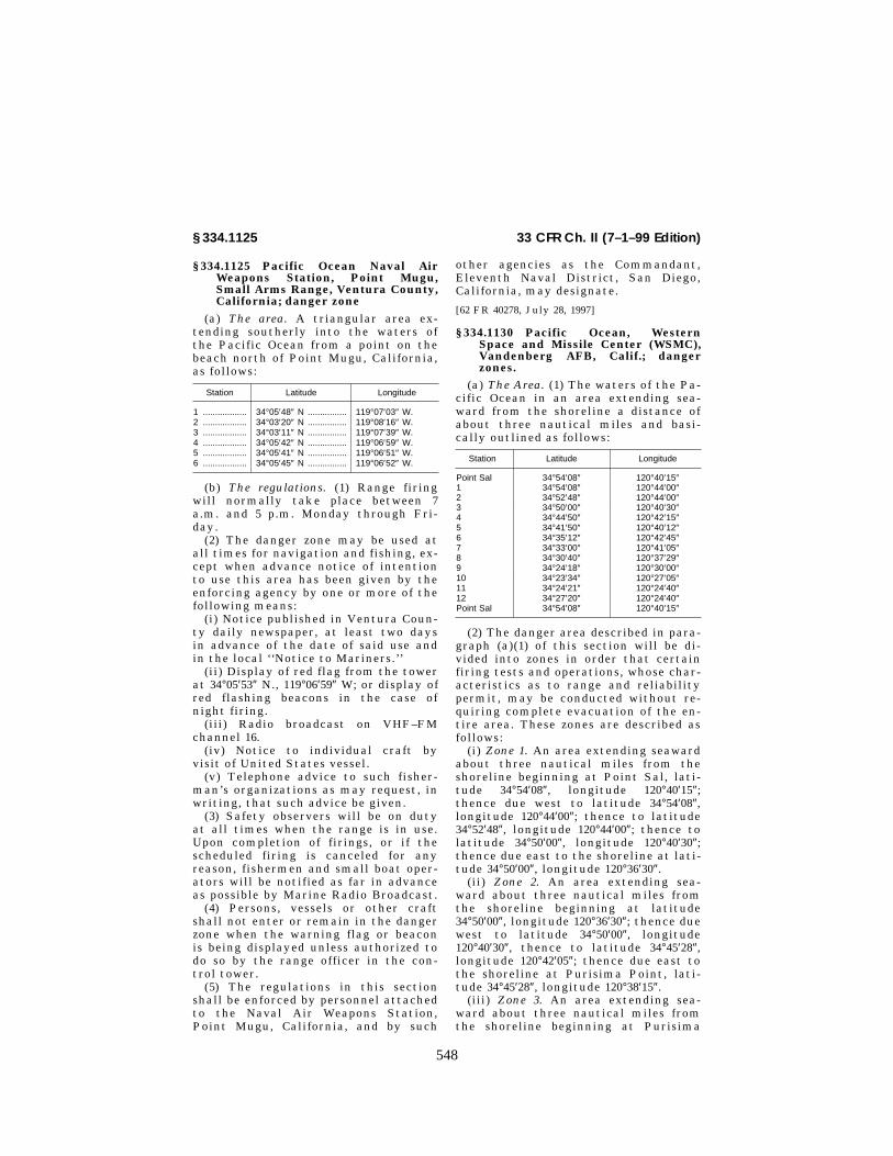
548
33 CFR Ch. II (7–1–99 Edition)§ 334.1125
§ 334.1125 Pacific Ocean Naval AirWeapons Station, Point Mugu,Small Arms Range, Ventura County,California; danger zone
(a) The area. A triangular area ex-tending southerly into the waters ofthe Pacific Ocean from a point on thebeach north of Point Mugu, California,as follows:
Station Latitude Longitude
1 .................. 34°05′48″ N ................ 119°07′03″ W.2 .................. 34°03′20″ N ................ 119°08′16″ W.3 .................. 34°03′11″ N ................ 119°07′39″ W.4 .................. 34°05′42″ N ................ 119°06′59″ W.5 .................. 34°05′41″ N ................ 119°06′51″ W.6 .................. 34°05′45″ N ................ 119°06′52″ W.
(b) The regulations. (1) Range firingwill normally take place between 7a.m. and 5 p.m. Monday through Fri-day.
(2) The danger zone may be used atall times for navigation and fishing, ex-cept when advance notice of intentionto use this area has been given by theenforcing agency by one or more of thefollowing means:
(i) Notice published in Ventura Coun-ty daily newspaper, at least two daysin advance of the date of said use andin the local ‘‘Notice to Mariners.’’
(ii) Display of red flag from the towerat 34°05′53″ N., 119°06′59″ W; or display ofred flashing beacons in the case ofnight firing.
(iii) Radio broadcast on VHF–FMchannel 16.
(iv) Notice to individual craft byvisit of United States vessel.
(v) Telephone advice to such fisher-man’s organizations as may request, inwriting, that such advice be given.
(3) Safety observers will be on dutyat all times when the range is in use.Upon completion of firings, or if thescheduled firing is canceled for anyreason, fishermen and small boat oper-ators will be notified as far in advanceas possible by Marine Radio Broadcast.
(4) Persons, vessels or other craftshall not enter or remain in the dangerzone when the warning flag or beaconis being displayed unless authorized todo so by the range officer in the con-trol tower.
(5) The regulations in this sectionshall be enforced by personnel attachedto the Naval Air Weapons Station,Point Mugu, California, and by such
other agencies as the Commandant,Eleventh Naval District, San Diego,California, may designate.
[62 FR 40278, July 28, 1997]
§ 334.1130 Pacific Ocean, WesternSpace and Missile Center (WSMC),Vandenberg AFB, Calif.; dangerzones.
(a) The Area. (1) The waters of the Pa-cific Ocean in an area extending sea-ward from the shoreline a distance ofabout three nautical miles and basi-cally outlined as follows:
Station Latitude Longitude
Point Sal 34°54′08″ 120°40′15″1 34°54′08″ 120°44′00″2 34°52′48″ 120°44′00″3 34°50′00″ 120°40′30″4 34°44′50″ 120°42′15″5 34°41′50″ 120°40′12″6 34°35′12″ 120°42′45″7 34°33′00″ 120°41′05″8 34°30′40″ 120°37′29″9 34°24′18″ 120°30′00″10 34°23′34″ 120°27′05″11 34°24′21″ 120°24′40″12 34°27′20″ 120°24′40″Point Sal 34°54′08″ 120°40′15″
(2) The danger area described in para-graph (a)(1) of this section will be di-vided into zones in order that certainfiring tests and operations, whose char-acteristics as to range and reliabilitypermit, may be conducted without re-quiring complete evacuation of the en-tire area. These zones are described asfollows:
(i) Zone 1. An area extending seawardabout three nautical miles from theshoreline beginning at Point Sal, lati-tude 34°54′08″, longitude 120°40′15″;thence due west to latitude 34°54′08″,longitude 120°44′00″; thence to latitude34°52′48″, longitude 120°44′00″; thence tolatitude 34°50′00″, longitude 120°40′30″;thence due east to the shoreline at lati-tude 34°50′00″, longitude 120°36′30″.
(ii) Zone 2. An area extending sea-ward about three nautical miles fromthe shoreline beginning at latitude34°50′00″, longitude 120°36′30″; thence duewest to latitude 34°50′00″, longitude120°40′30″, thence to latitude 34°45′28″,longitude 120°42′05″; thence due east tothe shoreline at Purisima Point, lati-tude 34°45′28″, longitude 120°38′15″.
(iii) Zone 3. An area extending sea-ward about three nautical miles fromthe shoreline beginning at Purisima
VerDate 18<JUN>99 07:27 Jul 28, 1999 Jkt 183125 PO 00000 Frm 00548 Fmt 8010 Sfmt 8010 Y:\SGML\183125T.XXX pfrm09 PsN: 183125T

549
Corps of Engineers, Dept. of the Army, DoD § 334.1130
Point latitude 34°45′28″, longitude120°38′15″; thence due west to latitude34°45′28″, longitude 120°42′05″; thence tolatitude 34°44′50″, longitude 120°42′15″;thence to latitude 34°41′50″, longitude120°40′12″; thence due east to the shore-line at the mouth of the Santa YnezRiver, latitude 34°41′50″, longitude120°36′20″.
(iv) Zone 4. An area extending sea-ward about three nautical miles fromthe shoreline beginning at the mouthof the Santa Ynez River latitude34°41′50″, longitude 120°36′20″; thence duewest to latitude 34°41′50″, longitude120°40′12″; thence to latitude 34°35′12″;longitude 120°42′45″; thence latitude34°34′32″, longitude 120°42′15″, thence dueeast to the shoreline at Point Arguello,latitude 34°34′32″, longitude 120°39′03″.
(v) Zone 5. An area extending seawardabout three nautical miles from theshoreline beginning at Point Arguello,latitude 34°34′32″, longitude 120°39′03″;thence due west to latitude 34°34′32″,longitude 120°42′15″; thence to latitude34°33′00″, longitude 120°41′05″; thence tolatitude 34°30′40″, longitude 120°37′29″;thence due north to the shoreline atlatitude 34°33′15″, longitude 120°37′29″.
(vi) Zone 6. An area extending sea-ward about three nautical miles fromthe shoreline beginning at latitude34°33′15″, longitude 120°37′29″; thence duesouth to latitude 34°30′40″, longitude120°37′29″; thence due east to the shore-line at latitude 34°30′40″, longitude120°30′10″.
(vii) Zone 7. An area extending sea-ward about three nautical miles fromthe shoreline beginning at latitude34°30′40″, longitude 120°30′10″; thence duewest to latitude 34°30′40″, longitude120°37′29″; thence to latitude 34°26′56″,longitude 120°33′06″; thence due east tothe shoreline at Point Conception, lati-tude 34°26′56″, longitude 120°28′10″.
(viii) Zone 8. An area extending sea-ward about three nautical miles fromthe shoreline beginning at Point Con-ception, latitude 34°26′56″, longitude120°28′10″; thence due west to latitude34°26′56″, longitude 120°33′06″; thence tolatitude 34°24′18″, longitude 120°30′00″;thence to latitude 34°23′34″, longitude120°27′05″; thence shoreward to PointConception, latitude 34°26′56″, longitude120°28′10″.
(ix) Zone 9. An area extending sea-ward about three nautical miles fromthe shoreline beginning at Point Con-ception, latitude 34°26′56″, longitude120°28′10″; thence seaward to latitude34°23′34″, longitude 120°27′05″; thence tolatitude 34°24′21″, longitude 120°24′40″;thence due north to the shoreline atlatitude 34°27′20″, longitude 120°24′40″.
(b) The regulations. (1) Except as pre-scribed in this section or in other regu-lations, the danger zone will be open tofishing, location of fixed or movable oildrilling platforms and general naviga-tion without restrictions.
(2) The stopping or loitering by anyperson or vessel is expressly prohibitedwithin Danger Zone 4, between themouth of the Santa Ynez River andPoint Arguello, unless prior permissionis obtained from the Commander,Western Space and Missile Center(WSMC) at Vandenberg AFB, Cali-fornia.
(3) The impacting of missile debrisfrom launch operations will take placein any one or any group of zones in thedanger areas at frequent and irregularintervals throughout the year. TheCommander, WSMC, will announce inadvance, the closure of zones hazardedby missile debris impact. Such advanceannouncements will appear in theweekly ‘‘Notice to Mariners.’’ For thebenefit of fishermen, small craft opera-tors and drilling platform operators,announcements will also be made onradio frequency 2182 kc, 2638 kc, VHFchannel 6 (156.30 MHZ), VHF channel 12(156.60 MHZ), and VHF channel 16(156.80 MHZ) for daily announcements.Additionally, information will be post-ed on notice boards located outsidePort Control Offices (Harbormasters)at Morro Bay, Port San Luis, SantaBarbara, Ventura, Channel Islands, andPort Hueneme Harbors, and any estab-lished harbor of refuge between SantaBarbara and Morro Bay.
(4) All fishing boats, other smallcraft, drilling platforms and shippingvessels with radios are requested tomonitor radio freqency 2182 kc, 2638 kc,VHF channel 6 (156.30 MHZ), VHF chan-nel 12 (156.60 MHZ), or channel 16 (156.80MHZ) while in these zones for daily an-nouncements of zone closures.
(5) When a scheduled launch oper-ation is about to begin, radio broadcast
VerDate 18<JUN>99 07:27 Jul 28, 1999 Jkt 183125 PO 00000 Frm 00549 Fmt 8010 Sfmt 8010 Y:\SGML\183125T.XXX pfrm09 PsN: 183125T

550
33 CFR Ch. II (7–1–99 Edition)§ 334.1140
notifications will be made periodically,starting at least 24 hours in advance.Additional contact may be made bysurface patrol boats or aircraftequipped with a loudspeaker system.When so notified, all persons and allvessels shall leave the specified zone orzones immediately by the shortestroute.
(6) The Commander, WSMC, will ex-tend full cooperation relating to thepublic use of the danger area and willfully consider every reasonable requestfor its use in light of requirements fornational security and safety of personsand property.
(7) Where an established harbor ofrefuge exists, small craft may takeshelter for the duration of zone closure.
(8) Fixed or movable oil drilling plat-forms located in zones identified ashazardous and closed in accordancewith this regulation shall cease oper-ations for the duration of the zone clo-sure. The zones shall be closed continu-ously no longer than 72 hours at anyone time. Such notice to evacuate per-sonnel shall be accomplished in accord-ance with procedures as established bythe Commander, WSMC, the U.S. De-partment of the Interior, MineralsManagement Service and the oil indus-try in the adjacent waters of the outercontinental shelf.
(9) No seaplanes, other than those ap-proved by the Commander, WSMC, mayenter the danger zones during launchclosure periods.
(10) The regulations in this sectionshall be enforced by personnel attachedto WSMC and by such other agencies asmay be designated by the Commander,WSMC.
(11) The regulations in this sectionshall be in effect until further notice.They shall be reviewed again duringAugust 1994.
(33 U.S.C. 1, 3)
[48 FR 19025, Apr. 27, 1983. Redesignated at 50FR 42696, Oct. 22, 1985, and amended at 54 FR31142, July 26, 1989; 62 FR 17558, Apr. 10, 1997]
§ 334.1140 Pacific Ocean at San MiguelIsland, Calif.; naval danger zone.
(a) The area. The waters around SanMiguel Island, extending about 3 milesseaward from the shoreline within thefollowing points:
Latitude (N) Longitude (W)
Point A 34°01′32″ 120°23′17″Point B 33°58′48″ 120°23′17″Point C 33°58′48″ 120°15′00″Point D 34°02′50″ 120°15′00″Point E 34°05′45″ 120°17′25″Point F 34°07′00″ 120°20′05″Point G 34°09′18″ 120°23′17″Point H 34°03′09″ 120°23′17″
(b) Markers. Range markers, as delin-eated below, are installed at points Aand H for navigational purposes forboth surface vessels and aircraft:
(1) At point A two triangular mark-ers are installed facing southward, 10feet in length on each side, with redand white diagonal stripes, each mark-er mounted atop 80-foot poles spaced100 yards apart, each pole being placedon the line of longitude 120°23′17″ W.and near the southerly shoreline atlatitude 34°01′32″ N. The southernmostmarker is 20 feet below the other.
(2) At point H two triangular mark-ers are installed facing true north 10feet in length on each side, with redand white diagonal stripes, each mark-er mounted atop 80-foot poles spaced100 yards apart, each pole being placedon the line of longitude 120°23′17″ W.and near the northwesterly shorelineat latitude 34°03′09″ N. The northern-most marker is 20 feet below the other.
(c) The regulations. (1) Except as pre-scribed in this section or in other regu-lations, the danger zone will be open tofishing and general navigation. Bombdrops between designated hours are ex-pected to be intermittent, and whensafe to do so, commercial fishing boatsand other small craft will be grantedpermission to proceed through the dan-ger zone. All vessels permitted to enterthe zone during a scheduled bomb dropperiod, other than those owned or oper-ated by the U.S. Government, shallproceed across the zone by the most di-rect route and clear the area as soon aspossible. When bomb drops are notscheduled, the zone may be occupiedwithout restriction.
(2) The anchoring, stopping or loi-tering by any person, vessel, fishingboat or recreational craft within thedanger zone during scheduled firing/drop hours is expressly prohibited.
(3) The bomb drops will take place inthe danger zone at frequent and irreg-ular intervals throughout the year.
VerDate 18<JUN>99 07:27 Jul 28, 1999 Jkt 183125 PO 00000 Frm 00550 Fmt 8010 Sfmt 8010 Y:\SGML\183125T.XXX pfrm09 PsN: 183125T

551
Corps of Engineers, Dept. of the Army, DoD § 334.1150
Danger zone usage demands are identi-fied in the Eleventh Coast Guard Dis-trict, ‘‘Local Notice of Mariners.’’ An-nouncements will also be made on ma-rine radio channel 16, at 0800 localtime, 1200 local time and/or 1 hourprior to bomb drop operations. Statusof the zone and/or permission to enter,may be requested by calling ‘‘PleadControl’’ on marine channel 16 or bycalling the Pacific Missile Test Center(PMTC) on telephone number (805) 982–8280 or 982–8841.
(4) The Commander, PMTC will ex-tend full cooperation relating to thepublic use of the danger zone area andwill fully consider every reasonable re-quest for its use in light of require-ments for national security and safetyof persons and property.
(5) No seaplanes, other than those ap-proved for entry by the Commander,PMTC, may enter the danger zone dur-ing firing periods.
(6) Landing by any vessel or goingashore by any person on San Miguel Is-land is specifically prohibited withoutprior permission of the Superintendent,Channel Islands National Park. Appli-cations for such permission should bemade to: Superintendent, Channel Is-lands National Park, 1699 Anchors WayDrive, Ventura, California 93003.
(7) The regulations in this sectionshall be enforced by personnel attachedto the Pacific Missile Test Center,Point Mugu, California, and by suchother agencies as the Commandant,11th Naval District, San Diego, Cali-fornia, may designate.
(8) The regulations in this sectionshall be in effect until further notice.They shall be reviewed in 1986.
(Sec. 7, 40 Stat. 266, Chap. XIX, 40 Stat. 892;33 U.S.C. 1, 3)
[31 FR 816, Jan. 21, 1966, as amended at 47 FR4990, Feb. 3, 1982. Redesignated at 50 FR42696, Oct. 22, 1985, as amended at 62 FR 17558,Apr. 10, 1997]
§ 334.1150 Monterey Bay, Calif.(a) Firing range, Fort Ord, Calif.—(1)
The danger zone. (i) A rectangular areain Monterey Bay, the southerly limitof which is an extension seaward of thesoutherly line of the Fort Ord MilitaryReservation boundary and bears 307°true, 8,000 yards from a point on theshore at latitude 36°37′47″, longitude
121°50′28″, and the northerly limit ofwhich is a line bearing 307° true, 8,000yards, from a point on the shore atlatitude 36°41′57″, longitude 121°48′30″,opposite Marina, Monterey County,California. The seaward boundary is astraight line joining the outer ends ofthe southerly and the northerly bound-aries at the 8,000 yard range and is ap-proximately parallel to the shore.
(ii) The danger zone is divided into ashort range area, extending seawardfrom the shore a distance of 5,000 yardsmeasured along the southerly andnortherly boundaries, and a long rangearea embracing the entire danger zone.
(2) The regulations. (i) The 5,000 yardshort range is prohibited to all persons,vessels and craft, except those author-ized by the enforcing agency, eachweek, between dawn and midnight fromMonday through Friday and betweendawn and dusk on Saturday and Sun-day.
(ii) The area between the 5,000 yardshort range and the 8,000 yard seawardboundary of the danger zone may beused at all times for navigation andfishing, except when advance notice ofintention to use this area has beengiven by the enforcing agency by oneor more of the following means.
(a) Notice published in MontereyCounty and Santa Cruz County dailynewspapers, at least two days in ad-vance of the date of said use.
(b) Display of red flags at IndianHead Beach and near the Point PinosLighthouse.
(c) Radio Broadcast.(d) Notice to individual craft by a
visit of a U.S. vessel.(e) Telephone advice to such fisher-
men’s organizations as may request, inwriting, that such advice be given.
(iii) The regulations in this para-graph will be enforced by the Com-manding General, Fort Ord, California.
(b) Navy mining operations area—(1)The danger zone. Shoreward of a linebeginning at the stack at about lati-tude 36°58′06″, longitude 121°54′06″;thence 230° true, 6.0 miles; thence 140°true, 7.5 miles; thence 50° true to theshore.
(2) The regulations. The danger zonewill be used for training in variousphases of mine warfare operations.During the period from August 1 to
VerDate 18<JUN>99 07:27 Jul 28, 1999 Jkt 183125 PO 00000 Frm 00551 Fmt 8010 Sfmt 8010 Y:\SGML\183125T.XXX pfrm09 PsN: 183125T

552
33 CFR Ch. II (7–1–99 Edition)§ 334.1160
February 15, inclusive, each year, nooperations will be carried on which willinvolve placing any obstructions in thewater nor will any operations be car-ried on at night. During the periodfrom February 16 to July 31, inclusive,each year, operations may be carriedon which will involve laying exercisemines and other moored or bottom ob-structions. In each case when mooredor bottom obstructions are laid a no-tice to mariners will be issued givingnotice of their approximate locationwithin the danger zone and all personsand vessels shall keep clear.
[13 FR 8301, Dec. 24, 1948. Redesignated at 14FR 4904, Aug. 9, 1949, and amended at 17 FR4665, May 22, 1952; 19 FR 96, Jan. 7, 1954. Re-designated at 50 FR 42696, Oct. 22, 1985, asamended at 62 FR 17558, Apr. 10, 1997]
§ 334.1160 San Pablo Bay, Calif.; targetpractice area, Mare Island NavalShipyard, Vallejo.
(a) The danger zone. A sector in SanPablo Bay adjacent to the westerlyshore of Mare Island with a radius of4,700 yards, centered at a point bearing316° true, 3,605 yards, from Mare IslandStrait Light 1, with limiting true bear-ings from that center of 266°30′ and 222°.
(b) The regulations. The Commander,Mare Island Naval Shipyard, Vallejo,California, will conduct target practicein the area at intervals of which thepublic will be duly notified. At suchtimes all persons and vessels shall stayclear.
[13 FR 8302, Dec. 24, 1948. Redesignated at 14FR 4904, Aug. 9, 1949, and amended at 27 FR10484, Oct. 27, 1962; 37 FR 9995, May 18, 1972.Redesignated at 50 FR 42696, Oct. 22, 1985, asamended at 62 FR 17558, Apr. 10, 1997]
§ 334.1170 San Pablo Bay, Calif.; gun-nery range, Naval Inshore Oper-ations Training Center, Mare Is-land, Vallejo.
(a) The Danger Zone. A sector in SanPablo Bay delineated by lines joiningthe following points:
Latitude Longitude
38°02′08″ 122°25′17″38°02′21″ 122°22′55″38°05′48″ 122°19′34″38°07′46″ 122°23′23″
NOTE: The danger zone shall be used untilSeptember 30, 1982, after which it shall be
subject to review to determine the furtherneed thereof.
(b) The regulations. The CommandingOfficer, Coastal River Division Eleven,Department of the Navy, Mare Island,Vallejo, California, will conduct gun-nery practice in the area during the pe-riod April 1 through September 30, be-tween the hours of 10 a.m. and 3 p.m.on the first Wednesday of each monthand the third full weekend (Saturdayand Sunday) of June. No persons orvessels shall enter or remain in thedanger zone during the above stated pe-riods except those persons and vesselsconnected with the gunnery practiceoperations. All firing will be from thesoutherly portion of the danger zone ina northerly direction, and only duringgood visibility. The public will be noti-fied prior to each firing by a Notice toMariners issued by the U.S. CoastGuard and the area will be patrolled byboat and searched by radar to insure aclear range. A safety officer will al-ways be aboard the firing boat to guar-antee that all safety precautions areobserved. The regulations in this sec-tion will be enforced by the Com-mandant, 12th Naval District and suchagencies as he may designate.
[31 FR 13992, Nov. 2, 1966, as amended at 34FR 5723, Mar. 27, 1969; 35 FR 9279, June 13,1970; 42 FR 40196, Aug. 9, 1977. Redesignatedat 50 FR 42696, Oct. 22, 1985, as amended at 62FR 17558, Apr. 10, 1997]
§ 334.1180 Strait of Juan de Fuca,Wash.; air-to-surface weapon range,restricted area.
(a) The restricted area. A circular areaimmediately west of Smith Island witha radius of 1.25 nautical miles havingits center at latitude 48°19′11″ Northand longitude 122°54′12″ West. In thecenter of the area will be located alighted and radar reflective buoy toserve as a navigational aid to mariners.The area will be used for air-to-surfacetarget practice using non-explosivetraining devices.
(b) The regulations. (1) No person, ves-sel or other watercraft shall enter orremain within the designated re-stricted area between 0700 and 1200hours daily, local time except as au-thorized by the enforcing agency andas follows: The area will be open tocommercial gill net fishing duringscheduled fishing periods from June 15
VerDate 18<JUN>99 07:27 Jul 28, 1999 Jkt 183125 PO 00000 Frm 00552 Fmt 8010 Sfmt 8010 Y:\SGML\183125T.XXX pfrm09 PsN: 183125T

553
Corps of Engineers, Dept. of the Army, DoD § 334.1190
to October 15 annually. The October 15closure date will be extended by the en-forcing agency if determined as advan-tageous to the commercial gill netfishing by the Washington State De-partment of Fisheries.
(2) Prior to each target practice oper-ation the restricted area will be pa-trolled by naval aircraft. Those personsand vessels found within the restrictedarea will be overflown by the aircraftat an altitude of not less than 300′ inthe direction in which the unauthor-ized person and vessel are to proceed toclear the area.
(c) The regulations in this sectionshall be enforced by the Commandant,Thirteenth Naval District, Seattle,Washington, and such agencies as hemay designate.
(Sec. 7, 40 Stat. 266, Chap. XIX)
[39 FR 44753, Dec. 27, 1974; 40 FR 6502, Feb. 12,1975. Redesignated at 50 FR 42696, Oct. 22,1985, as amended at 62 FR 17558, Apr. 10, 1997]
§ 334.1190 Hood Canal and Dabob Bay,Wash.; naval non-explosive torpedotesting area.
(a) Hood Canal in vicinity of Bangor—(1) The area. All waters of Hood Canalbetween latitude 47°46′00″ and latitude47°42′00″, exclusive of navigation lanesone-fourth nautical mile wide alongthe west shore and along the east shoresouth from the town of Bangor (lati-tude 47°43′28″).
(2) The regulations. (i) The area willbe used intermittently by the Navy fornon-explosive torpedo ranging. Launch-ing will be conducted only between 8:00a.m., and sunset on days other thanSaturdays, Sundays, and holidays. Atno time will the navigation lanes gen-erally paralleling the shore be closedto navigation.
(ii) Navigation will be permittedwithin the area at all times exceptwhen naval exercises are in progress.No vessel shall enter or remain in thearea when such exercises are inprogress. Prior to commencement of anexercise, the Navy will make an aerialor surface reconnaissance of the area.Vessels under way and laying a coursethrough the area will not be interferedwith, but they shall not delay theirprogress. Vessels anchored or cruisingin the area and vessels unobserved bythe Navy reconnaissance which enter
or are about to enter the area while atorpedo is in the water will be con-tacted by a Navy patrol boat and ad-vised to steer clear. Torpedos will betested only when all vessels or othercraft have cleared the area.
(iii) When operations are in progress,use of the area will be indicated by thepresence of Naval vessels flying a‘‘Baker’’ (red) flag.
(iv) Notices of temporary suspensionand revival of operations will be pub-lished in local newspapers and in No-tice to Mariners published by the U.S.Coast Guard.
(b) Dabob Bay in the vicinity ofQuilcene—(1) The area. All waters ofDabob Bay beginning at latitude47°39′27″, longitude 122°52′22″; thencenortheasterly to latitude 47°40′19″, lon-gitude 122°50′10″; thence northeasterlyto a point on the mean high water lineat Takutsko Pt.; thence northerlyalong the mean high water line to lati-tude 47°48′00″; thence west on latitude47°48′00″ to the mean high water line onthe Bolton Peninsula; thence south-westerly along the mean high waterline of the Bolton Peninsula to a pointon longitude 122°51′06″; thence south onlongitude 122°51′06″ to the mean highwater line at Whitney Pt.; thence alongthe mean water line to a point on lon-gitude 122°51′15″; thence southwesterlyto the point of beginning.
(2) The regulations. (i) Propeller-driv-en or other noise-generating craft shallnot work their screws or otherwisegenerate other than incidental noise inthe area during periods of actual test-ing, which will be indicated by flashingred beacons at strategic locations, andall craft shall keep well clear of vesselsengaged in such testing.
(ii) No vessel shall trawl or drag inthe area.
(iii) No vessel shall anchor in thearea except between the shore and the10-fathom depth line.
(iv) Operations will normally be con-fined to the period from about 9:30a.m., to 2:30 p.m., on Mondays throughFridays, and will normally consist ofintermittent tests of less than 30 min-utes duration, with boat passage per-mitted between tests. Transits of log-tows and other slow-moving traffic willbe arranged on a mutually satisfactory
VerDate 18<JUN>99 07:27 Jul 28, 1999 Jkt 183125 PO 00000 Frm 00553 Fmt 8010 Sfmt 8010 Y:\SGML\183125T.XXX pfrm09 PsN: 183125T

554
33 CFR Ch. II (7–1–99 Edition)§ 334.1200
individual basis as appropriate. Emer-gencies or high-priority projects mayoccasionally cause operations outsidethe periods specified above. No oper-ations will be conducted on Sundays.
(c) The regulations in this sectionshall be enforced by the Commandant,Thirteenth Naval District, and suchagencies as he may designate.
[26 FR 6515, July 20, 1961. Redesignated at 50FR 42696, Oct. 22, 1985]
§ 334.1200 Strait of Juan de Fuca, east-ern end; off the westerly shore ofWhidbey Island; naval restrictedareas.
(a) Area No. 1. Bounded by a line com-mencing at latitude 48°20′57″ N., lon-gitude 122°40′39″ W.; thence to latitude48°20′40″ N., longitude 122°42′59″ W.;thence to latitude 48°21′19″ N., lon-gitude 122°43′02″ W.; thence to latitude48°21′13″ N., longitude 122°40′26″ W.; andthence along the shore line to the pointof beginning.
(b) Area No. 2. Bounded by a line com-mencing at latitude 48°21′53″ N., lon-gitude 122°40′00″ W.; thence to latitude48°23′12″ N., longitude 122°41′17″ W.;thence to latitude 48°23′29″ N., lon-gitude 122°40′22″ W.; thence to latitude48°22′21″ N., longitude 122°39′50″ W.; andthence along the shore line to the pointof beginning.
(c) The regulations. (1) Persons andvessels shall not enter these areas ex-cept at their own risk.
(2) All persons and vessels enteringthese areas shall be obliged to complywith orders received from navalsources pertaining to their movementswhile in the areas.
(3) The regulations in this paragraphshall be enforced by the Commander,Naval Base, Seattle, and such agenciesas he/she may designate.
[26 FR 11203, Nov. 28, 1961. Redesignated at 50FR 42696, Oct. 22, 1985]
EDITORIAL NOTE: For FR citations affect-ing § 334.1200, see List of CFR Sections Af-fected in the Finding Aids section of this vol-ume.
§ 334.1210 Admiralty Inlet, entrance;naval restricted area.
(a) Admiralty Inlet, entrance; naval re-stricted area—(1) The area. Beginning atPoint Wilson Light thence southwest-erly along the coast line to latitude
48°07′ N.; thence northwesterly to apoint at latitude 48°15′ N. longitude123°00′ W.; thence due east to WhidbeyIsland; thence southerly along thecoast line to latitude 48°12.5′ N.; thencesoutherly to the point of beginning.
(2) The regulations. (i) Use of anyequipment such as anchors, fishinggear, grapnels, etc., which may foul un-derwater installations within the re-stricted area, is prohibited. Dumping ofany non-buoyant objects in this area isprohibited.
(ii) The regulations in this paragraphshall be enforced by the Commander,Naval Base, Seattle, and such agenciesas he/she may designate.
[26 FR 11203, Nov. 28, 1961. Redesignated at 50FR 42696, Oct. 22, 1985]
EDITORIAL NOTE: For FR citations affect-ing § 334.1210, see List of CFR Sections Af-fected in the Finding Aids section of this vol-ume.
§ 334.1220 Hood Canal, Bangor; navalrestricted areas.
(a) Hood Canal, Bangor; Naval re-stricted areas—(1) Area No. 1. That areabounded by a line commencing on theeast shore of Hood Canal at latitude47°43′28″ N; thence 270° true to latitude47°43′28″ N, longitude 122°44′40″ W;thence to latitude 47°43′50″ N, longitude122°44′40″ W; thence to latitude 47°44′24″N, longitude 122°44′22″ W; thence tolatitude 47°45′47″ N, longitude 122°43′22″W; thence to latitude 47°46′23″ N, lon-gitude 122°42′42″ W; thence to latitude47°46′23″ N, longitude 122°42′20″ W;thence 125° true to the high tide line;thence southerly along the shoreline tothe point of beginning.
(2) Area No. 2. Waters of Hood Canalwithin a circle of 1,000 yards diametercentered on a point located at latitude47°46′26″ N, longitude 122°42′49″ W.
(3) The regulations—(i) Area No. 1. Noperson or vessel shall enter this areawithout permission from the Com-mander, Naval Base, Seattle, Wash-ington, or his/her authorized represent-ative.
(ii) Area No. 2. (A) The area will beused intermittently by the Navy formagnetic silencing operations.
(B) Use of any equipment such as an-chors, grapnels, etc., which may foulunderwater installations within the re-stricted area, is prohibited at all times.
VerDate 18<JUN>99 07:27 Jul 28, 1999 Jkt 183125 PO 00000 Frm 00554 Fmt 8010 Sfmt 8010 Y:\SGML\183125T.XXX pfrm09 PsN: 183125T

555
Corps of Engineers, Dept. of the Army, DoD § 334.1250
(C) Dumping of any nonbuoyant ob-jects in this area is prohibited.
(D) Navigation will be permittedwithin that portion of this circulararea not lying within Area No. 1 at alltimes except when magnetic silencingoperations are in progress.
(E) When magnetic silencing oper-ations are in progress, use of the areawill be indicated by display of quickflashing red beacons on the pier locatedin the southeast quadrant of the area.
(4) Enforcement. The regulations inthis subsection shall be enforced by theCommander, Naval Base, Seattle,Washington, or his/her authorized rep-resentative.
[26 FR 11203, Nov. 28, 1961. Redesignated at 50FR 42696, Oct. 22, 1985]
EDITORIAL NOTE: For FR citations affect-ing § 334.1220, see List of CFR Sections Af-fected in the Finding Aids section of this vol-ume.
§ 334.1230 Port Orchard; naval re-stricted area.
(a) Port Orchard; naval restrictedarea—(1) The area. Shoreward of a linebeginning at a point on the west shore-line of Port Orchard bearing 90° fromstack (at latitude 47°42′01″, longitude122°36′54″); thence 90°, approximately190 yards, to a point 350 yards fromstack; thence 165°, 6,000 yards, to apoint bearing 179°, 1,280 yards, fromBattle Point Light; thence westerly tothe shoreline at latitude 47°39′08″ (ap-proximate location of the BrownsvillePier).
(2) The regulations. (i) No vessel shall,at any time, anchor or tow a drag ofany kind in this area.
(ii) The regulations in this paragraphshall be enforced by the Commander,Naval base, Seattle, and such agenciesas he/she may designate.
[26 FR 11203, Nov. 28, 1961. Redesignated at 50FR 42696, Oct. 22, 1985]
EDITORIAL NOTE: For FR citations affect-ing § 334.1230, see List of CFR Sections Af-fected in the Finding Aids section of this vol-ume.
§ 334.1240 Sinclair Inlet; naval re-stricted areas.
(a) Sinclair Inlet; naval restrictedareas—(1) Area No. 1. All the waters ofSinclair Inlet westerly of a line drawnfrom the Bremerton Ferry Landing at
latitude 47°33′48″ N, longitude 122°37′23″W on the north shore of Sinclair Inletand latitude 47°32′52″ N, longitude122°36′58″ W on the south shore of Sin-clair Inlet.
(2) Area No. 2. That area of SinclairInlet to the north and west of an areabounded by a line commencing at lati-tude 47°33′43″ N, longitude 122°37′31″ Wthence south to latitude 47°33′39″ N,longitude 122°37′27″ W thence southwestto latitude 47°33′23″ N, longitude122°37′45″ W thence southwest to lati-tude 47°33′19″ N, longitude 122°38′12″ Wthence southwest to latitude 47°33′10″N, longitude 122°38′19″ W thence south-west to latitude 47°33′07″ N, longitude122°38′29″ W thence west to latitude47°33′07″ N, longitude 122°38′58″ W thencesouthwest to latitude 47°33′04″ N, lon-gitude 122°39′07″ W thence west to thenorth shore of Sinclair Inlet at latitude47°33′04″ N, longitude 122°39′41″ W.
(3) The regulations—(i) Area No. 1. Novessel of more than 100 gross tons shallenter this area or navigate thereinwithout permission from the enforcingagency.
(ii) Area No. 2. This area is for the ex-clusive use of the U.S. Navy. No per-son, vessel, craft, article or thing ex-cept those under supervision of mili-tary or naval authority except Wash-ington State Ferries or Horluck Trans-portation Company Ferries on estab-lished routes shall enter this area with-out permission from the enforcingagency.
(iii) The regulations in this sectionshall be enforced by the Commander,Naval Base, Seattle, Washington, orhis/her authorized representative.
(b) [Reserved]
[60 FR 43379, Aug. 21, 1995; 60 FR 57935, Nov.24, 1995]
§ 334.1250 Carr Inlet, naval restrictedareas.
(a) Carr Inlet, naval restricted areas—(1) The area. The Waters of Carr Inletbounded on the southeast by a line run-ning from Gibson Point on Fox Islandto Hyde Point on McNeil Island, on thenorthwest by a line running fromGreen Point (at latitude 47°16′54″ N,longitude 122°41′33″ W) to PenrosePoint; plus that portion of Pitt Pas-sage extending from Carr Inlet to Pitt
VerDate 18<JUN>99 07:27 Jul 28, 1999 Jkt 183125 PO 00000 Frm 00555 Fmt 8010 Sfmt 8010 Y:\SGML\183125T.XXX pfrm09 PsN: 183125T

556
33 CFR Ch. II (7–1–99 Edition)§ 334.1250
Island, and that portion of Hale Pas-sage extending from Carr Inlet south-easterly to a line drawn perpendicularto the channel 500 yards northwesterlyof the Fox Island Bridge.
(2) The regulations. (i) The area shallbe used as an acoustic range for re-search studies and special noise trials.No explosive shall be used.
(ii) No marine craft of any type shallat anytime approach or remain withinone hundred yards of the hydrophonebuoys. The hydrophone buoys will beanchored in Carr Inlet on a line perpen-dicular to the course line oppositeKetner’s Point, and about one milefrom the Fox Island shore. The courseline, or range, will bear 134°38′21″(314°38′21″) true, and will be marked byrange beacons erected near the shore-line approximately one mile north-northeast of of Steilacoom and ap-proximately two miles north-northeastof Home.
(iii) Buoy Testing Area. No vesselshall, at anytime, anchor or tow a dragof any kind within 1,000 yards of thebuoy testing area.
(iv) The remainder of the area shallbe open to navigation at all times ex-cept when the range is in use or whenhydrophones are being calibrated.When the range is in use or hydro-phones are being calibrated, quickflashing beacon lights will be displayedon signal towers located at GibsonPoint, Green Point, Penrose Point,Pitt Island and Hyde Point. These bea-con lights will be either red or green.The beacon lights will show quickflashing every two seconds. The rang-ing of vessels or calibration of hydro-phones requiring retrictions will beconducted 24 hours per day for up to 5days consecutively, and will total ap-proximately 150 days spread through-out the year. Shutting off of beaconlights will indicate termination of useof the range. Insofar as possible, theschedule of operations giving the daysthe range will be in use for each forth-coming month will be published inlocal newspapers and in the local U.S.Coast Guart Notice to Mariners.
(v) When the red beacon lights aredisplayed, indicating that the range isin use or hydrophones are being cali-brated, navigation within the area willbe restricted as follows:
(a) As used in this section, the words‘‘operate, power vessel, and non-powervessel’’ are defined as follows:
(1) ‘‘Operate’’: To be physicallypresent in the designated area.
(2) ‘‘Power vessel’’: A vessel propelledprincipally by a mechanical propulsionsystem (i.e., gasoline, diesel, steam orelectric drive to a propeller, pump jet,paddle wheel or other device), andbeing propelled by that means.
(3) ‘‘Non-power vessel’’: A vessel notequipped with a mechanical propulsionsystem, such as a rowboat, canoe, orsailboat propelled by oars, paddles, orsails, respectively.
(b) Power vessels shall not operatewithin the area, except that traffic ineither direction between Hale Passageand upper Carr Inlet, within 200 yardsof the low water mark off Green Point,will be cleared by signal for approxi-mately 15 minutes total time withinthis area at the termination of indi-vidual ranging runs, while the vesselbeing ranged takes position for thenext run. Clearance to traverse thearea around Green Point will be indi-cated by extinguishing the red flashingbeacon lights and displaying the greenflashing beacon lights on all signaltowers.
(c) Non-powered marine craft shallnot operate within one mile of thecourse line bearing 134°38′21″ (314°38′21″)true, and within two miles to thesoutheast and two miles to the north-west of the hydrophone buoys situatedin Carr Inlet opposite Ketner’s Point;provided, however, non-powered craftmay operate within four hundred yardsof the low water mark on the northeastside of McNeil Island, within two hun-dred yards of the low water mark atGreen Point, and within two hundredyards of the low water mark on thesouthwest shore of Fox Island.
(d) Towboats shall have free accessand egress to designated tow havenswithin Carr Inlet, as follows: The Navywill establish and maintain suitablemooring buoys for the use of tugs andtheir tows at the following points: (1)approximately 1,500 yards northwest ofGibson Point Light and approximately400 yards offshore from the low watermark on the Fox Island shore; (2) ap-proximately 1,500 yards northwest ofHyde Point, and approximately 400
VerDate 18<JUN>99 07:27 Jul 28, 1999 Jkt 183125 PO 00000 Frm 00556 Fmt 8010 Sfmt 8010 Y:\SGML\183125T.XXX pfrm09 PsN: 183125T

557
Corps of Engineers, Dept. of the Army, DoD § 334.1270
yards offshore from the low watermark on McNeil Island shore; and (3)approximately 1,500 yards east ofWyckoff Shoal. Towboats will signal byradio (Marine Band Channel 14, 13, 12,or 6) or telephone as far in advance aspossible of the time they enter the towhaven, such signals to be directed to‘‘Carr Inlet Range Control’’ at therange instrument laboratory buildinglocated on Fox Island. The Navy shallpromptly suspend operations when nec-essary to permit the access and egressof such tow traffic, and Carr InletRange Control shall signal the towswhen the area is clear.
(e) Through commercial traffic, in-cluding tows, to points within CarrInlet, and through Carr Inlet, Pitt Pas-sage, and Hale Passage to adjacent wa-ters will be permitted free access andegress, as follows: Such traffic will sig-nal by radio (Marine Band Channel 14,13, 12, or 6) or telephone as far in ad-vance as possible of the time theyenter the area, such signals to be di-rected to ‘‘Carr Inlet Range Control’’at the range instrument laboratory lo-cated on Fox Island. The Navy shallpromptly suspend operations when nec-essary to permit the passage of suchtraffic, and Carr Inlet Range Controlshall signal when the area is clear forpassage.
(f) The Warden of the McNeil Islandpenitentiary and his authorized rep-resentatives shall be permitted to oper-ate within the area at any time, asmay be necessary, for the patrol andsearch of escaped convicts.
(g) Red or green signal flags will bedisplayed on the signal towers in caseof failure of the red or green beaconlights. The display or the signal flagsat the top of the flag masts will havethe same significance as the beaconlights.
(3) The regulations in this paragraphshall be enforced by the Commander,Naval Base, Seattle, and such agenciesas he/she may designate.
(b) [Reserved]
[26 FR 11203, Nov. 28, 1961. Redesignated at 50FR 42696, Oct. 22, 1985]
EDITORIAL NOTE: For FR citations affect-ing § 334.1250, see List of CFR Sections Af-fected in the Finding Aids section of this vol-ume.
§ 334.1260 Dabob Bay, Whitney Point;naval restricted area.
(a) Dabob Bay, Whitney Point, navalrestricted area—(1) The area. Beginningat the high water line along the west-erly shore of Dabob Bay, 100 yardsnortherly of the Naval control buildinglocated at approximately N. latitude47°45′36″ and W. longitude 122°51′00″,thence S. 89°59′ E. 2000 yards, thence toS. 00° 01′ W. 200 yards, thence N. 89°59′W. approximately 2000 yards to thehigh water line 100 yards southerly ofthe control building.
(2) The regulations. (i) No vessel shall,at any time, anchor or tow a drag ofany kind in this area.
(ii) The regulations in this paragraphshall be enforced by the Commander,Naval Base, Seattle, or his/her author-ized representative.
(b) [Reserved]
[26 FR 11203, Nov. 28, 1961. Redesignated at 50FR 42696, Oct. 22, 1985]
EDITORIAL NOTE: For FR citations affect-ing § 334.1260, see List of CFR Sections Af-fected in the Finding Aids section of this vol-ume.
§ 334.1270 Port Townsend, Indian Is-land, Walan Point; naval restrictedarea.
(a) The area. The waters of PortTownsend bounded by a line com-mencing on the north shore of WalanPoint at latitude 48°04′41″ N. longitude122°44′26″ W; thence to latitude 48°04′46″N, longitude 122°44′53″ W; thence tolatitude 48°04′19″ N, longitude 122°45′05″W; thence to latitude 48°04′15″ N, lon-gitude 122°44′48″ W thence to a point onthe Walan Point shore line at latitude48°04′18″ N, longitude 122°44′48″; andthence along the shoreline to the pointof beginning. This line is located ap-proximately 200 yards from the faceand ends of the pier.
(b) The regulations. No person or ves-sel shall enter this area without per-mission from the Commander, NavalBase, Seattle, or his/her authorizedrepresentative. This restriction shallapply during periods when ship loadingand/or pier operations preclude safeentry. These periods will be identifiedby flying a red flag from the ship and/or pier. A yellow flag will be displayed
VerDate 18<JUN>99 07:27 Jul 28, 1999 Jkt 183125 PO 00000 Frm 00557 Fmt 8010 Sfmt 8010 Y:\SGML\183125T.XXX pfrm09 PsN: 183125T

558
33 CFR Ch. II (7–1–99 Edition)§ 334.1275
24 hours in advance of the restrictedperiods.
[26 FR 11203, Nov. 28, 1961. Redesignated at 50FR 42696, Oct. 22, 1985]
EDITORIAL NOTE: For FR citations affect-ing § 334.1270, see List of CFR Sections Af-fected in the Finding Aids section of this vol-ume.
§ 334.1275 West Arm Behm Canal,Ketchikan, Alaska, restricted areas.
(a) The area—Area No. 1. The watersof Behm Canal bounded by a circle 2,000yards in diameter, centered on 55°36′ Nlatitude, 131°49.2′ W longitude.
Area No. 2. The waters of Behm Canalbounded by a circle 2,000 yards in di-ameter, centered at 55°34′ N latitude,131°48′ W longitude.
Area No. 3. The waters of Behm Canalexcluding those areas designated asareas Nos. 1 and 2 above, bounded by anirregular polygon beginning at theshoreline on Back Island near 55°32.63′N latitude, 131°45.18′ W longitude, thenbearing about 350° T to 55°38.06′ N lati-tude, 131°46.75′ W longitude then bear-ing about 300° T to 55°38.52′ N latitude,131°48.15′ W longitude, then bearingabout 203° T to 55°33.59′ N latitude,131°51.54′ W longitude, then bearingabout 112° T to the intersection of theshoreline at Back Island near 55°32.53′N latitude, 131°45.77′ W longitude, thennortheast along the shoreline to thepoint of beginning.
Area No. 4. The waters of Clover Pas-sage bounded by an irregular polygonbeginning at the shoreline on Back Is-land near 55 32.63′ N latitude, 131°45.18′W longitude, then bearing 150° T. to theintersection of the shoreline onRevillagegedo Island near 55°30.64′ Nlatitude, 131°43.64′ W longitude, thensouthwest along the shoreline to near55°30.51′ N latitude, 131°43.88 ′W lon-gitude, then bearing 330° T to the inter-section of the shoreline on Back Islandnear 55°32.16′ N. latitude, 131°45.20′ Wlongitude, and from there northeastalong the shoreline to the point of be-ginning.
Area No. 5. The waters of Behm Canalbounded to the north by a line startingfrom Point Francis on the ClevelandPeninsula to Escape Point onRevillagegedo Island then south alongthe shoreline to Indian Point, thensouth to the Grant Island Light at
55°33.3′ N latitude, 131°43.62′ W lon-gitude then bearing 218° T. to the southend of Back Island and continuing tothe intersection of the shoreline onBetton Island at about 55°31.55′ N lati-tude, 131°45.98′ W longitude, then northalong the shoreline of Betton Island tothe western side below Betton Head atabout 55°30.83′ N latitude, 131°50′ W lon-gitude, then bearing 283° T. acrossBehm Canal to the intersection ofshoreline near the point which formsthe southeast entrance of Bond Bay atabout 55°31.60′ N latitude, 131°56.58′ Wlongitude, then northeast to HelmPoint on the Cleveland Peninsula, thennortheast along the shoreline to thepoint of beginning at Point Francis.
(b) The regulations—(1) Area No. 1.Vessels are allowed to transit the areaat any time. No vessel may anchorwithin the restricted area or tow adrag of any kind, deploy a net or dumpany material within the area.
(2) Area No. 2. Vessels are allowed totransit the area at any time. No vesselmay anchor within the restricted areaor tow a drag of any kind, deploy a netor dump any material within the area.Vessels are also prohibited from moor-ing or tying up to, loitering alongsideor in the immediate vicinity of navalequipment and barges in the restrictedarea.
(3) Area No. 3. Vessels are allowed totransit the area at any time. Due tothe presence of underwater cables andinstrumentation, anchoring is prohib-ited and the towing of a drag or any ob-ject within 100 feet of the bottom isalso prohibited. Anchoring is allowedwithin 100 yards of the shore of BackIsland except within 100 yards of eachside of the area where electrical andother cables are brought ashore. Thetermination location of the cables onthe land is marked with a warning signthat is visible from the water.
(4) Area No. 4. Due to the presence ofcommunication and power cables cross-ing from Revillagegedo Island to BackIsland no anchoring or towing of a dragis allowed. Anchoring is allowed within100 yards of the shore of Back Islandexcept within 100 yards of each side ofthe area where the cables are broughtashore. The termination location of thecables on the land is marked with a
VerDate 18<JUN>99 07:27 Jul 28, 1999 Jkt 183125 PO 00000 Frm 00558 Fmt 8010 Sfmt 8010 Y:\SGML\183125T.XXX pfrm09 PsN: 183125T

559
Corps of Engineers, Dept. of the Army, DoD § 334.1280
warning sign that is visible from thewater.
(5) Area No. 5. (i) The area will beopen unless the Navy is actually con-ducting operations. To ensure safe andtimely passage through the restrictedarea vessel operators are required tonotify the Range Operations Officer oftheir expected time of arrival, speedand intentions. For vessels notequipped with radio equipment, theNavy shall signal with flashing beaconlights whether passage is prohibitedand when it is safe to pass through thearea. A flashing green beacon indicatesthat vessels may proceed through thearea. A flashing red beacon means thatthe area is closed to all vessels and toawait a green clear signal. Each clo-sure of the area by the Navy will nor-mally not exceed 20 minutes.
(ii) Small craft may operate within500 yards of the shoreline at speeds nogreater than 5 knots in accordancewith the restrictions in effect in areaNo. 3.
(iii) During the period May 1 throughSeptember 15 annually, the Navy willonly conduct acoustic measurementtests which will result in transitory re-strictions in Area #5 for a total of nomore than 15 days.
(iv) Transitory restrictions in Area#5 will not be enforced during daylighthours when Navy testing coincideswith pre-scheduled special events inBehm Canal. Special events are definedas summer holidays or celebrations,competitions, or economic endeavorsscheduled by an agency or organiza-tion, and typically occurring everyyear for the utilization of natural re-sources of Behm Canal. Special eventsinclude commercial emergency seinefishery openings from July 25 throughSeptember 15, historic salmon derbieslasting eight days or less, MemorialDay, Labor Day, Independence Day orany nationally recognized three dayweekend to celebrate these holidays.
(v) Public notification that the Navywill be conducting operations in BehmCanal will be given at least 72 hours inadvance to the following Ketchikancontacts: U.S. Coast Guard, KetchikanGateway Borough Planning Depart-ment, Harbor Master, Alaska Depart-ment of Fish and Game, KRBD Radio,
KTKN Radio, and the Ketchikan DailyNews.
(c) Vessels will be allowed to transitRestricted Area #5 within 20 minutes ofmarine radio or telephone notificationto the Navy Range Operations Officer.
(d) Enforcement. The regulations inthis section shall be enforced by theCommander, David Taylor ResearchCenter and such agencies he/she maydesignate.
[55 FR 2586, Jan. 25, 1990, as amended at 55FR 10237, Mar. 20, 1990; 58 FR 6718, Feb. 2,1993]
§ 334.1280 Bristol Bay, Alaska; air-to-air weapon range, Alaskan Air Com-mand, U.S. Air Force.
(a) The danger zone. An area in Bris-tol Bay beginning at latitude 58°24′ N.,longitude 159°10′ W.; thence to latitude57°58′ N., longitude 158°30′ W.; thence tolatitude 57°07′ N., longitude 160°20′ W.;thence to latitude 58°02′ N., longitude161°40′ W.; and thence to the point ofbeginning.
(b) The regulations. (1) Intermittentfiring will be conducted over two tothree day periods about 2 hours a daybetween the hours of 10:00 a.m. and 4:00p.m. during the months of May throughAugust.
(2) The fact that practice firing is totake place over the designated areashall be advertised to the public 72hours in advance through the usualmedia for the dissemination of such in-formation. Notice to the U.S. CoastGuard and NOTAM shall be issued atleast 48 hours before firing is to be con-ducted on the range. Information as tothe dates, time, and characteristics ofthe firing shall be advertised in ad-vance of each session of firing.
(3) Prior to conducting each practicefiring, the danger zone shall be pa-trolled by aircraft to note the locationof all vessels within the area. The prac-tice firing exercise shall be conductedin the portion of the danger zone notoccupied by surface craft.
(4) This section shall be enforced bythe Commander, Alaskan Air Com-mand, U.S. Air Force, Seattle, Wash-ington, or such agencies as he may des-ignate.
[29 FR 5947, May 6, 1964, as amended at 36 FR6422, Apr. 3, 1971. Redesignated at 50 FR 42696,Oct. 22, 1985]
VerDate 18<JUN>99 07:27 Jul 28, 1999 Jkt 183125 PO 00000 Frm 00559 Fmt 8010 Sfmt 8010 Y:\SGML\183125T.XXX pfrm09 PsN: 183125T

560
33 CFR Ch. II (7–1–99 Edition)§ 334.1290
§ 334.1290 In Bering Sea, Shemya Is-land Area, Alaska; meteorologicalrocket launching facility, AlaskanAir Command, U.S. Air Force.
(a) The danger zone. An arc of a circlewith a 45-nautical-mile radius of thelaunch point centered at latitude52°43′30″ N., longitude 174°06′05″ E ex-tending clockwise from 110° true bear-ing to 200° true bearing.
(b) The regulation. (1) Rockets willnormally be launched one each dayMonday through Friday between 9 a.m.and 3 p.m. Rocket hardware will dis-charge into the sea 22.5 to 37.5 nauticalmiles off the launchsite. The instru-ment package with parachute will im-pact about 11⁄2 hours later at an unde-termined area, depending on weatherconditions.
(2) All mariners entering the areawill do so at their own risk and arecautioned to take evasive action asnecessary.
(3) The regulation in this sectionshall be enforced by the Department ofthe Air Force, Headquarters 6th Weath-er Wing (MAC), Andrews Air ForceBase, Washington, D.C. 20331.
(40 Stat. 266 (33 U.S.C. 1))
[36 FR 19079, Sept. 28, 1971, as amended at 42FR 46520, Sept. 16, 1977. Redesignated at 50FR 42696, Oct. 22, 1985]
§ 334.1300 Blying Sound area, Gulf ofAlaska, Alaska; air-to-air gunnerypractice area, Alaskan Air Com-mand, U.S. Air Force.
(a) The danger zone. A rhomboidalarea beginning at latitude 59°51′30″ N.,longitude 148°42′00″ W.; thence to lati-tude 59°22′30″ N., longitude 147°00′00″ W.;thence to latitude 58°52′00″ N., lon-gitude 148°03′00″ W.; thence to latitude59°20′00″ N., longitude 149°45′00″ W., andthence to point of beginning.
(b) The regulations. (1) 20-mm. cannonwill be fired at towed targets in the air.One firing mission will be conductedevery 2 weeks during daylight hoursonly and weather permitting.
(2) The fact that practice firing is totake place over the designated areashall be advertised to the public 7 daysin advance through the usual media forthe dissemination of such information.
Notice to the U.S. Coast Guard andNOTAM shall be issued at least 48hours before firing is to be conductedon the range. Information as to thedates, time, and characteristics of thefiring shall be advertised in advance ofeach session of firing.
(3) Prior to conducting each practicefiring, the danger zone shall be pa-trolled by aircraft to note the locationof all vessels within the area. The prac-tice firing exercise shall be conductedin the portion of the danger zone notoccupied by surface craft.
(4) The regulations in this sectionshall be enforced by the Commander,Alaskan Air Command, U.S. Air Force,Anchorage, Alaska, or such agencies ashe may designate.
(Sec. 7, 40 Stat. 266; 33 U.S.C. 1)
[37 FR 527, Jan. 13, 1972. Redesignated at 50FR 42696, Oct. 22, 1985]
§ 334.1310 Lutak Inlet, Alaska; re-stricted areas.
(a) The areas—(1) Army POL dock re-stricted area. (i) The waters of LutakInlet bounded as follows: Beginning atthe water’s edge 900 feet northwest ofthe centerline of the landward end ofthe POL dock; thence 800 feet, 51° true;thence 1,400 feet, 113° true; thence 450feet, 211° true to the water’s edge at apoint approximately 720 feet from themost southwest corner of the seawardend of the POL dock; thence along thewater’s edge to the point of beginning.
(ii) The area will be marked at pointsapproximately 200 feet apart along theshore by white signs containing theword ‘‘Warning.’’ The signs will not belighted.
(2) Dry Cargo dock mooring area. (i)The waters within 60 feet off the face ofthe dock.
(b) The regulations. (1) No person, ves-sel or other watercraft shall enter orremain in the Army POL dock re-stricted area when tankers are engagedin discharging oil at the dock.
(2) The dropping and dragging of an-chors, weights, or other ground tacklewithin the Dry Cargo dock mooringarea is prohibited.
VerDate 18<JUN>99 07:27 Jul 28, 1999 Jkt 183125 PO 00000 Frm 00560 Fmt 8010 Sfmt 8010 Y:\SGML\183125T.XXX pfrm09 PsN: 183125T

561
Corps of Engineers, Dept. of the Army, DoD § 334.1350
(3) The regulations in this sectionshall be enforced by the District Engi-neer, U.S. Army Engineer District, An-chorage, Alaska, and such agencies ashe may designate.
[33 FR 7723, May 25, 1968. Redesignated at 50FR 42696, Oct. 22, 1985, as amended at 62 FR17559, Apr. 10, 1997]
§ 334.1320 Kuluk Bay, Adak, Alaska;naval restricted area.
(a) The area. The northwest portionof Kuluk Bay bounded as follows: Be-ginning on shore at latitude 51°55′00″ N,longitude 176°33′09″ W; thence due eastto latitude 51°55′00″ N, longitude176°33′09″ W; thence due south to lati-tude 51°51′55″ N longitude 176°31′09″ W;thence due west to the shore at lati-tude 51°51′00″ N, longitude 176°37′43″ W;thence along the shoreline to the pointof beginning.
(b) The regulations. (1) Except in greatemergency, no vessel shall anchor inthe restricted area described above.
(2) The dragging of anchors in oracross the restricted area is prohibitedand no object attached to a vessel shallbe placed on or near the bottom.
(3) Fishing and trawling activities inthe restricted area are prohibited.
(4) The regulation of this restrictedarea shall be enforced by the Com-mander, Patrol Wing, U.S. PacificFleet, Naval Air Station Moffett Field,California, and such agencies and he/she may designate.
[58 FR 26046, Apr. 29, 1993]
§ 334.1330 Bering Strait, Alaska; navalrestricted area off Cape Prince ofWales.
(a) The area. An area 2,000 feet wideextending from a point on Cape Princeof Wales marked by a triangular cablemarker located approximately midwaybetween the village of Wales and CapePrince of Wales Light to a point fourstatute miles due west of the cablemarker with the axis of the area pass-ing through the two points.
(b) The regulations. (1) No vessel shallanchor in the restricted area describedin paragraph (a) of this section.
(2) Dragging of anchors in or acrossthe restricted area is prohibited and noobject attached to a vessel shall beplaced on or near the bottom.
(3) The regulations in this sectionshall be enforced by the Commander,Third Fleet, Pearl Harbor, Hawaii andsuch agencies as he may designate.
[18 FR 8117, Dec. 10, 1953, as amended at 33FR 5875, Apr. 17, 1968; 42 FR 58519, Nov. 10,1977. Redesignated at 50 FR 42696, Oct. 22,1985]
§ 334.1340 Pacific Ocean, Hawaii; dan-ger zones.
(a) Danger zones. (1) Aerial bombingand strafing target surrounding KaulaRock, Hawaii. The waters within a cir-cular area with a radius of three (3)miles having its center on Kaula Rockat latitude 21°39′30″, longitude 160°32′30″.
(2) Submerged unexploded ordnancedanger zone, Kahoolawe Island, Hawaii.The waters adjacent to Kahoolawe Is-land within the area encompassed bythe following coordinates beginning atlatitude 20°37′30″, longitude 156°32′48″;thence to latitude 20°34′48″, longitude156°30′24″; thence to latitude 20°28′54″,longitude 156°30′30″; thence to latitude20°28′06″, longitude 156°41′48″; thence tolatitude 20°30′30″, longitude 156°44′12″;thence to latitude 20°33′12″, longitude156°44′30″; thence to latitude 20°37′30″,longitude 156°36′24″; thence to the be-ginning coordinates.
(b) The regulations. No person, vesselor other craft shall enter or remain inany of the areas at any time except asauthorized by the enforcing agency.
(c) Enforcing agency. The regulationsin this section shall be enforced byCommander, Naval Base, Pearl Harbor,Hawaii 96860–5020, and such agencies ashe/she may designated.
[20 FR 4129, June 11, 1955, as amended at 25FR 4749, May 28, 1960; 31 FR 14255, Nov. 4,1966; 45 FR 57126, Aug. 27, 1980. Redesignatedat 50 FR 42696, Oct. 22, 1985, and amended at58 FR 53427, Oct. 15, 1993; 61 FR 34733, July 3,1996; 62 FR 17559, Apr. 10, 1997]
§ 334.1350 Pacific Ocean, Island ofOahu, Hawaii; danger zone.
(a) The danger zone. Beginning atpoint of origin at Kaena Point Light inlatitude 21°34′42″ N., longitude 158°16′54″W.; thence on a bearing of 282°30′ Trueto latitude 21°38′ N., longitude 158°33′W.; thence along the arc of a circle cen-tered at Kaena Point Light to latitude21°42′30″ N., longitude 158°03′ W.; thenceon a bearing of 228° true to latitude
VerDate 18<JUN>99 07:27 Jul 28, 1999 Jkt 183125 PO 00000 Frm 00561 Fmt 8010 Sfmt 8010 Y:\SGML\183125T.XXX pfrm09 PsN: 183125T

562
33 CFR Ch. II (7–1–99 Edition)§ 334.1360
21°35′33″ N., longitude 158°11′30″ W.;thence to point of origin.
(b) The regulations. (1) The area willbe closed to the public and all shippingon specific dates to be designated foractual firing and no person, vessel orother craft shall enter or remain in thearea during the times designated forfiring except as may be authorized bythe enforcing agency. Notification tomaritime interests of specific dates offiring will be disseminated through theU.S. Coast Guard media of the LocalNotice to Mariners and the NOTAMSpublished by the Corps of Engineers.On dates not specified for firing, thearea will be open to normal maritimetraffic.
(2) The regulations of this sectionshall be enforced by the CommandingGeneral, U.S. Army, Hawaii/25th Infan-try Division, APO 957, and such agen-cies as he may designate.
[24 FR 5999, July 28, 1959. Redesignated at 50FR 42696, Oct. 22, 1985, as amended at 62 FR17559, Apr. 10, 1997]
§ 334.1360 Pacific Ocean at Barber’sPoint, Island of Oahu, Hawaii; dan-ger zone.
(a) The danger zone. The waters with-in a rectangular area beginning at apoint in latitude 21°17′56″ N., longitude158°05′21″ W., thence to latitude 21°17′30″N., longitude 158°05′21″ W.; thence tolatitude 21°17′58″ N., longitude 158°02′49″W., thence to latitude 21°18′24″ N., lon-gitude 158°02′49″ W.; thence along theshoreline at the highwater mark alongthe southerly boundary of Naval AirStation, Barber’s Point, to the point ofbeginning.
(b) The regulations. (1) The area isclosed to all surface craft, swimmers,divers and fishermen except to craftand personnel authorized by the enforc-ing agency.
(2) The regulations in this sectionshall be enforced by the CommandingOfficer, Naval Air Station, Barber’sPoint, Hawaii, 96862, and such agenciesas he/she may designate.
[31 FR 8129, June 9, 1966, as amended at 45 FR57126, Aug. 27, 1980. Redesignated at 50 FR42696, Oct. 22, 1985]
§ 334.1370 Pacific Ocean at KeahiPoint, Island of Oahu, Hawaii; dan-ger zone.
(a) The danger zone. The waters with-in an area beginning at a point in lati-tude 21°18′21.4″ N., longitude 157°59′14.2″W.; thence to latitude 21°18′11″ N., lon-gitude 158°00′17.5″ W.; thence to latitude21°17′11.8″ N., longitude 158°00′06.5″ W.;and thence to latitude 21°17′22.5″ N.,longitude 157°59′03.1″ W.
(b) The regulations. (1) The area isclosed to all surface craft, swimmers,divers, and fishermen except to craftand personnel authorized by the enforc-ing agency.
(2) The regulations in this sectionshall be enforced by the CommandingOfficer, Explosive Ordnance DisposalTraining and Evaluation Unit One,Barbers Point, Hawaii 96862–5600.
[31 FR 12437, Sept. 20, 1966, as amended at 45FR 57126, Aug. 27, 1980. Redesignated at 50 FR42696, Oct. 22, 1985, and amended at 58 FR53427, Oct. 15, 1993]
§ 334.1380 Marine Corps Air Station,(MCAS) Kaneohe Bay, Island ofOahu, Hawaii—Ulupau CraterWeapons Training Range; dangerzone.
(a) The danger zone. The waters with-in a sector extending seaward a dis-tance of 3,900 yards between radiallines bearing 352° true and 61° true, re-spectively, from a point on Mokapu Pe-ninsula at latitude 21°27′17″ N, lon-gitude 157°43′51″ W, exclusive of the ex-isting 500 yard wide prohibited area.The interface between the existing 500yard prohibited area and this dangerzone is defined by three points havingthe following coordinates:
Point A: Latitude 21°27′59″ N, Longitude157°43′56″ WPoint B: Latitude 21°27′52″ N, Longitude157°43′02″ WPoint C: Latitude 21°27′38″ N, Longitude157°43′12″ W
(b) The regulations. (1) Weapons firingat the Ulupau Crater Weapons TrainingRange may occur at any time between6:00 a.m. and 11:00 p.m., Mondaythrough Friday, and between 6:00 a.m.and 6:00 p.m., Saturday and/or Sunday,when required. Specific dates and hoursfor weapons firing, along with informa-tion regarding onshore warning sig-nals, will be promulgated by the U.S.
VerDate 18<JUN>99 07:27 Jul 28, 1999 Jkt 183125 PO 00000 Frm 00562 Fmt 8010 Sfmt 8010 Y:\SGML\183125T.XXX pfrm09 PsN: 183125T

563
Corps of Engineers, Dept. of the Army, DoD § 334.1390
Coast Guard’s Local Notice to Mari-ners. Information on weapons firingschedules may also be obtained by call-ing the Officer in Charge of the RangeTraining Facility, Headquarters andHeadquarters Squadron, MCAS (tele-phone number 257–2067).
(2) Whenever hazardous weapons (ma-chine guns) firing is scheduled and inprogress during daylight hours, twolarge red triangular warning pennantswill be flown at each of two highly visi-ble and widely separated locations onthe shore at Ulupau Crater.
(3) Whenever tactical weapons (exclu-sive of machine guns) firing is sched-uled and in progress during daylighthours, a single large red rectangularwarning flag will be flown at the twoseparate locations on the shore.
(4) Whenever any weapons firing isscheduled and in progress during peri-ods of darkness, flashing red warningbeacons will be displayed on the shoreat Ulupau Crater.
(5) Boaters will have complete accessto the danger zone whenever there isno weapons firing scheduled, which willbe indicated by the absence of anywarning flags, pennants, or beaconsdisplayed ashore.
(6) The danger zone is not consideredsafe for boaters whenever hazardousweapons (machine guns) firing is inprogress. Hazardous weapons firing willusually be scheduled approximatelytwice per month, on nonconsecutiveweekdays, for about eight hours oneach occasion. Boaters shall expedi-tiously vacate the danger zone at bestspeed and by the most direct routewhenever hazardous weapons firing isscheduled. Passage of vessels throughthe danger zone when hazardous weap-ons firing is in progress will be per-mitted, but boaters shall proceed di-rectly through the area at best speed.Hazardous weapons firing will be sus-pended as long as there is a vessel inthe danger zone. Whenever a boaterdisregards the publicized warning sig-nals that hazardous weapons firing isscheduled, the boater will be personallyrequested to expeditiously vacate thedanger zone by MCAS Kaneohe Baymilitary personnel utilizing a bull-hornfrom either a Marine helicopter orNavy crash boat.
(7) The danger zone may be occupiedfor extended periods and with cautionat individual risk whenever tacticalweapons (exclusive of machine guns)firing is scheduled and in progress be-cause of the remote possibility of arifle round from an accidental dis-charge impacting outside the limits ofthe existing prohibited area.
(8) Observation posts will be mannedwhenever any weapons firing is sched-uled and in progress. Visibility will besufficient to maintain visual surveil-lance of the entire danger zone and foran additional distance of 5 miles in alldirections whenever weapons firing isin progress.
(c) The Enforcing Agency. The fore-going regulations shall be enforced bythe Commanding Officer, MCASKaneohe Bay and such agencies as he/she may designate.
[46 FR 43044, Aug. 26, 1981. Redesignated at 50FR 42696, Oct. 22, 1985]
§ 334.1390 Pacific Ocean at BarkingSands, Island of Kauai, Hawaii; mis-sile range facility.
(a) The danger zone. The waters with-in an area beginning at latitude22°03′15″ N., longitude 159°47′15″ W.;thence southerly along the shoreline tolatitude 22°02′45″ N., longitude 159°47′18″W.; thence westerly to latitude 22°02′30″N., longitude 159°51′30″ W.; thencenortheasterly to latitude 22°06′30″ N.,longitude 159°49′30″ W.; and thencesoutheasterly to point of beginning.
(b) Markers. (1) Range markers at thecontrol point at latitude 22°03′17.4″ N.,longitude 159°47′12.2″ W., are separated300 feet (one pole 95.5 feet northwestand the other pole 334.5 feet southeastof this point) along a line bearing327°10′ True.
(2) Range markers at the controlpoint at latitude 22°02′44.5″ N., lon-gitude 159°47′16.4″ W., are separated 300feet (one pole 75 feet west and the otherpole 225 feet east of this point) along aline bearing 266°20′ True.
(3) The range marker poles seawardfrom each control point are 25 feet inheight above ground level. The othertwo poles are 45 feet above groundlevel.
(4) Each range marker consists of a10-foot equilateral triangle with alter-nate red and white diagonal stripes.
VerDate 18<JUN>99 07:27 Jul 28, 1999 Jkt 183125 PO 00000 Frm 00563 Fmt 8010 Sfmt 8010 Y:\SGML\183125T.XXX pfrm09 PsN: 183125T

564
33 CFR Ch. II (7–1–99 Edition)§ 334.1400
(c) The regulations. Entry into thearea by any person, boat, vessel orother craft is prohibited at all times.Special permission for transit throughthe area by the most direct route maybe obtainable on an individual basis, byprior arrangement with the Com-manding Officer, Pacific Missile RangeFacility, Hawaiian Area, BarkingSands, Kauai, Hawaii.
[34 FR 7575, May 10, 1969. Redesignated at 50FR 42696, Oct. 22, 1985]
§ 334.1400 Pacific Ocean, at BarbersPoint, Island of Oahu, Hawaii; re-stricted area.
(a) The area. That portion of the Pa-cific Ocean lying offshore of Oahu be-tween Ewa Beach and Barbers Point,basically outlined as follows:
Station Latitude Longitude
A (shoreline) 21°18′06″ 158°04′24″B 21°17′00″ 158°03′30″C 21°15′00″ 158°03′18″D 21°15′36″ 158°01′06″E (shoreline) 21°18′30″ 158°02′00″
(b) The regulations. (1) Vessels shallnot anchor within the area at anytime.
(2) Dredging, dragging, seining, orother fishing operations which mightfoul underwater installations withinthe area are prohibited.
(3) Use of the restricted area for boat-ing, fishing (except as prohibited inparagraph (b)(2) of this section) andother surface activities is authorized.
(4) The regulations in this sectionshall be enforced by the Officer inCharge, Fleet Area Control and Sur-veillance Facility, Pearl Harbor, Ha-waii 96860–7625, and such agencies as he/she may designate.
(Sec. 3012, 70A Stat. 157; 10 U.S.C. 3012)
[36 FR 14186, July 31, 1971, as amended at 45FR 57126, Aug. 27, 1980. Redesignated at 50 FR42696, Oct. 22, 1985, and amended at 58 FR53427, Oct. 15, 1993]
§ 334.1410 Pacific Ocean, at MakapuuPoint, Waimanalo, Island of Oahu,Hawaii, Makai Undersea TestRange.
(a) The restricted area. The waterswithin an area beginning at a point inlatitude 21°18′50″ N., longitude 157°39′07″W.; thence to latitude 21°20′33″ N., lon-gitude 157°38′00″ W.; thence to latitude
21°22′02″ N., longitude 157°39′07″ W.; andthence to latitude 21°19′35″ N., lon-gitude 157°40′46″ W.
(b) The regulations. (1) During criticaltesting phases of surface and sub-merged units, the operating officials ofthe Makai Test Range will mark in aconspicuous manner the location of theequipment which might be subject todamage from navigation and fishingactivities or might represent a hazardto persons or property in the vicinity.During the display of signals in the re-stricted area, all persons and surfacecraft will remain away from the areauntil such time as the signals are with-drawn. At all other times the area isopen to unrestricted fishing, boatingand general navigation.
(2) Operating officers and personnelof the Makai Test Range will be re-sponsible for marking in a conspicuousmanner the location of surface and un-derwater equipment which is subject todamage from navigation and fishingactivities in the vicinity or representsa hazard to persons or property in thevicinity, and the location of the workarea during critical testing phases.Surface communication by boat will beprovided by the Makai Test Range dur-ing testing phases.
[34 FR 7964, May 21, 1969. Redesignated at 50FR 42696, Oct. 22, 1985, as amended at 62 FR17559, Apr. 10, 1997; 62 FR 24034, May 2, 1997]
§ 334.1420 Pacific Ocean off OrotePoint, Apra Harbor, Island ofGuam, Marianas Islands; small armsfiring range.
(a) The danger zone. The waters with-in an area delineated by a line joiningthe following positions:
Latitude Longitude
13°26′03.9″ 144°37′38.3″13°25′26.0″ 144°36′14.2″13°24′51.2″ 144°36′31.9″13°25′28.7″ 144°37′59.1″13°25′43.2″ 144°38′09.5″
(b) The regulations. (1) The dangerzone shall be closed to the public andshipping on specific dates to be des-ignated for actual firing and no person,vessel or other craft shall enter or re-main in the danger zone designated forfiring except as may be authorized bythe enforcing agency. Notification tomaritime interests of specific dates of
VerDate 18<JUN>99 07:27 Jul 28, 1999 Jkt 183125 PO 00000 Frm 00564 Fmt 8010 Sfmt 8010 Y:\SGML\183125T.XXX pfrm09 PsN: 183125T

565
Corps of Engineers, Dept. of the Army, DoD § 334.1450
firing will be disseminated by the en-forcing agency. On dates not specifiedfor firing, the danger zone shall be opento normal maritime traffic.
(2) The regulations in this sectionshall be enforced by the CommandingOfficer, U.S. Naval Station, Guam,Marianas Islands and such agencies ashe may designate.
[28 FR 5377, May 30 1963. Redesignated at 50FR 42696, Oct. 22, 1985, as amended at 62 FR17559, Apr. 10, 1997]
§ 334.1430 Apra Inner Harbor, Islandof Guam; restricted area.
(a) The restricted area. The waterswithin Apra Inner Harbor and adjacentwaters of Apra Outer Harbor inclosedby a line beginning at the northeastcorner of a pier at latitude 13°26′32.1″N., longitude 144°39′02.8″ E.; thence tothe northern tip of a small island atlatitude 13°26′40.2″ N., longitude144°39′28.1″ E., and thence to the north-west corner of the point of land at lati-tude 13°26′28.1″ N., longitude 144°39′52.5″E.
(b) The regulations. (1) All swimmersand all vessels and craft except publicvessels of the United States are prohib-ited from entering this area withoutprior permission of the enforcing agen-cy.
(2) The regulations in this sectionshall be enforced by Commander NavalForces Marianas and such agencies ashe may designate.
(3) The water areas of the outerboundaries of the restricted area willnot be marked but signs will be postedat the designated boundary coordinatesto warn against trespassing in the re-stricted area.
[37 FR 8525, Apr. 28, 1972, as amended at 37FR 11058, June 2, 1972. Redesignated at 50 FR42696, Oct. 22, 1985]
§ 334.1440 Pacific Ocean at KwajaleinAtoll, Marshall Islands; missile test-ing area.
(a) The warning area. The waterswithin a circular area with a radius of200 nautical miles having its center atlatitude 8°43′00″ N., longitude 167°43′00″E. Intermittent hazardous missile oper-ations will be conducted within thearea 24 hours daily, on a permanentbasis.
(b) Advisory instructions. (1) KwajaleinTest Site will coordinate safe passageof surface shipping through the area.
(2) All ships are advised to contactKwajalein Control (2716 KC for voice,500 KC for CW initial contact, and 468KC for CW working) before entering thearea.
[31 FR 9850, July 21, 1966. Redesignated at 50FR 42696, Oct. 22, 1985]
§ 334.1450 Atlantic Ocean off northcoast of Puerto Rico; practice firingareas, U.S. Army Forces Antilles.
(a) The danger zones—(1) Westerlysmall-arms range. The waters within thesector of a circle bounded by radii of10,000 yards bearing 279° and 315° re-spectively, from latitude 18°28′31″, lon-gitude 66°25′37″, and the included arc.
NOTE: All bearings in this section are re-ferred to true meridian.
(2) Camp Tortuguero artillery range.The waters within the quadrant of acircle bounded by radii of 20,000 yardsbearing 315° and 45°, respectively, fromlatitude 18°28′31″, longitude 66°25′37″,and the included arc.
(3) Easterly small-arms range. The wa-ters within the sector of a circle bound-ed by radii of 7,210 yards bearing 45°and 70°, respectively, from a point onthe southeast boundary of the artilleryrange 2,790 yards from its southerlyend, and the included arc.
NOTE: The outer boundaries of the dangerzones will not be marked, but signs will beposted along shore to warn against tres-passing in the firing areas.
(b) The regulations. (1) The dangerzones shall be open to navigation at alltimes except when practice firing isbeing conducted. When practice firingis being conducted, no person, vessel orother craft except those engaged intowing targets or patrolling the areashall enter or remain within the dangerzones: Provided, that any vessel pro-pelled by mechanical power at a speedgreater than five knots may proceedthrough the Camp Totuguero artilleryrange at any time to and from pointsbeyond, but not from one point to an-other in the danger zone between lati-tudes 18° 31′ and 18° 32′, at its regularrate of speed without stopping or alter-ing its course, except when notified tothe contrary.
VerDate 18<JUN>99 07:27 Jul 28, 1999 Jkt 183125 PO 00000 Frm 00565 Fmt 8010 Sfmt 8010 Y:\SGML\183125T.XXX pfrm09 PsN: 183125T

566
33 CFR Ch. II (7–1–99 Edition)§ 334.1460
(2) The fact that practice firing is totake place over the designated areawill be advertised to the public throughthe usual media for the disseminationof such information. Factual informa-tion as to the dates, time, and charac-teristics of the firing will be advertisedin advance of each session of firing butin no case less than one week nor morethan four weeks before such firing isscheduled to take place.
(3) Prior to conducting each practicefiring, the entire danger zone will bepatrolled by aircraft or surface vesselsto insure that no watercraft are withinthe danger zone. Any watercraft in thevicinity will be warned that practicefiring is about to take place. Any suchwatercraft shall, upon being so warned,leave the danger zone immediately andshall not return until such practiceshall have been terminated and notifi-cation to that effect shall have beengiven by the patrol craft, except thatvessels proceeding on a regular coursethrough the area will be allowed toproceed out of the area without warn-ing, and firing will not commence untilsuch vessels are clear of the area.
(4) This section shall be enforced bythe Commanding General, U.S. ArmyForces Antilles, and such agencies ashe may designate.
[14 FR 4552, July 21, 1949. Redesignated at 14FR 5593, Sept. 13, 1949, and amended at 15 FR6758, Oct. 6, 1950. Redesignated at 50 FR 42696,Oct. 22, 1985, as amended at 62 FR 17559, Apr.10, 1997; 62 FR 24034, May 2, 1997]
§ 334.1460 Atlantic Ocean and ViequesSound, in vicinity of Culebra Island;bombing and gunnery target area.
(a) The danger zone. From PuntaResaca on the north coast of Culebra atlatitude 18°20′12″, longitude 65°17′29″ tolatitude 18°25′07″, longitude 65°12′07″;thence to latitude 18°26′31″, longitude65°16′45″; thence to latitude 18°23′00″,longitude 65°24′30″; thence to thecharted position of nun buoy ″2″ at lati-tude 18°20′19″, longitude 65°24′51″; thenceto latitude 18°18′47″, longitude 65°24′35″;thence to latitude 18°15′30″, longitude65°21′30″; thence to a point on thesoutheast coast of Cayo de Luis Penaat latitude 18°17′51″, longitude 65°19′41″;and thence to Punta Tamarindo on thewest coast of Culebra at latitude18°19′12″ longitude 65°19′22″.
(b) The regulations. (1) The dangerzone is subject to use as a target areafor bombing and gunnery practice. Itwill be open to navigation at all timesexcept when firing is being conducted.At such times, no person or surfacevessels, except those patrolling thearea, shall enter or remain within thedanger area. Prior to conducting eachfiring or dropping of ordnance the dan-ger area will be patrolled to insure thatno watercraft are within the dangerarea. Any watercraft in the vicinitywill be warned that practice firing isabout to take place and advised to va-cate the area.
(2) The regulations in this sectionshall be enforced by the Commander,Caribbean Sea Frontier, San Juan,Puerto Rico, and such agencies as hemay designate.
(Sec. 7, 40 Stat. 266, (33 U.S.C. 1))
[13 FR 9530, Dec. 31, 1948. Redesignated at 14FR 4904, Aug. 9, 1949, and amended at 28 FR349, Jan. 12, 1963; 39 FR 27133, July 25, 1974; 44FR 69298, Dec. 3, 1979. Redesignated at 50 FR42696, Oct. 22, 1985, as amended at 62 FR 17559,Apr. 10, 1997]
§ 334.1470 Caribbean Sea and ViequesSound, in vicinity of EasternVieques; bombing and gunnery tar-get area.
(a) The danger zone. From PuntaConejo on the south coast of Vieques atlatitude 18°06′30″, longitude 65°22′33″;thence to latitude 18°03′00″, longitude65°21′00″; thence to latitude 18°03′00″,longitude 65°15′30″; thence to latitude18°11′30″, longitude 65°14′30″; thence tolatitude 18°12′00″, longitude 65°20′00″;and thence to Cabellos Colorados onthe north coast of Vieques at latitude18°09′49″, longitude 65°23′27″.
(b) Regulations. (1) It will be open tonavigation at all times except whenfiring is being conducted. At suchtimes, no persons or surface vessels, ex-cept those patrolling the area, shallenter or remain within the dangerarea. Prior to conducting each firing ordropping of ordnance the danger areawill be patrolled to insure that nowatercraft are within the danger area.Any watercraft in the vicinity will bewarned that practice firing is about totake place and advised to vacate thearea.
VerDate 18<JUN>99 07:27 Jul 28, 1999 Jkt 183125 PO 00000 Frm 00566 Fmt 8010 Sfmt 8010 Y:\SGML\183125T.XXX pfrm09 PsN: 183125T

567
Corps of Engineers, Dept. of the Army, DoD § 335.1
(2) The regulations will be enforcedby the Commander, U.S. Naval ForcesCaribbean, U.S. Naval Station, Roo-sevelt Roads, Puerto Rico, and suchagencies and subordinate commands ashe/she may designate.
(Sec. 7, 40 Stat. 266, (33 U.S.C. 1))
[39 FR 27133, July 25, 1974, as amended at 46FR 29935, June 4, 1981. Redesignated at 50 FR42696, Oct. 22, 1985, as amended at 62 FR 17559,Apr. 10, 1997]
§ 334.1480 Vieques Passage and Atlan-tic Ocean, off east coast of PuertoRico and coast of Vieques Island;naval restricted areas.
(a) The restricted areas. (1) A strip,1,500 yards wide, off the naval reserva-tion shoreline along the east coast ofPuerto Rico extending from PointFiguera south to Point Puerca, andthence west to Point Cascajo and themouth of the Daguada River.
(2) A strip, 1,500 yards wide, off thenaval reservation shoreline along thewest end of Vieques Island extendingfrom Caballo Point on the north shore,west around the breakwater to PointArenas, and thence south and east to apoint on the shoreline one mile east ofthe site of the abandoned central atPlaya Grande.
(3) A strip, 1,500 yards wide, off thesouth coast of Vieques Island extendingfrom the entrance to Port Mosquitoeast to Conejo Point.
(4) An area inclosed by an arc with aradius of 3,000 yards centered on CabrasIsland Lighthouse and extending fromPoint Puerca to Point Cascajo.
(b) The regulations. No person or ves-sel shall enter or remain within the re-stricted areas at any time unless on of-ficial business. Fishing vessels are per-mitted to anchor in Playa Blanca,passing through the restricted area de-scribed in paragraph (a)(1) of this sec-tion, to and from anchorage on as neara north-south course as sailing condi-tions permit. Under no conditions willswimming, diving, snorkeling, otherwater related activities or fishing, bepermitted in the restricted area.
[13 FR 9564, Dec. 31, 1948. Redesignated at 50FR 42696, Oct. 22, 1985, as amended at 62 FR17559, Apr. 10, 1997]
§ 334.1490 Caribbean Sea, at St. Croix,V.I.; restricted areas.
(a) The areas—(1) Area ‘‘A’’. A tri-angular area bounded by the followingcoordinates:
Latitude Longitude
17°44′42″ N. 64°54′18″ W.17°43′06″ N. 64°54′18″ W.17°44′30″ N. 64°53′30″ W.
(2) Area ‘‘B’’. A rectangular areabounded by the following coordinates:
Latitude Longitude
17°41′42″ N. 64°54′00″ W.17°41′42″ N. 64°54′18″ W.17°41′18″ N. 64°54′00″ W.17°41′18″ N. 64°54′18″ W.
(b) The regulations. (1) Anchoring inthe restricted areas is prohibited withthe exception of U.S. Governmentowned vessels and private vessels thathave been specifically authorized to doso by the Commanding Officer, Atlan-tic Fleet Range Support Facility.
(2) The regulations in this paragraphshall be enforced by the CommandingOfficer, Atlantic Fleet Range SupportFacility, Roosevelt Roads, P.R., andsuch agencies as he may designate.
[34 FR 19030, Nov. 29, 1969. Redesignated at 50FR 42696, Oct. 22, 1985]
PART 335—OPERATION AND MAIN-TENANCE OF ARMY CORPS OFENGINEERS CIVIL WORKSPROJECTS INVOLVING THE DIS-CHARGE OF DREDGED OR FILLMATERIAL INTO WATERS OF THEU.S. OR OCEAN WATERS
Sec.335.1 Purpose.335.2 Authority.335.3 Applicability.335.4 Policy.335.5 Applicable laws.335.6 Related laws and Executive Orders.335.7 Definitions.
AUTHORITY: 33 U.S.C. 1344; 33 U.S.C. 1413.
SOURCE: 53 FR 14911, Apr. 26, 1988, unlessotherwise noted.
§ 335.1 Purpose.This regulation prescribes the prac-
tices and procedures to be followed by
VerDate 18<JUN>99 07:27 Jul 28, 1999 Jkt 183125 PO 00000 Frm 00567 Fmt 8010 Sfmt 8010 Y:\SGML\183125T.XXX pfrm09 PsN: 183125T