
Providing Data to SDI: the Role of the Public and … Paulo Souto... · the Public and Private...
33
Providing Data to SDI: the Role of the Public and Private Sectors Luiz Paulo Souto Fortes, PhD Public-Private Partnership for Spatial Data Infrastructure Exchange Forum Amsterdam, April 26, 2012
-
Upload
truonghanh -
Category
Documents
-
view
213 -
download
0
Transcript of Providing Data to SDI: the Role of the Public and … Paulo Souto... · the Public and Private...

Providing Data to SDI: the Role of
the Public and Private Sectors
Luiz Paulo Souto Fortes, PhD
Public-Private Partnership for Spatial Data Infrastructure Exchange Forum
Amsterdam, April 26, 2012

To present this topic from the Brazilian perspective
showing:
• The legal and institutional framework which states the
participation of both sectors in data production during the
past 4 decades
• Examples of participation of the public and private sectors’
data production during this time period
• The current open data context in Brazil and in the Americas
• Some examples of benefits of NSDI to public and private
sectors
• Situation of PPP in the country
• Final remarks
Contents

BRAZIL Land area 8,514,876.599 km2
Sea area 3,600,000 km2
States 27
Municipalities 5,565
Population
(2010 Demographic Census) 190,755,799
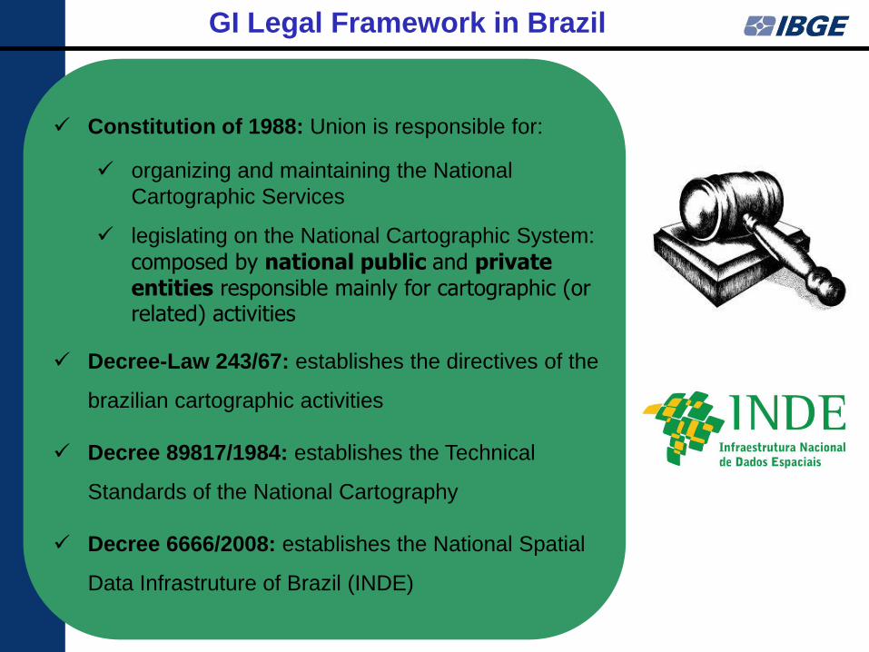
Constitution of 1988: Union is responsible for:
organizing and maintaining the National
Cartographic Services
legislating on the National Cartographic System:
composed by national public and private entities responsible mainly for cartographic (or related) activities
Decree-Law 243/67: establishes the directives of the
brazilian cartographic activities
Decree 89817/1984: establishes the Technical
Standards of the National Cartography
Decree 6666/2008: establishes the National Spatial
Data Infrastruture of Brazil (INDE)
GI Legal Framework in Brazil

Ministry of Planning
• Manager of the
National
Cartographic
System
• Responsible for
NSDI data sharing
agreements
National
Commission of
Cartography
• Cartographic Policy
• NSDI Coordination
Examples of GI Producers GI Institutional
Arrangement in Brazil

6
• 700+ flights
• Great majority by private companies contracted by the federal and state governments
• A few ones by the Brazilian Air Force
VÔOS EXISTENTES
Sca_base_aero.shp
1964 - 1969
1970 - 1979
1980 - 1989
1990 - 1999
2000 - 2005
Contorno_estados.shp
Aerial Photographs taken since 1960’s

Parana State Mapping in the 1980’s
Copel – Eletricity Company of the State of Paraná, created in 1954, co-
owned by the State and private investors (participates in the stock market
since 1994)
Example of a joint Public-Private
Initiative

• Covering the whole Brazilian territory
• From 2007 to 2012
• Developed by contracting private companies
• Reference layers for thematic mapping of Brazil
• To be continuously updated
Conclusão dos Blocos
2010 (141 sheets)
2008 (100 sheets)
2010 (70 sheets)
2010 (69 sheets)
2010 (69 sheets)
2011 (53 sheets)
2012 (47 sheets)
Completion of blocks
Seamless Cartographic Base Project 1:250,000

27 Federation Units
(States)
5,565 Municipalities
10,283 Districts
662 Subdistricts/R.A.
316,574 Enumeration areas
240,382 urban
76,192 rural
2010 Population Census
Census Mapping

Municipalities with less then 20,0000 inhabitants
covered by imagery in the 2010 Census Mapping Project
Ortophotographs (162)
Google Earth (1429)
ALOS PRISM+AVNIR (702)
ALOS PRISM (427)
No imagery available
2720 Municipalities

Orthophotograph
Pirapetinga, MG
From Ortophoto
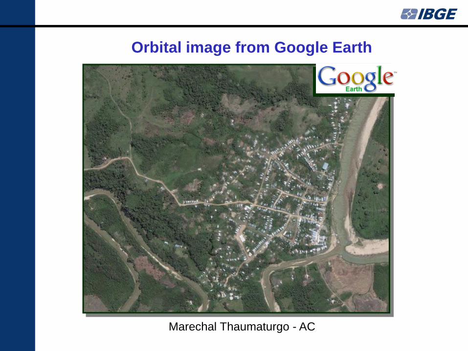
Marechal Thaumaturgo - AC
Orbital image from Google Earth

Orbital image from ALOS satellite
Cabo Frio - RJ

2010 Census Mapping Project

THE GOALS
• To promote the proper generation, storage, access, share,
dissemination and use of geospatial data produced at federal,
state, and municipal level
• To promote the use of standards and specifications certified by
the National Commission on Cartography – CONCAR
• To avoid duplication of efforts and waste of resources in
obtaining geospatial data by public administration bodies
National Spatial Data Infrastructure of Brazil - INDE
• Established by Presidential Decree 6666
of November 27, 2008
• Coordinated by the National Commission
on Cartography – CONCAR
• Used as reference for the National Open
Data Infrastructure of Brazil (INDA)
• Industry has a role to be played, as
indicated in the Decree

GI Production and Use Context in Brazil – After INDE

CONCAR
(Superior Council)
CINDE
(Technical Committee)
Standards and Specs
Data and Metadata
Technology
Capacity Building and Training
Dissemination
Management
Coordinates the
INDE
implementation
139 members from
32 institutions
GI Institutional Arrangement in Brazil for INDE

Avaliable applications
• INDE portal: www.inde.gov.br
• Metadata catalog
www.metadados.inde.gov.br
• Visualization tool
www.i3geo.inde.gov.br
Current status
Avaliable data and metadata
• Metadata: 5320 documents of 3
institutions
• Data: 150 WMS services
Access statistics
• Metadata catalog: 1,800,000 hits
per month
National Spatial Data Infrastructure of Brazil - INDE

www.inde.gov.br
Action Plan to INDE Implementation
(Portuguese, English and Spanish):
http://www.inde.gov.br/?p=896

Producers
Geospatial Reference (Framework) Data
Geodetic Topographic Mapping Subsidiary Special
Mapping
Redes G
eodésic
as:
Pla
nim
étr
ica
, Altim
étr
ica
,
GN
SS
, M
are
grá
fica
Perm
anente
, e
Gra
vim
étr
ica
Mapeam
ento
Terr
estr
e
Sis
tem
ático -
Geográ
fico
Mapeam
ento
Terr
estr
e
Sis
tem
ático -
Topográ
fico
Mapeam
ento
Terr
estr
e
Sis
tem
ático C
adastr
al
Mosaic
os O
rtorr
etificados
Modelo
Num
érico
Ort
ofo
tocart
as
Cart
as-I
magem
Nom
es G
eográ
ficos
Div
isão P
olit
ico
Adm
inis
trativa
Unid
ades d
e C
onserv
ação
Bacia
s H
idro
grá
ficas
Terr
as Indíg
enas
Dados e
Info
rmações
Fu
ndiá
ria
s
Mapeam
ento
Náutico
Mapeam
ento
Aero
náutico
Ministério da Ciência e Tecnologia – ON
Ministério da Ciência e Tecnologia - INPE
Ministério da Defesa – Aeronáutica – ICA
Ministério da Defesa – Exército - DSG
Ministério da Defesa – Marinha - DHN
Ministério do Desenvolvimento Agrário -
INCRA
Ministério da Justiça - FUNAI
Ministério do Meio Ambiente – ANA
Ministério do Meio Ambiente – ICMBio
Ministry of
Planning - IBGE Ministério das Relações Exteriores - CBDL
Órgãos Federais, Estaduais e Municipais
através de contratação da iniciativa privada
GI Production in Brazil by Public Sector

Schedule of releasing IBGE data through INDE
Data or Product Metadata
registered? Format
Service
availability
Redes Planimétrica, Altimétrica e Gravimétrica
(BDG - Banco de Dados Geodésicos) Yes
WMS and link to IBGE
website 2nd Sem 2012
Geodesy
Data or Product Metadata
registered? Format
Service
availability BCIM Yes WMS available
RR100 Yes WMS available
BC250 Yes WMS 2nd Sem 2012
Modelo Digital de Elevação Nível 1 - (1:25.000 e 1:50.000) Work in progress WMS 2nd Sem 2012
Modelo Digital de Elevação Nível 3 - (1:250.000) Work in progress WMS 2nd Sem 2012
Ortofotomosaico nível 1 (fotografia aérea) Work in progress WMS 2nd Sem 2012
Mapa Indice Work in progress WMS 2nd Sem 2012
Ortomosaico ótico nível 2 (AVNIR - PRISM - Spot) Work in progress WMS 2nd Sem 2012
Ortomosaico ótico nível 3 (LANDSAT - CBERS) Work in progress WMS 2nd Sem 2012
Ortomosaico Radar (PALSAR) Yes WMS 2nd Sem 2012
Topographic Mapping
Data or Product Metadata
registered? Format Service availability
REGIC - Arquivos Vetoriais; Pranchas do Atlas
Nacional Yes WMS available
Geography

Data or Product Metadata
registered? Format
Service
availability
Malha Municipal No WMS 2nd Sem 2012 Malha Distrital No WMS 2nd Sem 2012
Malha Subdistrital No WMS 2nd Sem 2012
Malha Setorial No WMS 2nd Sem 2012
Data or Product Metadata
registered? Format
Service
availability Biomas 1 : 5.000.000 BR No WMS 2nd Sem 2012
Geomorfologia 1 : 250.000 AML No WMS 2nd Sem 2012
Vegetação 1 : 250.000 AML No WMS 2nd Sem 2012 Vegetação 1 : 5.000.000 BR No WMS 2nd Sem 2012
Cobertura e Uso Estadual e 1:250.000 AP, AC, RR , RS, PA e SE.
No WMS 2nd Sem 2012
Geologia Estadual AML (–MA) No WMS 2nd Sem 2012
Geomorfologia Estadual – AML (– MA) No WMS 2nd Sem 2012
Hidrogeologia 1: 2.500.000 R. Nord. No WMS 2nd Sem 2012 Hidroq./Hidrogeo Estadual PB e RN (4) No WMS 2nd Sem 2012
Hidroq./Hidrogeo. 1 : 250.000 (22 folhas) SB24 e SB25 No WMS 2nd Sem 2012 Hidroquímica 1: 2.500.000 R. Nord. No WMS 2nd Sem 2012 Pedologia Estadual – AML (– MA) No WMS 2nd Sem 2012 Vegetação Estadual AML (–MA) No WMS 2nd Sem 2012
Census mapping
Thematic data – Natural resources
Schedule of releasing IBGE data through INDE

Annual Forest Concession Plan (PAOF) describes the public forests to be
submitted to concession processes by the Ministry of the Environment
(MMA)
Developed using IBGE 1:1,000,000 basemap (available at INDE)
Example of INDE Use by Public Sector

http://geopr1.planalto.gov.br/saei/sistemas/geopr
Example of INDE Use by Public Sector
GeoPR – Geospatial Information Supporting System
GSI - Institutional Security Cabinet of the Presidency

ArcGIS for INDE
Supporting INDE standards
Aligned with similar Esri initiatives in Europe and North America
Adapting ArcGIS system to INDE
standards will benefit for:
• Saving resources. Freely available data models.
• Increasing productivity in data conversion and editing for INDE standards.
• Increasing productivity in the use and sharing of data in INDE standards.
• Greater speed and ease of adoption of the standards across the community.
In partnership with: Diretoria de Serviço Geográfico
(DSG)

Cloud
Server
Mobile
Desktop
Web
Search Use Share
Data and Metadata Services Applications Tools
• Geodatabase Schema
• Esri GeoPortal Server
• ArcGIS Portal
ArcGIS for INDE
USE
RS

Brazilian Federal Law 11527 of Nov 18, 2011
• Regulates the access to public information in Brazil
based on principles of transparency of public
administration
• Art. 12: access to data is free
Brazilian open data website
• http://beta.dados.gov.br
Brazilian Open Data Context

0
2
4
6
8
10
12
14
16
18
20
Number of NMOs of the Americas versus each type of GI produced
Number of NMOs of the Americas versus each type of GI starting to be produced in the last 2 years
2011 PC-IDEA Questionnaire Results
Number of NMOs of the Americas versus each
type of geospatial information produced

2011 PC-IDEA Questionnaire Results
0
2
4
6
8
10
12
14
16
18
20
Number of NMOs of the Americas versus each type of GI distributed free of charge
Number of NMOs of the Americas versus each type of GI starting to be distributed free of charge during the last 2 years
Number of NMOs of the Americas versus each
type of GI distributed free of charge

• Applied to direct public administration entities, to public
foundations, to public companies, and to entities directly or
indirectly controlled by the Union, States, Federal District and
Municipalities
• PPP Managing Committee (CGP), composed by the Ministry of
Planning (as Coordinator), Ministry of Finance and Ministry of
Civil Affairs
PPP in Brazil – Law 11079/2004
Projects under public bid
• Datacenter Project (Banco do Brasil and Caixa Econômica
Federal)
• Pontal (Pernambuco)
Projects being analyzed
• Digital Public TV Network
• Brazilian Geostationary System
• Baixio do Irecê
• Salitre Project

The Brazilian Geostationary Satellites (SGB) are being jointly
developed by Empresa Brasileira de Aeronáutica (Embraer),
which is private, and by Telebras, which is public
Telebras will use SGB to improve the National Wide Band Plan,
which proposes to amplify the use of high speed Internet in
Brazil
Brazilian Geostationary Satellites

Final Remarks
Private companies have participated in the geospatial data production
in Brazil since the 60´s
Responsibility of data production still heavly relying on goverment
institutions in Brazil
Data providers to benefit from SDIs, either by using data available for
producing other data, either by avoiding overlap of efforts and by
optimizing resources
Private companies to benefit from SDIs, either by using data available,
either by providing new services to clients
There is a Legal Open Data framework in place in Brazil, in the
general and in the NSDI contexts
Situation in the Americas shows trend of producting risk and cadastre data, as well as of open data policies, based on the results of the 2011 questionnarie
PPP in Brazil still at the first stages and must properly address the
constraints and rules that generally govern the relationship between
the involved parties. At the same time, it may help fostering the
development of a SDI

Thank you! Luiz Paulo Souto Fortes, PhD


![Lamina Resumen Art Jazz Club [Estíbaliz Souto]](https://static.fdocuments.us/doc/165x107/568bdc051a28ab2034b0a9bd/lamina-resumen-art-jazz-club-estibaliz-souto.jpg)


![ART JAZZ CLUB [Estibaliz Souto]](https://static.fdocuments.us/doc/165x107/568c389b1a28ab02359f7e0c/art-jazz-club-estibaliz-souto.jpg)

