Providence River and Head of Narragansett Bayanchor temporarily at this po int. Providence is at the...
20
BookletChart ™ Providence River and Head of Narragansett Bay NOAA Chart 13224 A reduced-scale NOAA nautical chart for small boaters When possible, use the full-size NOAA chart for navigation. Included Area
Transcript of Providence River and Head of Narragansett Bayanchor temporarily at this po int. Providence is at the...

BookletChart™ Providence River and Head of Narragansett Bay NOAA Chart 13224
A reduced-scale NOAA nautical chart for small boaters When possible, use the full-size NOAA chart for navigation.
Included Area

2
Published by the National Oceanic and Atmospheric Administration
National Ocean Service Office of Coast Survey
www.NauticalCharts.NOAA.gov 888-990-NOAA
What are Nautical Charts?
Nautical charts are a fundamental tool of marine navigation. They show water depths, obstructions, buoys, other aids to navigation, and much more. The information is shown in a way that promotes safe and efficient navigation. Chart carriage is mandatory on the commercial ships that carry America’s commerce. They are also used on every Navy and Coast Guard ship, fishing and passenger vessels, and are widely carried by recreational boaters.
What is a BookletChart?
This BookletChart is made to help recreational boaters locate themselves on the water. It has been reduced in scale for convenience, but otherwise contains all the information of the full-scale nautical chart. The bar scales have also been reduced, and are accurate when used to measure distances in this BookletChart. See the Note at the bottom of page 5 for the reduction in scale applied to this chart.
Whenever possible, use the official, full scale NOAA nautical chart for navigation. Nautical chart sales agents are listed on the Internet at http://www.NauticalCharts.NOAA.gov.
This BookletChart does NOT fulfill chart carriage requirements for regulated commercial vessels under Titles 33 and 44 of the Code of Federal Regulations.
Notice to Mariners Correction Status
This BookletChart has been updated for chart corrections published in the U.S. Coast Guard Local Notice to Mariners, the National Geospatial Intelligence Agency Weekly Notice to Mariners, and, where applicable, the Canadian Coast Guard Notice to Mariners. Additional chart corrections have been made by NOAA in advance of their publication in a Notice to Mariners. The last Notices to Mariners applied to this chart are listed in the Note at the bottom of page 7. Coast Pilot excerpts are not being corrected.
For latest Coast Pilot excerpt visit the Office of Coast Survey website at http://www.nauticalcharts.noaa.gov/nsd/searchbychart.php?chart=13224
(Selected Excerpts from Coast Pilot) Pilotage, Narragansett Bay and Other Rhode Island Waters.–Pilotage is compulsory for foreign vessels and U.S. vessels under register when entering and departing Narragansett Bay and all ports of the waters of the State of Rhode Island. Federal and State pilots for Narragansett Bay are available from Northeast Marine Pilots, Inc., Newport, RI 20840; http://www.nemarinepilots.com; telephone
401-847-9050 (24 hours), 800-274-1216, FAX 401-847-9052; email: [email protected]. Hog Island, about 1 mile north of Arnold Point, lies in the entrance to Bristol Harbor, dividing the waters into two channels. The island has a rolling wooded terrain on which are a few houses and cottages. Shoal water surrounds the island extending as much as 0.4 mile southward
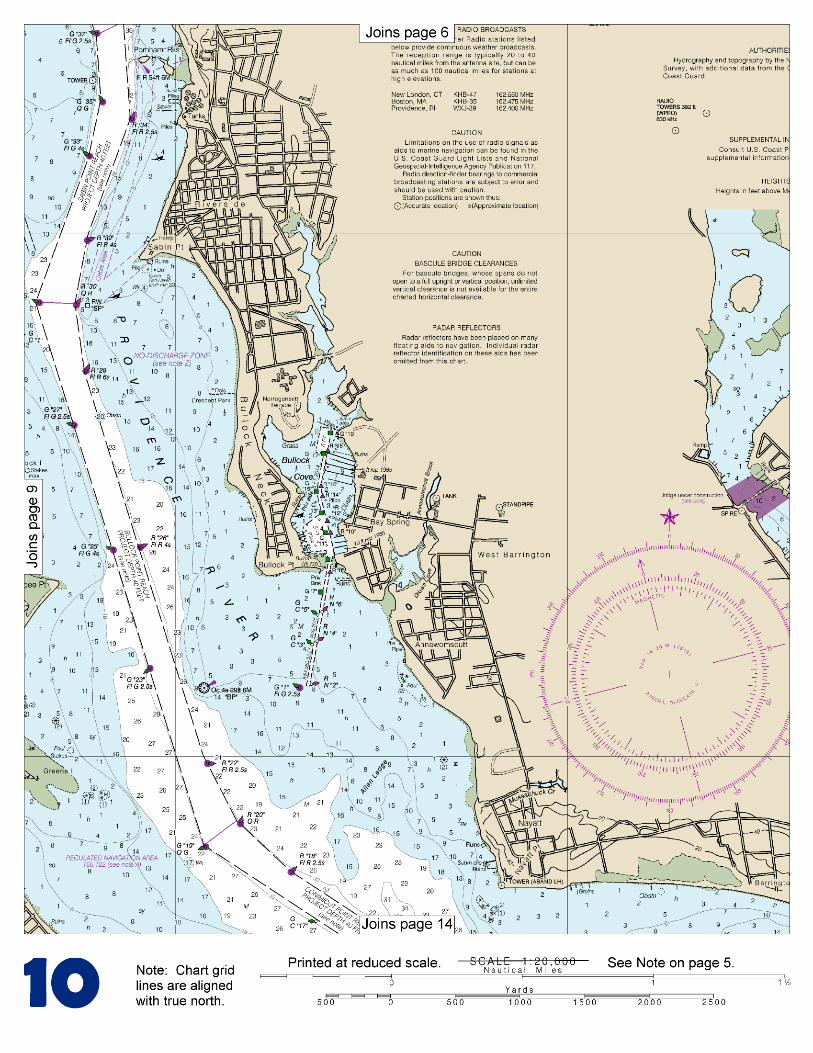
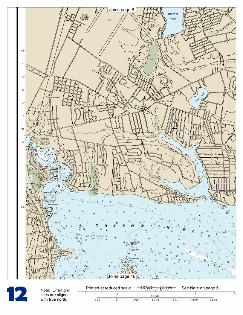
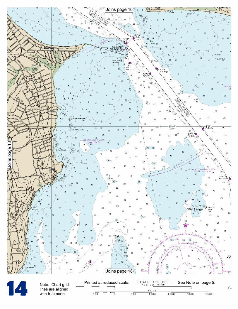
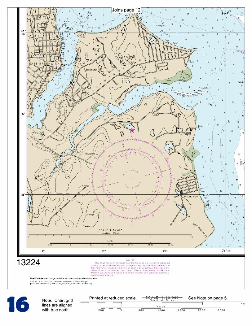
and 0.8 mile northward. The shoal area is marked by lights and buoys. About 0.6 mile E-NE of Hog Island Shoal Light is Musselbed Shoals, marked on the outer end by a light. From the light structure a directional light is shown to mark the channel to Mount Hope Bay. Hog Island is in the middle of the entrance to Bristol Harbor. A natural channel with depths of 19 to 25 feet extends on each side of the island. Excellent anchorage may be found in the harbor abreast the town in depths of 15 to 17 feet, soft bottom. A general anchorage is in Bristol Harbor. Usher Rocks, about 0.7 mile northeastward of Popasquash Point, are bare at low water. A buoy is eastward of the rocks and on the western side of the western passage to the harbor. From the bay, the channel to Warren passes between numerous shoals and rocks and is crooked and winding, but well marked. A depth of about 9 feet is in the channel to the lower wharves at Warren, and the same depth is in Barrington River to the fixed highway bridge about 0.5 mile above the entrance. Vessels approaching the river must take care to avoid Rumstick Shoal, which extends nearly 0.6 mile south of Rumstick Point, the southernmost point of Rumstick Neck and the western entrance point of the river. The shoal has depths of 2 to 12 feet and is marked by buoys. Rumstick Rock, 6 feet high, and Rumstick Ledge, with rocks that uncover 1 to 5 feet, are on the westerly side of the shoal. The tidal current off the town of Warren has a velocity of about 1 knot. Strong currents may be encountered in Barrington River. Dangers.–Numerous rocks and ledges border Providence River Channel on either side. Navigational aids mark the shoal areas off Bullock Point, about 1.5 miles above the mouth; off Sabin Point, about 3 miles above the Mouth; off Pomham Rocks, about 3.5 miles above the mouth; off Fuller Rock, about 5 miles above the mouth and Green Jacket Shoal, east of Fox Point about 7.4 miles above the mouth. Potter Cove, on the northeast side of Prudence Island, is a small nearly landlocked harbor. Buoys mark the entrance channel off Gull Point. The north and south ends of Prudence Island are a State park. Ohio Ledge, about 2.5 miles northward of Potter Cove, has a least depth of 8 feet and is marked on its southeast side by a bell buoy. Warren River, emptying into the head of Narragansett Bay westward of Bristol Neck, is the approach to the towns of Warren and Barrington, and Barrington River, which joins Warren River at Warren. A church spire in Warren is prominent. A State regulatory buoy, about 0.9 mile above the mouth of Warren River, marks a “Slow no wake” zone. An excellent anchorage may be found at the mouth of the Warren River about 0.2 mile from the eastern shore in depths of 14 to 15 feet, soft bottom. There is not room for anchorage in the river for any but small craft. Abreast the lower end of Warren the channel is about 0.1 mile wide, with depths of 13 to 17 feet in midchannel, and small vessels can anchor temporarily at this point. Providence is at the head of navigation on the Providence River, about 7 miles above the entrance, at the junction of the Providence and Seekonk Rivers. The port area includes both sides of the upper navigable channel of the river. Occupessatuxet Cove, on the west side of the river north of Conimicut Point, is a shallow bight south of Gaspee Point. The cove is frequented only by small craft with local knowledge.
U.S. Coast Guard Rescue Coordination Center 24 hour Regional Contact for Emergencies
RCC Boston Commander 1st CG District (617) 223-8555 Boston, MA

G
NOAA’s navigation managers serve as ambassadors to the maritime community. They help identify navigational challenges facing professional and recreational mariners, and provide NOAA resources and information for safe navigation. For additional information, please visit nauticalcharts.noaa.gov/service/navmanagers
To make suggestions or ask questions online, go to nauticalcharts.noaa.gov/inquiry. To report a chart discrepancy, please use ocsdata.ncd.noaa.gov/idrs/discrepancy.aspx.
Lateral System As Seen Entering From Seaward on navigable waters except Western Rivers
PORT SIDE
ODD NUMBERED AIDS
GREEN LIGHT ONLY
FLASHING (2)
PREFERRED CHANNEL
NO NUMBERS – MAY BE LETTERED
PREFERRED CHANNEL TO
STARBOARD
TOPMOST BAND GREEN
PREFERRED CHANNEL
NO NUMBERS – MAY BE LETTERED
PREFERRED CHANNEL
TO PORT
TOPMOST BAND RED
STARBOARD SIDE
EVEN NUMBERED AIDS
RED LIGHT ONLY
FLASHING (2)
FLASHING FLASHING
OCCULTING GREEN LIGHT ONLY RED LIGHT ONLY OCCULTING QUICK FLASHING QUICK FLASHING
ISO COMPOSITE GROUP FLASHING (2+1) COMPOSITE GROUP FLASHING (2+1) ISO
"1"
Fl G 6s
G "9"
Fl G 4s
GR "A"
Fl (2+1) G 6s
RG "B"
Fl (2+1) R 6s
"2"
Fl R 6s
8
R "8"
Fl R 4s
LIGHT
G
C "1"
LIGHTED BUOY
G
"5"
GR
"U"
GR
C "S"
RG
N "C"
RG
"G"
LIGHT
6
R
N "6"
LIGHTED BUOY
R
"2
"
CAN DAYBEACON
CAN NUN NUN
DAYBEACON
For more information on aids to navigation, including those on Western Rivers, please consult the latest USCG Light List for your area.
These volumes are available online at http://www.navcen.uscg.gov
Navigation Managers Area of Responsibility
Northeast
Lt. Meghan McGovern
Northwest and
Pacific Islands
Crescent Moegling
Great Lakes Region
Tom Loeper
Chesapeake and
Delaware Bay
Steve Soherr
California
Jeff Ferguson
[email protected] Mid-Atlantic
Lt. Ryan Wartick
Alaska
Lt. Timothy M. Smith
Western Gulf Coast
Alan Bunn
Central Gulf Coast
Tim Osborn
[email protected] South Florida
Puerto Rico
U.S. Virgin Islands
Michael Henderson
Southeast
Kyle Ward
2
2 C U 5
1


VHF Marine Radio channels for use on the waterways:Channel 6 – Inter-ship safety communications.Channel 9 – Communications between boats and ship-to-coast.Channel 13 – Navigation purposes at bridges, locks, and harbors.Channel 16 – Emergency, distress and safety calls to Coast Guard and others, and to initiate calls to other
vessels. Contact the other vessel, agree to another channel, and then switch.Channel 22A – Calls between the Coast Guard and the public. Severe weather warnings, hazards to navigation and safety warnings are broadcast here.Channels 68, 69, 71, 72 and 78A – Recreational boat channels.
Getting and Giving Help — Signal other boaters using visual distress signals (flares, orange flag, lights, arm signals); whistles; horns; and on your VHF radio. You are required by law to help boaters in trouble. Respond to distress signals, but do not endanger yourself.
EMERGENCY INFORMATION
Distress Call Procedures
• Make sure radio is on.• Select Channel 16.• Press/Hold the transmit button.• Clearly say: “MAYDAY, MAYDAY, MAYDAY.”• Also give: Vessel Name and/or Description;Position and/or Location; Nature of Emergency; Number of People on Board.• Release transmit button.• Wait for 10 seconds — If no responseRepeat MAYDAY call.
HAVE ALL PERSONS PUT ON LIFE JACKETS!
This Booklet chart has been designed for duplex printing (printed on front and back of one sheet). If a duplex option is not available on your printer, you may print each sheet and arrange them back-to-back to allow for the proper layout when viewing.
QR
Quick ReferencesNautical chart related products and information - http://www.nauticalcharts.noaa.gov
Interactive chart catalog - http://www.charts.noaa.gov/InteractiveCatalog/nrnc.shtmlReport a chart discrepancy - http://ocsdata.ncd.noaa.gov/idrs/discrepancy.aspx
Chart and chart related inquiries and comments - http://ocsdata.ncd.noaa.gov/idrs/inquiry.aspx?frompage=ContactUs
Chart updates (LNM and NM corrections) - http://www.nauticalcharts.noaa.gov/mcd/updates/LNM_NM.html
Coast Pilot online - http://www.nauticalcharts.noaa.gov/nsd/cpdownload.htm
Tides and Currents - http://tidesandcurrents.noaa.gov
Marine Forecasts - http://www.nws.noaa.gov/om/marine/home.htm
National Data Buoy Center - http://www.ndbc.noaa.gov/
NowCoast web portal for coastal conditions - http://www.nowcoast.noaa.gov/
National Weather Service - http://www.weather.gov/
National Hurrican Center - http://www.nhc.noaa.gov/
Pacific Tsunami Warning Center - http://ptwc.weather.gov/
Contact Us - http://www.nauticalcharts.noaa.gov/staff/contact.htm
NOAA’s Office of Coast Survey The Nation’s Chartmaker
For the latest news from Coast Survey, follow @NOAAcharts
NOAA Weather Radio All Hazards (NWR) is a nationwide network of radio stations broadcasting continuous weather information directly from the nearest National Weather Service office. NWR broadcasts official Weather Service warnings, watches, forecasts and other hazard information 24 hours a day, 7 days a week. http://www.nws.noaa.gov/nwr/