PROTECTED AREAS IN REGIONS OF INTENSIVE ECONOMICAL AC- TIVITY: CONFLICT...
14
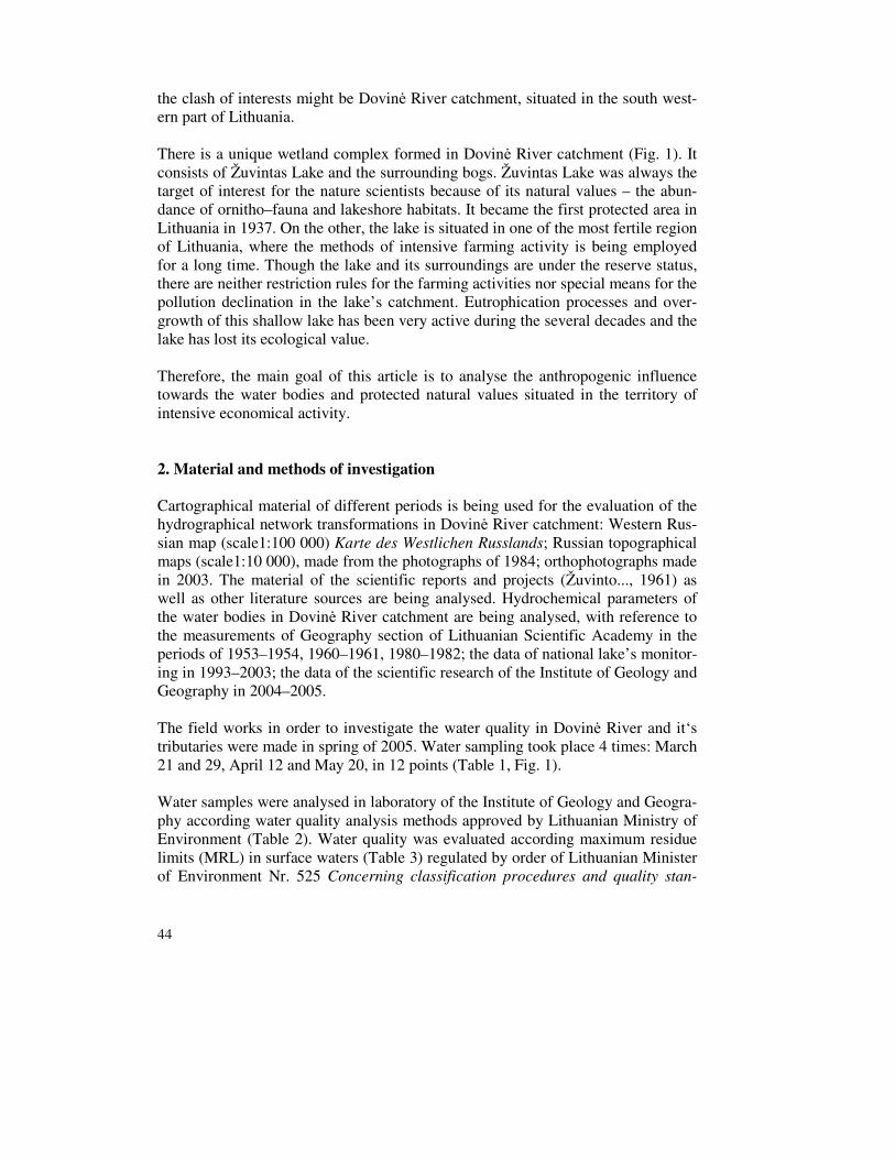
AGD Landscape & Environment 1 (1) 2007. 43-56. 43 PROTECTED AREAS IN REGIONS OF INTENSIVE ECONOMICAL AC- TIVITY: CONFLICT OF NATURE PROTECTION AND NATURE USE (CASE STUDY OF DOVINĖ RIVER CATCHMENT) RITA LINKEVIČIENĖ – JULIUS TAMINSKAS – RASA ŠIMANAUSKIENĖ Institute of Geology and Geography, University of Vilnius; LT–03223 Vilnius, T. Ševčenkos Str. 13, Lithuania; E-mail: [email protected] Abstract Nature protection and economical activity clash of interests is analysed on the example of Dovinė River catchment, situated in the south western part of Lithuania. It is a unique wetland complex con- sisting from Žuvintas Lake and the surrounding bogs (Fig. 1). Žuvintas Lake became the first pro- tected area in Lithuania in 1937. However, the lake is situated in one of the most fertile region of Lithuania, where the methods of intensive farming activity is being employed for a long time. Eutro- phication processes and overgrowth of this shallow lake has been very active during the several dec- ades and the lake has lost its ecological value. Therefore the main goal of this article is to analyse the anthropogenic influence towards the water bodies and protected natural values situated in the territory of intensive economical activity. Cartographical material of different periods is being used for the evaluation of the hydrographical network transformations in Dovinė River catchment. Hydrochemical parameters of the periods 1953–1954, 1960–1961, 1980–1982; 1993–2003; 2004–2005 of the water bodies in Dovinė River catchment are being analysed. The field works in order to investigate the water quality in Dovinė River and it‘s tributaries were made in spring of 2005. Water samples were analysed in laboratory of the Institute of Geology and Geography according water quality analysis methods approved by Lithuanian Ministry of Environment (Table 2). Water quality was evaluated according maximum residue limits (MRL) in surface waters (Table 3). The results of the study showed that although Žuvintas Lake is being protected for 70 years, the farming activity intensified constantly in its catchment. Canalised river beds and sluice–regulated hydrological regime of the lakes diminished the natural self–cleaning abilities of the water system. The average annual decrease of the lake specular surface was about 1,1 ha in the period of 1961–2003. The average annual increase of vegetation area is about 0,14 ha. Even a strong protection regime did not preserve this territory. Therefore, in order to keep the sustainable development in the protected territories the anthropogenic loading from the neighbouring territories (catchment area, etc) must be evaluated. The objectives of nature protection in protected territory could not be attained if there is no regulation of economical activity in the territories surrounding the protected area. Keywords: Žuvintas Lake, anthropogenic influence,hydrographical network transformations, water quality 1. Indroduction Each territory might have several functions, like economical, recreational, nature protection, aesthetical etc. These functions are determined by efficiency of the eco- nomical activity in the territory as well as by the legislation regulating that activity. The function of nature protection does not have an immediate economical benefit. Therefore it often crosses with the interests of economical activity, especially in the territories with high economical potential. An obvious example of
Transcript of PROTECTED AREAS IN REGIONS OF INTENSIVE ECONOMICAL AC- TIVITY: CONFLICT...

AGD Landscape & Environment 1 (1) 2007. 43-56.
43
PROTECTED AREAS IN REGIONS OF INTENSIVE ECONOMICAL AC-
TIVITY: CONFLICT OF NATURE PROTECTION AND NATURE USE
(CASE STUDY OF DOVINĖ RIVER CATCHMENT)
RITA LINKEVIČIENĖ – JULIUS TAMINSKAS – RASA ŠIMANAUSKIENĖ Institute of Geology and Geography, University of Vilnius; LT–03223 Vilnius, T. Ševčenkos Str. 13, Lithuania; E-mail: [email protected] Abstract Nature protection and economical activity clash of interests is analysed on the example of Dovinė River catchment, situated in the south western part of Lithuania. It is a unique wetland complex con-sisting from Žuvintas Lake and the surrounding bogs (Fig. 1). Žuvintas Lake became the first pro-tected area in Lithuania in 1937. However, the lake is situated in one of the most fertile region of Lithuania, where the methods of intensive farming activity is being employed for a long time. Eutro-phication processes and overgrowth of this shallow lake has been very active during the several dec-ades and the lake has lost its ecological value. Therefore the main goal of this article is to analyse the anthropogenic influence towards the water bodies and protected natural values situated in the territory of intensive economical activity. Cartographical material of different periods is being used for the evaluation of the hydrographical network transformations in Dovinė River catchment. Hydrochemical parameters of the periods 1953–1954, 1960–1961, 1980–1982; 1993–2003; 2004–2005 of the water bodies in Dovinė River catchment are being analysed. The field works in order to investigate the water quality in Dovinė River and it‘s tributaries were made in spring of 2005. Water samples were analysed in laboratory of the Institute of Geology and Geography according water quality analysis methods approved by Lithuanian Ministry of Environment (Table 2). Water quality was evaluated according maximum residue limits (MRL) in surface waters (Table 3). The results of the study showed that although Žuvintas Lake is being protected for 70 years, the farming activity intensified constantly in its catchment. Canalised river beds and sluice–regulated hydrological regime of the lakes diminished the natural self–cleaning abilities of the water system. The average annual decrease of the lake specular surface was about 1,1 ha in the period of 1961–2003. The average annual increase of vegetation area is about 0,14 ha. Even a strong protection regime did not preserve this territory. Therefore, in order to keep the sustainable development in the protected territories the anthropogenic loading from the neighbouring territories (catchment area, etc) must be evaluated. The objectives of nature protection in protected territory could not be attained if there is no regulation of economical activity in the territories surrounding the protected area. Keywords: Žuvintas Lake, anthropogenic influence,hydrographical network transformations, water
quality 1. Indroduction
Each territory might have several functions, like economical, recreational, nature protection, aesthetical etc. These functions are determined by efficiency of the eco-nomical activity in the territory as well as by the legislation regulating that activity. The function of nature protection does not have an immediate economical benefit. Therefore it often crosses with the interests of economical activity, especially in the territories with high economical potential. An obvious example of
44
the clash of interests might be Dovinė River catchment, situated in the south west-ern part of Lithuania. There is a unique wetland complex formed in Dovinė River catchment (Fig. 1). It consists of Žuvintas Lake and the surrounding bogs. Žuvintas Lake was always the target of interest for the nature scientists because of its natural values – the abun-dance of ornitho–fauna and lakeshore habitats. It became the first protected area in Lithuania in 1937. On the other, the lake is situated in one of the most fertile region of Lithuania, where the methods of intensive farming activity is being employed for a long time. Though the lake and its surroundings are under the reserve status, there are neither restriction rules for the farming activities nor special means for the pollution declination in the lake’s catchment. Eutrophication processes and over-growth of this shallow lake has been very active during the several decades and the lake has lost its ecological value. Therefore, the main goal of this article is to analyse the anthropogenic influence towards the water bodies and protected natural values situated in the territory of intensive economical activity.
2. Material and methods of investigation
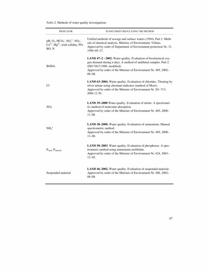
Cartographical material of different periods is being used for the evaluation of the hydrographical network transformations in Dovinė River catchment: Western Rus-sian map (scale1:100 000) Karte des Westlichen Russlands; Russian topographical maps (scale1:10 000), made from the photographs of 1984; orthophotographs made in 2003. The material of the scientific reports and projects (Žuvinto..., 1961) as well as other literature sources are being analysed. Hydrochemical parameters of the water bodies in Dovinė River catchment are being analysed, with reference to the measurements of Geography section of Lithuanian Scientific Academy in the periods of 1953–1954, 1960–1961, 1980–1982; the data of national lake’s monitor-ing in 1993–2003; the data of the scientific research of the Institute of Geology and Geography in 2004–2005. The field works in order to investigate the water quality in Dovinė River and it‘s tributaries were made in spring of 2005. Water sampling took place 4 times: March 21 and 29, April 12 and May 20, in 12 points (Table 1, Fig. 1). Water samples were analysed in laboratory of the Institute of Geology and Geogra-phy according water quality analysis methods approved by Lithuanian Ministry of Environment (Table 2). Water quality was evaluated according maximum residue limits (MRL) in surface waters (Table 3) regulated by order of Lithuanian Minister of Environment Nr. 525 Concerning classification procedures and quality stan-

45
dards of surface water bodies (October 25, 2001) and Nr. 261 Concerning partial changing of some orders of Minister of Environment regulating sewage waters management (May 22, 2002).
Table 1. Water sampling points in Dovinė River catchment
NR. WATER BODY SAMPLING POINT TASK OF INVESTIGATION
1 Dovinė after Dusia Lake Water quality of Dovinė River headwaters
2 Dovinė Kalesninkai, before fishing ponds
a) impact of Kalesninkai settlement to water quality of Dovinė River; b) quality of water taken to fishing ponds
3 Dovinė Simnas, after fishing ponds
Impact of fishing ponds to Dovinė River water quality
4 Well Simnas, Dovinė River valley
Ground water quality in Simnas town
5 Dovinė after Simnas Lake Impact of Simnas Lake to Dovinė River quality
6 Dovinė Ąžuoliniai Water quality changes in zone Simnas Lake – Ąžuoliniai
7 Kiaulyčia mouth Water quality of Kiaulyčia River catchment
8 Žuvintas Žuvintai, South–East shore of the lake
Water quality of Žuvintas Lake
9 Dovinė Daukšiai Water quality changes in zone Žuvintas Lake – Daukšiai
10 Šlavanta Šventragis, before Amalvas Lake
Quality of inflowing to Amalvas Lake water
11 Amalvė Amalvas swamp, after Amalvas lake
Quality of outflowing from Amalvas Lake water
12 Dovinė Mouth a) changes of water quality in zone Daukšiai – river mouth; b) water quality of Dovinė River catchment

46
Fig. 1. Hydrography of Dovinė River catchment
Dovinė
catch-
47
Table 2. Methods of water quality investigations
INDICATOR A DOCUMENT REGULATING THE METHOD
pH, O2, HCO3-, SO4
2-, NO3-,
Ca2+, Mg2+, total solidity, PO, BO, N
Unified methods of sewage and surface waters (1994). Part 1: Meth-ods of chemical analysis. Ministry of Environment, Vilnius. Approved by order of Department of Environment protection Nr. 31, 1994–05–27.
BOD47
LAND 47–2 : 2002. Water quality. Evaluation of biochemical oxy-gen demand during n days. A method of undiluted samples. Part 2. (ISO 5815:1989, modified). Approved by order of the Minister of Environment Nr. 405, 2002–08–08.
Cl-
LAND 63–2004. Water quality. Evaluation of chlorides. Titrating by silver nitrate using chromate indicator (method of More). Approved by order of the Minister of Environment Nr. D1–713, 2004 12 30.
NO2-
LAND 39–2000 Water quality. Evaluation of nitrite. A spectromet-ric method of molecular absorption. Approved by order of the Minister of Environment Nr. 485, 2000–11–06
NH4+
LAND 38–2000. Water quality. Evaluation of ammonium. Manual spectrometric method. Approved by order of the Minister of Environment Nr. 485, 2000–11–06.
Ptotal, Pmineral
LAND 58–2003. Water quality. Evaluation of phosphorus. A spec-trometric method using ammonium molibdate. Approved by order of the Minister of Environment Nr. 624, 2003–12–05.
Suspended material LAND 46–2002. Water quality. Evaluation of suspended material. Approved by order of the Minister of Environment Nr. 406, 2002–08–08.
48
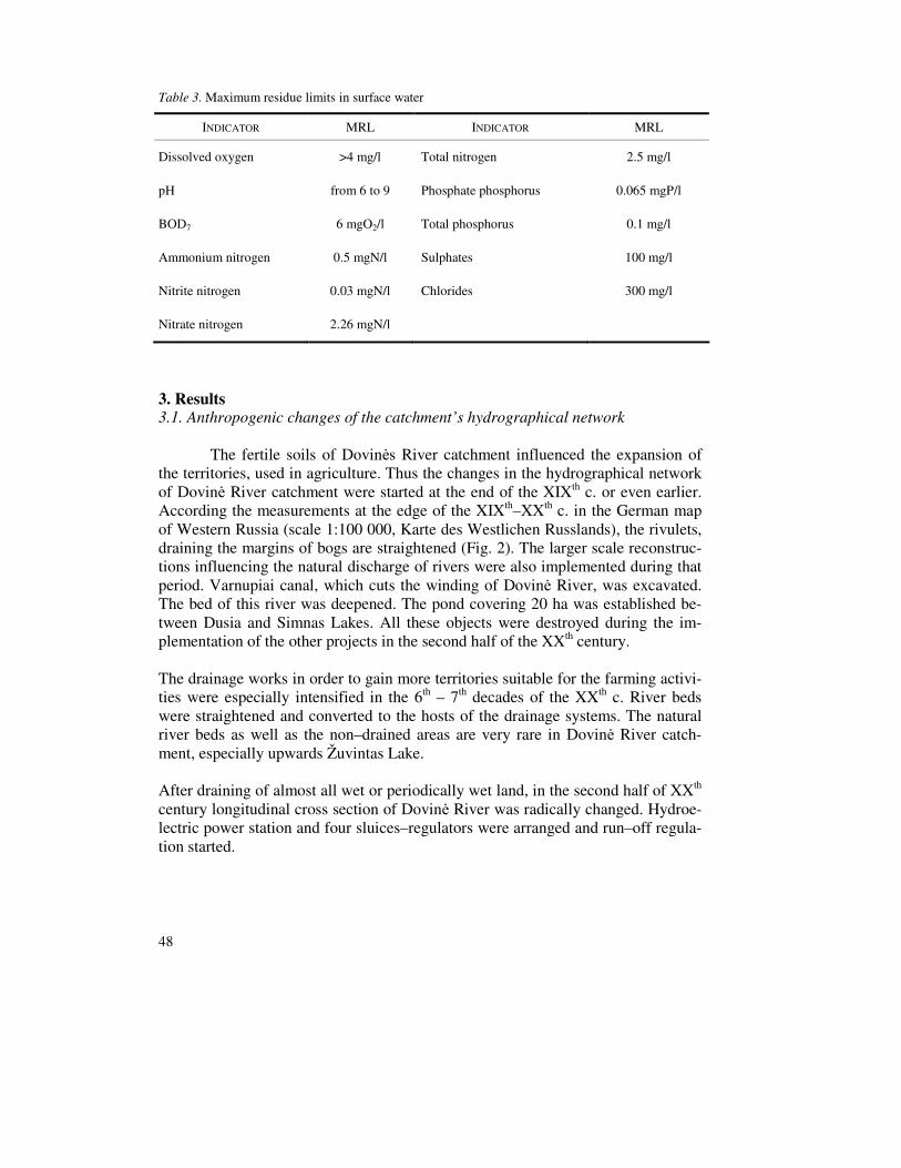
Table 3. Maximum residue limits in surface water
INDICATOR MRL INDICATOR MRL
Dissolved oxygen >4 mg/l Total nitrogen 2.5 mg/l
pH from 6 to 9 Phosphate phosphorus 0.065 mgP/l
BOD7 6 mgO2/l Total phosphorus 0.1 mg/l
Ammonium nitrogen 0.5 mgN/l Sulphates 100 mg/l
Nitrite nitrogen 0.03 mgN/l Chlorides 300 mg/l
Nitrate nitrogen 2.26 mgN/l
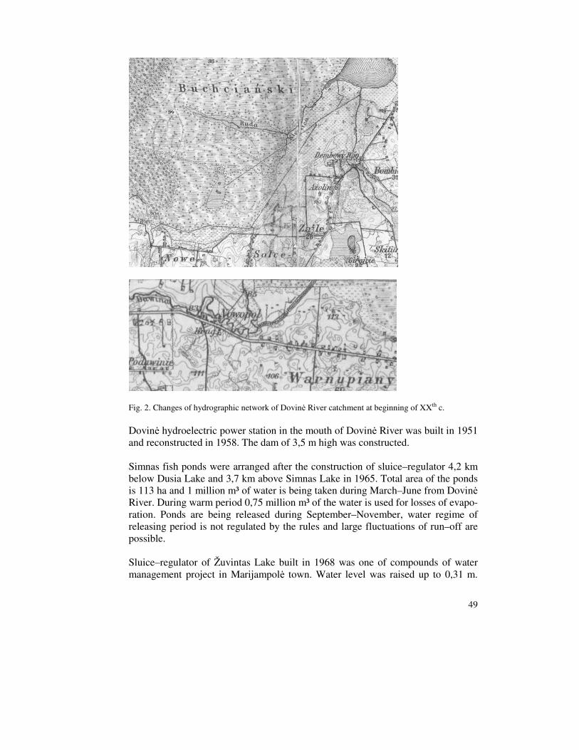
3. Results 3.1. Anthropogenic changes of the catchment’s hydrographical network
The fertile soils of Dovinės River catchment influenced the expansion of the territories, used in agriculture. Thus the changes in the hydrographical network of Dovinė River catchment were started at the end of the XIXth c. or even earlier. According the measurements at the edge of the XIXth–XXth c. in the German map of Western Russia (scale 1:100 000, Karte des Westlichen Russlands), the rivulets, draining the margins of bogs are straightened (Fig. 2). The larger scale reconstruc-tions influencing the natural discharge of rivers were also implemented during that period. Varnupiai canal, which cuts the winding of Dovinė River, was excavated. The bed of this river was deepened. The pond covering 20 ha was established be-tween Dusia and Simnas Lakes. All these objects were destroyed during the im-plementation of the other projects in the second half of the XXth century. The drainage works in order to gain more territories suitable for the farming activi-ties were especially intensified in the 6th – 7th decades of the XXth c. River beds were straightened and converted to the hosts of the drainage systems. The natural river beds as well as the non–drained areas are very rare in Dovinė River catch-ment, especially upwards Žuvintas Lake. After draining of almost all wet or periodically wet land, in the second half of XXth century longitudinal cross section of Dovinė River was radically changed. Hydroe-lectric power station and four sluices–regulators were arranged and run–off regula-tion started.
49
Fig. 2. Changes of hydrographic network of Dovinė River catchment at beginning of XXth c.
Dovinė hydroelectric power station in the mouth of Dovinė River was built in 1951 and reconstructed in 1958. The dam of 3,5 m high was constructed. Simnas fish ponds were arranged after the construction of sluice–regulator 4,2 km below Dusia Lake and 3,7 km above Simnas Lake in 1965. Total area of the ponds is 113 ha and 1 million m³ of water is being taken during March–June from Dovinė River. During warm period 0,75 million m³ of the water is used for losses of evapo-ration. Ponds are being released during September–November, water regime of releasing period is not regulated by the rules and large fluctuations of run–off are possible. Sluice–regulator of Žuvintas Lake built in 1968 was one of compounds of water management project in Marijampolė town. Water level was raised up to 0,31 m.

50
13,9 million m³ of Žuvintas Lake water is used for water level regulation (12,5 million m³ of Dusia Lake regulating volume and 1,4 million m³ of Simnas Lake regulating volume). Dovinė River was reorganized (straightened and deepened) during the regulation of the Simnas and Dusia Lakes water level in 1972 (table 4). Table 4. Morphometric characteristics of Dovinė catchment lakes before and after damming up (ac-cording to: Complex ..., 1972; Instruction… , 1996a; Report ..., 1961; Report ..., 1954; Instruction ..., 1996b; Instruction ..., 1997)
Lake Regulating Altitude, m Area, ha Volume, 10³ m³ Comparative
catchment
Natural conditions 105,92 2317 338 184 4,65 Dusia
Dammed lake 106,35 2334 359 000 4,6 Natural conditions 91,17 237 5096 74,6
Simnas Dammed lake 92 243,8 6920 72,5
Natural conditions 86,48 1031 12269 33,5 Žuvintas
Dammed lake 86,79 934,3 10502 36,9
3.2. Influence of economic activity in catchment towards the water quality
Fertile soils of Dovinė River catchment influences the great amount of biogenes inflow towards the lakes. However, this inflow is additionally augmented by the intensive farming activities. According to the comparative analysis of the earlier and recent water quality investigations the concentrations of biogenic materials in the water had an augmentation tendency from the middle to the end of the XXth c. The pollution of Dovinė catchment water bodies was minimal up to the 7th decade of the XXth c. Average concentration of mineral phosphorus (Pmin) was 0,011 mg/l, mineral nitrogen (Nmin) – 0,3 mg/l in the river section between Simnas and Žuvin-tas lakes in those relatively natural conditions. Average concentration of dissolved materials was 179 mg/l in 1954 in this section, whereas in Žuvintas Lake it reached 169 mg/l. Total inflow of dissolved mineral material from Dovinė River catchment to Žuvintas Lake in 1953 was 9335 t per year, in 1960 m. – 12282 t (Tamošaitis et al., 1986). On the one hand, the increase of the total amount of the dissolved min-eral material in 1960 could be influenced by the natural causes. The rate of runoff was low and average in 1953–1954 (annual rainfall was respectively 444 and 690 mm), whereas the big amount of rainfall (829 mm) was observed in the 1960. On the other hand, the augmentation of the mineral material inflow from the catchment towards the lake could be influenced by the started drainage works (drainage of the wetlands, straightening and deepening of the natural river beds etc.). A big part of suspended materials and littoral deposits rests in the river beds and lakes when the maximal water level decreased after the regulation of Dovinė run–off by the sluices. The lower speed of the water stream influences the decrease of

51
oxygen amount in the shallow water bodies and the higher minimal water level of the dry season inundates the bigger riverside area. Thus the mineralization proc-esses of organic material in the littoral deposits become very slow. Naturally, when the water level is very low or when the shores of water bodies are dry, the miner-alization of littoral deposits is very rapid. The anthropogenic pressure upon Dovinė River water bodies, especially Simnas and Žuvintas lakes, increased in the middle of the 7th decade of the XXth c. after the construction works of Simnas fish ponds. The increase of the natural run–off of the autumn season is influenced by the water discharged from the fish ponds to Dovinė River during September–October. The consumption of the biogenes in the water bodies naturally decreases at the end of the vegetation period. However, the water from the fish ponds is characterised by particularly high biogenes concentration. Average concentration of Nmin increased twice, average concentration of Pmin – 10 times in Dovinė River water from 1962 to 1982. Annual inflow of chemical mate-rials to Žuvintas Lake exceeded 23 000 t (where 26 t of Nmin and 7 t of Pmin was found) in 1980–1982. Annual pressure towards 1 m² of lake was 0,68 g of Pmin and 2,5 g of Nmin (Tamošaitis et al. 1986). The intensity of the farming activities as well as the consumption of the fish ponds decreased in Dovinė River catchment during the last decade of the XXth c. This influenced the changes in the biogenes run–off. Average concentration of total ni-trogen (Nt) decreased twice, total phosphorus (Pt) – three times in Žuvintas Lake in the period of 1986–1993 (Analysis, 1986). The concentration of Pt decreases more in Žuvintas Lake about 1997. This could be influenced by the decrease of the farm-ing activities pollution as well as by the changes in Simnas fish ponds. However, the problem of the pollution with phosphorus remains big in Dovinė River catch-ment and the concentration of the Nt has augmented in the period of 1993–2003. The distribution of biogenic materials was investigated along all Dovinė River in the spring of 2005. There was no human impact of pollution observed according the water quality investigations of Dovinė River below Dusia Lake held on March–May. An increased concentration of nitrite and total phosphorus are predominated by natural processes – mineralization of organic material and nitrification. Water quality of Dovinė River at Kalesninkai village slightly changes. The higher concen-tration of nitrate phosphorus and average amount of suspended material were ob-served at this point. The reason of this is the reduced water circulation in Kalesninkai pond and shore erosion. The significant pollution of Dovinė River after Simnas fish ponds by nitrogen compounds was not observed, but the concentration of Pt in water is even 7 times higher. Simnas fish ponds and not treated waste water of Simnas town could be the

52
sources of phosphorus. Direct discharge of such waste water from living houses were noticed during the period of investigations. Concentration of Pt in a well located in Dovinė River valley during all period of investigations exceeded maximum residue level (MRL). Such increase in the Pt
concentration could be influenced by the inflow of Dovinė River water to the ground water level during the period of the maximum water level, caused by the sudden discharge of the water from the Simnas fish ponds. One of the favourable conditions is the litology of this valley segment. Stream of Dovinė River ap-proaches the rocks consisting of the sand and the gravel in the western part, below the Simnas fish ponds (coefficient of infiltration ranges from 1 to 7 l/s km²). Water quality below Simnas Lake is better than above the lake. Concentration of Pt during the period of investigations exceeded MRL only once. Reduced amount of suspended material and phosphorus can be explained by accumulation of them in the lake water and sediments. From Simnas Lake up to Ąžuoliniai village, a water of the river became cleaner, but the amount of suspended material increased. Therefore the inflow of biogenic material to Žuvintas Lake from Dovinė River in spring of 2005 was not significant, the concentration of Nt and Pt in other tributary of the lake – Kiaulyčia – exceeded MRL. The result of phosphorus inflow was ob-served at the beginning of the vegetation period. Especially high concentrations of biogenic material were observed in Dovinė River at Daukšiai village. A high concentration of ammonium nitrogen, total phosphorus and suspended material were predominated by sewage waters from Daukšiai vil-lage. A bad quality of water was observed in Amalvė River which is tributary of Dovinė. Rather high concentrations of biogenic material (total phosphorus, and nitrogen) and also suspended material were observed and in Šlavanta River before Amalvas Lake. After Amalvas Lake amount of suspended material is less, but changes in concentration of biogenic material is not significant. Dovinė River water was characterized by the high amount of biogenic and sus-pended material during the period of March–May in 2005 (Fig. 3).

53
Fig. 3. Average concentration of total nitrogen (a) and total phosphorus (b) in Dovinė River from the headwaters to the mouth in the spring 2005 3.3. Changing of Žuvintas Lake status Anthropogenic changes of runoff conditions and intensive economic activity (farm-ing, fish ponds exploitation) determinate the increase in biogenes loading and the decrease in natural self–cleaning potential of Žuvintas Lake. The possible negative influence of the previewed melioration towards the complex of scientifically valuable Žuvintas Lake and the surrounding bogs’ was already discussed at the beginning of the XXth c. (About ..., 1926). There were no larger scale melioration projects implemented in Žuvintas Lake catchment in the 3rd – 5th decades of the XXth century. But the situation has changed in the second half of the XXth c. There was about 36% of the territory previewed to drain in Žuvintas Lake catchment (Tamošaitis et al. 1986). The elevation of Žuvintas Lake water level was proposed as one of the means for the amelioration of the shallow lake ecological state and its “rejuvenation” (Brundza, 1964). However the other problems rose up. The hydrodynamic proc-esses were activated, the water clarity declined after the elevation of the water level. Regulating water level fluctuations are close to natural, but the water level fluctuation amplitude decreased due to the extreme water level changes. The increase in biogenes loading accelerates the eutrophication processes and the overgrowth of Žuvintas Lake. The lake area decreased during the overgrowth proc-esses of the shores. According to the data of 1954 (Report ..., 1954), the total area of Žuvintas Lake was 1931 ha in 1954 and it decreased up to 1009,3 ha (the lake area without island was 999,2 ha) in 1961 (Report ..., 1961). The total lake area decreased up to 962,1 ha, including 12,1 ha area of the island according the orto–photograph of 2003. The average annual decrease of the lake specular surface was about 1,1 ha in the period of 1961–2003. The decrease of specular surface was also
b
0 .0
0 .1
0 .1
0 .2
0 .2
0 .3
0 .3
0 .4
afte
r D
usia
Lak
e
befo
re f
ish
pond
s
afte
r fi
sh p
onds
afte
r S
imna
s L
ake
Ąžu
olin
iai
Žuv
inta
s
mou
th
m g / l M R La
0 .0
0 .5
1 .0
1 .5
2 .0
2 .5
3 .0
3 .5
4 .0
4 .5
afte
r D
usia
Lak
e
befo
re f
ish
pond
s
afte
r fi
sh p
onds
afte
r S
imna
s L
ake
Ąžu
olin
iai
Žuv
inta
s
mou
th
m g / l M R L

54
determined by increasing area of floating islands. Area of floating islands was 324 ha in 1961 and 330 ha in 2003. The average annual increase of vegetation area is about 0,14 ha. Specular surface of Žuvintas Lake decreased from 674 ha in 1961 up to 619 ha in 2003 because of overgrowth of lake shores and increasing area of floating islands (Fig. 4).
Fig. 4. Changes of specular surface of Žuvintas Lake between 1961 and 2003
The longest reaches of the rivers extended through wet peaty meadows with up to 0,6 km, and floodplain of Dovinė River lower reaches was even 1 km width before regulation works. A part of organic and mineral material was accumulated in meadows during the floods. There was only 1 km length of relatively natural chan-nel segment left (from Žuvintas Lake up to the sluice–regulator) after the river bed regulation works. The former inundated territory is prevented from any floods. This river segment is separated with defensive dike from the flooded bogs situated in the lower levels. Therefore, only 1960 ha of the bogs situated near the lake and about 40 ha of the alluvial bogs are being inundated during the maximal floods. The sluices–regulators will be reconstructed into the overflow–type spillweirs in Žuvintas, Simnas and Dusia Lakes during the implementation of Dovinė River catchment management plan. Hydrological regime has to be renaturalised in the flood time. The part of biogenic material and suspended material would be depos-ited in the flooded territories; therefore the loading of biogenes towards Žuvintas Lake would decrease.

55
4. Discussion
Generally, the natural values (rare species or unique habitats) observed in a small territory become a real basis for the establishment of the protected areas. However, the conditions (i.e. humidity regime, balance of chemical materials in the soil, wa-ter and air, etc.) determining the existence of those values are functioning in a big-ger than protected territory. If there is no regulation of the territories influencing protected natural values, a real threat to these values appears. Negative consequences rapidly reflect in the water systems characterised by material transfer and accumulation processes. Žuvintas Lake is being protected for 70 years. Farming activity intensified con-stantly in its catchment. Even a strong protection regime did not preserve this terri-tory. Biogenic materials loading from agricultural fields and fishery ponds acceler-ated the euthrophication and overgrowth processes of Žuvintas Lake. The decrease of open water areas important for some bird species as well as the decline of vege-tation diversity and the trohic basis for animals is being observed in this lake. Moreover, canalised river beds and sluice–regulated hydrological regime of the lakes diminished the natural self–cleaning abilities of the water system. Therefore, there are two principle aspects for maintaining the sustainable develop-ment in protected territories and preserving their natural values. On the one hand the self–cleaning abilities of the water system situated in protected territory are very important. On the other hand, the anthropogenic loading from the neighbour-ing territories (catchment area, etc) must be evaluated. The objectives of nature protection in protected territory could not be attained if there is no regulation of economical activity in the territories surrounding the protected area. However, the preservation of natural values might be disrupted by the global changes, like climate change. Natural self–cleaning abilities of the water systems decrease during the periods of lower washiness, influencing the disappearance of humid habitats: open raised bogs or alluvial meadows. References
About destiny of Žuvintas Lake (1926) Newspaper "Lietuva", 1926 03 26 (in Lithuanian) Analysis of Lithuanian lakes' eutrophication and prognosis of their evolution (1986) Institute of Zool-
ogy and Parasitology, Departament of Geography, Vilnius, 1–267. (in Lithuanian) Brundza, K. (1964): A Lake will live on. Mūsų gamta 4 20–21 (in Lithuanian) Complex investigation of lakes with different thermal regime (Dusia, Obelija, Galstas, Šlavantas) to
establish dependence of Institute of Zoology and Parasitology (1972) Departament of Geog-raphy, Vilnius, 1–225 (in Lithuanian)

56
Instruction for use and supervision of dammed up Dusia Lake (1996a) Ministry of Environment, Service of Hydrographical Network LR Aplinkos apsaugos m–jos Hidrografinio tinklo tarnyba (in Lithuanian)
Instruction for use and supervision of dammed up Simnas Lake (1996b): Ministry of Environment, Service of Hydrographical Network LR Aplinkos apsaugos m–jos Hidrografinio tinklo tarnyba.LR Aplinkos apsaugos m–jos Hidrografinio tinklo tarnyba (in Lithuanian)
Instruction for use and supervision of dammed up Žuvintas Lake (1997) Ministry of Environment, Service of Hydrographical Network LR Aplinkos apsaugos m–jos Hidrografinio tinklo tarnyba.LR Aplinkos apsaugos m–jos Hidrografinio tinklo tarnyba (in Lithuanian)
Report of fishery investigation of Lithuanian lakes in 1952–1953 (1954) Institute of Biology, Vilnius, 1–498. (in Russian)
Report of investigations of Žuvintas Lake and rivulets (1961) Institute of Designing of Industrial Construction, Kaunas, 1–244 (in Lithuanian)
Tamošaitis, J. – Klimkaitė, I. – Lasinskas, M. (1986): Influence of anthropogenization on the regime of Žuvintas Lake. Geografijos metraštis 22–23. 167–171. (in Lithuanian with English sum-mary)