PROPOSED LOAN AND TECHNICAL ASSISTANCE GRANTfaspselib.denr.gov.ph/sites/default/files//Publication...
120
Final Feasibility Study August 2010 FEASIBILITY STUDY PROPOSED LOAN AND TECHNICAL ASSISTANCE GRANT THE REPUBLIC OF THE PHILIPPINES: INTEGRATED NATURAL RESOURCES AND ENVIRONMENTAL MANAGEMENT PROJECT
Transcript of PROPOSED LOAN AND TECHNICAL ASSISTANCE GRANTfaspselib.denr.gov.ph/sites/default/files//Publication...

Final Feasibility Study August 2010
FEASIBILITY STUDY
PROPOSED LOAN AND TECHNICAL ASSISTANCE GRANT THE REPUBLIC OF THE PHILIPPINES: INTEGRATED NATURAL RESOURCES AND
ENVIRONMENTAL MANAGEMENT PROJECT

Prepared by:
1. S. Tahir Qadri, Team Leader (Integrated Natural Resources and Environmental Management)
2. Romeo Acosta, Co-Team Leader (Forest Production and Conservation) 3. Roberto Rapera, Deputy Team Leader (Forest Land Use Management) 4. James Kho (Policy, Institutions and Legislation) 5. Mark van Steenwick (Institutional Analysis) 6. Clovis Ike Payumo (Rural Infrastructure) 7. Dulce Cacha (Financial Management) 8. Robin Erickson (Economics) 9. Mary Ann Botengan (Social Analysis and Social Safeguards and Gender) 10. Nathaniel Bantayan (GIS and Mapping) 11. Alexander Anda (Environnemental Safeguards) 12. Alastair Fraser (Climate Change) 13. Florencia Pulhin (Climate Change) 14. Rex Cruz (Climate Change Adaptation)
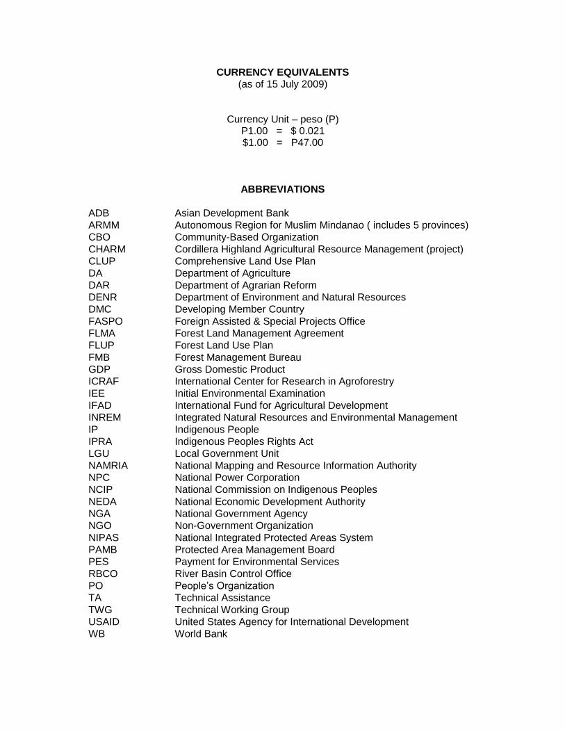
CURRENCY EQUIVALENTS (as of 15 July 2009)
Currency Unit – peso (P) P1.00 = $ 0.021 $1.00 = P47.00
ABBREVIATIONS
ADB Asian Development Bank
ARMM Autonomous Region for Muslim Mindanao ( includes 5 provinces)
CBO Community-Based Organization
CHARM Cordillera Highland Agricultural Resource Management (project)
CLUP Comprehensive Land Use Plan
DA Department of Agriculture
DAR Department of Agrarian Reform
DENR Department of Environment and Natural Resources
DMC Developing Member Country
FASPO Foreign Assisted & Special Projects Office
FLMA Forest Land Management Agreement
FLUP Forest Land Use Plan
FMB Forest Management Bureau
GDP Gross Domestic Product
ICRAF International Center for Research in Agroforestry
IEE Initial Environmental Examination
IFAD International Fund for Agricultural Development
INREM Integrated Natural Resources and Environmental Management
IP Indigenous People
IPRA Indigenous Peoples Rights Act
LGU Local Government Unit
NAMRIA National Mapping and Resource Information Authority
NPC National Power Corporation
NCIP National Commission on Indigenous Peoples
NEDA National Economic Development Authority
NGA National Government Agency
NGO Non-Government Organization
NIPAS National Integrated Protected Areas System
PAMB Protected Area Management Board
PES Payment for Environmental Services
RBCO River Basin Control Office
PO People’s Organization
TA Technical Assistance
TWG Technical Working Group
USAID United States Agency for International Development
WB World Bank

GLOSSARY
Protected Area – National Integrated Protected Areas System Act of 1992 defines a Protected area to be “identified portions of land and water set aside by reasons of their unique physical and biological significance, managed to enhance biological diversity and protected against destructive human exploitation.”
River basin Upper river basin
– -
A river basin is the portion of land drained by a river and its tributaries. It encompasses the entire land surface dissected and drained by many streams and creeks that flow downhill into one another, and eventually into one river. The final destination is an estuary or an ocean. The upper river basin is that portion of a major river basin that extends from the ridge dividing it from other basins down to a point where the gradient of the river has decreased to less than about 8% which is considered to be the gradient below which erosion becomes deposition. Within a URB there are generally several tributaries, and their catchments are referred to as watersheds
Vulnerability assessment
– An analysis of the relationship between natural and anthropogenic hazards and recipient subject (watershed). It identifies the strength and weaknesses of the recipient subject in relation to the identified hazard.
Watershed – A land area drained by a stream or fixed body of water and its tributaries having a common outlet for surface runoff. It includes small watersheds with an area of 10,000 hectares (ha) and less; medium-scale exceeding 10,000 ha up to 50,000 ha; and large-scale exceeding 50,000 ha in area.
Watershed characterization
– The process of describing the biophysical and socioeconomic characteristics and features of a watershed to have an understanding of the various processes within it.
Watershed condition
– Quantifies disturbances (stressors) the watersheds are subjected to; vulnerability denotes parameters at risk that could be changed (positive or negative) as a result of management activities.
Watershed functions
– Ecological services performed by a healthy watershed, including maintenance of water flow regimes to benefit aquatic resources, groundwater recharge, municipal water supply, or other uses; and maintaining or restoring ecological conditions needed for ecosystem and species diversity.
Watershed integrity
– A stable overall physical condition of the watershed (bedrock, landforms, soil, drainage) within which transfers of energy, matter, and, especially water occur. It is a prerequisite for the security of terrestrial and aquatic ecosystems. Watersheds with high integrity operate within their perceived natural range of variability and respond to disturbances with a trend to the watershed's “norm” in a reasonable time period.
Watershed management
– The process of guiding and organizing land and other resource uses in a watershed to provide desired goods and services without adversely affecting soil, water, and other natural resources.
Uplands – Land areas located on slopes of more than 18%.

CONTENTS I. INTRODUCTION AND BACKGROUND 1 II. RATIONALE: SECTOR PERFORMANCE, PROBLEMS, AND OPPORTUNITIES 1 A. Performance Indicators and Analysis 1 B. Analysis of Key Problems and Opportunities 3 C. ADB and IFAD Co-Financing 4 D. Rationale 6 III. THE PROPOSED PROJECT 9
A. Impact and Outcome 9 B. Outputs 13 C. Subproject and Subproject Selection 14 D. Special Features 15 E. Project Investment Plan 15 F. Financing Plan 16 G. Implementation Arrangements 17
IV. PROJECT BENEFITS, IMPACTS, ASSUMPTIONS, AND RISKS 24 V. ASSURANCES 29 MAPS 32 - 39 APPENDIXES 1. List of TWG and Stakeholder Consultations and Workshops 40 2. Natural Resources and Environmental Management Sector Analysis 41 3. Problem and Constraints Analysis 53 4. Summary Poverty Reduction and Social Strategy 54 5. Summary of Institutional Assessment and Strengthening 58 6. External Assistance to the Sector 64 7. GIS-based Database for Project Monitoring and Evaluation 67 8. Design and Monitoring Framework 71 9. Summary of Rural Infrastructure Rehabilitation 74 10. Detailed Cost Estimates 79 11. Project Organizational Structure 81 12. Implementation Schedule 82 13. Procurement Packages 84 14. Summary of Consulting Services 88 15. Financial Management including Flow of Funds 90 16. Gender Action Plan 95 17. Economic Analysis 99 SUPPLEMENTARY APPENDIXES (available on request)
A. Social and Poverty Analysis B. Institutional Analysis C. External Assistance and Lessons Learned D. GIS Mapping, Modeling and Database Development E. Description of Project Area and Subprojects

F. Technical Extension, Information, Education and Communication G. Infrastructure Rehabilitation H. Land Use Assessment, Land Capability Classification, and Zoning I. Detailed Implementation Arrangements J. Summary Initial Environmental Examination and Environmental Assessment and
Review Framework K. Involuntary Resettlement Framework and LARP L. Indigenous Peoples Development Plan and Framework M. Conceptual Framework of Performance-Based Grant System

1
I. INTRODUCTION AND BACKGROUND 1. Project preparatory technical assistance (PPTA) for preparing the Integrated Natural Resources and Environmental Management (INREM) Sector Development Program was approved by the Asian Development Bank (ADB) in July 2008. Under the PPTA, ADB provided a grant of $850,000 (funded by the Government of Japan) to the Government of the Republic of the Philippines (GOP). GOP's in-kind contribution was estimated at $300,000. However, following Inception, ADB and GOP advised the consultants to first prepare a Feasibility Study for a sector-like Project and then develop a Strategy and an Investment Plan for INREM for 2010–2020 period to provide a framework and a road map for addressing the problems of watershed degradation in priority river basins of the country. 2. The Consultants initially met with officials of the Department of Environment and Natural Resources (DENR), the Executing Agency (EA) for the PPTA, including the Foreign Assisted and Special Projects Office (FASPO) and the various Bureaus concerned. DENR then convened a multisectoral Technical Working Group (TWG), with representation from various government agencies (including NEDA, DOF, DAR, DA, NIA, NCIP, NPC, among others) to provide relevant information and guidance to the Consultant during project design. 3. In the course of project design development, Consultants held several stakeholders meetings, small group discussions and key informant interviews in Cordillera Administrative Region, Bukidnon, Cagayan de Oro City, Davao City, Lanao del Sur, and Bohol. Presentations were also made to the Sustainable Rural Development Working Group of the Philippines Development Forum convened by DENR. 4. This Feasibility Study Report is based on a review of available documents on river basins and watersheds of the Philippines, stakeholder workshops and social and environmental safeguards assessments, discussions with the concerned DENR staff, and various officials and nongovernment organizations (NGOs) at the national and regional level. See Appendix 1 for List of TWG and Stakeholder Consultation Meetings and Workshops.
II. RATIONALE: SECTOR PERFORMANCE, PROBLEMS, AND OPPORTUNITIES A. Performance Indicators and Analysis 5. The watersheds of the Upper River Basins (URBs) comprise an estimated 45% of the country’s total land area, and are home to one in four Filipinos, including indigenous communities.1 Natural resources in URBs are the primary source for domestic energy and the local production base. More importantly, these forest ecosystems play a critical role in economic development by regulating water quantity and quality for sustaining irrigation, hydropower generation and domestic water supplies, maintaining and restoring biodiversity, and mitigating climate change through carbon sequestration. 6. Watersheds in URBs, however, face the risk of rapid deterioration due to high rates of deforestation (as evident by an annual loss of 150,000 ha per year during 1990-2005 (World Bank 2007) and degradation (as evident by a decline in the closed canopy (old growth) forest area from about 5.5 million ha in 1988 to 2.5 million ha in 2003 (Acosta 2005).2 Such loss of forests contributes directly to an increased greenhouse gas (GHG) emissions as well as a reduction in
1 Asian Development Bank. November 2008. TA 4552-PHI: National Policy Study on River Basin Management in the
Philippines. Progress Report, October-November 2008. 2 Acosta, R. 2005. State of the Philippine Forests: The National Forest Assessment of 2003. Presentation at the
Philippines Forestry Forum, 2-3 June 2005. Manila. Asian Development Bank.

2
important habitats. A recent ADB report on Economics of Climate Change3 showed that the land use change and forestry sector is the biggest source of GHG emissions from Southeast Asia. The 2005 FAO Forest Resource Assessment showed that the Philippines lost 33.5 million tons of biomass from its forests between 2000 and 2005, and may have contributed as much as 37 million tons of CO2 annually. The sharp decline in forest cover has also been widely linked with increases in floods and land-slides that resulted in an annual average of 593 deaths and US$ 83 million worth of damage to property (Amadore 2005). Owing to deforestation and degradation, the number of critical watersheds in the Philippines has increased from 85 with an area of 3.3 million ha in 1995 to 149 with an area of 3.89 million ha in 2007.4 7. Watershed degradation in URBs is also compounded by (i) conversion of forestlands into unsuitable forms of agriculture and swidden farming or “kaingin”, (ii) rampant quarrying and mining, (iii) forest fires, and (iv) illegal logging. While, land-use conversion, from forests to farms, has increased productivity in the uplands, it is unsustainable for as long as watershed integrity is not ensured. Consequences of farming on land that is often unsuitable for crop cultivation are accelerated soil erosion and loss of productivity, resulting in an estimated soil loss of between 74 and 81 million tons per year, and affecting as much as 77% of the country’s land area. This led to a reduction in the storage capacity of reservoirs and as much as 30% reduction in service areas of irrigation systems during dry season. Apart from opportunity costs associated with foregone earnings from well-managed land, soil erosion has imposed high costs on downstream sectors – roads, bridges, agricultural production areas, settlements, water districts, etc.5 Silting of rivers and lake systems has caused the shortening of reservoir life-spans affecting both hydroelectric power and water supply. 8. Poverty is getting worse among upland communities. Average poverty rate in the country is 33%, however, in the uplands, poverty is significantly higher. There is no national data on upland vs. lowland poverty, but in the four Project sites identified, poverty rate is from 37% to 58%. Majority of the upland dwellers are indigenous peoples (IPs) who have historically been pushed higher up in the mountains because of displacement by commercial loggers and miners, and by migrant lowlanders. Because IPs and migrant communities live subsistent lives, they are very vulnerable to even slight changes in environmental, economic and policy conditions. One failed crop, drop in prices, devastating typhoon, or policy change that restricts traditional livelihoods can mean hunger for extended periods. Poverty drives the need to retreat further into the remaining forests and convert them to food production. 9. Major drivers of watershed degradation in the Project area are conversion of forest land to agriculture and illegal logging. The former is partly due to rapid population growth and partly to deteriorating economic conditions, which force poverty stricken rural communities with little alternative to subsistence agriculture to encroach into forests. It is also partly due to the expansion in production of valuable crops, such as fruit and vegetables by corporations and wealthy farmers. Illegal logging is due to a growing imbalance between high demand for wood products and low supply capacity, and high rates of poverty among the population in forest areas, which is exploited by greedy “rent seekers” to generate excess profits. Reversing this trend requires appropriate land use assessment, classification and zoning so that investments are more intensive and appropriate but environmentally sound agricultural and forestry production systems can be promoted in areas where environmental damage is minimized. It should also lead to the creation of alternative rural off-farm income generating opportunities that enable the rural poor to move out of subsistence farming and enter the market economy. Investment in protection and management of residual forests together with their restoration will provide immediate employment for a significant proportion
3 ADB Report on Economics of Climate Change.
4 Based on the information presented in the Lake Lanao Integrated Development Plan 2003, using the rate of PhP
0.5/KwH. The retail price of power in Mindanaomis PhP 3.00/KwH. 5 Upland Development Program Database, FMB, 2009.

3
of rural households, which could be an attractive alternative for those currently engaged in illegal logging. Investments in agroforestry, both on smallholder plots and in industrial plantations will increase output and provide both increased income and better livelihoods for households. These investments, within 5-10 years can also address the national timber supply-demand imbalance. See Appendix 2 for Sector Analysis and Supplementary Appendix A for Social and Poverty Analysis. 10. Sustainable watershed restoration policies and measures in URBs can yield many benefits in terms of conserving natural resources and addressing climate change. Indeed, the Philippines is one of 17 global mega-biodiversity “hot spots” (Mittermeier et. al. 1977),6 and protection of all residual closed forest areas and restoration of degraded areas through a combination of natural and artificial regeneration can help conserve biodiversity and other natural resources including land and water. Likewise, policies aimed at reducing emissions from deforestation and degradation (REDD), afforestation and reforestation, and sustainable agriculture and waste management can contribute greatly to reducing GHG emissions and increasing adaptive capacity of ecosystems and rural inhabitants. 11. Given the continuing degradation of the watersheds in the uplands, the cost of their conservation and restoration to ensure delivery of environmental services is staggering (currently over $1,000 per ha). Watershed management has traditionally been treated as a cost with little or no expected returns. GOPs budget allocations for restoration and rehabilitation of watersheds is contracting in real terms, and after overhead costs, there is little remaining in the budget for actual management interventions. Consequently, GOP is dependent on donor support for actual interventions to rehabilitate and restore watershed integrity and functions, which is not sustainable. 12. The Philippines is also highly vulnerable to the impacts of climate related events such as tropical cyclones and the El Niño effect. Deteriorating watershed conditions in the country have reduced the buffering capacity of montane and coastal wetlands ecosystems. Extreme climatic events have caused substantial economic loss with typhoons Ondoy and Pepeng causing damage equivalent to 2.7% of GDP in 2009 and total losses of P3.8 billion in the ANR sectors.7 Climate change impacts are predicted to become more intense in the future. The projected changes will put millions of subsistence upland farmers and coastal communities under greater risk of harm and damages, rendering the need for suitable adaptation and mitigation measures. B. Analysis of Key Problems and Opportunities
1. Policy and Institutional Environment
13. GOP has adopted sustainable development as a national policy for all environment and natural resources plans and programs. Towards this end, it has employed as one of its main strategies the integrated watershed management or the watershed ecosystem management approach. It is the policy of the DENR to ensure the attainment and optimization of environmental, socio-cultural, economic benefits from all watershed programs and projects through holistic, participatory management and effective implementation of interventions to sustain their production of multiple goods and services for the present and future generations. In this context, GOP has enunciated an array of sector policies, laws and regulations on forestry, protected areas, wildlife conservation, agriculture, public works, energy, air and water quality, waste management, and mining with significant implications for the management of URBs. Cutting across these sector
6 Mittermeier, R.A., P. Robles Gil and C.G. Mittermeier.1997. Megadiversity Earth’s Biologically Wealthiest Nations.
CEMEX. Monterey, Mexico. 7 Typhoons Ondoy and Pepeng: Post Disaster Needs Assessment (Sector Reports): Joint Report of the ADB, World
Bank, Australian Government Aid Program, et al.

4
policies are social policies on such matters as devolution of government jurisdiction and responsibilities, the rights of IPs and agrarian reform. Such a plethora of policies and supporting legislation is reflected in complex institutional arrangements with often overlapping responsibilities. In the watersheds/river basins, for example, several agencies look at different concerns in the same area: protected area management boards (PAMBs) in protected areas, IP councils for ancestral domains, water quality and air quality management boards, local watershed councils/boards created by local ordinances, and co-management boards by agreements between DENR and local government units (LGUs). The Local Government Code (RA 7160) provides for the transfer of certain environmental management and regulatory functions to LGUs and the option to manage forests and other natural resources, but such provisions are yet to be fully operationalized. See Appendix 3 for Problems and Constraints Analysis, Appendix 4 for Summary Poverty Reduction and Social Strategy and Appendix 5 for a Summary of Institutional Assessment and Strengthening and Supplementary Appendix B for Institutional Analysis.
2. Past Efforts and Lessons Learned
14. Many efforts to address degradation of watersheds have been undertaken through various national, provincial, and donor-funded development programs and projects8. Key lessons from such efforts that are relevant to the design of the Project include the following: (i) livelihood development activities should precede implementation of conservation programs; (ii) projects should aim for a practical and simple approach involving proven and tested tools/activities; (iii) prospects for sustainability are enhanced if the beneficiaries share in project costs through counterpart financing (cash or in-kind); and (iv) policy over natural resource access (including forest land tenure) needs to be consistent and stable over the long-term to attract investments. Studies9 suggest that the role of citizens and citizens’ organizations and the private sector must be enhanced. Development assistance initiatives therefore need to focus on establishing a policy environment that facilitates private sector participation. (See Appendix 6, External Assistance to the Sector). 15. Furthermore, IFAD experience from ongoing and completed projects with focal concern on natural resource management (NRM) suggest the following (i) active participation of beneficiaries and other stakeholders in project selection, implementation, monitoring and evaluation improved long term project impact (ii) respect of cultural structures, systems and practices and integrating them into the project’s institutional framework and processes have improved project sustainability, (iii) land and water asset control by the communities led to improved resources management, and (iv) livelihood opportunities provided to the poor and advocacy to local community stakeholders improved protection of natural resources. C. ADB and IFAD Co-Financing 1. ADB's Strategy 2020, Sector Strategy and Road Map 16. The Project is consistent with the three themes of ADB's long-term strategic framework 2008-2020 (Strategy 2020)—inclusive growth, environmentally sustainable growth, and regional integration, as it focuses on integrated management of forests and other natural resources for sustainable delivery of ecosystem services, especially sustained water supply, biodiversity conservation, and carbon sequestration to serve the interests of local, national and global communities. The Project is also in conformity with the Agriculture, Environment and Natural Resources Department (AENRD) Sector Road Map for the Philippines, which proposes
8 The National Program Support-Environment and Natural Resources Management (NPS-ENREM) of the World Bank,
Environment, Natural Resource Management and Rural Development (EnRD) Program of GTZ, and Philippine Environmental Governance (EcoGov) Project of USAID.
9 DANIDA, 1998.

5
interventions in agriculture and rural development aimed at poverty reduction through the development of livelihood initiatives, including improvement of access to markets, public services, employment and commercial opportunities while sustaining the natural resource environment for future generations. The road map recommends that ADB continue to contribute to achievement of the medium term Philippines development program objectives of “creating healthier environment for the population” with interventions in rehabilitation and reforestation of watersheds, improve water quality, marine and coastal resource management including biodiversity conservation, in the context of river basin planning as envisaged under the Project. 17. As discussed in the NREM Sector Analysis (Appendix 2), a sector development program (SDP) modality as well as multi-tranche financing facility (MFF) modality, would be appropriate, given the need for a programmatic longer-term perspective to supporting investments in integrated NREM. However, given limited experience in the innovative approach that the Project envisages, it would be prudent to adopt a cautious approach. With the implementation of the Project, followed by the Agusan River Basin Development Project currently being processed, and the possible interventions in the Rio Grande river basin in Mindanao, sufficient experience in the design and implementation would have been generated that would create a satisfactory investment climate for either an SDP or an MFF. 2. IFAD’s Results-Based Country Strategic Opportunities Programme 18. The IFAD Results-Based Country Strategic Opportunities Programme (RB-COSOP) of 2010 to 2014 is consistent with the development thrusts of the Government’s Medium-Term Philippine Development Plan 2004-2010 (MTPDP 2004- 2010) and with the government ten-point agenda for growth and poverty reduction. IFAD’s country strategy will continue to support the Government’s medium-term rural poverty reduction goals, which are closely aligned to the Millennium Development Goals (MDG). In particular, INREM is consistent with the 1st COSOP strategic objective of empowering poor rural women and men to achieve higher incomes and improved food security through improved access to and control over land and water resources and gainfully use these in environmentally sustainable endeavours, while gaining access to essential socio-economic public infrastructure. Key IFAD crosscutting issues are likewise addressed by the Project, which include: (i) natural resource management within the context of climate change and natural disasters, in particular through mitigation and payment-for-environmental-services mechanisms for indigenous peoples; and (ii) support for the decentralization agenda towards LGUs and farmers’ organizations and their platforms. 3. Linking INREMP & CHARMP 19. The Cordillera Highland Agricultural Resource Management (CHARM) Project was executed by the GOP through the Department of Agriculture (DA), and jointly funded by ADB and IFAD from 1997 to 2004. During negotiations for CHARMP 2 in 2008 amongst ADB, IFAD, and GOP (represented by NEDA, DA, and DOF), GOP sought assistance from ADB to assist the country in scaling up CHARMP. ADB acquiesced. The project cycle schedule for ADB was not congruent with that of GOP and IFAD inasmuch as the fielding of a preparatory team to scale up CHARMP into INREMP would delay the commencement of CHARMP 2. It had been agreed that the ADB infusion of US$10 million to CHARMP 2 be through INREMP. 20. It is acknowledged that what transpired during CHARM provided the opportunity to assess the dynamics of watershed management at the micro level with wide impacts to the greater society. The DENR is now envisaged to take the lead as Executing Agency with LGUs, DA, NCIP, CSO, and R&D institutions as co-implementing Agencies/Units.

6
21. The ADB commitment of US$ 10 million for rural infrastructure in CHARM 2 is consistent with the proportion of the INREM investment that will be required for CHARM 2 Municipalities and Barangays that lie in the Chico URB. It is proposed that said funds be downloaded directly to DA as originally agreed upon during negotiations for CHARM2 in 2007-2008. D. Rationale 22. The INREM perspective in designing the Project is to find ways of generating revenues for paying for the costs of conservation. The challenge is compounded by the public’s lack of awareness that environmental services are not free. But even if resource users accept the obligation to pay, there is generally lack of capacity to contribute as most direct resource users (IPs and migrant communities in uplands) are also poor. There are isolated examples of PES arrangements in some sites, but there is generally no mechanism to enable downstream users (such as irrigators associations, water districts, power generators, large commercial farms, global community) to pay for the benefits of keeping the forests. INREM approach, therefore, follows some of the basic generally-accepted principles in its design, and these include:
Watersheds and communities cannot be separated
Conserving watershed resources necessarily means addressing poverty among dependent communities and their empowerment
Sustaining conservation efforts requires investments and productive activities in the watersheds to improve lives of dependent communities
Recipients of environmental services must pay for the benefits received
Payments for environmental services must be used for conservation 23. The cross-sectoral nature of URB management therefore requires the INREM Project to address several issues: (a) fragmented and overlapping policies, legislation and institutional responsibilities; (b) conflicting, contradictory or ambiguous regulations and institutional roles; (c) insufficient capacity of concerned stakeholders to ensure sustainable management of critical watersheds; (d) ineffective implementation and enforcement of forest and mining laws and regulations; (e) inadequate demarcation of forest/non-forest boundaries; (f) inadequate land tenure rights recognition and enforcement of these rights; and (g) insufficient funding. These issues, in turn, highlight the need for (i) effective institutional arrangements that resolve cross-sectoral conflicts to ensure sustainability and restoration of natural resources, (ii) sustained stakeholder participation; (iii) enhanced private sector participation and investment; (iv) strengthened technical and financial services to support upland livelihood and small business growth; (v) adoption of appropriate conservation farming practices, provision of market information, and promotion of market linkages for upland products; and (vi) raising awareness of the public and LGU officials on ways to address climate change through both adaptation and GHG mitigation, and by making carbon stock management as an integral component of watershed conservation to enhance prospects for attracting additional funds through Payments for Environmental Services (PES), REDD, Global Environment Facility (GEF), Clean Development Mechanism (CDM), voluntary carbon markets, biodiversity conservation, and others. 24. In absence of such interventions, accelerated depletion of the natural resources and the likelihood of total decimation of closed forests within the next 20 years cannot be ruled out. Consequent impacts on the economy and the social well being of the people in terms of increased poverty and further decline in the water available for power generation and irrigation, and adverse climate change impacts will be enormous. This calls for a major shift to an integrated cross-sector approach to river basin management that incorporates biodiversity conservation and climate change considerations into a holistic approach to natural resource management and infrastructure improvement, as adopted in the INREM Project design.

7
25. The INREMP approach recognizes that in a river basin landscape10, most of the critical environmental services originate in the upper regions of the basin, while the benefits of these services are realized in the lower basin stretches. In addition, the whole basin is subdivided into different political administrative jurisdictions, often undertaking economic activities independent of each other. INREM emphasizes that the various political jurisdictions should, in fact, proceed in an integrated manner, recognizing the ecological interdependence between the upper, middle and lower river basins. INREM therefore aims to address the situations discussed above, and should comprise as follows:
The best uses for the lands within river basins and their component watersheds should be determined through science-based land capacity assessment and river basin and watershed management plans should subsequently be formulated, following participatory processes, that account for environmental, cultural, social-economic, political-legal concerns across the river basin landscape.
Investments in conservation (reinforced forest protection, forest rehabilitation) and production (rural infrastructure, demonstration for improved forest and agroforestry production, and conservation farming) by small farm holders, private sector and other investors should be guided by the watershed plans so formulated, supported by the appropriate social, economic and political institutions;;
The capacity for river basin and watershed management through the INREMP approach by NGAs, LGUs and stakeholders should be enhanced;
Putting in place the institutions to successfully manage the Project during its seven-year implementation, and to sustain the interventions beyond project-life and towards institutionalized ENR-river basin sector management, should be a feature of project management, i.e., project management should not only be concerned about project administration per se but more about institutionalization The river basins covered by this INREM Project are representative of the conditions of almost all river basins of the country; a river basin is a mosaic of public and private lands, defined under various legal land classifications (e.g., public forestlands and alienable and disposable lands), ownership and use rights (e.g., private lands in A and D, ancestral domains, tenured lands in public forestlands). The INREM approach takes these complexities into consideration, as shown in Figure 1 below. Figure 1. INREMP approach across the river basin landscape.
10
McCracken, J., Maginnis, S. and Sarre, A. (eds.).2007. The Forest Restoration Handbook (Earthscan, London).
NIPAS Protected Areas Strict Protection Multiple-use
Ancestral domains/ lands
Public domain
(forest, national park, mineral lands)
Alienable & Disposable
(agricultural)
conservation rehabilitation
improved roads, water supply and irrigation commercial forest plantations agroforestry conservation farming PES mechanisms
I N R E M
PAMB and/or IP Council LGU-based multi-stakeholder institutions, including upland peoples’ organizations
Non-NIPAS watersheds

8
26. This Project will implement the INREM approach through four components (see para. 48 ff. below for detailed description):
(i) Component 1: River basin/ Watershed Management and Investment Planning (ii) Component 2: Smallholder/ Commercial/ Institutional Investments (iii) Component 3: Capacity Strengthening for River Basin Management (iv) Component 4: Project Management and Support Services
Figure 2. Project components as they relate to each other.
INS
TIT
UT
ION
AL
CA
PA
CIT
Y B
UIL
DIN
G
PO
LIC
Y A
DJU
ST
ME
NT
RE
SO
UR
CE
AS
SE
SS
ME
NT
& S
TR
AT
EG
IC P
LA
NN
ING
CO
NS
ER
VA
TIO
N
Conservation of protection forests
TE
CH
NIC
AL
EX
TE
NS
ION
& IE
C
GIS
-ba
se
d M
ON
ITO
RIN
G A
ND
EV
ALU
AT
ION
AN
D D
SS
Reinforced protection of existing forest
Rehabilitation of degraded forest
ANR and Reforestation
Reinforced protection of rehabilitated
forests
PR
OD
UC
TIO
N
Production Forestry
Agroforestry
Commercial Forest. plantations Sustainable management of production
forests
Rural Infra Improvements: Rural access roads, irrigation systems improvement and domestic water supply
Conservation Farming
Capacity Building
Project Management
27. The management plan will consider the environmental impacts on the entire river basin, from “ridge to reef.” However, the Project investments will be restricted only to the uplands, starting with the ridges and down to the watersheds that are significant to ensuring integrity of the river basin – what is roughly referred to as “upper river basin.” The extent of the upper river basin to which Project investments are made may be different for each site, depending on biophysical characteristics, climate risks, extent of development/settlement in the area. Drawing the line to delineate the upper river basin is also a function of optimal use of Project resources (achieving the most impact for every peso invested). 28. Institutional arrangements for implementing INREM requires a combination of national government guidance and local government implementation., The river basin management plan is the instrument by which national agencies can guide, monitor and evaluate local government field implementation. The field investments are the catalysts for increasing productivity but ensuring watershed integrity. 29. The Project implementation, however, does not require that laws or major policies be changed drastically. As a general strategy, the Project will seek to empower provincial Governors,

9
advised by Provincial INREM Councils, to take decisions on inter-sectoral conflicts (e.g. forests vs. mines), that ensure sustainability and avoid further natural resource degradation. 30. The Councils will in turn be supported by a GIS-based decision support system that will allow proper pre-decision appraisal of all proposals for change in land-use. An appropriately designed project performance monitoring system will be linked to the GIS-based database for monitoring and evaluation to monitor various aspects of land use change, project performance and impact of various investments to reverse natural resources degradation in the watersheds. See Appendix 7 for GIS-Based M&E and Supplementary Appendix D GIS-based Mapping, Modeling, and Database Development. 31. Project implementation will not require that laws or major policies be changed significantly, except to ensure that the policies and regulations are consistent. Existing laws and policies are already supportive of INREM approach, except for some inter-sectoral inconsistencies and lack of implementation (See Appendix 5 and Supplementary Appendix B). A potential major enhancement will be establishing a science-based decision making system linked to a database of relevant monitoring and evaluation data gathered from the field. 32. INREM objectives can be achieved under the current legal and policy framework. However, implementation of current laws and policies has to be improved to be more effective and efficient. Improving effectiveness and efficiency will need some amendments of implementing regulations and enactment of local legislation, as indicated below:
INREM Approach Current Policy Framework Adjustment needed in existing policies
Managing watersheds as sustainable economic enterprises
• DENR has control over resources and resource use; but it cannot run an "economic enterprise"
• LGUs can (since they have the legal mandate), but have no control over the “capital” [land and NR]
• DENR has to allow LGUs more control over production areas so that these areas can be operated as local enterprises
• DENR has to strengthen property rights (tenure instruments) so that investments are secure
Institutionalizing PES to pay for conservation management
• DENR and LGUs have revenue generation powers; DENR has no flexibility in retaining revenues, whereas LGUs have.
• DENR can reorient itself and prepare for global sources of PES such as REDD, CDM and grants under international conventions
• LGUs can pass local legislation to capture PES
33. However, despite the uncertainties, the INREM approach and Project design lay the foundations for a sustainable management framework that has not been tried before on a nationwide scale. The sustainability of INREM requires a change in mindset of the national and local governments to treat watershed management as a self-financing local enterprise, rather than as a non-revenue, low priority obligation.
III. THE PROPOSED PROJECT
A. Impact and Outcome 34. The Project impact is to bring about improved livelihoods in the URBs through effective provision of ecosystems services. The expected Project outcome is that LGUs and POs/IPOs-

10
based watershed enterprises generate increased revenues from watershed management, biodiversity protection and livelihood investments. 35. Project outcomes will be influenced through policy dialogue to (i) clarify, rationalize and delineate use rights of local communities and IPs as part of watershed management regimes; and (ii) enable LGUs to establish model contracts and supportive local ordinances to implement watershed management plans. Institutional support under the Project will capacitate DENR to shift from primary implementer to enabler/trainer of LGUs for land assessment and NRM planning. LGU experience with enterprise management, such as with the Bukidnon Provincial Economic Enterprise Development Management Office will be adapted to manage watershed resources identified for production. Performance Based Grants (PBGs) will be instituted as incentives for LGUs to achieve land/water management targets in priority watersheds and improve allocation efficiencies. 36. The Project will implement a programmatic and geographic slice of DENR's core mandate for sustainable watershed management. Together, the four sites encompass the diversity of INREM issues and problems ensuring that development investments can be replicated across the country. The Project covers four representative river basins with 23 watersheds extending to over 1.13 million hectares with an estimated population of around 2.7 million. Approximately 350,000 household beneficiaries are targeted under the Project covering 9 provinces. The selection of the URBs was guided by an Interagency Technical Working Group (TWG), chaired by DENR based on their biophysical condition, socioeconomic and conservation values, and the state of their degradation. 37. In the Lake Lanao, Bukidnon and Wahig-Inabanga URBs, the Project will initiate interventions that will contribute to the reduction of nutrient runoff from agricultural lands, through the improvement of farming practices and restoration of vegetative cover to reduce siltation and discharge of harmful pollutants that contribute to oxygen depletion in coastal waters of Iligan Bay, Macajalar Bay and Bohol Sea. This ridge to reef approach will support activities under the Coral Triangle Initiative.11 Project Area 38. Project site selection was guided by the national interagencyTWG. After consultations with different sectors and agencies (environment, agriculture, infrastructure, economic planning, irrigation, etc), the TWG recommended inclusion of these four RBs within the scope of the Project. These sites, extending to over 1.13 million ha with an estimated population of around 1.7 million, were prioritized, namely: Chico River Basin, Bukidnon Upper River Basins, Wahig-Inabanga River Basin and Lake Lanao Watersheds. Selection was based on their representative biophysical conditions, socioeconomic and conservation values, likewise taking account of installed water management infrastructure, the state of land and forest degradation. These sites encompass the entire range of issues and concerns of INREM.
Chico River Basin (Cordillera Region in Luzon) represents large areas covering 5 provinces, with headwaters that are ecologically significant and fragile, but highly accessible and suitable for land conversion to high value agriculture; most of the land is claimed as ancestral domains;
11
The Coral Triangle Initiative is a six country program (Indonesia, Malaysia, Papua New Guinea, Philippines, Solomon Islands, and Timor Leste, also known as the CT6) to protect and preserve the rich marine biodiversity in the Coral Triangle region and help coastal communities adapt to climate change.

11
Wahig-Inabanga River Basin (Bohol Province in Visayas) represents relatively small areas with less developmental pressure, but with highly aware and capable LGUs, and high potential for successful management;
Bukidnon River Basins (Bukidnon and Misamis Oriental Provinces in Mindanao) represents the headwaters of several rivers that flow into the major agricultural areas of Mindanao; Provincial Governments relatively prosperous, with rich experience in environmental governance;
Lake Lanao Watersheds (Lanao del Sur, Autonomous Region in Muslim Mindanao) represents less economically developed areas but with relatively rich natural resources that are in danger because communities near the forests have no viable alternatives to timber poaching.
39. Poverty rates in the Project area range from 37 to 58%, substantially higher than the national average of about 33%. In three of the four URBs, indigenous peoples (IPs) account for over 70% of the population. More than a third of interviewees in the Project area reported that forest denudation was a major threat because of the erosion, flooding and reduced water supply and the effect that this has on agricultural productivity and damage to local infrastructure. The Lake Lanao URB is a major source of hydropower for Mindanao and studies have shown that hydropower output is currently only about 50% of installed capacity due to reduced water flow, resulting in lost revenue for National Power Corporation of around US$11 million annually.9 Siltation of the lake has resulted in a sharp drop in the number of endemic species of fish as well as a drop in overall fish catch in the lake which impacts negatively on local livelihoods and nutrition. 40. Of the total aggregate area 65% is classified as forest land while 35% are alienable and disposable lands. The terrain is mostly steep to critical slope with 53% of the area having an average slope higher than 30%, 14% with a slope of 18%-30% and 33% with less than 18% slope, with elevation as high as 2,900 meters above sea level. Despite the unfavorable terrain, the dominant land use is agriculture, with 41% of the total area cultivated and planted to annual and perennial crops, of which almost one third is on steeply sloping land (>30% slope),. This is followed by forestry, with 30% of the area under tree cover, shrubs covering 18%, wooded grassland at 8% and the rest are grassland and built-up areas. Out of the 30% forest cover, 54% are closed canopy forest, 44% open canopy and 2% plantations. It may be noted that almost one-third (29%) of the area planted to annual crops are located in slopes over 30%. 41. Spanning through nine provinces, 83 cities and municipalities, and around 1,377 barangays, the river basins are home to some 1.7 million people, 79% of whom are IPs, and have a poverty incidence among population (as of 2006) that ranges from 37.2% to as high as 58.5%. Significant acreage within the project sites is claimed as ancestral domains of various IP groups. An estimated 350,000 household beneficiaries are targeted under the Project. Main beneficiaries are marginal households with small landholdings planted to rice, corn, coconut, sugarcane, vegetables and other crops. IPs12 and other ethnic minorities13 (EM) constitute around 80% of the total beneficiaries that generally reside in headwaters of the river basins. In Lanao del Sur, there are about 10,000 families in 76 barangays14 who are victims of war in conflict-affected areas of Mindanao, where poverty is severe. It is also in these areas where wanton abuse of resources occurs through (i) illegal logging, (ii) conversion of forested lands to vegetable farms, and (iii) small scale mining/quarrying. These activities provide significant incentives for overexploiting the natural resource base.
12
Major IP groups are, from CAR - Kanakan-ey, Applai, Bontok, Kalinga, Ifugao, Isneg, and Tingguian; Bohol – Eskaya; Muleta-Manupali – Higaonon and Talaandig; Lake Lanao – Higaonon, Kolibugan, and Iranon.
13 Major EM found in Lake Lanao known as the Meranao, generally of Muslim affiliation.
14 Department of Social Welfare and Development, 2004.

12
42. Amongst the provinces in the Project area, Apayao in the in Cordillera Administrative Region (CAR) had the highest increase of 35.6% (27.5% in 1997 to 63% in 2006) in poverty incidence; Kalinga, also in CAR, had 13.2% increase (38.7% in 1997 to 51.9% in 2006); Bohol in Central Visayas recorded a 9.6% increase (37.3% in 1997 to 46.9% in 2006) and Lanao del Sur in Mindanao recorded a 2.9% increase (55.6% in 1997 to 58.5% in 2006). Decline in poverty incidence occurred in CAR in Ifugao with 17.4% (57.7% in 1997 to 403.3 in 2006), 6.2% in Mt. Province (56.6% in 1997 to 50.4% in 2006), and Bukidnon in Mindanao with 5.3% decrease from 42.5% in 1997 to 37.3% in 2006,15 The annual per capita poverty threshold was estimated at PhP14,866 in 2007—a 51.0% increase over the 1997 threshold of PhP9,843. 43. The Project Area includes four of the 128 priority sites for biodiversity conservation in the Philippines. These are: a) the Balbalasang-Balbalan National Park (Key Biodiversity Area16 (KBA) No. 5) in Chico River Basin; b) Rajah Sikatuna Protected Landscape (KBA 92) in Wahig-Inabanga; c) Mt. Kitanglad Range Natural Park (MKNRP) (KBA 106); and d) Lake Lanao (KBA 109) in Lake Lanao Watershed. The Project site also includes different types of tenure instruments granted to families or communities. Moreover, a significant number of occupants in the Project sites have no formal property or occupancy rights over the lands they are living on or tilling. The uncertainty of property rights has direct impacts on the short- or long-term land-use practices of the occupants.
44. The average annual rainfall in Chico, Upper Bukidnon, and Lake Lanao River Basins is about 2,400 mm while Wahig-Inabanga has almost twice as much at 4,600mm. Wahig-Inabanga and Lake Lanao belong to the same climatic type and rainfall is evenly distributed throughout the year. In Upper Bukidnon, rains are very frequent with the rainy season during May to October and maximum rainfall occurring in September while Chico is dry from November to April and wet the rest of the year.
45. Though there is no definite estimate on the volume of mineral deposits, Chico River Basin is reported to be richly endowed with mineral resources that include gold, sulfur, and copper while in Lake Lanao River Basin, mineral resources that include copper, gold, chromium, manganese and silver have been reported along its boundary with Lanao del Norte and North Cotabato. In Bohol, limestone covers 65% of the province while in Bukidnon, it is known that it is underlain with quaternary volcanic flows and pyroclastic materials that have been observed to have pyrite (FeS4) and chalcophyte (Cu2 Fe2) and ores of copper and zinc. 46. The road network within the project area is mostly gravel or earth road, especially the municipal and barangay roads. Most of these roads, especially in the uplands, are fair weather thereby constraining movement of agricultural products and inputs besides making access to social services difficult, especially in rainy season. Access to potable water by households is estimated at 61% to as high as 98%. In the uplands, however, potable drinking water facilities are limited and unable to cater to the needs of upland dwellers, especially IPs. Agriculture is the main source of livelihood. The proportion of area under cultivation and planted to annual crops ranges from 14% in Chico (due to topographic conditions), 21% in Lake Lanao; 64% in Upper Bukidnon, and 72% in Wahig-Inabanga. The crops raised include rice, corn, banana, vegetables (such as cabbage, potatoes and legumes), sugarcane, and root crops. Productivity is constrained by poor farming practices contributing to continued erosion, vulnerability to floods and landslides, and high transaction costs of agricultural inputs, low income levels, especially among the upland
15
NSCB, 2008. 16
According to Conservation International Philippines, Department of Environment and Natural Resources - Protected Areas and Wildlife Bureau, and Haribon Foundation (2006), Key Biodiversity Areas (KBA) are priority sites for conservation in the Philippines and are identified using simple, standard criteria based on the conservation planning principles of vulnerability and irreplaceability. Vulnerability is measured by the confirmed presence of one or more globally threatened species while irreplaceability is determined through the presence of geographically concentrated species.

13
communities and IPs. The irrigation service area ranges from 39% to about 48% of the total irrigable area. Existing communal irrigation systems in the Project area are in immediate need for rehabilitation and improvement. See Supplementary Appendix G for details. B. Outputs 47. The project will operationalize IEM within priority watersheds by assimilating science-based land management regimes with local indigenous knowledge and practices. The Project outputs are grouped under four mutually supportive components, based on extensive consultations with stakeholders and beneficiaries. The Project design and monitoring framework is presented in Appendix 8.
48. Component 1: River Basin/ Watershed Management and Investment Planning. Indicative Development Plans (IDPs) will be developed for the 4 River Basins to be adopted by Regional Development Councils and/or Provincial Legislative Councils. The IDPs will be based on land capability assessments to identify appropriate management zones and drawn up by the regional and provincial offices of DENR in coordination with relevant national agencies, LGUs and stakeholders. More detailed Watershed Management Plans (WMPs) for the 23 component watersheds will be prepared based on the respective IDPs. WMPs will define and prioritize the subprojects and establish a work program for implementation by LGU clusters and Municipal Development Councils. The WMPs will take account of existing tenurial arrangements and treat Ancestral Domains (AD) as management sub-units.17 49. Component 2: Smallholder/Commercial/ institutional investments. Subproject investments will be undertaken within the 23 Project watersheds. Based on the outputs from Component 1, a menu/bundle of interventions for watershed protection, restoration and rehabilitation will be implemented covering over 325,590 ha. Specific investment areas will comprise community based protection, reforestation and/or assisted natural regeneration, production forestry including agroforestry demonstrations and commercial forest plantations, and conservation farming demonstration areas. Livelihood enhancement investments to be undertaken by Municipal LGUs include (i) 645 km of rural access roads (560 km) and foot trails (85 km), (ii) communal irrigation systems servicing 3,040 ha, (iii) 275 units of potable community water facilities, (iv) one provincial trading/processing center supporting farming communities; and (v) seed funds for replication/expansion of tested and mature farming technologies.. 50. Component 3: Capacity Strengthening for river basin management. The Project will (i) work with existing institutions, where they exist and are appropriate (e.g. Protected Area Management Boards and LGU-created watershed councils); and (ii) train LGU/LCOs on land use assessments and watershed management/planning; PES; IPO/PO Revolving fund management; and LULUCF and REDD+ capacity building; (iii) support for development and implementation of technical extension–information communication (TE-IC) services; and (iv) social preparation and marketing of the project to stakeholders. 51. Component 4: Project management and Support Services. The project will support the establishment of a National Project Coordination Office (NPCO) at DENR, and project coordination/implementation units at DENR regional offices, offices of Provincial Governors, and host watershed cluster municipalities. The NPCO will coordinate (i) consultant recruitment and supervision; (ii) procurement of materials, equipment and vehicles during project implementation; and (iii) mobilize and manage project resources; (iv) initiate special studies in support of project delivery.. A geographical information system (GIS)-based database cum decision-support system
17
As defined in the Indigenous Peoples Right Act (IPRA) 1997.

14
will be established and operationalized at various levels (national to watershed cluster) for pre-decision appraisal and project performance monitoring. C. Subprojects and Subproject Selection 52. The Project follows a step by step approach by first implementing Component 1, which includes land use and capability assessment, and participatory management planning, leading to zoning and institutional capacity building measures (Component 3), extending to the entire Project area. For Component 2 of the Project, a sector-like modality is proposed. Under this modality, the Project area extending to 4 river basins has been subdivided into 23 watersheds, each watershed corresponding to one subproject. This subdivision has been undertaken to focus investment planning and implementation, and preserve the integrity of a watershed ecosystem. Moreover, smaller-sized subproject areas also provide the opportunity to work within existing laws, regulations, and institutional arrangements, and avoid jurisdictional conflicts and overlaps that exist at the river basin level. There would be no need for superimposing any new institutional arrangements that overlap existing institutions. Selection of subprojects for management plan based investments will be undertaken in accordance with criteria for selection and approval agreed between GOP and ADB (see para. 55 below). 53. The Project will employ an area based approach corresponding to integrated ecosystem management. In view of the widely dispersed nature of the Project sites and multiple components, a sector-like approach will be followed. Based on satellite imagery and local knowledge, land use and vegetation in the Project areas (selected URBs) vary with location, altitude, topography and agro-climatic conditions. Current land use varies from closed canopy forests, degraded forests, woodlands and grasslands, shifting cultivation areas, agriculture lands with and without irrigation, and built up areas including cities and towns. Details on current land use and recommended land use options for various categories of land in the Project area as a whole are given in Supplementary Appendix H. 54. The INREM under the integrated ecosystem management approach requires integration of interventions from conservation in the closed canopy forests, rehabilitation and reforestation of degraded forests and woodlands, agroforestry in areas subject to shifting cultivation, conservation farming in agricultural lands and in some areas pasture improvement for livestock, demonstration areas for commercial forest plantations and sustainable forest management, supported by improvement of irrigation systems, rural access roads, and communal small scale level 2 water supply systems, all within the same watershed/subproject area. As the subprojects correspond to an entire sub-watershed, they may extend to one or more municipalities and range in size from 20,000 to 35,000 ha. 55. Sample subproject areas have been assessed for design of possible interventions aimed at addressing the causes of natural resources degradation. Additional subprojects, to be designed during implementation, will be selected on the basis of criteria that include (i) consistency with provincial/national development strategy; (ii) socioeconomic significance and impact on poverty reduction; (iii) concurrence by concerned national agencies and LGUs and willingness of the LGUs to participate and put up the required equity in accordance with the Borrower’s National Government and Local Government Unit Cost Sharing Policy approved by the Investment Coordination Committee on 12 December 2002, or any follow up policies; (iv) LGUs' willingness to carry out the necessary surveys and safeguards assessments, individual subproject feasibility studies to determine their technical appropriateness, based on proven successful examples and implementation arrangements, economic viability and sustainability; (v) social acceptability of the design and implementation arrangements; (vi) ecological significance in terms of biodiversity and carbon sequestration potential; (vii) contribution to sustainable production of goods and services; (viii) post-investment financial sustainability; (ix) willingness of LGUs to abide by ADB and

15
government procurement safeguard and anticorruption policies, and to enforce proper financial due diligence and fiduciary management; (x) commitment of LGUs to facilitate resolution of any social or environmental problems; (xi) willingness of the LGUs and concerned regional and national agencies to support and facilitate operations and maintenance of the facilities supported by the Project; (xii) no financing overlap of proposed subprojects from any other foreign or local projects/sources; (xiii) constitute complete watersheds; (xiv) absence of resettlement impacts; (xv) do not result in adverse environmental impacts that cannot easily be mitigated; and (xvi) the state of watershed degradation and impacts on downstream communities requiring urgent attention. Approval of all subprojects for funding under the Project, including the sample subprojects, will be subject to satisfactory compliance with these criteria. D. Special Features
56. Climate Change Fund and Global Environmental Facility Fund. The Project will mainstream climate change mitigation through investments, supplemented by grants for: (i) establishing biomass energy forest plantations with private sector equity contribution in Bukidnon; (ii) establishing and verifying Reduced Emissions from Deforestation and Forest Degradation and Conservation/Enhancement of Carbon Stocks (REDD+) through demonstration activities; and (iii) implementing appropriate climate-change adaptation measures in upland production systems. The Project will mainstream biodiversity conservation in the watersheds through application of a community-based biodiversity corridor approach for conservation of remaining native mossy forest stands in the Chico-Agno-Magat River Basins triboundary headwaters area of the Cordillera. In addition, PES agreements will be developed between IPOs/POs and downstream ecosystem-service beneficiaries, initially in the triboundary area between 3 IPOs and the National Power Corporation (NPC).18 Seed capital will be provided for establishing "Revolving Funds" involving the IPOs. Options for bundling PES payments with carbon credits will be explored. 57. Phased devolution. The Project will address institutional/policy gaps in NRM at the national and local levels by supporting a phased devolution process as follows: (i) reinforcing existing co-management policies19 between DENR and LGU clusters in the 23 watersheds as part of Comprehensive Land Use Plans (CLUPs); (ii) establishing LGU ordinances for conservation through user fees and investment agreements over LGU managed forest lands; and (iii) establishing plow-back mechanisms for conservation investments in PAs and ADs from creation of new productive assets, encouraging private sector investments and PES. 58. Sustainability and Replicability. INREM adopts the design, funding modalities and implementation structures currently in use by DENR facilitating the transition to regular programs at project completion. The Project will implement investment packages by directly engaging local communities/IPs and ensuring strong representation of women during consultations, assessment and production of training modules. Revolving funds to be established under the Project will ensure that sufficient operational budgets are available for post-project sustainability of assets. Long term financial viability will be strengthened by institutionalizing/scaling up PES and exploring opportunities for carbon finance during Project implementation. E. Project Investment Plan 59. The project is estimated to cost $154.13 million, including duties and taxes in the amount equivalent to $6.06 million. The investment plan is summarized in Table 1. Detailed cost estimates by expenditure category and detailed cost estimates by financier are provided in Appendix 10.
18
Under the Electric Power Industry Reform Act of 2001, the NPC is mandated to administer an environmental charge which is equivalent to PhP 0.0025 per kilowatt-hour (kWh), intended to be used solely for the rehabilitation and management of NPC-managed watershed areas.
19 such as transfer of resource use rights to LGUs in production areas (DENR-DILG Memorandum Circular 2003-01)

16
Table 1: Project Investment Plan ($ million)
Item Amounta
A. Base Costb
1 Component 1. River Basin and Watershed Planning 12.16 2 Component 2. Small Holder/Commercial/Institutional Investments 112.09 3 Component 3. Enhanced Capacity on River basin & Watershed Mgnt 2.42 4 Component 4. Project Management & Support Services 8.60
Subtotal (A) 135.37 B. Contingencies
c
Physical Contingencies 6.14 Price Contingencies 4.15
Subtotal (B) 10.29 C. Financial Charges During Implementation
d 8.57
TOTAL (A+B+C) 154.13 a Includes taxes and duties of $6.06 million equivalent to be financed by the Government
b In mid-2009 prices.
c Physical contingencies computed at 5% for most expenditure categories. On foreign exchange costs, price contingencies are
computed at 1.0% for 2011 and 0.0% for 2012, 0.3% for 2013, and 0.5% for 2014-17; on local currency costs, price contingencies are computed at 5% for 2010 and 4.5% for 2012-17; the costing includes provision for potential exchange rate fluctuation under the assumption of a purchasing power parity exchange rate.
d Includes interest, commitment charges and front end fees.
Source: Asian Development Bank estimates F. Financing Plan 60. The Government of the Philippines, through DENR, has requested a loan of $100 million equivalent from ADB’s ordinary capital resources to help finance the Project costs, excluding taxes and duties and financing charges. The capitalized loan will have a 20-year term, including a grace period of 8 years, an interest rate determined in accordance with ADB’s London interbank offered rate (LIBOR)-based lending facility, a commitment charge of 0.15% per annum and other such terms and conditions set forth in the draft loan agreement. The Government has provided ADB with (i) reasons for its decision to borrow under ADB’s LIBOR-based lending facility based on these terms and conditions; and (ii) an undertaking that these choices were its own independent decision and not made in reliance on any communication or advice from ADB.
61. IFAD is expected to provide a $20 million loan subject to intermediate terms and conditions for middle-income countries, which currently includes a 20-year term and a grace period of five years. The IFAD loan will be administered by ADB as a parallel cofinancing agreement. IFAD funds are expected to finance all activities resulting from land use and capability assessment within selected watersheds in Bukidnon. IFAD’s interest in Lanao will be limited to participatory management planning and provision of livelihood support for the poor. 62. Grant financing is expected from GEF ($2.5 million equivalent, excluding duties and taxes) and from the Climate Change Fund ($1.41 million, excluding duties and taxes). In the case of the proposed grant funding from GEF, the financing is expected to be endorsed by the GEF CEO by September 2010. To avoid any project delay, the Board is requested to approve the administration of the proposed grant, in an amount not exceeding the equivalent of $2,500,000, which is expected to be confirmed by GEF prior to Board approval. If GEF does not approve grant financing, the GEF-financed activities of the Project will not be implemented under the Project. Alternatively, the Government may make other arrangements satisfactory to ADB to cover the funding shortfall. 63. The Government will provide funding equivalence of $15.46 million, $6.06 million in the form of duties and taxes and the remainder through project staff, facilities and management; local government units contribution of $7.48 million, for the required minimum equity in local infrastructure projects and for participation in the management and implementation of the INREMP

17
in their areas of jurisdiction; and in-kind contribution of $7.28 million by beneficiaries. In the event of a shortfall in the required finances, the GOP assures that it will make up any funding gap
Table 2: Financing Plan
Source Amount
($ million)
Share of Total (%)
Asian Development Bank 100.00 64.9 International Fund for Agricultural Development 20.00 13.0 Climate Change Fund 1.41 0.9 Global Environmental Fund 2.50 1.6 National Government 15.46 10.0 Local Government Units 7.48 4.9 Beneficiaries (in kind) 7.28 4.7
Total 154.13 100.0
Source: Asian Development Bank estimates. 2010
G. Implementation Arrangements
1. Project Organization and Management 64. The Department of Environment and Natural Resources (DENR) will be the Executing Agency (EA) and assume full supervision and responsibility in the management of the Project. Chaired by a DENR Undersecretary, an inter-agency National Project Steering Committee (NPSC) will be established at the DENR Central Office (CO) to provide policy guidance for the smooth implementation of the Project. The NPSC will be supported by a Multi-sector Technical Working Group (TWG), co-chaired by the DENR Director of the Forest Management Bureau (FMB-DENR) and the Director of Protected Areas and Wildlife Bureau (PAWB-DENR), which will coordinate their respective agencies’ work vis-à-vis the Project. 65. A National Project Coordination and Support Office (NPCO)20 will spearhead and oversee Project implementation of all Project components in collaboration with various operating units within the DENR and the LGUs concerned and in close coordination with the oversight agencies and the ADB on matters relating to loan reviews and disbursement of loan proceeds. It will act as Secretariat to the NPSC. The NPCO will be based at the DENR Central Office within the Forest Management Bureau. It will be headed by a DENR Director IV or III who will facilitate coordination across the technical bureaus. It will be staffed with seconded DENR personnel with appropriate skills and expertise related to INREM. It will ensure timely provision of logistics for all aspects of Project implementation; lead the conduct of necessary policy analyses and policy adjustments to support INREM; mobilize resources for capacity-building requirements of LGUs for URB planning and implementation; in terms of project components, responsible for Component 4: Project Management and Support Services, with the assistance of consultants, other government agencies, and non-government institutions/organizations; and prepare and submit withdrawal applications; consolidate expenditure reports and prepare and submit Statement of Expenditures (SOEs). 66. The Director of the DENR – Forest Management Bureau, will be designated as National Project Coordinator (NPC) to head the NPCO. 67. NPCO and NAMRIA , with assistance of consultants will spearhead implementation of the Component 1: River basin/ Watershed management planning and investment planning in
20
All DENR INREMP units at all levels shall be composed of seconded regular staff. Depending on the workloads as identified by the respective coordinators at various levels, these staff may be seconded as full-time or part-time. This is to ensure institutionalization of INREMP skills and expertise that will be developed. Additional contractual staff may be engaged only if the skills required are not available within the DENR.

18
close consultation with DENR Regional Offices,. the local governments and stakeholders concerned. 68. Chaired by the Governor, a Provincial inter-agency INREM Council (PINREM-C) will be set up to provide policy guidance, ensure coordination and oversee implementation of the Project at the provincial level. This Council will also refer all proposals received in the Province for changes in land-use and for land development to PPCO for an environmental, social and economic appraisal, prior to granting any licenses or approvals. This function will become institutionalized within the Governor’s office prior to project completion. A Provincial Project Coordination Office (PPCO), as the Secretariat to PINREM-C and headed by the Provincial Planning and Development Coordinator (PPDC), will be established to provide the necessary guidance and technical assistance to the implementing municipal LGUs (MLGUs). 69. PPCO will oversee implementation of Component 2: Small holder/ Commercial/ Institutional investments. This will include implementation of (i) conservation and protection of natural forests through community-based protection and monitoring; (ii) rehabilitation of conservation forests through ANR and A/R; (iii) design and implementation of demonstration models for commercial forest-based investments such as sustainable forest management (SFM), commercial forest plantations, and agroforestry in production forests and (iv) TE-IEC program implementation to enhance awareness regarding appropriate land use, protection and conservation, climate change, and conservation farming with the assistance of qualified NGOs selected on a competitive basis. 70. Implementation of livelihood enhancement through improvement of rural infrastructure will be undertaken by MLGUs following approval of detailed plans by the PINREM-C to ensure conformity with overall INREM objectives and will be under the direct supervision of the municipal mayor. The Project will utilize the existing supporting units at each level like Finance and Administration and Bids and Awards Committee (BAC) for the procurement of works and goods in accordance with R.A. 9184 as harmonized with the ADB Procurement Guidelines. 71. Design of subproject feasibility studies will be undertaken by NPCO in close consultation with PPCO and assistance of Consultants. Appraisal and approval of INREMP financed interventions (sub-components) will be the responsibility of the PINREM-C, which will be based on technical, economic, social and environmental evaluation by PPCO. 72. Monitoring will include establishment of a GIS based DSS to monitor implementation at various levels of management. The PSO will be responsible for providing the necessary support in implementation of subprojects approved by ADB upon endorsement by the PINREM-C. Project progress and performance will be monitored by ADB through regular review missions during implementation. See Appendix 11 for Organizational Structure for Implementation.
2. Stakeholders Preparation.
73. An intensive social preparation program for community-beneficiaries as well as institutional implementers and partners will be undertaken to prepare them for eventual agreed upon land and resources management regimes and future investments. Capability-building and organizational strengthening support to national, regional and local organizations will be implemented as an integral part of the development cycle. Modalities in this project-entry phase shall include, but not be limited to, extensive consultations, information, education and communication (IEC) strategies, and participatory resource appraisal (PRA) modalities.
74. Partnerships among line agencies, LGUs and local organizations have to be established. These stakeholders are envisaged to complement services in line with the INREM framework and

19
work with communities on a longer timeframe if not permanently, as opposed to project duration of seven years.
75. The engagement of indigenous cultural communities necessitates coordinative activities with the National Commission on Indigenous People. The prevailing participatory planning modalities stipulated in IPRA through existing Administrative Orders on the Free and Prior Informed Consent (2006) and Ancestral Domain Sustainable Development and Protection Plans will be upheld.
76. The INREM process dictates land use options that recognize land use and land capability assessment based suitability dictated by physical, biological, environmental, socio-economic and cultural characteristics of the river basin, e.g., current land cover and land use, legal land classification, biophysical soil characteristics, topography, terrain and slope, administrative boundaries that also recognize ancestral domains, major rivers and tributaries, and settlement patterns. Consequently, the INREM process shall result to a marriage of science-based land management regimes with local knowledge, to wit: (i) Conservation and protection of natural forests, (ii) Rehabilitation and reforestation of degraded forests and woodlands, (iii) Sustainable forest management, (iv) Commercial plantations with community participation, (v) AF in areas subject to shifting cultivation, and (vi) Conservation farming in agricultural lands, supported by improvement of irrigation systems, rural access roads, and communal water supply systems.
77. Following the land capability assessment in each watershed, participatory resource management planning with LGUs and local communities will be undertaken to identify potential investments for improving livelihoods relating to (i) biodiversity, carbon and water conservation and protection; (ii) sustainable production forestry, including AF to minimize CO2 emissions, (iii) improvement of productivity of smallholder farming systems to increase incomes and reduce pressure to expand agricultural production areas, (iv) restoration of degraded land for protective or productive functions, (v) upgrading and rehabilitating rural infrastructure such as small-scale irrigation schemes, community water supply and roads, subject to environmental safeguards to avoid the risk of facilitating encroachment, fires, illegal logging and other threats to residual forest areas; (vi) TE-IEC program development for INREM. Potential opportunities for introducing new, or expanding existing private sector led production systems will be identified and promoted to strengthen local economic growth, diversify the economy and create employment opportunities. Scope for developing sustainable PES financing mechanisms will be identified and where possible implemented and local institutional capacities will be strengthened. Ensuring food security shall be among the basic concerns in implementing conservation, protection, and production activities to promote peoples’ participation in forest protection. Field investment will support the immediate needs of the productive poor and the vulnerable upland farming households21.
3. Implementation Period
78. The proposed implementation period will be seven years. A long implementation period is considered necessary due to the need to consolidate and strengthen institutional capacities and policy framework for investments based on suitability-based land use planning and zoning to ensure adoption of sustainable agriculture, forestry and other natural resources conservation and management practices. The roles of contributing agencies, including the private sector, upland farmer and people’s organizations, especially with respect to PES, to sustain the impact from development initiatives must be understood and accepted. Similarly, the need for appropriate policies with adequate focus on social and environmental safeguards to facilitate decentralized level of coordination and operations takes time to articulate, to be tested and ultimately, accepted
21
Productive poor are those which show potentials to engage in agro-agri enterprises while the vulnerable upland farming households are those that experiencing severe poverty to include IDPs, women, and landless upland farmers and workers

20
as government policy. See Appendix 12 for Implementation Schedule and Supplementary Appendix I for Implementation Arrangements.
4. Procurement 79. All procurement to be financed under an ADB loan will be carried out in accordance with ADB’s Procurement Guidelines (2007, as amended from time to time). Subprojects are expected to be relatively small and unlikely to attract international contractors. Land use assessment planning, zoning, delineation and demarcation will be conducted under the direct supervision of DENR (regional or national, as appropriate) professional staff through consultative processes as provided in DENR Guidelines. Force Account procedures will be used for procurement of labor for demarcation, reforestation and assisted natural regeneration, and commercial and agroforestry demonstrations, since the works are small in scale and in remote locations. All civil work contracts exceeding $100,000 and less than $5,000,000 will be procured through the national competitive bidding procedure (NCB). Most rural infrastructure construction will be undertaken using labor-intensive methods, with arrangements for local communities to participate through equity contributions in the form of labor, materials, or cash. Community participation in procurement of rural infrastructure works will be supported for small works of up to $10,000. Under certain conditions, if communities have successfully participated in procurement before, they may participate in schemes of up to $30,000 in value. Community participation will build the involvement and commitment of local communities, use local knowledge, and promote the use of labor-intensive technologies. Multiple small-scale field expenditures will be funded to a large extent on a statement of account basis through NCB procedures unless there are grounds for single source selection. 80. Goods to be procured under the Project include office equipment and supplies, such as computers, printers, scanners, motorcycles, utility vehicles, land survey instruments, satellite imagery, GIS work stations nursery equipment, seeds and planting materials, among others. In consideration of the service maintenance that local suppliers can provide, procurement will be undertaken by the DENR-Regional Office or Provincial Environmental & Natural Resources Office (PENRO) nearest the LGUs requiring the equipment. Actual procurement will depend on the commitment or assured participation of the LGUs, which cannot be expected to come all at the same time. Hence, equipment for the LGUs are packaged for at least 8 municipalities each. . DENR- Field Office will procure through its Bids and Awards Committee in accordance with ADB’s guidelines on Procurement. Procurement of goods valued at less than $100,000 will be undertaken through the shopping method under ADB’s Procurement Guidelines. Goods valued at $100,000 or more but less than $500,000 will be through national competitive bidding. All equipment valued at $500,000 or more will be procured under the international competitive bidding procedure. Procurement under the rural infrastructure component will be the main responsibility of the municipal LGU through its bids and awards committee in accordance with ADB’s Procurement Guidelines. Procurement of equipment and materials for schools less than $100,000 can be done through the national competitive bidding. See Appendix 13 for Procurement Packages.
5. Consulting Services 81. Consultants to be engaged will be recruited through a firm using QCBS (80:20) method in line with ADB’s Guidelines on The Use of Consultants by Asian Development Bank and Its Borrowers (2007, as amended from time to time). Consulting services will be contracted to provide guidance and training to implementing agencies, in particular, the concerned LGU staff primarily during the first two years of implementation. Consulting services will also assist in the preparation and consolidation of land suitability maps and development plans, climate change vulnerability profiles, screening of GHG mitigation and adaptation options, and piloting of demonstration projects on carbon sequestration, preparation of gender and development plans, stakeholder

21
consultation and participation plans, social and environmental safeguards assessments including indigenous peoples' development plans, agricultural and water sector-related adaptations (including both hard and soft options). Consulting services may be required in some subprojects involving rural infrastructure development to prepare subprojects to address ADB and GOP procedures for subproject preparation, design and implementation, especially vis-à-vis compliance issues. Advance contracting, will be used for consultant recruitment, but not retroactive financing. The total requirements for consulting services have yet to be determined. Summary of Consulting Services is given in Appendix 14.
6. Anticorruption Policy 82. ADB’s Anticorruption Policy (1998, as amended to date) was explained to and discussed with the GOP and the EA. Consistent with its commitment to good governance, accountability, and transparency, ADB reserves the right to investigate, directly or through its agents, any alleged corrupt, fraudulent, collusive, or coercive practices relating to the Project. To support these efforts, relevant provisions of ADB’s Anticorruption Policy are included in the loan regulations and grant regulations and the bidding documents for the Project. In particular, all contracts financed by ADB in connection with the Project shall include provisions specifying the right of ADB to audit and examine the records and accounts of the EA and all contractors, suppliers, consultants, and other service providers as they relate to the Project.
7. Disbursement Arrangements 83. Following the procedures for Official Development Assistance (ODA) projects, the proceeds of the ADB loan will be released to the Bureau of Treasury and released to the Executing Agencies by the DBM through budgetary allocations. DENR, the EA, will disburse and account for the Project funds except for the funds for Livelihood Enhancement or infrastructure projects that will be implemented by the LGUs. These funds will be released through the Municipal Development Fund Office (MDFO) of the Department of Finance, subject to cost sharing prescribed in the LGU Financing Policy Framework, approved by the NEDA Board in March 2003, as amended. The Performance-based grants for the LGUs will also be released through the MDFO, in accordance with arrangements acceptable to ADB. For activities that will be implemented by the DENR Field Offices, and other participating agencies such as NAMRIA, funds will be transferred by DENR – Central Office (CO) through sub-allotments. . For activities that will be undertaken by other entities, private organizations, NGOs/POs/LCOs or LGUs, DENR will execute a Memorandum of Agreement to define responsibilities of each including the terms and conditions for the release or transfer of funds for the said activities. See Appendix 15 for Financial Management including Flow of Funds. 84. DOF will establish Imprest Accounts for DENR and the MDFO, which will be maintained in accordance with the ADB’s Loan Disbursement Handbook, as amended. DENR and MDFO will prepare/consolidate and submit to the ADB the Statement of Expenditures (SOEs) required to replenish their respective accounts. SOEs will be submitted periodically or as may be necessary to maintain the level of liquidity to efficiently implement the Project.
8. Accounting, Auditing, and Reporting 85. Receipts and disbursement of Project Funds will be recorded and monitored through a Special Account exclusively for the Project in the books of accounts, at DENR-Central Office and concerned Field Offices (Regional Office or PENRO as the case may be) and the MDFO. The LGU shall likewise open and maintain a Special Account in their books of accounts for General Fund exclusively for transactions of the Project. The LGUs will further be required to open accounts with the authorized government depository bank for the funds from the MDFO and

22
another for their share of the project cost. The New Government Accounting System (NGAS/eNGAS) accounts and prescribed methods will use in accounting for the Project funds. The NPCO shall ensure that all accounts at the CO and Field Offices are consolidated and audited by the Commission on Audit (COA) or other auditors acceptable to ADB. Audit will include verification on compliance to procedures and proper and efficient use of funds released.
9. Environment 86. The Project has been categorized as environmental category B. This rating will be enforced through selection criteria for subprojects to ensure that no subproject under any component will exceed this rating. Because of the emphasis placed on land suitability zoning and planning; stabilization of shifting cultivation; biodiversity conservation and protection of natural resources; climate change adaptation and mitigation, conservation farming, and improvement and rehabilitation of rural infrastructure along existing alignments and rights of way, the overall environmental impact is expected to be generally positive. The main environmental issues to be faced by the subprojects will primarily be on account of minor potential disturbances from rural infrastructure development. Environmental Assessment consisting of an initial environmental examination (IEE) and preparation of a Summary IEE (SIEE) for each of the four sample subprojects has been completed (Supplementary Appendix J). These SIEE includes an Environmental Assessment and Review Procedures Framework (EARF) to guide the EA and the implementing agencies in the preparation of environmental assessment reports for additional subprojects for investment during implementation. 10. Stakeholder Participation and Consultation during Implementation 87. Stakeholder consultations with representatives of various Bureaus of DENR and concerned line agencies, constituting the TWG17 served to establish protocols with respect to selection of sites/watersheds for detailed assessment in the feasibility study for the Project. The TWG emphasized the need for investments to be consistent with the priorities of the Government and to conduct an in-depth analysis of issues, constraints and opportunities. Stakeholder consultations were later continued in the Project area to better understand stakeholder perspectives and aid in the design process. Participants included concerned national government agencies, LGUs, NGOs, POs/COs, private sector including investors in tree crops, fruit plantations, farming enterprises, and national and local financing institutions. Village level consultations were similarly conducted along major sections of selected URBs.
88. During stakeholder consultations, it was reiterated that during Project implementation, participating LGUs would be provided firm, objective and natural resource-based land use and management plans for their river basins, which would be integrated with the Provincial Development and Physical Framework Plans (PDPFPs) and Provincial Development Investment Plans (PDIPs) as well as the Municipal/City’s Comprehensive Land Use Plans (CLUPs), Comprehensive Development Plans (CDPs) and Annual Investment Plans (AIPs). The land use and management plans for the river basin will also serve as the platform on which the provinces and concerned cities and municipalities would integrate their PDPFPs, PDIPs, CLUPs, CDPs and AIPs. This will further strengthen and facilitate the effective implementation of ADB’s project on Strengthening Provincial and Local Planning and Expenditure Management (TA 7074) and Harmonization and Development Effectiveness (TA 7190) which aimed to better local planning and budgeting systems.
89. The Social Assessment conducted during Project preparation concluded that participation of vulnerable stakeholders is deemed important for the Project’s success but these groups have limited influence. The Project design therefore provides for specialized participation plans that will ensure vulnerable stakeholders to access Project benefits: IP Development Framework and IP

23
Development Plans (IPDP) for indigenous people and the Maranaos of Lake Lanao within the ARMM, Land Acquisition and Resettlement Plan (LARP) for affected persons and a Gender Action Plan (GAP) for women (See Appendix 16). While the procedures in the conduct of consultation and participation in the Project are explicit in these plans, a consolidated consultation and participation (C&P) plan has been prepared which includes considerations on how Project implementers and key institutional partners will interact with vulnerable stakeholders and other Project participants.
11. Involuntary Resettlement
90. Based on the assessment of sample subprojects, no involuntary resettlement is anticipated. Moreover, selection criteria are explicit in terms of absence of involuntary resettlement. However, minor impacts of temporary displacement or livelihood impacts may be possible. Therefore, an Involuntary Resettlement Framework and Land Acquisition and Resettlement Plan (LARP), described in Supplementary Appendix K, prepared ensuring affected persons (APs) are recognized as beneficiaries by harnessing involuntary resettlement into a development opportunity. Measures are crafted to safeguard participation to the Project, specifically through (i) free, prior, and informed consultation, (ii) subproject selection that are community-identified small-scale types and agreed upon by stakeholders, (iii) clarity on entitlement policies and procedures, and (iv) M&E, grievance redress and disclosure protocols are accordingly implemented. The Project recognizes the plight of affected persons and strives to restore their living standards to levels equal to, if not better than that which they had before the Project.
12. Indigenous Peoples' Development Plans 91. Culturally sensitive social participation modalities build on peoples’ knowledge and capacities in the process of transferring technology and extending access to Project opportunities and benefits. Safeguarding the rights and interests of IPs/ICCs are basic elements to the main activities of the Project development process. The Project strategies for IP participation are all anchored upon the provisions of the Indigenous Peoples Rights Act (IPRA) and the National Commission on Indigenous People (NCIP) Free and Prior Informed Consent (FPIC) Guidelines of 2006. Support activities necessary to increase depth and breadth of participation are (i) subproject selection rationalized through plans and programs prioritized in the Ancestral Domain Sustainable Development and Protection Plans (ADSDPP)/Indigenous Peoples' Development Plans IPDPs) or in its absence, through Local Government Unit (LGU) plans and programs validated by tribal leaders/elders, (ii) social preparation/pre-planning consultations, (iii) organization of IP community working groups for data generation and information dissemination, (iv) conduct of social assessment and impact screening, (v) recognition of significant roles of NCIP, PCBs, and IPOs, and (vi) crafting M&E, grievance redress and disclosure mechanisms rooted on customary or agreed upon processes. An IPDP and an IP Development Framework is in Supplementary Appendix L.
13. Project Performance Monitoring and Evaluation 92. Since the Project will consist of a number of interventions subprojects both in institutional support and in public investment in replicating proven initiatives, an appropriate PPMS based on individual subprojects will be designed and implemented. Data that will be obtained during subproject preparation under the PPTA and include various assessments for preparation of the feasibility study and associated social, environmental and technical reports would serve as the baseline against which Project performance would be monitored and evaluated. Documentation of implementation progress will be undertaken by the implementing agencies at the national, regional and LGU (provincial) level as part of their normal project management duties, while performance and benefit monitoring will be undertaken periodically (annually from the end of the second project year) through an independent contracted organization or institution. Social and environmental

24
compliance monitoring will be undertaken by an independent institution. In addition, semi-annual project reviews will be undertaken due to the innovative nature of the public/private/cooperative investment anticipated. A full review of project performance will be undertaken at the end of the third and fourth year of implementation. In case of adoption of Performance-based grant (PBG) by LGUs, progressive milestone accomplishments of the LGUs under the Project will be documented and rewarded with the entitlement of the capital or capacity building grants. The status of the LGU in the area of performance covered by the PBG will also be established at the time it registers its intent to avail of the INREM PBG. Areas of performance for INREM PBG may initially include planning and revenue generation. See Supplementary Appendix M for a Conceptual Framework of PBG.
14. Project Review, 93. In addition to normal monitoring, the Project will be reviewed jointly at least twice a year by ADB and the Government. The reviews will (i) assess project performance and achievement of project objectives and outputs, with particular attention to the progress of policy and institutional adjustments, capacity building of the LGUs, land use assessment and classification, management planning, community level participation in planning and implementation of Project activities, and application of the PES at the LGU level; (ii) monitor financial progress; and (iii) identify issues and constraints affecting Project implementation—and work out a time-bound action plan for their resolution. In the fourth year of project implementation, ADB and the Government will carry out a midterm review to assess progress and anticipated progress by closing date, assess the continued validity of design assumptions, and the need for any adjustments in the design or implementation arrangements.
IV. PROJECT BENEFITS, IMPACTS, ASSUMPTIONS, AND RISKS Benefits and Impacts
A. Technical 94. Use of modern concepts and technologies in the integration of biodiversity conservation, climate change mitigation (REDD+) and adaptation, and production forestry and agroforestry and participation of local communities and the private sector and infrastructure development will benefit not only the local communities but have a positive impact on the provincial, and national economies and provide global benefits in terms of reduced emissions and conservation of the remaining forest resources in the watersheds, reduced emissions and reduced climate change risks on and vulnerabilities of human and natural systems. Institutionalization of PES as a sustainable financing mechanism will ensure continued upkeep and maintenance of the watershed resources while at the same time assuring downstream users of the stable and sustainable watershed services. Establishment of about 100 ha of demonstrations in each subproject area to promote clonally propagated fast growing root-stock for timber plantations will encourage private sector participation and enhance growth and productivity of the production forest areas. Similarly, demonstrations of modern technologies in conservation farming and agroforestry, while increasing net farm productivity and returns on investment will reduce adverse downstream environmental impacts while converting a potentially devastating landscape into a stable resource that enhances livelihood opportunities. Demonstration of reduced impact logging and use of residue in the production forests will reduce net emissions of GHGs with net benefits to society. Careful and thoughtful planning of rural access roads, will avoid local environmental damage from erosion as well a wider damage resulting from improved access such as wildfires, illegal logging and encroachment

25
B. Policy and Institutional Impacts 95. The Project is expected to strengthen the institutions that manage the river basins, through: a) clarification and realignment of roles, where LGUs take primary management responsibility and DENR plays the enabler role; b) legally binding obligations on decision-makers to make rational, science-based transparent decisions based on a comprehensive appraisal of all costs and benefits and a consultative process involving all stakeholders; and c) develop LGU skills to manage the URB as an enterprise (outside of the delineated conservation areas) in order to generate revenues from natural resource uses (including payments for environmental services from national and global sources). The Project will also strengthen access rights through more stable tenure instruments. 96. Both institutional and property rights strengthening will create an environment that is conducive for investments in the upper river basins. However, risks remain, including: a) DENR withholds devolution of needed powers and functions to LGUs, or demands unreasonable environmental performance measures; b) current and future LGU leadership will not be supportive of the INREM approach and will use devolution as a means to accelerate further the exploitation of watershed resources; c) Even with institutional and property rights strengthening, investors will not be attracted to invest in the URB because business prospects are not feasible [for other reasons such as global recession, peace and order, etc.]
C. Social, Gender, Poverty, Indigenous Peoples Impacts 97. The Project targets a total of 209,995 beneficiary households in the four sites of Chico, Wahig-Inabanga, Lake Lanao and Upper Bukidnon. An estimated 80% are indigenous people. Aside from farmers as cross cutting stakeholders in the URBs, other vulnerable stakeholders are indigenous people, women, affected persons brought about by triggers for involuntary resettlement, mainly on restriction to access, and the people in conflict-affected areas of Muslim Mindanao. Benefits may not be measured quantitatively up front, but more on social inclusion process elements of empowerment and participation, that in the end can allow vulnerable stakeholders equitable access to Project benefits. . Specifically, it is expected that through the various project components the vulnerabilities of IPs, women and children to climate change and the risks they are exposed to will be substantially reduced. 98. Customarily appropriate enabling mechanisms are crafted that allow ICCs to legitimately utilize resources. Policy adjustments that recognize customary laws further empower ICCs. Increased support to ADSDPP Formulation/Enhancement and Investment is another benefit to be derived from INREMP. Indigenous knowledge systems and practices among ICCs may be of benefit to the overall planning process and can offer economic opportunities, not only to the IPs but also non-IPs residing within IP areas. The inclusive planning processes assist ICCs in rationally identifying and mobilizing resources for community priorities to be developed into FS for possible investments. 99. As a whole, the policy directions needed in the attainment of INREMP proposes (i) harmonization and rationalization of land use plans developed and effectively implemented through enacted and enforced ordinances; (ii) regulation of access to and use of resources in designated protection and conservation areas; (iii) promotion of sustainable farming practices; and (iv) development of agriculture and forestry production methods that do not impair biodiversity and environmental quality. Thorough operationalization of these policy directions increases the capability of project beneficiaries in maximizing benefits from URB resources through improvement in rural infrastructure, increase agricultural productivity, improved access to markets, enhanced access to financial services, recognition of externalities associated with unsustainable resource use. Operationalization of the abovementioned policies also leads to development of effective

26
resource management options and improvement of the absorptive capacities of both production and consumption sectors in the local economy. 100. Promotion of sustainable farming practices and development of agriculture and forestry production methods that do not impair biodiversity and environmental quality, in particular are designed to increase farm productivity specifically through technical assistance extended for appropriate conservation farming that will improve on farm productivity. Sustainable farm and forest production technologies are likewise made available for local adoption. The rehabilitation of Farm-to Market roads will improve access to ICCs for better delivery of social services like education and health and for ICCs to access market as well as other community services. The construction of farmers trading centers can also lessen transactional costs with middlemen and the possibilities for increased profit among URB local producers. 101. The Gender Action Plan is designed to benefit women in terms of empowerment for participation and decision-making on natural resource management, improved access to services which will in the end redound to decreased time and effort for performing household reproductive activities.
D. Indigenous Peoples Development Framework
102. The Project, in keeping with ADB’s Policy on Indigenous Peoples (1998), an indigenous peoples development framework (IPDF) is prepared that will guide all facets of IP development at implementation. IP benefits from INREMP are fundamentally more rights-based over the economic, though economics will come into play down the road (as discussed in paragraph 6 above). The Project through its IPDF and IPDPs will safeguard the following rights in regard to land and natural resource management: (i) right of IPs to ancestral domains, (ii) right of ownership, develop lands and natural resources, (iii) right to maintain territories as well as in cases of displacement, (iv) right to regulate entry of migrants, (v) right to access safe and clean air and water, (vi) right to claim parts of reservations, and (vii) right to resolve conflict as envisaged in Chapter III, Section 7 of IPRA.
E. Involuntary Resettlement
103. INREMP can be considered as low risk category for resettlement since most of the subprojects are community-identified small-scale types and agreed upon by stakeholders, aside from avoidance of resettlement issues being a definitive criterion for subproject. However, this IRF is in keeping with the ADB Resettlement policy regardless of whether the source of financing will be ADB, government or co-financiers. The policy safeguards affected persons ensuring they are recognized as project beneficiaries by harnessing involuntary resettlement into a development opportunity. 104. In efforts to observe the “Do no harm” safeguards policy, should involuntary resettlement triggers occur, affected persons will be provided with: (i) fair and just compensation and rehabilitation assistance, irrespective of tenure status, social or economic standing, and any such factors that may discriminate against achieving the objectives outlined above; and, (ii) appropriate assistance to help them improve their socioeconomic status and income restoration.
F. Economic Impacts 105. The benefits of a well-managed watershed are substantial. Foremost is the potential to deliver dependable, high-quality water to support an array of downstream services, including: agriculture and irrigation, drinking water supply, hydropower, industry and commerce, downstream

27
fisheries and estuaries, and recreation. Dependable flow of water also counters salt-water inundation of coastal aquifers and other costs associated with reduced and irregular river flow. 106. A well-managed watershed provides sustenance for forests. Forests, in turn, provide habitat for wildlife and engender biodiversity. Growing forests achieve carbon sequestration, which is a countermeasure to global warming and climate change. A forested watershed offsets the impact of extreme weather by more effectively retaining precipitation. This increases percolation and infiltration, and as such, diminishing the hazards of rapid run-off, flooding and land slides. Tree cover also protects sloped areas from the percussive forces of precipitation, thus diminishing soil erosion. The environmental ascetics of a forested watershed also present potential for tourism and the support services that can provide a means for local livelihood. 107. To attain these benefits, the watershed must be nurtured and protected, and this, in turn, requires sustainable finance to fund conservation. To achieve sustainable finance, a watershed needs to deliver a mix of both conservation and profitable uses. These outcomes are compatible and attainable with well-defined land use guidance, which the Project is supporting. 108. Poverty and resource degradation are closely linked. In recognition of this, the Project strives to improve livelihood. Local communities will be trained and engaged to protect and monitor their watersheds, and to assist in reforestation and assisted natural regeneration. Project demonstrations of agroforestry and plantation forestry will encourage adoption of alternative, more profitable and environmentally compatible land management systems than those currently in use in moderately sloped areas. The financial internal rates of return are from 15-25% for agroforesty and from 25-40% for plantation forestry ventures. Technology extension, and information, exchange and communication will also be employed to promote conservation farming in cultivated areas. 109. The Project also supports livelihood through rehabilitation of rural infrastructure. Irrigation facilities will be upgraded to provide better more dependable supplies of water. This encourages adoption of better input packages, and results in increased yields and higher farmer income and in so doing will reduce pressure to encroach further into the remaining forest areas. The economic internal rates of return (EIRR) for irrigation rehabilitation are estimated in the range of 17-25%. To improve access, rural roads will be upgraded to all-weather surfaces. This increases market opportunities, and provides for greater access to social services. Sample rural roads have estimated EIRRs in the range of 20-29%. Providing rural domestic water supply reduces illness, lost work days, and drudgery of fetching water. Rehabilitation of rural drinking water supply generates an EIRR of 34%.
G. Environmental Impacts 110. The Project is very likely to produce substantial and positive environmental impacts in the river basins. Overall, the Project interventions in field investments in reforestation, assisted natural regeneration, forest protection, demonstrations in commercial plantations and agroforestry, and sustainable forest management, are likely to generate positive environmental impacts such as reduction of soil erosion and sedimentation of water system; increase of ground water/ aquifer recharge; carbon sequestration; protection/increase of biodiversity; improvement of water run-off and conserve soil nutrients; reduced occurrence of drought, floods and landslides; reduction of poverty and improvement of the economic condition of people living in river basins. These benefits outweigh the minimal and temporary adverse impacts occasioned by the implementation of these interventions, which could easily be mitigated by the adoption of the environmental monitoring/management plan, as outlined in the Initial Environmental Examination (IEE). 111. The Project’s livelihood enhancement component through rehabilitation and improvement of rural infrastructures is expected to produce positive environmental and economic impacts in the

28
long term. Any potential negative impacts that may be caused by construction of rural infrastructures like access roads, communal irrigation system and potable water system are temporary and minimal, which can also be reduced by observance of appropriate safeguards and the adoption of environmental management/monitoring plan, as described in the IEE. Assumptions and Risks 112. Sustainably managed river basins resulting in improved quality of life translates into a number of corollaries: stable local institutions capably managing watersheds and river basins, sustainable finance for conserving and protecting watersheds, improved food and employment security among rural communities, and enhanced biodiversity. The attainment of these outcomes through the assistance of Project-initiated thrusts also has attendant assumptions and risks.
A. Stable and Secure Policy Environment 113. There is assumption that the Government will commit to a stable and secure forestry policy, and a regulatory framework that provides a basis for long-term private investment in watersheds. Currently, many in the forestry industry bemoan the uncertainty and complexity of doing business in the sector. The Project will work to improve the policy environment for investors, large and small, by working to improve tenure arrangements and assisting local governments in establishing model contracts and supportive local ordinance.
B. Commitment to Devolve 114. One rationale for Project involvement also rests on the assumption that local governments and communities can take a more responsible and effective role in managing their local watersheds than the central government alone. There have been pockets of success that have favorably demonstrated this outcome. However, it is critical that central government devolve, not just the responsibilities, but also more authority to LGUs to govern use of local natural resources. While this is an important assumption, the thrust will be also supported by awareness and capacity building under the Project.
C. Commitment to Support 115. While devolution and decentralization are important themes, there are some important upland areas that will always remain in the State domain. There are examples of protected areas that are being relatively well managed, but many more that are not. There is the risk that Government will not make sufficient commitment to appoint capable staff or dedicate the necessary financial resources to manage the forestlands under its control. The Project will work publicize successes through the IEC program and engender cross-visit training experiences to strengthen capacities.
D. Staff Turnover and Changing Priorities 116. For there to be the understanding and commitment to manage watersheds effectively, the Project depends on substantial capacity building, from local communities and governments to central levels of administration. An important assumption for the Project is that the capacity building programs are effective and that there is limited staff and leadership turnover. This capacity building effort, however, if not sufficiently deep, also runs the risk of atrophy, dwindling Government commitment, and changes in political administrations and priorities. To counter this, the Project will work to be as inclusive as possible of civil society and the private sector to provide a counterweight to government focus alone.

29
E. Project Delays 117. Since the Project unfolds in a sequential progression, another risk to the Project is delay. The Project operates on the premise that capacity and understanding must be built. Then, land use and resource assessment and management planning proceed. And, then, if local governments demonstrate commitment, local supporting investments follow. Delay in any of the preliminary steps along the way could hold the Project back. The Project supports implementation with initial support of consultants and training. However, the Project does not rely on a separate project office and implementation consultants for success. Rather, the Project will work through organic offices and staff to ensure that capacities and programs are mainstreamed into regular government services.
F. Climate Change 118. Growing forests are viewed as positive in countering the build-up of carbon dioxide in the atmosphere, which has been linked to climate change. However, climate change itself presents a possible risk to measures to strengthen watersheds. Longer dry periods and periodic drought can intensify conditions for forestland fires and crop failure. So, there is an assumption that climate change impacts, risks and vulnerabilities will be appropriately addressed, and this will be fostered by the Project through specific support to building capacity for integration of climate change monitoring, adaptation and mitigation. . Overall Assessment 119. On the whole, the Project has potential to generate an array of benefits. Socially, the Project can facilitate integration and participation from IPs, women and the poor to help them partake in the benefits of development. Environmentally, the Project can not only help halt further degeneration of watersheds, but it can assist in moving to progressively healthier ecosystems. As a sector characterized by uneven policy and enforcement from the center, forestry governance can be stabilized and made more accountable with greater management authority and institutional development at local levels – a thrust which the Project supports. The Project can help capitalize on technology and international interests that can generate resources that might otherwise be foregone. Moreover, the Project can facilitate suitable development to increase livelihood and revenues, which in turn can help finance sustainable conservation. On the other hand, the complexity of the challenge necessarily poses a number of risks – such as lack of capacity, insufficient commitment, and extreme climate events. However, since these are risks that are either mitigated or are less than likely to be detrimental, the preponderance of realizable positive outcomes provides the rationale for pursuing the Project.
V. ASSURANCES 120. In addition to the standard assurances, the Government of the Philippines and DENR have provided the following assurances, which will be incorporated in the legal documents. The Government will ensure that:
(i) Project activities, including those under subprojects, will comply with (a) applicable laws and regulations of the Philippines; (b) ADB environment policies and regulations, specifically ADB's Environment Policy 2002; (c) environmental assessment and review procedures framework as prepared and agreed for the Project; and (d) the environmental monitoring plan as set out in the summary initial environmental examination (SIEE), including preparing initial environmental examination reports for subprojects. The Government will report compliance with ADB's Environment Policy in DENR's quarterly progress reports.

30
(ii) Land required for the Project is free of occupation; and any involuntary resettlement, as defined in ADB's Involuntary Resettlement Policy (1995), will be avoided under the Project. If, because of an unforeseeable circumstance, such involuntary resettlement is unavoidable, the Government will prepare LARPs in accordance with ADB's Environment Policy and the involuntary resettlement framework, and submit such resettlement plans to ADB for approval prior to commencing land acquisition activities.
(iii) An adequate number of qualified staff at national, regional, provincial and municipal level will be made available for the Project throughout its implementation.
(iv) Each participating province/municipality, as appropriate, will enter into an implementation agreement with the national Government on terms and conditions satisfactory to ADB, including the commitment to provide recurring expenditures of Project management during and after implementation.
(v) The Interagency Committee responsible for implementing a performance-based grant (PBG) mechanism through MDFO will approve criteria for eligibility of participating LGUs to avail of grants to be used for capacity-building and livelihood enhancement activities (as designed by the Project);
(vi) MDFO or its successor will disburse eligible loan and grant funds to the participating provinces/municipalities (as appropriate) upon fulfillment of the requirements.
(vii) Project's Gender and Development Action Plan is implemented, and equal access to all project activities and training opportunities is provided for men and women.
(viii) Where applicable, an indigenous peoples' development plan will be prepared in accordance with ADB's policy on indigenous people and the IPDP Framework. Implementation of the Project activities at such sites shall be conditional on ADB's approval of the relevant IPDP.
(ix) Consistent with current policy directions, issuance of a Presidential Executive Order or DENR Administrative Order that clearly sets out a program for phased devolution of watershed management functions to LGUs including: a) a definite timeline for devolution, marked by milestone achievements by LGUs in preparing local policies and internal capacity to accept the responsibilities; b) clear, measurable indicators for objective assessment of LGU performance vis-à-vis the milestones; and c) assurances that devolved functions will not be withdrawn or superseded by subsequent inconsistent regulations, for as long as the LGU is in compliance with its obligations.
(x) Where necessary, conduct a review, and make revisions, of tenure instruments (for individuals, community and/or commercial investors) for the purpose of making the access rights (including harvesting) stable over the period of the agreement; where access rights are not to be withdrawn or superseded by subsequent inconsistent regulations, for as long as the tenure holder is in compliance with the tenure instrument,
(xi) For Lake Lanao, conduct a Protected Area Suitability Assessment that will rationalize the area of the PA to be retained under NIPAS, and consider disestablishing the areas not suited as PA (retained as buffer zone) for sustainable production activities to be devolved to ARMM and the Province of Lanao del Sur. The PASA should lead to the submission of a bill in Congress finally delineating the redefined PA, and including the rationalization of the use of various funds intended for watershed management coming from power generation, consistent with the Integrated Protected Areas Fund.
(xii) Based on preliminary studies conducted during Project design, develop a comprehensive policy on payment for environmental services, covering all fees, permits, contracts, revenue-sharing schemes in existing laws under a single framework anchored on proper resource valuation and internalizing environmental costs; and

31
(xiii) Reduce emissions from deforestation and degradation by ensuring that remaining protection forests are not subjected to conversion.

32
CURRENT LAND USE

33

34

35

36
AFTER LAND CAPABILITY CLASSIFICATION

37

38

39

40 Appendix 1
LIST OF TWG AND STAKEHOLDER CONSULTATION MEETINGS AND WORKSHOPS
Event Place Dates
Initial Briefing with DENR (FASPO/FMB) DENR, Manila 26 October 2008
Meeting with World Bank Representatives WB, Manila 30 October 2008
Multi-stakeholder Meeting DENR, Manila 10 November 2008
First Regional Stakeholders meeting Davao 20 November 2008
Meeting with the Mindanao Economic Development Council
Davao 21 November 2008
Philippine Watershed Management Coalition Meeting
Davao 27- 28 November 2008
Meeting with the Mindanao Economic Development Council
Davao 28 November 2008
First TWG Meeting DENR, Manila 1 December 2008
Regional Stakeholders meeting Baguio 2 December 2008
Sustainable Rural Development Working Group of the PDF
DENR, Manila 4 December 2008
Inception Meeting DENR, Manila 15 December 2008
TWG Meeting DENR, Manila 17 December 2008
Meeting with Ernie Guiang, USAID EcoGov USAID EcoGov Office 19 December 2008
TWG Meeting DENR, Manila 13 January 2009
Meeting with NEDA NEDA, Manila 19 January 2009
Meeting with Dept of Agriculture DA Office, Manila 22 January 2009
Meeting with PAWB PAWB, DENR 27 January 2009
Meeting with FASPO Staff DENR, FASPO 29 January 2009
Meeting with USAID USAID, Manila 30 January 2009
Meeting with JICA DENR 2 February 2009
Meeting with JICA/JBIC ADB HQ 25 February 2009
TWG Meeting DENR 23 March 2009
Multi-stakeholder Meeting in Bukidnon Malaybalay 24 March 2009
Meeting with USEC Gerochi DENR 1 April 2009
Meeting with Jurgen Schade, GTZ ADB HQ 2 April 2009
LGU-stakeholder meeting at Lanao del Sur Marawi 7-9 April 2009
LGU-stakeholder meeting in Bukidnon Lantapan 15-16 April 2009
Regional-stakeholder meeting in Baguio Baguio 20 April 2009
LGU-stakeholder meeting in Bontoc Bontoc 22 April 2009
LGU-stakeholder meeting in Kalinga Tabuk 24 April 2009
Meeting with Provincial NCIP and LGU Siera Bullanes 29 April 2009
Meeting with LGU provincial, Bohol Tagbilaran 30 April 2009
Meeting with NAPOCOR, Watershed Div Manila 5 May 2009
Meeting with Philippines Wood Producers Association
Manila 7 May 2009
Meeting with NEDA NEDA Office 11 May 2009
TWG Meeting DENR, Manila 16 June 2009
DENR FMB/NAMRIA meeting re Mapping FMB, DENR, Manila 3 July 2009
NAMRIA re land use assessment/mapping NAMRIA Office 8 July 2009
Special Meeting on Lanao del Sur (Lake) DENR 10 July 2009
Follow up meeting with World Bank Manila 14 July 2009 ADB = Asian Development Bank; DENR =Department of Environment and Natural Resources; FASPO =Foreign Assisted Projects Office; FMB = Forest Management Bureau; JBIC = Japan Bank for International Cooperation; JICA = Japan International Cooperation Agency;; LGU = local government unit; NAMRIA = National Mapping and Resource Information Authority; NAPOCOR = National Power Corporation; NCIP = National Commission on Indigenous People; NEDA = National Economic Development Authority; PAWB = ; TWG = technical working group; USAID = United States Agency for International Development.

Appendix 2 41
NATURAL RESOURCES AND ENVIRONMENTAL MANAGEMENT SECTOR ANALYSIS
Introduction
1. Natural resources and environmental management (NREM) sector with specific reference to the upper river basins (URBs) in the Philippines has been prepared taking account of the sector issues, government policies and institutions, past experience and lessons learned and consistency with the agriculture environment and natural resources road map and Asian Development Bank's (ADB) Strategy 2020. The NREM sector assessment prepared in support of the Integrated Natural Resources and Environmental Management (INREM) Project will also contribute to the design of NREM Sector Strategy and Investment Program for the medium term (2010-2020).
1. Natural Resources in the Upper River Basins (Watersheds)
a. Key issues in the Sector
2. The country is endowed with abundant water resources: 421 principal river basins with drainage areas ranging from 41 km2 to 25,649 km2. Twenty-two major river basins have sizes larger than 1,000 km2. Forested watersheds in the URBs form an integral component of Philippine ecosystems and provide essential economic and environmental services and benefits to society. These include maintenance of water flow regimes to benefit aquatic resources, maintaining or restoring ecological conditions needed for ecosystem and species diversity; carbon sink against global warming; and source of livelihood for millions, especially for the indigenous peoples (IPs) who constitute about 30% of the population.1 Collectively, Philippine watersheds in the URBs occupy almost half of the country’s total land area and are home to one in four Filipinos.2 3. Over the last several decades, forest areas in the URBs have experienced severe deforestation. Mountain slips, landslides, flash floods, and massive soil erosion and siltation of vital river systems are now common phenomena in the country. In the absence of appropriate land use planning and zoning, watershed degradation is compounded by inappropriate conversion of forestlands into unsuitable forms of agriculture and swidden farming or “kaingin”, rampant quarrying and mining, forest fires, and illegal logging. A sizeable portion of the country's agriculture is practiced on land that is not suitable for crop cultivation especially in URBs, causing accelerated soil erosion and loss of productivity resulting in an estimated soil loss of between 74 and 81 million tons per year, affecting as much as 77% of the country’s land area.3 Simulation studies on watersheds have shown that increasing the cropped area in watersheds results in increased sediment yields. Sediment yield ranges from 1.09 tons per hectare (ha) per year when the watershed is covered by trees or grasses, 11.1 tons/ha/yr when 20% of land use in the watershed consists of corn, sugarcane, and vegetables interspersed with grasses, and increases to 19.9 tons/ha/yr if 50% of the watershed is under the same land use.4 Apart from opportunity costs associated with foregone earnings from well-managed land, soil erosion has imposed high costs on downstream sectors – roads, bridges, agricultural production
1 Philippines Country Environmental Assessment 2004.
2 Asian Development Bank. November 2008. TA 4552-PHI: National Policy Study on River Basin Management in
the Philippines. Progress Report, October-November 2008 3 Upland Development Program Database, FMB, 2009
4 PCARD 2005. Highlights 2004, Los Banos, Laguna. Predicting soil erosion and sediment yield in small upland
watersheds in the Philippines using the WEPP computer simulation model.

42 Appendix 2
areas, settlements, water districts, etc.5 Accelerated soil erosion has reduced the storage capacity of reservoirs and as much as 30% reduction in service areas of irrigation systems during dry season. Silting of rivers and lake systems has caused the shortening of reservoir life-spans affecting both hydroelectric power and water supply. The Lake Lanao URB is a major provider of hydropower for the Mindanao region and studies have shown that as a result of reduced water flow from the Lanao lake power, output is currently only about 50% of installed capacity resulting in lost revenue for National Power Corporation of around US$11 million annually.6 4. Deforestation during 1990–2005 was estimated at about 2.2% of the 7.1 million ha or about 150,000 ha/year according to World Bank (2007),3 very high by way of international comparison. In addition, there has been a steady decline in the closed canopy (old growth) forests over the past two decades, with the area reduced from about 5.5 million ha in 1988 to just 2.5 million ha in 2003 or about 8% of the land area of the country (Acosta 2005),7 extremely low by regional standards. This reduction of more than 200,000 ha annually or an annual rate of around 3.6% is indicative of the level of forest degradation, contributing to greenhouse gas (GHG) emissions. 5. Watershed degradation in the URBs, with its consequent impacts on agricultural productivity, is a significant contributor to poverty and loss of livelihood. The poverty incidence in the Philippines increased from 30.0% in 2003 to 32.9% in 2006.8 In rural areas where economic production is largely based on land and natural resources, poverty and environmental degradation form a vicious cycle. It accounts for about 75% of total poverty in the country. Most of the rural poor are dependent on agriculture and natural resources for their livelihood and are, thus, the most vulnerable to climate change. The country’s vulnerability to natural hazards is closely linked to poverty and environmental degradation. Risks from global climate change are expected to further exacerbate vulnerability of the poor to natural hazards.9 Poverty has increased more rapidly in the Project Preparatory Technical Assistance (PPTA) study areas than nationally, and this is broadly correlated with a decline in the proportion of the forested URBs. It has been observed that steadily growing population pressure, displacement of marginal and IPs with traditional stewardship patterns in resource management, and the lack of legal and practical mechanisms for resource protection, all lead to conversion of forest land into marginal upland farming. 10
6. Increase in GHG emissions and consequent climate change impacts is another serious consequence of deforestation and degradation. Changes in land use result from expansion of agriculture, changes in watering system, deforestation and reforestation, urbanization processes, and infrastructure development. (Lasco et al. 2006).11 It was only in the late 1990s
5 Mittermeier, R.A., P. Robles Gil and C.G. Mittermeier. 1997. Megadiversity Earth’s Biologically Wealthiest Nations.
CEMEX, Monterey, Mexico. 501 pp. 6 The estimate is based on the information presented in the Lake Lanao Integrated Development Plan 2003, using
the rate of PhP 0.5/KwH. The retail price of power in Mindanao is Php3.00/KwH (NPC Website 7 Acosta, R. 2005. State of the Philippine Forests: the National Forest Assessment of 2003. Presentation at the
Philippines Forestry Forum, 2-3 June 2005. Manila, Asian Development Bank. 8 National Statistics Bureau, 2008
9 In Maria Fernanda Garcia Rincón; Felizardo K. Virtucio, Jr.. 2008. World Bank Country Environmental Analysis.
2008 (Discussion draft) 10
ADB. 2008. Country Environmental Analysis (draft) 2008. 11
Lasco, R. D., K. L. Villegas, P. A. Jaranilla-Sanchez and G. B. Villamor. 2006. Climate Change R&D at the World Agroforestry Center (ICRAF)- Philippines. ASEAN-JAPAN project on Multifunctional of Agriculture and the 3 UN
Conventions on Biodiversity, Climate Change and Land Degradation, Cebu City. In Maria Fernanda Garcia Rincón; Felizardo K. Virtucio, Jr.. 2008. World Bank Country Environmental Analysis. 2008 (Discussion draft)

Appendix 2 43
that climate change was linked with land degradation following the ratification of the UN Framework Convention on Climate Change (UNFCCC). In the decade of the 1980s efforts to address land degradation expanded but without significant impact on agricultural productivity as more people were pushed to farm in uplands causing more environmental damage. Changes in rainfall pattern also pushed people to migrate to higher elevations where soil is relatively fertile causing the rate of conversion of forest to agricultural lands to increase, resulting in increased GHG emissions. Rehabilitation and reforestation of degraded land, therefore, offers great potential for carbon sequestration and provides many opportunities for co-benefits and financial sources for adaptation. 7. According to the recent ADB Report on Economics of Climate Change,12 in 2000, the region contributed 12% of the world’s GHG emissions, amounting to 5,187 MtCO2-eq, up 27% from 1990. The land use change and forestry sector was the biggest source, contributing 75% of the region’s total, the energy sector 15%, and the agriculture sector 8%. There is considerable scope for mitigation measures that can contribute to a global solution to climate change and bring significant co-benefits to Southeast Asia. The Philippines lost a total of 33.5 million tons of biomass from its forests between 2000 and 2005, which may have contributed up to about 37 million tons annually of CO2 to global emissions according to the 2005 FAO Forest Resource Assessment. This is additional 50% on top of emissions from the use of fossil fuels. Consequent to their deforestation and degradation, the number of critical watersheds in the URBs, identified by Government has increased from 85 watersheds with an area of 3.3 million ha in 1995 to 149 watersheds with an area of 4.37 million ha in 2007, an increase of about 33% in just over a decade. Of these, only 1.33 million ha or 30% are with forest cover, 1.38 million ha or 32% are grasslands, and 1.66 million ha or 38% are cultivated lands. It is estimated that about 589,000 ha of the areas under the national irrigation system are dependent on these critical watersheds. As the largest contributor to the GHG emissions, forestry sector is of critical significance in reducing emissions from deforestation and degradation (REDD+), afforestation and reforestation, and improving forest management. Since the Philippines is one of 17 global mega-biodiversity “hot spots” (Mittermeier et. al. 1977),13 the need to protect all residual closed forest areas and embark on serious efforts to restore degraded areas through natural and artificial regeneration has the added advantage of conserving biodiversity. The value of the resulting degraded forests in providing economic and environmental services is much lower due to low stocks of commercial timber, reduced biodiversity and its open nature which reduces the value as wildlife habitat and protector of the soil. The few remaining areas of closed forest are therefore of vital importance as gene pools for restoration of forest cover, continued delivery of environmental services and for the survival of the remaining biodiversity. Reducing emissions of CO2 from land-use changes will therefore have particular significance, since it will make a noticeable contribution to overall global reductions while bringing substantial benefits. 8. The country is significantly at risk and vulnerable to extreme weather events that are expected to be exacerbated by climate change. About 50.3% of its total area and 81.3% of the population are considered vulnerable to natural disasters. ADB, in its report on Critical Development Constraints in the Philippines, has concluded that disasters, both natural and manmade, have been a major source of poverty and vulnerability in the Philippines. An average of 20 typhoons, accompanied by strong winds, intense rainfall, and flooding, buffet the country every year, and in recent years hydrologic events have become more intense and more frequent (presumably due to global climate change). The most vulnerable areas of the country
12
ADB Report on Economics of Climate Change 13
Mittermeier, R.A., P. Robles Gil and C.G. Mittermeier. 1997. Megadiversity Earth’s Biologically Wealthiest Nations. CEMEX, Monterey, Mexico.

44 Appendix 2
are the Eastern Visayas and Southern, Central, and Northern Luzon, the first two being among the country’s poorest regions. Agriculture, the sector on which two thirds of the poor depend for income and sustenance, is most vulnerable to vagaries of climate and weather and to the incidence of pests and diseases. In 2004–2006, disasters, particularly typhoons and associated hydrologic events, adversely affected an annual average of about 8 million people, mostly in rural areas. This was an increase of over 50% from the number recorded in 1994–2006.14 9. The country is also vulnerable to sea level rise since about 70% of the country’s 1,500 municipalities are along the coast. A large portion of the population also lacks the socioeconomic resiliency to withstand climate-related and other stresses on their own given that nearly a third (28.1% in 2006) of total households live below the poverty line. A large segment of the poor live in natural disaster-prone areas.15 From 1975 to 2002, tropical cyclones have resulted to losses of PhP4.578 billion due to damage to property, including damage to agriculture worth PhP3.047 billion. Drought in Southern Mindanao in 1998, the second hottest year on record, incurred crop losses amounting to 828 million pesos. And damages due to four successive tropical cyclones towards the end of 2004 cost the nation an estimated 7,615.98 million pesos.16 Climate change is likely to become more intense in future putting additional pressure on already heavily stressed ecosystems, thereby increasing the vulnerability of the already highly vulnerable sectors of the society - the poor, elderly, women and children. It is also likely that the intensity of extreme weather events like extreme rainfall, typhoons and El Nino Southern Oscillation will also increase in the years to come that could further exacerbate the degraded condition of most natural resources including watershed resources especially water. Longer dry season could put additional burden on the inadequate water supply infrastructure for irrigation and seriously impair agricultural land productivity and put under greater risk most of subsistence upland farmers, whose main sources of livelihood are intricately linked with resources that are vulnerable to changing climate conditions. Therefore adoption of suitable adaptation and mitigation measures to reduce the vulnerability to climate change is a priority. 10. A decrease in soil moisture in drier areas may accelerate forest loss while an increase in precipitation beyond evaporation demand could increase runoff resulting in soil erosion and flood occurrences. Fortunately, stability of the watershed ecosystems in the URBs has the potential not only to ameliorate these adverse impacts and enhance resilience to such impacts. Moreover, stable ecosystems also help mitigate adverse impacts of climate change through carbon sequestration there, reducing GHG emissions that contribute to climate change. One of the major agenda items in the UNFCCC negotiations is the inclusion of REDD+ in the post-2012 regime. Since carbon stocks within forest areas have been vastly degraded, it is important to address forest degradation as a mitigation option. No comprehensive study has been conducted to determine the potential of the Philippines to generate REDD+ credits.
b. Key Policy Issues
11. The Government of the Republic of the Philippines' (GOP) activities in NREM are guided by an array of national policies, laws and corresponding implementing regulations on forestry, protected areas, wildlife conservation, air and water quality, waste management, large- and small-scale mining, among others. The Environmental Impact Statement System (PD 1586) provides the framework for regulating human development activities to ensure minimization and
14 ADB. 2007. Country Diagnostics Studies Philippines: Critical Development Constraints Economics and Research
Department. December 2007 15
World Bank Country Environmental Analysis 2008 (draft) 16
Green Peace In Philippines Today (6 September 2008)
Appendix 2 45
mitigation of adverse environmental impacts. The 1992 National Integrated Protected Area Systems (NIPAS) Act provides for proclamation of outstandingly remarkable areas and biologically important public lands and ancestral domains that are habitats of rare and endangered species of plants and animals, bio-geographic zones and related ecosystems, whether terrestrial, wetlands or marine, as "protected areas." Pursuant to the policy of decentralization, the Local Government Code of 1991 devolved numerous functions—including environment and natural resources management functions—to local government units (LGUs). However, devolution of environment and natural resources management functions has been ineffective due to existing policies that maintain the national regulatory function of the Department of Environment and Natural Resources (DENR) over LGU initiatives, exacerbated by DENR and LGU capacity constraints. 12. Proclamation of entire watersheds as protected areas under the NIPAS Act without adequate attention to the land capability and land use options for their sustainable management has not fielded the most appropriate outcome. Delays in development of management planning that would allow multiple use options in areas zoned for such use have prevented investments by local communities and the private sector on account of their unwillingness to risk their investments given the ambiguities regarding the returns on their investments. NIPAS Act, Local Government Code, Clean Water Act, Mining Act, Indigenous People’s Rights Act have given LGUs shared responsibility over natural resources management, and granted local communities and IPs preferential access rights to resource uses. A River Basin Management and Development Master Plan is being drafted by River Basin Control Office to provide a blueprint for the sustainable use of the Philippines’ major river basins. DENR, being the lead department tasked with water management issues, has been making efforts to ensure that activities are implemented in coordination and synergy. However, overlap and conflicting activities and approaches among the agencies tasked to handle watershed and resource management remain a major concern. Moreover, despite numerous laws that assign responsibility over forest lands and watersheds to government agencies, IPs and local communities, authority is practically absent on the ground resulting in a de facto open access situation where everyone can exploit natural resources without control, resulting in marginalization of IPs and the local communities who are real custodians of the URB resources. Failure of devolution appears to lie in the indifference of LGUs to National Resources Management because they consider the responsibility a burden passed on by DENR in absence of a concurrent transfer of authority to use resources to generate revenues to plow back to conservation. Experts and practitioners agree that it is at the LGU level where authorities and responsibilities converge to address the various dimensions of sustainable natural resources management. LGUs can better ensure stakeholder participation in planning and resource use allocation, accountability for public funds, equitable sharing of the burden of paying for environmental services (through fees), and firm enforcement of regulations. Moreover, LGUs have the flexibility to retain funds, enter into business ventures with private sector and communities, and invest in support mechanisms that will further attract investments. LGUs need to be turned into catalysts of URB investments, so that enough revenues are generated to meet the costs of conservation. It would therefore be necessary to make adjustments in national and local policies to institute payment for environmental services (PES), complete with institutional mechanisms to collect payments, reinvest in conservation and monitor impacts. 13. Despite decades of overexploitation and failure to significantly address resource degradation, the current degraded state of the natural resources in the URBs can still be restored to sustain livelihoods for dependent local communities through direct benefits and generate environmental services for the benefit of local, national and international communities. The challenge is to manage the URB resources to optimize benefits and reinvest some of the

46 Appendix 2
profits in conserving the renewable resource base. The underlying principles of natural resources management on which national policies are based are sound and should be supported and strengthened, including community-based approaches, devolution to LGUs and ecosystem-based planning. What is missing is a systematic and pragmatic assessment of sustainability options, especially looking at encouraging private investments and payment for environmental services (PES). Sustainability cannot be achieved without a net plowback of funds to the URBs to finance conservation, which may not be available in the public sector. Private investments, if properly motivated with incentives and assurances, can be mobilized for commercial enterprises in production forestry, community based agroforestry, conservation farming, hydropower generation, and other livelihood activities such as agroprocessing. Policy adjustments are therefore necessary for establishing an enabling environment to meet challenges of effective natural resources management.
c. Government’s Institutional Arrangements and Capacity
14. One of the most critical issues confronting the Philippine water sector is the lack of an appropriate institutional framework to address issues of development and management of water and related resources. At present, there are over 30 government agencies and departments separately dealing with water supply, irrigation, hydropower, flood control, pollution, watershed management, etc. It is this fragmented approach to water management which causes an overlap of work and conflicts among agencies and results in a fractional water management plan that does not adequately meet the requirements for sustainability.17 15. Sustainable management of the URB requires a comprehensive approach that looks at social, cultural, economic, environmental and political factors. DENR is the primary national sector agency tasked with protecting watersheds and river basins, and granting access to resource uses in these areas. The continued degradation of the watersheds and river basins is a testament to the enormous challenges DENR faces. It is also hampered by increasing responsibilities mandated by new laws, insufficient financial and human resources to meet these responsibilities, and an ambiguous policy and regulatory environment that hinder proper resource management. Long-term investments in forestry sector, timber plantations, for example, are only possible if the owners are assured that the policy environment at harvest time will still be the same. There is however a need for capacity building and institutional strengthening to institute an environment of enhanced responsibility and associated authority, supported by a regime of good governance, transparency and accountability. Capacity-building requires an adjustment of roles for DENR and local governments, aside from the acquisition of the necessary skills and resources. DENR should shift from primary implementer to enabler/trainer of LGUs as it has the technical knowledge to share. It should, however, build capacity to transfer the technical knowledge to LGUs, capacity and resources to monitor and evaluate LGU implementation based on pre-agreed environmental performance indicators. 16. Local governments have the skills for local program/enterprise management and local finance; what LGUs should build are: (a) technical knowledge to manage the URB as an ecosystem, with appropriate strategies for conserving and ensuring environmental services, and generating income to finance conservation; and (b) capacity to monitor and evaluate performance from ecological, financial and socio-cultural perspectives.
17
Barba, Pacita. 2005. Challenges in Water Resource Management in the Philippines- NWRB.

Appendix 2 47
2. Government's Response, Past Experience and Lessons Learned
17. Significant efforts to address continuing degradation of the watersheds have been undertaken under various national, provincial, and donor-funded development programs and projects. In response to 1992 Earth Summit, GOP was among the first countries to respond to the challenges of the climate change. GOP created the Philippine Council for Sustainable Development. An Inter-Agency Committee on Climate Change, established in 1991 coordinates climate change related activities, proposes climate change policies and prepares the Philippines’ position to the UNFCCC negotiations. In 2003, the Philippines ratified the Kyoto Protocol and DENR was designated as the national authority for the Clean Development Mechanism (CDM) in June 2004, with Department of Energy taking the lead on energy-related projects with the UNFCCC–CDM. In 2007, the Presidential Task Force on Climate Change Adaptation and Mitigation and the Advisory Council on Climate Change were formed. Meanwhile, some industrialized countries have established carbon funds to purchase carbon emission certificates to comply with reduction levels in GHG emission under the Protocol. Countries can benefit by participation in the emerging carbon market as a seller of carbon emission certificates since it will boost the development of IP resources in line with the energy independence agenda.18 18. ADB and Government documents19 present a number of general findings that are of relevance to NREM. Natural resource sector projects should avoid the pitfall of widespread geographic dispersal to satisfy political interests. Projects should try to work through existing government structures to ensure in-house capacity building and continuity of initiatives. Project interventions should be channeled to the most appropriate level of government for implementation. Devolution of responsibilities can make for effective management, but LGU capacities may need enhancing. It is important to provide sufficient time and resources for community involvement in activity selection and management. 19. ADB had made several investments in the forestry sector. 20,21 Most projects reportedly suffered from a target-driven approach - lack of effective monitoring was noted and sustainability often doubtful.22 In terms of private sector participation, an unstable policy environment for forestry production inhibits investment. Concerning land disposition and tenure issues, most project sites had forest occupants claiming ownership or usufruct rights. Encouraging private sector investment (whether by improved tenure agreements or subsidized credit) has been a recurrent theme that repeatedly eluded project outcome.
18
Government of the Philippines. 2004. Medium-Term Philippine Development Plan (MTPDP), 2004-2010 19
Philippine Country Assistance Program Evaluation: Increasing Strategic Focus for Better Results (ADB, Jun 2008) (CAPE); Agriculture and Rural Development Sector in the Philippines, ADB, Aug 2008; Philippines: Critical Development Constraints, Country Diagnostic Studies, Economics and Research Department, ADB, Dec 2007, and Outcome of 16th ODA Portfolio Review, NEDA, Project Monitoring Staff, 2007.
20 From recent to past: 1) Forest Sector Project (Loan 1191SF/1192-PHI) $100 million approved, $36 million disbursed; 1993-1999, PCR "partly successful". 2) Industrial Forest Plantation Sector Project (Loan 1106-PHI) $25 million loan approved, $13.2 million disbursed, 1992-1999, PCR "unsuccessful"); 3) Forestry Sector Program (Loan 899-SF/899-PHI, $240 million approved (ADB 120 / OECF 120), $238.25 million disbursed, 1988-1993. PPAR "partly satisfactory"; 4) Forestry Development Project (Loan 677-PHI) $43.9 million approved, $25.4 million disbursed, 1984-1993, PPAR "partially successful"; Bukidnon Irrigation Project (Loan 406-PHI/SF) $39.4 M appraised, $38.1 M actual, ADB loan 15 vs. 20.4 M disbursed; 1979-1989 (Muleta-Manupali Watershed, $5.8 million total cost vs. appraised $3.2 million, DENR responsible for soil conservation measures, PCR no rating).
21 Of four specific forest projects, none were rated successful. Of the non-program loans, disbursal was less than 50% of approved amounts. After completion of the most recent project preparatory technical assistance for a loan in forestry in 2000, pursuit of the proposed project was dropped.
22 Inadequate attention to site and species selection and matching prior to commencing the projects.
48 Appendix 2
20. A review of other project reports, evaluations and studies yields the following lessons. To avoid project start-up delay, there should be (i) effective management structure and staff in place, (ii) clear and efficient flow of funds, and (iii) capacity in financial management, procurement and monitoring. For rural infrastructure interventions, designs and maintenance should account for upland topography and vulnerabilities. For livelihood development, activities should precede implementation of conservation programs and interventions should aim for practical, proven and tested technologies. Culture should be understood and recognized, especially in areas where traditional leadership is still deeply-rooted and influential. One study suggested that future foreign-financed initiatives should include an explicit focus on assisting indigenous people to obtain title to their ancestral domains. It is within these domains that most of the forest lies. Reasons for lack of private sector investment, other than those previously cited, include: (a) plantation forests are perceived to have low rates of return and high risks; (b) integrating community participation into operations can pose challenges; and (c) establishment costs and market risks are high, and levels of government support and incentives are low.23 21. Investments in natural resources require continuous activity over an extended period of time. Environmental financing needs to ensure long-term viability of conservation and protection. DENR is highly dependent on government subsidy and external funding. The need and the rationale for participatory processes, which reduce the politicization of project activities, and promote transparency and accountability with LGUs is now better understood. The World Bank's Community-based Natural Resources Management Project Evaluation 2008 identified two key challenges in the decentralization processes and the resultant greater responsibility of LGUs were: (a) difficulty in channeling funds from national government to LGUs for investment programs; and (b) low involvement of LGUs in long-term natural resource improvement programs aimed at sustainable economic growth. The problem is exacerbated by limited institutional capacity and governance issues. Together with establishing an appropriate environment for LGU participation and devolution of enhanced responsibilities in NREM of the URBs, it is important that project design provide for building capacity first in LGUs and communities including information, education and communication programs for enhanced governance. Indigenous culture and traditions should be understood and recognized, especially in areas where traditional leadership is still deeply-rooted and influential in defining power relations in the community.24
22. In the context of policy adjustments needed for enhanced effectiveness, a significant part of international development assistance in the NREM sector has focused on establishment of enabling policies and functioning institutions. In this context, the World Bank supported National Program Support to Environment and Natural Resources Management aims to contribute to sustainable growth and improved environment and natural resources management through the development and implementation of appropriate policies and practices. Similarly, the Deutsche Gesellschaft für Technische Zusammenarbeit (German Technical Cooperation) under its Environment, Natural Resource Management and Rural Development Program seeks to improve capacities of key government agencies at the national, regional and local level in planning and implementation of natural resources management and sustainable rural development interventions by promoting, among other things, policies and strategies at the national level and local level which are conducive towards the conservation of environment and the sustainable use of natural resources. The United States Agency for International Development (USAID), under its Philippine Environmental Governance Project aims to improve
23
When compared to alternative locations in Asia. 24
World Bank report prepared for input to WRDP’s Implementation Completion Report (ICR)

Appendix 2 49
management of both forests and coastal/marine ecosystems through effective resource management planning and implementation, and law enforcement. Given the significance of enabling policy environment and enhanced institutional effectiveness, development partners are pursuing institutional and policy adjustments in the sector under the auspices of the Philippines Development Forum, with ADB as one of its key members. 23. The World Bank funded projects include Diversified Farm Income and Market Development Project, and the Mindanao Rural Development Project. Other World Bank projects (on-going and planned) include Participatory Irrigation Development Project, National Program Support to Environment and Natural Resources Management, Land Administration and Management Project – Phase 2, and Agrarian Reform Communities Development 2. Under Global Environment Facility, biodiversity conservation and management activities are supported through a programmatic approach. The bulk of the Japan Bank for International Cooperation support to the sector is on infrastructure support to agriculture or the construction and rehabilitation of irrigation facilities. The Japan Bank for International Cooperation provides assistance in the implementation of the Southern Mindanao Integrated Coastal Zone Management Project and the Environmental Infrastructure Support Credit Program. United States Agency for International Development (USAID) assists the Philippines to address four key challenges in the energy and environment sectors: competitiveness, corruption, conflict and conservation. On environmental governance, USAID assists DENR implement the Philippine Environmental Governance Project phase II. See Appendix 6 for a Summary Table of External Assistance to the Sector.
3. Strategic Investment Options
24. Based on the assessment of the natural resources base in the selected URBs, it has become evident that the current degraded state of the natural resources in the URBs can still be restored to sustain livelihoods for dependent local communities through direct benefits and generate environmental services for the benefit of local, national and global communities. The underlying principles of natural resources management on which national policies are based are sound and should be supported and strengthened, including community-based approaches, devolution to LGUs and ecosystem-based planning. A systematic and pragmatic assessment of sustainability options, especially looking at encouraging private investments and PES is needed. Sustainability cannot be achieved without a net plowback of funds to the watersheds in the RBs to finance conservation, which may not be available in the public sector. Private investments, if properly motivated with incentives and assurances, can be mobilized for commercial enterprises in production forestry, community based agroforestry, conservation farming, hydropower generation, and other livelihood activities such as agroprocessing. Consequent to policy and institutional adjustment, success is achievable because an enhanced interest in sustainable natural resources management by the local, national and global communities and existence of limited but successful approaches and replicable models of natural resources management in watersheds in URBs spread across the country, exist. As yet, these successful models and approaches have not been expanded or scaled up due to constraints that includes lack of continued financial, institutional, or policy support. Given the right policy environment, appropriate institutional setting, and financial support, potential for these models and approaches to be scaled up and sustained exists. Policy adjustments are therefore necessary for establishing an enabling environment to meet challenges of effective natural resources management. Recognizing that URB investments aimed at reversing degradation are likely to have impacts across the river basin, it would be important to rationalize expectations and roles of communities, vis-à-vis local and national government responsibilities and private sector

50 Appendix 2
investments that best respond to the needs of the communities without compromising the integrity of the ecosystems. 25. Given the current state of the watershed degradation and the imperatives of investments for socioeconomic development, the most appropriate approach to program investments would be the integrated ecosystem management approach with river basin as the planning unit. Under this approach, investments would be dictated by the intrinsic characteristics of the river basin that determine the most appropriate use and option for investment. It would be necessary to undertake a science-based assessment of the capability of the river basin and determine the most appropriate investment option based on land capability and potential without compromising watershed integrity. Appropriate environmental protection and mitigation measures would be integral to the design of such investments. Integrated NREM approach would ensure sustained delivery of goods and services including adequate and supplies of water resources, besides maintaining the biological attributes while safeguarding longevity and sustainability of investments downstream in infrastructure, all within the bounds of a river basin. 26. There is a need to take cognizance and advantage of a shift in the priorities of the global community in providing more resources to ensure continued delivery of global benefits by supporting programs for biodiversity conservation, climate change adaptation and mitigation, and carbon sequestration. There is also a willingness on the part of the national and LGUs to share the expenses that will be necessary to address the continuing degradation, complemented by the local stakeholders to actively participate in reversing the degradation. There is a greater recognition to institutionalize PES by the beneficiaries downstream to the real custodians upstream. Current environment is therefore appropriate and opportunistic to define the framework of investments and institutionalize sustainable NREM by enhancing institutional capacities and establishing an enabling environment for private sector partnerships with local communities for mutual gain for the ultimate benefit to the country and the global community. 27. The current legal and regulatory framework can be adjusted or strengthened to provide the stable environment for investments. Capacity constraints, which are especially apparent at the LGU level, must be addressed to ensure effective implementation and achieve desired results. Investment options should in all sectors (forestry, agriculture, irrigation, roads and bridges, irrigation or hydropower systems, water supply, drainage and sewerage, health and sanitation, etc): (i) be dictated by the most appropriate resource use option based on science-based assessments; (ii) ensure stability of watersheds in the URBs for continued delivery of goods and services for stability and longevity of downstream investments; (iii) not compromise watershed integrity by paying adequate attention to vulnerability of ecosystems to anthropogenic interference by integrating environment as part of the investment model; (iv) develop models for assessment of vulnerability to hazards and risks of climate change and incorporate mitigation and/or adaptation to such hazards and risks in the design of investments; (v) adopt sustainable financing mechanisms including global financial commitments for PES by (a) soliciting CDM funds for afforestation and reforestation, (b) climate change funds for REDD+ and Improved Land Use Management and (c) Global Environment Facility for biodiversity conservation, climate change, and international waters; (vi) institutionalize PES at the local and national level through appropriate policy adjustments and enabling administrative orders; (vii) enhance benefits to local communities for protection and maintenance of natural resources in the URBs; and (viii) ensure economic and financial viability. The incentive system should be a combination of subsidies for conservation-oriented activities, tax/fees for non-eco-friendly investments (to account for externalities and raise revenue for subsidies), and enforcement to ensure proper zoning and prevent encroachment. The instrument of recognition must carry with it strict contractual or regulatory provisions on the responsibility to create a social fence around

Appendix 2 51
protection zones and to exercise environment-friendly farming practice (e.g. less pesticides, controlled erosion). PES can be built into URB investment strategies, where regulation and taxation are geared towards internalizing environmental costs into development activities, and the funds re-invested back. 28. Recognition of the need for stable and sustained supplies of other ecosystem services, especially water and biodiversity, renewed emphasis on addressing potential impacts of climate change through carbon sequestration, and concerns about continuing degradation of watersheds where such services are generated, demand urgent attention. In terms of ADB's Agriculture, Environment, and Natural Resources Development Sector Road Map for the Philippines, indicative areas for interventions in agriculture and rural development include efforts in the development of livelihood initiatives with the objective of poverty reduction and in so doing support all areas that have direct impact on these – access to markets, access to public services, access to employment and commercial opportunities but, at the same time, sustaining the natural resource environment for future generations. For environment and natural resources, the road map recommends that ADB continue to contribute to achievement of the Medium Term Philippines Development Plan (MTPDP) objectives of “creating healthier environment for the population” with the intervention in rehabilitation and reforestation of watershed areas, rehabilitation and clean up of rivers to improve water quality, interventions in marine and coastal resource management, including biodiversity conservation and interventions that focus on realization of the frameworks on water resource and water quality management in the context of river basin planning. In response to the Strategy 2020 and the Philippines Road map, the Project focuses on sustainable management of forests and other natural resources in the selected URBs for sustainable delivery of ecosystem services, especially sustained water supply, biodiversity conservation, and carbon sequestration to serve the interests of local, national and global communities. 29. Since a river basin is coincident with an ecosystem, the health of the ecosystem would need to be maintained, through appropriate investment planning, with all investments supported under an effective watershed management regime to protect these investments and ensure their sustainability and longevity. Considering the need for a programmatic longer-term perspective to supporting investments in integrated NREM, a sector development program modality as well as multi-tranche financing facility modality, would be appropriate. ADB's assistance in the INREM program also includes preparation of an INREM Strategy and Investment Program (S&IP) for sustainable river basin management in consultation with the Government and development partners in the sector. The INREM S&IP will be designed for a period of ten years, beginning 2010–11 and coincide with the preparation of the MTPDP and ADB's Country Partnership Strategy. The S&IP encompasses a 10-year roadmap for ADB, GOP and the concerned development partners for INREM integrated over an entire river basin ecosystem – from ridge to reef, integrated across sectors along the river basin, across issues – socio-cultural (especially. IP), economic, political (institutional accountability, participation), technical/scientific, and comprehensive and well thought out at conceptual level, with specific strategies to guide programming by ADB/donors and public investment by the Government. 30. In addition to the INREM Project, currently being designed and due for submission to the Board in early 2010, the other recent and ongoing initiatives funded by ADB include the Agusan River Basin Master Plan; Policy Study on River Basin Management in the Philippines; the programmed 2009 PPTA for preparation of the Agusan River Basin Development Project; the INREM PPTA; and possibly support in addressing the severe degradation occurring in the Rio Grande River Basin, in response to a request from the Mindanao Economic Development Council. These potential investments warrant an appropriate programmatic approach for

52 Appendix 2
investments in the natural resources sector and acquire added significance in terms of enhancing the development impact. However, given limited experience in the innovative approach that the Project envisages, it would be prudent to adopt a cautious approach. With the implementation of the Project, followed by the Agusan River Basin Development Project, and the possible interventions in the Rio Grande river basin in Mindanao, sufficient experience in the design and implementation would have been generated that would create a satisfactory investment climate for a programmatic approach through either an SDP or an MFF. It is understood that such a programmatic approach will also dictate the design of the INREM Strategy and Investment Program which is expected to be completed by end of the current year. The programmatic approach will be based on the integrated NREM approach for the entire river basin conforming to a development planning unit, with management regimes and investment options dictated by science-based land use assessment and land capability classification. It is expected that the Strategy and the associated Investment Program will be incorporated in the Philippines Country Partnership Strategy as well as the next MTPDP. Given the socio-economic significance of the Mindanao region, an enviable resources situation, albeit facing severe degradation exacerbated by high level of poverty, a comparatively higher level of investment would be necessary. However, for such investments to achieve desired results, it would be necessary that the constraints that determine the success or failure of investment programs are analyzed and appropriately addressed. These include severe capacity constraints, problems with governance and unstable security situation in some of the high priority areas such as the Rio Grande river basin.

PROBLEM AND CONSTRAINTS ANALYSIS
Increased poverty
Breakdown of norms and traditional/indigenous knowledge systems
Increased vulnerability of communities to climate
extremes
Increased conflicts on use of natural resources and reduced availability of water
for irrigation/domestic use downstream
Loss of biodiversity
Increased floods, soil erosion, siltation, landslides
Reduced availability of water, timber, and other forest products
Polluted water sources
Reduced soil fertility and increased vulnerability to pests/diseases/invasive species
DEGRADATION OF NATURAL RESOURCES
IN UPPER RIVER BASINS (URBs)
Inappropriate conversion of forests to other uses
reducing environmental services and increasing vulnerability to climatic
extremes
Migration to URB; encroachment into conservation areas
Over-harvesting/ extraction of
URB resources
Indiscriminate use of harmful chemicals; dumping of
industrial, mining, agricultural and domestic wastes
Introduction of invasive species/ inappropriate crops/farming
systems that destroy habitats or reduce environmental services
Ineffective management:
Ambiguous or conflicting laws and policies
Institutions with overlapping mandates
Inappropriate land use planning
Unsecured property rights; open access
Lack capacity and resources
Lack science-based NRM: Inadequate/ inconsistent data/information for rational decision-making
Inadequate/inappropriate allocation of funds and personnel
Short-sighted planning and decision-making
Inability to maximize value/ income from URB resources:
Poor rural infrastructure
Low agricultural productivity
Poor access to markets
Poor access to credit
Under-pricing of URB resources
Lack appreciation on externalities associated with resource use
Increased demand for URB products and services and
land for commercial and
agricultural production
dictated by the need for food
scarcity consequent to
population increase
Low absorptive capacities:
Low household incomes/production
Lack access to basic services
Lack empowerment to exercise civil/ political & economic rights
Low awareness level on conservation practices
Lack incentives to protect public goods
Reduced agricultural productivity, service
areas and food security
EFFECTS
CORE PROBLEM
CAUSE/S
53
Ap
pe
nd
ix 3

54 Appendix 4
SUMMARY POVERTY REDUCTION AND SOCIAL STRATEGY
Country/Project Title: Philippines/Integrated Natural Resources & Environmental Management Project
Lending/Financing Modality: SDP
Project Loan Department/ Division:
Southeast Asia Department/Agriculture, Environment and Natural Resources Division
I. POVERTY ANALYSIS AND STRATEGY
A. Links to the National Poverty Reduction Strategy and Country Partnership Strategy The proposed Integrated Natural Resources and Environmental Management Project (the Project) is responsive to the Medium-Term Philippine Development Plan (MTPDP), the Asian Development Bank (ADB) country operations business plan (2007–2008), and the country poverty assessment (2004),and the Road Map for agriculture, environment and natural resources. The Project is consistent with the three themes of ADB's long-term strategic framework 2008–2020 (Strategy 2020)—inclusive growth, environmentally sustainable growth, and regional integration. The Project is likewise consistent with ADB's five core areas of operation for lending purposes: infrastructure, regional cooperation and integration, financial sector development, education, environment, and other areas such as health, agriculture, and disaster and emergency assistance, all point towards sustainable management of natural resources, which include the most critical resources—forests and water—which are intricately linked.
B. Poverty Analysis Targeting Classification: Targeted Intervention
1. Key Issues
Potential primary beneficiaries of the Project include indigenous people (IP) and upland migrants who are among the poorest and long excluded from lowland and urban-biased development investments. Potential needs of beneficiaries in relation to the proposed Project are comprehensive and integrated in the management of watershed areas in the upper river basins (URBs). These include improvement of tenure security over natural resources; better access to markets, capital and services; sustainable management of the resource base; and the responsiveness of policies and institutions to poverty reduction and environmental management requirements.
The Government of the Philippines’ (GOP) MTPDP 2004–2010 points out that underutilization and mismanagement of the nation's abundant natural resources are key causes of poverty, especially in the countryside. The potential of these natural resources to sustain poverty reduction programs has not been fully explored yet. Natural resources in watersheds of URBs comprise an estimated 45% of the country’s total land area and directly supports approximately 30% of the population that include IPs. Steadily growing population pressure, displacement of marginal and IPs with traditional stewardship patterns in resource management, and the lack of legal and practical mechanisms for resource protection have all contributed to the conversion of watershed areas into marginal upland agricultural areas.
Watershed degradation in the URBs, with its consequent impacts on agricultural productivity, is a significant contributor to poverty, inequality, and loss of sustainable economic opportunities. In rural areas, where economic production is largely based on agriculture and natural resources, poverty and environmental degradation form a vicious cycle. Poverty incidence in the Philippines increased by 4.8% from 28.1% in 1997 to 32.9% in 2006. Amongst the provinces in the Project area, Apayao in the in Cordillera Administrative Region (CAR) had the highest increase of 35.6% (27.5% in 1997 to 63% in 2006) in poverty incidence; Kalinga, also in CAR, had 13.2% increase (38.7% in 1997 to 51.9% in 2006); Bohol in Central Visayas recorded a 9.6% increase (37.3% in 1997 to 46.9% in 2006) and Lanao del Sur in Mindanao recorded a 2.9% increase (55.6% in 1997 to 58.5% in 2006). Decline in poverty incidence occurred in CAR in Ifugao with 17.4% (57.7% in 1997 to 403.3 in 2006), 6.2% in Mt. Province (56.6% in 1997 to 50.4% in 2006), and Bukidnon in Mindanao with 5.3% decrease from 42.5% in 1997 to 37.3% in 2006,.
1 The annual
per capita poverty threshold was estimated at PhP14,866 in 2007—a 51.0% increase over the 1997 threshold of PhP9,843.
Poverty in the Philippines is still largely rural as three of every four poor persons in the country are found in rural areas: they depend predominantly on agricultural employment and incomes.
2 The average annual household income within the Project sites
range from PhP 60,000 to PhP90,000. For the average family of 8 in the project sites, the annual poverty threshold is computed at PhP 120,255. Given the average household income range in the project sites, a typical upland farming family within the project sites still need PhP 30,255 - PhP 60,255 per annum to be able to purchase and avail of the family's minimum basic needs. In some sites in the Project area, residents augment their household income from non-farming activities by about PhP100,000 per annum, through wage employment and resource use activities, i.e., charcoal making and illegal logging.
1 NSCB, 2008.
2 Land Reform, Rural Development, And Poverty In The Philippines: Revisiting The Agenda. Technical Working
Paper. World Bank in the Philippines. 2009.

Appendix 4 55
Beneficiaries. An estimated 350,000 household beneficiaries are targeted under the Project. Poverty incidence on average is
about 47% across all sites.3 Main beneficiaries are marginal households with small landholdings planted to rice, corn, coconut,
sugarcane, vegetables and other crops. IPs4 and other ethnic minorities
5 (EM) constitute around 80% of the total beneficiaries
that generally reside in headwaters of the river basins. In Lanao del Sur, there are about 10,000 families in 76 barangays6who are
victims of war in conflict-affected areas of Mindanao, where poverty is severe. It is also in these areas where wanton abuse of resources occurs through (i) illegal logging, (ii) conversion of forested lands to vegetable farms, and (iii) small scale mining/quarrying. These activities provide significant incentives for overexploiting the natural resource base.
The Project is aimed at enhancing security and harmony by engaging with the poorest; and working closely with communities. Anticipated benefits for participating households will be through (i) improvement of rural infrastructure that gives them access to markets, support services, and new/more investments sources as it facilitates linkages with private investment; (ii) creation of jobs through reforestation, rehabilitation, sustainable livelihood; and (iii) payment for environmental services (PES) for effective conservation and protection for the environment and natural resources. IPs will further benefit through the formulation/enhancement of their Ancestral Domain Sustainable Development and Protection Plans (ADSDPP) as part of the IP development Plan (IPDP) towards rationalized and harmonized land use planning for investments. The Project will likewise ensure IP mandatory representation to various planning bodies, and uphold their indigenous knowledge systems and practices and customary laws in the management of natural resources.
The Project reaches out to the poorest municipalities, some of which are conflict-prone like Lake Lanao. It has been designed to reach poor barangays; the most severe in Tanudan, Kalinga at 88% (NSCB, 2003). In Lake Lanao, the immediate impact of watershed degradation is the reduction of rainfall by about 100 mm and 10 rainy days yearly, which has been going on for the last 10 years.
7 Continued siltation of Lake Lanao has seriously affected the volume of water that the lake can store affecting not only
power generation but more significantly, the livelihood of the Maranao. The number of fish species of Cyprinidae endemic to the lake has significantly reduced, also adversely impinging on livelihood
8. Similarly, stakeholders from the Chico River Basin have
stated that there will be less irrigated area and less food production particularly rice five years from now should the issue of continued resource degradation be ignored,.
By developing a sequential well-rationalized and participatory planning process, the Project is designed to reach vulnerable groups and create the possibility for their participation to be institutionalized in barangay and municipal development planning. The participatory planning process will ensure that local priorities will reflect the constraints of the poor as identified by them. Improved quality of life can be attained through access to social capital, services, and organizations. Adherence to ADB safeguard policies will doubly guarantee social inclusion and inclusive development, preventing and/or mitigating any possibilities of negative impacts.
2. Design Features
The Project is classified as a geographically targeted project largely based on the location of the Project sites within the poorest provinces and municipalities in the country: (i) Chico River Basin in the Cordillera Administrative Region; (ii) Wahig-Inabanga River Basin in Bohol (Region 7); (iii) Upper Bukidnon River Basin in Bukidnon (Region 10); and (iv) Lanao Lake River Basin in Lanao del Sur (Autonomous Region of Muslim Mindanao or ARMM) thus covering four regions, nine provinces, 83 municipalities, and 1,377 barangays.
The Project impact will be improved livelihoods in the URBs through effective provision of ecosystem and biodiversity services. Rural livelihood improvements in the URBs in the Philippines will be sustained by increased incentives to upland communities and indigenous peoples, improved LGU management capacities and private sector participation to stabilize and/or increase beneficiary access to ecosystem services and through improved land-use and natural resource management efficiencies.
Project strategy. The proposed implementation period will be seven years as the Project follows a chronological process
approach in two phases: (i) Preparatory and mobilization Phase - Institutional capacity building, policy adjustments, resource assessment and management planning; and (ii) Field Investments Phase – field level implementation. The field investments phase will tackle rehabilitation, protection and management of protected areas, other conservation areas and forest-based sustainable livelihoods and rural infrastructure rehabilitation, and improvements as dictated by the land use plans. Proposed interventions under the Project will be area-based with active support of local communities and organizations, including the concerned local government units. The Department of Environment and Natural Resources and its regional and provincial offices will provide over all guidance, technical support, supervision and monitoring. Stakeholder participation and consultation will be an
3 Range of poverty incidence is from 37.35% in Bukidnon to 58.5% in Lanao del Sur; within CAR areas, it is 40.3%
(Ifugao) to 63.1% (Apayao). 4 Major IP groups are, from CAR - Kanakan-ey, Applai, Bontok, Kalinga, Ifugao, Isneg, and Tingguian; Bohol –
Eskaya; Muleta-Manupali – Higaonon and Talaandig; Lake Lanao – Higaonon, Kolibugan, and Iranon. 5 Major EM found in Lake Lanao known as the Meranao, generally of Muslim affiliation.
6 Department of Social Welfare and Development, 2004.
7 Pipalawan Naga. Save Lake Lanao Movement. 2008.
8 Ibid.

56 Appendix 4
integral part of the design of each subproject to be taken up during implementation.
II. SOCIAL ANALYSIS AND STRATEGY
A. Findings of Social Analysis: Key Issues
Key issues among the poor and vulnerable groups in the Project areas are: a) inability to maximize value/income from URB resources due to poor rural infrastructure, low agricultural productivity, poor access to markets, poor access to credit, under-pricing of URB resources, and lack appreciation on externalities associated with resource use; and b) low absorptive capacities for low household incomes/production, poor access to basic services, low empowerment to exercise civil/ political and economic rights, low awareness level on conservation practices, and lack of incentives to protect public goods. These lead to inappropriate conversion of forests to other uses, thereby diminishing environmental amenities and increasing migration to URBs; over-harvesting/ extraction of URB resources; indiscriminate use of harmful chemicals; dumping of industrial, mining, agricultural and domestic waste; introduction of invasive species; and inappropriate crops/farming systems that destroy habitats or reduce value of environmental services.
These key issues give rise to the core problem of natural resources degradation in URBs. Specifically, the core problem includes: (i) increased poverty, (ii) breakdown of norms and indigenous knowledge systems, (iii) resource-use competition, (iv) reduced agricultural productivity, service areas and food security; and (v) climate change vulnerability of communities.
B. Consultation and Participation
1. Summary of the consultation and participation process during the project preparation.
Multistakeholder Consultations were conducted for Luzon, Visayas, and Mindanao (February 2009) among institutional stakeholders that included Department of Environment and Natural Resources, Department of Agriculture, National Commission on Indigenous People, National Water Resources Board, National Irrigation Administration, Department of Agrarian Reform, Local Government Units, financial institutions, National Power Corporation, Private Sector/Investors, Civil Society, and Water District offices -- all of these enabled the identification of URB localized stakeholders. The consultations further resulted in generating stakeholder perceptions as regards the various interests of all identified stakeholders within URBs, power dynamics and strengths and weaknesses of concerned government institutions.
From March to May 2009, village level consultations were undertaken across URBs with sample villages representing upstream, midstream and downstream sections of each river basin. Entry to villages was facilitated through multistakeholder consultations at the provincial and municipal levels. At the village level, focus group discussions and key informant interviews were utilized. Available secondary data were similarly collected across levels. Protocols were observed, especially in regard to consultations with IPs; the National Commission on Indigenous People (NCIP) coordinated all IP consultations.
2. What level of consultation and participation (C&P) is envisaged during the project implementation and monitoring?
Information sharing Consultation Collaborative decision making Empowerment
3. Was a C&P plan prepared? Yes No
If a C&P plan was prepared, describe key features and resources provided to implement the plan (including budget, consultant input, etc.). If no, explain why.
The C&P is designed in a manner that specific plans are prepared for various stakeholder groups identified to be most vulnerable with the prevailing power dynamics at different interactive planes, in particular, women, IPs and ethnic minorities—the Muslims of Mindanao.
C. Gender and Development
1. Key Issues
Household and community levels of interaction reflect strengths in the assertion of women in natural resources management especially marketing, credit, and household reproductive activities. Brought to a higher level, manifest interaction appears to be subdued and women largely become silent spectators to planning and decision-making specifically in regard to land use planning activities. Another key gender issue is the minimal and unsatisfactory access to social and financing services.
2. Key Actions
In its design, the Project ensures stakeholder participation and consultation across all components at implementation. The design and monitoring framework further includes a key performance indicator in terms of access to services specifically decreased transactional costs brought about by rural infrastructure rehabilitation and increased investments in river basins as a result of rationalized and harmonized planning. These issues are addressed and incorporated in the Gender Action Plan as well as the C&P Plan where women are identified as one of the critical groups for capacity building and increased awareness to environment and natural resource management. Information, education and communication and technical extension, training and consultation modules will be designed during implementation.

Appendix 4 57
Gender plan Other actions/measures No action/measure
III. SOCIAL SAFEGUARD ISSUES AND OTHER SOCIAL RISKS
Issue Significant/Limited/No Impact Strategy to Address Issue
Plan or Other Measures Included in Design
Involuntary Resettlement
The Project is expected to have limited resettlement impacts since the selection criteria for subprojects discourage resettlement issues. Further, most rural infrastructure subprojects are small in nature and will be developed in existing ROWs and sites. Wherever land acquisition and/or donation may be involved, ADB’s Involuntary Resettlement Policy will apply and land acquisition and resettlement plans will be prepared. The involuntary resettlement framework provides the basis for such plans to be prepared, implemented, and monitored.
Full plan Short plan Resettlement framework
No action
Indigenous peoples Indigenous peoples are expected to benefit from the Project. The IP Development Framework lays out the strategy for their equitable participation. In all URBs where they are present, indicative indigenous peoples' development plans (IPDPs) will be prepared, reviewed, and appended to INREMP development plans.
Plan
Other action Indigenous peoples framework
No action
Labor
Employment
opportunities Labor retrenchment Core labor standards)
Employment opportunities generated by the Project will benefit IPs and other vulnerable households within URBs, to be monitored accordingly.
Strategies concerning labor are incorporated in IRF-LARP, IPDF-IPDP and GAP.
Plan Other action
No action
Affordability Selection of subprojects ensures that these are all within the investment plans and priorities of the participating unit.
Action No action
Other risks and/or vulnerabilities
HiV/Aids Human trafficking Others (conflict, political instability, etc.), please specify
Not applicable Plan Other action No action
IV. MONITORING AND EVALUATION
Are social indicators included in the design and monitoring framework to facilitate monitoring of social development activities and/or social impacts during project implementation? Yes No

58 Appendix 5
SUMMARY OF INSTITUTIONAL ASSESSMENT AND STRENGTHENING 1. In order to implement the Project following the integrated natural resources and environmental management (INREM) approach, existing institutions must be strengthened to perform the required activities. Institutional strengthening requires an adjustment of roles for the Department of Environment and Natural Resources (DENR) and local governments, aside from acquiring necessary skills and resources. DENR should shift from primary implementer to enabler/trainer of local governments. DENR has the technical knowledge to share; what it needs to build are:
(i) Capacity to transfer technical knowledge to local governments on land assessment and natural resource management planning;
(ii) Capacity and resources to monitor and evaluate INREM outputs and outcomes based on pre-agreed environmental performance indicators built into a geographical information system (GIS)-based decision support system.
2. Local governments have the skills for local program/enterprise management and local finance; what local government units (LGUs) should build are:
(i) Technical knowledge to manage the upper river basin (URB) as an ecosystem, with appropriate strategies for conserving and ensuring environmental services, participatory decision-making and generating income to finance conservation;
(ii) Capacity to monitor and evaluate performance from ecological, financial and socio-cultural perspectives, as linked to the GIS-based decision support system.
3. DENR is the primary national sector agency tasked with protecting watersheds and river basins, and granting access to resource uses in these areas. DENR is also hampered by increasing responsibilities mandated by new laws, insufficient financial and human resources to meet these responsibilities, and an ambiguous record of policy and regulatory implementation that does not encourage sustainable resource management. 4. Experts and practitioners agree that it is at the LGU level where authorities and responsibilities converge to address various dimensions of sustainable natural resources management. Local governments have a dual identity (government and corporation) that is appropriately suited for this pivotal role. As government, it can ensure stakeholder participation in planning and resource use allocation, accountability for public funds, equitable sharing of the burden of paying for environmental services (through fees), and firm enforcement of regulations. As corporation, it has flexibility to retain funds, enter into business ventures with private sector and communities, and invest in support mechanisms that will further attract investments. 5. The foundations of INREM approach are already expressed in existing policies, and synthesized in a recent Presidential Executive Order. Executive Order No. 318 (2004) on Sustainable Forest Management provides, among others:
(i) A favorable and stable policy for investments in environment-friendly forest based industries;
(ii) Incentives to encourage co-management of forest resources involving national and other government agencies, LGUs, civil society, and private sector;
(iii) Local, regional and national plow-back mechanisms of utilizing proceeds from the use of watersheds, forests and forestlands for ecological and environmental services;
(iv) Forest land use plans to be incorporated by LGUs in their comprehensive land use plans. National Government Agencies shall assist LGUs in this endeavor.

Appendix 5 59
6. Figure B-1 below shows the general institutional framework by which the Project will operate. Table B-1 provides a summary of institutional issues that need to be addressed in Project implementation.
Figure B-1. Project Interventions and Institutional Arrangements (with Respect to Land Classifications)
7. For protected areas and ancestral domains (in critical parts of the watersheds – steep slope, closed canopy natural forests, geologically hazardous) the Project generally prescribes that the area be left alone as conservation or cultural zones, where no significant investments will be made except for conservation and rehabilitation activities, including patrolling and law enforcement, assisted natural regeneration, and reforestation in degraded forest lands.. The Project will work with existing institutions (Protected Area Management Board, tribal councils) and incorporate existing management plans into the overall Project recommendations for land-use and investments. 8. For areas of the watersheds outside of the protected area boundaries, LGUs should take the lead role over time (through phased devolution), respecting the ancestral domain titles in the same way as ordinary land title holders. However, a local government needs to have access rights over natural resources in the URB, which it can use as start-up capital. DENR can transfer access rights (akin to tenure instruments or stewardship) to local governments for this purpose. Local governments can then use the access rights as capital for watershed investments, in partnership with local communities and private investors. 9. Phased devolution can occur within the Project timeframe, following a definite schedule and milestones (See Supplementary Appendix B, Annex 1): In this context,
(i) Resource assessment and strategic planning should be facilitated by DENR, providing guidance to LGUs
(ii) Rehabilitation should be funded by DENR in the initial years, as part of demonstrating to LGUs how it is done, with particular focus on documenting carbon sequestration and/or water conservation; enhanced protection should be the counterpart of the LGU, compensating local community enforcement teams
(iii) LGU should promulgate ordinances that approximate payment for environmental services (PES), in order to generate funds for conservation – including imposing user fees and entering into investment agreements over the forest lands turned over to LGU for stewardship
NIPAS Protected Areas
SPZ MUZ
Ancestral domains/ lands
Public domain
(forest, national park, mineral lands)
Alienable &
Disposable
conservation and rehabilitation
improved roads, water supply and irrigation commercial plantations agroforestry PES mechanisms
I N R E M
PAMB and/or IP Council LGU-based multi-stakeholder institution
Non-NIPAS watersheds

60 Appendix 5
(iv) As LGU funds from ordinances come in, LGU should shoulder an increasing percentage of the Project costs (including borrowing funds to finance field activities), until it fully funds all activities by end of the Project
10. To ensure that local governments do not abuse the access rights, DENR can impose objective environmental performance conditions. Given concerns over LGU capacities and potential for abuse, DENR can transfer access privileges and associated responsibilities on a turn-key basis, following a definite roadmap with clear, objective milestones. 11. LGUs are now commonly creating multi-stakeholder bodies for coordination and participatory decision-making on environmental issues. These bodies are often consultative and created for policy-setting. In addition to a policy-setting stakeholder-representative body, the LGU should also create or designate an office that would manage the LGU-managed areas as an enterprise (e.g. Bukidnon Provincial Economic Enterprise Development Management Office). 12. The fundamental tool for attracting investments already exists in current laws and policies. Under the Project, the community-based model may be adjusted such that resource use rights are given to individuals or families, but the duty to conserve/protect/rehabilitate resources is a collective responsibility. Agreements should also be adjusted to equitably price the contribution of the community/families in resource conservation/rehabilitation. For commercial investors, their principal concern is for stability of policies on resource use rights so that they can predict and capture reasonable returns on investments. Tenure instruments [for communities and private commercial investors] will be adjusted so that any cancellation of rights can be done only after a finding of violation of the terms of the instrument in a fair hearing. Performance indicators should be agreed upon at the time the tenurial instrument is granted, between DENR, LGU and the awardee. 13. PES is not clear under current policy and regulatory framework, although existing laws and regulations can be used to allow national and local governments to impose charges that approximate the fair PES. Payment from the global community through mechanisms created under multilateral environmental agreements (UN Framework Convention on Climate Change, Convention on Biodiversity, etc.) have largely remained untapped. 14. Based on the foregoing assessment of institutional challenges and opportunities, and the needs of Project implementation, the following actions for institutional strengthening will be included in Project implementation:
(i) Conduct a capacity needs assessment for DENR and participating LGUs (number of personnel, budgetary support needed, available expertise/skills) to implement Project components;
(ii) Based on the assessment, engage experts to provide the technical skills training needed to improve service delivery and decision-making in the various institutions implementing the Project;
(iii) Establish the structures and systems needed, such as the GIS-based decision-support system
15. Table B-2 summarizes the generic institutional capacity-building elements, based on the requirements to implement an INREM approach. Each site will have to conduct an assessment of existing capacity (especially the availability of human and material resources) before it can determine accurately the specific program for institutional strengthening appropriate for the site.

Table B-1: Key Institutional Issues Relevant to Project Implementation On-site
Land-use options
Investment options
Relevant institutional/legal issues
Recommendations
Pre-requisites for action
Conservation and protection Rehabilitation and protection
Reinforced protection
Assisted Natural Regeneration
Afforestation and Reforestation
Weak NIPAS implementation: Unclear decision to disestablish non-viable areas, No PAMB/non-functional mgmt inst, conflicting mandates of agencies or groups given management authority
Poor law enforcement capability
Lack of funds to support conservation, protection and rehabilitation activities
Promote Mt. Kitanglad Range Natural Park as model of participatory management with strong LGU support
Disestablish ‘conservation farming’ areas or where NIPAS is not feasible as a management option
Assign implementation of PA management plan to willing LGUs, or allow LGUs to manage conservation areas outside of NIPAS framework under the auspices of a modified Memorandum of Agreement
Design comprehensive enforcement strategy development combining prosecution, alternative livelihood, rehabilitation of forests
Find new sources of revenue allowed under current legal regime to collect fees from downstream beneficiaries to reinvest in watershed protection and rehabilitation
Explore and recommend long-term policies to institute payment for environmental services from local, national and global communities.
Cross-learning among protected area superintendent staff and PAMBs
Proclamation for disestablishment
Memorandum of Agreement between PAMB and LGU; hold proclamation as PA
Enforcement training, equipment support
Local legislations to impose fees; studies on willingness-to-pay
Research on payment on environmental services policy, implement policy and new laws
Production forestry Commercial forestry
Agroforestry
Sustainable Forest Management
Unclear status of land for conservation or production (some still under antiquated proclamations)
Overlap with other resource uses (mining)
Overlap with ancestral domains or existing tenure instruments
Lack of incentives for investments
Unsecured harvest rights
No foolproof system of monitoring and labeling of origin of harvested products (to support permit issuance)
Implement land-use assessment and strategic planning to delineate production areas; disestablish/clarify as non-NIPAS areas
Require investors to work with local communities (protection from displacement) and develop arrangements for equitable sharing of production benefits.
Amend tenure agreements to guarantee harvest rights that may be cancelled only after notice and hearing
Assign clearly delineated production areas to LGUs that can operate these areas as businesses; DENR monitors based on pre-agreed indicators
Training for land-use assessment and strat plan (DENR to train LGUs)
Prototypes of investment contracts that protect locals
Revise terms of tenure instruments
Revise co-mgmt agreement to improve terms of phased delineation
Agriculture areas (including “perennial crops and farming” areas)
Rural infrastructure improvements
IEC and technical extension
Unclear legal status of land
Lack of technical extension services for environmentally sound farming practices
Conflicting support programs provided by different agencies (Department of Agriculture, DENR, Department of Agrarian Reform, LGUs)
Clarify status of land (disestablish from NIPAS if appropriate, delineate ancestral domain, release as alienable and disposable if appropriate)
Strictly enforce environmentally sound conservation farming practices (contour farming, terracing, organic production (to reduce contamination downstream), etc. with no expansion, etc)
Technical extension and IEC program (integrated across sectoral concerns)
Local conflict management processes
Publish land classification, zoning data and maps after land classification, delineation and strat plan
Training for LGUs to conduct technical extension and IEC, alternative dispute resolution
61
Ap
pe
nd
ix 5
DENR = Department of Environment and Natural Resources; IEC = information, education and communication; LGU = local government unit; NIPAS = National Integrated Protected Area Systems; PA = protected area;
PAMB = Protected Area Management Board.

Table B-2: Summary of Capacity Building Elements
Project Component
Capacity-Building Needed to Strengthen Institutions
Trainers
Trainees
Indicative
Cost (‘000 PhP)
Year implemented
1 2 3 4 5 6 7
A. River Basin and Watershed Management Plans
1. Land use assessment, land capability, mapping and zoning
Trainers’ training for DENR technical staff
Basic and advanced GIS for selected LGUs
Field validation/ data gathering
TA for training DENR as trainers, preparing training materials;
DENR as trainer of LGUs
DENR (trainers’ training)
Selected LGU personnel (per river basin)
6,000 X X X
X X X
2. Upper River Basin Management Planning
Land use planning for LGUs
Community mapping and land use zoning
Consensus-building
DENR
TA for consensus-building
LGUs, stakeholder representatives (by watershed clusters)
15,000 X
X
B. Smallholder/Commercial/Institutional Investments
1. Conservation assisted natural regeneration, rehabilitation, afforestation
Law enforcement
DENR for assisted natural regeneration and rehabilitation;
TA for law enforcement
LGUs,
community partners (e.g. Community-based Forest Management communities)
6,000 X X
2. Commercial production
Clonal technology, nursery and plantation establishment
Product development and marketing
Negotiations for tenure, harvest rights, partnership among LGU/investors/local community
Sustainable forest management
Private sector technology developers, DENR, TA team
Private sector investors
Farmers/ farmers’ groups
6,000 X X
3. Conservation farming and livelihood support
Conservation farming: bio-intensive gardening/organic vegetable farming; Masipag rice technology; agro-forestry (intercropped with cash crops)
Experts in DENR/DA, academe, non-governmental organizations, private sector
LGUs (watershed clusters) 25,000 X X X X X X X
C. Enhanced Capacity for River Basin and Watershed Management
1. Payment for environmental services mechanisms
Resource economics
Regulation mechanism /ordinance drafting
TA LGU (watershed clusters) 8,000 X X X
X
2. Technical extension, information, education and communication
Production of appropriate technical extension materials
Preparation of information, education and communication plans
Use of new communication media
Experts in DENR/DA, academe, non-governmental organizations, private sector
DENR/DA field staff and LGU (watershed level)
10,000 X X
D. Project Management and Support Services
1. GIS-based monitoring and evaluation and decision support system
GIS-based database design/development and maintenance
Environmental monitoring and evaluation design and implementation
TA team, DENR DENR/DA field staff, Provincial staff (focal points for data gathering and data
15,000 X X
X X
X X
Ap
pe
nd
ix 5
62

access)
2. Project and Financial Management
Orientation training on integrated natural resources and environmental management approach; Project disbursement/financial management and procurement
TA team DENR/ LGUs 10,000 X X X
DA = Department of Agriculture; DENR = Department of Environment and Natural Resources; GIS = geographical information system; LGU = local government unit; TA = Technical Assistance.

64 Appendix 6
EXTERNAL ASSISTANCE 1. This section draws together lessons, experience, and implications for project design from three categories:
(i) Asian Development Bank (ADB) and Government General Findings; (ii) Most Closely Related ADB Projects in the Sector; and (iii) Other Projects, Programs and Studies in the Sector.
2. ADB and Government documents1 present a number of general findings that are of relevance to Integrated Natural Resources and Environmental Management Project (INREMP) design. Natural resource sector projects should avoid the pitfall of widespread geographic dispersal to satisfy political interests. Projects should try to work through existing government structures to ensure in-house capacity building and continuity of initiatives. Project interventions should be channeled to the most appropriate level of government for implementation. Devolution of responsibilities can make for effective management, but local government unit (LGU) capacities may need enhancing. It is important to provide sufficient time and resources for community involvement in activity selection and management. 3. ADB had a continuous investment presence in the forestry sector for the two decades through 1999. 2,3 Most projects reportedly suffered from a target-driven approach. The quality of the tree stands was assessed as variable (low growth and survival rates). This was partly attributed to lack of applied research and development4 and insufficient provisioning for maintenance and silviculture. Lack of effective monitoring was noted and sustainability often doubtful. Capacity constraints were cited for the Department of Environment and Natural Resources (DENR). In terms of private sector participation, an unstable policy environment for forestry production inhibits investment. Concerning land disposition and tenure issues, most project sites had forest occupants claiming ownership or usufruct rights. The administrative requirements for planting, harvest and transport of timber were reported as constraints. Encouraging private sector investment (whether by improved tenure agreements or subsidized credit) has been a recurrent theme that repeatedly eluded project outcome. 4. A review of other project reports, evaluations and studies yields the following lessons. To avoid project start-up delay, there should be (i) effective management structure and staff in place, (ii) clear and efficient flow of funds, and (iii) capacity in financial management, procurement and monitoring. For rural infrastructure interventions, designs and maintenance should account for upland topography and vulnerabilities. For livelihood development, activities should precede implementation of conservation programs and interventions should aim for practical, proven and tested technologies. Culture should be understood and recognized, especially in areas where traditional leadership is still deeply-rooted and influential. One study suggested that future foreign-financed initiatives should include an explicit focus on assisting indigenous people to obtain title to their ancestral domains. It is within these domains that most
1 Philippine Country Assistance Program Evaluation: Increasing Strategic Focus for Better Results (ADB, Jun 2008)
(CAPE); Agriculture and Rural Development Sector in the Philippines, ADB, Aug 2008; Philippines: Critical Development Constraints, Country Diagnostic Studies, Economics and Research Department, ADB, Dec 2007, and Outcome of 16th ODA Portfolio Review, NEDA, Project Monitoring Staff, 2007.
2 From recent to past: 1) Forest Sector Project (Loan 1191SF/1192-PHI) $100 million approved, $36 million
disbursed; 1993-1999, PCR "partly successful". 2) Industrial Forest Plantation Sector Project (Loan 1106-PHI) $25 million loan approved, $13.2 million disbursed, 1992-1999, PCR "unsuccessful"); 3) Forestry Sector Program (Loan 899-SF/899-PHI, $240 million approved (ADB 120 / OECF 120), $238.25 million disbursed, 1988-1993. PPAR "partly satisfactory"; 4) Forestry Development Project (Loan 677-PHI) $43.9 million approved, $25.4 million disbursed, 1984-1993, PPAR "partially successful"; Bukidnon Irrigation Project (Loan 406-PHI/SF) $39.4 M appraised, $38.1 M actual, ADB loan 15 vs. 20.4 M disbursed; 1979-1989 (Muleta-Manupali Watershed, $5.8 million total cost vs. appraised $3.2 million, DENR responsible for soil conservation measures, PCR no rating).
3 Of four specific forest projects, none were rated successful. Of the non-program loans, disbursal was less than
50% of approved amounts. After completion of the most recent project preparatory technical assistance for a loan in forestry in 2000, pursuit of the proposed project was dropped.
4 Inadequate attention to site and species selection and matching prior to commencing the projects.

Appendix 6 65
of the forest lies. Reasons for lack of private sector investment, other than those previously cited, include: (a) plantation forests are perceived to have low rates of return and high risks; (b) integrating community participation into operations can pose challenges; and (c) establishment costs and market risks are high, and levels of government support and incentives are low.5 5. Investments in natural resources require continuous activity over an extended period of time. Environmental financing needs to ensure long-term viability of conservation and protection. DENR is highly dependent on government subsidy and external funding. 6. Implications for Project Design: In a departure from past forestry projects, INREMP places emphasis on effective watershed management institutions and financial viability. INREMP operates on the premise that, for watersheds to be sustainably managed, they must generate resources to pay for conservation. INREMP will develop this capacity. INREMP also employs an integrated ecosystem approach. Forest management is not an end, but rather a means to achieving effective watershed services. 7. As for excessive geographical dispersal of past projects, INREMP focuses in four upper river basins. Within each, there is to be a gradual approach to work from one watershed to the next6 until the upper river basins are covered. The Project will be phased. Project leadership for scientific and technical work starts at DENR, and then passes to LGU levels for stakeholder consultation, investment plan formulation, and endorsement. To allow for the longer commitment recommended for natural resource management projects, INREMP is planned for a 7-year implementation. To avoid creation of separate and unsustainable Project offices, INREMP will work through existing government organs and local institutions. 8. To avoid a centralized sector approach, INREMP aims to devolve watershed management to LGUs. DENR will be strengthened as a disseminator of technical and managerial guidance to local stakeholders. Local stakeholders will be trained to improve institutional capacities to sustainably manage their watersheds.7 INREMP preparation included (i) an assessment of financial capacity of potential stakeholders and (ii) an analysis of flow of funds. INREMP will provide stakeholder training in financial management and procurement. 9. By investing in livelihood and promoting private sector participation, INREMP will contribute to employment generation and poverty reduction. Consistent with appropriate land uses, INREMP will take a straight-forward approach to livelihood by demonstrating agroforestry, commercial tree production, sustainable forest management, and conservation farming. For rural infrastructure, LGUs and beneficiaries will cost-share and designs will be appropriate for upland settings. Operations and maintenance of facilities will be secured by signed agreements and training. 10. To encourage private sector activity, INREMP will promote initiatives at the national and local levels to improve the investment environment. INREMP will not pursue past failed approaches of channeling subsidized credit. INREMP will work with the different tenured and untenured stakeholders to attain clarity and promote investment security in the watersheds.
5 When compared to alternative locations in Asia.
6 There are 22 watersheds within the four upper river basins.
7 For the foreseeable future, DENR is envisaged as continuing to manage Protected Areas, while areas under
indigenous peoples' claims are under the purview of the NCIP.

66 Appendix 6
External Assistance to the Sector
# Project Name Financing (million)
Implementation Period
Financier
1. Community-Based Forest and Mangrove Management Project in Panay and Negros
*** *** GTZ
2. Project on Forestland Management $75 proposed 2009-2018
JBIC
3. Second Cordillera Highland Agricultural Resource Management Project
$47 2009-2015 IFAD/ADB/ OPEC
4. Agrarian Reform Communities Project II $70 2008-2014 ADB
5. Mindanao Rural Development Project (Phase 2) $83.75 2008-2013 WB
6. Integrated Coastal Resources Management Project $42.8 2007-2012 ADB/GEF
7. National Support-Environment and Natural Resources Management
$57 2007-2012 WB/GEF
8. Land Administration and Management II $38.3 2005-2011 WB/ AusAID
9. Environment, Natural Resource Management and Rural Development Program
E9.25* 2005-2009 GTZ
10. Philippine Environmental Governance Project Phase 2 $19 (original) 2004-2009/ extended
USAID
11. Enhancement of Community Based Forest Management Program
P192* 2004-2009 JICA
12. Northern Mindanao Community Initiatives and Resource Management Project
$21.6* 2003-2009 IFAD
13. Laguna de Bay Institutional Strengthening and Community Participation
$12.18* 2002-2009 WB,Netherlands
14. Community-Based Forest Resources Management Project
ADB PPTA 2000 TA, loan not ADB
15. Upland Development Programme for Southern Mindanao
E18.3* 1999-2006 EU
16. Mindanao Rural Development Program (MRDP1) $27.5 1999-2003 WB
17. Community-Based Resources Management Project $50 1998-2004 WB
18. Caraballo and Southern Cordillera Agriculture Development
E13.4* 1997-2004 EU
19. Agrarian Reform Communities Development $50 1997-2003 WB
20. Cordillera Highland Agricultural Resource Management Project
$27.2 1997-2003 ADB / IFAD
21. Central Cordillera Agricultural Programme Phase II E23 * 1996-2004 EU
22. Palawan Tropical Forestry Protection E17* 1995-2004 EU
23. Conservation of Priority Protected Areas $20 1994-2002 IBRD, WB
24. Conservation of Priority Protected Areas Project $20 1994-2002 GEF (WB)
25. Forest Sector Project $100 1993-1999 ADB
26. Industrial Forest Plantation Sector Project $25 1992-1999 ADB
27. Second Palawan Integrated Area Development Project $33 1991-1998 ADB
28. Environment and Natural Resources Sector Adjustment Program
$369* 1989-1999 WB
29. Sorsogon Integrated Area Development Project $24.1 1989-1997 ADB
30. Forestry Sector Program $240 1988-1993 ADB/OECF
31. Highland Agriculture Development Project $19.1 1987-1994 ADB ($15.05) / IFAD ($4.15)
32. Forestry Development Project $43.9 1984-1993 ADB
33. Muleta-Manupali Watershed Development Project / as part of the Bukidnon Irrigation Project
$5.8 1980-1988 ADB
34. Bukidnon Industrial Plantation Project / Bukidnon Forests Incorporated
$15 ** 1986-2003 NZAID
35. Natural Resources Management Program (NRMP) $125 1990-1995 USAID
36. Natural Resources Management Program (NRMP II) $38.8 1995-2002 USAID
ADB = Asian Development Bank; AusAID = Australian Agency for International Development; EU = European Union; GEF = Global Environment Facility; GTZ = Deutsche Gesellschaft für Technische Zusammenarbeit (German Technical Cooperation); IBRD = International Bank for Reconstruction and Development; IFAD = International Fund for Agricultural Development; JBIC = Japan Bank for International Cooperation; JICA = Japan International Cooperation Agency; NZAID = New Zealand Agency for International Development; OECF = Overseas Economic Cooperation Fund; OPEC = Organization of the Petroleum Exporting Countries; USAID = United States Agency for International Development; WB = World Bank; * - DENR data base cost. ** - Total NZAID spending on the project per Evaluation report (Ogle et. al., 2005), sponsored by NZAID. *** - To be determined.

Appendix 7 67
GIS-BASED DATABASE DEVELOPMENT FOR PROJECT MONITORING AND EVALUATION
1. The Project will set up a database system that will provide relevant, accurate, up-to-date science-based information to decision-makers and stakeholders in a timely manner and in a variety of formats that will facilitate analysis and informed decision-making. 2. The benefits of having a database extends beyond the needs of project monitoring and include:
For Project implementation, track progress of activities in producing outputs and monitoring outcomes;
A comprehensive characterization of the river basin using a standard and unified database and mapping system;
The ability to communicate with stakeholders (i.e. decision-makers, businessmen, farmers, researchers, scientists, among others) to share information and get feedback;
The ability to accommodate data in different spatial dimensions – i.e. satellite images, soil analysis, biodiversity surveys, cadastal surveys, irrigation service areas, but analyzed in an integrated manner;
The ability to predict the impact of land use interventions on: biodiversity; hazards, risks and vulnerabilities due to climate change; socio-cultural aspects like ancestral domain, improving quality of life;
Measure carbon stocks change resulting from land use changes;
Model land capability and land use potential for mining, agriculture, commercial forestry, and other extractive uses;
Model the social impact brought about by migration, displacement of existing settlers, indirect disturbance of nearby areas;
Model the impact of proposed land uses in terms of soil erosion, introduction of invasive alien species (flora and fauna).
3. The database can also provide the needed information for regular activities of government agencies, such as:
Model, via visualization and spatial analysis tools, the environmental impact analysis of development projects
Estimate the total value of agriculture and other property losses after a strong typhoon and flooding event in a rural district as geographic information on farms and properties are integrated and fused with PAGASA information on the typhoon, facilitating faster relief and rehabilitation activities and resource provisioning.
Equip the agriculture extension worker with information to provide advice to farmer customers on best crops to plant in a season, after accessing the agriculture information database that provides a visualization of technical information related to farm lots in his service area, as well as market conditions around the country.
View cadastral records of the DENR and match these with the Land Titles Records of the Land Registration Authority (LRA), making possible the speedy review and examination of land transactions.
Allow a municipal land use planner regularly update the municipal socio-economic and physical profile of his town in a visual way by being able to link transactional and statistical data to maps of the municipality that is available in the NSDI clearinghouse;

68 Appendix 7
Measure amount of carbon sequestered through reforestation and afforestation, or the amount of GHG gases prevented from emission due to reduction in deforestation, forest degradation and land-use conversion.
Parameters for Monitoring 4. The database will aggregate information from the field related to the targets and indicators in the Design and Monitoring Framework (Appendix 8). The indicators of successful implementation of INREM have four categories: institutional, environmental, economic and social. Ultimately, the performance indicators of INREM (and the Project, as implemented in the selected sites) are:
Institutional – established and functional local stakeholders’ institutions managing river basins and component watersheds; development and adoption of river basin/watershed management plans
Environmental – in designated conservation and protection areas, significantly reduced rates of deforestation, forest degradation and land-use conversion;
Economic – in designated production areas, increases in productivity, income of local resource-dependent communities, government revenues from payments for environmental services; and
Social – reduced risks from extreme weather events, improved access to basic services (access roads, drinking water systems, communal irrigation systems, healthcare; recognized rights to participate in decision-making for the management of the river basin/watershed; recognition of rights and special needs of IPs, women and children.
5. For institutional indicators, field data collectors have to monitor and record establishment of INREM-recommended management institutions at the river basin and component watershed levels. Institutional performance may be measured by a combination of quantitative and qualitative information, such as: number of meetings and attendance by stakeholder sector, analysis of substance of decisions made in meetings, consensus-building and collaborative mechanisms analysis or case studies, etc. Evaluating the management plans may be indirectly made through the environmental impact assessment, where the positive or negative impacts of the proposed management plan/interventions are projected. 6. For environmental indicators, there is need to make changes in the parameters and methods currently used. For instance, forest cover records must be made more precise to account for forest degradation, even at low rates. Current forest cover classification (closed canopy, open canopy, etc.) is not precise enough for this purpose. It is important to note that monitoring deforestation, degradation rates are fundamental in establishing a baseline and making an argument for global payments under REDD+ (when the funding facility becomes available). As for methods, environmental monitoring (water quality, erosion/siltation, river flow, etc.) should be strategically located to measure the changes in a component watershed, and aggregated for the river basin. Again, for purposes of payments for environmental services, there is need to establish that interventions in a watershed actually result in measurable benefits/environmental improvements. 7. For economic indicators, parameters such as amount of investments, taxes, production, etc. must be recorded by barangays, in order to be able to aggregate between upland and lowland performance within a watershed or river basin. Current methods of data collection does

Appendix 7 69
not distinguish between upland and lowland, nor clustered according to ecosystem/hydrogeographic criteria. 8. For social indicators, similar to economic indicators, parameters and data collection methods have to allow aggregation by watershed and river basin levels. For example, data should be able to describe poverty level (and change) between upland and lowland, within and across river basins. Special attention must be given to physical (land occupancy/claims) and social (community) boundaries of indigenous peoples, as well as recognized occupants of NIPAS protected areas (tenured migrants) because special rules or benefits may apply. Impacts to other sectors such as women, children, elderly must also be recorded. Technical Description of GIS-Based Database 9. The core of the database is a geographical information system that describes the general characteristics of the natural resources and environment in the area. Each element in the geodatabase is uniquely coded and described with information including:
Location descriptor - Refers to Administrative Boundaries: Region, District, Province, Municipality/City, Barangay; Point Locator, Line/Polygon Locators, NAMRIA Map Sheet Number
Physical description - Refers to natural features such as slope, elevation, aspect, geology, soils and man-made infrastructure such as roads, bridges, buildings
Hydrometeorology - Refers to meteorological data such as rainfall, temperature, and humidity and hydrologic data like water sources, discharge rates, water quality
Environmental description - This category includes presence of environmental hazards (e.g. landslide, flood, earthquake, seismicity, pollution), presence of threatened, endangered and vanishing species, and the presence of encroachment on forest territory.
Biological description - Refers to vegetative description (e.g. forest cover, shrubs, grassland) or biodiversity importance value
Socio-economic description - This data category includes land use description (i.e. agriculture, industry, etc.), economic data, and social data about included and adjacent human settlements, legal land classification, tenure (Forest, IPRAS, NIPAS, A&D), land use, boundary conflicts, among others.
10. There should be at least three sets of satellite images during the implementation period of 7 years, that is, every three years, a new set of satellite images should be acquired and processed to monitor change in land use and land cover specifically compliance with the land use zoning. Implementation Arrangements 11. The database will be consistent with the INREM project implementation arrangement. It will be based at the DENR-Forest Management Bureau (which also serves as the National Project Coordinating Office) Thus, the infrastructure (Figure 2) for the database will be a fully-equipped central operations center at the NPCO office, and field nodes at the regional, provincial and watershed levels.
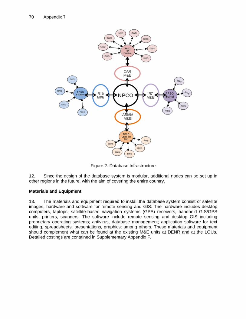
70 Appendix 7
Figure 2. Database Infrastructure 12. Since the design of the database system is modular, additional nodes can be set up in other regions in the future, with the aim of covering the entire country. Materials and Equipment 13. The materials and equipment required to install the database system consist of satellite images, hardware and software for remote sensing and GIS. The hardware includes desktop computers, laptops, satellite-based navigation systems (GPS) receivers, handheld GIS/GPS units, printers, scanners. The software include remote sensing and desktop GIS including proprietary operating systems; antivirus, database management; application software for text editing, spreadsheets, presentations, graphics; among others. These materials and equipment should complement what can be found at the existing M&E units at DENR and at the LGUs. Detailed costings are contained in Supplementary Appendix F.

Appendix 8 71
DESIGN AND MONITORING FRAMEWORK
Design Summary Performance Targets
and/or Indicators Data Sources and/or
Reporting Mechanisms Assumptions and Risks
Impact
Improved livelihoods in the URBs through effective provision of ecosystem services.
By 2025
Model livelihood improvement actions are replicated in 50 URBs at the local and landscape level across the Philippines
12 million beneficiaries with improved access to environmental services
Project post-evaluation
report Income and poverty
statistics of national and local governments
Assumptions
Economic growth of the country remains steady and moderate
Risks
Political instability or partisan rivalry in sub-Project sites
Outcome
LGUs and PO/IPO based watershed enterprises generating increased revenues from watershed management, biodiversity protection and livelihood investments
By 2017
350,000 household beneficiaries with diversified and increased income.
83 local institutions with established regulatory frameworks on watershed zoning and mapping.
Improved wet and dry season water flows from headwaters maintained in four pilot URBs compared to 2011/2012 levels
Reduced incidence of soil erosion and human-induced landslides in the Project areas compared to 2011/2012
Project baseline surveys
and Project RME reports Review Mission reports
and Project progress reports
Project completion report Approved biodiversity
corridor maps and regulation
DENR and NAMRIA updates on forest cover, CO2 emissions and biodiversity trends
DENR-RBCO and NEDA annual reports,
Income Class ranking of river basin LGUs and HH in IPO areas
Assumptions
Government’s timely approval of land use assessments/ and zoning plans
Appropriate Govt. directives enabling convergence of respective institutional mandates
Risks
Delays in approval of management plans for selected URBs.
Revenue streams from REDD and local PES mechanisms are not realized
Extreme weather events impact negatively on ecosystem services
Outputs
1. Environmentally sound river basin/watershed management and investment plans developed to place 1.13 million hectares under improved management 2. Smallholder, commercial and institutional investments increased in conservation and economic productivity enhancement in the forestry, agriculture and tourism sectors
By 2017:
Supportive policy and regulatory framework in place
River basin indicative development plans and watershed management plans adopted in four Project sites covering 1.13 million ha in total;
23 Watershed management and investment plans established and adopted by LGUs
231,580 ha protected 94,010 ha rehabilitated 5,370 ha of sustainable
forest management 24,450 ha of agro-forestry 5,950 ha of commercial
forest plantation 14,350 ha of conservation
farming 560 km of rural access
infrastructure, 85 km of foot trails, and 1 provincial trading center;
Project baseline surveys
and Project RME reports;
Review Mission reports Project progress reports Project completion report DENR and NEDA annual
reports Satellite imageries/maps
from NAMRIA and other sources
LGU Comprehensive/ Forest LUPs and Investment Plans
DENR watershed reports and management plans
River Basin Development and Management Plans
Assumptions
GOP counterpart inputs are provided on time and are adequate
Target LCO/IPO beneficiaries are able to effectively participate in training programs
Infrastructure investments improve support for intensive agriculture by communities and reduce transaction costs of access to public services
Potential negative climate change impacts are appropriately addressed and can be mitigated
Communities see sufficient incentives in diversification of agricultural techniques
Delays in government procurement can be minimized
Risks
High staff turn over GOP budgetary support
dwindles

72 Appendix 7
Design Summary Performance Targets
and/or Indicators Data Sources and/or
Reporting Mechanisms Assumptions and Risks
3,040 ha of improved Communal Irrigation Systems
275 of Potable Water Supply units;
$10,000 seed fund established in each of the four Project sites
Armed conflict (political and tribal) persists
LCOs/IPOs are not willing to cooperate / IPOs
LCOs ban access of surveyors and officials to CAD-T areas
3. River basin and watershed management capacity and related governance mechanisms strengthened
19,000 local beneficiaries trained on: (i) land use assessment and URBMP ; (ii) Technical extension (TE-IC) (IC); (iii) project management, accounting/ procurement; (iv) REDD technical capacity; (v) institutional & policy support to LGUs and DENR; and (vi) rural infrastructure maintenance;
1,735 barangays capacitated in developing land management systems to reduce CO2 emissions
23 Community Watershed Protection Brigades organized
4. Project management and support services delivered
1 National PCO and 4 Regional PCOs established by 2011;
Project M&E, including GIS-based database established with a national hub and provincial and watershed-level nodes by 2013;
Community based environmental monitoring of PES by 2017
Activities with Milestones Inputs
1. RIVER BASIN / WATERSHED MANAGEMENT & INVESTMENT PLANS
1.1 Design and establishment of geographical information system (GIS)-based database for performance monitoring including the training of DENR Central, Regional Provincial LGU staff in the 4 selected river basins (RBs) by end of June 2011
1.2 Remote sensing data acquisition and natural resources land use assessment and ground truthing for the 4 selected RBs by end of June 2011
1.3 Preparation of detailed vulnerability and adaptation assessment plans in the 4 selected RBs completed by June 2012
1.4 Land use capability assessments and participatory land use classification, zoning, and adoption in 4 selected RBs by December 2012
1.5 Development and implementation of carbon stock baseline assessments in the 4 selected RBs by December 2012
1.6 .Delineation and demarcation of forest boundaries in consultation with local communities June 2012-December 2017
1.7 Delineation/demarcation of buffer and land management zones based on URBMP prescriptions in the 4 selected RBs by subprojects from July 2012- June 2015
ADB: 100.0 million IFAD: 20.0 million GEF: 2.5 million CCF: 1.41 million Government: 15.46 million LGUs: 7.48 million Beneficiaries: 7.28 million Total: $154.13 million
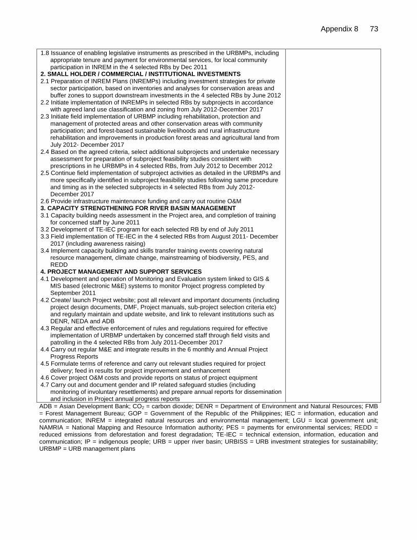
Appendix 8 73
1.8 Issuance of enabling legislative instruments as prescribed in the URBMPs, including appropriate tenure and payment for environmental services, for local community participation in INREM in the 4 selected RBs by Dec 2011
2. SMALL HOLDER / COMMERCIAL / INSTITUTIONAL INVESTMENTS
2.1 Preparation of INREM Plans (INREMPs) including investment strategies for private sector participation, based on inventories and analyses for conservation areas and buffer zones to support downstream investments in the 4 selected RBs by June 2012
2.2 Initiate implementation of INREMPs in selected RBs by subprojects in accordance with agreed land use classification and zoning from July 2012-December 2017
2.3 Initiate field implementation of URBMP including rehabilitation, protection and management of protected areas and other conservation areas with community participation; and forest-based sustainable livelihoods and rural infrastructure rehabilitation and improvements in production forest areas and agricultural land from July 2012- December 2017
2.4 Based on the agreed criteria, select additional subprojects and undertake necessary assessment for preparation of subproject feasibility studies consistent with prescriptions in he URBMPs in 4 selected RBs, from July 2012 to December 2012
2.5 Continue field implementation of subproject activities as detailed in the URBMPs and more specifically identified in subproject feasibility studies following same procedure and timing as in the selected subprojects in 4 selected RBs from July 2012-December 2017
2.6 Provide infrastructure maintenance funding and carry out routine O&M 3. CAPACITY STRENGTHENING FOR RIVER BASIN MANAGEMENT
3.1 Capacity building needs assessment in the Project area, and completion of training for concerned staff by June 2011
3.2 Development of TE-IEC program for each selected RB by end of July 2011 3.3 Field implementation of TE-IEC in the 4 selected RBs from August 2011- December
2017 (including awareness raising) 3.4 Implement capacity building and skills transfer training events covering natural
resource management, climate change, mainstreaming of biodiversity, PES, and REDD
4. PROJECT MANAGEMENT AND SUPPORT SERVICES
4.1 Development and operation of Monitoring and Evaluation system linked to GIS & MIS based (electronic M&E) systems to monitor Project progress completed by September 2011
4.2 Create/ launch Project website; post all relevant and important documents (including project design documents, DMF, Project manuals, sub-project selection criteria etc) and regularly maintain and update website, and link to relevant institutions such as DENR, NEDA and ADB
4.3 Regular and effective enforcement of rules and regulations required for effective implementation of URBMP undertaken by concerned staff through field visits and patrolling in the 4 selected RBs from July 2011-December 2017
4.4 Carry out regular M&E and integrate results in the 6 monthly and Annual Project Progress Reports
4.5 Formulate terms of reference and carry out relevant studies required for project delivery; feed in results for project improvement and enhancement
4.6 Cover project O&M costs and provide reports on status of project equipment 4.7 Carry out and document gender and IP related safeguard studies (including
monitoring of involuntary resettlements) and prepare annual reports for dissemination and inclusion in Project annual progress reports
ADB = Asian Development Bank; CO2 = carbon dioxide; DENR = Department of Environment and Natural Resources; FMB = Forest Management Bureau; GOP = Government of the Republic of the Philippines; IEC = information, education and communication; INREM = integrated natural resources and environmental management; LGU = local government unit; NAMRIA = National Mapping and Resource Information authority; PES = payments for environmental services; REDD = reduced emissions from deforestation and forest degradation; TE-IEC = technical extension, information, education and communication; IP = indigenous people; URB = upper river basin; URBISS = URB investment strategies for sustainability; URBMP = URB management plans

74 Appendix 9
SUMMARY OF RURAL INFRASTRUCTURE REHABILITATION
1. The continuing degradation of watersheds in the Upper River Basins (URBs) caused by unregulated cutting of trees and shifting cultivation among others are threats to further deterioration of these fragile resources. This is aggravated by the growing rural population where communities in the watersheds are slowly encroaching towards forested areas in their effort to earn a living through farming. Watershed degradation, with its consequent impacts on agricultural productivity, is a significant contributor to poverty, inequality and loss of livelihood and unsustainable economic ventures. 2. It is in this light that the Integrated Natural Resources and Environmental Management (INREM) Project (the Project) is being formulated with the purpose of reversing the trend of unabated destruction of the critical watersheds nationwide. The INREM under the Integrated Ecosystem Management (IEM) approach requires integration of interventions from conservation in the closed canopy forests, rehabilitation and reforestation of degraded forests and woodlands, agro-forestry in areas subject to shifting cultivation, and conservation farming in agricultural lands, supported by improvement of existing communal irrigation schemes, rural access, and rural water supply systems, all within the same sub-watershed or sub-project area. The type of rural Infrastructure interventions proposed under the Project was largely guided by the results of the needs assessment in the area and these are basically geared towards enhancing productivity of the farming communities residing within the RBs. Infrastructure support will also be in line with the Project goal of institutionalizing sustainable natural resource management in the RBs. 3. Given this premise, the general objective of rural infrastructure rehabilitation and improvement in complementary with the rest of the Project components is to improve productivity of the farming community within the RB as well as enhance the mobility of LGUs, CSOs and the community in monitoring and protecting the resources from further degradation and deterioration. Specifically, rural infrastructure will: i) provide strategic access up to the lower limits (buffer zone) of the river basin area to facilitate mobility of LGUs and CSOs for effective monitoring; ii) provide support facilities to agriculture production at the lower confines of the basin; iii) reduce transport time and cost of farm inputs; iv) reduce vulnerability of rural poor to various types of crisis situations through better access to basic support services; v) enhance ability to grow and market crops; vi) increase cropping intensity and improve yields and productivity; vii) reduce post-harvest losses and transport damage improving quality of products; viii) reduce incidence of water borne diseases; ix) generate time savings for better productive use; x) improve community hygiene and public health; xi) enhance democratic process in decentralized, local level water supply and sanitation committees; and xii) generate employment opportunities during construction. 4. In consideration of the fragility of the RB areas, only rehabilitation works on rural access will be supported by the Project to ensure that no further encroachment and exploitation of the resources especially in the upper slopes will happen brought about by opening access through new construction of roads. Irrigation development would also be confined to rehabilitation and improvement since majority of the existing communal schemes in the Project sites are either in-operational or needs funding support to restore the original service areas. In the case of potable water supply sub-component, improvement and development of available natural springs (which abound in the RBs) will be supported with provisions for pipelines to convey the water to communal faucets in strategic locations (Level II) to serve clusters of houses. 5. In summary, the following rural infrastructure interventions are recommended to cover the following major classifications:
i. Rural Access to include rehabilitation or improvement of existing and critical access road limited to the confines of the lower slopes of the RBs to facilitate mobility of LGUs, CSOs

Appendix 9 75
and communities in monitoring and protecting the resources; rehabilitation or improvement of critical barangay or farm to market roads to link production areas along the lower slopes to the nearest all weather road and reduce transport cost; improvement of foot/animal trails with connecting foot bridges where standard FMR is not appropriate; and provision of tramlines or small scale cable cars as conveyance mode for agricultural products in areas with substantial difference in elevation and where foot/animal trails are inappropriate due to very steep slopes
ii. Small Scale Communal Irrigation Schemes and Post Harvest Facilities to include rehabilitation and improvement of existing small scale communal irrigation schemes to restore previously irrigated areas; provision of small scale grain Post Harvest Facilities in the form of warehouses and solar driers; provision of small scale air drying sheds for high value crops (vegetables); and establishment of provincial trading centers in strategic locations
iii. Potable Water Supply to include improvement and development of natural spring for Level II potable water supply; and provision of Level I (point source) where appropriate in lieu of Level II
6. The general conditions in which proposed rural infrastructure sub-components will qualify for the Project assistance will be: i) the MLGU, Barangay Officials and community should be actively involved in the selection process, concur with the planned proposals, willing to put up the required equity contribution and maintain the completed facilities; ii) sub-component sites must be free from social and environmental problems and issues, or else feasible mitigating measures will have to be provided; and iii) proposed sub-components must not be currently covered under any local or foreign funding sources. 7. The importance of LGUs and the community in getting involved and providing counterparts in rural infrastructure implementation could not be overemphasized. Developing a strong sense of ownership in the LGUs and the community and providing capacity building interventions in the operation and maintenance of completed rural infrastructure facilities are the keys to sustainability and these can only be achieved if the LGUs and community themselves are fully involved and do their share in all aspects of sub-component implementation. Besides, interventions under the component are devolved functions of the Municipal LGUs under the Local Government Code of 1991. 8. In this regard, rural infrastructure under the Project will be carried out on a grant-equity mix following the current national government cost sharing policy where the Project interventions would mostly fall under Cluster 2 where the maximum grant available to 5th and 6th class municipalities is only 50% of the total sub-component cost with the remaining 50% to be shouldered by the LGUs as counterpart either taken out of their IRA or by availing a loan package from other funding sources. The 3rd and 4th class LGUs will shoulder 60% of the sub-component cost and 70% for the 1st and 2nd class. Cities categorized as 1st to 4th class will have zero grant from the national government. 9. To ease the financial burden of the LGUs, the eligible equity counterpart may be in cash or in kind and is recommended to include the i) cost of Pre and Detailed Engineering preparation; ii) cost of Engineering Construction Supervision; iii) partial cost and provision of indigenous Construction Materials; iv) partial cost of Labor; v) use of Construction Equipment; vi) provision of O and M Hand Tools; and vii) conduct of independent materials testing and quality control procedures. 10. To further enhance and build up a sense of ownership, the LGU counterpart will be shared by the community who will directly benefit from the completed facilities. This counterpart would mostly be in kind the affordable level of which is estimated to be about 5% of the sub-component cost. Community equity would mostly be in the form of donated labor time through “bayanihan” work and provision of indigenous construction materials. In addition and as a proven effective strategy in local

76 Appendix 9
organizational development and acceptable to the communities, it is recommended that local workers who are members of community organizations and are employed during construction will contribute part of their wage earned for capital build up formation, the amount of which will be agreed among themselves. Cash equity contributions by LGUs may be sourced from the provincial, municipal or barangay IRA or congressional funds and other legal sources. 11. The municipal LGUs with technical assistance from the provincial government and relevant line agencies will be the implementing arm of the Project for the rural infrastructure interventions in support to devolution under the Local Government Code (LGC) of 1991. However, MLGU assessment in terms of technical capability to conduct detailed engineering activities and in implementing rural infrastructure revealed several common deficiencies across municipalities like i) majority of the MLGUs do not own surveying instruments and have no items on geodetic engineer or surveyor to handle detailed survey works; ii) most MLGUs are undermanned and do not have the minimum number of technical personnel required to undertake the preparation of detailed engineering plans and supervise actual construction works; iii) majority of the MLGUs have no available construction equipment to implement horizontal infrastructure sub-components like roads, bridges, irrigation, etc.; and iv) most of the existing MLGU technical staff needs orientation and training in all aspects of rural infrastructure implementation. 12. These deficiencies could be addressed through the technical assistance to be provided by the Provincial Engineering Office (PEO) for rural access and potable water supply sub-components and NIA for small scale irrigation schemes. The lack of technical staff from the MLGUs could also be addressed through the engagement of short term civil engineers during implementation charged to sub-component overhead cost. In addition, trainings in all aspects of rural infrastructure development will be provided to the LGUs by the Project under the capacity building component. 13. The full involvement of the community is crucial to the success of any development initiatives and the sustainability of the initial gains that can be derived from the Project hence, participatory approach at all stages of implementation shall always be the Project guiding policy. In this regard, selected community leaders and members and some barangay officials need to be oriented and trained on some basic implementation and monitoring procedures of infrastructure development. This would include the development of their capacities in the operation and maintenance of the completed facilities to ensure that these are kept operational even after Project life. Delivery Mechanism for the Rural Infrastructure 14. The community will have the sole responsibility of identifying and prioritizing rural infrastructure sub-components during the conduct of participatory planning and consultations. Technical assistance and guidance will be provided by the MLGU and the Provincial Project Support Office (PPSO) to be established under the Provincial Governor. Identified and prioritized sub-components shall be subject to field validation by the PPSO with support from the Project technical consultants prior to the preparation of the individual Feasibility Study (FS) and Detailed Engineering (DE) Documents. The Municipal Planning and Development Office (MPDO) will ensure that all sub-components identified and prioritized by the community will be endorsed by the Barangay Development Council (BDC) to the Municipal Development Council (MDC) for integration to the Municipal Development Plan (MDP) and concurred by the Sangguniang Bayan (SB). 15. The conduct of sub-component feasibility analysis, detailed survey, and preparation of detailed engineering plans, specifications and Programs of Work (POW) will be the main responsibility of the MPDO and Municipal Engineer’s Office (MEO). Completed FS and DE documents will be reviewed by the PPSO with support from the technical consultants and endorsed to the Provincial INREM Council

Appendix 9 77
(PINREM-C) to be established by the Project for final appraisal and approval. All clearances and certifications from government regulatory agencies will be worked out by the MLGU. 16. Procurement of “Civil Works” and “Goods” will be the main responsibility of the municipal LGU through its duly constituted Bids and Awards Committee (BAC) in accordance with the provisions of R.A. 9184 consistent with the ADB Procurement Guidelines. MLGUs signifying intention to implement by “Force Account” will be evaluated by the PPSO for technical and equipment capability and will secure authorization from the National Project Coordination Office (NPCO) to be established at the central level. Fund release for rural infrastructure implementation will be in accordance to the Municipal Development Fund Office (MDFO) guidelines, procedures and processes. 17. In support to the national government’s employment generation program and in consideration that majority of the sub-components are small scale, Labor Based–Equipment Supported (LB/ES) methods of construction shall be adopted whenever possible. This should also allow communities to be engaged as “Pakyaw” labor contractors to ensure full involvement as well as help in the process of people empowerment and in building up a sense of ownership and responsibility. 18. Regardless of whether implementation is carried out by contract or by LGU “Force Account” and pursuant to R.A. 5635 dated December 12, 1988, at least fifty (50) percent of the unskilled and thirty (30) percent of the skilled labor requirement shall be taken from the beneficiary community. Hence, beneficiaries within the community shall be the first priority in the selection of labor force. The women shall be given equal opportunity to join the labor force. 19. The MLGU through the designated technical staff and Project Engineer will be the main responsible unit for the execution and daily supervision of sub-components implementation regardless of whether implemented by contract or force account. The PPSO will provide overall supervision across participating municipalities within its respective jurisdiction with the full involvement of the communities. 20. Monitoring and evaluation of sub-components implementation will be the main responsibility of the existing M and E unit at all levels. ADB at anytime will send supervision mission to selected sites to monitor and evaluate the progress and status of the implementation and management of the Project. The findings of the mission will be embodied in an aide memoire and will be submitted to the NPSC copies of which will be furnished all concerned stakeholders and Project implementers. NPCO will be responsible for the overall coordination and will actively participate in the conduct of all ADB supervision missions. DENR Regional Office and PPSO will likewise participate in the said missions. 21. All completed rural infrastructure facilities will be turned over to the MLGU represented by the Municipal Mayor for immediate operation and maintenance. However, there will be instances where completed facilities like communal irrigation schemes and post harvest facilities will be placed under a MOA with the farmers’ or people’s organizations (FA or PO) for appropriate operation and maintenance to ensure that responsibility is clearly delineated for sustainability. 22. The implementation schedule for the rural infrastructure component would rely heavily on the absorptive capacity of the participating LGUs to provide their local counterpart. In consideration of the MLGUs' fiscal difficulty, the rural infrastructure sub-components will be implemented for a period of seven (7) years to allow the MLGUs to spread their required equity contribution over a longer period. This will make it affordable for them to generate such counterpart in an annual basis as well as provide ample time for the preparation of detailed engineering documents which will be carried out starting in year 1 onwards with a few rural infrastructure sub-components to commence implementation by Year 2.

DETAILED COST ESTIMATES
Table A8.1: Detailed Cost Estimates: Cost Estimates by Expenditure Category
(P '000) ($ '000)
Expenditure Accounts Project Cost Summary
% %
Total
Foreign Base
Local Foreign Total Local Foreign Total Exchange Costs
I. Investment Costs
A. Civil Works
ADB-funded Civil Works 1,040,969 379,035 1,420,004 21,909 7,978 29,887 27 22
IFAD-funded Civil Works (Bukidnon only) 157,308 67,418 224,726 3,311 1,419 4,730 30 3
LGU_Counterpart Civil Works 115,738 49,602 165,340 2,436 1,044 3,480 30 3
Subtotal Civil Works 1,314,016 496,055 1,810,071 27,656 10,440 38,096 27 28
B. Equipment
Vehicles 13,121 19,681 32,802 276 414 690 60 1
Vehicles (IFAD) 4,211 6,316 10,526 89 133 222 60 -
GIS Network-Computer Package 13,449 20,174 33,623 283 425 708 60 1
IFAD_GIS Network-Computer Package 3,622 5,433 9,055 76 114 191 60 -
GEF-Funded Computer Packages 864 1,296 2,160 18 28 46 60 -
Subtotal Equipment 35,266 52,899 88,166 742 1,114 1,856 60 1
C. Satellite Images & Data Acquisition 21,676 32,514 54,190 456 684 1,141 60 1
D. Conservation Forestry
Protection & Monitoring 198,088 - 198,088 4,169 - 4,169 - 3
IFAD_Protection & Monitoring 101,223 - 101,223 2,130 - 2,130 - 2
CCF-Funded Protection & Montoring 12,377 - 12,377 263 - 263 - -
Establishment & Maintenance Costs 1,558,602 - 1,558,602 32,804 - 32,804 - 24
IFAD_Establishment & Maintenance Costs 146,736 - 146,736 3,088 - 3,088 - 2
GEF-Funded Conservation Forestry 16,991 - 16,991 362 - 362 - -
Subtotal Conservation Forestry 2,034,016 - 2,034,016 42,817 - 42,817 - 32
E. Commercial Forestry
CCF-Funded Sustainable Management 25,809 793 26,603 549 17 566 3 -
Establishment & Maintenance Costs 601,746 18,611 620,357 12,665 392 13,057 3 10
Beneficiary Contribution to Costs 257,891 7,976 265,867 5,428 168 5,596 3 4
Subtotal Commercial Forestry 885,447 27,380 912,827 18,642 576 19,218 3 14
F. Livelihood Inputs
Livelihood Inputs (except Bukidnon) 115,800 6,095 121,895 2,437 128 2,566 5 2
Livelihood Inputs (Bukidnon only) 248,766 13,093 261,859 5,236 276 5,511 5 4
GEF-Funded Livelihood Inputs 7,144 376 7,520 152 8 160 5 -
Subtotal Livelihood Inputs 371,710 19,564 391,274 7,825 412 8,237 5 6
G. Consultants
78
Ap
pe
nd
ix 1
0

Consultants - ADB 188,719 - 188,719 3,972 - 3,972 - 3
Consultants - IFAD 49,279 - 49,279 1,037 - 1,037 - 1
GEF-Funded Consultants 30,186 16,777 46,962 642 357 999 36 1
CCF-Funded Consultants 5,526 7,430 12,956 118 158 276 57 -
Subtotal Consultants 273,709 24,207 297,916 5,769 515 6,284 8 5
H. Locally Contracted Services
Locally Contracted Services 46,742 2,460 49,202 984 52 1,036 5 1
GEF_Locally Contracted Services 12,544 - 12,544 267 - 267 - -
Subtotal Locally Contracted Services 59,286 2,460 61,746 1,251 52 1,302 4 1
I. Capacity Building, Studies and Survey
Capacity Building, Studies and Survey 130,930 6,891 137,821 2,756 145 2,901 5 2
Capacity Building, Studies and Survey_IFAD 28,484 1,499 29,983 599 32 631 5 -
GEF-Funded Capacity Building, Studies & Surveys 16,048 845 16,893 341 18 359 5 -
CCF-Funded Capacity Building, Studies & Surveys 12,724 1,459 14,183 271 31 302 10 -
Subtotal Capacity Building, Studies and Survey 188,186 10,694 198,880 3,967 226 4,193 5 3
J. Incremental Operating Costs
1. Incremental Operating Costs 202,552 10,661 213,213 4,263 224 4,487 5 3
2. IFAD_Incremental Operating Costs 57,108 3,006 60,114 1,202 63 1,265 5 1
3. GEF_Incremental Operating Costs 19,713 1,038 20,751 419 22 442 5 -
Subtotal Incremental Operating Costs 279,374 14,704 294,078 5,884 310 6,194 5 5
Total Investment Costs 5,462,687 680,477 6,143,164 115,009 14,329 129,338 11 96
II. Recurrent Costs
A. Recurrent Government Expenditure 117,357 - 117,357 2,470 - 2,470 - 2
B. O&M Community Infrastructure 56,054 - 56,054 1,180 - 1,180 - 1
C. O&M LGU Infrastructure 108,605 - 108,605 2,286 - 2,286 - 2
Total Recurrent Costs 282,016 - 282,016 5,936 - 5,936 - 4
Total BASELINE COSTS 5,744,704 680,477 6,425,181 120,945 14,329 135,274 11 100
Physical Contingencies 258,639 32,895 291,534 5,444 692 6,136 11 5
Price Contingencies 1,228,997 129,635 1,358,633 3,739 413 4,152 10 3
Total PROJECT COSTS 7,232,340 843,007 8,075,348 130,128 15,435 145,563 11 108
Interest During Implementation 435,987 - 435,987 8,035 - 8,035 - 6
Commitment Charges 30,391 - 30,391 535 - 535 - -
Total Costs to be Financed 7,698,718 843,007 8,541,725 138,698 15,435 154,132 10 114
79
A
ppe
nd
ix 1
0

80 Appendix 10
Table A8.2: Detailed Cost Estimates: Cost Estimates by Financier ($’000)
Local
($ '000) GVNT ADB IFAD GEF CCF LGUs BENEs Total (Excl. Duties &
Amount % Amount % Amount % Amount % Amount % Amount % Amount % Amount % Taxes) Taxes
I. Investment Costs
A. Civil Works
ADB-funded Civil Works 2,877 8.9 29,300 91.1 - - - - - - - - - - 32,176 20.9 20,670 2,877
IFAD-funded Civil Works (Bukidnon only) 511 10.0 - - 4,598 90.0 - - - - - - - - 5,109 3.3 3,065 511
LGU_Counterpart Civil Works 0 - - - - - - - - - 3,763 100.0 - - 3,763 2.4 2,258 376
Subtotal Civil Works 3,387 8.3 29,300 71.4 4,598 11.2 - - - - 3,763 9.2 - - 41,048 26.6 25,993 3,764
B. Equipment
Vehicles 222 30.0 519 70.0 - - - - - - - - - - 741 0.5 74 222
Vehicles (IFAD) 71 30.0 - - 167 70.0 - - - - - - - - 238 0.2 24 71
GIS Network-Computer Package 91 12.0 667 88.0 - - - - - - - - - - 758 0.5 212 91
IFAD_GIS Network-Computer Package 25 12.0 - - 180 88.0 - - - - - - - - 204 0.1 57 25
GEF-Funded Computer Packages 6 12.0 - - - - 40 88.0 - - - - - - 46 - 13 6
Subtotal Equipment 415 20.9 1,186 59.7 346 17.4 40 2.0 - - - - - - 1,987 1.3 380 415
C. Satellite Images & Data Acquisition 147 12.0 1,076 88.0 - - - - - - - - - - 1,222 0.8 342 147
D. Conservation Forestry
Protection & Monitoring - - 4,534 100.0 - - - - - - - - - - 4,534 2.9 4,534 -
IFAD_Protection & Monitoring - - - - 2,317 100.0 - - - - - - - - 2,317 1.5 2,317 -
CCF-Funded Protection & Montoring - - - - - - - - 263 100.0 - - - - 263 0.2 263 -
Establishment & Maintenance Costs - - 35,463 100.0 - - - - - - - - - - 35,463 23.0 35,463 -
IFAD_Establishment & Maintenance Costs - - - - 3,343 100.0 - - - - - - - - 3,343 2.2 3,343 -
GEF-Funded Conservation Forestry - - - - - - 364 100.0 - - - - - - 364 0.2 364 -
Subtotal Conservation Forestry - - 39,998 86.4 5,660 12.2 364 0.8 263 0.6 - - - - 46,285 30.0 46,285 -
E. Commercial Forestry
CCF-Funded Sustainable Management - - - - - - - - 577 100.0 - - - - 577 0.4 561 -
Establishment & Maintenance Costs 0 - 14,120 100.0 - - - - - - - - - - 14,120 9.2 13,696 -
Beneficiary Contribution to Costs 0 - - - - - - - - - - - 6,051 100.0 6,051 3.9 5,870 -
Subtotal Commercial Forestry 0 - 14,120 68.1 - - - - 577 2.8 - - 6,051 29.2 20,749 13.5 20,127 -
F. Livelihood Inputs
Livelihood Inputs (except Bukidnon) 0 - 2,778 100.0 - - - - - - - - - - 2,778 1.8 2,639 -
Livelihood Inputs (Bukidnon only) 0 - - - 5,969 100.0 - - - - - - - - 5,969 3.9 5,670 -
GEF-Funded Livelihood Inputs - - - - - - 160 100.0 - - - - - - 160 0.1 152 -
Subtotal Livelihood Inputs 0 - 2,778 31.2 5,969 67.0 160 1.8 - - - - - - 8,907 5.8 8,462 -
G. Consultants
Consultants - ADB 393 9.2 3,319 77.3 581 13.5 - - - - - - - - 4,294 2.8 3,901 393
Consultants - IFAD 135 12.0 - - 988 88.0 - - - - - - - - 1,123 0.7 988 135
GEF-Funded Consultants 62 6.2 - - - - 937 93.8 - - - - - - 999 0.6 580 62
CCF-Funded Consultants 9 3.2 - - - - - - 280 96.8 - - - - 289 0.2 114 9
Subtotal Consultants 599 8.9 3,319 49.5 1,569 23.4 937 14.0 280 4.2 - - - - 6,705 4.4 5,583 599
H. Locally Contracted Services
Locally Contracted Services 135 12.0 990 88.0 - - - - - - - - - - 1,125 0.7 934 135
GEF_Locally Contracted Services 33 12.0 - - - - 242 88.0 - - - - - - 275 0.2 242 33
Subtotal Locally Contracted Services 168 12.0 990 70.7 - - 242 17.3 - - - - - - 1,400 0.9 1,176 168
I. Capacity Building, Studies and Survey
Capacity Building, Studies and Survey 143 4.6 2,990 95.4 - - - - - - - - - - 3,133 2.0 2,833 143
Capacity Building, Studies and Survey_IFAD 32 4.7 - - 648 95.3 - - - - - - - - 679 0.4 614 32
GEF-Funded Capacity Building, Studies & Surveys 18 5.1 - - - - 341 94.9 - - - - - - 359 0.2 323 18
CCF-Funded Capacity Building, Studies & Surveys 13 4.2 - - - - - - 289 95.8 - - - - 302 0.2 258 13
Subtotal Capacity Building, Studies and Survey 206 4.6 2,990 66.8 648 14.5 341 7.6 289 6.5 - - - - 4,474 2.9 4,028 206
J. Incremental Operating Costs
1. Incremental Operating Costs 579 12.0 4,244 88.0 - - - - - - - - - - 4,823 3.1 4,003 579
2. IFAD_Incremental Operating Costs 155 11.4 - - 1,210 88.6 - - - - - - - - 1,365 0.9 1,142 155
3. GEF_Incremental Operating Costs 27 6.1 - - - - 415 93.9 - - - - - - 442 0.3 393 27
Subtotal ncremental Operating Costs 761 11.5 4,244 64.0 1,210 18.3 415 6.3 - - - - - - 6,629 4.3 5,537 761
Total Investment Costs 5,683 4.1 100,000 71.7 20,000 14.3 2,500 1.8 1,410 1.0 3,763 2.7 6,051 4.3 139,407 90.4 117,913 6,059
II. Recurrent Costs
A. Recurrent Government Expenditure 1,213 47.4 - - - - - - - - 1,344 52.6 - - 2,556 1.7 2,556 -
B. O&M Community Infrastructure - - - - - - - - - - - - 1,225 100.0 1,225 0.8 1,225 -
C. O&M LGU Infrastructure - - - - - - - - - - 2,374 100.0 - - 2,374 1.5 2,374 -
Total Recurrent Costs 1,213 19.7 - - - - - - - - 3,718 60.4 1,225 19.9 6,156 4.0 6,156 -
Total PROJECT COSTS 6,896 4.7 100,000 68.7 20,000 13.7 2,500 1.7 1,410 1.0 7,481 5.1 7,277 5.0 145,563 94.4 124,069 6,059
Interest During Implementation 8,035 100.0 - - - - - - - - - - - - 8,035 5.2 - -
Commitment Charges 535 100.0 - - - - - - - - - - - - 535 0.3 - -
Total Disbursement 15,465 10.0 100,000 64.9 20,000 13.0 2,500 1.6 1,410 0.9 7,481 4.9 7,277 4.7 154,132 100.0 124,069 6,059

Appendix 11 81
PROJECT ORGANIZATIONAL STRUCTURE
NPCO Executive Coordination Group
(Bureau Directors and Heads of relevant DENR offices)
National Project Steering Committee (NPSC) (Chair: DENR Undersecretary)
National Project Coordination Office (NPCO) National Project Coordinator - NPC
Deputy NPC, and seconded staff from DENR units
Consultants
Provincial INREM Councils (PINREM-C)
(Relevant NGAs at Provincial Level)
Relevant NAs at Regional Level including NEDA as RDC Secretariat
CENROs, NCIP Service Centers, concerned Municipal Tribal
Chieftain, MAROs
DENR CO
Line Function
Communities and Organizations (IPs, POs, NGOs, Private Sectors)
Implementing Project sub-components and activities
DENR Regional Offices (RO) (RED)
Regional Project Coordination
Group
Provincial Project Coordination Offices (PPCO)
(clustered by River Basin) with seconded staff from
DENR and provincial offices
of relevant NGAs
Watershed Project Coordination Offices at Host Munici[pality (M/LGUs clustered by
Watersheds)
Staff Function
Technical Assistance, Advisory and Coordinative Functions
Lead Implementing Function
M and E Unit
M and E Unit
M and E Unit
M and E Unit (Host municipal
LGU)
Support Units: Admin and Finance, BAC, etc.
Support Units: Admin and Finance, BAC, etc.
Support Units: Admin and Finance, BAC, etc.
Support Unit: Admin and Finance, BAC, etc.
of Host Municipal LGU
NPSC Technical Working Group (TWG) [Relevant National Government Agencies]

PROPOSED IMPLEMENTATION SCHEDULE
Sequence of Activities Responsible Agency
Yr 0
Year 1
Year 2
Year 3
Year 4
Year 5
Year 6
Year 7 Yr 8
PREPARATORY DENR (NPCO)
Mobilization of staff and consultants, setting up Project organization at national, regional, provincial and municipal levels
NPCO/Consultants
Procurement of satellite data, office equipment, facilities, and consulting services
DENR (NPCO)/ FASPO
Planning for INREMP Project Implementation: formulate and adopt, through administrative issuances, standards and guidelines to ensure consistent and effective implementation of INREMP processes and procedures [1].
NPSC/TWG/NPCO, FASPO, NAMRIA & RO focal persons
PROJECT-WIDE ACTIVITIES
Baseline survey/assessment for the Project NPCO/Consultants
Capacity building needs assessment in the PA, and initiation and completion of concerned staff enhanced through capacity building programs
NPCO/Consultants
Development of geographical information system-based database including the training of staff and operations manual for the DENR Central and Regional staff and Provincial local government unit staff
NPCO/Consultants/
Development of TE-IEC program for each selected RB NPCO/Consultants
Remote sensing data acquisition and analysis for natural resources for land use assessment and ground truthing for field verification.
NPCO/NAMRIA/ Consultants
Land capability and participatory land use classification, zoning, approval, and adoption
NPCO/Consultants; NAMRIA; DENR Regional Offices; Provincial LGUs
Development and implementation of carbon stock baseline assessments NPCO, FMB, Consultants
Design and commissioning of research and studies on various aspects of INREM including climate change related aspects
NPCO, ERDB, PAWB, Consultants
Development and completion of detailed vulnerability and adaptation assessment plans
NPCO, LGUs, Consultants
Development and adoption of Guides and Manuals on climate change mitigation and adaptation
NPCO, LGUs, Consultants
Development and operation of Monitoring and Evaluation system linked to GIS database to monitor Project progress
NPCO, NAMRIA, LGUs, Consultants
Preparation of URBMPs including private sector participation, based on inventories and analyses for conservation areas and buffer zones to support downstream investments, taking into account results of analyses and studies
NPCO, FMB, PAWB, DENR Field Offices, LGUs, Consultants
SUBPROJECT-SPECIFIC ACTIVITIES
1. Setting up of LGU level organizations for effective implementation NPCO, DENR Field Offices, LGUs
2. Issuance of enabling legislative instruments as prescribed in the URBMPs, including appropriate tenure and payment for environmental services, for local community participation in INREM
DENR Policy TWG, LGUs
3. Initiate implementation of URBMPs in selected RBs by subprojects in accordance with agreed land use classification and zoning
DENR Field Offices, LGUs, Consultants
4. Delineation and demarcation of forest boundaries, buffer zones, and land management zones based on URBMP prescriptions and zoning in the 4 selected RBs by subprojects watershed
DENR Field Offices, LGUs, Communities
5. Selection of subprojects for field investments in accordance with selection criteria
Provincial PCOs, DENR Field Offices
Ap
pe
nd
ix 1
2
82
Ap
pe
nd
ix 1
2
82

6. Initiate field implementation of URBMP including rehabilitation, protection and management of protected areas and other conservation areas with community participation; and forest-based sustainable livelihoods and rural infrastructure rehabilitation and improvements in production forest areas and agricultural land
LGUs (Provincial and Municipal), Communities, POs, IPOs, with DENR guidance
7. Regular and effective enforcement of rules and regulations required for effective implementation of URBMP undertaken by participant-communities and project staff through field visits, ,monitoring and patrolling in the 4 selected RBs
Provincial and municipal LGUs, communities, POs, IPOs, with support of DENR field offices
8. Implementation of TE-IEC in the 4 selected RBs LGUs, with consultant support
ADDITIONAL SUBPROJECTS
Based on the agreed criteria, select additional subprojects and undertake necessary assessment for preparation of subproject feasibility studies consistent with prescriptions in the URBMPs in 4 selected RBs
Provincial PCOs, Watershed Management Groups, Communities
Continue field implementation of subproject activities as detailed in the URBMPs and more specifically identified in subproject feasibility studies following same procedure and timing as in the selected subprojects in 4 selected RBs
Provincial PCOs, Watershed Management Groups, Communities
PROJECT COMPLETION
Upon termination/completion of Project, turn-over of Project assets to LGUs or DENR as appropriate or as agreed upon.
NPCO/Participating LGUs
Preparation and submission of Project Completion Report NPCO
Final Accounting and Auditing of funds/disbursements NPCO/All Implementing Units/ COA
Evaluation of Project results and impacts ADB/IFAD/DENR
INREM = integrated natural resources and environmental management; NPCO: National Project Coordination Office; PPCO: Provincial Project Coordination Office; TE-IEC = technical extension, information, education
and communication; URBMP = upper river basin management plan.
A
ppe
nd
ix 1
2
83
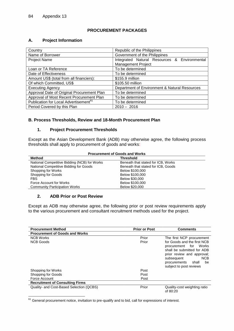
84 Appendix 13
PROCUREMENT PACKAGES
A. Project Information Country Republic of the Philippines
Name of Borrower Government of the Philippines
Project Name Integrated Natural Resources & Environmental Management Project
Loan or TA Reference To be determined
Date of Effectiveness To be determined
Amount US$ (total from all financiers): $155.9 million
Of which Committed, US$ $105.50 million
Executing Agency Department of Environment & Natural Resources
Approval Date of Original Procurement Plan To be determined
Approval of Most Recent Procurement Plan To be determined
Publication for Local Advertisement61
To be determined
Period Covered by this Plan 2010 – 2016
B. Process Thresholds, Review and 18-Month Procurement Plan
1. Project Procurement Thresholds
Except as the Asian Development Bank (ADB) may otherwise agree, the following process thresholds shall apply to procurement of goods and works:
Procurement of Goods and Works
Method Threshold
National Competitive Bidding (NCB) for Works Beneath that stated for ICB, Works National Competitive Bidding for Goods Beneath that stated for ICB, Goods Shopping for Works Below $100,000 Shopping for Goods Below $100,000 FBS Below $30,000 Force Account for Works Below $100,000 Community Participation Works Below $20,000
2. ADB Prior or Post Review
Except as ADB may otherwise agree, the following prior or post review requirements apply to the various procurement and consultant recruitment methods used for the project.
Procurement Method Prior or Post Comments
Procurement of Goods and Works
NCB Works Prior The first NCP procurement for Goods and the first NCB procurement for Works shall be submitted for ADB prior review and approval; subsequent NCB procurements shall be subject to post reviews
NCB Goods Prior
Shopping for Works Post Shopping for Goods Post Force Account Post
Recruitment of Consulting Firms
Quality- and Cost-Based Selection (QCBS) Prior Quality-cost weighting ratio of 80:20
61
General procurement notice, invitation to pre-qualify and to bid, call for expressions of interest.

Appendix 14 85
Procurement Method Prior or Post Comments
Quality-Based Selection (QBS) Prior Fixed Budget (FBS) Prior
Recruitment of Individual Consultants
Individual Consultants Prior Applied in accordance with the Guidelines on the Use of Consultants (2007, as amended from time to time)
3. Goods and Works Contracts Estimated to Cost More Than $1 Million
The following table lists goods and works contracts for which procurement activity is either ongoing or expected to commence within the next 18 months.
General Description
Contract Value ('$000)
Procurement
Method Prequalification of Bidders (y/n)
Advertisement Date (quarter/year) Comments
Satellite Images & Data Acquisition (4 packages)
1,222.3 NCB Y QIII/2010 Advance contracting
Civil Works (25 packages)
25,052.9 NCB Y QII/2011
NCB - national competitive bidding
4. Consulting Services Contracts Estimated to Cost More Than $100,000
The following table lists consulting services contracts for which procurement activity is either ongoing or expected to commence within the next 18 months.
General Description
Contract Value ('$000)
Recruitment Method
Advertisement Date
(quarter/year)
International or National
Assignment Comments
Consulting services for Watershed Management, Biodiversity and Investment Plans
818.5 QCBS (80:20) - STP
QI/2011 International and National
Advance contracting; to
be done by NPCO
Consulting services for Project Management and Implementation
4,148.5
QCBS (80:20)
- FTP
15% - QIII/2010; 85% - QI/2011
International and National
Advance
contracting; to be done by
NPCO
Carbon Baseline Survey
546.2
QCBS (80:20) - STP
QI/2011 International and National
Advance contracting; to
be done by NPCO
QCBS - quality and cost based selection; FTP - full technical proposal; STP - simplified technical proposal
5. Goods and Works Contracts Estimated to Cost Less than $1 Million and Consulting Services Contracts Less than $100,000
The following table groups smaller-value goods, works and consulting services contracts for which procurement activity is either ongoing or expected to commence within the next 18 months.

86 Appendix 13
General Description
Value of Contracts
('$000, cumulative)
Number of Contracts
Procurement / Recruitment
Method1 Comments
GIS Data Base Installation
865.6 1 NCB
4-wheel double cab pickup, for regional offices
110.2 5 Shopping
Motorcycles for Municipal Offices
632.2 4 Shopping
Computers/printers for provinces
82.6 4 Shopping
Computers/printers for Municipal Government Units
82.6 4 shopping
Equipment for Project Performance, Monitoring & Evaluation (computer, software and peripherals)
38.3 1 shopping
Consulting service for Project Performance, Monitoring & Evaluation
24. 1 FBS (national)
FBS - fixed budget selection; NCB - national competitive bidding
C. Indicative List of Packages Required Under the Project
The following table provides an indicative list of all procurement (goods, works and consulting services) over the life of the project. Contracts financed by the Borrower and others should also be indicated, with an appropriate notation in the comments section.
Indicative List of Packages Required Under the Project
General Description
Estimated Value ($'000,
cumulative)
Estimated No. of
Contracts
Procurement methods
Component 1: River Basin and Watershed Management Planning
1.1 Satellite Images & Data
Acquisition (4 packages) 1,222.3 4 NCB
1.2 Carbon Baseline Survey 546.2 1 QCBS (80:20)
– STP
1.3 GIS Data Base Installation
- URB GDSS Central Operations
Center 865.6 1 NCB - URB GDSS Nodes
1.4 Consulting services for
Watershed Management, Biodiversity and Investment Plans
818.5 1 QCBS (80:20) – STP
Component 2: Smallholder/Commercial/Institutional Investments
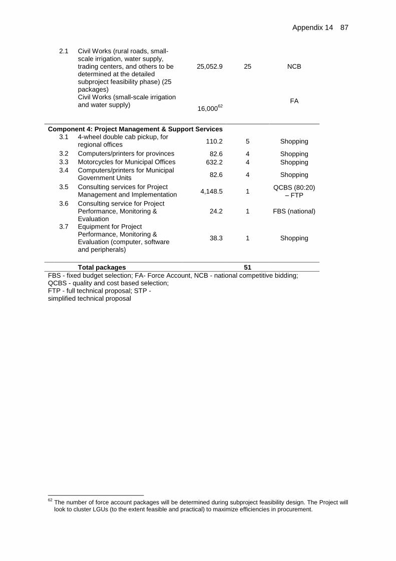
Appendix 14 87
2.1 Civil Works (rural roads, small-scale irrigation, water supply, trading centers, and others to be determined at the detailed subproject feasibility phase) (25 packages)
25,052.9
25
NCB
Civil Works (small-scale irrigation and water supply)
16,00062
FA
Component 4: Project Management & Support Services
3.1 4-wheel double cab pickup, for regional offices
110.2 5 Shopping
3.2 Computers/printers for provinces 82.6 4 Shopping
3.3 Motorcycles for Municipal Offices 632.2 4 Shopping
3.4 Computers/printers for Municipal Government Units
82.6 4 Shopping
3.5 Consulting services for Project Management and Implementation
4,148.5 1 QCBS (80:20)
– FTP
3.6 Consulting service for Project Performance, Monitoring & Evaluation
24.2 1 FBS (national)
3.7 Equipment for Project Performance, Monitoring & Evaluation (computer, software and peripherals)
38.3 1 Shopping
Total packages 51
FBS - fixed budget selection; FA- Force Account, NCB - national competitive bidding; QCBS - quality and cost based selection; FTP - full technical proposal; STP - simplified technical proposal
62
The number of force account packages will be determined during subproject feasibility design. The Project will look to cluster LGUs (to the extent feasible and practical) to maximize efficiencies in procurement.

88 Appendix 15
SUMMARY OF CONSULTING SERVICES
SUMMARY OF CONSULTING SERVICES
Unit 2011 2012 2013 2014 2015 2016 2017 Total
Component 1. River Basin and Watershed Management Plans
Internatioinal Consultants Biodiversity Specialist - Int'l Consultant /q p-mon 3 - - - - - - 3
Climate Change and REDD, Intl p-mon 2 2 - 2 2 - - 8
Carbon Stock Assessment Specialist /u p-mon 5 4 3 - - - - 12
Watershed Management Specialist- Int'l /s p-mon 3 2.5 - - - - - 5.5
National Consultants Biodiversity Specialist - National /r p-mon 6 4 4 2 - - - 16
Climate change and REDD, Natl p-mon 4 4 - 4 - 4 - 16
Environmental Safeguards and Cumulative Environmental Assessment p-mon 4 4 4 4 4 4 4 28
Geographical Information Systems & Mapping /d p-mon 2 2 2 2 - - - 8
Information, Education and Communication and Public Participation p-mon 4 4 4 4 4 - - 20
Land Use and Land Capability Assessment, Planning and Management p-mon 4 4 4 - - - - 12
Legal and Institutional Specialist /x p-mon 3 3 3 3 3 - - 15
Market Specialist /w p-mon 12 9 6 3 - - - 30
Planning and Regulatory Specialist /v p-mon 4 4 4 - - - - 12
Policy, Institutions and Legislation p-mon 8 8 8 6 4 4 2 40
Resource Economist p-mon 4 4 4 - - - - 12
Social Safeguards (incl. IPs and Resettlement), Poverty and Gender p-mon 6 8 8 6 4 - - 32
Strategic Environmental Assessment p-mon 6 8 2 - - - - 16
Watershed Management Specialist /t p-mon 12 8 6 - - - - 26
Unallocated p-mon - 7 9 9 10 9 - 44
Component 2 Smallholder/Commercial/institutional Investments National Consultants
Conservation Farming/Technical Extension p-mon 2 8 4 4 - - - 18
Rural infrastructure engineer p-mon - 2 4 4 4 2 - 16
Rural Infrastructure Economist p-mon - 2 4 4 4 2 - 16
Component 3 Enhanced Capacity for River Basin and Watershed Management National Consultants
Institutional Assessment and Capacity Building p-mon 4 8 6 - - - - 18
Training Specialist p-mon 9 9 4 2 - - - 24
Component 4. Project Management & Support Services
International Consultant Project Performance Evaluation Specialist- Int'l /c p-mon - - - - - - 1.5 1.5
National Consultants Lead Consultant, Ntrl Rsrcs & Frstry /c p-mon 10 10 6 6 6 6 6 50
Financial Management, Procurement and PBGS /e p-mon 4 4 4 - - - - 12
GIS-based Database development for Project performance Monitoring and Evaluation p-mon 4 2 2 - 2 - - 10
River Basin Based, Ntrl Rsrcs & Frstry /f p-mon 36 36 34 28 28 20 16 198
Project Performance, Monitoring & Evaluation Specialist /b p-mon 1 - - 2 - - 2 5
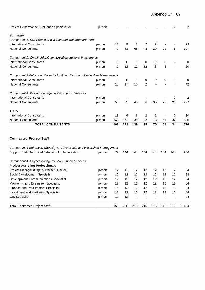
Appendix 14 89
Project Performance Evaluation Specialist /d p-mon - - - - - - 2 2
Summary
Component 1. River Basin and Watershed Management Plans
International Consultants p-mon 13 9 3 2 2 - - 29
National Consultants p-mon 79 81 68 43 29 21 6 327
Component 2. Smallholder/Commercial/institutional Investments
International Consultants p-mon 0 0 0 0 0 0 0 0
National Consultants p-mon 2 12 12 12 8 4 - 50
Component 3 Enhanced Capacity for River Basin and Watershed Management
International Consultants p-mon 0 0 0 0 0 0 0 0
National Consultants p-mon 13 17 10 2 - - - 42
Component 4. Project Management & Support Services
International Consultants p-mon - - - - - - 2 2
National Consultants p-mon 55 52 46 36 36 26 26 277
TOTAL
International Consultants p-mon 13 9 3 2 2 - 2 30
National Consultants p-mon 149 162 136 93 73 51 32 696
TOTAL CONSULTANTS 162 171 139 95 75 51 34 726
Contracted Project Staff
Component 3 Enhanced Capacity for River Basin and Watershed Management
Support Staff: Technical Extension Implementation p-mon 72 144 144 144 144 144 144 936
Component 4. Project Management & Support Services Project Assisting Professionals
Project Manager (Deputy Project Director) p-mon 12 12 12 12 12 12 12 84
Social Development Specialist p-mon 12 12 12 12 12 12 12 84
Development Communications Specialist p-mon 12 12 12 12 12 12 12 84
Monitoring and Evaluation Specialist p-mon 12 12 12 12 12 12 12 84
Finance and Procurement Specialist p-mon 12 12 12 12 12 12 12 84
Investment and Marketing Specialist p-mon 12 12 12 12 12 12 12 84
GIS Specialist p-mon 12 12 - - - - - 24
Total Contracted Project Staff 156 228 216 216 216 216 216 1,464

90 Appendix 15
FINANCIAL MANAGEMENT INCLUDING FLOW OF FUNDS 1. The Department of Environment and Natural Resources (DENR) will be the Executing Agency of the Integrated Natural Resources and Environmental Management (INREM) Project. The National Project Coordinating Office (NPCO) at the DENR Central Office will spearhead and oversee the over-all implementation of the project. The NPCO will lead the implementation of: Project Management and Support services and Participatory INREM planning for investments with the assistance of the consultants and in close consultation with Provincial Project Coordination Office (PPCO) and Provincial Watershed Council. NAMRIA will implement Land Use and Land Capability Assessment of 23 watersheds in close coordination with DENR Regional Office. 2. The municipal LGUs will also undertake investments for livelihood enhancement through improvement of rural infrastructure. (See details in Table 1. Implementation Arrangements and Fund Management)
3. Department of Finance (DOF) will open imprest accounts for the Project Funds from ADB with authorized government depository banks for DENR, DA and MDFO. Participating DENR Regional/Provincial Offices and LGUs will likewise open and maintain separate Project Accounts with authorized government depository banks for the project funds they will receive.
4. DENR, DA and MDFO will include the expected yearly loan/grant proceeds for the Project in their budget proposals to the Department of Budget and Management (DBM) for the inclusion in the annual appropriations to ensure sufficient budget cover.
5. The DBM shall issue, in accordance with the approved work and financial plan, Special Allotment Release Order (SARO) for the Project Funds to the respective executing/disbursing agencies. The SARO serves as the agencies’ authority to incur obligations for the Project. Once funds are deposited to their imprest accounts, the Bureau of Treasury (of the DOF) shall notify DBM of the receipt of such funds. The DBM shall then issue the Notice of Cash Allocation (NCA) equivalent to the amount deposited to the respective Executing/Disbursing Agencies to authorize them to issue checks against their imprest accounts.
6. Project funds will be released to DENR Regional and Provincial offices (RO/PENROs) project accounts based on the approved work and financial plan. The DENR (CO) will issue sub-allotment advice or Notice of Transfer of Allocation to the participating Regional/Provincial Offices to authorize them to incur obligations. Funding checks will be issued by the DENR (CO) to transfer the funds to the Regional/Provincial Special Accounts.
7. The DENR (CO)/NPCO, directly or thru the RO/PENROs, will execute Memorandum of Agreement (MOA) or contract with Local Government Units, private, community or peoples’ organization to undertake specific activities under the Project. Such MOA/contract will be basis for the release of funds to the participating LGUs and other organizations. Such releases or payments shall be in accordance with the arrangements specified in the Loan Agreement and ADB’s Loan Disbursement Handbook (2007) as well as national accounting/auditing rules and regulations.
8. The amount of $ 34 million of the loan proceeds is allocated for Rehabilitation and Improvement of Rural Infrastructures. $10 million of which will be released to DA for areas in the Chico River Basin covered by the CHARM Project. The remaining $24 Million will be released to the MDFO for administration and release to LGUs availing of the funds for their rural infrastructures in accordance with the NG-LGU Cost Sharing Policy approved by the NEDA Board in 2003 (as amended by DOF Department Order No. 40-09, dated December 3, 2009). The LGU counterpart, which may be availed of as loan from the MDFO may be

Appendix 14 91
sourced from project funds. DA will apply the co-sharing policy with LGUs in the administration of their allocations.
9. Initial funding of the imprest accounts equivalent to 15% of project allocations for the DENR, DA and MDFO is recommended.
10. As a protected area, Lake Lanao River Basin falls within the jurisdiction of DENR-Region X. However, by location, it falls within the jurisdiction of Autonomous Regional Government in Muslim Mindanao (ARMM) and a Council was created to manage the river basin. (See Institution Study) ARMM Organic Law (RA 9504) provides that it shall enjoy fiscal autonomy. Specifically, it provides – “The Regional Government shall enjoy fiscal autonomy in generating and budgeting its own sources of revenue, its share of the internal revenue taxes and block grants and subsidies remitted to it by the central government or national government or any donor.” Hence, if the jurisdiction of ARMM over Lake Lanao is recognized, the DENR-ARMM will replace the DENR-Regional X in implementing the project in the area. LGUs within the area will avail funds for infrastructure through the MDFO.
Table 1. Implementation Arrangements and Fund Management:
Component Lead Implementing Agency/Unit Fund Administration-Flow
1. River Basin and Watershed management Plan: Assessment of Current Land Use
Assessment and Mapping of current land use
Data acquisition Land Use Capability Assessment &
River Basin Zoning Land use Capability
assessment & URB Zoning Carbon baseline survey Boundary Delineation
Participatory Management Planning (including IP, gender and other safeguard concerns)
GIS Data base Installation Central Operations Center URB Nodes
GEF – Watershed management, biodiversity and investment plan
The NPCO, with the assistance of NAMRIA, consultants, institutions and DENR-RO; participation of the offices of National Government Agencies at the province (National Irrigation Authority, National Commission on Indigenous People, National Power Corporation); guidance of the PINREM-C; and, participation of the municipalities/cities, communities and indigenous peoples’ organizations in the area.
DENR-CO, the EA, will transfer funds to NAMRIA and other implementing units based on a MOA and/or approved Work and Financial Plan (WFP) through sub-allotment and check payment or bank transfer. NPCO, Project Operations Group will be responsible for the preparation/ consolidation and submission of Withdrawal Application and Statement of Expenditures (SOEs) to ADB for timely fund releases. DENR-CO – thru the DENR-RO. Transfer of funds from CO thru sub allotment to ROs based on approved Work and Financial Plan. DENR CO or RO may opt to contract or sub-contract the undertaking of specific activities to other government agencies, private firms/ consultants.
2. Small holders/ Commercial/institutional Investments
Provincial Project Coordination Office, with the guidance of Provincial inter-Agency INREM Council, support of the PENRO/CENRO and offices of national agencies at the province will coordinate the implementation Component 2. The participating cities/ municipalities will implement the activities on the ground. Activities may be contracted directly to private or non-
DENR – CO thru the Provincial or Municipal Government. Memorandum of Agreement between the DENR and Provincial or Municipal LGU will be executed whereby the LGU will undertake specific activities of the Project and DENR will transfer the funds for the activities on certain conditions.
2.1 Conservation, Rehabilitation and Protection of URB State Forest: Community based protection and
monitoring; and Rehabilitation through
reforestation; and Assisted natural regeneration
2.2 Sustainable forest management, agroforestry and commercial plantation with community participation : Sustainable Forest Management Agroforestry with Community
Participation (with Beneficiary (in

92 Appendix 15
Component Lead Implementing Agency/Unit Fund Administration-Flow
kind) contribution Commercial Forest Plantation with community participation (with Beneficiary –In kind contribution)
government organizations, communities, IPs, peoples’ or farmer organizations as maybe recommended by PINREMC/PPCO
2.3 Rehabilitation and Improvement of rural infrastructures Rural access roads, with
safeguards to avoid encroachment into forests through investments in improving agricultural productivity on land already cleared of forest;
Communal irrigation schemes; and Potable Water Supply (Level II –
Spring Development) Foot-Trail & Trading Center other Infrastructures, identified as
necessary in the Watershed Management Plans
Performance-Based Grants to LGUs
Participating City/Municipal LGUs. Municipal Development Fund Office – Municipal LGUs (for infrastructure projects) subject to the NG-LGU cost sharing per “LGU Financing Policy Framework” of 2003 DA for Project in CHARM 2 Areas in the Chico River Basin
2.4 Livelihood enhancement thru conservation farming: Extension and training; micro,
small, medium-sized agro-agribusiness and post-harvest management; business advisory, market linkages and linking to micro-credit/finance institutions;
Introduction and promotion of improved conservation farming practices and proven technologies;
Seed fund for the self-help groups composed of poorest of the poor/vulnerable households for the replication/up-scaling/expansion of tested and matured technologies
The DENR- NPCO in close coordination with the Municipal Agriculture Office and municipal environment and Resource Officer (MENRO) of participating LGUs; and assistance/ participation of qualified service providers (e.g. academe, NGOs) in the area.
DENR- CO through LGUs or Non- Governmental Organizations through MOA.
2.5 Investment in watershed Management (GEF& CCF): Nursery for Mossy forest-
indigenous species Assisted Natural Regeneration Buffers with Mixed Vegetable
Cover IPO-Revolving Fund Establishment
(Seed Capital) Bioenergy Plantation in Bukidnon Contribution – Feasibility study on the establishment of Pilot Charcoal Retort
National Project Coordinating Office -DENR, with the participation of Forest Management Bureau, National Mapping and Resource Information Authority, Protected Area and Wildlife Bureau, Foreign Assisted and Special Project Office Assisted by Consultants, Consulting firms, International/ Local Non-government Organizations, Academe or other institutions.
DENR-CO. With option to contract or sub-contract the undertaking of specific activities to other government agencies, private firms/consultants, LGUs and/or Non-Governmental Organizations.
3. Enhanced capacity for river basin and watershed Management REDD Capacity Building Awareness and Info Campaign PES Training LULUCF Capacity Building Improved institutional capacity for
participating communities and organizations (including indigenous peoples' organizations) responsible for INREM in all selected URBs;
Development of TE-IEC program that will document, for implementation and further dissemination, technologies and good practices promoted and undertaken by the Project on agroforestry, sustainable forest management, conservation farming and others introduced in support of

Appendix 14 93
Component Lead Implementing Agency/Unit Fund Administration-Flow
livelihood.
4 Project Management and Support Services: Consultants' recruitment and
supervision; Procurement of materials,
equipment and vehicles; Design and development of a
networked GIS-based Database System (GIS-DBS) at national, provincial and municipal LGUs for monitoring and decision making
Project Performance Monitoring & Evaluation
DENR = Department of Environment and Natural Resources; DENR-CO = Department of Environment and Natural Resources Central Office; DENR-RO = Department of Environment and Natural Resources Regional Office; LGU = local government unit; URB = upper river basin.

94 Appendix 15
INREM Project Funds Flow
Asian Development Bank (ADB)
Government of the Philippines Department of Finance (DOF)/
Bureau of Treasury (BOT) Department of Budget & Management
(DBM)
Municipal Development Fund Office (MDFO)
Participating LGUs (Provincial/Municipal)
Department of Environment & Natural Resources (DENR)
DENR – Regional Office (RO)/Provincial Environment
Natural Resources Office (PENRO)
Funds are transferred based on approved Work and Financial Plan or Memorandum of Agreement/Contract
Department of Agriculture (DA)
Small Scale Irrigation; Potable
Water System
International Fund for Agricultural Development
(IFAD)
Grants: Global Environmental Fund
(GEF); Climate Change Fund (CCF)
Rural Access & other Infra
Community/Indigenous Peoples’ or Non-Government Organizations (COs/POs/IPOs/NGOs)
(Beneficiaries/Partner Project Implementors)
URB Forest Conservation &
Protection; Livelihood Activities
Beneficiary Counterpart
Agroforestry & Commercial
Forest Plantation
Academe/Private Service Providers
Local Government Counterpart
Watershed Management Planning; Capacity Building; Project
Management
National & Local Government Counterpart
Beneficiary Participation Participation
Attributed Counterpart
For Rural Infrastructure & Performance-Based Grants System; LGU applies to avail of the funds.
Community/Indigenous Peoples’ Participation
With Imprest Accounts
With Special Accounts

Appendix 16 95
GENDER ACTION PLAN
A. Gender Status and Issues
1. The Philippine Human Development Report 2005 has reported continuing inequality between men and women in terms of economic activity. Admittedly, it has been observed to decrease. The numbers of employed and unemployed Filipinos in 2007 were estimated at 33.7 million and 2.2 million respectively. Female unemployment rate for the same year was relatively lower at 6.0% which is equivalent to 821 thousand compared to male at 6.4% which is estimated at 1.4 million.1 From the national standpoint, there exists inequality between males and females especially in terms of labor in the agriculture sector. Women appear to contribute more to, and therefore carry the greater burden of family upkeep than the men.2
2. Based on the local government unit socioeconomic profiles the ratio between men and women within the proposed Integrated Natural Resources and Environmental Management Project (the Project) sites is almost the same except in conflict-affected areas of Lake Lanao where women slightly outnumber males. The increase of female populace can be attributed to out-migration of male and higher mortality rate in males than in females.3
3. Data resulting from the social assessment reveal that the Project’s regional stakeholders, largely integrated natural resources and environmental management institutional stakeholders perceive women to be low in terms of importance and influence in river basin management. At the village level consultations with local communities resulted in women being rated as moderately important but with much influence in community concerns. Across river basins, household and community levels of interaction reflect strengths in the assertions of women in natural resources management especially marketing, credit, and household reproductive activities. Brought to a higher level of social interaction, power dynamics can be described as subdued for women where they largely become silent participants to planning and decision-making specifically in regard to land use planning.
4. Another key gender issue is the minimal and unsatisfactory access to social and financing services as perceived by women stakeholders. Social services cited were on education, health, water and electricity. By and large, those from the downstream areas of Wahig-Inabanga and Upper Bukidnon River Basins responded more positively.
5. That women are of the weaker gender in terms of physical strength is reflected in the distribution of and payment for labor. In the vegetable producing areas of CAR and Bukidnon, women are paid much less than their male counterparts though the tasks accorded women are less physical demanding. Land preparation activities and harvesting of forest products for timber/lumber are assigned to men. However, marketing and accessing informal credit, social services, and the like are generally within the domain of the women as was evident in Lanao del Sur areas.
6. There generally is equality in decision-making but in traditional and predominantly IP communities, the last word is that of the tribal leader, more often than not, a function attributed males. Local leadership at the project sites is still highly male-dominated, but this does not prevent women from taking the necessary initiative to organize and perform localized decision-making. Women’s associations flourish in the Project sites, which focus on alternative livelihood activities like basket and cloth weaving. Women in the Chico River Basin have been known to influence local ordinances directed to their men to limit domestic violence by controlling drinking sprees with curfew hours provided.
1 National Commission on the Role of Filipino Women, 2009.
2 Philippine Human Development Report, 2005, 2
nd ed.
3 Socioeconomic Profile of Lanao del Sur, 2007.

96 Appendix 16
7. Women play major roles in social protection4 within conflict-affected areas of Mindanao. War and conflict have a direct bearing on gender roles. While men join the battlefield or are in some cases their mobility is restricted, households have become dependent on women for survival. During these trying times, women are both mothers and fathers to their children.
B. Gender Action Plan
8. A Gender Action Plan (GAP) details of which is presented in Table 1, has been prepared based on findings from Social Assessment using the Asian Development Bank (ADB) Handbook for Social Assessment, in close consultation with stakeholders that significantly include women and women leaders. This GAP is designed to address three key issues: empowerment for participation and decision-making on natural resource management, improved access to services which will in the end redound to decreased time and effort for performing household reproductive activities.
9. To ensure women’s participation, the Project will target the following. (i) Women’s representation during consultations (30%). (ii) Committees to be established at least are 30% women. (iii) Gender Specialist included in production of training modules and
establishment of trainers’ pool. (iv) Gender sensitive training material in local dialects to be prepared in close
consultation with beneficiaries. (v) Hands-on attendees and beneficiaries of training activities at least 30%
women. (vi) For infrastructure construction and local labor, at least 35% of local labor
reserved for local rural women, particularly the poorer and more vulnerable. (vii) 50% beneficiaries of subsidized inputs will be women.
10. At the Project management level, the following will be observed: (i) GAP implementation and reporting on gender related achievements reflected
in quarterly progress reports to ADB. (ii) Implementing agencies to appoint project staff as gender focal point
responsible for monitoring GAP implementation. (iii) The terms of reference of all consultants will include responsibilities to ensure
GAP implementation as related to their work. (iv) Gender-sensitization training carried out as part of project orientation, for all
levels of staff, consultants, contractors, and facilitators. (v) Both female and male staff given equal opportunity to participate in non-
gender related training and capacity development programs. (vi) A national social development/gender consultant recruited to (i) build capacity
of project management units on gender responsive design and analysis; (ii) preparation of gender sensitive indicators; and (iii) preparation of checklists for evaluation of gender responsiveness of proposed subprojects.
(vii) Sex-disaggregated indicators to be established for project performance monitoring and evaluation.
(viii) Mid-term view Mission to assess gender related achievements and constraints to GAP implementation and propose adjustments for better project performance.
4 Joint Needs Assessment for Conflict-Affected Communities In Mindanao: Human Development Sector. Draft
Integrated Report. The World Bank. October 2004.
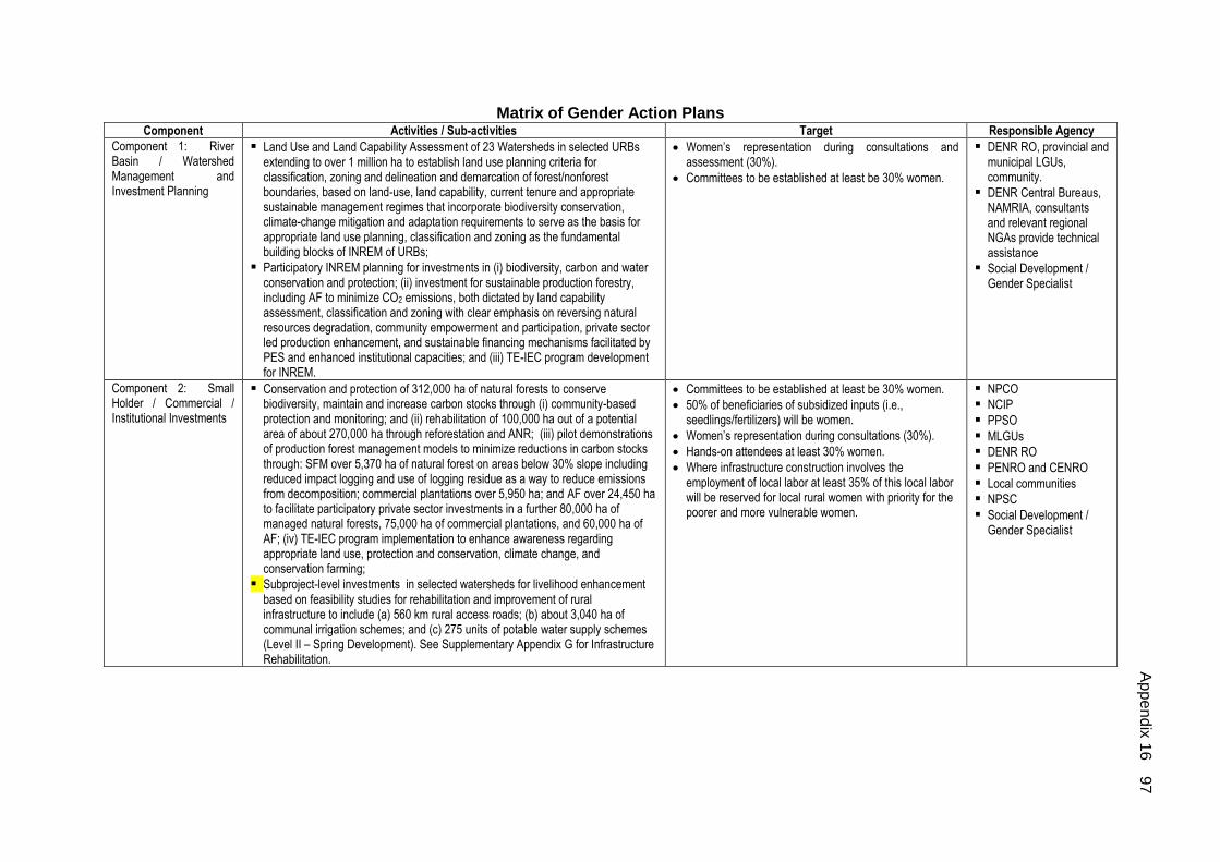
Matrix of Gender Action Plans
Component Activities / Sub-activities Target Responsible Agency
Component 1: River Basin / Watershed Management and Investment Planning
Land Use and Land Capability Assessment of 23 Watersheds in selected URBs extending to over 1 million ha to establish land use planning criteria for classification, zoning and delineation and demarcation of forest/nonforest boundaries, based on land-use, land capability, current tenure and appropriate sustainable management regimes that incorporate biodiversity conservation, climate-change mitigation and adaptation requirements to serve as the basis for appropriate land use planning, classification and zoning as the fundamental building blocks of INREM of URBs;
Participatory INREM planning for investments in (i) biodiversity, carbon and water conservation and protection; (ii) investment for sustainable production forestry, including AF to minimize CO2 emissions, both dictated by land capability assessment, classification and zoning with clear emphasis on reversing natural resources degradation, community empowerment and participation, private sector led production enhancement, and sustainable financing mechanisms facilitated by PES and enhanced institutional capacities; and (iii) TE-IEC program development for INREM.
Women’s representation during consultations and assessment (30%).
Committees to be established at least be 30% women.
DENR RO, provincial and municipal LGUs, community.
DENR Central Bureaus, NAMRIA, consultants and relevant regional NGAs provide technical assistance
Social Development / Gender Specialist
Component 2: Small Holder / Commercial / Institutional Investments
Conservation and protection of 312,000 ha of natural forests to conserve biodiversity, maintain and increase carbon stocks through (i) community-based protection and monitoring; and (ii) rehabilitation of 100,000 ha out of a potential area of about 270,000 ha through reforestation and ANR; (iii) pilot demonstrations of production forest management models to minimize reductions in carbon stocks through: SFM over 5,370 ha of natural forest on areas below 30% slope including reduced impact logging and use of logging residue as a way to reduce emissions from decomposition; commercial plantations over 5,950 ha; and AF over 24,450 ha to facilitate participatory private sector investments in a further 80,000 ha of managed natural forests, 75,000 ha of commercial plantations, and 60,000 ha of AF; (iv) TE-IEC program implementation to enhance awareness regarding appropriate land use, protection and conservation, climate change, and conservation farming;
Subproject-level investments in selected watersheds for livelihood enhancement based on feasibility studies for rehabilitation and improvement of rural infrastructure to include (a) 560 km rural access roads; (b) about 3,040 ha of communal irrigation schemes; and (c) 275 units of potable water supply schemes (Level II – Spring Development). See Supplementary Appendix G for Infrastructure Rehabilitation.
Committees to be established at least be 30% women.
50% of beneficiaries of subsidized inputs (i.e., seedlings/fertilizers) will be women.
Women’s representation during consultations (30%).
Hands-on attendees at least 30% women.
Where infrastructure construction involves the employment of local labor at least 35% of this local labor will be reserved for local rural women with priority for the poorer and more vulnerable women.
NPCO
NCIP
PPSO
MLGUs
DENR RO
PENRO and CENRO
Local communities
NPSC
Social Development / Gender Specialist
Ap
pe
nd
ix 1
6
97

Component Activities / Sub-activities Target Responsible Agency
Components 3 & 4: Capacity Strengthening For River Basin Management and Project Management and Support Services
Consultants' recruitment and supervision;
Procurement of materials, equipment and vehicles;
Improved institutional capacity for participating communities and organizations (including indigenous peoples' organizations) responsible for INREM in all selected URBs;
Design and development of an operational GIS-based decision-support systems at national, provincial and municipal LGUs to monitor biodiversity conservation, and improve management of land-use changes with Supplementary Appendix F for Design and Operation of Decision Support System respect to the maintenance and improvement of carbon stocks and monitor progress;
Development of TE-IEC program See Supplementary Appendix G for Technical Extension, Information, Education and Communication;
Research and Studies on climate change related aspects, identification of High Conservation Value Forests within the remaining closed forest and assessment of additional incentives to local communities based on the value of the potential reduction in CO2 emissions;
Project Performance Monitoring System; and
Performance Based Grant Monitoring System.
Gender Specialist included in production of training modules and establishing trainers’ pool.
Gender sensitive training material in local dialects to be prepared in close consultation with beneficiaries.
Women’s representation during consultations (30%).
NPCO and Project Director responsible for overseeing GAP implementation and reporting on gender related achievements in quarterly progress reports to ADB.
Implementing agencies to appoint project staff as gender focal point responsible for monitoring GAP implementation and report gender related achievements and constraints to NPCO.
TOR of all consultants will include responsibilities to ensure GAP implementation as related to their work.
Gender-sensitization training carried out as part of project orientation, for all levels of staff, consultants, contractors, and facilitators.
Both female and male staff given equal opportunity to participate in non-gender related training and capacity development programs.
A national social development/gender consultant to be recruited to (i) build capacity of project management units across levels, project staff and facilitators in gender responsive design and analysis; (ii) preparation of gender sensitive indicators; and (ii) preparation of checklists for evaluation of gender responsiveness of proposed subprojects.
Sex-disaggregated indicators to be established for project performance M&E system; monitoring will be on-going to ensure activities are effectively carried out and targets reached; progress reports to include gender-related achievements and constraints.
Mid-term review Mission to assess gender related achievements and constraints to GAP implementation and propose adjustments for better project performance.
DENR and other oversight agencies
PLGUs and MLGUs
DENR, Project Director and social development/gender specialist.
ADB = Asian Development Bank; ADSDPP = Ancestral Domain Sustainable Development and Protection Plans; DENR = Department of Environment and Natural Resources; FMB = Forest Management Bureau; FPIC = Free and Prior Informed Consent; GAP = gender action plan; IEC = information, education and communication; INREM = integrated natural resources and environmental management; IPDP = Indigenous Peoples Development Plan; IPRA = Indigenous Peoples Rights Act; LGU =local government unit; MLGU = municipal local government unit; NGA = National Government Agency; NPCO = National Project Coordination Office; NPSC = National Project Steering Committee; PES = payment for environment services; PPSO = Provincial Project Support Office;
RO = Regional Office; URB = upper river basin.
98
A
ppe
nd
ix 1
6

Appendix 17 99
ECONOMIC ANALYSIS FINANCIAL AND ECONOMIC ANALYSES
A. Introduction
1. Investments under the INREM Project is consistent with the Philippine Government’s Medium-Term Development Plan, the Asian Development Bank (ADB) country operations business plan (2007–2008), and the country poverty assessment (2004), and the Road Map for agriculture, environment and natural resources. In particular, the Project is consistent with the three themes of the Bank’s long-term strategic framework 2008–2020 (Long Term Strategic Framework 2020). Further, the Project is consistent with the Bank’s five core areas of operation for lending purposes: infrastructure, regional cooperation and integration, financial sector development, education, environment, and other areas such as health, agriculture, and disaster and emergency assistance, all point towards sustainable management of natural resources, which include the most critical resources—forests and water—which are intricately linked.
2. The economic impact of the Project will be generated at three levels. Approximately 200,000 individual beneficiary households will benefit from a more productive and sustainable source of income from their agricultural activities as a result of the direct technical support and demonstrations implemented by the Project. Public utilities, other productive enterprises and downstream farmers that utilize water for many purposes will benefit from improved quality and reliability of the water resources within the river basin. This will enable them to increase their productivity and avoid some of the costs currently incurred as a result of the irregular flow and polluted nature of the water supply. The third level of benefit will be felt by the population as a whole within the river basin and some 83 local governments (cities and municipalities), as a result of increased economic activity and greater security from the harmful impact of climate change and natural disasters and to a certain extent the global community will benefit from modest reductions in carbon dioxide, while better protection and conservation of biodiversity will open opportunities for ecotourism and bio-prospecting that will bring national and global benefits. B. Economic Valuation of Ecosystem Services in the Project Area
3. Ecosystem services can be defined as goods and services provided by a natural unit of living things (animals, plants and micro-organisms) and their physical environment that benefit human beings1. Most of the forest ecosystem services (e.g. water, clean air, pollination etc.) are difficult to quantify or put a value in money terms. Although timber (e.g. tree), non-timber forest products (e.g. forest food, rattan, latex, resins, etc.) are tradable in the market, the price mechanism often fails to reflect the real value of those ecosystem services because their valuation is based on the cost of extraction (labor, equipment, and transport) and raw material only. This does not take into consideration the ecosystem service value, such as watershed protection, soil fertility, carbon sequestration, and biodiversity protection. Therefore, market failures often occur in ecosystem management as markets and economic development planning rarely reflect the full social costs or benefits of environmental goods or services, and valuation of ecosystem services is essential in correction of market failure and economic planning to support decision making.
4. Valuation of ecosystem services of selected river basins under the Integrated Natural Resources and Environmental Management (INREM) project serves as a basis for identifying real costs and reflection of economic values in government planning and decision-making for watershed management and establishment of payment for ecosystem services (PES) mechanism.
1 Defra. 2007. An introductory guide to valuing ecosystem services. www.defra.gov.uk

100 Appendix 17
5. An economic valuation of the existing regulatory services in the forest ecosystem in the four selected upper river basins (URBs) under the proposed INREM Project was conducted mainly to assess the real costs and reflection of economic values in government planning and decision-making for watershed management and establishment of payment for ecosystem services (PES) mechanism. Forests provide ecosystem services, such as climate regulation, watershed protection, water quality regulation, soil erosion prevention and nutrition retention. The results of the valuation indicated that the total value of ecosystem services assessed in the four river basins (INREM project area) amounts to $2.78 billion (Table 1), which translates into just over $8,417 per ha, if we take into account the total forested area of 330,225 ha. Nutrient retention and carbon sequestration functions of the forest ecosystem provide the highest values followed by soil erosion control and water regulation services (for details see Annex on valuation of ecosystem services – VES in the Supplementary Appendix).
Table 1. Summary values of ecosystem services in INREM project areas (in US$)
Ecosystem
Services
Chico River
Basin
(163,324ha)
Wahig
Inabanga
(19,961ha)
Upper
Bukidnon
(65,927ha)
Lake
Lanao
(81,011 ha)
Total
4 URBs
(330,225 ha)
Unit
Value
(USD/ha)
Carbon
sequestration
236,266,548 40,935,676 140,071,701 112,255,995 529,529,920 1,604
Oxygen generation 172,474,580 29,883,043 102,252,342 81,946,876 386,556,841 1,171
Watershed
protection (storage)
160,874,000 9,949,376 75,470,876 92,888,255 339,182,507 1,027
Water quality
regulation
185,811,915 11,491,680 87,170,009 107,287,346 391,760,950 1,186
Soil erosion control 230,044,237 28,115,281 92,859,349 114,106,136 465,125,002 1,409
Nutrient retention 265,125,325 32,402,781 107,020,134 131,506,995 536,055,236 1,623
Tourism - 131,302,650 - - 131,302,650 398
Total Value 1,250,596,606 284,080,487 604,844,411 639,991,602 2,779,513,107 8,417 Notes: 1. The forest cover of the island province of Bohol has been taken as a basis as the Wahig Inabanga upper watershed area could be taken as headwaters of several rivers flowing down to coastal areas. Also tourism revenue and tourism investment affects the whole island just as water consumption needs is for the whole island; 2. Tourism values of Bohol are based on data collected by Tourism Office Bohol.
6. Loss of forest cover (estimated at roughly 2% per annum) affects the above mentioned economic values, which are all the more critical in river basins servicing infrastructure such as hydropower installations and irrigation facilities. In the Project area, the Chico river basin headwaters in the Bauko watershed are also the headwaters of Agno, Magat, and Amburayan rivers. This makes the protection and maintenance of watershed in the triborder area of Benguet, Mountain Province and Ifugao all the more critical as downstream siltation and soil erosion will affect both the dams and irrigation infrastructure on all four rivers as far as these are currently operational and generating revenue. A scenario analysis of with and without project of these ecosystem values is provided under section C.
C. Ecosystem Values and Scenario Analysis
7. As mentioned in section B above, the total value of ecosystem services assessed in the four river basins (INREM project area) amounts to $2.78 billion (Table 1, section B above), which translates into just over $8,417 per ha, if we take into account the total forested area of 330,225 ha. If the values of ecosystem services are taken into account, a simple model of economic analysis and comparison of different land use options can demonstrate that maintaining forests or even restoring the degraded forests/reforestation provides higher value than agricultural land use options, especially on marginal soil and steep slopes.

Appendix 17 101
8. A summary table of Net Present Values (NPV) (US$/ha) of different land use options applying a 12% discount rate over a 25 year time frame is presented in Table 2. However, the values of forest ecosystem services are not well recognized and received by people due to imperfect market information on environmental externalities and unclear property rights. Instead, the rather high economic return of vegetable farming drives the rapid expansion of vegetable gardens in the Cordillera. The NPVs of plantation and crop models are higher than forest conservation and reforestation, but the internal rate of return (IRR) is lower and it normally takes long period for return. Although the economic value of agriculture is relatively lower, it plays a very important role in local livelihoods in terms of source of food and income.
Table 2. Summary of Net Present Values (NPV) of land use options in the Project area
No. Land use option NPV (US$/ha) 15%, 25yrs
1 Forest conservation and protection 65,964
2 Reforestation (IRR=128%) 29,070
3 Plantation Model 1 (Gmelina) (IRR=44%) 10,839
4 Plantation Model 2 (Low-investment option) (IRR=26%) 967
5 Agroforestry models (IRR=15%-59%) 861 – 5,266
6 Crop model 1 - Mango (IRR=27%) 3,386
7 Crop model 2 - Coffee (IRR=21%) 687
8 Crop model 3 – Calamansi (IRR=30%) 3,448
9 Rice cultivation 20,491
10 Corn (yellow and white) 2,233
11 Cabbage 11,060 – 18,383
12 Carrot 21,238
13 Peanut 3,198
14 Cassava 4,661
15 Tomato 12,804
16 Eggplant 14,222
17 Banana 10,683
18 Coconut 1,674
19 Sugarcane 8,505
9. To simplify the scenario analysis model, three broad categories of land use options are considered for valuation, namely, (i) forest, (ii) plantation, and (iii) agriculture, where plantation model 1 and rice is selected for calculation as representatives for category 2 and 3 as they are the dominant models within the category and generate modest benefits.
Figure 1. Scenarios of Land Use Change in the Project area (ha)
0 200,000 400,000 600,000 800,000 1,000,000
Status Quo
Scenario with
project
Scenario without
project
Croplands
Plantation
Open forest
Closed forest

102 Appendix 17
10. The scenario analysis results (table 3) shows that “with-project scenario” increases NPV from US$31 billion at status quo to US$47 billion (positive change of US$16 billion), while the unchecked growth “without-project scenario” may only increase in value of US$320 million. The results show that “with-project scenario” is a more beneficial and sustainable manner to move forward.
Table 3. Scenario Analysis of Land Use Change in the Project area
Land use
option
Status Quo
(ha)
With-project Scenario Without-project Scenario
Ha Change ha Change
Closed forest 170,079 508,008 337,930 85,039 -85,039
Open forest 143,205 143,205 0 79,945 -63,261
Plantation 5,183 68,644 63,461 5,183 0
Agriculture 485,604 408,996 -76,609 978,598 492,994
NPV
(12%, 25 yrs)
(million US$)
30,672 46,789 16,126 30,992 320
11. The results of the sensitivity analysis (table 4) show that NPVs are more sensitive to discount rate used, and less sensitive to carbon prices. The discount rate of 8% yields approximately 36% incremental increase in NPVs, while a 15% discount rate causes a decrease of 17% in NPV values. However, the incremental changes in NPVs by adjusting the values of selected variables do not affect the outcomes of scenario analysis. In all the cases, NPVs of “with-project scenario” maintain the highest values in comparison with scenarios of “status quo” and “without-project”. If carbon price is set at 20 US$/ton, “without-project scenario” may even incur a loss (4.47%) in NPV compared to the status quo.
Table 4. Sensitivity Analysis of Scenarios Analysis (NPV: million US$)
Scenarios Base case* Discount rate Carbon price
8% 15% 5 US$/t 20 US$/t
Status Quo 30,672 41,765 25,272 28,702 34,614
36.17% -17.61% -6.42% 12.85%
Scenario without project
30,992 42,200 25,535 29,954 33,068
36.16% -17.61% -3.35% 6.70%
Scenario with project
46,799 65,041 38,036 43,202 53,994
38.98% -18.72% -7.69% 15.38%
Note: * Base case with 12% discount rate, carbon price of 10US$/ton.
12. Therefore, it is essential for the Project to formulate watershed management plans and policy, and establish payment for ecosystem services (PES) schemes to secure and capture the value of ecosystem services and to provide: (i) incentives for forest conservation, restoration and watershed protection; (ii) disincentives for uncontrolled expansion of vegetable farming and cash crops on marginal soil and slopes above 30%.
D. Investment Analysis
1. Land Distribution
13. The current distribution of land within the four URBs by slope and land cover is shown in Table 5. It is observed that about 570,000 ha or about 50% of the total land area is on land sloping by more than 30%, and therefore subject to high risk of erosion if not properly managed. About 123,000 ha are reported as being cultivated with annual crops. This area is estimated to contribute about 70% of the annual soil losses amounting to about

Appendix 17 103
80 million metric tons2. This annual loss of soil not only reduces soil fertility and productivity, it also fills reservoirs downstream and as deposits build up in the river bed, and accentuates flooding. The Project, therefore, aims to deal with this problem by promoting either agroforestry or conservation farming on cultivated sloping lands, and, and replanting abandoned areas with native tree species.
Table 5. Land cover by slope class within the four INREMP upper river basins (ha)
Project land cover by slope class (ha)
Land cover 0-3 % 3-8 % 8-18% 18-30% 30-50% above 50% Total
Closed forest, broadleaved 436 49 23,194 13,469 15,588 71,671 124,406
Closed forest, coniferous 626 1,842 425 1,609 4,444 36,725 45,673
Open forest, broadleaved 4,135 1,350 16,503 19,069 15,132 70,147 126,336
Open forest, coniferous 0 1,035 117 1,435 2,277 12,004 16,869
Forest plantations, broadleaved 219 490 880 374 2,434 785 5,183
Other land, built-up area 4,108 359 1,602 269 88 170 6,596
Other land, cultivated, annual crop 103,376 65,753 74,735 69,965 54,468 68,713 437,011
Other land, cultivated, perennial crop 3,622 744 14,245 13,094 9,605 7,283 48,593
Other land, natural, marshland 0 0 284 52 0 0 336
Other lands, grassland 5,395 1,815 3,320 4,690 6,892 541 22,653
Other wooded land, shrubs 11,530 5,148 17,418 26,276 38,092 112,852 211,316
Other wooded land, wooded grassland 12,318 2,116 16,816 20,079 17,915 21,568 90,813
Inland water 3,270 0 4 0 1 0 3,275
Other land, natural, fishponds 250 0 0 0 0 0 250
Other land, natural, barren land 1 0 0 0 21 0 23
Other land, mangrove forest 461 0 0 0 0 0 461
149,747 80,704 169,543 170,379 166,959 402,460 1,139,793
14. About half of this cultivated land on steep slopes is state forest land and the other half is alienable and disposable. Most of these lands are occupied generally by poor farmers, generally engaged in kaingin (slash and burn agriculture). The Project will have to provide farmers, with legal land ownership, incentives to change their cultivation practices and adopt agroforestry or conservation farming systems in order to conserve soil and water, and retain soil nutrients to increase agricultural productivity. Meanwhile, farmers occupying state forest land or the land which forms part of a claim for an Ancestral Domain (AD) will also be provided with incentives to change their intensive agricultural practices. In addition, the Project will work out in providing these farmers with conditional land titles.
15. The Project will also fund rehabilitation of infrastructure, especially barangay roads to improve their access to markets, community irrigation systems and potable water supply systems. These sub-projects will be packaged with the technical support both for agriculture and for developing small-scale agricultural processing enterprises. In doing so, the Project will generate the economic benefit of reduced erosion and environmental degradation in addition to the improved livelihoods for the individual farmers involved.
2. Scenario Description
a. "Without-Project" Scenario
16. The environment in the URBs have been deteriorating for years due to forest clearance, shifting cultivation, and other unsustainable farming practices. Without the project, this deterioration can be expected to continue. Using data from a FAO study on the land value of in the Philippines for the three regions where the INREMP will operate (CAR, Region VII and X) and adjusting for changes in the exchange rate since the date of original
2 Based on numerous measurements of annual soil losses on different slopes with different land-uses

104 Appendix 17
study, it is estimated that the annual land depreciation due to soil nutrient loss is currently valued at around US$49 million from an area of about 1.6 million ha, or an average of US$30 per ha of agricultural land. The loss from these regions is about 25% of the national total, and has reached a point where the rate of loss is accelerating (Figure 2 below).
Figure 2. Estimated economic depreciation of agricultural land in the INREMP river
basins since 1989 based on the value of lost nutrients (US$ million per year)
17. An estimation of the soil loss value based on the current land cover distribution by slope class in the four river basins, is about US$37 million. This estimate is consistent with that of FAO for the whole of the three regions. The magnitudes of these losses are likely to be larger than the above estimates, because of increasing cultivated area for agricultural activities. Moreover, agricultural activities have moved onto steeper land and the real cost of fertilizers has increased by about 25% during the intervening period.
18. The value of the nutrient loss from a hectare of land varies greatly according to the type of soil, land slope, and the farming system adopted. However, the FAO study gave a weighted average value of nutrient loss of about PhP800 (US$38) per ha for 1988, which would be about PhP 2,200 (US$47) per ha at the current prices. This is more than the net revenue for some farming systems, and is unlikely to be replaced by the addition of fertilizers. These estimates are based on the weighted average replacement cost of the nutrients lost in a metric ton of the soil from major soil types in the country, valued at about PhP 13 per metric ton.
19. Using the values for soil loss under different land uses developed by David and Collado (Table 6) and the current land use in the selected river basins as estimated by the PPTA, it is possible to make an estimate of the current total annual loss of soil for each river basin, and totals almost 25 million metric tons annually. This represents both a productivity loss for farmers in the watersheds of the river basins, especially of those on the steeper slopes, and a loss of revenue for power utilities and irrigation systems in the down stream.
Economic depreciation
0
20
40
60
80
100
120
1989
1992
1995
1998
2001
2004
2007
2010
2013
2016
Year
Ec
on
om
ic d
ep
rec
iati
on
(U
S$ m
illi
on
)
Economic depreciation

Appendix 17 105
Table 6. Estimated present sheet and rill erosion losses in tons per hectare per year for the various land uses and slope. (David and Collado, 1987)3
Land use
Slope Range, % Area Weighted Average
for all Slope 0-3 3-8 8-15 15-25 25-40 >40
1a. Primary forest - 0.048 0.16 0.32 0.63 1.28 1.03 1b. Primary forest 0.86 2.25 2.22 2a. Secondary forest 0.064 0.34 0.96 2.05 3,73 8,79 5,73 2b, Secondary forest 0.41 7.03 6.95 3a. Open grasslands 2,44 9.79 32.73 55.57 126.24 240.60 122.01 3b. Open grasslands - 10.01 25.72 141.70 139.95 264.03 210.72 4a. Irrigated paddy 0.21 0.67 1.52 3.74 10,43 10,92 1.03 4b. Irrigated paddy 0.18 8.82 0.45 5a. Rainfed paddy 0.21 - 2.69 4.04 7.07 14,03 2.75 5b. Rainfed paddy 0.22 0.81 - 5.56 - 25.26 0.64 6. Terraced rice,(irrig) 0.094 0.41 1.29 2.34 4.44 9,42 4.63 7. Terraced rice,(rainf) - 0.40 1.66 3.57 - - 2.04 8. Savannah 120.85 238.99 194.83 9. Kaingin 280.85 374.88 586.51 507.88 10a. Diversified crops 4.13 9.00 - 68.97 144.46 - 10.95 10b. Diversified crops 177.77 177.77 11. Orchard 1.95 6,77 - 74.44 - - 45.98 12a. Built-up area 5.11 12.053 1.48 90.92 160,83 282,57 12.88 12b. Built-up area 3.68 169.30 161.17 333.48 103.26 13a. Riverwashings 10.86 61.64 165.25 410.92 1125.22 93.81 13b. Riverwashings 10.17 985.97 418.39 Average for all landuses 1.24 3.85 25.65 86.24 98.51 82.23 79.99
20. The largest measurable losses are in Bukidnon and Lake Lanao, where major power utilities are located. In the sector analysis, NPC indicated that its annual loss due to soil erosion amounts to about US$55 million, accounted to foregone electricity sales because sub-optimal operation.
21. Without further research, it is not possible to know the amount by which generating capacity is reduced for each metric ton of soil erosion. Taking the soil losses from table 6, it could be argued that in Bukidnon, 1 metric ton of soil washed down to the reservoir, costs about US$0.75 in terms of lost power output. In Lake Lanao, it was estimated at US$7.30/mt of soil erosion.
22. A study on changes in forest cover conducted for the PPTA by NAMRIA in 1990-2003 suggested that the rate of loss of low density forest cover has been around 2% per annum. If encroachment and conversion continues at this rate, about 17,000 ha of forest will be lost during the next decade. Apart from the biodiversity losses, this will also mean emissions of about 180,000 metric tons of CO2 annually, with a current value of around US$900,000, and if this forest is converted to agricultural cropping without any soil conservation measures the nutrient value of the soil losses could be as much as US$700,000 per annum. These losses are additional to the current losses due to the past forest conversions and poor land management practices. These estimates are exclusive of additional losses from reduced hydro-power generation capacity and reduced water for irrigation.
b. "With-Project" Scenario
23. The models with quantifiable benefits are presented in the following sequence: (i) small-scale communal irrigation systems rehabilitation and improvement; (ii) rural access
3 David, W. P. and C. U.Collado, Jr. "An Assessment of Land and Water Resources Present Management Practices and
Problems, and Future Management Plans and Programs for the Magat Watershed." Upland Resource Policy

106 Appendix 17
roads rehabilitation and improvement; (iii) communal drinking water supply; (iv) agroforestry; and (v) plantation forestry.
24. Communal Irrigation systems rehabilitation and improvement. The irrigation areas warranting rehabilitation are currently functioning sub-optimally. They provide less water less regularly than is needed to achieve better crop yields and stability. For the four subproject models, the increase in rice yield and cropping intensities average: (i) 2.9 t/ha rice without project to 4.3 t/ha rice with project; and (ii) 112% cropping intensity without project to 150% with project. The projected economic life of this project is 22 years.
25. Rural Access roads rehabilitation and improvement. Access and mobility are restricted in the watershed areas, especially in the wet season when many roads become impassable for motorized traffic. Improved access reduces costs of transactions, facilitates business and investment, and improves connectivity to health and social service providers. In modeling rural access improvement, the quantifiable benefits include (i) savings over existing freight and passenger traffic due to with-project use of more efficient motorized carriers; (ii) generated freight and passenger traffic and savings; and (iii) induced agricultural production4. The projected economic life of this project is 22 years.
26. Communal Drinking Water Supply. Good access to safe water supply remains a challenge in rural areas, especially in by stakeholders within the Lanao Lake Watershed. As such, the project aims to establish communal drinking water supply systems to enhance peoples’ access to safe water supply. Benefits include the following: (i) savings over existing acquisition time, health costs, and lost-workdays; and (ii) the value of increased water supply do to greater ease of access and superior conveyance. The projected economic life of this project is 22 years.
27. Establishment of Agroforestry. The Project will provide financial and technical support for agroforestry in the watersheds with the aim of encouraging environmentally sound cultivation and land use practices, and stakeholder profitability. There is a wide array of cultivation possibilities for agroforestry interventions. Agroforestry systems may be pure perennials or combinations of annuals, perennials, and/or livestock systems. The primary purpose of advocating agroforestry is to give poor farmers on steep slopes and at higher elevations a sustainable alternative to their current practices, which are environmentally damaging and are the primary cause of watershed degradation.
28. The current practices vary between the river basins with vegetable growing being a major activity in CAR and corn and cassava in the other three river basins. The usual practice is to clear land and grow crops without any special measures to minimize erosion with contour bunds, hedgerows and tree planting. This causes most of the current heavy soil losses that renders the farming unsustainable because of the steady loss of nutrients from the soil and results in underperformance of irrigation and hydro-power generation down stream. Because it is the mainly poor and under-educated farmers that employ these practices, and that their main concern is with the immediate annual cash flow, they are likely to be reluctant to adopt sustainable practices if their income is reduced in the short-term. The project therefore needs to consider the “opportunity cost” to the farmers brought about by changing their practices. This implies offering them payments to compensate them for forgoing their future income from intensive agricultural production. In view of the wider economic benefits to downstream communities, there is strong justification for investing public funds in improving the farming practices for these upland communities. The projected economic life of this project is 25 years.
4 For the benefits of generated traffic and agricultural production increases, care must be taken to not double
count. For this reason, only non-agricultural freight is included in the generated freight volumes and values.

Appendix 17 107
29. Establishment of Plantation Forestry. Plantation forestry for commercial purposes will be promoted on degraded land on moderate to gentle slopes where the risk of erosion is less and the conversion of grassland to tree cover will also reduce erosion. While the use of degraded land means lower yields from the trees, this can be largely offset by choosing species that improve soil quality through nitrogen fixation, either as a pioneer crop like Calliandra or as the main crop like Acacia mangium. In Bukidnon, there is a large demand for industrial charcoal and since this does not require large logs, raw material can be provided from short rotation densely planted species like Calliandra that also have valuable soil improving qualities. There are also reputable mining companies that need to open land currently under forest and they are obliged to establish compensatory plantations.
30. An important aspect of the Project under Component 1 will be the identification of suitable land for such plantations. Two types of plantations will be promoted, generally in combination, with one being relatively large blocks of corporate plantations (to capture economies of scale for efficient management) and the other being smallholder plantations, either linked to the corporate schemes to benefit from technical support and markets, or as independent operations.
31. Two representative models are presented to indicate the returns that commercial companies and smallholders might achieve given the necessary access to land and a favorable regulatory environment. The first model is for a commercially management approach in the plantation of clonal Gmelina. The second model is for a low-cost, less-intensively managed smallholder plantation that could apply to a number of species (gmelina, mangium, eucalyptus, or falcata). Because demand for timber, charcoal and other products requires many thousand hectares of commercial plantations, promotion of these models in any of the sub-project watersheds will be dependent on the prospects within that watershed of sufficient suitable land being available for expansion once the arrangements for access to the land and the regulatory framework has been put in place. The projected economic life of this project is 25 years.
1. Financial and Economic Price Assumptions
32. Financial and economic prices assumptions are presented in Table 7. The table includes: (i) prices of agricultural, agro-forestry, and forestry products; (ii) prices of agricultural production inputs; (iii) economic conversion factors; and (iv) the opportunity cost of capital.
Table 7. Financial and Economic Price Assumptions
Item Financial Values Economic Values
Price Unit CF Price Unit
I. Crop Output
1. Paddy 13.9 kg Bp 17.5 kg
2. Corn 11.7 kg Bp 10.6 kg
3. Carrot 18.8 kg 1 18.8 kg
4. Cabbage 11.2 kg 1 11.2 kg
5. Potato 23.4 kg 1 23.4 kg
6. Ampalaya 25.5 kg 1 25.5 kg
7. Tomato 13.6 kg 1 13.6 kg
8. Peanut 33.2 kg 1 33.2 kg
9. Cassava 5.6 kg 1 5.6 kg
10. Camote 9.9 kg 1 9.9 kg
11. Durian 32.3 kg 1 32.3 kg
12. Pineapple 5.8 kg 1 5.8 kg
13. Mango 26.0 kg 1 26.0 kg

108 Appendix 17
14. Coffee, robusta 61.0 kg Bp 72.2 kg
15. Calamansi 20.4 kg 1 20.4 kg
II. Farming Inputs
Seed, major cereals
rice, hybrid, private 2,898 20-kg bag 1.04 3,014 20-kg bag
rice, hybrid w/gvnt subsidy 1,346 20-kg bag 1 1,346 20-kg bag
rice, normal 828 20-kg bag 1 828 20-kg bag
rice, farmer-farmer 725 40-kg bag 1 725 40-kg bag
corn, hybrid, private 3,105 20-kg bag 1.04 3,229 20-kg bag
corn, normal 621 40-kg bag 1 621 40-kg bag
Agrochemical
Average, across brands 714 kg or l 1.2 857 kg or l
Flower inducer 124 kg 1.2 149 kg
Fertilizer
1. Ammosul 932 50-kg bag Bp 1,298 50-kg bag
2. Urea 1,500 50-kg bag Bp 2,091 50-kg bag
3. Ammophos 1,600 50-kg bag Bp 2,230 50-kg bag
4. Complete 1,200 50-kg bag Bp 1,673 50-kg bag
5. Organic 2.3 kg 1 2.3 kg
Labor/Power
1. Institutional/public works day 170 hour 0.6 119 hour
2. Farm person-animal day 400 day 0.6 280 day
3. Person-day, small farms, agricultural area 100 day 0.6 70 day
III. Forestry/Agroforestry Output
1. Bamboo 31 pole 1 31 pole
2. Rattan 26 pole 1 26 pole
3. Abaca 64.2 kg 1 64 kg
4. Gmelina
1 1,656 cu.m 1 1,656 cu.m
5. Eucalyptus (degupta)
1 1,656 cu.m 1 1,656 cu.m
6. Falcatta
1 2,070 cu.m 1 2,070 cu.m
7. Benguet pine
1 2,277 cu.m 1 2,277 cu.m
8. Carribean pine
1 2,277 cu.m 1 2,277 cu.m
Other Project Analysis Parameters Shadow exchange rate factor (SERF) 1.2 Shadow wage rate factor 60% Foreign exchange rate 47 P/US$
Sources: PPTA field visits, 2009 (adjusted to reflect 2010 prices using an inflation rate of 3.35% (BSP, 2010); Bureau of Agricultural Statistics, Department of Agriculture (2010). For economic prices, major tradable commodities are border priced using World Bank commodity price forecasts, June 2009. Note: 1. For smaller sized diameters, at roadside, typical of farmer production (30-40 cm diameter and lower); for larger diameter trees (more typical from plantation management), prices substantially higher; 2. bp = border pricing
2. Financial and Economic Viability of "Representative" Investment Models
33. This section assesses investment viability of the four "representative" subproject watersheds of (i) Bauko in Northern Luzon; (ii) Wahig-Pamaksalan in Central Visayas; (iii) Manupali-Kitanglad in Northern Mindanao; and (iv) Bubong also in Northern Mindanao. Each subproject will have access to budget under the Project to pursue a number of investments that are supportive of a healthy and revenue-generating watershed. So that these packages of investments in alternative sustainable farming systems and infrastructure can be evaluated, first, models are constructed of the interventions and activities to be pursued

Appendix 17 109
under the Project. The models with quantifiable benefits include small-scale irrigation, rural roads, drinking water supply, agroforestry, and plantation forest. Financial and economic analysis is conducted to establish viability of each of these models.
34. For initial analysis of subproject viability, the evaluation is based on the ability of the profitable and quantifiable investments to adequately carry the activities providing the more general benefits. The summary analysis determines viability of the packaged subproject investments. Each subproject is evaluated for economic internal rate of return (EIRR) and net present value (ENPV), using a 15% discount rate.
a. Financial Viability of Investment Models
35. The Financial Net Present Values (FNPV) of investment models in all proposed project sites are positive (except for the Bauko communal irrigation system project), ranging from Php861,000 for the Lanao Rural Access Road project to PhP273,862,030 for the plantation forestry. A positive FNPV indicates that the project’s total discounted benefit is greater than the total discounted cost hence the project is feasible. Meanwhile, the Financial Internal Rates of Return (FIRR) of all investment models across proposed project sites are greater than the assumed hurdle rate of 15% per year, except for the Bauko communal irrigation system. FIRR estimates range from 17% (for the Bohol communal irrigation system) to 40% (for plantation forestry). The FIRR represents the average earning power of the money used in the project over the project life. Because the FIRRs of the investment models are greater than the hurdle rate of 15%, the representative sub-projects (except the Bauko CIS) are deemed financially feasible (table 8).
Table 8. Financial viability indicators, by type of sub-project and by river basin
Sub-project River Basin All River Basins
Bauko Bohol Bukidnon Lanao All River
Basins Model 1 Model 2
Establishment of communal irrigation system
IRR (%) 13% 17% 21% 17% 17%
NPV ('000 Php) -7.82 8.66 27.79 9.22 9.46
Rehabilitation and Improvement of Rural Access Roads
IRR(%) 37% 24% 30% 23% 28%
NPV ('000 Php) 2,942.92 1,014.56 1,867.21 861.28 1,671.49
Establishment of communal drinking water supply
IRR(%) 31% 31%
NPV ('000 Php) 6,770.74 6,770.74
Agroforestry
IRR(%) 25%
NPV ('000 Php) 60,036.82
Plantation Forestry
IRR (%) 40% 25%
NPV ('000 Php) 273,862.03 21,272.36
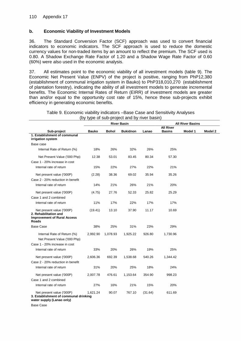
110 Appendix 17
b. Economic Viability of Investment Models
36. The Standard Conversion Factor (SCF) approach was used to convert financial indicators to economic indicators. The SCF approach is used to reduce the domestic currency values for non-traded items by an amount to reflect the premium. The SCF used is 0.80. A Shadow Exchange Rate Factor of 1.20 and a Shadow Wage Rate Factor of 0.60 (60%) were also used in the economic analysis.
37. All estimates point to the economic viability of all investment models (table 9). The Economic Net Present Value (ENPV) of the project is positive, ranging from PhP12,380 (establishment of communal irrigation system in Bauko) to PhP318,010,270 (establishment of plantation forestry), indicating the ability of all investment models to generate incremental benefits. The Economic Internal Rates of Return (EIRR) of investment models are greater than and/or equal to the opportunity cost rate of 15%, hence these sub-projects exhibit efficiency in generating economic benefits.
Table 9. Economic viability indicators –Base Case and Sensitivity Analyses (by type of sub-project and by river basin)
Sub-project
River Basin All River Basins
Bauko Bohol Bukidnon Lanao All River Basins Model 1 Model 2
1. Establishment of communal irrigation system
Base case Internal Rate of Return (%) 18% 26% 32% 26% 25%
Net Present Value ('000 Php) 12.38
53.01 83.45
80.34
57.30
Case 1 - 20% increase in cost Internal rate of return 15% 22% 27% 22% 21%
Net present value ('000P)
(2.28)
38.36 69.02
35.94
35.26
Case 2 - 20% reduction in benefit Internal rate of return 14% 21% 26% 21% 20%
Net present value ('000P)
(4.75)
27.76 52.33
25.82
25.29
Case 1 and 2 combined Internal rate of return 11% 17% 22% 17% 17%
Net present value ('000P)
(19.41)
13.10 37.90
11.17
10.69
2. Rehabilitation and Improvement of Rural Access Roads
Base Case 38% 25% 31% 23% 29%
Internal Rate of Return (%) 2,992.90
1,078.93 1,925.22
926.80
1,730.96 Net Present Value ('000 Php)
Case 1 - 20% increase in cost Internal rate of return 33% 20% 26% 19% 25%
Net present value ('000P) 2,606.36
692.39 1,538.68
540.26
1,344.42
Case 2 - 20% reduction in benefit Internal rate of return 31% 20% 25% 18% 24%
Net present value ('000P) 2,007.78
476.61 1,153.64
354.90
998.23
Case 1 and 2 combined Internal rate of return 27% 16% 21% 15% 20%
Net present value ('000P) 1,621.24
90.07 767.10
(31.64)
611.69
3. Establishment of communal drinking water supply (Lanao only)
Base Case
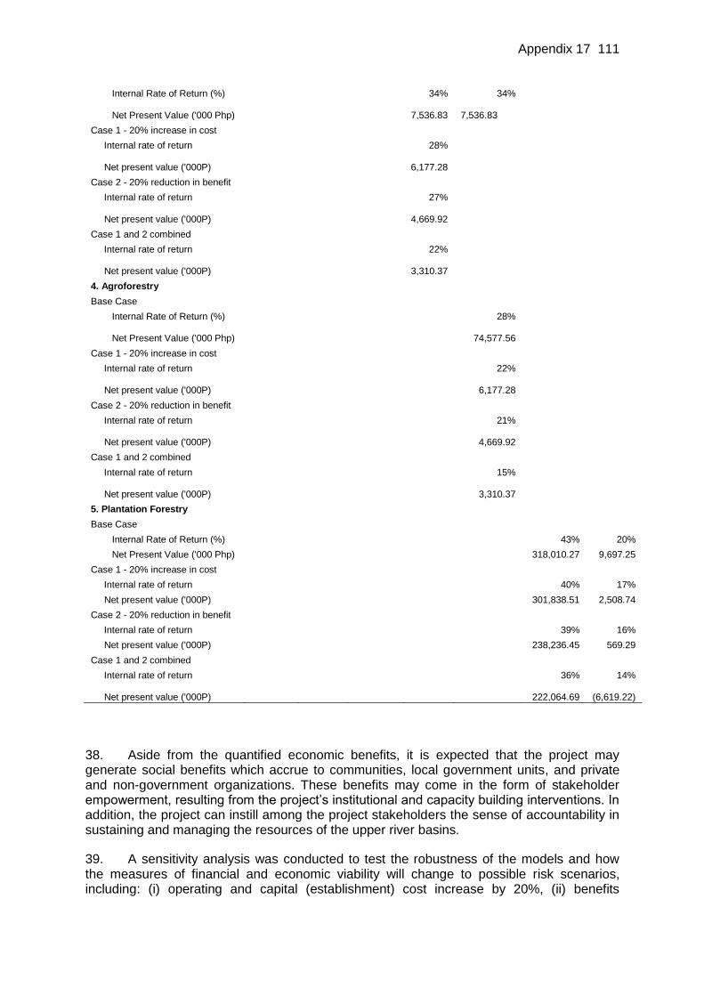
Appendix 17 111
Internal Rate of Return (%)
34% 34%
Net Present Value ('000 Php)
7,536.83
7,536.83
Case 1 - 20% increase in cost Internal rate of return
28%
Net present value ('000P)
6,177.28
Case 2 - 20% reduction in benefit Internal rate of return
27%
Net present value ('000P)
4,669.92
Case 1 and 2 combined Internal rate of return
22%
Net present value ('000P)
3,310.37
4. Agroforestry Base Case Internal Rate of Return (%)
28%
Net Present Value ('000 Php)
74,577.56
Case 1 - 20% increase in cost Internal rate of return
22%
Net present value ('000P)
6,177.28
Case 2 - 20% reduction in benefit Internal rate of return
21%
Net present value ('000P)
4,669.92
Case 1 and 2 combined Internal rate of return
15%
Net present value ('000P)
3,310.37
5. Plantation Forestry Base Case Internal Rate of Return (%)
43% 20%
Net Present Value ('000 Php)
318,010.27 9,697.25
Case 1 - 20% increase in cost Internal rate of return
40% 17%
Net present value ('000P)
301,838.51 2,508.74
Case 2 - 20% reduction in benefit Internal rate of return
39% 16%
Net present value ('000P)
238,236.45 569.29
Case 1 and 2 combined Internal rate of return
36% 14%
Net present value ('000P) 222,064.69
(6,619.22)
38. Aside from the quantified economic benefits, it is expected that the project may generate social benefits which accrue to communities, local government units, and private and non-government organizations. These benefits may come in the form of stakeholder empowerment, resulting from the project’s institutional and capacity building interventions. In addition, the project can instill among the project stakeholders the sense of accountability in sustaining and managing the resources of the upper river basins.
39. A sensitivity analysis was conducted to test the robustness of the models and how the measures of financial and economic viability will change to possible risk scenarios, including: (i) operating and capital (establishment) cost increase by 20%, (ii) benefits

112 Appendix 17
decrease by 20%, and (iii) combined 20% increase in operating and capital cost and 20% decrease in benefits.
40. Despite the possible 20% increase in operating and capital cost, all sub-projects remain economically viable, except for the Bauko communal irrigation system project. Based on the sensitivity tests, the communal irrigation system sub-project in Bauko appear to be the most sensitive to possible increase in cost. Meanwhile, most sub-projects remain economically viable even if costs are doubled. If benefits decrease by 20%, all sub-projects remain economically viable. As in the first risk scenario, the communal irrigation sub-project in the Bauko watershed appears to be very sensitive to risk situations. The 20% decrease in benefits may cause the EIRR to decrease to 14%.
E. Project-Wide Economic Analysis
41. As a whole, the project is economically viable given an EIRR of 22% and an ENPV of about Php2.7 billion (Table 10). The project remains viable even if subjected to different sensitivity tests. A 2-year delay yields the smallest EIRR of 16% and ENPV of about Php414,559,320. Sensitivity analysis 3 (simultaneous increase in costs by 10% and decrease in benefits by 10%) yields an EIRR of 19% and a positive ENPV of Php1,532,203,810.
Table 10. Project-wide economic viability indicators –Base Case and Sensitivity Analyses
Case IRR NPV
Base Case 22% 2,671,747.84
Sensitivity analysis 1: 10% increase in investment and operating cost 21% 2,235,563.22
Sensitivity analysis 2: 10% decrease in benefits 21% 1,968,388.43
Sensitivity analysis 3: simultaneous change in benefits and costs (by 10%) 19% 1,532,203.81
Sensitivity analysis 4: Delay in realizing benefits by 1 year 17% 783,233.98
Sensitivity analysis 5: Delay in realizing benefits by 2 years 16% 414,559.32
F. Conclusions
42. The objective of the Project is to improve the management of the natural resources in the watersheds of river basins in order to prevent further degradation and begin the process of rehabilitation. As discussed in the sector analysis, the current degradation has a huge cost implication for downstream populations and utilities that suffer from flash floods, irregular water flow, heavy deposits of soil and an environment that offers less and less in the way of aesthetic and recreational values.
43. An additional loss to the river basins as a whole from the soil erosion is the value of the nutrients lost in the topsoil that is washed away. These must either be replaced with artificial fertilizer or else there will be a gradual reduction in crop productivity. This is a more general loss throughout all the river basins. The FAO study on soil depreciation, referred to in the sector analysis estimated the value of the nutrients lost in a metric ton of soil as PhP 12.9 or US$ 0.33. Using this figure for the four river basins, the value of the nutrients lost annually is about US$37 million. As with the power losses, if 10% of the cultivated land on steep slopes, or a total of 12,000 ha in the four selected river basins is converted to agroforestry or tree cover, reduction in nutrient loss can be valued at US$ 1.7 million

Appendix 17 113
annually, with an NPV (at 12%) of about US$ 12.7 million. The challenges for INREM Project will be to demonstrate that these changes actually take place following the project investment, and to determine and collect an appropriate payment from the beneficiaries.
44. It is part of the INREM concept that if these benefits are tangible for downstream interests, the upstream farmers who modify their practices should receive at least part of the benefit enjoyed downstream as compensation for any opportunity costs associated with the change in practice. However, these benefits for the upstream farmers will have to be provided in advance in order that they change their land-use practices, and this argues strongly in favor of the “equity model” approach, since if the government invests with the farmers and shares the risks, it will have a stake in the PES later, and therefore an incentive to both ensure that the farmers perform well, and that the results are properly monitored.
45. There will also be investments in community-based protection and monitoring, reforestation, enrichment planting or assisted natural regeneration, and sustainable forest management. These will bring immediate direct benefits in the form of cash income to those community members who are employed, but over time there will also be benefits to downstream interests, especially from improved water supply and quality, and also in the form of economic opportunities with ecotourism, bio-prospecting and other recreational pursuits. The INREM concept is that the local government should fund these activities initially from the project loan funds, and should begin charging downstream beneficiaries as soon as possible in order to generate revenue with which to sustain the management of the natural resources, especially the forest.
46. The benefits of a well-managed watershed are substantial and well beyond those quantified in the model and subproject analysis presented here. Rapid assessment of economic values of ecosystem services have been documented in Table 1 and in the scenario analysis in section C. During implementation and over time, the Project will take steps to measure and quantify such indicators as water yield, water quality, forest cover, biodiversity, and micro-climate improvement. Healthier watersheds will have the ability to support an array of downstream services, including improved agriculture and irrigation, water districts, hydropower, industry and commerce, and downstream fisheries and estuaries. The value of improved watershed management also include: (i) gains from carbon sequestration, expanded tourism potential and environmental aesthetics, and (ii) losses-avoided such as flood damages from extreme weather events, salt water inundation of coastal aquifers, and costs associated with reduced and irregular river flow.
47. Moreover, the non-quantified benefits on the human resource component such as empowered communities, local government units the private, government and non-government sectors are not disregarded. The investments on the institutional and capacity building interventions of the Project is envisaged to instill in the project stakeholders the sense of accountability in sustaining and managing the resources of upper river basin ecosystems.
48. At the present, there is little information on the populations of floral and faunal species in the four URBs or the numbers that are threatened or endangered. Without this information it is difficult to asses the benefits that might be derived from use of non-timber forest products, agro-biodiversity, crop pollination, natural disease control, ecotourism or bio-prospecting that could result in revenues being generated. Interventions funded under a grant from the Global Environment Facility primarily for biodiversity conservation and other environmental protection activities will examine a range of possible Payments for Environmental Services, and in so doing will throw light on the financial and economic benefits that would arise from investment in biodiversity conservation and other environmental protection measures. The study on the Climate Change adaptation sheds light on the likely economic costs of climate change through increased natural disasters and

114 Appendix 17
reduction in crop productivity due to drought or floods as well as possible changes in the distribution and prevalence of diseases.