
Proposed Building Addition Saint Michael’s Cemetery 500 ...
88
Proposed Building Addition Saint Michael’s Cemetery 500 Canterbury Street Roslindale, MA Notice of Intent Filing Prepared for: Saint Michael’s Cemetery c/o Michael Sheehan 500 Canterbury Street Roslindale, MA Submitted by: Joyce Consulting Group, PC 100 Wyman Road Braintree, MA (781) 817-6120 [email protected] May 5, 2021 Rev. July 2, 2021
Transcript of Proposed Building Addition Saint Michael’s Cemetery 500 ...
Proposed Building Addition
Saint Michael’s Cemetery 500 Canterbury Street
Roslindale, MA
Notice of Intent Filing
Prepared for:
Saint Michael’s Cemetery c/o Michael Sheehan
500 Canterbury Street Roslindale, MA
Submitted by:
Joyce Consulting Group, PC 100 Wyman Road
Braintree, MA (781) 817-6120
May 5, 2021
Rev. July 2, 2021

TABLE OF CONTENTS
PROJECT NARRATIVE PAGES 1‐6
APPENDICES:
APPENDIX A: NOTICE OF INTENT
APPENDIX B: FIGURES
‐USGS LOCUS
‐FEMA FIRMETTE
‐WETLAND SUMMARY FORM
APPENDIX C: ABUTTERS INFORMATION
APPENDIX D: STORMWATER CHECKLIST & REPORT
APPENDIX E: PLAN SET

NOI Application 1 500 Canterbury Street
Proposed Building Addition Boston, MA
PROJECT NARRATIVE 1.0 INTRODUCTION
The applicant, Mr. Michael Sheehan of St. Michael’s Cemetery proposes to construct a 7,600 square foot addition to an existing mausoleum building with associated site improvements at 500 Canterbury Street in the Roslindale neighborhood of Boston. The majority of the proposed work will take place within the 100-foot buffer to a Bordering Vegetated Wetland associated with Canterbury Brook which bisects the project parcel. A small portion of the project will also take place within the 25-foot riverfront, this work consists of utility improvements over an existing bridge.
The plans included with this filing show the scope of the proposed work as well as the resource areas located on the site. Due to the fact that a portion of the proposed work falls within the 100-foot buffer to a resource area and within the 25-foot riverfront, the project is subject to the jurisdiction of the Massachusetts Wetlands Protection Act and the City of Boston Conservation Commission.
2.0 EXISTING CONDITIONS
2.1 Site Description
The site is located at 500 Canterbury Street, the parcel is bounded to the north by Canterbury Street, to the west by Walk Hill Street, to the south by American Legion Highway and to the east by a commercial landscape operation. The development parcel is approximately 12 acres in size and consists of a large cemetery lot occupied by two structures, a crematorium and a mausoleum building with office space. In addition to these structures the site also has bituminous concrete driveways and cemetery plots. Bisecting the entirety of the parcel is Canterbury Brook which generally runs parallel to American Legion Highway. Existing site features are indicated on the “Existing Conditions Plan” within the enclosed Plan Set. Existing features can also be seen below in Figure 1 “500 Canterbury Street Aerial Image”.
The site a rectangular lot that is relatively level and generally slopes at a gradual pitch towards Canterbury Brook. There are catch basins scattered throughout the site that ultimately drain to Canterbury Brook. There are no other stormwater management systems located on site.
There is bordering vegetated wetland located sporadically throughout the site. This wetland is associated with Canterbury Brook which has a 25-foot riverfront area.

NOI Application 2 500 Canterbury Street
Proposed Building Addition Boston, MA
Figure 1: 500 Canterbury Street - Aerial Image
As noted previously, there are two resources area that impact the site, a portion of the site is located within 100 feet of a Bordering Vegetated Wetland, and a portion of the site is located within the Riparian Zone. The resource areas are associated with Canterbury Brook which bisects the site. The resource areas are defined in the Massachusetts Wetlands Protection Act and the proposed project will require approval from the City of Boston Conservation Commission.
2.2 Rare Species Habitat
The property is not mapped as either priority or estimated habitat of rare species by the MA Natural Heritage and Endangered Species Program (MAGIS 2020) as shown below in Figure 2 “500 Canterbury Street NHESP Viewer.”

NOI Application 3 500 Canterbury Street
Proposed Building Addition Boston, MA
Figure 2 “500 Canterbury Street NHESP Viewer.”
3.0 WETLAND RESOURCE AREAS
The following wetland resources area are present on site and is subject to protection under the Wetlands Protection Act (M.G.L. Ch. 131 § 40) and the City of Boston Conservation Commission.
3.1 Bordering Vegetated Wetland
According to 310CMR 10.55(2)(a) A Bordering Vegetated Wetlands are freshwater wetlands which border on creeks, rivers, streams, ponds and lakes. The types of freshwater wetlands are wet meadows, marshes, swamps and bogs. Bordering Vegetated Wetlands are areas where the soils are saturated and/or inundated such that they support a predominance of wetland indicator plants.
The Bordering Vegetated Wetland (B.V.W.) is located immediately adjacent to Canterbury Brook with an associated 100-foot buffer extending into the area of proposed work. The proposed work will take place within previously disturbed grass area and paved areas. The proposed building footprint will extend to within approximately 20 feet from the resource area. There will be no work performed within the resource area. It is anticipated that this work will not have any adverse impact to the resource area.
The proposed project meets the general performance standards of 310CMR because all of the work will be performed outside of the resource area. There will be no work performed within the resource area.
3.2 Inland Bank
According to 310CMR 10.55(2)(a) A Bank is the portion of the land surface which normally abuts and confines a water body. It occurs between a water body and a vegetated bordering wetland and adjacent flood plain, or, in the absence of these, it occurs between a water body and an upland. A Bank may be

NOI Application 4 500 Canterbury Street
Proposed Building Addition Boston, MA
partially or totally vegetated, or it may be comprised of exposed soil, gravel or stone.
The Inland Bank is associated with Canterbury Brook, the bank has a 100-foot buffer extending into the area of proposed work. The proposed work will take place within previously disturbed grass area and paved areas. The proposed building footprint will extend to within approximately 20 feet from this resource area. There will be no work performed within the resource area. It is anticipated that this work will not have any adverse impact to the resource area.
The proposed project meets the general performance standards of 310CMR because all of the work will be performed outside of the resource area. There will be no work performed within the resource area.
3.3 Riverfront Area
According to 310CMR 10.58(2)(a) A Riverfront Area is the area of land between a river's mean annual high-water line and a parallel line measured horizontally. The riverfront area may include or overlap other resource areas or their buffer zones. The riverfront area does not have a buffer zone.
The Riverfront Area on the site is associated with Canterbury Brook, the associated riparian area is 25 feet. There will be no work performed within the riverfront area with the exception of utility installations that will be performed within the existing driveway, over an existing bridge. The driveway surface will be restored to its existing condition. It is anticipated that this work will not have any adverse impact to the resource area.
The proposed project meets the following performance standards: a) Protection of Other Resource Areas – The work performed for the proposed project will not take place within any other resource areas. Work that takes place within buffer areas will be performed areas that have been previously disturbed. b) Protection of Rare Species – It is not anticipated that the proposed work will have any impact on Rare Species. The work performed within the Riverfront area will consist of the installation of a water service within an existing paved driveway, at the end of the work the trench will be repaved. c) Practicable and Substantially Equivalent Economic Alternatives – There are no practicable and substantially equivalent alternatives as presented in the following alternatives analysis.
No Work Alternative:
In this option, there would be no work performed. This is not an economically viable option for the proposed development.
Move Addition North on the Property:
In this option, the addition would be tied into the north end of the existing building. In this alternative the proposed addition would be closer to all of the resource areas on site. The grading would ultimately be pushed into the wetland area. This option was not selected as it would have a greater impact on all of the resource areas.
Addition Centered on the North Side of the Building (Selected Option):
In this option, the addition would be tied into middle of the east side of the existing building. In this alternative the proposed addition would be located within the existing grass field. There will be no

NOI Application 5 500 Canterbury Street
Proposed Building Addition Boston, MA
significant work within any of the resource areas and no negative impact on any resource area. This is the preferred alternative.
3.4 Waterfront Area
According to the Boston Wetland Ordinance Section 7-1.4 the Waterfront Area is the portion of the buffer zone which extends twenty-five (25) feet horizontally from the edge of the following wetland resource areas:
1. Any coastal beach, dune, bank, tidal flats, rocky intertidal shores, salt marshes or land containing shellfish; or
2. Any inland bank, lake, pond, intermittent stream, brook, creek or riverfront area.
The Waterfront Area on the site is associated with 25 foot riparian zone that extends from Canterbury Brook. There will be no work performed within the waterfront area with the exception of utility installations that will be performed within the existing driveway, over an existing bridge and a minimal amount of grading that will be performed in an area of existing open grass. Once the grading has been complete the surface will be returned to it’s original condition, the entirety of the waterfront area will remain vegetated. It is anticipated that this work will not have any adverse impact to the resource area.
4.0 PROPOSED IMPROVEMENTS
4.1 Proposed Site Improvements
The proposed project consists of the construction of a building addition to the existing mausoleum. The proposed building addition will have a footprint of approximately 7,610 square feet, with associated site grading, landscaping, utilities and a new driveway and parking area. The new building will have vehicular access from an existing internal driveway running parallel to American Legion Highway. There will be additional parking provided within the new parking area located immediately west of the proposed addition. Proposed site features and utility connections are indicated on the “Proposed Site Plan”.
The majority of the proposed work is located within the 100-foot buffer to the Bordering Vegetated Wetland (B.V.W.) The existing driveway is not curbed and stormwater runs off the driveway untreated and into the wetland buffer. The proposed driveway will be bordered by bituminous concrete berm and all runoff will be directed to deep sump catch basins and then directed to an isolator row within the proposed subsurface infiltration area. The infiltration area will consist of 64 Stormtech SC-740 chambers surrounded with crushed stone. The infiltration area will outlet at an outlet control structure from which the stormwater will flow to an existing drainage manhole and ultimately to Canterbury Brook. The detention system has been designed to overflow during large storm events. The result of the proposed drainage design will be cleaner stormwater leaving the site at a reduced rate of runoff during all storm events. Overall, the proposed work, including the proposed drainage improvements are not anticipated to have any negative impact on the resource area. Details for proposed site features and improvements are indicated on the “Proposed Site Plan” plan.
4.2 Erosion Controls
Temporary erosion controls consisting of staked mulch wattles will be installed prior to commencement of

NOI Application 6 500 Canterbury Street
Proposed Building Addition Boston, MA
construction activities along the limit of work. All temporary erosion control devices will be inspected daily in areas of active construction to ensure proper functioning and maintenance. In other areas, temporary erosion control will be inspected and maintained throughout construction, and within 24 hours following storm events of greater than or equal to 0.25 inches of precipitation within a 24-hour period.
4.3 Site Stabilization and Planting
The final phase of the project is the restoration and stabilization of all exposed surfaces. Permanent restoration and re-vegetation measures serve to control erosion and sedimentation by establishing a vegetative cover. In the event that weather conditions prevent final restoration, temporary erosion and sedimentation measures will be employed until the weather is suitable for final cleanup. A final inspection will ensure that the project site has been permanently stabilized. Straw wattles and erosion controls will not be removed until the site is stabilized and the final inspection is complete.
5.0 REGULATORY COMPLIANCE
5.1 Wetlands Protection Act
The Project, as designed, complies with the performance standards of the Wetlands Protection Act for work proposed within the resource areas and their buffers. Erosion controls shall be installed at the limit of work to prevent stormwater from carrying sediment off site. Stormwater that outlets to Canterbury Brook will now be treated and the existing waterfront area will remain undisturbed.
6.0 CONSTRUCTION SEQUENCE
The following section provides construction details and highlights the construction sequence and timing of earthmoving activities.
6.1 Clearing
It is not anticipated that any clearing will be necessary. If any small shrubs or trees need to be removed, it shall be done in a manner that proceeds along the limit of work closest to the BVW such that erosion controls may be installed immediately subsequent to the vegetation removal. No grading will be conducted prior to the installation of erosion controls.
6.2 Installation of Erosion Controls
Erosion and sedimentation controls (i.e., mulch filled waddles) will be installed where needed and inspected at the limits of the work area prior to the commencement of earth moving activities.
6.3 Site Preparation and Foundation Construction

NOI Application 7 500 Canterbury Street
Proposed Building Addition Boston, MA
During this phase of construction, the foundation will be excavated and constructed. The excavation for the stormwater infiltration area will also be completed. Any soil that needs to be removed will not be stockpiled on site for any extended period of time and will be removed from the site prior to the end of the work day.
6.4 Utility Installation, Site Work and Vertical Construction of Building
During this phase of construction, the proposed sewer lateral, water, electric and gas services will be installed. Any soil that needs to be removed will not be stockpiled on site for any extended period of time and will be removed from the site prior to the completion of the work day.
6.5 Site Stabilization
The final phase of the project is the restoration and stabilization of all exposed surfaces. Disturbed areas will be landscaped or seeded as necessary with an erosion control seed mix. Much of the disturbed area is to be rough graded with topsoil and allowed to revegetated with indigenous species and kept thereafter in a natural state as habitat. Permanent restoration and revegetation measures serve to provide additional habitat and to control erosion and sedimentation by establishing a vegetative cover. In the event that weather conditions prevent final restoration, temporary erosion and sedimentation measures will be employed until the weather is suitable for final cleanup. A final inspection will ensure that the project site is cleared of all project debris and that erosion and sedimentation controls are functioning properly. Erosion controls will not be removed until the site is stabilized and the final inspection is complete.
7.0 CLIMATE CHANGE RESILIENCE
The following section provides construction details and highlights the construction sequence and timing of earthmoving activities.
7.1 Measures
The site has been designed in an effort to take climate change resilience into account. The proposed parking area incorporates landscape islands to minimize heat island effects. The parking area has also been designed to incorporate a stormwater management system that recharges stormwater, provides stormwater treatment and decreases stormwater runoff from the site. This system will improve stormwater runoff now and over the course of future rain events.

Appendix A: Notice of Intent


NOTICE OF INTENT APPLICATION FORM Boston Wetlands Ordinance City of Boston Code, Ordinances, Chapter 7-1.4
1
_______________ Boston File Number
_______________ MassDEP File Number
A. GENERAL INFORMATION
1. Project Location
a. Street Address b. City/Town c. Zip Code
f. Assessors Map/Plat Number g. Parcel /Lot Number
2. Applicant
a. First Name b. Last Name c. Company
d. Mailing Address
e. City/Town f. State g. Zip Code
h. Phone Number i. Fax Number j. Email address
3. Property Owner
4. Representative (if any)
a. First Name b. Last Name c. Company
d. Mailing Address
e. City/Town f. State g. Zip Code
h. Phone Number i. Fax Number j. Email address
a. First Name b. Last Name c. Company
d. Mailing Address
e. City/Town f. State g. Zip Code
h. Phone Number i. Fax Number j. Email address
Check if more than one owner(If there is more than one property owner, please attach a list of these property owners to this form.)
mjoyc
Typewritten Text
mjoyc
Typewritten Text
mjoyc
Typewritten Text
mjoyc
Typewritten Text
mjoyc
Typewritten Text
mjoyc
Typewritten Text
mjoyc
Typewritten Text
mjoyc
Typewritten Text
mjoyc
Typewritten Text
500 Canterbury Street
mjoyc
Typewritten Text
mjoyc
Typewritten Text
mjoyc
Typewritten Text
mjoyc
Typewritten Text
Boston
mjoyc
Typewritten Text
mjoyc
Typewritten Text
02131
mjoyc
Typewritten Text
mjoyc
Typewritten Text
mjoyc
Typewritten Text
Boston Assessors
mjoyc
Typewritten Text
mjoyc
Typewritten Text
mjoyc
Typewritten Text
Italian Catholic Cemetery Association
mjoyc
Typewritten Text
mjoyc
Typewritten Text
Parcel 1405199000
mjoyc
Typewritten Text
Michael
mjoyc
Typewritten Text
Sheehan
mjoyc
Typewritten Text
500 Canterbury Street
mjoyc
Typewritten Text
Boston
mjoyc
Typewritten Text
MA
mjoyc
Typewritten Text
02131
mjoyc
Typewritten Text
617-524-1036
mjoyc
Typewritten Text
617-522-4646
mjoyc
Typewritten Text
Italian Catholic Cemetery Association c/o Michael Sheehan
mjoyc
Typewritten Text
474 Canterbury Street
mjoyc
Typewritten Text
Boston
mjoyc
Typewritten Text
MA
mjoyc
Typewritten Text
02131
mjoyc
Typewritten Text
617-524-1036
mjoyc
Typewritten Text
617-522-4646
mjoyc
Typewritten Text
Michael
mjoyc
Typewritten Text
Joyce
mjoyc
Typewritten Text
Joyce Consulting Group
mjoyc
Typewritten Text
439 Washington Street, 3rd Floor
mjoyc
Typewritten Text
Braintree
mjoyc
Typewritten Text
MA
mjoyc
Typewritten Text
02184
mjoyc
Typewritten Text
781-817-6120
NOTICE OF INTENT APPLICATION FORM Boston Wetlands Ordinance City of Boston Code, Ordinances, Chapter 7-1.4
2
_______________ Boston File Number
_______________ MassDEP File Number
5. Is any portion of the proposed project jurisdictional under the Massachusetts WetlandsProtection Act M.G.L. c. 131 §40?
Yes No
If yes, please file the WPA Form 3 - Notice of Intent with this form
6. General Information
7. Project Type Checklist
a. Single Family Home b. Residential Subdivision
c. Limited Project Driveway Crossing d. Commercial/Industrial
e. Dock/Pier f. Utilities
g. Coastal Engineering Structure h. Agriculture – cranberries, forestry
i. Transportation j. Other
8. Property recorded at the Registry of Deeds
a. County b. Page Number
c. Book d. Certificate # (if registered land)
9. Total Fee Paid
a. Total Fee Paid b. State Fee Paid c. City Fee Paid
B. BUFFER ZONE & RESOURCE AREA IMPACTS
Buffer Zone Only - Is the project located only in the Buffer Zone of a resource area protected by the Boston Wetlands Ordinance?
Yes No
1. Coastal Resource Areas
mjoyc
Typewritten Text
X
mjoyc
Typewritten Text
The applicant is proposing to construct an addition to an existing Mausoleum and perform associated site improvements. The proposed work will take place within 100 feet of Bordering Vegetated Wetland associated with Stony Brook. Refer to Project Narrative for additional information.
mjoyc
Typewritten Text
X
mjoyc
Typewritten Text
Suffolk
mjoyc
Typewritten Text
130
mjoyc
Typewritten Text
7567
mjoyc
Typewritten Text
X
mjoyc
Typewritten Text
$1,050 (WPA Fee) $550 (Bylaw Fee)
mjoyc
Typewritten Text
$512.50
mjoyc
Typewritten Text
$537.50

NOTICE OF INTENT APPLICATION FORM Boston Wetlands Ordinance City of Boston Code, Ordinances, Chapter 7-1.4
3
_______________ Boston File Number
_______________ MassDEP File Number
Resource Area Resource Area Size
Proposed Alteration*
Proposed Migitation
Coastal Flood Resilience ZoneSquare feet Square feet Square feet
25-foot Waterfront AreaSquare feet Square feet Square feet
100-foot Salt Marsh AreaSquare feet Square feet Square feet
Riverfront AreaSquare feet Square feet Square feet
2. Inland Resource Areas
Resource Area Resource Area Size
Proposed Alteration*
Proposed Migitation
Inland Flood Resilience ZoneSquare feet Square feet Square feet
Isolated WetlandsSquare feet Square feet Square feet
Vernal PoolSquare feet Square feet Square feet
Vernal Pool Habitat (vernal pool + 100 ft. upland area)Square feet Square feet Square feet
25-foot Waterfront AreaSquare feet Square feet Square feet
Riverfront AreaSquare feet Square feet Square feet
C. OTHER APPLICABLE STANDARDS & REQUIREMENTS
1. What other permits, variances, or approvals are required for the proposed activity describedherein and what is the status of such permits, variances, or approvals?
mjoyc
Typewritten Text
X
mjoyc
Typewritten Text
69,901
mjoyc
Typewritten Text
50
mjoyc
Typewritten Text
50
mjoyc
Typewritten Text
Approval required from BWSC (currently under review), ZBA (currently under review) and Parks Commission (currently under review)

NOTICE OF INTENT APPLICATION FORM Boston Wetlands Ordinance City of Boston Code, Ordinances, Chapter 7-1.4
4
_______________ Boston File Number
_______________ MassDEP File Number
2. Is any portion of the proposed project located in Estimated Habitat of Rare Wildlife asindicated on the most recent Estimated Habitat Map of State-Listed Rare Wetland Wildlifepublished by the Natural Heritage and Endangered Species Program (NHESP)? To viewhabitat maps, see the Massachusetts Natural Heritage Atlas or go tohttp://www.mass.gov/dfwele/dfw/nhesp/nhregmap.htm.
Yes No
If yes, the project is subject to Massachusetts Endangered Species Act (MESA) review (321 CMR 10.18).
A. Submit Supplemental Information for Endangered Species Review
Percentage/acreage of property to be altered:
(1) within wetland Resource Area percentage/acreage
(2) outside Resource Area percentage/acreage
Assessor’s Map or right-of-way plan of site
3. Is any portion of the proposed project within an Area of Critical Environmental Concern?
Yes No
If yes, provide the name of the ACEC: ____________________________________
4. Is the proposed project subject to provisions of the Massachusetts Stormwater ManagementStandards?
5. Is the proposed project subject to Boston Water and Sewer Commission Review?
Yes No
Yes. Attach a copy of the Stormwater Checklist & Stormwater Report as required.
Applying for a Low Impact Development (LID) site design credits
A portion of the site constitutes redevelopment
Proprietary BMPs are included in the Stormwater Management System
No. Check below & include a narrative as to why the project is exempt
Single-family house
Emergency road repair
Small Residential Subdivision (less than or equal to 4 single family houses or lessthan or equal to 4 units in a multifamily housing projects) with no discharge toCritical Areas
mjoyc
Typewritten Text
X
mjoyc
Typewritten Text
X
mjoyc
Typewritten Text
X
mjoyc
Typewritten Text
X
mjoyc
Typewritten Text
X


������������������ ������������ �������������������������� !"�#"$%&'(')*+,'-.'/01('21'*+'340(/01(('50(3*670('+8)9850:/04+,)*-.'/01;1*+<=>?=@ABCDEDF@GHI*'(98;'J7(89*85+)09KLJL051;'9+JM)N'04O).'JM+8+1*047(89*85+)09JL8+'8937);'P('8+'3JQ���J7,)*-.'09./)95.13'*40(;*+,8+R'(':8(+04/01(+(89*85+)098*04+,'38+'893+);')93)58+'38S0T'6K4/019''38;0('51(('9+50:/04/01(+(89*85+)09U('+1(9+0'LVW893*'.'5++0XL0R9.0838P0:/Y4(0;+,'P1(('9+M1S;)++8.*:8Z'6[\]_[[a[\a\b\[c[[c\c]de\]f][ghijklkmnodpqrstuviwwxorqyz{{

������������� �������������������������������� ��!! "##$�%&'()*(+�&(''&,�$��-.&�/� )0�&0% ��1�2$� � #3�4� ������5 � 63�378""% �����9��5 � :���#64:;<�=�2.�>��? )0�&0%���'��0( 9������>.���? �6#"�88###3��22>������@� �A� 5�> 0�9���B�������C��!�%�D� =@$E�'� ,���!�%�D� �E''E�%��0�9���B����� ��@%&=@$E�'�F�$'='&'(+ �=��>��9� ��!! "##$�%&'()*(+�&(''&��$��-.&�/� )0�&0% <������ =� 9�1�2$� � #3�4�G��G���%5D,�� H�:I"36I�#4H ��C�J ��'D��> D��G��>�!D�K��D��!�����4����2���-0/����D����G������/�����C��!�%�D� =@$E�'� ,���!�%�D� �E''E�%��0�9���B����� ��@%&=@$E�'�F�$'='&'(+ �=��>��9� ��!! "##$�%&'()*(+�&(''&��$��-.&�/� )0�&0% <������ =� 9�1�2$� � #3�4�G��G���%5D,�� H�:I"36I�#4H ��C�J ��'D��> D��G��>�!D�K��D��!�����6�(�2��!������A����C��!�%�D� =@$E�'� ,���!�%�D� L0+$'��0�9���B����� L0+$'$0%�*�&@%MM(0*�N��$� �=��>��9� ��!! 648;��E@%M&0%�&(''&N&E@(OC�00(��$��-.&�/� )(�@%&('' <������ =� 9�1�2$� � #3�76I6:3�G��G���%5D,�� :7�I7�:IH�3# ��C�J ��'D��> D��-��K��-���9���D"�&���>;��C����� P�5��D�����>>-��!���� <��D%0@;��>�� C��&���!D����>C��DQ���&���>C����� �N#"#�## ,������C����� "�3�"# ��$��-.&�/�C����� "4:�"#H�M�����>�������O�!���2�����&E'����@$�%&@��(0�0�@%M&0$0%�&(*$&�%�OO@&@0%&0�%'R@�&@%M=�*�0�'*=�%O�'(C0(=���0$@�&'O�@&'@=�(0S'='%&��&E'�(0�0�'O;0(T;@��&�T'���$';@&E@%�##C''&0C)0(O'(@%MS'M'&�&'O;'&��%O���0$@�&'O;@&E�&0%+)(00T�('C'(&0�(0L'$&%�((�&@S'C0(�OO@&@0%��@%C0(=�&@0%�:���������&-2���� ���9>�C�D�>-E�D� 3� (�!� �����>�5, �A�!���4� ��D��� �������O��A�/�-$��!!��9 6� $�DD�����>.@� 5!����>"� O��U.���� H� *��>����!:� $��!��>'�9�������9���5��5�� 7� �9���5>�5��P�9�N����,�����!N<���!��-Q8� &���!2�������� �#� 0�G��:,�@!��-2�������<�G�2��2�!� ����A��-�>�9�,>���,������� �!�>�D��� 2������!5,������4�#$=(�#�36P���!��>Q��4�#$=(�#�"4P��>�� QV�� +�! %� @<-�!N �!���,�/G��G>�D��� 2�������22>��!���G�!2�������3���D��� �������7����2���-����� � ���G�(�9�!��-�<O�� !<���
j�ee�\kXe���el�f��� �����m�n���� ���������\����)5���5�<(�!�5�������������I;��>�� !o �p�� qrs���\��������=�!!��G5!���!;��>�� !�������������=�M������4�Nt6# ���A� � ,-=�!!O'��=�!!O'�C�>�?��O'�&���!������?��36:8��$��-.&�/��)0�&0%
uvwxyz{|}~�~���������u�


���������� ���������������� ���������� ���������������� ��������������� ���������������� ���������� ������ ��������� ������������ �� ������������������ ���������� ����� ��������� ������������ � ��� ������������������ ���������� ���� !"#$�%&&'()*+'#�,!*-.*$./�*-.�0#12($#3#-!/,!$#*3'(-#.�4*//*)"2/#!!/�5-.*-6#$#.�,&#)(#/�%)!78#!'*-./�9$:!#)!(:-�%)!�0#;(#<=���� >������ �������������?�������������?�� �5/!(3*!#.�@*+(!*!�:A�0*$#�8('.'(A#���� ?����?�� ����������� B����?�C�����D���������EF��?�G����H��� ?�H��?������������?��>����I������C����������B ?� ����?���������������JICB��KL*� M� I����>���� ���?���������������� ������� ?�?������>����IN���OI������C�������� ?�B ?� ����?��������������P����� ����Q�������� ?�H��?����=�G�����C����G��?H����������DR�S=�T=���P���������OQGND�DR��U�BHBG���>���������������������������D�������B ?� ����?��������R��JDB�RK��������JVW=��DG�=S�=TK��������������������� ���� ������� �����B ?� ����?��������G������X�J����Y���Z������>�����>K=� ������ ���������������������>�����������?OJ�K����� �H��� ?�G�������R��� ����� �����������J�K����?��G�������R��� ����� �����������W� �R���[�D����������E��E��>���� ������V� ����������� ������ ���������������� ���?� ������ ?��������������� ?���������?��������� ?�����?���� ������ ��Z�� ��� ?�������?��� ?��� ���Z�� ��� ?�������?������������ ������� ���� ���� ?�������>�?�������?������������Y�XX�� �������?������� �J� ���?� ��?������� �������������?��������� ?��������������\��������]� �K�� ����������������� ��������������� �DB�R����� ������J����� ������� ������������O���O�������������������� ����?���?��� �����E����������������>E���������E� ?� ����?E�����E��E�������E���E���?��������KD�Y������Y���>�������I������C�������\�B ?� ����?��������Q� ?�� ?�3*('�!:�_@5,9����������??��abcdefg�hifdajkl�mn�op�qopr�stpru�bv�ihkwx�higb�gyz{jf|?� U������ �������>�������������� ���������� ����� ��������>�\�B����?�C�������� ?����?��NG�����Y�N ��������������� �=� �����������Z���������DB�R���������R����������� ������� ?���� ��������DB�R��Z����� ���������J����VW=�DG�=S�=}����O�������������������� ����?���?������E�������� �����VW=E���E=SSSE�������E� ?� ����?E�����E������~=S�=}�����IN������������� ���ICB���������������������� ������?������������ ���V=S��DG=S�V��� ?�=S����KW� ���������DB�R��������� ��� �����ICB�������Y� ��I��������P��������?���ICB��V� ��������DB�R���������������?�� ���?�����>����ICB��� ����Y��?����� ��� ��������?��� ������ �\�D� ����� ������������������?���� �X������������-:!�� �B����?�C�������>���������?�� �������>�C������� ?���������ICB������������W�Q����������������� �>����� >������ �������������?�������������?������������� ������������ ������ ��������� L
4*//*)"2/#!!/��#&*$!3#-!�:A�5-;($:-3#-!*'9$:!#)!(:-����������G�������������� �E�H��� ?89%��:$3�����_:!()#�:A��-!#-!D�������H��� ?�������� �R��D���F�����=V=���}S �����?�?��>�D�PB�OD�PB��Q����~O�PB����� ���� �~O=W}��==��>���� O�N��NI
������������������������������������������������������

�� ������������ ������������������� ������������������������������������������������� ������� ������!"#$"%$&"�$�������%���'
���()*�+�,��%����(��������-�������������()*�+�� �� ������*�����.������ /����0�/����� �����()*�+�1���,�%�1����������������.�/��� �����.�����2�����������+���������� ��.��� /���3����� ��4���567����*�������)������������/��������+�������)������������������()*�+���.������8�9�������/� ��4�����/���������� ������������ �� ����� ��4��/�������/��������������������/��������������������:�� �(��� /���/��&� ��4����������/�������������������/��� ��� (�0���������/���� �����������/��������������/�.�������(;0��������'�����������&� ���������������0�/������������ � ��2�0�/����'-�.����������������9���������&����������������9����������������'�*�.��������/���.�����<�#�����������9�����=/.��(���=������������8>?? (����������&�)�//���(���)�� �����'-�.����������������9���������&�(����������;������'�*�.��������/���.��������*��������.����@/�������������A��0����������������������� �� ���A��/�������9�������/������������(��������������� /�������������-*+B��=�����;�����9�������/���������������������������� /�������������-*+B�����������������/���������0������ ������������ �� ����� ��4������������������� ����/�*�.��������/� ������"� * $:�� ��� (� 0������� ��.������������� * �"����������������C+�9���������-*+�C����������� * �/������$��D67EF�/��������/����/�%����C���������� * �(���?�0������ ������������ �� ����� ��4��������������������������������;�����������������C����";�C$�������������������������������������C����G��/���������������?� ���?���:�� ��� (�!�0������ �������������������4������C�/��������������;��������������0�/����C�/����������������"��@�H��������I?��$������� ����/�C�/����������������"��@�H��������I���!$:�� ��� (�#�0������ ��4�����4���� ��.�����������������-*+����������������������������:�� � /���������H���0� ��-�.�/� ����"H0-$������������������"����������������������������������)������%J�/�8�� �� ����$8� �� ����������������������������.�/� ����� +�� �������=�+��������/������������������������������������� (���*K /����������� ��4������K�� '������/��9���/��)���8�*��������������� ��������//����������/������.������"/���������������/���?�����/�&����/������������/���������������/���?�����������/�&����/��������� ��4�$������������������� ����/�������LM�NOOP7P65QR�S5T6UVQ7P65
[QYYQ\]YE77Y�LE_QU7VE57�6T�5aPU65VE57QRbU67E\7P65=�����������������+�������&�C�/����cbN�d6UV�e�f�D67P\E�6T�S57E57�����������C�/�����+�����������@�H���������I?� +��.������������-*+'����-*+�9�/��g'�-*+�,���������g'�8?>A�� ��h,���'=;�,;(
ijkl�m�no�p�q�rsrtuvwxyt�twiz�������������������������
������������ �������������� ��������������������������������������������������������� ������!"���� ������������������������� ������������!"���� ����������#���$%����������������&�������'�����()*++,-,./012/3.450-,./'�����������������������"����%���%�������6������"7������687$����������������"����������9/1,/:;<:4<='�������������������������������������������� ��������������$"���� �"���"����%�����"�������� �������������>���������� ������������������ ���?�@������������"�������������%������������������������A�"�������� $������������""��������"��������"�����&�����������&���������������>������������������������������������"������� �������������$��B����������" ���������������"��������������������������������������������������������C��������D��������E������FCDEG���������������������������������������$������������������������"�����""��������������������7�����" ���������"��CDE��������������������������� �������������H���>�BCDE����>��������$�>�������������"'����������� A8�����"��������'���>����������A����$A�����������������������"������������� � �I��������������������"������������������������������������%�������687�0)J10/K,-1:= L)J10/J4:M04:+NO= P)J10/Q,R/:+SQ-05M:+NO=P)T:U,<:+V,/01(0-:=:)QP01:=B�8B8��>&7D7IBI'6��W H7&�'�IX8Y&�AB��� Z�[��[�Z��\�7"������������������������� �%���A������������������"������������ �%�������������������"����]�'���������"�"�������"��6����������������������������������B������A�"��������'���������"�"�������"��H������������>��������"H�������������A�"�������_�'�����687E��������W���������������'����������%����������A�"�������a)V::<�����b����c6�"�����"�����������������"�����#�����"�� ��� A��%�A����� A�����������"���&�����%�����A"������� �������d��7������������������������� A������������������������ A�����H������������C� W�������������'������� �'����������������������"����%�����"��������������������������������"���687E��������W�������������$�����"���"���� ����c
f0<<0Pgh<:--<(:M04-5:/-.3a/U,4./5:/-01J4.-:P-,./C������"��������B���������!E�������iJ*V.45jkl.-,P:.32/-:/-H������������E�������B���������'��H�@�I������Am Z B�������� H���>�BcH���>�B���nc�>�BW����������nc�� ��&�� [W�%�cC8�W86
opqrstuvwxyxz{|}~�zz}o�


������������� ���� ������������������������� !"#$�%& '�&������� ($%%$�����)�*���+���,� (�"�-�!"#$�%&.(�#%!%-%/01��!�����*��11� �� 233�#��-%/45/0�(-/%%- ��#��67-,8� 4)(-)� 9��(��� !� *��:���#,1 3;�<�=��>=,� ��?�' � @�A2;B�3<@ �����C D��%���� ���=� �����E�,������� �;�>�,� ��6�)8� ��F�9�1�99 � ��G������������ !"#$�%& '��&������� ($%%$�����)�*���+���,� (�"�-�!"#$�%&.(�#%!%-%/01��!�����*��11� �� 233�#��-%/45/0�(-/%%- ��#��67-,8� 4)(-)� 9�(��� !� *��:���#,1 3;�<�=��>=,� ��?�' � @�A2;B�3<@ �����C D�%���� ���=� �����E�,������� �<��>�,D ���&,����,�����(�� ���11� �� 233�#��-%/45/0�(-/%%- '��#��67-,8� 4)(-)��� �6,?� C ��� 1�9�,��� H�I JK�� �8����' � C ��� 1��9�6,?��� �,� �,9��= �9,��,8��*�#��67-,8�7#,?��67L�������!?��������$,?���*��?�=,���6"�1����-��' �$,?���*��?�=,���6!4-�(��� ��* ��� ���� �,��6� C �����9��= �9 ����� ����=���M�33N��OJJP���Q�R�SR�J ���Q�RIT�UJ� ���Q�R�OJJ VO�WT�����J� XTU�S ��4�G�%�#$�45"&L"�Y�F�)/�L%Z%&)>!%�-G"�#&5L"�Y�("-%[ � �323�33 �323�33#��67-,8���=�� �,9�9�����*�9 M2<A�23 (��� ��=�� �,9�9����*�9 M2�;�23 -,����>�,D ���� M�\323�33
W�PP��]TPJP�J����J� ��_Q�� �J���� J�� 4?� �?�,9�/ �,?�� �>�,� ���,��a�b ����1�c ��O ���d�e�I ��J� ��cJ��f�OJJS��P����O ��!�����=?� ����b ����1��>�,� ���,������!�Y�&������<�\�gB3 >�,h�1 1�'6�!���L%>�!���L%>���� �i� L%>�-��������,��i��;BAj��#��67-,8��4)(-)�
klmn�o�pq�o�r�stsuvwxyzu�uxk{�������������������������

Appendix B: Figures

USGS Quad 233890
St. Michael’s Cemetery - 500 Canterbury Street – Roslindale, MA

National Flood Hazard Layer FIRMette
0 500 1,000 1,500 2,000250Feet
Ü
SEE FIS REPORT FOR DETAILED LEGEND AND INDEX MAP FOR FIRM PANEL LAYOUT
SPECIAL FLOODHAZARD AREAS
Without Base Flood Elevation (BFE)Zone A, V, A99
With BFE or DepthZone AE, AO, AH, VE, AR
Regulatory Floodway
0.2% Annual Chance Flood Hazard, Areasof 1% annual chance flood with averagedepth less than one foot or with drainageareas of less than one square mileZone X
Future Conditions 1% AnnualChance Flood HazardZone X
Area with Reduced Flood Risk due toLevee. See Notes.Zone X
Area with Flood Risk due to LeveeZone D
NO SCREENArea of Minimal Flood HazardZone X
Area of Undetermined Flood HazardZone D
Channel, Culvert, or Storm Sewer
Levee, Dike, or Floodwall
Cross Sections with 1% Annual Chance17.5 Water Surface Elevation
Coastal Transect
Coastal Transect BaselineProfile BaselineHydrographic Feature
Base Flood Elevation Line (BFE)
Effective LOMRs
Limit of StudyJurisdiction Boundary
Digital Data Available
No Digital Data Available
Unmapped
This map complies with FEMA's standards for the use ofdigital flood maps if it is not void as described below.The basemap shown complies with FEMA's basemapaccuracy standards
The flood hazard information is derived directly from theauthoritative NFHL web services provided by FEMA. This mapwas exported on 5/5/2021 at 11:01 PM and does notreflect changes or amendments subsequent to this date andtime. The NFHL and effective information may change orbecome superseded by new data over time.
This map image is void if the one or more of the following mapelements do not appear: basemap imagery, flood zone labels,legend, scale bar, map creation date, community identifiers,FIRM panel number, and FIRM effective date. Map images forunmapped and unmodernized areas cannot be used forregulatory purposes.
Legend
OTHER AREAS OFFLOOD HAZARD
OTHER AREAS
GENERALSTRUCTURES
OTHERFEATURES
MAP PANELS
8
B20.2
The pin displayed on the map is an approximatepoint selected by the user and does not representan authoritative property location.
1:6,000
71°6'56"W 42°17'28"N
71°6'18"W 42°17'2"N
Basemap: USGS National Map: Orthoimagery: Data refreshed October, 2020

Appendix C: Abutters Information

BABEL NOTICE
English:
IMPORTANT! This document or application contains important information about your rights,
responsibilities and/or benefits. It is crucial that you understand the information in this document
and/or application, and we will provide the information in your preferred language at no cost to
you. If you need them, please contact us at [email protected] or 617-635-3850.
Spanish:
¡IMPORTANTE! Este documento o solicitud contiene información importante sobre sus derechos,
responsabilidades y/o beneficios. Es fundamental que usted entienda la información contenida en
este documento y/o solicitud, y le proporcionaremos la información en su idioma preferido sin
costo alguno para usted. Si los necesita, póngase en contacto con nosotros en el correo electrónico
[email protected] o llamando al 617-635-3850.
Haitian Creole:
AVI ENPÒTAN! Dokiman oubyen aplikasyon sa genyen enfòmasyon ki enpòtan konsènan dwa,
responsablite, ak/oswa benefis ou yo. Li enpòtan ke ou konprann enfòmasyon ki nan dokiman
ak/oubyen aplikasyon sa, e n ap bay enfòmasyon an nan lang ou prefere a, san ou pa peye anyen. Si
w bezwen yo, tanpri kontakte nou nan [email protected] oswa 617-635-3850.
Traditional Chinese:
非常重要!這份文件或是申請表格包含關於您的權利,責任,和/或福利的重要信息。請您務必完全理解
這份文件或申請表格的全部信息,這對我們來說十分重要。我們會免費給您提供翻譯服務。如果您有需要
請聯糸我們的郵箱 [email protected] 電話# 617-635-3850..
Vietnamese:
QUAN TRỌNG! Tài liệu hoặc đơn yêu cầu này chứa thông tin quan trọng về các quyền, trách nhiệm
và/hoặc lợi ích của bạn. Việc bạn hiểu rõ thông tin trong tài liệu và/hoặc đơn yêu cầu này rất quan
trọng, và chúng tôi sẽ cung cấp thông tin bằng ngôn ngữ bạn muốn mà không tính phí. Nếu quý vị
cần những dịch vụ này, vui lòng liên lạc với chúng tôi theo địa chỉ [email protected] hoặc số điện thoại
617-635-3850.
Simplified Chinese:
非常重要!这份文件或是申请表格包含关于您的权利,责任,和/或福利的重要信息。请您务必完全理解
这份文件或申请表格的全部信息,这对我们来说十分重要。我们会免费给您提供翻译服务。如果您有需要
请联糸我们的邮箱 [email protected] 电话# 617-635-3850.

Cape Verdean Creole:
INPURTANTI! Es dukumentu ó aplikason ten informason inpurtanti sobri bu direitus,
rasponsabilidadis i/ó benefísius. Ê krusial ki bu intendi informason na es dukumentu i/ó aplikason
ó nu ta da informason na língua di bu preferênsia sen ninhun kustu pa bó. Si bu prisiza del,
kontata-nu na [email protected] ó 617-635-3850.
Arabic:
مھم! یحتوي ھذا المستند أو التطبیق على معلومات مھمة حول حقوق ك ومسؤولیاتك أو فوائدك. من الأھمیة أن تفھم المعلومات الواردة في ھذا المستند أو
التطبیق. سوف نقدم المعلومات بلغتك المفضلة دون أي تكلفة علیك. إذا كنت في حاجة إلیھا، یرجى الاتصال بنا على
[email protected] أو.617-635-3850
Russian:
ВАЖНО! В этом документе или заявлении содержится важная информация о ваших правах,
обязанностях и/или льготах. Для нас очень важно, чтобы вы понимали приведенную в этом
документе и/или заявлении информацию, и мы готовы бесплатно предоставить вам
информацию на предпочитаемом вами языке. Если Вам они нужны, просьба связаться с нами
по адресу электронной почты [email protected], либо по телефону 617-635-3850.
Portuguese:
IMPORTANTE! Este documento ou aplicativo contém Informações importantes sobre os seus
direitos, responsabilidades e/ou benefícios. É importante que você compreenda as informações
contidas neste documento e/ou aplicativo, e nós iremos fornecer as informações em seu idioma de
preferência sem nenhum custo para você. Se precisar deles, fale conosco: [email protected] ou
617-635-3850.
French:
IMPORTANT ! Ce document ou cette demande contient des informations importantes concernant
vos droits, responsabilités et/ou avantages. Il est essentiel que vous compreniez les informations
contenues dans ce document et/ou cette demande, que nous pouvons vous communiquer
gratuitement dans la langue de votre choix. Si vous en avez besoin, veuillez nous contacter à
[email protected] ou au 617-635-3850.

NOTIFICATION TO ABUTTERS
BOSTON CONSERVATION COMMISSION
In accordance with the Massachusetts Wetlands Protection Act, Massachusetts General Laws Chapter 131, Section 40, and the Boston Wetlands Ordinance, you are hereby notified as an abutter to a project filed with the Boston Conservation Commission. A. ItalianCatholicCemeteryAssociationhas filed a Notice of Intent with the Boston Conservation Commission seeking permission to alter an Area Subject to Protection under the Wetlands Protection Act (General Laws Chapter 131, section 40) and Boston Wetlands Ordinance. B. The address of the lot where the activity is proposed is 500CanterburyStreet. C. The project involves constructionofanadditiontoanexistingbuildingandperformassociatedsiteimprovements. Workwilltakeplacewithin100feetofaBorderingVegetatedWetland. D. Copies of the Notice of Intent may be obtained by contacting the Boston Conservation Commission at [email protected]. E. Copies of the Notice of Intent may be obtained from JoyceConsultingGroup,P.C.(781)817‐6120between the hours of 10‐2,Monday‐Friday. F. In accordance with the Commonwealth of Massachusetts Executive Order Suspending Certain Provisions of the Open Meeting Law, the public hearing will take place virtuallyat https://zoom.us/j/6864582044. If you are unable to access the internet, you can call 1-929-205-6099, enter Meeting ID 686 458 2044 # and use # as your participant ID. G. Information regarding the date and time of the public hearing may be obtained from the BostonConservationCommissionby emailing [email protected] calling (617)635‐3850between the hours of 9AMto5PM,MondaythroughFriday. NOTE: Notice of the public hearing, including its date, time, and place, will be published at least five (5) days in advance in the BostonHerald. NOTE: Notice of the public hearing, including its date, tine, and place, will be posted on www.boston.gov/public-notices and in Boston City Hall not less than forty-eight (48) hours in advance. NOTE: If you would like to provide comments, you may attend the public hearing or send written comments to [email protected] or Boston City Hall, Environment Department, Room 709, 1 City Hall Square, Boston, MA 02201
NOTE: You also may contact the Boston Conservation Commission or the Department of Environmental Protection Northeast Regional Office for more information about this application or the Wetlands Protection Act. To contact DEP, call: the Northeast Region: (978) 694-3200.

NOTIFICACIÓN PARA PROPIETARIOS Y/O VECINOS COLINDANTES COMISIÓN DE CONSERVACIÓN DE BOSTON
De conformidad con la Ley de protección de los humedales de Massachusetts, Capítulo 131, Sección 40 de las Leyes Generales de Massachusetts y la Ordenanza sobre los humedales de Boston, por la presente queda usted notificado como propietario o vecino colindante de un proyecto presentado ante la Comisión de Conservación de Boston.
A. The ItalianCatholicCemeteryAssociationha presentado una solicitud a la Comisión de Conservación de Boston pidiendo permiso para modificar una zona sujeta a protección en virtud de la Ley de protección de los humedales (Leyes generales, capítulo 131, sección 40) y la Ordenanza sobre los humedales de Boston.
B. La dirección del lote donde se propone la actividad es: 500CanterburyStreet.
C. El proyecto consiste en la construcción de una adición a un edificio existente y a la realización de mejorías asociadas con el sitio. El trabajo se va a llevar a cabo a menos de 30 metros (100 pies) de un humedal con vegetación limítrofe.
D. Se pueden obtener copias del Aviso de Intención comunicándose con la Comisión de Conservación de Boston en [email protected].
E. Las copias de la notificación de intención pueden obtenerse de JoyceConsultingGroup,P.C.llamandoal:(781)817‐6120entre las 10:00amylas2:00pm,delunesaviernes.
F. De acuerdo con el Decreto Ejecutivo de la Mancomunidad de Massachusetts que suspende ciertas disposiciones de la Ley sobre reuniones abiertas, la audiencia pública se va a llevar a cabo virtualmente en: https://zoom.us/j/6864582044. Si no tiene acceso a Internet, puede llamar al: 1-929-205-6099, ingresar el número de identificación de la reunión: 686 458 2044 # y usar nuevamente # como su identificación de participante.
G. La información relativa a la fecha y hora de la audiencia pública puede solicitarse a la ComisióndeConservacióndeBostonpor correo electrónico a: [email protected] llamando al: (617)635‐4416entre las 9:00amylas5:00pm,delunesaviernes.
NOTA: La notificación de la audiencia pública, incluida su fecha, hora y lugar, va a ser publicada en el BostonHeraldcon por lo menos cinco (5) días de antelación.
NOTA: La notificación de la audiencia pública, incluida su fecha, hora y lugar, va a ser publicada en: www.boston.gov/public-notices y en el Ayuntamiento de Boston con no menos de cuarenta y ocho (48) horas de antelación. Si desea hacer comentarios, puede asistir a la audiencia pública o enviarlos por escrito a: [email protected] o al Ayuntamiento de Boston, Departamento de Medio Ambiente, Sala 709, 1 City Hall Square, Boston, MA 02201.

Affidavit of Translation
I, Gabriela Herrera, am fluent in English and Spanish. I hereby certify that I have verified the following document which is attached to this Affidavit: Abutter Notification for 500 Canterbury Street., of one page, on June 16, 2021. I further certify that, to the best of my knowledge, the attached document written in Spanish is a true and accurate translation of the attached document written in English.
Gabriela Herrera
Signature of Verifier Print Name


PARCEL ID OWNER ADDRESSEE MAILING ADDRESS MAILING CITY/STATE MAILING ZIP PARCEL ADDRESS PARCEL CITY PARCEL ZIP
1405198010 MASS AUDUBON SOCIETY MASS AUDUBON SOCIETY 450 WALK HILL ST DORCHESTER MA 02124 AMERICAN LEGION HW DORCHESTER 02124
1405199000 ITALIAN CATH CEM ASSN ITALIAN CATH CEM ASSN AMER LEGION HGWY ROSLINDALE MA 02131 AMERICAN LEGION HW ROSLINDALE 02131
1405199001 ITALIAN CATH CEMETERY ASSN ITALIAN CATH CEMETERY ASSN 474 CANTERBURY DORCHESTER MA 02124 474 CANTERBURY ST ROSLINDALE 02131
1405199002 COMMWLTH OF MASSACHUSETTS COMMWLTH OF MASSACHUSETTS 450 CANTERBURY ROSLINDALE MA 02131 450 CANTERBURY ST ROSLINDALE 02131
1806562000 LOUIS A CALISI FAMILY LOUIS A CALISI FAMILY 52 ENGLISH COMMONS TOPSFIELD MA 01983 283 WALK HILL ST ROSLINDALE 02131
1806563000 CALISI DORA CALISI DORA 52 ENGLISH COMMONS TOPSFIELD MA 01983 289 WALK HILL ST ROSLINDALE 02131
1806573000 ST MICHAEL CEMETERY CORP ST MICHAEL CEMETERY CORP 500 CANTERBURY ST ROSLINDALE MA 02131 586 CANTERBURY ST ROSLINDALE 02131
1806574000 582 CANTERBURY LLC 582 CANTERBURY LLC 321 WEST GROVE ST MIDDLEBORO MA 02346 582 CANTERBURY ST ROSLINDALE 02131
1806575000 VELASQUEZ BROTHERS LLC VELASQUEZ BROTHERS LLC 52 ENGLISH COMMONS TOPSFIELD MA 01983 578 CANTERBURY ST ROSLINDALE 02131
1806576000 CALISI LOUIS A CALISI LOUIS A 52 ENGLISH COMMONS TOPSFIELD MA 01983 576 CANTERBURY ST ROSLINDALE 02131
1806577000 MAZZELLA JENNIE I TS MAZZELLA JENNIE I TS 335 WALK HILL ST ROSLINDALE MA 02131 530 AMERICAN LEGION HW ROSLINDALE 02131
1806580000 MAZZELLA JENNIE GP MAZZELLA JENNIE GP 335 WALK HILL ST ROSLINDALE MA 02131 327 WALK HILL ST ROSLINDALE 02131
1904556000 ITALIAN CATH CEM ASSN ITALIAN CATH CEM ASSN 223 WALK HILL ROSLINDALE MA 02131 223 WALK HILL ST JAMAICA PLAIN 02130
1904602000 FOREST HILLS CEMETERY FOREST HILLS CEMETERY 165A BLOCK ROSLINDALE MA 02131 165 A BLOCK ST ROSLINDALE 02131
**Obtained from City of Boston Online Assessing Database on 05‐05‐2021
300' ABUTTER LIST ‐ ST. MICHAEL'S CEMETERY ‐ 500 CANTERBURY STREET (PARCEL 1405199000)

Appendix D: Stormwater Report
St. Michael’s Cemetery 500 Canterbury Street
Roslindale, MA
Stormwater Report
Prepared for:
Saint Michael’s Cemetery 500 Canterbury Street
Roslindale, MA
Submitted by:
Joyce Consulting Group, PC 100 Wyman Road
Braintree, MA (781) 817-6120
May 4, 2021
500 Canterbury Street Boston, Massachusetts JCG #20-052 05/04/21
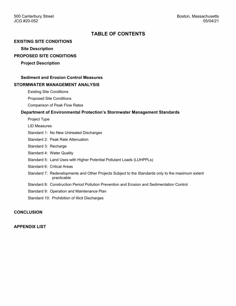
TABLE OF CONTENTS EXISTING SITE CONDITIONS
Site Description PROPOSED SITE CONDITIONS
Project Description Sediment and Erosion Control Measures
STORMWATER MANAGEMENT ANALYSIS Existing Site Conditions
Proposed Site Conditions
Comparison of Peak Flow Rates Department of Environmental Protection’s Stormwater Management Standards
Project Type
LID Measures
Standard 1: No New Untreated Discharges
Standard 2: Peak Rate Attenuation
Standard 3: Recharge
Standard 4: Water Quality
Standard 5: Land Uses with Higher Potential Pollutant Loads (LUHPPLs)
Standard 6: Critical Areas
Standard 7: Redevelopments and Other Projects Subject to the Standards only to the maximum extent practicable
Standard 8: Construction Period Pollution Prevention and Erosion and Sedimentation Control
Standard 9: Operation and Maintenance Plan
Standard 10: Prohibition of Illicit Discharges
CONCLUSION APPENDIX LIST

500 Canterbury Street Boston, Massachusetts JCG #20-052 05/04/21 EXISTING CONDITIONS Site Description The site is located at 500 Canterbury Street, the parcel is bounded to the north by Canterbury Street, to the west by Walk Hill Street, to the south by American Legion Highway and to the east by a commercial landscape operation. The development parcel is approximately 12 acres in size and consists of a large cemetery lot occupied by two structures, a crematorium and a mausoleum building with office space. In addition to these structures the site also has bituminous concrete driveways and cemetery plots. Bisecting the entirety of the parcel is Stony Brook which generally runs parallel to American Legion Highway. Existing site features are indicated on the “Existing Conditions Plan” within the enclosed Plan Set. Existing features can also be seen below in Figure 1 “500 Canterbury Street Aerial Image”. The site a rectangular lot that is relatively level and generally slopes at a gradual pitch towards Stony Brook. There are catch basins scattered throughout the site that ultimately drain to Stony Brook. There are no other stormwater management systems located on site.
Figure 1: 500 Canterbury Street - Aerial Image
The Soil Survey of Norfolk and Suffolk Counties, Massachusetts, as mapped by the National Resources Conservation Service (NRCS), indicates that soils on the lot consist of – Udorthents, wet substratum (655), as shown in Figure 2 “NRCS Hydrologic Rating Mapping of 485 Blue Hills Parkway”. In addition to the soil mapping, exploratory test pits were advanced at the site, these test pit logs can be found within the plan set. The test pit efforts revealed soils that are generally classified as soils of hydrologic soil group B.

500 Canterbury Street Boston, Massachusetts JCG #20-052 05/04/21
Figure 2: NRCS Hydrologic Rating Mapping of 500 Canterbury Street
For the sake of the stormwater analysis in this report, the immediate area of development is analyzed for pre-development and post-development runoff calculations. The drainage area, as generally delineated by the Limit of Work line, is the portion of the lot effected by the proposed work, the entirety of which drains towards Stony Brook. See Figure 3 for depiction of drainage area.

500 Canterbury Street Boston, Massachusetts JCG #20-052 05/04/21
Figure 3: Existing Drainage Areas – Pre Development PROPOSED CONDITIONS Project Description The proposed project consists of the construction of a building addition to the existing Mausoleum. The proposed building addition will have a footprint of approximately 7,610 square feet, with associated site grading, landscaping, utilities and a new driveway and parking area. The new building will have vehicular access from an existing internal driveway running parallel to American Legion Highway. There will be additional parking provided within the new parking area located immediately west of the proposed addition. Proposed site features and utility connections are indicated on the “Proposed Site Plan”. The existing driveway is not curbed and stormwater runs off the driveway untreated. The proposed driveway will be bordered by bituminous concrete berm and all runoff will be directed to deep sump catch basins and directed to an isolator row within the proposed subsurface infiltration area. The infiltration area will consist of 64 Stormtech SC-740 chambers surrounded with crushed stone which will outlet through an outlet control structure to an existing drainage manhole and ultimately to Stony Brook. The infiltration system has been designed to overflow during large storm events. The result of the proposed drainage design will be cleaner stormwater leaving the site at a reduced rate of runoff during all storm events. Details for proposed site features and improvements are indicated on the “Proposed Site Plan” plan.

500 Canterbury Street Boston, Massachusetts JCG #20-052 05/04/21
Figure 4: Proposed Drainage Areas – Post Development Sediment and Erosion Control Measures Sediment and erosion control during construction will prevent possible damage to surrounding properties. The following guidelines will be adhered to during construction:
1. Keep land disturbance to a minimum. Plan the phases of development so that only the areas actively being developed are exposed. All other areas should have natural vegetation preserved, have good temporary cover, or permanent vegetation established.
2. Stabilize disturbed areas. Permanent structures, temporary or permanent vegetation, and mulch should be employed as quickly as possible after land is disturbed.
3. Protect disturbed areas from stormwater runoff. Install erosion control or stormwater management measures to prevent water from entering and running over disturbed areas, and to prevent erosion damage to downstream facilities.
Installation of perimeter control practices (silt socks, siltation fences and/or haybales) will also occur prior to construction commencing. The contractor will be required to do inspections of all controls regularly to ensure that the controls are working properly. The contractor shall clean and reinstall any control that need to be cleaned or replaced.

500 Canterbury Street Boston, Massachusetts JCG #20-052 05/04/21 STORMWATER MANAGEMENT ANALYSIS Joyce Consulting Group has performed a stormwater management analysis to compare the pre- and post-development conditions of the site. The hydrology for the drainage areas was analyzed with the Soil Conservation Service’s (SCS) Runoff Curve Number (CN) methodology. The HydroCAD Version 9.10 computer modeling system was used in conjunction with the SCS’s methods to determine the peak rates of runoff for the 2-year, 10-year, 25-year and 100-year 24-hour storm events. Existing Site Conditions Joyce Consulting Group compiled the existing drainage areas from an existing conditions survey prepared by Joyce Consulting Group, P.C. The Drainage Area analyzed for this project is as shown in Figure 3: Existing Drainage Areas – Pre Development. There is one design point for the analysis which ultimately flows to Stony Brook. Proposed Site Conditions Joyce Consulting Group compiled the proposed drainage areas from the Site Plan enclosed in this report. The Drainage Area analyzed for this project is as shown in Figure 4: Proposed Drainage Areas – Post Development. There is one design points for the analysis at the edge of Stony Brook. Department of Environmental Protection’s Stormwater Management Standards Project Type: This project is considered a mix of new development and redevelopment. The project is a mixed-use development, per the Massachusetts Stormwater Management Standards the project is subject to the standards see Volume 1: Overview of Massachusetts Stormwater Standards Chapter 1 Page 2 and Page 3. This project is designed to meet all of the Stormwater Management Standards. LID Measures: The project has taken into consideration Low Impact Development measures to the extent that the development is situated within an existing commercial lot and the proposed work is within an area that has been previously disturbed. There are wetlands off site associated with Pope’s Pond, there is no work proposed within the wetland. Standard 1: No New Untreated Discharges Compliance: The proposed design will comply with this Standard. There will be no new untreated stormwater discharges from areas with pollutant loading. The majority of stormwater runoff flowing off the site will be from either the non-metal roof-top, which is considered runoff without higher potential pollutant loads, or from the driveway areas which are being treated via deep sump catch basins and a hydrodynamic oil & sediment removal chamber which will further cleanse the stormwater before releasing it off-site. Standard 2: Peak Rate Attenuation Compliance: This project will comply with this Standard – see Table 1, below. Stormwater management systems have been designed to mitigate post-development peak discharge rates to less than pre-development levels. Supporting hydrologic model calculations are attached at the end of this report.
Table 1: Peak Rates of Runoff (all rates listed in cfs) Design Point– SC-1 (Stony Brook) 2-Year 10-year 25-year 100-Year Existing 1.25 3.09 4.20 5.96 Proposed 1.07 2.95 4.11 5.95
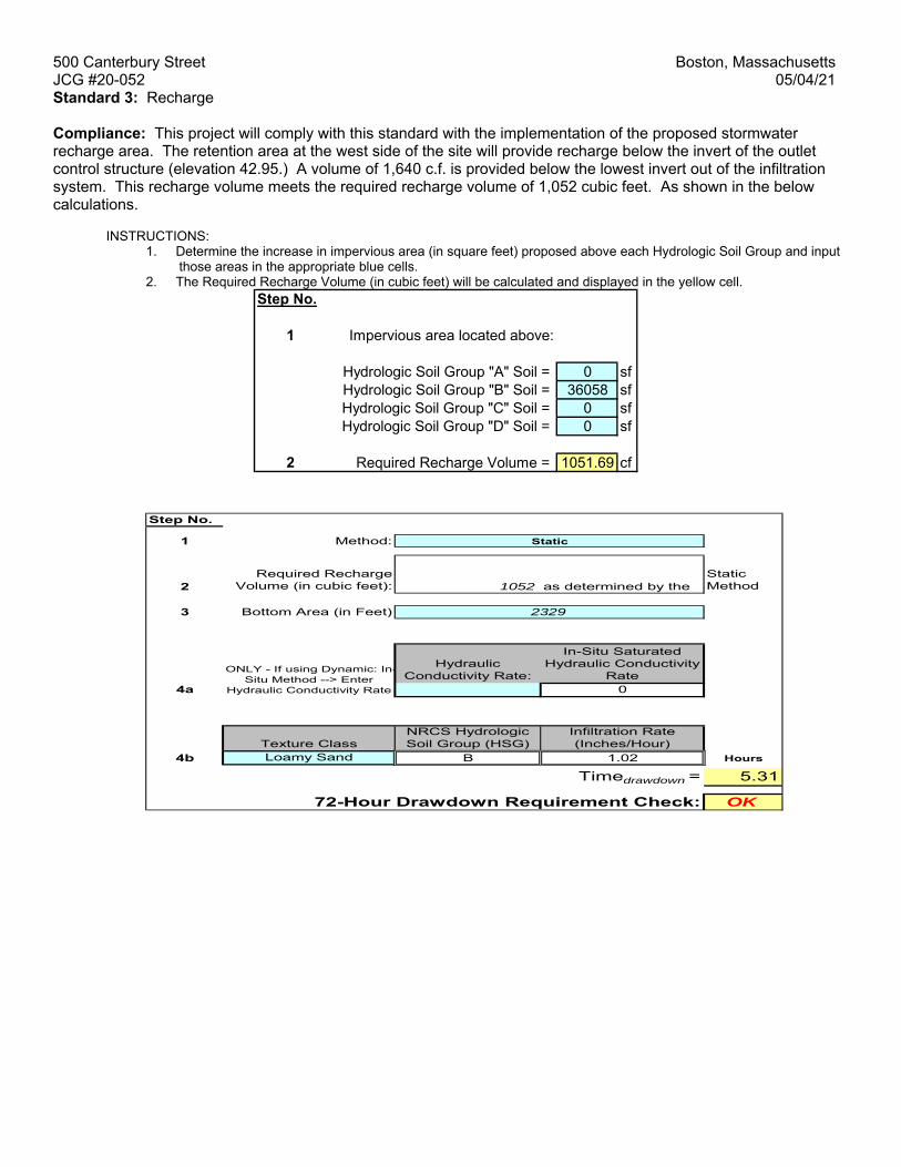
500 Canterbury Street Boston, Massachusetts JCG #20-052 05/04/21 Standard 3: Recharge Compliance: This project will comply with this standard with the implementation of the proposed stormwater recharge area. The retention area at the west side of the site will provide recharge below the invert of the outlet control structure (elevation 42.95.) A volume of 1,640 c.f. is provided below the lowest invert out of the infiltration system. This recharge volume meets the required recharge volume of 1,052 cubic feet. As shown in the below calculations.
INSTRUCTIONS:
1. Determine the increase in impervious area (in square feet) proposed above each Hydrologic Soil Group and input those areas in the appropriate blue cells.
2. The Required Recharge Volume (in cubic feet) will be calculated and displayed in the yellow cell. Step No.
1
0 sf36058 sf
0 sf0 sf
2 1051.69 cfRequired Recharge Volume =
Impervious area located above:
Hydrologic Soil Group "A" Soil = Hydrologic Soil Group "B" Soil = Hydrologic Soil Group "C" Soil = Hydrologic Soil Group "D" Soil =
Step No.
1 Method:
2Required Recharge
Volume (in cubic feet): 1052 as determined by the Static Method
3 Bottom Area (in Feet)
Hydraulic Conductivity Rate:
In-Situ Saturated Hydraulic Conductivity
Rate4a 0
Texture ClassNRCS Hydrologic Soil Group (HSG)
Infiltration Rate (Inches/Hour)
4b Loamy Sand B 1.02 Hours
Timedrawdown = 5.31
OK72-Hour Drawdown Requirement Check:
Static
2329
ONLY - If using Dynamic: In-Situ Method --> Enter
Hydraulic Conductivity Rate

500 Canterbury Street Boston, Massachusetts JCG #20-052 05/04/21 Standard 4: Water Quality Compliance: The project will comply with this standard. The required water quality volume is equal to 0.5” times the Impervious Area of the Site. Required WQv = (0.5/12) x (36,058sf) = 1,502 cf The Stormwater infiltration area below the proposed parking lot provides sufficient volume for the required water quality volume with 1,640 cubic feet of storage below the proposed outlet. In addition to this water quality storage, the runoff will also be treated by an isolator row within the infiltration area to further improve water quality. Parking Lot sweeping, deep sump catch basins, and the isolator row are water quality BMPs that have been incorporated into the design and sized to provide greater than 80% TSS removal. The anticipated TSS removal calculations are included below. A Long-Term Operation and Maintenance (O&M) Plan for the storm drainage system has been included at the end of this report as well.
DESCRIPTION OF DISCHARGE POINT: Detention Basin Standard 5: Land Uses with Higher Potential Pollutant Loads (LUHPPLs) Compliance: The project is not associated with Higher Potential Pollutant Loads. This project complies with this standard. Standard 6: Critical Areas Compliance: The site is not located near any Critical Areas. This project complies with this standard.
3. After BMP is selected, TSS Removal and other Columns are automatically completed.
Location:
B C D E FTSS Removal Starting TSS Amount Remaining
BMP1 Rate1 Load* Removed (C*D) Load (D-E)
Street Sweeping - 5% 0.05 1.00 0.05 0.95
Deep Sump and Hooded Catch Basin 0.25 0.95 0.24 0.71
Proprietary Treatment Practice 0.80 0.71 0.57 0.14
0.00 0.14 0.00 0.14
0.00 0.14 0.00 0.14
Total TSS Removal = 86%
Separate Form Needs to be Completed for Each Outlet or BMP Train
Project: St. Michael's Cemetery
Prepared By: mgj *Equals remaining load from previous BMP (E)
Date: 05.04.2021 which enters the BMP
TSS
Rem
oval
Cal
cula
tion
Wor
kshe
et
500 Canterbury Street

500 Canterbury Street Boston, Massachusetts JCG #20-052 05/04/21 Standard 7: Redevelopments and Other Projects Subject to the Standards only to the maximum extent practicable. Compliance: Since the project is a mix of new development and redevelopment, the project is complying with all of the Stormwater Management Standards, as indicated previously in this report. Standard 8: Construction Period Pollution Prevention and Erosion and Sedimentation Control. Compliance: The project will comply with this standard. Sedimentation and erosion controls will be incorporated as part of the design of this project and employed during site construction. Standard 9: Operation and Maintenance Plan Compliance: An operations and maintenance plan intended to ensure the continued proper functioning of the existing stormwater controls and the proposed stormwater controls has been included with this report as Appendix F. Standard 10: Prohibition of Illicit Discharges. Compliance: An Illicit Discharge Statement will be provided prior to discharge to post-construction BMP’s as required. CONCLUSION In conclusion, the proposed work at 500 Canterbury Street will have a beneficial effect on the stormwater management of the site by reducing the rate of stormwater runoff from the site, providing the necessary suspended solids removal and will comply with the DEP’s Stormwater Management Handbook standards.

500 Canterbury Street Boston, Massachusetts JCG #20-052 05/04/2021
APPENDIX LIST
Appendix A – NRCS (SCS) Soil Description Appendix B – Plans Appendix C – Hydrologic Model
Appendix D – Operations and Maintenance Plan

500 Canterbury Street Boston, Massachusetts JCG #20-052 05/04/2021
APPENDIX A
NRCS (SCS) SOIL DESCRIPTION

Soil Map—Norfolk and Suffolk Counties, Massachusetts(St. Michael's Cemetery)
Natural ResourcesConservation Service
Web Soil SurveyNational Cooperative Soil Survey
11/16/2020Page 1 of 3
4683
800
4683
890
4683
980
4684
070
4684
160
4684
250
4683
800
4683
890
4683
980
4684
070
4684
160
4684
250
326090 326180 326270 326360 326450 326540 326630 326720 326810 326900
326090 326180 326270 326360 326450 326540 326630 326720 326810 326900
42° 17' 29'' N71
° 6
' 34'
' W42° 17' 29'' N
71° 5
' 57'
' W
42° 17' 12'' N
71° 6
' 34'' W
42° 17' 12'' N
71° 5
' 57'' W
N
Map projection: Web Mercator Corner coordinates: WGS84 Edge tics: UTM Zone 19N WGS840 150 300 600 900
Feet0 50 100 200 300
MetersMap Scale: 1:3,830 if printed on A landscape (11" x 8.5") sheet.
Soil Map may not be valid at this scale.

MAP LEGEND MAP INFORMATION
Area of Interest (AOI)Area of Interest (AOI)
SoilsSoil Map Unit Polygons
Soil Map Unit Lines
Soil Map Unit Points
Special Point FeaturesBlowout
Borrow Pit
Clay Spot
Closed Depression
Gravel Pit
Gravelly Spot
Landfill
Lava Flow
Marsh or swamp
Mine or Quarry
Miscellaneous Water
Perennial Water
Rock Outcrop
Saline Spot
Sandy Spot
Severely Eroded Spot
Sinkhole
Slide or Slip
Sodic Spot
Spoil Area
Stony Spot
Very Stony Spot
Wet Spot
Other
Special Line Features
Water FeaturesStreams and Canals
TransportationRails
Interstate Highways
US Routes
Major Roads
Local Roads
BackgroundAerial Photography
The soil surveys that comprise your AOI were mapped at 1:25,000.
Warning: Soil Map may not be valid at this scale.
Enlargement of maps beyond the scale of mapping can cause misunderstanding of the detail of mapping and accuracy of soil line placement. The maps do not show the small areas of contrasting soils that could have been shown at a more detailed scale.
Please rely on the bar scale on each map sheet for map measurements.
Source of Map: Natural Resources Conservation ServiceWeb Soil Survey URL: Coordinate System: Web Mercator (EPSG:3857)
Maps from the Web Soil Survey are based on the Web Mercator projection, which preserves direction and shape but distorts distance and area. A projection that preserves area, such as the Albers equal-area conic projection, should be used if more accurate calculations of distance or area are required.
This product is generated from the USDA-NRCS certified data as of the version date(s) listed below.
Soil Survey Area: Norfolk and Suffolk Counties, MassachusettsSurvey Area Data: Version 16, Jun 11, 2020
Soil map units are labeled (as space allows) for map scales 1:50,000 or larger.
Date(s) aerial images were photographed: Sep 11, 2019—Oct 5, 2019
The orthophoto or other base map on which the soil lines were compiled and digitized probably differs from the background imagery displayed on these maps. As a result, some minor shifting of map unit boundaries may be evident.
Soil Map—Norfolk and Suffolk Counties, Massachusetts(St. Michael's Cemetery)
Natural ResourcesConservation Service
Web Soil SurveyNational Cooperative Soil Survey
11/16/2020Page 2 of 3

Map Unit Legend
Map Unit Symbol Map Unit Name Acres in AOI Percent of AOI
5 Saco silt loam, 0 to 3 percent slopes
1.4 2.0%
70A Ridgebury fine sandy loam, 0 to 3 percent slopes
5.5 7.9%
73A Whitman fine sandy loam, 0 to 3 percent slopes, extremely stony
6.5 9.4%
254B Merrimac fine sandy loam, 3 to 8 percent slopes
0.8 1.2%
310B Woodbridge fine sandy loam, 3 to 8 percent slopes
18.1 26.1%
420B Canton fine sandy loam, 3 to 8 percent slopes
12.4 17.8%
602 Urban land, 0 to 15 percent slopes
0.5 0.7%
653 Udorthents, sandy 5.5 8.0%
655 Udorthents, wet substratum 18.7 26.9%
Totals for Area of Interest 69.4 100.0%
Soil Map—Norfolk and Suffolk Counties, Massachusetts St. Michael's Cemetery
Natural ResourcesConservation Service
Web Soil SurveyNational Cooperative Soil Survey
11/16/2020Page 3 of 3
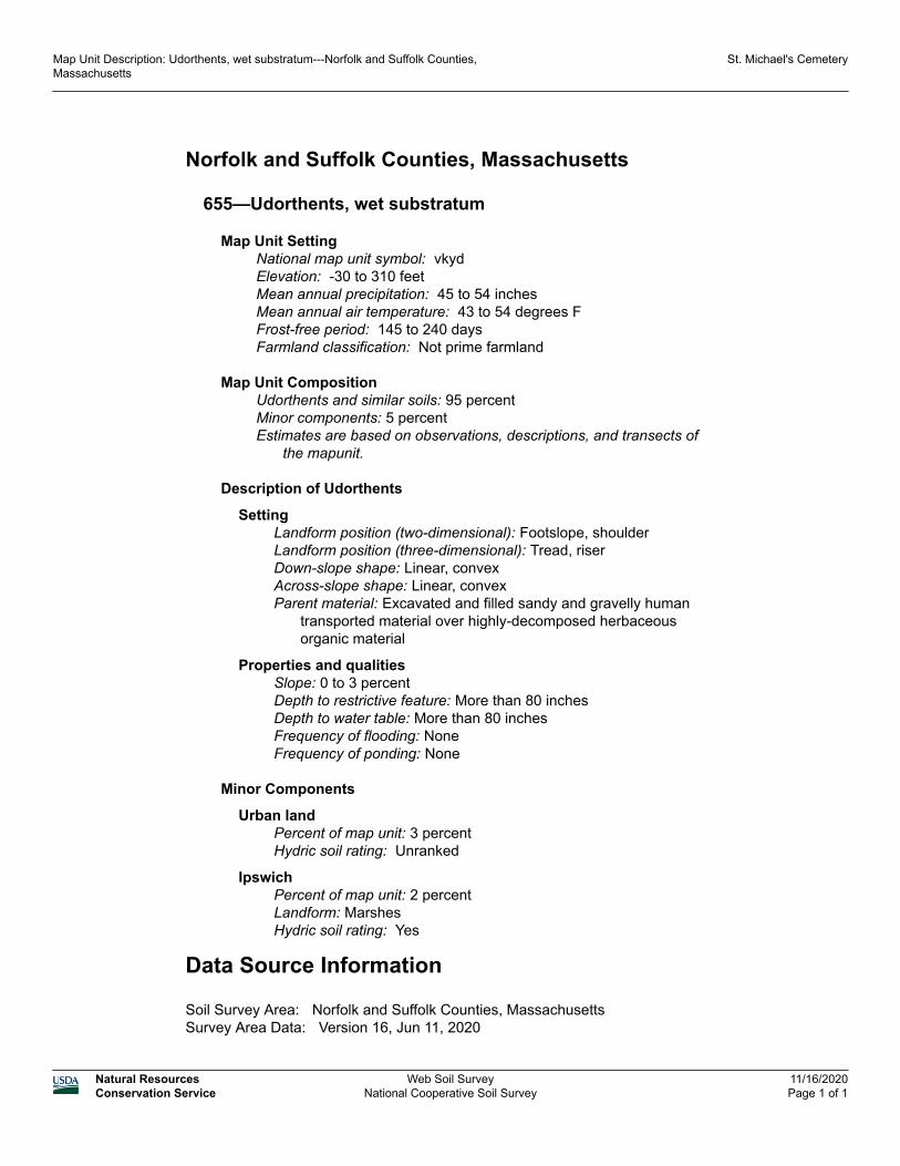
Norfolk and Suffolk Counties, Massachusetts
655—Udorthents, wet substratum
Map Unit SettingNational map unit symbol: vkydElevation: -30 to 310 feetMean annual precipitation: 45 to 54 inchesMean annual air temperature: 43 to 54 degrees FFrost-free period: 145 to 240 daysFarmland classification: Not prime farmland
Map Unit CompositionUdorthents and similar soils: 95 percentMinor components: 5 percentEstimates are based on observations, descriptions, and transects of
the mapunit.
Description of Udorthents
SettingLandform position (two-dimensional): Footslope, shoulderLandform position (three-dimensional): Tread, riserDown-slope shape: Linear, convexAcross-slope shape: Linear, convexParent material: Excavated and filled sandy and gravelly human
transported material over highly-decomposed herbaceous organic material
Properties and qualitiesSlope: 0 to 3 percentDepth to restrictive feature: More than 80 inchesDepth to water table: More than 80 inchesFrequency of flooding: NoneFrequency of ponding: None
Minor Components
Urban landPercent of map unit: 3 percentHydric soil rating: Unranked
IpswichPercent of map unit: 2 percentLandform: MarshesHydric soil rating: Yes
Data Source Information
Soil Survey Area: Norfolk and Suffolk Counties, MassachusettsSurvey Area Data: Version 16, Jun 11, 2020
Map Unit Description: Udorthents, wet substratum---Norfolk and Suffolk Counties, Massachusetts
St. Michael's Cemetery
Natural ResourcesConservation Service
Web Soil SurveyNational Cooperative Soil Survey
11/16/2020Page 1 of 1

500 Canterbury Street Boston, Massachusetts JCG #20-052 05/04/2021
APPENDIX B
EXISTING CONDITIONS PLANS PROPOSED CONDITIONS PLANS

STONY BROOK
AMERICAN LEGION HIGHWAY
CANTERBURY STREET
SCALE
DATE
JOB NO. PLAN TITLE: EXISTING CONDITIONS PLANGRADING, UTILITY AND DRAINAGE
500 CANTERBURY STREETROSLINDALE, MA
100 WYMAN ROAD 781-817-6120BRAINTREE, MA 02184 [email protected]
"Copyright 2020" Joyce Consulting Group, Inc. All rights reserved unauthorized duplication is a violation of all applicable laws.
LEGEND JCG 20-052
10.21.20
1"=20'
REVISIONSNO. REVISION BY
- - -
DATE
-
PREPARED FOR:
SAINT MICHAEL'S CEMETERY500 CANTERBURY STREET
ROSLINDALE, MAC-1
GENERAL NOTES
AutoCAD SHX Text
100' BUFFER TO B.V.W.
AutoCAD SHX Text
51" TALBOT AVENUE - HIGH LEVEL BRICK SEWER
AutoCAD SHX Text
GRASS AREA
AutoCAD SHX Text
GRASS AREA
AutoCAD SHX Text
GRASS AREA
AutoCAD SHX Text
APPROXIMATE EDGE OF GRASS/TREELINE
AutoCAD SHX Text
EXISTING BIT. CONC. DRIVEWAY WITH PARKING
AutoCAD SHX Text
EXISTING IRRIGATION CONTROLS MANHOLE
AutoCAD SHX Text
EXISTING BIT. CONC. DRIVEWAY
AutoCAD SHX Text
BRIDGE
AutoCAD SHX Text
BRIDGE
AutoCAD SHX Text
EXISTING OFFICE, MAUSOLEUM AND CHAPEL FF=50.8'±
AutoCAD SHX Text
SPIGOT
AutoCAD SHX Text
SPIGOT
AutoCAD SHX Text
SPIGOT
AutoCAD SHX Text
CB R=49.02 TOP OF HOOD=45.42
AutoCAD SHX Text
MH R=51.05
AutoCAD SHX Text
SPIGOT
AutoCAD SHX Text
EXISTING BIT. CONC. DRIVEWAY
AutoCAD SHX Text
EXISTING BIT. CONC. DRIVEWAY WITH PARKING
AutoCAD SHX Text
EXISTING CREMATORIUM BUILDING
AutoCAD SHX Text
SMH R=50.48 INV.=32.38(HELD)
AutoCAD SHX Text
WF-B9
AutoCAD SHX Text
WF-B8
AutoCAD SHX Text
WF-B7
AutoCAD SHX Text
WF-B10
AutoCAD SHX Text
WF-B11
AutoCAD SHX Text
WF-B12
AutoCAD SHX Text
WF-B13
AutoCAD SHX Text
EDGE OF PAVEMENT
AutoCAD SHX Text
EDGE OF PAVEMENT
AutoCAD SHX Text
SLOPED GRANITE CURB
AutoCAD SHX Text
SLOPED GRANITE CURB
AutoCAD SHX Text
GRASS AREA
AutoCAD SHX Text
(PUBLIC WAY)
AutoCAD SHX Text
30" MWRA WATER MAIN
AutoCAD SHX Text
24" MWRA WATER MAIN
AutoCAD SHX Text
CHAIN LINK FENCE
AutoCAD SHX Text
VERTICAL GRANITE CURB
AutoCAD SHX Text
BIKE LANE
AutoCAD SHX Text
SIDEWALK
AutoCAD SHX Text
UNDERGROUND ELECTRIC
AutoCAD SHX Text
APPROXIMATE PROPERTY LINE
AutoCAD SHX Text
DMH R=48.60 INV=43.50
AutoCAD SHX Text
CB R=49.12 TOP OF HOOD=45.42
AutoCAD SHX Text
WF-B6
AutoCAD SHX Text
FLARED END SECTION INV=42.1±
AutoCAD SHX Text
BRIDGE
AutoCAD SHX Text
(26' WIDE - PUBLIC WAY)
AutoCAD SHX Text
1.5" WATER SERVICE
AutoCAD SHX Text
UTILITY POLE
AutoCAD SHX Text
GUY WIRE
AutoCAD SHX Text
12" WATER MAIN (2004)
AutoCAD SHX Text
GV
AutoCAD SHX Text
VGC
AutoCAD SHX Text
VERTICAL GRANITE CURB
AutoCAD SHX Text
EX. HANDHOLE
AutoCAD SHX Text
HH
AutoCAD SHX Text
EX. CATCH BASIN
AutoCAD SHX Text
CB
AutoCAD SHX Text
G
AutoCAD SHX Text
EX. GAS
AutoCAD SHX Text
H
AutoCAD SHX Text
Y
AutoCAD SHX Text
D
AutoCAD SHX Text
WV
AutoCAD SHX Text
WATER VALVE
AutoCAD SHX Text
HYDRANT
AutoCAD SHX Text
TELEPHONE MANHOLE
AutoCAD SHX Text
TMH
AutoCAD SHX Text
SEWER MANHOLE
AutoCAD SHX Text
SMH
AutoCAD SHX Text
ELECTRIC MANHOLE
AutoCAD SHX Text
EMH
AutoCAD SHX Text
DRAIN MANHOLE
AutoCAD SHX Text
DMH
AutoCAD SHX Text
T
AutoCAD SHX Text
E
AutoCAD SHX Text
D
AutoCAD SHX Text
S
AutoCAD SHX Text
W
AutoCAD SHX Text
EX. TEL
AutoCAD SHX Text
EX. ELECT
AutoCAD SHX Text
EX. DRAIN
AutoCAD SHX Text
EX. SEWER
AutoCAD SHX Text
EX. WATER
AutoCAD SHX Text
LP
AutoCAD SHX Text
LIGHT POLE
AutoCAD SHX Text
CONCRETE RETAINING WALL
AutoCAD SHX Text
CRTW
AutoCAD SHX Text
FGC
AutoCAD SHX Text
FLUSH GRANITE CURB
AutoCAD SHX Text
GV
AutoCAD SHX Text
GAS VALVE
AutoCAD SHX Text
UTILITY POLE
AutoCAD SHX Text
UP
AutoCAD SHX Text
SCALE: 1" = 20'
AutoCAD SHX Text
20'
AutoCAD SHX Text
0'
AutoCAD SHX Text
10'
AutoCAD SHX Text
40'
AutoCAD SHX Text
60'
AutoCAD SHX Text
1. SITE FEATURES AND UTILITIES SHOWN ON THIS PLAN ARE BASED ON A COMPILATION OF RECORD PLANS, PLANS ACQUIRED FROM UTILITY PROVIDERS, GPS AND LAND INSTRUMENT SURVEY. 2. LOCATION OF SUBSURFACE UTILITIES IS APPROXIMATE. THE CONTRACTOR SHALL PROTECT AND MAINTAIN ALL EXISTING UTILITY SERVICES THROUGHOUT CONSTRUCTION. CONTACT DIG SAFE AT 1-888-DIGSAFE AT LEAST 72 HOURS PRIOR TO CONSTRUCTION. CONTRACTOR SHALL VERIFY LOCATION OF EXISTING UTILITIES PRIOR TO CONSTRUCTION.

STONY BROOK
AMERICAN LEGION HIGHWAY
CANTERBURY STREET
SCALE
DATE
JOB NO. PLAN TITLE:
GENERAL NOTES
BWSC SITE PLAN (BWSC SHEET 1 OF 2)GRADING, UTILITY AND DRAINAGE
500 CANTERBURY STREETROSLINDALE, MA
100 WYMAN ROAD 781-817-6120BRAINTREE, MA 02184 [email protected]
"Copyright 2021" Joyce Consulting Group, Inc. All rights reserved unauthorized duplication is a violation of all applicable laws.
LEGEND JCG 20-052
03.31.21
1"=20'
REVISIONSNO. REVISION BY
- - -
DATE
-
PREPARED FOR:
SAINT MICHAEL'S CEMETERY500 CANTERBURY STREET
ROSLINDALE, MAC-4
GENERAL GRADING NOTES
UTILITY CONSTRUCTION NOTES
BWSC USE ONLYBWSC SITE PLAN # _____
AutoCAD SHX Text
ASPHALT ROADWAY
AutoCAD SHX Text
(PRIVATE)
AutoCAD SHX Text
25' RIVERFRONT AREA BOUNDARY
AutoCAD SHX Text
EXTENT OF BORDER OF VEGETATED WETLAND
AutoCAD SHX Text
100' BUFFER TO B.V.W.
AutoCAD SHX Text
51" TALBOT AVENUE - HIGH LEVEL BRICK SEWER
AutoCAD SHX Text
GRASS AREA
AutoCAD SHX Text
GRASS AREA
AutoCAD SHX Text
GRASS AREA
AutoCAD SHX Text
APPROXIMATE EDGE OF GRASS/TREELINE
AutoCAD SHX Text
PROPOSED EROSION CONTROL (SILT SOCK OR APPROVED EQUAL)
AutoCAD SHX Text
EXISTING BIT. CONC. DRIVEWAY WITH PARKING
AutoCAD SHX Text
EXISTING IRRIGATION CONTROLS MANHOLE
AutoCAD SHX Text
EXISTING BIT. CONC. DRIVEWAY
AutoCAD SHX Text
BRIDGE
AutoCAD SHX Text
BRIDGE
AutoCAD SHX Text
PROPOSED ADDITION TO EXISTING BUILDING FF TO MATCH EXISTING (REFER TO ARCHITECTURAL PLANS FOR ACTUAL DIMENSIONS) FOOTPRINT AREA =7,610 ± S.F.
AutoCAD SHX Text
EXISTING OFFICE, MAUSOLEUM AND CHAPEL FF=50.8'±
AutoCAD SHX Text
SPIGOT
AutoCAD SHX Text
SPIGOT
AutoCAD SHX Text
SPIGOT
AutoCAD SHX Text
CB R=49.02 TOP OF HOOD=45.42
AutoCAD SHX Text
MH R=51.05
AutoCAD SHX Text
SPIGOT
AutoCAD SHX Text
EXISTING BIT. CONC. DRIVEWAY
AutoCAD SHX Text
EXISTING BIT. CONC. DRIVEWAY WITH PARKING
AutoCAD SHX Text
EXISTING CREMATORIUM BUILDING
AutoCAD SHX Text
SMH R=50.48 INV.=32.38(HELD)
AutoCAD SHX Text
WF-B9
AutoCAD SHX Text
WF-B8
AutoCAD SHX Text
WF-B7
AutoCAD SHX Text
WF-B10
AutoCAD SHX Text
WF-B11
AutoCAD SHX Text
WF-B12
AutoCAD SHX Text
WF-B13
AutoCAD SHX Text
EDGE OF PAVEMENT
AutoCAD SHX Text
EDGE OF PAVEMENT
AutoCAD SHX Text
SLOPED GRANITE CURB
AutoCAD SHX Text
SLOPED GRANITE CURB
AutoCAD SHX Text
GRASS AREA
AutoCAD SHX Text
TOP OF BANK
AutoCAD SHX Text
(PUBLIC WAY)
AutoCAD SHX Text
30" MWRA WATER MAIN
AutoCAD SHX Text
24" MWRA WATER MAIN
AutoCAD SHX Text
CHAIN LINK FENCE
AutoCAD SHX Text
VERTICAL GRANITE CURB
AutoCAD SHX Text
BIKE LANE
AutoCAD SHX Text
SIDEWALK
AutoCAD SHX Text
UNDERGROUND ELECTRIC
AutoCAD SHX Text
APPROXIMATE PROPERTY LINE
AutoCAD SHX Text
DMH R=48.60 INV=43.50
AutoCAD SHX Text
CB R=49.12 TOP OF HOOD=45.42
AutoCAD SHX Text
WF-B6
AutoCAD SHX Text
FLARED END SECTION INV=42.1±
AutoCAD SHX Text
50.75
AutoCAD SHX Text
50.75
AutoCAD SHX Text
BRIDGE
AutoCAD SHX Text
(26' WIDE - PUBLIC WAY)
AutoCAD SHX Text
1.5" WATER SERVICE
AutoCAD SHX Text
ASPHALT ROADWAY
AutoCAD SHX Text
(PRIVATE)
AutoCAD SHX Text
IP
AutoCAD SHX Text
IP
AutoCAD SHX Text
IP
AutoCAD SHX Text
IP
AutoCAD SHX Text
50.75
AutoCAD SHX Text
50.75
AutoCAD SHX Text
OPEN PLAZA
AutoCAD SHX Text
50.50
AutoCAD SHX Text
50.15
AutoCAD SHX Text
49.85
AutoCAD SHX Text
49.35
AutoCAD SHX Text
CB101 DEEP-SUMP CATCH BASIN WITH 4' SUMP AND HOOD RIM=47.00 INV=44.90 (8"HDPE)
AutoCAD SHX Text
INFILTRATION AREA 64 STORMTECH SC-740 INFILTRATION UNITS WITH ISOLATOR ROW INV.CHAMBERS=44.0 INV.IN=44.5 INV.OUT=45.10
AutoCAD SHX Text
50.00
AutoCAD SHX Text
50.25
AutoCAD SHX Text
49.80
AutoCAD SHX Text
50.50
AutoCAD SHX Text
48
AutoCAD SHX Text
49
AutoCAD SHX Text
47
AutoCAD SHX Text
50
AutoCAD SHX Text
50.50
AutoCAD SHX Text
50.50
AutoCAD SHX Text
50.20
AutoCAD SHX Text
50.20
AutoCAD SHX Text
49.65
AutoCAD SHX Text
50.05
AutoCAD SHX Text
50.30
AutoCAD SHX Text
50.30
AutoCAD SHX Text
50.15
AutoCAD SHX Text
H
AutoCAD SHX Text
Y
AutoCAD SHX Text
D
AutoCAD SHX Text
CB102 DEEP-SUMP CATCH BASIN WITH 4' SUMP AND HOOD RIM=48.50 INV=45.00 (8"HDPE)
AutoCAD SHX Text
OUTLET CONTROL STRUCTURE WITH WEIR PLATE RIM=48.90 INVin=45.10 (12" HDPE) 6"X6" ORIF.=45.20 5"X4" ORIF.=45.50 6"X6" ORIF.=46.25 INVout=45.10 (12"HDPE)
AutoCAD SHX Text
DRAIN MANHOLE RIM=49.10 INV=44.50 (8"HDPE)
AutoCAD SHX Text
CB 103 DEEP-SUMP CATCH BASIN WITH 4' SUMP AND HOOD RIM=50.0 INV=46.85 (8"HDPE)
AutoCAD SHX Text
PROTECT EXISTING CATCH BASIN - NEW INVERT OUT TO INFILTRATION AREA INV=46.55
AutoCAD SHX Text
UTILITY POLE
AutoCAD SHX Text
GUY WIRE
AutoCAD SHX Text
PROPOSED GENERATOR (COORDINATE EXACT SIZE AND LOCATION WITH OWNER)
AutoCAD SHX Text
STA 0+07 215 L.F. CLDI LATERAL WITH 12"X6" TAPPING SLEEVE AND VALVE EXCAVATION 11'X5'
AutoCAD SHX Text
WV
AutoCAD SHX Text
12" WATER MAIN (2004)
AutoCAD SHX Text
STA 0-13 CUT AND CAP EXISTING 1~1/2" SERVICE EXCAVATION 5'X5'
AutoCAD SHX Text
215 6" L.F. CLDI
AutoCAD SHX Text
PROPOSED PRIVATE HYDRANT
AutoCAD SHX Text
RECONNECT EXISTING SERVICE TO NEW 6" CLDI
AutoCAD SHX Text
PROPOSED 4" CLDI FIRE SERVICE
AutoCAD SHX Text
WV
AutoCAD SHX Text
WV
AutoCAD SHX Text
WV
AutoCAD SHX Text
REBUILD EXISTING MANHOLE TO ACCEPT 12" HDPE INVinv=43.50
AutoCAD SHX Text
49.10
AutoCAD SHX Text
49.10
AutoCAD SHX Text
INV=46.0
AutoCAD SHX Text
PROPOSED GAS SERVICE (COORDINATE EXACT SIZE AND LOCATION WITH OWNER AND UTILITY PROVIDER)
AutoCAD SHX Text
56' SDR65 MIN S=0.02
AutoCAD SHX Text
PROPOSED ELECTRICAL CONDUIT (COORDINATE EXACT SIZE AND LOCATION WITH OWNER & MEP)
AutoCAD SHX Text
WATER LINE TO BE INSULATED AND WRAPPED WITH HEAT-TRACE WIRE (COORDINATE WITH MEP)
AutoCAD SHX Text
WV
AutoCAD SHX Text
RELOCATE EXISTING METER TO BASEMENT
AutoCAD SHX Text
C/O
AutoCAD SHX Text
50
AutoCAD SHX Text
BWSC STATIONING BEGIN SMH @ DRIVEWAY ON CANTERBURY ST
AutoCAD SHX Text
0+50
AutoCAD SHX Text
0+00
AutoCAD SHX Text
TP-1
AutoCAD SHX Text
TP-2
AutoCAD SHX Text
MEET AND MATCH EXISTING EDGE OF PAVEMENT (CONTRACTOR AND OWNER TO COORDINATE ON EXTENT OF RECONSTRUCTION OF EXISTING BITUMINOUS CONCRETE)
AutoCAD SHX Text
50.45
AutoCAD SHX Text
DRAIN MANHOLE RIM=48.90 INV=45.50 (8"HDPE)
AutoCAD SHX Text
50.30
AutoCAD SHX Text
208 L.F. 8" HDPE
AutoCAD SHX Text
PROPOSED SEWER CONNECTION INV. LATERAL=42.8±INV MAIN=32.4±
AutoCAD SHX Text
90 L.F. 8" HDPE
AutoCAD SHX Text
ISOLATOR ROW
AutoCAD SHX Text
VGC
AutoCAD SHX Text
VERTICAL GRANITE CURB
AutoCAD SHX Text
EX. HANDHOLE
AutoCAD SHX Text
HH
AutoCAD SHX Text
EX. CATCH BASIN
AutoCAD SHX Text
CB
AutoCAD SHX Text
G
AutoCAD SHX Text
EX. GAS
AutoCAD SHX Text
H
AutoCAD SHX Text
Y
AutoCAD SHX Text
D
AutoCAD SHX Text
WV
AutoCAD SHX Text
WATER VALVE
AutoCAD SHX Text
HYDRANT
AutoCAD SHX Text
TELEPHONE MANHOLE
AutoCAD SHX Text
TMH
AutoCAD SHX Text
SEWER MANHOLE
AutoCAD SHX Text
SMH
AutoCAD SHX Text
ELECTRIC MANHOLE
AutoCAD SHX Text
EMH
AutoCAD SHX Text
DRAIN MANHOLE
AutoCAD SHX Text
DMH
AutoCAD SHX Text
T
AutoCAD SHX Text
E
AutoCAD SHX Text
D
AutoCAD SHX Text
S
AutoCAD SHX Text
W
AutoCAD SHX Text
EX. TEL
AutoCAD SHX Text
EX. ELECT
AutoCAD SHX Text
EX. DRAIN
AutoCAD SHX Text
EX. SEWER
AutoCAD SHX Text
EX. WATER
AutoCAD SHX Text
LP
AutoCAD SHX Text
LIGHT POLE
AutoCAD SHX Text
CONCRETE RETAINING WALL
AutoCAD SHX Text
CRTW
AutoCAD SHX Text
FGC
AutoCAD SHX Text
FLUSH GRANITE CURB
AutoCAD SHX Text
GV
AutoCAD SHX Text
GAS VALVE
AutoCAD SHX Text
UTILITY POLE
AutoCAD SHX Text
UP
AutoCAD SHX Text
1. SITE FEATURES AND UTILITIES SHOWN ON THIS PLAN ARE BASED ON A COMPILATION OF RECORD PLANS, PLANS ACQUIRED FROM UTILITY PROVIDERS, GPS AND LAND INSTRUMENT SURVEY. 2. LOCATION OF SUBSURFACE UTILITIES IS APPROXIMATE. THE CONTRACTOR SHALL PROTECT AND MAINTAIN ALL EXISTING UTILITY SERVICES THROUGHOUT CONSTRUCTION. CONTACT DIG SAFE AT 1-888-DIGSAFE AT LEAST 72 HOURS PRIOR TO CONSTRUCTION. CONTRACTOR SHALL VERIFY LOCATION OF EXISTING UTILITIES PRIOR TO CONSTRUCTION.
AutoCAD SHX Text
SCALE: 1" = 20'
AutoCAD SHX Text
20'
AutoCAD SHX Text
0'
AutoCAD SHX Text
10'
AutoCAD SHX Text
40'
AutoCAD SHX Text
60'
AutoCAD SHX Text
1.ALL PAVED AREAS MUST PITCH TO DRAIN AT A MINIMUM OF ALL PAVED AREAS MUST PITCH TO DRAIN AT A MINIMUM OF ONE-EIGHTH INCH (1/8") PER FOOT. 2.WHERE NEW PAVING MEETS EXISTING PAVING, MEET LINE AND GRADE WHERE NEW PAVING MEETS EXISTING PAVING, MEET LINE AND GRADE OF EXISTING. 3.UNDERGROUND UTILITIES SHOWN AS APPROXIMATE ONLY. UNDERGROUND UTILITIES SHOWN AS APPROXIMATE ONLY. 4.PROVIDE POSITIVE DRAINAGE AWAY FROM FACE OF BUILDINGS AT ALL PROVIDE POSITIVE DRAINAGE AWAY FROM FACE OF BUILDINGS AT ALL LOCATIONS. 5.ALL PROPOSED TOP OF CURB ELEVATIONS ARE SIX INCHES (6") ALL PROPOSED TOP OF CURB ELEVATIONS ARE SIX INCHES (6") ABOVE BOTTOM OF CURB ELEVATIONS UNLESS SHOWN OTHERWISE. 6.THE GENERAL CONTRACTOR SHALL BLEND NEW EARTHWORK THE GENERAL CONTRACTOR SHALL BLEND NEW EARTHWORK SMOOTHLY INTO EXISTING EARTHWORK. 7.ALL POINTS OF CONSTRUCTION EGRESS AND/OR INGRESS SHALL BE ALL POINTS OF CONSTRUCTION EGRESS AND/OR INGRESS SHALL BE MAINTAINED TO PREVENT TRACKING OR FLOWING OF SEDIMENT ONTO PUBLIC ROADS. 8.THE CONTRACTOR SHALL VERIFY ALL EXISTING GRADES IN THE FIELD THE CONTRACTOR SHALL VERIFY ALL EXISTING GRADES IN THE FIELD AND REPORT ANY DISCREPANCIES IMMEDIATELY TO THE ARCHITECT/ENGINEER PRIOR TO STARTING WORK. 9.ANY ALTERATIONS TO THESE DRAWINGS MADE IN THE FIELD DURING ANY ALTERATIONS TO THESE DRAWINGS MADE IN THE FIELD DURING CONSTRUCTION SHALL BE RECORDED BY THE GENERAL CONTRACTOR AND SHARED WITH THE ARCHITECT AND ENGINEER AS REQUIRED. 10.SURPLUS MATERIALS SHALL NOT BE REMOVED FROM THE SITE SURPLUS MATERIALS SHALL NOT BE REMOVED FROM THE SITE UNLESS DIRECTED BY THE OWNER OR OWNER'S REPRESENTATIVE. 11.ANY AREAS OUTSIDE OF THE LIMIT-OF-WORK THAT IS DISTURBED ANY AREAS OUTSIDE OF THE LIMIT-OF-WORK THAT IS DISTURBED SHALL BE RESTORED TO ITS ORIGINAL CONDITION AT NO COST TO THE OWNER.
AutoCAD SHX Text
1.WATER SERVICE SHALL BE 6" DICL, CLASS 56 PIPE. ALL WATER WATER SERVICE SHALL BE 6" DICL, CLASS 56 PIPE. ALL WATER MAIN FITTINGS, VALVES AND GATES SHALL MEET THE BWSC STANDARDS. 2.MINIMUM COVER OVER THE WATER MAIN AND SERVICES MINIMUM COVER OVER THE WATER MAIN AND SERVICES SHALL BE FIVE (5') FEET. 3.SANITARY SEWER GRAVITY PIPE SHALL BE 6" PVC, SDR 35. SANITARY SEWER GRAVITY PIPE SHALL BE 6" PVC, SDR 35. AND SHALL MEET THE BWSC STANDARDS. 4.WATER MAIN BENDS, TEES, AND PLUGS SHALL HAVE A WATER MAIN BENDS, TEES, AND PLUGS SHALL HAVE A CONCRETE THRUST BLOCKS AS SPECIFIED IN THE DETAIL SHEET. 5.ALL CONSTRUCTION TO MEET BWSC STANDARDS. ALL CONSTRUCTION TO MEET BWSC STANDARDS. 6.GAS, TELEPHONE, CABLE, ELECTRICITY TO BE DESIGNED BY THE GAS, TELEPHONE, CABLE, ELECTRICITY TO BE DESIGNED BY THE INDIVIDUAL UTILITY COMPANY. 7.MAINTAIN 10 FEET HORIZONTAL SEPARATION BETWEEN SEWER MAINTAIN 10 FEET HORIZONTAL SEPARATION BETWEEN SEWER AND WATER LINES. ENCASE BOTH UTILITIES WITH CONCRETE IF 10 FEET SEPARATION CANNOT BE MAINTAINED. WHEREVER THERE IS LESS THAN 10 FEET OF HORIZONTAL SEPARATION AND 18" OF VERTICAL SEPARATION BETWEEN A PROPOSED OR EXISTING SEWER LINE TO REMAIN AND A PROPOSED OR EXISTING WATER LINE TO REMAIN, BOTH UTILITIES SHALL BE ENCASED IN CONCRETE. 9. PROPOSED CLEANOUTS WILL BE CONSTRUCTED OF TWO 22.5 DEGREE ELBOWS AND ONE 45 DEGREE ELBOW.
AutoCAD SHX Text
DRAINAGE CALCULATIONS: : PROPOSED IMPERVIOUS AREA: TOTAL PROPOSED IMPERVIOUS AREA NEW BUILDING = 7,609 SF NEW BUILDING = 7,609 SF NEW DRIVEWAY & HARDSCAPE = 11,654 SF TOTAL = 19,263 SF STORAGE REQUIRED: 19,263 S.F. * 1'/12"= 1,605 C.F. REQUIRED STORAGE PROVIDED: CRUSHED STONE BED TOTAL VOLUME: 58.96' X 39.5' X 3.5' =8,151.2 C.F. SYSTEM HEIGHT: 3.5' TOTAL CHAMBER VOLUME PROVIDED: 64-SC 740 UNITS (45.9 CF/CHAMBER) 64 * 45.9 CF/UNIT= 2,937.6 C.F. STORAGE CRUSHED STONE BED STORAGE VOLUME: (STONE VOLUME LESS CHAMBER STORAGE) 8,151.2 C.F. - 2,937.6 C.F. = 5,213.6 C.F. 5,213.6 C.F. X (30% VOIDS) 5,213.6 C.F. X 0.30 = 1,564.1 C.F. TOTAL STORAGE PROVIDED: CHAMBER STORAGE + STONE STORAGE 2,937.6 C.F. + 1,564.1 C.F. = 4,501.7 C.F. STORAGE OUTLET AT ELEV. 45.20' (36.4% OF STORAGE) 36.4% = 1,640 C.F. STORAGE PRIOR TO OUTLET STORAGE REQUIRED < STORAGE PROVIDED (1,605 C.F.< 1,640 C.F.) THEREFORE SYSTEM CAPACITY IS SUFFICIENT
AutoCAD SHX Text
SITE INFORMATION: ADDRESS: 500 CANTERBURY STREET PARCEL: 1405199000 WARD: 14 EXISTING WATER ACCOUNT#:1582218 LAND USE CODE: CL
AutoCAD SHX Text
OWNER ITALIAN CATHOLIC CEMETERY ASSOCIATION
AutoCAD SHX Text
PROJECT CONTACT SAINT MICHAEL'S CEMETERY CONTACT: MICHAEL SHEEHAN PHONE: 617-524-1036 500 CANTERBURY STREET BOSTON, MA 02131

500 Canterbury Street Boston, Massachusetts JCG #20-052 05/04/2021
APPENDIX C
HYDROLOGIC MODEL

2S
Existing To Stony Brook
3S
ADDITION ROOFTOP
4S
Parking/Landscape
5S
Remainder of Subcatchment
6S
Existing Rooftop
5R
Stony Brook
1P
Infiltration Area
Drainage Diagram for Hydrologic Calcs - St MichaelsPrepared by Joyce Consulting Group, P.C., Printed 5/7/2021
HydroCAD® 9.10 s/n 06645 © 2011 HydroCAD Software Solutions LLC
Subcat Reach Pond Link

St. Michael's Cemetery- Hydro CalcsHydrologic Calcs - St Michaels
Printed 5/7/2021Prepared by Joyce Consulting Group, P.C.Page 2HydroCAD® 9.10 s/n 06645 © 2011 HydroCAD Software Solutions LLC
Area Listing (all nodes)
Area(acres)
CN Description(subcatchment-numbers)
0.520 60 Woods, Fair, HSG B (2S, 5S)1.575 61 >75% Grass cover, Good, HSG B (2S, 4S, 5S)0.248 98 Existing Building (2S, 6S)0.246 98 Parking/Driveway (2S)0.175 98 Roof (3S)0.089 98 driveway (5S)0.157 98 ex pav (4S)0.268 98 new pave (4S)0.016 98 open patio (4S)3.292 74 TOTAL AREA

St. Michael's Cemetery- Hydro CalcsType III 24-hr 2-Year Rainfall=3.20"Hydrologic Calcs - St Michaels
Printed 5/7/2021Prepared by Joyce Consulting Group, P.C.Page 3HydroCAD® 9.10 s/n 06645 © 2011 HydroCAD Software Solutions LLC
Time span=5.00-20.00 hrs, dt=0.05 hrs, 301 pointsRunoff by SCS TR-20 method, UH=SCS
Reach routing by Dyn-Stor-Ind method - Pond routing by Dyn-Stor-Ind method
Runoff Area=71,709 sf 22.46% Impervious Runoff Depth>0.70"Subcatchment 2S: Existing To Stony Brook Flow Length=269' Tc=7.2 min CN=69 Runoff=1.25 cfs 0.096 af
Runoff Area=7,610 sf 100.00% Impervious Runoff Depth>2.77"Subcatchment 3S: ADDITION ROOFTOP Tc=6.0 min CN=98 Runoff=0.53 cfs 0.040 af
Runoff Area=36,683 sf 52.24% Impervious Runoff Depth>1.30"Subcatchment 4S: Parking/Landscape Tc=0.0 min CN=80 Runoff=1.58 cfs 0.091 af
Runoff Area=22,008 sf 17.61% Impervious Runoff Depth>0.62"Subcatchment 5S: Remainder of Tc=0.0 min CN=67 Runoff=0.39 cfs 0.026 af
Runoff Area=5,408 sf 100.00% Impervious Runoff Depth>2.77"Subcatchment 6S: Existing Rooftop Tc=6.0 min CN=98 Runoff=0.38 cfs 0.029 af
Inflow=1.07 cfs 0.145 afReach 5R: Stony Brook Outflow=1.07 cfs 0.145 af
Peak Elev=45.72' Storage=2,523 cf Inflow=1.95 cfs 0.131 afPond 1P: Infiltration Area Outflow=0.72 cfs 0.091 af
Total Runoff Area = 3.292 ac Runoff Volume = 0.282 af Average Runoff Depth = 1.03"63.63% Pervious = 2.095 ac 36.37% Impervious = 1.197 ac

St. Michael's Cemetery- Hydro CalcsType III 24-hr 2-Year Rainfall=3.20"Hydrologic Calcs - St Michaels
Printed 5/7/2021Prepared by Joyce Consulting Group, P.C.Page 4HydroCAD® 9.10 s/n 06645 © 2011 HydroCAD Software Solutions LLC
Summary for Subcatchment 2S: Existing To Stony Brook
Runoff = 1.25 cfs @ 12.12 hrs, Volume= 0.096 af, Depth> 0.70"
Runoff by SCS TR-20 method, UH=SCS, Time Span= 5.00-20.00 hrs, dt= 0.05 hrsType III 24-hr 2-Year Rainfall=3.20"
Area (sf) CN Description44,544 61 >75% Grass cover, Good, HSG B11,062 60 Woods, Fair, HSG B
* 5,408 98 Existing Building* 10,695 98 Parking/Driveway
71,709 69 Weighted Average55,606 77.54% Pervious Area16,103 22.46% Impervious Area
Tc Length Slope Velocity Capacity Description(min) (feet) (ft/ft) (ft/sec) (cfs)
5.4 48 0.0200 0.15 Sheet Flow, SheetGrass: Short n= 0.150 P2= 3.20"
0.2 25 0.0160 2.57 Shallow Concentrated Flow, Shallow Conc.Paved Kv= 20.3 fps
1.0 120 0.0160 2.04 Shallow Concentrated Flow, Shallow concUnpaved Kv= 16.1 fps
0.1 31 0.1900 7.02 Shallow Concentrated Flow, SCUnpaved Kv= 16.1 fps
0.5 45 0.0100 1.61 Shallow Concentrated Flow, scUnpaved Kv= 16.1 fps
7.2 269 Total
Summary for Subcatchment 3S: ADDITION ROOFTOP
Runoff = 0.53 cfs @ 12.09 hrs, Volume= 0.040 af, Depth> 2.77"
Runoff by SCS TR-20 method, UH=SCS, Time Span= 5.00-20.00 hrs, dt= 0.05 hrsType III 24-hr 2-Year Rainfall=3.20"
Area (sf) CN Description* 7,610 98 Roof
7,610 100.00% Impervious Area
Tc Length Slope Velocity Capacity Description(min) (feet) (ft/ft) (ft/sec) (cfs)
6.0 Direct Entry, Direct

St. Michael's Cemetery- Hydro CalcsType III 24-hr 2-Year Rainfall=3.20"Hydrologic Calcs - St Michaels
Printed 5/7/2021Prepared by Joyce Consulting Group, P.C.Page 5HydroCAD® 9.10 s/n 06645 © 2011 HydroCAD Software Solutions LLC
Summary for Subcatchment 4S: Parking/Landscape
Runoff = 1.58 cfs @ 12.01 hrs, Volume= 0.091 af, Depth> 1.30"
Runoff by SCS TR-20 method, UH=SCS, Time Span= 5.00-20.00 hrs, dt= 0.05 hrsType III 24-hr 2-Year Rainfall=3.20"
Area (sf) CN Description* 11,654 98 new pave* 6,819 98 ex pav
17,519 61 >75% Grass cover, Good, HSG B* 691 98 open patio
36,683 80 Weighted Average17,519 47.76% Pervious Area19,164 52.24% Impervious Area
Summary for Subcatchment 5S: Remainder of Subcatchment
Runoff = 0.39 cfs @ 12.02 hrs, Volume= 0.026 af, Depth> 0.62"
Runoff by SCS TR-20 method, UH=SCS, Time Span= 5.00-20.00 hrs, dt= 0.05 hrsType III 24-hr 2-Year Rainfall=3.20"
Area (sf) CN Description* 3,876 98 driveway
1,032 61 >75% Grass cover, Good, HSG B5,498 61 >75% Grass cover, Good, HSG B
11,602 60 Woods, Fair, HSG B22,008 67 Weighted Average18,132 82.39% Pervious Area
3,876 17.61% Impervious Area
Summary for Subcatchment 6S: Existing Rooftop
Runoff = 0.38 cfs @ 12.09 hrs, Volume= 0.029 af, Depth> 2.77"
Runoff by SCS TR-20 method, UH=SCS, Time Span= 5.00-20.00 hrs, dt= 0.05 hrsType III 24-hr 2-Year Rainfall=3.20"
Area (sf) CN Description* 5,408 98 Existing Building
5,408 100.00% Impervious Area
Tc Length Slope Velocity Capacity Description(min) (feet) (ft/ft) (ft/sec) (cfs)
6.0 Direct Entry, Direct

St. Michael's Cemetery- Hydro CalcsType III 24-hr 2-Year Rainfall=3.20"Hydrologic Calcs - St Michaels
Printed 5/7/2021Prepared by Joyce Consulting Group, P.C.Page 6HydroCAD® 9.10 s/n 06645 © 2011 HydroCAD Software Solutions LLC
Summary for Reach 5R: Stony Brook
Inflow Area = 1.646 ac, 50.28% Impervious, Inflow Depth > 1.06" for 2-Year eventInflow = 1.07 cfs @ 12.22 hrs, Volume= 0.145 afOutflow = 1.07 cfs @ 12.22 hrs, Volume= 0.145 af, Atten= 0%, Lag= 0.0 min
Routing by Dyn-Stor-Ind method, Time Span= 5.00-20.00 hrs, dt= 0.05 hrs
Summary for Pond 1P: Infiltration Area
Inflow Area = 1.017 ac, 60.45% Impervious, Inflow Depth > 1.55" for 2-Year eventInflow = 1.95 cfs @ 12.01 hrs, Volume= 0.131 afOutflow = 0.72 cfs @ 12.30 hrs, Volume= 0.091 af, Atten= 63%, Lag= 17.2 minPrimary = 0.72 cfs @ 12.30 hrs, Volume= 0.091 af
Routing by Dyn-Stor-Ind method, Time Span= 5.00-20.00 hrs, dt= 0.05 hrsPeak Elev= 45.72' @ 12.30 hrs Surf.Area= 2,329 sf Storage= 2,523 cf
Plug-Flow detention time= 140.1 min calculated for 0.090 af (69% of inflow)Center-of-Mass det. time= 69.3 min ( 849.8 - 780.5 )
Volume Invert Avail.Storage Storage Description#1A 44.00' 1,563 cf 39.50'W x 58.96'L x 3.50'H Field A
8,151 cf Overall - 2,940 cf Embedded = 5,211 cf x 30.0% Voids#2A 44.50' 2,940 cf StormTech SC-740 x 64 Inside #1
Effective Size= 44.6"W x 30.0"H => 6.45 sf x 7.12'L = 45.9 cfOverall Size= 51.0"W x 30.0"H x 7.56'L with 0.44' Overlap
4,503 cf Total Available Storage
Storage Group A created with Chamber Wizard
Device Routing Invert Outlet Devices#1 Primary 45.20' 6.0" W x 6.0" H Vert. Orifice/Grate C= 0.600 #2 Primary 45.50' 5.0" W x 4.0" H Vert. Orifice/Grate C= 0.600 #3 Primary 46.25' 6.0" W x 6.0" H Vert. Orifice/Grate C= 0.600
Primary OutFlow Max=0.72 cfs @ 12.30 hrs HW=45.71' TW=0.00' (Dynamic Tailwater)1=Orifice/Grate (Orifice Controls 0.59 cfs @ 2.36 fps)2=Orifice/Grate (Orifice Controls 0.13 cfs @ 1.49 fps)3=Orifice/Grate ( Controls 0.00 cfs)

St. Michael's Cemetery- Hydro CalcsType III 24-hr 10-Year Rainfall=4.70"Hydrologic Calcs - St Michaels
Printed 5/7/2021Prepared by Joyce Consulting Group, P.C.Page 6HydroCAD® 9.10 s/n 06645 © 2011 HydroCAD Software Solutions LLC
Summary for Subcatchment 2S: Existing To Stony Brook
Runoff = 3.09 cfs @ 12.11 hrs, Volume= 0.219 af, Depth> 1.60"
Runoff by SCS TR-20 method, UH=SCS, Time Span= 5.00-20.00 hrs, dt= 0.05 hrsType III 24-hr 10-Year Rainfall=4.70"
Area (sf) CN Description44,544 61 >75% Grass cover, Good, HSG B11,062 60 Woods, Fair, HSG B
* 5,408 98 Existing Building* 10,695 98 Parking/Driveway
71,709 69 Weighted Average55,606 77.54% Pervious Area16,103 22.46% Impervious Area
Tc Length Slope Velocity Capacity Description(min) (feet) (ft/ft) (ft/sec) (cfs)
5.4 48 0.0200 0.15 Sheet Flow, SheetGrass: Short n= 0.150 P2= 3.20"
0.2 25 0.0160 2.57 Shallow Concentrated Flow, Shallow Conc.Paved Kv= 20.3 fps
1.0 120 0.0160 2.04 Shallow Concentrated Flow, Shallow concUnpaved Kv= 16.1 fps
0.1 31 0.1900 7.02 Shallow Concentrated Flow, SCUnpaved Kv= 16.1 fps
0.5 45 0.0100 1.61 Shallow Concentrated Flow, scUnpaved Kv= 16.1 fps
7.2 269 Total
Summary for Subcatchment 3S: ADDITION ROOFTOP
Runoff = 0.78 cfs @ 12.09 hrs, Volume= 0.060 af, Depth> 4.15"
Runoff by SCS TR-20 method, UH=SCS, Time Span= 5.00-20.00 hrs, dt= 0.05 hrsType III 24-hr 10-Year Rainfall=4.70"
Area (sf) CN Description* 7,610 98 Roof
7,610 100.00% Impervious Area
Tc Length Slope Velocity Capacity Description(min) (feet) (ft/ft) (ft/sec) (cfs)
6.0 Direct Entry, Direct

St. Michael's Cemetery- Hydro CalcsType III 24-hr 10-Year Rainfall=4.70"Hydrologic Calcs - St Michaels
Printed 5/7/2021Prepared by Joyce Consulting Group, P.C.Page 7HydroCAD® 9.10 s/n 06645 © 2011 HydroCAD Software Solutions LLC
Summary for Subcatchment 4S: Parking/Landscape
Runoff = 2.99 cfs @ 12.00 hrs, Volume= 0.173 af, Depth> 2.46"
Runoff by SCS TR-20 method, UH=SCS, Time Span= 5.00-20.00 hrs, dt= 0.05 hrsType III 24-hr 10-Year Rainfall=4.70"
Area (sf) CN Description* 11,654 98 new pave* 6,819 98 ex pav
17,519 61 >75% Grass cover, Good, HSG B* 691 98 open patio
36,683 80 Weighted Average17,519 47.76% Pervious Area19,164 52.24% Impervious Area
Summary for Subcatchment 5S: Remainder of Subcatchment
Runoff = 1.04 cfs @ 12.01 hrs, Volume= 0.062 af, Depth> 1.46"
Runoff by SCS TR-20 method, UH=SCS, Time Span= 5.00-20.00 hrs, dt= 0.05 hrsType III 24-hr 10-Year Rainfall=4.70"
Area (sf) CN Description* 3,876 98 driveway
1,032 61 >75% Grass cover, Good, HSG B5,498 61 >75% Grass cover, Good, HSG B
11,602 60 Woods, Fair, HSG B22,008 67 Weighted Average18,132 82.39% Pervious Area
3,876 17.61% Impervious Area
Summary for Subcatchment 6S: Existing Rooftop
Runoff = 0.56 cfs @ 12.09 hrs, Volume= 0.043 af, Depth> 4.15"
Runoff by SCS TR-20 method, UH=SCS, Time Span= 5.00-20.00 hrs, dt= 0.05 hrsType III 24-hr 10-Year Rainfall=4.70"
Area (sf) CN Description* 5,408 98 Existing Building
5,408 100.00% Impervious Area
Tc Length Slope Velocity Capacity Description(min) (feet) (ft/ft) (ft/sec) (cfs)
6.0 Direct Entry, Direct

St. Michael's Cemetery- Hydro CalcsType III 24-hr 10-Year Rainfall=4.70"Hydrologic Calcs - St Michaels
Printed 5/7/2021Prepared by Joyce Consulting Group, P.C.Page 8HydroCAD® 9.10 s/n 06645 © 2011 HydroCAD Software Solutions LLC
Summary for Reach 5R: Stony Brook
Inflow Area = 1.646 ac, 50.28% Impervious, Inflow Depth > 2.15" for 10-Year eventInflow = 2.95 cfs @ 12.07 hrs, Volume= 0.295 afOutflow = 2.95 cfs @ 12.07 hrs, Volume= 0.295 af, Atten= 0%, Lag= 0.0 min
Routing by Dyn-Stor-Ind method, Time Span= 5.00-20.00 hrs, dt= 0.05 hrs
Summary for Pond 1P: Infiltration Area
Inflow Area = 1.017 ac, 60.45% Impervious, Inflow Depth > 2.75" for 10-Year eventInflow = 3.52 cfs @ 12.01 hrs, Volume= 0.233 afOutflow = 1.83 cfs @ 12.16 hrs, Volume= 0.191 af, Atten= 48%, Lag= 9.1 minPrimary = 1.83 cfs @ 12.16 hrs, Volume= 0.191 af
Routing by Dyn-Stor-Ind method, Time Span= 5.00-20.00 hrs, dt= 0.05 hrsPeak Elev= 46.40' @ 12.16 hrs Surf.Area= 2,329 sf Storage= 3,546 cf
Plug-Flow detention time= 99.5 min calculated for 0.191 af (82% of inflow)Center-of-Mass det. time= 48.4 min ( 820.2 - 771.8 )
Volume Invert Avail.Storage Storage Description#1A 44.00' 1,563 cf 39.50'W x 58.96'L x 3.50'H Field A
8,151 cf Overall - 2,940 cf Embedded = 5,211 cf x 30.0% Voids#2A 44.50' 2,940 cf StormTech SC-740 x 64 Inside #1
Effective Size= 44.6"W x 30.0"H => 6.45 sf x 7.12'L = 45.9 cfOverall Size= 51.0"W x 30.0"H x 7.56'L with 0.44' Overlap
4,503 cf Total Available Storage
Storage Group A created with Chamber Wizard
Device Routing Invert Outlet Devices#1 Primary 45.20' 6.0" W x 6.0" H Vert. Orifice/Grate C= 0.600 #2 Primary 45.50' 5.0" W x 4.0" H Vert. Orifice/Grate C= 0.600 #3 Primary 46.25' 6.0" W x 6.0" H Vert. Orifice/Grate C= 0.600
Primary OutFlow Max=1.82 cfs @ 12.16 hrs HW=46.39' TW=0.00' (Dynamic Tailwater)1=Orifice/Grate (Orifice Controls 1.17 cfs @ 4.66 fps)2=Orifice/Grate (Orifice Controls 0.57 cfs @ 4.10 fps)3=Orifice/Grate (Orifice Controls 0.09 cfs @ 1.22 fps)

St. Michael's Cemetery- Hydro CalcsType III 24-hr 25-Year Rainfall=5.50"Hydrologic Calcs - St Michaels
Printed 5/7/2021Prepared by Joyce Consulting Group, P.C.Page 9HydroCAD® 9.10 s/n 06645 © 2011 HydroCAD Software Solutions LLC
Summary for Subcatchment 2S: Existing To Stony Brook
Runoff = 4.20 cfs @ 12.11 hrs, Volume= 0.294 af, Depth> 2.15"
Runoff by SCS TR-20 method, UH=SCS, Time Span= 5.00-20.00 hrs, dt= 0.05 hrsType III 24-hr 25-Year Rainfall=5.50"
Area (sf) CN Description44,544 61 >75% Grass cover, Good, HSG B11,062 60 Woods, Fair, HSG B
* 5,408 98 Existing Building* 10,695 98 Parking/Driveway
71,709 69 Weighted Average55,606 77.54% Pervious Area16,103 22.46% Impervious Area
Tc Length Slope Velocity Capacity Description(min) (feet) (ft/ft) (ft/sec) (cfs)
5.4 48 0.0200 0.15 Sheet Flow, SheetGrass: Short n= 0.150 P2= 3.20"
0.2 25 0.0160 2.57 Shallow Concentrated Flow, Shallow Conc.Paved Kv= 20.3 fps
1.0 120 0.0160 2.04 Shallow Concentrated Flow, Shallow concUnpaved Kv= 16.1 fps
0.1 31 0.1900 7.02 Shallow Concentrated Flow, SCUnpaved Kv= 16.1 fps
0.5 45 0.0100 1.61 Shallow Concentrated Flow, scUnpaved Kv= 16.1 fps
7.2 269 Total
Summary for Subcatchment 3S: ADDITION ROOFTOP
Runoff = 0.92 cfs @ 12.09 hrs, Volume= 0.071 af, Depth> 4.87"
Runoff by SCS TR-20 method, UH=SCS, Time Span= 5.00-20.00 hrs, dt= 0.05 hrsType III 24-hr 25-Year Rainfall=5.50"
Area (sf) CN Description* 7,610 98 Roof
7,610 100.00% Impervious Area
Tc Length Slope Velocity Capacity Description(min) (feet) (ft/ft) (ft/sec) (cfs)
6.0 Direct Entry, Direct
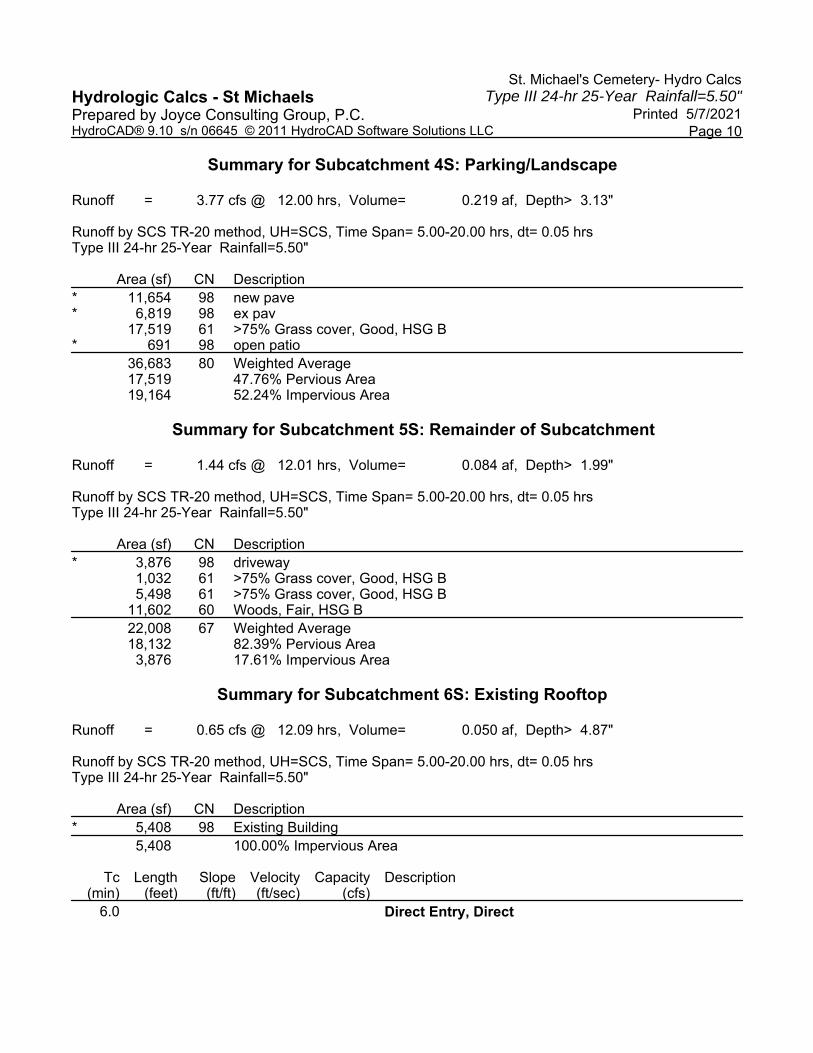
St. Michael's Cemetery- Hydro CalcsType III 24-hr 25-Year Rainfall=5.50"Hydrologic Calcs - St Michaels
Printed 5/7/2021Prepared by Joyce Consulting Group, P.C.Page 10HydroCAD® 9.10 s/n 06645 © 2011 HydroCAD Software Solutions LLC
Summary for Subcatchment 4S: Parking/Landscape
Runoff = 3.77 cfs @ 12.00 hrs, Volume= 0.219 af, Depth> 3.13"
Runoff by SCS TR-20 method, UH=SCS, Time Span= 5.00-20.00 hrs, dt= 0.05 hrsType III 24-hr 25-Year Rainfall=5.50"
Area (sf) CN Description* 11,654 98 new pave* 6,819 98 ex pav
17,519 61 >75% Grass cover, Good, HSG B* 691 98 open patio
36,683 80 Weighted Average17,519 47.76% Pervious Area19,164 52.24% Impervious Area
Summary for Subcatchment 5S: Remainder of Subcatchment
Runoff = 1.44 cfs @ 12.01 hrs, Volume= 0.084 af, Depth> 1.99"
Runoff by SCS TR-20 method, UH=SCS, Time Span= 5.00-20.00 hrs, dt= 0.05 hrsType III 24-hr 25-Year Rainfall=5.50"
Area (sf) CN Description* 3,876 98 driveway
1,032 61 >75% Grass cover, Good, HSG B5,498 61 >75% Grass cover, Good, HSG B
11,602 60 Woods, Fair, HSG B22,008 67 Weighted Average18,132 82.39% Pervious Area
3,876 17.61% Impervious Area
Summary for Subcatchment 6S: Existing Rooftop
Runoff = 0.65 cfs @ 12.09 hrs, Volume= 0.050 af, Depth> 4.87"
Runoff by SCS TR-20 method, UH=SCS, Time Span= 5.00-20.00 hrs, dt= 0.05 hrsType III 24-hr 25-Year Rainfall=5.50"
Area (sf) CN Description* 5,408 98 Existing Building
5,408 100.00% Impervious Area
Tc Length Slope Velocity Capacity Description(min) (feet) (ft/ft) (ft/sec) (cfs)
6.0 Direct Entry, Direct

St. Michael's Cemetery- Hydro CalcsType III 24-hr 25-Year Rainfall=5.50"Hydrologic Calcs - St Michaels
Printed 5/7/2021Prepared by Joyce Consulting Group, P.C.Page 11HydroCAD® 9.10 s/n 06645 © 2011 HydroCAD Software Solutions LLC
Summary for Reach 5R: Stony Brook
Inflow Area = 1.646 ac, 50.28% Impervious, Inflow Depth > 2.78" for 25-Year eventInflow = 4.11 cfs @ 12.07 hrs, Volume= 0.382 afOutflow = 4.11 cfs @ 12.07 hrs, Volume= 0.382 af, Atten= 0%, Lag= 0.0 min
Routing by Dyn-Stor-Ind method, Time Span= 5.00-20.00 hrs, dt= 0.05 hrs
Summary for Pond 1P: Infiltration Area
Inflow Area = 1.017 ac, 60.45% Impervious, Inflow Depth > 3.43" for 25-Year eventInflow = 4.40 cfs @ 12.01 hrs, Volume= 0.290 afOutflow = 2.65 cfs @ 12.12 hrs, Volume= 0.248 af, Atten= 40%, Lag= 6.6 minPrimary = 2.65 cfs @ 12.12 hrs, Volume= 0.248 af
Routing by Dyn-Stor-Ind method, Time Span= 5.00-20.00 hrs, dt= 0.05 hrsPeak Elev= 46.76' @ 12.12 hrs Surf.Area= 2,329 sf Storage= 3,961 cf
Plug-Flow detention time= 87.6 min calculated for 0.247 af (85% of inflow)Center-of-Mass det. time= 43.9 min ( 812.0 - 768.1 )
Volume Invert Avail.Storage Storage Description#1A 44.00' 1,563 cf 39.50'W x 58.96'L x 3.50'H Field A
8,151 cf Overall - 2,940 cf Embedded = 5,211 cf x 30.0% Voids#2A 44.50' 2,940 cf StormTech SC-740 x 64 Inside #1
Effective Size= 44.6"W x 30.0"H => 6.45 sf x 7.12'L = 45.9 cfOverall Size= 51.0"W x 30.0"H x 7.56'L with 0.44' Overlap
4,503 cf Total Available Storage
Storage Group A created with Chamber Wizard
Device Routing Invert Outlet Devices#1 Primary 45.20' 6.0" W x 6.0" H Vert. Orifice/Grate C= 0.600 #2 Primary 45.50' 5.0" W x 4.0" H Vert. Orifice/Grate C= 0.600 #3 Primary 46.25' 6.0" W x 6.0" H Vert. Orifice/Grate C= 0.600
Primary OutFlow Max=2.60 cfs @ 12.12 hrs HW=46.74' TW=0.00' (Dynamic Tailwater)1=Orifice/Grate (Orifice Controls 1.36 cfs @ 5.46 fps)2=Orifice/Grate (Orifice Controls 0.69 cfs @ 4.98 fps)3=Orifice/Grate (Orifice Controls 0.55 cfs @ 2.24 fps)
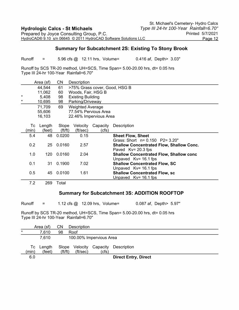
St. Michael's Cemetery- Hydro CalcsType III 24-hr 100-Year Rainfall=6.70"Hydrologic Calcs - St Michaels
Printed 5/7/2021Prepared by Joyce Consulting Group, P.C.Page 12HydroCAD® 9.10 s/n 06645 © 2011 HydroCAD Software Solutions LLC
Summary for Subcatchment 2S: Existing To Stony Brook
Runoff = 5.96 cfs @ 12.11 hrs, Volume= 0.416 af, Depth> 3.03"
Runoff by SCS TR-20 method, UH=SCS, Time Span= 5.00-20.00 hrs, dt= 0.05 hrsType III 24-hr 100-Year Rainfall=6.70"
Area (sf) CN Description44,544 61 >75% Grass cover, Good, HSG B11,062 60 Woods, Fair, HSG B
* 5,408 98 Existing Building* 10,695 98 Parking/Driveway
71,709 69 Weighted Average55,606 77.54% Pervious Area16,103 22.46% Impervious Area
Tc Length Slope Velocity Capacity Description(min) (feet) (ft/ft) (ft/sec) (cfs)
5.4 48 0.0200 0.15 Sheet Flow, SheetGrass: Short n= 0.150 P2= 3.20"
0.2 25 0.0160 2.57 Shallow Concentrated Flow, Shallow Conc.Paved Kv= 20.3 fps
1.0 120 0.0160 2.04 Shallow Concentrated Flow, Shallow concUnpaved Kv= 16.1 fps
0.1 31 0.1900 7.02 Shallow Concentrated Flow, SCUnpaved Kv= 16.1 fps
0.5 45 0.0100 1.61 Shallow Concentrated Flow, scUnpaved Kv= 16.1 fps
7.2 269 Total
Summary for Subcatchment 3S: ADDITION ROOFTOP
Runoff = 1.12 cfs @ 12.09 hrs, Volume= 0.087 af, Depth> 5.97"
Runoff by SCS TR-20 method, UH=SCS, Time Span= 5.00-20.00 hrs, dt= 0.05 hrsType III 24-hr 100-Year Rainfall=6.70"
Area (sf) CN Description* 7,610 98 Roof
7,610 100.00% Impervious Area
Tc Length Slope Velocity Capacity Description(min) (feet) (ft/ft) (ft/sec) (cfs)
6.0 Direct Entry, Direct

St. Michael's Cemetery- Hydro CalcsType III 24-hr 100-Year Rainfall=6.70"Hydrologic Calcs - St Michaels
Printed 5/7/2021Prepared by Joyce Consulting Group, P.C.Page 13HydroCAD® 9.10 s/n 06645 © 2011 HydroCAD Software Solutions LLC
Summary for Subcatchment 4S: Parking/Landscape
Runoff = 4.97 cfs @ 12.00 hrs, Volume= 0.292 af, Depth> 4.16"
Runoff by SCS TR-20 method, UH=SCS, Time Span= 5.00-20.00 hrs, dt= 0.05 hrsType III 24-hr 100-Year Rainfall=6.70"
Area (sf) CN Description* 11,654 98 new pave* 6,819 98 ex pav
17,519 61 >75% Grass cover, Good, HSG B* 691 98 open patio
36,683 80 Weighted Average17,519 47.76% Pervious Area19,164 52.24% Impervious Area
Summary for Subcatchment 5S: Remainder of Subcatchment
Runoff = 2.08 cfs @ 12.01 hrs, Volume= 0.120 af, Depth> 2.85"
Runoff by SCS TR-20 method, UH=SCS, Time Span= 5.00-20.00 hrs, dt= 0.05 hrsType III 24-hr 100-Year Rainfall=6.70"
Area (sf) CN Description* 3,876 98 driveway
1,032 61 >75% Grass cover, Good, HSG B5,498 61 >75% Grass cover, Good, HSG B
11,602 60 Woods, Fair, HSG B22,008 67 Weighted Average18,132 82.39% Pervious Area
3,876 17.61% Impervious Area
Summary for Subcatchment 6S: Existing Rooftop
Runoff = 0.80 cfs @ 12.09 hrs, Volume= 0.062 af, Depth> 5.97"
Runoff by SCS TR-20 method, UH=SCS, Time Span= 5.00-20.00 hrs, dt= 0.05 hrsType III 24-hr 100-Year Rainfall=6.70"
Area (sf) CN Description* 5,408 98 Existing Building
5,408 100.00% Impervious Area
Tc Length Slope Velocity Capacity Description(min) (feet) (ft/ft) (ft/sec) (cfs)
6.0 Direct Entry, Direct

St. Michael's Cemetery- Hydro CalcsType III 24-hr 100-Year Rainfall=6.70"Hydrologic Calcs - St Michaels
Printed 5/7/2021Prepared by Joyce Consulting Group, P.C.Page 14HydroCAD® 9.10 s/n 06645 © 2011 HydroCAD Software Solutions LLC
Summary for Reach 5R: Stony Brook
Inflow Area = 1.646 ac, 50.28% Impervious, Inflow Depth > 3.77" for 100-Year eventInflow = 5.95 cfs @ 12.06 hrs, Volume= 0.517 afOutflow = 5.95 cfs @ 12.06 hrs, Volume= 0.517 af, Atten= 0%, Lag= 0.0 min
Routing by Dyn-Stor-Ind method, Time Span= 5.00-20.00 hrs, dt= 0.05 hrs
Summary for Pond 1P: Infiltration Area
Inflow Area = 1.017 ac, 60.45% Impervious, Inflow Depth > 4.47" for 100-Year eventInflow = 5.73 cfs @ 12.01 hrs, Volume= 0.379 afOutflow = 3.73 cfs @ 12.10 hrs, Volume= 0.335 af, Atten= 35%, Lag= 5.7 minPrimary = 3.73 cfs @ 12.10 hrs, Volume= 0.335 af
Routing by Dyn-Stor-Ind method, Time Span= 5.00-20.00 hrs, dt= 0.05 hrsPeak Elev= 47.42' @ 12.10 hrs Surf.Area= 2,329 sf Storage= 4,450 cf
Plug-Flow detention time= 76.5 min calculated for 0.335 af (89% of inflow)Center-of-Mass det. time= 39.3 min ( 802.7 - 763.3 )
Volume Invert Avail.Storage Storage Description#1A 44.00' 1,563 cf 39.50'W x 58.96'L x 3.50'H Field A
8,151 cf Overall - 2,940 cf Embedded = 5,211 cf x 30.0% Voids#2A 44.50' 2,940 cf StormTech SC-740 x 64 Inside #1
Effective Size= 44.6"W x 30.0"H => 6.45 sf x 7.12'L = 45.9 cfOverall Size= 51.0"W x 30.0"H x 7.56'L with 0.44' Overlap
4,503 cf Total Available Storage
Storage Group A created with Chamber Wizard
Device Routing Invert Outlet Devices#1 Primary 45.20' 6.0" W x 6.0" H Vert. Orifice/Grate C= 0.600 #2 Primary 45.50' 5.0" W x 4.0" H Vert. Orifice/Grate C= 0.600 #3 Primary 46.25' 6.0" W x 6.0" H Vert. Orifice/Grate C= 0.600
Primary OutFlow Max=3.72 cfs @ 12.10 hrs HW=47.42' TW=0.00' (Dynamic Tailwater)1=Orifice/Grate (Orifice Controls 1.69 cfs @ 6.75 fps)2=Orifice/Grate (Orifice Controls 0.88 cfs @ 6.37 fps)3=Orifice/Grate (Orifice Controls 1.15 cfs @ 4.60 fps)

500 Canterbury Street Boston, Massachusetts JCG #20-052 05/04/2021
APPENDIX D
OPERATIONS AND MAINTENANCE PLAN

Proposed Addition 1 500 Canterbury Street - Boston, MA 05.04.2021
Stormwater Operation and Maintenance Plan Erosion and Sedimentation Control Plan,
Pollution Prevention Plan, and Construction Scheduling
Stormwater Management System:
500 Canterbury Street Boston, MA
Stormwater Management System’s Owner & Responsible Party:
Property Owner(s) : St. Michael’s Cemetery c/o Michael Sheehan 617-524-1036
As part of any infrastructure improvement the system must be maintained in order to work properly. The following is an Operation and Maintenance plan to upkeep the proposed non-structural and structural best performance practices as outlined in the Massachusetts Department of Environmental Protection’s Stormwater Management Policy and in accordance with the approved design drawings. Operation and Maintenance Plan During Construction, Construction Pollution Prevention Plan, and Construction Scheduling: Operator to Complete : “CONSTRUCTION: Erosion and Sedimentation Controls Inspection & Maintenance Report” after completion of each maintenance activity. The potential pollutants and their sources during construction are as follows:
Source of Pollution
Type of Pollution
Approximate Chemical/Physical
Description
Potential Stormwater Pollutants
BMP Section
Erosion and sedimentation during excavation/grading
Sedimentation Soil, sediment Soil, sediment Sediment and Erosion Control
Dust during soil removal,excavation, grading
and construction
Dust Particles Dust Particles Dust Particles Sediment and Erosion Control
Vehicle/machine/equipment refueling or maintenance
Gasoline Colorless, pale brown or pink
petroleum hydrocarbon
Benzene, ethyl benzene, toluene, xylene, MTBE
Good Housekeeping
Vehicle/machine/equipment refueling or maintenance
Diesel Fuel Clear, blue-green to yellow liquid
Petroleum distillate, oil & grease, naphthalene, xylenes
Good Housekeeping
Vehicle/machine/equipment refueling or maintenance
Antifreeze/coolant Clear green/yellow liquid
Ethylene glycol, propylene glycol, heavy metals (copper, lead, zinc)
Good Housekeeping
Vehicle/machine/equipment refueling or maintenance
Hydraulic oil/fluids Brown oily petroleum
hydrocarbon
Mineral oil Good Housekeeping

Proposed Addition 2 500 Canterbury Street - Boston, MA 05.04.2021
1) Sediment and Erosion Control All erosion and sediment control measures must be installed prior to any disturbance. Perimeter Silt Fence: A silt fence must be installed around a section of the perimeter of the site as shown on the enclosed Site Plan Set.
Installation: Follow manufacturer’s specifications. Maintenance: Silt fence should be inspected daily and trapped sediment should be removed.
Dust Control: Sprinkle water as necessary to control dust during construction. Material Stockpiling: Stockpiles of material must be placed upgradient of the perimeter silt fence and, if left overnight, protected from the weather with silt fence around the immediate stock pile perimeter. 2) Good Housekeeping The following good housekeeping BMP’s will be implemented in order to prevent pollution during construction:
All vehicles on site will be monitored for leaks and receive regular preventive maintenance to reduce the chance of leakage.
Petroleum products will be stored in tightly sealed containers which are clearly labeled. If portable sanitary units are used, sanitary waste will be removed as necessary to avoid
overfilling. All paint and other hazardous waste materials will be tightly sealed and stored when not in use.
Excess material will not be discharged into the stormwater system but will be properly disposed of according to the manufacturer’s specifications.
If dewatering is necessary during excavation, water should be directed to the temporary dewatering perimeter as shown on the plan. Sediment will be immediately removed from the siltation fabric during dewatering procedures.
All spills will be cleaned up immediately upon discovery. Spills large enough to reach the stormwater systems will be reported to the National Response Center at 1-800-424-8802
3) Upon completion of construction and permanent stabilization of all disturbed areas, sediment control may be removed.

Proposed Addition 3 500 Canterbury Street - Boston, MA 05.04.2021
Operation and Maintenance Plan Post Construction Operator to Complete : “POST CONSTRUCTION: Stormwater Management System Report” after completion of each maintenance activity. Pavement Sweeping The locus site shall be swept a minimum of four (4) times a year (quarterly) primarily in the spring and fall if a High Efficiency Vacuum Sweeper or Regenerative Air Sweeper was used. Deep Sump Catch Basin & Structures Inspect or clean deep sump basins at least four times per year and at the end of the foliage and snow removal seasons. Sediments must also be removed four times per year or whenever the depth of deposits is greater than or equal to one half the depth from the bottom of the invert of the lowest pipe in the basin. If handling runoff from land uses with higher potential pollutant loads or discharging runoff near or to a critical area, more frequent cleaning may be necessary. Subsurface Infiltration Area Conduct semi-annual inspections and inspections after large storm events (more than 3.2-inches of rainfall in a 24-hour period.) Remove sediment by jetting system in accordance with Manufacturer’s recommendations when sediment is observed in the inspection ports. Piping, Inlets, Outlets Because piping is installed underground it is difficult to inspect it is important to ensure that all piping is functioning properly. Inlets and outlets should be inspected in late winter or early spring after the snow melts, preferably during a rain event. In addition to ensuring that all piping is functioning properly, any sediment or garbage that has gathered at inlets or outlets each inspection period. Snow Management Snow will be stored at corners and edges of parking areas; at no time will the snow be stored directly over any catch basin. In the event of the snow storage capacity being maximized, a snow removal contractor will remove snow from the site. Maintenance Access Areas: Catch Basin Inlet and Hood Catch basins and its hoods are easily accessible for maintenance. No designated access area is needed. Infiltration Bed Maintenance The Infiltration Bed is accessible from the parking area.

Proposed Addition 4 500 Canterbury Street - Boston, MA 05.04.2021
Detention Bed Maintenance The Detention Bed is accessible from the end of driveway. Parking Lot Cleaning All vehicular paved areas are accessible from Blue Hills Parkway Street. Estimated Operations and Maintenance Budget:
Maintenance Task Estimated Cost Frequency
(times/year) Annual Budget
Pavement Sweeping $300 4 $1,200
Inspection of Stormwater
Management System $100 4 $400
Catch Basin Cleaning
(Sediment Removal) $500
0.5 (anticipated maximum)
$250
Infiltration System Cleaning
$1,000 0.25
(anticipated maximum) $250
TOTAL ANTICIPATED BUDGET: $2,100


Proposed Addition 6 500 Canterbury Street - Boston, MA 05.04.2021
CONSTRUCTION: Erosion and Sedimentation Controls Inspection & Maintenance Report 500 Canterbury Street – Boston, MA
Stormwater Management System Owner: Property Owner(s)
INSPECTOR: DATE: NUMBER:
DAYS SINCE LAST RAINFALL: AMOUNT LAST RAINFALL: INCHES
TEMPORARY STABILIZATION CATCH BASIN SILT SACKS?
(YES/NO) PAVED AREAS? (YES/NO) LANDSCAPED AREAS? (YES/NO)
COMMENTS/ACTION: TO BE PERFORMED BY: ON OR BEFORE:
STABILIZED CONSTRUCTION ENTRANCE
IS SEDIMENT TRACKED ONTO ROAD? (YES/NO)
IS THE GRAVEL CLEAN? (YES/NO)
DOES ALL TRAFFIC USE THE STABILIZED ENTRANCE TO LEAVE THE SITE? (YES/NO)
COMMENTS/ACTION: TO BE PERFORMED BY: ON OR BEFORE:
SILT FENCES AND HAYBALES
DEPTH OF SEDIMENT
CONDITION OF EFFLUENT?
CONDITION OF SILT FENCE
ANY EVIDENCE OF SEDIMENT BYPASSING THE FENCE
SILT FENCE
COMMENTS/ACTION: TO BE PERFORMED BY: ON OR BEFORE:
CHANGES REQUIRED TO THE POLLUTION PREVENTION PLAN/REASONS FOR CHANGES:
INSPECTED BY SIGNATURE DATE

Proposed Addition 7 500 Canterbury Street - Boston, MA 05.04.2021
POST CONSTRUCTION: Stormwater Management System Report 500 Canterbury Street- Boston, MA
Stormwater Management System Owner: Property Owner(s)
500 Canterbury Street Inspected by:____________ Bosotn, MA Date:____________
Component
Status Action Taken

Appendix E: Plan Set

// //
LEGEND
GENERAL NOTES
USGS LOCUS MAP
SAINT MICHAEL'S CEMETERYPROPOSED BUILDING ADDITION
500 CANTERBURY STREETROSLINDALE, MA 02131
SHEET INDEX:COVER SHEETEXISTING CONDITIONS PLANSITE DEMO AND EROSION CONTROL PLANSITE LAYOUT PLANBWSC SITE PLANBWSC DETAIL SHEET IDETAIL SHEET II
C-0C-1C-2C-3C-4C-5C-6
ARCHITECT:O'SULLIVAN ARCHITECTS, INC.580 MAIN STREETREADING, MA 01867781.439.6166
CIVIL ENGINEER:JOYCE CONSULTING GROUP, P.C.439 WASHINGTON STREET, 3RD FLOORBRAINTREE, MA 02184781.817.6120
APPLICANT:SAINT MICHAEL'S CEMETERY500 CANTERBURY STREETBOSTON, MA 02131617.524.1036
SCALE
DATE
JOB NO. PLAN TITLE:
PREPARED FOR:
COVER SHEET500 CANTERBURY STREET
ROSLINDALE, MA
100 WYMAN ROAD 781-817-6120BRAINTREE, MA 02184 [email protected]
"Copyright 2020" Joyce Consulting Group, Inc. All rights reserved unauthorized duplication is a violation of all applicable laws.
LEGEND
SAINT MICHAEL'S CEMETERY500 CANTERBURY STREET
ROSLINDALE, MA
JCG 20-052
03.31.21
AS NOTED
REVISIONSNO. REVISION BYDATE
C-0
LOCUS
1 ADDED TREES AND INLAND BANK BUFFER MGJ05.21.21
2 REMOVED PARKING FROM WATERFRONT AREA MGJ07.02.21
AutoCAD SHX Text
VGC
AutoCAD SHX Text
VERTICAL GRANITE CURB
AutoCAD SHX Text
EX. HANDHOLE
AutoCAD SHX Text
HH
AutoCAD SHX Text
EX. CATCH BASIN
AutoCAD SHX Text
CB
AutoCAD SHX Text
G
AutoCAD SHX Text
EX. GAS
AutoCAD SHX Text
H
AutoCAD SHX Text
Y
AutoCAD SHX Text
D
AutoCAD SHX Text
WV
AutoCAD SHX Text
WATER VALVE
AutoCAD SHX Text
HYDRANT
AutoCAD SHX Text
TELEPHONE MANHOLE
AutoCAD SHX Text
TMH
AutoCAD SHX Text
SEWER MANHOLE
AutoCAD SHX Text
SMH
AutoCAD SHX Text
ELECTRIC MANHOLE
AutoCAD SHX Text
EMH
AutoCAD SHX Text
DRAIN MANHOLE
AutoCAD SHX Text
DMH
AutoCAD SHX Text
T
AutoCAD SHX Text
E
AutoCAD SHX Text
D
AutoCAD SHX Text
S
AutoCAD SHX Text
W
AutoCAD SHX Text
EX. TEL
AutoCAD SHX Text
EX. ELECT
AutoCAD SHX Text
EX. DRAIN
AutoCAD SHX Text
EX. SEWER
AutoCAD SHX Text
EX. WATER
AutoCAD SHX Text
LP
AutoCAD SHX Text
LIGHT POLE
AutoCAD SHX Text
CONCRETE RETAINING WALL
AutoCAD SHX Text
CRTW
AutoCAD SHX Text
FGC
AutoCAD SHX Text
FLUSH GRANITE CURB
AutoCAD SHX Text
GV
AutoCAD SHX Text
GAS VALVE
AutoCAD SHX Text
UTILITY POLE
AutoCAD SHX Text
UP
AutoCAD SHX Text
TYP.
AutoCAD SHX Text
TYPICAL
AutoCAD SHX Text
BIT. CONC.
AutoCAD SHX Text
BITUMINOUS CONCRETE
AutoCAD SHX Text
CONCRETE
AutoCAD SHX Text
CONC.
AutoCAD SHX Text
INVERT
AutoCAD SHX Text
INV.
AutoCAD SHX Text
LINEAR FEET
AutoCAD SHX Text
LF
AutoCAD SHX Text
PVC
AutoCAD SHX Text
POLYVINYL CHLORIDE PIPE
AutoCAD SHX Text
AD
AutoCAD SHX Text
PROPOSED AREA DRAIN
AutoCAD SHX Text
G
AutoCAD SHX Text
LINE TO BE ABANDONED
AutoCAD SHX Text
PROPOSED GAS LINE
AutoCAD SHX Text
S
AutoCAD SHX Text
W
AutoCAD SHX Text
CO
AutoCAD SHX Text
DMH
AutoCAD SHX Text
SMH
AutoCAD SHX Text
CB
AutoCAD SHX Text
PROPOSED GATE VALVE
AutoCAD SHX Text
PROPOSED DRAIN LINE
AutoCAD SHX Text
PROPOSED SEWER LINE
AutoCAD SHX Text
PROPOSED WATER LINE
AutoCAD SHX Text
PROPOSED CLEANOUT
AutoCAD SHX Text
PROPOSED DRAIN MANHOLE
AutoCAD SHX Text
PROPOSED SEWER MANHOLE
AutoCAD SHX Text
PROPOSED CATCH BASIN
AutoCAD SHX Text
E
AutoCAD SHX Text
PROPOSED ELECTRIC LINE
AutoCAD SHX Text
ROOF DRAIN
AutoCAD SHX Text
RD
AutoCAD SHX Text
SANITARY SEWER
AutoCAD SHX Text
SS
AutoCAD SHX Text
R&D
AutoCAD SHX Text
REMOVE AND DISPOSE
AutoCAD SHX Text
RCP
AutoCAD SHX Text
REINFORCED CONCRETE PIPE
AutoCAD SHX Text
WG
AutoCAD SHX Text
D
AutoCAD SHX Text
REMOVE AND REPLACE
AutoCAD SHX Text
R&R
AutoCAD SHX Text
VERIFY IN FIELD
AutoCAD SHX Text
VIF
AutoCAD SHX Text
1. SITE FEATURES AND UTILITIES SHOWN ON THIS PLAN ARE BASED ON A COMPILATION OF RECORD PLANS, PLANS ACQUIRED FROM UTILITY PROVIDERS, AERIAL IMAGERY AND A LAND INSTRUMENT SURVEY. 2. PROPERTY LINE SHALL BE CONSIDERED APPROXIMATE. 3. THE CONTRACTOR SHALL COMPLY WITH MASSACHUSETTS GENERAL LAWS CHAPTER 82, SECTION 40, AS AMENDED, WHICH STATES THAT NO ONE MAY EXCAVATE IN THE COMMONWEALTH OF MASSACHUSETTS EXCEPT IN AN EMERGENCY WITHOUT 72 HOURS NOTICE, EXCLUSIVE OF SATURDAYS, SUNDAYS, AND LEGAL HOLIDAYS, TO NATURAL GAS PIPELINE COMPANIES, AND MUNICIPAL UTILITY DEPARTMENTS THAT SUPPLY GAS, ELECTRICITY, TELEPHONE, OR CABLE TELEVISION SERVICE IN OR TO THE CITY OR TOWN WHERE THE EXCAVATION IS TO BE MADE. THE CONTRACTOR SHALL CALL "DIG SAFE" AT 1-888-DIG-SAFE. 4. ALL UTILITY CONNECTIONS ARE SUBJECT TO THE APPROVAL OF, AND GRANTING OF PERMITS BY, THE CITY OF BOSTON AND THE BOSTON WATER AND SEWER COMMISSION. IT SHALL BE THE RESPONSIBILITY OF THE GENERAL CONTRACTOR TO SEE THAT ALL PERMITS AND APPROVALS ARE OBTAINED BEFORE STARTING CONSTRUCTION. THE CONTRACTOR SHALL BE SOLELY RESPONSIBLE FOR MAKING ALL NECESSARY ARRANGEMENTS FOR AND FOR PERFORMING ANY NECESSARY WORK INVOLVED IN CONNECTION WITH THE DISCONTINUANCE OF ANY UTILITIES OR WITHIN THE JURISDICTION OF ANY UTILITY COMPANIES, SUCH AS ELECTRICITY, TELEPHONE, WATER, GAS, AND ANY SYSTEM OR SYSTEMS WHICH WILL BE AFFECTED BY THE WORK TO BE PERFORMED UNDER THIS CONTRACT. THE CONTRACTOR SHALL NOTIFY ALL APPROPRIATE AGENCIES, DEPARTMENTS, AND UTILITY COMPANIES, IN WRITING, AT LEAST 48 HOURS AND NOT MORE THAN 30 DAYS PRIOR TO ANY CONSTRUCTION. CONSTRUCTION SHALL NOT INTERFERE WITH OR INTERRUPT UTILITIES WHICH ARE TO REMAIN IN OPERATION. 5. THE CONTRACTOR SHALL COMPLY WITH ALL APPLICABLE FEDERAL, STATE, AND LOCAL LAWS, RULES, REGULATIONS AND SAFETY CODES IN THE CONSTRUCTION OF ALL IMPROVEMENTS. 6. THE CONTRACTOR SHALL TAKE ADEQUATE PRECAUTIONS TO PROTECT ALL WALKS, GRADING, SIDEWALKS AND SITE DETAILS OUTSIDE OF THE LIMITS OF REGRADING AND WORK AS SHOWN ON THE DRAWINGS AND SHALL REPAIR AND REPLACE OR OTHERWISE MAKE GOOD AS DIRECTED BY THE ENGINEER OR OWNER'S DESIGNATED REPRESENTATIVE ANY SUCH OR OTHER DAMAGE SO CAUSED. 7. THE CONTRACTOR SHALL REMOVE FROM THE SITE ALL RUBBISH AND DEBRIS FOUND THEREON. STORAGE OF SUCH MATERIALS ON THE PROJECT SITE WILL NOT BE PERMITTED. THE CONTRACTOR SHALL LEAVE THE SITE IN SAFE, CLEAN, AND LEVEL CONDITION UPON COMPLETION OF THE SITE CLEARANCE WORK. 8. THE CONTRACTOR SHALL REMOVE FROM THE AREA OF CONSTRUCTION PAVEMENT, CONCRETE, GRANITE CURBING, CEMENT CURBING, POLES AND FOUNDATIONS, ISLANDS, TREE BERMS AND OTHER FEATURES WITHIN THE LIMITS OF CONSTRUCTION AS REQUIRED TO ACCOMMODATE NEW CONSTRUCTION WHETHER SPECIFIED ON THE DRAWINGS OR NOT. 9. ALL WATER, SEWER, AND DRAIN WORK SHALL BE PERFORMED ACCORDING TO THE REQUIREMENTS AND STANDARD SPECIFICATIONS OF THE BOSTON WATER AND SEWER COMMISSION. 10. ELEVATIONS REFER TO BOSTON CITY BASE. 11. GAS, TELEPHONE, ELECTRIC, AND CABLE SERVICES ARE TO BE DESIGNED BY EACH UTILITY COMPANY IN COORDINATION WITH THE MECHANICAL, ELECTRIC AND PLUMBING CONSULTANTS. THE CONTRACTOR SHALL COORDINATE CONSTRUCTION ACTIVITIES AND DESIGN OF NEW UTILITIES WITH ELECTRIC, CABLE TELEVISION AND TELECOMMUNICATION UTILITIES. 12. UTILITY STRUCTURES TO BE ABANDONED SHALL BE REMOVED TO A DEPTH OF NO LESS THAN 3 FEET BELOW FINISHED GRADE, THE BOTTOMS OF THE STRUCTURES SHALL BE BROKEN AND THE STRUCTURES SHALL BE BACKFILLED WITH GRAVEL BORROW AND COMPACTED. 13. CONTRACTOR SHALL MAINTAIN ALL EXISTING UTILITIES EXCEPT THOSE NOTED TO BE ABANDONED OR REMOVED & DISPOSED. 14. THE GENERAL CONTRACTOR IS RESPONSIBLE FOR TRENCHING, BACKFILLING, AND SURFACE RESTORATION FOR THE GAS LINE INSTALLATION. 15. ALL GRATES IN WALKWAYS, IF REQUIRED, SHALL BE ADA COMPLIANT.
AutoCAD SHX Text
SCALE: N.T.S.
AutoCAD SHX Text
VGC
AutoCAD SHX Text
VERTICAL GRANITE CURB
AutoCAD SHX Text
EX. HANDHOLE
AutoCAD SHX Text
HH
AutoCAD SHX Text
EX. CATCH BASIN
AutoCAD SHX Text
CB
AutoCAD SHX Text
G
AutoCAD SHX Text
EX. GAS
AutoCAD SHX Text
H
AutoCAD SHX Text
Y
AutoCAD SHX Text
D
AutoCAD SHX Text
WV
AutoCAD SHX Text
WATER VALVE
AutoCAD SHX Text
HYDRANT
AutoCAD SHX Text
TELEPHONE MANHOLE
AutoCAD SHX Text
TMH
AutoCAD SHX Text
SEWER MANHOLE
AutoCAD SHX Text
SMH
AutoCAD SHX Text
ELECTRIC MANHOLE
AutoCAD SHX Text
EMH
AutoCAD SHX Text
DRAIN MANHOLE
AutoCAD SHX Text
DMH
AutoCAD SHX Text
T
AutoCAD SHX Text
E
AutoCAD SHX Text
D
AutoCAD SHX Text
S
AutoCAD SHX Text
W
AutoCAD SHX Text
EX. TEL
AutoCAD SHX Text
EX. ELECT
AutoCAD SHX Text
EX. DRAIN
AutoCAD SHX Text
EX. SEWER
AutoCAD SHX Text
EX. WATER
AutoCAD SHX Text
LP
AutoCAD SHX Text
LIGHT POLE
AutoCAD SHX Text
CONCRETE RETAINING WALL
AutoCAD SHX Text
CRTW
AutoCAD SHX Text
FGC
AutoCAD SHX Text
FLUSH GRANITE CURB
AutoCAD SHX Text
GV
AutoCAD SHX Text
GAS VALVE
AutoCAD SHX Text
UTILITY POLE
AutoCAD SHX Text
UP

STONY BROOK
AMERICAN LEGION HIGHWAY
CANTERBURY STREET
SCALE
DATE
JOB NO. PLAN TITLE:EXISTING CONDITIONS PLAN
500 CANTERBURY STREETROSLINDALE, MA
100 WYMAN ROAD 781-817-6120BRAINTREE, MA 02184 [email protected]
"Copyright 2020" Joyce Consulting Group, Inc. All rights reserved unauthorized duplication is a violation of all applicable laws.
LEGEND JCG 20-052
10.21.20
1"=20'
REVISIONSNO. REVISION BY
1 ADDED TOP OF BANK BUFFER MGJ
DATE
05.21.21
PREPARED FOR:
SAINT MICHAEL'S CEMETERY500 CANTERBURY STREET
ROSLINDALE, MAC-1
GENERAL NOTES
2 ADDED WATERFRONT AREA BUFFER MGJ07.02.21
AutoCAD SHX Text
100' BUFFER TO B.V.W.
AutoCAD SHX Text
51" TALBOT AVENUE - HIGH LEVEL BRICK SEWER
AutoCAD SHX Text
GRASS AREA
AutoCAD SHX Text
GRASS AREA
AutoCAD SHX Text
GRASS AREA
AutoCAD SHX Text
APPROXIMATE EDGE OF GRASS/TREELINE
AutoCAD SHX Text
EXISTING BIT. CONC. DRIVEWAY WITH PARKING
AutoCAD SHX Text
EXISTING IRRIGATION CONTROLS MANHOLE
AutoCAD SHX Text
EXISTING BIT. CONC. DRIVEWAY
AutoCAD SHX Text
BRIDGE
AutoCAD SHX Text
BRIDGE
AutoCAD SHX Text
EXISTING OFFICE, MAUSOLEUM AND CHAPEL FF=50.8'±
AutoCAD SHX Text
SPIGOT
AutoCAD SHX Text
SPIGOT
AutoCAD SHX Text
SPIGOT
AutoCAD SHX Text
CB R=49.02 TOP OF HOOD=45.42
AutoCAD SHX Text
MH R=51.05
AutoCAD SHX Text
SPIGOT
AutoCAD SHX Text
EXISTING BIT. CONC. DRIVEWAY
AutoCAD SHX Text
EXISTING BIT. CONC. DRIVEWAY WITH PARKING
AutoCAD SHX Text
EXISTING CREMATORIUM BUILDING
AutoCAD SHX Text
SMH R=50.48 INV.=32.38(HELD)
AutoCAD SHX Text
WF-B9
AutoCAD SHX Text
WF-B8
AutoCAD SHX Text
WF-B7
AutoCAD SHX Text
WF-B10
AutoCAD SHX Text
WF-B11
AutoCAD SHX Text
WF-B12
AutoCAD SHX Text
WF-B13
AutoCAD SHX Text
EDGE OF PAVEMENT
AutoCAD SHX Text
EDGE OF PAVEMENT
AutoCAD SHX Text
SLOPED GRANITE CURB
AutoCAD SHX Text
SLOPED GRANITE CURB
AutoCAD SHX Text
GRASS AREA
AutoCAD SHX Text
(PUBLIC WAY)
AutoCAD SHX Text
30" MWRA WATER MAIN
AutoCAD SHX Text
24" MWRA WATER MAIN
AutoCAD SHX Text
CHAIN LINK FENCE
AutoCAD SHX Text
VERTICAL GRANITE CURB
AutoCAD SHX Text
BIKE LANE
AutoCAD SHX Text
SIDEWALK
AutoCAD SHX Text
UNDERGROUND ELECTRIC
AutoCAD SHX Text
APPROXIMATE PROPERTY LINE
AutoCAD SHX Text
DMH R=48.60 INV=43.50
AutoCAD SHX Text
CB R=49.12 TOP OF HOOD=45.42
AutoCAD SHX Text
WF-B6
AutoCAD SHX Text
FLARED END SECTION INV=42.1±
AutoCAD SHX Text
BRIDGE
AutoCAD SHX Text
(26' WIDE - PUBLIC WAY)
AutoCAD SHX Text
1.5" WATER SERVICE
AutoCAD SHX Text
UTILITY POLE
AutoCAD SHX Text
GUY WIRE
AutoCAD SHX Text
12" WATER MAIN (2004)
AutoCAD SHX Text
GV
AutoCAD SHX Text
VGC
AutoCAD SHX Text
VERTICAL GRANITE CURB
AutoCAD SHX Text
EX. HANDHOLE
AutoCAD SHX Text
HH
AutoCAD SHX Text
EX. CATCH BASIN
AutoCAD SHX Text
CB
AutoCAD SHX Text
G
AutoCAD SHX Text
EX. GAS
AutoCAD SHX Text
H
AutoCAD SHX Text
Y
AutoCAD SHX Text
D
AutoCAD SHX Text
WV
AutoCAD SHX Text
WATER VALVE
AutoCAD SHX Text
HYDRANT
AutoCAD SHX Text
TELEPHONE MANHOLE
AutoCAD SHX Text
TMH
AutoCAD SHX Text
SEWER MANHOLE
AutoCAD SHX Text
SMH
AutoCAD SHX Text
ELECTRIC MANHOLE
AutoCAD SHX Text
EMH
AutoCAD SHX Text
DRAIN MANHOLE
AutoCAD SHX Text
DMH
AutoCAD SHX Text
T
AutoCAD SHX Text
E
AutoCAD SHX Text
D
AutoCAD SHX Text
S
AutoCAD SHX Text
W
AutoCAD SHX Text
EX. TEL
AutoCAD SHX Text
EX. ELECT
AutoCAD SHX Text
EX. DRAIN
AutoCAD SHX Text
EX. SEWER
AutoCAD SHX Text
EX. WATER
AutoCAD SHX Text
LP
AutoCAD SHX Text
LIGHT POLE
AutoCAD SHX Text
CONCRETE RETAINING WALL
AutoCAD SHX Text
CRTW
AutoCAD SHX Text
FGC
AutoCAD SHX Text
FLUSH GRANITE CURB
AutoCAD SHX Text
GV
AutoCAD SHX Text
GAS VALVE
AutoCAD SHX Text
UTILITY POLE
AutoCAD SHX Text
UP
AutoCAD SHX Text
SCALE: 1" = 20'
AutoCAD SHX Text
20'
AutoCAD SHX Text
0'
AutoCAD SHX Text
10'
AutoCAD SHX Text
40'
AutoCAD SHX Text
60'
AutoCAD SHX Text
1. SITE FEATURES AND UTILITIES SHOWN ON THIS PLAN ARE BASED ON A COMPILATION OF RECORD PLANS, PLANS ACQUIRED FROM UTILITY PROVIDERS, GPS AND LAND INSTRUMENT SURVEY. 2. LOCATION OF SUBSURFACE UTILITIES IS APPROXIMATE. THE CONTRACTOR SHALL PROTECT AND MAINTAIN ALL EXISTING UTILITY SERVICES THROUGHOUT CONSTRUCTION. CONTACT DIG SAFE AT 1-888-DIGSAFE AT LEAST 72 HOURS PRIOR TO CONSTRUCTION. CONTRACTOR SHALL VERIFY LOCATION OF EXISTING UTILITIES PRIOR TO CONSTRUCTION.

STONY BROOK
AMERICAN LEGION HIGHWAY
CANTERBURY STREET
SCALE
DATE
JOB NO. PLAN TITLE:
PREPARED FOR:
GENERAL NOTESSITE DEMOLITION & EROSION CONTROL
500 CANTERBURY STREETROSLINDALE, MA
100 WYMAN ROAD 781-817-6120BRAINTREE, MA 02184 [email protected]
"Copyright 2020" Joyce Consulting Group, Inc. All rights reserved unauthorized duplication is a violation of all applicable laws.
LEGEND
SAINT MICHAEL'S CEMETERY500 CANTERBURY STREET
ROSLINDALE, MA
JCG 20-052
03.31.21
1"=20'
REVISIONSNO. REVISION BYDATE
C-2
SILT SACK DETAIL
SITE PREPARATION & EROSION CONTROL NOTES
1 ADDED TOP OF BANK BUFFER MGJ05.21.21
2 ADDED WATERFRONT AREA BUFFER MGJ07.02.21
AutoCAD SHX Text
ASPHALT ROADWAY
AutoCAD SHX Text
(PRIVATE)
AutoCAD SHX Text
25' RIVERFRONT AREA BOUNDARY
AutoCAD SHX Text
EXTENT OF BORDER OF VEGETATED WETLAND
AutoCAD SHX Text
100' BUFFER TO B.V.W.
AutoCAD SHX Text
51" TALBOT AVENUE - HIGH LEVEL BRICK SEWER
AutoCAD SHX Text
GRASS AREA
AutoCAD SHX Text
GRASS AREA
AutoCAD SHX Text
GRASS AREA
AutoCAD SHX Text
APPROXIMATE EDGE OF GRASS/TREELINE
AutoCAD SHX Text
PROPOSED EROSION CONTROL (SILT SOCK OR APPROVED EQUAL)
AutoCAD SHX Text
EXISTING BIT. CONC. DRIVEWAY WITH PARKING
AutoCAD SHX Text
EXISTING IRRIGATION CONTROLS MANHOLE
AutoCAD SHX Text
EXISTING BIT. CONC. DRIVEWAY
AutoCAD SHX Text
BRIDGE
AutoCAD SHX Text
BRIDGE
AutoCAD SHX Text
EXTENT OF PROPOSED ADDITION
AutoCAD SHX Text
EXISTING OFFICE, MAUSOLEUM AND CHAPEL FF=50.8'±
AutoCAD SHX Text
SPIGOT
AutoCAD SHX Text
SPIGOT
AutoCAD SHX Text
SPIGOT
AutoCAD SHX Text
CB R=49.02 TOP OF HOOD=45.42
AutoCAD SHX Text
MH R=51.05
AutoCAD SHX Text
SPIGOT
AutoCAD SHX Text
EXISTING BIT. CONC. DRIVEWAY
AutoCAD SHX Text
EXISTING BIT. CONC. DRIVEWAY WITH PARKING
AutoCAD SHX Text
EXISTING CREMATORIUM BUILDING
AutoCAD SHX Text
SMH R=50.48 INV.=32.38(HELD)
AutoCAD SHX Text
WF-B9
AutoCAD SHX Text
WF-B8
AutoCAD SHX Text
WF-B7
AutoCAD SHX Text
WF-B10
AutoCAD SHX Text
WF-B11
AutoCAD SHX Text
WF-B12
AutoCAD SHX Text
WF-B13
AutoCAD SHX Text
EDGE OF PAVEMENT
AutoCAD SHX Text
EDGE OF PAVEMENT
AutoCAD SHX Text
SLOPED GRANITE CURB
AutoCAD SHX Text
SLOPED GRANITE CURB
AutoCAD SHX Text
GRASS AREA
AutoCAD SHX Text
TOP OF BANK
AutoCAD SHX Text
(PUBLIC WAY)
AutoCAD SHX Text
30" MWRA WATER MAIN
AutoCAD SHX Text
24" MWRA WATER MAIN
AutoCAD SHX Text
CHAIN LINK FENCE
AutoCAD SHX Text
VERTICAL GRANITE CURB
AutoCAD SHX Text
BIKE LANE
AutoCAD SHX Text
SIDEWALK
AutoCAD SHX Text
UNDERGROUND ELECTRIC
AutoCAD SHX Text
APPROXIMATE PROPERTY LINE
AutoCAD SHX Text
DMH R=48.60 INV=43.50
AutoCAD SHX Text
CB R=49.12 TOP OF HOOD=45.42
AutoCAD SHX Text
WF-B6
AutoCAD SHX Text
FLARED END SECTION INV=42.1±
AutoCAD SHX Text
BRIDGE
AutoCAD SHX Text
(26' WIDE - PUBLIC WAY)
AutoCAD SHX Text
1.5" WATER SERVICE
AutoCAD SHX Text
ASPHALT ROADWAY
AutoCAD SHX Text
(PRIVATE)
AutoCAD SHX Text
UTILITY POLE
AutoCAD SHX Text
GUY WIRE
AutoCAD SHX Text
12" WATER MAIN (2004)
AutoCAD SHX Text
GRUB & CLEAR PROPOSED PARKING AREA AND PROPOSED BUILDING FOUNDATION
AutoCAD SHX Text
PROPOSED INFILTRATION AREA
AutoCAD SHX Text
PROTECT EXISTING IRRIGATION MANHOLE
AutoCAD SHX Text
// // // // // // // // // // // // // // // // // // // //
AutoCAD SHX Text
REMOVE EXISTING DRAIN LINE THROUGH PROPOSED FOUNDATION
AutoCAD SHX Text
PROTECT AND MAINTAIN EXISTING CATCH BASIN (PROVIDE SILT SACK IN BASIN)
AutoCAD SHX Text
INSTALL SILT SACK IN CATCH BASIN
AutoCAD SHX Text
EXISTING WATER SERVICE TO BE REPLACED WITH NEW SERVICE
AutoCAD SHX Text
PROTECT EXSTING PAVEMENT WITHIN LIMIT OF WORK
AutoCAD SHX Text
GV
AutoCAD SHX Text
EXISTING SLOPED GRANITE CURB TO BE RELOCATED
AutoCAD SHX Text
100' BUFFER TO TOP OF BANK
AutoCAD SHX Text
25' WATERFRONT AREA BOUNDARY
AutoCAD SHX Text
VGC
AutoCAD SHX Text
VERTICAL GRANITE CURB
AutoCAD SHX Text
EX. HANDHOLE
AutoCAD SHX Text
HH
AutoCAD SHX Text
EX. CATCH BASIN
AutoCAD SHX Text
CB
AutoCAD SHX Text
G
AutoCAD SHX Text
EX. GAS
AutoCAD SHX Text
H
AutoCAD SHX Text
Y
AutoCAD SHX Text
D
AutoCAD SHX Text
WV
AutoCAD SHX Text
WATER VALVE
AutoCAD SHX Text
HYDRANT
AutoCAD SHX Text
TELEPHONE MANHOLE
AutoCAD SHX Text
TMH
AutoCAD SHX Text
SEWER MANHOLE
AutoCAD SHX Text
SMH
AutoCAD SHX Text
ELECTRIC MANHOLE
AutoCAD SHX Text
EMH
AutoCAD SHX Text
DRAIN MANHOLE
AutoCAD SHX Text
DMH
AutoCAD SHX Text
T
AutoCAD SHX Text
E
AutoCAD SHX Text
D
AutoCAD SHX Text
S
AutoCAD SHX Text
W
AutoCAD SHX Text
EX. TEL
AutoCAD SHX Text
EX. ELECT
AutoCAD SHX Text
EX. DRAIN
AutoCAD SHX Text
EX. SEWER
AutoCAD SHX Text
EX. WATER
AutoCAD SHX Text
LP
AutoCAD SHX Text
LIGHT POLE
AutoCAD SHX Text
CONCRETE RETAINING WALL
AutoCAD SHX Text
CRTW
AutoCAD SHX Text
FGC
AutoCAD SHX Text
FLUSH GRANITE CURB
AutoCAD SHX Text
GV
AutoCAD SHX Text
GAS VALVE
AutoCAD SHX Text
UTILITY POLE
AutoCAD SHX Text
UP
AutoCAD SHX Text
1. SITE FEATURES AND UTILITIES SHOWN ON THIS PLAN ARE BASED ON A COMPILATION OF RECORD PLANS, PLANS ACQUIRED FROM UTILITY PROVIDERS, GPS AND LAND INSTRUMENT SURVEY. 2. LOCATION OF SUBSURFACE UTILITIES IS APPROXIMATE. THE CONTRACTOR SHALL PROTECT AND MAINTAIN ALL EXISTING UTILITY SERVICES THROUGHOUT CONSTRUCTION. CONTACT DIG SAFE AT 1-888-DIGSAFE AT LEAST 72 HOURS PRIOR TO CONSTRUCTION. CONTRACTOR SHALL VERIFY LOCATION OF EXISTING UTILITIES PRIOR TO CONSTRUCTION.
AutoCAD SHX Text
SCALE: 1" = 20'
AutoCAD SHX Text
20'
AutoCAD SHX Text
0'
AutoCAD SHX Text
10'
AutoCAD SHX Text
40'
AutoCAD SHX Text
60'
AutoCAD SHX Text
NOT TO SCALE
AutoCAD SHX Text
PAVEMENT
AutoCAD SHX Text
EXISTING
AutoCAD SHX Text
3'
AutoCAD SHX Text
50 FT. MIN.
AutoCAD SHX Text
5:1
AutoCAD SHX Text
10'MIN.
AutoCAD SHX Text
12'MIN.
AutoCAD SHX Text
EACH RAINSTORM.
AutoCAD SHX Text
10'MIN.
AutoCAD SHX Text
EXISTING PAVEMENT
AutoCAD SHX Text
12 WIDTH
AutoCAD SHX Text
%%UPROFILE
AutoCAD SHX Text
6" MIN. DEPTH
AutoCAD SHX Text
%%UPLAN VIEW
AutoCAD SHX Text
MOUNTABLE BERM
AutoCAD SHX Text
7. PERIODIC INSPECTION AND MAINTENANCE SHALL BE PROVIDED AFTER
AutoCAD SHX Text
INSTALL ADDITIONAL EROSION CONTROLS, IF NEEDED.
AutoCAD SHX Text
THAT DIRECTS SEDIMENT RUNOFF TOWARDS EROSION CONTROL DEVICES.
AutoCAD SHX Text
6. WHEN ROADWAY WASHING IS REQUIRED, IT SHALL BE DONE IN A MANNER
AutoCAD SHX Text
IN A CONDITION WHICH WILL PREVENT TRACKING OR SEDIMENT FLOW
AutoCAD SHX Text
5. MAINTENANCE - THE CONTRACTOR SHALL MAINTAIN THE ENTRANCE
AutoCAD SHX Text
4. USE FILTER FABRIC UNDER STONE FOR ENTRANCE STABILITY.
AutoCAD SHX Text
2. THICKNESS - NOT LESS THAN 6 (SIX) INCHES.
AutoCAD SHX Text
ONTO A PUBLIC ROADWAY.
AutoCAD SHX Text
3. WIDTH - FULL ENTRANCE WIDTH
AutoCAD SHX Text
1. STONE SIZE - USE #2 STONE
AutoCAD SHX Text
1. CONTRACTOR SHALL CLEAR THE PERIMETER OF THE CONSTRUCTION AREA AND PLACE EROSION CONTROL MEASURES PRIOR TO COMMENCING WORK. EROSION CONTROL DEVICES TO BE MAINTAINED BY THE CONTRACTOR UNTIL GROUND COVER HAS BEEN ESTABLISHED. CRUSHED STONE STABILIZATION PAD TO BE PLACED AT THE CONSTRUCTION ENTRANCE. IF BUILDING AND SITE WORK TO BE PHASED, CLEARING LIMITS SHOULD NOT EXCEED AREA NECESSARY TO CONSTRUCT EACH PHASE OF CONSTRUCTION. 2. AS EARTHWORK IS IN PROGRESS EROSION CONTROL DEVICES SHALL BE INSTALLED AS SLOPES ARE DISTURBED OR CREATED. SLOPES SHALL BE STABILIZED AS SOON AS WORK ON THEM IS COMPLETED. SLOPES AT 3:1 OR GREATER SHALL BE TRACKED AND SEEDED. SLOPES SHALL BE SEEDED AS SOON AS POSSIBLE AFTER COMPLETION OF WORK. 3. IN AREAS WHERE SOIL DISTURBANCE ACTIVITY HAS BEEN TEMPORARILY OR PERMANENTLY CEASED, TEMPORARY OR PERMANENT SOIL STABILIZATION MEASURES SHALL BE INSTALLED AND/OR IMPLEMENTED WITHIN 7 DAYS FROM THE DATE THE SOIL DISTURBANCE ACTIVITY CEASED AS PER THE NPDES CONSTRUCTION GENERAL PERMIT. 4. UPON COMPLETION OF THE EARTHWORK, THE CONTRACTOR SHALL PROCEED WITH THE INSTALLATION OF ALL UNDERGROUND UTILITIES AND PLACE SILT SACKS IN NEW INLETS AS SHOWN ON THE PLANS. THE CONTRACTOR SHALL NOTIFY THE APPROPRIATE AGENCY PRIOR TO MAKING CONNECTION OR ALTERING ANY EXISTING UTILITIES. 5. DURING CONSTRUCTION, THE CONTRACTOR WILL BE RESPONSIBLE FOR REPLACING ANY SILT FENCING, CHECK DAMS OR CATCH BASIN/YARD INLET PROTECTIONS WHICH BECOME CLOGGED, INOPERABLE OR DAMAGED. SILT FENCE SHALL BE INSPECTED AFTER RAINFALL EVENTS. ALL EROSION AND SILTATION CONTROLS INCLUDING SILT FENCING, CHECK DAMS, INLET PROTECTION AND DESILTATION SINKS WILL BE INSPECTED AFTER A STORM EVENT AND REQUIRED REPAIRS WILL BE MADE IMMEDIATELY. 6. CRUSHED STONE PAD SHALL BE INSTALLED AT CONSTRUCTION ENTRANCE TO PROVIDE A STABILIZED ENTRANCE POINT. (SEE DETAIL) 7. ANY SILT OR SEDIMENT ACCUMULATED IN EXISTING SWALES, STORM SEWERS, STREET AND/ OR GUTTERS SHALL BE CLEANED OUT DURING CONSTRUCTION.

CANTERBURY
BROOK
AMERICAN LEGION HIGHWAY
CANTERBURY STREET
EB
A
C
D
F G
H
I
SCALE
DATE
JOB NO. PLAN TITLE:
PREPARED FOR:
GENERAL NOTESSITE LAYOUT PLAN
500 CANTERBURY STREETROSLINDALE, MA
100 WYMAN ROAD 781-817-6120BRAINTREE, MA 02184 [email protected]
"Copyright 2020" Joyce Consulting Group, Inc. All rights reserved unauthorized duplication is a violation of all applicable laws.
LEGEND
SAINT MICHAEL'S CEMETERY500 CANTERBURY STREET
ROSLINDALE, MA
JCG 20-052
03.31.21
1"=20'
REVISIONSNO. REVISION BY
1 ADDED TREES AND INLAND BANK BUFFER MGJ
DATE
05.21.21
C-32 REMOVED PARKING FROM WATERFRONT AREA MGJ07.02.21
AutoCAD SHX Text
ASPHALT ROADWAY
AutoCAD SHX Text
(PRIVATE)
AutoCAD SHX Text
25' RIVERFRONT AREA BOUNDARY
AutoCAD SHX Text
EXTENT OF BORDER OF VEGETATED WETLAND
AutoCAD SHX Text
100' BUFFER TO B.V.W.
AutoCAD SHX Text
51" TALBOT AVENUE - HIGH LEVEL BRICK SEWER
AutoCAD SHX Text
GRASS AREA
AutoCAD SHX Text
GRASS AREA
AutoCAD SHX Text
GRASS AREA
AutoCAD SHX Text
APPROXIMATE EDGE OF GRASS/TREELINE
AutoCAD SHX Text
PROPOSED EROSION CONTROL (SILT SOCK OR APPROVED EQUAL)
AutoCAD SHX Text
EXISTING BIT. CONC. DRIVEWAY WITH PARKING
AutoCAD SHX Text
EXISTING IRRIGATION CONTROLS MANHOLE
AutoCAD SHX Text
EXISTING BIT. CONC. DRIVEWAY
AutoCAD SHX Text
BRIDGE
AutoCAD SHX Text
BRIDGE
AutoCAD SHX Text
PROPOSED ADDITION TO EXISTING BUILDING FF TO MATCH EXISTING (REFER TO ARCHITECTURAL PLANS FOR ACTUAL DIMENSIONS) FOOTPRINT AREA =7,610 ± S.F.
AutoCAD SHX Text
EXISTING OFFICE, MAUSOLEUM AND CHAPEL FF=50.8'±
AutoCAD SHX Text
SPIGOT
AutoCAD SHX Text
SPIGOT
AutoCAD SHX Text
SPIGOT
AutoCAD SHX Text
CB R=49.02 TOP OF HOOD=45.42
AutoCAD SHX Text
MH R=51.05
AutoCAD SHX Text
SPIGOT
AutoCAD SHX Text
EXISTING BIT. CONC. DRIVEWAY
AutoCAD SHX Text
EXISTING BIT. CONC. DRIVEWAY WITH PARKING
AutoCAD SHX Text
EXISTING CREMATORIUM BUILDING
AutoCAD SHX Text
SMH R=50.48 INV.=32.38(HELD)
AutoCAD SHX Text
WF-B9
AutoCAD SHX Text
WF-B8
AutoCAD SHX Text
WF-B7
AutoCAD SHX Text
WF-B10
AutoCAD SHX Text
WF-B11
AutoCAD SHX Text
WF-B12
AutoCAD SHX Text
WF-B13
AutoCAD SHX Text
EDGE OF PAVEMENT
AutoCAD SHX Text
EDGE OF PAVEMENT
AutoCAD SHX Text
SLOPED GRANITE CURB
AutoCAD SHX Text
SLOPED GRANITE CURB
AutoCAD SHX Text
GRASS AREA
AutoCAD SHX Text
TOP OF BANK
AutoCAD SHX Text
(PUBLIC WAY)
AutoCAD SHX Text
30" MWRA WATER MAIN
AutoCAD SHX Text
24" MWRA WATER MAIN
AutoCAD SHX Text
CHAIN LINK FENCE
AutoCAD SHX Text
VERTICAL GRANITE CURB
AutoCAD SHX Text
BIKE LANE
AutoCAD SHX Text
SIDEWALK
AutoCAD SHX Text
UNDERGROUND ELECTRIC
AutoCAD SHX Text
APPROXIMATE PROPERTY LINE
AutoCAD SHX Text
DMH R=48.60 INV=43.50
AutoCAD SHX Text
CB R=49.12 TOP OF HOOD=45.42
AutoCAD SHX Text
WF-B6
AutoCAD SHX Text
FLARED END SECTION INV=42.1±
AutoCAD SHX Text
BRIDGE
AutoCAD SHX Text
(26' WIDE - PUBLIC WAY)
AutoCAD SHX Text
1.5" WATER SERVICE
AutoCAD SHX Text
ASPHALT ROADWAY
AutoCAD SHX Text
(PRIVATE)
AutoCAD SHX Text
OPEN PLAZA
AutoCAD SHX Text
UTILITY POLE
AutoCAD SHX Text
GUY WIRE
AutoCAD SHX Text
12" WATER MAIN SH DICL (2004)
AutoCAD SHX Text
BIT. CONC. BERM (TYP.)
AutoCAD SHX Text
PROPOSED BIT. CONC. PARKING AREA
AutoCAD SHX Text
CONCRETE WALKWAY
AutoCAD SHX Text
LANDSCAPE
AutoCAD SHX Text
LANDSCAPE
AutoCAD SHX Text
CONCRETE BIT. CONC.
AutoCAD SHX Text
BIT. CONC. CONC. CONCRETE
AutoCAD SHX Text
TP-1
AutoCAD SHX Text
TP-2
AutoCAD SHX Text
SLOPED GRAN CURB
AutoCAD SHX Text
SLOPED GRAN CURB
AutoCAD SHX Text
BIT. CONC. BERM (TYP.)
AutoCAD SHX Text
MATCH EXISTING PAVEMENT EDGE
AutoCAD SHX Text
MATCH EXISTING PAVEMENT EDGE
AutoCAD SHX Text
CONCRETE WALKWAY
AutoCAD SHX Text
BIT. CONC. BERM (TYP.)
AutoCAD SHX Text
100' BUFFER TO TOP OF BANK
AutoCAD SHX Text
25' WATERFRONT AREA BOUNDARY
AutoCAD SHX Text
VGC
AutoCAD SHX Text
VERTICAL GRANITE CURB
AutoCAD SHX Text
EX. HANDHOLE
AutoCAD SHX Text
HH
AutoCAD SHX Text
EX. CATCH BASIN
AutoCAD SHX Text
CB
AutoCAD SHX Text
G
AutoCAD SHX Text
EX. GAS
AutoCAD SHX Text
H
AutoCAD SHX Text
Y
AutoCAD SHX Text
D
AutoCAD SHX Text
WV
AutoCAD SHX Text
WATER VALVE
AutoCAD SHX Text
HYDRANT
AutoCAD SHX Text
TELEPHONE MANHOLE
AutoCAD SHX Text
TMH
AutoCAD SHX Text
SEWER MANHOLE
AutoCAD SHX Text
SMH
AutoCAD SHX Text
ELECTRIC MANHOLE
AutoCAD SHX Text
EMH
AutoCAD SHX Text
DRAIN MANHOLE
AutoCAD SHX Text
DMH
AutoCAD SHX Text
T
AutoCAD SHX Text
E
AutoCAD SHX Text
D
AutoCAD SHX Text
S
AutoCAD SHX Text
W
AutoCAD SHX Text
EX. TEL
AutoCAD SHX Text
EX. ELECT
AutoCAD SHX Text
EX. DRAIN
AutoCAD SHX Text
EX. SEWER
AutoCAD SHX Text
EX. WATER
AutoCAD SHX Text
LP
AutoCAD SHX Text
LIGHT POLE
AutoCAD SHX Text
CONCRETE RETAINING WALL
AutoCAD SHX Text
CRTW
AutoCAD SHX Text
FGC
AutoCAD SHX Text
FLUSH GRANITE CURB
AutoCAD SHX Text
GV
AutoCAD SHX Text
GAS VALVE
AutoCAD SHX Text
UTILITY POLE
AutoCAD SHX Text
UP
AutoCAD SHX Text
1. SITE FEATURES AND UTILITIES SHOWN ON THIS PLAN ARE BASED ON A COMPILATION OF RECORD PLANS, PLANS ACQUIRED FROM UTILITY PROVIDERS, GPS AND LAND INSTRUMENT SURVEY. 2. LOCATION OF SUBSURFACE UTILITIES IS APPROXIMATE. THE CONTRACTOR SHALL PROTECT AND MAINTAIN ALL EXISTING UTILITY SERVICES THROUGHOUT CONSTRUCTION. CONTACT DIG SAFE AT 1-888-DIGSAFE AT LEAST 72 HOURS PRIOR TO CONSTRUCTION. CONTRACTOR SHALL VERIFY LOCATION OF EXISTING UTILITIES PRIOR TO CONSTRUCTION.
AutoCAD SHX Text
SCALE: 1" = 20'
AutoCAD SHX Text
20'
AutoCAD SHX Text
0'
AutoCAD SHX Text
10'
AutoCAD SHX Text
40'
AutoCAD SHX Text
60'
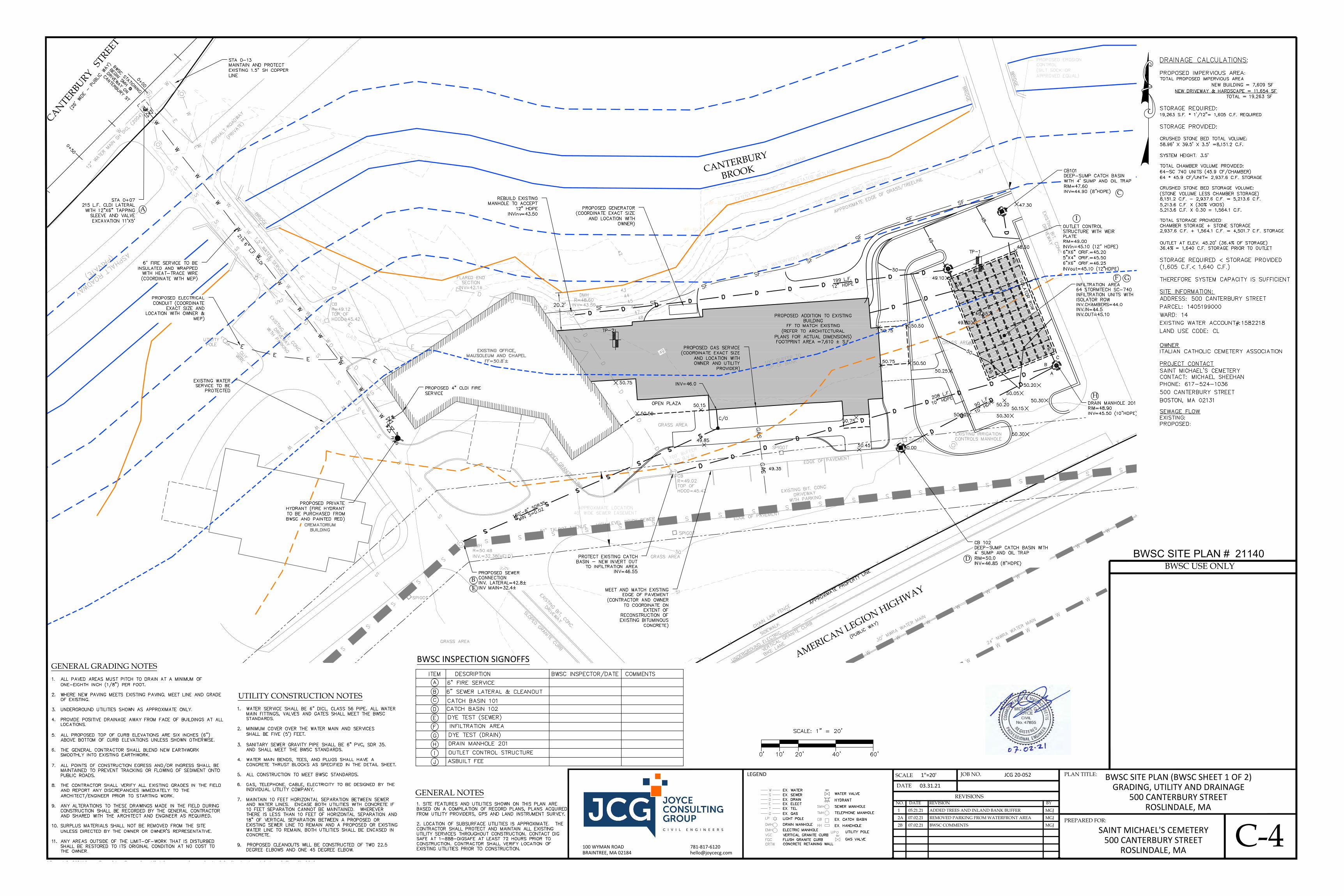
CANTERBURY
BROOK
AMERICAN LEGION HIGHWAY
CANTERBURY STREET
EB
A
C
D
F G
H
I
SCALE
DATE
JOB NO. PLAN TITLE:
GENERAL NOTES
BWSC SITE PLAN (BWSC SHEET 1 OF 2)GRADING, UTILITY AND DRAINAGE
500 CANTERBURY STREETROSLINDALE, MA
100 WYMAN ROAD 781-817-6120BRAINTREE, MA 02184 [email protected]
"Copyright 2021" Joyce Consulting Group, Inc. All rights reserved unauthorized duplication is a violation of all applicable laws.
LEGEND JCG 20-052
03.31.21
1"=20'
REVISIONSNO. REVISION BYDATE
PREPARED FOR:
SAINT MICHAEL'S CEMETERY500 CANTERBURY STREET
ROSLINDALE, MAC-4
GENERAL GRADING NOTES
UTILITY CONSTRUCTION NOTES
BWSC USE ONLYBWSC SITE PLAN # 21140
1 ADDED TREES AND INLAND BANK BUFFER MGJ05.21.21
2A REMOVED PARKING FROM WATERFRONT AREA MGJ07.02.21
2B BWSC COMMENTS MGJ07.02.21
BWSC INSPECTION SIGNOFFS
AutoCAD SHX Text
ASPHALT ROADWAY
AutoCAD SHX Text
(PRIVATE)
AutoCAD SHX Text
25' RIVERFRONT AREA BOUNDARY
AutoCAD SHX Text
EXTENT OF BORDER OF VEGETATED WETLAND
AutoCAD SHX Text
100' BUFFER TO B.V.W.
AutoCAD SHX Text
51" TALBOT AVENUE - HIGH LEVEL BRICK SEWER
AutoCAD SHX Text
GRASS AREA
AutoCAD SHX Text
GRASS AREA
AutoCAD SHX Text
GRASS AREA
AutoCAD SHX Text
APPROXIMATE EDGE OF GRASS/TREELINE
AutoCAD SHX Text
PROPOSED EROSION CONTROL (SILT SOCK OR APPROVED EQUAL)
AutoCAD SHX Text
EXISTING BIT. CONC. DRIVEWAY WITH PARKING
AutoCAD SHX Text
EXISTING IRRIGATION CONTROLS MANHOLE
AutoCAD SHX Text
EXISTING BIT. CONC. DRIVEWAY
AutoCAD SHX Text
BRIDGE
AutoCAD SHX Text
BRIDGE
AutoCAD SHX Text
PROPOSED ADDITION TO EXISTING BUILDING FF TO MATCH EXISTING (REFER TO ARCHITECTURAL PLANS FOR ACTUAL DIMENSIONS) FOOTPRINT AREA =7,610 ± S.F.
AutoCAD SHX Text
EXISTING OFFICE, MAUSOLEUM AND CHAPEL FF=50.8'±
AutoCAD SHX Text
SPIGOT
AutoCAD SHX Text
SPIGOT
AutoCAD SHX Text
SPIGOT
AutoCAD SHX Text
CB R=49.02 TOP OF HOOD=45.42
AutoCAD SHX Text
MH R=51.05
AutoCAD SHX Text
SPIGOT
AutoCAD SHX Text
EXISTING BIT. CONC. DRIVEWAY
AutoCAD SHX Text
EXISTING BIT. CONC. DRIVEWAY WITH PARKING
AutoCAD SHX Text
EXISTING CREMATORIUM BUILDING
AutoCAD SHX Text
SMH R=50.48 INV.=32.38(HELD)
AutoCAD SHX Text
WF-B9
AutoCAD SHX Text
WF-B8
AutoCAD SHX Text
WF-B7
AutoCAD SHX Text
WF-B10
AutoCAD SHX Text
WF-B11
AutoCAD SHX Text
WF-B12
AutoCAD SHX Text
WF-B13
AutoCAD SHX Text
EDGE OF PAVEMENT
AutoCAD SHX Text
EDGE OF PAVEMENT
AutoCAD SHX Text
SLOPED GRANITE CURB
AutoCAD SHX Text
SLOPED GRANITE CURB
AutoCAD SHX Text
GRASS AREA
AutoCAD SHX Text
TOP OF BANK
AutoCAD SHX Text
(PUBLIC WAY)
AutoCAD SHX Text
30" MWRA WATER MAIN
AutoCAD SHX Text
24" MWRA WATER MAIN
AutoCAD SHX Text
CHAIN LINK FENCE
AutoCAD SHX Text
VERTICAL GRANITE CURB
AutoCAD SHX Text
BIKE LANE
AutoCAD SHX Text
SIDEWALK
AutoCAD SHX Text
UNDERGROUND ELECTRIC
AutoCAD SHX Text
APPROXIMATE PROPERTY LINE
AutoCAD SHX Text
DMH R=48.60 INV=43.50
AutoCAD SHX Text
CB R=49.12 TOP OF HOOD=45.42
AutoCAD SHX Text
WF-B6
AutoCAD SHX Text
FLARED END SECTION INV=42.1±
AutoCAD SHX Text
50.75
AutoCAD SHX Text
50.75
AutoCAD SHX Text
BRIDGE
AutoCAD SHX Text
(26' WIDE - PUBLIC WAY)
AutoCAD SHX Text
1.5" WATER SERVICE
AutoCAD SHX Text
ASPHALT ROADWAY
AutoCAD SHX Text
(PRIVATE)
AutoCAD SHX Text
IP
AutoCAD SHX Text
IP
AutoCAD SHX Text
IP
AutoCAD SHX Text
IP
AutoCAD SHX Text
50.75
AutoCAD SHX Text
50.75
AutoCAD SHX Text
OPEN PLAZA
AutoCAD SHX Text
50.50
AutoCAD SHX Text
50.15
AutoCAD SHX Text
49.85
AutoCAD SHX Text
49.35
AutoCAD SHX Text
CB101 DEEP-SUMP CATCH BASIN WITH 4' SUMP AND OIL TRAP RIM=47.60 INV=44.90 (8"HDPE)
AutoCAD SHX Text
INFILTRATION AREA 64 STORMTECH SC-740 INFILTRATION UNITS WITH ISOLATOR ROW INV.CHAMBERS=44.0 INV.IN=44.5 INV.OUT=45.10
AutoCAD SHX Text
50.00
AutoCAD SHX Text
50.25
AutoCAD SHX Text
49.80
AutoCAD SHX Text
50.50
AutoCAD SHX Text
48
AutoCAD SHX Text
49
AutoCAD SHX Text
50
AutoCAD SHX Text
50.50
AutoCAD SHX Text
50.50
AutoCAD SHX Text
50.20
AutoCAD SHX Text
50.20
AutoCAD SHX Text
49.65
AutoCAD SHX Text
50.05
AutoCAD SHX Text
50.30
AutoCAD SHX Text
50.30
AutoCAD SHX Text
50.15
AutoCAD SHX Text
H
AutoCAD SHX Text
Y
AutoCAD SHX Text
D
AutoCAD SHX Text
OUTLET CONTROL STRUCTURE WITH WEIR PLATE RIM=49.00 INVin=45.10 (12" HDPE) 6"X6" ORIF.=45.20 5"X4" ORIF.=45.50 6"X6" ORIF.=46.25 INVout=45.10 (12"HDPE)
AutoCAD SHX Text
CB 102 DEEP-SUMP CATCH BASIN WITH 4' SUMP AND OIL TRAP RIM=50.0 INV=46.85 (8"HDPE)
AutoCAD SHX Text
PROTECT EXISTING CATCH BASIN - NEW INVERT OUT TO INFILTRATION AREA INV=46.55
AutoCAD SHX Text
UTILITY POLE
AutoCAD SHX Text
GUY WIRE
AutoCAD SHX Text
PROPOSED GENERATOR (COORDINATE EXACT SIZE AND LOCATION WITH OWNER)
AutoCAD SHX Text
STA 0+07 215 L.F. CLDI LATERAL WITH 12"X6" TAPPING SLEEVE AND VALVE EXCAVATION 11'X5'
AutoCAD SHX Text
WV
AutoCAD SHX Text
12" WATER MAIN SH DICL (2004)
AutoCAD SHX Text
STA 0-13 MAINTAIN AND PROTECT EXISTING 1.5" SH COPPER LINE
AutoCAD SHX Text
215 6" L.F. CLDI
AutoCAD SHX Text
EXISTING WATER SERVICE TO BE PROTECTED
AutoCAD SHX Text
PROPOSED 4" CLDI FIRE SERVICE
AutoCAD SHX Text
WV
AutoCAD SHX Text
WV
AutoCAD SHX Text
REBUILD EXISTING MANHOLE TO ACCEPT 12" HDPE INVinv=43.50
AutoCAD SHX Text
49.10
AutoCAD SHX Text
48.50
AutoCAD SHX Text
INV=46.0
AutoCAD SHX Text
PROPOSED GAS SERVICE (COORDINATE EXACT SIZE AND LOCATION WITH OWNER AND UTILITY PROVIDER)
AutoCAD SHX Text
160'-6" SDR35 MIN S=0.02
AutoCAD SHX Text
PROPOSED ELECTRICAL CONDUIT (COORDINATE EXACT SIZE AND LOCATION WITH OWNER & MEP)
AutoCAD SHX Text
6" FIRE SERVICE TO BE INSULATED AND WRAPPED WITH HEAT-TRACE WIRE (COORDINATE WITH MEP)
AutoCAD SHX Text
C/O
AutoCAD SHX Text
50
AutoCAD SHX Text
BWSC STATIONING BEGIN SMH @ DRIVEWAY ON CANTERBURY ST
AutoCAD SHX Text
0+50
AutoCAD SHX Text
0+00
AutoCAD SHX Text
TP-1
AutoCAD SHX Text
TP-2
AutoCAD SHX Text
MEET AND MATCH EXISTING EDGE OF PAVEMENT (CONTRACTOR AND OWNER TO COORDINATE ON EXTENT OF RECONSTRUCTION OF EXISTING BITUMINOUS CONCRETE)
AutoCAD SHX Text
50.45
AutoCAD SHX Text
DRAIN MANHOLE 201 RIM=48.90 INV=45.50 (10"HDPE)
AutoCAD SHX Text
50.30
AutoCAD SHX Text
208 L.F. 10" HDPE
AutoCAD SHX Text
PROPOSED SEWER CONNECTION INV. LATERAL=42.8±INV MAIN=32.4±
AutoCAD SHX Text
90 L.F. 10" HDPE
AutoCAD SHX Text
ISOLATOR ROW
AutoCAD SHX Text
100' BUFFER TO TOP OF BANK
AutoCAD SHX Text
25' WATERFRONT AREA BOUNDARY
AutoCAD SHX Text
47.30
AutoCAD SHX Text
PROPOSED PRIVATE HYDRANT (FIRE HYDRANT TO BE PURCHASED FROM BWSC AND PAINTED RED)
AutoCAD SHX Text
199 L.F. 12" HDPE
AutoCAD SHX Text
A
AutoCAD SHX Text
B
AutoCAD SHX Text
C
AutoCAD SHX Text
VGC
AutoCAD SHX Text
VERTICAL GRANITE CURB
AutoCAD SHX Text
EX. HANDHOLE
AutoCAD SHX Text
HH
AutoCAD SHX Text
EX. CATCH BASIN
AutoCAD SHX Text
CB
AutoCAD SHX Text
G
AutoCAD SHX Text
EX. GAS
AutoCAD SHX Text
H
AutoCAD SHX Text
Y
AutoCAD SHX Text
D
AutoCAD SHX Text
WV
AutoCAD SHX Text
WATER VALVE
AutoCAD SHX Text
HYDRANT
AutoCAD SHX Text
TELEPHONE MANHOLE
AutoCAD SHX Text
TMH
AutoCAD SHX Text
SEWER MANHOLE
AutoCAD SHX Text
SMH
AutoCAD SHX Text
ELECTRIC MANHOLE
AutoCAD SHX Text
EMH
AutoCAD SHX Text
DRAIN MANHOLE
AutoCAD SHX Text
DMH
AutoCAD SHX Text
T
AutoCAD SHX Text
E
AutoCAD SHX Text
D
AutoCAD SHX Text
S
AutoCAD SHX Text
W
AutoCAD SHX Text
EX. TEL
AutoCAD SHX Text
EX. ELECT
AutoCAD SHX Text
EX. DRAIN
AutoCAD SHX Text
EX. SEWER
AutoCAD SHX Text
EX. WATER
AutoCAD SHX Text
LP
AutoCAD SHX Text
LIGHT POLE
AutoCAD SHX Text
CONCRETE RETAINING WALL
AutoCAD SHX Text
CRTW
AutoCAD SHX Text
FGC
AutoCAD SHX Text
FLUSH GRANITE CURB
AutoCAD SHX Text
GV
AutoCAD SHX Text
GAS VALVE
AutoCAD SHX Text
UTILITY POLE
AutoCAD SHX Text
UP
AutoCAD SHX Text
1. SITE FEATURES AND UTILITIES SHOWN ON THIS PLAN ARE BASED ON A COMPILATION OF RECORD PLANS, PLANS ACQUIRED FROM UTILITY PROVIDERS, GPS AND LAND INSTRUMENT SURVEY. 2. LOCATION OF SUBSURFACE UTILITIES IS APPROXIMATE. THE CONTRACTOR SHALL PROTECT AND MAINTAIN ALL EXISTING UTILITY SERVICES THROUGHOUT CONSTRUCTION. CONTACT DIG SAFE AT 1-888-DIGSAFE AT LEAST 72 HOURS PRIOR TO CONSTRUCTION. CONTRACTOR SHALL VERIFY LOCATION OF EXISTING UTILITIES PRIOR TO CONSTRUCTION.
AutoCAD SHX Text
SCALE: 1" = 20'
AutoCAD SHX Text
20'
AutoCAD SHX Text
0'
AutoCAD SHX Text
10'
AutoCAD SHX Text
40'
AutoCAD SHX Text
60'
AutoCAD SHX Text
1. ALL PAVED AREAS MUST PITCH TO DRAIN AT A MINIMUM OF ALL PAVED AREAS MUST PITCH TO DRAIN AT A MINIMUM OF ONE-EIGHTH INCH (1/8") PER FOOT. 2. WHERE NEW PAVING MEETS EXISTING PAVING, MEET LINE AND GRADE WHERE NEW PAVING MEETS EXISTING PAVING, MEET LINE AND GRADE OF EXISTING. 3. UNDERGROUND UTILITIES SHOWN AS APPROXIMATE ONLY. UNDERGROUND UTILITIES SHOWN AS APPROXIMATE ONLY. 4. PROVIDE POSITIVE DRAINAGE AWAY FROM FACE OF BUILDINGS AT ALL PROVIDE POSITIVE DRAINAGE AWAY FROM FACE OF BUILDINGS AT ALL LOCATIONS. 5. ALL PROPOSED TOP OF CURB ELEVATIONS ARE SIX INCHES (6") ALL PROPOSED TOP OF CURB ELEVATIONS ARE SIX INCHES (6") ABOVE BOTTOM OF CURB ELEVATIONS UNLESS SHOWN OTHERWISE. 6. THE GENERAL CONTRACTOR SHALL BLEND NEW EARTHWORK THE GENERAL CONTRACTOR SHALL BLEND NEW EARTHWORK SMOOTHLY INTO EXISTING EARTHWORK. 7. ALL POINTS OF CONSTRUCTION EGRESS AND/OR INGRESS SHALL BE ALL POINTS OF CONSTRUCTION EGRESS AND/OR INGRESS SHALL BE MAINTAINED TO PREVENT TRACKING OR FLOWING OF SEDIMENT ONTO PUBLIC ROADS. 8. THE CONTRACTOR SHALL VERIFY ALL EXISTING GRADES IN THE FIELD THE CONTRACTOR SHALL VERIFY ALL EXISTING GRADES IN THE FIELD AND REPORT ANY DISCREPANCIES IMMEDIATELY TO THE ARCHITECT/ENGINEER PRIOR TO STARTING WORK. 9. ANY ALTERATIONS TO THESE DRAWINGS MADE IN THE FIELD DURING ANY ALTERATIONS TO THESE DRAWINGS MADE IN THE FIELD DURING CONSTRUCTION SHALL BE RECORDED BY THE GENERAL CONTRACTOR AND SHARED WITH THE ARCHITECT AND ENGINEER AS REQUIRED. 10. SURPLUS MATERIALS SHALL NOT BE REMOVED FROM THE SITE SURPLUS MATERIALS SHALL NOT BE REMOVED FROM THE SITE UNLESS DIRECTED BY THE OWNER OR OWNER'S REPRESENTATIVE. 11. ANY AREAS OUTSIDE OF THE LIMIT-OF-WORK THAT IS DISTURBED ANY AREAS OUTSIDE OF THE LIMIT-OF-WORK THAT IS DISTURBED SHALL BE RESTORED TO ITS ORIGINAL CONDITION AT NO COST TO THE OWNER.
AutoCAD SHX Text
1. WATER SERVICE SHALL BE 6" DICL, CLASS 56 PIPE. ALL WATER WATER SERVICE SHALL BE 6" DICL, CLASS 56 PIPE. ALL WATER MAIN FITTINGS, VALVES AND GATES SHALL MEET THE BWSC STANDARDS. 2. MINIMUM COVER OVER THE WATER MAIN AND SERVICES MINIMUM COVER OVER THE WATER MAIN AND SERVICES SHALL BE FIVE (5') FEET. 3. SANITARY SEWER GRAVITY PIPE SHALL BE 6" PVC, SDR 35. SANITARY SEWER GRAVITY PIPE SHALL BE 6" PVC, SDR 35. AND SHALL MEET THE BWSC STANDARDS. 4. WATER MAIN BENDS, TEES, AND PLUGS SHALL HAVE A WATER MAIN BENDS, TEES, AND PLUGS SHALL HAVE A CONCRETE THRUST BLOCKS AS SPECIFIED IN THE DETAIL SHEET. 5. ALL CONSTRUCTION TO MEET BWSC STANDARDS. ALL CONSTRUCTION TO MEET BWSC STANDARDS. 6. GAS, TELEPHONE, CABLE, ELECTRICITY TO BE DESIGNED BY THE GAS, TELEPHONE, CABLE, ELECTRICITY TO BE DESIGNED BY THE INDIVIDUAL UTILITY COMPANY. 7. MAINTAIN 10 FEET HORIZONTAL SEPARATION BETWEEN SEWER MAINTAIN 10 FEET HORIZONTAL SEPARATION BETWEEN SEWER AND WATER LINES. ENCASE BOTH UTILITIES WITH CONCRETE IF 10 FEET SEPARATION CANNOT BE MAINTAINED. WHEREVER THERE IS LESS THAN 10 FEET OF HORIZONTAL SEPARATION AND 18" OF VERTICAL SEPARATION BETWEEN A PROPOSED OR EXISTING SEWER LINE TO REMAIN AND A PROPOSED OR EXISTING WATER LINE TO REMAIN, BOTH UTILITIES SHALL BE ENCASED IN CONCRETE. 9. PROPOSED CLEANOUTS WILL BE CONSTRUCTED OF TWO 22.5 DEGREE ELBOWS AND ONE 45 DEGREE ELBOW.
AutoCAD SHX Text
DRAINAGE CALCULATIONS: : PROPOSED IMPERVIOUS AREA: TOTAL PROPOSED IMPERVIOUS AREA NEW BUILDING = 7,609 SF NEW BUILDING = 7,609 SF NEW DRIVEWAY & HARDSCAPE = 11,654 SF TOTAL = 19,263 SF STORAGE REQUIRED: 19,263 S.F. * 1'/12"= 1,605 C.F. REQUIRED STORAGE PROVIDED: CRUSHED STONE BED TOTAL VOLUME: 58.96' X 39.5' X 3.5' =8,151.2 C.F. SYSTEM HEIGHT: 3.5' TOTAL CHAMBER VOLUME PROVIDED: 64-SC 740 UNITS (45.9 CF/CHAMBER) 64 * 45.9 CF/UNIT= 2,937.6 C.F. STORAGE CRUSHED STONE BED STORAGE VOLUME: (STONE VOLUME LESS CHAMBER STORAGE) 8,151.2 C.F. - 2,937.6 C.F. = 5,213.6 C.F. 5,213.6 C.F. X (30% VOIDS) 5,213.6 C.F. X 0.30 = 1,564.1 C.F. TOTAL STORAGE PROVIDED: CHAMBER STORAGE + STONE STORAGE 2,937.6 C.F. + 1,564.1 C.F. = 4,501.7 C.F. STORAGE OUTLET AT ELEV. 45.20' (36.4% OF STORAGE) 36.4% = 1,640 C.F. STORAGE PRIOR TO OUTLET STORAGE REQUIRED < STORAGE PROVIDED (1,605 C.F.< 1,640 C.F.) THEREFORE SYSTEM CAPACITY IS SUFFICIENT
AutoCAD SHX Text
SITE INFORMATION: ADDRESS: 500 CANTERBURY STREET PARCEL: 1405199000 WARD: 14 EXISTING WATER ACCOUNT#:1582218 LAND USE CODE: CL
AutoCAD SHX Text
OWNER ITALIAN CATHOLIC CEMETERY ASSOCIATION
AutoCAD SHX Text
PROJECT CONTACT SAINT MICHAEL'S CEMETERY CONTACT: MICHAEL SHEEHAN PHONE: 617-524-1036 500 CANTERBURY STREET BOSTON, MA 02131
AutoCAD SHX Text
BWSC INSPECTOR/DATE
AutoCAD SHX Text
COMMENTS
AutoCAD SHX Text
A
AutoCAD SHX Text
ITEM
AutoCAD SHX Text
DESCRIPTION
AutoCAD SHX Text
B
AutoCAD SHX Text
6" FIRE SERVICE
AutoCAD SHX Text
C
AutoCAD SHX Text
D
AutoCAD SHX Text
6" SEWER LATERAL & CLEANOUT
AutoCAD SHX Text
DYE TEST (SEWER)
AutoCAD SHX Text
E
AutoCAD SHX Text
INFILTRATION AREA
AutoCAD SHX Text
F
AutoCAD SHX Text
G
AutoCAD SHX Text
DYE TEST (DRAIN)
AutoCAD SHX Text
CATCH BASIN 101
AutoCAD SHX Text
CATCH BASIN 102
AutoCAD SHX Text
H
AutoCAD SHX Text
DRAIN MANHOLE 201
AutoCAD SHX Text
I
AutoCAD SHX Text
J
AutoCAD SHX Text
ASBUILT FEE
AutoCAD SHX Text
OUTLET CONTROL STRUCTURE
AutoCAD SHX Text
SEWAGE FLOW EXISTING: PROPOSED:

OUTLET CONTROL STRUCTURE DETAIL
DRAIN MANHOLE DETAIL
CATCH BASIN DETAIL
DRAIN MANHOLE COVER DETAILNOT TO SCALE
SCALE
DATE
JOB NO. PLAN TITLE:BWSC DETAIL SHEET I (BWSC SHEET 2 OF 2)
500 CANTERBURY STREETROSLINDALE, MA
100 WYMAN ROAD 781-817-6120BRAINTREE, MA 02184 [email protected]
"Copyright 2021" Joyce Consulting Group, Inc. All rights reserved unauthorized duplication is a violation of all applicable laws.
LEGEND JCG 20-052
03.31.21
1"=20'
REVISIONSNO. REVISION BYDATE
PREPARED FOR:
SAINT MICHAEL'S CEMETERY500 CANTERBURY STREET
ROSLINDALE, MAC-5
18"(450 mm) MIN*
8'(2.4 m)MAX
SUBGRADE SOILS(SEE NOTE 4)
PAVEMENT LAYER (DESIGNEDBY SITE DESIGN ENGINEER)
SC-740END CAP
6" (150 mm) MIN
DC
B
A
PERIMETER STONE(SEE NOTE 6)
EXCAVATION WALL(CAN BE SLOPED OR VERTICAL)
12" (300 mm) MIN
ADS GEOSYNTHETICS 601T NON-WOVEN GEOTEXTILE ALLAROUND CLEAN, CRUSHED, ANGULAR STONE IN A & B LAYERS
12" (300 mm) TYP51" (1295 mm)6"(150 mm) MIN
30"(760 mm)
DEPTH OF STONE 6" (150 mm) MIN
*TO BOTTOM OF FLEXIBLE PAVEMENT. FOR UNPAVEDINSTALLATIONS WHERE RUTTING FROM VEHICLES MAY OCCUR,
INCREASE COVER TO 24" (600 mm).
UNDERGROUND DETENTION AREA
BWSC USE ONLYBWSC SITE PLAN # 21140
FIRE AND LATERAL CONNECTION DETAIL
2" DOMESTIC WATER CONNECTION DETAIL
CLEANOUT DETAIL
CATCH BASIN GRATE DETAILNOT TO SCALE
SEWER CONNECTION DETAIL
³ 24
2B BWSC COMMENTS MGJ07.02.21
AutoCAD SHX Text
1. PROVIDE RESILIENT CONNECTOR WHERE PIPE ENTERS MANHOLE. PROVIDE RESILIENT CONNECTOR WHERE PIPE ENTERS MANHOLE. 2. DESIGN LIVE LOAD HS20-44. DESIGN LIVE LOAD HS20-44.
AutoCAD SHX Text
MORTAR ALL AROUND
AutoCAD SHX Text
FINISHED GRADE
AutoCAD SHX Text
ADJUST TO GRADE WITH A MIN OF TWO COURSES OF BRICK MASONRY IN FULL MORTAR BED
AutoCAD SHX Text
6"- GRAVEL BEDDING
AutoCAD SHX Text
2'-0" DIA (TYP)
AutoCAD SHX Text
NOTES:
AutoCAD SHX Text
12" HDPE FROM INFILTRATORS
AutoCAD SHX Text
INV=45.10
AutoCAD SHX Text
12" HDPE TO OUTLET DRAIN
AutoCAD SHX Text
INV=45.10
AutoCAD SHX Text
R=48.90
AutoCAD SHX Text
TOP WEIR=47.50
AutoCAD SHX Text
TOP WEIR=47.5
AutoCAD SHX Text
INV 6"X6"=45.20
AutoCAD SHX Text
BOTTOM WEIR EXTENDS TO MANHOLE BOTTOM
AutoCAD SHX Text
BOLTED WITH 3/8" SS BOLTS & EXP. ANCHORS (3 PER )
AutoCAD SHX Text
WEIR PLATE
AutoCAD SHX Text
1/4" STAINLESS STEEL WEIR PLATE
AutoCAD SHX Text
SECURE WEIR PLATE TO MANHOLE SIDE WITH 2- 1/2" x 2" x 5/16"
AutoCAD SHX Text
STORMTECH SYSTEM
AutoCAD SHX Text
4' DIAMETER PRECAST MANHOLE OR APPROVED EQUAL
AutoCAD SHX Text
INV 5"X4"=45.50
AutoCAD SHX Text
INV 6"X6"=46.25
AutoCAD SHX Text
7'-6" (STANDARD DEPTH)
AutoCAD SHX Text
OIL AND GREASE TRAP
AutoCAD SHX Text
8" MIN. M2.01.4
AutoCAD SHX Text
CRUSHED STONE
AutoCAD SHX Text
NORMAL WATER LEVEL
AutoCAD SHX Text
5" MIN.
AutoCAD SHX Text
MORTAR ALL JOINTS
AutoCAD SHX Text
SUMP
AutoCAD SHX Text
48"
AutoCAD SHX Text
PRECAST CEMENT
AutoCAD SHX Text
24"%%p1" DIA.
AutoCAD SHX Text
MAY VARY
AutoCAD SHX Text
FROM 12"
AutoCAD SHX Text
TO 48"
AutoCAD SHX Text
RISER SECTIONS
AutoCAD SHX Text
HEIGHT OF
AutoCAD SHX Text
1"
AutoCAD SHX Text
4'%%P1" DIA.
AutoCAD SHX Text
TOP SLAB STEEL REINFORCED TO MEET OR EXCEED H-20 LOADING
AutoCAD SHX Text
OPENINGS
AutoCAD SHX Text
DIAMETER
AutoCAD SHX Text
OUTSIDE PIPE
AutoCAD SHX Text
8"
AutoCAD SHX Text
BRICK LEVELING COURSE
AutoCAD SHX Text
AS REQUIRED FOR GRADE
AutoCAD SHX Text
(2" MIN. - 5" MAX.)
AutoCAD SHX Text
PROVIDE 'V'
AutoCAD SHX Text
ADJUSTMENTS
AutoCAD SHX Text
(3 FLANGE), OR APPROVED EQUAL
AutoCAD SHX Text
IRON WORKS CATALOG NOS. 5520M5 & 5523Z
AutoCAD SHX Text
FRAME AND GRATE SHALL BEEAST JORDAN
AutoCAD SHX Text
GRANITE CURB INLET
AutoCAD SHX Text
FULL BED OF MORTAR
AutoCAD SHX Text
FRAME TO BE SET IN
AutoCAD SHX Text
CONCRETE BASE UNIT
AutoCAD SHX Text
OR APPROVED EQUAL
AutoCAD SHX Text
LeBARON SNOUT 18R
AutoCAD SHX Text
PER VERTICAL FOOT, PLACED
AutoCAD SHX Text
ACCORDING TO AASHTO
AutoCAD SHX Text
DESIGNATION M-199
AutoCAD SHX Text
MIN. 10 SQ. IN. STEEL
AutoCAD SHX Text
PLUS 2"
AutoCAD SHX Text
CLEAR
AutoCAD SHX Text
9.0' OR LESS IN DEPTH
AutoCAD SHX Text
CLEARANCE
AutoCAD SHX Text
SEAL ALL BRICK WORK
AutoCAD SHX Text
SEE DETAIL SDSW.02A
AutoCAD SHX Text
1-#3 BAR AROUND
AutoCAD SHX Text
INVERTED ARCH WITH
AutoCAD SHX Text
BRICKS LAID ON EDGE
AutoCAD SHX Text
PIPE DIA.
AutoCAD SHX Text
18" DIAMETER AND
AutoCAD SHX Text
OPENINGS FOR PIPES
AutoCAD SHX Text
30" MAX.
AutoCAD SHX Text
PRECAST IN RISER SECTION
AutoCAD SHX Text
PIPE OPENINGS TO BE
AutoCAD SHX Text
%%uJOINT DETAIL
AutoCAD SHX Text
1" CLEAR
AutoCAD SHX Text
18" - 24" CONICAL
AutoCAD SHX Text
24"%%p1" DIA.
AutoCAD SHX Text
5" MIN.
AutoCAD SHX Text
WITH METAL LADDER
AutoCAD SHX Text
FROM 12" TO 48"
AutoCAD SHX Text
RUNGS
AutoCAD SHX Text
2" CLEAR
AutoCAD SHX Text
4'%%P1" DIA.
AutoCAD SHX Text
SECTIONS MAY VARY
AutoCAD SHX Text
HEIGHT OF RISER
AutoCAD SHX Text
SECTIONS WITH
AutoCAD SHX Text
8" MIN.
AutoCAD SHX Text
3" MIN.
AutoCAD SHX Text
MORTAR ALL JOINTS
AutoCAD SHX Text
2" MIN.
AutoCAD SHX Text
3" MIN.
AutoCAD SHX Text
# 3 BAR
AutoCAD SHX Text
3"
AutoCAD SHX Text
FULL BED OF MORTAR
AutoCAD SHX Text
FRAME TO BE SET IN
AutoCAD SHX Text
(2" MIN. - 5" MAX.)
AutoCAD SHX Text
AS REQUIRED FOR GRADE
AutoCAD SHX Text
BRICK LEVELING COURSE
AutoCAD SHX Text
ADJUSTMENTS
AutoCAD SHX Text
PROVIDE 'V'
AutoCAD SHX Text
OPENINGS
AutoCAD SHX Text
DIAMETER PLUS
AutoCAD SHX Text
2" CLEARANCE
AutoCAD SHX Text
OUTSIDE PIPE
AutoCAD SHX Text
DESIGNATION M-199
AutoCAD SHX Text
ACCORDING TO AASHTO
AutoCAD SHX Text
MIN. 10 SQ. IN. STEEL
AutoCAD SHX Text
PER VERTICAL FOOT, PLACED
AutoCAD SHX Text
CRUSHED STONE
AutoCAD SHX Text
8" MIN. M2.01.4
AutoCAD SHX Text
9.0' OR LESS IN DEPTH
AutoCAD SHX Text
OVER, 1" COVER
AutoCAD SHX Text
FRAME AND COVER SHALL BE EAST JORDAN
AutoCAD SHX Text
IRON WORKS CATALOG NOS. 2110A & 2114Z
AutoCAD SHX Text
MARKED "DRAIN", OR APPROVED EQUAL
AutoCAD SHX Text
SEAL ALL BRICK WORK
AutoCAD SHX Text
METAL LADDER RUNGS
AutoCAD SHX Text
NOT TO SCALE
AutoCAD SHX Text
NOT TO SCALE
AutoCAD SHX Text
NOT TO SCALE
AutoCAD SHX Text
NOTE: FRAME AND COVER SHALL BE EAST JORDAN IRON WORKS CATALOG NOS. 2110A & 2114Z MARKED "DRAIN", OR APPROVED EQUAL.
AutoCAD SHX Text
8"
AutoCAD SHX Text
A
AutoCAD SHX Text
23 7/8"
AutoCAD SHX Text
36.5"
AutoCAD SHX Text
%%uSECTION A-A
AutoCAD SHX Text
26.25"
AutoCAD SHX Text
1-1/8"
AutoCAD SHX Text
36.5"
AutoCAD SHX Text
A
AutoCAD SHX Text
DRAIN
AutoCAD SHX Text
VGC
AutoCAD SHX Text
VERTICAL GRANITE CURB
AutoCAD SHX Text
EX. HANDHOLE
AutoCAD SHX Text
HH
AutoCAD SHX Text
EX. CATCH BASIN
AutoCAD SHX Text
CB
AutoCAD SHX Text
G
AutoCAD SHX Text
EX. GAS
AutoCAD SHX Text
H
AutoCAD SHX Text
Y
AutoCAD SHX Text
D
AutoCAD SHX Text
WV
AutoCAD SHX Text
WATER VALVE
AutoCAD SHX Text
HYDRANT
AutoCAD SHX Text
TELEPHONE MANHOLE
AutoCAD SHX Text
TMH
AutoCAD SHX Text
SEWER MANHOLE
AutoCAD SHX Text
SMH
AutoCAD SHX Text
ELECTRIC MANHOLE
AutoCAD SHX Text
EMH
AutoCAD SHX Text
DRAIN MANHOLE
AutoCAD SHX Text
DMH
AutoCAD SHX Text
T
AutoCAD SHX Text
E
AutoCAD SHX Text
D
AutoCAD SHX Text
S
AutoCAD SHX Text
W
AutoCAD SHX Text
EX. TEL
AutoCAD SHX Text
EX. ELECT
AutoCAD SHX Text
EX. DRAIN
AutoCAD SHX Text
EX. SEWER
AutoCAD SHX Text
EX. WATER
AutoCAD SHX Text
LP
AutoCAD SHX Text
LIGHT POLE
AutoCAD SHX Text
CONCRETE RETAINING WALL
AutoCAD SHX Text
CRTW
AutoCAD SHX Text
FGC
AutoCAD SHX Text
FLUSH GRANITE CURB
AutoCAD SHX Text
GV
AutoCAD SHX Text
GAS VALVE
AutoCAD SHX Text
UTILITY POLE
AutoCAD SHX Text
UP
AutoCAD SHX Text
BOTTOM OF SYSTEM ELEV.=44.0
AutoCAD SHX Text
CHAMBER INV.=44.50
AutoCAD SHX Text
TOP STONE=47.50
AutoCAD SHX Text
FINISHED GRADE VARIES ~ 49.0 (MIN)
AutoCAD SHX Text
NOTES: 1. SC-740 CHAMBERS SHALL CONFORM TO THE REQUIREMENTS OF ASTM F2418 "STANDARD SPECIFICATION FOR POLYPROPYLENE (PP) SC-740 CHAMBERS SHALL CONFORM TO THE REQUIREMENTS OF ASTM F2418 "STANDARD SPECIFICATION FOR POLYPROPYLENE (PP) CORRUGATED WALL STORMWATER COLLECTION CHAMBERS", OR ASTM F2922 "STANDARD SPECIFICATION FOR POLYETHYLENE (PE) CORRUGATED WALL STORMWATER COLLECTION CHAMBERS". 2. SC-740 CHAMBERS SHALL BE DESIGNED IN ACCORDANCE WITH ASTM F2787 "STANDARD PRACTICE FOR STRUCTURAL DESIGN OF SC-740 CHAMBERS SHALL BE DESIGNED IN ACCORDANCE WITH ASTM F2787 "STANDARD PRACTICE FOR STRUCTURAL DESIGN OF THERMOPLASTIC CORRUGATED WALL STORMWATER COLLECTION CHAMBERS". 3. "ACCEPTABLE FILL MATERIALS" TABLE ABOVE PROVIDES MATERIAL LOCATIONS, DESCRIPTIONS, GRADATIONS, AND COMPACTION REQUIREMENTS "ACCEPTABLE FILL MATERIALS" TABLE ABOVE PROVIDES MATERIAL LOCATIONS, DESCRIPTIONS, GRADATIONS, AND COMPACTION REQUIREMENTS FOR FOUNDATION, EMBEDMENT, AND FILL MATERIALS. 4. THE SITE DESIGN ENGINEER IS RESPONSIBLE FOR ASSESSING THE BEARING RESISTANCE (ALLOWABLE BEARING CAPACITY) OF THE SUBGRADE THE SITE DESIGN ENGINEER IS RESPONSIBLE FOR ASSESSING THE BEARING RESISTANCE (ALLOWABLE BEARING CAPACITY) OF THE SUBGRADE SOILS AND THE DEPTH OF FOUNDATION STONE WITH CONSIDERATION FOR THE RANGE OF EXPECTED SOIL MOISTURE CONDITIONS. 5. PERIMETER STONE MUST BE EXTENDED HORIZONTALLY TO THE EXCAVATION WALL FOR BOTH VERTICAL AND SLOPED EXCAVATION WALLS. PERIMETER STONE MUST BE EXTENDED HORIZONTALLY TO THE EXCAVATION WALL FOR BOTH VERTICAL AND SLOPED EXCAVATION WALLS. 6. ONCE LAYER 'C' IS PLACED, ANY SOIL/MATERIAL CAN BE PLACED IN LAYER 'D' UP TO THE FINISHED GRADE. MOST PAVEMENT SUBBASE SOILS ONCE LAYER 'C' IS PLACED, ANY SOIL/MATERIAL CAN BE PLACED IN LAYER 'D' UP TO THE FINISHED GRADE. MOST PAVEMENT SUBBASE SOILS CAN BE USED TO REPLACE THE MATERIAL REQUIREMENTS OF LAYER 'C' OR 'D' AT THE SITE DESIGN ENGINEER'S DISCRETION.
AutoCAD SHX Text
ESHGW>38.9(BASED ON TP-1)
AutoCAD SHX Text
NOT TO SCALE
AutoCAD SHX Text
NOT TO SCALE
AutoCAD SHX Text
NOTES: - CONCRETE THRUST BLOCK TO BE USED ONLY WHERE IT WILL BEAR ON UNDISTURBED EARTH. - USE RESTRAINED JOINT FITTINGS (MEGALUG OR APPROVED EQUAL) WHERE CONCRETE THRUST BLOCK IS UNACCEPTABLE. - SIZE OF BLOCK OR MEGALUG TO BE DESIGNED FOR SPECIFIC CONDITIONS.
AutoCAD SHX Text
MECHANICAL JOINTS
AutoCAD SHX Text
EXISTING WATER MAIN
AutoCAD SHX Text
TAPPING SLEEVE
AutoCAD SHX Text
6" DUCTILE IRON (CLASS 56 & ZINC COATED)
AutoCAD SHX Text
ACCESS TUBE
AutoCAD SHX Text
MECHANICAL JOINT TAPPING GATE VALVE
AutoCAD SHX Text
MASONRY RING
AutoCAD SHX Text
STANDARD VALVE BOX AND COVER
AutoCAD SHX Text
5'-6" APPROXIMATELY
AutoCAD SHX Text
PROPERTY LINE
AutoCAD SHX Text
STREET SURFACE
AutoCAD SHX Text
SIDEWALK
AutoCAD SHX Text
LIMIT OF TRAVELED WAY
AutoCAD SHX Text
NOT TO SCALE
AutoCAD SHX Text
SIDEWALK UPRIGHT EXTENSION TUBE
AutoCAD SHX Text
TYPE "K" COPPER SERVICE PIPE
AutoCAD SHX Text
STREET BASE
AutoCAD SHX Text
MAIN TUBE SHOE
AutoCAD SHX Text
WATER MAIN
AutoCAD SHX Text
CORPORATION STOP DIRECT TAP
AutoCAD SHX Text
SIDEWALK COCK
AutoCAD SHX Text
STREET SURFACE
AutoCAD SHX Text
CURB STONE
AutoCAD SHX Text
SIDEWALK
AutoCAD SHX Text
TEE HEAD
AutoCAD SHX Text
NOT TO SCALE
AutoCAD SHX Text
NOTE:
AutoCAD SHX Text
CLEANOUT TOP SHALL BE ENCLOSED IN CASTING AND/OR FABRICATED COVER ASSEMBLY.
AutoCAD SHX Text
SEWER CLEANOUT FRAME & COVER (IF IN PAVED AREA)
AutoCAD SHX Text
SET CASTING ASSEMBLY IN CONCRETE COLLAR (IF IN PAVED AREA)
AutoCAD SHX Text
6" PVC SCHEDULE 40 RISER PIPE
AutoCAD SHX Text
6" PVC SCHEDULE 40 SEWER PIPE
AutoCAD SHX Text
LOAM AND SEED OR PAVEMENT
AutoCAD SHX Text
6" PVC SCHEDULE 40 BEND (2-22.5° BENDS)
AutoCAD SHX Text
6" PVC SCHEDULE 40 WYE
AutoCAD SHX Text
NOTES:
AutoCAD SHX Text
1. SEWER CLEANOUTS SHALL BE TYPICALLY LOCATED A MINIMUM OF 10' FROM THE
AutoCAD SHX Text
FOUNDATION. HOWEVER, IN SPECIAL CIRCUMSTANCES THE CLEANOUT MAY BE LOCATED
AutoCAD SHX Text
WITHIN 10' OF THE FOUNDATION WITH PERMISSION OF THE ENGINEERING DEPARTMENT. THE
AutoCAD SHX Text
10' ZONE SHALL BE CONSIDERED THE DISTANCE FROM THE INSIDE FACE OF THE FOUNDATION
AutoCAD SHX Text
TO A DISTANCE OF 10' OUTSIDE OF THE FOUNDATION, PERPENDICULAR TO THE INSIDE FACE
AutoCAD SHX Text
2. ALL WORK TO BE CONDUCTED WITHIN THE 10' ZONE SHALL BE PERFORMED BY A PLUMBER
AutoCAD SHX Text
LICENSED IN THE STATE OF MASSACHUSETTS AND SHALL CONFORM TO 248 CMR 2.00 AND
AutoCAD SHX Text
248 CMR 10.00.
AutoCAD SHX Text
OF THE FOUNDATION.
AutoCAD SHX Text
TO SEWER MAIN
AutoCAD SHX Text
%%uSECTION A-A
AutoCAD SHX Text
3 FLANGE
AutoCAD SHX Text
A
AutoCAD SHX Text
A
AutoCAD SHX Text
30 5/16"
AutoCAD SHX Text
24.25"
AutoCAD SHX Text
34"
AutoCAD SHX Text
21.75"
AutoCAD SHX Text
8"
AutoCAD SHX Text
2"
AutoCAD SHX Text
NOTE : : FRAME AND GRATE SHALL BE EAST JORDAN IRON WORKS CATALOG NOS. 5520M5 & 5524Z FOR THE 4 FLANGE AND CATALOG NOS. 5520M5 & 5523Z FOR THE 3 FLANGE, OR APPROVED EQUAL.
AutoCAD SHX Text
NOT TO SCALE
AutoCAD SHX Text
SERVICE PIPE
AutoCAD SHX Text
STAINLESS STEEL EXPANSION BAND
AutoCAD SHX Text
CONCRETE TRUNK LINE OR MANHOLE WALL
AutoCAD SHX Text
STAINLESS STEEL PIPE CLAMP
AutoCAD SHX Text
FLEXIBLE RUBBER CONNECTOR
AutoCAD SHX Text
NOTES: 1. OPENING IN CONCRETE WALL SHALL BE CORED USING OPENING IN CONCRETE WALL SHALL BE CORED USING HIGH SPEED DIAMOND DRILL 2. ALL METAL FIXTURES SHALL BE OF STAINLESS STEEL ALL METAL FIXTURES SHALL BE OF STAINLESS STEEL 3. SERVICE LINE SHALL BE FLUSH WITH THE INSIDE OF SERVICE LINE SHALL BE FLUSH WITH THE INSIDE OF THE CONCRETE PIPE OR WALL 4. IF TRUNK LINE DIAMETER IS LESS THAN 24" THEN A IF TRUNK LINE DIAMETER IS LESS THAN 24" THEN A SADDLE TYPE CONNECTION WILL BE USED

DRIVEWAY DETAIL
HANDICAP PARKING SIGNSHALL BE WHITE LETTERING
AGAINST A BLUEBACKGROUND
ACCESSIBLEVAN
RESERVEDPARKING
ACCESSIBLE PARKING SIGN WITH BOLLARD DETAIL
BITUMINOUS CONCRETE PAVEMENT (TWO COURSES)
CONCRETE SIDEWALK DETAIL
CONTROL JOINT [5'-0" O.C. MAX] EXPANSION JOINT [30'-0" O.C. MAX]
SCALE
DATE
JOB NO. PLAN TITLE:DETAIL SHEET II
500 CANTERBURY STREETROSLINDALE, MA
100 WYMAN ROAD 781-817-6120BRAINTREE, MA 02184 [email protected]
"Copyright 2020" Joyce Consulting Group, Inc. All rights reserved unauthorized duplication is a violation of all applicable laws.
LEGEND JCG 20-052
03.31.21
1"=20'
REVISIONSNO. REVISION BY
- - -
DATE
-
PREPARED FOR:
SAINT MICHAEL'S CEMETERY500 CANTERBURY STREET
ROSLINDALE, MAC-6
STANDARD TRENCH DETAIL FOR UTILITY PIPETRENCH PAVEMENT DETAIL
NOT TO SCALE
EXPLORATORY TEST-PIT LOG
CAPE COD BERM DETAIL
SLOPED GRANITE CURB DETAIL
AutoCAD SHX Text
DRIVEWAYS SHALL BE CONSTRUCTED IN CONFORMANCE WITH THE CURRENT REGULATIONS OF THE ARCHITECTURAL ACCESS BOARD, THE AMERICANS WITH DISABILITIES ACT AND THE CURRENT MASSHIGHWAY CONSTRUCTION STANDARDS.
AutoCAD SHX Text
NOT TO SCALE
AutoCAD SHX Text
C DRIVE
AutoCAD SHX Text
L
AutoCAD SHX Text
GUTTERLINE
AutoCAD SHX Text
DRIVEWAY
AutoCAD SHX Text
WIDTH AS NOTED ON PLAN
AutoCAD SHX Text
GRANITE CURB TYPE VB
AutoCAD SHX Text
PC
AutoCAD SHX Text
PC
AutoCAD SHX Text
PROPOSED CURB CUT
AutoCAD SHX Text
3'
AutoCAD SHX Text
GRANITE CURB RETURN R=3'
AutoCAD SHX Text
1.5% MAX.
AutoCAD SHX Text
GRANITE CURB RETURN R=3'
AutoCAD SHX Text
4'
AutoCAD SHX Text
FINISH GRADE
AutoCAD SHX Text
SIGNS SHALL BE SET AT RIGHT ANGLES TO THE DIRECTION, AND FACING, THE TRAFFIC INTENDED TO SERVE.
AutoCAD SHX Text
GALVANIZED STEEL POST CAP
AutoCAD SHX Text
ALUMINUM PANEL SIGN
AutoCAD SHX Text
DIE-PUNCHED KNOCKOUT HOLES ( "±DIA) ON 716"±DIA) ON 1" CENTERS ON ALL FOUR SIDES PUNCHED, BUT NOT REMOVED.
AutoCAD SHX Text
2" SQ. GALVANIZED STEEL POST
AutoCAD SHX Text
EARTH
AutoCAD SHX Text
3000 PSI CONCRETE ANCHOR FOOTING
AutoCAD SHX Text
6"DIA. STEEL PIPE BOLLARD, CONCRETE FILLED, PAINTED YELLOW
AutoCAD SHX Text
1/2" EXPANSION JOINT
AutoCAD SHX Text
[AS NOTED]
AutoCAD SHX Text
NOT TO SCALE
AutoCAD SHX Text
COMPACTED SUBGRADE REMOVE UNSUITABLE MATERIAL & REPLACE WITH GRAVEL BORROW (MHD M1.03.0 TYPE "B") COMPACTED IN 6" LAYERS
AutoCAD SHX Text
8" GRAVEL BORROW (MHD M1.03.0 TYPE "B")
AutoCAD SHX Text
2" HOT MIX ASPHALT BASE COURSE
AutoCAD SHX Text
1-1/2" HOT MIX ASPHALT WEARING COURSE
AutoCAD SHX Text
4" DENSE GRADED CRUSHED STONE (MHD M2.01.7)
AutoCAD SHX Text
EXISTING PAVEMENT DEPTH AND SUBBASE
AutoCAD SHX Text
SAWCUT EXISTING PAVEMENT AND APPLY LONGITUDINAL JOINT ADHESIVE
AutoCAD SHX Text
NOT TO SCALE
AutoCAD SHX Text
NOT TO SCALE
AutoCAD SHX Text
CONTROL JOINT " WIDE x 1 38" WIDE x 1 1/2" DEEP, MIN ( 14THICKNESS OF SLAB, MIN)
AutoCAD SHX Text
SMOOTH TOOLED EDGE TYPICAL 1 " WIDE EITHER 12" WIDE EITHER SIDE OF JOINT (TYP)
AutoCAD SHX Text
8" COMPACTED GRAVEL COMPACTED TO 95%
AutoCAD SHX Text
CONCRETE WALK WITH LIGHT BROOM FINISH PERPENDICULAR TO TRAVEL
AutoCAD SHX Text
CONTINUOUS TOOLED SEALANT BEAD
AutoCAD SHX Text
3/8" PREMOLDED EXPANSION JOINT FILLER, CUT BACK 1/2" MIN FROM SURFACE AFTER POUR
AutoCAD SHX Text
NOTE: : 1 1/2" FOR 6" THICK
AutoCAD SHX Text
SMOOTH TOOLED EDGE TYPICAL 1 " WIDE 12" WIDE EITHER SIDE OF JOINT (TYP)
AutoCAD SHX Text
8" COMPACTED GRAVEL COMPACTED TO 95%
AutoCAD SHX Text
CONCRETE WALK (4,000 PSI, 3/4" CEMENT) WITH LIGHT BROOM FINISH PERPENDICULAR TO TRAVEL
AutoCAD SHX Text
VGC
AutoCAD SHX Text
VERTICAL GRANITE CURB
AutoCAD SHX Text
EX. HANDHOLE
AutoCAD SHX Text
HH
AutoCAD SHX Text
EX. CATCH BASIN
AutoCAD SHX Text
CB
AutoCAD SHX Text
G
AutoCAD SHX Text
EX. GAS
AutoCAD SHX Text
H
AutoCAD SHX Text
Y
AutoCAD SHX Text
D
AutoCAD SHX Text
WV
AutoCAD SHX Text
WATER VALVE
AutoCAD SHX Text
HYDRANT
AutoCAD SHX Text
TELEPHONE MANHOLE
AutoCAD SHX Text
TMH
AutoCAD SHX Text
SEWER MANHOLE
AutoCAD SHX Text
SMH
AutoCAD SHX Text
ELECTRIC MANHOLE
AutoCAD SHX Text
EMH
AutoCAD SHX Text
DRAIN MANHOLE
AutoCAD SHX Text
DMH
AutoCAD SHX Text
T
AutoCAD SHX Text
E
AutoCAD SHX Text
D
AutoCAD SHX Text
S
AutoCAD SHX Text
W
AutoCAD SHX Text
EX. TEL
AutoCAD SHX Text
EX. ELECT
AutoCAD SHX Text
EX. DRAIN
AutoCAD SHX Text
EX. SEWER
AutoCAD SHX Text
EX. WATER
AutoCAD SHX Text
LP
AutoCAD SHX Text
LIGHT POLE
AutoCAD SHX Text
CONCRETE RETAINING WALL
AutoCAD SHX Text
CRTW
AutoCAD SHX Text
FGC
AutoCAD SHX Text
FLUSH GRANITE CURB
AutoCAD SHX Text
GV
AutoCAD SHX Text
GAS VALVE
AutoCAD SHX Text
UTILITY POLE
AutoCAD SHX Text
UP
AutoCAD SHX Text
NOTES:
AutoCAD SHX Text
NOT TO SCALE
AutoCAD SHX Text
ROADS, ROAD SHOULDERS, PARKING
AutoCAD SHX Text
ABOVE PIPE. MTW=PIPE DIAM.+2FT. MAX.
AutoCAD SHX Text
MTW=MAXIMUM TRENCH WIDTH TO 12"
AutoCAD SHX Text
LANDSCAPED AREAS
AutoCAD SHX Text
AREAS, DRIVEWAYS, WALKWAYS
AutoCAD SHX Text
LOAM & SEED (SEE MAT. SPECS)
AutoCAD SHX Text
BIT. CONC. PVMT. OR PATCH (SEE MATERIAL SPECS.)
AutoCAD SHX Text
FINISH GRADE
AutoCAD SHX Text
SHEETING (IF REQUIRED) TO BE CUT OFF AND LEFT IN PLACE A MAX. OF 3 FT. BELOW FINISH GRADE OR 1.5 FT. ABOVE TOP OF PIPE (WHICH EVER IS HIGHER)
AutoCAD SHX Text
EXISTING PAVEMENT
AutoCAD SHX Text
SAWCUT
AutoCAD SHX Text
GRAVEL BORROW (MHD M1.03.0 "TYPE B")
AutoCAD SHX Text
DRAIN OR SEWER PIPE (SEE MATERIAL SPECS.)
AutoCAD SHX Text
GRAVEL BORROW COMPACTED TO 95% MAX. DENSITY (MHD M1.03.0 "TYPE B")
AutoCAD SHX Text
MID DIAMETER
AutoCAD SHX Text
COMPACTED SUBBASE
AutoCAD SHX Text
SUITABLE BACKFILL MATERIAL
AutoCAD SHX Text
BITUMINOUS TOP COURSE AND BITUMINOUS BINDER COURSE SEE PAVING AND SURFACING FOR THICKNESS
AutoCAD SHX Text
UNDISTURBED EXISTING PAVEMENT
AutoCAD SHX Text
UNDISTURBED EARTH
AutoCAD SHX Text
SAWCUT AND TACK COAT EDGES OF EXISTING PAVEMENT
AutoCAD SHX Text
NOTES: PERMANENT TRENCH PAVEMENT PAYMENT WIDTH SHALL BE THE TRENCH PAY LIMIT PLUS 2 FEET TEMPORARY TRENCH PAVEMENT PAYMENT WIDTH SHALL BE EQUAL TO THE TRENCH PAYMENT LIMIT REMOVE AND DISPOSE ALL TEMPORARY PAVEMENT AS REQUIRED. RESTORE AND COMPACT SUBBASE AS REQUIRED PRIOR TO PERMANENT TRENCH PAVEMENT.
AutoCAD SHX Text
1. 2. 3.
AutoCAD SHX Text
NOT TO SCALE
AutoCAD SHX Text
0
AutoCAD SHX Text
1
AutoCAD SHX Text
2
AutoCAD SHX Text
3
AutoCAD SHX Text
4
AutoCAD SHX Text
5
AutoCAD SHX Text
6
AutoCAD SHX Text
LOGGED BY:
AutoCAD SHX Text
DATE
AutoCAD SHX Text
TEST PIT 1
AutoCAD SHX Text
GRD EL 47.9' %%P
AutoCAD SHX Text
G.W. EL > 38.9'
AutoCAD SHX Text
BTP@96"
AutoCAD SHX Text
01-25-21
AutoCAD SHX Text
M. JOYCE, JCG
AutoCAD SHX Text
6"
AutoCAD SHX Text
24"
AutoCAD SHX Text
A HORIZON: LOAM (FILL - GRANULAR, FRIABLE)
AutoCAD SHX Text
FILL - C1 HORIZON: LOAMY SAND
AutoCAD SHX Text
NOTES: 1. NO INDICATIONS OF ESTIMATED SEASONAL HIGH GROUNDWATER. 2. DRY TO BOTTOM OF HOLE
AutoCAD SHX Text
7
AutoCAD SHX Text
8
AutoCAD SHX Text
9
AutoCAD SHX Text
FILL: LOAMY SAND 3-5% GRAVEL
AutoCAD SHX Text
10YR 3/3
AutoCAD SHX Text
10YR 4/1
AutoCAD SHX Text
10YR 7/1
AutoCAD SHX Text
C HORIZON: SANDY LOAM, HIGH SILT CONTENT 3-5% GRAVEL, 3-5% COBBLES/STONES
AutoCAD SHX Text
10YR 4/4
AutoCAD SHX Text
0
AutoCAD SHX Text
1
AutoCAD SHX Text
2
AutoCAD SHX Text
3
AutoCAD SHX Text
4
AutoCAD SHX Text
5
AutoCAD SHX Text
6
AutoCAD SHX Text
LOGGED BY:
AutoCAD SHX Text
DATE
AutoCAD SHX Text
TEST PIT 2
AutoCAD SHX Text
GRD EL 49.0' %%P
AutoCAD SHX Text
G.W. EL > 43.0'
AutoCAD SHX Text
BTP@72"
AutoCAD SHX Text
01-25-21
AutoCAD SHX Text
M. JOYCE, JCG
AutoCAD SHX Text
A HORIZON: LOAM (FILL - GRANULAR, FRIABLE)
AutoCAD SHX Text
FILL - C1 HORIZON: LOAMY SAND SOME BRICK & WOOD
AutoCAD SHX Text
NOTES: 1. NO INDICATIONS OF ESTIMATED SEASONAL HIGH GROUNDWATER. 2. DRY TO BOTTOM OF HOLE
AutoCAD SHX Text
FILL: LOAMY SAND 3-5% GRAVEL
AutoCAD SHX Text
10YR 3/3
AutoCAD SHX Text
10YR 4/1
AutoCAD SHX Text
10YR 4/4
AutoCAD SHX Text
1' - 0"
AutoCAD SHX Text
12"
AutoCAD SHX Text
SHOULDER
AutoCAD SHX Text
2" BINDER COURSE
AutoCAD SHX Text
1-1/2" WEARING COURSE
AutoCAD SHX Text
12" GRAVEL BASE
AutoCAD SHX Text
GRADE
AutoCAD SHX Text
FINISH
AutoCAD SHX Text
LEVEL
AutoCAD SHX Text
BERM
AutoCAD SHX Text
BIT CONC.
AutoCAD SHX Text
SUBGRADE
AutoCAD SHX Text
NOT TO SCALE
AutoCAD SHX Text
3"
AutoCAD SHX Text
(MIN.)
AutoCAD SHX Text
BINDER
AutoCAD SHX Text
TOP COURSE
AutoCAD SHX Text
UNDISTURBED MATERIAL
AutoCAD SHX Text
UNDISTURBED MATERIAL
AutoCAD SHX Text
NOT TO SCALE


![[JMJ] Feast of The Holy Family of Saint Michael’s Catholic ...€¦ · members of Saint Michael’s and attending Mass. Dates and times of Baptism can ONLY be set after registering](https://static.fdocuments.us/doc/165x107/5faff7e79549bb3638604505/jmj-feast-of-the-holy-family-of-saint-michaelas-catholic-members-of-saint.jpg)


