PROPOSED 3RD SEMESTER CURRICULAR …...3.9 Prismatic Compass, surveyor’s compass. 3.10 Difference...
40
PROPOSED 3 RD SEMESTER CURRICULAR STRUCTURE AND SYLLABI OF FULL-TIME DIPLOMA COURSE IN SURVEY ENGINEERING
Transcript of PROPOSED 3RD SEMESTER CURRICULAR …...3.9 Prismatic Compass, surveyor’s compass. 3.10 Difference...

PROPOSED
3RD
SEMESTER
CURRICULAR STRUCTURE
AND
SYLLABI OF
FULL-TIME DIPLOMA COURSE IN
SURVEY ENGINEERING

PROPOSED CURRICULAR STRUCTURE FOR THIRD SEMESTER OF THE FULL TIME DIPLOMA COURSE IN SURVEY ENGINEERING
WEST BENGAL STATE COUNCIL OF TECHNICAL EDUCATION
TEACHING & EXAMINATION SCHEME FOR DIPLOMA IN ENGINEERING COURSES
BRANCH: DIPLOMA IN SURVEY ENGINEERING SEMESTER: THIRD
SL. NO.
SUBJECT CREDITS PERIODS EVALUATION SCHEME
L TU PR INTERNAL SCHEME ESE PR
#
TW
@
TOTAL MARKS
TA CT TOTAL
1 Chain & Compass Survey 4 3 1 10 20 30 70 - - 100
2 Cadastral Survey & Plane Table Surveying 3 3 - - 10 20 30 70 - - 100
3 Levelling & Tachometry 3 3 1 - 10 20 30 70 - - 100
4 Theodolite Survey 3 3 - - 10 20 30 70 - - 100
5 Materials & Construction Practices 3 3 - - 10 20 30 70 - - 100
6 Civil Engineering Drawing-I 2 1 - 3 - - - - 50 50 100
7 Field Survey Practices – I 5 - - 9 - - - - 100 100 200
8 Professional Practice I 2 - - 3 - - - - 25 25 50
TOTAL 25 16 2 15 50 100 150 350 175 175 850
STUDENT CONTACT HOURS PER WEEK: 33 Hrs.
Theory and Practical Period of 60 Minutes each.
# - External Assessment @ - Internal Assessment, ESE - End Semester Exam, CT- Class Test, TA - Teachers Assessment.
L – Lecturer, TU –Tutorial, PR – Practical, TA – Teachers’ Assessment, CT – Class Test, ESE – End Semester Exam. TW – Term Work.
Note :- The common syllabus of Workshop Practice of 1st year students may be followed for Survey Engineering department also and the syllabus of Survey Practice subject may be covered in Field Survey Practice subject of 2nd and 3rd year.

2
Name of the Course : SURVEY ENGINEERING
( CHAIN AND COMPASS SURVEY )
Course code : SE / S3 / T1 / CC Semester : THIRD
Duration : 15 weeks Maximum Marks : 100
Teaching Scheme Examination Scheme
Theory : 3 hrs/week Mid Semester Exam / CT : 20 Marks
Tutorial: 1 hrs/week Attendance, Assignment & Quiz : 10 Marks
Practical : - hrs/week End Semester Exam: 70 Marks
Credit :- 4
Aim :-
S.No
1. Developing the survey skill required for survey engineering.
Objective :-
S.No Students will be able to:
1. Gather preliminary knowledge of surveying.
2. Gather knowledge about chain survey.
3. Gather knowledge about compass survey.
Pre-Requisite :-
S.No
1. Students should have the knowledge of drawing and sketching.
Contents : Hrs/unit Marks
Unit -1
INTRODUCTORY CONCEPTS
1.1 Basic concept and general introduction
1.2 Measurement – Linear and angular, units of measurement,
precision of surveying, work of Surveyor.
1.3 Direct measurement – Instrument for measuring distances,
different types of chain, ranging out a survey line, errors in
chaining, tape correction, degree of accuracy.
DEFINITION OF SURVEY
1.4 Definition and object of Surveying.
1.5 Difference between Plane and Geodetic Surveying.
1.6 Principle of Surveying.
1.7 Classification of surveying.
BASIC CONCEPTS OF PLANS, MAPS, SCALES
1.8 Plans, Maps and Scales – Choice of scale of a map.
1.9 Construction and use of a simple scale.
1.10 Construction and use of a diagonal scale.
1.11 Error due to use of wrong scale.
16
20

3
Unit -2
2.0 CHAIN SURVEYING
2.1 Survey conventional signs, abbreviations and colours used.
2.2 Selection of scales for plotting.
2.3 Principle of Chain Survey.
2.4 Instrument used, their description and checking their
correctness.
2.5 Ranging and chain a line
2.6 Errors in chaining, test and adjust of chains.
2.7 Obstructions while chaining and method of over coming them.
2.8 Chaining along a sloping ground.
2.9 Off-sets and their measurements, use of cross-staff and optical
square, oblique offset.
2.10 Procedure of chain Surveying.
2.11 Computation of areas from plans by various method: -
(i) Graphical, (ii) Divide into triangles, (iii) Divide into squares,
(iv) By ordinates, (v) Mid-ordinate rule, (vi) Average ordinate
method, (vii) Trapezoidal rule, (viii) Simpson’s rule.
2.12 Planimeter – different types, description of different parts,
precaution to be taken.
2.13 Conversion of satak, acres & decimal into bigha, katha,
chattack & hectres and inversely.
2.14 Numerical problems.
21
25
Unit -3
3.0 COMPASS / DIAL SURVEYING
3.1 Bearing, designation of bearing, converting whole circle
bearing to quadrant bearing & vice-versa.
3.2 Meridians, classification of bearing.
3.3 Azimuth, reduce bearing.
3.4 Fore bearing, back bearing.
3.5 Computation of internal angles from bearing & vice-versa.
3.6 Magnetic declination, variation of declination, isogonic lines,
agonic lines.
3.7 Computation of angles from bearings and bearing from angles
and related problems.
3.8 Local attraction, detection and elimination of local attraction.
3.9 Prismatic Compass, surveyor’s compass.
3.10 Difference between prismatic compass and surveyor’s
compass.
3.11 Traversing by compass/dial, closed traverse, open traverse.
3.12 Numerical problems
23
25
Text Books:-
Sl. No. Titles of the Book Name of Authors Name of the Publisher
1 Surveying and Levelling N N Basak Tata Mc Graw-Hill
2 Surveying and Levelling ( Part I )
T .P. Kanetkar & S. V,
Kulkarni
PUNE VIDHYARTHI GRIHA Prakashan
3 Surveying and Levelling ( Vol. I )
Dr. B. C. Punmiya Laxmi Publication
4 Text book of Surveying S.K.Husain, M.S. Nagaraj S. Chand and company
5 Surveying and Levelling S. K. Duggal TATA MC GRAW-HILL

4
6 Plane Surveying Dr. A.M.Chandra NEW AGE INTERNATIONAL
7 Surveying
( Vol. I)
Dr. K. R. Arora STANDARD BOOK HOUSE
8 Fundamentals of Surveying
S. K. Roy PHI Learning Pvt. Ltd.
Reference books :- Nil
Suggested List of Laboratory Experiments :- Nil
Suggested List of Assignments/Tutorial :- Nil

5
Name of the Course : SURVEY ENGINEERING
( CADASTRAL SURVEY & PLANE TABLE SURVEY )
Course code : SE / S3 / T2 / CSPTS Semester : THIRD
Duration : 15 weeks Maximum Marks : 100
Teaching Scheme Examination Scheme
Theory : 3 hrs/week Mid Semester Exam / CT : 20 Marks
Tutorial: - hrs/week Attendance, Assignment & Quiz : 10 Marks
Practical : - hrs/week End Semester Exam: 70 Marks
Credit :- 3
Aim :-
S.No
1. Developing the survey skill required for survey engineering.
Objective :-
S.No Students will be able to:
1. Gather knowledge about cadastral survey.
2. Gather knowledge about plane table survey.
Pre-Requisite :-
S.No
1. Students should have the knowledge of drawing and sketching.
Contents : Hrs/unit Marks
Unit -1
1.0 CADASTRAL SURVEYING
1.1 Definition & Purpose of Cadastral Survey.
1.2 Unit of Cadastral Survey
1.3 Use of Cadastral Survey Instruments : Plane Table, Optical
Square, Offset Scale, Diagonal Scale, Acre Comb &
Compass. Testing of these instruments. Underlying Principles
of Optical Squares, Acre-Comb, etc.
1.4 Orientation of Plane Table.
1.5 Different methods of finding missing Traverse Pegs. Polygon
closing by finding Traverse pegs.
1.6 Principle of distribution of errors
1.7 Quadrilaterals, their arrangement.
1.8 Sikmi Lines, Selective of Sikmi Lines, Limit of Offsets.
1.9 Definition: China, Goad, Dhabi and Kaman, Standard Line,
Tahoka Line, Trijunction Pillar, Alamat, Scale and their
classification.
1.10 Detailed Survey, Booking of Field Notes, Survey-in-Situ.
1.11 Error-in-chaining.
1.12 Procedure of horizontal chaining and its application
1.13 Obstruction of chaining – (a) Chaining Free, Vision
obstruction, (b) chaining obstructed, but vision free, (c)
Chaining and vision both obstructed.
20
35
6
1.14 Procedure of Chain Triangulation and Prolongation.
1.15 Inspection of cadastral survey – Running of Partal Line.
1.16 Boundary compassion, Plot Numbering, Bata and Chhut Plot
Numbers.
1.17 Inking of Map.
1.18 Area extraction with the help of Acre- Comb, Passing of
mauza area.
1.19 Khanapuri – Map Correction
1.20 Bujharat - Map Correction
1.21 Attestation - Map Correction
1.22 Post Draft Publication – Map Correction
1.23 Post Final publication – Map Correction
1.24 Maintenance of Cadastral Survey Maps and other records.
Unit -2
2.0 PLANE TABLE SURVEYING
2.1 Plane table, its parts & accessories.
2.2 Setting up & orienting the table by back sighting & by magnetic
needle.
2.3 Various methods of plane table survey by: —
(i) Radiation method,
(ii) Intersection method or triangulation method,
(iii) Traversing method,
(iv) Resection method,
2.4 Three point problems & their solution by tracing paper method.
2.5 Advantages & disadvantages of plane table and sources of
errors in plane tabling.
2.6 Problem on above topics.
25
35
Text Books:-
Sl. No. Titles of the Book Name of Authors Name of the Publisher
1 Surveying and Levelling N N Basak Tata Mc Graw-Hill
2 Surveying
( Vol. I)
Dr. K. R. Arora STANDARD BOOK HOUSE
3 Surveying and Levelling ( Vol. I )
Dr. B. C. Punmiya Laxmi Publication
4 Plane Surveying Dr. A.M.Chandra NEW AGE INTERNATIONAL
PUBLISHERS
5 Surveying and Levelling
( Vol. I )
S. K. Duggal TATA MC GRAW-HILL
Reference books :- Nil
Suggested List of Laboratory Experiments :- Nil
Suggested List of Assignments/Tutorial :- Nil

7
Name of the Course : SURVEY ENGINEERING
( LEVELLING AND & TACHOMETRY )
Course code : SE / S3 / T3 / LT Semester : THIRD
Duration : 15 weeks Maximum Marks : 100
Teaching Scheme Examination Scheme
Theory : 3 hrs/week Mid Semester Exam / CT : 20 Marks
Tutorial: - hrs/week Attendance, Assignment & Quiz : 10 Marks
Practical : - hrs/week End Semester Exam: 70 Marks
Credit :- 3
Aim :-
S.No
1. Developing the survey skill required for survey engineering.
Objective :-
S.No Students will be able to:
1. Gather knowledge about leveling.
2. Gather knowledge about tacheometry.
Pre-Requisite :-
S.No
1. Students should have the knowledge of drawing and sketching.
Contents : Hrs/unit Marks
Unit -1
1.0 LEVELLING
1.1. Concept of levelling, uses of levelling, Definition of
important terms used in levelling.
1.2. Datum elevation, vertical angle, mean sea level and bench
mark.
1.3. Levelling Instruments- Different types- parts and function of
dumpy level, tilting level and automatic level.
1.4. Levelling staff.
1.5. Sensitivity of spirit level- methods of determining sensitivity.
Parallel plate micrometer.
1.6. Tests and adjustments of dumpy level & tilting level.
1.7. (i) Methods of levelling- Spirit levelling, trigonometrical
levelling & barometric levelling.
(ii) Special methods of spirit levelling- Details of
differential levelling, profile levelling, cross-sectioning
& reciprocal levelling.
(iii) Methods of booking, calculation of reduced levels
&plotting of level sections
(iv) Recording and plotting of longitudinal section of an
alignment.
(v) Levelling problems like levelling of steep slope,
15
25
8
summits &hollows, taking level of an overhead point,
levelling ponds & lakes too wide to be sighted across.
Levelling across river, levelling past high wall.
(vi) Levelling in an inclined plane on surface and
underground
(vii) Use of Abney’s clinometer
1.8 Sources of errors in levelling, precautions.
Unit -2
2.0 CONTOURING
2.1 Basic concept, contour interval.
2.2 Characteristics of contour.
2.3 Methods of locating contours.
2.4 Interpolation & extrapolation of contour.
2.5 Contour gradient.
2.6 Use of contour maps.
2.7 Locating the proposed route for a road on a contour map.
2.8 Establishing grade contours, stratum contour.
12
20
Unit -3
3.0 TACHEOMETRY
3.1 Introduction.
3.2 Advantage of Tacheometric Survey.
3.3 Tacheometer.
3.4 Basic systems of Tacheometric Measurements.
3.5 Principle of Stadia Method.
3.6 Determination of Tacheometric Constants.
3.7 External Focussing Telescopes with an Anallatic Lens.
3.8 Internal Focussing Telescope.
3.9 DISTANCE AND ELEVATION FORMULA: Line of sight horizontal
— Line of sight inclined.
3.0 Use of Tacheometry.
4.0 Sources of error, accuracy of measurement.
18
25
Text Books:-
Sl. No. Titles of the Book Name of Authors Name of the Publisher
1 Surveying and Levelling N N Basak Tata Mc Graw-Hill
2 Surveying and Levelling ( Part I & II )
T .P. Kanetkar & S. V,
Kulkarni
PUNE VIDHYARTHI GRIHA Prakashan
3 Surveying and Levelling ( I & II) Dr. B. C. Punmiya Laxmi Publication
4 Surveying and Levelling( I & II ) S. K. Duggal TATA MC GRAW-HILL
5 Plane Surveying Dr. A.M.Chandra NEW AGE INTERNATIONAL
6 Surveying ( Vol. I & II ) Dr. K. R. Arora STANDARD BOOK HOUSE
7 Fundamentals of Surveying S. K. Roy PHI Learning Pvt. Ltd.
Reference books :- Nil
Suggested List of Laboratory Experiments :- Nil
Suggested List of Assignments/Tutorial :- Nil
9
Name of the Course : SURVEY ENGINEERING
( THEODOLITE SURVEY )
Course code : SE / S3 / T4 / TS Semester : THIRD
Duration : 15 weeks Maximum Marks : 100
Teaching Scheme Examination Scheme
Theory : 3 hrs/week Mid Semester Exam / CT : 20 Marks
Tutorial: - hrs/week Attendance, Assignment & Quiz : 10 Marks
Practical : - hrs/week End Semester Exam: 70 Marks
Credit :- 3
Aim :-
S.No
1. Developing the survey skill required for survey engineering.
Objective :-
S.No Students will be able to:
1. Gather knowledge about theodolite.
2. Compute area and volume.
Pre-Requisite :-
S.No
1. Students should have the knowledge of drawing and sketching.
2. Students should have the knowledge of mathematics.
Contents : Hrs/unit Marks
Unit -1
1.0 THEODOLITE SURVEY
1.1 Classification of Theodolite, description of Theodolite, function
of its different parts.
1.2 Different parts of a transit Theodolite.
1.3 Relations between fundamental lines.
1.4 Temporary adjustments of the Theodolite.
1.5 MEASUREMENT OF HORIZONTAL ANGLES: Repetition method –
Reiteration method
1.6 Measurement of vertical angles.
1.7 Calculation of bearings from angles.
1.8 Balancing in the intersection of two straight lines.
1.9 Layout a horizontal angle.
1.10 Traversing with the Theodolite by bearing and included angles.
1.11 Traverse connection with G.T.S. and open traverse. Conversion
of spherical to rectangular coordinates and vice-versa.
1.12 Checks in closed traverse and open traverse.
1.13 Relation between precision of angle and linear measurement.
1.14 Sources of error in Theodolite work.
30
45

10
1.15 Traverse computation
1.16 ADJUSTMENT OF CLOSED TRAVERSE:
(i) Distribution of angular errors;
(ii) Balancing the traverse by Bowditch’s Rule and transit
rule.
1.17 Computation of area of a closed traverse.
1.18 Computation of length and bearing from co-ordinates.
1.19 Testing and permanent adjustment of a transit Theodolite.
1.20 Missing data problems.
Unit -2
2.0 COMPUTATION OF AREA & VOLUME
2.1 COMPUTATION OF AREA: General methods of determining areas
computed by sub-division into triangles, area from: Off-set to
base line – Off-sets at regular intervals – Off-sets at irregular
intervals — Area by planimeter — Area computed by map
measurement.
2.2 COMPUTATION OF VOLUME: Measurement from cross-sections —
Prismoidal formula — Trapezoidal formula — Volume from spot
levels — Volume from contour plans.
15
25
Text Books:-
Sl. No. Titles of the Book Name of Authors Name of the Publisher
1 Surveying and Levelling N N Basak Tata Mc Graw-Hill
2 Surveying and Levelling ( Part I )
T .P. Kanetkar & S. V,
Kulkarni PUNE VIDHYARTHI
GRIHA Prakashan
3 Surveying and Levelling ( Vol. I )
Dr. B. C. Punmiya Laxmi Publication
4 Text book of Surveying S.K.Husain, M.S. Nagaraj S. Chand and company
5 Surveying and Levelling
( Vol. I )
S. K. Duggal TATA MC GRAW-HILL
6 Plane Surveying Dr. A.M.Chandra NEW AGE
INTERNATIONAL
PUBLISHERS
7 Surveying
( Vol. I)
Dr. K. R. Arora STANDARD BOOK HOUSE
8 Fundamentals of Surveying
S. K. Roy PHI Learning Pvt. Ltd.
Reference books :- Nil
Suggested List of Laboratory Experiments :- Nil
Suggested List of Assignments/Tutorial :- Nil

11
Name of the Course : SURVEY ENGINEERING
( MATERIALS & CONSTRUCTION PRACTICES )
Course code : SE / S3 / T5 / MCP Semester : THIRD
Duration : 15 weeks Maximum Marks : 100
Teaching Scheme Examination Scheme
Theory : 3 hrs/week Mid Semester Exam / CT : 20 Marks
Tutorial: - hrs/week Attendance, Assignment & Quiz : 10 Marks
Practical : - hrs/week End Semester Exam: 70 Marks
Credit :- 3
Aim :-
S.No
1. Developing the conceptual knowledge in building material, construction, problems and its remedies.
Objective :-
S.No Students will be able to:
1. Identify various components of buildings and their functions.
2. Check line, level and plumb of various construction activities.
3. Identify & suggest rectification the various defects in civil engineering works.
Pre-Requisite :-
S.No
1. Student should know the basic properties of material being used in the construction of the building.
2. Student should be able to think over the construction problems and their remedies.
Contents : Hrs/unit Marks
Unit -1
1.0
STONES
1.1 Formation of rock, Igneous, Sedimentary, Metamorphic.
1.2 Classification of stones, different varieties of stones available
from different rocks.
1.3 Characteristic qualities of good building stone, Different
varieties of stones use and places where available.
BRICK
1.4 Definition
1.5 Classification and size
1.6 Traditional and I.S. characteristics of 1st / 2
nd / 3
rd class bricks
1.7 Use in different purpose.
LIME
1.8 Classification of lime, manufacturing of lime, burning, air
slaking, storage.
20
30

12
1.9 Characteristic s of good lime. CEMENT 1.10 Type of cement – Portland cement, Rapid hardening cement &
Slag cement.
TIMBER
1.11 Definition, characteristic s of good timber.
1.12 Seasoning, artificial and natural seasoning.
1.13 Principal timber trees in India, use for different purposes.
METALS
1.14 Ferrous and non-ferrous metals, principal iron ores in India,
Places where available and percentage of iron content in it.
1.15 Manufacture of pig iron by blast furnace.
1.16 Cast iron, wrought iron and steel, its properties and uses in
engineering works.
Unit -2
2.0
MORTAR
2.1 General principles and precautions in brick masonry work –
mortar used.
CONCRETE
2.2 Definition
2.3 Types & properties
2.4 Use
2.5 Preparation of concrete
2.6 Reinforced cement concrete - function
CONCEPT OF SOIL & FOUNDATION
2.7 Concept of soil, Definition of soil, Classification of soil as per
BIS classification only, Phase Diagram, Limit.
2.8 Concept of foundation, object of foundation, bearing capacity of
soil, Determination of width and depth of foundation.
2.9 Different types of foundation used at specific locations ( no
detail of construction).
BRICK MASONRY
2.10 Definition
2.11 Bonding
2.12 Function
2.13 Types (only two types)
2.14 Odd and even layer
2.15 Plan of 1-brick & ½ brick thick in English bond.
WALL FINISH
2.16 Plastering – types and function
2.17 White washing – function and methods
2.18 Colour washing – function, types and methods
PAINTS
2.19 Paints, object of painting, ingredients of paints.
2.20 Characteristic s of good paints.
25
40

13
PLASTERING, POINTING & JOINING
2.21 Object of plastering, composition, and application.
2.22 Different types of pointing and joining.
DAMP PROOF COURSE
2.23 Causes of dampness, its harmful effect.
2.24 Methods of damp proofing.
FLOORING
2.25 Definition, choice of floor construction.
2.26 Construction details of different flooring.
ROOF
2.27 Definition, choice of roof construction.
2.28 Construction details of different flat roofs
DOORS & WINDOWS SHUTTERS
2.29 Different types of door & window shutters,
2.30 Its construction details.
LINTEL & ARCHES
2.31 Lintels – advantages, classification of lintels.
2.32 Arches – object of providing it, parts of an arch, classification of
arches(no details of construction).
Text Books:-
Sl. No. Titles of the Book Name of Authors Name of the Publisher
1 Building materials S. K. Duggal New Age International
2 Building Construction Dr. B. C. Punmiya Laxmi Publication
3 Building Construction Sushil Kumar Standard Publication
4 Construction Materials D.N. Ghose TATA MC GRAW-HILL
Reference books :- Nil
Suggested List of Laboratory Experiments :- Nil
Suggested List of Assignments/Tutorial :- Nil

14
Name of the Course : SURVEY ENGINEERING
( CIVIL ENGINEERING DRAWING - I )
Course code : SE / S3 / P1 / CED1 Semester : THIRD
Duration : 15 weeks Maximum Marks : 100
Teaching Scheme Examination Scheme
Theory : -1 hrs/week Continuous Internal Assessment : 50 Marks
Tutorial: - hrs/week Attendance, Assignment & Quiz : - Marks
Practical : 3 hrs/week External Assessment : 50 Marks
Credit :- 2
Aim :-
S.No
1. To develop the ideas, vision and its practical reality through engineering graphics.
2. Developing the approach of visualization, drafting, modeling and analysis.
Objective :-
S.No Students will be able to:
1. Read, interpret and draw the building drawings.
2. Prepare working drawings for the building.
3. Apply the building rules, regulations and byelaws
Pre-Requisite :-
S.No
1. Perfection in geometry and sketching.
2. The students should be perfect in plotting the geometrical shapes and skill of reading the geometrical designs.
Contents : ( Theory ) Hrs/unit Marks
Unit -1
1.0 INTRODUCTION 8
1.1 Element of building planning
1.2 Neighborhoods/Available facilities / Physical features/ Cost of
site/Size of plot.
1.3 Floor plan and characteristics
1.4 Sleeping area / Living area / Service of working area minimum
dimensions of room / Kitchen / Bath and W.C. / Staircase /
Doors and windows etc.
15
Contents : ( Practical )
Sl. No. Assignments : Following exercises should be drawn on full imperial size drawing sheets.
1.
DRAWING PLATE – 1 : BUILDING PLAN, SECTION & ELEVATION 36
Double storeyed residential buildings along with the following drawings:
(i) Plan, elevation and section of a double storeyed small residential building form given
sketch; the building should have Toilet / W.C. / Bathroom, Kitchen and veranda.
(ii) Detail of foundation plan (layout), roof plan, Site plan.
15
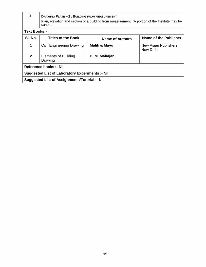
2. DRAWING PLATE – 2 : BUILDING FROM MEASUREMENT 16
Plan, elevation and section of a building from measurement. (A portion of the Institute may be taken.)
Text Books:-
Sl. No. Titles of the Book Name of Authors Name of the Publisher
1 Civil Engineering Drawing Malik & Mayo New Asian Publishers New Delhi
2 Elements of Building Drawing
D. M. Mahajan
Reference books :- Nil
Suggested List of Laboratory Experiments :- Nil
Suggested List of Assignments/Tutorial :- Nil
16
Name of the Course : SURVEY ENGINEERING
( FIELD SURVEY PRACTICES – I )
Course code : SE / S3 / P2 / FSP1 Semester : THIRD
Duration : 15 weeks Maximum Marks : 200
Teaching Scheme Examination Scheme
Theory : - hrs/week Continuous Internal Assessment : 100 Marks
Tutorial: - hrs/week Attendance, Assignment & Quiz : - Marks
Practical : 9 hrs/week External Assessment : 100 Marks
Credit :- 5
Aim :-
S.No
1. Developing the survey skill required for survey engineering.
Objective :-
S.No Students will be able to:
1. Identify different survey instruments.
2. Record and observe necessary observation with the survey instruments
3. Compute necessary survey data from field observation for drawing.
4. Prepare drawing using survey data.
INSTRUCTIONS:
S.No
1. Group size for survey practical work should be maximum 6 students.
2. Each student from a group should handle the instrument independently to understand the function of different components and use of the instrument.
3. Drawing and plotting should be considered as part of practical.
4. Term work shall consist of record of all practical and projects in field book and drawing of Project work on full / half imperial size drawing sheets.
Pre-Requisite :-
S.No
1. Perfection in drawing and sketching.
2. Students should have basic knowledge of Surveying.
Contents : ( Practical )
Sl. No. Assignments
1.
1.0 CHAIN SURVEY
1.1 Unfolding and folding the chain
1.2 Direct Ranging: Ranging by Eye – Ranging by Line Ranger – Chaining on Level
Ground
1.3 Indirect Ranging: Chaining on Sloping Ground
1.4 Laying of angle with chain and tape: 30°, 60°, 45° & 90°

17
1.5 Obstacle in Chaining: Chaining free – Vision obstructed – Chaining obstructed but
vision free – Chaining and vision both obstructed
1.6 Cross Staff Survey
1.7 Surveying an area with Chain and Tape: Reconnaissance the area of survey –
Preparation of Key Plan and Reference Sketch – Selection of Base Line, Station Points
and Marking of Stations – Booking Field Notes – Plotting of Field Data with
conventional signs.
2.
2.0 COMPASS TRAVERSE
2.1 Traversing an area with prismatic compass.
2.2 Traversing in presence of local attraction.
2.3 Surveying an area with prismatic compass, noting the field book, calculate the correct
bearings plotting the traverse by bearing and distance. Graphical adjustment of closing
error of the traverse.
3.
3.0 PLANE TABLE SURVEY
3.1 Setting up and Orientation of plane table with Trough Compass and Back Ray Method
3.2 Plane Tabling by Radiation Method
3.3 Plane Tabling by Intersection Method
3.4 Plane Tabling by Traversing Method
3.5 Plane Tabling by Resection Method
3.6 Fixing inaccessible objects in a plane table survey
3.7 Relaying a missing traverse station with plane table and sight vane
3.8 Surveying a small area by plane table and determination of area by graphical method
Text Books:-
Sl. No. Titles of the Book Name of Authors Name of the Publisher
1 Surveying and Levelling N N Basak Tata Mc Graw-Hill
2 Surveying and Levelling ( Part I )
T .P. Kanetkar & S. V,
Kulkarni PUNE VIDHYARTHI
GRIHA Prakashan
3 Surveying and Levelling ( Vol. I )
Dr. B. C. Punmiya Laxmi Publication
4 Text book of Surveying S.K.Husain, M.S. Nagaraj S. Chand and company
5 Surveying and Levelling
( Vol. I )
S. K. Duggal TATA MC GRAW-HILL
6 Plane Surveying Dr. A.M.Chandra NEW AGE
INTERNATIONAL
PUBLISHERS
7 Surveying
( Vol. I)
Dr. K. R. Arora STANDARD BOOK HOUSE
8 Fundamentals of Surveying
S. K. Roy PHI Learning Pvt. Ltd.
Reference books :- Nil
Suggested List of Laboratory Experiments :- Nil
Suggested List of Assignments/Tutorial :- Nil

18
Name of the Course : SURVEY ENGINEERING
( PROFESSIONAL PRACTICE I )
Course code : SE / S3 / P3 / PP1 Semester : THIRD
Duration : 15 weeks Maximum Marks : 50
Teaching Scheme Examination Scheme
Theory : - hrs/week Continuous Internal Assessment : 25 Marks
Tutorial: - hrs/week Attendance, Assignment & Quiz : - Marks
Practical : 3 hrs/week External Assessment : 25 Marks
Credit :- 2
Aim :-
S.No
1. Development and evaluation of individual skills.
2. Enhancement in soft skills through innovation.
Objective :-
S.No Students will be able to:
1. Acquire information from different sources.
2. Prepare notes for given topic.
3. Present given topic in a seminar.
4. Interact with peers to share thoughts.
5. Prepare a report on industrial visit, expert lecture.
Pre-Requisite :-
S.No
1. Communication skill must be perfect.
Contents : ( Practical )
Sl. No. Assignments
1.
Industrial Visits Structured industrial visits be arranged and report of the same should be submitted by the individual student, to form a part of the term work. Industrial visits may be arranged in the following areas / industries: • Survey Site
2.
Lectures by Professional / Industrial Expert be organized from ANY ONE of the following areas :
1. Different types of construction machineries and equipment. 2. Different types of Survey instruments / software.
3. Individual Assignments : Seminar and report preparation.
Text Books:- Nil.
Reference books :- Nil
Suggested List of Laboratory Experiments :- Nil
Suggested List of Assignments/Tutorial :- Nil

PROPOSED
4TH
SEMESTER
CURRICULAR STRUCTURE
AND
SYLLABI OF
FULL-TIME DIPLOMA COURSE IN
SURVEY ENGINEERING
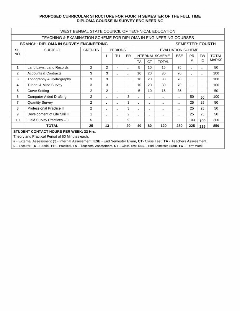
PROPOSED CURRICULAR STRUCTURE FOR FOURTH SEMESTER OF THE FULL TIME DIPLOMA COURSE IN SURVEY ENGINEERING
WEST BENGAL STATE COUNCIL OF TECHNICAL EDUCATION
TEACHING & EXAMINATION SCHEME FOR DIPLOMA IN ENGINEERING COURSES
BRANCH: DIPLOMA IN SURVEY ENGINEERING SEMESTER: FOURTH
SL. NO.
SUBJECT CREDITS PERIODS EVALUATION SCHEME
L TU PR INTERNAL SCHEME ESE PR
#
TW
@
TOTAL MARKS
TA CT TOTAL
1 Land Laws, Land Records 2 2 - - 5 10 15 35 - - 50
2 Accounts & Contracts 3 3 - - 10 20 30 70 - - 100
3 Topography & Hydrography 3 3 - - 10 20 30 70 - - 100
4 Tunnel & Mine Survey 3 3 - - 10 20 30 70 - - 100
5 Curve Setting 2 2 - - 5 10 15 35 - - 50
6 Computer Aided Drafting 2 - - 3 - - - - 50 50 100
7 Quantity Survey 2 - - 3 - - - - 25 25 50
8 Professional Practice II 2 - - 3 - - - - 25 25 50
9 Development of Life Skill II 1 - - 2 - - - - 25 25 50
10 Field Survey Practices – II 5 - - 9 - - - - 100 100 200
TOTAL 25 13 - 20 40 80 120 280 225 225 850
STUDENT CONTACT HOURS PER WEEK: 33 Hrs.
Theory and Practical Period of 60 Minutes each.
# - External Assessment @ - Internal Assessment, ESE - End Semester Exam, CT- Class Test, TA - Teachers Assessment.
L – Lecturer, TU –Tutorial, PR – Practical, TA – Teachers’ Assessment, CT – Class Test, ESE – End Semester Exam. TW – Term Work.

Name of the Course : SURVEY ENGINEERING
( LAND LAWS, LAND RECORDS )
Course code : SE / S4 / T1 / LLLR Semester : FOURTH
Duration : 15 weeks Maximum Marks : 50
Teaching Scheme Examination Scheme
Theory : 2 hrs/week Mid Semester Exam / CT : 10 Marks
Tutorial: - hrs/week Attendance, Assignment & Quiz : 5 Marks
Practical : - hrs/week End Semester Exam: 35 Marks
Credit :- 2
Aim :-
S.No
1. Study of rules and regulation regarding land.
Objective :-
S.No Students will be able to:
1. Work with rules and regulation regarding land.
Pre-Requisite :-
S.No
1. Student should have knowledge of Survey Engineering.
Contents : Hrs/unit Marks
Unit -1
1.0 BENGAL TENANCY ACT
1.1. Bengal Tenancy Act, 1886, Sec – 3 (Definition – Estate, Holding, Agricultural year, Tenure and village ).
WEST BENGAL LAND REFORMS ACT, 1955 1.2. Sec-2 ( Definition ) – Land, Personal Cultivation, Raiyat,
Bargadar, Encumbrance, Homestead. 1.3. Sec-4 – Salient Provisions. 1.4. Sec-14K(c) Family. 1.5. Sec-14K(f) Standard Hectare. 1.6. Sec-14M(1(&(2)-Ceiling Area 1.7. Sec-14(M)(5) – Ceiling for Trust and Endowment. 1.8. Sec-14P-Salient Provisions. 1.9. Sec-14Q(2) – Ceiling for Orchard. 1.10. Sec-14Q(3) – Ceiling for Charitable and Religious
Institutions. 1.11. Sec-14U – Restriction on transfer of land by a raiyat. 1.12. Sec-14Y – Limitation on farther acquisition of land. 1.13. Sec-15A(i) Bargadar right heritable. 1.14. Sec-16 & 16(A) – Share of produce payable by
Bargadar. 1.15. Sec-17 – Termination of Cultivation by Bargadar. 1.16. Sec- 19B – Salient Provisions – Restoration of Land
to Bargadar – Salient Provisions. 1.17. Sec-22, Sec-23 & Sec-24 – Provisions as to Revenue. 1.18. Sec-50 – Maintenance of R-O-R. 1.19. Sec-51 – Revision & Preparation of R-O-R.
WEST BENGAL ESTATE ACQUISITION ACT, 1953 1.20. A General Discussion On The Purpose Of The Act 1.21. Sec – 2 ( Definitions ) – Agricultural Year, Agriculture Land,
Charitable purpose, Data Of Vesting, Homestead, Incumbrance,
15
20

Intermediary, Religious purpose, Rent. 1.22. Sec – 4, Sec – 5, Sec-5(A)– Selling Provision.
1.23. Sec-6(1)(a) to (e) & 6(3).
Unit -2
2.0
LAND ACQUISITION ACT 2.1. Land Acquisition Act, 1894. Section – 1,4,5,6,7,8,9(1), 16,
17(1), 35 and Relevant Portion of the Land Acquisition Manual regarding Valuation of Land.
BENGAL SURVEY ACT 2.2. Bengal Survey Act, 1875. Section – 2, 5, 6& 3, 7,8,9,10,11.
MINES & MINERALS ( REGULATION & DEVELOPMENT) ACT, 1957
2.3. Sec-3 – Definition. 2.4. Sec-4 to 11 – Salient Provisions.
W. B. MINOR MINERALS RULES, 1973 7.1 Definition – Rule 2 : Chief Mining Offices, District Authority,
Lease, Person & Quary Permit. 7.2 Rules : 4, 5, 7, 8, 10, 11, 12, 15, 16, 17, 18, 24
15
15
Text Books:-
Sl. No. Titles of the Book Name of Authors Name of the Publisher
Reference books :- Nil
Suggested List of Laboratory Experiments :- Nil
Suggested List of Assignments/Tutorial :- Nil

Name of the Course : SURVEY ENGINEERING
( ACCOUNTS & CONTRACTS )
Course code : SE / S4 / T2 / AC Semester : FOURTH
Duration : 15 weeks Maximum Marks : 100
Teaching Scheme Examination Scheme
Theory : 3 hrs/week Mid Semester Exam / CT : 20 Marks
Tutorial: - hrs/week Attendance, Assignment & Quiz : 10 Marks
Practical : - hrs/week End Semester Exam: 70 Marks
Credit :- 3
Aim :-
S.No
1. Study of contracts, costing and budgeting of building constructions.
Objective :-
S.No Students will be able to:
1. Differentiate between types of contract.
2. Prepare tender documents.
3. Draft tender notice for various types of construction
4. Prepare specification of an item of construction.
5. Calculate the value of a land and old buildings
Pre-Requisite :-
S.No
1. Student should know tentative rates of materials to be used.
2. Student should have knowledge of accounting.
Contents : Hrs/unit Marks
Unit -1
1.0 SSPPEECCIIFFIICCAATTIIOONN
1.1 Definition, importance and manner of writing specification.
Types of specifications.
1.2 General specification of 1st and 2nd class buildings. Detail
specification of important tax items of a building. Foundation of
a typical load bearing wall, foundation of a typical isolated RCC
column footing, brick work in superstructure, RCC work in slab,
beam and column, lime terracing, external and internal
plastering, I. P. S. flooring, terrazzo flooring, woodwork in doors
and windows.
1.3 Detail specification of important building materials, brick, sand,
cement, coarse aggregate, steel reinforcement.
1.4 Specification for different types of survey jobs :
1.4.1 For a residential building on a plot of size upto 200
sq. m. in plain area and hilly area.
1.4.2 For a township project of size upto 8 hectares.
1.4.3 For a road project of 3 km.
1.4.4 Cadastral surveying of a village
15
20

Unit -2
2.0 ESTIMATION
2.2. Different types of estimates, importance of approximate estimate. General items of work for building estimate.
2.3. Estimation of building from line plan, detail estimate of double storied building.
2.4. Mode of measurements based on IS : 1200. 2.5. Calculation of volume of earthwork by midsection formula,
trapezoidal formula or average end area. Principle and example of mass haul diagram.
2.6. Analysis of rate and how it is prepared. Quantities of material & labour to be analysed.
12
20
Unit -3
3.0 VALUATION
3.2. What is valuation? 3.3. Difference between value and cost 3.4. Purpose of valuation 3.5. Gross income, net income, scrap value, salvage value 3.6. Comparison between scrap value & salvage value 3.7. Comparison between market value and book value 3.8. Sinking fund, capitalized value, depreciation 3.9. Obsolesce, freehold property, lease hold property, mortgage
property
3.10. Determination of depreciation by different methods.
9
15
Unit -4
4.0 CONTRACT
4.2. Definition of tender and contract, Different types of Civil Engineering contracts.
4.3. Contract documents 4.4. Clauses of general condition of contract 4.5. Tender Notice 4.6. Comparative statement and acceptance of tender
4.7. Costing
9
15
Text Books:-
Sl. No. Titles of the Book Name of Authors Name of the Publisher
1 ESTIMATING & COSTING IN
CIVIL ENGINEERING
B.N. Datta UBS Publishers
2 Estimating & costing, Specification and Valuation in Civil
Engineering
M. Chakraborti M. Chakraborti , Calcutta
3 Estimating & costing S.C. Rangwala Charotar Publication
4 Civil Engineering Contracts and
accounts Vol I , II
B.S. Patil Orient Longman,
5 ESTIMATING & COSTING G. S. Birdie Dhanpat Rai and Sons
Reference books :- Nil
Suggested List of Laboratory Experiments :- Nil
Suggested List of Assignments/Tutorial :- Nil

Name of the Course : SURVEY ENGINEERING
( TOPOGRAPHY & HYDROGRAPHY )
Course code : SE / S4 / T3 / TH Semester : FOURTH
Duration : 15 weeks Maximum Marks : 100
Teaching Scheme Examination Scheme
Theory : 3 hrs/week Mid Semester Exam / CT : 20 Marks
Tutorial: - hrs/week Attendance, Assignment & Quiz : 10 Marks
Practical : - hrs/week End Semester Exam: 70 Marks
Credit :- 3
Aim :-
S.No
1. Study of topographic and hydrographic surveying.
Objective :-
S.No Students will be able to:
1. Prepare topographical maps.
2. Construct contour maps.
Pre-Requisite :-
S.No
1. Student should have knowledge of basic Survey Engineering.
Contents : Hrs/unit Marks
Unit -1
11..
GENERAL IDEA ABOUT PREPARATION OF TOPOGRAPHICAL MAPS
1.1. General idea about Topographic Surveying and its purpose. 1.2. Legal authority for conducting this survey. 1.3. Choice of Map scale and contour interval 1.4. Use of Topographical Maps.
GENERAL FIELD PROCEDURE 1.5. Control - Establishment of Horizontal control by
Triangulation / Traversing. 1.6. Control - Establishment of Vertical control by
Trigonometrical leveling/ precise leveling. 1.7. Control - Establishment of V. control by Hand level and
Barometer. 1.8. Instrument to be employed : Stadia Transit, P. Table, Level,
Band-Level & Barometer, Talescopic Alidade, Clinometer etc. LOCATION OF DETAILS
1.9. Details by Trace contour method. 1.10. Details by Cross-Profile method. 1.11. Details by controlling pointing method. 1.12. Details by Checker Board method 1.13. Details by Precision.
RELIEF AND ITS REPRESENTATION 1.14. Representation of Relief by (i) Relief Models (ii)
Shading, (iii) Hachures & (iv) Form – lines/ Contour lines. CONSTRUCTION OF CONTOUR MAPS
1.15. Plotting of Horizontal control station.
23
35
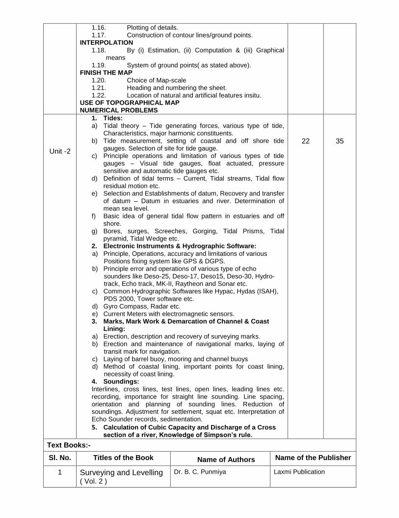
1.16. Plotting of details. 1.17. Construction of contour lines/ground points.
INTERPOLATION 1.18. By (i) Estimation, (ii) Computation & (iii) Graphical
means 1.19. System of ground points( as stated above).
FINISH THE MAP 1.20. Choice of Map-scale 1.21. Heading and numbering the sheet. 1.22. Location of natural and artificial features insitu.
USE OF TOPOGRAPHICAL MAP NUMERICAL PROBLEMS
Unit -2
1. Tides: a) Tidal theory – Tide generating forces, various type of tide,
Characteristics, major harmonic constituents. b) Tide measurement, setting of coastal and off shore tide
gauges. Selection of site for tide gauge. c) Principle operations and limitation of various types of tide
gauges – Visual tide gauges, float actuated, pressure sensitive and automatic tide gauges etc.
d) Definition of tidal terms – Current, Tidal streams, Tidal flow residual motion etc.
e) Selection and Establishments of datum, Recovery and transfer of datum – Datum in estuaries and river. Determination of mean sea level.
f) Basic idea of general tidal flow pattern in estuaries and off shore.
g) Bores, surges, Screeches, Gorging, Tidal Prisms, Tidal pyramid, Tidal Wedge etc.
2. Electronic Instruments & Hydrographic Software: a) Principle, Operations, accuracy and limitations of various
Positions fixing system like GPS & DGPS. b) Principle error and operations of various type of echo
sounders like Deso-25, Deso-17, Deso15, Deso-30, Hydro-track, Echo track, MK-II, Raytheon and Sonar etc.
c) Common Hydrographic Softwares like Hypac, Hydas (ISAH), PDS 2000, Tower software etc.
d) Gyro Compass, Radar etc. e) Current Meters with electromagnetic sensors. 3. Marks, Mark Work & Demarcation of Channel & Coast
Lining: a) Erection, description and recovery of surveying marks. b) Erection and maintenance of navigational marks, laying of
transit mark for navigation. c) Laying of barrel buoy, mooring and channel buoys d) Method of coastal lining, important points for coast lining,
necessity of coast lining. 4. Soundings: Interlines, cross lines, test lines, open lines, leading lines etc. recording, importance for straight line sounding. Line spacing, orientation and planning of sounding lines. Reduction of soundings. Adjustment for settlement, squat etc. Interpretation of Echo Sounder records, sedimentation.
5. Calculation of Cubic Capacity and Discharge of a Cross section of a river, Knowledge of Simpson’s rule.
22
35
Text Books:-
Sl. No. Titles of the Book Name of Authors Name of the Publisher
1 Surveying and Levelling ( Vol. 2 )
Dr. B. C. Punmiya Laxmi Publication

2 Surveying and Levelling
( Vol. 2 )
S. K. Duggal TATA MC GRAW-HILL
3 Surveying ( Vol. 2) Dr. K. R. Arora STANDARD BOOK HOUSE
Reference books :- Nil
Suggested List of Laboratory Experiments :- Nil
Suggested List of Assignments/Tutorial :- Nil

Name of the Course : SURVEY ENGINEERING
( TUNNEL & MINE SURVEY )
Course code : SE / S4 / T4 / TH Semester : FOURTH
Duration : 15 weeks Maximum Marks : 100
Teaching Scheme Examination Scheme
Theory : 3 hrs/week Mid Semester Exam / CT : 20 Marks
Tutorial: - hrs/week Attendance, Assignment & Quiz : 10 Marks
Practical : - hrs/week End Semester Exam: 70 Marks
Credit :- 3
Aim :-
S.No
1. Developing the underground survey skill required for survey engineering.
Objective :-
S.No Students will be able to:
1. Gather knowledge of dip and strike.
2. Gather knowledge about setting out of curve in underground.
3. Gather knowledge about reserve, mines regulation, correlation and tunnel survey.
Pre-Requisite :-
S.No
1. Students should have the knowledge of basic surveying with drawing and sketching.
Contents : Hrs/unit Marks
Unit -1
1.0
DIP AND STRIKE PROBLEM 1.1. Types of Dip and derivation of the formula used to connect
true dip, apparent dip and included angles. 1.2. Borehole problems for determining the dip ( amount and
direction ) of loads and seams. 1.3. Borehole surveying
11..44.. Computation of quantity of coal in certain block ( between boreholes).
FAULT PROBLEM 1.5 Types of faults, folds etc. 1.6 Problems of faults 1.7 Occurrence of faults in mines.
15
20
Unit -2
2.0
CURVE SETTING 2.1 Designation of curve 2.2 Elements of simple circular curve 2.3 Setting out a simple circular curve by
2.3.1. Chord and offset method. 2.3.2. Chord and angle method.
2.4 Example covering the above
15
25

ESTIMATION OF RESERVES (ONLY METALLIFEROUS DEPOSIT) 2.5 Minerals, mineral resources, reserves. 2.6 Methods of calculation of reserves.
2.6.1. Contour lines method 2.6.2. Mean arithmetic method 2.6.3. Polygon method 2.6.4. Section method
2.7 Problems on calculation of average width and grade of an ore body
2.8 Mine sampling :- 2.8.1. Purpose and scope
2.8.2. Sampling method and sampling calculations.
Unit -3
3.0
MINE SURVEY REGULATIONS 3.1 Practical experience of candidates for surveyor’s examination 3.2 Appointment of surveyors 3.3 Duties and responsibilities of surveyors 3.4 General requirements about mine plans and sections 3.5 Types of plans and sections 3.6 Preparation and preservations of plans and sections
according to safety code under the survey legislation 3.7 Management of survey office and its various equipments
MINE CO-RELATION AND SHAFT SURVEY 3.8 Definition and type of mine correlation 3.9 Correlation through inclines and shafts
3.10 Methods of correlation 3.10.1. Single shaft methods: 3.10.1.1. Assumed bearing method 3.10.2. Double shafts methods: 3.10.2.1. Alignment methods 3.10.2.2. Weisbach triangle method 3.10.3. Gyroscopic method of correlation – an
introduction. TUNNEL SURVEY
3.11 Triangulation in Tunnel 3.12 Fixing shaft in a straight tunnel 3.13 Fixing shaft in a curved tunnel 3.14 Construction survey of a straight tunnel 3.15 Construction survey of a curved tunnel 3.16 Construction survey of a sloping tunnel 3.17 Numerical problems.
15
25
Text Books:-
Sl. No. Titles of the Book Name of Authors Name of the Publisher
1 Surveying and Levelling ( Vol. I, II & III )
S. Ghatak COALFIELD PUBLISHERS
2 Surveying ( Vol. 2) Dr. K. R. Arora STANDARD BOOK HOUSE
Reference books :- Nil
Suggested List of Laboratory Experiments :- Nil
Suggested List of Assignments/Tutorial :- Nil

Name of the Course : SURVEY ENGINEERING
( CURVE SETTING )
Course code : SE / S4 / T5 / CS Semester : FOURTH
Duration : 15 weeks Maximum Marks : 50
Teaching Scheme Examination Scheme
Theory : 2 hrs/week Mid Semester Exam / CT : 10 Marks
Tutorial: - hrs/week Attendance, Assignment & Quiz : 5 Marks
Practical : - hrs/week End Semester Exam: 35 Marks
Credit :- 2
Aim :-
S.No
1. Developing the survey skill required for survey engineering.
Objective :-
S.No Students will be able to:
1. Gather knowledge of different types of curve required for land survey.
2. Gather knowledge of curve setting.
Pre-Requisite :-
S.No
1. Students should have the knowledge of basic surveying with drawing and sketching.
Contents : Hrs/unit Marks
Unit -1
1.0 CURVE
1.1 Definition of curve. 1.2 Classification of curve. 1.3 Elements of curve. 1.4 Designation of curve. 1.5 Relation between radian and degree. 1.6 Methods of curve ranging :- 1.6.1 Location of tangent points 1.6.2 Setting out of curve by chain or tape. 1.6.3 Setting out of curve by ordinates or offsets from long chord, 1.6.4 Setting out of curve by offsets from tangent. 1.6.5 Setting out of curve by offsets from chords produced. 1.6.6 Setting out of curve by deflection angles(Rankine’s method). 1.6.7 Setting out of curve by two theodolites method.
1.7 Method of calculation when curve start and end with subchords. 1.8 Difficulties in ranging simple curve:-
1.8.1 When the complete curves cannot be set from starting points. 1.8.2 When an obstacle intervenes 1.8.3 When the point of intersection of tangents is inaccessible. 1.8.4 When the first or second tangent point is inaccessible 1.8.5 When both tangent points are inaccessible.
1.9 Elements of compound curve. 1.10 Problems on simple curve. 1.11 Transition curve :- (i) Definition of transition curve, (ii) Super
elevation, (iii) Characteristic of transition curve. 1.12 Elements of Cubic parabola. 1.13 Vertical curves
30
35
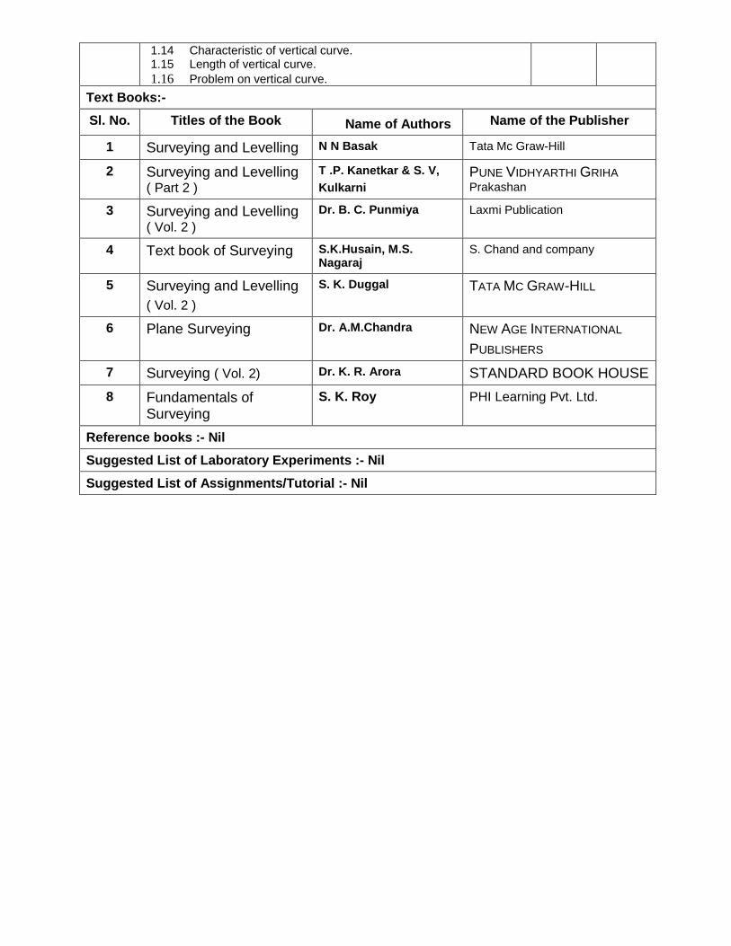
1.14 Characteristic of vertical curve. 1.15 Length of vertical curve.
1.16 Problem on vertical curve.
Text Books:-
Sl. No. Titles of the Book Name of Authors Name of the Publisher
1 Surveying and Levelling N N Basak Tata Mc Graw-Hill
2 Surveying and Levelling ( Part 2 )
T .P. Kanetkar & S. V,
Kulkarni PUNE VIDHYARTHI GRIHA
Prakashan
3 Surveying and Levelling ( Vol. 2 )
Dr. B. C. Punmiya Laxmi Publication
4 Text book of Surveying S.K.Husain, M.S. Nagaraj
S. Chand and company
5 Surveying and Levelling
( Vol. 2 )
S. K. Duggal TATA MC GRAW-HILL
6 Plane Surveying Dr. A.M.Chandra NEW AGE INTERNATIONAL
PUBLISHERS
7 Surveying ( Vol. 2) Dr. K. R. Arora STANDARD BOOK HOUSE
8 Fundamentals of Surveying
S. K. Roy PHI Learning Pvt. Ltd.
Reference books :- Nil
Suggested List of Laboratory Experiments :- Nil
Suggested List of Assignments/Tutorial :- Nil

Name of the Course : SURVEY ENGINEERING
( COMPUTER AIDED DRAFTING )
Course code : SE / S4 / P1 / CAD Semester : FOURTH
Duration : 15 weeks Maximum Marks : 100
Teaching Scheme Examination Scheme
Theory : - hrs/week Continuous Internal Assessment : 50 Marks
Tutorial: - hrs/week Attendance, Assignment & Quiz : - Marks
Practical : 3 hrs/week External Assessment : 50 Marks
Credit :- 2
Aim :-
S.No
1. Developing the computerized drawing skill required for survey engineering.
Objective :-
S.No Students will be able to:
1. Work with drawing software.
2. Make a drawing, create text, dimension a drawing, hatch patterns and make & insert symbols.
3. Draw and plot a drawing with the help of computer, software and plotter / printer.
4. Prepare a set of orthographic projections of a building.
Pre-Requisite :-
S.No
1. Perfection in drawing and sketching.
2. Students should be familiarized with Computer environment.
Contents : ( Practical )
Sl. No. Assignments
1.
GETTING STARTED – I
Starting AutoCAD – AutoCAD screen components – Starting a drawing: Open drawings,
Create drawings (Start from scratch, Use a template & Use a wizard) – Invoking commands
in AutoCAD –Drawing lines in AutoCAD – Co-ordinate systems: Absolute co-ordinate system,
Relative co-ordinate system – Direct distance method – Saving a drawing: Save & Save As –
Closing a drawing – Quitting AutoCAD
2
GETTING STARTED – II
Opening an existing file – Concept of Object – Object selection methods: Pick by box,
Window selection, Crossing Selection, All, Fence, Last, Previous, Add, Remove – Erasing
objects: OOPS command, UNDO / REDO commands – ZOOM command – PAN command,
Panning in real time – Setting units – Object snap, running object snap mode – Drawing
circles
3.
DRAW COMMANDS
ARC command – RECTANG command – ELLIPSE command, elliptical arc – POLYGON
command (regular polygon) – PLINE command – DONUT command – POINT command –
Construction Line: XLINE command, RAY command – MULTILINE command

4.
EDITING COMMANDS
MOVE command – COPY command – OFFSET command – ROTATE command – SCALE
command – STRETCH command – LENGTHEN command –TRIM command – EXTEND
command – BREAK command – CHAMFER command – FILLET command – ARRAY
command – MIRROR command –MEASURE command – DIVIDE command – EXPLODE
command – MATCHPROP command – Editing with grips: PEDIT
5.
DRAWING AIDS
Layers – Layer Properties Manager dialog box – Object Properties: Object property toolbar,
Properties Window – LTSCALE Factor – Auto Tracking – REDRAW command, REGEN
command
6.
CREATING TEXT
Creating single line text – Drawing special characters – Creating multiline text – Editing text –
Text style
7.
BASIC DIMENSIONING
Fundamental dimensioning terms: Dimension lines, dimension text, arrowheads, extension
lines, leaders, centre marks and centrelines, alternate units – Associative dimensions –
Dimensioning methods – Drawing leader
8.
INQUIRY COMMANDS
AREA – DIST – ID – LIST – DBLIST – STATUS – DWGPROPS
9.
EDITING DIMENSIONS
Editing dimensions by stretching – Editing dimensions by trimming & extending – Editing
dimensions: DIMEDIT command – Editing dimension text: DIMTEDIT command – Updating
dimensions – Editing dimensions using the properties window – Creating and restoring
Dimension styles: DIMSTYLE
10. HATCHING
BHATCH, HATCH commands – Boundary Hatch Options: Quick tab, Advance tab – Hatching
around Text, Traces, Attributes, Shapes and Solids – Editing Hatch Boundary – BOUNDARY
command
11.
BLOCKS
The concept of Blocks – Converting objects into a Block: BLOCK, _BLOCK commands –
Nesting of Blocks – Inserting Blocks: INSERT, MINSERT commands – Creating drawing files:
WBLOCK command – Defining Block Attributes – Inserting Blocks with Attributes – Editing
Attributes
12.
PLOTTING DRAWINGS IN AUTOCAD
PLOT command – Plot Configuration – Pen Assignments – Paper Size & Orientation Area –
Plot Rotation & Origin – Plotting Area – Scale
13.
PRACTICE WITH COMPLETE DRAWING
Each student is required to prepare a set of orthographic projections of a building. The
drawing of the building will be supplied by the teacher-in-charge.
Text Books:-
Sl. No. Titles of the Book Name of Authors Name of the Publisher
1 Reference Manual of AutoCAD AutoDesk
Reference books :- Nil
Suggested List of Laboratory Experiments :- Nil
Suggested List of Assignments/Tutorial :- Nil
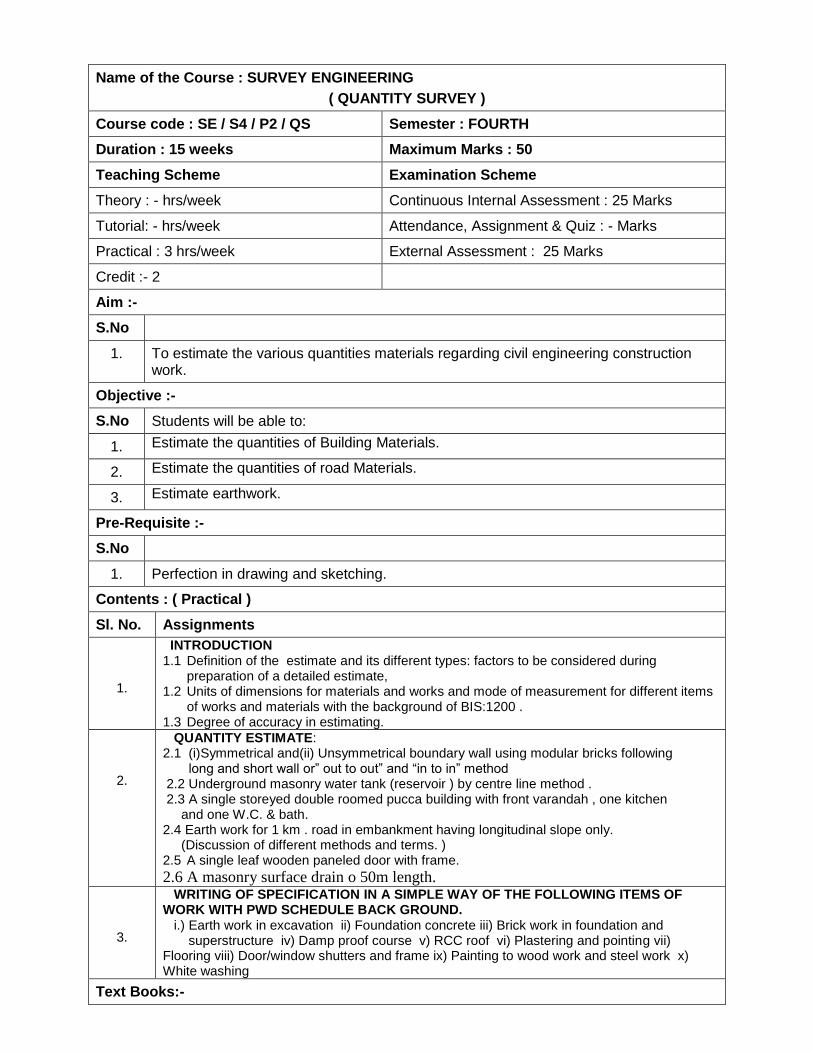
Name of the Course : SURVEY ENGINEERING
( QUANTITY SURVEY )
Course code : SE / S4 / P2 / QS Semester : FOURTH
Duration : 15 weeks Maximum Marks : 50
Teaching Scheme Examination Scheme
Theory : - hrs/week Continuous Internal Assessment : 25 Marks
Tutorial: - hrs/week Attendance, Assignment & Quiz : - Marks
Practical : 3 hrs/week External Assessment : 25 Marks
Credit :- 2
Aim :-
S.No
1. To estimate the various quantities materials regarding civil engineering construction work.
Objective :-
S.No Students will be able to:
1. Estimate the quantities of Building Materials.
2. Estimate the quantities of road Materials.
3. Estimate earthwork.
Pre-Requisite :-
S.No
1. Perfection in drawing and sketching.
Contents : ( Practical )
Sl. No. Assignments
1.
INTRODUCTION 1.1 Definition of the estimate and its different types: factors to be considered during
preparation of a detailed estimate, 1.2 Units of dimensions for materials and works and mode of measurement for different items
of works and materials with the background of BIS:1200 . 1.3 Degree of accuracy in estimating.
2.
QUANTITY ESTIMATE: 2.1 (i)Symmetrical and(ii) Unsymmetrical boundary wall using modular bricks following long and short wall or” out to out” and “in to in” method 2.2 Underground masonry water tank (reservoir ) by centre line method . 2.3 A single storeyed double roomed pucca building with front varandah , one kitchen and one W.C. & bath. 2.4 Earth work for 1 km . road in embankment having longitudinal slope only. (Discussion of different methods and terms. ) 2.5 A single leaf wooden paneled door with frame.
2.6 A masonry surface drain o 50m length.
3.
WRITING OF SPECIFICATION IN A SIMPLE WAY OF THE FOLLOWING ITEMS OF WORK WITH PWD SCHEDULE BACK GROUND. i.) Earth work in excavation ii) Foundation concrete iii) Brick work in foundation and superstructure iv) Damp proof course v) RCC roof vi) Plastering and pointing vii) Flooring viii) Door/window shutters and frame ix) Painting to wood work and steel work x) White washing
Text Books:-

Sl. No. Titles of the Book Name of Authors Name of the Publisher
Text Books:- Nil.
Reference books :- Nil
Suggested List of Laboratory Experiments :- Nil
Suggested List of Assignments/Tutorial :- Nil

Name of the Course : SURVEY ENGINEERING
( PROFESSIONAL PRACTICE II )
Course code : SE / S4 / P3 / PP2 Semester : FOURTH
Duration : 15 weeks Maximum Marks : 50
Teaching Scheme Examination Scheme
Theory : - hrs/week Continuous Internal Assessment : 25 Marks
Tutorial: - hrs/week Attendance, Assignment & Quiz : - Marks
Practical : 3 hrs/week External Assessment : 25 Marks
Credit :- 2
Aim :-
S.No
1. Development and evaluation of individual skills.
2. Enhancement in soft skills through innovation.
3. Development of professional approach
Objective :-
S.No Students will be able to:
1. Acquire information from different sources.
2. Prepare notes for given topic.
3. Present given topic in a seminar.
4. Interact with peers to share thoughts.
5. Prepare a report on industrial visit, expert lecture.
Pre-Requisite :-
S.No
1. Communication skill must be perfect.
Contents : ( Practical )
Sl. No. Assignments
1.
Industrial Visits Structured industrial visits be arranged and report of the same should be submitted by the individual student, to form a part of the term work. Industrial visits may be arranged in the following areas / industries:
• Survey Site
2. Lectures by Professional / Industrial Expert be organized from any survey topic.
3. Individual Assignments : Seminar and report preparation.
Text Books:- Nil.
Reference books :- Nil
Suggested List of Laboratory Experiments :- Nil
Suggested List of Assignments/Tutorial :- Nil

Name of the Course : SURVEY ENGINEERING
( DEVELOPMENT OF LIFE SKILL II )
Course code : SE / S4 / P4 / DLS2 Semester : FOURTH
Duration : 15 weeks Maximum Marks : 50
Teaching Scheme Examination Scheme
Theory : - hrs/week Continuous Internal Assessment : 25 Marks
Tutorial: - hrs/week Attendance, Assignment & Quiz : - Marks
Practical : 2 hrs/week External Assessment : 25 Marks
Credit :- 1
Details syllabus as per common syllabus of all discipline
Name of the Course : SURVEY ENGINEERING
( FIELD SURVEY PRACTICES – II )
Course code : SE / S4 / P5 / FSP2 Semester : FOURTH
Duration : 15 weeks Maximum Marks : 200
Teaching Scheme Examination Scheme
Theory : - hrs/week Continuous Internal Assessment : 100 Marks
Tutorial: - hrs/week Attendance, Assignment & Quiz : - Marks
Practical : 9 hrs/week External Assessment : 100 Marks
Credit :- 5
Aim :-
S.No
1. Developing the survey skill required for survey engineering.
Objective :-
S.No Students will be able to:
1. Identify different survey instruments.
2. Record and observe necessary observation with the survey instruments
3. Compute necessary survey data from field observation for drawing.
4. Prepare drawing using survey data.
INSTRUCTIONS:
S.No
1. Group size for survey practical work should be maximum 6 students.
2. Each student from a group should handle the instrument independently to understand the function of different components and use of the instrument.
3. Drawing and plotting should be considered as part of practical.
4. Term work shall consist of record of all practical and projects in field book and drawing of Project work on full / half imperial size drawing sheets.
Pre-Requisite :-
S.No
1. Perfection in drawing and sketching.
2. Students should have basic knowledge of Surveying.
Contents : ( Practical )
Sl. No. Assignments
1.
1.0 LEVELLING
1.1 Temporary Adjustment of Levels.
1.2 Holding and Reading the Staff.
1.3 B.M. connection from G.T.S.B.M. or local B.M.
1.4 Fly levelling with dumpy level and check levelling and recording level book
1.5 Profile levelling and recording
1.6 Plotting longitudinal section in suitable scales from field notes.

2.
2.0 THEODOLITE TRAVERSE
2.1 Temporary adjustment of Theodolite.
2.2 Measurement of horizontal angle by repetition method and reiteration method.
2.3 To traverse by the method of included angles.
2.4 To compute and plot.
2.5 Individual Traverse : To measure and compute for 5+ sided traverse (for each
student).
3.
3.0 TRIGONOMETRICAL LEVELLING
3.1 To determine height of tower by the theodolite and tape.
4.
4.0 MINOR INSTRUMENTS
4.1 Field practice with the following instruments: —
4.1.1. Hand level
4.1.2. Abney level
4.1.3. Sextant
4.1.4. Pentagraph
4.1.5. Planimeter
4.2 Measurement of distance by subtense bar.
Text Books:-
Sl. No. Titles of the Book Name of Authors Name of the Publisher
1 Surveying and Levelling N N Basak Tata Mc Graw-Hill
2 Surveying and Levelling ( Part I )
T .P. Kanetkar & S. V,
Kulkarni PUNE VIDHYARTHI
GRIHA Prakashan
3 Surveying and Levelling ( Vol. I )
Dr. B. C. Punmiya Laxmi Publication
4 Text book of Surveying S.K.Husain, M.S. Nagaraj S. Chand and company
5 Surveying and Levelling
( Vol. I )
S. K. Duggal TATA MC GRAW-HILL
6 Plane Surveying Dr. A.M.Chandra NEW AGE
INTERNATIONAL
PUBLISHERS
7 Surveying
( Vol. I)
Dr. K. R. Arora STANDARD BOOK HOUSE
8 Fundamentals of Surveying
S. K. Roy PHI Learning Pvt. Ltd.
Reference books :- Nil
Suggested List of Laboratory Experiments :- Nil
Suggested List of Assignments/Tutorial :- Nil