Proposal of methodology for determining of potential ... · Acta Montanistica Slovaca Ročník 18...
8
Acta Montanistica Slovaca Ročník 18 (2013), číslo 1, 9-16 9 Proposal of methodology for determining of potential residual biomass for agriculture and forestry in Slovak republic Žofia Kuzevičová 1 , Marcela Gergeľová 1 , Jana Naščáková 2 and Štefan Kuzevič 3 The issue of efficient use of biomass as a renewable source of energy in the process of sustainable development of every country is a problem that is often tackled nowadays being also imposed by the legislation of the European Union. In the process of the accession to the EU, the Slovak republic incorporated the obligations as defined by the EU Directive 2001/77/EC on the promotion of electricity produced from renewable energy sources. Out of all the renewable sources of energy, biomass has the greatest economic potential to be used on the territory of Slovakia. The use of biomass for the purposes of electricity generation is the most promising alternative to generate not only thermal but also electrical energy. This paper presents the proposal of methodology developed to determine the utilization potential of residual biomass in the sectors of forestry and agriculture within a certain area of eastern Slovakia. The theoretical proposal is developed based on using Corine Land Cover. The application of Corine Land Cover and GIS tools made it possible to effectively determine residual biomass for the selected sectors of the economy. Keywords: Corin Land Cover, methodology, residual biomass, GIS Introduction Based on the general definition of biomass, at this point it is necessary to provide a specific definition ofthe term. Since biomass as a source of energy is dealt with by a large number of qualified experts not only in Slovakia but also abroad, the following parts of the paper will focus on establishing and introducing a preliminary definition of this term. On the territory of the Slovak republic biomass is one of the several sources of clean energy with a high potential of utilization (Resch et al., 2011). According to the Directive 2001/77/ES the term biomass means “ the biodegradable fraction of products, waste and residues from agriculture (including vegetal and animal substances), forestry and related industries as well as the biodegradable fraction of industrial and municipal waste” (Directive 2001/77/ES). Regulation of the Government of the SR No 246/2006 Coll., defines biomass in a narrower context as “ the biodegradable fraction of a product or residues of vegetal and animal substances from agriculture, forestry and related industries or the biodegradable fraction of industrial and municipal waste ” (Regulation No 246/2006 Coll.). In light of further relevant legislation, i.e. Act No 309/2009, biomass means the biodegradable fraction of a product, residue from vegetal and animal substances from agriculture, forestry, the biodegradable fraction of municipal and industrial waste, including black liquor from wood processing (Act 309 of 19 June 2009). In general, biomass can be considered the most important renewable source of energy. In terms of utilization, biomass as a source of energy is suitable to produce thermal energy, electrical energy, biogas and biofuels. In terms of general definition there are two basic types of biomass: biomass of vegetable and biomass of animal origin. (Trenčianský et al., 2007). Due to its high energy efficiency, traditional biomass creates prerequisites for partial independence of society from fossil fuels (Resch et al., 2011, Pastorek, 2001). The above-mentioned subject matter is tackled through implementation of Corine Land Cover methodology (CLC). The advantage of interconnecting several methodological techniques to deal with the above referred problem is simplification and automation of the process of determination of the residual biomass potential. 1 assoc. prof. Žofia Kuzevičová, PhD., MSc. Marcela Gergeľová, PhD.,Technical University of Košice, Faculty of Mining, Ecology, Process Control and Geotechnologies, Institute of Geodesy, Cartography and Geographic Information Systems, Letná 9, 042 00 Košice, marcela.gergelova@tuke , [email protected] . 2 MSc. Jana Naščáková, PhD., University of Economics in Bratislava, Faculty of Business Economy with seat in Košice, Tajovského 13, 041 30 Košice, [email protected] 3 assoc. prof. Štefan Kuzevič, PhD., Technical University of Košice, Faculty of Mining, Ecology, Process Control and Geotechnologies, Institute of Institute of Business and Management, Letná 9, 042 00 Košice, stefan.kuzevic@tuke .
Transcript of Proposal of methodology for determining of potential ... · Acta Montanistica Slovaca Ročník 18...
Acta Montanistica Slovaca Ročník 18 (2013), číslo 1, 9-16
9
Proposal of methodology for determining of potential residual biomass
for agriculture and forestry in Slovak republic
Žofia Kuzevičová1, Marcela Gergeľová 1, Jana Naščáková 2 and Štefan Kuzevič 3
The issue of efficient use of biomass as a renewable source of energy in the process of sustainable development of every country is a problem that is often tackled nowadays being also imposed by the legislation of the European Union. In the process of the accession to the EU, the Slovak republic incorporated the obligations as defined by the EU Directive 2001/77/EC on the promotion of electricity produced from renewable energy sources. Out of all the renewable sources of energy, biomass has the greatest economic potential to be used on the territory of Slovakia. The use of biomass for the purposes of electricity generation is the most promising alternative to generate not only thermal but also electrical energy. This paper presents the proposal of methodology developed to determine the utilization potential of residual biomass in the sectors of forestry and agriculture within a certain area of eastern Slovakia. The theoretical proposal is developed based on using Corine Land Cover. The application of Corine Land Cover and GIS tools made it possible to effectively determine residual biomass for the selected sectors of the economy.
Keywords: Corin Land Cover, methodology, residual biomass, GIS
Introduction
Based on the general definition of biomass, at this point it is necessary to provide a specific definition ofthe term. Since biomass as a source of energy is dealt with by a large number of qualified experts not only in Slovakia but also abroad, the following parts of the paper will focus on establishing and introducing a preliminary definition of this term. On the territory of the Slovak republic biomass is one of the several sources of clean energy with a high potential of utilization (Resch et al., 2011). According to the Directive 2001/77/ES the term biomass means “ the biodegradable fraction of products, waste and residues from agriculture (including vegetal and animal substances), forestry and related industries as well as the biodegradable fraction of industrial and municipal waste” (Directive 2001/77/ES). Regulation of the Government of the SR No 246/2006 Coll., defines biomass in a narrower context as “ the biodegradable fraction of a product or residues of vegetal and animal substances from agriculture, forestry and related industries or the biodegradable fraction of industrial and municipal waste ” (Regulation No 246/2006 Coll.).
In light of further relevant legislation, i.e. Act No 309/2009, biomass means the biodegradable fraction of a product, residue from vegetal and animal substances from agriculture, forestry, the biodegradable fraction of municipal and industrial waste, including black liquor from wood processing (Act 309 of 19 June 2009). In general, biomass can be considered the most important renewable source of energy. In terms of utilization, biomass as a source of energy is suitable to produce thermal energy, electrical energy, biogas and biofuels. In terms of general definition there are two basic types of biomass: biomass of vegetable and biomass of animal origin. (Trenčianský et al., 2007). Due to its high energy efficiency, traditional biomass creates prerequisites for partial independence of society from fossil fuels (Resch et al., 2011, Pastorek, 2001).
The above-mentioned subject matter is tackled through implementation of Corine Land Cover methodology (CLC). The advantage of interconnecting several methodological techniques to deal with the above referred problem is simplification and automation of the process of determination of the residual biomass potential.
1 assoc. prof. Žofia Kuzevičová, PhD., MSc. Marcela Gergeľová, PhD.,Technical University of Košice, Faculty of Mining, Ecology,
Process Control and Geotechnologies, Institute of Geodesy, Cartography and Geographic Information Systems, Letná 9, 042 00 Košice, marcela.gergelova@tuke, [email protected].
2 MSc. Jana Naščáková, PhD., University of Economics in Bratislava, Faculty of Business Economy with seat in Košice, Tajovského 13, 041 30 Košice, [email protected]
3 assoc. prof. Štefan Kuzevič, PhD., Technical University of Košice, Faculty of Mining, Ecology, Process Control and Geotechnologies, Institute of Institute of Business and Management, Letná 9, 042 00 Košice, stefan.kuzevic@tuke .
Žofia Kuzeresidual bio
10
Genlandlockewith mouand flat tborders PUkraine iin the sosouth-weRepublic for a totaThe ris charact(Commermain geSlovakian• the C• the P
The
region is Fig.1). It plain, theThe Slans
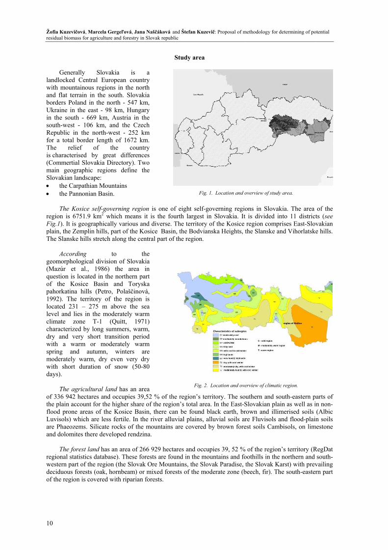
Acco
geomorph(Mazúr question of the pahorkati1992). Tlocated 2level andclimate characterdry and with a spring moderatewith shodays).
The
of 336 94the plain flood proLuvisols)are Phaeoand dolom
The f
regional swestern pdeciduouof the reg
evičová, Marcelaomass for agricult
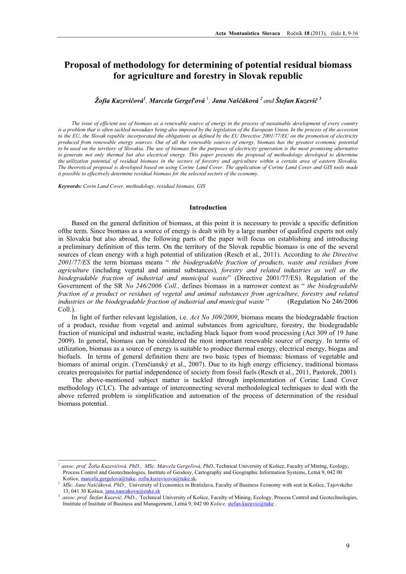
erally Sloed Central Euuntainous regiterrain in thePoland in the in the east -
outh - 669 kmst - 106 km,in the north
al border lengrelief of terised by grtial Slovakia ographic regn landscape: Carpathian MoPannonian Ba
Kosice self-g6751.9 km2 is geographic
e Zemplin hillsske hills stretc
ording hological diviet al., 1986is located in Kosice Basinina hills (Pet
The territory o231 – 275 md lies in the m
zone T-1 rized by long
very short twarm or mand autumn
ely warm, dryort duration o
agricultural 42 hectares anaccount for th
one areas of t) which are leozems. Silicatmites there de
forest land hastatistics databpart of the regus forests (oakgion is covered
a Gergeľová, Janture and forestry
vakia is uropean counions in the no
e south. Slovanorth - 547 k98 km, Hung
m, Austria in , and the Cz
h-west - 252 gth of 1672 k
the coungreat differen
Directory). Tgions define
ountains asin.
governing regwhich means
cally various as, part of the Kch along the c
to ision of Slova6) the area the northern pn and Torytro, Polaščinoof the region
m above the moderately wa
(Quitt, 19summers, watransition per
moderately wan, winters y even very of snow (50
land has an and occupies 3he higher sharthe Kosice Baess fertile. In te rocks of th
eveloped rendz
as an area of 2base). These f
gion (the Slovak, hornbeam) od with riparian
na Naščáková anin Slovak republi
S
a ntry orth akia km, gary
the zech
km km. ntry nces Two
the
gion is one ofs it is the fouand diverse. TKosice Basin
central part of
the akia
in part
yska ová, n is sea
arm 971) arm, riod arm are dry
0-80
area 9,52 % of there of the regioasin, there canthe river alluv
he mountains zina.
266 929 hectaforests are fouak Ore Mountor mixed foren forests.
nd Štefan Kuzevic
Study area
f eight self-gourth largest inThe territory on, the Bodvian
the region.
e region’s terron’s total arean be found blvial plains, alare covered b
ares and occupund in the moutains, the Slovsts of the mod
Fig. 1
Fig. 2. L
vič: Proposal of m
overning region Slovakia. It of the Kosice nska Heights, t
ritory. The so. In the East-Slack earth, brlluvial soils arby brown fore
pies 39, 52 % untains and fovak Paradise, tderate zone (b
1. Location and o
Location and ove
methodology for d
ons in Slovakis divided inregion comprthe Slanske an
uthern and soSlovakian plairown and illimre Fluvisols aest soils Camb
of the regionoothills in the the Slovak Ka
beech, fir). Th
overview of study
erview of climatic
determining of po
kia. The area nto 11 districtrises East-Slovnd Vihorlatske
outh-eastern pin as well as imerised soils and flood-plainbisols, on lim
n’s territory (Rnorthern and
arst) with prevhe south-easter
y area.
c region.
otential
of the ts (see vakian e hills.
parts of in non-(Albic n soils
mestone
RegDat south-
vailing rn part
Acta Montanistica Slovaca Ročník 18 (2013), číslo 1, 9-16
11
Geographical location, climate conditions, pedological potential are accompanying factors for production of biomass in the Kosice region. In terms of the high energy utilization potential of biomass, this part of Slovakia is one of the regions having great potential according to the evaluative report of the Kosice self-governing region.
Methodology
The methodology is based on the
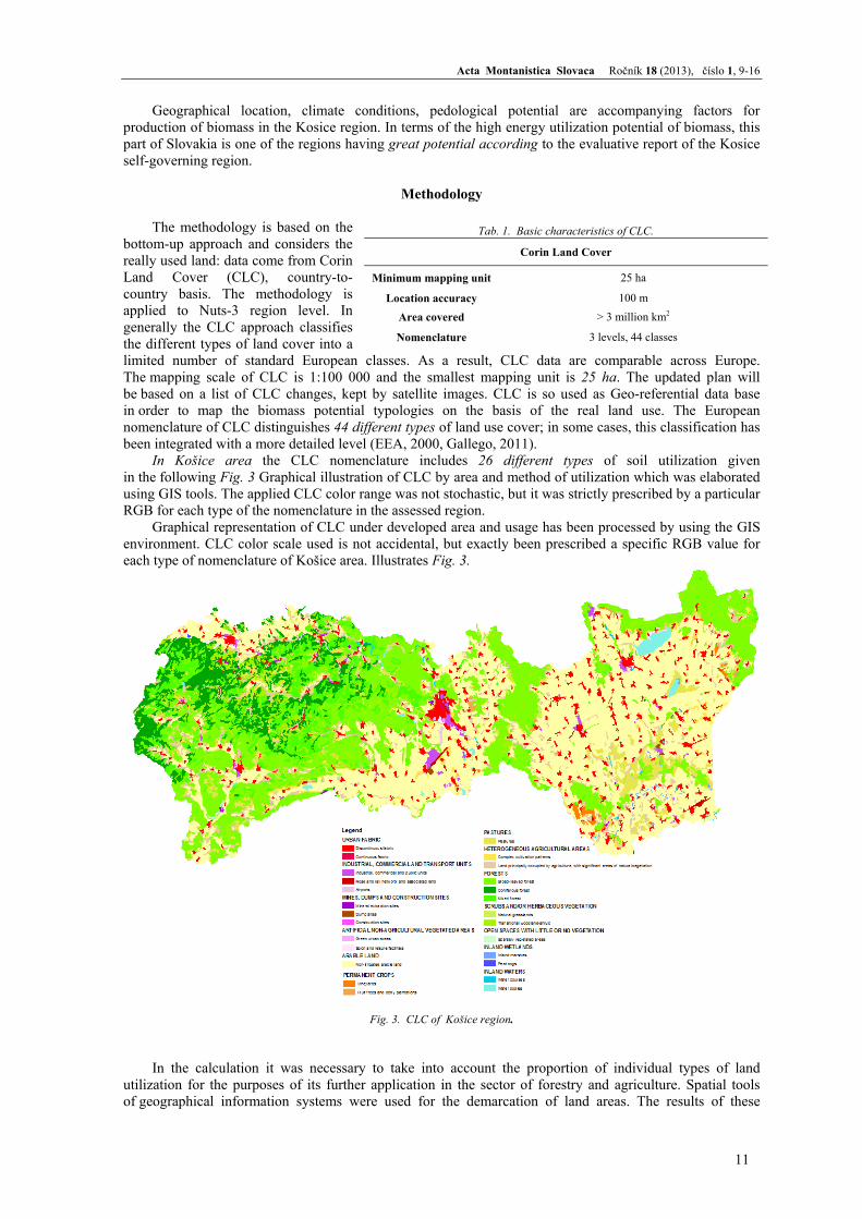
bottom-up approach and considers the really used land: data come from Corin Land Cover (CLC), country-to- country basis. The methodology is applied to Nuts-3 region level. In generally the CLC approach classifies the different types of land cover into a limited number of standard European classes. As a result, CLC data are comparable across Europe. The mapping scale of CLC is 1:100 000 and the smallest mapping unit is 25 ha. The updated plan will be based on a list of CLC changes, kept by satellite images. CLC is so used as Geo-referential data base in order to map the biomass potential typologies on the basis of the real land use. The European nomenclature of CLC distinguishes 44 different types of land use cover; in some cases, this classification has been integrated with a more detailed level (EEA, 2000, Gallego, 2011).
In Košice area the CLC nomenclature includes 26 different types of soil utilization given in the following Fig. 3 Graphical illustration of CLC by area and method of utilization which was elaborated using GIS tools. The applied CLC color range was not stochastic, but it was strictly prescribed by a particular RGB for each type of the nomenclature in the assessed region.
Graphical representation of CLC under developed area and usage has been processed by using the GIS environment. CLC color scale used is not accidental, but exactly been prescribed a specific RGB value for each type of nomenclature of Košice area. Illustrates Fig. 3.
In the calculation it was necessary to take into account the proportion of individual types of land
utilization for the purposes of its further application in the sector of forestry and agriculture. Spatial tools of geographical information systems were used for the demarcation of land areas. The results of these
Tab. 1. Basic characteristics of CLC.
Corin Land Cover
Minimum mapping unit 25 ha
Location accuracy 100 m
Area covered > 3 million km2
Nomenclature 3 levels, 44 classes
Fig. 3. CLC of Košice region.
Žofia Kuzevičová, Marcela Gergeľová, Jana Naščáková and Štefan Kuzevič: Proposal of methodology for determining of potential residual biomass for agriculture and forestry in Slovak republic
12
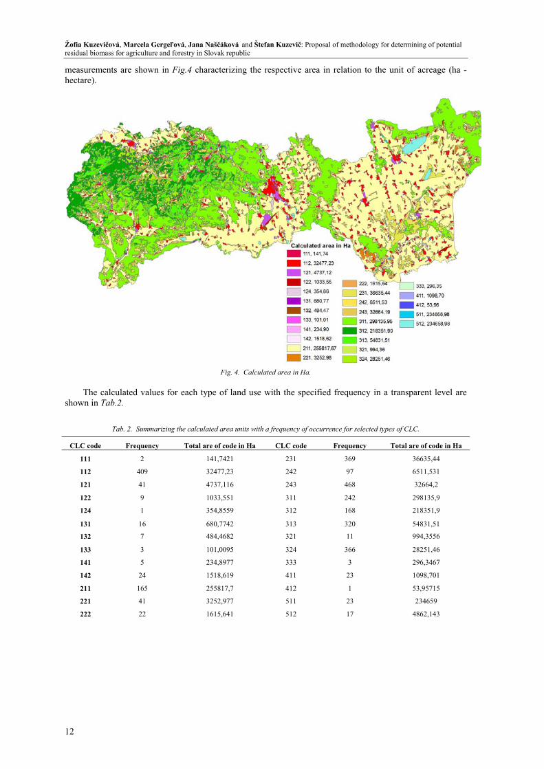
measurements are shown in Fig.4 characterizing the respective area in relation to the unit of acreage (ha - hectare).
Fig. 4. Calculated area in Ha.
The calculated values for each type of land use with the specified frequency in a transparent level are
shown in Tab.2.
Tab. 2. Summarizing the calculated area units with a frequency of occurrence for selected types of CLC.
CLC code Frequency Total are of code in Ha CLC code Frequency Total are of code in Ha
111 2 141,7421 231 369 36635,44
112 409 32477,23 242 97 6511,531
121 41 4737,116 243 468 32664,2
122 9 1033,551 311 242 298135,9
124 1 354,8559 312 168 218351,9
131 16 680,7742 313 320 54831,51
132 7 484,4682 321 11 994,3556
133 3 101,0095 324 366 28251,46
141 5 234,8977 333 3 296,3467
142 24 1518,619 411 23 1098,701
211 165 255817,7 412 1 53,95715
221 41 3252,977 511 23 234659
222 22 1615,641 512 17 4862,143
Acta Montanistica Slovaca Ročník 18 (2013), číslo 1, 9-16
13
Biomass analysis for the selected area
Two main biomass analyses for selected area were assumed: 1. potential forest residues, 2. potential agricultural residues.
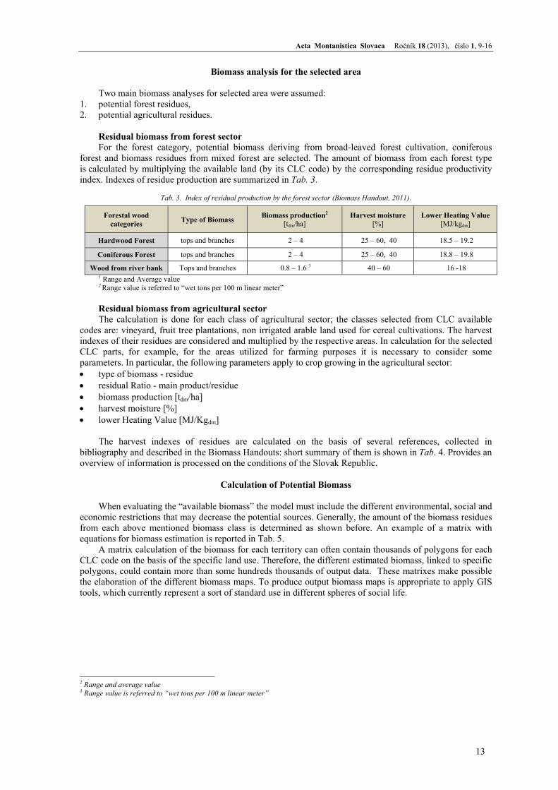
Residual biomass from forest sector For the forest category, potential biomass deriving from broad-leaved forest cultivation, coniferous
forest and biomass residues from mixed forest are selected. The amount of biomass from each forest type is calculated by multiplying the available land (by its CLC code) by the corresponding residue productivity index. Indexes of residue production are summarized in Tab. 3.
Tab. 3. Index of residual production by the forest sector (Biomass Handout, 2011).
1 Range and Average value 2 Range value is referred to “wet tons per 100 m linear meter” Residual biomass from agricultural sector The calculation is done for each class of agricultural sector; the classes selected from CLC available
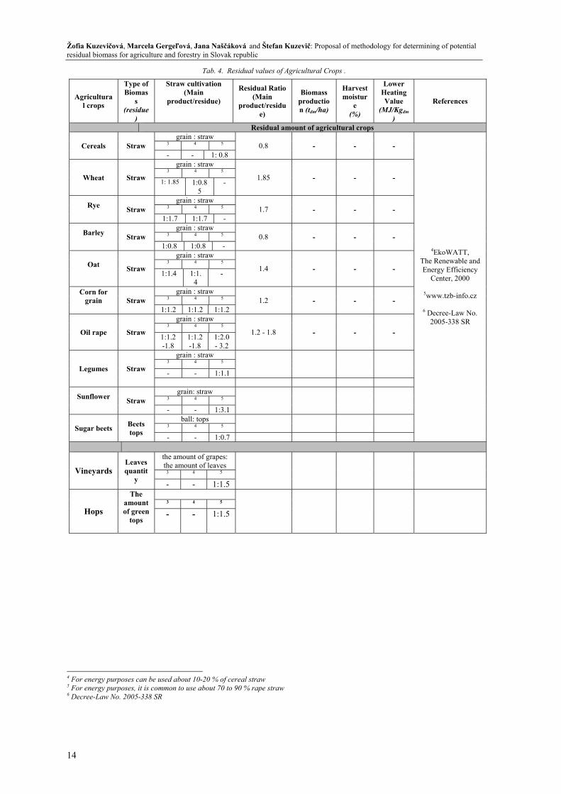
codes are: vineyard, fruit tree plantations, non irrigated arable land used for cereal cultivations. The harvest indexes of their residues are considered and multiplied by the respective areas. In calculation for the selected CLC parts, for example, for the areas utilized for farming purposes it is necessary to consider some parameters. In particular, the following parameters apply to crop growing in the agricultural sector: • type of biomass - residue • residual Ratio - main product/residue • biomass production [tdm/ha] • harvest moisture [%] • lower Heating Value [MJ/Kgdm]
The harvest indexes of residues are calculated on the basis of several references, collected in
bibliography and described in the Biomass Handouts: short summary of them is shown in Tab. 4. Provides an overview of information is processed on the conditions of the Slovak Republic.
Calculation of Potential Biomass
When evaluating the “available biomass” the model must include the different environmental, social and
economic restrictions that may decrease the potential sources. Generally, the amount of the biomass residues from each above mentioned biomass class is determined as shown before. An example of a matrix with equations for biomass estimation is reported in Tab. 5.
A matrix calculation of the biomass for each territory can often contain thousands of polygons for each CLC code on the basis of the specific land use. Therefore, the different estimated biomass, linked to specific polygons, could contain more than some hundreds thousands of output data. These matrixes make possible the elaboration of the different biomass maps. To produce output biomass maps is appropriate to apply GIS tools, which currently represent a sort of standard use in different spheres of social life.
2 Range and average value 3 Range value is referred to “wet tons per 100 m linear meter”
Forestal wood categories Type of Biomass Biomass production2
[tdm/ha] Harvest moisture
[%] Lower Heating Value
[MJ/kgdm]
Hardwood Forest tops and branches 2 – 4 25 – 60, 40 18.5 – 19.2
Coniferous Forest tops and branches 2 – 4 25 – 60, 40 18.8 – 19.8
Wood from river bank Tops and branches 0.8 – 1.6 3 40 – 60 16 -18
Žofia Kuzevičová, Marcela Gergeľová, Jana Naščáková and Štefan Kuzevič: Proposal of methodology for determining of potential residual biomass for agriculture and forestry in Slovak republic
14
Tab. 4. Residual values of Agricultural Crops .
4 For energy purposes can be used about 10-20 % of cereal straw 5 For energy purposes, it is common to use about 70 to 90 % rape straw 6 Decree-Law No. 2005-338 SR
Agricultural crops
Type of Biomas
s (residue
)
Straw cultivation (Main
product/residue)
Residual Ratio (Main
product/residue)
Biomass production (tdm/ha)
Harvest moistur
e (%)
Lower Heating Value
(MJ/Kgdm)
References
Residual amount of agricultural crops
Cereals Straw grain : straw
0.8 - - -
4EkoWATT, The Renewable and Energy Efficiency
Center, 2000
5www.tzb-info.cz
6 Decree-Law No. 2005-338 SR
3 4 5
- - 1: 0.8
Wheat Straw
grain : straw
1.85 - - - 3 4 5
1: 1.85 1:0.85
-
Rye Straw
grain : straw 1.7 - - - 3 4 5
1:1.7 1:1.7 -
Barley Straw
grain : straw 0.8 - - - 3 4 5
1:0.8 1:0.8 -
Oat Straw
grain : straw
1.4 - - - 3 4 5
1:1.4 1:1.4
-
Corn for grain
Straw
grain : straw 1.2 - - - 3 4 5
1:1.2 1:1.2 1:1.2
Oil rape Straw
grain : straw
1.2 - 1.8 - - - 3 4 5
1:1.2-1.8
1:1.2-1.8
1:2.0 - 3.2
Legumes Straw
grain : straw 3 4 5
- - 1:1.1
Sunflower Straw
grain: straw 3 4 5
- - 1:3.1
Sugar beets Beets tops
ball: tops 3 4 5
- - 1:0.7
Vineyards Leaves quantit
y
the amount of grapes: the amount of leaves
3 4 5
- - 1:1.5
Hops
The amount of green
tops
3 4 5
- - 1:1.5
Acta Montanistica Slovaca Ročník 18 (2013), číslo 1, 9-16
15
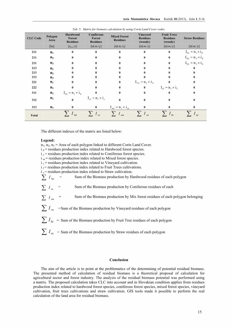
Tab. 5. Matrix for biomass calculation by using Corin Land Cover codes.
The different indexes of the matrix are listed below:
Legend: n1, n2, n3 = Area of each polygon linked to different Corin Land Cover. i h = residues production index related to Hardwood forest species. i c = residues production index related to Coniferous forest species. i m = residues production index related to Mixed forest species. i v = residues production index related to Vineyard cultivation. i f = residues production index related to Fruit Trees cultivations. i s = residues production index related to Straw cultivation.
∑ hnI = Sum of the Biomass production by Hardwood residues of each polygon
∑ cnI = Sum of the Biomass production by Coniferous residues of each
∑ mnI = Sum of the Biomass production by Mix forest residues of each polygon belonging
∑ vnI = Sum of the Biomass production by Vineyard residues of each polygon
∑ fnI = Sum of the Biomass production by Fruit Tree residues of each polygon
∑ snI = Sum of the Biomass production by Straw residues of each polygon
Conclusion
The aim of the article is to point at the problematics of the determining of potential residual biomass.
The presented method of calculation of residual biomass is a theoretical proposal of calculation for agricultural sector and forest industry. The analysis of the residual biomass potential was performed using a matrix. The proposed calculation takes CLC into account and in Slovakian condition applies from residues production index related to hardwood forest species, coniferous forest species, mixed forest species, vineyard cultivation, fruit trees cultivations and straw cultivation. GIS tools made it possible to perform the real calculation of the land area for residual biomass.
CLC Code Polygon Area
Hardwood Forest
Residues
Coniferous Forest
Residues
Mixed Forest Residues
Vineyard Residues (woody)
Fruit Trees Residues (woody)
Straw Residues
[ha] [td.m./y] [td.m./y] [td.m./y] [td.m./y] [td.m./y] [td.m./y]
211 n1 0 0 0 0 0 S1S1 inI ×=
211 n2 0 0 0 0 0 S2S2 inI ×=
211 n3 0 0 0 0 0 S3S3 inI ×=
213 n1 0 0 0 0 0 0 213 n2 0 0 0 0 0 0 213 n3 0 0 0 0 0 0 221 n1 0 0 0 V1V1 inI ×= 0 0
222 n1 0 0 0 0 f1f1 inI ×= 0
311 n1 h1h1 inI ×= 0 0 0 0 0
312 n1 0 c1c1 inI ×=
0 0 0 0
313 n1 0 0 m1m1 inI ×= 0 0 0
Total ∑ hnI ∑ cnI ∑ mnI ∑ vnI ∑ fnI ∑ snI

Žofia Kuzevičová, Marcela Gergeľová, Jana Naščáková and Štefan Kuzevič: Proposal of methodology for determining of potential residual biomass for agriculture and forestry in Slovak republic
16
This article was prepared with financial support from VEGA project No.1/0369/13
References
Act No 309/20093 o podpore obnoviteľných zdrojov energie a vysoko účinnej kombinovanej výroby a o zmene a doplnení niektorých zákonov
Biomass Handout, Ener Supply Project, 2011, [cit. 15.12.2012] http://www.ener-supply.eu/downloads/ENER_handbook_en.pdf
Resch, G., Panzer, Ch., Busch, S., Ragwitz, M., Rosende, D., Rothová, M.: Výhľadová analýza využívania obnoviteľných zdrojov energie na Slovensku. Viedenská technická univerzita, Ústav elektrických sietí a energetickej ekonomiky, Energeticko – ekonomická skupina (EEG), 2011, 29 p. http://skrea.sk/fileadmin/skrea/user_upload/dokumenty/RES_analyza_REPAP.pdf
Commertial Slovakia Directory, [cit. 15.12.2012], http://www.infoma.sk/dokumenty/slovakia-2012.pdf Directive 2001/77/ES o podpore elektrickej energie vyrábanej z obnoviteľných zdrojov energie, Smernica
Európskeho parlamentu a rady z 27. Januára 2001 European environment agency, 2000, [30.1.2013], http://www.eea.europa.eu/data-and-maps/data/corine-
land-cover-2000-clc2000-seamless-vector-database Gallego F.J. (2001): Comparing CORINE Land Cover with a more detailed database in Arezzo (Italy).
Towards Agri-environmental indicators, Topic report 6/2001 European Environment Agency, Copenhagen, pp. 118-125 [30.1.2013], http://ams.jrc.it/publications/pdfs/CLC_ACC_AREZ.pdf
Mazúr, E., Lukniš M., 1986: Geomorfologické členenie SSR a ČSSR. Časť Slovensko. Slovenská kartografia, Bratislava
Pastorek, Z. Využití biomasy k energetickým účelům, s. 139-161 In: Obnovitelné zdroje energie, FCC Public, Praha, 2001, ISBN
Petro, Ľ., Polaščinová, E.: Vysvetlivky k inžinierskogeologickým mapám severnejčasti Košicej kotliny 1:10 000. Geologický ústav Dionýza Štúra, Bratislava 1992, ISBN 80-85314-10-X, 11-34 s.
Regulation No 246/2006 Coll. o minimálnom množstve pohonných látok vyrobených z obnoviteľných zdrojov v motorových benzínoch a motorovej nafte uvádzaných na trh Slovenskej republiky
RegDat regional statistics database SR, http://px-web.statistics.sk/PXWebSlovak/ Trenčianský, M., Lieskovský, M., Oravec, M.: Energetické zhodnotenie biomasy, Lesnické národné centrum,
Zvolen, 2007, 153 p., ISBN 978-80-8093-050-9 Quitt, E.: Klimatické oblasti Československa. Studia Geographica 16. 1971. Brno: Academia, geografický
ústav ČSAV,73 s.