Groundwater aquifer / aquitard water table groundwater flow groundwater contamination.
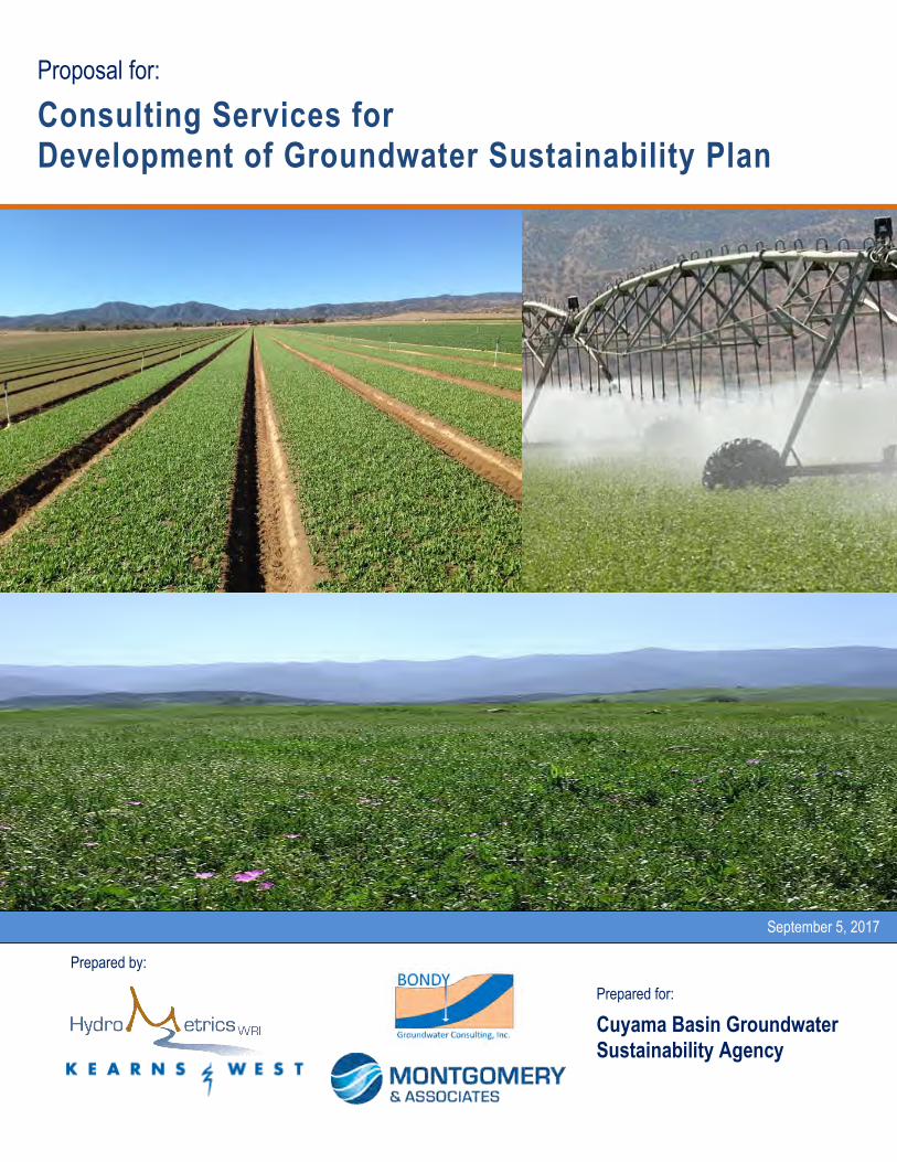
Prepared for:
Cuyama Basin Groundwater Sustainability Agency
Proposal for:
Consulting Services for Development of Groundwater Sustainability Plan
Prepared by:
September 5, 2017
Page 1 of 30
HydroMetrics Water Resources Inc. 1814 Franklin Street, Suite 501 Oakland, CA 94612
(510) 903-0458 (510) 903-0468 (fax)
Mr. Matt Young
Santa Barbara County Water Agency
130 E. Victoria Street, Suite 200
Santa Barbara, CA 93101
September 1, 2017
Subject: Proposal for Developing a Groundwater Sustainability Plan (GSP) for the Cuyama
Basin Groundwater Sustainability Agency (CBGSA)
Mr. Young,
HydroMetrics Water Resources Inc. (WRI), in association with Kearns & West, Inc. (K&W), Bondy
Groundwater Consulting, Inc. (BGC), and Montgomery & Associates (M&A), appreciates the
opportunity to submit this proposal in response to the Cuyama Basin Groundwater Sustainability
Agency Request for Proposal for Consulting Services for Development of Groundwater Sustainability Plan.
From our unique team, we have assembled a team of highly motivated professionals with
expertise tailored specifically for the needs of this project. We offer:
Unique Insight into the Sustainable Groundwater Management Act (SGMA): Derrik Williams,
our project manager, is a recognized leader in California groundwater – he has been at the table
with the Department of Water Resources (DWR) developing SGMA, shaping its implementation,
and guiding the development of best management practices.
Unparalleled Expertise in Groundwater Hydrology: Unlike other consulting firms, the core
business of HydroMetrics WRI, BGC, and M&A is groundwater hydrology – our team has
decades of experience characterizing and modeling groundwater basins similar to Cuyama Basin.
Specialized Expertise in Stakeholder Engagement: We believe the highest priority for the GSP
will be building a shared vision of sustainability among stakeholders; an imperative for avoiding
risks associated with poor communication, contentious relationships, and misinformation about
the GSP process. K&W offers decades of specialized experience in stakeholder engagement,
public outreach, and conflict resolution.
Local Presence and Regional Experience: Bryan Bondy, our local project lead, offers critical local
understanding of groundwater management challenges in the project area; HydroMetrics WRI is
a demonstrated leader in groundwater management throughout California; and M&A offers
regional perspective on groundwater management through their decades of experience in
Arizona, where groundwater regulations have existed for over 35 years.

Page 2 of 30
HydroMetrics Water Resources Inc. 1814 Franklin Street, Suite 501 Oakland, CA 94612
(510) 903-0458 (510) 903-0468 (fax)
In addition to our demonstrated expertise, our team has the staff capacity and resources to work
closely with the CBGSA to bring stakeholders together and complete the technical requirements
for adoption of a GSP that meets DWR requirements. We look forward to an opportunity to work
with the CBGSA and other stakeholders on this project. Please feel free to contact me by phone
at (510) 903-0358 ext. 301, or email at [email protected].
Sincerely,
Derrik Williams, President
HydroMetrics Water Resources Inc.

Cuyama Basin Groundwater Sustainability Plan Page 3 of 30
Project Team The HydroMetrics WRI team comprises of four firms: HydroMetrics Water Resources Inc. (WRI),
Kearns & West, Inc. (K&W), Bondy Groundwater Consulting, Inc. (BGC), and Montgomery &
Associates (M&A). HydroMetrics WRI is the lead firm. Our team was assembled specifically to bring
the local presence, statewide experience, SGMA expertise, stakeholder facilitation services, and
technical excellence needed to successfully and efficiently develop the Cuyama Basin Groundwater
Sustainability Agency (CBGSA) Groundwater Sustainability Plan (GSP). Our team is based on long-
standing relationships: HydroMetrics WRI staff has known and worked with staff from each of the
firms for decades, including on recent Sustainable Groundwater Management Act (SGMA) projects.
Our team is at the forefront of developing successful groundwater management strategies in both
urban and agricultural basins throughout California and the Western United States. Not only do we
bring the necessary technical capabilities needed for developing effective and practical GSPs; we also
bring decades of experience aligning diverse and competing stakeholders to a common platform for
effective water resource management. We have developed integrated solutions and implemented
successful multi-party groundwater management plans in basins that, similar to the Cuyama Valley
Groundwater Basin (Cuyama Basin or Basin), have competing water users and uses.
HydroMetrics WRI
HydroMetrics WRI is one of the few California
consulting firms with groundwater as its core
business. Our staff of experienced hydrologists,
hydrogeologists, engineers, and water
management policy professionals is unique.
HydroMetrics WRI specializes in groundwater
planning at a regional scale and implementing
local groundwater projects to improve water
supply reliability and sustainability. We provide
targeted expertise to clients for developing,
protecting, and managing both groundwater and
surface water resources. We have a reputation
for providing perceptive, quality analyses that
yield practical solutions to water resource issues.
We have prepared several groundwater
management plans under AB3030/SB1938,
including for the Soquel-Aptos area and Olympic
Valley Basin, and have managed adjudicated
groundwater basins, most prominently the
Seaside Basin. Our staff includes two retired
general managers of water agencies. They bring
practical experience with governance and policy
issues and have hands-on experience managing
water resources in agricultural and urban
settings at both local and regional scales.
HydroMetrics WRI has been actively involved
with SGMA since its inception. We have served
as close advisors to the Department of Water
Resources (DWR), local water agencies, local
stakeholders (including growers), and non-
governmental organizations such as the
California Water Foundation, where we helped
develop and direct statewide SGMA policy. We
have led all aspects of SGMA implementation
including assisting Groundwater Sustainability
Agencies form, modifying groundwater basin
boundaries for the Santa Margarita, Santa Cruz
Mid-County, and Pajaro Valley Basins, guiding
early GSP development for the Santa Cruz Mid-
County Basin, and creating best management
practices on behalf of DWR. Our unique
relationship with SGMA policy makers and
implementers allows us to effectively resolve
issues on our clients’ behalf.

Cuyama Basin Groundwater Sustainability Plan Page 4 of 30
As a statewide leader in groundwater modeling,
HydroMetrics WRI has a reputation for
developing and implementing practical and
effective models for groundwater management.
We have developed and applied groundwater
models in some of California’s most important
agricultural, coastal, and urban basins such as
the Pajaro Valley and Livermore Valley Basins.
HydroMetrics WRI is built around a culture of
providing our clients the best understanding
possible of their groundwater basins and
partnering with them to establish and achieve
groundwater management goals and objectives
that are practical and effective. We pride
ourselves on consistently providing value-added
service that positions our clients to successfully
address the challenges and complexities of
integrated water management.
Kearns & West
K&W is a woman-owned collaboration, conflict
resolution, and strategic communications firm
founded in 1984. They bring an extensive resume
of assisting diverse stakeholders to build
agreements around water supply, water
allocation, and resource management problems,
and have contributed significantly to SGMA
development as well as initial implementation in
multiple sub-basins.
K&W’s collaboration initiatives are designed to
take a diverse range of issues, opinions, goals
and interests and organize them into clear,
productive processes that lead to successful
conclusions. The K&W “tool kit” encompasses
assessment, outreach, engagement and
collaboration, process and meeting design,
facilitation, mediation, environmental dispute
resolution, public involvement, and development
of communications tools tailored to each project’s
unique issues. Collectively, these tools and
techniques build productive stakeholder
relationships, collaborations, and strategic
partnerships to support long-term, sustainable
solutions. K&W’s staff combine their deep
experience designing and facilitating stakeholder
collaborative processes with strong up-front
strategic planning, mixed with an adaptive
approach that allows them to be nimble and
effective in keeping processes focused on
achieving project objectives.
The K&W team brings specific experience
working with eligible local agencies,
stakeholders, and the interested public in the
context of SGMA. K&W has a practical working
knowledge of SGMA that includes playing an
active role in developing policy
recommendations that informed the SGMA
legislation. K&W staff have conducted multiple
assessments and facilitated multiple GSA
formation work group sessions, workshops, and
public meetings. K&W’s direct SGMA experience
includes contracts working with both the State
Water Resources Control Board and DWR on
projects specific to SGMA outreach and
facilitation.
While K&W makes it a point to understand
project content, their collaboration work is
successful because they remain impartial about
subject matter while focusing on the parties, their
interests and desired outcomes to build trust and
transparency. K&W’s approach emphasizes
building understanding through exchange of
reliable information, effective communication
customized to project needs, meaningful
decision-making, and conflict resolution where
necessary. This approach enables K&W to
navigate controversial projects and maintain
stakeholder confidence. Clients that K&W has
supported through SGMA and groundwater
management projects include: Butte County GSA
Formation Assessment with HydroMetrics WRI

Cuyama Basin Groundwater Sustainability Plan Page 5 of 30
(four subbasins); Santa Cruz GSA Outreach
(HydroMetrics WRI is technical consultant); Bay
Area Water Supply and Conservation Agency for
SGMA Strategic Advice; Merced County
Groundwater Sustainability Agency Formation;
and Water Foundation Groundwater Stakeholder
Dialog Process Design and Implementation (to
inform legislation resulting in SGMA) and
subsequent support for development of resource
materials for SGMA implementation.
Bondy Groundwater Consulting, Inc.
BGC was founded in 2016 to service the growing
need for groundwater professionals to address
groundwater management, planning, and
development needs in California. Mr. Bondy
has 20+ years of private and public-sector
experience conducting a wide range of
groundwater projects in California, including
SGMA planning, groundwater basin studies, and
groundwater modeling. BGC is located in
Ventura, California.
Mr. Bondy has considerable experience guiding
the technical and stakeholder aspects of GSPs.
Mr. Bondy has completed numerous
groundwater studies and management plans
prior to SGMA and is currently involved in
various capacities in the development of seven
GSPs. Mr. Bondy is a Board-appointed member
of the Fox Canyon Groundwater Management
Agency’s Technical Advisory Group that is
reviewing four GSPs currently under
development. Mr. Bondy is an advisor to Yuima
Municipal Water District for the San Luis Rey
Valley GSP and is part of a consultant team
advising the City of San Diego on the
development of GSPs in multiple groundwater
basins in San Diego County. Mr. Bondy has
worked with the Las Posas Valley Basin
Groundwater Users Group for nearly a decade
and recently facilitated the group’s development
of a proposed groundwater pumping allocation
plan for the GSP.
Montgomery & Associates
M&A is one of the most accomplished
groundwater consultants in the Western United
States. For more than 30 years, they have
achieved successful outcomes for clients in the
municipal, agricultural, land development, tribal,
industrial, mining, and energy sectors.
Over the past year, M&A has provided
consulting to several clients in California.
Specifically, M&A teamed with HydroMetrics
WRI to assess recharge capacity and develop
grant funding for the Tulare Irrigation District
and is currently conducting a groundwater
modeling study of aquifer storage and recovery
in the Santa Margarita Basin. Additionally,
M&A is providing groundwater modeling
services and grant funding assistance to the
Antelope Valley-East Kern Water Agency for a
planned enterprise groundwater bank.
In addition to recent work for SGMA, M&A has
decades of experience assisting clients address
water resource challenges under groundwater
management laws in other states, including
Arizona and Texas. Their experienced staff of over
40 groundwater professionals specializes in
hydrology, geology, soil science, policy and
regulatory affairs, groundwater modeling, GIS
analyses and 3D visualization, database
management, and instrumentation and monitoring.
Areas of specific expertise that will benefit the
CBGSA include:
Managed Aquifer Recharge (MAR) – M&A is a
demonstrated expert in MAR. They have
provided planning, investigation, and design

Cuyama Basin Groundwater Sustainability Plan Page 6 of 30
services for over 30 recharge facilities over the
past 30 years. The recharge projects M&A has
participated in account for more than two-thirds
of the Colorado River water stored in Arizona.
Modeling & Data Management – M&A has
developed numerous groundwater models to
assist water managers make informed financial
decisions, usually under highly dynamic and
uncertain conditions. In most cases, modeling
projects include comprehensive data
management services, where data are organized,
analyzed, and reported using the latest software,
such as tools for on-line data serving on websites
and data portals.
Water Policy, Planning, and Economics – M&A
professionals have expertise in water policy and
regulations, environmental economics, water
demand forecasting and analysis, and water
conservation planning. They work with clients to
develop reliable, affordable water resource
portfolios that are aligned with their needs. Their
planning services typically entail quantifying
use, assessing trends, and developing forecasts of
future demand.
Our team, as depicted on the flow diagram
below, comprises motivated senior
professionals who will build a
constructive and collaborative working
environment among the GSA members
and stakeholders, clearly communicate
technical concepts to stakeholders and the
public, and provide sound technical
analyses and practicable strategies to
develop a broadly accepted GSP.
Key Success Factors for GSP:
Stakeholder Consensus
Clear Communication
Technical Excellence ● Practicable Strategies

Cuyama Basin Groundwater Sustainability Plan Page 7 of 30
Organizational Chart for Cuyama GSP Development
We are committed to complete execution of this project. Based on the level of effort envisioned to develop
the GSP, our team members will commit the following percentages of available work hours during the
period January 1, 2018 through January 31, 2020.
Percentage Time Commitment for Project Team
Team Member Commitment Team Member Commitment
Derrik Williams 20% J. Michael Harty 5%
Cameron Tana 10% Bryan Bondy 30%
Georgina King 10% Tim Leo 15%
Laura Brown 5% Staffan Schorr 5%
Ellen Cross 25% Colin Kikuchi 15%
Short biographical sketches for the senior professionals who will work closely with the CBGSA are
provided on the following pages.
Cuyama Basin Groundwater Sustainability Plan Page 8 of 30
Derrik Williams, P.G., C.Hg.
Project Manager
Derrik Williams, a California Professional
Geologist and Certified Hydrogeologist, is
President of HydroMetrics WRI. He will be the
project manager and principal point of contact
for the CBGSA.
Mr. Williams has more than 30 years of
experience in applied geology and
hydrogeology. His project experience spans all
aspects of groundwater resource management.
He has facilitated stakeholder consensus and
developed groundwater management plans in
agricultural basins with contentious water rights,
and has testified in court regarding
groundwater-surface water interactions.
California Groundwater Leadership
He is an established leader in statewide
groundwater policy. As a member of the
Groundwater Committee of the ACWA since
2008, Derrik helped shape the California
Statewide Groundwater Elevation Monitoring
Program (CASGEM) and helped develop
ACWA's Groundwater Framework document. He
also drafted ACWA’s Guidelines for Groundwater
Monitoring. Derrik is currently working with
DWR to develop the state’s SGMA
implementation process, including the pending
best management practice for Sustainable
Management Criteria (SMC). He reviewed and
commented on the SGMA legislation while it
was being drafted, and currently chairs ACWA’s
SGMA Best Management Practices work group.
He was a contributor to the California Water
Foundation’s GSP regulations workshops. He
has been invited to, and participated in,
Stanford’s Water in the West meetings on data
and modeling in SGMA and the Groundwater
Resources Association of California’s
Contemporary Groundwater Issues Council.
Groundwater Modeling
Mr. Williams is an established expert in
groundwater modeling. He has managed and
applied groundwater models in the Kings
Groundwater Basin, the Santa Clara Valley, San
Benito County, Santa Cruz County, Monterey
County, San Luis Obispo County, Placer County,
Alameda County, Ventura County, Los Angeles
County, and Santa Barbara County, among other
areas in California.
Ellen Cross
Ellen Cross drives diverse stakeholders forward
to develop and realize shared vision and success.
Ellen has more than 27 years of experience in the
California water and environmental science
industry creating successful, innovative solutions
through forums for vision, collaboration, and
achievement. Ellen brings a large-scale view of
proven strategic and tactical approaches to
develop outcomes that meet multi-stakeholder
objectives. Ellen has a history of creating neutral
forums to work on critical topics where
communication and leadership are key to
moving complex issues forward.
Facilitator
In the area of emerging challenges, Ellen has
successfully facilitated public and private entities
on climate change, restoration in the Delta, water
scarcity, sea level rise and flood protection. Ellen
has facilitated initiatives that envision multi-
stakeholder success and operationalizes the
tactics to achieve results on policy, governance,
funding, institutional and technical goals to
ensure sustained success. Specific to
groundwater projects, Ellen has developed
strategies to develop holistic integrated scopes
for Fox Canyon GSA, Mid Kaweah, Tulare,
Irvine Ranch Water District, Kings Canyon,
Department of Water Resources, and San Luis
Obispo.

Cuyama Basin Groundwater Sustainability Plan Page 9 of 30
Bryan Bondy, P.G. C.Hg.
Mr. Bondy, a California Professional Geologist
and Certified Hydrogeologist, has considerable
experience guiding the technical and stakeholder
aspects of GSPs. Mr. Bondy has completed
numerous groundwater studies and
management plans prior to SGMA and is
currently involved in various capacities in the
development of seven GSPs.
GSP Advisor
Mr. Bondy is a Board-appointed member of the
Fox Canyon Groundwater Management
Agency’s Technical Advisory Group that is
reviewing four GSPs currently under
development. Mr. Bondy is an advisor to Yuima
Municipal Water District for the San Luis Rey
Valley GSP and is part of a consultant team
advising the City of San Diego on the
development of GSPs in multiple groundwater
basins in San Diego County. Mr. Bondy has
worked with the Las Posas Valley Basin
Groundwater Users Group for nearly a decade
and recently facilitated the group’s development
of a proposed groundwater pumping allocation
plan for the GSP.
Tim Leo, P.G., C.Hg.
Tim Leo, a California Professional Geologist and
Certified Hydrogeologist, is a Principal and
Director of California Operations at M&A.
For nearly 30 years, Mr. Leo has managed and
participated in numerous multidisciplinary
water resources and groundwater restoration
projects throughout the western U.S. His work
in Arizona, where groundwater has been state-
managed for over 35 years, has included a
variety of projects related to groundwater
resource management, including aquifer
protection permitting, groundwater supply
protection, and regulatory permitting. For nearly
15 years, he has directed a regional groundwater
restoration project in the Sacramento area.
Analytical Hydrogeology
Mr. Leo specializes in analytical hydrogeology.
He has decades of experience developing and
applying groundwater modeling, conceptual
models and water budgets, and groundwater
system characterization and testing.
SGMA Experience
Mr. Leo is also conducting project work related
to SGMA, including groundwater recharge
studies in Tulare County and the Antelope
Valley. On both of these projects, he has
provided technical support on grant applications.
Cameron Tana, P.E.
A co-founder of HydroMetrics WRI, Cameron Tana has 17 years of experience as a hydrologist focused on assisting public agencies in California
manage their groundwater resources. He is
experienced at communicating technical findings
to advance groundwater management, taking
into account legal, economic, and political
challenges.
SGMA Related Experience
Cameron has supported SGMA implementation
for the Santa Cruz Mid-County Groundwater
Agency, presenting to the Mid-Santa Cruz County Stakeholder Advisory Committee, leading the successful application to DWR to modify basin boundaries to consolidate portions of four basins into a single basin, assisting the Agency with GSA notification to the state and representing the Agency in Central Coast advisory group meetings with DWR. He has also supported the basin boundary modification and alternate submittal for the Pajaro Valley Subbasin.
He is leading a team to evaluate and revise the Santa Clara Valley Water District’s groundwater zones of benefit that provide the basis for its groundwater charges that fund groundwater management projects. To date, the groundbreaking study evaluates areas that
Cuyama Basin Groundwater Sustainability Plan Page 10 of 30
benefit from the District’s in-lieu and managed recharge activities and Cameron has presented study plans at stakeholder meetings.
Groundwater Modeling
Cameron is an accomplished
groundwater modeler helping develop
and calibrate groundwater models of
the Santa Cruz Mid-County, Livermore
Valley, Seaside, Olympic Valley, and
Carpinteria Basins.
Colin Kikuchi, PhD
Colin Kikuchi is a lead modeler at M&A. He has
a doctoral degree in Hydrology and Water
Resources, with a minor in Agricultural and
Resource Economics from the University of
Arizona. His research and project work at M&A
have focused on advance methods in
groundwater modeling, including efficient
methods for groundwater model calibration and
uncertainty analysis. He has conducted project
work and research related to agricultural water
management using the MODFLOW-OWHM,
IWFM Demand Calculator, and C2VSim models.
Colin is currently working with the staff at
HydroMetrics WRI on a groundwater modeling
study in the Santa Margarita Basin in Santa Cruz
County.
J. Michael Harty, JD
Mr. Harty has over 20 years of direct experience
involving conflict management and resolution,
facilitated decision making, organizational
dynamics, strategic planning, public outreach
and engagement, and policy assessment. He was
a practicing attorney for eight years before
focusing full time on conflict resolution.
Policy Expertise
Mike has worked with numerous local, state, and
federal agencies, both internally and in multi-
agency contexts, as well as diverse private sector
and not-for-profit stakeholders. His policy
understanding has been an asset in assisting
agency managers and staff with internal
planning and organizational decision making,
and in designing and conducting successful
external policy-focused stakeholder processes.
SGMA Experience
Mike has experience with regulatory policy as it
relates to SGMA and environmental compliance.
He was directly involved in development of
policy recommendations that informed SGMA
and led K&W teams in multiple sub-basins to
support initial SGMA implementation. As a
Strategic Advisor, Mike will work with the team
to develop effective outreach strategies and
process design. In addition to his extensive
facilitation skills, he is an expert on conflict
resolution and mediation.
Staffan Schorr
Staffan Schorr is a Principal Hydrogeologist and
GIS specialist with a background in water
resource data management and analysis. He has
developed systems for data management,
analysis, visualization, and dissemination for a
variety of M&A’s projects. He also has extensive
experience using GIS methods to develop
numerical model inputs, display model results,
geospatial databases for conceptual
hydrogeologic models. He also manages M&A’s
3D modeling services, and specializes in the use
of Leapfrog software to develop volumetric
geologic and geochemical interpolation models.
Prior to joining M&A, Staffan worked for 8 years
in watershed planning at a regional agency that
facilitates coordination among local jurisdictions.

Cuyama Basin Groundwater Sustainability Plan Page 11 of 30
Georgina King, P.G., C.Hg.
Georgina King is a Professional Geologist and
Certified Hydrogeologist, and Principal
Hydrogeologist at HydroMetrics WRI. She has
23 years of experience in groundwater resource
management and development. She has worked
in both Northern and Southern California on
numerous hydrogeologic studies, including
water budgets, groundwater basin management,
monitoring plans, and groundwater modeling.
GIS/Data Management
Ms. King is an expert in GIS and database
development. For example, she directed GIS
efforts to support basin boundary modification
requests for the Santa Margarita, Santa Cruz
Mid-County, and Pajaro Valley Basins as well as
the Santa Clara Valley Water District zone of
benefit study. She has developed database
applications for water districts to store and
analyze hydrogeologic data.
SGMA Experience
In addition to providing technical
support for basin modification
requests, she helped prepare the
alternative GSP submittals for the
Pajaro Valley Subbasin, and has
experience as project manager for early
GSP development of four groundwater
basins in Ventura County.
Ventura County Experience
Georgina was HydroMetrics WRI’s
project manager and lead
hydrogeologist for developing a water
supply and demand estimates for
Ventura County. She also was technical
lead on a team developing salt and
nutrient management plans for the
Lower Santa Clara River and City of
Oxnard.
Laura Brown
Laura Brown joined HydroMetrics WRI
following a 33-year career in local government
administration. Most notably, she served as
General Manager of a highly exemplary and
innovative urban water purveyor and
groundwater management agency for 17 years.
In that role, Laura guided the process for
engaging other agencies, stakeholders, and the
community in groundwater management
planning to address a critically overdrafted
coastal basin.
Laura excels at complex problem solving and
strategic planning, teamwork, public outreach
and community engagement, fostering inter-
agency cooperation, regulatory compliance,
sound fiscal management and professional
integrity and ethics. Her significant
contributions to regional water resource
management were recognized by being named
Woman of the Year by both the Santa Cruz (2013)
and Aptos (2007) Chambers of Commerce. Her
agency’s approach to groundwater management
was also recognized by numerous groups’
publications including:
The Association of California Water
Agencies’ Sustainability from the Ground Up:
A Framework for Groundwater Management in
California
Stanford University’s Woods Institute’s
Uncommon Innovation: Developments in
Groundwater Management Planning in
California
Laura has an agricultural background and is very
engaged with current California Central Coast
agricultural issues through familial relationships.

Cuyama Basin Groundwater Sustainability Plan Page 12 of 30
Project Approach Our approach to developing the Cuyama Basin GSP is based on a first-hand understanding of
DWR’s expectations and our experience assisting other GSAs initiate their GSPs. The RFP
requested identification of key priorities and potential risk factors and mitigation measures.
From our perspective, the critical key priority for developing the GSP will be to successfully
implement our proposed stakeholder engagement strategy as a foundation for building
shared vision, transparency and mutual interests in groundwater sustainability. Doing so
will reduce the cost and time required to prepare the GSP, avoid risks associated with poor
communication and misinformation, and create a path forward for agreement on
sustainability metrics and plans in time to meet the January 2020 submittal deadline. We will
work closely with the CBGSA members and Board, GSA Advisory Committee, and Executive
Director (collectively referred to as the CBGSA in our proposal) to develop a positive and
productive working relationship that will facilitate development of a broadly accepted GSP.
To develop a GSP that has broad support among basin stakeholders and will be approved by
DWR, it will be critical to develop a shared vision for sustainable groundwater management in
the basin. This shared vision will be required to develop the sustainability goal(s) and SMC,
develop confidence in the groundwater model for the GSP, and implement and adaptively
manage the actions and projects that will be required to achieve sustainability.
In line with the RFP, our approach is designed to develop a GSP that meets all requirements
and procedures under DWR’s regulations, including stakeholder facilitation, notice and
communication requirements of Section 354.10 of the GSP Regulations. As requested in the
RFP, our approach is outlined as follows:
1. Stakeholder Engagement Strategy
2. Data Management
3. Development of a Basin Model and Water Budget
4. Establishment of Basin Sustainability Criteria
5. Development of Projects and Actions to Achieve Sustainability Goals
6. GSP Document Preparation
7. GSP Implementation
8. Meetings (added to provide cost transparency)
Key deliverables to the CBGSA are identified in the task descriptions.
Cuyama Basin Groundwater Sustainability Plan Page 13 of 30
1. Stakeholder Engagement
Strategy
Our strategy for successful stakeholder
engagement is based on the following
principles:
Shared understanding. Build broadly
shared understanding throughout the
GSP development process that
encompasses: the GSA members, GSA
Board, the Advisory Committee,
Executive Director, technical or ad hoc
committees, key stakeholder
representatives, and the interested
public
Reliable and accessible information.
Build confidence in key information
that will inform the GSP’s key
elements and the CBGSA decisions
through appropriate transparency
and accessibility
Clear expectations and meaningful
opportunities. Ensure that
engagement activities are meaningful
and that stakeholders and the public
have accurate expectations about
opportunities to impact decision
making including input on GSP drafts
Project integration. Ensure that
SGMA engagement requirements are
identified as clear objectives and that
stakeholder engagement is integrated
into project work plans, schedules,
and quality assurance and quality
control (QA/QC).
These principles reflect our team’s extensive
familiarity with SGMA: its purposes,
statutory and regulatory requirements,
1 DWR recently released draft guidance on
stakeholder engagement under SGMA for
comment. This guidance, when finalized, will be
an important reference point for the Cuyama
experiences with GSA formation and other
implementation actions, and insight into the
concerns and interests of diverse
stakeholders who use groundwater or are
otherwise impacted by SGMA. They also
reflect decades of experience designing and
successfully implementing stakeholder
engagement strategies across a wide range of
water resource issues within California and
around the western United States.
SGMA is notable for its identification of
certain requirements linked to stakeholder
engagement. One example is the requirement
in WC Section 10723.2 that a GSA consider
the interests of all beneficial uses and users of
groundwater, as well as those responsible for
implementing GSPs. Our engagement
strategy will incorporate and address these
requirements, and the GSP will include all
necessary engagement information.1 More
importantly, our strategy will provide
opportunities for all participants to make
contributions to a comprehensive GSP for the
Basin.
Stakeholder engagement will be a critical
aspect of GSP development and we
recommend that the CBGSA commit the
appropriate resources accordingly. While
our recommended strategy represents is
comprehensive, at the beginning of the
process we will meet with the CBGSA and
other stakeholders to understand the goals
and needs for stakeholder engagement.
Based on these discussions, we will tailor our
approach to best meet those goals and needs.
Throughout GSP development, we will
optimize our stakeholder engagement
approach in collaboration with the CBGSA.
Basin GSP engagement approach.
http://www.water.ca.gov/groundwater/sgm/pdfs/
GD_C&E_Final_2017-06-29.pdf

Cuyama Basin Groundwater Sustainability Plan Page 14 of 30
STAKEHOLDERS
Engagement begins with identifying who
should be engaged by asking: Whose interests
will be significantly affected by development and
implementation of a GSP for the Basin? Certain
stakeholders are obvious, beginning with the
six GSA members and Advisory Committee.
Each GSA member has its own interests and
priorities, and one important early
engagement task will be to learn as much as
possible about those interests. Looking
around the Basin, our second question is: To
what extent are significant interests or needs
related to developing and implementing a GSP
not fully represented by GSA members and
Advisory Committee, and what are options for
engaging those interests? One of our project
tasks described below is an Assessment for
the purpose of answering these questions.
Our intention is not to suggest that the GSA
and its members, particularly counties, don’t
represent all key stakeholder interests and
perspectives, but rather to ensure that we test
assumptions through an independent
evaluation. Our assessment would focus on
applicable following stakeholder categories,
including for example:
Independent groundwater pumpers in
agriculture at different scales
Independent groundwater pumpers in
other sectors including oil and gas
Residential water users
Native American tribes
Federal and state resource agencies
The online GSA formation filing with DWR
identifies a list of over 100 Interested Parties
in Section E. We will utilize this document as
a starting point for individuals and
organizations that should be considered as
stakeholders for our engagement strategy.
KEY TASKS
Our proposed engagement strategy includes
these basic tasks; others may be added based
on the findings and recommendations from
our assessment in Task 1b.
Task 1a: Workshop to Develop Shared
Project Understanding
Consistent with the principle of building
understanding, Task 1a is intended to
publicly initiate the GSP development
process. The “kickoff” workshop would
likely be structured primarily around the
GSA Board and the Advisory Committee,
and any technical staff assigned to the GSP
effort. The workshop also would be open to
the public and provide an opportunity for
input from the public. Our focus would be on
shared understanding of SGMA and the GSP
development process; we would emphasize
clear and realistic expectations about roles
and responsibilities, opportunities to
participate in the Task 1b assessment and
GSP development, and availability of key
technical information. Other potential
workshop topics include:
Understanding of Roles for GSP: It
will be essential to confirm the
decision making and representation
framework established by the GSA for
GSP development and adoption. This
topic includes the functioning of the
GSA, its funding and other resources,
its management, and the role and
authority of the Advisory Committee.
It also includes any plans for
submitting a Basin Boundary
modification to DWR in 2018.
Understanding of GSP
Requirements: This will ensure
stakeholders understand what GSP
regulations require and what does not
have to be resolved for the GSP.
Project Manager Derrik Williams,
who helped draft the forthcoming
Best Management Practice (BMP) on
SMC, will present on the importance

Cuyama Basin Groundwater Sustainability Plan Page 15 of 30
and requirements of SMC (see Task 4)
and how groundwater models can be
used for the GSP.
GSP Approach: This topic includes
developing a shared vision for GSP
success; creating GSP process goals
and metrics for progress and decision
making; anticipating challenges and
opportunities; and identifying key
deliverables and milestones including
Advisory Committee charter2
GSP Engagement Strategy: Creating
a strategy to identify and engage
Stakeholder participants and their
interests and anticipated concerns
through a stakeholder assessment
Task 1b: Survey Assessment of Key
Stakeholders
We will design and conduct a focused,
efficient assessment step in order to ensure
that we have a reliable understanding of
stakeholder needs, priorities, interests, and
concerns related to:
Participation in the GSP process
Quality of, access to and uses of
information and technical tools
including models
Decision making for the GSP – how
will the Advisory Committee operate?
Vision for GSP success
Concerns or interests related to GSP
implementation including future GSA
decisions about: Who pays? For what?
How much? And why?
Role(s) of the GSP team including
objectivity and lack of bias
The tools for this assessment tentatively
include an online survey and a limited
number of individual and group discussions.
2 If the Advisory Committee has not yet been
chartered, we recommend including this as a task
for the engagement effort.
We will prepare a summary of key findings
and recommendations that will inform other
tasks.
Task 1c: Prepare Communications,
Outreach and Engagement Plan
Based on the information gained from Task
1a (Workshop) and Task 1b (Survey), we will
prepare a draft Communications, Outreach
and Engagement Plan (COEP). The plan’s
content will depend on what we learn in the
workshop and assessment to a significant
extent. Our experience and knowledge of
SGMA suggest the following will be
included:
Specific engagement goals
Key stakeholders’ interests related to GSP
components including Sustainability
Goal, Minimum Thresholds, Measurable
Criteria
Specific engagement activities such as
facilitation of stakeholder interactions
with technical team
GSA’s decision making process for the
GSP
Inter-basin engagement needs and
opportunities
Opportunities for participation and how
public input will be considered
Approach to outreach and education for
the interested public including how the
public will be kept informed
Recommended methods of
communication
Website and other tools for access
The COEP will identify opportunities for
meaningful engagement to improve
outcomes, optimize resources, broaden
support, and reduce conflict. It will consider
both intra-basin and inter-basin dimensions

Cuyama Basin Groundwater Sustainability Plan Page 16 of 30
of engagement. Equally important, the COEP
will explicitly focus on meeting the minimum
requirements identified in SGMA and its
regulations. For example, the GSP must have
a section that explains the GSA’s decision
making process, identifies opportunities for
public engagement, and describes how the
GSA encourages active involvement from
diverse elements of the Basin’s population.
Task 1d: Plan, Coordinate, and Facilitate
Stakeholder Engagement in GSP
Development and Public Outreach
As elements of the plan are developed, a
central engagement task will be facilitating
the interaction of the GSA’s designated
representatives (Advisory Committee), other
stakeholders, and the interested public.
Based on the RFP these interactions will
occur primarily in the context of the
Advisory Committee; they also may involve
one or more ad hoc technical committees; and
they may also involve the Board and GSA
members. These assumptions will be
addressed as part of the initial workshop
(Task 1a). Our engagement strategy
anticipates developing an agreed framework
for GSP development with the Advisory
Committee; this framework will be added to
the COEP (Task 1c). The framework will
include customized engagement approaches
for each key element of the GSP, including
Sustainability Criteria and Measurable
Objectives. These approaches will vary
depending on where it is critical to reach
agreements within the Advisory Committee,
and where it is sufficient to ensure that all
key viewpoints and concerns are heard
without seeking agreement.
Task 1e: Conduct QA/QC of the
Communication and Engagement Plan
We will integrate engagement objectives and
activities into our overall QA/QC for this
project. We will focus on required content for
the GSP as well as engagement deliverables,
milestones, criteria and schedule. We will
also review and update our COEP as
appropriate based on project dynamics and
our learning about the most effective
engagement tools and activities for the
Cuyama Basin. Our metrics may consider:
Are stakeholders and the interested
public informed about the GSP
development process and their own
roles?
Is the timeline for GSP development
understood?
Has the GSA received positive or
negative public comment and media
coverage?
Do diverse stakeholders feel
engagement opportunities are
meaningful?
Deliverables
Key deliverables for Task 1 include:
presentations from the workshop, the COEP
and required GSP sections describing
stakeholder engagement.
2. Data Management
SGMA requires that GSAs develop an
electronic database to store hydrogeologic
data (e.g., groundwater levels, pumping data,
water quality data, etc.) for the basin and to
aid in reporting data to the state-wide DWR
database. Clear and transparent
communication among stakeholders can only
happen if data and information are managed
effectively and are easily accessible. An
effective data management system will also
be critical for groundwater modeling and
water budget development, future data
acquisition under the monitoring program,
and developing and evaluating attainment of
minimum thresholds and measurable
objectives.

Cuyama Basin Groundwater Sustainability Plan Page 17 of 30
Task 2a. Prepare Data Management Plan
There are many forms and software available
for data management. Early in the
stakeholder engagement process, we will
work with stakeholders to develop goals and
a conceptual plan for data management and
information dissemination. Based on that
process, we will prepare a brief written data
management plan that will outline the
approach to data management. During this
task, we will confer with the USGS to assess
the availability of databases that they may
have developed for the basin groundwater
model. In addition, we will coordinate with
the DWR and evaluate existing tools to
streamline the data management system
development.
Task 2b. Develop Data Management System
The data management system will be built in
phases, starting with necessary elements and
adding additional elements as they are
needed – this approach will control costs and
result in a more effective data management
system. We will evaluate the nature and
extent of data available in the basin to
determine the most appropriate approach for
managing data in an electronic
database. Early system development will
focus on building a database to organize,
analyze, and report the basic hydrogeology
that will be needed to develop and
implement the GSP. As the GSP progresses,
the data management system may be
extended in collaboration with the CBGSA to
support information dissemination to
stakeholders via the GSA’s website.
Important considerations in developing the
database include:
Historic Data – Incorporating historic
data into a database will likely be
needed. In many cases, this task can
be time consuming and costly,
depending on the amount of historic
data that exist. We will assess the
amount of historic data and develop a
plan for incorporating data that are
considered most useful for GSP
development, prioritizing data related
to undesirable results that define
sustainability. The cost to populate
the database with historic data only
can be developed after the form and
amount of data are determined and
the data management objectives of the
GSA are better understood.
Software and Compatibility – The
database should be developed in a
commercially available database
software to ensure broad
compatibility of the database with
other software.
Database Use – To facilitate GSP
development and implementation, a
robust database should be developed
that can serve the current and future
needs of the CGBSA. We will develop
a database that is easily updated, that
can interface with mapping software
like geographical information systems
(i.e., a geodatabase), and that can be
easily linked to the CBGSA’s website.
During database management system
develop, we will keep the CBGSA and other
stakeholders informed on data management,
and we will ensure that the data management
system is developed in a timely manner as
well as effective to support GSP
development.
Task 2c. Deliver and Deploy Data
Management System
Once the data management system is
developed and tested, we will work with the
CBGSA to deliver and deploy the system.
We will train CBGSA staff on use of the
database. If needed, we can prepare a user’s
manual for the database. We will also

Cuyama Basin Groundwater Sustainability Plan Page 18 of 30
continue to maintain the database and adapt
it to improve use for GSP development and
implementation.
Deliverables
Key deliverables for Task 2 include: data
management plan and a functional data
management system.
3. Development of a Basin
Model and Water Budget
Models of the hydrogeologic conditions in
the basin are the primary basis for
developing water budgets. Two types of
basin models will be utilized. First, a
conceptual model of hydrogeologic
conditions in the basin must be developed.
The conceptual model is a narrative and
graphical summary of the state of
groundwater conditions in the basin. The
conceptual model forms the basis for
mathematical models, which are typically
numerical computer models of the basin
aquifer systems. A critical first step in
developing the basin conceptual model is to
assess basin conditions.
DWR outlined basic requirements for
modeling in the GSP regulations (§352.4f)
and prepared a BMP document for modeling.
However, DWR does not prescribe the type
of modeling or specify which modeling
software should be used for GSP
development if it meets certain minimum
standards. GSAs are encouraged to decide
on the scope of modeling they believe is
needed for their basin, and if modeling is
conducted, select any model that meets the
minimum requirements outlined in the
regulations.
Hydrologic conditions and water resource
management challenges in the Cuyama Basin
are complex. In order to adequately address
these complexities in the GSP, groundwater
modeling will be required. The U.S.
Geological Survey (USGS) has developed a
hydrologic computer model of the Cuyama
Basin. We understand that some GSA
members question aspects of the USGS
model. Our approach to analyzing basin
conditions and groundwater modeling will
start with an evaluation of the USGS model
to identify key uncertainties. There is likely
insufficient time to revise the model to fully
address all model uncertainties before the
GSP is due to DWR, but the model can still be
used for the GSP with acknowledgement of
these uncertainties.
Modeling will be important for establishing
water budgets for the groundwater basin,
developing SMC and interim milestones,
estimating sustainable yield, developing the
hydrologic monitoring program, evaluating
management actions and projects to achieve
sustainability, and supporting an adaptive
management strategy for ensuring progress
towards sustainability. The modeling
program we propose will be conducted in
accordance with the GSP regulations and
BMPs established by DWR. It is important to
recognize that, while modeling will be
important in the sustainability planning
process, it will not be the basis for proving
that sustainable groundwater conditions
have been achieved in the basin. Actual
data – for example, groundwater elevations
or groundwater quality – obtained from the
hydrologic monitoring program will provide
the basis for demonstrating progress towards
sustainable groundwater management.
Our modeling and water budget task
includes the following subtasks.
Task 3a. Evaluate Basin Conditions
Critical decisions related to developing an
effective GSP must be based on a reasonable
understanding of the basin’s hydrogeology.
Therefore, an important early step in the GSP
Cuyama Basin Groundwater Sustainability Plan Page 19 of 30
process is assessing the state
of the basin and agreeing on
data gaps. In our discussions
with DWR, it is clear that a
perfect understanding of the
basin hydrogeology is not
necessary. We will assess
what is understood about the
basin’s hydrogeology and
water balance and work with
GSA members and
stakeholders to determine hydrogeologic and
water budget data gaps.
If data are available to reduce uncertainties,
we will analyze these data during GSP
development. However, it is more likely that
new data will be developed during GSP
implementation to address these
uncertainties. We believe the most efficient
path forward is to identify uncertainties and
ambiguities, and specifically acknowledge
them in the GSP. DWR fully expects most
plans to contain uncertainties which can be
addressed during GSP implementation.
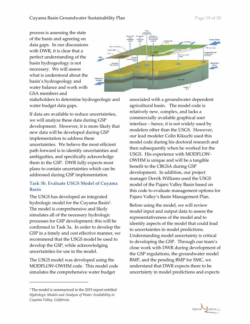
Task 3b. Evaluate USGS Model of Cuyama
Basin
The USGS has developed an integrated
hydrologic model for the Cuyama Basin3.
The model is comprehensive and likely
simulates all of the necessary hydrologic
processes for GSP development; this will be
confirmed in Task 3a. In order to develop the
GSP in a timely and cost effective manner, we
recommend that the USGS model be used to
develop the GSP, while acknowledging
uncertainties for use in the model.
The USGS model was developed using the
MODFLOW-OWHM code. This model code
simulates the comprehensive water budget
3 The model is summarized in the 2015 report entitled
Hydrologic Models and Analysis of Water Availability in
Cuyama Valley, California.
associated with a groundwater dependent
agricultural basin. The model code is
relatively new, complex, and lacks a
commercially available graphical user
interface – hence, it is not widely used by
modelers other than the USGS. However,
our lead modeler Colin Kikuchi used this
model code during his doctoral research and
then subsequently when he worked for the
USGS. His experience with MODFLOW-
OWHM is unique and will be a tangible
benefit to the CBGSA during GSP
development. In addition, our project
manager Derrik Williams used the USGS
model of the Pajaro Valley Basin based on
this code to evaluate management options for
Pajaro Valley’s Basin Management Plan.
Before using the model, we will review
model input and output data to assess the
representativeness of the model and to
identify aspects of the model that could lead
to uncertainties in model predictions.
Understanding model uncertainty is critical
to developing the GSP. Through our team’s
close work with DWR during development of
the GSP regulations, the groundwater model
BMP, and the pending BMP for SMC, we
understand that DWR expects there to be
uncertainty in model predictions and expects

Cuyama Basin Groundwater Sustainability Plan Page 20 of 30
that GSAs will account for this uncertainty
when developing their GSP. For that reason,
we will focus on model representativeness
and uncertainties instead of striving to
develop the perfect model for the basin. This
modeling approach will lead to timely and
less costly integration of modeling into the
GSP process, and lead to more effective
development of SMC and more effective
analysis of management actions and projects
that are needed to achieve sustainability. In
the future during GSP implementation,
additional evaluation of the model would be
conducted to determine whether
modifications are needed to improve model
utility for adaptive management and
optimization of sustainability projects and
management actions.
Task 3c: Develop Water Budgets
The model will be used to develop historic,
current, and future water budgets. The water
budgets will provide a basis for estimating
sustainable yield for the basin. The water
budgets are also critical for developing SMC.
It is important to recognize that the model
will be used in the context of developing
water budgets and SMC and estimating
sustainable yield based on SMC, but results
from the model will not be the basis for
demonstrating that sustainable conditions
have been achieved. Therefore, it is important
to scale the model to inform water budgets
not to define sustainability.
Task 3d: Support Development of
Sustainable Management Criteria
SMC are the most important aspect of the
GSP. The model will be used to support
development of the SMC. In particular, the
model will be useful for conceptually
evaluating the cause of undesirable results,
establishing minimum thresholds and
measurable objectives, and developing and
refining the monitoring program for the
basin. The model can potentially be used to
establish groundwater level proxies for
sustainability criteria such as subsidence and
surface water depletion.
Task 3e: Simulate Management Actions and
Projects
After the model has been used to develop the
water budget and support development of
SMC, the model will be used to evaluate
various management actions and projects
that may be feasible components of
sustainability. In this case, the model will be
used to simulate different actions and
projects. The model provides the best means
to simulate the effect of actions and projects
on complex hydrologic processes, such as
interconnected surface and groundwater
systems, and to account for potential impacts
from climate change. Model results will be
compared to identify the best combination of
management actions and projects that avoid
undesirable results, attain measurable
objectives, help set interim milestones based
on simulated progress toward sustainability
in the basin, and estimate sustainable yield
for inclusion in the water budget section of
the GSP.
Deliverables
Key deliverables for Task 3 include: technical
memoranda on basin conditions, model
review, water budgets, and summary of use
of the model during GSP development for
use as sections in GSP.
Cuyama Basin Groundwater Sustainability Plan Page 21 of 30
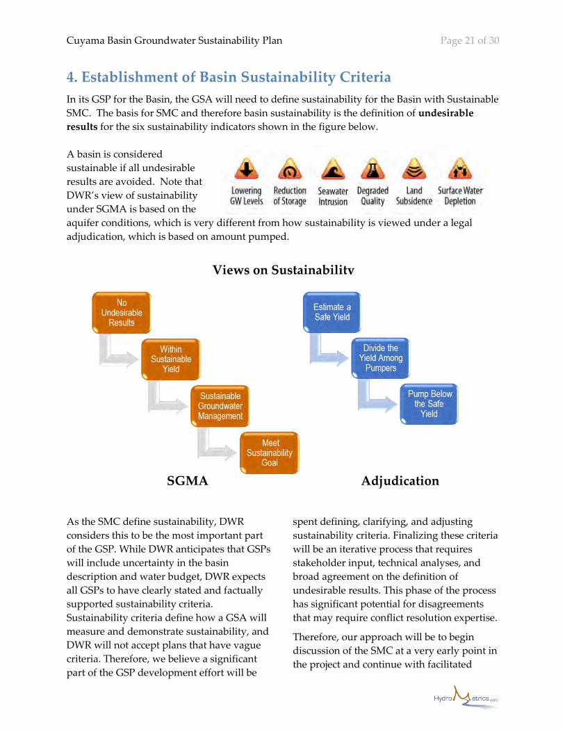
4. Establishment of Basin Sustainability Criteria
In its GSP for the Basin, the GSA will need to define sustainability for the Basin with Sustainable
SMC. The basis for SMC and therefore basin sustainability is the definition of undesirable
results for the six sustainability indicators shown in the figure below.
A basin is considered
sustainable if all undesirable
results are avoided. Note that
DWR’s view of sustainability
under SGMA is based on the
aquifer conditions, which is very different from how sustainability is viewed under a legal
adjudication, which is based on amount pumped.
As the SMC define sustainability, DWR
considers this to be the most important part
of the GSP. While DWR anticipates that GSPs
will include uncertainty in the basin
description and water budget, DWR expects
all GSPs to have clearly stated and factually
supported sustainability criteria.
Sustainability criteria define how a GSA will
measure and demonstrate sustainability, and
DWR will not accept plans that have vague
criteria. Therefore, we believe a significant
part of the GSP development effort will be
spent defining, clarifying, and adjusting
sustainability criteria. Finalizing these criteria
will be an iterative process that requires
stakeholder input, technical analyses, and
broad agreement on the definition of
undesirable results. This phase of the process
has significant potential for disagreements
that may require conflict resolution expertise.
Therefore, our approach will be to begin
discussion of the SMC at a very early point in
the project and continue with facilitated
SGMA Adjudication
Views on Sustainability
Cuyama Basin Groundwater Sustainability Plan Page 22 of 30
discussions on the SMC throughout the
project. The discussion will start with a
workshop that will help stakeholders
understand their specific roles in making
decisions, and what is required of them
during the GSP development process. By the
start of the project, DWR is scheduled to
release a draft BMP for developing the SMC.
Our principal-in-charge and project
manager, Derrik Williams, assisted in
drafting this BMP for DWR, and therefore
has unparalleled knowledge of the
requirements for developing the SMC. He is
therefore uniquely qualified and prepared
to present on the SMC at this early
workshop. Facilitated discussions on SMC
with the GSP Advisory Committee will
continue to take place as other tasks for the
GSP are undertaken, such as establishing
basin conditions, developing data
management systems, assessing and
recommending improvements to the
monitoring network, identifying projects and
programs to achieve sustainability,
groundwater modeling to evaluate
contributions of identified projects and
programs to sustainability, and planning
implementation. All of this work must be
performed within the context of developing
the SMC. By facilitating discussion of the
SMC throughout the project, we will help the
basin’s beneficial users quantify the desired
state of the groundwater basin with the SMC.
The SMC include identification of
undesirable results, minimum thresholds at
every representative monitoring point (RMP),
measurable objectives at every RMP, and
describing how combinations of minimum
threshold exceedances in the basin will be
considered to be undesirable results. The
different steps for developing the SMC and
how they integrate and sequence with other
GSP tasks (italicized) are described below.
These steps are part of the broader GSP
development process, and we have grouped
them into the following four subtasks for cost
estimation purposes (provided under
separate sealed cover).
Task 4a – Monitoring Network
Evaluation (Step 3)
Task 4b – Sustainable Management
Criteria (Steps 2, 4, 5, 8, and 9)
Task 4c – Management Areas (Steps 6
and 7)
Task 4d – Interim Milestones (Step 10)
An important early milestone will be the
Workshop to Develop Shared Project
Understanding (Task 1a), where Derrik
Williams will present on the SMC to initiate
development of a shared understanding of
their importance and the process required to
develop them.
Steps to Developing SMC
1. Identify Applicable Sustainability
Indicators, Identify Undesirable
Results, and Draft Sustainability
Goal. As Basin Conditions (Task 3a)
are documented and communicated
with the GSA and the GSP Advisory
Committee, we will help identify the
applicable sustainability indicators
and develop draft descriptions of
what is significant and unreasonable
for the sustainability indicators and
therefore considered undesirable
results. Based on this process, we will
draft the descriptive sustainability
goal.
2. Assess and Improve Monitoring
Network Based on Needs for
Evaluating Undesirable Results.
Groundwater sustainability is
demonstrated using data from the
basin’s monitoring network. The
network must be sufficient to assess
all six sustainability indicators, and

Cuyama Basin Groundwater Sustainability Plan Page 23 of 30
provide reasonable coverage
throughout the basin. Assessing the
existing monitoring network, and
improving or modifying it is an
imperative for avoiding undesirable
results. Attempting to demonstrate
sustainability with an incomplete or
poorly designed monitoring network
may result in the CBGSA having
difficulty proving sustainability in the
future. It will also be important to
Develop a Data Management System
(Task 2) with the SMC in mind as the
data should focus on the applicable
sustainability indicators.
3. Draft Concepts for Minimum
Thresholds. Minimum thresholds are
the numeric value for each applicable
sustainability indicator used to define
undesirable results. Based on GSP
Advisory Committee agreement on
undesirable results and data
availability, we will propose options
for what the bases of minimum
thresholds could be. This could
include proposing use of
groundwater levels as proxies for
minimum thresholds for multiple
sustainability indicators. Discussion
with the GSP Advisory Committee on
the conceptual options will be
facilitated to arrive at agreement on
the bases for minimum thresholds.
4. Draft Concepts for Measurable
Objectives. Measurable objectives
are specific, quantifiable goals for the
maintenance or improvement of
specified groundwater conditions.
They represent better basin conditions
than minimum thresholds and
represent a long-term sustainability
goal that provides operational
flexibility and a buffer, for example
during dry periods, which reduce risk
of undesirable results. Based on the
agreed concepts for minimum
thresholds, we will facilitate
discussion by the GSP Advisory
Committee of the operational
flexibility that is appropriate for the
basin guided by historic water budget
information from Basin Conditions
(Task 3a).
5. Evaluate Establishment of
Management Areas. The GSP
regulations allow for definition of
multiple management areas with
different minimum thresholds and
measurable objectives than the rest of
the basin. It may be appropriate to
define multiple management areas in
the Basin since there are three distinct
subareas within the Basin (Main Zone,
Sierra Madre Foothills, and
Ventucopa Uplands). However, the
definition of undesirable results needs
to be consistent with the rest of the
basin so this discussion takes place
after agreement on definition and
concepts for minimum thresholds and
measurable objectives. We will advise
the GSP Advisory Committee on the
appropriateness for defining
management areas based on the
hydrogeologic conceptual model in
Basin Conditions (Task 3a) and the
level of monitoring described in
Assess and Improve Monitoring Network.
6. Select Representative Monitoring
Points (e.g., red dots on
graphic). Minimum
thresholds and
measurable
objectives are
only applied at
representative
monitoring
points. Based on

Cuyama Basin Groundwater Sustainability Plan Page 24 of 30
the work to Assess and Improve
Monitoring Network (Task 4a), we will
propose representative monitoring
points for each applicable
sustainability indicator to the GSP
Advisory Committee for discussion
and revision.
7. Establish Minimum Thresholds and
Measurable Objectives at Each
Representative Monitoring Point.
Based on an understanding of the
above steps, we will propose
minimum thresholds and measurable
objectives at all representative
monitoring points for consideration
by the GSP Advisory Committee. The
Water Budget (Task 3c) section will
include an estimate of sustainable
yield which will be estimated by
Groundwater Modeling for pumping
totals that achieve measurable
objectives
throughout the
basin. It should
be noted that, per
SGMA, total
pumping that
meets this
sustainable yield
estimate does not
define
sustainability.
8. Define Combinations of Minimum
Thresholds that Represent
Undesirable Results. In the SMCs,
the GSA can establish combinations of
minimum threshold exceedances that
represent undesirable results. We will
facilitate a discussion by the GSP
Advisory Committee of how the GSA
wants to apply minimum thresholds
throughout the Basin that will inform
development of these combinations.
9. Establish Interim Milestones for
Achieving Sustainability. As part of
Development of Projects and Actions to
Achieve Sustainability Goals (Task 5),
we will use the Basin Model (Task 3) to
assess whether projects and actions
result in sustainability by meeting
measurable objectives by 2040 and
prevent undesirable results for the
rest of the 50-year future climate
evaluation period required by DWR.
The modeled results for the first 20
years can guide the establishment of
interim milestones for progress that is
expected to achieve sustainability.
Deliverables
Key deliverables for Task 4 include: Five
technical memoranda describing steps
developing sustainability management
criteria for use as draft sections for the GSP.
5. Development of Projects
and Actions to Achieve
Sustainability Goals
Projects and management actions are a
required element of the GSP and will be
selected to meet the sustainability goal for the
basin. The GSP must describe the projects
and management actions that CBGSA has
determined will achieve the sustainability
goal for the basin. This discussion must
identify the specific linkages with the SMC
(i.e. measurable objectives, interim
0
10
20
30
40
50
60
70
80
90
Gro
un
dw
ate
r Le
vel
Historical Future
Minimum Threshold
Measurable Objective
IM#1 IM#3IM#2
Sustainable

Cuyama Basin Groundwater Sustainability Plan Page 25 of 30
milestones, and minimum thresholds) and
any implementation triggers. This section of
the GSP must also describe the process by
which CBGSA will provide notice to the
public and other agencies that the
implementation of projects or management
actions is being considered or has been
implemented. Because the basin has been
designated as critically overdrafted by DWR,
the GSP must specifically describe projects or
management actions that may be
implemented to address the overdraft
condition.
The HydroMetrics WRI team recognizes that
there are three distinct subareas within the
basin (Main Zone, Sierra Madre Foothills,
and Ventucopa Uplands), which have
different groundwater conditions and
potentially different sustainability criteria.
Moreover, there are structural imbalances
between these areas, with the majority of the
recharge occurring in the Ventucopa and
Sierra Madre Foothills and the majority of the
pumping and groundwater storage depletion
occurring in the Main Zone. Hence, these
areas may require different projects and
management actions achieve the
sustainability goal for the basin. While the
GSP may proceed with different management
areas for the three subareas, it may be
necessary to consider projects that facilitate
water transfers from areas that are more
easily recharged to areas that are not. Of
course, any project that transfers water must
ensure that the beneficial users located in the
area where the water is being transferred
from are not impacted or are made whole.
The principal issue in the basin that must be
addressed to achieve sustainability is
balancing groundwater supply and demand.
Balance will likely be achieved through a
combination of water supply augmentation
projects and demand management measures.
If appropriate, our approach will consider the
use of decision support modeling to better
evaluate the financial tradeoffs and benefits
of projects and actions. This approach is
more transparent and objective, and can help
quantify the financial implications of the
projects and actions that are being considered
for the basin.
Potential water supply augmentation projects
will likely need to focus on engineered
projects that increase recharge following
precipitation events and transfer water from
areas that are more easily recharged to areas
that are not. Some options that will be
considered include:
Regional storm water recharge projects in
the Ventucopa and Sierra Madre Foothills;
On-farm recharge projects (temporary
flooding of farmland adjacent to Cuyama
River or a tributary for recharge);
Storm water retention;
Dry wells in recharge areas; and
Injection wells in the Main Zone.
Demand management programs should be
considered to reduce groundwater demand
and ensure that the available resources are
being used as efficiently as possible. Demand
management options that will be considered
include, but are not limited to:
Irrigation efficiency improvement
programs;
Pay-to-fallow programs;
Longer crop rotations; and
Land-use change (e.g. solar
generation).
There are three ways to pursue the above-
listed demand management measures. One
method is via regulatory mandates. Another
method is via incentives provided by the
GSA (funded by an extraction fee). The last
option is via a water market. The idea behind
a water market is that it would create market-
driven financial incentives that drive
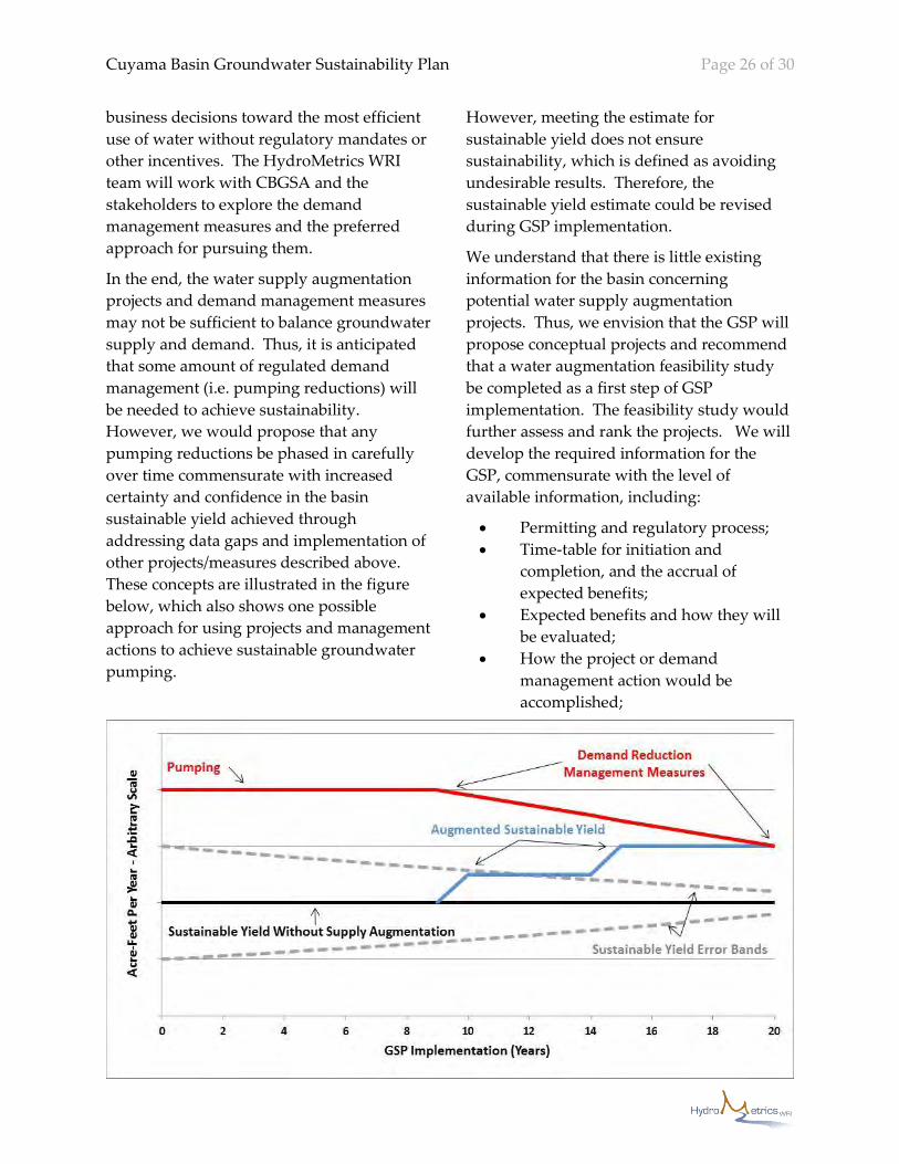
Cuyama Basin Groundwater Sustainability Plan Page 26 of 30
business decisions toward the most efficient
use of water without regulatory mandates or
other incentives. The HydroMetrics WRI
team will work with CBGSA and the
stakeholders to explore the demand
management measures and the preferred
approach for pursuing them.
In the end, the water supply augmentation
projects and demand management measures
may not be sufficient to balance groundwater
supply and demand. Thus, it is anticipated
that some amount of regulated demand
management (i.e. pumping reductions) will
be needed to achieve sustainability.
However, we would propose that any
pumping reductions be phased in carefully
over time commensurate with increased
certainty and confidence in the basin
sustainable yield achieved through
addressing data gaps and implementation of
other projects/measures described above.
These concepts are illustrated in the figure
below, which also shows one possible
approach for using projects and management
actions to achieve sustainable groundwater
pumping.
However, meeting the estimate for
sustainable yield does not ensure
sustainability, which is defined as avoiding
undesirable results. Therefore, the
sustainable yield estimate could be revised
during GSP implementation.
We understand that there is little existing
information for the basin concerning
potential water supply augmentation
projects. Thus, we envision that the GSP will
propose conceptual projects and recommend
that a water augmentation feasibility study
be completed as a first step of GSP
implementation. The feasibility study would
further assess and rank the projects. We will
develop the required information for the
GSP, commensurate with the level of
available information, including:
Permitting and regulatory process;
Time-table for initiation and
completion, and the accrual of
expected benefits;
Expected benefits and how they will
be evaluated;
How the project or demand
management action would be
accomplished;

Cuyama Basin Groundwater Sustainability Plan Page 27 of 30
Legal authority required;
Estimated costs for the projects and
management actions; and
Strategy to finance the projects and
management actions (Task 5b in
schedule and cost).
Deliverables
Key deliverables for Task 5 include a
technical memorandum on conceptual
management actions and projects, and a
technical memorandum on planned
management actions, projects, and finance
strategy for use as the draft GSP chapter.
6. Groundwater Sustainability
Plan Document Preparation
The GSP will be the fundamental document
for groundwater management in the Cuyama
Basin. Additionally, the GSP serves as proof
to DWR that the CBGSA has a hydrogeologic
understanding of the basin, a clear definition
of sustainability, and a defined approach for
achieving sustainability within 20 years.
In terms of content and compliance with the
GSP regulations, the GSP will follow
guidance from DWR in their Groundwater
Sustainability Plan Annotated Outline Guidance
Document for the Sustainable Management of
Groundwater. We have reviewed this outline,
and used it as the starting point for other
GSPs that we are working on. We believe
DWR’s outline could be structurally modified
for clarity, however all the basic sections
suggested by DWR will be included in our
GSP. Relying on DWR’s outline ensures that
the CBGSA will address all of DWR’s
requirements in the GSP.
While our goal is to ensure the GSP meets the
standards set forth in the GSP regulations
and BMPs, we also recognize that a
successful GSP requires much more than just
meeting these standards. SGMA envisions a
robust stakeholder engagement process
during the GSP development and for good
reason – a GSP that is adopted with
significant stakeholder opposition may not be
approved by DWR and would be challenging
to implement. Thus, we view the GSP as an
outcome of a successful planning process, not
just a deliverable. We believe this
wholeheartedly because our team’s success in
other basins has resulted from taking the
time to build shared vision amongst the
participating stakeholders throughout the
planning process. Thus, our approach will
be to deliver draft sections of the GSP
incrementally as they are completed so we
can obtain early input from the CBGSA and
build confidence in the process and,
ultimately, the GSP itself. Our outreach and
stakeholder involvement program will be
aligned with draft GSP section deliveries to
ensure a cohesive and collaborative process.
We believe this approach maximizes
transparency, provides early and frequent
opportunities for stakeholder input, and
helps mitigate the inevitable push back that
will occur immediately prior to adoption by
the CBGSA Board.
Deliverables
Key deliverables for Task 6 include draft and
final GSP.
7. GSP Implementation
The implementation chapter of the GSP
summarizes the plan to achieve
sustainability, describes how sustainability
will be periodically evaluated, and discusses
the use of adaptive management to meet
sustainability. Therefore, this chapter will
not only describe how the GSA will meet
ongoing requirements of the GSP regulations
and SGMA, such as annual reports and the
five year periodic evaluations, but describe
how actions and projects will meet interim
milestones and eventually measurable

Cuyama Basin Groundwater Sustainability Plan Page 28 of 30
objectives. This chapter represents the GSA’s
roadmap to sustainability based on the
actions and projects identified in the GSP.
In addition to cost, schedule, and planned
contents of annual reports and five year
periodic evaluations, the chapter will include
the cost and schedule of planned actions and
projects in relation to achieving interim
milestones set every five years until 2040.
The chapter will describe the additional
actions and projects or revisions to actions
and projects available if interim milestones
are not achieved. We will propose adaptive
management options for a facilitated
discussion with the GSP Advisory Committee
before describing them in the GSP.
Deliverables
Key deliverables for Task 7 include: the draft
implementation chapter of the GSP.
8. Meetings Our approach to the GSP development
process will be hands-on with frequent
interaction with the CBGSA, GSP Advisory
Committee, Executive Director, and other
stakeholders. A key element of the process
will be participation in meetings. In order to
inform stakeholders on the GSP process,
build consensus among the stakeholders, and
minimize delays, we will participate in all
GSP Advisory Committee meetings, attend
all CGBSA Board meetings, and take on an
appropriate role in other ad hoc meetings as
needed. It will be important for our project
manager, lead facilitator, and local project
lead to be involved in meetings throughout
the GSP development process. Other team
members may attend some meetings when
appropriate. We understand that the GSP
Advisory Committee is in the process of
forming and an Executive Director will be
hired. We also understand that advisory
committee and GSA Board meetings will be
held monthly. For cost estimating purposes,
we have assumed the following level of effort
for meetings.
Task 8a: GSP Advisory Committee
Meetings
We assume there will be 20 advisory
committee meetings during GSP
development. Our lead facilitator, Ellen
Cross, will attend all meetings, and our
senior facilitator, J. Michael Harty, will attend
4 meetings, where they will facilitate
stakeholder interactions and ensure that
meeting goals are met and the GSP process
stays on schedule. We assume our project
manager, Derrik Williams, will attend 8
meetings and our local project lead, Bryan
Bondy, will attend the other 12 meetings. For
meetings they do not attend, Derrik and
Bryan will attend by teleconference to stay
updated. Their attendance will be important
to inform stakeholders on technical issues
and progress.
Task 8b: CBGSA Board Meetings
We assume there will be 20 meetings during
GSP development. Bryan Bondy will attend
all CBGSA Board meetings to stay informed
about issues and report back to the technical
and facilitation team. We assume Ellen and
Derrik would each attend 4 meetings.
Task 8c: Other Meetings
We anticipate that other technical meetings
will be required to develop the GSP. For
planning purposes, we assume that Ellen,
and Bryan will attend 4 additional meetings.
Deliverables
The primary deliverable for Task 8 will be
meeting notes and presentations.
Cuyama Basin Groundwater Sustainability Plan Page 29 of 30
Project Schedule Figure 1 shows a detailed schedule for GSP development. Our team is motivated to deliver the GSP
before the January 31, 2020 deadline assuming we can start work during or before January 2018.
Proprietary Statement HydroMetrics WRI, on behalf of it and its subconsultants, attests that nothing contained in the
submittal is proprietary. HydroMetrics WRI further attests that it will, to the best of its ability, not
include proprietary information in any subsequent interview (if required).
Insurance All members of the HydroMetrics WRI team currently have the required insurance coverages. The
table below identifies the insurance carrier for each team member.
Firm HydroMetrics
WRI
Kearns & West Bondy
Groundwater, Inc.
Montgomery &
Associates
General
Liability
Travelers
Insurance
Twin City Fire
Insurance/The
Hartford
Farmers Insurance
Exchange
The Hartford
Automotive Travelers
Insurance
The Hartford Farmers Insurance
Exchange
The Hartford
Workers Comp. Travelers
Insurance
The Hartford N/A – Sole
proprietor
The Hartford
Errors &
Omissions
U.S. Specialty
Insurance
Federal
Insurance Co.
U.S. Specialty
Insurance
CNA
Estimated Costs Estimated costs are provided under separate cover.
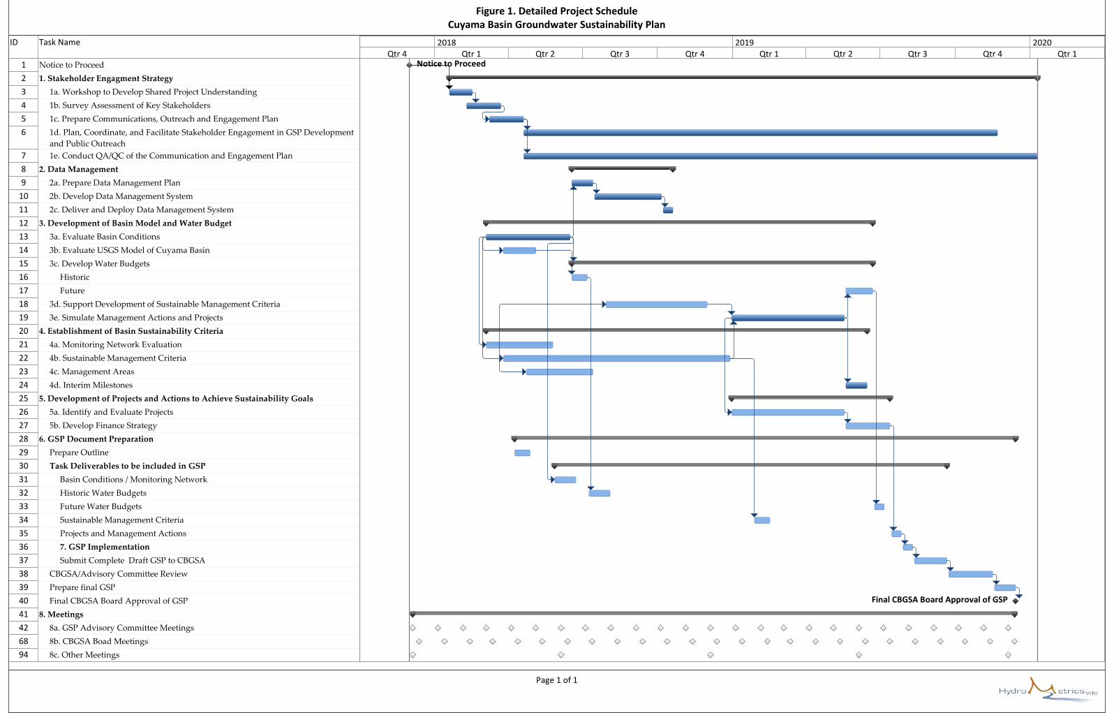
ID Task Name
1 Notice to Proceed
2 1. Stakeholder Engagment Strategy
3 1a. Workshop to Develop Shared Project Understanding
4 1b. Survey Assessment of Key Stakeholders
5 1c. Prepare Communications, Outreach and Engagement Plan
6 1d. Plan, Coordinate, and Facilitate Stakeholder Engagement in GSP Development
and Public Outreach
7 1e. Conduct QA/QC of the Communication and Engagement Plan
8 2. Data Management
9 2a. Prepare Data Management Plan
10 2b. Develop Data Management System
11 2c. Deliver and Deploy Data Management System
12 3. Development of Basin Model and Water Budget
13 3a. Evaluate Basin Conditions
14 3b. Evaluate USGS Model of Cuyama Basin
15 3c. Develop Water Budgets
16 Historic
17 Future
18 3d. Support Development of Sustainable Management Criteria
19 3e. Simulate Management Actions and Projects
20 4. Establishment of Basin Sustainability Criteria
21 4a. Monitoring Network Evaluation
22 4b. Sustainable Management Criteria
23 4c. Management Areas
24 4d. Interim Milestones
25 5. Development of Projects and Actions to Achieve Sustainability Goals
26 5a. Identify and Evaluate Projects
27 5b. Develop Finance Strategy
28 6. GSP Document Preparation
29 Prepare Outline
30 Task Deliverables to be included in GSP
31 Basin Conditions / Monitoring Network
32 Historic Water Budgets
33 Future Water Budgets
34 Sustainable Management Criteria
35 Projects and Management Actions
36 7. GSP Implementation
37 Submit Complete Draft GSP to CBGSA
38 CBGSA/Advisory Committee Review
39 Prepare final GSP
40 Final CBGSA Board Approval of GSP
41 8. Meetings
42 8a. GSP Advisory Committee Meetings
68 8b. CBGSA Boad Meetings
94 8c. Other Meetings
Notice to Proceed
Final CBGSA Board Approval of GSP
Qtr 4 Qtr 1 Qtr 2 Qtr 3 Qtr 4 Qtr 1 Qtr 2 Qtr 3 Qtr 4 Qtr 1 Qtr 22017 2018 2019 2020
Figure 1. Detailed Project ScheduleCuyama Basin Groundwater Sustainability Plan
Page 1 of 1

.
Appendix A: Resumes

Derrik Williams, P.G., C.Hg. Page 1 of 2
1814 Franklin Street, Oakland, CA 94612
EDUCATION M.S., Hydrology, University of Arizona, 1987
B.S., Geology, University of California at Davis, 1982
EXPERIENCE 28 years
REGISTRATION Professional Geologist, California, #6044
Certified Hydrogeologist, California, #35
EXPERTISE o 3D groundwater flow
and transport models o Groundwater recharge o Conjunctive water
management o Groundwater basin
management o Aquifer test analysis o Interagency
negotiation and coordination
o Independent technical review
PROFESSIONAL AFFILIATIONS o American Geophysical
Union o Association of
California Water Agencies
o National Groundwater Association
o Groundwater Resources Association of California
Experience Summary
Derrik Williams, a California Professional Geologist and Certified
Hydrogeologist, is President of HydroMetrics Water Resources Inc.
Derrik has more than 28 years of experience in applied geology and
hydrogeology and excels at assisting his clients with integrating
technical analyses and institutional challenges to manage their water
resources. His project experience includes managing, reviewing, and
assisting on water supply, groundwater recharge, wastewater
disposal, and hazardous waste remediation projects. Derrik is
accomplished in analytical hydrogeology, with extensive
interpretation and application of groundwater flow and transport
models. He is an expert in aquifer test design and analysis and is
experienced in all aspects of groundwater management.
As a member of the Groundwater Committee of the Association of
California Water Agencies (ACWA) since 2008, Derrik helped shape
the California Statewide Groundwater Elevation Monitoring
Program (CASGEM) and helped develop ACWA's Groundwater
Framework document. He additionally drafted ACWA’s Guidelines for
Groundwater Monitoring. Derrik is one of the few consultants
working closely with DWR to develop the state’s SGMA
implementation process. He reviewed and commented on the
SGMA legislation while it was being drafted, and currently sits on
ACWA’s SGMA Implementation Policy Committee as well as
ACWA’s SGMA Policy Advisory Workgroup.
Derrik has been invited to meet regularly with representatives from
DWR and SWRCB to shape the regulations implementing the SGMA
legislation. During 2015, he represented both ACWA and the mid-
coast groundwater users group in numerous meetings with DWR
and SWRCB. He was a contributor to the California Water
Foundation’s GSP regulations workshops, and he was invited to
participate in Stanford’s Water in the West meetings on data and
modeling in SGMA.
Representative Experience
Sustainable Groundwater Management Act
Santa Margarita Groundwater Basin Boundary Modification,
Scotts Valley Water District. Derrik managed the one of the most
complex basin boundary modifications as in SGMA’s
implementation. The basin boundary modification included both
technical and jurisdictional modifications to promote sustainable
groundwater management. Derrik reviewed and interpreted

Derrik Williams, P.G., C.Hg. Page 2 of 2
1814 Franklin Street, Oakland, CA 94612
relevant SGMA regulations for the client and hosted meetings with DWR and SWRCB to review
and obtain agreement to the modification approach. He developed the technical justification to
establish a new groundwater basin that encompasses all or parts of two existing groundwater
basins, along with areas previously not considered groundwater basins. Derrik assisted the
client with required stakeholder outreach and water agency notification, and developed
responses to concerns raised by neighboring water agencies. As part of his management, Derrik
presented the modification approach and technical work at numerous Boards of Directors
meetings in Santa Cruz County.
Groundwater Sustainability Agency Assessment, Butte County Department of Water and
Resource Conservation. Derrik is providing technical assistance regarding GSA development
to Butte County as a subconsultant to Kearns and West Inc. The project is assisting Butte
County assess the potential interest and concerns of various agencies and groups regarding
GSA formation under SGMA. Derrik was part of the team that helped develop the outreach
materials to ensure that relevant information was collected to guide Butte County’s GSA
development.
Groundwater Supply/Groundwater Management
Seaside Basin Groundwater Management, Seaside Basin Watermaster. Derrik helped develop
both a Basin Management Action Plan and Seawater Intrusion Response Plan (SIRP) for the
Watermaster in Monterey County. The Basin Management Action Plan identified specific data
needs, water sources, and groundwater management actions and recommended an
implementation strategy to the Watermaster. The SIRP was a companion document that
included exhaustive statistical and graphical analyses of groundwater quality data to identify
potential seawater intrusion.
Groundwater Management for the Soquel-Aptos Basin, Soquel Creek Water District. For the
past nine years, Derrik has served as technical consultant and advisor to the Soquel Creek
Water District for all aspects of their groundwater program. Specific support includes updating
the groundwater management plan, investigating conjunctive use alternatives, providing well
master plan EIR support, designing and installing monitoring wells, seawater intrusion
monitoring, assisting with municipal well rehabilitation and restoration, and assisting with
negotiating with neighboring agencies.
Creek/Aquifer Interaction Study, Squaw Valley Public Service District (SVPSD). Derrik
directed a unique study to establish and quantify the interflow between Squaw Creek and the
adjoining shallow aquifers. The study used temperature monitoring techniques that can
directly estimate the flow rates between the Creek and the shallow aquifers. This project was
funded by a California Department of Water Resources AB303 Local Groundwater Assistance
Grant.

Cameron Tana, P.E. Page 1 of 2
Experience Summary A co-founder of HydroMetrics Water Resources Inc., Cameron Tana has 17 years of experience as a hydrologist focused on assisting public agencies in California manage their groundwater resources. Cameron uses analytical tools and numerical models to address his clients’ challenges and is particularly adept at selecting and implementing the analytical tools best suited to address specific ground- and surface-
water issues. He is experienced at communicating technical findings to
advance groundwater management, taking into account legal,
economic, and political challenges.
As a member of the American Water Works Association, Cameron serves as Chair of the California-Nevada Section’s Water Well Technology Committee.
Representative Experience
Sustainable Groundwater Basin Management
Sustainable Groundwater Management Act (SGMA) Implementation, Santa Cruz Mid-County Groundwater Agency. Cameron has presented an overview of the Santa Cruz Mid-County Basin’s groundwater hydrology and groundwater management activities to the Santa Cruz Mid-County Stakeholder Advisory Committee, providing important background as the committee discussed stakeholder involvement in formation of a Groundwater Sustainability Agency. Cameron led the successful application to the Department of Water Resources to revise basin boundaries to consolidate portions of four basins into the Santa Cruz Mid-County Basin that will be managed by the Santa Cruz Mid-County Groundwater Agency (MGA). The revision included jurisdictional and scientific modifications of internal and external boundaries. Cameron coordinated between MGA members and neighboring agencies to ensure all basin boundary modification applications in Santa Cruz County were consistent. Cameron also assisted with MGA’s notification of its formation as a Groundwater Sustainability Agency to the state and represented the MGA in Central Coast advisory group meetings with the California Department of Water Resources, where he articulated how groundwater conditions on the Central Coast differ from the rest of the state.
Groundwater Zone of Benefit Study, Santa Clara Valley Water District. Cameron is leading a team to evaluate and revise the District’s groundwater zones of benefit that provide the basis for its groundwater charges. To date, the team has developed the study methodology and draft report to evaluate areas that benefit from the District’s in-lieu and managed recharge activities. Working with the outreach subconsultant and the District, Cameron planned meetings with stakeholder groups and presented study plans at the meetings.
EDUCATION M.Eng., Civil and Environmental Engineering, Massachusetts Institute of Technology, 1999
B.S., Civil and Environmental Engineering, Stanford University, 1998
A.B., Economics, Stanford University, 1998
EXPERIENCE 17 years
REGISTRATION Registered Professional, Engineer (Civil), California, #C65822
EXPERTISE o Three dimensional
groundwater flow and transport models
o Groundwater basin management
o Analysis of pumping impacts
o Inverse methods for calibrating numerical models
o Estuarine hydrodynamics models
PROFESSIONAL AFFILIATIONS o American Society of
Civil Engineers o American Water
Works Association o Emerging Leaders
Alliance o Groundwater
Resources Association of California
o National Ground Water Association

Cameron Tana, P.E. Page 2 of 2
Conjunctive Use Benefit of Treated Water, Santa Clara Valley Water District. Cameron led a water resources engineering team in support of an evaluation of the District’s groundwater production charges. The task involved estimating the economic benefit of in-lieu recharge to the groundwater basin from including treated surface water in the supply portfolio. Cameron evaluated the groundwater infrastructure required for a groundwater only portfolio and managed the cost estimates for developing the additional groundwater infrastructure.
Groundwater Basin Management, Soquel Creek Water District. Cameron has provided broad technical expertise to the Soquel Creek Water District since 2005 under four consecutive as-needed consulting contracts. His contributions have touched on all issues dealing with groundwater management for the Santa Cruz Mid-County Basin. Examples of his work include:
Revised the Groundwater Management Plan for the Basin, leads the compilation of annual reports on the state of the groundwater basin and the status of basin management objectives, and recommended updates to the Plan.
Developed drought curtailment criteria for an update of the Integrated Resources Plan. Cameron analyzed deep recharge results from a Precipitation Runoff Watershed Model to base drought curtailment stages on multi-year rainfall totals that indicate shortfalls of the groundwater recharge.
Groundwater Modeling/Analytical Hydrogeology
Santa Cruz Mid-County Basin Integrated Watershed-Groundwater Model, Santa Cruz Mid-County Groundwater Agency. Cameron is project manager for development of a GSFLOW model of the Santa Cruz Mid-County Basin that integrates groundwater flow with watershed processes. He has directed strategy for updates to the basin conceptual model, model construction, estimates of non-metered pumping and return flow, and calibration to streamflows and groundwater levels. The model will be used to evaluate in-lieu recharge, recharge of purified water, and aquifer storage and recovery of excess surface water as well as analyses required by the Basin’s Groundwater Sustainability Plan. Cameron has led Technical Review Committee meetings and presented to the Agency Board on model development progress.
Groundwater Model Upgrades, Zone 7 Water Agency. Zone 7 uses its groundwater model to evaluate projects for salts and minerals management. Cameron updated and recalibrated the model to reflect new salinity and groundwater data. He developed and implemented a strategy for calibrating the Zone 7 model with pilot points and regularization using PEST. He provided training and technical consultation to Zone 7 in-house staff regarding optimizing use of the model. As part of a recently completed project to improve simulation of managed recharge and salt transport in the basin, he managed development of packages included in the MT3D-USGS release for transport in surface water and its interaction with groundwater.
PRESENTATIONS ON SGMA Culkin, S., C. Tana, and D. Williams. 2017. Using Cross-Sectional models to Develop Proxy Measurable
Thresholds for Seawater Intrusion. Groundwater Resources Association Tools for SGMA
Workshop. Modesto, CA.
Tana, C., S. Culkin, N. Byler, and D. Williams. 2016. First Steps in Inter-Basin Coordination for SGMA: Basin Boundary Modification Requests in Santa Cruz County, Groundwater Resources Association of California Annual Conference. Concord, CA.
Georgina King, P.G., C.Hg. Page 1 of 3
1814 Franklin Street, Oakland, CA 94612
Experience Summary Georgina King is a Principal Hydrogeologist at HydroMetrics Water
Resources Inc. Educated in South Africa, she spent her early career
years with the South African Department of Water Affairs as
Assistant Director of groundwater resources for the province of
KwaZulu-Natal. She was responsible for the technical aspects of
managing groundwater, such as establishing a regional monitoring
network, rural water supply, and developing regional
hydrogeological maps. Since 2000, Georgina has worked in California
and focused on developing, managing, and protecting groundwater
resources. She has extensive experience in developing and managing
geographic information systems (GIS) and databases, which she
applies to most of her projects. She is experienced in managing and
conducting technical studies on basin-wide groundwater
management, large-capacity public water supply projects,
sustainable yield, and groundwater modeling projects.
Representative Experience
Groundwater Supply/Groundwater Management
Well Siting Study, Santa Cruz County, Scotts Valley Water District.
As the primary author of a well siting study to identify up to three
new potential well sites, Georgina performed a GIS overlay analysis
that took into account hydrogeologic and logistical factors. She also
provided site specific actions that would need to take place for the
three preferred sites, and prepared the report.
Groundwater Management Plan Annual Report, Santa Cruz
County, Scotts Valley Water District. Georgina prepared the Water
Year 2016 annual report for the Santa Margarita Groundwater Basin.
The work included analyzing groundwater level and quality data,
preparing groundwater contour maps, and reporting on
environmental cleanup operations and drought impacts.
Groundwater Zone of Benefit Study, Santa Clara County, Santa
Clara Valley Water District. Georgina has contributed her
hydrogeologic and GIS expertise to a project to evaluate and revise
the District’s groundwater zones of benefit that provide the basis for
its groundwater charges. She assisted the project team in developing
the study methodology to evaluate areas that benefit from the
District’s in-lieu and managed recharge activities. She also will work
with the project surveyor to determine metes and bounds for the
zones of benefit based on boundaries developed in GIS.
EDUCATION M.S., Geohydrology, Rhodes University, Grahamstown, South Africa, 1997
B.S., Engineering Geology, University of Natal-Durban, Kwazulu-Natal, South Africa, 1992
B.S., Geology, University of Natal-Durban, Kwazulu-Natal, South Africa, 1991
Postbaccalaureate Certificate in GIS, Penn State, 2016
EXPERIENCE 24 years
REGISTRATION Registered Geologist, California, #8023
Certified Hydrogeologist, California, #874
EXPERTISE ► Hydrogeologic
characterization
► Groundwater basin management
► Groundwater recharge
► Groundwater quality
► Geographical Information Systems and database management
PROFESSIONAL AFFILIATIONS ► Association of California
Water Agencies
► Groundwater Resources Association of California
► National Ground Water Association
Georgina King, P.G., C.Hg. Page 2 of 3
1814 Franklin Street, Oakland, CA 94612
Groundwater Recharge Capacity Evaluation, Phase I, Tulare Irrigation District (TID). Georgina
was the primary analyst and author of a recharge capacity report that estimated the surface and
groundwater budgets of the TID service area, identifies potential water sources to supplement
groundwater recharge, evaluated existing recharge capacity and required future capacity given the
potential sources available.
Ventura County Water Supply and Demand, Ventura County. Georgina was the project manager
and lead hydrogeologist in developing countywide water supply and demand estimates for 2013.
To estimate the amount of undocumented demand by urban and agricultural private users, a
demand calculator (IDC) was developed to estimate the countywide demands. The difference
between the countywide demand and the documented use was assumed to be the private use.
Seaside Groundwater Basin Laguna Seca Subarea Safe Yield, Seaside Basin Watermaster.
Georgina was the project manager for a modeling study to estimate the safe yield of the Laguna
Seca subarea which has experienced ongoing declines in groundwater levels. She was responsible
for directing modeling work carried out, preparing the technical memorandum, and presenting the
results to the Technical Advisory Committee.
Oxnard and Pleasant Valley Salt and Nutrient Management Plan, City of Oxnard/Carollo
Engineers. Georgina provided technical hydrogeologic information that was incorporated into a
salt and nutrient management plan for three groundwater basins. Georgina was responsible for the
basin characterization, estimating existing groundwater quality, and assimilative capacity portions
of the plan.
Lower Santa Clara River Salt and Nutrient Management Plan, Ventura County/Larry Walker
Associates. Georgina was the project manager for HydroMetrics WRI which was part of a team of
consultants preparing a salt and nutrient management plan for five groundwater basins. Georgina
was responsible for the basin characterization, estimating existing groundwater quality, and
assimilative capacity portions of the plan.
Seaside Basin Salt and Nutrient Management Plan, Monterey Peninsula Water Management
District. Georgina was the project manager and principal author of the salt and nutrient plan for
the Seaside basin. She was also responsible for preparing the Prop 84 grant application that
provided funding for the project.
Seaside Groundwater Basin Hydrogeologic Studies, Seaside Basin Watermaster. Georgina is the
project manager for all hydrogeologic studies and annual reports for the Seaside Basin
Watermaster. She has managed finalization of reports including the Basin Management Action
Plan, annual Seawater Intrusion Analysis Report since 2009, and the Seawater Intrusion Response
Plan.
Groundwater Management for the Soquel-Aptos Basin, Soquel Creek Water District. Since
2009, Georgina has been involved in preparing the annual groundwater review and report as per
Groundwater Management Plan requirements. She develops seasonal groundwater contour maps
and prepares all GIS maps.

Georgina King, P.G., C.Hg. Page 3 of 3
1814 Franklin Street, Oakland, CA 94612
AB303 Aquifer/Stream Interaction, Squaw Valley Public Service District. Georgina has
conducted installation of pressure transducers in monitoring wells, and pumping tests to study the
interaction between a local creek and production wells. This work is ongoing.

Laura D. Brown Page 1 of 2
1814 Franklin Street, Suite 501, Oakland, CA 94612
EDUCATION B.A. Political Science, University of Southern California, 1976 Senior Executive Institute, University of Virginia, 1985
EXPERIENCE 33 years Public Administration
17 years Groundwater Resources Management
EXPERTISE o Groundwater
Resources Management
o Integrated Water Resources Planning & Development
o Water Conservation o Seawater Desalination
Issues & Permitting o Interagency
Negotiation and Coordination
o Public Outreach and Engagement
o Municipal Utility Administration
o California Laws and Regulations pertaining to Local Gov’t, Groundwater and Drinking Water
HONORS o Santa Cruz Chamber
of Commerce Woman of the Year 2013
o Aptos Chamber of Commerce Woman of the Year 2007
Experience Summary
Laura Brown joined HydroMetrics Water Resources, Inc. as a
Senior Manager in 2013, following a 33-year career in local
government administration.
From 1995 through 2012, Laura provided solid and progressive
leadership as General Manager of the highly regarded Soquel
Creek Water District (SqCWD) in Santa Cruz County, which is
entirely dependent on local aquifers for its water supply. Under
Laura’s leadership, SqCWD was identified as one of California’s
exemplary and innovative groundwater management agencies by
numerous groups’ publications including:
The Association of California Water Agencies’
Sustainability from the Ground Up: A Framework for
Groundwater Management in California
Stanford University’s Woods Institute’s Uncommon
Innovation: Developments in Groundwater Management
Planning in California
Prior to managing SqCWD, Laura served as Assistant City
Manager for both the City of Monterey (1991 – 1995) and the City
of Santa Cruz (1985 – 1991).
Since joining HydroMetrics WRI, Laura has become well-versed
in the provisions of the Sustainable Groundwater Management
Act (SGMA) and has provided a variety of SGMA related services
to clients.
Laura excels at complex problem solving and strategic planning,
teamwork, public outreach and community engagement,
fostering inter-agency cooperation, regulatory compliance, sound
fiscal management and professional integrity and ethics.
Laura has an agricultural background and is very engaged with
current California agricultural issues through familial
relationships.

Laura D. Brown Page 2 of 2
1814 Franklin Street, Suite 501, Oakland, CA 94612
Representative Experience
Sustainable Groundwater Management Act (SGMA)
Develop Guidance Documents for Interagency Agreements and Other Tasks Related to GSA
Formation, County of San Luis Obispo (June 2016 – Present).
Funded through a Prop 1 grant, Laura has provided reference and public outreach materials to
be available to GSAs within San Luis Obispo County. This included researching and analyzing
groundwater management agency governance structures, preparing a worksheet for
developing a Joint Powers Agreement (JPA), and preparing SGMA Fact Sheets and Frequently
Asked Questions for the public. She is currently developing guidance documents for GSA start-
up. The latter is a resource addressing GSA staffing decisions, conducting agency business,
initial board actions to form and administer the new agency, sample policy documents, and a
work plan outline for undertaking preparation of a Groundwater Sustainability Plan.
Groundwater Management
Soquel Creek Water District (SqCWD) (1995 – 2012). With her agency being the primary user
of the overdrafted Soquel-Aptos groundwater basin and solely dependent on groundwater,
Laura supported a diverse group of 25 community stakeholders through a process that: 1)
achieved consensus on the water supply shortage; 2) vetted a list of viable conservation and
supply alternatives against agreed upon criteria; and 3) provided a roadmap for meeting long-
term water needs. Laura also led the effort for SqCWD to greatly expand its coastal and inland
groundwater monitoring program; prepare a Well Master Plan to strategically locate and design
new and replacement wells to more uniformly pump the basin; establish a collaborative
approach to groundwater management with other stakeholders; implement a monitoring and
mitigation program for private wells within the potential impact radii of new municipal wells;
and establish groundwater level goals to protect against seawater intrusion.
Tulare Irrigation District (TID) Groundwater Recharge Capacity Evaluation (2014 – Present).
Laura serves as project manager for this project that includes a water budget to determine a
groundwater sustainability goal for TID and assessment of current and potential recharge
capacity and supply resources.
Quality Assurance/Quality Control
Groundwater Zone of Benefit Study, Santa Clara Valley Water District. This project is to
evaluate and revise the District’s groundwater zones of benefit that provide the basis for its
groundwater charges. Laura reviews and edits all reports and presentations associated with this
highly technical and potentially controversial study for clarity and understandability by the
general public.

Bryan Bondy, PG, CHG Bondy Groundwater Consulting, Inc.
9452 Telephone Road, #112, Ventura, CA 93004 ● 805-212-0484 ● [email protected] 1 of 2
EDUCATION MS, Geological Sciences (Hydrogeology), San Diego State University (2000)
BS, Geological Sciences (Hydrogeology), San Diego State University (1997)
GIS Certification, Mt. San Jacinto Junior College (2008) PROFESSIONAL REGISTRATIONS Professional Geologist: California No. 7676
Certified Hydrogeologist: California No. 821 DISTINGUISHING QUALIFICATIONS • Hands-on SGMA
experience
• Former public water agency management employee experience
• Strong technical, writing, and public speaking skills
• Seeks to provide practical and cost-effective solutions
Bryan has 20 years of experience conducting a wide range of groundwater projects in California. His experience includes both public water agency and consulting experience including, Sustainable Groundwater Management Act implementation, groundwater supply studies, well design, construction, and rehabilitation, contaminant hydrogeology, groundwater modeling, interagency planning and coordination, permitting, project management, grant writing, and grant management. EMPLOYMENT HISTORY 2016-Present: President, Bondy Groundwater Consulting, Inc. Bryan is the founder and President of Bondy Groundwater Consulting, Inc. formed in 2016 to service the growing need for groundwater professionals to address Sustainable Groundwater Management Act requirements and other groundwater regulatory and planning issues.
2012-Present*: Contract Groundwater Manager, Calleguas Municipal Water District, Ventura County, California. Bryan has served as the District’s expert groundwater hydrogeologist and has served on the District’s management team since 2012. Bryan’s responsibilities include addressing legal and technical issues related to operation of the District’s aquifer storage and recovery project. Bryan serves on the Fox Canyon Groundwater Management Agency’s Board-appointed Technical Advisory Group for Sustainable Groundwater Management Act implementation and he is the facilitator of the Las Posas Valley Groundwater Basin Users Group, where he advises the groundwater users on Sustainable Groundwater Management Act planning issues. * In July 2016, Bryan’s role transitioned to a part-time Contract Groundwater Manager position serviced through Bondy Groundwater Consulting, Inc.
2009- 2012: Groundwater Policy Senior Hydrogeologist (Inter-Agency Position), Calleguas Municipal Water District, United Water Conservation District, and Fox Canyon Groundwater Agency, Ventura County, California. Bryan served as the Inter-Agency Groundwater Hydrogeologist working on groundwater management issues affecting the above-listed agencies.
2005-2009: Principal Hydrogeologist, Aqui-Ver, Inc., Temecula, California. Bryan served as a principal-in-charge on groundwater remediation design projects.
2000 – 2005: Senior Hydrogeologist / Project Manager, Kleinfelder, Inc., Temecula, California. As a client service manager, Bryan was responsible for numerous groundwater supply and remediation projects. As one of the few hydrogeologists in the firm at the time, Bryan was frequently called upon to assist other Kleinfelder offices with groundwater projects. Bryan also managed a team of professional staff and technicians.
1996 – 2000: Staff Hydrogeologist, Hargis + Associates, Inc., San Diego, California. As a staff hydrogeologist, Bryan completed numerous groundwater investigations. PROFESSIONAL AND ACADEMIC HONORS Kleinfelder President’s Award for Exceptional Client Service
Member of the Phi Kappa Phi and Phi Beta Kappa Honor Societies
Undergraduate Honors: Summa Cum Laude, Student of the Year

Bryan Bondy, PG, CHG Bondy Groundwater Consulting, Inc.
9452 Telephone Road, #112, Ventura, CA 93004 ● 805-212-0484 ● [email protected] 2 of 2
SELECTED REPRESENTATIVE EXPERIENCE AND PROJECTS SGMA Technical Advisory Group – Fox Canyon Groundwater Management Agency (FCGMA), Ventura County, California. In 2015, Bryan was appointed by the Agricultural Representative on the FCGMA Board of Directors to the Agency’s SGMA Technical Advisory Group. The committee is tasked with advising the Board of Directors on technical aspects of the four Groundwater Sustainability Plans currently under development.
SGMA Advisor – Yuima Municipal Water District. Bryan was hired by Yuima Municipal Water District to advise the General Manager and Board of Directors concerning the development of the San Luis Rey Valley GSP.
SGMA Advisor – City of San Diego. Bryan is teamed with another consulting firm to provide technical services for the City of San Diego on SGMA and other related groundwater issues in multiple groundwater basins.
SGMA Stakeholder Group Advisor/Facilitator - Las Posas Valley Groundwater Basin Users Group, Ventura County, California. Since 2009, Bryan has served as the Las Posas Valley Groundwater Basin Users (stakeholder) Group’s technical advisor and facilitator. During this time Bryan has educated the stakeholders on the basin groundwater hydrology, groundwater management issues, and led the group through a groundwater management planning process prior to SGMA. More recently, Bryan facilitated the group’s development of a pumping allocation management program for the Groundwater Sustainability Plan.
SGMA Data Gaps Evaluation – Countywide Groundwater Monitoring Program, County of San Luis Obispo. Bryan is the lead hydrogeologist working with GSI Water Solutions, Inc. performing a data gaps evaluation of the County’s groundwater monitoring program. The purpose of the project is to identify data gaps in the existing groundwater monitoring program relative to the SGMA GSP regulations and BMPs.
SGMA Basin Prioritization Re-Evaluation Project – Las Posas Valley Basin. Bryan, on behalf of the Las Posas Valley Groundwater Basin Users Group, worked with DWR staff to re-assess the “critical overdraft” designation of the Las Posas Valley Basin. Mr. Bondy reviewed groundwater conditions with DWR staff and recommended that the basin be reclassified. DWR staff concurred with Mr. Bondy’s recommendation and the basin was ultimately removed from the “critical overdraft” priority list.
SGMA Groundwater Dependent Ecosystems Guidance Framework, The Nature Conservancy and Department of Water Resources. Bryan is serving on a subcommittee of the Fox Canyon GMA SGMA Technical Advisory Group that is working with The Nature Conservancy and DWR to develop a guidance manual for the identification, evaluation, and consideration of Groundwater Dependent Ecosystems under SGMA.
USGS Groundwater Model Review United Water Conservation District, Santa Paula, CA. Bryan performed an independent, comprehensive review of the Ventura Regional Groundwater Model originally completed by the United States Geological Survey (USGS). The model area includes the groundwater basins of the Santa Clara River Valley and Coastal Plain of Ventura County, which provide almost half of the water supply for Ventura County. Bryan’s review revealed that the model was not accurately predicting groundwater levels in key areas of the basins, which led to a decision by the District to reconstruct and re-calibrate the model.
Santee – El Monte Basin Groundwater Management Study, San Diego County Water Authority, Padre Dam Municipal Water District, Riverview Water District, Lakeside Water District, Helix Water District, and City of San Diego. Bryan was the principal investigator for this study to develop information and planning tools necessary to manage the groundwater resources of the Santee-El Monte Basin. The study consisted of a hydrogeologic evaluation of the basin, water budget development, groundwater monitoring well installation, establishment of a groundwater monitoring network, groundwater monitoring and water quality testing, and development of a groundwater flow model of the basin.
Goleta Basin Groundwater Management Plan Update, Goleta, California. Bryan was the lead author of the Goleta Water District’s 2016 Groundwater Management Plan update.
J. Michael Harty Principal/Senior Mediator
Discipline/Specialty
! Assessment and process design
! Environmental mediation/facilitation
! Public Engagement Planning and Implementation
! Policy and Regulatory Analysis
! Policy Evaluation
! Natural Resource Management
Education ! J.D. cum laude, Georgetown
University Law Center
! B.A. cum laude, Political Philosophy, Kenyon College
Professional Affiliations and Awards ! Roster Member, U.S. Institute for
Environmental Conflict
Resolution
! American Bar Association
! Bar admissions: NY (inactive), CO (inactive)
Summary of Qualifications
J. Michael Harty is a Principal with Kearns & West and oversees the Sacramento regional office located in Davis, California. He has over 20 years of direct experience in the field of conflict management, mediation, facilitated decision making, public outreach and engagement, and strategic planning, and was a practicing attorney for eight years before turning full time to conflict resolution.
Mike has substantive experience with water rights, water quality, conjunctive water management, groundwater, flood risk management, oceans, mining, ecosystem restoration and endangered species issues, among others. He has worked with numerous local, state, and federal agencies, both internally and in multi-agency contexts. He also has worked with a wide range of stakeholders in and around the Sacramento-San Joaquin Delta. Mike is familiar with CERCLA, the Clean Water Act, the Clean Air Act, NEPA, and the Endangered Species Act, and with some state natural resource and environmental statutes, particularly those in California including SGMA, MLMA, MLPA, CESA, and CEQA. He is also familiar with water rights frameworks around the Western United States. Mike also has significant experience working with government agencies at all levels around strategic planning, organizational change, policy development, and conflict resolution.
Selected Experience
The following projects are provided as examples, generally in chronological order. Please contact Kearns & West to discuss any of these projects or learn about others not listed here.
SGMA Implementation (2015 – 2017) K&W worked in portions of five sub-basins located in Butte and Merced Counties over the past two years supporting implemenation of the Sustainable Groundwater Management Act (SGMA). The K&W roles included conducting assessments intended to develop recommendations for local decision makers about options for forming Groundwater Sustainability Agencies. K&W worked with county staff and other eligible local agency representatives to design and support collaborative efforts to form GSAs prior to the June 30, 2017 deadline. The implementation processes differed as a result of local interests and dynamics, as anticipated under SGMA, but stakeholders were successful in meeting initial SGMA requirements. Mike served as the project lead for both efforts.
Bay Area Water Supply and Conservation Agency (BAWSCA) SGMA Support (Ongoing)
Kearns & West is teamed with a technical consultant (Geosyntec) to assist BAWSCA as it makes decisions related to groundwater management in the context of SGMA.
J. Michael Harty Principal/Senior Mediator
California Water Foundation Groundwater Project (2014-2015) In early 2014 the California Water Foundation engaged K&W to assist with design and facilitation of a Stakeholder Dialog process to support development of a report to Governor Brown and the Legislature on sustainable groundwater management. The project timeframe was short: eight weeks from initiation to finalizing a report with policy recommendations. Mike worked with CWF to design the Dialogue’s three- track process: a Steering Committee, a round of Interest Group meetings that combined in-person and webinar participation, and one-on-one meetings. In addition to its Findings and Recommendations, the CWF report highlighted areas of agreement across stakeholder groups, along with differences in views on key issues to be addressed in the policy process. Mike subsequently was hired by CWF to facilitate a series of public meetings sponsored by legislators and the Governor’s office designed to gather input on pending legislative proposals for groundwater management. Following adoption of California’s Sustainable Groundwater Management Act (SGMA) late in 2014, Mike served as project lead for a Kearns & West team that assisted multiple co-sponsors in designing, planning, and facilitating three educational workshops on the unique local governance requirements of the SGMA. As a final task for CWF, Mike led a K&W team that worked with four counties, local agencies, and other stakeholders across the Colusa Sub-basin to convene, design, and conduct a well attended meeting in July 2015 that explored opportunities for collaborative groundwater governance.
State Water Project Contract Extension Negotiations (2013-2014) The California State Water Project provides water to 25 million Californians and 750,000 acres of agricultural land. It is a water storage and delivery system of reservoirs, aqueducts, power plants and pumping plants, the main purpose of which is to store water and distribute it to 29 urban and agricultural public water agencies in Northern California, the San Francisco Bay Area, the San Joaquin Valley, the Central Coast, and Southern California. Contract extension involves extending and amending the water supply contracts between the Department of Water Resources (DWR) and 29 State Water Project (SWP) Contractors beyond the current contract cost repayment period that terminates in December 2035. The formal phase of these complex negotiations is required to be conducted in public. Mike was part of a Kearns & West team that provided process support, including facilitation, for the public negotiation process. K&W also advised DWR about preparations for the public negotiations.
Delta Stewardship Council Outreach and Engagement (2010-2013) Mike was the project manager for a Kearns & West team that support outreach and public engagement for the Delta Stewardship Council and also provided internal support for organizational transition. As part of that role, Mike worked with Council staff during 2010 to organize and conduct a series of stakeholder work group sessions on key issues of importance for development of both an interim plan and Delta Plan. He later worked with staff to gather input about organizational transition issues and plan and conduct an initial all- staff conversation.
Yuba Salmon Forum and Yuba Salmon Partnership Initiative (2009-ongoing) Convened in 2009, the Yuba Salmon Forum is a multi-stakeholder effort to develop and implement a collaborative process to address anadromous fish restoration and water management issues in the Yuba River Watershed. Kearns & West conducted an initial assessment that led to convening, process design, and facilitation services for the Forum; Mike has served as the Forum’s facilitator since late in 2011. The National Oceanic and Atmospheric Administration provides financial support for the Kearns & West facilitation role. Stakeholders include representatives from state, federal, tribal, NGO, and public water agencies, including the CA Department of Water Resources, CA Department of Fish and Wildlife, Yuba County Water Agency, and American Rivers. The Forum has focused intensively on gathering and analyzing technical data involving salmonid habit and cost estimates for various actions to support species recovery in order to support future decision making about restoration activities. The Yuba Salmon Partnership Initiative involves many of the same participants as the Forum; its discussions currently are subject to a confidentiality agreement. Bar Admission Colorado (no longer active), New York (no longer active)
Contact Information [email protected] 530-298-7111 (o); 530-902-4322 (c)
Ellen Cross Sr. Facilitator
Summary of Qualifications Ellen drives diverse stakeholders forward to develop and realize shared
vision and success. Ellen Cross has more than 27 years of experience in the
California water and environmental science industry creating successful
innovative solutions through forums for vision, collaboration, and
achievement. Ellen brings a large-scale view of proven strategic and tactical
approaches to develop outcomes that meet multi-stakeholder objectives.
Beginning her career on Capitol Hill leading workshops on anti-terrorism,
global environmental issues and narco-trafficking under the auspices of the
United Nations and United States Information Agency, Ellen has a history
of creating neutral forums to work on critical topics where communication
and leadership are key to moving complex issues forward.
In the area of emerging challenges, Ellen has successfully facilitated public
and private entities on Superfund, climate change, restoration in the Delta,
water scarcity, sea level rise and flood protection. Ellen has facilitated
intiatives that envision the multi stakeholder success goals and
operationlizes the tactics to achieve results holistically on policy,
governance, stakeholders, funding, institituional and technical goals to
ensure sustained success.
Example Projects Private Consultants Groundwater + Sustainable Groundwater
Management Act (SGMA) Facilitation + Strategic Communications for
GEI, Environmental Science Associates, HydroMetrics Water Resources
Inc., Churchwell White (2005-present)
Ellen has served as a Senior Facilitator and Strategic Communications
Advisor for private industry consultants that focus on groundwater
challenges from a broad range of perspectives including: technical,
environmental compliance and permitting, and specific basin stakeholder
concerns. Scope has included developing strategy and approach for
pursuing groundwater and SGMA related projects including: strategic
planning to capture Fox Canyon SGMA, Mid Kaweah, Tulare, Irvine Ranch
Water Agency, Kings Canyon, Department of Water Resources, San Luis
Obispo, Sacramento Water Forum to name a few.
San Francisco Bay Region Coastal Hazards Adaptation Resiliency Group
(CHARG) (2014-present)
Ellen served as the primary facilitator for more than 100 stakeholders
including federal, state and local flood managers, planners, scientists and
engineers who are undertaking the development and implementation of
regional solutions to issues associated with sea level rise and extreme tides.
Discipline/Specialty
▪ Facilitated and drafted
governance frameworks for water + flood agencies
▪ Created funding strategies for emerging water and flood initiatives
▪ Worked among local, regional, state and federal agencies on top water and flood issues
▪ Crafted strategic communications at programmatic level to meet funding, technical, institutional and stakeholder objectives
▪ Provided implementation of Strategic Plans ensuring performance metrics and success
Education/Training
▪ Bachelor of Science, Political Science, University of Oregon
▪ Eagleton Institute of Politics, Rutgers University
▪ Water Education Foundation; MetroChamber Cap to Cap: Association of California Water Agencies

She worked closely with the sponsoring agencies and 13 steering committee members including local
county flood districts (Alameda, Santa Clara, Contra Costa, Marin, San Francisco and San Francisquito
Creek JPA; state (BCDC, BARC, Coastal Conservancy, DWR), federal (FEMA, USACE), and NGOs (San
Francisco Estuary Institute) to develop CHARG’s vision and goals for CHARG’s Strategic Brief (Q1 2015).
She played a central role to keep the working groups (policy, funding and technical) engaged and focused
on important issues that address resiliency. Also, she co-authored strategic communications including
presentations, poster boards, memoranda of understanding, governance models, letters of support,
workshop and meeting notes with emphasis on outcomes and actions. Ellen facilitated stakeholder
workshops and represented and spoke on behalf of CHARG at professional organizations.
Marin County Department of Public Works BayWAVE Facilitation + Strategic Communications for
Sea Level Rise On Call Contract (2016-Present)
Ellen served as senior facilitator for outreach to more than 55 public officials ranging from public works,
city mayors to emergency responders for BayWAVE that represents the County’s Vulnerability
Assessment outreach. The first task order included facilitation and development of a Strategic
Communications Plan which includes talking points as well as a PowerPoint for officials to educate their
organizations and provide a unified message across the various public authorities throughout the
County.
DWR Division of Flood Management / Interagency Flood Management Collaborative Program. (2014-
present)
Ellen is facilitating the IFMCP which is comprised of, but not limited to representatives from the USFWS,
National Marine Fisheries Service, USACE, California Department of Fish and Wildlife, Central Valley
Flood Protection Board, and DWR - Flood Maintenance and FloodSAFE Environmental Stewardship and
Statewide Resources Offices. The IFMCP's intent is to promote dialogue between maintaining agency and
regulatory agency staff, identify maintenance opportunities and constraints, and improve permitting and
maintenance procedures for flood control activities on local and regional scales. The IFMCP was
mandated by Governor Arnold Schwarzenegger to collaboratively work with flood protection
implementers and the resource agencies to prevent a “California Katrina.”
Mid and Upper Sacramento River Regional Flood Management Plan. (2015)
Ellen facilitated two workshops to identify multi-benefit opportunities on behalf of landowners, public
agencies and community organizations who are partnering to identify and address regional flood
management challenges and opportunities within the Mid and Upper Sacramento River basin. Over 50
stakeholders from urban cities, small communities and rural areas including local agri-business,
government, state and federal resource agencies, NGOs and the Department of Water Resources
participated. The MUSR RFMP is a follow up to the 2012 CVFPP and will be used to inform the 2017
update of the CVFPP. The MUSR RFMP outlines the long-term vision for flood management in the region
and includes a description of the current flood management conditions, opportunities for improving flood
management within the Planning Area, needed projects based upon priority, and a preliminary financing
plan that will compete for state and federal funding.
Delta Stewardship Council Delta Science Plan Strategic Plan Facilitation (February-Present 2017)
Facilitated 20+ scientists for the Delta Science Program’s Strategic Plan to include emphasis on vision, core
culture, successon and leadership planning and key priroty objectives to plan and implement their key
science programatic goals within and external to the Delta.

Resumes
PAGE 1
Timothy P. Leo, P.G., Hydrogeologist / Principal
Tim Leo manages large, multidisciplinary water resources projects. For nearly three decades, he has worked on a variety of groundwater resource projects throughout the western United States for private-sector and municipal clients. As a principal hydrogeologist, he routinely provides senior guidance to staff on a variety of technical hydrogeologic analyses. In his technical work, he specializes in analytical hydrogeology, groundwater modeling, groundwater system characterization and testing, hydrogeologic conceptual models and water budgets, and groundwater remediation. His current focus is on water resources projects in CA, with a particular focus on managed aquifer recharge studies. He recently led the opening of our Sacramento office and currently leads the marketing effort for that branch office.
Representative Projects
Managed Aquifer Recharge
Managed Aquifer Recharge Capacity Study • Conjunctive Water Use Study • Tulare Irrigation District Under subcontract to HydroMetrics Water Resources Inc., assessed recharge capacity at over 1,000 acres of infiltration basins; work included field studies to assess lithologic conditions, including testing to determine infiltration rates [TULARE COUNTY, CA]
Managed Aquifer Recharge Capacity Study • Proposed Groundwater Bank • Antelope Valley-East Kern Water Agency Under subcontract to WestWater Research, LLC, managed a modeling study to assess the recharge capacity at two proposed enterprise groundwater banks; developed recommendations for additional investigations to prove-out the recharge capacity; supported an evaluation to determine if one of the water banks could be partially funded under WSIP [LOS ANGELES COUNTY, CA]
Impact Analysis • Effluent Recharge APP • City of Avondale Conducted a groundwater modeling study to project the area impacted by discharge from a proposed recycled water recharge basin [MARICOPA COUNTY, AZ]
Groundwater Resource Protection
Groundwater Restoration • Inactive Rancho Cordova Site • The Boeing Company Provided strategic direction for a regional groundwater remedy; directed groundwater investigations, feasibility studies, remedial action planning, groundwater modeling, remedial wellfield design, source area remediation; currently manages stakeholder communications and provides strategic direction on remedy effectiveness, cost containment, and risk management [SACRAMENTO
COUNTY, CA]
Conceptual Site Model • Industrial Site • Montrose Chemical Company Developed a hydrogeologic conceptual model for a complex site in Nevada; conceptual model evaluated groundwater flow conditions, effects of
Office: TUCSON/SACRAMENTO
Years Experience
Total: 29 | M&A: 9
Education
M.S., Hydrology, University of Arizona (1988)
B.S., Geology, Bradley University (1983)
Key Areas of Expertise
Water resource evaluations
Groundwater modeling
Environmental hydrogeology
Groundwater system characterization, testing and analysis
Managed aquifer recharge
Resumes
PAGE 2
groundwater contamination, and effectiveness of remediation system at protecting groundwater resources in the Colorado River watershed [CLARK
COUNTY, NV]
Hydrogeologic Investigations • Former Lisbon Mine & Mill • Rio Algom Mining LLC Managed a comprehensive hydrogeologic investigation that included well drilling, sampling, and testing; development of a conceptual site model, development of a groundwater model, preparation of reports and presentations for project stakeholders [SAN JUAN COUNTY, UT]
Groundwater Restoration • Various Sites • City of Tucson, Pima County, and State of Arizona Provided a range of analyses of groundwater contamination sites for city, county, and state agencies; projects include evaluation of groundwater restoration programs at historical landfills; evaluation of impacts to public from contaminated groundwater; presented results of groundwater models to project stakeholders [AZ]
Groundwater Modeling
Groundwater Restoration • Various Sites• Various Clients Developed or directed the development of groundwater models to design, optimize, or evaluate groundwater restoration wellfields at five Superfund sites in the CA and AZ; analyses included studies to improve wellfield operations to protect potable water supplies and limit impact to groundwater resources; presented complex model results to project stakeholders, including the public [AZ/CA]
Water Resource Management Studies • Various Mine Sites• Various Clients Developed groundwater models to evaluate various groundwater management scenarios at copper and gold mines; model uses have included estimating groundwater inflows to open pits and underground tunnels; evaluating environmental impacts from mine groundwater pumping; evaluating impacts to surface and groundwater quality from mine water discharges, among others [U.S AND SOUTH AMERICA]
Model Reviews • Various Sites • Various Clients Reviewed groundwater model developed for variety of water resource objectives; evaluated model parameters and model calibration; recalibrated models; provided recommendations for model improvement [TULARE AND
ORANGE COUNTY, CA]
Expert Testimony & Litigation Support
Expert Testimony Support • Various Sites • Various Clients Evaluated hydrogeologic data and conducted groundwater modeling in support of expert testimony; presented complex data analyses to nontechnical stakeholders [AZ, CA, AND HI]
Professional Registrations
Registered Professional Geologist #6163, CA
Certified Professional Hydrogeologist #344, CA
Registered Professional Geologist #33257, AZ
Registered Professional Geologist #8272244, UT

Resumes
PAGE 1
Colin P. Kikuchi, Ph.D., Hydrologist
Colin joined M&A in 2014, bringing a background in quantitative hydrology and resource economics. From 2012–2013, he served as the lead instructor for the Alaska Section of American Water Resources Association’s workshop series on groundwater and surface-water interactions.
Representative Projects
Groundwater Modeling
Recharge Uncertainty Analysis • San Pedro – Inacaliri Basin • CODELCO Evaluated hydrogeologic and geochemical data to develop alternate conceptual models; quantified the uncertainty of groundwater budget components, including natural recharge and underflow in and out of basin [CHILE]
Numerical Groundwater Flow Simulation • Salares de Centenario & Ratones • ERAMET SA Developed an approach to simulate head-dependent evaporation by the finite-element code FEFLOW to support ongoing modeling efforts [ARGENTINA]
Aquifer Storage & Recovery Model • Santa Margarita Basin • HydroMetrics WRI Conducting a modeling study of aquifer storage and recovery for the Santa Margarita Basin [SANTA CRUZ, CA]
Hydrologic Impact Analysis
Recharge Analysis • Salar de Lagunillas • Compañía Minera Cerro Colorado Designed and installed a streambed and borehole temperature monitoring network; analyzed the statistical uncertainty of natural groundwater recharge [CHILE]
Contaminant Investigation
Analysis of Aquifer Test Data • Inactive Rancho Cordova Test Site • The Boeing Company Compiled data on groundwater pumping rates and water levels; developed a conceptual model of an unconsolidated, multiple-aquifer system; used analytical and numerical solutions to infer aquifer hydraulic properties based on aquifer test data [SACRAMENTO COUNTY, CA]
Analysis of Well Capture • Inactive Rancho Cordova Test Site • The Boeing Company Developed probabilistic approach to determination of capture from extraction wells based on realization of lithofacies within unconsolidated sediments [SACRAMENTO COUNTY, CA]
Adjudication & Water Rights
Litigation Support • Confidential Project • Confidential Client Prepared groundwater and surface water budgets based on historical data; evaluated a framework for estimating groundwater diversion for irrigation uses
Office: TUCSON
Years of Experience
Total: 8 | M&A: 3
Education
Ph.D., Hydrology & Water Resources, Minor in Agricultural and Resource Economics, University of Arizona (2016)
M.S., Hydrology & Water Resources, University of Arizona (2011)
B.A., Environmental Studies and Geography, Middlebury College (2005)
Key Areas of Expertise
Groundwater flow modeling
Quantitative uncertainty prediction for hydrologic simulations
Analysis of groundwater / surface water interactions
Design of hydrologic monitoring networks

Resumes
PAGE 2
and irrigation return flows; developed a conceptual framework for quantifying farm budget components at the irrigation-district scale [NM]
Experience
USGS Experience
Served as a technical review team member for aquatic and riparian instream flow studies, Susitna–Watana Hydroelectric Project, as part of the FERC licensing process
Performed field investigations and hydrologic simulations for a permafrost-affected boreal catchment
Worked as lead scientist for regional-scale groundwater availability study
Developed conceptual hydrogeologic model and a numerical groundwater flow model for the Matanuska-Susitna Valley
Used a land-surface modeling code to estimate spatially distributed groundwater recharge
Publications & Presentations
Journal Articles
Towards Increased Use of Data Worth Analyses in Groundwater Studies Kikuchi, C.P., in Groundwater, in press
On the optimal design of experiments for conceptual and predictive discrimination of hydrologic system models Kikuchi, C.P., Ferré, T.P.A., and Vrugt, J.A., 2015, in Water Resources Research, volume 51
Runoff sources and flow paths in a partially burned, upland boreal catchment underlain by permafrost Koch, J.C., Kikuchi, C.P., Wickland, K.P., and Schuster, P., 2014, in Water Resources Research, volume 50 issue 10
Spatially telescoping measurements for improved characterization of groundwater-surface water interactions Kikuchi, C.P., Ferré, T.P.A., and Welker, J.M., 2012, in Journal of Hydrology, volume 446–447
Professional Reports
Shallow groundwater in the Matanuska-Susitna Valley, Alaska – Conceptualization and simulation of flow Kikuchi, C.P., 2013, USGS Scientific Investigations Report 2013-5049
Codes & Software
MODFLOW, MODFLOW-USG PEST
AQTESOLV
MAxSym (Axisymmetric Numerical Simulator)
IDC (Irrigation Demand Calculator)
SURFER/KT3D
Awards & Distinctions
2012: Harshbarger Doctoral Fellowship in Subsurface Hydrology
2011: Galileo Circle Scholarship
2010: Outstanding Student Paper, American Geophysical Union
Additional Training
2015: Fundamentals of MODFLOW-USG, an unstructured grid version of MODFLOW
2015: Model Calibration and Uncertainty Analysis with PEST
2011: Practical Statistics for Environmental Applications
2010: Introduction to Distributed Temperature Sensing (DTS) Systems for Water Resource
Applications
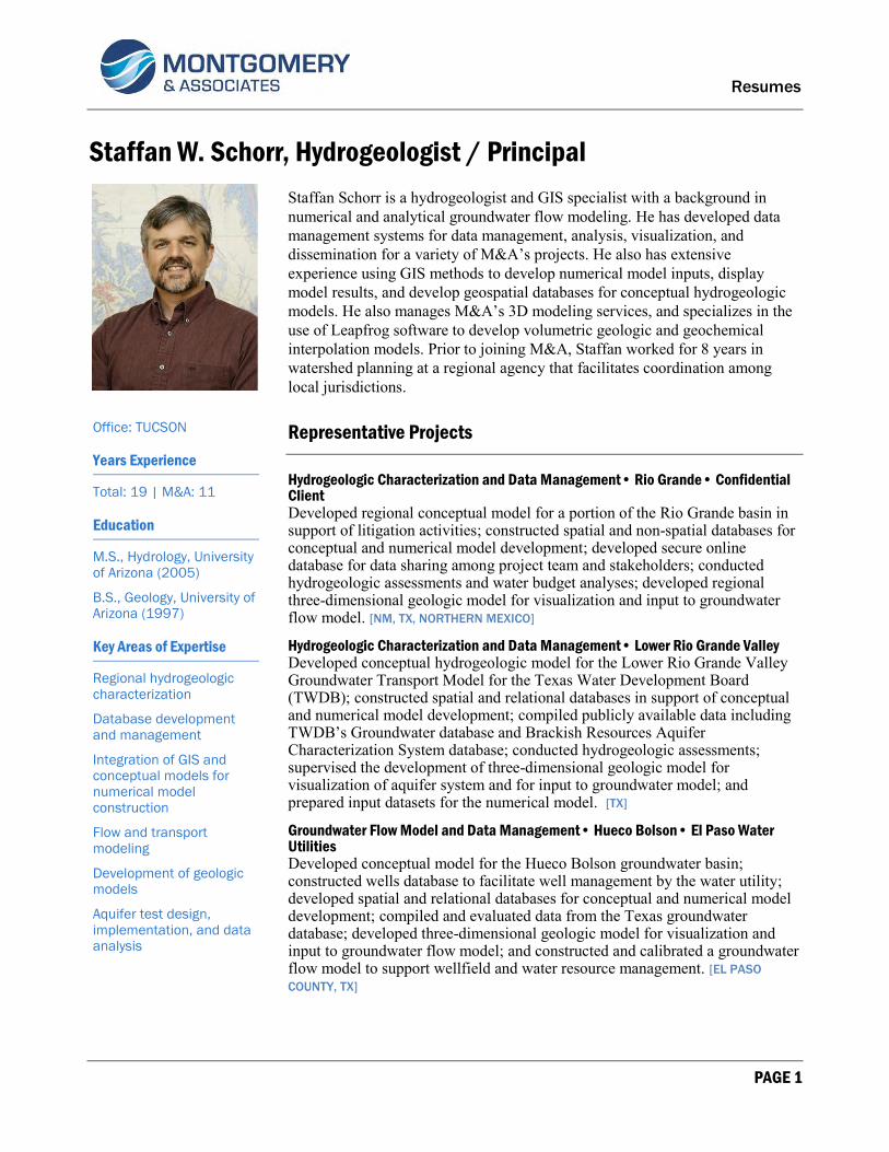
Resumes
PAGE 1
Staffan W. Schorr, Hydrogeologist / Principal
Staffan Schorr is a hydrogeologist and GIS specialist with a background in numerical and analytical groundwater flow modeling. He has developed data management systems for data management, analysis, visualization, and dissemination for a variety of M&A’s projects. He also has extensive experience using GIS methods to develop numerical model inputs, display model results, and develop geospatial databases for conceptual hydrogeologic models. He also manages M&A’s 3D modeling services, and specializes in the use of Leapfrog software to develop volumetric geologic and geochemical interpolation models. Prior to joining M&A, Staffan worked for 8 years in watershed planning at a regional agency that facilitates coordination among local jurisdictions.
Representative Projects
Hydrogeologic Characterization and Data Management• Rio Grande• Confidential Client Developed regional conceptual model for a portion of the Rio Grande basin in support of litigation activities; constructed spatial and non-spatial databases for conceptual and numerical model development; developed secure online database for data sharing among project team and stakeholders; conducted hydrogeologic assessments and water budget analyses; developed regional three-dimensional geologic model for visualization and input to groundwater flow model. [NM, TX, NORTHERN MEXICO]
Hydrogeologic Characterization and Data Management• Lower Rio Grande Valley Developed conceptual hydrogeologic model for the Lower Rio Grande Valley Groundwater Transport Model for the Texas Water Development Board (TWDB); constructed spatial and relational databases in support of conceptual and numerical model development; compiled publicly available data including TWDB’s Groundwater database and Brackish Resources Aquifer Characterization System database; conducted hydrogeologic assessments; supervised the development of three-dimensional geologic model for visualization of aquifer system and for input to groundwater model; and prepared input datasets for the numerical model. [TX]
Groundwater Flow Model and Data Management• Hueco Bolson• El Paso Water Utilities Developed conceptual model for the Hueco Bolson groundwater basin; constructed wells database to facilitate well management by the water utility; developed spatial and relational databases for conceptual and numerical model development; compiled and evaluated data from the Texas groundwater database; developed three-dimensional geologic model for visualization and input to groundwater flow model; and constructed and calibrated a groundwater flow model to support wellfield and water resource management. [EL PASO
COUNTY, TX]
Office: TUCSON
Years Experience
Total: 19 | M&A: 11
Education
M.S., Hydrology, University of Arizona (2005)
B.S., Geology, University of Arizona (1997)
Key Areas of Expertise
Regional hydrogeologic characterization
Database development and management
Integration of GIS and conceptual models for numerical model construction
Flow and transport modeling
Development of geologic models
Aquifer test design, implementation, and data analysis

Resumes
PAGE 2
Dewatering & Impacts Modeling • Collahuasi Mine / Rosario Pit • Compañía Minera Doña Inés de Collahuasi SMC Developed data management systems in support of development of the conceptual model, the numerical model, and pre- and post-processing of model results. Designed and constructed a groundwater flow model to support dewatering operations and predict the environmental impacts associated with a large, open-pit mine in a complex mountain aquifer system [NORTHERN CHILE]
GIS and Database Development & Application• Various Sites • Various Clients Developed GIS inventories for wells, infrastructure, water use, land use, and other related features; developed geodatabases and relational databases for project data management and sharing; prepared cartographically correct maps and figures; and used ArcGIS applications to construct and evaluate three-dimensional geologic models for many hydrogeologic investigations and modeling projects. [U.S., MEXICO, CHILE, PERU, ARGENTINA, BOLIVIA]
Publications & Presentations
Development of conceptual plan for direct recovery of Central Arizona Project water stored at Tonopah Desert Recharge Project, Maricopa County, Arizona Meyer, J.J., Cross, M.M., Schorr, S.W., Shipman, T.D., and Fuerst, D., 2009, National Groundwater Association 2009 Groundwater Summit, Tucson, AZ, April 19–23
Hydrogeologic conceptual model for the Collahuasi Mine area, Chile Thomasson, M.J., Schorr, S.W., Davis, L.A., Rosko, M.J., Acosta, O.J., 2010, Water in Mining, Second International Congress on Water Management in the Mining Industry, Santiago, Chile, June 9–11
Modeling Codes & Software
MS Access MODFLOW HEC-RAS Leapfrog Hydro Leapfrog Geo Groundwater Vistas ArcView ArcGIS Spatial Analyst 3D Analyst
Additional Training
2015: Introduction to MineSight
2013: MODFLOW-USG workshop
2012: Fundamental and Advanced Techniques of Leapfrog Hydro
2010: Advanced Techniques for Aquifer Test Analysis Featuring AQTESOLV
2010: Fundamentals of Leapfrog Hydro
2009: HEC-RAS 3-Day Short Course
2008: Advanced Techniques for Aquifer Test Analysis Featuring AQTESOLV
2008: Calibration, Uncertainty Analysis, and Optimization — A Seminar
on Groundwater Vistas