Proposal for a set of Fisheries Management Measures in Belgian … · 2018-01-17 · environmental...
97
Draft for submission to the European Commission Background Document June 2016 P ROPOSAL FOR A SET OF F ISHERIES M ANAGEMENT M EASURES IN B ELGIAN WATERS Description of a set of fisheries measures proposed in order to achieve a 'good environmental status' of the marine waters in the Belgian part of the North Sea. This Background Document is the Belgian proposal for a set of fisheries management measures that are necessary for the purpose of complying with the obligations under Directive 2008/56/EC. This document has been discussed with Member States with a direct management interest affected by the Measures. It will be used to provide the EC sufficient information on the proposed measures. This basic document serves also for Belgium and the involved Member States as a starting point to find an agreement on the measures. In other words, the regional process as described in the Common Fisheries Policy has been initiated with the development of this Background Document.
Transcript of Proposal for a set of Fisheries Management Measures in Belgian … · 2018-01-17 · environmental...

1
Draft for submission to the European Commission
Background Document
June 2016
PROPOSAL FOR A SET OF
FISHERIES MANAGEMENT
MEASURES IN BELGIAN
WATERS Description of a set of fisheries measures proposed in order to achieve a 'good
environmental status' of the marine waters in the Belgian part of the North Sea.
This Background Document is the Belgian proposal for a set of fisheries
management measures that are necessary for the purpose of complying with the
obligations under Directive 2008/56/EC. This document has been discussed with
Member States with a direct management interest affected by the Measures. It will be
used to provide the EC sufficient information on the proposed measures. This basic
document serves also for Belgium and the involved Member States as a starting point
to find an agreement on the measures. In other words, the regional process as
described in the Common Fisheries Policy has been initiated with the development of
this Background Document.

2
Proposal for a set of Fisheries Management
Measures in Belgian waters
Description of a set of fisheries measures proposed in order to achieve a 'good
environmental status' of the marine waters in the Belgian part of the North Sea.
1 INTRODUCTION ......................................................................................................................................... 3
1.1 GENERAL REMARKS ................................................................................................................................. 3
1.2 AIM OF THIS PROPOSAL ............................................................................................................................ 3
2 PROCESS ...................................................................................................................................................... 4
2.1 LEGAL FRAMEWORK ................................................................................................................................ 4
2.2 NATIONAL COORDINATION AND CONSULTATION ..................................................................................... 7
2.3 PEER REVIEW OF THE PROPOSAL .............................................................................................................. 7
2.4 INTERNATIONAL CONSULTATION – REGIONALIZATION ............................................................................. 7
2.5 PROCESS LEADING TO THE ADOPTION OF MEASURES ................................................................................ 8
3 PRINCIPLES AND RATIONALE ............................................................................................................ 11
3.1 TRANSPARENCY ..................................................................................................................................... 11
3.2 PROPORTIONALITY ................................................................................................................................. 11
3.3 PRECAUTIONARY APPROACH .................................................................................................................. 12
3.4 CONSISTENCY AND CONTINUITY ............................................................................................................ 12
3.5 HABITATS AND BIOLOGICAL VALUE ....................................................................................................... 12
3.6 NO NO-TAKE ZONES ............................................................................................................................... 16
3.7 ALL PROPOSED MEASURES CONTRIBUTE TO GES ................................................................................... 16
4 MEASURES PROPOSED .......................................................................................................................... 16
4.1 DESCRIPTION OF FISHERIES MANAGEMENT MEASURES PROPOSED.......................................................... 16
4.2 FLEET ACTIVITY ..................................................................................................................................... 24
4.3 CONTROL, ENFORCEMENT AND MONITORING ......................................................................................... 27
5 REFERENCES ............................................................................................................................................ 28
SUMMARY ......................................................................................................................................................... 31
RESUME ............................................................................................................................................................. 33
SAMENVATTING .............................................................................................................................................. 35
ANNEX 1 – MARINE SPATIAL PLAN ........................................................................................................... 37
ANNEX 2 – LIST OF “POINTS TO DISCUSS” .............................................................................................. 65
ANNEX 3 HABITATS DESCRIPTION ........................................................................................................... 66
ANNEX 4 – BIOLOGICAL VALUATION: METHODOLOGY ................................................................... 73
ANNEX 5 – METHODOLOGY SAND BANK SCORING AND POTENTIAL SCI DELINEATION ...... 74
ANNEX 6 – BELGIAN AND DUTCH FLEET ACTIVITY IN BPNS ........................................................... 77
ANNEX 7 – FRENCH FLEET ACTIVITY IN BPNS ..................................................................................... 82
ANNEX 8 –BRITISH FLEET ACTIVITY IN BPNS ...................................................................................... 89
ANNEX 9 – DANISH FLEET ACTIVITY IN BPNS....................................................................................... 92

3
1 INTRODUCTION
1.1 General remarks The Belgian part of the North Sea (BPNS) is surrounded by sea areas under the jurisdiction of the Netherlands,
United Kingdom and France and is one of the most intensively used seas in the world. Shipping, tourism,
fisheries, sand exploitation, windmills etc. make use of what the sea has to offer. Several activities may conflict
with one another and may also have an impact on the environment.
Belgium has a very small maritime area under national jurisdiction, corresponding to about 0.5% of the North
Sea and representing 3454 km² (Fig. 1). In order to balance all activities in such a small maritime zone, the
Belgian authorities have drawn up a marine spatial plan (MSP) for the Belgian part of the North Sea. This plan
includes all activities, including fisheries. The zones that are being proposed for fisheries measures are located in
the maritime area under Belgian jurisdiction and are hence very small in an international perspective.
Fig 1. Belgian part of the North Sea with indication of facts and figures
As an initiating Member State, it is the intention of the Belgian government to take measures in its territorial
waters and in the Exclusive Economic Zone, with respect to fishing activities exercised by all vessels including
fishing vessels carrying the flag of other Member States. In order to apply these measures to international fleets,
Belgium is bringing its proposal to a European/regional level through the application of Art. 11 of EU
Regulation 1380/2013. The application of this procedure is done following the framework of the Scheveningen
group.
1.2 Aim of this proposal As a first aim, this document serves as a background document providing the relevant information on the
measures required, including their rationale, scientific evidence in support and details on their practical
implementation and enforcement. It is important to note that this document has been discussed within the Ad
Hoc Group and on a bilateral basis with all individual Member States with management interest. Therefore, the
present proposal includes the supplementary scientific documentation and other relevant information requested
by the Member States with a direct management interest.
The second aim of the present background document is to present a scientifically sound document to serve as a
basis for discussions on a possible Joint Agreement with the Member States having a management interest in the
fishery to be affected by the proposed measures.

4
2 PROCESS
2.1 Legal Framework
2.1.1 CFP
The Common Fisheries Policy (CFP), i.e. Regulation 1380/2013, states in Art. 11(1)1 that Member States are
empowered to adopt conservation measures to comply with obligations under the Natura 2000 Directives and the
Marine Strategy Framework Directive. According to Art. 11(3)2 of the CFP, Belgium shall provide the
Commission and the other Member States having a direct management interest with relevant information on the
measures required, including their rationale, scientific evidence in their support and details on their practical
implementation and enforcement.
Following the same article, Belgium and the other Member States having a direct management interest intend to
submit a joint recommendation within six months from the provision of sufficient information3. According to the
procedure, the Commission can adopt the measures, taking into account any available scientific advice, not
before the expiry of the six months period and within three months from the Joint Recommendation. According
to Art. 18 of the CFP, this Joint Recommendation for achieving the objectives of the relevant Union conservation
measures, has to be submitted by the Member States having a direct management interest affected by the
measures.
Member States having a direct management interest affected by those measures may, within a deadline to be
stipulated in the relevant conservation measure and/or multiannual plan, agree to submit joint recommendations
for achieving the objectives of the relevant Union conservation measures
Belgium has identified the Member States having fisheries rights and a potential direct management interest that
is affected by the proposed fisheries measures as being the following: The Netherlands, France, United
Kingdom, Germany and Denmark. Since these Member States have been identified, Belgium has taken steps to
discuss its proposal on the fisheries measures, which will apply to all fishing vessels carrying out fishing
activities in the concerned sites.
2.1.2 Scheveningen Group
The application of the CFP Art. 11 procedure in order to achieve a “joint recommendation” for the Belgian
fisheries measures proposal, is done following the framework of the Scheveningen group, in accordance with the
Terms of Reference for the Scheveningen North Sea FISH- ENVI technical expert group adopted on 23
September 2014.
The first informal international meeting took place on April 29 2015 followed by the activation of an Ad Hoc
Group by Belgium the 10th
of July 2015, to discuss the proposal with all Member States having a direct
management interest in the fishery to be affected by the proposed measures. Besides the mentioned Member
1 Member States are empowered to adopt conservation measures not affecting fishing vessels of other Member
States that are applicable to waters under their sovereignty or jurisdiction and that are necessary for the purpose
of complying with their obligations under Article 13(4) of Directive 2008/56/EC, Article 4 of Directive
2009/147/EC or Article 6 of Directive 92/43/EEC, provided that those measures are compatible with the
objectives set out in Article 2 of this Regulation, meet the objectives of the relevant Union legislation that they
intend to implement, and are at least as stringent as measures under Union law. 2 The initiating Member State shall provide the Commission and the other Member States having a direct
management interest with relevant information on the measures required, including their rationale, scientific
evidence in support and details on their practical implementation and enforcement. The initiating Member State
and the other Member States having a direct management interest may submit a joint recommendation, as
referred to in Article 18(1), within six months from the provision of sufficient information. The Commission
shall adopt the measures, taking into account any available scientific advice, within three months from receipt of
a complete request. If not all Member States succeed in agreeing on a joint recommendation to be submitted to
the Commission in accordance with the first subparagraph within the deadline set therein, or if the joint
recommendation is deemed not to be compatible with the requirements referred to in paragraph 1, the
Commission may submit a proposal in accordance with the Treaty. 3 i.e. formal notification to the European Commission through the submission of this Background Document

5
States, representatives of the European Commission (DG ENV and DG MARE) participated as an observer in
the Ad-Hoc Group meetings and were being informed bilaterally during the progress. Belgium is holding the
chair of the Ad Hoc Group and provides the secretariat for the Group. The proposal has been discussed within
this Ad Hoc group during a physical pre-consultation meeting on September 14th
2015, during email discussions,
during bilateral meetings and during a physical Ad Hoc Group meeting on July 5th
2016. The High Level Group
and North Sea Member states were informed on the progress on June 13th
2016.
The Ad Hoc Group is the forum that guides and contributes throughout the whole CFP Art 11(3) process to come
to a Joint Recommendation. As a first step, all relevant information has been shared with the Member States with
management interest and the background document is fully developed (i.e. to serve as provision of information
to the EC).
2.1.3 MSFD
Following the obligation under the Marine Strategy Framework Directive (MSFD), Directive 2008/56/EC, the
Good Environmental Status (GES) and the environmental targets for the Belgian marine waters were defined on
the basis of the eleven qualitative descriptors listed in Annex I of the MSFD. Specifically in relation to descriptor
6 “sea-floor integrity”, MSFD defines the GES as follows:
“Seafloor integrity is at a level that ensures that the structure and functions of the ecosystems are safeguarded
and benthic ecosystems, in particular, are not adversely affected.” Belgium further specified that the GES for
seafloor integrity will only be reached if, amongst other things, “physical disturbance of the seafloor is
minimised to a sustainable level, taking account of the relative sensitivity of habitat types”. 4
Studies show that seafloor integrity is closely linked to human activities, such as marine aggregate extraction,
large scale developments and bottom trawling. These human activities have therefore been taken into
consideration when developing environmental targets in order to reach GES for seafloor integrity. Specifically
in relation to the disturbance of the benthic habitats by fisheries, Belgium defined the following targets:
“Positive trend in sea floor surface area permanently devoid of bottom-contacting fishing gear
disturbance within each of the benthic habitat types (= pressure indicator), as to allow a natural
development of the benthic fauna and flora and as to minimise artificial fragmentation of the seafloor
(= desired state).”
“Positive trend in sea floor surface area impacted only by alternative, environment-friendly fishing
gear which pursues a substantial reduction of bottom disturbance within each of the benthic habitat
types (= pressure indicator), as to allow for an improved benthic habitat quality and as to minimise
artificial fragmentation of the seafloor (= desired state).”
Belgium intends to achieve progress towards these targets “through spatially-explicit management actions
related to the sectors concerned (i.e. delineation of areas devoid of bottom disturbance and areas open only for
environmental-friendly bottom-contacting gear)”.5
2.1.4 MSP
Belgium designed its fisheries measures proposal within the framework of Marine Spatial Planning (MSP)6, see
overview map in Fig. 2. This process started in 2012, followed by public consultations and international
consultation with neighboring countries in 2013 to end up in a legally binding MSP in 2014.
4 Report on the determination of “GES” in Belgian Marine Waters: Belgische Staat, 2012. Omschrijving van
Goede Milieutoestand en vaststelling van Milieudoelen voor de Belgische mariene wateren. Kaderrichtlijn
Mariene Strategie – Art 9 & 10. BMM, Federale Overheidsdienst Volksgezondheid, Veiligheid van de
Voedselketen en Leefmilieu, Brussel, België,., p. 8. 5Report on the determination of “GES” in Belgian Marine Waters: Belgische Staat, 2012. Omschrijving van
Goede Milieutoestand en vaststelling van Milieudoelen voor de Belgische mariene wateren. Kaderrichtlijn
Mariene Strategie – Art 9 & 10. BMM, Federale Overheidsdienst Volksgezondheid, Veiligheid van de
Voedselketen en Leefmilieu, Brussel, België, p. 10-11

6
Fig 2. Overview Map of Belgian Marine Spatial Plan (MSP)
The legal basis for MSP was established in 2012 by amending the 1999 Marine Environmental Protection Act
(MEPA). The formal procedure to come to a MSP was published in November 2012 (Royal Decree of
13/11/2012 concerning the installation of an Advisory Council and the procedure to adopt a Marine Spatial Plan
in Belgian waters). This procedure formally insured the integration between the federal government departments
and regional authorities. Furthermore, advisory bodies, provinces, municipalities, Flemish authorities and
neighboring countries were able to comment on the 2014 draft-MSP after which the plan was adopted by the
Government and was published as a Royal Decree the 20th
of March 2014 (cf. Summary of full MSP in Annex
1).
In this Marine Spatial Plan, several environmental measures have been put in place. This concerns a wide range
of measures in Natura2000 areas and outside these areas (Fig. 3). Within the framework of reaching the Good
Environmental Status, several measures have been taken, including for sand extraction activities, recreational
fisheries and commercial fisheries (cf. Annex 1). Hence, the commercial fisheries measures that are being
proposed, aim to contribute to the good environmental status according the European Marine Strategy
Framework Directive (see MSP figure on fisheries Fig. 4). The draft-proposal was developed by the Belgian
Marine Environment Service of the Directorate-General for the Environment of the Federal Public Service
Health, Food Chain Safety and Environment and by the Fisheries Policy and Animal Production quality Division
of the Flemish Agriculture and Fisheries Department; this proposal was developed as part of the MSP in which
fisheries and other activities in the Belgian MSP-process were balanced to each other.
Fig 3. Illustration of Environmental measures in BPNS
6 For a summary of the MSP, a brochure has been made explaining all spatial decisions for the Belgian part of
the North Sea:
http://www.health.belgium.be/sites/default/files/uploads/fields/fpshealth_theme_file/19094284/Something%20is
%20moving%20at%20sea%20....pdf

7
Fig 4. Illustration of Fisheries and Aquaculture in BPNS
In other words, the MSP-process was the process during which the Belgian proposal for fisheries measures was
developed. This proposal has been published in the Royal Decree of 20/03/2014 and explicitly states that the
proposal has to be adopted by the European Commission and hence based on a Joint Recommendation with the
Member States with fisheries management interests.
2.2 National coordination and consultation Several consultations were held as the proposed fisheries measures have been included in the Belgian MSP. The
draft MSP and the fisheries measures contained therein were subjected to a wide survey of both the neighbouring
countries and various Belgian institutions, the users of the BPNS and the general public.
The public consultation was organised based on the following legal sources: (i) the Royal Decree of 13
November 2012 establishing an advisory commission and the procedure for the adoption of a marine spatial plan
in the Belgian sea areas and (ii) the Law of 13 February 2006 on the assessment of the environmental impacts of
certain plans and programmes and public participation in the development of the plans and programmes relating
to the environment.
On this legal basis, the draft MSP was subjected to several consultations. Firstly, for 90 days (between 2 July
2013 and 29 September 2013) a public consultation was set up, during which the draft MSP was presented to the
general public.7 This resulted in 140 remarks and proposals from private persons, authorities, federations and
companies. Secondly, there was a specific consultation of 5 Belgian institutions: the SEA Advisory Committee,
the Federal Council for Sustainable Development, and the Flemish, Walloon and Brussels Regional
Governments.
2.3 Peer review of the proposal The measures that are proposed in the present proposal have been sent to several marine institutes as a part of all
the measures included in the MSP. Research institutes that provided comments on the MSP measures include
Ghent University, Royal Belgian Institute of Natural Sciences, Flanders Marine Institute and Institute for
Agricultural and Fisheries Research.
2.4 International consultation – regionalization
2.4.1 MSP Process
7 The advice, reactions and comments and the respective answers are available on the website of the FPS Health,
Food Chain Safety and Environment, DG Environment (www.consult-leefmilieu.be / www.consult-
environnement.be).

8
International consultations were performed during the MSP-process as the proposed fisheries measures have
been included in the Belgian MSP: the Netherlands, France and the United Kingdom were asked for their advice
on the draft MSP by letter.8
In addition, specifically in relation to the fisheries measures, informal consultations with The Netherlands and
France took place.
The draft MSP was adapted taking into account the results of the consultations. For instance, where the fisheries
measures are concerned, exceptions were included with respect to the prohibition for recreational fishermen to
fish in the Flemish Banks using seabed-disturbing fishing techniques.
2.4.2 CFP Process
According to Art. 18 of CFP, Member States having a direct management interest affected by the measures have
to cooperate with one another to formulate joint recommendations (which is reinforced through the
Scheveningen Group, cf. supra).
During the formulation of the present background document, a range of informal meetings have been held, both
in plenary and bilaterally.
- 29th
of April 2015: Plenary informal international meeting in Brussels with The Netherlands, France,
United Kingdom, Germany and Denmark (plus EC representatives and Belgian scientists as observers);
- 14th
September 2015: Plenary formal preconsultation meeting of Scheveningen group in Brussels with
The Netherlands, France, United Kingdom, Germany and Denmark (plus EC representatives and
Belgian scientists as observers);
- 10th
of May 2016: bilateral meeting with France in Paris;
- 16th
of May 2016: bilateral meeting with United Kingdom (teleconference);
- 17th
of May 2016: bilateral meeting with Germany (teleconference);
- 19th
of May 2016: bilateral meeting with Denmark (teleconference);
- 6th
of June 2016: feedback meeting with European Commission (DG ENV) in Brussels;
- 7th
of June 2016: bilateral meeting with United Kingdom (teleconference);
- 21st of June 2016: feedback meeting with European Commission (DG MARE) in Brussels;
- 22nd
of June 2016: bilateral meeting with the Netherlands in The Hague;
- 5th
of July 2016: Ad Hoc Group Meeting to discuss final version of background document, in Brussels
with The Netherlands, France, United Kingdom, Germany and Denmark (plus EC representatives,
NSAC representatives and Belgian scientists as observers).
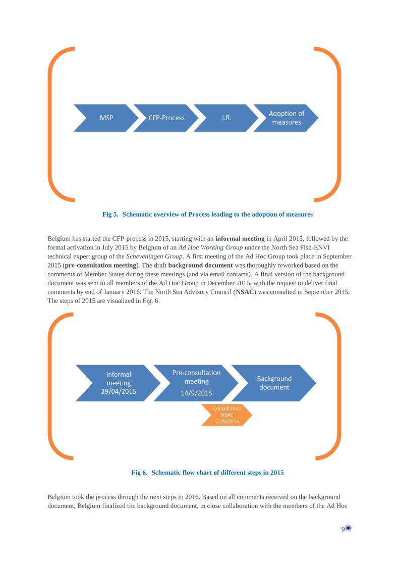
2.5 Process leading to the adoption of measures The process leading to the adoption of fisheries measures is visualized in Fig. 5. The Belgian proposal has been
designed in the period 2012-2014 (within MSP-process). This proposal is now brought to a European/regional
level through the application of Art. 11 of the Common Fisheries Policy (CFP-Process). This process must lead
to a Joint Recommendation (J.R.) of all Member States having a direct management interest in the fishery to be
affected by the proposed measures. This J.R. can lead to the adoption of the measures through a delegated act.
8 MSP, Annex 1, p. 11-13
9
Fig 5. Schematic overview of Process leading to the adoption of measures
Belgium has started the CFP-process in 2015, starting with an informal meeting in April 2015, followed by the
formal activation in July 2015 by Belgium of an Ad Hoc Working Group under the North Sea Fish-ENVI
technical expert group of the Scheveningen Group. A first meeting of the Ad Hoc Group took place in September
2015 (pre-consultation meeting). The draft background document was thoroughly reworked based on the
comments of Member States during these meetings (and via email contacts). A final version of the background
document was sent to all members of the Ad Hoc Group in December 2015, with the request to deliver final
comments by end of January 2016. The North Sea Advisory Council (NSAC) was consulted in September 2015.
The steps of 2015 are visualized in Fig. 6.
Fig 6. Schematic flow chart of different steps in 2015
Belgium took the process through the next steps in 2016. Based on all comments received on the background
document, Belgium finalized the background document, in close collaboration with the members of the Ad Hoc
MSP CFP-Process J.R.Adoption of
measures
Informal meeting
29/04/2015
Pre-consultation meeting
14/9/2015
Background document
Consultation NSAC
22/9/2015

10
Group. As far as possible, Belgium integrated all comments to come to a scientifically sound background
document. In parallel, some ‘points to discuss’ have been listed in a separate document (Annex 2). The
background document serves as the background information on the fisheries measures to provide to the Member
States with management interest and to the European Commission and therefore contains the relevant
information on the measures, their rationale, scientific evidence and details on the implementation and
enforcement. The process during 2015 (Fig. 6) and the finalizing of the background document by mid-2016
based on the last comments have led to the inclusion of supplementary scientific documentation and other
relevant information on the proposed measures. The submission of the background document to the EC
(notification EC) will be the formal provision of sufficient information on the measures proposed by Belgium
and will be the start of a 6 months period to find a Joint Recommendation with the Member States with
management interest. During this period several multilateral meetings will be organized by Belgium. The
negotiation to come to a J.R. will be based on the list with identified discussion points and will be done in the
Ad Hoc Group. Once agreement has been reached, final approval of J.R. will take place in the “High Level
Group”. The formal submission of the J.R. to the European Commission will be prepared by Belgium. Different
steps will be taken to come to the final Joint Recommendation in the beginning of 2017. The steps to be taken
are visualized in Fig. 7.
Fig 7. Overview chart indicating different steps of the process
After having reached a Joint Recommendation and the adoption of measures through a delegated act, the Belgian
Royal Decree of 20 March 2014 (MSP Decree) has to be evaluated for potential changes to the measures.
Belgium will adapt the Decree and refer to the Delegated Act. The whole process, including this feedback loop is
visualized in Fig 8.

11
Fig 8. Full process with feedback loop to Belgian MSP
3 PRINCIPLES AND RATIONALE
3.1 Transparency Transparency is a leading principle during the proposal of fisheries management measures. During the entire
process (MSP and CFP, cf. supra) stakeholder involvement, regional coordination, non-discrimination and
scientific advice are the basic principles. The ecological data on which the proposal is based as well as the
fishing fleet information is made available through this background document. The different steps of the process
are fully described in order to further increase transparency.
3.2 Proportionality The natural environment on the seabed is influenced by different activities on and in the North sea. Given that
the seabed is of great importance for different ecosystems in the North sea, every human activity which affects
the seabed may have great and sometimes permanent consequences for the marine environment. Belgium chose
to introduce spatial measures which are (i) limited in surface and (ii) which encourage the development of
techniques that are less harmful to the seabed. In this manner, commercial fisheries will be able to continue their
activities with no loss of fishing grounds, while at the same time, the most sensitive areas to seabed disturbance
will be given the chance to recover.
The proposed measures balance the sustainable exploitation of resources and the need to reach the Good
Environmental Status. Therefore, there is no intent to close any areas off for fisheries. Only small areas have
been selected to protect very sensitive habitats resulting in five relatively small zones where access for fisheries
is conditional.
The surface area where bottom impacting activities will be excluded is very limited: it represents merely 5 % of
the total surface area of the BPNS. In reality the surface area where bottom impacting fishing activities will be
prohibited will be even smaller for a considerable period of time since the prohibition will only be immediate in
zone 3. In zone 1, the prohibition will only apply to new vessels.
Joint Recommendation
(J.R.)
Preparatory meetings
MSPBackground document
Notification EC
Multilateral meetings

12
As for the coastal measure, section 4.2 above describes the biological importance of the coastal zone until 6 NM.
The extension of the existing measure from 3 NM to 4.5 NM would hence result in 50% improvement of the
protection of the coastal zone, while fishing vessels (above 70 GT) would only “lose” 6% fishing grounds in the
BPNS.
The small areas also relate to a low displacement of the fishing effort. Given the very small zones for fisheries
measures, any possible higher pressure in adjacent areas will in any case be diluted within the remaining parts of
the Belgian part of the North Sea.
3.3 Precautionary approach As a leading principle, scientific evidence is the basis to shape the fisheries measures. However, the lack of
extensive scientific knowledge on specific impacts can never be a reason not to take action if there is a plausible
risk to deteriorate the seafloor integrity in areas with a high biological value.
3.4 Consistency and continuity The fisheries measures need to be consistent and rely on the general rationale; moreover, continuity with existing
measures is an important leading principle, and (spatial) fine tuning according to information on the biological
value ensures consistent use of the best available science.
3.5 Habitats and biological value
3.5.1 Habitats of the Belgian part of the North Sea
The seabed is characterised by the presence of sandbanks, which are located parallel to the coast, sloping
upward. The sandbanks stretch 15 to 30 km and can reach heights of approximately 20 metres measured from the
bottom of the sea.
The substrate of the BPNS mainly consists of sand and also clay, silt and gravel. Silt deposits are found in the
coastal area, approximately between Ostend and the Dutch border. The sandbanks coarsen from fine to coarse
sand in a seaward direction.
The BPNS is characterised by the presence of a complex system of sandbanks, including biogenic and geogenic
reefs (cf. Annex 3 for full description of habitats). Studies show that these habitats are sensitive to seabed
disturbance (see for example Degraer et al. (2009)).
3.5.2 Most valuable areas of the Belgian part of the North Sea
3.5.2.1 Biological Valuation Map
In 2007, the Belgian Federal Science Policy Department developed a biological valuation map (the “BWZee
project”9) showing the intrinsic biological value of the different subzones in the BPNS. This biological valuation
map (BVM) compiles as much biological information as is available (cf Annex 4 for description of
methodology). The map is of important value to be able to make objective, scientifically-sound and sustainable
policy decisions. This methodology increases transparency and ensures that Best Available Science is used.
Fig. 9 shows a general appreciation of the biological value of different areas within the BPNS and “visualizes
the high biological value of the coastal zone and the lower value of the offshore area.”9
9 http://www.vliz.be/projects/bwzee/index.php; Derous S., Verfaillie E., Van Lancker V., Courtens W., Stienen
E.W.M., Hostens K., Moulaert I., Hillewaert H., Mees J., Deneudt K., Deckers P., Cuvelier D., Vincx M.,
Degraer S., 2007, A biological valuation map for the Belgian part of the North Sea: BWZee, Final report,
Research in the framework of the BELSPO programme “Gobal chance, ecosystems ans biodiversity” – SPSD II,
March 2007, pp. 99 (+ Annexes).

13
Fig 9. The marine biological valuation map of the BPNS which integrates the seabird,
macrobenthos, epibenthos and demersal fish valuation.
3.5.2.2 Sand bank scoring
Within the process of defining potential SCIs (as obligation within the Habitats Directive), all sand banks have
been scored relatively to one another, making use of the above-described biological valuation map combined
with biodiversity indicators (cf. Annex 5 for methodology and conclusion for potential SCI area). This report of
Degraer et al. (2009)10
is an important scientific basis for the proposed measures.
3.5.2.3 Gravel beds offshore and L. conchilega aggregations near shore
The BPNS contains two habitat vulnerable habitats: geogenic gravel beds and biogenic Lanice conchilega
aggregates (Degraer et al. 2009; see Annex for full description).
Gravel beds are found in the Hinderbanken area: historical data from the Gilson collection of the Royal Belgian
Institute of Natural Sciences indicates that at the end of the 19th century, gravel beds were the most dominant
type of habitat in the channel between the Oosthinder and Westhinder and that they contained a very high
biodiversity (Van Beneden 1883, Houziaux et al. 2008). Moreover, two small zones near the Hinderbanken that
are characterised by a remarkably well-developed gravel-bed fauna have been found. These locations are
considered as refuge-sites situated in a natural shield against seabed-disturbing activities (such as fishing
disturbance). These refuges imply an ecological potential of the Belgian gravel banks (i.e. if the pressure were to
be reduced). The value of these sites lies not in the locations itself but in the insight that recovery of the habitat is
possible (as the specific species are still around).
10
An English version of the report was send around to the Ad Hoc Working Group members

14
Lanice aggregations on the other hand are hotspots of benthic biodiversity in the BPNS and are located in the
coastal area. Thanks to their structuring effect (changing the micro-topography of the seabed), macrobenthic
biodiversity is four to six times higher than the surrounding sediment, while the macrobenthic density exceeds it
by 34 times. Furthermore, the aggregates are an important foraging and shelter area for, among others, juvenile
flat fish. Especially the western section of the BPNS, has potential for the expansion of the L. conchilega
aggregations (cf. Annex 3 for full habitat description).
This potential to expand depends on a successful larval recruitment to the benthos, which is estimated to be
vulnerable to bottom trawling. Moreover, only a fraction of the suitable habitat contains L. conchilega
aggreagations. An increase in coverage is expected if no bottom impacting fishing gear was applied.
These two vulnerable habitats were taking into account in the designation op SCIs (cf. Annex 5).
3.5.2.4 The coastal zone
As mentioned above, the biological value of the coastal zone has been established long before the development
of the biological valuation map. In 2002, the Flemish Institute for the Sea (“Vlaams Instituut voor de Zee” –
VLIZ) prepared a guidance note for policy makers about the ecological value of the Belgian coastal zone11
. In
particular, the note examined whether it makes sense to distinguish between 3, 6 and 12 NM from the coast
based on the ecological value of BPNS.
In relation to macrobenthos, the note concluded that “no substantial difference in ‘ecological
importance’(measured in terms of density, species richness, the amounts of shellfish and the relative presence of
the trophically most important communities) can be demonstrated between 0-3 and 3-6 NM. These two coastal
areas do score significantly better than the more offshore areas”, i.e. areas beyond 6 NM.
The study also mentioned that the density of epibenthos and hyperbenthos is also significantly higher in coastal
areas (more or less corresponding to the 6NM mark) than in the areas more offshore. These higher densities in
the coastal area indicate that the coastal area serves the function of “nursery grounds” for fish and shrimp.12
The importance of the coastal zone was also confirmed by the BVM of 2007 and by the report of Degraer et al.
(2009) (cf. supra). These studies confirm that the importance of the coastal zone is not limited to the western part
of the coastal zone. In the protection scenario 2 (Fig. 10), which is the scenario coinciding with the 10%
preferential biotope (cf. Annex 5), of the report of Degraer et al. (2009) three coastal sandbanks were selected as
important: the large sandbank at the eastern part of the BPNS, Wenduine Bank (cf. Annex 5).
11
Seys, J.; Cattrijsse, A.; Mees, J. (2002). Hoe ver uit de kust liggen België's ecologisch meest waardevolle
mariene habitats? Een analyse van de meest actuele beschikbare wetenschappelijke informatie. Adviesnota
VLIZ/AN/2002/1. Vlaams Instituut voor de Zee (VLIZ): Oostende, Belgium. 10 pp. 12
Seys, J. et al (2002), p.7.

15
Fig 10. Degraer et al. (2009): Nine sandbanks were selected as potential Habitat Directive area. The
following three coastal sandbanks were selected: Trapegeer – Broers Bank – Den Oever,
Nieuwpoort Bank – Stroombank system and Wenduine Bank
The biological value of the coastal zone is further illustrated by the integrated BVM and in particular the
valuation of macro and epibenthos. For macrobenthos, the highly valuable areas seemed to occur mostly in the
coastal area, ranging from very nearshore in the western part to approximately 15 km offshore in the eastern part
(cf. Annex 3 Fig C). Also the epibenthos valuation map shows that the coastal area has the highest biological
value.

16
Fig 11. The marine biological valuation maps of macrobenthos (left) and epibenthos (right) that for
part of the integrated BVM.
The high biological value of the coastal area, largely coincides with vulnerable Abra alba biotope and biogenic
reef potential. The coastal system is known to suffer from significant ecosystem changes, including local
extinctions. Moreover, bottom disturbance is considered to be the primary threat to the biogenic reefs in the
coastal zone (Degraer et al, 2009).
3.6 No no-take zones The measures relate to the targets defined in the Belgian Marine Strategy to reach the Good Environmental
Status. As such, there is no incentive to create closures for fisheries and no no-take zones are being proposed as
fisheries management measure in the Belgian part of the North Sea.
3.7 All proposed measures contribute to GES The five zones are designed to reduce bottom impact to increase the seafloor integrity (and hence to reach the
Good Environmental Status). However, different management measures are designed as such to allow for
comparison and increasing insight.
4 MEASURES PROPOSED
4.1 Description of fisheries management measures proposed
4.1.1 Background and definitions
The proposed fisheries management measures are the result of extensive scientific research performed by the
Institute for Agricultural and Fisheries Research (ILVO) and the scientific service of the Royal Belgian Institute
of Natural Sciences (BMM) on the biologically most valuable areas and well as the sensitivity of these areas to
seabed disturbing activities (mainly fisheries, but also sand and gravel extraction). The main scientific sources
for the delineation of the zones with fisheries measures were (i) the Report on the biological valuation map for

17
the BPNS13
as well as (ii) the study regarding the creation of a list of potential Habitats Directive Areas in the
BPNS14
.
As for seabed disturbing activities in particular, the study relating to the establishment of a list of potential
Habitat directive areas in BPNS (Degraer et al. 2009) stresses that beam trawling causes “spading and changes
in the morphology of the seabed, as well as re-suspension of fine sediments”. The study also mentions that
“different local extinctions of amongst others bivalve molluscs are for example attributed to beam trawling and
other seabed disturbing activities”. Degraer et al. (2009) particularly stresses that both biogenic reefs and gravel
beds “suffer loss of their ecological integrity as a result of seabed disturbing fishing techniques”.15
Therefore, 5 zones harbouring sensitive habitats and high biological valuation have been selected to exclude or
reduce bottom trawling impact to counteract the loss of ecological integrity. Four small sensitive zones have
been delineated to come to exclusion of seabed disturbing, while the protected 3NM zone is proposed to be
spatially extended to be consistent with the high biological valuable coastal area, largely coinciding with
vulnerable Abra alba biotope and biogenic reef potential. Given that (1) seabed disturbance have brought about
significant changes in the coastal ecosystem, including local extinctions, and (2) that bottom disturbing fisheries
are considered to be the primary threat for loss of seafloor integrity16
, the application of the precautionary
approach in the coastal zone is necessary.
Where the fisheries measures are concerned, the following definitions apply with a view to the application of the
Royal Decree (Chapter 1, Article 1):
Seabed-disturbing fishing techniques: active fishing techniques that disturb the seabed habitat by
dragging the fishing equipment along the seabed;
Alternative seabed-disturbing fishing techniques: active seabed-disturbing fishing techniques which
have modifications to reduce the impact on the seabed;
13
Derous, S.; Verfaillie, E.; Van Lancker, V.R.M.; Courtens, W.; Stienen, E.; Hostens, K.; Moulaert, I.;
Hillewaert, H.; Mees, J.; Deneudt, K.; Deckers, P.; Cuvelier, D.; Vincx, M.; Degraer, S. (2007). A marine
biological valuation map for the Belgian part of the North Sea: BWZee, Final Report, Research in the framework
of the BELSPO programme “Global change, ecosystems and biodiversity” – SPDS II, March 2007, pp. 99 (+
Annexes). 14
Degraer, S., U. Braeckman, J. Haelters, K. Hostens, T. Jacques, F. Kerckhof, B. Merckx, M. Rabaut, E.
Stienen, G. Van Hoey, V. Van Lancker & M. Vincx (2009). Studie betreffende het opstellen van een lijst met
potentiële Habitatrichtlijn gebieden in het Belgische deel van de Noordzee. Eindrapport in opdracht van de
Federale Overheidsdienst Volksgezondheid, Veiligheid van de Voedselketen en Leefmilieu, Directoraat-generaal
Leefmilieu. Brussel, België. 93 pp. The original version of this document is in Dutch, but the relevant parts of
this study have been translated into English for the purpose of the fisheries measures proposal. 15
See study Degraer (2009) p. 21 and 27. 16
Also the Report on the Initial Assessment of the Belgian Waters in the framework of Article 8, paragraphs 1a
and 1b of the MSFD describes in detail the negative effects of beam trawling on the seabed: “The physical
effects of beam trawling depend on the size and intensity of the interactions between the fishery activities and the
sediment/habitat. The significant impact on the seabed from beam trawling is due to the high intensity of the
interaction rather than the fished surface (Løkkeborg 2005; Polet et al. 2010). The main effects of beam trawling
include the removal of physical structures as a result of sediment homogenisation, as well as removal of sand
ridges and of accumulations and tubes formed by organisms. Other effects are sediment resuspension with local
loss of or coverage by sediment, the loss of three-dimensional structures, changes in turbidity and visibility
under water and sediment compression (Løkkeborg 2005, Depestele et al. 2012). Beam trawling leaves
detectable traces that remain visible for a number of days (Fonteyne 1999, 2000; Van Lancker et al. 2009).
According to an estimate involving beam trawling activity in an area near the Thornton bank, local damage to
the seabed covered 30-73% of the sandbank area (Van Lancker et al. 2011). In places, the seabed was
completely fragmented as a result of fishery activities. Although this spatial impact data is not yet available for
other areas, similar damage as a result of fishery activities may be assumed. Fishery activities generally are
concentrated in the channels between the sandbanks and their largest impact can be found alongside the slopes
of the banks.”16

18
Traditional seabed-disturbing fishing techniques: active seabed-disturbing fishing techniques which do
not have modifications to reduce the impact on the seabed;
Non-seabed-disturbing fishing techniques: active and passive fishing techniques that do not disturb the
seabed habitat as this type of fishing only fishes in the water column or places static fishing equipment
in the water;
Coastal fisheries: fisheries active with fishing vessels with a gross tonnage of 70 or less;
In the table below (Table 1), an overview is given of the different fishing techniques used by the Belgian fleet at
the time of drafting of the MSP. As the table is part of the informative Annex 1 of the MSP describing the
situation “as is”, the table in question is neither exhaustive nor binding. However, it may be used as guidance for
which techniques can be covered by the above-mentioned definitions of “alternative” and “traditional seabed
disturbing” fishing techniques.
Passive fishing methods Active fishing methods
No seabed disturbance Seabed disturbance (techniques which disturb the sea bottom habitat as the gear touches the sea bottom)
No seabed disturbance
Trammel nets Gill nets Pots Lines Fyke nets
Alternative (with adaptations to reduce the impact on the bottom)
Classic (without adaptations to reduce the impact on the bottom)
Classic
Pulskor shrimp trawler Pulskor flatfish trawler Light on-board nets Alternative beam trawler Sumwing trawler Shrimp trawler trawl shoe with wheels*
Beam trawler Otter trawler shrimp trawler
Pelagic fisheries
Table 1. Overview of fishing techniques – Gear code specification: cf. description of measures (Table 2)

19
4.1.2 Proposed measures description
Fig 12. Map showing the fishing zone limits for 3, 4.5 and 12 nautical miles
(Translation of the legend: Visserij en mariene aquacultuur: Fisheries and mariculture - Limiet visserijzone 3M: 3NM limit of the fisheries
zone - Limiet visserijzone 4,5 NM: 4,5 NM limit of the fisheries zone - Limiet visserijzone 12M: 12NM limit of the fisheries zone -
Vaarverbod munitiestortplaats “Paardenmarkt”: Closure of area for shipping munition disposal site “Paardenmarkt” - Speciale zone voor
bodemintegriteit: Special zone for seabed integrity - Zone voor aquacultuur: Zone for aquaculture)
4.1.2.1 Spatial measures in 4 sensitive areas
In Habitats Directive area the 'Flemish Banks', 4 zones were defined based on based on the most valuable and
vulnerable zones (cf. 3.5.2):
Within zone 1, with the following coordinates (in projection WGS 84):
1° 51.09469 N 2.54140 E
2° 51.14990 N 2.49385 E
3° 51.22609 N 2.70173 E
4° 51.17053 N 2.75699 E
all fishing vessels currently present in the area may continue their activities on condition that beams with wheels
(“roller shoes”) are incorporated into the fishing equipment. For shrimp fishing a sieving net is obligatory.
Existing vessels may be replaced. New vessels are allowed to fish in the area using non-seabed-disturbing
fishing techniques. This means that vessels that were up until now were not active in this area cannot use seabed-
impacting techniques.
20
More concretely, sieving net shall mean the following: a conical shaped net rigged in the inside of a trawl net, at
the front connected with its full circumference to the surrounding trawl net and at the rear part connected to an
outlet in the belly of the trawl net. The mesh size of the sieve net is significantly larger than the mesh size of the
trawl net. As such the smaller organisms go through the sieve net meshes into the cod-end, the larger organisms
are guided by the sieve net to the outlet.
Roller shoes are defined as: trawl heads rigged with wheel shaped rollers allowing the trawl heads to roll over
the seafloor rather than shove over the seafloor.
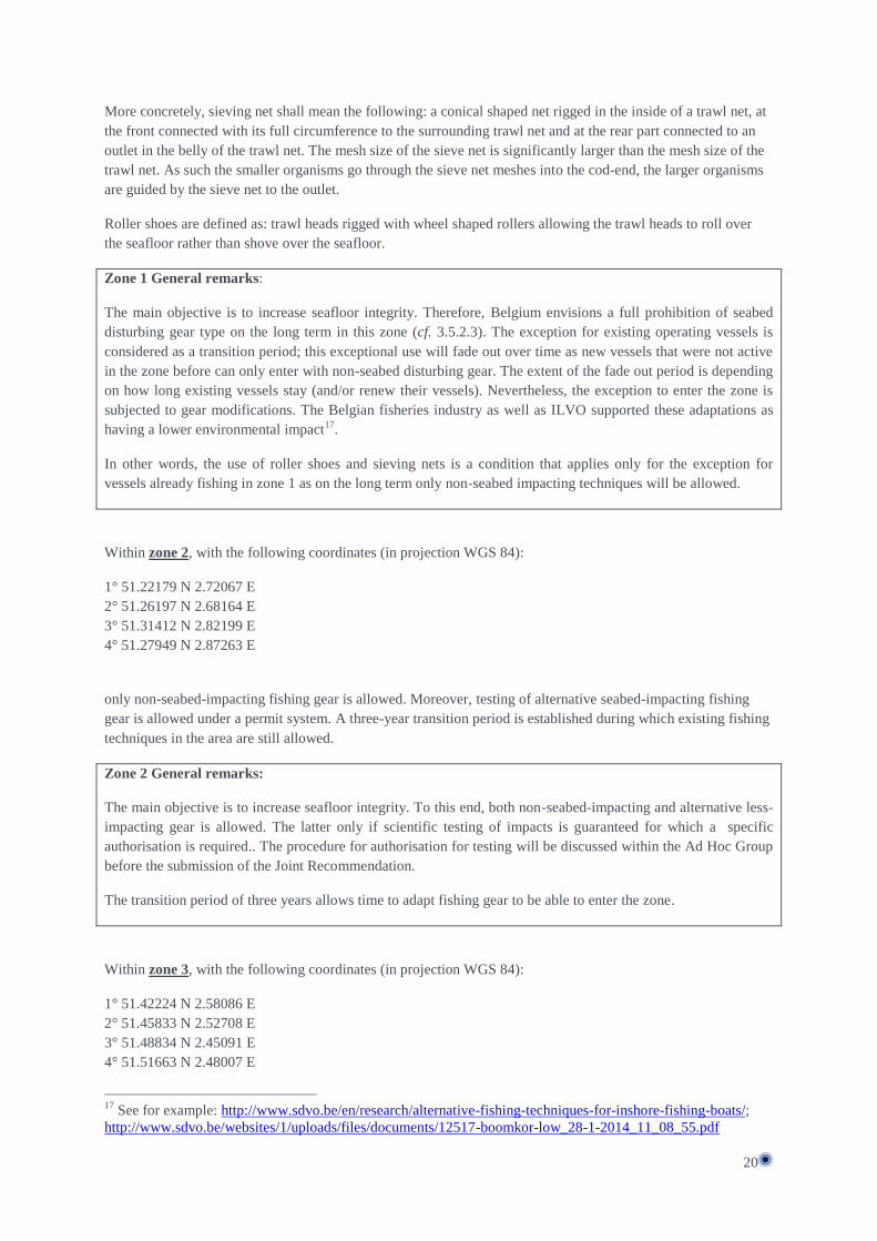
Zone 1 General remarks:
The main objective is to increase seafloor integrity. Therefore, Belgium envisions a full prohibition of seabed
disturbing gear type on the long term in this zone (cf. 3.5.2.3). The exception for existing operating vessels is
considered as a transition period; this exceptional use will fade out over time as new vessels that were not active
in the zone before can only enter with non-seabed disturbing gear. The extent of the fade out period is depending
on how long existing vessels stay (and/or renew their vessels). Nevertheless, the exception to enter the zone is
subjected to gear modifications. The Belgian fisheries industry as well as ILVO supported these adaptations as
having a lower environmental impact17
.
In other words, the use of roller shoes and sieving nets is a condition that applies only for the exception for
vessels already fishing in zone 1 as on the long term only non-seabed impacting techniques will be allowed.
Within zone 2, with the following coordinates (in projection WGS 84):
1° 51.22179 N 2.72067 E
2° 51.26197 N 2.68164 E
3° 51.31412 N 2.82199 E
4° 51.27949 N 2.87263 E
only non-seabed-impacting fishing gear is allowed. Moreover, testing of alternative seabed-impacting fishing
gear is allowed under a permit system. A three-year transition period is established during which existing fishing
techniques in the area are still allowed.
Zone 2 General remarks:
The main objective is to increase seafloor integrity. To this end, both non-seabed-impacting and alternative less-
impacting gear is allowed. The latter only if scientific testing of impacts is guaranteed for which a specific
authorisation is required.. The procedure for authorisation for testing will be discussed within the Ad Hoc Group
before the submission of the Joint Recommendation.
The transition period of three years allows time to adapt fishing gear to be able to enter the zone.
Within zone 3, with the following coordinates (in projection WGS 84):
1° 51.42224 N 2.58086 E
2° 51.45833 N 2.52708 E
3° 51.48834 N 2.45091 E
4° 51.51663 N 2.48007 E
17
See for example: http://www.sdvo.be/en/research/alternative-fishing-techniques-for-inshore-fishing-boats/;
http://www.sdvo.be/websites/1/uploads/files/documents/12517-boomkor-low_28-1-2014_11_08_55.pdf

21
5° 51.48100 N 2.57800 E
6° 51.44485 N 2.63069 E
only non-seabed-impacting fishing techniques are allowed.
Zone 3 General remarks:
The main objective is to increase seafloor integrity. Given that this zone has been selected for the restoration of
biologically valuable gravel beds which have diminished in the BPNS (cf. 3.5.2.3), only non-seabed-impacting
gear is allowed.
No transitional measures apply in this zone and commercial fisheries are required to switch immediately to non-
seabed impacting fishing techniques.
Within zone 4, with the following coordinates (in projection WGS 84):
1° 51.39540 N 2.51862 E
2° 51.42010 N 2.49147 E
3° 51.44974 N 2.41779 E
4° 51.48821 N 2.45186 E
5° 51.45833 N 2.52708 E
6° 51.42224 N 2.58086 E
only non-seabed-disturbing fishing techniques and testing of alternative seabed-impacting fishing techniques are
permitted.
Zone 4 General remarks:
The main objective is to increase seafloor integrity. To this end, both non-impacting and alternative less-
impacting gear is allowed. The latter only if scientific testing of impacts is guaranteed for which a specific
authorisation is required.. The procedure for authorisation for testing will be discussed within the Ad Hoc Group
before the submission of the Joint Recommendation.
No transitional measures apply in this zone and commercial fisheries are required to switch immediately to non-
seabed impacting fishing techniques.
4.1.2.2 Zone 5: Ecological valuable coastal zone
In order to preserve seabed integrity, fishing within an area of 4.5 nautical miles (NM) offshore is prohibited for
fishing vessels having a gross tonnage of more than 70 or a total length exceeding 20m. This zone is measured
from the baseline that serves as the reference for the width of the territorial sea of Belgium18
.
Zone 5 General remarks:
The main objective is to increase seafloor integrity. Therefore, the restrictions that currently apply within 3NM
from the baseline, are proposed to be spatially extended to be consistent with the high biological value coastal
area, largely coinciding with vulnerable Abra alba biotope and biogenic reef potential (cf. supra 3.5.5). Given
that (1) seabed disturbance has brought about significant changes in the coastal ecosystem, and (2) that bottom
impacting fisheries are considered to be the primary threat to the biogenic reefs in the coastal zone, the
application of the precautionary approach (leading principle, cf.supra 3.3), based on the best available scientific
18 Art. 6 §3 MSP; the 4.5 nautical mile limit is shown graphically in Annex 4 of the MSP, Map 4.

22
insights, in the coastal zone is necessary.
In other words, an existing coastal fisheries management measure is spatially extended based on ecological
information and plausible risk for impacts. The distinction based on tonnage is an existing threshold for the
smallest commercial vessel segment in Belgium. The existing measure with the Gross Tonnage threshold of 70
was based on an existing threshold in the Regulation 850/98 (Technical Measures) where it is mentioned that this
threshold coincides to an overall length of 20m.
4.1.3 Summary of the proposed measures
Fig 13. Overview map of the proposed fisheries measures and of the different habitat types within
BPNS orange: Macoma balthica biotope; blue: Abra alba biotope; light pink: Nephtys cirrosa
biotope; green: Ophelia borealis biotope. Green triangles: 2 refuges areas in gravel beds

23
Zones 1 and 2 are places where the Abra alba community is found. This community comprises various so-called
'ecosystem engineers'. These habitat-structuring species create biodiversity hotspots and are sensitive to bottom-
impacting fishing gear.
Zones 3 and 4 comprise the gravel beds: the gravel beds are home to a rich fauna and flora with a high species
richness, both of infauna and of epifauna on the rocks. These rich communities can only develop if the habitat is
not strongly subject to natural and/or anthropogenic disturbance. Especially the gravel beds in the Hinderbanken
area are important: historical data (Gilson collection: early 20th century) indicate that gravel beds were the most
dominant type of habitat in the channel between the Oosthinder and Westhinder (Houziaux et al. 2008), and that
they contained a very high biodiversity (Van Beneden 1883).
Zone 5 is the highly biologically valuable coastal area, largely coinciding with vulnerable Abra alba biotope and
biogenic reef potential.
In short, several small zones have been delineated to reduce the fisheries’ impact on the seafloor integrity. The
purpose of the measures is to reduce seabed impacting fishing techniques and hence increase seafloor integrity.
In zones 1 and 3, only fishing techniques that do not disturb the seabed habitat will remain allowed. Both
traditional and alternative seabed disturbing techniques will be fully prohibited. These zones will hence remain
solely available for techniques fishing only in the water column or passive fishing techniques.
The prohibition will be immediate for zone 3 as this zone is meant for the preservation of valuable gravel beds,
while in zone 1 the proposed measure will only apply to new vessels. This means that the assignment of zone 1
to solely non seabed impacting fishing techniques will be more gradual (transition period). This fade out period
is defined by the fact that vessels that were not active in the zone before can only enter with non-seabed
disturbing gear. The extent of the fade out period depends on how long existing vessels stay (and/or renew their
vessels).
Zones 2 and 4 are both zones where mobile fishing gear is prohibited. However, exceptions will be allowed
within the framework of testing alternative seabed-disturbing fishing techniques, i.e. techniques with a lower
impact on the seabed than the classic beam trawlers. Any party wishing to perform testing activities in these
zones will have to present a request to do so. For zone 2, there is a transition period of 3 years after the adoption
of the proposed measures.
The coastal measure (zone 5) intends to find a better consistency between the biological value of the coastal area
and the protection of this valuable area (which is currently limited to only 3 NM).
In the remaining part of the BPNS, all fishing techniques will take place as before. This differential approach
will allow for more accurate evaluation on the effectiveness of the measures. A comparison will be possible (a)
between zones 1 and 3 where no seabed disturbing activities take place, (b) between zones 2 and 4 where only
seabed disturbing fishing activities with a reduced impact on the seabed take place, (c) between the effect of
zone 5 and the effects of the zones 1-4 and (d) between zone 1-5 and other areas of the BPNS where seabed
disturbing activities take place as before.
An overview of the measures per gear code is added in Table 2 below.
Gear types International standard
classification of fishing gear Zones in which gear is banned
Beamtrawls TBB (1)*, 2, 3, 4, (5)** Bottom trawls/otter trawl OTB, PTB 2, 3, 4, (5)** Seine nets SDN, SSC 2, 3, 4, (5)** Gill nets/static gear/Other GN, GT en LHP No limitations
Table 2. Summary of proposed measures: Indication of Gear Type and Gear Codes for each zone (*beamtawl only
allowed for existing vessels and use of roller shoes/sieve nets, ** trawling with vessels <70GT allowed)

24
4.2 Fleet activity
4.2.1 Fishing rights in the Belgian part of the North Sea
The Regulation 1380/2013 (CFP) provides that European fishing vessels have a right to fish in the exclusive
economic zone (EEZ). Within the EEZ, Belgium identified five Member States with fisheries activities: The
Netherlands, France, United Kingdom, Germany and Denmark. The territorial sea is, in principle, reserved for
national fishing vessels. However, on the basis of bilateral agreements, Belgium has granted additional fishing
rights to Dutch and French fishing vessels in the Belgian territorial sea. Further subdivision was made between 3
and 12 NM.
Between 3 and 12 NM, Dutch fishing vessels are allowed to fish on all fish species. French ships only have
access between 3 and 12 NM to fish herring.
Between the baseline and 3 NM, in addition to Belgian coastal fishing vessels, also Dutch fishing vessels are
allowed access. This 3 NM limit allowing fishing access to Dutch vessels dates back to the Benelux Treaty and
will not be modified by the proposed measures. Moreover, bilateral agreements in relation to the performance of
seasonal fishing activities have existed between France and Belgium since 1976.
4.2.2 Fleet activity analysis
At the request of the Marine Environment Service, the Institute for Agricultural and Fisheries Research (ILVO)
gathered information about the Belgian, Dutch and British vessels that were active in the BPNS during the
period 2010-2012 (ILVO study)19
. To this end, Vessel Monitoring System ('VMS') and logbook data were used.
Additionally, this study was complemented with a new study for the analysis of French data for the same period
(2010-2012) (ILVO study20
). The methodology for both studies is the same21
. Denmark provided processed data
and Germany preferred not to include their fleet activity as their management interest affected by the proposed
measures is minimal.
4.2.2.1 Belgian fisheries activities
The Belgian fleet is rather limited (89 vessels in 2011) and is mainly active in non-Belgian waters. During the
period 2010-2012 only 9.4% of the total number of 'active' VMS signals from the Belgian fishing fleet came
from the BPNS.
4.2.2.2 Dutch fisheries activities
The Dutch fleet is much larger as compared to the Belgian fleet (831 vessels in 2008). In the period 2010-2012
VMS pings of 125 Dutch fishing vessels were recorded. The ILVO study showed that the Dutch fishing fleet is
mainly active in (i) shrimp fishing and (ii) beam trawling for demersal fish using nets with a mesh size between
80 and 99 mm. Other métiers present within the Flemish Banks were beam trawling with a different mesh size
than 80 to 99 mm, otter trawling and gill netting, pelagic fishing and pot fishing.
Dutch beam trawling was also observed all over the BPNS. Fishing activities took place all year round in all 4 of
the proposed sectors of the Flemish Banks. However, the highest intensities were measured beyond the 3 NM
limit. Thus, generally speaking, beam trawling activity was less intense in zone 1. The spatial distribution of
Dutch beam trawling activities varies depending on the season. In autumn and winter there was more offshore
19
Pecceu E, Vanelslander B, Vandendriessche S, Van Hoey G, Hostens K, Torreele E, Polet H (2014).
Beschrijving van de visserijactiviteiten in het Belgisch deel van de Noordzee in functie van de aanvraag bij de
Europese Commissie voor visserijmaatregelen in de Vlaamse Banken (Habitatrichtlijngebied). ILVO-
mededeling nr. 156, 92 p. 20
Vanelslander B (2016). French fishing activities in the Belgian part of the North Sea (BPNS), ILVO
26/02/2016, 24p. 21
Methodology: to process the data and to visualize it on maps, the R software has been used (open source
programme) to perform statistical analyses as well as graphical applications. The VMStools R Package was used
to do so. This tool has been developed in the EU Project “Development of tools for logbook and VMS data
analysis (MARE/2008/10 lot 2)‟ and can be found on http://code.google.com/p/vmstools (Hintzen et al, 2012).

25
fishing (in zones 3 and 4), whereas in spring and summer fishing took place closer to the coast, especially in the
area between 3 and 12NM (in zone 2).
Fig. 14 below illustrates that the Dutch beam trawl fleet is also very active in the coastal zone beyond 3 NM (as
the Dutch fleet is highly present in the entire BPNS). The proposed coastal measure is likely to have effects on
large Dutch beam trawls (above 70 GT), while smaller beam trawls will remain allowed. As a result of the
proposed coastal measure, large vessels will in practice have to give up only 6%22
of their fishing grounds in the
BPNS. In return however, the protection of the biologically valuable coastal area (which is most valuable until 6
NM – see section above 4.2) will increase by 50%23
.
Fig 14. Spatial distribution of VMS efforts for demersal beam trawls of the Belgian (left) and Dutch
(right) fleet in 2010-2012
As Belgian and Dutch fishing fleets are active in large parts of the BPNS, a more detailed comparison between
the two fleets is provided in Annex 6.
4.2.2.3 French fisheries activities
The majority of the French fleet activity in the BPNS concerns trawling (91.5% OTB gear type), while other
gear is almost not represented.
22
6% is the surface area of the extension of the coastal measure from 3 to 4.5 NM. 23
50% protection increase, the increase being from 3 NM to 4.5 NM.

26
Fig 15. VMS effort of French OTB vessels inside the Belgian part of the North Sea for 2010-2012.
Black line shows the borders of the Belgian part of the North Sea. Blue lines are the 3 and 12
NM borders. Grey line shows the “Vlaamse Banken” and green lines the 4 proposed
protected areas.
It should be kept in mind that only 29% of the OTB gear fishing trips in the logbook data are covered with VMS
data. So the patterns observed in figure 15 might give a fragmented view of the actual fishing activity of the
OTB gear. For all gear together, only 2% of the fishing trips in the logbook are covered by the delivered VMS
data.
Maps of the landings for the OTB gear were made for species that had a catch higher than 10 tonnes spread over
2010:2012. These species were European seabass (BSS), Dab (DAB), European plaice (PLE), Atlantic Cod
(COD), Atlantic horse mackerel (HOM), Atlantic mackerel (MAC) and Whiting (WHG) (cf. Annex 7).
4.2.2.4 German fisheries activities
Germany preferred not to include their fleet activity as their management interest affected by the proposed
measures is minimal.
4.2.2.5 British fisheries activities
The activity of the British fleet in the BPNS is very limited (cf. Annex 8). The British fishing fleet is active in the
BPNS in beam trawling, otter trawling, pot fishing, seine trawling, gill netting and longline fishing. UK fishing
activity is very low (rare) within the boundaries of the 4 fishing zones and non-existent in zone 5. It is very
unlikely that any UK vessels will be affected by the fishing restriction defined in the Belgian fisheries measures
proposal.
Fig 16. UK Fishing fleet activity in BPNS

27
4.2.2.6 Danish fisheries activities
An analysis of the Danish fishery in Belgian zone of the North Sea for mobile bottom contacting gears, pelagic
gears and other gears has been provided by Denmark (cf. Annex 9). There is no bottom impacting gear used in
the BPNS by Danish vessels. The only fisheries activities take place in the EEZ and consist for 100% of gill net
fisheries.
Fig 17. Danish Fishing fleet activity in BPNS
4.3 Control, enforcement and monitoring
4.3.1 Control
To control environmental and/or fisheries measures, traditionally a combination of procedures has been used,
concretely remote monitoring using the VMS or the AIS (automatic identification system), aerial and marine
control and technical control on board of the vessel itself.
4.3.1.1 Administrative control
The introduction of an additional licensing system is explicitly not taken into consideration. This is because the
Belgian authorities are of the opinion that the conditions for awarding fishing licences and permits must be
determined at the European level, and that this principle cannot be deviated from.
Lists of fishing vessels with their characteristics, in particular the gross tonnage, are available for national and
foreign fleets. The lists will be kept available on board of the surveillance units (patrol vessels and plane) and
updated when necessary.
4.3.1.2 Remote control
According to EU regulations, vessels with a LOA ('length over all') of more than 12 m are subject to the VMS.
Moreover, vessels with a LOA of more than 15 m are also subject to the AIS as of May 2014. Both electronic
monitoring systems are used to monitor the presence of vessels. Although fishing activities as such are not
reported by the systems, these can indirectly be deduced from the pattern of consecutive positions.
Monitoring with the VMS is done in near real time during office hours from the FMC (fleet monitoring centre)
in Ostend.
4.3.1.3 Surveillance on the spot
Marine units of the Navy, Maritime Police and Customs will be assigned the permanent duty to monitor and
report on the presence and activity of fishing vessels.
The flight plan and route of the control plane will be adapted in order to fly over the different zones during their
routine operation. The annual aerial programme of the Sea Fisheries Department comprises the performance of
missions with the OO-MMM plane for a total of 40 flying hours over sea. The Marine Environment Service of
the Directorate-General for the Environment carries out helicopter flights for training and environmental
monitoring tasks at sea for a total of approximately 20 flying hours over sea per year.

28
During missions at sea, so-called boardings will be performed of vessels during their activity. Aside from an
inspection of the documentation and the catch, in particular the fishing equipment will be subjected to a technical
inspection. Arrangements have been made with the partners/owners of seagoing vessels within the coast guard
structure on the use of patrol vessels for monitoring operations at sea. For instance, the Sea Fisheries Department
has an agreement with the Ministry of Defence on the use of patrol vessels during 100 days at sea per year. The
Directorate-General for the Environment has a similar agreement with the Ministry of Defence on the use of
patrol vessels during 50 days at sea per year. With the putting into service of the BNS CASTOR (2014) and the
BNS POLLUX (2015) it will be possible to achieve this objective. There is an agreement with DAB Vloot on the
use of the ZEEHOND for sea fisheries inspections during 30 days at sea per year. The Sea Fisheries Department
and the competent federal departments will plan and perform their inspections in a coordinated manner, taking
into account possible synergies and cooperation and attempting to make an optimal use of the existing means for
fishing and environmental monitoring at sea.
However, inspections of the fishing equipment in the ports are not planned, because, as a general rule, the mere
presence of fishing equipment which may be used illegally is not prohibited under European or national
regulations.
The monitoring teams will have the lists and descriptions of permitted alternative seabed-disturbing fishing
equipment at their disposal. The research institute ILVO will be asked to provide an approach for this. The
fishing industry will be informed of the result of this study.
4.3.2 Enforcement
The enforcement is taken care of by Flemish (Sea Fisheries Department) and federal (Directorate-General for the
Environment) officials, who derive their respective powers from the Decree of 28 June 2013 on the Agriculture
and Fisheries Policy and the the 1999 Marine Environmental Protection Act (MEPA).
4.3.3 Monitoring and evaluation
As the proposed fisheries measures are based on obligations under the MSFD, the MSFD-monitoring scheme
will cover the monitoring of the proposed measures. This monitoring programme was developed and discussed
under the coordination of the Management Unit of the North Sea Mathematical Models (BMM), in charge of the
design and implementation of the Belgian monitoring programmes for the continuous assessment of the marine
environmental status24
. This programme was established in cooperation with experts and policy-makers of the
various Belgian administrations and public research institutions.
The final monitoring plan aims for consistency by bringing together the relevant provisions on assessment and
monitoring established in the legislation of the European Union and/or by virtue of international agreements.
Existing monitoring schemes stay therefore in place, are integrated and adapted where necessary. The
monitoring programme covers all environmental targets, with the exception of pressure- or need-oriented
environmental targets, for which, rather than a number of environmental data, measures will be required with
respect to pressure or ad hoc considerations during the environmental impact assessments.
Evaluation is guaranteed by the national MSP-process. Given that the proposed fisheries measures are part of the
MSP for the years 2014-2020, the fisheries measures will need to be evaluated by the end of each 6 year period.
Moreover, fisheries measures may also be adapted through an interim review of the MSP if the monitoring
results show this to be necessary.
5 REFERENCES Belgische Staat (2012). Omschrijving van Goede Milieutoestand en vaststelling van Milieudoelen voor de
Belgische mariene wateren. Kaderrichtlijn Mariene Strategie – Art 9 & 10. BMM, Federale Overheidsdienst
Volksgezondheid, Veiligheid van de Voedselketen en Leefmilieu, Brussel, België, 34 pp.
24
Article 9 of Royal Decree of 23 June 2010
29
Braeckman U. (2011). Macrobenthos structuring the sea floor: importance of its functional biodiversity for the
benthic ecosystem. PhD thesis, Ghent University, 239pp.
Dahl L. & Dahl K. (2002). Temporal, spatial and substrate-dependent variations of Danish hard-bottom
macrofauna. Helgoland. Marine Research, 56, 159-168.
Davoult D. & Richard A. (1988). Les Ridens, haut-fond rocheux isolé du Pas de Calais: un peuplement
remarquable. Cahier de Biologie Marine, 29-107.
Degraer S., Van Lancker V., Moerkerke G., Van Hoey G., Vanstaen K., Vincx M. & Henriet J.-P. (2003).
Evaluation of the ecological value of the foreshore: habitat-model and macrobenthic side-scan sonar
interpretation: extension along the Belgian Coastal Zone. Final report. Ministry of the Flemish Community,
Environment and Infrastructure. Department. Waterways and Marine Affairs Administration, Coastal
Waterways.
Degraer S., Verfaillie E., Willems W., Adriaens E., Vincx M. & Van Lancker V. (2008). Habitat suitability
modelling as a mapping tool for macrobenthic communities: An example from the Belgian part of the North Sea.
Continental Shelf Research, 28, 369-379.
Degraer, S., U. Braeckman, J. Haelters, K. Hostens, T. Jacques, F. Kerckhof, B. Merckx, M. Rabaut, E. Stienen,
G. Van Hoey, V. Van Lancker & M. Vincx (2009). Studie betreffende het opstellen van een lijst met potentiële
Habitatrichtlijn gebieden in het Belgische deel van de Noordzee. Eindrapport in opdracht van de Federale
Overheidsdienst Volksgezondheid, Veiligheid van de Voedselketen en Leefmilieu, Directoraat-generaal
Leefmilieu. Brussel, België. 93 pp.
DG5 Leefmilieu, Dienst Marien Milieu. Bericht voor het Belgisch Staatsblad, Verklaring naar aanleiding van de
raadpleging van het publiek over het ontwerp.
DG5 Leefmilieu, Dienst Marien Milieu. (2009). Beleidsplannen - Beschermde Mariene Gebieden in het
Belgische deel van de Noordzee. Minister bevoegd inzake marien milieu. 2009. 69pp.
DG5 Leefmilieu, Dienst Marien Milieu. Vragen en opmerkingen publieksbevraging met antwoorden koninklijk
besluit tot vaststelling van het marien ruimtelijk plan.
Houziaux J.-S., Craeymeersch J., Merckx B., Kerckhof F., Van Lancker V., Courtens W., Stienen E., Perdon J.,
Goudswaard PC., Van Hoey G., Vigin L., Hostens K., Vincx M. & Degraer S. (2012). 'EnSIS' - Ecosystem
Sensitivity to Invasive Species. Final Report. Belgian Science Policy. 105pp.
Houziaux J.-S., Kerckhof F, Degrendele K, Roche M & Norro A. (2008). The Hinder banks: yet an important
region for the Belgian marine biodiversity? Final report HINDERS. Belgian Science Policy Office, 249pp.
Kühne S. & Rachor E. (1969). The macrofauna of a stony sand area in the German Bight (North Sea).
Helgoländer Meeresuntersuchungen, 50, 433-452.
Lindeboom H. 2008. The North Sea, past and present: shifting baselines and human uses, in: Mees J. & Seys J.
(Ed.) (2008). VLIZ Young Scientists‘ Day, Brugge, Belgium, 29 February 2008: book of abstracts. VLIZ Special
Publication, 40: 24 pp.
Pecceu E, Vanelslander B, Vandendriessche S, Van Hoey G, Hostens K, Torreele E, Polet H (2014) Beschrijving
van de visserijactiviteiten in het Belgisch deel van de Noordzee in functie van de aanvraag bij de Europese
Commissie voor visserijmaatregelen in de Vlaamse Banken (Habitatrichtlijngebied). ILVO-mededeling nr 156,
92p.
Philippart, C. J. M. 1998. Long-term impact of bottom fisheries on several by-catch species of demersal fish and
benthic invertebrates in the south-eastern North Sea. ICES Journal of Marine Science, 55: 342–352.

30
Polet, H. & Depestele, J. (2010). Impact assessment of the effects of a selected range of fishing gears in the
North Sea. Report commissioned by Stichting Noordzee and WNF.
Rabaut M, Vincx M, Degraer S (2009) Do Lanice conchilega (sandmason) aggregations classify as reefs?
Quantifying habitat modifying effects. Helgol Mar Res 63:37-46. doi: 10.1007/s10152-008-0137-4
Van Beneden E. (1883). Compte rendu sommaire des recherches entreprises à la Station biologique d’Ostende
pendant les mois d’été 1883. Bulletin de l’Académie Royale des Sciences, Littérature et Beaux-Arts de Belgique,
3ième Série, T6, no 11, II, 458-483.
van Hal R. (2014), Waardekaarten Belgisch EEZ. IJmuiden : IMARES (Rapport C004.14), 19pp.
van Hal R. (2014), Waardekaarten Belgische 3 tot 4,5-mijlszone. Ijmuiden : IMARES (Rapport C052.14), 19pp.
Van Hoey G., Degraer S. & Vincx M. (2004). Macrobenthic community structure of soft-bottom sediments at
the Belgian Continental Shelf. Estuarine, Coastal and Shelf Science, 59, 601-615.
Van Lancker V., Du Four I., Verfaillie E., Deleu S., Schelfaut K., Fettweis M., Van den Eynde D., Francken F.,
Monbaliu J., Giardino A., Portilla J., Lanckneus J., Moerkerke G. & Degraer S. (2007). Management, research
and budgetting of aggregates in shelf seas related to end-users (Marebasse). Final Report. Belgian Science
Policy, 139pp.
van Moorsel G.W.N.M. (2003). Ecologie van de Klaverbank. Biotasurvey 2002. Ecosub, Doorn.
Vanaverbeke J., Braarup Cuykens A., Braeckman U., Courtens W., Cuveliers E., Deneudt K., Goffin A.,
Hellemans B., Huyse T., Lacroix G., Larmuseau M., Mees J., Provoost P., Rabaut M., Remerie T., Savina M.,
Soetaert K., Stienen EWM., Verstraete H.,Volckaert F. & Vincx M. (2011). WestBanks. Understanding benthic,
pelagic and airborne ecosystem interactions in shallow coastal seas. Final Report. Belgian Science Policy, 82pp.

31
SUMMARY For the implementation of the EU Marine Strategy Framework Directive (MSFD), several activities at sea are
managed to meet the obligation to reach the Good Environmental Status in the Belgian part of the North Sea.
Amongst other activities, fisheries activities are impacted in five relatively small zones where access for fisheries
is conditional. As Belgium intends to achieve progress towards the MSFD targets through spatially-explicit
management actions related to the sectors concerned, several activities, including fisheries, are impacted,
specifically in relation to descriptor 6 (“sea-floor integrity”or “sea-floor integrity is at a level that ensures that the
structure and functions of the ecosystems are safeguarded and benthic ecosystems, in particular, are not
adversely affected.”). The Belgian proposal has been developed in the period 2012-2014, within the process of
Marine Spatial Planning (MSP). It is the intention of the Belgian government to take measures in its territorial
waters and in the Exclusive Economic Zone as an initiating Member State, with respect to fishing activities
exercised by all vessels including fishing vessels carrying the flag of other Member States. In order to apply
these measures to international fleets, Belgium is bringing this proposal to a European/regional level through the
application of Art. 11 of EU Regulation 1380/2013. The application of this procedure follows the framework of
the Scheveningen group.
The process must lead to an agreement of all Member States having a direct management interest in the fishery
to be affected by the proposed measures (a so-called Joint Recommendation). As a first step, all relevant
information is shared with the Member States with management interest and this document is the background
document which has been developed to serve as provision of sufficient information to the EC. The overall aim of
the present background document is to present a document which is scientifically sound as a basis to discuss a
Joint Recommendation with the Member States having a management interest in the fishery to be affected by the
proposed measures.
The rationale of the proposed measures is that there is no intent to close any areas off for fisheries. Only small
areas have been selected to protect those habitats that are very sensitive. Moreover, the proposed measures
intend to act as an incentive to consider less seabed impacting techniques.
In order to preserve the seafloor integrity, the most vulnerable and valuable zones have been selected for the
measures. Four of the five selected zones are situated within the Habitats Directive area SAC Flemish Banks.
Zone 1 intends to exclude any seafloor disturbing fishing gear in the long term. As a transitional measure,
existing coastal ships are allowed to continue all fisheries activities. The conditions to make use of this
transitional measure towards exclusion of bottom gear are the obliged use of roller shoes to reduce the impact on
the bottom and to apply a sieving net for shrimp fisheries. Existing vessels may be replaced and new vessels may
enter the zone only with non-seabed disturbing techniques. The use of roller shoes and sieving nets is a condition
that applies only to the exception for vessels already fishing in zone 1 as on the long term only non-seabed
disturbing techniques will be allowed.
Zone 2 is situated near zone 1 and allows only non-seabed disturbing fishing techniques. Besides, alternative
seabed-disturbing techniques are allowed if they are framed within a scientific research project. Belgium is in the
process of designing the procedure to use these testing zones. The procedure will be presented to the Ad Hoc
Group. The measures in zone 2 will apply after an interim period of 3 years during which all existing fishing
techniques are still allowed.
Zone 3 allows only non-seabed-disturbing fishing techniques.
Zone 4 is situated near zone 3 and allows only non-seabed impacting fishing techniques. Besides, alternative
seabed-disturbing techniques are allowed if it they are framed within a scientific research project. Belgium is in
the process of designing the procedure to use these testing zones. The procedure will be presented to the Ad Hoc
Group.
Zone 5 concerns a spatial extension of an existing fisheries measure in Belgian waters. Within 3NM from the
coast, only vessels with <70GT are allowed to fish to protect the valuable coastal area. This threshold has been

32
used in analogy to the threshold that is mentioned in Regulation 850/98 (Technical Measures). As the valuable
coastal zone goes up to 6NM, this ecological information has been used to extent the measure spatially with
50%, implying that the <70GT rule applies up to 4,5NM from the coast.
The present proposal will be submitted to the European Commission (i.e. notification), which serves as the
provision of sufficient information in accordance with the Basic Regulation Art. 11(3).

33
RESUME En vue de la mise en œuvre de la directive-cadre 2008/56/CE « stratégie pour le milieu marin » (DCSMM),
plusieurs activités en mer font l'objet d'une gestion afin de rencontrer l'obligation d'atteindre le bon état
écologique dans la partie belge de la Mer du Nord. Parmi d'autres activités, les activités de pêche sont impactées
dans cinq zones relativement petites où l'accès aux pêcheries est soumis à certaines conditions. Particulièrement
en ce qui concerne le descripteur 6 ("Intégrité des fonds marins" ou « le niveau d’intégrité des fonds marins
garantit que la structure et les fonctions des écosystèmes sont préservées et que les écosystèmes benthiques, en
particulier, ne sont pas perturbés »)., plusieurs activités, dont la pêche, sont impactées dans la mesure où la
Belgique projette d'accomplir des progrès en direction des objectifs de la DCSMM au travers d'actions de gestion
explicitement spatiales liées aux secteurs concernés. La proposition belge a été élaborée au cours de la période
2012-2014, dans le cadre du processus de plan d'aménagement des espaces marins (PAEM). L'intention du
gouvernement belge est de prendre des mesures dans ses eaux territoriales et dans la zone économique exclusive
en tant qu'État membre demandeur, relatives aux activités de pêche exercées par tous les navires, y compris les
bateaux de pêche portant le pavillon d'autres États membres. Afin de rendre ces mesures applicables aux flottilles
internationales, la Belgique soumet sa proposition au niveau européen / régional en application de l'article 11 du
règlement UE 1380/2013. L'application de cette procédure s'effectue conformément au cadre défini au sein du
groupe Scheveningen.
Le processus doit déboucher sur un accord de tous les États membres ayant un intérêt direct dans la gestion de
l'activité de pêche qui seront affectés par les mesures proposées (ce que l'on appelle une "recommandation
commune"). Dans une première étape, toute l'information pertinente est partagée avec les États membres ayant
un intérêt dans la gestion et le présent document constitue le document de base qui a été élaboré dans le but de
fournir une information suffisante à la CE. Le but général du présent document de base est d'offrir un document
scientifiquement cohérent servant base à la discussion d'un accord commun avec les États membres ayant un
intérêt dans la gestion des activités de pêche qui sera affecté par les mesures proposées.
La logique sous-jacente aux mesures proposées est que l'intention n'est nullement de fermer à la pêche quelque
zone que ce soit. Seules de petites zones ont été sélectionnées afin de préserver les habitats les plus sensibles. En
outre, les mesures proposées se veulent un incitant pour encourager des techniques de pêche moins perturbatrices
des fonds marins.
Afin de préserver l'intégrité des fonds marins, seules les zones les plus vulnérables et les plus précieuses ont été
sélectionnées pour ces mesures. Quatre des cinq zones sélectionnées sont situées à l'intérieur de la zone directive
Habitats Vlaamse Banken.
La zone 1 vise l'exclusion à long terme des engins de pêche perturbateurs des fonds marins. En guise de mesure
transitoire, les navires côtiers existants sont autorisés à poursuivre toutes leurs activités. Les conditions pour
bénéficier de cette mesure transitoire en attendant l'exclusion à terme des engins traînant sur le fond sont
l'utilisation obligatoire des engins de coulisses pour réduire l'impact sur le fond et l'emploi du chalut de
séparation pour la pêche aux crevettes. Les navires existants peuvent être remplacés et de nouveaux navires
peuvent pêcher dans la zone exclusivement avec des techniques non perturbatrices des fonds marins.
L'utilisation des engins de coulisses et des chaluts de séparation est une condition qui s'applique uniquement à
l'exception prévue pour les navires qui pêchent déjà en zone 1 étant donné qu'à long terme, seules les techniques
non perturbatrices des fonds marins seront autorisées.
La zone 2 est située à proximité de la zone 1 et autorise uniquement les techniques de pêche non perturbatrices
des fonds marins. Par ailleurs, des techniques alternatives perturbatrices des fonds marins sont autorisées si elles
s'inscrivent dans le cadre d'un projet de recherche scientifique. La Belgique est occupée à définir la procédure
pour l'utilisation de ces zones de test. La procédure sera présentée au Groupe ad hoc. Les mesures en zone 2
s'appliqueront après une période intérimaire de 3 ans au cours de laquelle les techniques de pêche existantes sont
toujours autorisées.
La zone 3 autorise uniquement les techniques de pêche non perturbatrices des fonds marins.
34
La zone 4 est située à proximité de la zone 3 et autorise uniquement les techniques de pêche non perturbatrices
des fonds marins. Par ailleurs, des techniques alternatives perturbatrices des fonds marins sont autorisées si elles
s'inscrivent dans le cadre d'un projet de recherche scientifique. La Belgique est occupée à définir la procédure
pour l'utilisation de ces zones de test. La procédure sera présentée au Groupe ad hoc.
La zone 5 concerne une extension dans l'espace d'une mesure existante en matière de pêche dans les eaux
territoriales belges. La pêche au sein de la zone des 4,5 MN de la côte est interdite aux bateaux de pêche jaugeant
plus de 70 Tonnage brut (c.-à-d. extension de 3 à 4,5 MN).
Le seuil de 70TB a été appliqué par analogie avec celui mentionné dans le règlement 850/98 (mesures
techniques) et correspond à 20m de longueur. Puisque la précieuse zone littorale s'étend jusqu'à 6 MN (cartes de
valeur biologique,), cette information écologique a été utilisée pour étendre la mesure dans l'espace à raison de
50%,.
La présente proposition sera soumise (c.-à-d. notifiée) à la Commission Européenne, ce qui constitue la
fourniture d'une information suffisante conformément à l'article 11 (3) du règlement de base.
35
SAMENVATTING Voor de toepassing van de EU-Kaderrichtlijn Mariene Strategie (KRMS) worden er op zee verschillende
activiteiten beheerd om te voldoen aan de verplichting om te komen tot een ‘Goede Milieutoestand’ in het
Belgische gedeelte van de Noordzee. Hieronder vallen onder meer visserijactiviteiten in vijf relatief kleine
zones, waar de toegang voor visserij aan voorwaarden is onderworpen. Meer specifiek in verband met het
beschrijvende element 6 (“integriteit van de zeebodem” of “Integriteit van de zeebodem is zodanig dat de
structuur en de functies van de ecosystemen gewaarborgd zijn en dat met name bentische ecosystemen niet
onevenredig worden aangetast”) slaat deze regelgeving op verschillende activiteiten, waaronder de visserij.
België wil namelijk vooruitgang boeken in de realisatie van de KRMS-doelstellingen via expliciet ruimtelijke
beheeracties met betrekking tot de betrokken sectoren. Het Belgische voorstel werd opgemaakt in de periode
2012-2014, binnen het proces van de Mariene Ruimtelijke Planning. De Belgische regering wil als initiërende
Lidstaat in zijn territoriale wateren en in de Exclusieve Economische Zone maatregelen nemen rond
visserijactiviteiten die worden verricht door alle vaartuigen, ook vaartuigen die onder de vlag van andere
Lidstaten varen. Om deze maatregelen toe te passen op internationale vloten, tilt België zijn voorstel op een
Europees/regionaal niveau door toepassing van art. 11 van de EU-Verordening 1380/2013. De toepassing van
deze procedure gebeurt volgens het kader van de Scheveningen-groep.
Het proces moet leiden tot een akkoord tussen alle Lidstaten die een rechtstreeks beheersbelang hebben in de
visserijactiviteiten die onder de voorgestelde maatregelen moeten vallen (een zogenaamde Gezamenlijke
Aanbeveling). In eerste instantie wordt alle relevante informatie gedeeld met de Lidstaten die beheersbelang
hebben en dat document vormt de basis die volledig wordt uitgewerkt om de Europese Commissie voldoende
informatie te kunnen aanreiken. Het doel van dit basisdocument is om een wetenschappelijk kader te kunnen
voorleggen als basis voor de bespreking van een Gemeenschappelijke Aanbeveling met de Lidstaten met een
rechtstreeks belang bij het beheer van de visserij waarvoor de maatregelen gevolgen sorteren. De rationale van
de voorgestelde maatregelen is dat er geen intenties zijn om gebieden af te sluiten voor visserijactiviteiten. Enkel
kleine gebieden werden geselecteerd om de meest gevoelige habitats te beschermen. De voorgestelde
maatregelen willen bovendien een stimulans zijn om alternatieve bodemberoerende technieken in overweging te
nemen die de zeebodem minder verstoren.
Om de integriteit van de zeebodem te vrijwaren, worden de meest kwetsbare en de meest waardevolle zones
uitgekozen voor maatregelen. Vier van de vijf gekozen zones liggen binnen het Habitatrichtlijngebied Vlaamse
Banken.
Zone 1 beoogt op lange termijn bodemverstorend vistuig uit te sluiten. Bij wijze van overgangsmaatregel hebben
bestaande kustschepen de toelating om alle activiteiten verder te zetten. De voorwaarden om zich op deze
overgangsmaatregel ten aanzien van de uitsluiting van bodemberoerend vistuig te mogen beroepen, zijn het
verplichte gebruik van rolsloffen om de bodemberoering te verminderen, en zeefnetten te gebruiken voor
garnaalvisserij. Bestaande schepen kunnen worden vervangen en nieuwe schepen mogen de zone enkel binnen
met technieken die de zeebodem niet verstoren. Het gebruik van rolsloffen en van zeefnetten is een voorwaarde
die enkel slaat op de uitzonderingsmaatregel voor schepen die nu al in zone 1 vissen, aangezien op lange termijn
enkel technieken zullen worden toegelaten die de zeebodem niet verstoren.
Zone 2 ligt in de nabijheid van zone 1, en daar zijn enkel visserijtechnieken toegelaten die de zeebodem niet
verstoren. Daarnaast zijn er weliswaar alternatieve zeebodemverstorende technieken toegelaten indien zij
kaderen in een wetenschappelijk onderzoeksproject. België is bezig de procedure uit te werken om toelatingen
te geven. De procedure zal aan de Ad Hoc Werkgroep worden voorgelegd. De maatregelen in zone 2 zullen van
toepassing zijn na een overgangsperiode van 3 jaar, waarbinnen bestaande visserijtechnieken nog steeds
toegelaten zijn.
In Zone 3 zijn enkel niet-zeebodemverstorende technieken toegelaten.
Zone 4 ligt in de nabijheid van zone 3 en daar zijn enkel visserijtechnieken toegelaten die de zeebodem niet
verstoren. Daarnaast zijn er weliswaar alternatieve zeebodemverstorende technieken toegelaten indien zij
36
kaderen in een wetenschappelijk onderzoeksproject. België is bezig de procedure uit te werken om deze
testzones te gebruiken. De procedure zal aan de Ad Hoc Werkgroep worden voorgelegd.
Zone 5 betreft een ruimtelijke uitbreiding van een bestaande visserijmaatregel in Belgische wateren. Binnen de
3 zeemijl buiten de kust hebben enkel schepen van <70BT toestemming om te vissen, teneinde de waardevolle
kuststreek te beschermen. Deze drempel werd gebruikt naar analogie met de drempel die is opgenomen in
Verordening 850/98 (Technische Maatregelen). Aangezien de waardevolle kuststreek zich 6 zeemijl in zee
uitstrekt, werd deze ecologische informatie gebruikt om de maatregel ruimtelijk met 50% uit te breiden, wat
betekent dat de <70BT-regel van toepassing is binnen de 4,5 zeemijl buiten de kust.
Het voorliggende voorstel zal als basisdocument aan de Europese Commissie worden voorgelegd (d.w.z.
notificatie), wat overeenkomt met het aanreiken van voldoende informatie conform Art. 11(3) van het
Gemeenschappelijk Visserijbeleid.

37
ANNEX 1 – MARINE SPATIAL PLAN An English summary of the Belgian MSP is provided below
1. Introduction
Taking the analysis of the current situation into account, in this section we develop a global vision and determine
the general and specific spatial principles. To this end, we are looking in particular for multiple uses of space.
This is possible by taking into consideration overlapping activities in four dimensions, such as the possibility to
fish, extract sand, navigate and organize firing exercises in function of defence, all in the same zone (not always
at the same time). The fourth dimension is the time frame. This section in addition includes the specific
objectives and indicators and the spatial policy choices, including the integrated map of this marine spatial plan.
Revisiting the binding stipulations in the Royal Decree, activities for implementing the marine spatial plan are
included in Annex 3 and are binding for the Federal Government.
2. Spatial structural vision for the BPNS
The spatial principles form the basis for formulating a spatial structural vision for the BPNS. This is an abstract
schema in which prior principles are synthesized into one future image for the long-term: how do we see the
spatial situation of the BPNS in the long term? This is therefore the long-term policy framework against which
all the objectives, measures and actions in the short term will be measured.
The long-term spatial vision of the future for the BPNS is summarized as follows.
The BPNS is a sea of space
The structural vision demonstrates the way in which activities within this sea of space can develop. Activities are
possible to a greater or lesser extent within certain spatial wholes (or structures). These large structures are
represented as zones with white, continuous edges on the figure at the end of this paragraph:
The coastal zone: this is a zone containing both land and sea. This space should be considered as one
spatial whole because important economical, ecological and social challenges are situated here (coastal
defence, economic development of the ports, tourist-recreational development of the coastal region,
ecological function of the valuable sandbanks, dunes and polders, coastal fisheries, military exercises
and sea landscape in which the relationship of sea-land is important ...). There is shared competence
within this zone (federal and Flemish). Spatially, the base line indicates the border between these
competencies. At the seaward side of the baseline, the Flemish Region has a number of assigned
competencies. Residuary powers, including spatial planning, are the competence of the federal
government.
The deeper sea: further at sea, the intensity and dynamics of activities decreases and the relationship
with the land is of lesser importance. The deeper sea is the ideal area for productive activities in which
the raw materials of the sea (energy, fish, sand, gravel ...) can be extracted sustainably. In addition, this
zone is also suitable for military exercises.
The BPNS is a sea of balances between activities.
The North Sea is one of the most heavily used seas in the world. The Belgian part is embedded in this and
demonstrates a high level of activities. This means that a balance must be sought, as well as complementarity
with the mainland in the spatial allocation of activities. Spatial emphases are therefore laid down within the

38
spatial structures, but multiple uses of space and looking for win-win situations is still the order of the day. The
spatial emphases are situated within the sub-areas, displayed in the figure below by means of zones with dotted
and dashed lines and shades.
The naturally most valuable zone is shaded within the coastal zone. The ecological value of the coastal
zone proposes important preconditions on the spatial possibilities of other activities which may be
situated in the coastal zone (displayed by a zone with a grey dotted line).
Landscape value plays an important role within the coastal zone. Constructions at sea within the coastal
zone can have an important influence on visual pollution (value of landscape). Important heritage value
is also found within these coastal zones, but also further at sea.
There are three important sub-zones deeper at sea:
o there is an area of potential for generating renewable energy located at the eastern side of the
BPNS. This zone in fact continues into the Dutch part of the North Sea. This is a zone for wind
farms, but also for other forms of renewable energy. This zone is displayed by a dashed-dotted
line.
o Situated to the west of this area is a potential zone for all forms of productive activities
(fisheries, sand and gravel, energy…), displayed by a white dotted line.
o Further west in the deep sea, nature protection is important (shaded). Other activities are
possible here, but in balance with the important natural value of this area. Nature protection is
also applicable in the bordering French portion of the North Sea.
The BPNS is an open sea with structural connections and cross-border relationships
As a relatively small sea space, the realization that the sea is an open system is of great importance to the spatial
vision: the relationship and spatial continuity with neighbouring countries is essential in this. This is why
structural connections are also indicated (displayed by dashed and dotted lines) in this structural vision:
o In the first instance, important shipping connections are shown; this concerns the IMO routes and the
connections to the Westerschelde, Westpit route and the shipping lanes to the ports of Ostend and
Zeebrugge.
o The coastline is an important structural connection on land and at the same time forms the spatial
dividing line between land and sea. Currently this line is a hard border and mainly serves as a connection
between the various coastal locations. The intention in the longer term is to adapt this hard border so that
more spatial relations are possible between land and sea in the framework of integrated coastal area
management. In this way, strong, dynamic zones on land can be extended into dynamic zones at sea: for
instance, ports and large cities protected by hard coastal defence infrastructures are installed at sea
through shipping lanes, potential areas for activities on the level of production and storage, corridors for
cables and pipelines ... On the other hand, land areas with great potential on the level of ecological
value, are extended to sea as areas with attention for nature conservation, coastal defence, as an 'open
system' ...
o Furthermore, the structural cable and pipeline connections are very important. These form corridors
within the BPNS. The most important connections are indicated on the structural scheme: connections to
the zone for renewable energy, connections to Great Britain, corridors to Zeebrugge and Ostend. They
constitute the impetus for an energy grid at the European level.
The BPNS is a sea of strategic possibilities
Certain locations in the BPNS are of structural importance at the scale of the entire BPNS. These locations are
indicated in the structural scheme as strategic locations by their own symbols (circles, squares, triangles, stars,
diamonds):
o In the renewable energy zone, a number of energy platforms are provided as links in the Belgian and
European energy grid (circles);

39
o The two most important economic ports bordering on the BPNS (in addition to Antwerp, at the
Westerschelde) are Ostend and Zeebrugge. They constitute the motor of the spatial dynamic, on land as
well as at sea (squares);
o The Port of Nieuwpoort forms an important recreational junction for recreational sailing (at sea and
internal waterways) is being expanded further to become one of the largest marinas in Europe.
o A number of strategic locations in the coastal area are indicated for research and testing.
Figure: Spatial structural vision for the BPNS
3. Economic, social, environmental and safety objectives and indicators
In what follows, the vision and long-term objectives are translated into specific objectives for the BPNS for the
2020 plan horizon. These are the objectives that Belgium has proposed for the coming 6-year planning period
(2014-2020). These are situated at the social, economic, ecological and safety level and are defined as much as
possible as SMART: specific, measurable, acceptable, realistic and time-bound. The objectives are not binding
in themselves, but form the basis for binding measures. Naturally, this concerns objectives with spatial
relevance.
The government is committed to implementing a facilitative and stimulating policy so that these objectives can
be reached. Whether all the objectives will effectively be met by the plan horizon, however, also depends on
other parties and external conditions (economic situation, will of the market parties ...). The objectives are
translated in to measurable indicators which, in 2020, should enable politics to evaluate the decisions taken and
to adjust them where necessary.
The pursuit is to establish indicators for objectives that concern the use of space. In practice, it is also the case
that such indicators are not always available. Marine spatial planning, after all, provides for the coordination of
not postponing and possibly even desirable use of space, without this meaning in every case that this use of

40
space also must necessarily be carried through. This is in fact often determined by sectoral policy making and
regulations. In this way, providing space for aquaculture projects within the marine plan does not mean that this
Marine Spatial Planning also forms the policy domain for developing the sector of marine aquaculture. For this
reason the objectives are formulated in such a way that an evaluation can be made at the end of the first cycle as
to whether they have been achieved or not.
Environmental objectives
o For the whole BPNS, in accordance with the Marine Strategy Framework Directive and the Water
Framework Directive, a ‘good environmental status’ (by 2020) and a ‘good surface water status’ are
pursued. The achievement of a favourable conservation status (habitat and birds directive) en the
implementation of the biodiversity strategy are also pursued.
o Specific environmental measures to achieve this situation are preferentially taken in the protected areas
insofar as there is a link with the state of conservation of the habitats and species for which these areas
are designated. Further description of these objectives and the translation of these objectives into
measurable parameters can be found in the "Determination of Good Environmental Status and
establishment of Environmental Targets for the Belgian Marine Waters" (July 2012).
o On the level of renewable and sustainable energy production, the objective is to provide at least 2000
MW capacity at sea.
o Furthermore, the objective of this marine spatial plan is that the entire current project for the generation
of wind energy in the designated area for renewable energy will be operational in 2020.
o By 2020 there must also be additional insights acquired as to the feasibility of different techniques for
alternative forms of renewable energy in the BPNS. In the first instance in this regard, the thinking is
about techniques with respect to wave energy.
o Finally, as an objective it is also proposed that active environmental measures are tested in the zone for
renewable energy. These measures to promote biodiversity must be sufficiently tested by 2020 in order
to implement them in other locations.
Safety objectives
In this marine spatial plan, safety objectives are translated into objectives for the safety of shipping, objectives
for protection against the sea and for defence. The spatial policy decisions for every activity are considered
against these objectives.
With regard to shipping, the objective is to continue to guarantee safe passage and safe access to all Belgian
ports, not only for the current generation of ships, but also for ships from the coming generations (larger
dimensions, increasing draught). The chance of back-flow for dredging dumping is minimized.
The above also includes that during the planning period, sufficient space is continually provided for dumping
dredged material in the best possible conditions, this means with the least possible chance of back-flow. The
efficiency of the dredging dumping sites must be increased by reducing the chance of back-flow based upon
scientific research and monitoring.
On the level of protection against the sea and floods we refer to the measures and objectives from the Masterplan
Coastal Safety (http://www.kustveiligheid.be).
In conclusion, the objective is that the BPNS continues to provide sufficient space for conducting military
exercises, attuned to other activities and uses in the BPNS.
Economic objectives
The goal is, within the planning period, to guarantee sufficient space for all economic activities at sea:

41
o All of the existing fishing grounds remain accessible, except in the designated areas for renewable
energy subject to infrastructural constructions for energy storage and transport. Space will be created
for integrated aquaculture as a complimentary activity for the ‘traditional’ fisheries activity.
o Corridors for cables and pipelines, aligned with other activities and uses in the BPNS and with attention
to efficiency. Therefore, the objective is to lay all new cables and pipelines in the corridors already
provided and to pursue common cables as far as possible;
o Sufficient sand and gravel extraction zones in function of the demand for building sand and gravel and
in function of the coastal defence activities. To this end, the objective is to sufficiently monitor the
impact on the sea floor and biodiversity and to limit the amount, and if necessary the duration of
extraction in function of this impact. Per successive periods of 5 years (2010-2015 and 2015-2020), a
maximum volume of 15 million m³ (3 million m³/year as progressive average over 5 years) may be
extracted. In addition to this, extractions for coast replenishment with the goal of maintaining the
current profile of the beaches will be taken into account;
o The current zone for renewable energy must offer sufficient space for the generation of sustainable
forms of energy. The specific objective is, by 2020, to have approximately at least 2,000 MW installed
capacity in this zone;
o The marine spatial plan provides for the spatial potential for the expansion of the Belgian ports;
o The existing space at sea for recreational activities will be maintained to the extent possible;
By the end of the plan horizon (2020), the realization of the Belgian Offshore Grid must be started.
By 2020 there will be an electricity connection with Great Britain.
Cultural, Social and Scientific Objectives
o An important social objective is therefore a strong respect for the maritime landscape (seascape) and
the underwater heritage of the BPNS.
o The sea landscape (seascape) is the landscape of the sea surface to the horizon and has great
experiential value due to its integrity for the coastal resident as well as tourists and recreational users.
This is one of the most integrally preserved landscapes and must also be cherished as a valuable good
for future generations.
o The coast and the BPNS must also be an attractive destination for tourism and recreation in 2020.
o Additionally, the BPNS must also be a place for research, education and monitoring. The existing
accessibility of the BPNS for these activities must also be maintained to the extent possible in 2020.
4. Spatial policy choices for users and activities in the BPNS
The 'Spatial policy decisions' are succinctly described for the sake of smooth reading of this document for cross-
border consultation.
These policy options are described in greater detail in the actual marine spatial plan.
The long-term structural vision, which is decisive for the economic, social and environmental and safety
objectives in the short term (6 years), is hereinafter translated into policy decisions for every activity and use and
protection of the BPNS. These are the spatial decisions for the planning horizon 2020 which are binding. This is
a more specific representation of the spatial accents in the policy, in words as well as images for each user. The
spatial alternatives considered for every activity and user are also represented.
Good environmental status and nature conservation areas

42
The vision assumes maximum conservation of the most valuable ecological zones by
delineating marine protected areas with actual management measures. In these marine
protected areas, it is desirable to pursue an ecological situation which is significantly better
than the minimum according to the Marine Strategy Framework Directive.
The option of building a network of marine protected areas (international and land-sea
connections) is also pursued.
Finally, there is an on-going search for forms of multi-spatial use that provide advantages for
the marine environment.
Summary of the spatial policy options
Maintaining the contours of the marine protected areas in the BPNS and maintaining the current number of nature conservation areas;
Concentration on the further development and implementation of effective nature conservation measures. Measures are provided for recreational fishing, sand and gravel extraction and professional fisheries.;
When there are new functions or activities in the BPNS (energy storage, power outlet at sea, zone for renewable energy…) the possibilities for multiple use of a space in function of nature conservation or development are considered (bioremediation forms of aquaculture, breeding grounds for small gulls, tern island, artificial reefs …).

43
Translation of the map legend: Good environmental status and nature conservation areas
Goede milieutoestand en natuurbeschermingsgebieden - Good environmental status and nature conservation areas

44
Habitatrichtlijngebied – Vlaamse Banken (‘The Flemish Banks’)– Special Area for Conservation, SAC
Vogelrichtlijngebied – Special Protection Area, SPA
Deelzone “Trapegeer Stroombank” - Subzone “Trapegeer Stroombank”
Gericht marien reservaat « Baai van Heist » - National nature reserve « Baai van Heist »
Zone voor installaties voor de productie van elektriciteit uit water, stromen of winden – Zone for installations for electricity production generated by water, current and wind.
Speciale zone voor bodemintegriteit – Special zone for seabed integrity
Zone voor een installatie voor het transport van elektriciteit - Zone designated for an installation for electricity transport (a high -voltage station)
Zone voor een installatie voor de opslag van energie– Zone designated for an installation for energy storage
Basislijn – Baseline
Energy, cables and pipelines
These notions are considered together due to the fact that they, in a spatial sense, are related.
The vision assumes sustainable offshore energy generation with optimal use of various
compatible forms of 'green' energy and a choice of location with minimal impact. Space is
provided for energy storage and a concession area for a power outlet at sea.
Connections take place efficiently. Where possible, multiple use of space is promoted.
Summary of the spatial policy options
A maximum amount of new cables and pipelines in the cable and pipeline corridors; cables and pipelines follow the shortest possible route between points of departure and arrival;
Additional cables and high-voltage stations in function of the development of an European energy grid;
Additional concession zone for a high-voltage station (‘power outlet at sea’);
Zone for a concession application for a new electricity cable connection with Great Britain;
Landing points: Ostend (Slijkens) and Zeebrugge;
The already-indicated zone for generating renewable energy remains and will not be expanded
45
within the planning period; the pursuit is to make the current concession zone operational as far as possible within the planning period;
New concession zones for energy atolls (energy storage):
- off the coast of Blankenberge-De Haan;
- to the east of the port of Zeebrugge.
Maintenance of safety perimeters;
Potential for multiple use of space;
High-voltage stations can obtain a supplementary nature function or serve supplementary as tug stations;
The energy atolls off the coast of De Haan-Blankenberge and to the east of the port of Zeebrugge: in addition to the function of energy storage, the energy atolls receive a mandatory function in the framework of nature development;
The zone for renewable energy is the priority zone for tests with alternative forms of sustainable energy generation;
The zone for renewable energy is also designated as a location for concessions for potentially marine aquaculture (see section on marine aquaculture);
The zone for renewable energy is also used for research into proactive nature conservation measures (constructing artificial reefs and seal platforms).
Visitor Centre can be allowed in the zone for a high-voltage stations and the zones for energy storage.

46
Translation of the map legend: Energy, Cables and pipelines
Energie, kabels & pijpleidingen - Energy, Cables and pipelines
47
Zone voor installaties voor de productie van elektriciteit uit water, stromen of winden – Zone for installations for electricity production generated by water, current and wind.
Zone voor een installatie voor het transport van elektriciteit– Zone designated for an installation for electricity transport (a high -voltage station)
Zone voor kabels en pijpleidingen –Zone for cables and pipelines (i.e. cable and pipeline corridors)
Zone elektriciteitskabel naar Groot-Brittannië – Zone for an electricity cable connection with Great Britain
Aanlandingspunt voor offshore energie – Landing points for offshore energy
Zone voor een installatie voor de opslag van energie– Zone designated for an installation for energy storage
Voorzorgsgebied – Precautionary area
Basislijn – Baseline
Shipping, port development and dredging
Summary of the spatial policy options
• Not mortgaging the further expansion of the ports Zeebrugge, Ostend, Nieuwpoort and
Blankenberge;
• Maintaining dredging locations in function of safe nautical access and in relation to the
developments of ships;
• Maintaining and expanding dredging deposit locations with a reservation area, based on all
current deposit locations, in function of the efficiency of dumping, taking into account the operational
requirements;
• Researching the possibility of additional shipping lane systems and when considered
appropriate initiating the procedure for announcing this to IMO;
• No objections to the important (shipping) traffic streams;
• Maintaining sufficient safe shipping connections between the Belgian coast and Great Britain;
• Not mortgaging possibilities for temporary emergency lookout stations in the reservation area
deep at sea;

48
• Permanent tug station in function of serving the Westpit, Ferry and the rest of the BPNS;
• Potential for multiple use of space;
A new tug station is possible to combine with a high-voltage station provided that this is located outside the zone for renewable energy.

49
Translation of the map legend: Shipping, port development and dredging
Scheepvaart, havenontwikkeling en baggerstorten – Shipping, port development and dredging
Scheepvaart - Shipping
Voorzorgsgebied – Precautionary area

50
Ankergebied – Anchor area
Te vermijden gebied – Area to be avoided
Gekende verkeersstroom – Known maritime traffic flow
Te vrijwaren bocht Westpitroute – Safeguarding the bend of the Westpit route
Reservatiezone voor havenuitbreiding – Reservation area for port expansion
Zone voor een installatie voor het transport van elektriciteit– Zone designated for an installation for electricity transport (a high -voltage station)
Zone voor storten van baggerspecie – Zone for the disposal of dredged material
Reservatiezone voor storten van baggerspecie – Reservation area for the deposit of dredged material
Basislijn – Baseline
Fisheries and marine aquaculture
This vision assumes the maximum preservation of rich fishing grounds as a function of the
sustainability of the Belgian fisheries sector. Complementary, sustainable forms of fisheries
and marine integrated aquaculture are stimulated.
Summary of the spatial policy options
Preservation of current fishing grounds, except for infrastructural constructions for coastal defence, energy storage and energy transport;
Preservation of the access to the Belgian fishery harbours;
Stimulate alternative, sustainable fisheries in parts of the special area for conservation “Vlaamse Banken” (‘The Flemish Banks’);
Only sustainable forms of marine aquaculture are possible and they are limited, within this planning period, to the renewable energy zone, namely Belwind I and C-Power;
Potential for multiple use of space; o In the zone for renewable energy, beside activities in the framework of production
and storage of renewable energy, only activities of marine aquaculture are allowed.

51
Translation of the map legend: fisheries and marine aquaculture

52
Limiet visserijzone 3M – 3NM limit of the fisheries zone
Limiet visserijzone 4,5 NM - 4,5 NM limit of the fisheriesing zone
Limiet visserijzone 12M –12NM limit of the fisheries zone
Vaarverbod munitiestortplaats “Paardenmarkt” – Closure of area for shipping munition disposal site “Paardenmarkt”
Speciale zone voor bodemintegriteit – Special zone for seabed integrity
Zone voor aquacultuur – Zone for aquaculture
Basislijn – Baseline
Sand and gravel extraction
The vision assumes an optimal and sustainable extraction of sand and gravel, both for the
construction sector and for the use as a function of the coastal defence against flood risks
and for other applications.
Summary of the spatial policy options
Preservation of the 4 existing extraction zones;
New definition of the sectors of zone 2 as a function of the shipping safety and nature conservation;
Introduction of an appropriate assessment as an additional part of the environmental impact reports for concession demands within the special area for conservation ‘Vlaamse Banken’ (‘The Flemish Banks’);
Preservation of the maximum allowed extraction volumes, with a gradual reduction of the extraction within the special area for conservation ‘Vlaamse Banken’ (‘The Flemish Banks’);
Potential for multiple use of space
Combination with other activities in the extraction zones is possible since sand- and gravel extraction are temporary activities

53
Translation of the map legend: Sand and gravel extraction

54
Zand- en grindontginning - Sand and gravel extraction
Controle en exploitatiezones – Zone for control and exploitation
Monitoringgebied – Zone for monitoring
Basislijn – Baseline
Coastal defence
The vision assumes a safe coast. The framework for this has already been established by the
Masterplan Coastal Safety. The emphasis is on a combination of hard and soft coastal
defences, attuned to the specific spatial characteristics of the surroundings and anticipating
the natural dynamic at sea. Coastal defence not only has to respond to a small line that forms
the border between sea and land, but must constitute a part of integrated coastal zone
management which combines measures on land with those at sea.
Particular attention is given to the effect of the potential expansion of the ports of Ostend and
Zeebrugge for coastal defence and development in the zones east and west of these ports. The
potential construction of an energy atoll in the proposed zone will also influence coastal
defence.
Summary of the spatial policy options
Maintenance of sufficient sand and gravel reclamation areas in function of soft coastal defence, in the framework of implementing and supporting the Masterplan Coastal Safety;
Exploring new possibilities for coastal defence;
Specific location for experiments within this coastal zone at the Broers Bank;
Potential for multiple use of space: no execution within this planning period.

55
Translation of the map legend: Coastal Defence and measuring poles
Zeewering en meetpalen – Coastal Defence and measuring poles
Testzone in functie van zeewering – Zone for experiments in function of coastal defence

56
Meetpaal - measuring pole
Basislijn – Baseline

57
Scientific research, buoys, radars and measuring poles
The vision assumes additional knowledge required about the BPNS, in function of innovation,
of monitoring requirements, sustainable management of natural resources and the protection
and repair of the marine environment and shipping safety.
The requisite buoys, radars and measuring poles are provided in the BPNS.
Summary of the spatial policy options
Potential for multiple use of space:
Buoys, radars, measuring poles, and so forth, can best be combined with other functions.
Military use
The vision assumes support of Belgian military (international) engagements. To this belongs,
inter alia, providing sufficient space for military exercises and mine removal operations at sea.

58
Summary of the spatial policy options
The BPNS provides sufficient space for military exercises and other military uses;
Sufficient consultation is conducted about the contours and uses of the various legally-established zones, in function of proper alignment with the other activities and uses in the BPNS;
In this framework, an investigation is taking place as to whether zone NBH-10 is compatible with the zone for the energy atoll (see 6.2). The same is applicable for the compatibility between the Nieuwpoort-Lombardsijde firing exercises and the natural functions.

59

60
Translation of the map legend: Military use
Zone voor militaire activiteiten– Zone for military activities
Basislijn – Baseline
Tourism and recreation
This vision assumes the retention of the BPNS as a space for sustainable recreation.
Summary of the spatial policy options
Maintaining as much as possible the tourist-recreational possibilities in the BPNS;
Ban on the use of seabed-disturbing techniques in the entire special area for conservation 'Vlaamse Banken' (‘The Flemish Banks’), with the exception of recreational fishing on foot and on horseback and recreational shrimp fishing can obtain a permit awarded by the minister (hobby shrimp fishers who have been active for at least three years, are allowed to go fishing ten times a year and the permit is valid for a maximum of six years.

61
Cultural heritage and seascape
Summary of the spatial policy options
Allowing cultural heritage to take advantage of protective measures already in place.
Ensuring that appropriate mitigating measures are taken when cultural heritage is threatened by
certain activities.
Making optimal use of shipwrecks in the framework of nature conservation.
4. Integrated graphic plan

June 2016
62
Translation of the map legend: Integrated graphic plan

June 2016
63
Goede milieutoestand en natuurbeschermingsgebieden - Good environmental status and nature
conservation areas
Habitatrichtlijngebied – Vlaamse Banken (‘The Flemish Banks’) – Special Area for Conservation
Vogelrichtlijngebied – Special Protection Area
Deelzone “Trapegeer Stroombank” - Subzone “Trapegeer Stroombank”
Gericht marien reservaat « Baai van Heist » - National nature reserve « Baai van Heist »
Zone voor installaties voor de productie van elektriciteit uit water, stromen of winden – Zone for installations for electricity production generated by water, current and wind.
Speciale zone voor bodemintegriteit – Special zone for seabed integrity
Energie, kabels & pijpleidingen - Energy, Cables and pipelines
Zone voor installaties voor de productie van elektriciteit uit water, stromen of winden – Zone for installations for electricity production generated by water, current and wind.
Zone voor een installatie voor het transport van elektriciteit– Zone designated for an installation for electricity transport (a high -voltage station)
Zone voor kabels en pijpleidingen –Zone for cables and pipelines (i.e. cable and pipeline corridors)
Zone elektriciteitskabel naar Groot-Brittannië – Zone for an electricity cable connection with Great Britain
Aanlandingspunt voor offshore energie – Landing points for offshore energy
Zone voor een installatie voor de opslag van energie– Zone designated for an installation for energy storage
Scheepvaart, havenontwikkeling en baggerstorten – Shipping, port development and
dredging
Scheepvaart - Shipping
Voorzorgsgebied – Precautionary area
Ankergebied – Anchor area
Te vermijden gebied – Area to be avoided
Gekende verkeersstroom – Known maritime traffic flow
Te vrijwaren bocht Westpitroute – Safeguarding the bend of the Westpit route
Reservatiezone voor havenuitbreiding –Reservation area for port expansion
Zone voor storten van baggerspecie – Zone for the disposal of dredged material
Reservatiezone voor storten van baggerspecie – Reservation area for the deposit of dredged material
Visserij en mariene aquacultuur -Fisheries and marine aquaculture
Limiet visserijzone 3M – 3NM limit of the fisheries zone
Limiet visserijzone 4,5 NM - 4,5 NM limit of the fisheries zone
Limiet visserijzone 12M –12NM limit of the fisheries zone
Vaarverbod munitiestortplaats “Paardenmarkt” – Closure of area for shipping munition disposal site “Paardenmarkt”
Speciale zone voor bodemintegriteit – Special zone for seabed integrity
Zone voor aquacultuur – Zone for aquaculture

June 2016
64
Zand- en grindontginning - Sand and gravel extraction
Controle en exploitatiezones – Zone for control and exploitation
Monitoringgebied – Zone for monitoring
Zeewering en meetpalen – Coastal Defence and measuring poles
Testzone in functie van zeewering – Zone for experiments in function of coastal defence
Meetpaal - measuring pole
Militair gebruike - Military use
Zone voor militaire activiteiten– Zone for military activities
Basislijn – Baseline

June 2016
65
ANNEX 2 – LIST OF “POINTS TO DISCUSS” This list points the aspects of the where further negotiation between Member States with management
interest will be needed to come to a final Joint Recommendation.

June 2016
66
ANNEX 3 HABITATS DESCRIPTION Two types of habitats as laid down in Annex 1 of the Habitats Directive can be found in the BPNS:
sandbanks slightly covered by seawater all the time (habitat type 1110) and reefs, including biogenic reefs
and geogenic gravel beds (habitat type 1170). In this section, we will further describe the habitat types (i)
sandbanks, (ii) geogenic gravel beds and (iii) biogenic reefs formed by Lanice conchilega aggregates.
Sandbanks (code 1110)
Habitat type 1110 is described as the structurally and functionally indivisible aggregate of sandbank top
and flanking channels such as they can be distinguished morphologically on bathymetric maps. Since from
a morphological point of view, practically the entire BPNS can be considered as a system of sandbanks and
channels, this habitat type stretches a distance of 3148 km². Only in the northern part do the sandbanks
gradually roll into a sand wave field, which is the reason why this area is not classified as Habitat type
1110. We distinguish 24 different sandbank systems (see Fig. a).
Fig a. Spatial distribution of habitat type 1110 indicating the 24 sandbank systems
(Degraer et al. 2009).
The Belgian sandbanks are of importance for this habitat type at the European level. The diversity of the
soil and water composition results in a great diversity of the seabed in the benthic communities. These
communities play an important role in the functioning of the BPNS and make an important contribution to
the development of fish stocks (thanks to the incubator functions of sandbanks).
Four subtidal communities are distinguished in the sandbank habitat, each connected to a specific substrate:
the Macoma balthica community, the Abra alba community, the Nephtys cirrosa community and the
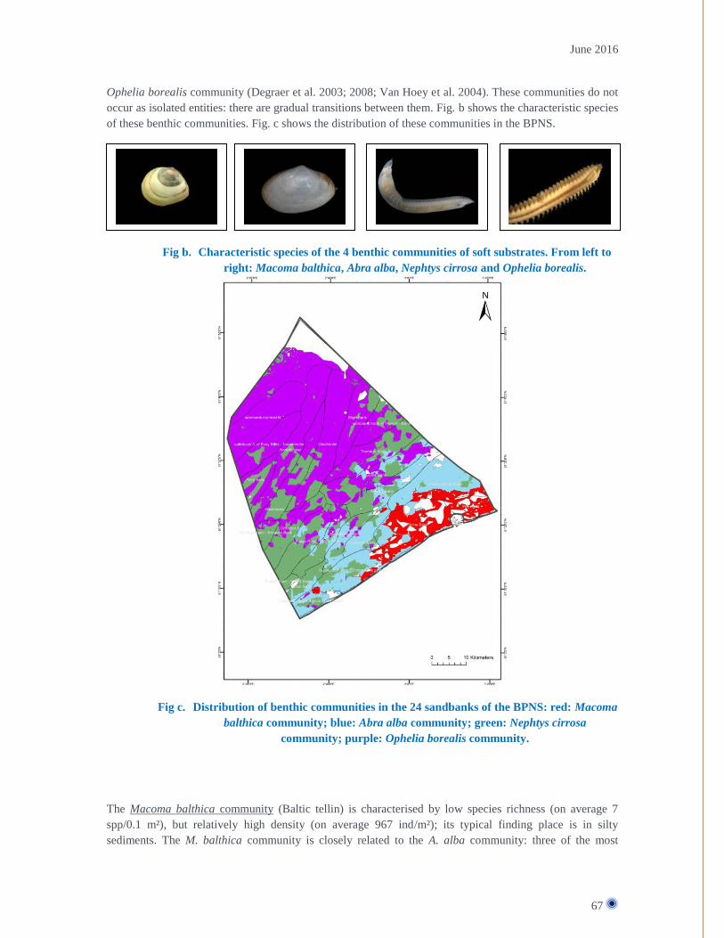
June 2016
67
Ophelia borealis community (Degraer et al. 2003; 2008; Van Hoey et al. 2004). These communities do not
occur as isolated entities: there are gradual transitions between them. Fig. b shows the characteristic species
of these benthic communities. Fig. c shows the distribution of these communities in the BPNS.
Fig b. Characteristic species of the 4 benthic communities of soft substrates. From left to
right: Macoma balthica, Abra alba, Nephtys cirrosa and Ophelia borealis.
Fig c. Distribution of benthic communities in the 24 sandbanks of the BPNS: red: Macoma
balthica community; blue: Abra alba community; green: Nephtys cirrosa
community; purple: Ophelia borealis community.
The Macoma balthica community (Baltic tellin) is characterised by low species richness (on average 7
spp/0.1 m²), but relatively high density (on average 967 ind/m²); its typical finding place is in silty
sediments. The M. balthica community is closely related to the A. alba community: three of the most

June 2016
68
common species are also present in the A. alba community. Characteristic species are: the bristle worms
Cirratulidae and Heteromastus filiformis. A likely explanation for the lower species richness in the eastern
coastal waters is the high concentration of suspended matter.
The Abra alba community is characterised by a high density (6,432 ind/m² on average), high species
richness (30 spp/0.1 m² on average) and it is typically found in fine sand rich in silt. Characteristic species
include the white furrow shell Abra alba, the cut through shell Spisula subtruncata, the bivalve mollusc
Mysella (Kurtiella) bidentata, the caprellid Pariambus typicus, and bristle worms, such as Stenelais boa
and the reef-building sand mason worm Lanice conchilega. The A. alba community also comprises an
abundance of the invasive American jackknife Ensis directus (Houziaux et al. 2012). First found in this
area in 1987, this species now displays average densities of 9 ind/m² in coastal waters.
The Nephtys cirrosa bristle worm community has a low density (402 ind/m² on average) and a low species
richness (7 spp/0.1 m² on average) and typically lives in fine to medium sandy sediments that are very low
in silt. Other characteristic species are: the bulldozer amphipod Urothoe poseidonis and the sand digger
shrimp Bathyporeia spp.
A very low density (190 ind/m² on average) and species richness (5 spp/0.1 m² on average) are typical for
the Ophelia borealis bristle worm community, which can be found in medium- to coarse-grained seabeds.
Another characteristic species is the interstitial bristle worm Hesionura elongata.
The distribution of these benthic communities in the BPNS has been extensively described (Van Hoey et
al., 2004). Species richness and density are highest in the coastal zone and decrease in the direction of the
open sea (see Fig.d). Hence, the ecological value of the coastal zone cannot be denied.
Fig d. Van Hoey et al. (2004). Species richness (species/sample) and abundance (ind/m²)
distribution of the benthic communities across the onshore-offshore gradient in
BPNS. Black dots and solid trend line represent species richness; white dots and
dotted trend line represent species abundance.

June 2016
69
Geogenic gravel beds (code 1170)
The BPNS also contains two habitat types 1170 associated with habitat type 1110: geogenic gravel beds
and biogenic Lanice conchilega aggregates.
Gravel beds are generally recognised as areas of special ecological value: several studies have found that
gravel banks are home to a rich flora and fauna with a high species richness of both infauna and epifauna
on the rocks (e.g. Kühne and Rachor 1969; Davoult and Richard 1988; de Kluijver 1991; Dahl and Dahl
2002; Van Moorsel 2003). These rich communities can only develop if the habitat is not strongly subject to
natural and/or anthropogenic disturbance. Fig. e shows some examples of fauna associated with gravel
beds.
The ecological value of the gravel beds can for instance be illustrated by the example of the European
oyster Ostrea edulis. This reef forming species from the southern North Sea appears to be highly
dependent on gravel beds, but it is now threatened with extinction. Gravel beds also have a key function as
breeding and growing area for various fish species.
Fig e. Examples of fauna associated with gravel beds
In relation to the BPNS in particular, Houziaux et al. (2008) and Van Lancker et al. (2007) studied the
gravel beds in the Hinderbanken and Flemish Banks. These studies show that gravel is found mainly in the
channels between the banks. Especially the gravel beds in the Hinderbanken area are important: historical
data from the Gilson collection of the Royal Belgian Institute of Natural Sciences indicates that at the end
of the 19th century, gravel beds were the most dominant type of habitat in the channel between the
Oosthinder and Westhinder and that they contained a very high biodiversity (Van Beneden 1883, Houziaux
et al. 2008). This data further shows a clear correlation between the distribution of the gravel beds and that
of the European oyster Ostrea edulis (Houziaux et al. 2008). As mentioned above, this species is now
practically extinct in the southern North Sea. It is assumed that these oyster beds acted as source population
for the intertidal oyster populations (Houziaux et al. 2008). The oysters, together with the rocks, were
colonised by a very diverse epifauna (e.g. Pomatoceros triqueter, Sabellaria spinulosa, Haliclona occulata,
Flustra foliacea, Alcyonidium spp., Alcyonium digitatum, Sertularia cupressina, Nemertesia spp.) and
numerous other smaller and more mobile species lived there as well. As such, they constituted the ultimate
hotspot of benthic biodiversity (Houziaux et al. 2008). Fig f shows the (potential) presence of gravel beds
in BPNS.

June 2016
70
Fig f. Mapping of potential gravel areas (yellow zones), sample areas (purple dots),
observed gravel areas (green dots) (Degraer et al. 2009).
Another indication of the ecological importance of gravel beds in BPNS is the recent discovery of two two
small zones near the Hinderbanken. These zones are characterised by a remarkably well-developed fauna of
gravel beds, with a well-developed layer of three-dimensional epifauna species, such as sponges, moss
animals and hydropolyps, which, in turn, are home to a more mobile fauna of, among others, sea sludges,
small crustaceans and worms (Houziaux et al. 2008). It is highly likely that the location of these places
provides a natural shield against seabed-disturbing human activities (such as beam trawling). This refuge
offers an insight into the possible ecological potential of the Belgian gravel banks if the pressure from
operations on the seabed were to be reduced. The refuges are situated in zone 4 of the Flemish Banks (see
below in the document).
Biogenic reefs (code 1170)
The aggregates of the sand mason worm (Lanice conchilega) can be considered a biogenic reef (Rabaut et
al. 2009). Biogenic reefs are also protected under the Habitat Directive as a habitat type 1170 associated
with habitat type 1110. These Lanice conchilega aggregates cause local sediment accumulations, creating
clearly marked structures with specific physical characteristics. The areas where these biogenic reefs occur
are generally large and have a non-continuous pattern ('patchiness') with a 5-18% coverage. Biogenic reefs
form a stable habitat, in the sense that these aggregations continue to exist for several years. Where the
distribution of Lanice conchilega aggregations is concerned, it is found that this largely corresponds to the
distribution of the Abra alba community of the sandbanks. In the Belgian part of the North Sea a 732 km²

June 2016
71
area can be marked out where L. conchilega aggregations of more than 500 ind/m² can be expected (i.e.
20% of the BPNS). Along the west coast the aggregations are located very near the coastline, whereas on
the east coast they lie further from the coast, in the Vlakte van de Raan area. Fig. g shows the habitat
suitability for L. conchilega aggregates. It can be concluded that the coastal area, especially in the western
section of the BPNS, is of special importance for the expansion of the Laniche conchilega aggregations.
Fig g. Habitat suitability map for Lanice conchilega aggregates with a density of > 500
ind/m² as generated using the MaxEnt programme for habitat suitability modelling.
Most likely absent: blue (0); most likely present: red (1) (Degraer et al. 2009). The
Lanice conchilega aggregates can be clearly linked to the Abra alba community (see
fig. above)
Together with the gravel beds, these Lanice aggregations are hotspots of benthic biodiversity in the BPNS.
Thanks to their structuring effect (changing the micro-topography of the seabed), macrobenthic biodiversity
is four to six times higher than the surrounding sediment, while the macrobenthic density exceeds it by 34
times. Furthermore, the aggregates are an important foraging and shelter area for, among others, juvenile
flat fish.25
Lanice conchilega aggregations currently only cover 10-15% of the suitable habitat. If no bottom trawling
were performed, there could be an increase in this degree of coverage. This is because a possible expansion
25
The report on the initital assessment of the BPNS: Belgische Staat, 2012. Initiële Beoordeling voor de
Belgische mariene wateren. Kaderrichtlijn Mariene Strategie – Art 8 lid 1a & 1b. BMM, Federale
Overheidsdienst Volksgezondheid, Veiligheid van de Voedselketen en Leefmilieu, Brussel, België, , p. 21-
24

June 2016
72
of an existing aggregation depends on a successful larval recruitment to the benthos, which is estimated to
be vulnerable to bottom trawling.

June 2016
73
ANNEX 4 – BIOLOGICAL VALUATION: METHODOLOGY For the development of the BVM of the BPNS scientists took a step-by-step approach. First, the most
suitable biological valuation criteria were selected. For the purpose of the BWZee project, “marine
biological value” was defined as “the intrinsic value of marine biodiversity, without reference to
anthropogenic use”, i.e. socio-economic value of biodiversity was not taken into account. The purpose of
the BVM is to provide subzones within BPNS with a label of their intrinsic biological value (low, medium
or high).
Based on existing literature, the following five valuation criteria were selected:
- Rarity: distinguishes subzones which are characterized by unique, rare or distinct features for
which no alternatives exist
- Aggregation: distinguishes subzones where most individuals of a species are aggregated
- Fitness consequences: distinguishes subzones where natural activities take place which contribute
significantly to the survival or reproduction of a population or species.
- Naturalness: distinguishes subzones which are pristine and characterised by native species; and
- Proportional importance: measures the proportion of the national, regional and/or global resource
of a species or feature which occurs within a subzone of BPNS.
The first three criteria were considered the first-order (main) criteria, while the remaining two were used as
modifying criteria to upgrade the value of certain areas when they scored high for these criteria.
Additionally, the concept of biodiversity was also included in the valuation framework.
Second, the marine ecosystem components were selected for which detailed spatial distribution data were
available. A data gathering process revealed that for BPNS, such data was primarily available for
macrobenthos and seabirds for which full-coverage maps could be constructed. Data on spatial distribution
was also available of the demersal fish and the epi- and hyperbenthos, but to a lesser extent. Therefore, data
on these last components was solely used as point data, no spatial extrapolation of the data was performed
to obtain a full coverage distribution map. For other ecosystem components (e.g. sea mammals, pelagic
fish,…) the available data were too sparse or too fragmentary dispersed. The BVM ultimately takes into
account different ecosystem components: seabirds, macrobenthos, hyperbenthos, epibenthos and demersal
fish. The BVM is a synthesis map of valuation maps of the five ecosystem components.
Third, a set of assessment questions for each biological valuation criterion were chosen and applied to the
data of the five ecosystem components, leading to BVM for seabirds, macrobenthos, epibenthos and
demersal fish. Combining these maps allowed producing a marine BVM for the BPNS which integrates all
available biological information for different ecosystem components and clearly shows which areas are
biologically most valuable.

June 2016
74
ANNEX 5 – METHODOLOGY SAND BANK SCORING AND
POTENTIAL SCI DELINEATION Degraer mentions that only the biological value of macrobenthos was taken into account, as organisms
directly linked to the Habitat type 1110. No distinction in value was made between the four macrobenthic
communities (Macoma balthica, Abra alba, Nephtys cirrosa and Ophelia borealis), although the Albra
alba community is generally considered as most valuable because of the presence of the sand mason worm
Laniche conchilega. Degraer et al. (2009) compared the biological value of the different sandbanks while
providing a degree of protection to all four macrobenthic communities present in the BPNS. On this basis,
four protection scenarios were put forward (see Fig. h):
- Scenario 1: At least 5% of each preferential biotope would be protected. In this scenario, around
20% of the Habitat type 1110 would be covered.
- Scenario 2: At least 10% of each preferential biotope would be protected. In this scenario, around
30% of the Habitat type 1110 would be covered.
- Scenario 3: At least 15% of each preferential biotope would be protected. In this scenario, around
40% of the Habitat type 1110 would be covered.
- Scenario 4: At least 40% of each preferential biotope would be protected. In this scenario, around
60% of the Habitat type 1110 would be covered.
Fig h. The four “protection scenarios” of the BPNS as proposed by the report of Degraer
et al (2009) for delineating the Flemish Banks as a Habitat Directive. The four
colours represent the four benthic communities of the BPNS: red: Macoma balthica
community; blue: Abra alba community; green: Nephtys cirrosa community; purple:
Ophelia borealis community.
Based on:
(1) the four scenarios, as guiding for the indication of the potential Habitat Directive areas with
respect to Habitat type 1110,
(2) the spatial distribution of the L. conchilega aggregations and gravel beds (including refuge areas),
it was decided to delineate the Natura 2000 site the Flemish Banks as indicated in Figure i.

June 2016
75
Fig i. Delineation of the Flemish Banks on the basis of the spatial distribution of Habitat
type 1110, Lanice conchilega aggregations and gravel beds (red polygon); 0,
undefined biotope; 1, Macoma balthica biotope; 2, Abra alba biotope; 3, Nephtys
cirrosa biotope; 4, Ophelia borealis biotope.
As you can see, the delineation Flemish Banks are the closest to the above “Scenario 2”, i.e. around 30%
coverage of the Habitat type 1110. However, two sandbanks were not included within the Flemish Banks
despite having been defined as biologically important for management and control reasons: (i) the
Wenduine Bank (Macoma balthica biotope) on the Eastern coastline of BPNS and (ii) the sandbank north
of the Thornton Bank (Nephtys cirrosa and Ophelia borealis biotopes) offshore.
When the 'Flemish Banks' Habitats Directive area was registered, this area was subdivided into 4 areas for
simplification purposes in order to demonstrate where the most valuable and vulnerable parts lie of habitat
types 1110 and 1170 (see Fig. j). The areas A and C were described as the most vulnerable to seabed-
disturbing fishing activities, as these areas contain biogenic reefs and gravel beds (habitat type 1170).
Logically, the areas A and C are hence also the areas where the fisheries measures were proposed.
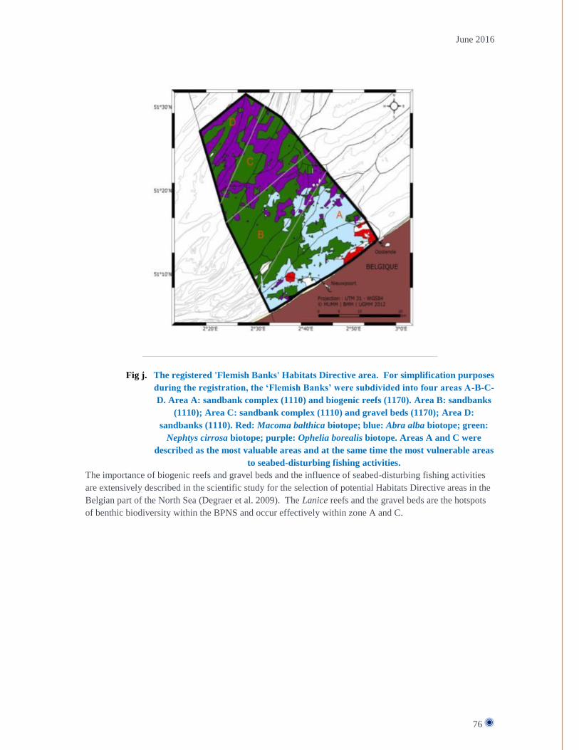
June 2016
76
Fig j. The registered 'Flemish Banks' Habitats Directive area. For simplification purposes
during the registration, the ‘Flemish Banks’ were subdivided into four areas A-B-C-
D. Area A: sandbank complex (1110) and biogenic reefs (1170). Area B: sandbanks
(1110); Area C: sandbank complex (1110) and gravel beds (1170); Area D:
sandbanks (1110). Red: Macoma balthica biotope; blue: Abra alba biotope; green:
Nephtys cirrosa biotope; purple: Ophelia borealis biotope. Areas A and C were
described as the most valuable areas and at the same time the most vulnerable areas
to seabed-disturbing fishing activities.
The importance of biogenic reefs and gravel beds and the influence of seabed-disturbing fishing activities
are extensively described in the scientific study for the selection of potential Habitats Directive areas in the
Belgian part of the North Sea (Degraer et al. 2009). The Lanice reefs and the gravel beds are the hotspots
of benthic biodiversity within the BPNS and occur effectively within zone A and C.

June 2016
77
ANNEX 6 – BELGIAN AND DUTCH FLEET ACTIVITY IN BPNS At the request of the Marine Environment Service, the Institute for Agricultural and Fisheries Research
(ILVO) gathered information about the Belgian, Dutch and British vessels that were active in the BPNS
during the period 2010-2012 (ILVO study)26
.
The Belgian fleet is rather limited (89 vessels in 2011) and is mainly active in non-Belgian waters. During
the period 2010-2012 only 9.4% of the total number of 'active' VMS signals from the Belgian fishing fleet
came from the BPNS. The Dutch fleet is much larger (831 vessels in 2008). In the period 2010-2012 VMS
pings of 125 Dutch fishing vessels were recorded. The ILVO study showed that both the Belgian and the
Dutch fishing fleet, both in the BPNS and within the Flemish Banks, are mainly active in (i) shrimp fishing
and (ii) beam trawling for demersal fish using nets with a mesh size between 80 and 99 mm. Other métiers
present within the Flemish Banks were beam trawling with a different mesh size than 80 to 99 mm, otter
trawling and gill netting, pelagic fishing and pot fishing.
A summary of the results is provided in the table below (Table a). This shows the interactions between the
fishing activities and the proposed fisheries measures within the Flemish Banks. Most interaction takes
place in zone 1 in Belgian shrimp fishing and beam trawling, in zone 2 in Belgian shrimp fishing and Dutch
beam trawling, and in zones 3 and 4 in Dutch beam trawling. Fisheries measures in these zones may have
an influence on the catches of shrimp, sole, plaice and flounder.
Table a Summary table for the Flemish Banks and for sectors 1-2-3-4 per flag state and per métier.
Red: high effort; orange: medium effort; yellow: low effort; white: not fished. Fish species were
mentioned when the catch data for at least one quadrant within the area exceeded 10 tonnes in the
period 2010-2012. * indicates métiers for which no detailed catch analysis was performed.
Shrimp beam trawl
General
26
Pecceu E, Vanelslander B, Vandendriessche S, Van Hoey G, Hostens K, Torreele E, Polet H (2014).
Beschrijving van de visserijactiviteiten in het Belgisch deel van de Noordzee in functie van de aanvraag bij
de Europese Commissie voor visserijmaatregelen in de Vlaamse Banken (Habitatrichtlijngebied). ILVO-
mededeling nr. 156, 92 p.
Flemish Banks Zone 1 Zone 2 Zone 3 Zone 4 Shrimp fishing within 12NM / shrimp shrimp shrimp Beam trawling (70-99) within 3NM / sole, plaice, flounder sole, plaice, flounder
Beam trawling (70-99)>221kW* beyond 12NM Beam trawling (70-99)<=221kW* within 3NM Beam trawling (100-119)* within 12NM Beam trawling (>=120)* within 3NM Otter trawling* within 3NM Standing rigging* beyond 12NM Fly shooting* 3-12NM Shrimp fishing within 3NM Beam trawling (70-99) beyond 3NM / sole, plaice, flounder, dab, cod sole, plaice, flounder sole, plaice sole, plaice Otter trawling* Seine fishing* beyond 3NM Other métiers (no code)*
UK All métiers* beyond 3NM
BE
NL

June 2016
78
Within shrimp fishing the activity of Belgian vessels was the highest (2.5 times higher than the Dutch
activity). Generally speaking, the Dutch shrimp fleet is not very active in the BPNS, but considerable
activity has been detected in the eastern part of the BPNS (Fig. k). Shrimp fishing was concentrated within
the 12 NM zone. The main Belgian activity lasted a little longer (summer and autumn) than the Dutch
activity (especially autumn).
Flemish Banks
Fig k. Spatial distribution of VMS effort for shrimp beam trawls (80-99) of the Belgian
(left) and Dutch (right) fleet in 2010-2012
In the period 2010-2012 the Flemish Banks area was fished mainly by Belgian shrimp fishermen, and high
intensities were observed in zones 1 and 2. In these zones Belgian shrimp fishermen fished all year round,
zone 1 being the most important (an average of 27% of active VMS pings of Belgian shrimp trawlers in the
Flemish Banks were recorded in this zone).
For the Dutch shrimp fleet the number of active VMS pings in the BPNS during the period 2010-2012 was
only 2% of the total number of active VMS pings of the entire Dutch shrimp feet. Of those 2% in the BPNS
only 2% of pings were recorded in the Flemish Banks, mainly in zone 2. In zone 1 only very limited
activity was recorded, and only in autumn. Zones 3 and 4 were neither fished by Belgian nor by Dutch
shrimp fishermen.
Catch
Based on the catch data of the Belgian shrimp fishermen, common shrimp, dab and flounder could be
identified as the most important species, both for the BPNS as a whole and within the Flemish Banks.
These species were caught mainly within the 12 NM zone, with high numbers within the 3 NM zone. Both
zone 1 and, to a slightly lesser extent, zone 2 were important for these species. Shrimp was caught all year
round, the greatest amounts within 3 NM.

June 2016
79
For Dutch shrimp fishermen, the Flemish Banks area was of little importance, as most activity was
recorded along the east coast. Limited amounts of common shrimp, and very limited amounts of dab,
flounder and cod were caught in zone 2 in summer and autumn. In zone 1 only negligible amounts of fish
were caught, and only in autumn.
Fig l. Spatial distribution of shrimp (kg) landed by shrimp beam trawl by the Belgian
(left) and Dutch (right) fleet in 2010-2012
Demersal beam trawl
General
Unlike for shrimp fishing, a substantially higher intensity was recorded for Dutch beam trawling with a net
mesh size between 80 and 99 mm than for the Belgian fleet in the BPNS (4 times higher than the Belgian
one). Belgian beam trawlers fish mainly outside the BPNS. Where spatial and temporal distribution are
concerned, there were important differences between the Belgian and the Dutch fleet.
Flemish Banks
Belgian trawling activities took place all over the BPNS, but the highest concentration occurred within the
3 NM zone. Within the Flemish Banks, zone 1 was the most important of the four defined sectors for the
Belgian beam trawler fleet. In this zone fishing took place mainly in spring and summer. In autumn and
winter there was less activity in this zone and more fishing in the offshore zones (zones 3 and 4). In zone 2
activity was recorded all year round, but at a much lower level than in zone 1. In the offshore zones (zones
3 and 4) fishing took place as well, but the share of VMS pings is never more than 3% of the number of
signals in the Flemish Banks.
For Belgian vessels a distinction was also made between the large and the small fleet segment. The large
fleet segment was found mainly offshore, including in zones 3 and 4 of the Flemish Banks. Limited fishing

June 2016
80
activity was observed in zone 2. The small fleet segment was mainly found in the territorial sea, with peaks
within the 3 NM zone.
Dutch beam trawling was also observed all over the BPNS. Fishing activities took place all year round in
all 4 of the proposed sectors of the Flemish Banks. However, the highest intensities were measured beyond
the 3 NM limit. Thus, generally speaking, beam trawling activity was less intense in zone 1. The spatial
distribution of Dutch beam trawling activities varies depending on the season. In autumn and winter there
was more offshore fishing (in zones 3 and 4), whereas in spring and summer fishing took place closer to the
coast, especially in the area between 3 and 12NM (in zone 2). Fig. m below illustrates that the Dutch beam
trawl fleet is also very active in the coastal zone beyond 3 NM (as the Dutch fleet is highly present in the
entire BPNS). The proposed coastal measure is likely to have effects on large Dutch beam trawls (above 70
GT), while smaller beam trawls will remain allowed. As a result of the proposed coastal measure, large
vessels will in practice have to give up only 6%27
of their fishing grounds in the BPNS. In return however,
the protection of the biologically valuable coastal area (which is most valuable until 6 NM – see section
above 4.2) will increase by 50%28
.
Fig m. Spatial distribution of VMS effort for demersal beam trawls (80-99) of the Belgian
(left) and Dutch (right) fleet in 2010-2012
Catch
Where species caught with a demersal beam trawl (80-99) are concerned, there are considerable differences
between the Belgian and the Dutch fleet. Belgian vessels with a demersal beam trawl (80-99) mainly
caught plaice, sole and flounder in the BPNS and in the Flemish Banks. Generally speaking, especially the
western part (as well as the Flemish Banks) was an important fishing area for Belgian vessels. The largest
amounts of flounder, sole and plaice were caught in zone 1. In this zone, plaice was caught mainly in
spring, flounder in summer and autumn, and sole mainly in spring and summer. Zone 2 was important
especially for the catch of plaice. Fishing also took place in zones 3 and 4, but to a lesser extent.
Where the Dutch beam trawler fleet (80-99) is concerned, mainly plaice, sole and dab were landed. Unlike
for the Belgian beam trawler fleet, most of these amounts were caught in zones 2, 3 and 4. Plaice was
27
6% is the surface area of the extension of the coastal measure from 3 to 4.5 NM. 28
50% protection increase, the increase being from 3 NM to 4.5 NM.

June 2016
81
mainly caught in zone 2 in spring and summer, while fishing activities took place mainly in zones 3 and 4
in autumn and winter. Sole was caught primarily in zones 3 and 4 in autumn and winter, whereas in spring
and summer it was caught more in coastal zones. As for dab, the highest catch figures from BPNS were
measured in summer and autumn. Dab was mainly fished in zone 2 in spring, whereas in winter, zones 3
and 4 were the most used zones. The ILVO study also showed the fish species that were caught to a lesser
extent in the Flemish Banks by Dutch beam trawls (70-99): flounder was mainly caught in zone 2. Zones 3
and 4, on the other hand, were relatively important for Dutch beam trawlers for the catch of lemon dab,
turbot, brill and cod.
Fig n. Spatial distribution of plaice (kg) landed by demersal beam trawl (80-99) by the
Belgian (left) and Dutch (right) fleet in 2010-2012
Fig o. Spatial distribution of sole (kg) landed by demersal beam trawl (80-99) by the
Belgian (left) and Dutch (right) fleet in 2010-2012

June 2016
82
ANNEX 7 – FRENCH FLEET ACTIVITY IN BPNS Maps of the landings for the OTB gear were made for species that had a catch higher than 10 tonnes spread
over 2010:2012. These species were European seabass (BSS), Dab (DAB), European plaice (PLE), Atlantic
Cod (COD), Atlantic horse mackerel (HOM), Atlantic mackerel (MAC) and Whiting (WHG).
Fig p. Landings of Whiting allocated to VMS fishing pings inside the Belgian part of the
North Sea for 2010-2012.

June 2016
83
Fig q. Landings of Atlantic mackerel (MAC) allocated to VMS fishing pings inside the
Belgian part of the North Sea for 2010-2012.

June 2016
84
Fig r. Landings of Atlantic horse mackerel (HOM) allocated to VMS fishing pings inside
the Belgian part of the North Sea for 2010-2012.
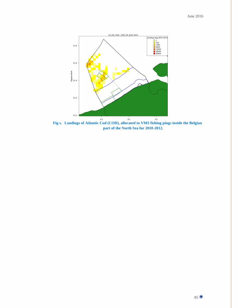
June 2016
85
Fig s. Landings of Atlantic Cod (COD), allocated to VMS fishing pings inside the Belgian
part of the North Sea for 2010-2012.

June 2016
86
Fig t. Landings of European plaice (PLE) allocated to VMS fishing pings inside the
Belgian part of the North Sea for 2010-2012.
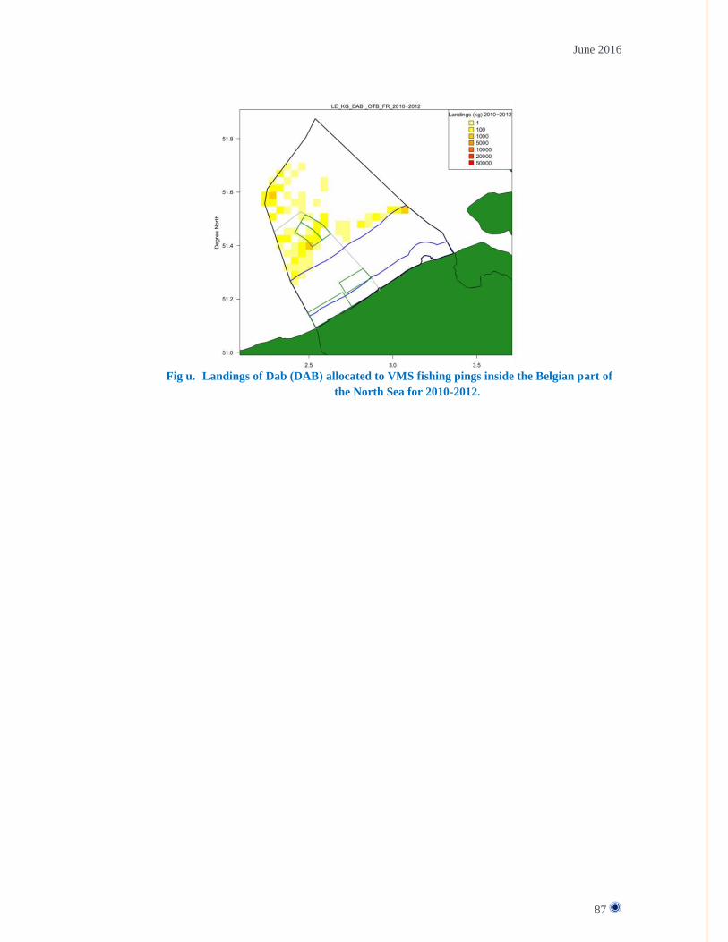
June 2016
87
Fig u. Landings of Dab (DAB) allocated to VMS fishing pings inside the Belgian part of
the North Sea for 2010-2012.

June 2016
88
Fig v. Landings of European seabass (BSS) allocated to VMS fishing pings inside the
Belgian part of the North Sea for 2010-2012.

June 2016
89
ANNEX 8 –BRITISH FLEET ACTIVITY IN BPNS Summary of the UK VMS data:
1605 VMS pings over a 16 month period from UK registered vessels in all of the Belgian sea area.
This is represented in figure w.
37 individual UK registered vessels
1440 of these 1605 pings equate to just 3 vessels.
34 vessels have very low (less than 50 pings each) levels of activity in the Belgian sea area and are
likely to be occasional visitors
Out of the 3 “active” vessels; 1 vessel has 1153 VMS pings and is very active. The other 2 vessels
both have less than 200 VMS pings over a 16 month period. This information is represented in
figure x.
The active vessel is UK registered but has not held a valid UK fishing licence since January 2014
and is now owned by a Dutch operator. This (Dutch owned) vessel is very active across the coast
and has a significant number of pings from within the MPA boundaries. This information is
represented in red in figure x.
Apart from the Dutch owned UK registered vessel, there is very low activity directly in any of the
Belgian MPAs (approx. less than 20pings over a 16 month period).
The Belgian marine spatial plan (MSP) has proposed 4 fishing zones be defined within the boundaries of
the Flemish Banks special area of conversation (SAC) which also overlaps 2 special protection areas for
birds (SPAs). Only specific gears and techniques are to be permitted in each to the 4 defined fishing zones.

June 2016
90
Fig w.
Fig x.

June 2016
91

June 2016
92
ANNEX 9 – DANISH FLEET ACTIVITY IN BPNS Danish fishery in Belgian zone
Belgium has started a process for regulation of the fisheries necessary to fulfil requirements for the Habitat
directive and the Marine Strategy Framework Directive.
A description of the Danish fishery in Belgian zone of the North Sea is requested for the period 2012-2015
for mobile bottom contacting gears, pelagic gears and other gears. The target species are to be included.
Maps with VMS pings and a table with landings in kg, DKK and Euro are requested.
The coordinates for the area including sub-areas can be seen in the attached document. So far, no other
information has been received from Belgium. The underlying proposals have been requested, but haven’t
yet been received.
Method
Landings and the value of the landings within Natura 2000 areas are not registered directly. To give an
estimate the Danish logbook register has been merged with the sales notes register to estimate the weight
and value of the landings by vessel, catch date, gear and species. This information is merged with VMS
data which gives the vessel positions, with a ping-rate of one hour, time and speed. When the gear is
known, the VMS data are filtered by the speeds where fishery is assumed for each gear. To give an
example, landings for one day are distributed on 4 VMS points, where one is within a Natura 2000 area and
the rest are outside the area. ¼ of the landings by species will be assigned to the Natura 2000 area, and ¾
will be assigned to the area outside. The resulting tables are found below.
The Danish fishery within the Belgian Natura 2000 areas is a gillnet fishery. In the maps and tables, this
has been classified as “gillnet” instead of “other gears”.

June 2016
93
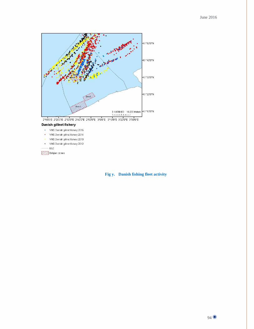
June 2016
94
Fig y. Danish fishing fleet activity

June 2016
95
Fig z. Weight (kg) of landings from Danish vessels by year
Zone Gear Species KG 2012
KG 2013
KG 2014
KG 2015
Zone 3 Gillnet Bass 5 6 0 0
Blue Shark 5 0 0 0
Brill 3 8 1 3
Common Dab 0 27 0 1
Common Sole 151 664 305 199
Edible Crab 1 8 4 1
European Plaice 28 26 29 18
Thornback ray 0 8 2 0
Tub Gurnard 47 77 47 54
Turbot 3 12 7 2
Zone 3 Total 242 835 395 277
Zone 4 Gillnet Bass 1 6 0 0
Blue Shark 5 0 0 0
Brill 2 5 1 0
Common Dab 0 5 0 0
Common Sole 57 588 346 0
Edible Crab 0 8 4 0
European Plaice 13 20 6 0
Thornback ray 0 5 2 0
Tub Gurnard 13 82 45 0
Turbot 0 10 0 0
Zone 4 Total 91 728 405 0
Total 334 1,564 800 277
Table 2: Value of landings (DKK) from Danish vessels by year
Zone Gear EART DKK 2012
DKK 2013
DKK 2014
DKK 2015

June 2016
96
Zone 3 Gillnet Bass 337 418 35 17
Blue Shark 9 0 0 0
Brill 119 331 38 53
Common Dab 0 73 0 8
Common Sole 10,621 32,976 22,536 16,248
Edible Crab 14 190 104 24
European Plaice 230 187 282 222
Thornback ray 0 80 16 0
Tub Gurnard 398 633 601 623
Turbot 167 569 397 129
Zone 3 Total 11,896 35,459 24,009 17,325
Zone 4 Gillnet Bass 82 398 22 0
Blue Shark 9 0 0 0
Brill 69 221 55 0
Common Dab 0 20 0 0
Common Sole 3,862 29,215 25,372 0
Edible Crab 3 181 102 0
European Plaice 107 178 56 0
Thornback ray 0 74 15 0
Tub Gurnard 182 653 613 0
Turbot 0 480 18 0
Zone 4 Total 4,314 31,420 26,252 0
Total 16,210 66,879 50,261 17,325
Table 3: Value of landings (EUR) from Danish vessels by year
Zone Gear Species EUR 2012
EUR 2013
EUR 2014
EUR 2015
Zone 3 Gillnet Bass 45 56 5 2
Blue Shark 1 0 0 0
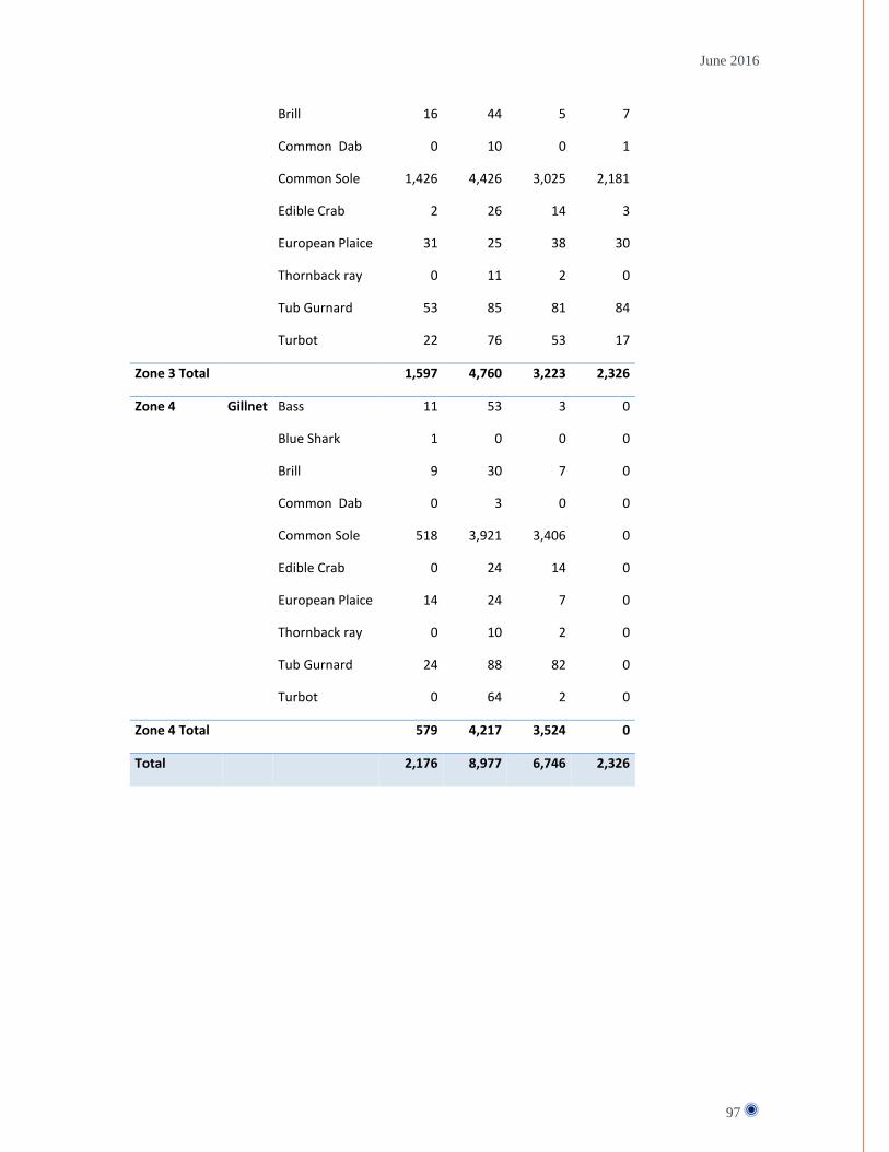
June 2016
97
Brill 16 44 5 7
Common Dab 0 10 0 1
Common Sole 1,426 4,426 3,025 2,181
Edible Crab 2 26 14 3
European Plaice 31 25 38 30
Thornback ray 0 11 2 0
Tub Gurnard 53 85 81 84
Turbot 22 76 53 17
Zone 3 Total 1,597 4,760 3,223 2,326
Zone 4 Gillnet Bass 11 53 3 0
Blue Shark 1 0 0 0
Brill 9 30 7 0
Common Dab 0 3 0 0
Common Sole 518 3,921 3,406 0
Edible Crab 0 24 14 0
European Plaice 14 24 7 0
Thornback ray 0 10 2 0
Tub Gurnard 24 88 82 0
Turbot 0 64 2 0
Zone 4 Total 579 4,217 3,524 0
Total 2,176 8,977 6,746 2,326