Property Rights and Land Markets in St. Luciapdf.usaid.gov/pdf_docs/PNADI942.pdfProperty Rights and...
64
Property Rights and Land Markets in St. Lucia FEBRUARY 2005 This publication was produced for review by the United States Agency for International Development. It was prepared by Development Alternatives, Inc.
Transcript of Property Rights and Land Markets in St. Luciapdf.usaid.gov/pdf_docs/PNADI942.pdfProperty Rights and...

Property Rights and Land Markets in St. Lucia
FEBRUARY 2005
This publication was produced for review by the United States Agency for International Development. It was prepared by Development Alternatives, Inc.

PROPERTY RIGHTS AND LAND MARKETS IN
ST LUCIA U.S Agency for International Development 1300 Pennsylvania Ave, NW Washington, DC 20523-7100 CONTRACT No. LAG –I – 04 – 98 – 00026 - 00 DAI Project No. 4050-104
The authors’ views expressed in this publication do not necessarily reflect the views of the United States Agency for International Development or the United States Government.
ii
PROPERTY RIGHTS AND LAND MARKETS IN ST. LUCIA
P e t e r C . B l o c h S u s a n a L a s t a r r i a - C o r n h i e l C h a r i s s e G r i f f i t h - C h a r l e s
C e l s u s B a p t i s t e R u f i n u s B a p t i s t e
Under Subcontract to Development Alternatives, Inc. Financed by U.S. Agency for International Development,
BASIS IQC LAG-I-00-98-0026-0 DAI Project Number 4050-104
February 2005

iii
Contents H1. Background ��H1
�H1.1 Theoretical Justification ��H1 �H1.2 St. Lucia Context and the Land Registration and Titling Project ��H2
�HLand tenure issues prior to the Registration and Titling Project ��H3 �HReform of legislation in the 1980s ��H3 �HLand Registration and Titling Project ��H5 �HLand tenure structure and land market in mid-1990s ��H8
�H1.3 Overview of Methodology ��H9 �HField survey methodology ��H10 �HSite descriptions ��H12
��H2. Impact on Tenure Security and Land Market Activity ��H12 ��H2.1 Evidence of Tenure Security ��H13
��HLand use ��H13 ��HTypes of land ownership ��H15 ��HPerceptions of tenure security ��H20 ��HSummary ��H21
��H2.2 Land-Based Credit and Investment ��H21 ��H2.3 Land Rental Markets ��H23 ��H2.4 Land Transactions ��H24
��HTransactions by gender ��H25 ��HTransactions by type of ownership ��H26 ��HLand market transactions for sample parcels ���H29
��H2.5. Sustainability of the Land Registry ���H29 ��HLevel of sustainability ���H30 ��HCharacteristics that impact on sustainability ���H31 ��HSummary ���H33
��H3. Costs of Transactions ���H33 ��H3.1 Real Estate Brokers ���H34 ��H3.2 Valuation ���H34 ��H3.3 Map Surveying ���H34 ��H3.4 Subdivision Permits and Costs ���H35 ��H3.5 Legal Fees ���H35 ��H3.6 Mortgage Costs ���H35 ��H3.7 Government Fees and Taxes ���H36
��H4. Land Market Professions ���H37 ��H4.1 Land Surveying ���H37 ��H4.2 Real Estate Brokerage and Valuation ���H39 ��H4.3 Lawyers ���H40 ��H4.4 Bankers ���H42 ��H4.5 The Court System ���H43 ��H4.6 Summary ���H43
��H5. Implications of Findings ���H44 ��H6. References ���H46 ��HAnnex A. Survey Questionnaires ���H49 ��HAnnex B: Registry Data Entry Form ���H57 ��HAnnex C: Types Of Land Ownership by Site ���H58 ��HAnnex D: Number of Parcels with Transactions by Site ���H59

iv
List of Tables ��HTable 1: Types of Registered Ownership, 1987 ���H5 ��HTable 2: Incidence of Individual and Family Land, 1987 (number & percent) ���H6 ��HTable 3: Levels of Land Utilization in Babonneau and Micoud, 2004 ���H13 ��HTable 4: Levels of Land Utilization in Babonneau & Micoud, 1987 & 2004 ���H13 ��HTable 5: Intensity of Land Use by Type of Ownership ���H14 ��HTable 6: Ownership types for four sites as recorded in the Land Registry ���H15 ��HTable 7: Principal ownership types ���H16 ��HTable 8: Types of Ownership in Babonneau & Micoud, 1987 & 2004 ���H17 ��HTable 9: Types of Ownership from Registry Data ���H19 ��HTable 10: Number of Female Owners by Type of Ownership (N=46) ���H20 ��HTable 11: Parcel-Based Credit - 1987 and 2004 ���H21 ��HTable 12: Purpose of credit by parcel size (N=12) ���H22 ��HTable 13: Purpose of Credit by Ownership Type (N=12) ���H22 ��HTable 14: Number of improvements by parcel size (N=60) ���H23 ��HTable 15: Number of Improvements by Type of Ownership ���H23 ��HTable 16: Parcels with at least one land transaction per type recorded in Land Registry ���H25 ��HTable 17: Parcels with at least one transaction, by gender ���H26 ��HTable 18: Parcels with at least one transaction by type of ownership ���H26 ��HTable 19: Parcels with at least one sale by type of ownership ���H27 ��HTable 20: Parcels with at least one mortgage by type of ownership ���H27 ��HTable 21: Parcels with at least one inheritance by type of ownership ���H27 ��HTable 22: How Parcel Holder Obtained Land in Survey Sample ���H29 ��HTable 23: Number of owners as recorded in Land Registry and Questionnaires ���H31 ��HTable 24: Detailed Costs of Transactions (EC$) ���H37
List of Figures ��HFigure 1: Location of Map Sheets Chosen for Registry Data Capture ���H10 ��HFigure 2: Location of Map Sheets Used for Random Sample Selection ���H11 ��HFigure 3: Comparison of Tenure Types in Babonneau, 1987 & 2004 ���H18 ��HFigure 4: Comparison of Tenure Types in Micoud, 1987 & 2004 ���H18 ��HFigure 5: Land Transfers Recorded in Land Registry ���H28 ��HFigure 6: Mortgages Registered in Land Registry ���H28

PROPERTY RIGHTS AND LAND MARKETS IN ST. LUCIA
Land Tenure Center, University of Wisconsin–Madison February 2005
1. BACKGROUND In the first quarter of 2004, a country study was undertaken in St. Lucia to assess the effects
of the USAID-funded Land Registration and Titling Project of the mid-1980s on land market activity. Prior to this country study, a literature review on land markets in St. Lucia was undertaken (Vargas and Stanfield 2003) and can be consulted for further background information. Both are part of a worldwide assessment of USAID investments in land markets and property rights.�F
1
This section will outline the theoretical justification for this country study, a brief description of the Land Registration and Titling Project, and the context in which this project was implemented. A general description of the methodology followed for this country study is also provided.
1.1 THEORETICAL JUSTIFICATION Land tenure theory has suggested that increasing security of tenure by individualizing and recording property rights encourages landowners to invest more money, time and effort in their land, secure in the knowledge that they possess exclusive rights to all returns on their investment (Feder and Nishio 1999). The result is therefore a potential increase in productivity on the land.�F
2 Based on this theory, the Land Registration and Titling Project (LRTP) aimed to achieve an increase in the level of tenure security on the part of the occupiers of land (1) by identifying and recording existing property rights and (2) by creating an institutional and legislative environment that would facilitate the individualization of family land property. The current assessment seeks in part to determine the level of security of tenure as a result of the LRTP. Since security of tenure is difficult to measure directly, the tenure security being experienced by the users of land was determined by administering a questionnaire designed to measure the perceptions of tenure security of a sample group of landholders. The questionnaire posed a series of questions that addressed the issue of security by capturing information not only on what investments had been made on the parcels but also on the perceptions of respondents about what rights and restrictions existed in relation to the activities that they could potentially perform on the land they occupied.
Property theory also posits that access to the accurate, comprehensive, and current tenure status of land reduces the information asymmetry that restricts the volume and frequency of land transactions (Demsetz 1967; Palmer 1996; Feder and Nishio 1999). The LRTP instituted a land titles registry to satisfy this requirement for adequate land tenure information with the objective of invigorating the land market. When both buyers and sellers have confidence in the accuracy 1 For the methodology and conceptual framework of this assessment, see Stanfield and Bloch 2002. 2 More current theory (see for example, Deininger et al. 2003) suggests a more complex causal relationship between individualization of property rights, security of tenure, and increased investment and production.

2
and currency of the tenure database, they are encouraged to participate in the land market. The land market potentially moves land from unproductive landholders to more productive ones and in this way increasing agricultural productivity. To continue to perform efficiently, the land registry must maintain the currency that would allow it to function as an information system. The congruence between what is recorded in the registry and what exists on the ground determines how up-to-date the system is. This country study attempts to assess the currency of the Land Registry in St. Lucia.
1.2 ST. LUCIA CONTEXT AND THE LAND REGISTRATION AND TITLING PROJECT St. Lucia, a small Windward Island in the Caribbean, has been an independent country since 1979. The Island had been under British rule from 1814 and previous to that France had controlled it since 1660. The language and legal norms of St. Lucia reflect the cultural influence of the French. Sugar cane was the main product during the colonial era up until the 1950s; bananas became the main product substituting sugar in the 1960s. The preferential market to the United Kingdom facilitated the development of the banana industry during the 1960s and 1970s. However, there has been concern since the mid 1980s on the over-dependence of St. Lucia’s economy on a single crop. In the 1990s, with the establishment of a single European market and the discontinuing of the protection on the United Kingdom market, the St. Lucia banana industry encountered severe constraints in the export market.
The topography of St. Lucia being mountainous, there is little agricultural land: approximately 5% of the island is arable (7,494 acres) and 23% is devoted to permanent crops (34,957 acres). A Geographical Information System (GIS) constructed for Saint Lucia in the late 1980s showed that only 13% of the land devoted to farming occurs on good quality land and that the land being farmed at that time was sufficient to support only 40% of the rural population (Rojas et al. 1988). Not surprisingly, the contribution from the agriculture, livestock, forestry and fisheries sector to the GDP has been decreasing over the last 20 years: from 14.5% in 1985 to 9.5% in 1995 and finally to 7.7% in 2000. Banana is the principal crop and it contribution has also been declining: 8.4% in 1985 to 3.6% in 2000. Nonetheless, agriculture is responsible for around 64% of the total domestic exports and bananas accounted for over 90% of agricultural exports in 1996 (Government of St. Lucia 1996).
One characteristic of the land tenure system in St. Lucia, shared with other Caribbean states, is the presence of the family-land. According to Bruce (1983), family land emerged in St. Lucia following the end of slavery in the 1800s within the context of French Civil law. Land assigned or bought by former slaves was transferred, unpartitioned, to their heirs. Bruce maintains that: 1) the workings of family land tenure are poorly understood; 2) family land is a Caribbean-wide phenomenon based on labor and economic factors and not a local legal oddity resulting from the Civil Code’s provisions on succession; and 3) family land may perform an important economic safety-net function.
Dujon’s 1995 study documented the persistence of family land in St. Lucia, even after the comprehensive land registration project was implemented. Dujon concluded that family land constitutes a major form of land management in St. Lucia because it is integrated into economic strategies that buffer farmers against unstable markets. Dujon also maintained that the assumed deficiencies in tenure security and low investment levels associated specifically with communal

3
land are unsubstantiated and therefore policies to eliminate this tenure form based on these assumptions are misguided.
Land tenure issues prior to the Registration and Titling Project In 1979 the Government of St. Lucia established a Land Reform Commission to study the issue of land tenure and provide recommendations regarding policy options. The Commission drew from several analyses conducted in the 1970s and public hearings. This Land Reform Commission contributed significantly to increasing the public awareness of the complexity of land reform issues. The studies and hearings of the 1970s and 1980s resulted in three main conclusions:
1. The plantation system has produced a land tenure structure where the majority of holders are on small parcels of poor quality and fragile land, while plantations underutilize their highly productive lands. The 1973/74 agricultural census showed that 92.7 % of all farmers control only 24 % of the land. In contrast, 0.17 % of the farmers, mostly absentee owners, controlled 50% of all cultivable land.�F
3 St. Lucia’s dependency on the export of bananas has contributed to the continuity of the plantation agricultural structure. In 1963, the majority of the 10,000 registered members of the Windward Island Banana Association operated on less than five acres of land.�F
4
2. Much of St. Lucia’s land is held as family land owned by a number of heirs who hold shares in the land, but without a physical partition of the property. Transactions are difficult to arrange for such land, since there may be many owners who are difficult to identify and contact. Investments by any one member of the family may be constrained since other family members can benefit without compensation to the investor. On the other hand, family land may perform an important economic safety net function.
3. By the late 1970s, the archaic system of deed registration had become a relatively inefficient and costly system of defining and protecting rights to land. The registered records were incomplete in that many deeds were vague as to the location of the land and exactly who held what rights to that land.
As a response to this diagnosis, several interventions took place during the 1980s, notably a USAID Agricultural Structural Adjustment Project that included a land registration and titling component.
Reform of legislation in the 1980s Four laws provided the legal structure necessary for implementation of the national Land Registration and Titling Program (LRTP) and the creation of a modern land registry: the Land
3 St. Lucia continues to have a skewed distribution of agricultural land. OAS (1991), citing figures from the Latin American Bureau of the United Kingdom, reported that 75% of the approximately 7,000 farmers that cultivate bananas owned 10 acres of land or less in the mid 1980s. In the mid-1990s, small farmers with less than 5 acres (totaling about 10,000 farmers) controlled only 1% of farmland, while 32% of the area was controlled by middle farmers and 67% by large farmers (Adrien 1996). 4 http://www.slumaffe.org/Agriculture/Extension_Services/Green_Gold/green_gold.html

4
Registration Act, the Land Adjudication Act, the Land Surveyors Act, and the Agricultural Small Tenancies Act.
The Land Registration Act (No. 12 of 1984) replaced the laws governing the ineffective deed registration system. Under the old legislation, the registrar was under no obligation to scrutinize documents beyond seeing to it that they were in the form prescribed by law. Reasonable assurance that a proposed seller had good title to convey could only be obtained through a laborious and exceedingly costly title search by a legal practitioner. Under the new registration system, the state examines each title to be registered and, having determined its validity, registers the land and guarantees the title. The title is then unassailable except on grounds of fraud. Once the system is in place, the accuracy of the register is maintained by a requirement that all transactions in land must be registered in order to be valid. The certainty of title is thus perpetuated and not permitted to deteriorate with the passage of time.
In addition, the Act provides for a “trust for sale” mechanism to facilitate the transfer of family land by assuring any purchaser that he or she is indeed acquiring clear title. Under a trust for sale, the power to sell or subject a family land parcel to a mortgage is vested in a family trustee or a limited number of trustees, who are listed on the registry. The trustees remain accountable to the other co-owners for their share in the proceeds of the sale, but a purchaser’s title is not affected by the fact that some of the co-owners were not consulted or did not agree to the sale.
The Land Adjudication Act (No. 11 of 1984) provided for a systematic survey of parcels and the adjudication of titles, a precondition to registration of titles and their guarantee by the State. During the titling and registration project, an area was declared an adjudication section, and a team headed by an Adjudication Officer identified all the parcels of land in the section and surveyed their boundaries. Notice was given for all those with interests in those parcels to bring forward their claims. Both ownership and other interests in land, such as leases and mortgages, were noted. Disputes were resolved by the Adjudication Officer, whose decisions could be appealed to a three-man tribunal and then to the court of Appeals. When the adjudication process was completed for the section, the first Land Register and Land Registry Index Map were prepared from the adjudication record, and the new land-registration system began to function in that section.
The Land Surveyors’ Act (No. 13 of 1984, with Amendments Nos. 1 and 8 of 1986) replaced the Surveyors and Boundaries Settlement Ordinance and the Colony Survey Ordinance. The new law provides, in a manner consistent with the Land Registration and Land Adjudication Acts, for the licensing of land surveyors, the conduct of surveys, and the preservation of survey marks.
Together these three acts created a new legal infrastructure for improving the functioning of the land market. Because registration confers a guarantee of title, a purchaser can now confidently rely on the information shown on the register, and a lender may do the same in accepting a registered parcel as security. The new system reduces land disputes and facilitates the resolution of those that still do arise. Finally, the systematic mapping of all parcels and the computerization of registry records provides the Government with an automatically up-dated database on land for a variety of planning purposes.
The Agricultural Small Tenancies Act provides a legal framework for leases of small agricultural holdings, which have often been handled on a relatively informal basis and have thus

5
been the object of considerable uncertainty for both landlords and tenants. The Act regulates the creation and termination of such tenancies, their assignment and subletting, compensation for improvements upon termination, and a variety of additional matters. The Small Tenancies Act does not regulate rental rates, and is intended primarily to provide both parties with that security of expectations which is conducive to good resource husbandry.
Land Registration and Titling Project The land registration and titling and tenure project was designed to produce three outputs:
1. A survey of all lands outside the National Forest Reserve, boundary demarcation of existing holdings, identification of land owners, and a recording of these data.
2. A new land registry system based on this survey.
3. A land tenure code embodied in the new legislation to regulate and record private land transactions.
At the time the titling and registration project was being designed, a tenure individualization program was to be implemented, to facilitate land transactions including the conversion of family lands to individual ownership. The St. Lucia Development Bank planned to offer 10-year mortgages at commercial interest rates of 11-13% for 80% of the holdings valued up to US$ 20,000. The mortgages would allow an heir of family land to buy out the other heirs’ shares. The farmer’s share in the family land being purchased would count toward the 20% down payment, and family shareholders would receive the value of their shares in cash and debentures. Due to a lack of funds and mounting cultural resistance, the Government did not implement the tenure individualization program. Many family members maintained their right to family land ownership for the sense of independence and long-term security it provided. This could not be measured in the monetary values set forth in the program’s original guidelines.
Table 1: Types of Registered Ownership, 1987
Type of ownership Number Percent
Individual ownership 70 37
Ownership in common 61 32
Heirs of a deceased person 49 26
Joint ownership 2 1
Unclear or multiple 7 4
Total 189 100.0
Source: Stanfield 1988
The LRTP demarcated, and recorded a total of 33,287 parcels, 5,944 of which were in the urban area of Castries. The only study of the LRTP was done by the Land Tenure Center in 1987-88. A statistical sample of 189 parcels was selected in four regions: Babonneau, Micoud, Choiseul, and Millet. Field interviews were conducted with holders of these sample parcels and

6
data from the registry and LRTP records were tabulated. Table 1 shows the forms of registered ownership for the sample parcels resulting from the LRTP (LTC 1988; Stanfield 1989.)
The adjudication of ownership by the LRTP required an assessment of who had the rights of ownership to each parcel of land. Of the sampled parcels, 37% were adjudicated to individuals and another 32% to owners in common. Owners in common were, in most cases, husband and wife, although in some cases of probated wills property was awarded to two or more people as ownership in common. Just over a quarter of the parcels were adjudicated to “the heirs of ...” in individual shares, that is, as family land.
This adjudication category, “the heirs of ...”, clearly indicates that the parcel was and continues to be family land. However, it is likely that other parcels were also in this category. In most cases of “proprietors in common” where the number of co-owners are three or more, it appears reasonable to consider such parcels as family land. If there were only two co-owners, it is likely that they are husband and wife, although it is possible that some of these situations could be classified as family land. Table 2 shows the relative distribution of land for each of the four areas sampled using these definitions.
Table 2: Incidence of Individual and Family Land, 1987 (number & percent)
Type of ownership Ownership Types by Survey Site
Babonneau Micoud Choiseul Millet Total
Individual 41 57.7% 9 22.0% 9 20.9% 11 37.9% 70 38.0%
Husband & wife 14 19.7% 18 43.9% 10 23.3% 11 37.9% 53 28.8%
Family land 16 22.5% 14 34.1% 24 55.8% 7 24.1% 61 33.2%
Totals 71 100% 41 100% 43 100% 29 100% 184 100%
Source: Stanfield 1988
Analysis of the baseline data came to several conclusions regarding the land registry, family land, tenure security, mapping, and land use intensity and investment. A land registry for the entire country was created, containing the registry map of all parcels, the parcel register, as well as the parcel files containing the field data concerning the claims made to the LRTP and the decisions made as to the interests in each parcel. A Registrar of Land was appointed, and staff and office space were provided to the Land Registry. The parcel files, the register, and the maps are in the Registry and easily accessible to Registry staff. Notaries are using the Registry on a daily basis, as is the general public.
The creation of a functioning Land Registry for over 33,000 parcels within approximately three years is impressive. This achievement is moderated, however, by the difficulties the LRTP had in resolving the alleged problems of family land. Approximately one-third of the parcels in the country was still in this status as of 1988. Few family land parcels were partitioned and the ownership individualized through the LRTP. Thus, this aspect of the hypothesized problem of ownership insecurity, which provided much of the original justification for the project, remains to be resolved.
7
At least three factors contributed to this lack of LRTP success in dealing with the family land issue. The legal framework of the LRTP was probably inadequate at the initiation of the project. The Civil Code’s rules for handling family-owned parcels were different from those incorporated into the Land Registration Act and the Land Adjudication Act. This led to confusion between the common law concepts of proprietorship in common and adjudications in favor of the heirs of a deceased person, on the one hand, and the Civil Code concepts of community property and rights of survivorship, on the other. Furthermore, the proposed mechanism of trust for sale for resolving the lack of negotiability of family land parcels (as defined in the Land Registration and the Land Adjudication Acts) proved inadequate, both in terms of the difficulty of applying the notion in specific circumstances as well as in terms of the resistance to the concept by families and attorneys on the grounds of its unfairness.
These problems with the formulation of the Land Registration Act and the Land Adjudication Act for the first two years of the project were multiplied by the amendment of the two acts in early 1987. These amendments removed the clause in the Land Registration Act, which had stated that the new act took precedence over any preceding and potentially conflicting rule of law. This action by Parliament to remove the priority of the Land Registration Act opened the door to questions as to which body of law was to be applied in the operation of the new Land registry, the Land Registration Act or the Civil Code. More recently, the Courts have ruled on the finality of the adjudication record and this has provided the basis for widespread acceptance of the new Land Registration process.
Finally, the experience of the LRTP and the reluctance of the St. Lucian people to modify the family land form of tenure bring into question the adequacy of the initial strategy to individualize family land parcels. The advantages of this tenure form and the difficulties encountered in sorting out all interests in an equitable but individualistic way appear to outweigh the problems this tenure form generates. It seems advisable that institutional means be found to deal with the problems of family land holdings when they arise, rather than struggle to eliminate or fatally weaken the arrangement.
The LRTP did affect ownership security by providing absolute and provisional titles to those holders of land who did not possess adequate legal documentation of their ownership prior to the LRTP. However, in some cases this titling involved the awarding of provisional titles which did not resolve the original underlying difficulties behind the lack of legal title, even though absolute title could possibly be acquired in the future. The inability to award absolute titles corresponds in large part to the inability to resolve the family land issues. Only about 50% of the family land parcels were awarded absolute titles. Thus, the LRTP improved the ownership security of about 20% of the claimants to land, leaving about 27% with provisional title with many of the same insecurities of ownership that existed previously. About 57% of absolute titles were based on already secure documentation of ownership prior to the initiation of the LRTP.
The demarcation and mapping done by the LRTP may prove to one of its strongest contributions to improving the property system of St. Lucia. Prior to the LRTP, only 20% of the parcels had an adequate survey plan, and 23% had no written description of the boundaries whatsoever. The remainder had very approximate descriptions. Following the LRTP, all parcels are described in the Registry’s parcel map at a scale of 1:2500 for rural areas and 1:1000 for urban ones. This represented a substantial improvement in accuracy and availability of parcel boundary information.

8
With regard to land-based credit and investment, a major rationale for the LRTP was that it would reduce disincentives to farmers investing in or using the land to its maximum potential. This was hoped to occur as a result of LRTP (1) reducing tenure insecurity and (2) increasing farmers’ access to formal credit. Regarding access to credit, the baseline study found that prior to the LRTP the use of parcels as collateral had been rare. The ownership of those parcels used for collateral, however, was well documented.
The baseline study found regional differences in the distribution of family land. Assuming a connection between family land status and credit availability, areas like Choiseul, with a high proportion of family land and provisional titles, were likely to remain in a disadvantageous position unless explicit policy measures were devised to overcome this unfavorable circumstance. Yet, even among parcels that were documented with deeds, the percentage used for local collateral remained small, about 20% at the time of the completion of LRTP.
Regarding land use intensity, the baseline study found that almost three-quarters of the parcels were utilized to most of their potential extent. Underutilization was most marked in Choiseul and Micoud, where less than half of the area is cultivated in 25% or more of the parcels. The baseline study also found out that rented parcels displayed the least favorable qualities in terms of flexibility of land use (in particular, tree planting) and conservation practices. The baseline survey data suggested that, to the extent that ownership documentation was improved by the LRTP, land rental might become more common. Rental may be more acceptable or less risky to a landowner with title document who has less ground to fear that a renter would establish a claim that subsequently would not be able to be countered.
Finally, the pervasive belief that family land tenure itself (that is, its organizational principles) inhibits intensive exploitation of land resources was only partially supported by the baseline study. The study revealed that lower investment does exist for those operating family land holdings. However, the baseline study questioned if the appropriate response to this condition was the destruction of this tenure form by policy fiat, or if a better strategy was to modify or develop new initiatives in the institutions serving agriculture to support such holdings and increase the potential of their productivity. Dujon (1995) later validated this conclusion.
Land tenure structure and land market in mid-1990s The 1996 Census of Agriculture provides some information regarding land tenure changes that may be useful in assessing land market impacts. The number of agricultural holdings had increased by 16% since the 1986 Census. On the other hand, the total land area devoted to agriculture showed a decline of 12% as compared to the 1986 Census. Regarding the land tenure forms, the 1996 Census show that family land continues to be the predominant form of land tenure (46%). There has been a 4% increase (1,098 in absolute numbers) since 1986 in the number of individually-owned parcels. And the number of squatter parcels decreased from 11% in 1986 to 7% in 1996.
A review of the land distribution data over the last three decades seems to show that there is a better distribution of agricultural land at present, although the distribution pattern is still somewhat skewed. In 1974, 88% of the smaller holdings with land held 24% of the land, and 0.2% of the larger holdings operated just over 37% of the land. By 1996, 81% of the smaller landholdings controlled almost 48% of the land, while less than 0.1% of the larger holdings hold

9
just under 11% of the total land. The Gini coefficient for land concentration supports this evolution towards a better distribution of land declining from 0.9 in 1973/74 to 0.8 in 1996.
The only available study on agricultural land markets since the LRTP is by Dujon, who conducted fieldwork in 1992 in the areas of Micoud and Choiseul. The survey of 87 holdings was formulated to elicit comparative information for freehold and family land holdings about management practices, crops grown, levels of investment, disposal of produce and land transfer practices. Originally the holdings sampled were divided into four different tenure categories: private; family land; a combination of the two, and holdings converted from family land to absolute title (freehold) as a result of the LRTP. Dujon found that it was difficult to identify farmers in the last category, since the number of conversions that took place was insignificant. In fact, “only one farmer was identified in that category” (Dujon 1995: 66). Regarding land market activities, Dujon concluded that “currently there is no active open land market and even with the establishment of the new Land Registry where all parcels and owners are clearly identified, there is unlikely to be one in the near future” (Dujon 1995: 57).
1.3 OVERVIEW OF METHODOLOGY As the previous section indicates, little information was found regarding the agricultural land market in St. Lucia since the Land Registration and Titling project of the mid 1980s. In order to gather more specific information on the agricultural land market since the LRTP, a country study was undertaken in early 2004 utilizing several different methods of data collection. These included a random survey of landholders in two of the four sites surveyed in 1988, data capture from the Land Registry, and key informant interviews with land market professionals.
The Land Registry data were collected from title documents and parcel files�F
5 for the four sites studied by LTC in 1987-88. In 1987, map sheets were chosen randomly for each of the four sites resulting in a total of 15 map sheets. In 2004, these 15 map sheets contained approximately 1,000 agricultural parcels.�F
6 Figure 1 shows the location of the map sheets in the four sites: Babonneau in the north, Tete Chemin (sometimes called Millet) in the center, Micoud in the southeast, and Choiseul in the southwest.
Two of the sites, Babonneau and Micoud, were selected for the purpose of the sample survey. Sixty parcels were randomly selected from the 7 map sheets for these two sites—thirty from each site. The areas of Babonneau and Micoud were chosen since they represent a peri-urban district (Babonneau) where urban, residential use is impinging on agricultural use and a largely agricultural area (Micoud) noted for its banana production. In the 1987 baseline study, Babonneau was characterized as having predominantly individualized tenure, which should have facilitated subsequent land market activity. Micoud, conversely, had a larger percentage of parcels held by multiple owners—family land. Together, therefore, the two areas represent both ends of the land market spectrum: if individualization of property rights promotes land market activity, one would expect such activity to be vibrant in one area and relatively slow in the other. More detailed information on the field survey method is offered below.
5 The data capture sheet designed to capture the Land Registry information is reproduced as Annex B. 6 Defined as parcels equal to or greater than 0.4 hectare (1 acre). Data were also collected for smaller, non-agricultural parcels, but were eliminated from the data analysis.

10
Simultaneous to the collection of the Registry and field data, key informant interviews were carried out with land market professionals—surveyors, valuers, lawyers, and bankers—to obtain their knowledge regarding land market transactions and to determine their role in these transactions.
Figure 1: Location of Map Sheets Chosen for Registry Data Capture
Field survey methodology Parcels to be surveyed in the field were randomly selected from parcels equal to or larger than 0.4 hectares on the map sheets for the Babonneau and Micoud sites.�F
7 In this way the analysis serves to focus on the benefits accruing to the rural agricultural sector, as this was the target for the project even though the project systematically titled the entire country (Stanfield 1988). The approximate locations of the sampled areas with respect to the administrative districts of St. Lucia are shown in Figure 2. Questionnaires were administered in person to 30 users of parcels in each of the two areas.�F
8 The survey questionnaires are reproduced in Annex A.
7 To verify the representativeness of the sample parcels, their characteristics, especially ownership types, were compared to the characteristics of all the agricultural parcels in the corresponding map sheets. 8 The sample size of 30 was chosen since standard statistical tests for population means allow the use of samples of size 30 or greater whether distributions are normal or non-normal.
Babonneau
Tete Chemin
Micoud
Choiseul

11
To administer the questionnaires for the study, information on the name and contact address of the registered owners was extracted from the land registry and used to locate the parcel holder in the field. Since St. Lucia has no household postal delivery service, addresses are generally the nearest post office where personal mail is collected. Locating specific persons is therefore difficult without happening to encounter the individual’s neighbors, friends or acquaintances. Even this method of locating the individual is problematic since many St. Lucians are known by several different names, not all of them known to even close relatives. In some instances the parcel was visited in an attempt to contact the owner, however this method was seldom successful because of the currently reduced levels of cultivation. In a few instances the search for the owner or user was eventually abandoned especially as some landowners were temporarily out of the country or were residing abroad. In these instances, replacement parcels were chosen from within the random sample.
Figure 2: Location of Map Sheets Used for Random Sample Selection
These areas should give an indication of how the LRTP impacted the country. Since these two areas had also been surveyed in the 1987 baseline study at the end of the LRTP, the statistics
Babonneau
Micoud

12
obtained in the current survey could be compared with those obtained from the original study to determine levels of change. The baseline survey had randomly sampled the same map sheets. However, in the baseline study no distinction was made in respect to size of parcel when selecting the sample to be surveyed. Also all users of the sampled parcels and all parcels held by those users were included in the baseline survey, resulting in a larger sample size for both parcels and users. Time, cost, and labor constraints precluded a survey as extensive as the baseline study in this instance.
Site descriptions The rugged terrain in Babonneau is under development pressure for residential purposes. Rural Castries, which encompasses part of Babonneau, has the largest and fastest growing population of all administrative districts in St. Lucia based on the Government Statistics Department (Government of St. Lucia 2004). Figures for 2001 indicate a population of 51,213 in rural Castries, up from 39,090 in 1990, a 31% increase. Agricultural use is being converted to residential use to accommodate the incoming population. The existing infrastructure cannot support this increase in population that was not anticipated when it was originally constructed. Whatever infrastructure there is, however, directs the expansion outwards from the Castries center.
The topography in Micoud stands in sharp contrast to Babonneau as large flat areas present an opportunity for less arduous agricultural activity. Wide, well paved roads and the expectation of employment on the banana plantations attracted people to the area all through the banana boom in the 1980s and continuing into the 1990s. However, with the downturn in agriculture and attendant loss of employment opportunities in agriculture in this region, a politician recently opined that Micoud was one of the poorest regions in the country. Recent data show a population of 16,051 in the Quarter of Micoud in 2001, only a 6% increase from 15,178 in 1990. Pockets of state-owned land are considered prime for informal development and this has occurred through the years in Micoud, adding to the increase in the population of poorer households.
Banana production, the mainstay of St. Lucian agriculture, has declined from 112,540 tons in 1986 at the end of the LRTP, to 33,972 tons in 2003 (Government of St. Lucia 2004). Many banana plantations have been abandoned by its cultivators. Problems being experienced by farmers that encourage the decision to leave the previously lucrative banana production include (a) lower guaranteed prices for produce and (b) rejected fruit because of a current ‘leaf-spot’ infestation and strict export quotas maintained by the export company. Vegetable production suffers from a limited local market and a lack of a ready export market. Livestock production is also experiencing problems in local distribution and marketing systems.
2. IMPACT ON TENURE SECURITY AND LAND MARKET ACTIVITY This section presents results regarding tenure security and market activity from analysis of the Land Registry data and the 2004 field survey data. Indications of whether the Land Registry is being utilized by landholders to record land transactions was also done by comparing Land Registry data and the 2004 field survey data.
13
2.1 EVIDENCE OF TENURE SECURITY Since increased security of tenure is hypothesized to lead to improved land use and increased access to credit, changes in land use intensity and in the number of instances where credit is sought can be used as indicators of changes in security of tenure. Tenure type, perceptions, and levels of renting out of land were also used as measures of security of tenure.
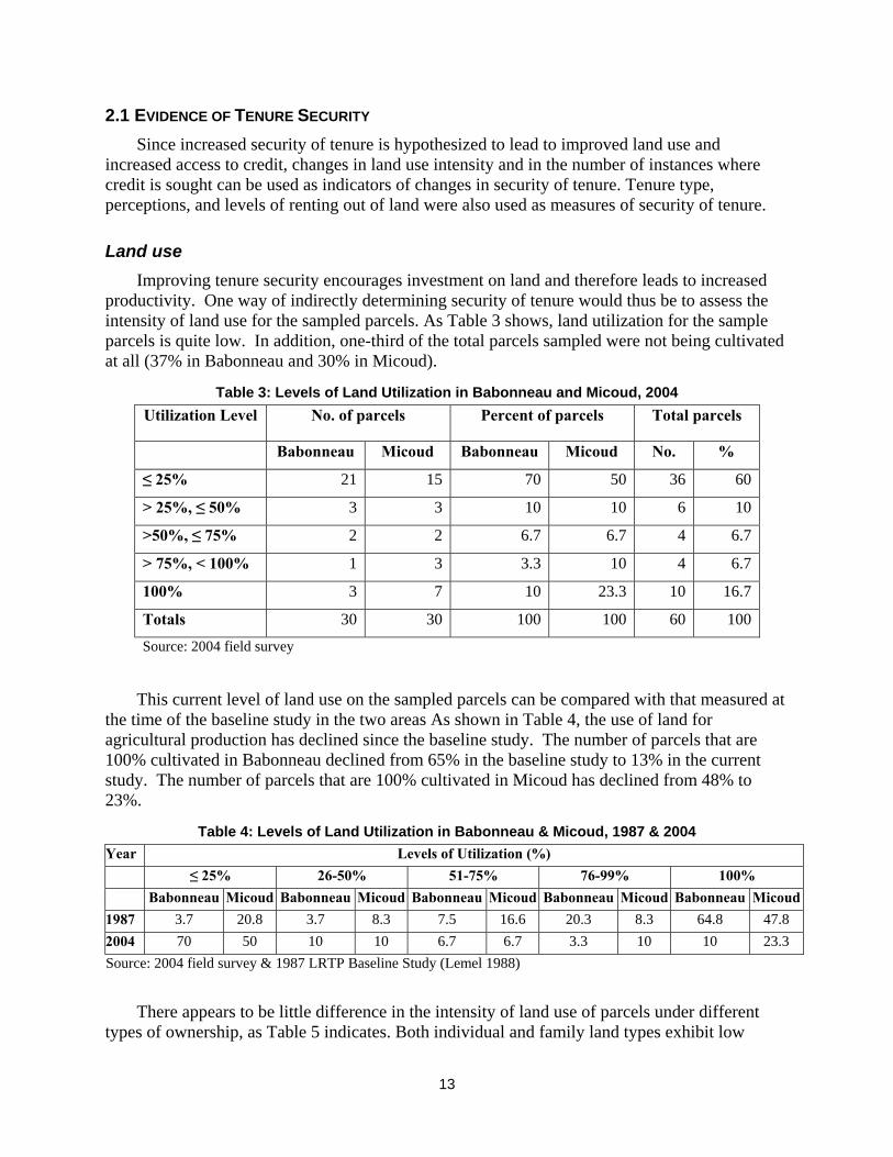
Land use Improving tenure security encourages investment on land and therefore leads to increased productivity. One way of indirectly determining security of tenure would thus be to assess the intensity of land use for the sampled parcels. As Table 3 shows, land utilization for the sample parcels is quite low. In addition, one-third of the total parcels sampled were not being cultivated at all (37% in Babonneau and 30% in Micoud).
Table 3: Levels of Land Utilization in Babonneau and Micoud, 2004 Utilization Level No. of parcels Percent of parcels Total parcels
Babonneau Micoud Babonneau Micoud No. %
≤ 25% 21 15 70 50 36 60
> 25%, ≤ 50% 3 3 10 10 6 10
>50%, ≤ 75% 2 2 6.7 6.7 4 6.7
> 75%, < 100% 1 3 3.3 10 4 6.7
100% 3 7 10 23.3 10 16.7
Totals 30 30 100 100 60 100
Source: 2004 field survey
This current level of land use on the sampled parcels can be compared with that measured at the time of the baseline study in the two areas As shown in Table 4, the use of land for agricultural production has declined since the baseline study. The number of parcels that are 100% cultivated in Babonneau declined from 65% in the baseline study to 13% in the current study. The number of parcels that are 100% cultivated in Micoud has declined from 48% to 23%.
Table 4: Levels of Land Utilization in Babonneau & Micoud, 1987 & 2004 Year Levels of Utilization (%)
≤ 25% 26-50% 51-75% 76-99% 100% Babonneau Micoud Babonneau Micoud Babonneau Micoud Babonneau Micoud Babonneau Micoud
1987 3.7 20.8 3.7 8.3 7.5 16.6 20.3 8.3 64.8 47.8 2004 70 50 10 10 6.7 6.7 3.3 10 10 23.3 Source: 2004 field survey & 1987 LRTP Baseline Study (Lemel 1988)
There appears to be little difference in the intensity of land use of parcels under different types of ownership, as Table 5 indicates. Both individual and family land types exhibit low

14
cultivation percentages, with a majority of parcels having less than 50% utilization. This suggests that the persistence of family land does not contribute to the explanation for low utilization. In other words, our sample does not provide support for the supposition that family land tenure reduces land use intensity – and therefore that individualization would increase it.
Table 5: Intensity of Land Use by Type of Ownership Percent land cultivated
Type of Ownership none 1-25% 26-50% 51-75% 76-100% Total
Individual 37% 26% 4% 7% 26% 100%
In common 100% 100% 0% 0% 0% 100%
Family land 29% 26% 16% 6% 23% 100%
All Ownership types 34% 27% 10% 7% 24% 100%
Source: 2004 field survey & 2004 Land Registry data
Reasons given by field survey respondents for underutilization of the parcel were:
• the insurmountable problem of ‘praedial larceny’�F
9 that usually but not exclusively affects crops other than bananas
• inaccessibility of the parcel because of topography or limits in the road network
• the declining profitability of banana production
• the advancing age of the owner, coupled with the reluctance of the younger generation to pursue an agricultural career
• the lack of commitment of employed labor
• the fear of having to negotiate a lengthy legal process to recover the land if it were leased out for agricultural use.
None of these reasons save the last is directly related to perceptions of security of tenure and this demonstrates that factors other than security of tenure also impact on land use. The landowners’ fear that their rights would not be institutionally or legislatively supported over the rights of lessees does however impact negatively on their perceptions of security of tenure. In the baseline survey, reasons given for not increasing utilization of parcels included: (a) age and shortage of labor, (b) shortage of money (capital), (c) land was rented, not owned, (d) bad location of land, (e) poor land quality or size of parcel, and (f) parcel is family land (Lemel 1988).
Despite the low utilization levels, 33% of the respondents in both Babonneau and Micoud are totally dependent on agriculture for their monthly income. On the other hand, for 50% of those in Babonneau and 47% of those interviewed in Micoud, agriculture does not contribute at all to their monthly income.
9 ‘Praedial larceny’ is a legal term to define theft of agricultural produce. The term is widely known and used by the general population in the Caribbean.

15
The property taxation system in St. Lucia may also contributes to the low level of utilization since the level of taxation is very low and is currently not enforced; there are, however, plans to do so using the land registry information system as support. Agricultural land is taxed only on parcels more than 5 acres in size and then at a low rate of EC$0.25 per acre that does not make enforcement economically worthwhile to the state (Land and House Tax Ordinance Cap 217). Whereas land taxation can theoretically be used as a disincentive to speculation and under-utilization of land, this mechanism is not functioning in this environment. Only 2 of the 60 respondents mentioned tax as a disadvantage of land registration.
Types of land ownership Family land ownership is defined in St. Lucia and elsewhere in the Caribbean as land held
by multiple persons in undivided ownership, usually acquired through intestate inheritance (Bruce 1983, Stanfield 1988; Crichlow 1994; Maurer 1997). In the early 1980s when the LRTP was implemented, family land ownership was believed to reduce security of tenure, since multiple ownership may interfere with decision-making about land use. Thus, it sought to reduce the incidence of family land by individualizing tenure based on occupation, and also by providing alternative legal mechanisms for decision-making such as trusts for sale. More recently, the advantages of group ownership have become better understood,�F
10 and a more flexible approach to titling and management of land is used.
Table 6: Ownership types for four sites as recorded in the Land Registry Registry ownership types 1986-87 2004
1. individual ownership 322 314
2. ownership in common 5 39
3. undivided ownership 222 189
4. executor/administrator 27 50
5. trust for sale 80 93
6. heirs of … 256 225
7. rights of survivorship 4 1
8. crown 82 76
9. crown and private 4 4
10. other 33 44
Total no. of parcels* 1035 1035
* some missing data Source: 2004 Land Registry data & l987 LRTP Baseline Study
To have a general overview of current ownership types in St. Lucia, we will look at the Land Registry information for the more than 1,000 properties in the four baseline sites. As a prelude, 10 “Group rights are more appropriate if [for example] there are economies of scale and externalities, if risk coping and mutual insurance are important, and if benefits from land-related investment are low” (Deininger 2003: 29).

16
Table 6 presents information on the types of land ownership recorded in the Land Registry at the time of the baseline survey (1987) and in 2004 (Annex C breaks down the information by site).
These multiple ownership types conceal the various ways family land is legally recognized and recorded in the Land Registry. Family land is privately owned land held in pro indiviso��F
11 by numerous owners, whose exact number and identity are not legally recorded, and may not even be known. If we aggregate those categories that are family land parcels (nos. 4, 5, 6, and 10), family land comprises more than one-third of the parcels (Table 7), ranging from two-thirds in Choiseul to around one-fifth in Babonneau and Millet. Not only does the share of family land remain high, but it also has increased slightly, especially in Babonneau which is thought to have the most land market activity.
Table 7: Principal ownership types Principal Ownership Types 1986-87 2004
Individual 31.1% 30.3%
In common + undivided 21.9% 22.0%
Family land* 38.3% 39.8%
Crown 8.3% 7.7%
* family land defined as the total of ownership types no. 4, 5, 6, and 10.
Source: 2004 Land Registry data & 1987 LRTP Baseline Study
A surprising observation from Table 7 is that the percentage of ownership types across family land, individual (one owner), and joint property (husband and wife and other identified multiple owners) in the four study sites has not really changed in the nearly 15-years since the LRTP was implemented. Percentage changes between the two time periods in all principal ownership types varies less than one percentage point with the exception of family land which increased by 1.5%.
In the 2004 survey sample on two of the study sites, a large percentage of parcels are individually owned (by one person or a married couple��F
12); but family land is also common. The ownership analyzed here is current ownership as reported by the interviewee as opposed to what is listed in the land registry. Compared with the baseline data, as shown in Table 8, there has been an increase in the percentage of family land parcels in both Babonneau and Micoud, at the expense of individual ownership (whether by one person or married couple). The reasons for the increase could be economic or cultural. The cost of partitioning, including survey, legal, and registration costs may be prohibitive in the depressed economy currently existing in St. Lucia,
11 Each owner’s share of land is not demarcated—the entire parcel is owned by all owners. 12 Community title was introduced by the LRTP to record marital (wife & husband) property (Stanfield 1988: 87). Deterville (1988: 43) explains this type of individual (not family land) property: “[T]he property is owned by the [marital] community and the spouses each have a one-half share in the community, not in the undivided property owned by the community. … On the dissolution of the community (by death, divorce, or on order for separation) the property of the community is partitioned on the basis of an undivided one-half share to each spouse.”

17
particularly in the agricultural sector.��F
13 Some owners of interests in family land may traditionally be reluctant to partition land and individualize tenure for fear of inciting conflicts within the family over land. Attorneys interviewed stated that they continue to comply with requests to vest land in multiple (family land) ownership in instances of inheritance. In addition, interest in partitioning is low as there are few or no alternative profitable uses for the land in the current economic environment.
Table 8: Types of Ownership in Babonneau & Micoud, 1987 & 2004 1987 2004
Babonneau Micoud Babonneau Micoud
Type
of
Ownership No. % No. % No. % No. %
Individual 41 57.7 9 22.0 17 56.7 12 40
Husband and wife 14 19.7 18 43.9 4 13.3 5 16.7
Family land 16 22.5 14 34.1 9 30 13 43.3
Totals 71 100 41 100 30 100 30 100
Source: 2004 Land Registry data & 1987 LRTP Baseline Study (Stanfield 1988)
In some instances the process of locating absent owners delays or stalls the process of partitioning, transferring title, and registration after the death of the registered owner. In one instance, the administrator had been trying to determine the whereabouts of a half sibling who lives abroad since the death of his father in 2000. This matter has not yet concluded. In another instance, portions of the parcel were partitioned in 1999 and transferred to some of the members of the family, who reside locally, leaving the remainder of the land in multiple ownership for the member of the family who could not afford surveying charges at the time and for another member of the family who currently resides abroad.
The graphic depiction of the change in tenure types between 1987 and 2004 in Figures 3 and 4 shows that while there is an increase in family land it is partly at the cost of the number of parcels owned by both husband and wife. This reduction of land titled as marital (in common) property may be an indication of (1) a cultural reluctance to title land in the name of both wife and husband, and (2) the number of non-married consensual unions (only married couples may use the in-common title).
13 Typical earnings of persons employed in the agriculture, hunting and fishing sector as at 1999 are given as EC$2,350 for males per month and EC$1,200 per month for females (Government Statistics Department 2000), while the legal fees for transferring a 5-acre parcel of land are in the area of EC$3,500 and the survey fees for surveying a 5-acre parcel of agricultural land are EC$5,900.

18
Figure 3: Comparison of Tenure Types in Babonneau, 1987 & 2004
Comparison of Tenure Types in Babonneau (1987 and 2004)
0%10%20%30%40%50%60%70%80%90%
100%
1987 2004
Time of Survey
Perc
enta
ge o
f Ten
ure
Type
Family landIn common (husband and wife)Individual
Figure 4: Comparison of Tenure Types in Micoud, 1987 & 2004
Comparison of Tenure Types in Micoud (1987 and 2004)
0%
10%
20%
30%
40%
50%
60%
70%
80%
90%
100%
1987 2004
Time of Survey
Perc
enta
ge o
f Ten
ure
Type
Family land
In common (husband and w ife)
Individual
S
If the incidence of family land is taken as an indicator of insecurity of tenure because of the restrictions in use placed on the multiple owners, then it would appear that landowners are less

19
secure than at the time of the baseline study.��F
14 The baseline study used this method of defining and empirically testing for tenure insecurity. However when it is borne in mind that security of tenure is a perception felt by occupiers it would seem that persons feel sufficiently secure on multiple-owned parcels and so do not actively seek the individualization and registration of land in which they have an interest. The perceptions of occupiers are examined in a subsequent section.
The 2004 registry data on private parcels of 0.4 hectare or more indicate a higher percentage of individualization, particularly in Babonneau as is shown in Table 9. However, as is explored later in this report in relation to sustainability of the registry data, there exists some discrepancy between the ownership recorded in the Land Registry and what actually exists in the field.
Table 9: Types of Ownership from Registry Data Babonneau Micoud
Type of Ownership Number Percent Number Percent
Individual 130 50 90 33.1
In common (husband and wife) 57 21.9 77 28.3
Family land 71 27.3 105 38.6
Totals 260 100 272 100
Source: 2004 Land Registry data
From the registry, we were also able to find out how many women owners were listed for 46 of the 60 parcels in the field survey.��F
15 Table 10 shows that while the great majority of individually owned parcels (82%) are owned by men, all of the family land parcels have both women and men as owners. Jointly-owned—or property in common—parcels are usually a married couple and would thus have one woman owner. As has been pointed out in other literature and in the 1987-88 LRTP study, family land offers women an opportunity to have legal rights to land, a right that is more difficult for women to obtain when land becomes individually owned. The fact that property titled in both spouses’ names has declined from the time of the LRTP is a further indication that family land, in contrast to individually titled land, offers women greater opportunity for ownership rights.
14 This points out the inadequacy of family land as a de facto indicator of insecurity, and also the difficulty with the use of insecurity as a hindrance to productivity-enhancing investment. Still, whatever the mechanism, the high and even growing incidence of family land interacts with the land market and financial institutions to depress the potential for improved land use and productivity. 15 For 14 of the family land parcels, the registry data did not list all of the owners, making it impossible to know how many owners that parcel had and how many were women.

20
Table 10: Number of Female Owners by Type of Ownership (N=46) Number of Female Owners Type of Ownership
0 1 3 4
Individual (n-27) 81% 19% 0% 0%
Joint (n=2) 0% 100% 0% 0%
Family land (n=31) 0% 65% 30% 6%
Total 48% 39% 11% 2%
Source: 2004 Land Registry data
Perceptions of tenure security Security of tenure was explored in the survey by directly inquiring about perceptions regarding potential conflicts over land rights and over rented land. For the sampled areas, 83% of those interviewed felt that it was impossible for their claim of ownership to the land they occupied is disputed by another person. The 10% that felt that a counterclaim was likely, believed that their own rights would be confirmed eventually based on the documents they possessed. This documentation usually consists of a deed of sale, a will or deed of purchase of the deceased owner, and the long occupation of the family. These figures therefore demonstrate the high level of security of tenure felt even on land under multiple ownership. Tenure systems serve to give public notice of ownership claims. Where land is commonly known to belong to a particular group after longstanding occupation, only membership in the group is required to be proven. Contestation of claims of occupation would in these instances come from within the group rather than from others.
Security of tenure for rented parcels should be supported by institutional, legislative and policy structures for optimum productivity to occur. Both the lessor and the lessee must feel their rights protected to invest in the land. While over half of the interviewed landowners (52% in Babonneau and 62% in Micoud) feel secure that they could recover their land from a lessee at the end of the agreed lease period, 48% in Babonneau and 38% in Micoud feel insecure about leasing land since they believe that it would be difficult or impossible to recover the land at the end of the leased period. The perception is that the law favors the occupant of the land and the anticipated long and expensive legal process to recover the land prevents some landowners from renting the land. Increasing confidence on the part of landowners that they would recover the land would help to provide access to land for those who cannot afford to acquire land and would allow land to be utilized where it would otherwise be left idle.
Renters indicated that they felt security of tenure because they rented from relatives or friends, because the rental agreement had been of many years standing, or because they themselves had kept records such as payments records, receipts, or contracts witnessed by a Justice of the Peace or a lawyer. While the legal requirement for registration of leases is supposed to protect both sides in the contract, it is not utilized for this purpose. The reasons could be that both sides feel sufficiently protected by other structures or that the procedure for using the formal lease mechanism is too costly, complex or incompatible with what the society is

21
familiar. A final reason may be that landowners, as stated above, feel insecure about leasing land and would therefore be reluctant to record a leasehold in the Land Registry.
Summary The LRTP increased security of tenure by the adjudication of conflicting and unsupported claims to land at that point in time. Indirect measures of assessing security of tenure such as land use, tenure individualization, and willingness to rent are confounded by economic and cultural factors. For the focus population, the sample survey found lowered levels of land use since the baseline study, little or no tendencies toward increasing individualization, and little willingness to formally rent out land. On the other hand, the perception of tenure security as stated by the respondents was high.
2.2 LAND-BASED CREDIT AND INVESTMENT Accepted theory postulates that improved tenure security encourages landowners to seek access to credit to invest in the land. The 2004 survey reveals that 77% of the respondents in Babonneau and in Micoud had not accessed credit since the LRTP, nor had they even attempted to access credit. Even the vibrant economy and flourishing agricultural sector of the late 1980s and early 1990s had not encouraged attempts to access credit. The level of credit use as compared with that of the baseline study in 1987 is shown in Table 11. It would appear that land titling and registration have not increased the use of credit for investment in land. The perception that the use of credit is risky and leads to loss of land and other assets is prevalent. Even though 53% felt confident that they could obtain credit from any institution, 13% volunteered that they did not want any credit. Only one of the 60 persons interviewed felt that lack of credit had hampered ability to develop the land.
Table 11: Parcel-Based Credit - 1987 and 2004 Babonneau Micoud
1987 2004 1987 2004 Use of Parcel as Collateral No. % No. % No. % No. %
Yes 15 20 6 23 5 17 6 23
No 60 80 24 77 24 83 24 77
Totals 75 100 30 100 29 100 30 100
Source: 2004 field survey & 1987 LRTP Baseline Study (Stanfield 1988)
Of the 12 persons who had obtained credit since the LRTP was implemented, the breakdown by size of parcel��F
16 reveals that parcel size does not seem to influence credit access (Table 12). Nor does it seem to influence what the credit was used for. With the exception of the 2-5 hectare parcels where all the credit was used for house building, credit use across parcel size was pretty much distributed between house building and non-farm investment.
16 The parcels were grouped into four size categories that simulate a normal curve.

22
Table 12: Purpose of credit by parcel size (N=12) Purpose of Credit
Parcel size (ha.)
Agricultural investment
House building
Non-farm business
Total
0.4 – 1.0 (n=3) 0% 67% 33% 100%
1.1 – 2.- (n=3) 33% 0% 67% 100%
2.1-5.0 (n=4) 0% 100% 0% 100%
5.1 - (n-2) 0% 50% 50% 100%
Total 8% 58% 33% 100%
Source: 2004 field survey
Of the 12 parcel holders who had obtained credit since 1987, almost 60% were individual owners, they used credit for building a house or for non-farm business (Table 13). Only one-third were family landowners and three-quarters of those loans were used for house-building. There was only one case of credit for agricultural investment, obtained for a jointly owned parcel.
Table 13: Purpose of Credit by Ownership Type (N=12) Purpose of Credit Type of
Ownership Agricultural Investment
House Building
Non-Farm Business
Total
Individual (n=7) 0% 57% 43% 100%
Joint (n=1) 100% 0% 0% 100%
Family land (n=4) 0% 75% 25% 100%
Total 8% 58% 33% 100%
Source: 2004 field survey
Information on land improvements was collected in the sample survey by asking respondents whether certain investments had been undertaken on their parcel since the land registration project. These improvements include tree planting, purchase of farm animals, terracing, irrigation, farm building, among others (consult Annex A for the complet list of improvements). The most common improvements were trees, farm buildings, and farm animals. Analysis of this data by parcel size category reveals that small parcels have had none or few improvements (Table 14). On the other hand, 40% of large parcels had also not experienced any improvements. It appears that the middle-sized parcels (between 1 and 5 hectares) received the greater number of improvements.

23
Table 14: Number of improvements by parcel size (N=60) Number of Improvements
Parcel Size (ha.) none 1-2 3-5
0.4 – 1.0 (n=12) 58% 42% 0% 100%
1.1 – 2.- (n=23) 26% 52% 22% 100%
2.1-5.0 (n=20) 10% 75% 15% 100%
5.1 - (n-5) 40% 40% 20% 100%
Total 28% 57% 15% 100%
Source: 2004 field survey
The number of improvements on sample parcels by ownership type (Table 15) reflects land use levels described in the previous section: 25-30% of both family and individually owned land has had no improvements. At least half of all three types have had 1-2 improvements. And 18% of individually owned land has experienced 3-5 improvements. Overall, close to three-quarters of the surveyed households have made improvements on their land—this could be attributed to improved security of ownership which lowers risk and provides incentives for investment.
Table 15: Number of Improvements by Type of Ownership Number of Improvements
Type of Ownership None 1-2 3-5
Individual (n-27) 26% 56% 18% 100%
Joint (n=2) 50% 50% 100%
Family land (n=31) 28% 58% 13% 100%
Total 28% 57% 15% 100%
Source: 2004 field survey
2.3 LAND RENTAL MARKETS In the 2004 survey, renting out land appears to be a mechanism for keeping the land clear of overgrowth on the part of the owner or for assisting an acquaintance or family member and not as a means of obtaining income. Therefore in most instances there is no rental payment or sharecropping arrangement. Fifteen percent of the parcels surveyed in Babonneau and 17% of the parcels in Micoud have been leased out or are being cultivated by someone other than the owner. By way of comparison, 36% of the parcels in the 1987 baseline study were being cultivated by non-owners (Lemel 1988). It would appear that the LRTP has therefore not resulted in an increase in the access to land by non-owners.
Loans are not given on leased land. However, there are very few registered leases by the state for agricultural purposes and very few registered leases on private land even though there are a significant number of yearly rentals by the crown for agricultural purposes.
24
The state has been leasing out agricultural Crown land for some decades under a policy to make land available to smallholder farmers. The Office of Commissioner for Crown Lands (CCL) has administered the program. Approximately 1,000 acres of Crown land are rented out; this represents about 27% of Crown land. The remainder of Crown land (not including forest reserves, state parks, and lands vested in statutory bodies such as the National Development Corporation and the National Housing Corporation) are used by the state itself or are leased for commercial purposes. Over 50% of this tenancy land is located in the southern part of the island in the Vieux Fort, Micoud, and Praslin areas.
This tenancy program was quite active until the mid-1990s. These rentals are annual agreements, renewed each year. The majority of rentals is for parcels of 5-10 acres and is generally in the household head’s name. Initially, the yearly rental was EC$10 per acre; in 1994, the yearly rental was increased to EC$100 per acre. This rental rate is considered below market level. Currently, there are not many new tenants; most tenants are now older and have been renting for many years. Tenancies can be passed on to family members at death or retirement. According to the Crown Land Commissioner, younger persons (either new or heirs of older tenants) appear to be less productive farmers. Some tenancy land is being returned to the state.
No permanent structures can be built on tenancy land, although some tenants have built chattels (small houses that can be moved). No bank mortgages can be made on Crown land tenancies. Previously, production credit and services were available from the state development bank based on certificates from CCL.
The CCL sometimes purchases land on the market; it also assumes ownership of land that has never been granted to private parties and escheat land (land on which no one holds title or documentation). For example, Woodland Estate was recently purchased by the state. Plans for this land include putting some under watershed protection and some into tenancies. An inventory has been undertaken of Crown land—the results of the inventory and analysis of the situation should be available later in 2004.
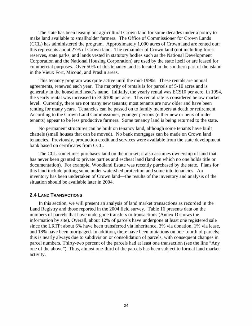
2.4 LAND TRANSACTIONS In this section, we will present an analysis of land market transactions as recorded in the Land Registry and those reported in the 2004 field survey. Table 16 presents data on the numbers of parcels that have undergone transfers or transactions (Annex D shows the information by site). Overall, about 12% of parcels have undergone at least one registered sale since the LRTP; about 6% have been transferred via inheritance, 3% via donation, 1% via lease, and 18% have been mortgaged. In addition, there have been mutations on one-fourth of parcels; this is nearly always due to subdivision or consolidation of parcels, with consequent changes in parcel numbers. Thirty-two percent of the parcels had at least one transaction (see the line “Any one of the above”). Thus, almost one-third of the parcels has been subject to formal land market activity.

25
Table 16: Parcels with at least one land transaction per type recorded in Land Registry
All four sites*
Transaction Number Percent
Sale 113 11.8%
Inheritance 56 5.8%
Donation 26 2.7%
Lease 10 1.0%
Mortgage 169 17.6%
Any one of the above 312 32.5%
Mutation ** 245 25.5%
Total no. of parcels 960 100%
*excluding Crown land **mutations usually indicate a subdivision or consolidation of parcels
Source: 2004 Land Registry data
The larger proportion of sales in Micoud is likely due first to the banana boom, which made land there very attractive, and then the boom’s collapse, which made it much less so but may have forced owners to sell. Choiseul has by far the lowest numbers of sales and mortgages, as well as all transactions. The very low rate of transfer via inheritance,��F
17 fairly consistent among the four sites, is probably the principal reason for which the Land Registry is gradually going out of date.
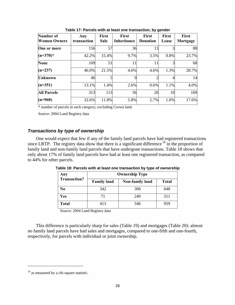
Transactions by gender It is difficult to gain insight into gender issues from the Land Registry data. The only available information is whether there are any female owners listed for a given parcel. Table 17 shows that parcels with one or more female owners have somewhat lower rates of transactions, especially sales and mortgages, than parcels with no female owners. But the differences between these two categories are minor compared to the difference between them and the parcels where the number of owners – both male and female – is unknown. This category is composed virtually entirely of family land parcels (which are likely to have female owners).
17 Actuarially, one would expect inheritances to have amounted to something like 2% or 3% annually from 1987 to 2004, so that the figure for actual inheritances would be 35-50% over the 17 years since LRTP. Some of the “missing” inheritances can be accounted for by the increase in the number of executors or administrators who are shown as acting for the owners.
26
Table 17: Parcels with at least one transaction, by gender Number of Women Owners
Any transaction
First Sale
First Inheritance
First Donation
First Lease
First Mortgage
156 57 36 13 3 88One or more
(n=370)* 42.2% 15.4% 9.7% 3.5% 0.8% 23.7%
109 51 11 11 3 68None
(n=237) 46.0% 21.5% 4.6% 4.6% 1.3% 28.7%
46 5 9 2 4 14Unknown
(n=351) 13.1% 1.4% 2.6% 0.6% 1.1% 4.0%
313 113 56 26 10 169All Parcels
(n=960) 32.6% 11.8% 5.8% 2.7% 1.0% 17.6%
* number of parcels in each category; excluding Crown land. Source: 2004 Land Registry data
Transactions by type of ownership One would expect that few if any of the family land parcels have had registered transactions since LRTP. The registry data show that there is a significant difference��F
18 in the proportion of family land and non-family land parcels that have undergone transactions. Table 18 shows that only about 17% of family land parcels have had at least one registered transaction, as compared to 44% for other parcels.
Table 18: Parcels with at least one transaction by type of ownership Ownership Type Any
Transaction? Family land Non-family land Total
No 342 306 648
Yes 71 240 311
Total 413 546 959
Source: 2004 Land Registry data
This difference is particularly sharp for sales (Table 19) and mortgages (Table 20): almost no family land parcels have had sales and mortgages, compared to one-fifth and one-fourth, respectively, for parcels with individual or joint ownership.
18 as measured by a chi-square statistic.
27
Table 19: Parcels with at least one sale by type of ownership Ownership Type
Any Sales? Family land Non-family land Total
No 406 435 841
Yes 7 111 118
Total 413 546 959
Source: 2004 Land Registry data
Table 20: Parcels with at least one mortgage by type of ownership Ownership Type
Any Mortgage? Family land Non-family land Total
No 398 392 790
Yes 15 154 169
Total 413 546 959
Source: 2004 Land Registry data
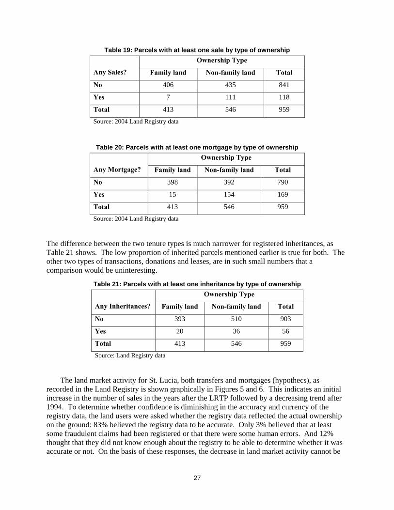
The difference between the two tenure types is much narrower for registered inheritances, as Table 21 shows. The low proportion of inherited parcels mentioned earlier is true for both. The other two types of transactions, donations and leases, are in such small numbers that a comparison would be uninteresting.
Table 21: Parcels with at least one inheritance by type of ownership Ownership Type
Any Inheritances? Family land Non-family land Total
No 393 510 903
Yes 20 36 56
Total 413 546 959
Source: Land Registry data
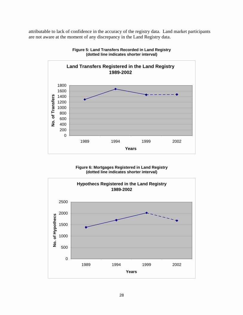
The land market activity for St. Lucia, both transfers and mortgages (hypothecs), as recorded in the Land Registry is shown graphically in Figures 5 and 6. This indicates an initial increase in the number of sales in the years after the LRTP followed by a decreasing trend after 1994. To determine whether confidence is diminishing in the accuracy and currency of the registry data, the land users were asked whether the registry data reflected the actual ownership on the ground: 83% believed the registry data to be accurate. Only 3% believed that at least some fraudulent claims had been registered or that there were some human errors. And 12% thought that they did not know enough about the registry to be able to determine whether it was accurate or not. On the basis of these responses, the decrease in land market activity cannot be
28
attributable to lack of confidence in the accuracy of the registry data. Land market participants are not aware at the moment of any discrepancy in the Land Registry data.
Figure 5: Land Transfers Recorded in Land Registry
(dotted line indicates shorter interval)
Land Transfers Registered in the Land Registry 1989-2002
0200400600800
10001200140016001800
1989 1994 1999 2002
Years
No.
of T
rans
fers
Figure 6: Mortgages Registered in Land Registry (dotted line indicates shorter interval)
Hypothecs Registered in the Land Registry 1989-2002
0
500
1000
1500
2000
2500
1989 1994 1999 2002
Years
No.
of H
ypot
hecs

29
To summarize, there is a low level of formal land market activity on agricultural parcels in St. Lucia. Over the 17 years since LRTP, only one-third of the parcels had any type of transactions, or about 2% per year. Sales, mortgages and inheritances all average fewer than 1% per year, indicating that some transactions, especially inheritances, are probably not registered.
Land market transactions for sample parcels The field survey in Babonneau and Micoud contained questions concerning land transactions, including how the holder had obtained the parcel. Sixty-eight percent of the sample parcels in Babonneau and 83% in Micoud had not had any transactions; subdivision and sale, mortgages, sales or leases, performed on them. There is therefore a low level of land market activity. The method by which the parcel owner in the current sample obtained the land compared with the method by which the parcel owner in the baseline sample obtained the land, is shown in Table 22. The largest category by which owners obtained land is still inheritance. This statistic has increased since the baseline study while the percentage of owners obtaining land by purchase has decreased. This further indicates a lowered level of land market activity.
Table 22: How Parcel Holder Obtained Land in Survey Sample 1987
(all four sites) 2004
Babonneau 2004
Micoud 2004
(two sites) How parcel was obtained
No. % No. % No. % No. %
Inherited 70 47.9 14 53.8 16 61.5 30 57.7
Purchased 64 43.8 10 38.5 10 38.5 20 38.5
Long possession 1 0.7 1 3.9 0 0 1 1.9
Other 11 7.5 1 3.9 0 0 1 1.9
Total 146 100.0 26 100 26 100 52 100
Source: 2004 field survey & 1987 LRTP Baseline Study (Stringer 1988)
Fifty-three percent of the respondents in Babonneau and 63% in Micoud had not purchased, sold or rented in or out, parcels other than the parcel occupied since the LRTP. While no informal sales were reported, there was one instance where the person registered as owner stated that she had sold the parcel to another person several years previously with a lawyer preparing the documentation. She supposed that the lawyer would have registered the sale and had never checked the land registry records herself to confirm that the transfer had been recorded.
2.5. SUSTAINABILITY OF THE LAND REGISTRY The initial establishment of a land title registration system by systematic adjudication and survey is an important aspect of the development of an efficient and effective land tenure and cadastral information system. The adjudication and systematic survey process serves to resolve many enduring conflicts and prevents others from arising. However, the maintenance of the title registration system is equally important for preserving the security of tenure achieved by the adjudication and recording of tenure (Dale and McLaughlin 1999; Groot and McLaughlin 2000).

30
Without maintenance, the integrity of the system erodes over time leading to lack of confidence in the information presented, which can negatively impact on efforts to invigorate the land market. With this in mind, the land registration system in St. Lucia was assessed for currency and accuracy by comparing the data in the Land Registry with data acquired in the field from the sample survey.
The maintenance of the registry depends on the acceptance and the adoption of the whole concept and structure of the system by the society. Certain inherent characteristics of the system, and how these characteristics are perceived by potential users, encourage the society to adopt and so maintain the system (Rogers 1983; Chan and Williamson 1999). These characteristics are posited in theories of diffusion of innovations. Incentives or penalties may also be used to foster maintenance. The characteristics inherent in an innovation that impact on its acceptance and adoption by the user group are given as: the relative advantage to the user of adopting the innovation, its compatibility with the predecessor technology, the relative complexity of the technology or innovation, the ‘trialability’ or whether the user group can experiment with the use of the technology without committing to adoption, and observability or whether the user group can observe others adopting. The characteristics of the group that is adopting the innovation also impacts on the diffusion process. Cultural characteristics that impact on the adoption of innovation include how the society deals with power hierarchies, problem solving, gender differences, individuality, and long or short-term orientation (Hofstede 1980; 1991). The characteristics of the land registration system and the perceptions of the landholders, as users of the system, were investigated in the St. Lucian context within the sample survey.
Level of sustainability The level of congruence between the registry data and what obtains on the ground can be assessed before attempting to determine what factors contribute to the status. The sample survey revealed that 61% of the parcels sampled in Babonneau and 55% in Micoud were titled in the name of the current user. The user of the parcel, as defined here, includes both the owners and the lessees who were in occupation of the parcel at the time of the survey. In Babonneau, 19% of the users and 36% in Micoud did not have any documents to support their occupation. These were the users who had informal lease or rental arrangements with the owners or persons who had inherited parcels or shares in family land but had not transferred the title. For 18% of the parcels, the registered owner was deceased and this was not recorded in the registry data. In one case, the persons registered as owner during the LRTP had died intestate and his wife had subsequently died, also intestate. The current owners, after two unregistered de facto transfers, are the 7 adult offspring of the original owner. One of the heirs stated that she and her siblings had no immediate intention of registering themselves as the current owners since they did not see the need: their ownership was unchallenged, the parcel was under-utilized as accessibility was difficult, and they all deplored seeking credit.
If we consider only the owners (and not all users), 69% of the owners in the Babonneau sample and 65% of the owners in the Micoud sample are titled owners. This means that 31% of the owners in Babonneau and 35% of those in Micoud (31% overall) are unregistered owners.
Another point of comparison is the number of owners for each parcel. Table 23 compares the number of owners listed in the registry with the number of owners measured in the interviews. This again indicates an almost 30% disparity between the registry and the field data.

31
Table 23: Number of owners as recorded in Land Registry and Questionnaires Number From Questionnaires Total
1 2 3 or more
1 22 1 4 27
2 4 5 2 11
Number
From
Registry
3 or more 3 3 15 21
Total 29 9 21 59
Source: 2004 field survey & 2004 Land Registry data
None of the lease arrangements found in the field was registered despite the fact that the lease period had been continuous for many years beyond the stipulated two years required for registration of leases by the Land Registration Act No. 12 of 1984. Reasons given for failure to register leases included the fact that the owner of the parcel was not registered,��F
19 the lease was an informal one with no payment or sharecropping arrangement involved, and that the lease was a month-to-month arrangement. Most of the respondents, however, simply stated that the arrangement was a private one and should not require registration.
These figures, both for ownership and lease, reflect some lack of accuracy and currency of the registry data. Some owners were content to remain as executors or administrators of the deceased’s estate for many years without settling the estate and registering the new owners, while others simply continued to occupy the parcel after the death of the registered owner.
Characteristics that impact on sustainability To assess the perceptions of the potential users of the land registration system about the characteristics of the system and so the likelihood of acceptance and adoption of use, the landholders were asked several relevant questions including whether there were any advantages to registration of title. The majority of total users (80%) cited advantages such as the security or certainty of rights that would be experienced with title. Fifteen percent felt that there were no advantages to title registration while a further 3% felt that they did not know enough about land matters to be able to determine whether there were any advantages. One respondent felt that there was no advantage to the registration but the law required it so compliance was mandatory. Only 2 respondents cited access to credit as an advantage of title registration.
While 53% of the respondents saw no disadvantage to title registration, the rest of the respondents felt that the cost and time of transactions within the system, the fact that lawyers had to be involved in the transactions, the potential for taxation, and the lack of confidentiality of ownership were major disadvantages of the system. Interestingly, one respondent felt that the security of tenure of the title registration system was a disadvantage since where previously persons would ensure that the land was well utilized to show ownership, now with ownership secure land could be left idle.
19 Often because the current owner had obtained the parcel by inheritance and had not registered as the new owner.
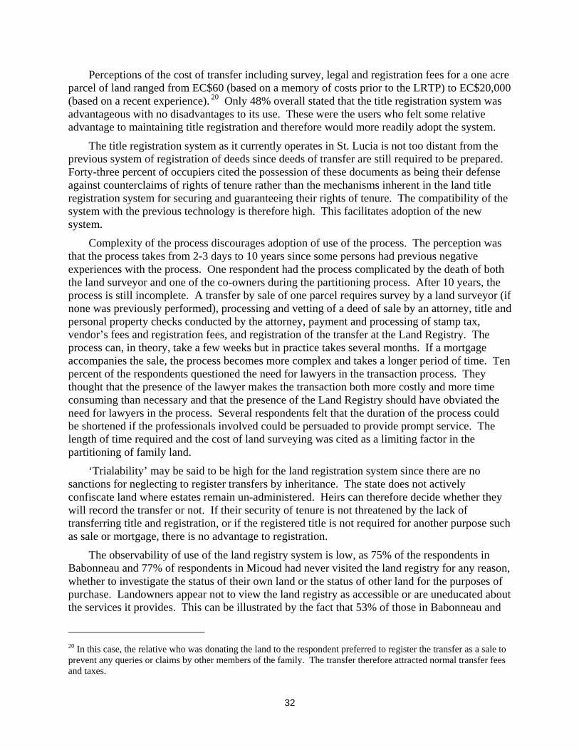
32
Perceptions of the cost of transfer including survey, legal and registration fees for a one acre parcel of land ranged from EC$60 (based on a memory of costs prior to the LRTP) to EC$20,000 (based on a recent experience).��F
20 Only 48% overall stated that the title registration system was advantageous with no disadvantages to its use. These were the users who felt some relative advantage to maintaining title registration and therefore would more readily adopt the system.
The title registration system as it currently operates in St. Lucia is not too distant from the previous system of registration of deeds since deeds of transfer are still required to be prepared. Forty-three percent of occupiers cited the possession of these documents as being their defense against counterclaims of rights of tenure rather than the mechanisms inherent in the land title registration system for securing and guaranteeing their rights of tenure. The compatibility of the system with the previous technology is therefore high. This facilitates adoption of the new system.
Complexity of the process discourages adoption of use of the process. The perception was that the process takes from 2-3 days to 10 years since some persons had previous negative experiences with the process. One respondent had the process complicated by the death of both the land surveyor and one of the co-owners during the partitioning process. After 10 years, the process is still incomplete. A transfer by sale of one parcel requires survey by a land surveyor (if none was previously performed), processing and vetting of a deed of sale by an attorney, title and personal property checks conducted by the attorney, payment and processing of stamp tax, vendor’s fees and registration fees, and registration of the transfer at the Land Registry. The process can, in theory, take a few weeks but in practice takes several months. If a mortgage accompanies the sale, the process becomes more complex and takes a longer period of time. Ten percent of the respondents questioned the need for lawyers in the transaction process. They thought that the presence of the lawyer makes the transaction both more costly and more time consuming than necessary and that the presence of the Land Registry should have obviated the need for lawyers in the process. Several respondents felt that the duration of the process could be shortened if the professionals involved could be persuaded to provide prompt service. The length of time required and the cost of land surveying was cited as a limiting factor in the partitioning of family land.
‘Trialability’ may be said to be high for the land registration system since there are no sanctions for neglecting to register transfers by inheritance. The state does not actively confiscate land where estates remain un-administered. Heirs can therefore decide whether they will record the transfer or not. If their security of tenure is not threatened by the lack of transferring title and registration, or if the registered title is not required for another purpose such as sale or mortgage, there is no advantage to registration.
The observability of use of the land registry system is low, as 75% of the respondents in Babonneau and 77% of respondents in Micoud had never visited the land registry for any reason, whether to investigate the status of their own land or the status of other land for the purposes of purchase. Landowners appear not to view the land registry as accessible or are uneducated about the services it provides. This can be illustrated by the fact that 53% of those in Babonneau and
20 In this case, the relative who was donating the land to the respondent preferred to register the transfer as a sale to prevent any queries or claims by other members of the family. The transfer therefore attracted normal transfer fees and taxes.

33
73% of those in Micoud (63% overall) were unaware of the cost of land transfers. And 65% did not know how long a transaction would take. Legislation requires that land be transferred by notarized document; responsibility for registration of the transaction is therefore left to the lawyer. This also reduces the observability and the interaction of the user with the system. Observability favors adoption of innovations especially in cultures where group action is valued over individual action. The prevalence of the family land system would seem to indicate that the culture in St. Lucia regards group activity highly. Persons would therefore individualize ownership rights and register them if others did, but conversely would also not individualize and register if others in the community did not. While the initial LRTP was highly observable and therefore facilitated adoption of the system initially, maintenance of registration is largely a private activity. Publicity campaigns and display of registration maps in prominent areas would perhaps raise the observability of the system.
Summary The systematic adjudication and mapping program of LRTP was an important process in the determination and recording of tenure rights in St. Lucia. The value of the land registration data and the system is now in danger of being eroded over time as already the existing culture of multiple ownership encourages non-registration of inheritances. The 31% disparity between the registry data and the ground data will continue to grow as more of the original titled persons die. On the other hand, it does appear that land purchases are being recorded in the Land Registry. Characteristics of the system itself and characteristics of the user society impact on the level of sustainability of a land registration system. However, economic factors appear to have a greater impact on the level of activity in the land market at the moment than the lack of currency of the registry data. More dissemination of information on the registry and interaction of the registry with users would encourage use, as would simplifying the process of transfer in instances of inheritance.
3. COSTS OF TRANSACTIONS The formal contractual transfer of land in St Lucia has costs of various magnitudes. Not only are land transaction costs directly related to the number of actions needed to complete the transaction, the value of the property also has a direct impact on the cost of the transfer. This has significant implications for persons of the lower income bracket, and persons with limited access to ready cash. The general consensus appears to be that the apparently high transactions costs associated with property transfers reduces the incentive to keep the Land Registry information current. The result is an increase in the number of persons who own land without it being formally registered in the Land Registry. As North (1990) expounded “societies that display greater relative efficiency in reducing transaction costs defending property rights ... are able to achieve greater economic growth than societies that are less efficient in this area.” In other words, a reduced ability to defend individual property rights also reduces a rural sector’s potential for economic activity.
Market transactions of purchase, sale, mortgage, and donation require the participation of several professionals and institutions for formal completion in St. Lucia. The process is typically started with the use of land and valuation surveyors (the negotiation phase), then the notary and finance professions (monitoring phase), and lastly the recording of documentation is done at the
34
Land Registry (enforcement phase). The various inputs required are detailed below and then examples are given of some typical transaction scenarios to demonstrate the application of the process. While very little primary evidence of informal sales could be found, there is anecdotal evidence of sales being conducted between individuals by instalment payments, with formal deed processing and registration occurring on completion of the final payment.
3.1 REAL ESTATE BROKERS For the average St. Lucian, especially in the rural environment, knowledge of the availability of land is obtained via word of mouth or in some instances via signs displayed on the parcel itself. Few available properties are advertised in the press and these are usually the more expensive properties. Many transactions occur between relatives, friends or acquaintances. Real estate brokers are seldom part of the transaction. When real estate brokers are involved the fee is normally 5% of the value of the property.
3.2 VALUATION Many land market participants rely on undocumented information regarding the value of property and agree on a price without the input of a valuation surveyor. Parties to private conveyances that are not subject to mortgage may forgo the valuation and agree between themselves on the price for the parcel. Banks, however, usually insist on a valuation prior to any transaction that is subject to mortgage in order to protect their investment. However, issues relating to the sufficiency of an open market report reflecting current market conditions for a long-term security position are rarely if ever discussed.
A valuation surveyor’s fee ranges from EC$350-$500 for the appraisal of a vacant lot to EC$500 for the valuation on a residential parcel with a house. Some valuers charge up to 1% of the value of the property but the typical fee is between 0.12% and 0.25%. The professional tariff of fees is not strictly followed, as it has not been revised in over 10 years. A period of one week is normal for the preparation of a valuation report.
3.3 MAP SURVEYING A lodged survey plan is a requirement if bank financing is to be utilised for the purchase of freehold property. If there is already a lodged survey plan for the property, then this plan is accepted. While there is a survey tariff governing the costs of some typical surveys, the actual cost can vary owing to additional services provided by the land surveyor or the particular logistic conditions affecting the individual survey. Additional services that may factor into the total cost of survey include seeking planning approval for subdivision and designing subdivision layouts. A typical subdivision of land can take up to 2.5 months from commencement to finish. The Development Control Approval (DCA) has to be obtained before a land survey can be executed. After the fieldwork, the survey plan has to be submitted to the Survey and Mapping Section of the Ministry of Physical Development for mandatory checks before it can be lodged as a state registered public document. A time period of 8 to 10 weeks for a small subdivision is normal.
The scale of fees published in the land surveyors regulations of 1984 are outdated and the current scale of fees is not publicly available for inspection nor strictly followed. Costs for land

35
surveying can range from EC$2500 for the survey of a typical residential parcel to EC$5900 for the survey of 2.5 hectares to EC$8350 for the survey and subdivision of a 2.5 hectare parcel.
3.4 SUBDIVISION PERMITS AND COSTS Application to the planning authority for permission to develop or subdivide land also attracts a fee. Standard fees are EC$20 for applications to develop parcels under 3000 square feet in area, EC$25 for parcels between 3001 and 6999 square feet, and EC$30 for parcels 7000 square feet and over. For example, it would cost EC$150 for an application to subdivide 5 acres into five 1-acre parcels. A time period of 3 to 4 weeks to obtain a permit for a small subdivision from the DCA is normal.
When Development Control Approval is granted for 5 lots or less, these can be sold without completed infrastructure development. Partition of land into more than 5 lots would require infrastructure to be put in place before final approval is granted for the partition to be registered. For 6 lots or more, provisional approval is granted on condition that the application is accompanied by a drainage plan signed by a registered engineer; the type of engineer, however, is not described. Theoretically, any type of engineer including an electrical engineer can be utilised. Final approval for registration at the land registry is granted on the completion of the infrastructure. A 5-acre subdivision into 6 parcels for agricultural use, for example, would require the installation of at least a gravel surfaced, 6-meter wide farm road with earthen side drains at a typical cost of EC$120,000 for cutting and surfacing. For installation of a dressed surface, 6-8m wide road and water and electricity utilities in a residential subdivision, the cost can be EC$3 per sq. ft. on the total area of the development. For family land partitions of more than 5 lots, final approval is granted when the plan is accompanied by a signed drainage plan. A time period of 3 to 6 months (depending on the season) is normal.
3.5 LEGAL FEES Legal fees are usually calculated as a percentage of the value of the property being transferred (2% to 4%) with a standard base figure included.��F
21 Usually the legal documents required for the transaction are prepared by one lawyer and then are vetted by another. The transaction therefore attracts a larger fee than what many individuals think to be necessary for the transaction. In cases where a mortgage is paid off but still recorded on the Land Registry, there is a cost for removing the mortgage notation from the Land Register. This is done with the assistance of a notary who has to prepare a radiation deed to be registered at the land registry. The fees associated with this is in the region of EC$200.00.
3.6 MORTGAGE COSTS Banks require an administrative fee for the processing of the mortgage in a typical land sale. This fee is usually 1% of the value of the loan. Banks tend not to lend for the full open market value of the asset and require that the mortgagee proffer a 5-25% deposit. Current lending rates 21 At current prices, a typical residential lot of 5,000 to 7,000 square feet will cost in the region of EC$30,000 to EC$40,000. Residential parcels with house sell for prices in the range of EC$150,000 to EC$200,000. An agricultural parcel of land of 5 acres sell for prices in the range of EC$50,000 to EC$80,000. These prices have seen a significant reduction from previous years because of the current depressed economy.

36
range from 7.99% to 10%. Loans for the purchase of vacant land are usually restricted to a maximum 10-year period but more typically a 5-year repayment term is utilized. Loans for the purchase of land and house together would be subject to a 10% deposit and would be allowed a repayment term of 20 years or to a maximum of 30 years. Agricultural parcels attract a requirement for at least a 25% deposit because this investment is seen as being high risk.
3.7 GOVERNMENT FEES AND TAXES Registration fees at the Land Registry are a flat EC$20 per registration of transaction. In addition, government taxes must be paid on both sales and donations, but not on inheritance land transfers. The purchaser or donee pays stamp duty on the stated transaction amount. The stamp duty is calculated as 2% of the stated value of the property, which may or may not have had the benefit of a professional valuation surveyor’s opinion. It is not unheard of for persons to understate the value of the property for deeds of donation or the actual consideration paid on the deed of sale to avoid paying the full stamp duty.
In addition to stamp duties, transactions valued at over EC$50,000 also attract a vendor’s tax. Again, under-valuation or under-reporting of the sale price allows for avoidance or reduction in this cost. The vendor’s tax is calculated as 2.5% on the first EC$25,000 above the exempt EC$50,000, 3.5% on the next EC$75,000 of the value and 5% on the remaining value. If the vendor is non-national, the vendor’s tax is a flat 10% of the value. Though it may be called a vendor’s tax, the fee can be a factor considered in the setting of the sale price of the property. The typical costs incurred in the purchase of land for several examples are shown in Table 24.

37
Table 24: Detailed Costs of Transactions (EC$) Type of Cost Vacant
Lot Residential
Lot with Building(s)
5 Acres Agricul-
tural
5 Acres subdivided into 5 lots
5 Acres subdivided into 6 lots
Time*
Purchase price 30,000 150,000 50,000 50,000 50,000 n/a
Valuation 450 500 500 500 500 1 wk
Land survey 2,500 2,500 5,900 8,350 8,350 3 wks
Planning permit
none 25 none 150 180 3 wks
Engineering plan
none none none none 2,000 3 wks
Infrastructure none none none 120,000 120,000 3-6 mths
Legal fees 2,500 7,000 3,500 3,500 3,500 3 wks
Stamp duty 600 3,000 1,000 1,000 1,000 1 day
Vendor’s tax exempt 3,250 exempt exempt exempt n/a
Bank fee for mortgage
270 1,350 450 450 450 n/a
Total fees 6,320 17,625 11,350 13,950 13,980
Total time 5-6 weeks 8-9 weeks 5-6 weeks 4-7 months 5-8 months * Some of these can overlap to some extent; total times are estimates
4. LAND MARKET PROFESSIONS This section will describe the legally defined responsibilities and qualifications of land market professionals. The professions associated with the formal land market include land surveyors, valuation surveyors or valuers, lawyers and notaries, bankers, and the courts.
4.1 LAND SURVEYING Land surveyors have found that the land registration project has resulted in a system that supports simpler and more efficient cadastral research on parcels. The land surveyor is responsible for conducting thorough research on the location of boundaries prior to performing redefinition, regularisation and subdivision surveys on the ground. It is also standard practice for land surveyors to prepare and follow planning applications for land development. The LRTP project created new imprecise general boundaries in many instances where more precisely defined legal boundaries existed previously. The resulting conflicts have had to be rectified by land surveyors since some people did not accept the new legal boundaries. The LRTP also left many boundary conflicts unresolved.
Another legacy of the LRTP that land surveyors have had to deal with is the issue of the rights of way created by the project. In some instances, rights of way described in Land Registry documents do not exist on the ground. However, they are recorded as encumbrances and

38
therefore prevent or restrict partitioning or development. In other instances the width of the right of way described is not in keeping with the accustomed use: for example, footpath widths are described as vehicular rights of way or believed to be vehicular rights of way. This has resulted in conflicts over usage. In yet other cases, owners agreed to the introduction of rights of way during the project, not realising that it would become a permanent encumbrance on the property and restrict future development.
The family land situation continues to present problems since the issue was not fully dealt with in the LRTP. Even though the trust-for-sale mechanism and the listing of heirs of the deceased owners partially resolved some of the conflicts of family land, this is still a problematic social issue. Attempting to partition these family lands to the satisfaction of all the parties concerned presents many problems to land surveyors as they attempt to provide equitable solutions since the family members may not be able to resolve the conflict between partitioning into equal area or into equal value. Attempts to partition family land are also constrained by restrictive planning regulations that require expensive infrastructure to be put in place prior to approval for subdivision even in instances where de facto subdivision has already occurred. The partitioning process can take as much as 5 years to be resolved to the satisfaction of all parties and the regulatory agencies. The trusts for sale created in an attempt to deal with family land appears to also present problems as there are reports of trustees selling land and dividing the proceeds amongst themselves or dividing the land itself amongst themselves unknown to absent or other uninformed owners. Land surveyors subdivide based on a request from any of the legal heirs listed in the land registry, with the consent of the other heirs.
For surveys ordered by the High Court, a licensed land surveyor is appointed by the court to view and value and submit a report and proposal for partition. The surveyor is usually required to present his/her report to the court and is required to assist the judge in the determination of the case. For boundary disputes, the surveyor has to undertake the necessary research to guide the court towards the best suitable solution for the boundary dispute. When the location of boundaries is known, there are no boundary disputes. In recent times there have been several boundary disputes between adjoining owners because they cannot agree where their common boundary is. In many instances the flagging that was used to mark the corners of boundary during the LRTP has disappeared due to several factors such weather, fire, animals and people. Better and more permanent methods should be used to mark boundaries in the future.
Land acquisition is the appropriation of land by the state, either compulsorily or by private treaty to obtain land for public uses. Land acquisition surveys are undertaken on behalf of the state to determine the extent of the land required and available for the particular public purpose. Land acquisition surveys is another activity of land surveyors, but executed only by surveyors within the Survey and Mapping Section within the government service.
There are 19 practising licensed surveyors in St. Lucia. Membership in the professional association of surveyors is voluntary. The association is in transition at the moment from being a group whose membership was restricted to only land surveyors to combined membership with valuation and quantity surveyors under an umbrella organization. The survey board is comprised of the Chairman who is the ex oficio Chief Surveyor, and two licensed land surveyors nominated by him and approved by the responsible minister of government. The participation of the two nominated members and the Chairman carries no remuneration, so the board is not as vibrant and functional as it should be. The board, however, does deal with complaints against land surveyors
39
and there is at least one instance in the 1990s where a licence was rescinded and several instances of reprimands to land surveyors after investigation of complaints.
4.2 REAL ESTATE BROKERAGE AND VALUATION Real estate brokerage and valuation services in St Lucia are characterised by an informal client-agent relationship. There is a dearth of trained valuation surveyors in St Lucia. Not surprisingly, as a result, the void is being filled by persons from a variety of other professions. Instructions given are usually verbal and the transaction of service and payment unrecorded except in the minds of the two parties involved. Typically as well, the training of the service provider is informal and heavy reliance is placed on past experience. Persons tend to gravitate into these professions via other land related professions in which they have done some from of internship, for example, working with a lawyer who does conveyancing or with a land surveyor or with the Ministry of Physical Development. The application of new technology and methodology is not seen as an effective means of increased efficiency, especially in the real estate brokerage services. The result is a lack of standards and no regulatory mechanisms. Increasing the availability of valuation knowledge will lead to more efficient services being made available to the persons who would like to participate in the land market.
There are no industry or state regulations to determine how real estate services are performed, and there is a lack of capacity within the real estate industry to influence policy decisions on land matters. For example a draft Valuation Standards was presented to the Ministry of Physical Development (the major user of valuation services within the public service) in 2001. To date there has been no action taken to introduce this into practice.
In the case of valuation services, there is some movement towards self-regulation of the profession; nevertheless, approximately 20% of the transactions are done by persons not affiliated to the professional association. In the case of the real estate brokerage, due to the informality of the services, approximately 80% of the transactions are done by persons not affiliated to the professional association.
The lack of adoption of international standards especially in the valuation services sector has fostered a lack of transparency in the valuation process. Terminology is used loosely resulting in confusion regarding the precise nature of the property interest that is being assessed. This increases the investment risk of the transactions and this in turn is being reflected in the bank interest rates and banking fees. Another result is the short list selection by individual banks of a few professional service providers that they are willing to accept an opinion from. In the private sector, valuation surveyors are required to provide valuations prior to the banking institutions’ engaging in any loan process with land as collateral.
Although the Land Registry has a record of all registered conveyances of freehold property transfers from 1987 to date, less than 5% of the valuation services providers make use of the transaction information contained therein.��F
22 There appears to be a consensus amongst the majority of the valuation service providers, real estate brokers, and banks that historical replacement costs (discounted) are an adequate indication of present market worth. This hypothesis is currently being tested in the St. Lucian real estate market. It has already been
22 This lack of use may be due to the under-reporting of land prices in the Land Registry.

40
found to be wanting in the hospitality sector and agriculture (banana lands) sector of the real estate market, but the jury is still out regarding the residential and commercial sectors.
There is now a growing trend for the public to request land value information and even land availability information from the Ministry of Physical Development. The rationale appears to be that the Ministry’s exposure to land information places these persons in a knowledgeable position vis-à-vis the general public.
The professional valuation surveyor provides several services to the state. The office of valuation surveyor within the state assists the chief surveyor or authorised officer to value property that is the subject of a land acquisition process. The authorised officer is responsible for compulsory acquisition with respect to the terms and conditions as specified by the Land Acquisition Ordinance Section 6 (Sub Section 1 and 2, Chapter 109) of the Revised Laws of St. Lucia. The valuation surveyor within the state also values property that is to be disposed of or alienated from the state. Valuation surveyors within the Inland Revenue Department perform valuations of all land to support the property taxation function.
The Offices of the Associations are located within the office of one of the larger company members of the Institute of Surveyors (St. Lucia) Inc. and the National Association of Realtors. The assets are derived primarily from the minimal membership dues paid annually. The executives are elected annually with no bar on re-election of officers. There is no staff, neither on full time nor part time, retained by the Associations. The voluntary nature of the Associations makes it difficult to enforce any type of standard with regard to ethics, fees scales, and production of services.
The Associations have provided in the past a small amount of training, limited to one-day workshops. This format allows for only general overview of subject areas not the more in-depth courses of study required. However the amount of resources required to provide a more comprehensive training program is usually not available at prices that participants can afford. Indeed, these workshops are seen partly as a means of raising funds for other association activities. This situation tends to create a tension within the associations reflecting a small cadre of trained professionals who are aware of the benefits of using up-to-date technology and of continuous learning on one side and a larger band of untrained persons relying on old technology and having no need for industry innovations.
4.3 LAWYERS The attorney or notary has a major role to play in the transactions of sale, lease and hypothecation. It is the responsibility of the lawyer to draw up the required documents for deed of sale or hypothecation and to check the records for any restrictions in the status of ownership and encumbrances that would prevent the conclusion of the transaction. These encumbrances may include mortgages, personal and property taxes or liens, and court judgements. Since personal taxes and judgements are not recorded in the Land Registry, but rather in the personal Registry of Deeds and Mortgages, these checks must be thorough. It is possible, but not typical, to perform all the checks in one day. After the conclusion of the land transaction between the parties, the lawyer registers the transaction in the Land Registry, paying the required taxes and fees.
While it is not believed, from the perspective of the attorneys, that informal sales occur, there are instances of incomplete informal sales processes that come to the attention of the

41
attorneys. Buyers may pay instalments towards a purchase over an extended period of time to the seller, whose ownership they may have confidence in. At the end of the payment period, they may demand a deed of sale since there is a culture of confidence in authority and in legal documentation. At this point the attorney is contacted, but in some instances the owner may not have full authority to sell being only one of several owners. This results in an incomplete transaction. It is however believed that cases of this type are rare.
There are many instances of leases that are not registered in the land registry. Some of these agreements are kept by the attorneys in their capacity of notary royal. The term of these leases would be kept under the two years beyond which the lease is required by law to be registered even though through renewal or continued occupation the lease period eventually exceeds the two-year period. There are instances where the parties to the lease go to a Justice of the Peace to prepare the lease agreement or make some note of the agreement themselves.
The legal profession felt that they were not consulted prior to the LRTP at a time when their input would have been invaluable. However, they appreciate the marked improvement in the process of conveyancing. Parcels that are the subject of transactions are now readily and uniquely identifiable even though the persons that are party to the transactions may not be, owing to St. Lucians having several different names by which they are known.��F
23
Some attorneys also believe that the changes to the land law were too drastic and should have been more gradually introduced. Large landowners lost lands on which they had allowed occupation because under the old laws they could have regained possession at any time. During the LRTP these lands were registered to the occupants via prescription. Sufficient time has elapsed where the land law is now due for review; however, this is an expensive and time-consuming process.
Aggrieved persons still challenge the decisions on ownership arrived at during the LRTP. However, the determination of these cases does not generally favour the complainant. Some claim that they were unaware of the project at the time or that they did not put in a claim because they were out of the country or unaware of the ability to claim prescriptive rights. Some lawyers take these cases even where there is no merit to the case or because the client is insistent.
To address the attacks on the validity of the adjudication process, some lawyers are attempting to challenge the curtain principle of the Torrens foundation of the LRTP. They believe that the adjudication decisions can be overturned to accommodate persons claiming fraud on the part of those titled at the time of the LRTP. Allowing the decisions of the adjudication officers to be overturned in spite of the clause in the Land Registration Act which states that the decisions are final would have serious implications for the integrity of and the confidence in the Land Registry data.
While the legal profession has an association and maintains officers in the required leadership posts, membership is voluntary and participation is minimal. Complaints by members of the public about practices of individual lawyers or the group remain unresolved or 23 This latter problem came about as a result of the practice of names being recorded by priests at the time of baptism for persons who were often illiterate. The priests recorded what they believed was communicated to them and converted the name to a spelling that they were familiar with. During and after slavery and indentureship, the ethnicity of the person was also sometimes recorded as part of the name and this led to problems in tracing ancestry and inheritance.

42
unsanctioned. Payment of a mandatory fee for a practising certificate is required each year and this is observed. The association prescribes a scale of fees applicable to typical services but this is not generally followed.
4.4 BANKERS The development of the infrastructure in the country has helped to fuel an increase in the value of all land, including agricultural land. The planning authority readily approves the conversion of previously agricultural land to residential and other uses and this also fosters an increase in value of agricultural land. Despite restrictive clauses in some original crown grants of agricultural land proscribing uses other than agricultural, conversion is allowed to occur. Finance institutions therefore are willing to enter into mortgages of agricultural land for non-agricultural purposes once the other requirements for approval of a loan are satisfied. These are primarily student loans and vehicle loans. Whereas prior to the LRTP agricultural land could seldom be used for mortgages, the ready availability of current and assured ownership information has allowed the proliferation of this type of contract.
Prior to the project, chattel houses��F
24 were accepted as collateral for agricultural purposes and this led to many unrecoverable loans and the near collapse of the state-owned development bank. The process then required only a bill of sale for the chattel house, one or two guarantors for the repayment of the loan, and a small deposit. After the titling and registration project, the land could be used for mortgages. This period coincided with the sudden development of the banana industry, and access to credit was linked to the potential profit from the banana crop on the land and not the land itself.
The St. Lucia Development Bank was merged with a commercial bank in 2000 and now access to credit is much more restrictive. Farmers are thought to be high-risk clients since they seldom maintain a bank account to establish credit worthiness. Only two-thirds of the assessed value of the land is loaned for agricultural purposes, and even this requires that the landowner have a history of profitable agricultural production, a sizeable investment of their own funds, and a marketable proposal. Short-term loans for crop production are prevalent, with a repayment schedule of the duration of the life of the crop, which may be from 18 months to 2 years. The mortgagor pays an assessment fee and a risk premium but receives a rate of interest of 11%, well below the rates for loans for other purposes. Processing time includes the time required to visit and appraise the land, checking procedures on the status of the land and encumbrances, and contract preparation and registration of land transaction at the land registry. The processing time can be as much as a month, but the farmers are allowed to access the credit prior to the completion of the process.
Since the 1995 downturn in the banana industry, banks have been issuing far fewer loans for agricultural purposes. Those that are supported tend to be in the area of vegetable production, cut flower production or animal rearing but traditional banana farmers seem to find difficulty transitioning to the more intensive processes required for these other types of agricultural production. Now, even though many smallholders of agricultural land seek funds for diversification from the ailing banana industry to other areas such as fishing, pig rearing, poultry
24 Chattel houses are very small wooden houses that can be easily moved from one location to another.

43
and vegetables, the possession of secure title does not always guarantee a loan or a loan of the amount desired.
The upsurge in the ability to use land to access credit subsequent to the land registration project is felt to be attributable more to the vibrant economic activity in the banana industry of the early 1990s than to the increased security of title offered by the registration of land. Legislation that favors social welfare over economic development restricts this area of the land market from flourishing. The legislation proscribes mortgages from containing power of sale clauses. Consequently, in the instance of default on a mortgage, the mortgagor must be personally sued to recover the outstanding value of the loan. The beleaguered court system can cause the suit to be prolonged for three years or more during which time the property remains in the hands of the defaulting individual. Even after judgement is given in favour of the mortgagee, the law requires the auction of the property with the proviso that at least three bids be received. Mortgagors have been known to manipulate the process in their favour by having an agent bid an inflated amount beyond which no other bidder would be expected to bid. This effectively voids the auction and allows the mortgagor to remain in possession. This circumstance discourages financial institutions from basing loans solely on the value of the property. Financial institutions have been petitioning the government to revise the relevant laws but this idea does not have popular support and therefore does not have political backing. However, even if the laws governing defaults were revised, the declining values in agricultural land over the last few years would still impact on the ability to access credit with agricultural land.
There is a professional bankers’ association and though there is no credit bureau, banks freely exchange information on the credit ratings of customers.
4.5 THE COURT SYSTEM The Land Adjudication Tribunal was established during the LRTP to assist in the resolving of boundary and land disputes, but was dismantled at the end of the project. The Tribunal was comprised of a judge who was the chair, a licensed land surveyor, and an agriculturist. More than 150 cases were brought before it, with only about 5 cases that proceeded to the High Court. It is now felt by both land surveyors and lawyers that the Land Tribunal should have been continued in order to address land conflicts arising post LRTP. The decisions of the Land Adjudication Tribunal are upheld when conflicts reoccur.
Currently, disputes remaining from LRTP or that were not resolved while the Land Tribunal was in operation must enter the regular court system. For example, individualization of family land is attainable by voluntary partition and by a High Court Order, which involves both lawyers and surveyors. A High Court Order is usually a costly and lengthy exercise. When there is consent among the family members the High Court matter can be finalised within three years, but when there are conflicts among the heirs the matter can take between five and twenty years. For example, the High Court matter 119/83 between Germaine Ramjan et al. (claimants) and Edward Bernard (defendant), begun in 1983, has yet to be settled.
4.6 SUMMARY Both lawyers and land surveyors have access to the land registry, which makes it easy to conduct research about any parcel in the country. For conveyancing, the lawyer can easily prepare a schedule for the land involved in the transaction. The land surveyor knows who the

44
adjoining landowners are to serve notice of intention to survey prior to surveying a parcel of land.
The Land Registry database, registry index map, and geodetic co-ordinates provide a platform for the government national GIS project. In some ministries, that data is part of their GIS programmes. For land professionals, GIS is becoming an important tool for the management of land. The LRTP provides government the relevant tools for land administration in the determining, recording and dissemination about the land use, tenure and property taxation. Successive governments have and continue to use the Land Registry data for their formulation of their land policy.
In addition, the LRTP made the government acquisition of private property easier because it is now known who the rightful owner(s) for compensation purposes. Prior to the LRTP this sometimes was a very arduous task, especially when there were several owners.
A Land Policy cannot succeed unless it is politically acceptable to all the political parties in the country. At the time of the LRTP the two political parties accepted the programme as being beneficial to the country and it did not become a political football. It was established under the previous government and current one has continued its support in terms of modernizing the Land Registry. The successive governments have accepted that the extent of interest held in land, by landowners is represented by boundaries. The LRTP exercise did not only register title, but also determined the extent and location of properties in the country as shown by the Land Registry Index Map.
A major problem after the LRTP is that of fraud which comes in different forms. Persons are able to obtain title by fraudulent means; these fraudulent claims are still being settled by the High Court, which is an additional cost to the petitioner in terms of time and cost. There are some persons who would employ a land surveyor to execute a cadastral survey on the belief that the land is theirs. In carrying out the survey, the surveyor would find out that someone else is claiming the land. Many people in St. Lucia do not know that a survey plan does not give title. For partition surveys, some persons may forge other heirs’ signatures or get other persons to sign a consent agreement for partition. Again the surveyor may find later this consent agreement for partition was fraudulent.
A recent fraud problem that has arisen is that of impersonation. Persons purporting to be someone else have conveyed properties. This is a very serious concern that has resulted in some law firms asking persons to bring along their identification card before land transactions are executed. The additional concern is that the state has no compensation fund in place to take care of such events. Some people have escaped while other have been arrested and prosecuted by the court. As society becomes more sophisticated, these are some of the problems that can arise in land transactions.
5. IMPLICATIONS OF FINDINGS Legally identifying landowners does not, by itself, eliminate existing uncertainty and inequities in land ownership, nor does a reorganized registry, in itself, guarantee the end of the ambiguity of property rights inherent in family land. However, as one component of an integrated development policy, the LRTP rendered a substantial service to the society of St. Lucia by reducing the possibility of fraudulent transactions, providing the improved information
45
base and organizational mechanism essential to efficient administration of land-tenure questions, introducing modern techniques, and training local personnel in the use of these techniques.
The primary conclusion gathered from the analysis of the results of the underlying research is that the amount of land held as family land has increased since the LRTP was implemented. This increase is most likely attributable to several factors: cultural preference for family land particularly among rural population, uncertain economic conditions, and the high cost of converting family land to individually-owned parcels. Notwithstanding the constraints impeding the conversion from family to individual land ownership, the preference among a growing sector of the populace tends towards private individual land ownership. In St. Lucia, land ownership is a symbol of social status and power. Therefore, this is a growing potential area of conflict.
The lengthy judicial process for resolving conflicts over property rights would seem to point out the need for a non-judicial dispute resolution process. During the LRTP, a Land Adjudication Tribunal was established to resolve boundary and ownership disputes in a timely manner. When the LRTP terminated, the Tribunal was dismantled in spite of the fact that not all disputes had been resolved and that conflicts have arisen since the LRTP, due mostly to boundary disputes. Some of these disputes take years to resolve, suggesting that non-judicial dispute resolution mechanisms that avoid the judicial process may provide a more efficient (in terms of time and monetary cost) alternative process.
At the same time, although the land registry has reduced the amount of time and the difficulty of research into land title, registration, and tenure information, the nature of the registry restricts the amount of information that the public in general can access. Since, with a few exceptions, only lawyers (notaries) and surveyors are allowed full access to view the information stored at the land registry, land title information comes at a significant cost to the general public. This is so regardless of the fact that the registry is publicly funded and acts as the custodian of public information.
The portion of the land transaction costs paid to the notaries have remained at approximately 2% of the value of the property, although as mentioned above information retrieval is now much easier. It can therefore be argued that since the value of land has generally increased, the amount of money paid for land transfer notarisation has increased. This has not, however, led to any discernible efficiencies in the recording of the rights and interests that are being transferred. Anecdotal evidence continues to show a “cut and paste” preference in deed preparation, instead of an “each property is unique” approach. The same argument regarding the financial implications of a value-based system of payments can be made regarding the procurement of valuation surveying services. These conditions have led to a situation where legalizing land transfers is generally looked upon by the public as being expensive and complex.
Although more reliable property market research and analysis can now be made, increasing the justification for assessed values, there continues to be a general lack of researched transaction and other financial data being referred to in valuation reports. This makes it difficult for risk assessment to be carried out. In the past, with foreign aid financing and a robust agricultural export-driven economy, this did not matter because property used as security was good business for financial institutions such as banks. The new economic conditions are less favourable for the local economy and the financial institutions have now realised that there is a need for risk assessment in a mortgage portfolio and effective valuations are a part of this. However the valuation services generally available tend to give very little guide to risk

46
management efforts.
There is room for State action on the fiscal side to help make transaction costs less burdensome. The volume of transactions on an annual basis is a small percentage of the total number of parcels on the island. A suggested alternative is the implementation and enforcement of an island-wide “highest and best use” land parcel tax and removal of the transaction taxes. With the correspondingly larger proposed taxable base more money can be raised while at the same time the liquidity of the property market is likely to be enhanced.
The Land Registry, with the State as the guarantor of title, is not yet 20 years old. However, based on the conducted research and anecdotal information, the Land Registry is already out of date. Unless there is an intervention, the records will over time become less and less reliable with regards to the true and current property ownership situation in St Lucia. This will effectively erode people’s confidence in the land registration system and may eventually have a negative impact on the national property market.
The legal framework could usefully undergo some revisions to reduce some of these tendencies. First, the Civil Code’s rules for handling family-owned parcels could be reconciled with those incorporated in the Land Registration Act and the Land Adjudication Act. Second, the mechanism of Trust for Sale for resolving the lack of negotiability of family land parcels (as defined in the Land Registration and the Land Adjudication Acts) could be improved by a series of fiscal and administrative incentives for all land market participants that could facilitate sale, lease, subdivision, or buyout of rights to a family land parcel. Third, the 1987 amendments to the two Acts should be revisited in light of recent Court decisions that support the finality of the adjudication record. Finally,
Finally, the experience of the LRTP and the reluctance of the St. Lucian people to modify the family land form of tenure bring into question the adequacy of the initial strategy to individualize family land parcels. The advantages of this tenure form and the difficulties encountered in sorting out all interests in an equitable but individualistic way appear to outweigh the problems it generates. It seems advisable that institutional means be found to deal with the problems of family land holdings when they arise, rather than struggle to eliminate or weaken the arrangement.
This country study has demonstrated that a titling and registration project may be successfully implemented, but that its positive impact on the agricultural land market and agricultural production will be conditioned on economic conditions that stimulate investment in agriculture, enforcement of property rights as recorded in the title registry, and other factors such as timely resolution of land disputes.
6. REFERENCES Adrien, P. 1996. Metayage, Capitalism And Peasant Development In St. Lucia, 1840- 1957.
Mona, Jamaica: Consortium Graduate School of Social Sciences, University of the West Indies.
Bruce, J. W. 1983. Family Land Tenure and Agricultural Development in St. Lucia. Research Paper No. 79. Madison: Land Tenure Center. University of Wisconsin-Madison.
Chan, T. O. and I. P. Williamson. 1999. The Different Identities of GIS and GIS Diffusion. International Journal of Geographical Information Science. Vol. 13:3. pp267-281.

47
Crichlow, M. A. 1994. An alternative approach to family land tenure in the Anglophone Caribbean: the case of St. Lucia. 68 (1&2). New West Indian Guide pp. 77-99.
Deininger, K. 2003. Land Policies for Growth and Poverty Reduction. World Bank Research Report. Oxford: Oxford University Press.
Demsetz, H. 1967. Toward a Theory of Property Rights. The American Economic Review. Vol. 57:2, pp.347-359.
Deterville, Hilford. 1988. “Assessment of the Long-Term Effects of the LRTP: Saint Lucia Land Registration Act 1984: An Examination of New Registration Procedures,” in Land Registration, Tenure Security, and Agricultural Development in St. Lucia: A Research Report, (Volume 1). Madison, Wisconsin: Land Tenure Center.
Dujon, V. 1995. National Actors Against World Market Pressures : Communal Land, Privatization And Agricultural Development In The Caribbean. Unpublished PhD dissertation. Madison: University of Wisconsin-Madison.
Feder, G., and A. Nishio. 1999. The Benefits of Land Registration and Titling: Economic and Social Perspectives. Land Use Policy. Vol. 15:1. pp25-43.
Hofstede, G. 1991. Cultures and Organizations: Software of the Mind. New York: McGraw-Hill.
Hofstede, G. 1980. Culture’s Consequences: International Differences in Work-Related Values. London: Sage Publications.
Government of St. Lucia. 2004a. Estimated Mid-Year Population By District. ��Hhttp://www.stats.gov.lc/pop22.htm.
Government of St. Lucia. 2004b. Banana Production, Exports and Revenue 1985-2003. http://www.stats.gov.lc/agri2.htm
Government Statistics Department. 2000. St. Lucia Earnings and Hours of Work Report 2000-2002. St. Lucia: Government of St. Lucia. ��Hhttp://www.stats.gov.lc/salavg.htm
Government of St. Lucia. 1996. Main Censal Results. Castries: Statistics Department (http://www.stats.gov.lc/main5.htm).
Land Tenure Center. 1988. Land Registration, Tenure Security, and Agricultural Development in St. Lucia: A Research Report. Wisconsin-Madison: Land Tenure Center.
Lemel, H. 1988. ‘Land Use Intensity and Investment: Evidence from the LRTP Baseline Survey.’ In Land Registration, Tenure Security, and Agricultural Development in St. Lucia: A Research Report. Wisconsin, Madison: Land Tenure Center.
Maurer, B. 1997. Recharting the Caribbean: Land, Law and Citizenship in the British Virgin Islands. Ann Arbor, University of Michigan Press.
Palmer, D. W. 1996. Incentive-Based Maintenance of Land Registration Systems. PhD Dissertation. University of Florida.
Rogers, E. 1983. Diffusion of Innovation. New York: The Free Press.
Rojas, E., R. M. Wirtshafter, J.Radke and R. Hosier. 1988. Land Conservation in Small Developing Countries: Computer Assisted Studies in Saint Lucia. Ambio 17(4):282-288.

48
Stanfield, D. 1988. “Evaluation of Procedures and Outcomes.” In Land Registration, Tenure Security, and Agricultural Development in St. Lucia: A Research Report, (Volume 1). Madison, Wisconsin: Land Tenure Center.
Stanfield, D. and P. C. Bloch. 2002. A Conceptual and Methodological Framework for an Assessment of USAID’s Investments in Land Markets and Property Rights. Madison, Wisconsin: Land Tenure Center
Stanfield, J. David, 1989. Land Registration and Security of Land Ownership. Paper presented to the Latin American Studies Association (LASA) Congress. San Juan Puerto Rico, 21-23 September 1989.
Stringer, R. 1988. ‘Changes in the Land Market: Has the LRTP Laid a More Solid Groundwork for the Functioning of the Land Market?’ In Land Registration, Tenure Security, and Agricultural Development in St. Lucia: A Research Report. Wisconsin, Madison: Land Tenure Center.
Vargas, A. and D. Stanfield. 2003. St. Lucia Country Brief: Property Rights and Land Markets. Madison: Land Tenure Center, University of Wisconsin.

49
ANNEX A. SURVEY QUESTIONNAIRES
QUESTIONNAIRE 1: SUSTAINABILITY OF LAND REGISTRATION SYSTEMS
1. Name of participant: _____________________________________
2. Gender of participant: male female
3. Address of parcel: ________________________________________
4. Total number of buildings on the parcel:
5. Number of residences on the parcel:
6. Percentage of parcel under cultivation:
7. How many owners of this parcel are there?_______________________________
8. Relationship of participant to owner:
Owner lessee manager caretaker
Other (specify) ______________________
9. How many years of school did you attend?
none primary 1-5 secondary 6-10 tertiary >10
10. Can you give an estimate of your total monthly income?_____________________________
11. When did you obtain this parcel? ______________________________
12. How did you obtain this parcel?
purchase lease inheritance occupation
other _____________________________________
13. What documents do you have to support your occupation?
Title deed contract none
other ______________________
14. Have you performed any of the following on this parcel?
Subdivision sale mortgage lease none
other ______________________
15. Did you register the transaction that you performed in the national registry?
Yes No
16. If ‘no’ why did you not register the transaction?
____________________________________________________________
Parcel ID: ____________

50
17. If you know the cost, give a figure for the cost of registering a transfer of ownership of 1 acre of land at the registry (including cost of lawyers for preparing documents, cost of surveyor, taxes, registration fees). If you do not know guess. _____________________________________________________
18. Do you think that this cost is:
Too high Too low About right
19. If you believe the cost is too high or too low, what do you think is a reasonable cost?
_______________________________________________
20. What advantages are there (if any) to registering your land transactions?
__________________________________________________
21. What disadvantages are there (if any) to registering your land transactions?
_____________________________________________________________________
22. If you know for sure, how long does the process of registering a transaction take (including survey, legal process and registry process)? If you do not know guess. ______________________________________________
23. Do you think that this time is:
Too long Too short About right
24. If you believe the time to be too long, what length of time do you think is reasonable?
________________________________________
25. Have you ever visited the registry?
Yes no 26. If ‘yes’ for what purpose?
_________________________________________________________
27. Do you think that the registry information represents the true ownership on the ground?
Yes No
28. If ‘no’ why does the registry information not represent the true ownership on the ground?
________________________________________________________________
END OF QUESTIONNAIRE 1
Parcel ID: ____________

51
QUESTIONNAIRE 2: GROWTH OF LAND MARKETS IN ST. LUCIA
For land held in ownership
Confidence in the system:
1. Can someone else claim ownership of this parcel of land?
Likely unlikely impossible
2. Why?
______________________________________________________________________
Less
ee
othe
r ow
ners
fam
ily
rela
tives
stat
e
nobo
dy
Other (specify)
Exclusivity of rights
3. Besides yourself and the other rights holders named, who else has rights to this parcel?
Transfer rights
4. Whose permission do you believe you will need to sell this parcel?
5. Whose permission do you believe you will need to mortgage this parcel?
6. Whose permission do you believe you will need to pass on land in a will to specific persons of your choosing?
7. Whose permission do you believe you will need to lease out this parcel?
8. Whose permission do you believe you will need to give this parcel as a gift or donation to persons of your choosing
Use rights
9. Whose permission do you need to grow cash crops
10. Whose permission do you need to fence this parcel of land?
11. Whose permission do you need to build agricultural structures on this parcel of land?
12. Whose permission do you need to plant permanent trees on this parcel of land?
Parcel ID: ____________

52
Less
ee
othe
r
fam
ily
rela
tives
stat
e
nobo
dy Other (specify)
Investments
13. Whose permission do you need to make short-term improvements to this parcel of land (e.g. fertilizer applications, improved varieties of seed)?
14. Whose permission do you need to make long-term improvements to this parcel of land (e.g., irrigation wells & canals, terracing)?
Market rights
15. Whose permission do you need to sell the produce from your land?
16. Could you recover this parcel of land if a lessee refuses to move at the end of the lease period?
Easily difficult impossible
For land held in leasehold:
Confidence in the system
17. Can the lessor deny that they leased this land to you?
Likely unlikely impossible
18. Why? _________________________________________________________________
19. How easy do you think it would be to recover your improvements at the end of the lease period?
Easy difficult impossible
Exclusivity of rights
20. Does the owner of this land that you are leasing have the right to use this land in any way?
Yes No
21. If ‘yes’ in what ways?
_________________________________________________________________
Length of use rights
22. Is the lease period available to you long enough for the purpose that you are using it for?
Long enough not long enough
23. Do you have the right to renew the lease on this parcel if you wish?
Yes No

53
Less
or
Oth
er
less
ees
Fam
ily
Rel
ativ
es
Stat
e
nobo
dy
Other (specify)
Transfer rights
24. Whose permission do you need to transfer this leased parcel of land to someone else (sublease)?
25. Whose permission do you need to pass on this leased parcel of land to someone else in case of death?
Less
or
Oth
er
less
ees
Stat
e
nobo
dy
Other (specify)
Use rights
26. Whose permission do you need to grow cash crops on this parcel of leased land?
27. Whose permission do you need to fence this parcel of leased land?
28. Whose permission do you need to build structures on this leased parcel of land?
29. Whose permission do you need to plant permanent trees on this leased parcel of land?
Investments
30. Whose permission do you need to make short-term changes to this leased parcel of land (e.g. fertilizer applications)?
31. Whose permission do you need to make long-term changes to this leased parcel of land (e.g., irrigation wells & canals, terracing)?
Market rights
32. Whose permission do you need to sell the produce from the land you have leased?
33. Are you required to share the proceeds from the sale of produce with the owner?
Yes No

54
For Owners and Lessees Credit investments
34. Which credit institutions would give you a loan if you applied for it?
commercial bank credit union or cooperative
insurance company other financial companies
informal arrangement _________________________________________
other ______________________________________________________
Have you tried to access credit since 1987? Yes no
35. For what purpose?
agricultural production (inputs, livestock, etc,)
agricultural investment (irrigation, machinery, fencing, etc.)
agricultural buildings (barn, machinery shed, processing shed, etc.)
residential building
non-farm business
other purpose ____________________________________________
36. Were you successful in obtaining credit? Yes no
37. If no, why not? _________________________________________________________
38. If yes, what was the value of the loan? ________________________________________
39. When did you obtain the loan? ______________________________________________
40. What type of credit institution did you obtain the loan from?
commercial bank credit union or cooperative
insurance company other financial companies
informal arrangement __________________________________________
other ___________________________________
41. What was the interest rate of the loan? _______________________________________
42. What was the repayment period? ____________________________________________

55
Investments and improvements 43. Have you ever performed any of the following on your land?
Improvement of soils through application of organic matter, rotation of crops
Tillage practices that avoid erosion, Terracing on slopes
Planting of trees and orchards
Purchase of farm animals
Installation and maintenance of wells and/or irrigation systems
Purchase of agricultural machinery
Construction of farm buildings
Property boundary markers: these can be fences, trees, or boundary monuments
44. How were these investments financed?
%personal savings %commercial credit %informal loans
45. Has lack of credit prevented you from making investments on the land?
Yes no
46. What percentage of your monthly income is derived from agriculture?_________________

56
Land transactions in respect to parcels other than this one since 1987
Purchase Sale Rent in Rent out
47. Year of transaction
48. Size of parcel
49. From whom/to whom*
50. Approx. price/rental
51. How price verified/arrived at
52. How did you advertise/become aware of parcel availability?**
53. How financed*** ______%PS
______%CC
______%IL
______
______%PS
______%CC
______%IL
______
54. Purpose****
55. Type of land
56. Year recorded in LR
57. If not recorded, why not
END OF QUESTIONNAIRE 2
*
1. = family/relative
2. = neighbour
3. = outsider
4. = commercial interest
5. = other (specify)
***
PS = personal savings
CC = commercial credit
IL = informal loan
O = other (specify)
****
1. = agricultural production
2. = residential
3. = commercial
4. = investment
5. = other (specify)
**
1. =word of mouth
2. =newspaper
3. = real estate agent
4. = sign posted on parcel
5. = other (specify)

ANNEX B: REGISTRY DATA ENTRY FORM REGISTRY DATA ENTRY FORM
Map Sheet No. Page
1 2 3 4 5 6 7 8 9 10
Parcel No. original
current
Mutation No.
Area in ha.
Ownership Initial
current
Title Initial
current
Number of owners
of whom: females
Sale 1 Yr. Reg.
Yr. Sold
price (000)
conditions
Inheritance 1 Yr. Reg.
Yr. of Estate
Donation 1 Yr. Reg.
Yr. donated
conditions
Lease 1 Yr. Reg.
annual rent
Term
conditions
Mortgage 1 Yr. Reg.
Yr. paid off
Amount
Term
Institution
purpose
[parcels with more than one transaction of each type were given supplementary data sheets]

58
ANNEX C: TYPES OF LAND OWNERSHIP BY SITE Ownership status of registered land parcels Babonneau Choiseul Micoud Millet Total 4 Sites
Original Current Original Current Original Current Original Current Original Current
1. individual ownership 145 130 32 32 53 53 92 99 322 314
2. ownership in common (community ownership) 4 14 0 5 0 10 1 10 5 39
3. undivided ownership (shares) 51 43 45 43 58 48 68 55 222 189
4. executor/administrator 12 22 6 12 2 4 7 12 27 50
5. Trust for Sale 30 35 20 26 13 17 17 15 80 93
6. heirs of … 12 10 169 150 53 45 22 20 256 225
7. rights of survivorship 0 0 3 1 0 0 1 0 4 1
8. crown 12 12 18 18 9 9 43 37 82 76
9. crown and private 2 2 2 2 0 0 0 0 4 4
10. Other (mixed tenure, considered family land) 3 4 7 13 16 17 7 10 33 44
Total no. of parcels 271 272 302 302 204 203 258 258 1035 1035
Percentage of ownership:
Individual 53.5% 47.8% 10.6% 10.6% 26.0% 26.1% 35.7% 38.4% 31.1% 30.3%
In common 20.3% 21.0% 14.9% 15.9% 28.4% 28.6% 26.7% 25.2% 21.9% 22.0%
Family land 21.0% 26.1% 66.9% 66.6% 41.2% 40.9% 20.5% 22.1% 38.3% 39.8%
Crown 5.2% 5.1% 6.6% 6.6% 4.4% 4.4% 16.7% 14.3% 8.3% 7.7%
Source: Land Registry, 1987 & 2004

59
ANNEX D: NUMBER OF PARCELS WITH TRANSACTIONS BY SITE
Parcels with at least one registered transaction: number and percentage
Babonneau Micoud Choiseul Millet All four sites
Number % Number % Number % Number % Number %
Sale 32 12.3% 38 19.6% 17 5.5% 26 11.7% 113 11.8%
Inheritance 19 7.3% 13 6.7% 17 5.5% 8 3.6% 56 5.8%
Donation 10 3.8% 7 3.6% 8 2.6% 1 0.4% 26 2.7%
Lease 3 1.2% 1 0.5% 0 0 6 2.7% 10 1.0%
Mortgage 58 22.3% 29 14.9% 15 4.8% 67 30.0% 169 17.6%
Any one above 104 40.0% 64 33.0% 58 18.6% 88 39.5% 312 32.5%
Mutation * 71 27.3% 51 26.3% 30 10.6% 102 45.7% 245 25.5%
Total No. of parcels** 260 203 284 223 960
*Mutations usually indicate a subdivision or consolidation of parcels.
**Excluding Crown lands.
Source: Land Registry, 2004