Property - geoscape.com.au
20
Property Product Guide Version 1.0
Transcript of Property - geoscape.com.au
Property
Product Guide Version 1.0
Property Product Guide (Version 1.0) Page 2
Disclaimer Geoscape Australia endeavours to ensure that the information in this document is correct at
the time of publication. It does not accept responsibility for any consequences arising from the
use of this information. Readers should rely on their own skill and judgement to apply the
information to particular issues.
© Geoscape Australia. This work is copyright. Apart from any use permitted under
the Copyright Act 1968 (Cth), no part may be reproduced, copied, scanned, stored in a
retrieval system, recorded, or transmitted in any form or by any means without the prior
written permission of Geoscape Australia.
Property Product Guide (Version 1.0) Page 3
Contents Preface ............................................................................................................... 4
Responsible Party ................................................................................................ 4
Copyright and disclaimer ...................................................................................... 4
Privacy .............................................................................................................. 4
Product Version ................................................................................................... 5
Overview ............................................................................................................. 5
Technical Description .......................................................................................... 6
Linkages ............................................................................................................ 6
Attributes........................................................................................................... 7
Data Model ......................................................................................................... 8
Data Dictionary ................................................................................................... 9
Domain Values .................................................................................................. 10
Update Frequency ............................................................................................. 10
Data Quality ..................................................................................................... 11
Extent/Geographic Description ............................................................................ 12
Spatial Reference System ................................................................................... 13
Delivery Format ................................................................................................ 13
Product Versioning ............................................................................................ 15
Annex A – User Guide ........................................................................................ 16
Contributor IDs and how to find valuation information ............................................. 16
Base polygons and how they represent a non-overlapping property layer ................... 17
Linking Cadastre and Property ............................................................................. 18
Linking CadLite to Property ................................................................................. 20
Property Product Guide (Version 1.0) Page 4
Preface
Responsible Party PSMA Australia Limited trading as Geoscape Australia
ABN: 23 089 912 710
Unit 6, 113 Canberra Ave, GRIFFITH ACT 2603 Australia
T: +61 2 6260 9000
URL: www.geoscape.com.au
Copyright and disclaimer Please see geoscape.com.au/legal/data-copyright-and-disclaimer/
Privacy Geoscape products and services should not contain any personal names or other personal
information. Geoscape undertakes reasonable data cleansing steps as part of its production
processes to ensure that is the case. If you think that personal information may have
inadvertently been included in Geoscape products or services, please contact
Property Product Guide (Version 1.0) Page 5
Product Version 1.0
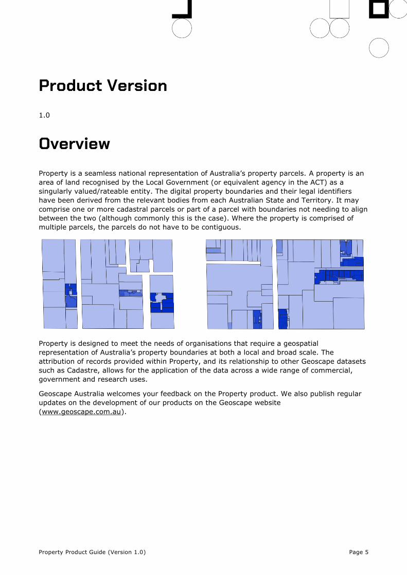
Overview Property is a seamless national representation of Australia’s property parcels. A property is an
area of land recognised by the Local Government (or equivalent agency in the ACT) as a
singularly valued/rateable entity. The digital property boundaries and their legal identifiers
have been derived from the relevant bodies from each Australian State and Territory. It may
comprise one or more cadastral parcels or part of a parcel with boundaries not needing to align
between the two (although commonly this is the case). Where the property is comprised of
multiple parcels, the parcels do not have to be contiguous.
Property is designed to meet the needs of organisations that require a geospatial
representation of Australia’s property boundaries at both a local and broad scale. The
attribution of records provided within Property, and its relationship to other Geoscape datasets
such as Cadastre, allows for the application of the data across a wide range of commercial,
government and research uses.
Geoscape Australia welcomes your feedback on the Property product. We also publish regular
updates on the development of our products on the Geoscape website
(www.geoscape.com.au).
Property Product Guide (Version 1.0) Page 6
Technical Description Property is created through processing property data sourced from Australia’s States and
Territories. Source attributes are mapped and standardised to provide a coherent definition
across the jurisdictional supplies, with associated geometry being cleaned and processed to
output a topologically consistent layer of Australia’s property boundaries at a national scale.
Each property record has a boundary representing the overall coverage of the single property
and a Contributor ID which is the jurisdiction’s reference to the property for land valuation and
other property purposes. The Contributor ID can be utilised for searches in the relevant
jurisdiction’s land valuation system to provide the indicative value of the property for rating
purposes.
Property is updated and released regularly and has integrated relationships with other
Geoscape Products. Further information regarding attributes, quality, coverage and product
release details are outlined below.
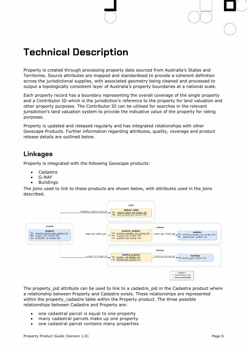
Linkages Property is integrated with the following Geoscape products:
• Cadastre
• G-NAF
• Buildings
The joins used to link to these products are shown below, with attributes used in the joins
described.
The property_pid attribute can be used to link to a cadastre_pid in the Cadastre product where
a relationship between Property and Cadastre exists. These relationships are represented
within the property_cadastre table within the Property product. The three possible
relationships between Cadastre and Property are:
• one cadastral parcel is equal to one property
• many cadastral parcels make up one property
• one cadastral parcel contains many properties
Property Product Guide (Version 1.0) Page 7
Attributes
Contributor ID
The Contributor ID is the property identifier provided by the jurisdiction that is searchable for
land valuation and rates purposes. The associated attribute(s) in the jurisdiction source
data for each State or Territory are found in the table below.
State Jurisdiction Value Notes
ACT TITLE_NUMBER Derived from the following dataset: ‘ACT_PROPERTY’
BLOCK + “/” + SECTION + “/” + DIVISION_CODE Derived from the following dataset: ‘BLOCKS’
NSW PROPID
NT VOLUME_TYP + “/” + VOLUME_NO + “/” + FOLIO_NO
QLD PROPERTY_ID
SA ASSNO_TENSEQNO
TAS PID
VIC PFI
WA VPU_VE_NUMBER
Source
The name of the State or Territory that the property data was sourced from.
Base Property
The Base Property allows for a simple visualisation of property coverage across all States and
Territories without overlapping parcels. Only property parcels which are not contained by
another property can be part of the base representation.
Area
The area of each property polygon in square meters, calculated from the feature geometry
using an equal area projection. The total area in square meters can be calculated by summing
property parcels with a common Property PID.
Property Product Guide (Version 1.0) Page 8
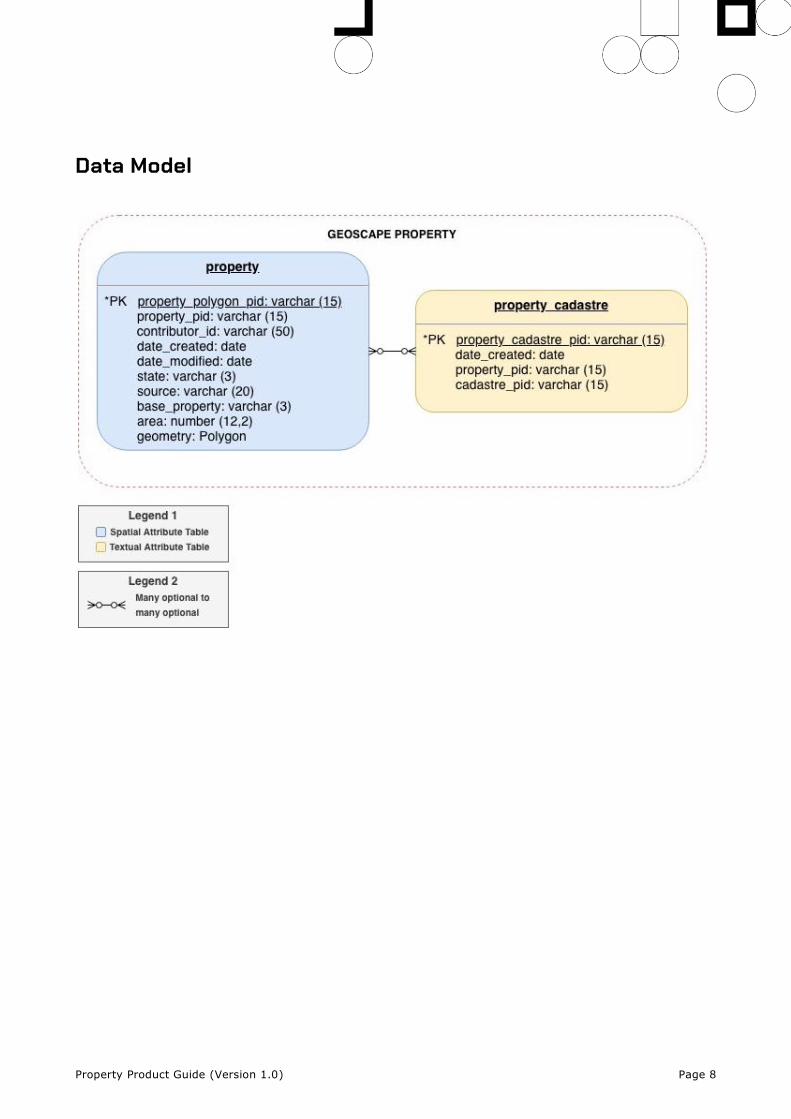
Data Model
Property Product Guide (Version 1.0) Page 9
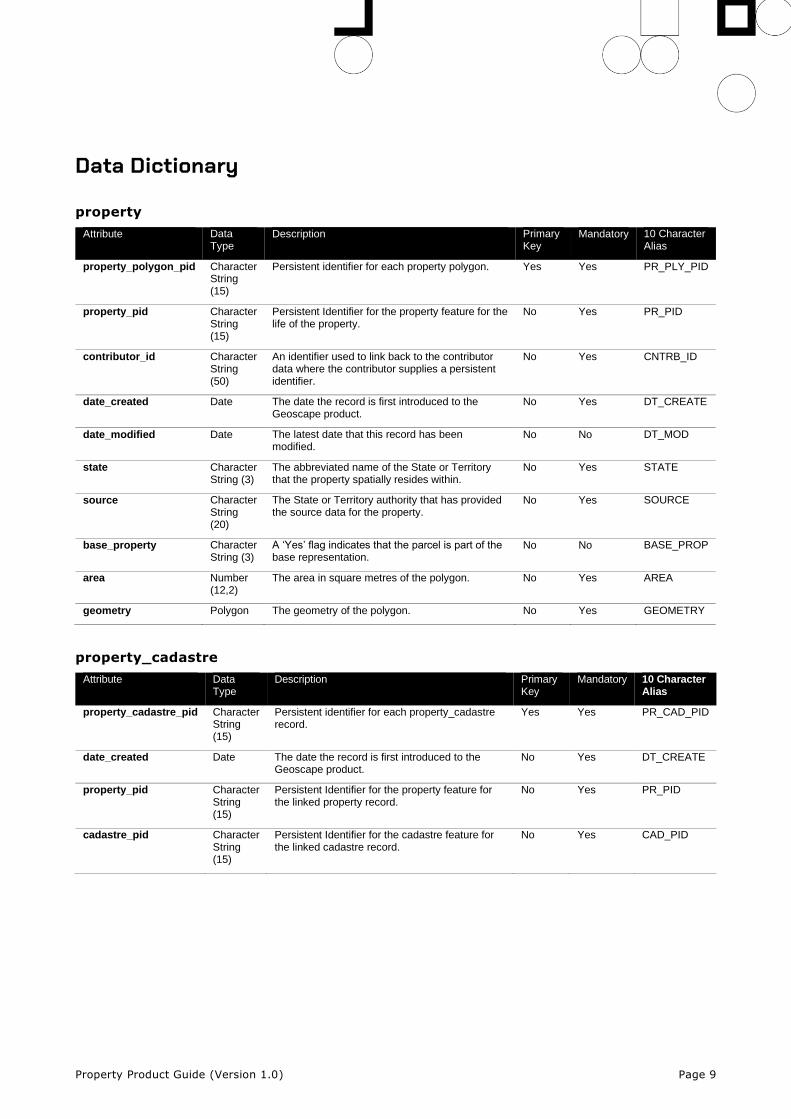
Data Dictionary
property
Attribute Data Type
Description Primary Key
Mandatory 10 Character Alias
property_polygon_pid Character String (15)
Persistent identifier for each property polygon. Yes Yes PR_PLY_PID
property_pid Character String (15)
Persistent Identifier for the property feature for the life of the property.
No Yes PR_PID
contributor_id Character String (50)
An identifier used to link back to the contributor data where the contributor supplies a persistent identifier.
No Yes CNTRB_ID
date_created Date The date the record is first introduced to the Geoscape product.
No Yes DT_CREATE
date_modified Date The latest date that this record has been modified.
No No DT_MOD
state Character String (3)
The abbreviated name of the State or Territory that the property spatially resides within.
No Yes STATE
source Character String (20)
The State or Territory authority that has provided the source data for the property.
No Yes SOURCE
base_property Character String (3)
A ‘Yes’ flag indicates that the parcel is part of the base representation.
No No BASE_PROP
area Number (12,2)
The area in square metres of the polygon. No Yes AREA
geometry Polygon The geometry of the polygon. No Yes GEOMETRY
property_cadastre
Attribute Data Type
Description Primary Key
Mandatory 10 Character Alias
property_cadastre_pid Character String (15)
Persistent identifier for each property_cadastre record.
Yes Yes PR_CAD_PID
date_created Date The date the record is first introduced to the Geoscape product.
No Yes DT_CREATE
property_pid Character String (15)
Persistent Identifier for the property feature for the linked property record.
No Yes PR_PID
cadastre_pid Character String (15)
Persistent Identifier for the cadastre feature for the linked cadastre record.
No Yes CAD_PID
Property Product Guide (Version 1.0) Page 10
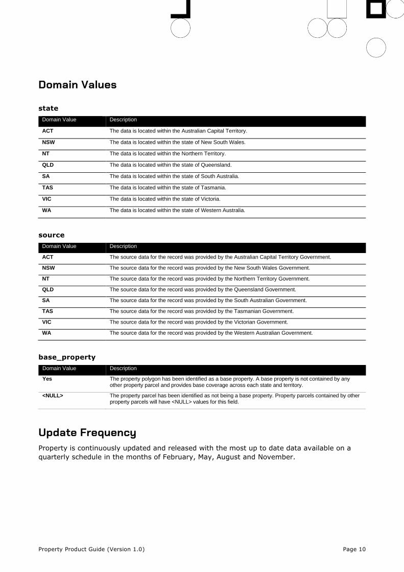
Domain Values
state
Domain Value Description
ACT The data is located within the Australian Capital Territory.
NSW The data is located within the state of New South Wales.
NT The data is located within the Northern Territory.
QLD The data is located within the state of Queensland.
SA The data is located within the state of South Australia.
TAS The data is located within the state of Tasmania.
VIC The data is located within the state of Victoria.
WA The data is located within the state of Western Australia.
source
Domain Value Description
ACT The source data for the record was provided by the Australian Capital Territory Government.
NSW The source data for the record was provided by the New South Wales Government.
NT The source data for the record was provided by the Northern Territory Government.
QLD The source data for the record was provided by the Queensland Government.
SA The source data for the record was provided by the South Australian Government.
TAS The source data for the record was provided by the Tasmanian Government.
VIC The source data for the record was provided by the Victorian Government.
WA The source data for the record was provided by the Western Australian Government.
base_property
Domain Value Description
Yes The property polygon has been identified as a base property. A base property is not contained by any other property parcel and provides base coverage across each state and territory.
<NULL> The property parcel has been identified as not being a base property. Property parcels contained by other property parcels will have <NULL> values for this field.
Update Frequency Property is continuously updated and released with the most up to date data available on a
quarterly schedule in the months of February, May, August and November.
Property Product Guide (Version 1.0) Page 11
Data Quality
Positional Accuracy
Property has been created by combining land valuation/rates information with Cadastre. To
achieve a single property representation a union of multiple Cadastre boundaries happens
during production. This will preserve the outer boundaries accuracies as supplied by the
jurisdiction. Geoscape makes minor changes only where they are required to create valid
features described in Property Geometry Validity.
Coordinates Referencing the GDA2020 Datum
Spatial features referencing the GDA2020 datum are produced using a coordinate
transformation from the GDA94 datum using the following parameters.
shift_x = 0.06155,
shift_y = -0.01087,
shift_z = -0.04019,
rotate_x = -0.0394924,
rotate_y = -0.0327221,
rotate_z = -0.0328979,
scale_adjust = -0.009994
Property Geometry Validity
Property geometry is validated to ensure polygons are a valid representation and free of self-
intersection. Issues being detected and resolved include spikes, bow ties, duplicate vertices,
null geometries, multipart geometries, and self-contacts. Minor overlaps are also resolved
where a property has a Base Property of ‘Yes’. Overlapping polygons will persist in the product
as they can be valid geometries representing the jurisdictions intent.
Polygon orientation conforms to the following specifications:
• OGC Simple Feature Access Specification v1.2.1 [Section - 6.1.11.1]
• The GeoJSON Specification RFC7946 [Section 3.1.6 dot point 4]
This means the polygon outer boundary will be counter clockwise and the inner boundary will
be clockwise for file formats that support the above standards.
Further Comments
Property has been processed to assure all polygons are stored as single part features to
improve capability with a range of software applications. Due to this there is duplication of the
Property PID and Contributor ID information.
Property Product Guide (Version 1.0) Page 12
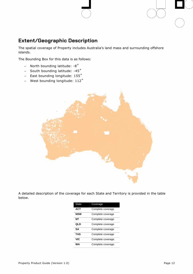
Extent/Geographic Description The spatial coverage of Property includes Australia’s land mass and surrounding offshore
islands.
The Bounding Box for this data is as follows:
– North bounding latitude: -8˚
– South bounding latitude: -45˚
– East bounding longitude: 155˚
– West bounding longitude: 112˚
A detailed description of the coverage for each State and Territory is provided in the table
below.
State Coverage
ACT Complete coverage
NSW Complete coverage
NT Complete coverage
QLD Complete coverage
SA Complete coverage
TAS Complete coverage
VIC Complete coverage.
WA Complete coverage.
Property Product Guide (Version 1.0) Page 13
Spatial Reference System
GDA94
Horizontal Datum: The Geocentric Datum of Australia 1994 (GDA94) is the target horizontal
datum.
Coordinate System: Geographic Coordinate System Geocentric Datum of Australia 1994
(GDA94).
GDA2020
Horizontal Datum: The Geocentric Datum of Australia 2020 (GDA2020) is the target horizontal
datum.
Coordinate System: Geographic Coordinate System Geocentric Datum of Australia 2020
(GDA2020).
Delivery Format Property is provided at a National and State/Territory level, depending on the file format
selected. The data is made available in the File Geodatabase, GeoJSON, ESRI Shapefile and
MapInfo TAB formats described below.
Format National State/Territory
File Geodatabase Yes Yes
GeoJSON Yes Yes
ESRI Shapefile - Yes
MapInfo TAB - Yes
File Geodatabase
Format name
File Geodatabase – ESRI™
Specification
This format includes files with the following extensions: *.gdb
ESRI File Geodatabase Technical Description. Follow this link:
http://desktop.arcgis.com/en/desktop/latest/manage-data/administer-file-gdbs/file-
geodatabases.htm
Language
English
Property Product Guide (Version 1.0) Page 14
GeoJSON
Format name
GeoJSON
Specification
This format includes files with the following extensions: *.geojson
GeoJSON specification: https://tools.ietf.org/html/rfc7946
NOTE: The GeoJSON specification states that the coordinate reference system for all GeoJSON
coordinates is:
“a geographic coordinate reference system, using the World Geodetic System 1984 (WGS 84)
datum, with longitude and latitude units of decimal degrees”
Property will be provided with coordinates using the datum selected for download
(GDA94/GDA2020) with longitude and latitude units of decimal degrees.
Language
English
JSON
Format name
JSON
Specification
This format includes files with the following extensions: *.json
JSON specification: https://www.json.org/json-en.html
Language
English
ESRI Shapefile
Format name
Shape – ESRI™
Specification
This format includes files with the following extensions: *.shp, *.shx, *.dbf
ESRI Shapefile Technical Description, an ESRI White Paper, July 1998. Follow this link:
www.esri.com/library/whitepapers/pdfs/shapefile.pdf
Language
English
Property Product Guide (Version 1.0) Page 15
MapInfo TAB
Format name
TAB – MapInfo Professional™
Specification
This format includes files with the following extensions: *.tab, *.dat, *.id, *.map
The MapInfo TAB format is a popular geospatial vector data format for geographic information
systems software. It is developed and regulated by MapInfo as a proprietary format. TAB files
support geospatial standards such as Open GIS, the OGC, ISO, W3C and others.
Language
English
Product Versioning Property versioning is managed through incrementing when there is a change to the product
schema or a significant change in data population, these are described further below:
• A schema change can affect a major or minor increment to the versioning. Additive
changes (changes that won’t break customers’ ability to work with the data) will be
incremented with a minor version increment, an example is the addition of a new
attribute. Removal of attributes or changing the structure of the Property schema will
enact a major change to identify that this requires the attention of all customers and
partners.
• Where a significant geography of Australia either has a new population of data for an
attribute or is populated from a much higher quality source a minor increment will be
applied to the product version.
Therefore, Property versioning will not increment with every data update, published releases
will have a name e.g. ‘May 2021’ and will reference a version of the Property product e.g. ‘1.0’.
Property Product Guide (Version 1.0) Page 16
Annex A – User Guide
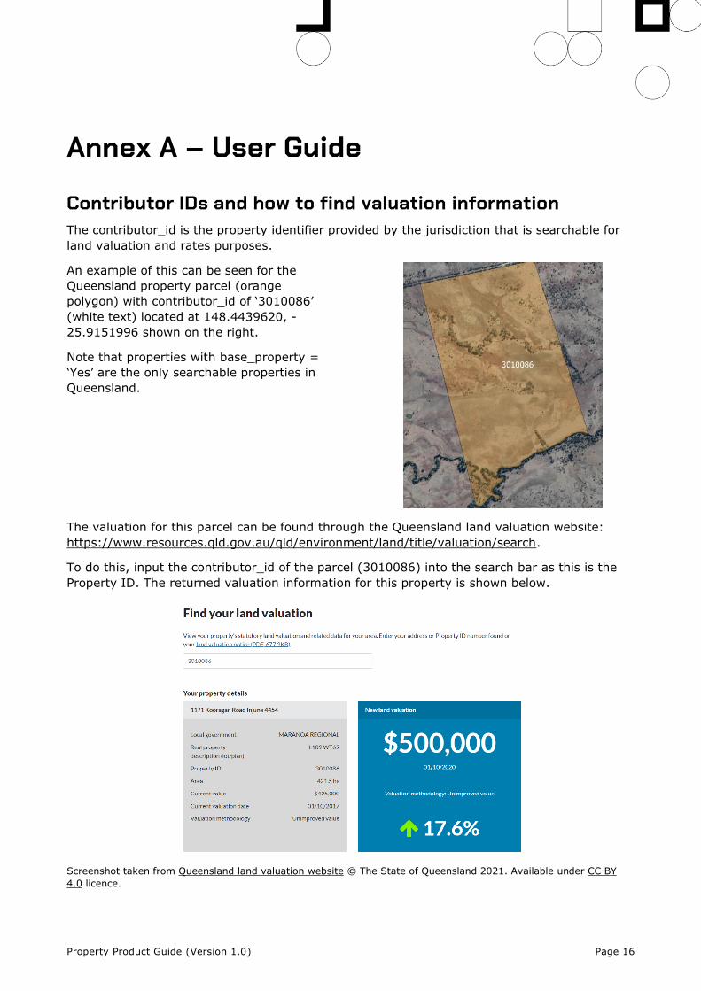
Contributor IDs and how to find valuation information The contributor_id is the property identifier provided by the jurisdiction that is searchable for
land valuation and rates purposes.
An example of this can be seen for the
Queensland property parcel (orange
polygon) with contributor_id of ‘3010086’
(white text) located at 148.4439620, -
25.9151996 shown on the right.
Note that properties with base_property =
‘Yes’ are the only searchable properties in
Queensland.
The valuation for this parcel can be found through the Queensland land valuation website:
https://www.resources.qld.gov.au/qld/environment/land/title/valuation/search.
To do this, input the contributor_id of the parcel (3010086) into the search bar as this is the
Property ID. The returned valuation information for this property is shown below.
Screenshot taken from Queensland land valuation website © The State of Queensland 2021. Available under CC BY
4.0 licence.
Property Product Guide (Version 1.0) Page 17
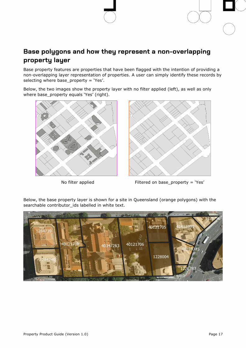
Base polygons and how they represent a non-overlapping property layer Base property features are properties that have been flagged with the intention of providing a
non-overlapping layer representation of properties. A user can simply identify these records by
selecting where base_property = ‘Yes’.
Below, the two images show the property layer with no filter applied (left), as well as only
where base_property equals ‘Yes’ (right).
No filter applied Filtered on base_property = ‘Yes’
Below, the base property layer is shown for a site in Queensland (orange polygons) with the
searchable contributor_ids labelled in white text.
Property Product Guide (Version 1.0) Page 18
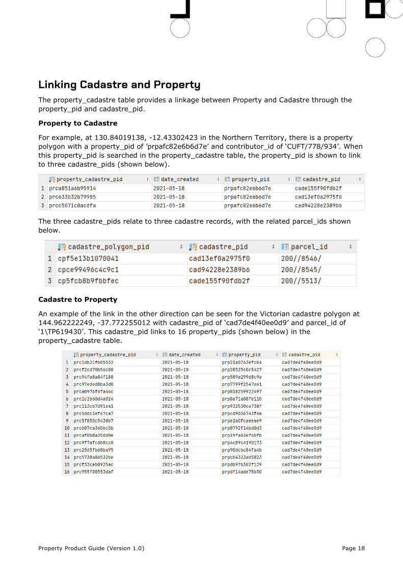
Linking Cadastre and Property The property_cadastre table provides a linkage between Property and Cadastre through the
property_pid and cadastre_pid.
Property to Cadastre
For example, at 130.84019138, -12.43302423 in the Northern Territory, there is a property
polygon with a property_pid of ’prpafc82e6b6d7e’ and contributor_id of ‘CUFT/778/934’. When
this property_pid is searched in the property_cadastre table, the property_pid is shown to link
to three cadastre_pids (shown below).
The three cadastre_pids relate to three cadastre records, with the related parcel_ids shown
below.
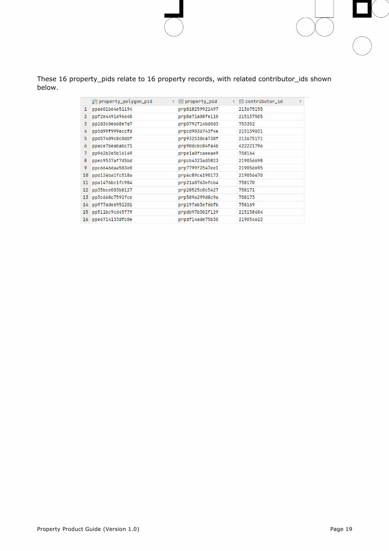
Cadastre to Property
An example of the link in the other direction can be seen for the Victorian cadastre polygon at
144.962222249, -37.772255012 with cadastre_pid of ‘cad7de4f40ee0d9’ and parcel_id of
‘1\TP619430’. This cadastre_pid links to 16 property_pids (shown below) in the
property_cadastre table.
Property Product Guide (Version 1.0) Page 19
These 16 property_pids relate to 16 property records, with related contributor_ids shown
below.
Property Product Guide (Version 1.0) Page 20
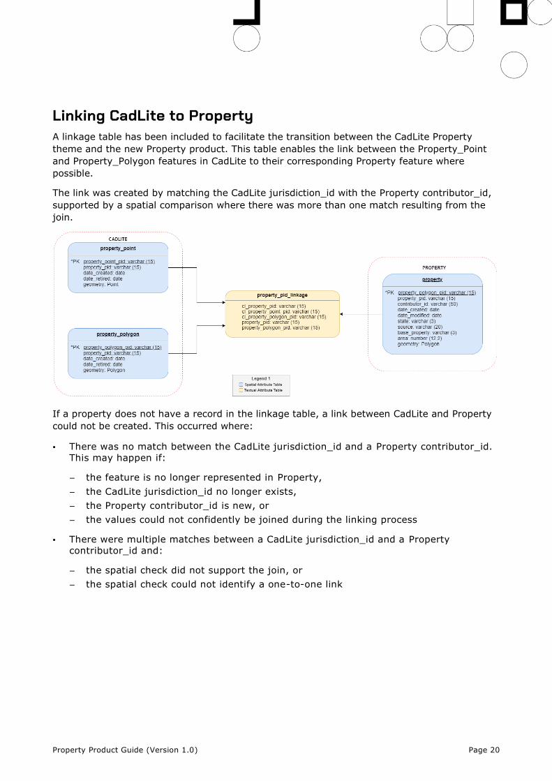
Linking CadLite to Property A linkage table has been included to facilitate the transition between the CadLite Property
theme and the new Property product. This table enables the link between the Property_Point
and Property_Polygon features in CadLite to their corresponding Property feature where
possible.
The link was created by matching the CadLite jurisdiction_id with the Property contributor_id,
supported by a spatial comparison where there was more than one match resulting from the
join.
If a property does not have a record in the linkage table, a link between CadLite and Property
could not be created. This occurred where:
• There was no match between the CadLite jurisdiction_id and a Property contributor_id.
This may happen if:
– the feature is no longer represented in Property,
– the CadLite jurisdiction_id no longer exists,
– the Property contributor_id is new, or
– the values could not confidently be joined during the linking process
• There were multiple matches between a CadLite jurisdiction_id and a Property
contributor_id and:
– the spatial check did not support the join, or
– the spatial check could not identify a one-to-one link