Project Summary Existing Conditions Lane Culvert Analysis.pdfthis analysis. There is currently only...
10
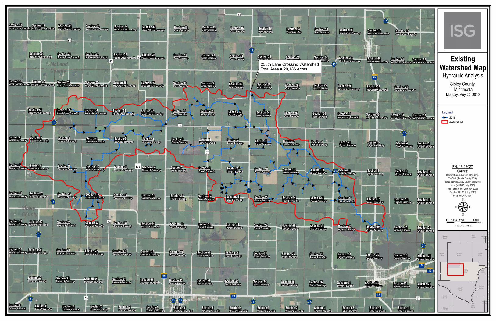
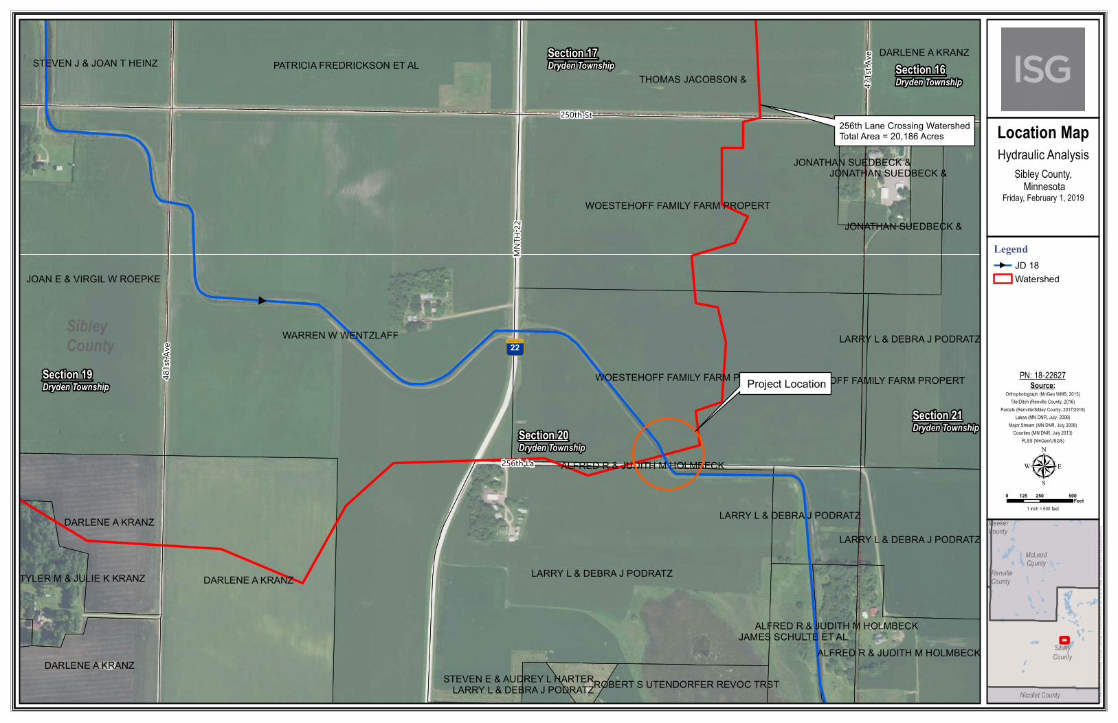
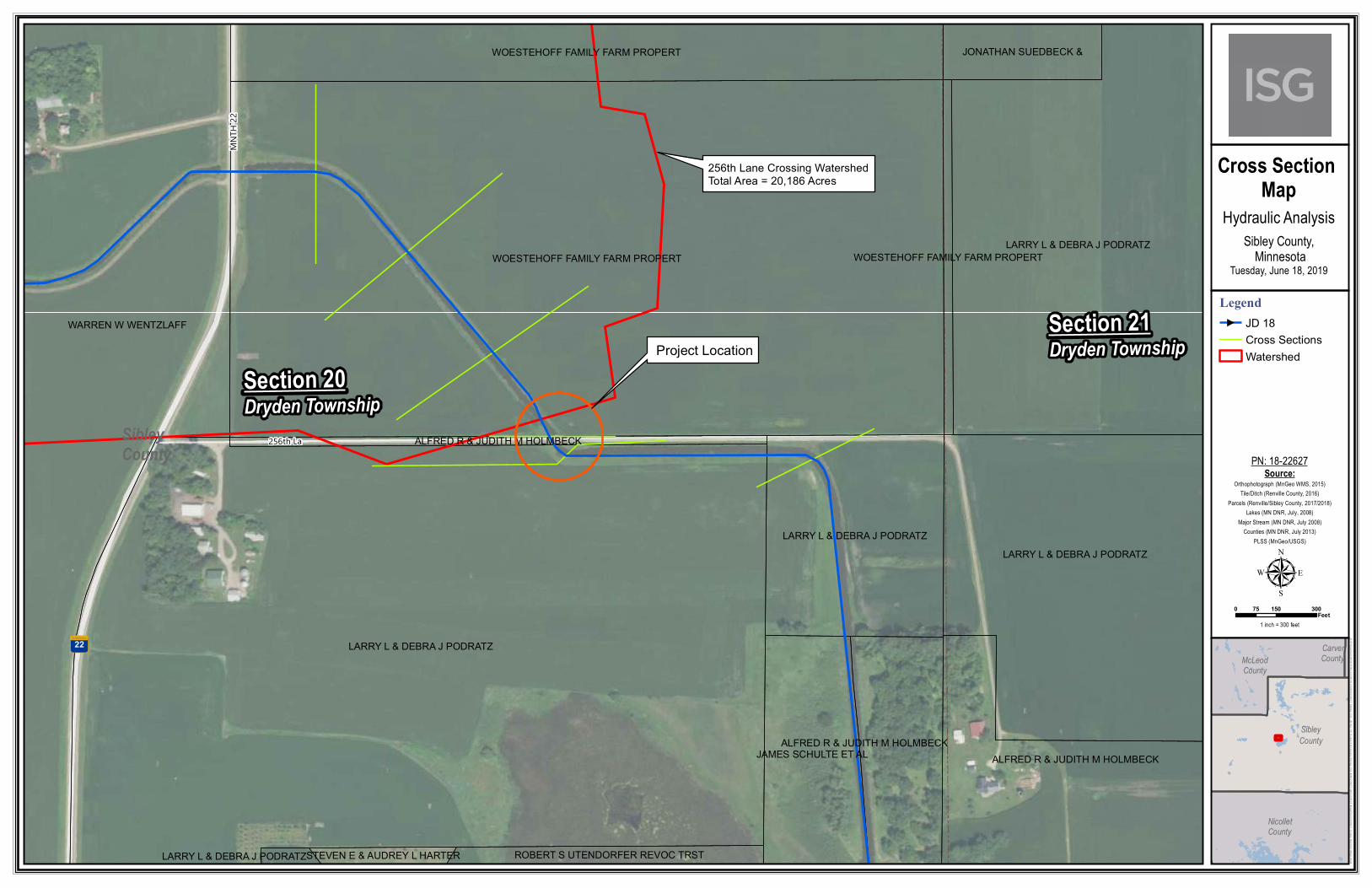
18-22627 256 th Lane Crossing 1 507.387.6651 + www.is-grp.com Figure 1: Existing Culvert Condition Figure 2: Roadway Over Crossing July 9, 2019 Aaron Goemann County Ditch Inspector Sibley County P.O. Box 51 Gaylord, Minnesota 55334-0051 RE: Sibley County JD No. 18 Culvert Analysis Project Summary I+S Group (ISG) has completed a hydraulic analysis and culvert design of the Judicial Ditch No. 18 (JD 18) 256 th Lane crossing located in Section 20 of Dryden Township. JD 18 begins in Section 22 of Bismarck Township and runs north to Section 35 of Round Grove Township, it then runs east to Section 2 Transit Township, and then finally southeast where it outlets into Titlow Lake in Section 29 of Dryden Township. Existing Conditions ISG performed topographic survey of the crossing in January 2019 including full cross sections of the roadway and ditch for 1,000 feet. Three road crossings upstream were also observed for culvert sizes and conditions. There are currently 10x10 dual box culverts located at two of the upstream crossings on Highway 22, and 481 st Avenue. JD 18 has a bottom width of 20 feet and side slopes of 3:1. The 256 th Lane crossing currently consists of a 126-inch rise by 198-inch span CMP with an upstream invert elevation of 981.40 (MSL) and a downstream invert elevation of 981.32. The total length of the culvert is 36-feet and it runs southeast across 256 th Lane.
Transcript of Project Summary Existing Conditions Lane Culvert Analysis.pdfthis analysis. There is currently only...

18-22627 256th Lane Crossing 1
507.387.6651 + www.is-grp.com
Figure 1: Existing Culvert Condition Figure 2: Roadway Over Crossing
July 9, 2019
Aaron Goemann
County Ditch Inspector
Sibley County
P.O. Box 51
Gaylord, Minnesota 55334-0051
RE: Sibley County JD No. 18 Culvert Analysis
Project Summary
I+S Group (ISG) has completed a hydraulic analysis and culvert design of the Judicial Ditch No. 18 (JD
18) 256th Lane crossing located in Section 20 of Dryden Township. JD 18 begins in Section 22 of Bismarck
Township and runs north to Section 35 of Round Grove Township, it then runs east to Section 2 Transit
Township, and then finally southeast where it outlets into Titlow Lake in Section 29 of Dryden Township.
Existing Conditions
ISG performed topographic survey of the crossing in January 2019 including full cross sections of the
roadway and ditch for 1,000 feet. Three road crossings upstream were also observed for culvert sizes and
conditions. There are currently 10x10 dual box culverts located at two of the upstream crossings on
Highway 22, and 481st Avenue. JD 18 has a bottom width of 20 feet and side slopes of 3:1. The 256th
Lane crossing currently consists of a 126-inch rise by 198-inch span CMP with an upstream invert elevation
of 981.40 (MSL) and a downstream invert elevation of 981.32. The total length of the culvert is 36-feet
and it runs southeast across 256th Lane.
18-22627 256th Lane Crossing 2
507.387.6651 + www.is-grp.com
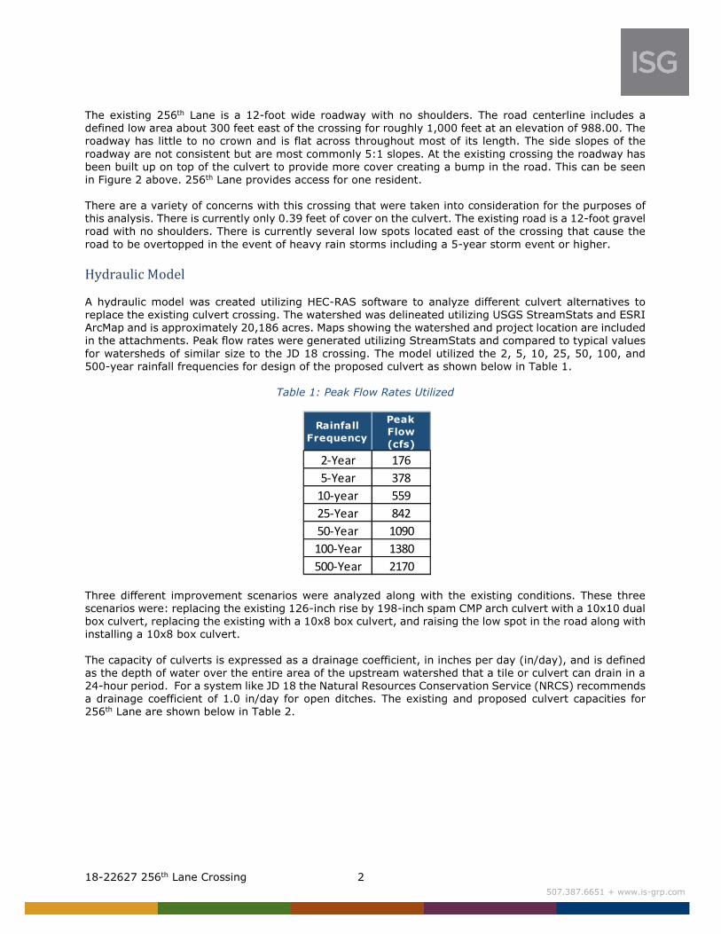
The existing 256th Lane is a 12-foot wide roadway with no shoulders. The road centerline includes a
defined low area about 300 feet east of the crossing for roughly 1,000 feet at an elevation of 988.00. The
roadway has little to no crown and is flat across throughout most of its length. The side slopes of the
roadway are not consistent but are most commonly 5:1 slopes. At the existing crossing the roadway has
been built up on top of the culvert to provide more cover creating a bump in the road. This can be seen
in Figure 2 above. 256th Lane provides access for one resident.
There are a variety of concerns with this crossing that were taken into consideration for the purposes of
this analysis. There is currently only 0.39 feet of cover on the culvert. The existing road is a 12-foot gravel
road with no shoulders. There is currently several low spots located east of the crossing that cause the
road to be overtopped in the event of heavy rain storms including a 5-year storm event or higher.
Hydraulic Model
A hydraulic model was created utilizing HEC-RAS software to analyze different culvert alternatives to
replace the existing culvert crossing. The watershed was delineated utilizing USGS StreamStats and ESRI
ArcMap and is approximately 20,186 acres. Maps showing the watershed and project location are included
in the attachments. Peak flow rates were generated utilizing StreamStats and compared to typical values
for watersheds of similar size to the JD 18 crossing. The model utilized the 2, 5, 10, 25, 50, 100, and
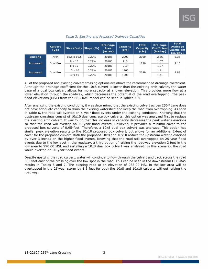
500-year rainfall frequencies for design of the proposed culvert as shown below in Table 1.
Table 1: Peak Flow Rates Utilized
Three different improvement scenarios were analyzed along with the existing conditions. These three
scenarios were: replacing the existing 126-inch rise by 198-inch spam CMP arch culvert with a 10x10 dual
box culvert, replacing the existing with a 10x8 box culvert, and raising the low spot in the road along with
installing a 10x8 box culvert.
The capacity of culverts is expressed as a drainage coefficient, in inches per day (in/day), and is defined
as the depth of water over the entire area of the upstream watershed that a tile or culvert can drain in a
24-hour period. For a system like JD 18 the Natural Resources Conservation Service (NRCS) recommends
a drainage coefficient of 1.0 in/day for open ditches. The existing and proposed culvert capacities for
256th Lane are shown below in Table 2.
Rainfall
Frequency
Peak
Flow
(cfs)
2-Year 176
5-Year 378
10-year 559
25-Year 842
50-Year 1090
100-Year 1380
500-Year 2170
18-22627 256th Lane Crossing 3
507.387.6651 + www.is-grp.com
Table 2: Existing and Proposed Drainage Capacities
All of the proposed and existing culvert crossing options are above the recommended drainage coefficient.
Although the drainage coefficient for the 10x8 culvert is lower than the existing arch culvert, the water
base of a dual box culvert allows for more capacity at a lower elevation. This provides more flow at a
lower elevation through the roadway, which decreases the potential of the road overtopping. The peak
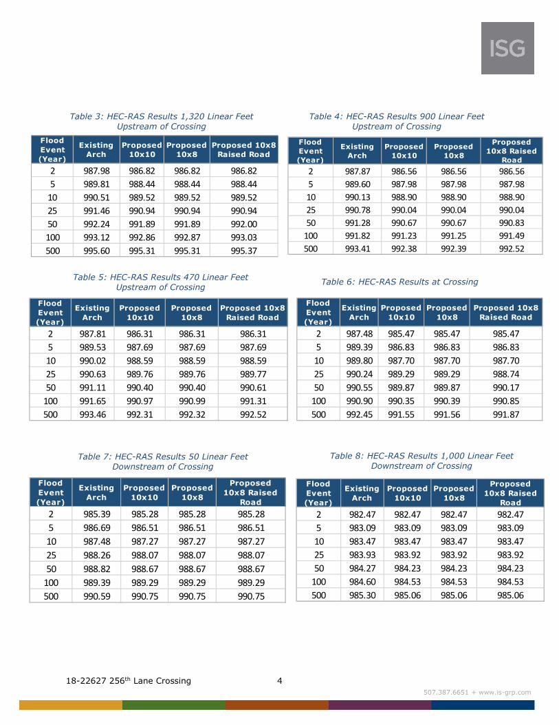
flood elevations (MSL) from the HEC-RAS model can be seen in Tables 3-8.
After analyzing the existing conditions, it was determined that the existing culvert across 256th Lane does
not have adequate capacity to drain the existing watershed and keep the road from overtopping. As seen
in Table 6, the road will overtop on 5-year flood events under the existing conditions. Knowing that the
upstream crossings consist of 10x10 dual concrete box culverts, this option was analyzed first to replace
the existing arch culvert. It was found that this increase in capacity decreases the peak water elevations
so that the road will overtop on 25-year flood events. However, it provides a minimal cover to the
proposed box culverts of 0.95-feet. Therefore, a 10x8 dual box culvert was analyzed. This option has
similar peak elevation results to the 10x10 proposed box culvert, but allows for an additional 2-feet of
cover for the proposed culvert. Both the proposed 10x8 and 10x10 reduce the upstream water elevations
by over 3 inches on the higher flood events. Knowing that the road still overtopped on 25-year flood
events due to the low spot in the roadway, a third option of raising the roadway elevation 2 feet in the
low area to 990.00 MSL and installing a 10x8 dual box culvert was analyzed. In this scenario, the road
would overtop on 50-year flood events.
Despite upsizing the road culvert, water will continue to flow through the culvert and back across the road
300 feet east of the crossing over the low spot in the road. This can be seen in the downstream HEC-RAS
results in Tables 6 and 7. The existing road at an elevation of 988.00 MSL in the low area will be
overtopped in the 25-year storm by 1.3 feet for both the 10x8 and 10x10 culverts without raising the
roadway.
Culvert
TypeSize (feet) Slope (%)
Drainage
Area
(acres)
Capacity
(cfs)
Total
Capacity
(cfs)
Drainage
Coefficient
(in/day)
Total
Drainage
Coefficient
(in/day)
Existing Arch 16.5 x 10.5 0.22% 20186 2000 2000 2.36 2.36
8 x 10 0.22% 20186 910 1.07
8 x 10 0.22% 20186 910 1.07
10 x 10 0.22% 20186 1200 1.41
10 x 10 0.22% 20186 1200 1.41
2.15
2.83
1820
2399
Proposed
Proposed
Dual Box
Dual Box
18-22627 256th Lane Crossing 4
507.387.6651 + www.is-grp.com
Table 3: HEC-RAS Results 1,320 Linear Feet
Upstream of Crossing
Table 4: HEC-RAS Results 900 Linear Feet
Upstream of Crossing
Table 7: HEC-RAS Results 50 Linear Feet
Downstream of Crossing
Table 8: HEC-RAS Results 1,000 Linear Feet
Downstream of Crossing
Table 5: HEC-RAS Results 470 Linear Feet
Upstream of Crossing Table 6: HEC-RAS Results at Crossing
Flood
Event
(Year)
Existing
Arch
Proposed
10x10
Proposed
10x8
Proposed
10x8 Raised
Road
2 987.87 986.56 986.56 986.56
5 989.60 987.98 987.98 987.98
10 990.13 988.90 988.90 988.90
25 990.78 990.04 990.04 990.04
50 991.28 990.67 990.67 990.83
100 991.82 991.23 991.25 991.49
500 993.41 992.38 992.39 992.52
Flood
Event
(Year)
Existing
Arch
Proposed
10x10
Proposed
10x8
Proposed 10x8
Raised Road
2 987.81 986.31 986.31 986.31
5 989.53 987.69 987.69 987.69
10 990.02 988.59 988.59 988.59
25 990.63 989.76 989.76 989.77
50 991.11 990.40 990.40 990.61
100 991.65 990.97 990.99 991.31
500 993.46 992.31 992.32 992.52
Flood
Event
(Year)
Existing
Arch
Proposed
10x10
Proposed
10x8
Proposed 10x8
Raised Road
2 987.48 985.47 985.47 985.47
5 989.39 986.83 986.83 986.83
10 989.80 987.70 987.70 987.70
25 990.24 989.29 989.29 988.74
50 990.55 989.87 989.87 990.17
100 990.90 990.35 990.39 990.85
500 992.45 991.55 991.56 991.87
Flood
Event
(Year)
Existing
Arch
Proposed
10x10
Proposed
10x8
Proposed
10x8 Raised
Road
2 985.39 985.28 985.28 985.28
5 986.69 986.51 986.51 986.51
10 987.48 987.27 987.27 987.27
25 988.26 988.07 988.07 988.07
50 988.82 988.67 988.67 988.67
100 989.39 989.29 989.29 989.29
500 990.59 990.75 990.75 990.75
Flood
Event
(Year)
Existing
Arch
Proposed
10x10
Proposed
10x8
Proposed
10x8 Raised
Road
2 982.47 982.47 982.47 982.47
5 983.09 983.09 983.09 983.09
10 983.47 983.47 983.47 983.47
25 983.93 983.92 983.92 983.92
50 984.27 984.23 984.23 984.23
100 984.60 984.53 984.53 984.53
500 985.30 985.06 985.06 985.06
Flood
Event
(Year)
Existing
Arch
Proposed
10x10
Proposed
10x8
Proposed 10x8
Raised Road
2 987.98 986.82 986.82 986.82
5 989.81 988.44 988.44 988.44
10 990.51 989.52 989.52 989.52
25 991.46 990.94 990.94 990.94
50 992.24 991.89 991.89 992.00
100 993.12 992.86 992.87 993.03
500 995.60 995.31 995.31 995.37

18-22627 256th Lane Crossing 5
507.387.6651 + www.is-grp.com
Proposed Alternatives
Option 1
Option 1 for this crossing is to install a 10-foot by 8-foot dual box culvert. This will maintain close to the
same capacity and lower the peak flood elevations upstream of the crossing by up to 2 feet in higher flood
events. It will provide adequate cover of 2.56 feet on the culvert, much more protection than the existing
0.39 feet. The 10-foot by 8-foot dual box culvert will be placed at the existing invert elevations of 981.40
upstream and 981.32 downstream. The total width of the dual culvert will be 22.5 feet which will be
slightly wider than the existing channel width of 20 feet.
This option is proposed over the 10x10 dual box culvert analyzed as it still reduces the occurrence of the
road overtopping to the 25-year flood event and while also providing an appropriate amount of cover over
the culvert. The additional capacity in the 10x10 does not help with the overtopping frequency as the
roadway to the east will still over top with a larger culvert. The extra 2-feet in height of the 10x10 is at
an elevation that is higher than the low spot in the roadway to the east.
Option 2
Option 2 is to leave the existing crossing as is until more funding is available. The culvert appears to be
in good condition and currently only supplies access to one resident. With the existing road geometry,
overtopping is inevitable due to the low elevation of the road running parallel to the ditch as described
above. Without raising the road, a new culvert will continue to flood this crossing with relative frequency.
Option 3
Option 3 is to raise the road 2 feet in the low area from an elevation of 988.00 to 990.00. The roadway
would be constructed to its existing 12 foot wide conditions with a 5:1 side slope. This would require
about 1,500 CY of fill over a length of roadway about 1,000 feet long. A 10x8 dual box culvert would be
installed to increase the capacity of the crossing and the raised road would prevent the water from flowing
over the road in the low area east of the crossing. This would prevent overtopping of the road up to the
50-year storm event. It also provides the 2.56 feet of cover on the culvert and decreases upstream flood
elevations. In the event of a 100-year storm the road would be overtopped in the same area 300 feet
east of the crossing.
Cost Estimate
For all proposed options, the culvert should be armored with Class III riprap a minimum of 10-feet out
on the upstream end and 20-feet out from the outlet end to protect from scour and erosion. Additional
riprap will be required to protect the bend on the downstream side. Table 9 shows a cost summary for
Options 1 and 3.
Table 9: Proposed Option Cost Summaries
Item No. Item Unit Quantity Unit Price Amount
101 MOBILIZATION LS 1 20,000.00$ 20,000$
102 10x8 DUAL BOX CULVERT LF 40 2,300.00$ 92,000$
103 10x8 DUAL BOX CULVERT END SECTION EA 2 14,950.00$ 29,900$
104 BACKFILL CY 20 12.00$ 240$
105 CLASS III RIPRAP WITH GEOTEXTILE FABRIC CY 100 75.00$ 7,500$
106 REMOVE METAL CULVERT LS 1 1,500.00$ 1,500$
107 OPEN CUT & RESTORE GRAVEL ROAD OR DRIVEWAY EA 1 1,700.00$ 1,700$
152,840$ Total
OPTION 1

18-22627 256th Lane Crossing 6
507.387.6651 + www.is-grp.com
Please feel free to contact me at 507-387-6651 or at [email protected] with any questions
regarding the design of culvert.
Sincerely,
Mark Origer, PE
Civil Engineer Enclosures: Watershed Map Location Map Cross Section Location Map Cost Estimate
Item No. Item Unit Quantity Unit Price Amount
101 MOBILIZATION LS 1 20,000.00$ 20,000$
102 10x8 DUAL BOX CULVERT LF 40 2,300.00$ 92,000$
103 10x8 DUAL BOX CULVERT END SECTION EA 2 14,950.00$ 29,900$
104 COMMON BORROW CY 1,500 12.00$ 18,000$
105 CLASS III RIPRAP WITH GEOTEXTILE FABRIC CY 100 75.00$ 7,500$
106 AGGREGATE BASE (CV) (P), CLASS V CY 225 27.00$ 6,075$
107 REMOVE METAL CULVERT LS 1 1,500.00$ 1,500$
110 OPEN CUT & RESTORE GRAVEL ROAD OR DRIVEWAY EA 1 1,700.00$ 1,700$
176,675$ TOTAL
OPTION 3
Section 36Penn Township
Section 35Penn Township
Section 34Penn Township
Section 33Penn Township
Section 32Penn Township
Section 31Penn Township
Section 30Penn Township
Section 29Penn Township
Section 28Penn Township
Section 27Penn Township
Section 26Penn Township
Section 25Penn Township
Section 24Penn Township
Section 23Penn Township
Section 22Penn Township
Section 21Penn Township
Section 20Penn Township
Section 19Penn Township
Section 18Penn Township
Section 17Penn Township Section 16
Penn Township Section 15Penn Township
Section 14Penn Township
Section 13Penn Township
Section 9Dryden Township
Section 8Dryden Township
Section 7Dryden Township
Section 6Dryden Township
Section 5Dryden Township
Section 4Dryden Township
Section 3Dryden Township
Section 6Sibley Township
Section 5Sibley Township
Section 4Sibley Township
Section 9Transit Township
Section 8Transit Township
Section 7Transit Township
Section 6Transit Township
Section 5Transit Township
Section 4Transit Township Section 3
Transit TownshipSection 2Transit Township
Section 1Transit Township
Section 34Dryden Township
Section 33Dryden Township
Section 31Dryden Township
Section 30Dryden Township
Section 29Dryden Township
Section 28Dryden Township Section 27
Dryden Township
Section 22Dryden Township
Section 21Dryden Township
Section 20Dryden Township
Section 19Dryden Township
Section 18Dryden Township
Section 17Dryden Township
Section 16Dryden Township
Section 15Dryden Township
Section 10Dryden Township
Section 6Cornish Township
Section 5Cornish Township
Section 4Cornish Township
Section 3Cornish Township
Section 2Cornish Township
Section 1Cornish Township
Section 9Bismarck Township
Section 8Bismarck Township
Section 7Bismarck Township
Section 6Bismarck Township
Section 5Bismarck Township
Section 4Bismarck Township
Section 3Bismarck Township
Section 2Bismarck Township
Section 1Bismarck Township
Section 36Transit Township
Section 35Transit Township
Section 34Transit Township
Section 33Transit Township
Section 32Transit Township
Section 31Transit Township
Section 30Transit Township
Section 29Transit Township
Section 28Transit Township
Section 27Transit Township
Section 26Transit Township
Section 25Transit Township
Section 24Transit Township
Section 23Transit Township
Section 22Transit Township
Section 21Transit Township
Section 20Transit Township
Section 19Transit Township
Section 18Transit Township
Section 17Transit Township
Section 16Transit Township
Section 15Transit Township
Section 14Transit Township
Section 13Transit Township
Section 12Transit Township
Section 11Transit Township
Section 10Transit Township
Section 32Gaylord Township
Section 6Winthrop Township
Section 5Alfsborg Township
Section 4Alfsborg Township
Section 3Alfsborg Township
Section 2Alfsborg Township
Section 1Alfsborg Township
Section 36Bismarck Township
Section 35Bismarck Township
Section 34Bismarck Township
Section 33Bismarck Township
Section 32Bismarck Township
Section 30Bismarck Township
Section 29Bismarck Township
Section 28Bismarck Township
Section 27Bismarck Township
Section 26Bismarck Township
Section 25Bismarck Township
Section 24Bismarck Township
Section 23Bismarck Township
Section 22Bismarck Township
Section 21Bismarck Township
Section 20Bismarck Township
Section 19Bismarck Township
Section 18Bismarck Township
Section 17Bismarck Township
Section 16Bismarck Township
Section 15Bismarck Township
Section 14Bismarck Township
Section 13Bismarck Township
Section 12Bismarck Township
Section 11Bismarck Township
Section 10Bismarck Township
Section 34New Auburn Township
Section 33New Auburn Township
Section 32New Auburn Township
Section 31New Auburn Township
Section 30New Auburn Township Section 29
New Auburn TownshipSection 28New Auburn Township
Section 22New Auburn Township
Section 21New Auburn Township
Section 20New Auburn Township
Section 19New Auburn Township
Section 18New Auburn Township Section 17
New Auburn TownshipSection 16New Auburn Township
Section 36Round Grove Township
Section 35Round Grove Township
Section 34Round Grove Township
Section 33Round Grove Township
Section 32Round Grove Township
Section 30Round Grove Township
Section 29Round Grove Township
Section 28Round Grove Township
Section 27Round Grove Township
Section 26Round Grove Township
Section 25Round Grove Township
Section 24Round Grove Township
Section 23Round Grove Township
Section 22Round Grove Township
Section 21Round Grove Township
Section 20Round Grove Township
Section 18Round Grove Township
Section 17Round Grove Township
Section 16Round Grove Township
Section 15Round Grove Township
Section 14Round Grove Township
Section 13Round Grove Township
ßß
ªATOSENNIM
19
ßß
ªATOSENNIM
22
ßß
ªATOSENNIM
15
ßß
ªATOSENNIM
5
ßß
ªATOSENNIM
19
ßß
ªATOSENNIM
22
56515
56517
5657
56513
56521
56512
56526
5653
5654
5652356533 56532
5653
56515
5653 5654
")53
")58
")67
")52
")51
")57
")54
")172
")57
")53
SibleyCounty
McLeodCounty
S:\Projects\22000 PROJ\22600-22699\22627 Sibley CO JD No 18 Culvert Analysis-Sibley CO MN\22627 GIS\22627 MapDocs\22627 Watershed Map.mxd
1 inch = 5,500 feet
LegendJD18Watershed
0 2,750 5,5001,375Feet
µ
Orthophotograph (MnGeo WMS, 2015)Tile/Ditch (Renville County, 2016)
Parcels (Renville/Sibley County, 2017/2018)Lakes (MN DNR, July, 2008)
Major Stream (MN DNR, July 2008)Counties (MN DNR, July 2013)
PLSS (MnGeo/USGS)
PN: 18-22627Source:
ExistingWatershed Map
Hydraulic AnalysisSibley County,
MinnesotaMonday, May 20, 2019
HennepinCounty
WasecaCounty
WrightCountyMeeker
County
McLeodCounty
CarverCounty
RenvilleCounty
ScottCounty
SibleyCounty
Le SueurCounty
BrownCounty
NicolletCounty
BlueEarth
CountyWatonwanCounty
256th Lane Crossing WatershedTotal Area = 20,186 Acres
Section 21Dryden TownshipSection 20
Dryden Township
Section 19Dryden Township
Section 17Dryden Township Section 16
Dryden Township
WARREN W WENTZLAFF
LARRY L & DEBRA J PODRATZDARLENE A KRANZ
JOAN E & VIRGIL W ROEPKE
WOESTEHOFF FAMILY FARM PROPERT
THOMAS JACOBSON &
WOESTEHOFF FAMILY FARM PROPERT
PATRICIA FREDRICKSON ET AL
DARLENE A KRANZ
DARLENE A KRANZ
DARLENE A KRANZ
STEVEN J & JOAN T HEINZ
LARRY L & DEBRA J PODRATZ
LARRY L & DEBRA J PODRATZ
JONATHAN SUEDBECK &
ALFRED R & JUDITH M HOLMBECK
TYLER M & JULIE K KRANZ
JAMES SCHULTE ET AL
LARRY L & DEBRA J PODRATZ
JONATHAN SUEDBECK &
ROBERT S UTENDORFER REVOC TRST
ALFRED R & JUDITH M HOLMBECK
JONATHAN SUEDBECK &
STEVEN E & AUDREY L HARTERLARRY L & DEBRA J PODRATZ
ALFRED R & JUDITH M HOLMBECK
WOESTEHOFF FAMILY FARM PROPERT
250th St
MNTH
22
481s
t Ave
256th La
471s
t Ave
ßß
ªATOSENNIM
22SibleyCounty
S:\Projects\22000 PROJ\22600-22699\22627 Sibley CO JD No 18 Culvert Analysis-Sibley CO MN\22627 GIS\22627 MapDocs\22627 Location Map.mxd
1 inch = 500 feet
LegendJD 18Watershed
0 250 500125Feet
µ
Orthophotograph (MnGeo WMS, 2015)Tile/Ditch (Renville County, 2016)
Parcels (Renville/Sibley County, 2017/2018)Lakes (MN DNR, July, 2008)
Major Stream (MN DNR, July 2008)Counties (MN DNR, July 2013)
PLSS (MnGeo/USGS)
PN: 18-22627Source:
Location MapHydraulic Analysis
Sibley County, Minnesota
Friday, February 1, 2019
MeekerCounty
RenvilleCounty
McLeodCounty
SibleyCounty
Nicollet County
Project Location
256th Lane Crossing WatershedTotal Area = 20,186 Acres
Section 21Dryden Township
Section 20Dryden Township
LARRY L & DEBRA J PODRATZ
WOESTEHOFF FAMILY FARM PROPERT
WARREN W WENTZLAFF
LARRY L & DEBRA J PODRATZ
LARRY L & DEBRA J PODRATZLARRY L & DEBRA J PODRATZ
ALFRED R & JUDITH M HOLMBECK
WOESTEHOFF FAMILY FARM PROPERT JONATHAN SUEDBECK &
ROBERT S UTENDORFER REVOC TRST
JAMES SCHULTE ET ALALFRED R & JUDITH M HOLMBECK
ALFRED R & JUDITH M HOLMBECK
WOESTEHOFF FAMILY FARM PROPERT
STEVEN E & AUDREY L HARTERLARRY L & DEBRA J PODRATZ
256th La
MNTH
22
ßß
ªATOSENNIM
22
SibleyCounty
S:\Projects\22000 PROJ\22600-22699\22627 Sibley CO JD No 18 Culvert Analysis-Sibley CO MN\22627 GIS\22627 MapDocs\22627 Cross Section Map.mxd
1 inch = 300 feet
LegendJD 18Cross SectionsWatershed
0 150 30075Feet
µ
Orthophotograph (MnGeo WMS, 2015)Tile/Ditch (Renville County, 2016)
Parcels (Renville/Sibley County, 2017/2018)Lakes (MN DNR, July, 2008)
Major Stream (MN DNR, July 2008)Counties (MN DNR, July 2013)
PLSS (MnGeo/USGS)
PN: 18-22627Source:
Cross Section Map
Hydraulic AnalysisSibley County,
MinnesotaTuesday, June 18, 2019
CarverCounty
BrownCounty
McLeodCounty
SibleyCounty
NicolletCounty
256th Lane Crossing WatershedTotal Area = 20,186 Acres
Project Location

Item No. Item Unit Quantity Unit Price Amount
101 MOBILIZATION LS 1 20,000.00$ 20,000$
102 10x8 DUAL BOX CULVERT LF 40 2,300.00$ 92,000$
103 10x8 DUAL BOX CULVERT END SECTION EA 2 14,950.00$ 29,900$
104 BACKFILL CY 20 12.00$ 240$
105 CLASS III RIPRAP WITH GEOTEXTILE FABRIC CY 100 75.00$ 7,500$
106 REMOVE METAL CULVERT LS 1 1,500.00$ 1,500$
107 OPEN CUT & RESTORE GRAVEL ROAD OR DRIVEWAY EA 1 1,700.00$ 1,700$
152,840$
Item No. Item Unit Quantity Unit Price Amount
101 MOBILIZATION LS 1 20,000.00$ 20,000$
102 10x8 DUAL BOX CULVERT LF 40 2,300.00$ 92,000$
103 10x8 DUAL BOX CULVERT END SECTION EA 2 14,950.00$ 29,900$
104 COMMON BORROW CY 1,500 12.00$ 18,000$
105 CLASS III RIPRAP WITH GEOTEXTILE FABRIC CY 100 75.00$ 7,500$
106 AGGREGATE BASE (CV) (P), CLASS V CY 225 27.00$ 6,075$
107 REMOVE METAL CULVERT LS 1 1,500.00$ 1,500$
110 OPEN CUT & RESTORE GRAVEL ROAD OR DRIVEWAY EA 1 1,700.00$ 1,700$
176,675$ TOTAL
OPTION 1
SIBLEY COUNTYJUDICIAL DITCH No. 18
Total
OPTION 3