PROJECT : PORTO INGLÊS AND PALMERIA PORTS …...Mohamed El Abass WADE, Transport Engineer...
39
PROJECT : PORTO INGLÊS AND PALMERIA PORTS EXPANSION AND MODERNISATION PROJECT COUNTRY : CABO VERDE SUMMARY OF THE ENVIRONMENTAL AND SOCIAL IMPACT ASSESSMENT (ESIA) Project Team Team Leader Mohamed El Abass WADE, Transport Engineer RDGW.3/COSN 6540 Team Members Modeste KINANE, Environmental Safeguards Expert RDGW.4 2933 Souwèye MAIGA, Procurement Expert SNFI.3/COSN 6574 Alain NNA, Regional Financial Management Coordinator SNFI.2/COSN 6577 Mam Tut WADDA, Transport Engineer RDGW.3/COGH 6168 Neil COUSINS, Biodiversity Expert (Consultant) RDGW.4 Moctar MBODJ, Transport Economist (Consultant) RDGW/COSN Sector Division Manager Jean Kizito KABANGUKA PICU.1 2143 Sector Director Amadou OUMAROU PICU 3075 Regional Director Marie-Laure AKIN OLUGBADE RDWG 7778 Regional Division Manager for Infrastructure Jean Noel ILBOUDO RDGW.3 5012 AFRICAN DEVELOPMENT BANK GROUP
Transcript of PROJECT : PORTO INGLÊS AND PALMERIA PORTS …...Mohamed El Abass WADE, Transport Engineer...

PROJECT : PORTO INGLÊS AND PALMERIA PORTS
EXPANSION AND MODERNISATION
PROJECT
COUNTRY : CABO VERDE
SUMMARY OF THE ENVIRONMENTAL AND SOCIAL IMPACT ASSESSMENT (ESIA)
Project Team
Team Leader Mohamed El Abass WADE,
Transport Engineer RDGW.3/COSN 6540
Team Members
Modeste KINANE, Environmental
Safeguards Expert RDGW.4 2933
Souwèye MAIGA, Procurement
Expert SNFI.3/COSN 6574
Alain NNA, Regional Financial
Management Coordinator SNFI.2/COSN 6577
Mam Tut WADDA, Transport
Engineer RDGW.3/COGH 6168
Neil COUSINS, Biodiversity Expert
(Consultant) RDGW.4
Moctar MBODJ, Transport
Economist (Consultant) RDGW/COSN
Sector Division
Manager Jean Kizito KABANGUKA PICU.1 2143
Sector Director Amadou OUMAROU PICU 3075
Regional Director Marie-Laure AKIN OLUGBADE RDWG 7778
Regional Division
Manager for
Infrastructure
Jean Noel ILBOUDO RDGW.3 5012
AFRICAN DEVELOPMENT BANK GROUP

2
2
SUMMARY OF THE ENVIRONMENTAL AND SOCIAL IMPACT ASSESSMENT (ESIA)
Project Title: Porto Inglês and Palmeira Ports Modernisation and
Expansion Project
SAP Code: P-CV-
DD0-005
Country: Cabo Verde Category: 1
Department: RDGW Division: RDGW-3
1. INTRODUCTION
This document is a summary of the Environmental and Social Impact Assessment (ESIA) of the Porto Inglês and
Palmeira Ports Modernisation and Expansion Project in Cabo Verde. It covers the works executed in these ports
as well as the ancillary infrastructure (see project description for details). An ESIA as well as an Environmental
and Social Management Plan (ESMP) were prepared by Motaengil in English in 2016 for the expansion of Palmeira
Port (phases 1 and 2) and another ESIA was prepared by Consulmar in Portuguese in August 2017 for the Maio
Port. Following comments from the Ministry of Agriculture and the Environment (MAE) in December 2017, an addendum was prepared for the Maio Port ESIA and validated by the MAE in February 2018. The MAE requested
no additional national requirements for the Palmeira Port.
Following the Bank’s involvement, a revised ESIA report for Maio was produced and supplemented with an
ESMP. These reports were subsequently translated into French. The Bank also recruited an international consultant
to support ENAPOR in preparing a Biodiversity Action Plan (BAP) in English to supplement the ESIA and ESMP.
For Palmeira and following the Bank's comments, a revised version of the ESIA, accompanied by an ESMP, was
prepared in French by the Andjona Office in 2018, targeting the works phase of the project as well as the
operational phase of the entire port considered as ancillary infrastructure.
This summary of the two ESIAs was prepared in accordance with the Integrated Safeguards System (ISS) and the
AfDB environmental and social assessment guidelines and procedures for Category 1 projects. It sums up the
political, legal and administrative framework of the project; its implementation and environment; the alternative
solutions rejected in favour of the selected option; its environmental and social impacts; the recommended
mitigation and rehabilitation measures; the concerns raised during public consultations; measures for mitigating
negative impacts and strengthening positive impacts as defined in the management plan; and project monitoring
mechanisms.
2. POLITICAL, LEGAL, ADMINISTRATIVE AND INSTITUTIONAL FRAMEWORK
Cabo Verde relies on a national and international legal framework, including conventions, agreements, treaties,
development policies, programmes, plans and strategies as well as national laws and regulations on environmental
and social protection.
2.1 Legal Framework
The national requirements are presented relative to the applicable AfDB operational safeguards (OS), including
OS 1, 3, 4 and 5. These are:
• Environmental and Social Assessment: (i) Law No. 86/IV/1993 to define the environmental
policy; (ii) Decree-Law No. 29/2006 of 6 March establishing the legal framework for
Environmental Impact Assessment (EIA) of public or private projects;
• Biodiversity, Renewable Resources and Ecosystem Services: (i) Regulatory Decree No. 7/2002
of 30 December (DR 7/2002) defining measures for the conservation and protection of endangered
fauna and flora species that form part of the biodiversity and constitute an integral part of the
natural heritage of Cabo Verde; (ii) Decree-Law No. 53/2005, Article 40 of which penalises the

3
3
possession, consumption and trading of turtles and their meat or eggs (the degradation or
transformation of turtle habitats and the disturbance of turtles during the breeding season is also
penalised); (iii) Resolution No. 72/2010 of 13 December 2010 approving the National Plan for the
Conservation of Sea Turtles in Cabo Verde; (iv) Decree-Law No. 3/2003 of 24 February
establishing the Legal Regime for Protected Areas, as amended in part by Decree-Law No.
44/2006 of 28 August; and (v) Decree No. 1/2018 defining the protection and conservation regime
for marine turtles in Cabo Verde;
• Prevention and Control of Pollution, Hazardous Materials and Efficient Resource Use: (i)
Decree-Law No. 5/2003 of 31 March defining the National Air Protection System; (ii) Decree No.
31/2003 of 1 September defining the essential requirements to be considered in the elimination of
solid urban, industrial and other waste in order to protect the environment and human health; (iii)
Decree-Law No. 7/2004 of 23 February setting the standards for wastewater discharge; (iv)
Decree-Law No. 6/2003 of 31 March establishing the legal regime for granting licences and
operating quarries; (v) Law No. 34/VIII/2013 establishing the regime for preventing and
controlling noise pollution, aimed at ensuring the rest, tranquillity and well-being of the
population; and (vi) Law No. 2/2002 prohibiting the extraction and exploitation of sand from the
beaches, coastal areas and the sea;
• Work, Health and Safety Conditions: (i) Decree-Law No. 64/2010 of 27 December 2010
defining the general planning, organisation and coordination rules for promoting safety, hygiene
and health on construction sites; (ii) Law No. 19/VII/2007 of 26 November 2007 on HIV/AIDS;
(iii) Ministerial Decree No. 1-F/91 establishing a set of rules to be observed by industrial
enterprises that transport, store, handle, process and dispose of toxic or hazardous products; (iv)
Law No. 113 / VIII / 2016 of 10 March 2016 approving the National List of Dangerous Child
Labour and regulate its application; (v) Decree-Law No. 36/93 regulating the work, wages and
leave of maritime workers; (vi) Decree-Law No. 15/95 setting the rules governing access to and
exercise of the activity of port operator; (vii) Order No. 80/84 of 22 December defining the
regulations governing summer work and workers in Cabo Verde ports; (viii) Decree-Law No.
170/91 governing the exercise of the right of association and the corresponding activity of workers;
and (ix) Regulatory Decree No. 2/93, of 25 January regulating the effects of the working time
exemption laid down in Article 97 of Decree-law No. 62/87 of 30 June.
2.2 Administrative and Institutional Framework
• The Ministry of Infrastructure, Land-use Planning and Housing is the project owner.
• The Ministry of Maritime Infrastructure and the Economy is responsible for the port sector and
maritime transport in Cabo Verde. Port management is the responsibility of ENAPOR (Cabo
Verde Ports Authority), with headquarters in Mindelo. This State company enjoys autonomy and
financial independence. It shall ensure delegated project management.
• The General Directorate for the Environment (DGE) within the Ministry of Environment, Housing
and Land-Use Planning, with headquarters in Praia, is tasked with the planning, development,
protection, optimal and integrated use of natural resources as well as linkages with the national
environmental policy. It coordinates crosscutting systems that have an impact on the ecological
sustainability and protection of the country's natural biodiversity, urban waste management, risk
prevention and integrated pollution control and environmental education, while ensuring the
participation and information of the public, NGOs and businesses.
• The Ministry of Tourism, Industry and Energy supervises the tourism sector through the General
Directorate for Tourism.
4
4
• Maio and Sal Municipalities are responsible for environmental management on their islands. They
work with other services delegated to municipal representatives or departments, namely Planning,
Urban Planning, Basic Sanitation, Culture, Gender and Local Development.
Apart from these entities, there are companies that will be responsible for works in both ports as well as the control
missions (“fiscalização” in Portuguese).
There are also civil society organisations, prominent among which are:
• The Maio Biodiversity Foundation (FMB), an NGO established on Maio Island to protect its
unique fauna and flora and, at the same time, create long-term opportunities and benefits for the
population, through sustainable and eco-friendly economic development. Their four main
intervention areas are: (i) protection of marine turtles; (ii) marine conservation, including baseline
surveys on marine biodiversity; (iii) land conservation, including management and organisation of
nature reserve infrastructure in the salt lands; and (iv) promotion of ecotourism;
• Association of Artisanal Fishermen of Maio and Sal;
• Maio Island Salt Cooperative / Women's Association of Salinas de Porto Inglês.
2.3 International Agreements
The main international conventions applicable to the project are: (i) the 1972 UNESCO Paris Convention for the
Protection of the World Cultural and Natural Heritage; (ii) the 1973 CITES Convention; (iii) the 1992 Rio United
Nations Convention on Biological Diversity (CBD); (iv) the 1992 United Nations Framework Convention on
Climate Change (UNFCCC); (v) the Rotterdam Convention on PIC and the Stockholm Convention on POPs; (vi)
the Geneva International Tropical Timber Agreement; (vii); the 1974 International Convention for the Safety of
Life at Sea, as amended (SOLAS); (viii) the 1973 International Convention for the Prevention of Pollution from
Ships, as amended by the 1978 and 1997 Protocols (MARPOL); (ix) the International Plant Protection Convention
(IPPC); (x) the Convention on Wetlands of International Importance (RAMSAR) especially as Waterfowl Habitat,
adopted on 2 February 1971.
2.4. For the African Development Bank (AfDB)
This section describes the key aspects of the project that trigger the applicable ISS operational safeguards:
• Operational Safeguard 1: This operational safeguard is triggered by the fact that the operation is
an investment project that is subject de facto to an environmental and social impact assessment.
• Operational Safeguard 2 - Involuntary resettlement: This operational safeguard is not triggered
because the project does not result in community displacement. The works will be executed on
existing sites belonging to ENAPOR on which no other activities have been conducted.
• Operational Safeguard 3 - Biodiversity, renewable resources and ecosystem services: This
operational safeguard is triggered by the fact that the Maio Project will be carried out near a
sensitive site (Protected landscape of Salinas do Porto Inglês [Salt marshes of Porto Inglês], which
is a RAMSAR site) and the potential risks and impacts on marine turtle nesting areas and cetacean
migration. The triggering of this OS will allow appropriate detailed assessments to be conducted
and, if necessary, the formulation of a biodiversity action plan commensurate with the impacts.
• Operational Safeguard 4 - Prevention and control of pollution, hazardous materials and efficient
use of resources: This operational safeguard is triggered as a precautionary principle (even if the

5
5
initial ESIA did not indicate any significant impact) due to the existence of various pollution and
nuisance risks during the maritime works, mainly at Maio Port.
• Operational Safeguard 5 ‑ Working, health and safety conditions: This operational safeguard is
triggered because of the existence of risks to the health and safety of workers during the execution
of works for this type of project.
The other relevant policies and guidelines remain applicable as soon as they are triggered under the ISS. The main
ones are:
• The Bank’s Gender Policy (2001);
• Framework for Enhanced Engagement with Civil Society Organisations (2012);
• Disclosure and Access to Information policy (2012);
• Handbook on Stakeholder Consultation and Participation in Bank Operations (2001);
• The Bank’s Integrated Water Resource Management Policy (2000);
• Bank’s Policy on Population and Strategies for Implementation (2002);
• Environmental and Social Assessment Procedures for Bank Operations (2015).
3. PROJECT RATIONALE AND DESCRIPTION
3.1 Rationale
The geographic fragmentation of Cabo Verde gives rise to high transport costs. The country's 10 islands are
sprawled over a vast area. The Government of Cabo Verde (GoCV) is working to establish a reliable inter-island
transport system that will strengthen economic links between the islands and cut transport and storage costs,
thereby boosting inclusive growth. The Cabo Verde economy is heavily dependent on tourism (which accounts for
47% of goods and services exports). In 2018, foreign direct investment is projected to rise sharply. Manufacturing
and catering should grow in the next three years. Despite weak growth in Europe, remittances (11% of GDP in
2016) are expected to continue rising, with a positive impact on economic growth. Cabo Verde is one of the
countries that have a very high potential for implementing the Blue Economy that the African Union (AU) has
identified in its Agenda 2063 as an objective and a priority area for the next 10 years. Of all the sectors of the Blue
Economy, maritime transport, which accounts for 95% of world communications and nearly 90% of trade between
States, plays an essential role.
Project implementation should help to reduce disparities between the various territories, develop the great tourism
potential of Maio Island, open up access to the hinterland and diversify the national economy by leveraging
maritime resources. Hence, this project should contribute to the development of the tourism industry, particularly
in Maio where it is constrained by the absence of an adequate inter-island transport system. Accordingly, by letter
of 12/11/2014, the Government requested the Bank to finance the Modernisation and Extension Project for the
Ports of Porto Inglês at Maio and Palmeira at Sal. This request was confirmed by the current Government through
an invitation sent to the Bank in 2018 to conduct a project appraisal.
6
6
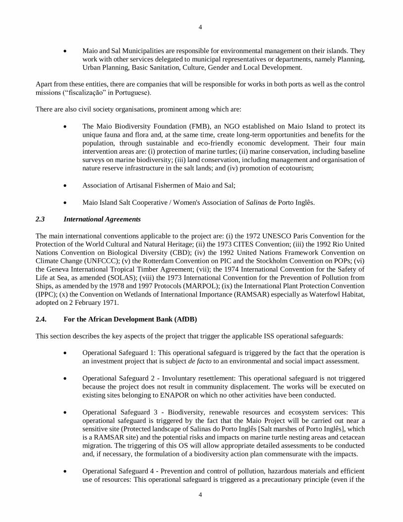
3.2 Project Objectives and Components
From the strategic standpoint, the project’s goal is to contribute to the attainment of economic growth and tourism
development in Cabo Verde.
The project’s specific goals are to:
(i) Improve the level of service at the Porto Inglês Port in Maio and Palmeira Port in Sal; and
(ii) Improve the living conditions of project area (PA) communities, particularly in Maio.
The activities identified provisionally with the Government have been grouped under three components for final
selection after project appraisal.
These are:
Component
Cost
(in UA millions)
Description
A – Port
expansion and
modernisation
26.86
(i) Expansion and modernisation of the Porto Inglês Port in Maio through the erection
of sheet piles next to the existing 280 m quay, complete rehabilitation of the existing
350 m quay, construction of two 112 m and 80 m Ro-Ro ramps and the rehabilitation
and duplication of the port's earthworks and maritime protection area; (ii)
modernisation of Palmeira Port through the construction of 2,548 m2 administrative
buildings; (iii) construction of 2 km of port access roads, of which 1.2 km will be
paved for access to Palmeira Port and 0.8 km laid with basalt pavestones for access
to the Porto Inglês Port; (iv) works control and monitoring; (v) awareness-raising on
HIV/AIDS, social mobilisation, environmental protection and port safety; (vi)
implementation of the ESMP; and (vi) monitoring of ESMP implementation.
B - Ancillary
facilities and
support to the
transport sector
1.65
(i) Support to the women's salt extraction group in Maio through the installation of
wire fencing on the extraction sites, rehabilitation of buildings, management training,
provision of transport means and procurement of safety kits; (ii) support to fishermen
groups in Maio through the supply of five facilities for the conservation and freezing
of fish and rehabilitation of the 250 m2 building; (iii) support to the Maio Vocational
Training Centre through the rehabilitation and expansion of buildings, renewal of
machinery and training tools; (iv) training of 150 young people in various trades and
the enhancement of their communication skills with a view to promoting tourism; (iv)
works monitoring and supervision; and (v) road and urban development studies to
prepare transport and urban development projects.
C - Project
management 0.50
(i) Monitoring/evaluation of the project’s socioeconomic impacts; (ii) accounting
and financial audit; (iii) training of the OE; (iv) operation of the executing agency.
Source: NCP July 2018
7
7
3.3 Description of Existing Infrastructure Considered as Ancillary Infrastructure at the Port
Palmeira: Phase I works of the Port Expansion and Modernisation Project were completed in 2009 and led to
extension of the existing quay to 30 metres and the construction of a new 90-metre quay. Phase 2 works, executed
in 2016, entailed the construction of a new quay that is 150 m long, 35 metres wide and 12 metres deep to receive
large international vessels.
Palmeira Port has a single existing 120-metre berth of variable water depth (5 metres deep for the first 60 metres
measured from the end of the quay; 3 metres deep for the next 30 metres and 2.5 metres deep in the last 30 metres
closest to the shore).
It also has an offshore mooring station with four mooring buoys, and a flexible hose connection point linked to an
underwater pipeline for unloading Jet-A1 (aircraft fuel). This pipeline supplies JET-A1 to Shell and ENACOL
(National Oil and Gas Company), which both have nearby depots connected to the port by a pipeline.
Maio: The current situation at Porto Inglês Port is as follows: (i) existence of a bridge with concrete pillars that is
approximately 350 metres long and 15 metres wide, which is in an advanced state of deterioration and has at its
(southern) end the designated Maio Port lighthouse; (ii) a rectangular embankment of 140 x 50 metres, built along
the coastline and forming a T with the jetty bridge; and (iii) a set of administrative buildings and facilities erected
on the northeast corner of the embankment.
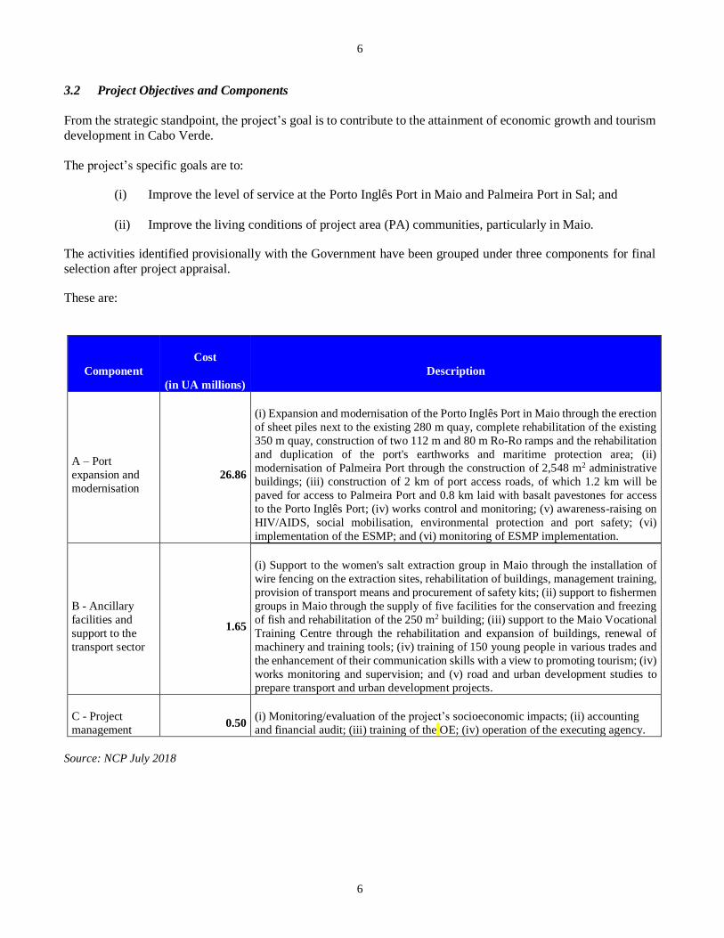
3.4 PROJECT LOCATION
Maio Location: The Porto Inglês Port Extension and Modernisation Project is executed within the existing port, in
the south-western part of Maio Island, approximately 750 metres from Maio town in Cabo Verde. It is an integrated
space within the Porto Inglês Jurisdiction Zone that is fully exposed to maritime agitation.

8
8
View of the existing port (quay and administrative
buildings)
View of the existing quay
Palmeira Location: Palmeira Port is located on the west coast of Sal Island, 7 km from the city. It is the third
largest port in Cabo Verde. In addition to commercial activities related to goods and passenger transport, the port
also handles fishing activities and related industries.
The photos and maps below show the location and layout of the existing infrastructure built under the extension
phase financed by the EIB.
Aerial view of the existing Palmeira Port Location of the port on Palmeira Island

9
9
View of the existing port (phase 2)
View of the area reserved for the construction of buildings
4. DESCRIPTION OF THE PROJECT ENVIRONMENT
Direct Impact Area: The direct impact area is the zone where a concentration of direct impacts is expected; i.e.
the zone that will suffer the greatest impact during the works, including the movement of workers, equipment and
boats during the construction phase, and changes arising from project execution.
For Palmeira Port, this is primarily: (i) the works area for the buildings, covering approximately 2 ha; and (ii) the
access road to the port, which is 1.2 km long. The project works will cover 14,000 m2, with 4,000 m2 occupied by the
above infrastructure and 10,000 m2 occupied by the road. The area to be occupied by the road includes that of the central
separator and the gangways. The direct project area is approximately 14,000 m2 and coincides with the area occupied by the
supra infrastructure and access road.
For Maio, it is mainly the area defined in red in the figure below.
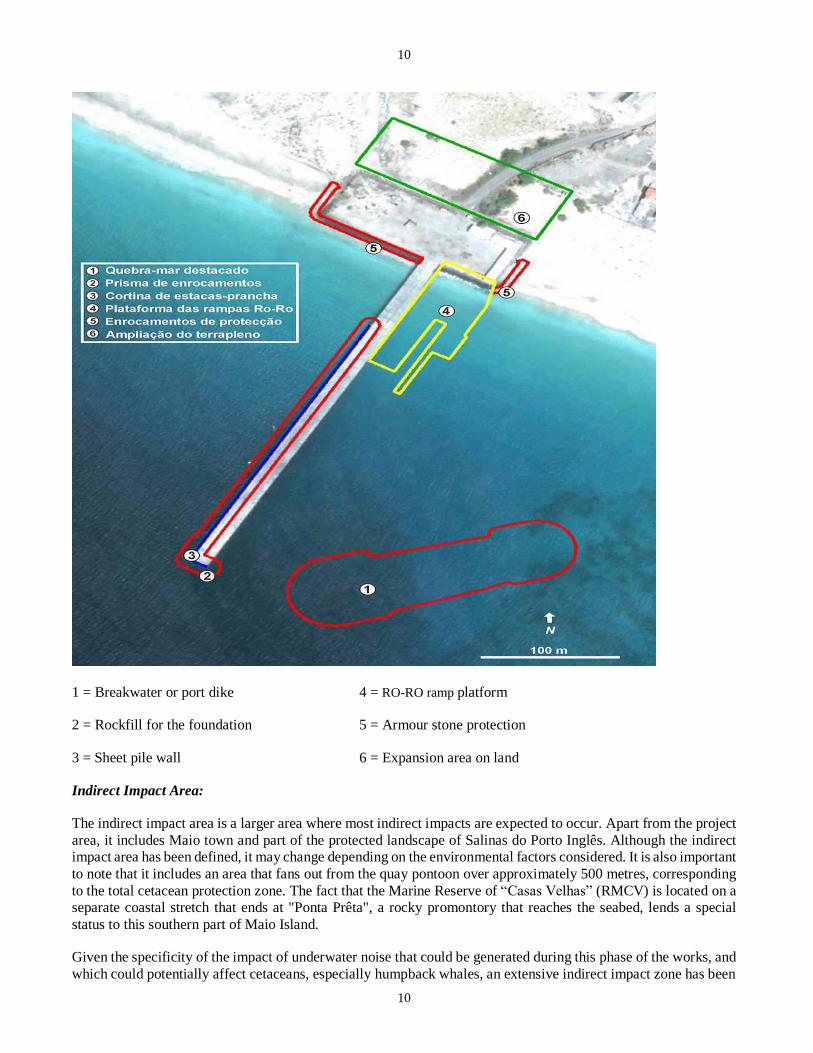
10
10
1 = Breakwater or port dike 4 = RO-RO ramp platform
2 = Rockfill for the foundation 5 = Armour stone protection
3 = Sheet pile wall 6 = Expansion area on land
Indirect Impact Area:
The indirect impact area is a larger area where most indirect impacts are expected to occur. Apart from the project
area, it includes Maio town and part of the protected landscape of Salinas do Porto Inglês. Although the indirect
impact area has been defined, it may change depending on the environmental factors considered. It is also important
to note that it includes an area that fans out from the quay pontoon over approximately 500 metres, corresponding
to the total cetacean protection zone. The fact that the Marine Reserve of “Casas Velhas” (RMCV) is located on a
separate coastal stretch that ends at "Ponta Prêta", a rocky promontory that reaches the seabed, lends a special
status to this southern part of Maio Island.
Given the specificity of the impact of underwater noise that could be generated during this phase of the works, and
which could potentially affect cetaceans, especially humpback whales, an extensive indirect impact zone has been
11
11
defined, within which the impact of the noisiest actions (fixing of poles) can be felt. It corresponds to a distance
of 25 km around the port.
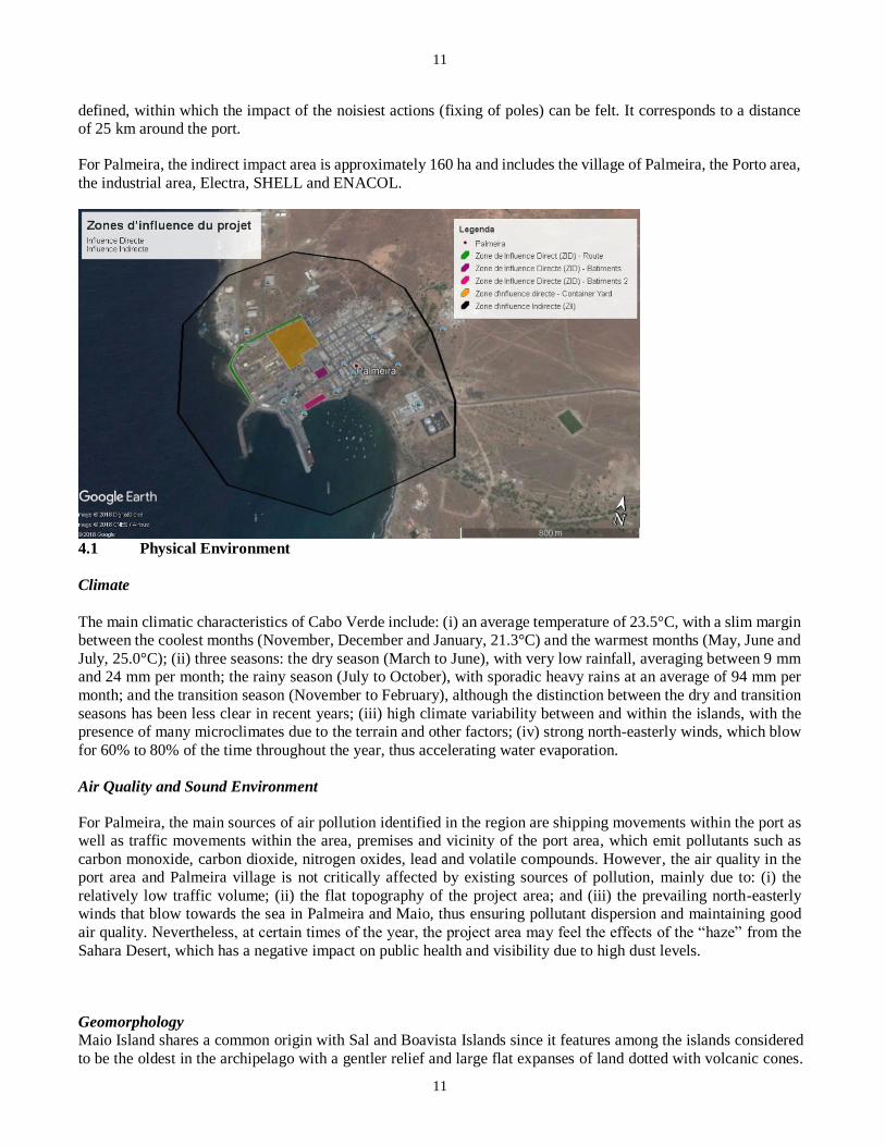
For Palmeira, the indirect impact area is approximately 160 ha and includes the village of Palmeira, the Porto area,
the industrial area, Electra, SHELL and ENACOL.
4.1 Physical Environment
Climate
The main climatic characteristics of Cabo Verde include: (i) an average temperature of 23.5°C, with a slim margin
between the coolest months (November, December and January, 21.3°C) and the warmest months (May, June and
July, 25.0°C); (ii) three seasons: the dry season (March to June), with very low rainfall, averaging between 9 mm
and 24 mm per month; the rainy season (July to October), with sporadic heavy rains at an average of 94 mm per
month; and the transition season (November to February), although the distinction between the dry and transition
seasons has been less clear in recent years; (iii) high climate variability between and within the islands, with the
presence of many microclimates due to the terrain and other factors; (iv) strong north-easterly winds, which blow
for 60% to 80% of the time throughout the year, thus accelerating water evaporation.
Air Quality and Sound Environment
For Palmeira, the main sources of air pollution identified in the region are shipping movements within the port as
well as traffic movements within the area, premises and vicinity of the port area, which emit pollutants such as
carbon monoxide, carbon dioxide, nitrogen oxides, lead and volatile compounds. However, the air quality in the
port area and Palmeira village is not critically affected by existing sources of pollution, mainly due to: (i) the
relatively low traffic volume; (ii) the flat topography of the project area; and (iii) the prevailing north-easterly
winds that blow towards the sea in Palmeira and Maio, thus ensuring pollutant dispersion and maintaining good
air quality. Nevertheless, at certain times of the year, the project area may feel the effects of the “haze” from the
Sahara Desert, which has a negative impact on public health and visibility due to high dust levels.
Geomorphology
Maio Island shares a common origin with Sal and Boavista Islands since it features among the islands considered
to be the oldest in the archipelago with a gentler relief and large flat expanses of land dotted with volcanic cones.

12
12
From the morphological standpoint, there are three distinct units, with the central massif being the predominant
orographic element. The central reliefs constitute three branches that meet on Monte Penoso, the highest landform
on the island with an altitude of 436 metres. The project area is located on Holocene sedimentary formations that
are part of the sandy beach lithostratigraphic unit. Holocene sediments are materials deposited on the shore and
which form long beaches. Although almost the entire coastline has beach deposits, the most extensive sandy
stretches are found in the northern, western and southern regions of the island. These are very well-graded whitish
sands with medium to fine grain.
Tectonics and Seismicity
Although the islands of Cabo Verde are of volcanic origin, the archipelago is in a relatively stable intra-plate
environment and geotectonic zone. However, unlike Fogo, Brava and Santo Antão Islands, Maio Island has no
recent records of significant volcanic or seismic activity. Consequently, it is assumed that the project area will have
low to reduced seismicity for both Palmeira and Maio.
Soils
The geological matter in Palmeira essentially comprises basalts and phonolites. The project area had already been
backfilled in Phases 1 and 2 of the port construction works. In Maio, there is only one soil type in the project area,
namely regosols (R). These are developing mineral soils that are generally coarse in texture, with very little or no
horizon A (i.e. containing humus) and no horizon R (bedrock). Such soils are composed of sand and unconsolidated
detrital debris of varying thickness. The regosols in the project area are composed of calcareous sand deposits that
build up along the coastal strip and have no agrarian value.
Hydrodynamics
For Maio, the tides in the area are semi-diurnal, with average amplitudes of about 0.65 metres and a peak of 1.15
metres. With regard to wave height distribution, the most frequent wave readings (59% of data) range from a
trough of 1.0 metre to a crest of 2.0 metres. About 91% of the waves are below 2.5 metres, 96% are below 3.5
metres and approximately 0.2% are above 4 metres. The highest crests are in the NNW and N directions, rising up
to 5.5 metres. For Palmeira, the dominant wave height is less than 2 metres. The west coast of Sal Island on
Palmeira Port is sheltered against the huge waves from the north, east and south. The north-south current along the
west coast of Sal, passes near the shore. Currently, there is very limited sedimentation in the harbour and even in
Palmeira Bay.
4.2 Biological Environment
4.2.1 Definition of Habitats
The project site is located within the boundaries of the port areas. These areas are modified habitats as defined in
OS-3. There are no protected areas in the direct project area and no species of conservation interest.
However for Maio, FMB monitoring data indicate that some sea turtle (caretta caretta) nests are sometimes found
between Bitxi Rotxa and the project area. Between 2012 and 2014, no egg-laying nests were found. However, one,
two and 12 nests were found in 2015, 2016 and 2018 respectively, representing less than 1% of the nests in the
Salinas area. Furthermore, the indirect project area as defined above includes part of the Protected Landscape of
“Salinas de Porto Inglês” (PPSPI), including the RAMSAR site. At the national level, the competent authorities
insisted that delimitation of the PPSPI site and its buffer zone should take into account the existing port. Its buffer
zone has been moved closer to the port area more to prevent future expansion than to ensure the presence of species
of special conservation interest. However, as a precautionary measure and to ensure conservation, the Bank
considered the landscape approach for habitat characterisation. Although the project area is outside the legal
13
13
boundaries of the PPSPI and the habitat is considered to be modified, the project site is deemed a critical habitat
within the meaning of OS-3 based on the seascape/landscape approach because of its ecological connection to the
PPSPI. Accordingly, the Bank recruited an international consultant to assist Cabo Verde in assessing and preparing
an appropriate biodiversity action plan for the construction and operation phases of the project in accordance with
OS-3 requirements.
4.2.2 Flora and Fauna in the Direct Project Area
There is almost no vegetation in the direct project area of Palmeira and Maio – i.e. within the confines of the port
area and the associated facilities (buildings and access roads). A few Frankenia ericifolia and acacia trees are
scattered here and there along the access road and in the port area. In the indirect project area of Palmeira, there is
very little flora of conservation interest. In Maio, however, there are species of conservation interest, particularly
in the protected zones located near the project area. A detailed description of the baseline, including these species,
will be presented in the next section on protected areas.
4.2.3 Protected Area
There are no protected areas within the direct or indirect project areas of Palmeira Port. Consequently, the
description below only applies to the indirect project area of Maio Port.
4.2.3.1 Protected Landscape of “Salinas do Porto Inglês” (PPSPI)
The PPSPI, which covers 534.66 ha (400.5 ha for the land portion and 134.1 ha for the marine portion), is located
between Porto Inglês, the airport and Morro village. It is the largest permanent wetland on the island and one of
the biggest in the archipelago. It has been included on the list of wetlands protected by the RAMSAR Convention
in 2013 and is ranked fourth in the country and first on the island. The PPSPI is located approximately 200 metres
to the north and 300 metres to the west of Porto Inglês. Its boundaries were defined taking into account the existing
port and with a view to providing buffer protection in the long term (see diagram below). The water in the wetlands
comes from the sea, fresh water run-off and saline intrusive groundwater. However, the area outside the wetlands
is crucial for other species of conservation interest.
Birds
An inventory conducted in 2011 yielded approximately 17,689 individual birds belonging to 20 species. The
endemic or endangered bird species of conservation interest are:
(i) Common curlew (Cursorius cursor exsul): This is a subspecies endemic to Cabo Verde with an
estimated population of 150 and 350 individuals on Maio Island; 50% of its population nests in
Maio, and the PPSPI probably holds the second largest population after that of the Terras Salgadas
(north of the island). In Cabo Verde, the Cursorius cursor exsul reproduces between September
and February, after the first rains. A precise mapping of Cursorius cursor exsul nests was done
between 2015 and 2017. None is present within the project area and the nests closest to Porto
Inglês are located approximately 1,200 metres to the north. These maps are available in the ESIA
report;
(ii) Kentish plover (charadrius alexandrinus): FMB conducted a complete nest mapping of this
species in the PPSPI with nest locations from 2016 to 2018. These maps are available in the ESIA
report. The location of the nests highlights the importance of the wetland and its banks, including
dunes. None is present within the project area.
As documented in the RAPIM PG, the presence of these two bird species (Chadrius alexandrinus and Cursorious
cursor) was one of the criteria that led to classification of the PPSPI as a Wetland of International Importance
(Ramsar Site No. 2182) in the Ramsar Convention table, specifically:

14
14
• Criterion 3 - Salinas de Porto Inglês has a wide variety of bird species belonging to the dune and
semi-desert environments, including Alaemon alaudipes, Eremopterix nigriceps, Ammomanes cinctura and species belonging to humid environments such as Calidris alba and Limosa
lapponica. Another noteworthy activity is the breeding of the caretta species of marine turtle.
• Criterion 6 - The site hosts a reproductive population of approximately 30-40 individuals of the
Cursorius cursor exsul species, representing 20 to 40% of the total population of the sub-species.
This same site is believed to host the largest population of Charadrius alexandrinus from the
Atlantic Ocean with 150-300 individuals. Given the genetic differences within the Cabo Verdean
population of the Charadrius alexandrinus species, this equates to 50% of the total for this distinct
genetic population.
Marine Turtles
With regard to marine wildlife in the PPSPI area, it is important to mention the presence of the common or red turtle (caretta caretta) classified under the conservation status “endangered”. Caretta caretta usually nests between
June and mid-October, with August being the peak period. The egg incubation period is approximately 60 days.
In 2014, about 23 nests were detected 2 km away from the project site (Salinas) and none was found within a
distance of less than 750 metres (Bitxi Rotxa beach). In 2015, 27 sites were recorded in the Salinas area (within
the PPSPI ) and one on Bitxi Rotxa beach (Bitchirotcha on the map) located 750 metres from the port area. This
figure was 219 in Salinas compared to 12 in Bitxi Rotxa in 2017. Since 2012, the highest number of nests was
recorded in 2017. However, the number of nests located in Bitxi Rotxa beach accounts for 0.2% of those found on
Maio Island. The map below shows the nesting site distribution on Maio Island.
One of the factors limiting the number of nests at Bitxi Rotxa beach (the area closest to the city of Maio) is night
light pollution, which turtles tend to avoid. According to IUCN, the caretta caretta turtle sub-population in Cabo
Verde is subject to continuous anthropogenic pressure that destroys their habitat.

15
15
Source: FMB
Reptiles
All species of terrestrial reptiles identified on the island, have been recorded in the PPSPI, including the Tarentola maioensis and Chioninia spinalis maioensis. These endemic species are generally associated with the rocky semi-
desert area, although the T. maioensis has also been seen in dune environments. The first of these two environments
is particularly adapted to these species since abounds with pebbles, small rocks and invertebrates which constitute
their main food.
These two species are classified under the “Least concern” conservation status but are presented due to their
endemism.
Zoning Plan of the Protected Landscape of Salinas do Porto Inglês

16
16
Source: FMB
4.2.3.2 Marine Reserve of Casas Velhas (RMCV)
The RMCV is located 3 km south-west of the construction area (Porto Inglês). This Marine Reserve covers the
entire coastal strip in the southern part of the island, comprising a distinct set of biological, terrestrial and marine
assets of great ecological and environmental interest. Of course, the marine biodiversity is the most important
component, since this site has one of the two coastal marine biodiversity hotspots on the island. The RMCV also
has a lagoon of brackish water frequented by migratory shorebirds, beaches that are crucial to the nesting of caretta
caretta, excellently preserved native plant communities and significant environmental assets. As regards the
nesting of caretta caretta from June to October, monitoring data for 2012 shows that the beaches of Jampaia and
Ponta Preta / Casas Velhas, which have approximately 156 to 45 registered nests, respectively account for 10.0%
and 2.7% of the nests on Maio Island. Hence, in 2012, the RMCV hosted approximately 13% of caretta caretta
nesting activity on the island. Data from previous years’ studies had already highlighted the important role of this
natural reserve at island level.
The RMCV region is still frequented by dolphins in search of food, and sometimes humpback whales (Megaptera novaeangliae) that move to the Cabo Verde archipelago during the winter and spring from the northern hemisphere
(especially in February and May) to breed and, probably, to mate. In the coastal zone of Maio Island, especially to
the west, pods of female whales called “de-bossa” and their young are regularly spotted. According to the IUCN
Red List, the humpback whale (Megaptera novaeangliae) belongs to the LC (Least concern) category. A map of
the reserve is provided in the ESIA report.
4.2.3.3 Marine Ecosystem
Marine Flora
Regardless of the coastal environment, areas consisting largely of sandy substrate have a much lower diversity of
microalgae than areas with a rocky substrate. Algae or algae bits brought in by the swell may appear on the supra-
littoral level of the sandy substrate that is rarely covered by water. A key example is the “alface-do-mar”
(Ulvalactuca). At the inter-littoral or inter-tidal level, wave action and substrate instability associated with changes
in beach appearance throughout the year due to variations in the sea swell, make it difficult or even impossible for
micro-algae to take root. It is only at the infra-littoral level that all the conditions are met for the growth of some
macro-algae such as the marine “pradarias” or Cymodocea nodosa, a species characteristic of this environment in
Cabo Verde. However, as ascertained within the project area that predominantly has a sandy substrate, macroalgae
were not detected from the supra-littoral right down to the infra-littoral levels. Unfavourable exposure,
compounded by a relatively agitated sea swell, will be the main factor preventing algae formation.
Pelagic Communities, Sandy Bottoms and Icthyofauna
In areas with a sandy substrate, the following sandy bottom fish are found: Diplodus fasciatus, Diplodus prayensis,
Diplodus puntazzo, Diplodus sargus lineatus, Lithognathus mormyrus (sea bream); Mulloidichthys martinicus
(mullet); Synodus saurus (Atlantic lizardfish); and soles and rays. The following species, which live in contact
with sand and have no significant commercial value, can also be found in sandy substratum: Chilomycterus reticulatus (fish-sea urchins) and marcellae Prognathodes (butterfly fish).
Cetaceans
The cetacean species most frequently spotted on Maio Island, especially on the western coast, are the bottlenose
dolphin (Tursiops truncatus), the pantropical spotted dolphin (Stenella attenuata), the long-finned pilot whale
(Globicephala sp.) and the humpback whale (Megaptera novaeangliae). Among these various species of cetaceans
identified on the Cabo Verde archipelago, special attention must be paid to the humpback whale (Megaptera
novaeangliae) because it is a sub-population that migrates from the northern hemisphere during winter and spring
17
17
(especially in February and May) to the waters of the archipelago to breed and mate. Groups of mother humpback
whales and their litter have been sighted frequently within the direct project area of Porto Inglês. A whale
distribution mapping is provided in the ESIA report.
According to the FMB which conducted a systematic observation of the west coast of Maio island between 2014
and 2017 from Forte de S. José (Maio Town) as part of a drive to monitor marine mammals and other species,
humpback whales were sighted within the Porto Inglês direct project area (between Ponta Prêta and Bitxi Rotxa
beach). The decrease in its findings of 2016 and 2017 partly stems from a decline in its observation efforts. The
humpback whale breeds from February to May. The locations where cetaceans are found within the study area
have been mapped and are available in the ESIA report.
4.2.3.3. Key Ecosystem Services
The main benefit derived from the Maio Island marine ecosystem is fishing, an activity practised by the local
fishing community, who catch fish for sale to the local population and for own consumption. The catching of
turtles and use of their eggs for human consumption was commonplace a few months ago. However, legislation
was passed recently, specifically prohibiting the capture of turtles in Cabo Verde. Seawater is also essential for
consumption by the Maio community once it has been desalinated.
The salt lagoon has salt resources that are rationally exploited mainly for export. Maritime tourism activities are
virtually non-existent, being essentially limited to offshore “big game fishing” outside the project area. Moreover,
the boats used for this activity are not moored on site because there is currently no port with the capacity to
accommodate them permanently. There is potential to observe cetaceans and other marine species.
Industrial, semi-industrial and coastal fishing are not practised in Maio because the island does not have a fishing
port and there is no infrastructure on site to support fishermen. Hence, such fishing is practised offshore, far from
the project area.
4.3 Human Environment
Population: The direct project area (DPA) covers a surface area of 485 km2 (comprising 216 km2 for Sal and 269
km2 for Maio), or 12.03% of the surface area of Cabo Verde and has an estimated population of 43,880 inhabitants
(including 36,769 in Sal) or close to 8.22% of the national population. According to INE data, the majority of the
population lives in rural areas. Women account for 47.39% of the project area population. The population is highly
youthful and dynamic, with over half of the inhabitants of working age. The majority of the workforce is equally
youthful with an average age of 28.6 years.
Education: Primary education is universal (97%), free and egalitarian (girls represent 52% of pupils). With
regard to training, there is a perceptible similarity at the secondary school level between Maio Municipality and
the rest of the country. The disparities are wider in higher education, given that only 2.7% of the population in
Maio Municipality has intermediate or higher education.
Health: The country has made substantial progress towards achieving the MDGs. However, it will need to
continue its efforts, especially in poverty reduction and control of the incidence of underweight children.
HIV/AIDS prevalence in the population is estimated at 0.8% (1.1% for men and 0.4% for women). Tuberculosis
is still a public health problem with a prevalence of approximately 60 per 100,000 while malaria has low
endemicity. The key challenges include: capacity building in the delivery of neonatal and maternal care;
implementation of the malaria pre-elimination action plan; improvement of the quality and coverage of DOTS;
and strengthening of the capacity to manage and monitor the multisector HIV/AIDS plan. Infectious diseases,
including acute diarrhoeal and respiratory infections, are being reduced and vaccine-preventable diseases are
controlled through the establishment of national universal access programmes. Public health services are
organised at three levels: the local level, corresponding to the municipality (17 health delegations spread across
nine islands); the regional level (3 regional hospitals); and the national level (2 central hospitals). Health
coverage is estimated at 89% for a population located within an hour's walk. The system has undergone major
18
18
changes, particularly in the extension of the health network, the coverage of qualified human resources, and the
implementation of policies and strategies.
Economy, Poverty and Unemployment: The services sector dominates the economy, accounting for
approximately 72% of GDP in 2000 (about 50% of the labour force, including 20% in public services), mainly
owing to a surge in the tourism and trade sectors. The industrial sector generates approximately 20% of GDP
(about 20% of the labour force), mainly construction and light export industries launched through foreign
investments. Agriculture, practised under unfavourable conditions, generates 10-12% of GDP and accounts for
approximately 22.5% of the labour force.
Sal is the second least poor island in Cabo Verde with an incidence of 19%; a GDP per capita of USD 5,498,
the second highest in Cabo Verde; and an unemployment rate of only 8.3%. Its economy is heavily driven by
tourism with a GDP of USD 16,057,000 and a predominant services sector that generates 2/3 of the island's
wealth, thus yielding a GDP per capita of USD 5,498, the second highest in Cabo Verde.
For Maio, about 31.7% of the population lives in absolute poverty and the island's labour force comprises 3,170
employees, with a participation rate of 63.4% and an unemployment rate of only 5.7%. It has a GDP per capita
of USD 2,573, the fourth lowest in Cabo Verde. Maio Municipality recorded an unemployment rate of 8.3%,
which is lower than the national rate (10.7%).
Salt Extraction at Maio by the Women's Association: Salt extraction in Salinas do Porto Inglês is an ancient
and long-standing activity on Maio Island. However, the Maio Island Salt Cooperative, managed by women, was
only created in 1985. Since 2003, the dynamism of this activity has increased. The salt works currently produce
about 4.5 tons of salt per month. Although there is potential for expanding production, the activity is in a delicate
situation due to the low number of customers and weaknesses pertaining to disposal of the product, given the
irregularity of maritime transport on Maio Island. The salt produced in Salinas do Porto Inglês is mainly destined
for the national market, particularly Praia City, Fogo, São Vicente and Maio Island. According to the salt
cooperative points, production can be doubled if there is demand. The salt is extracted by a group of about 50
women from Maio Island, who sell it to the existing milling and packaging entity on the island. Production is
traditional and artisanal, with only milling and iodisation being mechanised. The salt is manually packaged in bags
of 1 kg and 25 kg. Salt extraction and production benefits approximately 65 households on Maio Island and is
therefore a major source of income, especially for women in an environment with a relatively high incidence of
poverty. Thirteen of the 20 existing employees work in the salt plant.
Poverty: National poverty rates fell considerably from 49% in 1990 to 26.6% in 2007. Poverty rates on islands
with the best tourism infrastructure, notably the Sal Islands, are less than half the national average. Similarly,
urban poverty rates dropped sharply from 25% in 2002 to 13.2% in 2007, while rural poverty rates fell only
slightly from 51.1% to 44.3%. Hence, there is need for more balanced development between the various islands
and between urban and rural areas to promote inclusive growth in the country.
Gender Profile: According to Cabo Verde's January 2018 gender profile, many gender equality goals have been
achieved, mainly in education and health, and an excellent national policy study has analysed specific gaps and
recommended solutions. However, gender constraints in Cabo Verde continue to limit women's access to
resource benefits as well as their ability to contribute fully to sustainable and equitable growth.
Cabo Verde has made significant progress in promoting gender equality and equity, particularly in terms of a
legal and institutional framework conducive to gender equality as well as good outcomes in health and education.
The establishment of the Cabo Verde Gender Observatory has increased the spotlight on the gender inequalities
that still exist in the country. Thus, it appears that women's economic empowerment has been hampered by
many obstacles, and that women are over-represented in unpaid work and the informal sector.
Many health, education and legal issues remain, including for women and girls facing specific difficulties of
rural isolation, disability, or sexual abuse. However, the key issues that have constrained the majority of women
19
19
to poverty and low productivity are their lack of:
• Time: The burden of primary responsibility for households and dependents, and lack of access
to water, sanitation and transport are the key factors limiting women's time for productive work;
• Access to land: Lack of land titles limits official access to credit and the capacity to build assets;
• Access to finance: Lack of access to finance inhibits the growth and productivity of business
efforts; demand for micro-credit exceeds available supply and commercial borrowing costs are
too high;
• Knowledge: Lack of knowledge on the options for stable income-generating and productive
activities, and the lack of continuous services and networking of structures to develop skills,
boost production and access markets.
Water and Sanitation: With regard to water supply and sanitation, the average coverage is 89% for water
supply and 63% for sanitation. However, there are wide disparities between the various islands. For the Sal
islands, waste collection and management is more satisfactory than on Maio Island. Municipal authorities have
indicated that a waste management plan is being prepared and will be implemented by 2021.
5. ANALYSIS OF ALTERNATIVES
5.1 No-project Option
Without a project, the conditions described in the baseline situation would be maintained, including the operational
limitations of the port infrastructure and no protection from the vagaries and effects of climate change, which do
and will continue to impede port operation conditions, sometimes requiring vessels to remain offshore until it is
possible for them to berth. Furthermore, the adjacent embankment area is also insufficient to store and organise
the different types of goods transported.
These conditions affect all sectors, including passenger traffic and the supply of goods and consumables in general,
thus seriously affecting the population of Maio Island and undermining tourism development. Accordingly, the
“no project” alternative will be highly detrimental to the socioeconomic development aspirations of Maio Island
and inconsistent with the main development policy objectives of the island and of Cabo Verde in general.
The “no project” alternative is not feasible as it would be highly detrimental to the social, economic and operational
dimensions of the port infrastructure in Maio Island. It is noteworthy that the project is supported not only by the
population, but also by the Maio Island Municipality and NGOs involved in biodiversity issues, including the Maio
Biodiversity Foundation (FMB). No public or private entity or group is opposed to the project.
5.2 Project Option
5.2.1 Site Selection
Under the Porto Inglês Master Plan, an analysis of the natural conditions on the Maio Island coast and of the
existing territorial conditions was conducted. Nine sites were pre-selected, and a local reconnaissance visit was
organised for seven of them, namely: Ponta Cais, Ponta Branca, Ponta do Pau Seco, Calheta, south of Maio Island,
Ponta Prêta and Ribeira de D. João.
Each site was characterised based on its location on the island, distance from Maio town, road and sea accessibility,
identification of protected areas for biodiversity conservation purposes, identification of tourism development
areas, physical characteristics and the advantages and disadvantages of a port decision. Based on this
characterisation, two locations were proposed for a more detailed development of the port solutions to be adopted,

20
20
namely: the Porto Inglês area and the area covered by Ponta do Pau Seco, situated in the north-western part of
Maio Island.
5.4 Analysis of Alternatives for the Construction of a New Port
Taking into account the preliminary selection of the two most appropriate locations for the new port on Maio
Island, as well as the natural conditions on the sites concerned, three alternative solutions were formulated for the
general development of the new port, which would tally with the programme initially set out in the Plan:
• Alternative Solution 1, situated on the environs of Porto Inglês, with the commercial, fishing and
recreational nautical and maritime/tourism leisure sectors located in a new sheltered basin, created
just south of the current Porto Inglês;
• Alternative Solution 2, situated in the surroundings of Porto Inglês, with the commercial, fishing
and recreational nautical and maritime/tourism leisure sectors located in a new sheltered basin,
created just north of the current Porto Inglês;
• Alternative Solution 3, with the commercial and fishing sectors in Ponta do Pau Seco and the
recreational nautical and maritime tourism sector at Porto Inglês.
The main criteria used for the multi-criteria analysis were: (i) port planning; (ii) general port layout; (iii) port
operation; (iv) flexibility; (v) costs and execution conditions; (vi) total cost and cost per sector of activity; (vii)
cost of the main operations under the first investment; (viii) operating costs; (ix) implementation timeframe and
condition; (x) urban integration and environmental impact.
Based on the results of the multi-criteria analysis conducted on the three alternative solutions considered, the
advantage of Alternative Solution 3 was evident, all the more so as it is found in a location offering the most
adequate coastal configuration for building a port facility. However, after careful consideration, and given the high
cost of the cheapest alternative, ENAPOR and the Government of Cabo Verde abandoned the idea of building a
new port on Maio Island and preferred to invest in improving the operational conditions of the existing port
infrastructure in Porto Inglês. The solutions considered are presented below.
2.2. Solutions Considered for the Existing Port
In addition to the proposed project solution, an alternative solution was considered that included a single Ro-Ro
ramp to serve Fast Ferry (small vessels) and a breakwater in the rear position. In this alternative, Ro-Ro operations
with large vessels would be executed at the tip of the pier deck, supported on a platform, probably with a structure
similar to the one proposed for small ferries, which allows the vessel to be moored to appropriate fixtures, frees
up the entrance and is attached to suitably arranged posts.
Since both wind and sea agitation are expected at the port entrance within a quadrant aligned in the direction of
the pier deck, this platform would be three-sided with 45º angles between the adjacent sides, such that the vessel
commander can guide each of the operations as conveniently as possible. At its bow, the vessel would be moored
with two attached iron fixtures. The ramp should have a projection of 30 m (15 m to close the gap with the others
in order to facilitate the registration of heavy goods vehicles on deck, with 45º angles).
The remaining operations, such as partial rehabilitation of the existing pier, extension of the port embankment and
construction of piling at the end of the pier deck would be executed regardless of the solution chosen. The main objective of this alternative solution was to try to cut costs. However, it turned out to be less effective as shelter,
especially given sea agitation on the westward side where the ships are fully exposed, unlike the chosen solution
that shelters the facilities against waves coming from the WNW and WSW quadrants.
21
21
This could have been considered as an alternative whose configuration is symmetrical to the chosen solution.
However, such a solution was dropped since it would not only expose ships to tempestuous waves from the west
quadrant but would also require greater depth in the breakwater area and, consequently, a larger volume of stones.
2.3. Comparison of Alternatives Considered
In addition to the Porto Inglês location, the two alternatives considered share many of the elements of the project,
namely: partial rehabilitation of the existing deck, extension of the port embankment and construction of a sheet
pile wall at the end of the pier deck.
The main distinction between the alternatives resides in the location of the RO-RO ramp platform for large ships
and the size of the breakwater concerned. While the chosen alternative requires Ro-Ro operations with large vessels
to be conducted alongside smaller ferries (i.e. in the routing area of the pier deck on its east side), the rejected alternative requires such operations with large vessels to be conducted at the end of the pier deck. Either of these
solutions entails driving in piles to hold up the structure. As for the exceptional breakwater, it would be smaller in
the abandoned alternative since it would be built on shallower bottoms. Hence, both the chosen and abandoned
alternatives can be considered as very similar from the environmental and social standpoints. In terms of the
environmental, social and construction costs, the two alternatives considered are quite similar and therefore do not
have a comparative criterion.
The major difference resides in the technical and operational aspects. The abandoned alternative proved to be less
effective in terms of protection particularly against the westward sea turmoil to which ships are fully exposed,
unlike the chosen solution that provides protection against waves. This situation would mean that under more
turbulent sea conditions, it would not be possible to moor ships to the platform under the abandoned alternative,
and this would negatively affect the island's economy.
As regards alternative locations, a number of solutions were considered, particularly the construction of a new port
at Ponta do Pau Seco (north-west of the island). However, after careful consideration, ENAPOR and the
Government of Cabo Verde, cognisant of the high cost of one of the alternative solutions presented in the Porto
Inglês Master Plan, abandoned the construction of a new port on the Maio Island and opted for the improvement
of the operational and accommodation conditions of the existing port infrastructure at Porto Inglês.
6. POTENTIAL IMPACT AND MITIGATION/REHABILITATION MEASURES
6.1 Major Direct and Indirect Negative Impacts during the Construction Phase
6.1.1 Physical Environment
Impact on air and noise quality: The installation and operation of the site, including the presence of workers,
equipment and materials will result in gaseous emissions of which oxides of carbon (COx), nitrogen (NOx) and
sulphur (SOx) as well as aerosols and noise. However, these impacts will be localised, given the number of
construction vehicles involved and the duration of the work. Furthermore, in view of the current traffic level, very
limited local navigation, constant winds in the project area and wave noise, these emissions are not likely to
significantly degrade ambient air quality and noise parameters.
Risk of physical and chemical water and soil pollution: During the works, hazardous products such as
hydrocarbons, lubricants and waste oils may be accidentally or deliberately discharged into the water. Given that the access road to Maio Port will be built with stones extracted on the island instead of bitumen, the risk is low.
Meanwhile, certain construction materials will also be used on site, including concrete, greases and motor oils,
formwork stripping products and paints for various uses during building construction work. Since rainfall is scare

22
22
on the two islands, the risk of pollution is mainly limited to the soil. However, the magnitude is small, given the
quantities, limited scope and the short duration of the work.
6.1.2 Marine Ecosystem
Destruction of the vegetation and wildlife: The impact focuses on destruction of the vegetation cover on the site
where the new embankment (extension) will be constructed, with approximately 0.8 ha for Maio and,
consequently, the associated habitats. As far as Palmeira is concerned, less than 0.1 ha of vegetation cover is
concerned. During the construction phase, noise and particulate emissions from moving machinery as well as
disturbances to the fauna (noise) and flora (reduction in primary productivity due to particle deposition) in areas
adjacent to the project zone must also be considered as a negative impact. However, this negative impact is not
very significant given the reduced ecological value of the adjacent area, which has a very scanty vegetation cover
and the virtual absence of any particular fauna.
Impact on the terrestrial area of the PPSPI (excluding beach and seashore) considered as a RAMSAR site: No
negative impacts would be recorded. The entire protected area of this wetland is more than 600 m away; moreover,
it is only in 1.7% of cases that the wind blows in the southward and south-western direction towards the salt works
in July (5% of the time), August (10% of the time) and September (5% of the time). However, given that the land
surrounding the salt works is breeding ground for several bird species, including Charadrius alexandrinus, in July,
August and September, special attention must be paid. Emissions of air pollutants and noise should be minimised
in this area.
Overall, the impact on terrestrial ecosystems of the direct project area is deemed insignificant and of limited
magnitude, although it will be direct, permanent, irreversible, negative and immediate. Within the indirect project
area, the impact on the terrestrial ecosystem is also considered negative but insignificant because it will be indirect,
temporary, reversible, probable and of reduced magnitude.
6.1.3 Marine Ecosystem
Destruction of habitat: During the construction phase, any impact will result from construction of the breakwater,
the sliding wedge, the Ro-Ro ramp platform and the protective riprap. This infrastructure will be constructed
mainly at the expense of coastal and infra-littoral land occupancy, because it extends over the seabed, affecting an
area of approximately 2.1 ha - rock prism (0.44 ha), Ro-Ro ramp platform (0.45 ha) and protective riprap (0.07 +
0.02 ha). In general, the range of foreseeable effects caused by the works will lead to various changes in the coastal
environment. One of the most significant negative impacts will be the destruction of marine habitats and their
associated fauna at both the intertidal and subtidal level, due to works on the seabed. Such destruction will mainly
affect the sandy substrate zone, which has low algae cover, affecting the benthic fauna of the mobile substrate that
finds feeding habitat there. As regards the fish population, it is foreseeable that during the construction works,
noise and the direct destruction of habitats will temporarily frighten off certain fish species. However, at the end
of this period, it is possible that the rocks, depressions and protective landforms could serve as an alternative refuge
and substrate to be colonised by marine flora, crustaceans and molluscs. The creation of temporary access to
construct the breakwater and the placement of breakwater rock on the seabed could generate a greater volume of
suspended materials, resulting in some pelagic species avoiding the project area. Although this is a negative impact,
its scope is limited, given the spatial and temporal location of the impact.
Impact of noise on cetaceans: Negative impacts on cetaceans will be mainly underwater noise that may be emitted
during planting of the piles holding up the Ro-Ro ramps and their access platforms as well as the piles near the
causeway bridge. The impact of the pile endings can be considered negative for cetaceans only if the percussive
method is used to drive in the piles. Noise in water can spread several tens of kilometres and, according to National
Marine Fisheries Service guidelines (2016), whales in general are particularly sensitive to noise (7 Hz to 35 kHz),
while dolphins and other species will be more sensitive to medium frequency noise (150 Hz to 160 kHz). For the
works at Porto Inglês, it will be recalled that the humpback whale migrates to the waters of Maio Island between
February and May (4 months) at a sensitive stage of its life cycle – i.e. the breeding stage, according to common

23
23
observations of humpback whales in mother-litter groups. Accordingly, there is a greater need to protect these
migratory species. Hence, if adequate measures are not taken during the works phase at Porto Inglês to reduce
cetacean exposure to the pressure and/or noise limits mentioned above, the works will have a negative impact on
them. Such impact would be direct, irreversible, immediate, localised and far-reaching.
Risk of whales colliding with vessels under construction: Such collision as well as emitted noise cannot be
considered relevant because during the works, there will be one or two support vessels that will only sail close to
the project site. Even the works machinery and materials will be transported to Maio Island by a ferry connecting
Praia City, as well as a support ship that will make one or two trips, thus creating very limited impact. Moreover,
the main building material (namely stones) will be extracted on Maio Island. Hence, this impact is negative, direct,
localised, probable, temporary, reversible, but of limited significance and scope.
Impact of light on turtles: The main impact of the works is nocturnal light pollution that will lead to: (i)
suspension of nesting site selection because female turtles may not emerge from the sea due to the presence of
artificial lighting, or may reproduce in an alternative location, meaning that they would waste energy at best, or be
prevented from completing the nesting process, at worst; (ii) frustration of the return to sea: egg-laying females,
disoriented by artificial lighting, may be unable to find their way back to the sea; (iii) disorientation of newborns:
light pollution may attract the young to go in the wrong direction (incorrect orientation) instead of heading to sea,
or disrupt their ability to maintain the same direction to the sea (disorientation). In both cases, this usually leads to
death, as the offspring become exhausted, dehydrated and ultimately caught by predators such as crabs and birds.
White light (such as xenon, mercury vapour, metal halide, halogen and fluorescent light) is the main problem of
marine turtles.
Restriction of turtles’ access to Bitxi Rotxa beach: Another negative impact would arise from the deployment
of equipment for the construction of a breakwater in the marine environment and partly on Bitxi Rotxa beach, thus
temporarily reducing access. Such an operation may cause the common sea turtle (caretta caretta) to avoid
choosing Bitxi Rotxa beach, at least partially, as a nesting area or result in the destruction of turtle eggs. This will
have a direct, probable, immediate, albeit temporary and reversible negative impact, supposedly of average
magnitude since it is a small and marginal nesting area. Meanwhile, assuming that nesting takes place within the
area of temporary access for the construction of the detached breakwater, there will subsequently be a risk that
newborns may find it difficult to reach the sea. Furthermore, there would be the risk of destruction and crushing
of eggs in the nest during incubation. To ensure that these situations do not result in the death of progeny, mitigation
measures will be proposed for implementation in tandem with the marine turtle monitoring programme.
6.1.4 Human Environment
Health and safety risks during land transportation of materials and construction: The arrival of employees from
diverse backgrounds to the project area is likely to increase the prevalence of communicable diseases. Moreover,
the organisation of work could generate certain health risks for workers operating noisy machinery (hearing
disturbances) that emit gases. Workers may be subject to accidents as they move around or handle/operate their
work tools. The communities in both cities may also be disturbed by various nuisances, especially those living
closest to the roads used by trucks plying the road between the quarry and the construction site. The discomfort
caused by truck traffic will be greater near Horace Silver Secondary School, with approximately 30 truck trips per
day (15 empty + 15 loaded) in front of the school, if the works last for 24 months, and 40 daily truck trips (20
empty + 20 loaded), if they last for 18 months. The same applies to work at Palmeira, which will require
approximately the same truck rotations.
24
24
Risks of disruption to port operations during construction: The volume of materials to be imported from abroad
is approximately 11,500 tons, of which more than 95% will be concrete and sheet piling (metal). While it is difficult
to estimate the volume of the equipment needed for the works (excluding ships and support vessels), it should be
approximately 50 to 100 tons. Given the volume of materials and equipment needed for the works, the duration of
the works and the cargo movement conditions in Porto Inglês, four to six rotations will be necessary, the last one
being the equipment return trip. Since two vessels per week are normally received in Porto Inglês, berthing of the
vessel carrying the materials and equipment should not cause any significant disruption in the normal functioning
of the port.
Risk of conflict: Several types of conflict may arise between the project and local communities, between the
employer and employees, etc. Such conflict may stem from: (i) workers’ failure to respect local mores and customs
in their new environment; (ii) non-compliance with pollution and impact mitigation measures; (iii) non-compliance
with employment conditions by workers and/or the project manager, etc.; and (iii) misuse of resources and
poaching in the Salinas on Maio Island.
6.2 Main Direct and Indirect Negative Impacts during the Operational Phase
6.2.1 Physical Environment
Ballast water pollution risk: There is the risk of discharge of ballast water from ships that could contaminate the
local environment with pollutants, exotic species, harmful organisms, etc., with a negative impact on the
landscape/seascape. This is a concern expressed in the policies of the International Maritime Organization and the
International Convention for the Control and Management of Ships’ Ballast Water and Sediments. However, this
risk is minor because the number and volume of ships likely to discharge ballast water in the ports of Maio and
Palmeira will be very small. In the event of a necessary discharge of ballast water from ships, this shall be done in
accordance with the International Convention for the Control and Management of Ships' Ballast Water and
Sediments (MARPOL).
Water pollution risks due to the presence of ships: During the operational phase and due to the presence of
ships, there is a risk, albeit a less probable one, of discharge or spillage of pollutants that could degrade the quality
of coastal waters, resulting from: (i) washing of containers holding organic waste, detergents, plastics, wood and
other solid wastes; and (ii) accidental oil spills (diesel fuel, oils, lubricants).
Terrestrial ecosystem: The permanent negative impacts generated during the construction phase could persist
during the operational phase, disturbing any wildlife in that environment with noise generated by human presence
and the operation of port equipment. However, such impact will be limited because the port areas concerned are
poor in flora and fauna and the negative effects, apart from the lighting, will be limited to the port area.
Introduction of harmful or exotic organisms: Several products (livestock and live plants, food, fuel, baggage,
vehicles, personal luggage, etc.) will transit through the ports. This poses the risk of importation of harmful alien
25
25
species or infesting organisms, including plants that may alter or compromise the local ecosystem and affect
species within the local landscape. Consequently, it is logical to prevent the entry of alien species into Maio Island
in the form of seeds, live plants or other forms, including genetically modified organisms.
Impact of light on turtles: The Porto Inglês Port Modernisation Project involves the installation of lighting
fixtures that will certainly increase light pollution. However, this negative impact can be mitigated using lamps
that focus solely on the grounds of the embankment and pier bridge, as well as yellow or red bulbs. In any event,
the lighting planned at Porto Inglês will have a negative, direct, permanent, certain, immediate, localised and
reversible impact on marine turtles. However, the impact will be small and of limited magnitude if the proposed
mitigation measures are adopted.
Risk of collision with whales: For humpback whales migrating to breed in Maio Island between February and
May, the main negative impact is the risk of collision with vessels connecting Porto Inglês to Praia Port. This is a
negative, indirect, permanent, probable, reversible, immediate and localised impact on the maritime route linking
the two islands, although it is of little magnitude and significance, given the low port traffic forecasts for the Porto
Inglês (around 12 to 14 vessels per month) and, above all, if the proposed mitigation measures are adopted.
6.2.2. Human Environment
Health and safety risk: Many improvements are being made to handling methods in a bid to enhance the safety
of port workers. However, the nature of certain operations, particularly those related to the loading and unloading
of ships, is such that port handling is still considered a high-risk activity. Furthermore, changes in port organisation
and the employment of port staff, including the increased use of temporary workers, are innovations that could
affect the health and safety of workers and users. Furthermore, Palmeira Port operations, which include fuel depots,
also pose a health and safety risk. This risk will also be present at Maio, since the town’s development will require
regular fuel supply and storage in the long term. However, this risk remains limited given the volume of goods to
be handled and the number of port workers. Hence, it is deemed moderate and requires mitigation measures.
6.3 Direct Positive Impact
The expected impacts of the project are an increased contribution to GDP growth from 4% in 2017 to 7% in 2025
and a surge in the number of tourists from 644,429 in 2017 to 1,547,098 in 2025, representing a huge 140%
increase. When the project infrastructure is commissioned, it is expected at Porto Inglês in Maio and the Palmeira
Port in Sal, that: (i) passenger and freight transit times will be halved; (ii) the number of passengers will increase by 32%; and (iii) freight traffic will increase sharply by 180%. Furthermore, on Maio Island, women's and youth
groups involved in fishing and salt extraction will earn more income through better conservation of fishery
products and diversification towards the cosmetic use of salt. At least 150 young people will be trained in various
trades, including communication in foreign languages to welcome tourists. Sessions to raise awareness will also
be organised for 1000 people (50% being women). Furthermore, the capacity of local stakeholders will be
strengthened in the areas of plant health monitoring and biodiversity conservation.
Impact on Gender: The Porto Inglês and Palmeira Ports Modernisation Project is a response to all concerns that
hinder passenger and goods transport. It will increase household and women's income, particularly through
increased trade flows and the massive arrival of tourists to Maio and Sal islands. It will also curb the exodus to

26
26
Praia by creating jobs in trade and tourism services. It emerged from group discussions with women that the men
have no jobs, and the majority are fishermen or migrate to Praia, which explains the high number of women in
Maio Island, unlike other islands. More specifically, the project will support the group of women who extract salt
on Maio Island by rehabilitating their house, procuring salt processing and packaging machines, and connecting
them to the water system to facilitate hygiene and conditions for conserving treated salt. The group of women who
transform milk into cheese will be supported through the procurement of machines for freezing milk and storing
cheese. For both groups, training will be organised in simplified accounting, procurement, inventory management,
leadership, entrepreneurship and business plan presentation. Support to microfinance institutions has also been
proposed to help women increase their capital. Training in yoghurt making will be provided to women producers
to diversify milk products. Furthermore, the project will support the youth training centre through the rehabilitation
of the Maio Vocational Training Centre, the renewal of training machines and tools, and the training of 150 young
people (50% of them women) in various trades and in foreign languages (French or English) to improve their
communication skills, with a view to developing tourism.
6.4 Cumulative Impacts
In the two project areas of Sal and Maio, there is growing urbanisation. However, the cumulative impacts for
Palmeira Port will be limited to existing infrastructure, specifically the port and its depots, and will not concern
Sal Island. In Maio, however, the development of Salinas Beach will have a cumulative impact. After the
construction phase, the most significant impact will be night light pollution, which will increase the effect of the
night lighting planned for Inglês Port. Excessive night lighting can cause sea turtle (caretta caretta) to disappear
from Bitxi Rotxa beach, thus creating a negative albeit limited impact, since this area is not a major nesting site
for marine turtles.
Furthermore, the protected Salinas do Porto Inglês landscape, which is a few metres away from the Salinas Beach
real estate complex, could potentially be subject to greater disturbance, particularly in terms of noise and light
pollution, due to a greater and more frequent human presence. However, this is an uncertain impact that will depend
on the decision of State and municipal entities regarding the development of Salinas Beach.
As regards the social and economic system, and given the possible development of the tourism sector, there is
expected to be an increase in local income, thanks to the provision of services, mainly housing, catering and support
to tourists. As concerns health and safety, and within the same development scenario for the tourism sector, there
will be a greater risk of the spread of infectious and contagious diseases, and increased waste production.
Furthermore, a rise in tourism activity may indirectly increase the pressure on biodiversity. However, the impact
of such change will take time to build up. Nonetheless, it is not expected to be significant as long as the natural
and cultural values in both islands remain the key tourist attractions.
6.5 Mitigation/Rehabilitation and Monitoring Measures Anticipated at this Stage
6.5.1 Normative and Administrative Measures, and Site Management Best Practices
Such measures entail ensuring project compliance with the applicable administrative and contractual regulations
including:
• Compliance with environmental and social regulations: Project implementation should comply with the
applicable environmental regulations of Cabo Verde and the AfDB. In this respect, the ESIA and ESMP reports
were validated in accordance with the regulations in force and the Bank's requirements.

27
27
• Establishment of an environmental and social management system for ENAPOR: The project provides for
the preparation of an environmental and social management system (ESMS) to manage environmental, social,
health and safety issues for port operations. This ESMS must be submitted to the Bank three months prior to
the completion of the first port (Maio or Palmeira).
• Commitments and deliverables of each company: Environmental and social (E&S) clauses will be included
in the bidding documents (BDs). ENAPOR shall submit revised versions of the E&S clauses to the AfDB and
include them in the BDs before their launch. The company shall prepare a Site Environmental and Social
Management Plan (SESMP), have it validated by the Project Owner (45 days after notification of the contract),
and then execute and update it. The company shall prepare a Site Environment Protection Plan (SEPP) and
append it to the SESMP. The SESMP is the sole reference document in which the Company defines in detail all
the organisational and technical measures it implements to comply with the obligations of the EHSS clauses.
This SESMP should at least indicate the:
• Environmental and social management system: (i) definition of the company's environmental and social
policy; (ii) human resources assigned to EHSS management; (iii) definition of the responsibilities of EHSS
stakeholders, including the organisation chart; (iv) internal regulations; (v) applicable standards and non-
compliance management system; (vi) documentation and reporting;
• Environmental protection plan: (i) protective measures and construction methods needed to avoid affecting
the vegetation, soils, fauna and flora, natural drainage and water quality; (ii) selection of land for the disposal
of rubble; (iii) effluent management plan in accordance with national regulations and applicable international
standards; (iv) working/construction method that reduces air emissions and the emission mitigation plan; (v)
construction/working method that reduces noise and vibration, and the noise and vibration mitigation plan;
(vi) waste management plan (excluding the hazardous materials considered in the HSS plan; etc.);
• Hygiene, health and safety plan comprising at least: (i) the organisational method for implementing plan
measures (frequency of safety and hygiene meetings per site and per type of activity); (ii) operating standards
and equipment; (iii) permits and authorisations; (iv) hazardous materials management; (v) emergency
planning; (vi) health centre, first-aid kit and health workers on site; (vii) medical follow-up; (viii) hygiene
(drinking water, housing conditions, etc.); (ix) traffic management plan and signage on access roads;
• Biodiversity action plan (see details in 6.5.2)
• Relations/communication with local communities and jobs: (i) local labour recruitment plan; (ii) personal
and property damage management plan, including complaint handling mechanisms; (iii) information for local
communities and port users.
6.5.2 Construction and Operational Phase
Given the nature of the works, implementation of the mitigation measures described in section 6.5.1 will mitigate
all anticipated impacts. Given that impacts, excluding those related to biodiversity, are conventional to all projects
of this nature, the sections below shall focus on related measures in Maio Port. Moreover, this is the main concern
even if the anticipated impacts are of low-to-medium significance. Accordingly, a detailed biodiversity action plan
(BAP) has been developed in accordance with OS-3 requirements. It also takes into account the requirements of
OS-4 relative to those of OS-3.
Through the adoption and implementation of the BAP, ENAPOR must make a firm commitment to mitigate and
manage the impacts on biodiversity and ecosystem services identified in the ESIA report (Consulmar, 2018) and

28
28
the BAP. Through the recommendations made in this BAP, ENAPOR will align with AfDB ISS requirements, and
in particular operational safeguards 3 and 4 (OS-3 and OS-4). This includes requirements to implement the
mitigation hierarchy and achieve a net gain for all features that qualify as a critical habitat when a residual impact
occurs. ENAPOR will seek to maintain the value and function of priority ecosystem services by avoiding
significant residual negative impacts on ecosystems that provide services to local communities. ENAPOR also
undertakes to meet these commitments in partnership with the local community and research groups on Maio
Island engaged in biodiversity studies to develop a long-term partnership that ensures robust and effective
management of priority biodiversity features and ecosystem services.
BAP is a comprehensive document that describes an overall framework and approach. Its objective is to reduce
direct, indirect and cumulative impacts on priority biodiversity values and ecosystem service characteristics by
providing mitigation measures to avoid, minimise, restore and, as a last resort, offset impacts. The specific
objectives of BAP are to:
(i) Conserve priority biodiversity values in the project area and surrounding landscapes and seascapes in the
long term;
(ii) Maintain and conserve the integrity of critical habitat areas on which key priority species depend;
(iii) Protect priority species; and
(iv) Identify, measure and offset residual impacts on biodiversity values associated with critical habitat
designation.
BAP focuses on an environmental and management framework for the project with different levels as summarised
below:
• Level 1: An ESIA study, including baseline data collection and reporting, impact assessment, mitigation and
monitoring commitments, and completion of critical habitat assessment.
• Level 2: An Environmental Management System (EMS) specific to companies and ports, designed to
guarantee commitment to and adoption of implementation, monitoring and audit measures for all
environmental components.
• Level 3: An ESMP for the project produced as part of the overall ESIA. It contains broad proposals for an
environmental management plan for biodiversity and related factors that have a biophysical link, such as water
quality. The ESMP addresses all biophysical issues, while BAP focuses on priority biodiversity values.
Therefore, the ESMP provides the overall framework for BAP. The information contained in the ESMP is not
repeated in BAP, namely: project description, detailed description of all potential impacts and their
significance, consultation, requirements for the development of the company's systems and procedures, general
internal and external capacity building requirements, implementation costs of measures identified (including
those contained in BAP). The ESMP refers to and incorporates the recommendations of BAP to provide an
overall context for project environmental management.
• Level 3a: Provides general biodiversity management measures for priority habitat and species. Once
BAP has been developed, a range of more detailed plans are required, as outlined below:
• Level 3a (i): Detailed management plans to address specific priority issues, including method statements
where appropriate. This includes the: (i) Construction Management Plan (CMP); (ii) Light Management
29
29
Plan; (iii) Staff Training and Awareness Plan; (iv) Pollution Prevention and Control Plan; (v) Integrated
Waste Management Plan; (vi) Stakeholder Engagement Plan; (vii) Rehabilitation and Restoration
Management Plan.
• Level 3a (ii): Detailed plan for implementation and evaluation of compensation measures or for making
recommendations under BAP.
• Level 3b: Biodiversity monitoring/evaluation system.
• Following the development of this BAP, the delivery of sub-levels 3a (i-ii) and 3b should be ordered by
ENAPOR as part of the implementation of the recommendations contained therein.
The approach to developing BAP is to consider each biodiversity value, by addressing the following key requirements:
• General measures that apply to all biodiversity features. Consideration is given to direct impacts that are
within the control of the project and broader indirect and cumulative impacts;
• Species measures for identified priority characteristics;
• Summary of potential impacts on priority biodiversity values associated with general and species-specific
risks. It should be noted that the ESIA report (Consulmar, 2018) provides a detailed analysis of impacts.
This BAP provides only an overview of key impacts on priority biodiversity values that have been
considered;
• The mitigation approach, including how the mitigation hierarchy was applied. The project will seek to
implement avoidance as a priority. Where this is not possible, impacts will be mitigated through
minimisation or restoration measures. Where there is residual impact on priority habitats and species,
recommendations are proposed for making net gains, including avoided loss compensation and restoration
approaches;
• Monitoring and evaluation measures are proposed to ensure that mitigation measures are effective and
adaptively managed. Key performance indicators (KPIs) have been defined to monitor the implementation
of proposed actions. These KPIs should be periodically reviewed according to the proposed monitoring
schedule for the construction and operational phases. Where monitoring details are appropriately defined,
it is recommended that a monitoring and evaluation management plan be developed. The plan should be
used to define specific methods and the resources needed for implementation, including finances, internal
and external staff. The plan should be used to quantify impacts, to determine whether the project will
achieve the net gain for priority biodiversity features, and to determine monitoring thresholds,
responsibilities as well as verification and reporting procedures. The results of the evaluation should lead
to one of the following three actions:
o Continue if KPIs remain on target;
o Adjust if KPIs are not on target; and
o Stop if KPIs and overall BAP targets are consistently achieved over time.
Key performance indicators will be used to assess the success of the measures. The results of the evaluation will
be to continue, adjust or cease activities. In this regard, BAP is designed to provide an adaptive management
approach to ensure that proposals continue to be adapted, but also to take into account the monitoring outcomes.
This BAP and related plans are considered dynamic and changes are expected to be part of this adaptive
management approach.
6.5.3 Complementary Initiatives: The project has a socioeconomic development component.

30
30
Maio: EUR 502,748 (up to 16 months)
Support activities targeting local organisations
• Capacity building for the Maio Island Training Centre: EUR 163,053
• Capacity building for Salina de Porto Inglês Women's Associations: EUR 54,351
• Capacity building for Salina de Porto Inglês Fishermen's Associations: EUR 63,410
Public awareness-raising actions targeting the population
• Training (300 persons): EUR 72,468
• Awareness-raising campaign (population in general): EUR 113,232
Palmeira
• Reconstruction of a school for health and safety issues, due to proximity to the port: EUR 150,000
7. RESIDUAL EFFECTS AND ENVIRONMENTAL RISK MANAGEMENT
7.1 Negative Residual and Cumulative Effects
No average or significant negative residual impact is expected after the application of mitigation measures.
Adoption of the mitigation measures proposed in BAP will ensure that no significant residual adverse effects occur.
However, as mentioned, the project site is located within a critical habitat area and some minor residual impacts
are expected. Therefore, it is necessary to make net gains for critical habitat features that may potentially be
affected. This should be provided as the last step in the mitigation hierarchy. The main residual effects include:
• Disturbance from atmospheric and underwater noise that will persist during the activities. All significant
sound effects will be avoided, but minor impacts will continue even with the adoption of minimisation
measures;
• Pollution incidents may occur even if the best mitigation measures are adopted to avoid and minimise the
likelihood and consequences of such events. However, even if a small pollution incident occurs in the
marine environment, it could have a potentially irreversible and consequently residual impact, albeit a
limited one;
• Longer-term indirect and cumulative effects may occur. Minimisation measures are proposed to address
this, but it is likely that not all impacts can be managed. Consequently, some residual impacts would be
expected. However, the impact area cannot be defined at this stage;
• Avoidance and minimisation measures have been proposed to address minor impacts during construction
and operation. While light impacts can be avoided during construction, it is unlikely that they can be fully
avoided during operation. However, the impacts will be minor if the proposed mitigation measures are
adopted;
• The ESIA report (Consulmar, 2018) determined that there will be long-term effects on beaches due to the
presence of new structures and changes in beach morphology. The ESIA report indicates that the main
31
31
residual effects of permanent structures will occur on Bitxi Rotxa Beach. However, the overall impact area
is uncertain.
The options selected to offset residual impacts are:
• Support existing local monitoring programmes to combat sea turtle poaching on Maio Island with focus
on the critical habitat area in which the project site is located;
• Support local stakeholders to develop an existing predation risk management and reduction programme
with a view to improving the nesting success of priority species;
• Support local stakeholders to mark sea turtle movements from nesting beaches on Maio Island in order to
record offshore movements during nesting periods. This will make it possible to understand the linkages
between habitats and determine whether there are important offshore aggregation areas that may warrant
additional conservation and protective measures;
• Provide funding and coordination to support the development of a biodiversity working group to manage
and address broader indirect impacts on the Salinas do Port Inglês protected area; including support for
the implementation of recommended management approaches and monitoring programmes.
These costs will be factored into the monitoring programme to be drawn up with FMB.
7.2 Environmental Risks
The environmental risks will mainly relate to the accidental spillage of hydrocarbons, bituminous products, and
other substances used for construction of the port and access roads. Several types of waste will be produced on the
construction site, which can be categorised as: (i) inert waste – mainly concrete, soil from earthworks, rubble (tile,
brick, plaster, sand from the demolitions, etc.); (ii) non-hazardous waste (wood, plastics, paper and cardboard,
ferrous and non-ferrous metals, tapestries, carpets, plants, glass, electrical wires and cables, PVC pipes, tyres, etc.);
and (iii) hazardous wastes (paint, mastic, varnish, sprays, solvents, oils, etc.).
An emergency response plan will be implemented by each company. The plan for Maio will be more detailed than
that of Palmeira, given the nature of works. It will cover waste and effluent management, including accidental
spills. All these measures will be detailed in the documents to be submitted by the company and approved by the
control office prior to works commencement, namely: (i) the waste management plan; (ii) all site protection
measures with their implementation schedules; (iii) methods for avoiding and reducing pollution, fires and road
accidents during works; (iv) health infrastructure and community access in case of emergency; and (v) construction
site regulations pertaining to environmental protection and safety.
8. SURVEILLANCE/MONITORING PROGRAMME AND INSTITUTIONAL RESPONSIBILITIES
8.1 Surveillance and Monitoring
8.1.1 Objectives and Content
The goal of environmental monitoring is to ensure the effective implementation of environmental measures. Its
main objectives are to: (i) enforce the laws, regulations and policies in force within the relevant services; (ii)
comply with government directives on the guidelines outlined in the Palmeira and Maio ESIA/ESMP reports; (iii)

32
32
submit an environmental assessment in the event of impacts not predicted by the ESIA and propose adequate
solutions; (iv) enable ENAPOR to promptly react to the failure of a proposed mitigation measure or any other
unexpected environmental disturbance; (v) apply sanctions and penalties as stipulated in the different contracts
signed between ENAPOR, the companies and their sub-contractors.
To ensure good project environmental monitoring, there is need to: (i) prepare the monitoring programme; (ii)
define the operations to be controlled; (iii) identify and locate sites to be monitored; and (iv) take ownership of the
environmental measures proposed in the ESIA/ESMP.
8.1.2 Main Surveillance and Monitoring Stakeholders
The main surveillance stakeholders are:
• The company’s Environment, Safety, Social and Hygiene (ESSH) Officer: Internal control within the
company is done by an E&S team. The company’s environmentalist will be responsible for implementing
certain measures, but will remain the primary official who ensures environmental monitoring;
• Biodiversity expert (solely for Maio Port): Such expert shall also work under the company’s ESSH
Officer, feature among the key company staff and be responsible for BAP implementation;
• Environment, Health and Social Officer of the Control Mission: The environmentalists in control
missions shall be the main agents tasked with social and environmental monitoring. Their role shall be to
ensure the proper implementation of social and environmental measures. To succeed, they must work
closely with their counterparts in the works companies;
• Project Manager at ENAPOR: Overall responsibility for operations and compliance with national and
Bank requirements;
• Environment, Health and Social Officers at ENAPOR: (i) Overall responsibility for ESMP
implementation in accordance with national and Bank requirements; (ii) provision of resources for
implementation, including internal and external resources; (iii) consultation and coordination with internal
and external stakeholders; (iv) preparation and submission of reports;
• Maio Biodiversity Foundation: Responsible for monitoring BAP implementation.
8.1.3 Surveillance and Monitoring Programme
Six control or monitoring programmes are proposed, mainly for marine cetaceans (whales and dolphins), marine
turtles, avifauna, coastal morphology and water quality:
33
33
• Water quality monitoring: The general objective of the water quality monitoring programme is to
safeguard the quality of seawater in the port area during the construction and operational phases by
monitoring its main parameters, taking the initial situation prior to project commencement as the
benchmark. Water samples will be collected under the conditions specified by the laboratory performing
the quality tests. The laboratory must be certified by an independent and accredited body. This will be
done quarterly during the works. The main indicators will concern physical, chemical and bacteriological
parameters.
• Marine Turtle (caretta caretta) Surveillance Programme: Its objectives are to: (i) provide nest
protection so that no turtle nests are destroyed during the construction phase, and ensure successful egg
hatching; (ii) relocate turtle eggs, if spawning occurs in the control area; (iii) evaluate nocturnal light
pollution levels in the control area to address situations that could disrupt the normal behaviour of marine
turtles; (iv) ensure that marine turtles do not suffer any sensory damage during construction of the
foundation or planting of the piles or sheet piling using the percussive method. As regards spawning and
hatching, the control area respects the sections of the neighbouring beach of Porto Inglês, on all sides, with
an extension of 250 m per section. Concerning the observation of marine turtles for underwater noise
protection purposes, the control area is a circular zone fanning out over a radius of 100 m around the pier
head, where observers will be positioned. Monitoring will be done during sensitive periods, particularly
between 15 June and 15 December.
• Humpback Whale (Megaptera novaeangliae) Monitoring Programme: Its objective is to ensure that
the humpback whale is not disturbed by underwater noise produced during the planting of piles between
February and May, the time of the year during which humpback whales migrate to the marine waters on
the west coast of Maio Island. Hence, from February to May when the humpback whale is spotted along
the west coast of Maio Island, a boat will be positioned 1000 metres off Porto Inglês for that purpose.
• Dolphin (Tursiops truncatus and Stenella attenuata) Surveillance Programme: Ensure that the
various dolphin species occasionally seen off Maio Island are not disturbed by underwater noise
produced during the planting of piles. The monitoring area fans out over a radius of 500 metres from the
pier head, where observers will be positioned.
• Salinas Bird Monitoring Programme: Determine how the works may or may not affect the reproductive
activity of these species by counting the number of nests and assessing the nesting success rate of two
species, namely: Charadrius alexandrinus and Cursorius cursor. The monitoring area is a circular zone
fanning out over a radius of about 1000 m from Porto Inglês in areas with nesting potential for these
species and is based on the monitoring work hitherto carried out by the Maio Biodiversity Foundation.
Monitoring will be conducted each year from September to end-December.
• Coastline Morphology Monitoring Programme: Understand the evolution of coastline morphology
before, during and after conclusion of the works, through the topo-hydrographic register of the cross-
sectional profiles of the beach. The area to be monitored corresponds to two sections of the beach. A
section in the Praia Bitxi Rotxa of about 650 m and three cross-sectional profiles of the beach; and the
second which is in the Praia das Salinas measuring about 900 m of extension and four cross-sectional
profiles of the beach. This programme will start prior to the works; every six months, during execution of
the works and subsequently every six months (end of maritime winter and end of maritime summer at sea),
for three years (which may be extended if it is established and justified that an evolution is taking place).
The indicators, location of monitoring areas, frequencies and responsibilities are described in the ESIA and ESMP
reports.
8.2 Reporting
Quarterly monitoring reports shall be submitted to the AfDB and MAE in the agreed format.

34
34
35
35
9. PUBLIC CONSULTATION AND INFORMATION DISSEMINATION
9.1 Public Consultations with All Stakeholders
The various stakeholders were consulted during the conduct of detailed technical studies, the ESIA and project
design.
For Palmeira, this consultation was done as part of ESIA 2008 for which works were executed during Phases 1
and 2. As the project site is within the harbour and given the nature of the works (building construction), there were
no ESIA and consultation requirements in accordance with national regulations. However, during the Bank's
preparation and appraisal missions in April-May and July-August 2018, the main project stakeholders were
consulted, namely local authorities including the Municipal Council and the Directorate for the Environment,
fishermen's associations and port staff (agricultural sector officials, especially phytosanitary inspectors, customs
officers, etc.). The project as well as its implications and expectations were discussed.
For Maio, the same approach was adopted. This consultation was held as part of ESIA 2017 and 2018. The main
stakeholders consulted were: (i) the Maio Island Municipal Council on 27 April 2018; (ii) the delegation of the
Ministry of Environment in Maio town on 26 April 2018; (iii) Salinas do Maio Cooperative/Women's Association
of Salinas do Porto Inglês on 12 June 2018; (iv) Maio Artisanal Fishermen's Association on 14 June 2018; and (v)
Maio Biodiversity Foundation (FMB) on 26 April 2018.
Furthermore, the ESIA which was designed and validated in accordance with the relevant legal procedures
requiring that the project be subjected to a public hearing at the Maio Island Municipal Hall, the Delegation of the
Ministry of Agriculture and Environment (MAA) in Maio Island and the National Directorate for the Environment
(DNA), in Praia. During the public hearing, the reaction of the Maio Biodiversity Foundation (FMB) was recorded.
It included a series of preventive measures to mitigate impact, especially the project's proximity to the protected
landscape of Salinas de Porto Inglês, one of the country's four wetlands, classified as a RAMSAR site since 2013.
The consultation brought together all members of the evaluation committee (representatives of DNA, MAA
delegation to Maio Island, Maio Municipality, Maritime and Port Agency and the General Directorate for
Infrastructure). During these consultations, some concerns were raised regarding the construction of the
breakwater, the size of the manoeuvring area, the location of the expansion works and the impact of the works on
salt production and quality, among others.
A summary of the ESIA will be published on the Bank’s website 120 days prior to submission of the project to the
Bank's Board of Directors.
9.4 Public Consultation Results for the ESIA and Bank Missions
The concerns raised by participants included the following potential risks: (i) Maio Municipality stressed the need
to start the works as soon as possible in order to alleviate the inconveniences currently observed in the operation
of Porto Inglês due to the irregularity of the ferry; (ii) Sal Municipality asked for reconstruction of a school located
near the port for child safety reasons; (iii) women's, fishermen's and youth associations wanted support for
improving working conditions and income; (iv) Maio Municipality wanted support for youth capacity
development; and (v) FMB proposed measures to mitigate the project's impacts on biodiversity.
Many of these concerns and expectations were factored into project design and related developments/measures.
These include: (i) support to the women's salt extraction group in Maio through the installation of wire fencing at
the salt works, rehabilitation of buildings, training in management, transport equipment and procurement of safety
kits; (ii) support to fishermen groups in Maio through the supply of five facilities for the conservation and freezing
of fish and rehabilitation of the 250 m2 building; (iii) support to the Maio Vocational Training Centre through
rehabilitation and expansion of buildings, renewal of machinery and training tools; (iv) training of 150 young
people in various trades and to improve their communication skills with a view to boosting tourism development;
and (v) monitoring of the implementation of the Biodiversity Action Plan.

36
36
9.5 Future Consultations
The participatory approach and public consultation process is expected to continue during project appraisal and
implementation, particularly for: (i) the installation of the worksites and commencement of works; (ii) the
establishment of the baseline situation and the monitoring/evaluation of project impacts; and (iii) the monitoring
of BAP implementation. The consultations should allow for implementation of the measures recommended in the
Environmental and Social Management Plan (ESMP). Provision is also made in connection with the company's
contract and project management to facilitate communication with the local communities concerned.
Community participation will entail: (i) collaborating with the project team; (ii) participating in awareness
meetings; (iii) using the complaint management mechanisms; and (iv) reporting any environmental non-
compliance observed during works execution.
10. SUMMARY COSTS OF THE ENVIRONMENTAL AND SOCIAL MANAGEMENT PLAN
The total cost of the ESMP is estimated at EUR 675,000, comprising:
• 80,000 for Palmeira;
• 480,000 for Maio, which covers: (i) 270,000 for biodiversity measures to be included in the
company contract; and (ii) 210,000 for monitoring and awareness-raising by FMB during the
construction phase;
• 70,000 for preparation of the ESMS for ENAPOR;
• 45,000 for capacity building of phytosanitary services operating at the port.
The summary cost of ESMP measures is provided in the table below. It should be noted that these costs are
indicative.

37
37
ESMP Measures Palmeira Port (EUR) Maio Port (EUR) Comments
Works
Remuneration of the Environment,
Health and Safety Officer of the
company
PM PM
Included in the key personnel and taken into
account in the BDs (18 months for Maio and
12 months spread over the duration of works)
and the DC
Remuneration of the biodiversity
expert - PM
Included in the key personnel and taken into
account in the BDs of Maio
Preparation and implementation of
the worksite ESMP, including all
specific plans pertaining to Safety
and Environment at Work
PM PM Included in the salary of the personnel
concerned and the company's contract
General mitigation measures and
implementation of the Worksite
ESMP
PM PM
Included in the contract of the company, which
shall prepare its offer based on the technical
specifications described in the BDs
Consultation, information and
awareness-raising targeting the staff
and local communities before and
during the works
20000 20000
This component will be included in the
contract of the company and control firm that
will be responsible for informing, consulting
and raising the awareness of staff and local
communities regarding the works.
Measures relating to BAP
implementation during the works 250,000
These are measures that the entrepreneur
should take to avoid, reduce and offset impact
on priority biodiversity during the works
phase.
Institutional support and capacity
building
Development of an Environmental
and Social Management System
(ESMS) for ENAPOR for the
management of its ports and training
of ENAPOR staff on the Bank's
operational safeguard policies
70,000.00
Recruit a consultancy firm for the
development of an ENAPOR Environmental
and Social Management System that will serve
as an environmental and social monitoring tool
for all ports in accordance with ISO 14001
standards. The firm shall be responsible for
training ENAPOR staff on the Bank's E&S
procedures.
Phytosanitary capacity building
45.000
Agreement with the FAO to train the staff of
the Ministry of Agriculture and the
Environment responsible for phytosanitary
inspection at ports.
Related and social rehabilitation
facilities
Capacity building for the Maio Island
Training Centre PM
Capacity building for Salina de Porto
Inglês Women's Associations PM
Capacity building for Salina de Porto
Inglês Fishermen's Associations PM
Reconstruction of a school in
Palmeira PM
Monitoring of ESMP
implementation
Awareness-raising on environmental
protection and monitoring of BAP
implementation
200.000
The environmental awareness-raising
component and the monitoring of BAP
implementation will be covered by the same
agreement to be signed with FMB.
BAP Working Committee 10.000
TOTAL per port 80.000 480.000
GRAND TOTAL 675000
38
38
11. CLIMATE CHANGE The main climatic characteristics of Cabo Verde include: (i) an average temperature of 23.5°C, with a limited
difference between the coolest (November, December and January, 21.3°C) and warmest months (May, June
and July, 25.0°C); (ii) low rainfall; (iii) high climate variability between and within the islands, with the presence
of many microclimates due to the terrain and other factors; (iv) Strong north-easterly winds, which blow for
60% to 80% of the time throughout the year, thus accelerating water evaporation.
Historical data and projections show that temperature increased by 0.6°C between 1960 and 2006 and will
continue to rise over the coming decades, with a likely reduction in rainfall during the rainy season. The main
productive sectors are vulnerable to climate variability and change, including water resources, agro-pastoral
activities and forestry, coastal infrastructure, tourism, fisheries, energy and transport. This vulnerability is
exacerbated by social and economic conditions that place undue pressure on already limited and fragile natural
resources and ecosystems.
The project is sensitive to the effects of climate fluctuations, namely rising water levels and swell effects, and
wind deposition of sand. Consequently, its design provides for the installation of breakwaters and a maritime
zone to limit the exposure of ships to high waves and improve safety during the movement of ships at berthing
and departure. Provision is also made for gabion protections to shelter the embankments from scouring and
erosion. In light of the above, the project is classified in Climate Category 2, in accordance with the Bank's CCS.
12. INSTITUTIONAL CAPACITY AND CAPACITY BUILDING PLAN
E&S Staff: At the time of publication of this summary, ENAPOR had no permanent staff in charge of
environmental and social issues. The Technical Director supervises environmental and social issues through
various firms and engineering consultants. Under this project, ENAPOR will recruit a health, safety and
environment expert as well as a social issues expert. The Bank will assist in developing ToRs or job descriptions
as necessary.
Biodiversity monitoring: The Bank noted that: (i) the Maio Biodiversity Foundation (FMB) is the main entity
approved by the Ministry of Environment to monitor biodiversity in the project area (marine turtles, cetaceans,
etc.); (ii) FMB monitoring data will be used to update and standardise the ESIA and ESMP reports of Maio Port;
(iii) FMB has the necessary technical expertise and works directly with local stakeholders and the Ministry of
Environment; (iv) during the validation of reports, FMB helped guide the Ministry of Environment on the specific
measures to be adopted. Accordingly, it was agreed that FMB be involved in biodiversity monitoring during port
construction and operation. The cost of such monitoring are included in the ESMP monitoring and implementation
costs.
Zootechnical and phytosanitary monitoring: The Bank's preliminary assessment noted that the phytosanitary
service of Palmeira Port is unfamiliar with the international standards for phytosanitary measures of the IPPC,
FAO. Furthermore, Maio Port has no phytosanitary capacity. To improve monitoring during the operational phase,
it was agreed to include a capacity building component for the phytosanitary officers of the ports concerned through
phytosanitary capacity assessment accompanied by training and upgrading workshops to be organised by the FAO
in collaboration with MAE. This component will be included in the ESMP cost.
13. CONCLUSION
The ESIA and ESMPs discussed in this summary have largely covered all aspects targeted by the Bank's
requirements. The Maio Port ESIA/ESMP and the Palmeira Port ESMP have also met the national regulatory
requirements in terms of impact studies. For this reason, Cabo Verde authorities have already granted the
certificates of conformity for both ports.
39
39
14. REFERENCES AND CONTACTS
References
This summary was prepared using the following documents:
• Bluedot. 2018. Biodiversity Action Plan (BAP). 75p
• Andjona. 2018. Environmental and Social Impact Assessment of the Palmeira Port Support
Building Construction Project 78 p
• Andjona. 2018. Environmental and Social Management Plan of the Palmeira Port Support
Building Construction Project 50 p
• Consulmar. 2018. Environmental and Social Impact Assessment (ESIA) of the Porto Inglês
Expansion and Requalification Project 218 p.
• Consulmar. 2018. Environmental and Social Management Plan (ESMP) of the Porto Inglês
Expansion and Requalification Project 87 p.
For more information, please contact:
For ENAPOR
• Rogério Soulé, ENAPOR – Portos de Cabo Verde, Tel: +238 230 75 03, E-mail:
For AfDB
• Abass WADE, AfDB, Senegal, E-mail : [email protected]
• Modeste KINANE, AfDB, Cote d’Ivoire, E-mail : [email protected]