Project Intent Report – July 2016 · I-70 EB Over Conrail RR I70-84-2426B 42650 I-70 WB Over...
16
- 1 - PROJECT INTENT REPORT I-65 from Vermont Street to Fall Creek and I-70 from I-65 North Split to I-465 East Leg Original Draft 9 May 2016, Revision 18 July 2016 Corridor Development Office Traffic Engineering Division N I-70 I-65 Added Travel Lanes & Ramp Re-alignment I-65/I-70 North Split Interchange Modification Added Travel Lanes Indianapolis Keystone Avenue / Rural Street Sherman Drive 21 st Street West Street I-70 N Added Travel Lanes I-465 Emerson Avenue Shadeland Avenue PURPOSE The purpose of this document is to outline essential intent of the project to improve mobility of I-65 from Vermont Street to Fall Creek and I-70 from I-65 north junction to I-465 east leg in Indianapolis. The proposal is separated into three sections as shown in the location maps below and as follows: I-65/70 North Junction bounded by Vermont Street, Central Avenue and Commerce Avenue (Des #1600808) I-65 from Central Avenue to Fall Creek (Des #1600713) I-70 from Commerce Avenue to I-465 East Leg (Des #1600712) The report describes the project at a preliminary level and will guide the ongoing phases of project development. It is an internal, pre-decisional account that may lead to further action to refine and advance the concepts described here-in.
Transcript of Project Intent Report – July 2016 · I-70 EB Over Conrail RR I70-84-2426B 42650 I-70 WB Over...

- 1 -
PROJECT INTENT REPORTI-65 from Vermont Street to Fall Creek and
I-70 from I-65 North Split to I-465 East Leg Original Draft 9 May 2016, Revision 18 July 2016
Corridor Development Office Traffic Engineering Division
N
I-70
I-65
Added Travel Lanes & Ramp Re-alignment
I-65/I-70 North Split Interchange Modification
Added Travel Lanes
Indianapolis
Key
ston
e A
venu
e / R
ural
Str
eet
Sher
man
Dri
ve
21st Street
Wes
t Str
eet
I-70
N
Added Travel Lanes
I-465
Em
erso
n A
venu
e
Shad
elan
d A
venu
e
PURPOSE The purpose of this document is to outline essential intent of the project to improve mobility of I-65 from Vermont Street to Fall Creek and I-70 from I-65 north junction to I-465 east leg in Indianapolis. The proposal is separated into three sections as shown in the location maps below and as follows:
I-65/70 North Junction bounded by Vermont Street, Central Avenue and Commerce Avenue (Des #1600808) I-65 from Central Avenue to Fall Creek (Des #1600713) I-70 from Commerce Avenue to I-465 East Leg (Des #1600712)
The report describes the project at a preliminary level and will guide the ongoing phases of project development. It is an internal, pre-decisional account that may lead to further action to refine and advance the concepts described here-in.

- 2 -
PROJECT INTENT REPORTI-65 from Vermont Street to Fall Creek and
I-70 from I-65 North Split to I-465 East Leg Original Draft 9 May 2016, Revision 18 July 2016
Corridor Development Office Traffic Engineering Division
EXISTING CONDITIONS Cross Section The following traveled-way cross section description will start at the south project limits of I-65 at Vermont Street and move north on I-65 to east on I-70; back west on I-70 to north on I-65, then south on I-65 to conclusion at I-65 and Vermont Street. The shoulders on these sections of I-65 and I-70 are variable with a range of 5’ to 14’ for the inside shoulder and 10’ to 14’ for the outside shoulder. The existing cross section of I-65 at Vermont Street is 4 lanes northbound. Roughly 415’ north of the I-65 northbound bridge over Michigan Street the cross section diverges with the left 2 lanes continuing to I-65N and the right 2 lanes going to I-70E. The cross section to I-70E expands to 3 lanes, at the bridge over St. Claire Street, where the Pine Street entrance ramp joins. That lane creates an auxiliary lane that exits at Keystone Avenue from I-70 eastbound. Just east of the I-65 north junction, I-70 eastbound consists of 4 basic travel lanes (2 from I-65S and 2 from I-65N/I-70E) plus the aforementioned auxiliary lane. Ramp entries to I-70 eastbound at Keystone Avenue/Rural Street and Emerson Avenue are merge condition. I-70 expands to 5 lanes at just after the bridge over Ritter Avenue with the right lane exiting 1.3 miles downstream at Shadeland Avenue. The 4 basic travel lanes split at the I-70 and I-465 divergence with 3 lanes going to I-70E and 2 lanes going to I-465. The 2 lanes to I-465 expand to 3 lanes with the entry of the ramp from Shadeland Avenue roughly 0.5 mile after the I-70 divergence. The cross section of I-70 westbound is 3 lanes just prior to the 2 lane entry of I-465S. The right lane merges to produce a cross section of 4 basic travel lanes. The entrance of I-465N and Shadeland Avenue are a combined merge condition to maintain the 4 lane cross section west of the Shadeland Avenue interchange. Both the loop and diagonal entrance ramps to I-70 from Emerson Avenue are merge condition with only 1500’ separation. The entrance ramp from northbound Rural Street to westbound I-70 creates an auxiliary lane to I-65N while the entrance ramp from southbound Keystone Avenue merges with I-70 westbound approximately 2100’ downstream of the loop ramp entrance. This addition expands the cross section to 5 lanes on approach to the I-65 north junction. The right 2 lanes depart to I-65N while the left 3 lanes split 2 lanes and 2 lanes to I-65S/I-70W and the collector distributor serving downtown exits. The cross section of I-65 northbound just west of the I-70 north junction is 4 lanes with the right lane exiting to Pennsylvania Street, Meridian Street and Illinois Street approximately 1500’ west of I-70 north junction. The entrance ramp from those 3 streets creates and merges with I-65 northbound. There is a left exit to West Street starting in the vicinity of Meridian Street. The 3 basic travel lanes expand to 4 lanes with the entry of the ramp from West Street which creates an auxiliary lane that exits immediately at 21st Street. The 3 lane cross section then continues north. The cross section of I-65 southbound is 3 lanes just north of 21st Street. The entrance ramp from 21st Street creates an auxiliary lane that exits 0.6 mile later at West Street. The 3 basic travel lanes continue and the West Street entrance ramp merges at the left. The Delaware Street entrance ramp joins at the right to form an auxiliary lane that splits to continue to the southbound collector distributor (C-D) road and I-65 southbound. The 4 lanes (3 basic travel lanes + Delaware Street auxiliary lane) diverge to 2 lanes going to I-70E and 2 lanes to I-65S. Around the curve to the south, the 2 lanes from I-70 westbound join the 2 lanes from I-65 southbound with the right lane merging to form 3 basic
- 3 -
PROJECT INTENT REPORTI-65 from Vermont Street to Fall Creek and
I-70 from I-65 North Split to I-465 East Leg Original Draft 9 May 2016, Revision 18 July 2016
Corridor Development Office Traffic Engineering Division
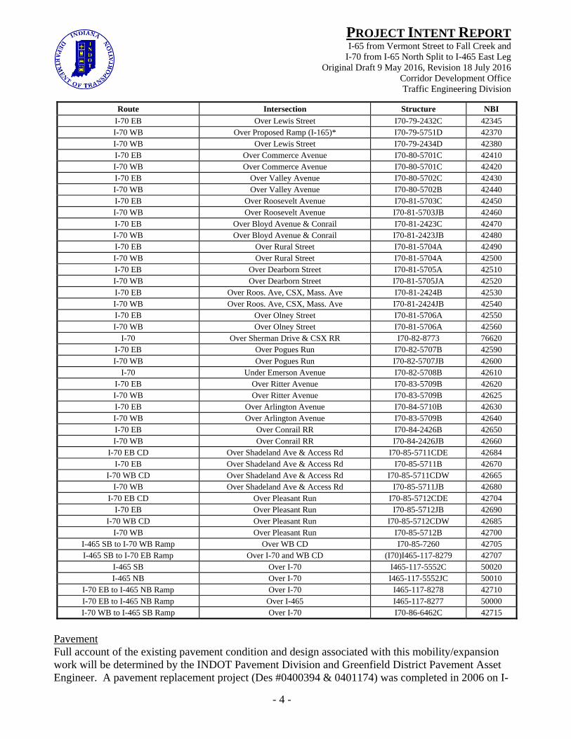
travel lanes. The southbound mainline is barrier separated from the southbound 2 lane collector distributor road that serves exits to North Street, Michigan Street, Vermont Street and New York Street. There are intermittent stretches where the C-D is 3 lanes when a ramp enters and then exits. Bridges The INDOT Bridge Division and Greenfield District Bridge Asset Engineer are sources for existing bridge conditions and design associated with this mobility/expansion work. I-65: There are 28 bridges on I-65 from Vermont Street to Fall Creek. The bridges with their structure and NBI numbers are listed in the table below along with the feature crossed.
Route Intersection Structure NBI I-65 NB / SB / CD Over Vermont Street I65-112-5731A 36490
I-65 NB Over Michigan Street I65-112-5732A 36500 I-65 SB Over Michigan Street I65-112-5733A 36510 I-65 NB Over Ramp from Pine Street I65-112-5734A 36520
I-65 NB / I-70 EB Over Saint Clair Street I65-112-5735A 36530 I-65 SB / I-70 WB Over Saint Clair Street I65-112-5736A 36540 I-65 NB / I-70 EB Over 10th Street (I65)I70-79-5737A 42330
I-65 SB Over 10th Street I65-113-5738B 36550 I-70 WB / CD Over 10th Street I70-79-5739B 42340
Ramp to I-70 EB Over I-65 NB (I70)I65-113-5741B 42350 I-65 NB Over Proposed Ramp (I-165)* I65-113-5742B 36560
I-65 SB to I-70 EB Ramp Over I-70 WB / Ramp to I-65 I65-113-5743B 36570 I-65 SB Over I-70 WB / Ramp to I-65 I65-113-5744B 36580 I-65 NB Over I-70 WB / Ramp to I-65 I65-113-5747B 36590
I-65 SB / I-70 EB Ramp Over College Avenue I65-113-5745A 36600 I-65 Ramp to CD Over College Avenue I65-113-5746A 36610
I-65 NB Over College Avenue I65-113-5748A 36620 I-70 WB Ramp to I-65 NB Over College Avenue I65-113-5749A 36630 I-70 WB Ramp to I-65 NB Over Proposed Ramp (I-165)* I65-113-5750B 36640
I-65 Over Central Avenue I65-114-5666A 36650 I-65 Over 7 City Sts (“Monster Bridge”) I65-114-2419B 36660
I-65 SB Over I-65 NB to West St Ramp I65-114-5669A 36670 I-65 NB to West St Ramp Over West St to I-65 NB Ramp I65-114-5670A 36680
I-65 NB Over West St to I-65 NB Ramp I65-114-5671A 36690 I-65 Over 16th Street I65-114-5673C 36700 I-65 Over 21st Street I65-115-5367B 36720 I-65 Over Fall Creek & Parkway I65-115-5368B 36730
I-65 SB Ramp to 21st Street Over Fall Creek & Parkway I65-115-5368DRB 36740 *Note: There was once a plan in the late 1970’s for I-165 (I-69) to travel down the Binford Boulevard, Sutherland Ave, and Monon Trail corridors arriving at the north split downtown so bridges were built to accommodate that plan. Those bridges remain in place and do not span any active roadway. They have on occasion been used to enhance rehabilitative construction logistics.
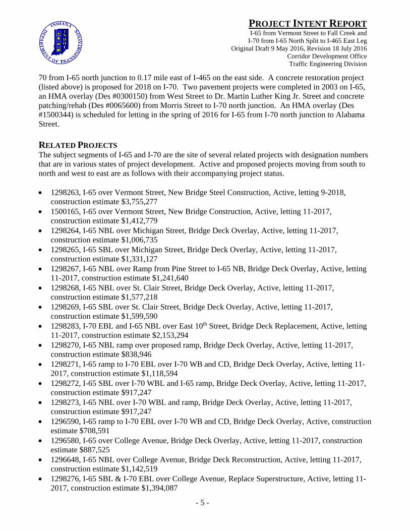
I-70: There are 44 bridges on I-70 from I-65 north junction to I-465. The bridges with their structure and NBI numbers are listed in the table below along with the feature crossed and condition. All bridges on I-70 between I-65 north junction and Shadeland Avenue were widened or otherwise rehabilitated, most as part of the major pavement project on I-70, between 2003 and 2007.
- 4 -
PROJECT INTENT REPORTI-65 from Vermont Street to Fall Creek and
I-70 from I-65 North Split to I-465 East Leg Original Draft 9 May 2016, Revision 18 July 2016
Corridor Development Office Traffic Engineering Division
Route Intersection Structure NBI
I-70 EB Over Lewis Street I70-79-2432C 42345 I-70 WB Over Proposed Ramp (I-165)* I70-79-5751D 42370 I-70 WB Over Lewis Street I70-79-2434D 42380 I-70 EB Over Commerce Avenue I70-80-5701C 42410 I-70 WB Over Commerce Avenue I70-80-5701C 42420 I-70 EB Over Valley Avenue I70-80-5702C 42430 I-70 WB Over Valley Avenue I70-80-5702B 42440 I-70 EB Over Roosevelt Avenue I70-81-5703C 42450 I-70 WB Over Roosevelt Avenue I70-81-5703JB 42460 I-70 EB Over Bloyd Avenue & Conrail I70-81-2423C 42470 I-70 WB Over Bloyd Avenue & Conrail I70-81-2423JB 42480 I-70 EB Over Rural Street I70-81-5704A 42490 I-70 WB Over Rural Street I70-81-5704A 42500 I-70 EB Over Dearborn Street I70-81-5705A 42510 I-70 WB Over Dearborn Street I70-81-5705JA 42520 I-70 EB Over Roos. Ave, CSX, Mass. Ave I70-81-2424B 42530 I-70 WB Over Roos. Ave, CSX, Mass. Ave I70-81-2424JB 42540 I-70 EB Over Olney Street I70-81-5706A 42550 I-70 WB Over Olney Street I70-81-5706A 42560
I-70 Over Sherman Drive & CSX RR I70-82-8773 76620 I-70 EB Over Pogues Run I70-82-5707B 42590 I-70 WB Over Pogues Run I70-82-5707JB 42600
I-70 Under Emerson Avenue I70-82-5708B 42610 I-70 EB Over Ritter Avenue I70-83-5709B 42620 I-70 WB Over Ritter Avenue I70-83-5709B 42625 I-70 EB Over Arlington Avenue I70-84-5710B 42630 I-70 WB Over Arlington Avenue I70-83-5709B 42640 I-70 EB Over Conrail RR I70-84-2426B 42650 I-70 WB Over Conrail RR I70-84-2426JB 42660
I-70 EB CD Over Shadeland Ave & Access Rd I70-85-5711CDE 42684 I-70 EB Over Shadeland Ave & Access Rd I70-85-5711B 42670
I-70 WB CD Over Shadeland Ave & Access Rd I70-85-5711CDW 42665 I-70 WB Over Shadeland Ave & Access Rd I70-85-5711JB 42680
I-70 EB CD Over Pleasant Run I70-85-5712CDE 42704 I-70 EB Over Pleasant Run I70-85-5712JB 42690
I-70 WB CD Over Pleasant Run I70-85-5712CDW 42685 I-70 WB Over Pleasant Run I70-85-5712B 42700
I-465 SB to I-70 WB Ramp Over WB CD I70-85-7260 42705 I-465 SB to I-70 EB Ramp Over I-70 and WB CD (I70)I465-117-8279 42707
I-465 SB Over I-70 I465-117-5552C 50020 I-465 NB Over I-70 I465-117-5552JC 50010
I-70 EB to I-465 NB Ramp Over I-70 I465-117-8278 42710 I-70 EB to I-465 NB Ramp Over I-465 I465-117-8277 50000 I-70 WB to I-465 SB Ramp Over I-70 I70-86-6462C 42715
Pavement Full account of the existing pavement condition and design associated with this mobility/expansion work will be determined by the INDOT Pavement Division and Greenfield District Pavement Asset Engineer. A pavement replacement project (Des #0400394 & 0401174) was completed in 2006 on I-
- 5 -
PROJECT INTENT REPORTI-65 from Vermont Street to Fall Creek and
I-70 from I-65 North Split to I-465 East Leg Original Draft 9 May 2016, Revision 18 July 2016
Corridor Development Office Traffic Engineering Division
70 from I-65 north junction to 0.17 mile east of I-465 on the east side. A concrete restoration project (listed above) is proposed for 2018 on I-70. Two pavement projects were completed in 2003 on I-65, an HMA overlay (Des #0300150) from West Street to Dr. Martin Luther King Jr. Street and concrete patching/rehab (Des #0065600) from Morris Street to I-70 north junction. An HMA overlay (Des #1500344) is scheduled for letting in the spring of 2016 for I-65 from I-70 north junction to Alabama Street. RELATED PROJECTS The subject segments of I-65 and I-70 are the site of several related projects with designation numbers that are in various states of project development. Active and proposed projects moving from south to north and west to east are as follows with their accompanying project status. 1298263, I-65 over Vermont Street, New Bridge Steel Construction, Active, letting 9-2018,
construction estimate $3,755,277 1500165, I-65 over Vermont Street, New Bridge Construction, Active, letting 11-2017,
construction estimate $1,412,779 1298264, I-65 NBL over Michigan Street, Bridge Deck Overlay, Active, letting 11-2017,
construction estimate $1,006,735 1298265, I-65 SBL over Michigan Street, Bridge Deck Overlay, Active, letting 11-2017,
construction estimate $1,331,127 1298267, I-65 NBL over Ramp from Pine Street to I-65 NB, Bridge Deck Overlay, Active, letting
11-2017, construction estimate $1,241,640 1298268, I-65 NBL over St. Clair Street, Bridge Deck Overlay, Active, letting 11-2017,
construction estimate $1,577,218 1298269, I-65 SBL over St. Clair Street, Bridge Deck Overlay, Active, letting 11-2017,
construction estimate $1,599,590 1298283, I-70 EBL and I-65 NBL over East 10th Street, Bridge Deck Replacement, Active, letting
11-2017, construction estimate $2,153,294 1298270, I-65 NBL ramp over proposed ramp, Bridge Deck Overlay, Active, letting 11-2017,
construction estimate $838,946 1298271, I-65 ramp to I-70 EBL over I-70 WB and CD, Bridge Deck Overlay, Active, letting 11-
2017, construction estimate $1,118,594 1298272, I-65 SBL over I-70 WBL and I-65 ramp, Bridge Deck Overlay, Active, letting 11-2017,
construction estimate $917,247 1298273, I-65 NBL over I-70 WBL and ramp, Bridge Deck Overlay, Active, letting 11-2017,
construction estimate $917,247 1296590, I-65 ramp to I-70 EBL over I-70 WB and CD, Bridge Deck Overlay, Active, construction
estimate $708,591 1296580, I-65 over College Avenue, Bridge Deck Overlay, Active, letting 11-2017, construction
estimate $887,525 1296648, I-65 NBL over College Avenue, Bridge Deck Reconstruction, Active, letting 11-2017,
construction estimate $1,142,519 1298276, I-65 SBL & I-70 EBL over College Avenue, Replace Superstructure, Active, letting 11-
2017, construction estimate $1,394,087

- 6 -
PROJECT INTENT REPORTI-65 from Vermont Street to Fall Creek and
I-70 from I-65 North Split to I-465 East Leg Original Draft 9 May 2016, Revision 18 July 2016
Corridor Development Office Traffic Engineering Division
1298277, I-65 SBL to CD over College Avenue, Replace Superstructure, Active, letting 11-2017, construction estimate $724,925
1298278, I-65 over Central Avenue, Bridge Deck Overlay, Active, letting 11-2017, construction estimate $1,845,680
0900324, I-65 over 7 Streets, Bridge Deck Patching, Active, letting 5-2016, construction estimate $3,841,196
1298279, I-65 NBL ramp to West Street over West Street to I-65 NBL ramp, Bridge Deck Overlay, Active, letting 11-2017, construction estimate $1,395,849
1298280, I-65 SBL over ramp to and from West Street, Bridge Deck Overlay, Active, letting 11-2017, construction estimate $1,062,665
1298281, I-65 NBL over ramp from West Street to I-65 NB, Bridge Deck Overlay, Active, letting 11-2017, construction estimate $1,185,710
1592545, I-70 from I-65 N Jct. to 1.38 miles east of I-465 E Leg (Post Road), Concrete Pavement Restoration, Proposed, letting 2018, construction estimate $3,764,275
1298284, I-70 at north split 0.47 mile east of I-65 (I-70 ramp over I-65 NBL), Bridge Deck Overlay, Active, letting 11-2017, construction estimate $1,440,516
1298285, I-70 at north split 0.32 mile east of I-65 (I-70 ramp over proposed ramp), Bridge Deck Overlay, Active, letting 11-2017, construction estimate $1,697,353
1296927, I-70 WB 0.25 mile east of I-65 N Jct. over Lewis Street and Monon Trail, Bridge Deck Overlay, Active, letting 11-2017, construction estimate $2,793,492
1592305, I-70 EB 0.25 mile east of I-65 N Jct. over Lewis Street and Monon Trail, Bridge Replacement, Active, letting 11-2017, construction estimate $5,574,753
1500785, I-70 EB C-D over Shadeland Avenue 0.57 mile west of I-465, Bridge Painting, Active, letting 8-2017, construction estimate $339,372
OPERATIONAL DEFICIENCIES OBSERVED Capacity and congestion are severe issues on this section of I-65 and I-70. Westbound I-70 experiences daily congestion and reduction of travel speed during the AM peak. There are multiple bottleneck locations along the highway segment from I-65 north junction to I-465 east leg. On entry the westbound flow at the east end experiences a bottleneck at the entry of the I-465 ramps and Shadeland Avenue ramps. The cross section at this point consists of 3 lanes from I-70 westbound and 1 lane from I-465 southbound merged down from 2 lanes at the merge with I-70 while the Shadeland Avenue and I-465 northbound to I-70 westbound ramps both merges. The problem arises with the fact that there is a very high volume coming from I-465 southbound that is forced to merge down and then move left quickly to make way for the next 2 ramps that enter in short succession. This configuration culminates in degradation of mainline performance with decreased speed. As traffic moves to the west, there is a bottleneck, although less significant than the aforementioned one to the east, at Emerson Avenue with the 2 ramps entering westbound flow at the interchange. The entering traffic is not a significantly high volume, but the mainline is near or at capacity so any entering volume trying to merge with the mainline causes turbulence and impediment of flow. The Keystone Avenue / Rural Street interchange creates a lane westbound with the loop ramp continuing as an auxiliary lane while the diagonal ramp merges. The relatively high volume of traffic

- 7 -
PROJECT INTENT REPORTI-65 from Vermont Street to Fall Creek and
I-70 from I-65 North Split to I-465 East Leg Original Draft 9 May 2016, Revision 18 July 2016
Corridor Development Office Traffic Engineering Division
entering at the diagonal ramp with many trying to cross mainline traffic to access I-65 south or the downtown collector distributor causes breakdown in flow and reduced speed at Keystone Avenue / Rural Street. The degradation of service at this location often does not get the chance to resolve due to the bottleneck at the junction of I-70 westbound and I-65 northbound. Queuing from this location often backs up to Keystone Avenue / Rural Street. A large proportion of the traffic arriving at the junction, from I-65 and I-70, wishes to access the Pennsylvania Street, Meridian Street and Illinois Street exit complex at the right or the West Street exit on the left. The major junction of 2 interstate highways combined with the very close proximity of two exits results in extreme turbulence within the weaving area. Additionally, the right lane of the I-70 westbound 2 lane ramp exits at the Pennsylvania/Meridian/Illinois Street exit complex on the right which introduces further complication to the situation. The left exit ramp for West Street also causes turbulence due to lane changes on northbound I-65. During the PM peak, southbound I-65, west of the north split, and eastbound I-70 experience daily congestion and reduced travel speed. The eastbound/southbound entrance ramp from West Street is a left hand entrance ramp and is therefore joining southbound I-65 in the high speed lane. This causes a bottleneck but the larger issue is the right side eastbound/southbound entrance ramp from 11th/Delaware Street being located just 1500’ upstream of the exit to the southbound collector-distributor ramp and 1850’ upstream of the major divergence of I-70 eastbound and I-65 southbound. The close proximity of these ramps and the downstream divergence with 3 entry points and 3 downstream choices causes weaving that results in complete breakdown of operations at times. To the east on I-70, the eastbound flow is bottlenecked at the Keystone Avenue/Rural Street interchange due to the exit of the right lane to the loop ramp. Although recent improvements in advanced signing have improved the situation, there is still an overcrowding of vehicles in the 4 lanes that continue, from the 5 lanes that preceded the interchange. Furthermore, the right lane experiences lower utilization due to the merging of the eastbound entrance ramp from Keystone Avenue / Rural Street. At the Emerson Avenue interchange the 2 eastbound entrance ramps (loop and diagonal) both merge shortly before the bridge over Ritter Avenue. After the bridge the cross section eastbound increases to 5 lanes. These features produce a bottleneck that causes turbulence and sometimes queuing during the PM peak as motorists (especially trucks) attempt to position themselves whilst observing the first of 2 diagrammatic signs for I-465 and Shadeland Ave. At I-465 and Shadeland Ave, the eastbound collector distributor lanes experience congestion as 2 lanes currently exist inside of Shadeland Ave and 3 lanes are now needed. This is compounded by a weaving maneuver (2-sided) necessary for traffic from Shadeland Ave (a dual-lane loop ramp) destined for eastbound I-70 as it is forced to cross two lanes of eastbound I-70 to I-465 traffic (currently 4400 vph in the PM peak).
- 8 -
PROJECT INTENT REPORTI-65 from Vermont Street to Fall Creek and
I-70 from I-65 North Split to I-465 East Leg Original Draft 9 May 2016, Revision 18 July 2016
Corridor Development Office Traffic Engineering Division
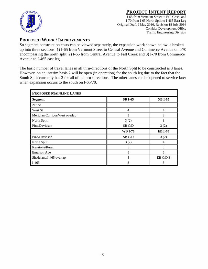
PROPOSED WORK / IMPROVEMENTS So segment construction costs can be viewed separately, the expansion work shown below is broken up into three sections: 1) I-65 from Vermont Street to Central Avenue and Commerce Avenue on I-70 encompassing the north split, 2) I-65 from Central Avenue to Fall Creek and 3) I-70 from Commerce Avenue to I-465 east leg. The basic number of travel lanes in all thru-directions of the North Split to be constructed is 3 lanes. However, on an interim basis 2 will be open (in operation) for the south leg due to the fact that the South Split currently has 2 for all of its thru-directions. The other lanes can be opened to service later when expansion occurs to the south on I-65/70.
PROPOSED MAINLINE LANES
Segment SB I-65 NB I-65
21st St 5 5
West St 4 4
Meridian Corridor/West overlap 3 3
North Split 3 (2) 3
Pine/Davidson SB C/D 3 (2)
WB I-70 EB I-70
Pine/Davidson SB C/D 3 (2)
North Split 3 (2) 4
Keystone/Rural 5 5
Emerson Ave 5 5
Shadeland/I-465 overlap 5 EB C/D 3
I-465 3 3
- 9 -
PROJECT INTENT REPORTI-65 from Vermont Street to Fall Creek and
I-70 from I-65 North Split to I-465 East Leg Original Draft 9 May 2016, Revision 18 July 2016
Corridor Development Office Traffic Engineering Division
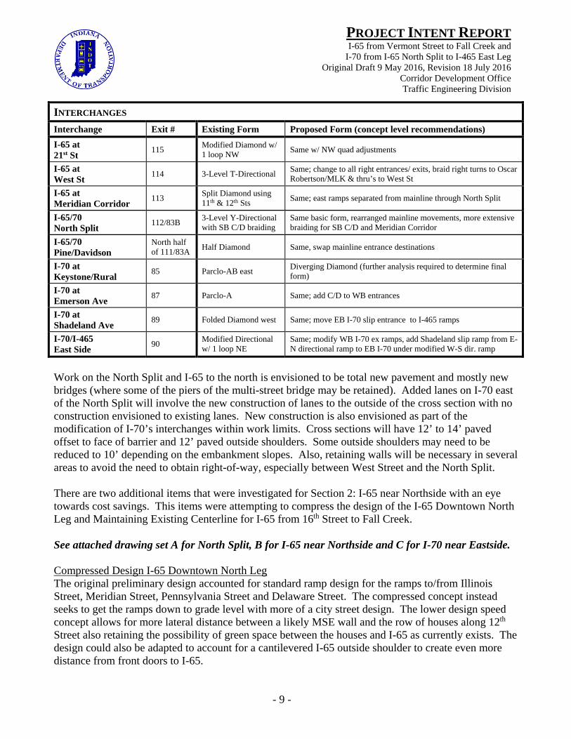
INTERCHANGES
Interchange Exit # Existing Form Proposed Form (concept level recommendations)
I-65 at 21st St
115 Modified Diamond w/ 1 loop NW
Same w/ NW quad adjustments
I-65 at West St
114 3-Level T-Directional Same; change to all right entrances/ exits, braid right turns to Oscar Robertson/MLK & thru’s to West St
I-65 at Meridian Corridor
113 Split Diamond using 11th & 12th Sts
Same; east ramps separated from mainline through North Split
I-65/70 North Split
112/83B 3-Level Y-Directional with SB C/D braiding
Same basic form, rearranged mainline movements, more extensive braiding for SB C/D and Meridian Corridor
I-65/70 Pine/Davidson
North half of 111/83A
Half Diamond Same, swap mainline entrance destinations
I-70 at Keystone/Rural
85 Parclo-AB east Diverging Diamond (further analysis required to determine final form)
I-70 at Emerson Ave
87 Parclo-A Same; add C/D to WB entrances
I-70 at Shadeland Ave
89 Folded Diamond west Same; move EB I-70 slip entrance to I-465 ramps
I-70/I-465 East Side
90 Modified Directional w/ 1 loop NE
Same; modify WB I-70 ex ramps, add Shadeland slip ramp from E-N directional ramp to EB I-70 under modified W-S dir. ramp
Work on the North Split and I-65 to the north is envisioned to be total new pavement and mostly new bridges (where some of the piers of the multi-street bridge may be retained). Added lanes on I-70 east of the North Split will involve the new construction of lanes to the outside of the cross section with no construction envisioned to existing lanes. New construction is also envisioned as part of the modification of I-70’s interchanges within work limits. Cross sections will have 12’ to 14’ paved offset to face of barrier and 12’ paved outside shoulders. Some outside shoulders may need to be reduced to 10’ depending on the embankment slopes. Also, retaining walls will be necessary in several areas to avoid the need to obtain right-of-way, especially between West Street and the North Split. There are two additional items that were investigated for Section 2: I-65 near Northside with an eye towards cost savings. This items were attempting to compress the design of the I-65 Downtown North Leg and Maintaining Existing Centerline for I-65 from 16th Street to Fall Creek. See attached drawing set A for North Split, B for I-65 near Northside and C for I-70 near Eastside. Compressed Design I-65 Downtown North Leg The original preliminary design accounted for standard ramp design for the ramps to/from Illinois Street, Meridian Street, Pennsylvania Street and Delaware Street. The compressed concept instead seeks to get the ramps down to grade level with more of a city street design. The lower design speed concept allows for more lateral distance between a likely MSE wall and the row of houses along 12th Street also retaining the possibility of green space between the houses and I-65 as currently exists. The design could also be adapted to account for a cantilevered I-65 outside shoulder to create even more distance from front doors to I-65.
- 10 -
PROJECT INTENT REPORTI-65 from Vermont Street to Fall Creek and
I-70 from I-65 North Split to I-465 East Leg Original Draft 9 May 2016, Revision 18 July 2016
Corridor Development Office Traffic Engineering Division
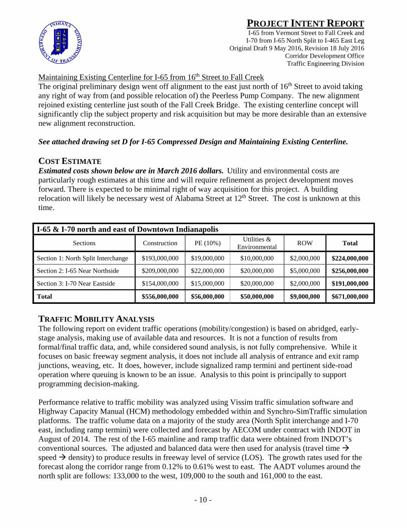
Maintaining Existing Centerline for I-65 from 16th Street to Fall Creek The original preliminary design went off alignment to the east just north of 16th Street to avoid taking any right of way from (and possible relocation of) the Peerless Pump Company. The new alignment rejoined existing centerline just south of the Fall Creek Bridge. The existing centerline concept will significantly clip the subject property and risk acquisition but may be more desirable than an extensive new alignment reconstruction. See attached drawing set D for I-65 Compressed Design and Maintaining Existing Centerline. COST ESTIMATE Estimated costs shown below are in March 2016 dollars. Utility and environmental costs are particularly rough estimates at this time and will require refinement as project development moves forward. There is expected to be minimal right of way acquisition for this project. A building relocation will likely be necessary west of Alabama Street at 12th Street. The cost is unknown at this time. I-65 & I-70 north and east of Downtown Indianapolis
Sections Construction PE (10%) Utilities &
Environmental ROW Total
Section 1: North Split Interchange $193,000,000 $19,000,000 $10,000,000 $2,000,000 $224,000,000
Section 2: I-65 Near Northside $209,000,000 $22,000,000 $20,000,000 $5,000,000 $256,000,000
Section 3: I-70 Near Eastside $154,000,000 $15,000,000 $20,000,000 $2,000,000 $191,000,000
Total $556,000,000 $56,000,000 $50,000,000 $9,000,000 $671,000,000
TRAFFIC MOBILITY ANALYSIS The following report on evident traffic operations (mobility/congestion) is based on abridged, early-stage analysis, making use of available data and resources. It is not a function of results from formal/final traffic data, and, while considered sound analysis, is not fully comprehensive. While it focuses on basic freeway segment analysis, it does not include all analysis of entrance and exit ramp junctions, weaving, etc. It does, however, include signalized ramp termini and pertinent side-road operation where queuing is known to be an issue. Analysis to this point is principally to support programming decision-making. Performance relative to traffic mobility was analyzed using Vissim traffic simulation software and Highway Capacity Manual (HCM) methodology embedded within and Synchro-SimTraffic simulation platforms. The traffic volume data on a majority of the study area (North Split interchange and I-70 east, including ramp termini) were collected and forecast by AECOM under contract with INDOT in August of 2014. The rest of the I-65 mainline and ramp traffic data were obtained from INDOT’s conventional sources. The adjusted and balanced data were then used for analysis (travel time speed density) to produce results in freeway level of service (LOS). The growth rates used for the forecast along the corridor range from 0.12% to 0.61% west to east. The AADT volumes around the north split are follows: 133,000 to the west, 109,000 to the south and 161,000 to the east.

- 11 -
PROJECT INTENT REPORTI-65 from Vermont Street to Fall Creek and
I-70 from I-65 North Split to I-465 East Leg Original Draft 9 May 2016, Revision 18 July 2016
Corridor Development Office Traffic Engineering Division
The following 2 tables show traffic operations on existing I-65 and I-70 in the current (2016) and design year (2036). The majority of highway segments in the proposal area in peak periods are operating at LOS F currently as those segments are at full capacity. Conditions worsen with extreme densities in the design year representing a complete breakdown of operations.
I-70 Eastbound, East of Downtown Indianapolis (PM) - Existing Conditions
Segment Existing Lane Configuration
2016 2036
LOS Density (pc/mi/ln) LOS Density (pc/mi/ln)
Inside North Split 3 Lanes F 62 (pm) F 64 (pm)
North Split to Rural St 5 Lanes F 80 (pm) F 88 (pm)
Rural St to Keystone Ave 5 Lanes F 107 (pm) F 132 (pm)
Inside Keystone/Rural 4 Lanes F 91 (pm) F 121 (pm)
Keystone Ave to Emerson Ave 4 Lanes F 64 (pm) F 73 (pm)
Inside Emerson Ave 4 Lanes F 53 (pm) F 67 (pm)
SB Emerson to NB Emerson 4 Lanes F 71 (pm) F 95 (pm)
Emerson Ave to I-465/Shadeland Ave 4 Lanes min F 86 (pm) F 131 (pm)
Inside I-465/Shadeland Ave 3 Lanes C 19 (pm) C 19 (pm)
Shadeland Slip to SB I-465 3 Lanes C 19 (pm) C 23 (pm)
SB I-465 to NB I-465 3 Lanes D 29 (pm) D 31 (pm)
I-70 Westbound, East of Downtown Indianapolis (AM) - Existing Conditions
Post Rd to I-465 5 Lanes C 20 (am) C 21 (am)
Inside I-465 3 Lanes B 17 (am) B 17 (am)
Inside I-465 & Shadeland Ave 3 Lanes C 21 (am) C 21 (am)
SB I-465 to NB I-465 4 Lanes F 69 (am) F 76 (am)
NB I-465 to Shadeland Ave 4 Lanes F 81 (am) F 81 (am)
Shadeland Ave to Emerson Ave 4 Lanes F 75 (am) F 89 (am)
Inside Emerson Ave 4 Lanes F 116 (am) F 111 (am)
NB Emerson to SB Emerson 4 Lanes F 128 (am) F 125 (am)
Emerson Ave to Keystone/Rural 4 Lanes F 116 (am) F 108 (am)
Inside Keystone/Rural 4 Lanes F 128 (am) F 120 (am)
Rural St to Keystone Ave 5 Lanes F 123 (am) F 116 (am)
Keystone Ave to NB I-65 5 Lanes F 144 (am) F 138 (am)
NB I-65 to SB C/D 3 Lanes F 68 (am) F 73 (am)
Inside North Split 2 Lanes E 34 (am) E 37 (am)
- 12 -
PROJECT INTENT REPORTI-65 from Vermont Street to Fall Creek and
I-70 from I-65 North Split to I-465 East Leg Original Draft 9 May 2016, Revision 18 July 2016
Corridor Development Office Traffic Engineering Division
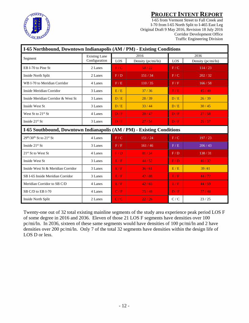
I-65 Northbound, Downtown Indianapolis (AM / PM) - Existing Conditions
Segment Existing Lane Configuration
2016 2036
LOS Density (pc/mi/ln) LOS Density (pc/mi/ln)
EB I-70 to Pine St 2 Lanes F / C 58 / 22 F / C 114 / 23
Inside North Split 2 Lanes F / D 151 / 34 F / C 202 / 32
WB I-70 to Meridian Corridor 4 Lanes F / E 110 / 35 F / F 166 / 58
Inside Meridian Corridor 3 Lanes E / E 37 / 36 F / E 45 / 40
Inside Meridian Corridor & West St 3 Lanes D / E 28 / 39 D / E 26 / 39
Inside West St 3 Lanes D / E 33 / 44 D / E 30 / 45
West St to 21st St 4 Lanes D / F 28 / 47 D / F 27 / 58
Inside 21st St 3 Lanes D / F 27 / 54 D / F 26 / 57
I-65 Southbound, Downtown Indianapolis (AM / PM) - Existing Conditions
29th/30th St to 21st St 4 Lanes F / C 151 / 24 F / C 197 / 23
Inside 21st St 3 Lanes F / F 161 / 46 F / E 206 / 43
21st St to West St 4 Lanes F / D 81 / 34 F / D 138 / 31
Inside West St 3 Lanes E / F 44 / 52 F / D 46 / 32
Inside West St & Meridian Corridor 3 Lanes E / F 36 / 61 E / E 39 /41
SB I-65 Inside Meridian Corridor 3 Lanes E / F 42 / 88 E / F 44 / 72
Meridian Corridor to SB C/D 4 Lanes E / F 42 / 65 E / F 44 / 59
SB C/D to EB I-70 4 Lanes C / F 25 / 48 D / F 27 / 48
Inside North Split 2 Lanes C / C 22 / 26 C / C 23 / 25
Twenty-one out of 32 total existing mainline segments of the study area experience peak period LOS F of some degree in 2016 and 2036. Eleven of those 21 LOS F segments have densities over 100 pc/mi/ln. In 2036, sixteen of these same segments would have densities of 100 pc/mi/ln and 2 have densities over 200 pc/mi/ln. Only 7 of the total 32 segments have densities within the design life of LOS D or less.

- 13 -
PROJECT INTENT REPORTI-65 from Vermont Street to Fall Creek and
I-70 from I-65 North Split to I-465 East Leg Original Draft 9 May 2016, Revision 18 July 2016
Corridor Development Office Traffic Engineering Division
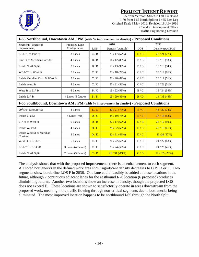
The following 2 tables show traffic operations during peak periods on proposed expanded and/or reconstructed I-65 and I-70 in the current and design year. The proposed configuration yields vast improvement in network performance for I-65 and I-70. High densities do still exist in the peak hour for select segments along each corridor but this level of improvement represents the most cost-effective expansion alternative. While adding another lane in each direction would improve the operations to LOS C or D in many segments, the opportunity cost of effecting that is judged unacceptably high and would create a much greater need of right of way acquisition. The LOS E during the peak hour shown in the table below represents a maximizing of that capital investment. The single segment that shows LOS F is just beyond the threshold for LOS E.
I-70 Eastbound, East of Downtown PM (with % improvement in density) - Proposed Conditions
Segments (degree of improvement)
Proposed Lane Configuration
2016 2036
LOS Density (pc/mi/ln) LOS Density (pc/mi/ln)
Inside North Split 4 Lanes (min) D 35 (pm) (44%) E 36 (pm) (44%)
North Split to Keystone/Rural 6 Lanes (min) E 39 (pm) (51%) E 41 (pm) (53%)
Inside Keystone/Rural 5 Lanes E 40 (pm) (56%) E 42 (pm) (65%)
Keystone/ Rural to Emerson Ave 6 Lanes E 36 (pm) (44%) E 37 (pm) (49%)
Inside Emerson Ave 5 Lanes E 39 (pm) (26%) E 41 (pm) (39%)
SB Emerson to NB Emerson 6 Lanes D 33 (pm) (54%) D 33 (pm) (65%)
Emerson Ave to I-465 6 Lanes (min) E 44 (pm) (49%) F 48 (pm) (63%)
Inside I-465/Shadeland Ave 3 Lanes C 19 (pm) (0%) C 19 (pm) (0%)
SB I-465 to NB I-465 4 Lanes E 41 (pm) (-41%) E 44 (pm) (-42%)
I-70 Westbound, East of Downtown AM (with % improvement in density) - Proposed Conditions
Post Rd to I-465 5 Lanes C 20 (am) (0%) C 21 (am) (0%)
Inside I-465 3 Lanes B 17 (am) (0%) B 17 (am) (0%)
Inside I-465 & Shadeland Ave 3 Lanes B 16 (am) (24%) B 16 (am) (24%)
SB I-465 to NB I-465/Shad. 5 Lanes C 23 (am) (67%) C 23 (am) (70%)
Shadeland Ave to Emerson Ave 6 Lanes D 28 (am) (63%) D 28 (am) (69%)
Inside Emerson Ave 5 Lanes D 29 (am) (75%) D 29 (am) (74%)
Emerson to Keystone/Rural 6 Lanes E 36 (am) (71%) E 42 (am) (66%)
Inside Keystone/Rural 5 Lanes E 43 (am) (66%) F 45 (am) (63%)
Keystone to SB C\D/Mrdn Corr 6 Lanes (min) E 36 (am) (75%) E 37 (am) (73%)
SB C\D/Mrdn Corr to NB I-65 4 Lanes (5 future) D 28 (am) (59%) D 28 (am) (62%)
Inside North Split 2 Lanes (3 future) D 28 (am) (18%) D 28 (am) (24%)
- 14 -
PROJECT INTENT REPORTI-65 from Vermont Street to Fall Creek and
I-70 from I-65 North Split to I-465 East Leg Original Draft 9 May 2016, Revision 18 July 2016
Corridor Development Office Traffic Engineering Division
I-65 Northbound, Downtown AM / PM (with % improvement in density) - Proposed Conditions
Segments (degree of improvement)
Proposed Lane Configuration
2016 2036
LOS Density (pc/mi/ln) LOS Density (pc/mi/ln)
EB I-70 to Pine St 3 Lanes C / B 25 / 17 (57%) D / C 26 / 21 (77%)
Pine St to Meridian Corridor 4 Lanes B / B 16 / 12 (89%) B / B 17 / 13 (93%)
Inside North Split 3 Lanes B / B 15 / 13 (90%) B / B 15 / 13 (94%)
WB I-70 to West St 5 Lanes C / C 23 / 18 (79%) C / C 23 / 19 (86%)
Inside Meridian Corr. & West St 3 Lanes C / C 22 / 20 (49%) C / C 20 / 19 (51%)
Inside West St 4 Lanes C / C 20 / 21 (52%) C / C 19 / 22 (51%)
West St to 21st St 6 Lanes B / C 15 / 22 (53%) B / C 15 / 24 (58%)
Inside 21st St 4 Lanes (5 future) B / D 15 / 29 (46%) B / D 14 / 33 (48%)
I-65 Southbound, Downtown AM / PM (with % improvement in density) - Proposed Conditions
29th/30th St to 21st St 4 Lanes E / C 40 / 21 (73%) E / C 43 / 20 (78%)
Inside 21st St 4 Lanes (min) D / C 34 / 19 (76%) E / B 37 / 18 (82%)
21st St to West St 6 Lanes D / B 27 / 17 (67%) D / B 28 / 17 (80%)
Inside West St 4 Lanes D / C 28 / 22 (58%) D / C 29 / 19 (41%)
Inside West St & Meridian Corridor
3 Lanes D / D 32 / 31 (49%) D / C 33 /26 (37%)
West St to EB I-70 5 Lanes C / C 20 / 22 (66%) C / C 21 / 22 (63%)
EB I-70 to SB C/D 3 Lanes (4 Future) C / C 23 / 24 (50%) C / C 24 / 26 (46%)
Inside North Split 2 Lanes (3 Future) C / D 21 / 31 (-19%) C / D 22 / 32 (-28%)
The analysis shows that with the proposed improvements there is an enhancement to each segment. All noted bottlenecks in the defined work area show significant density decreases to LOS D or E. Two segments show borderline LOS F in 2036. One lane could feasibly be added at these locations in the future, although 7 continuous adjacent lanes for the eastbound I-70 location (6 proposed) produces diminishing returns. Another two locations show an increase in density, though the projected LOS does not exceed E. These locations are shown to satisfactorily operate in areas downstream from the proposed work, meaning more traffic flowing through non-critical segments due to bottlenecks being eliminated. The most improved location happens to be northbound I-65 through the North Split.
- 15 -
PROJECT INTENT REPORTI-65 from Vermont Street to Fall Creek and
I-70 from I-65 North Split to I-465 East Leg Original Draft 9 May 2016, Revision 18 July 2016
Corridor Development Office Traffic Engineering Division
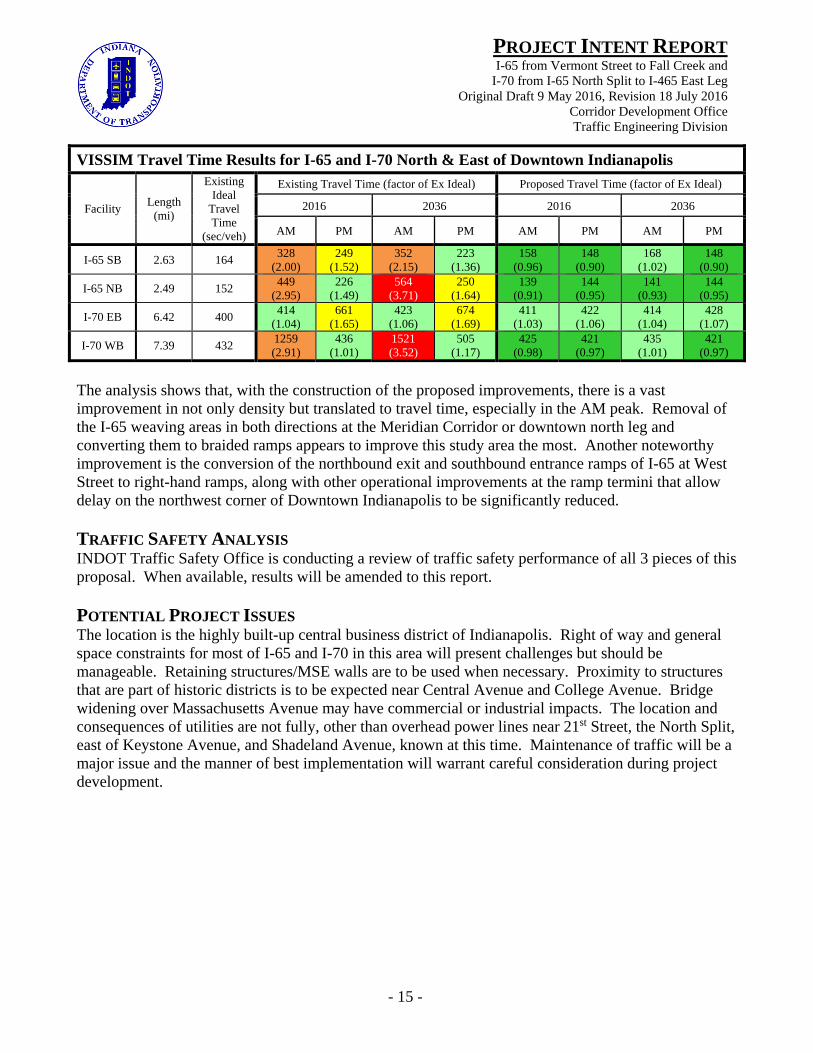
VISSIM Travel Time Results for I-65 and I-70 North & East of Downtown Indianapolis
Facility Length
(mi)
Existing Ideal
Travel Time
(sec/veh)
Existing Travel Time (factor of Ex Ideal) Proposed Travel Time (factor of Ex Ideal)
2016 2036 2016 2036
AM PM AM PM AM PM AM PM
I-65 SB 2.63 164 328
(2.00) 249
(1.52) 352
(2.15) 223
(1.36) 158
(0.96) 148
(0.90) 168
(1.02) 148
(0.90)
I-65 NB 2.49 152 449
(2.95) 226
(1.49) 564
(3.71) 250
(1.64) 139
(0.91) 144
(0.95) 141
(0.93) 144
(0.95)
I-70 EB 6.42 400 414
(1.04) 661
(1.65) 423
(1.06) 674
(1.69) 411
(1.03) 422
(1.06) 414
(1.04) 428
(1.07)
I-70 WB 7.39 432 1259 (2.91)
436 (1.01)
1521 (3.52)
505 (1.17)
425 (0.98)
421 (0.97)
435 (1.01)
421 (0.97)
The analysis shows that, with the construction of the proposed improvements, there is a vast improvement in not only density but translated to travel time, especially in the AM peak. Removal of the I-65 weaving areas in both directions at the Meridian Corridor or downtown north leg and converting them to braided ramps appears to improve this study area the most. Another noteworthy improvement is the conversion of the northbound exit and southbound entrance ramps of I-65 at West Street to right-hand ramps, along with other operational improvements at the ramp termini that allow delay on the northwest corner of Downtown Indianapolis to be significantly reduced. TRAFFIC SAFETY ANALYSIS INDOT Traffic Safety Office is conducting a review of traffic safety performance of all 3 pieces of this proposal. When available, results will be amended to this report. POTENTIAL PROJECT ISSUES The location is the highly built-up central business district of Indianapolis. Right of way and general space constraints for most of I-65 and I-70 in this area will present challenges but should be manageable. Retaining structures/MSE walls are to be used when necessary. Proximity to structures that are part of historic districts is to be expected near Central Avenue and College Avenue. Bridge widening over Massachusetts Avenue may have commercial or industrial impacts. The location and consequences of utilities are not fully, other than overhead power lines near 21st Street, the North Split, east of Keystone Avenue, and Shadeland Avenue, known at this time. Maintenance of traffic will be a major issue and the manner of best implementation will warrant careful consideration during project development.
- 16 -
PROJECT INTENT REPORTI-65 from Vermont Street to Fall Creek and
I-70 from I-65 North Split to I-465 East Leg Original Draft 9 May 2016, Revision 18 July 2016
Corridor Development Office Traffic Engineering Division
RECOMMENDATIONS The recommendation for I-65 and I-70 Downtown and east of Downtown Indianapolis is to execute the proposed expansion and reconstruction outlined earlier and as shown in the attached sketch drawings. The party selected to develop/design the work must confer early and directly with the Corridor Development Office to ensure full understanding of essential project intent and limitations of traffic analysis and sketch planning carried out to support the proposals here-in. As is shown in the tables above, the addition of the mainline though and auxiliary lanes with construction of the interchange modification at I-65 and I-70 north junction will provide improved densities, levels of service and travel times with significant reduction in driver delay. A next step of development for this study area is the Interstate Access Request (IAR) process, ideally to be done in a single process for all geometrically modified interchanges in the project area, with the exception of I-65/21st St (Exit 115) and I-70/Shadeland Avenue (Exit 89). Exits 111 (Fletcher, Washington, Ohio, & Michigan) and 115 (21st St) on I-65 and Exit 91 (Post Rd) on I-70 will serve as “adjacent” interchanges for the Interstate Access Request study area. Depending on how the 3 separable project units are advanced/funded (altogether, or incrementally), it may be acceptable to conduct interchange IAR’s in steps or phases. For a variety of reasons, including sheer scale and cost, the 3 sections of this work are most likely to be advanced separately; though design must be coordinated closely. Further subdividing this work could be done. The merit of that will be determined at a later stage. At this time, the order of the 3 sections completion should be (1) the North Split interchange bounded by Vermont Street, Central Avenue and Commerce Avenue, (2) I-65 near Northside from Central Avenue to Fall Creek, and (3) I-70 near Eastside from Commerce Avenue to I-465 East Leg. A future Project Intent Report is to be done by the Corridor Development Office for the corresponding parts of the I-65/70 Inner Loop south of Vermont Street. The southern and western study limits are I-65 at Thompson Road (as to include the I-465 interchange) and I-70 at Belmont Avenue (as to include the Harding Street interchange). Please contact the Corridor Development Office should you have questions or need additional information. Attachments: Drawings