Project Description - Anheuser-Busch Coastal … Description ... quarters for the Virginia Coast...
15
1 Project Description The mission of the Anheuser Busch Coastal Research Center (ABCRC) of the University of Virginia is to promote the understanding of the ecological, chemical and geomorphological processes that regulate coastal systems and landscapes. This is both a research and education mission. The Center exists now in a rented farmhouse and has served as the laboratory and quarters for the Virginia Coast Reserve Long-Term Ecological Research Project (VCR/LTER) since 1988. In 2000, the University of Virginia completed purchase of 43 acres of land adjacent to the harbor in Oyster Virginia and construction phase I of the ABCRC facilities is scheduled to begin in the May 2001, with initial site preparation to be completed by July 1, 2001. Expansion of the ABCRC is driven by three major motivations. The VCR/LTER has outgrown the rented facility, which has only a single laboratory and room to sleep 20. A major impetus for developing the ABCRC is the need to provide facilities for the growing number of researchers, including those not associated with the VCR/LTER, wishing to do work on the barrier islands, lagoons and marshes along the Virginia coast. Additionally, the farmhouse does not accommodate the educational activities, such as lectures, courses and conferences that are required to fully achieve the ABCRC mission. The Anheuser Busch Coastal Research Center is located in an environment of extensive protected natural areas in the form of barrier islands, lagoons and Spartina alterniflora marshes as well as fringing human agroecosystems. The mainland of the peninsula is largely agricultural in character (winter wheat, soybeans, tomatoes, with limited areas of upland pine and bottomland hardwood forests), interspersed with hedgerows. The barrier islands off the Virginia coast of the lower Delmarva Peninsula are (with a single exception) protected in one form or another. The Nature Conservancy’s Virginia Coast Reserve owns 14 of the islands, plus extensive marshes in the lagoon and adjoining the mainland. The State of Virginia owns two additional islands (Mockhorn and Wreck) along with numerous additional marshes and lagoonal areas. The Chincoteague and Eastern Shore National Wildlife Refuges bound the barrier island- lagoon complex to the north and south at Assateague and Fishermans Islands respectively. Further, the VCR is designated by the United Nations as a Man and the Biosphere (MAB) Reserve. The Chesapeake Bay side of the peninsula has small, well mixed estuaries with a minimum of fringing salt marshes. The contrast between the bayside and seaside coasts of Virginia's Eastern Shore affords outstanding research opportunities. Station History: The Department of Environmental Sciences at the University of Virginia has had a research presence at the Virginia Barrier Island-Lagoon Complex for more than 28 years. Early studies by department faculty focused on the geomorphology of the barrier islands and their susceptibility to erosion (Dolan and Godfrey 1973, Dolan et al. 1979, Kochel and Baker 1982) and on the role of extra-tropical storms in barrier island migration (Hayden et al. 1980). Research by UVA scientists was complemented by work conducted by scientists from Old Dominion Unversity’s Barrier Island Laboratory (Oertel and colleagues). Funding of the Department of Environmental Sciences’ Virginia Coast Reserve Long Term Ecological Research Project late in 1987 necessitated on-site facilities for research and education.
Transcript of Project Description - Anheuser-Busch Coastal … Description ... quarters for the Virginia Coast...

1
Project Description The mission of the Anheuser Busch Coastal Research Center (ABCRC) of the University of Virginia is to promote the understanding of the ecological, chemical and geomorphological processes that regulate coastal systems and landscapes. This is both a research and education mission. The Center exists now in a rented farmhouse and has served as the laboratory and quarters for the Virginia Coast Reserve Long-Term Ecological Research Project (VCR/LTER) since 1988. In 2000, the University of Virginia completed purchase of 43 acres of land adjacent to the harbor in Oyster Virginia and construction phase I of the ABCRC facilities is scheduled to begin in the May 2001, with initial site preparation to be completed by July 1, 2001.
Expansion of the ABCRC is driven by three major motivations. The VCR/LTER has outgrown the rented facility, which has only a single laboratory and room to sleep 20. A major impetus for developing the ABCRC is the need to provide facilities for the growing number of researchers, including those not associated with the VCR/LTER, wishing to do work on the barrier islands, lagoons and marshes along the Virginia coast. Additionally, the farmhouse does not accommodate the educational activities, such as lectures, courses and conferences that are required to fully achieve the ABCRC mission.
The Anheuser Busch Coastal Research Center is located in an environment of extensive protected natural areas in the form of barrier islands, lagoons and Spartina alterniflora marshes as well as fringing human agroecosystems. The mainland of the peninsula is largely agricultural in character (winter wheat, soybeans, tomatoes, with limited areas of upland pine and bottomland hardwood forests), interspersed with hedgerows. The barrier islands off the Virginia coast of the lower Delmarva Peninsula are (with a single exception) protected in one form or another. The Nature Conservancy’s Virginia Coast Reserve owns 14 of the islands, plus extensive marshes in the lagoon and adjoining the mainland. The State of Virginia owns two additional islands (Mockhorn and Wreck) along with numerous additional marshes and lagoonal areas. The Chincoteague and Eastern Shore National Wildlife Refuges bound the barrier island- lagoon complex to the north and south at Assateague and Fishermans Islands respectively. Further, the VCR is designated by the United Nations as a Man and the Biosphere (MAB) Reserve. The Chesapeake Bay side of the peninsula has small, well mixed estuaries with a minimum of fringing salt marshes. The contrast between the bayside and seaside coasts of Virginia's Eastern Shore affords outstanding research opportunities. Station History: The Department of Environmental Sciences at the University of Virginia has had a research presence at the Virginia Barrier Island-Lagoon Complex for more than 28 years. Early studies by department faculty focused on the geomorphology of the barrier islands and their susceptibility to erosion (Dolan and Godfrey 1973, Dolan et al. 1979, Kochel and Baker 1982) and on the role of extra-tropical storms in barrier island migration (Hayden et al. 1980). Research by UVA scientists was complemented by work conducted by scientists from Old Dominion Unversity’s Barrier Island Laboratory (Oertel and colleagues). Funding of the Department of Environmental Sciences’ Virginia Coast Reserve Long Term Ecological Research Project late in 1987 necessitated on-site facilities for research and education.

2
The existing (rented) laboratory has been in intensive use since 1988. In 1995, the University of Virginia authorized funds for the purchase of land for the building of a field station, then called the University of Virginia Coastal Research Center. Following an extensive search for suitable

3
property, and negotiations with The Nature Conservancy on a conservation easement, 43 acres of waterfront property were purchased, approximately 1 km from the existing, rented laboratory. In 2000, a planning workshop was held to further refine the research and administrative directions for the ABCRC (see Results of Prior Support for details). Training: During most of its history, educational activities at the ABCRC have been confined to class field trips and independent study projects. However, in 2000, the first for-credit course (Ecological Communities of Virginia) was taught at the ABCRC. This intensive, field-oriented course includes one week each at the ABCRC, Blandy Experimental Farm and Mountain Lake Biological Station. After receiving rave reviews from the students, this course will be offered again in 2001. An additional graduate course, aimed at ecological training for local K-12 teachers, has been added for the summer of 2001. This latter course will be taught off-site, since existing facilities can support neither the lecture nor the laboratory parts of the course. We intend to expand the opportunities for courses at the ABCRC through expansion of our facilities. Facility Administration & Staffing: The ABCRC is administered by the Department of Environmental Sciences at the University of Virginia. Dr. Bruce Hayden is the current Director of the ABCRC. A site manager, C. Randy Carlson oversees day-to-day operations of the Center. The number of UVA staff at the ABCRC is being increased from two (site manager and marine scientist) to four full- time positions, (adding two technicians with expertise in chemical and biological data collection) and one part-time (an administrative assistant/fiscal technician) position. We are actively seeking funding from state and private sources for a full- time, on-site Center director. Dr. John Porter provides information management and oversight support for the ABCRC. Additionally, under the authority of the Center director, Dr. David E. Smith, Dr. Jay Zieman, Dr. Linda Blum, Dr. Aaron Mills and Dr. Karen McGlathery oversee specific aspects of station operation and planning. Research Areas: Research at the ABCRC focuses on the Virginia barrier island- lagoon complex, a region that extends 100 km (north-south) along the seaward margin of the Delmarva Peninsula, from Chincoteague Island southward to the mouth of Chesapeake Bay (centered on 37o 30’ N and 75 o 40’ W). This barrier island- lagoon complex includes barrier islands and intervening inlets, back-barrier islands, extensive bays, tidal flats, salt marshes, and the mainland ecosystems. Although the islands have been inhabited sporadically since the landing of Captain John Smith in 1608 (Graham 1976), they remain today isolated, uninhabited and relatively little changed from the natural state (Dueser et al. 1976). Chincoteague National Wildlife Refuge bounds the area to the north and Fishermans Island National Wildlife Refuge bounds it to the south. The barrier island- lagoon landscape is dynamic, and frequently disturbed, with elements that differ in degrees normally associated with biome-level differences. The types of ecosystem changes that normally occur across large distances (i.e., continents) and over long periods (i.e., glacial and interglacial periods) happen on decadal time-scales in this landscape. As a result, changes between different ecosystem states (such as changes that occur as a maritime forest evolves into a salt marsh) are relatively frequent. This barrier island- lagoon complex is an ideal location for a field station with the goal of understanding the coastal environment. Pursuant to obtaining required permits, ABCRC researchers are able to conduct research on tens of thousands of hectares of TNC, state and federal properties. Further, the land purchased for the

4
ABCRC also includes woodlands (21 acres) and salt marsh (18 acres) bounding Cobb Mill Creek, and grassland (4 acres). These have been instrumented to monitor streamflow and groundwater levels using automatic data loggers. The topographic gradient from the agricultural field to Cobb Mill Creek provides the opportunity to study groundwater and nutrient movements in the unconfined aquifer as well as aquifer recharge; both are critical to understanding the water and nutrient budget of the mainland- lagoon system. At larger spatial scales, there also are opportunities to use this field research facility as a laboratory for the study of population, community, and landscape ecology in the context of sea-level change on coastal wetlands. For example, these opportunities include research on invasive species (especially Phragmites australis), and the relative impact of ground water/ atmospheric/ tidal/ internal cycling of nutrients on marsh plant production, organic matter accumulation, and marsh plant community diversity. The dynamic nature of the complex and diversity of land cover lends itself to remote sensing activities. The VCR/LTER is a Global Terrestrial Observing System (GTOS) site, and a participant in the Global Fiducial and National Assets Imagery programs. Proximity to NASA’s Wallops Island Flight Center and Goddard and Langley Space Flight Centers has led to increasing interest by NASA researchers as well. There is also interest by NASA in using the ABCRC laboratory as a site to host instruments, such as sun photometers. Finally, survey-grade Global Positioning System (GPS) units have been used to establish over 70 monuments with a resolution of approximately 2 cm in the X, Y and Z dimensions within the barrier island- lagoon complex. These survey monuments make it possible to locate research sites and assess landscape changes with a high degree of accuracy.
Transportation: The ABCRC is located 45-minutes drive from Norfolk International Airport. The University of Virginia operates two Suburban trucks, two 24’ and one 21’ “Privateer” boats, a 17’ “Aquasport” and a 13’ “Boston Whaler” boat. These boats are shallow-draft vessels capable of operating in the shallow waters of the lagoons. For more protracted use in deep water, we also operate a 32’ diesel-powered Trawler. Boats are operated daily in the summer and upon request throughout the remainder of the year. Automated Data Acquisition: Largely as a result of the presence of the VCR/LTER, there is a substantial infrastructure of automated measurement equipment and other research infrastructure available to ABCRC visitors (Table 1). Table 1: What
Number Stat./units
Frequency of Measurement
Description
Tide Monitoring Stations
2 Every 12 minutes
Data are available from Hog Island and Redbank, VA back to 1989. An additional station will be added in Oyster Harbor when dock construction is completed.
Meteorological Stations
3 Hourly Temperature, humidity, wind, solar and photosynthetically active radiation. Stations are located at Hog Island, Phillips Creek and in Oyster, VA back to 1989.
Ground Water Levels
10 Every 205 minutes
Ground water levels are monitored on Hog Island, Phillips Creek and Oyster. Data for Hog Island and Phillips Creek extend back to 1997.
Water Levels 8 Hourly Water levels in Cobb Mill Creek are measured by a series of digital water level recorders. Data collection initiated in 2000.

5
Global Positioning Systems
2 survey-grade units and numerous navigation-grade units
Variable Accuracies of >2cm in three dimensions over 5 km distances with survey-grade units. Over 70 high-resolution monuments have been established in proximity to research areas. See http://www.abcrc.virginia.edu/~crc7m/gps.html for details on specific projects
Digital Fathometer
1 unit Variable Coupled to differentially-corrected Global Positioning System to yield real-time bathymetric mapping capabilities.
Digital Video Camera
1 unit Variable Used for documenting research methodologies and sites and in change analyses.
Digital Still Camera
1 unit Variable Used for high-resolution images of sites, organisms and activities.
In addition to data collected through automated means, long-term data sets on water quality, storms, primary production, nitrogen budgets, biodiversity and small-mammal abundance are available through the VCR/LTER project (http://www.vcrlter.virginia.edu/data.html). See Data Collection & Management Policies (below) for use information. Facility Use Policies: The equipment and facility use policy of the ABCRC is based on the following principles:
• The ABCRC will foster sharing of scientific resources among station users. • Equipment and facilities are best stewarded when there is a clearly identified responsible
party associated with them. • Equipment purchased through grants need to be used to support the objectives of those
grants. • When facility or equipment use entails costs, either in the form of consumables or
excessive wear and tear, equipment and facility use will be contingent upon identifying a source to pay those costs.
The specifics of the policy are at: http://www.abcrc.virginia.edu/equip_policy.html . Communications: The ABCRC is connected to the Internet via a dedicated T1 line (1.5 MBS). This supports connections to the Internet by all station computers, as well as two phones connected directly to the UVA phone system, allowing toll- free calling between the laboratory and the local Charlottesville, VA phone system. A conventional phone line can be used for local and long-distance calling on the shore. Cellular telephones are the primary means of communication between UVA staff and researchers on site. In addition to staff phones, 3 cellular telephones are currently available for field use at the ABCRC. The laboratory and boats are also equipped with marine-band radios. We are in the process of initiating a network of spread-spectrum digital radios (“wireless networking”) that will allow Internet connectivity over large portions of the barrier island- lagoon complex.
Unique Features: Understanding of large-scale lithospheric-atmospheric-biospheric interactions is significantly limited by the difficulty of dealing with the disparities in the spatial and temporal scales used. For example, because of landscape heterogeneity, information collected at a small scale (e.g., m2) cannot readily be extrapolated to characterize vegetation over the large area (e.g., km2) as is required for input to atmospheric models. The emphasis at the ABCRC is to couple small-scale population and community dynamics to large-scale events and processes occurring in barrier-island lagoons. The ABCRC provides an excellent opportunity for investigating the local, regional and global implications of landscape/estuarine and landscape/atmosphere interactions.

6
The major emphasis continues to be the effect of physical dynamics on the biology of the systems and the biological feedbacks that effect physical dynamics. As a result, the ABCRC provides a unique resource that does not duplicate facilities elsewhere. Currently, there are no other field stations along the Atlantic coast from New Jersey to Florida, that provide a similar orientation. For example, nearby Horn Point Environmental Laboratory, MD; Chesapeake Biological Laboratory, MD; and Virginia Institute of Marine Sciences (VIMS) all focus on estuarine studies of Chesapeake Bay. VIMS maintains an excellent and very active Eastern Shore Laboratory in Wachapreague VA (40 miles north of the ABCRC). However, the mission of the VIMS Eastern Shore Lab focuses on applied marine sciences, specifically aquaculture. To the south, the Carolina marine research labs are involved with elements of coastal research; however, their primary focus is on oceanic systems. None of these programs focuses on combined physical-biological interactions at the landscape scale, and none is in a location that is as physically dynamic as is the Virginia Coast Reserve.
Proposed Improvements The proposed improvements will foster a fundamental change in the ways the ABCRC facilities are used. Existing facilities support only a short-term presence on site. Limited laboratory facilities require that samples be taken elsewhere for processing. Further, the single existing laboratory space must be shared by all researchers and is used almost entirely for stabilization of samples prior to transport. With the proposed laboratory, researchers will be able to conduct analyses on site, leading to more productive use of research time. Moreover, the availability of multiple laboratory rooms will allow specialization and therefore remove existing conflicts in common laboratory use (i.e., clean vs dirty labs). With improvements in the laboratory facilities comes the need for improved on-site housing, educational and outreach facilities, and docks. Existing accomodations require 5-8 people per room, a condition that is not conducive to long-term stays, especially by senior personnel. The
Housing Commons
Laboratory
Dock
Access Road
Marsh
Proposed Buildings

7
proposed housing will target room occupancy at 2-3 per room. Current meeting spaces (seating for 12-15) are insufficient to support all but small class field trips. Larger groups need to be hosted off-site in rented or borrowed facilities. The commons/conference facility will permit us to meet our education and outreach obligations. Finally, having docks on site will facilitate the movement of people and equipment to research sites and reduce the need for multiple loading/offloading sequences (currently users must travel by car 25 minutes to reach our boats). Plans for improving and modernizing our research and education facilities on Virginia's Eastern Shore were made possible by an alumnus gift of $1,000,000 and a second gift of $1,200,000. These gifts led to a detailed master plan and architectural design. The construction plans to meet our needs for the coming decade consist of 10,000 sq. ft. of laboratory space (two buildings), 9,500 sq ft. (two buildings) of accommodations space and a 3,500 sq. ft. education and conference building. With existing funds and the request in this proposal we will construct one of the two proposed lab buildings, one of the living units and the conference facility (highlighted on the map). The remaining two buildings await the development of significant new funds. The proposed construction plans have been approved by The Northampton County Planning Commission, The University of Virginia Board of Visitors, the Architectural Review Board of the Commonwealth of Virginia, and meet the conditions specified by the deed of sale of the land and the conservation easements placed on the property.
The Site The ABCRC harbor site will support 5 buildings and a marine dock. Approximately 30 acres of land, including upland and bottomland forest, salt marshes and harbor, are ideal for long-term research. The current proposal requests funds in partial support of the first phase of construction in which one of the two planned laboratory buildings, one of the two planned housing units and the commons building will be completed. In addition to the lab, housing, and conference buildings, site infrastructure will include boat docks, domestic water supply and a sewage system. Building elevations are 14 feet above mean high water. Both on and offsite parking will be provided.
Laboratory Building The laboratory building will be built as a single story on a slab with pilings at 14 ft. above mean high water. The laboratory will have 5,000 sq. ft. of interior space with 10 ft. high ceilings . In addition, there will be 10-ft. wide porches on all sides which will provide additional outside work space with protection from mosquitoes. The laboratory will include rooms for sample preparation, processing and preservation. Wet labs and assignable labs will provide facilities for wet chemistry, microbial ecology, isotope and sediment labs. The laboratory building also will house science staff offices and reception/bookkeeper office. A modest library (linked to online journals via the University of Virginia Library) and an herbarium, along with a 16-station teaching laboratory will be installed in space that will remain shelled and undivided for the first year of operation. With the development of a second laboratory building at a later date the functions contained in each building will be adjusted.

8
Housing The housing unit will contain four apartments with sleeping, living and kitchen areas. A total of eleven double occupancy sleeping rooms are planned, and results in an overnight capacity of 22 people. Until our second housing unit is funded, one of the two beds in each room will be a bunk-bed thereby increasing residence in the sleeping rooms to 33. The four adjoining apartments are each of a different occupancy and with adjoining internal doors between apartments, a wide spectrum of use patterns is afforded. Each apartment will have a kitchen and a laundry. The housing unit has 10ft. wide screened porches on two sides and will serve as outdoor living areas. Each room in the living area and the screened porches will have computer drops connected to the T-1 connection to the Internet.
Commons The commons building is designed to accommodate conferences and educational functions with an audience of up to 70 people at tables or 100 people in theater seating. A large kitchen will provide support for meeting conference food needs. The commons building will include a full range of AV equipment. The conference facility will have complete Internet capability served by the T-1 network connection. The conference center will double as a computer center until our second laboratory build is constructed which will contain a computer/GIS center.
Research and Training Use of Facility It is not possible to summarize the use of ABCRC facilities over the past five years because the Center facilities are only now being constructed. However, there are records from the VCR/LTER laboratory over the past five years that provide some estimates (albeit minimal) of expected facility use. User - Days1 User- Nights2 User-Boats3 User Lab-Days4 Visits5 5-year total 8,600 6,200 4,000 1,350 1,200 Mean Annual
1,720 1,240 800 270 240
We logged one or more visits by 140 different researchers during 1996-2000. Roughly 40% of facility use is during the summer research season (June 1 through 15 August). While we look forward to greatly increased summer use, we anticipate this percentage of the annual use to decrease as year-round use increases as well. During a typical year, we have 21 Principal Investigators and 20 graduate students conducting Masters or Doctoral research and 6 undergraduate students participating in a the Research Experience for Undergraduates program
1 Calculated as the number of people on a visit to the laboratory times the number of days spent. Since summer residents at the laboratory (5-10 individuals) did not log visits, the count was incremented by 1,050 (210 per year) to account for the 6 week period between 1 June and 15 August. 2 Calculated as number of individuals on a visit times the number of nights spent at the laboratory. To adjust for summer residents, the count was incremented by 1,050 (210 per year) to account for weekdays during the period between 1 June and 15 August each year. 3 Numb er of individuals * number of days using boat 4 Number of individuals * number of days using laboratory. 5 Number of visits by one or more individuals.

9
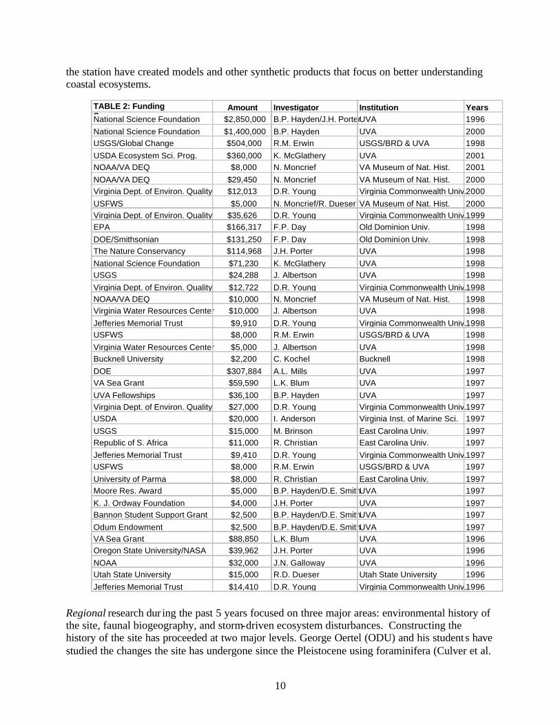
or doing an undergraduate research project. Thirty-nine student theses/dissertations have been produced in the last 5 years. These use statistics under-represent what we believe the use of the ABCRC would have been during the same period (had it existed) for several reasons. First, the facilities of the renovated farmhouse were extremely limited in terms of the number of researchers and the laboratory activities that could be accommodated relative to the proposed new capacities of the ABCRC. Secondly, the VCR/LTER facilities were primarily devoted to meeting the needs of VCR/LTER researchers. Other researchers were welcome, but only when there was “excess capacity” in the system, thus some potential researchers had to be turned away. Finally, the tracking system for use of the VCR/LTER laboratory is a voluntary one. Some researchers may have neglected to post their trip in the VCR/LTER online calendar (http://www.vcrlter.virginia.edu/calendar.html) and thus would not be represented here. With the new facilities, we will be instituting a formal reservation system on a room-by-room basis that should improve the quality of these statistics in the future. The ABCRC has a history of broad research funding with $6,476,180 of research funded between 1996 and 2001 (Table 2). The data in this table is limited to funds committed for the period 1996 and 2001 (i.e., committed funds for out-years are not included). If all committed funding through 2006 were included, the amount would top $9,500,000. The LTER project accounts for approximately 65% ($4,250,000) of total research funding with 35% ($2,226,180) coming from a variety of other state and federal sources. We have also hosted international visits by researchers from Brazil, Portugal, Argentina, the United Kingdom, China and Denmark. In addition to research use, the facility was used by 23 classes for field trips. During the last 5 years we have hosted field trips by classes from the University of Virginia, Lynchburg College, East Carolina University, University of Delaware, Bucknell and Old Dominion University. As mentioned earlier, starting in 2000 the ABCRC, along with Blandy Experimental Farm and State Arboretum, and Mountain Lake Biological Station, we began teaching an intensive field-oriented course for 18 students. During 2001, we will be teaching that course again, and are adding a graduate- level course through the University of Virginia School of Continuing Education aimed at K-12 science teachers.
Summary of Significant Research (last 5 years) From January 1996 through April 2001, 52 journal articles have appeared in print or are now in press. In addition, researchers working at the ABCRC have contributed 13 book chapters and proceedings contributions. Thirty-nine theses and dissertations were completed using data collected at the field station. An additional 6 journal articles and 3 book chapters are in review. A complete listing by topic is available at: http://www.abcrc.virginia.edu/publications/topics/ . Research activities connected to the station fall into five major focus areas: “Regional” research focuses on the entire Virginia coast and the associated mainland areas, “Barrier Island” research focuses on the marsh and upland areas of the numerous barrier islands, “Lagoon” research focuses on the shallow bays between the islands and the mainland and “Mainland” research focuses on marsh and upland sites on the Delmarva Peninsula. Additionally, researchers using
10
the station have created models and other synthetic products that focus on better understanding coastal ecosystems.
Regional research dur ing the past 5 years focused on three major areas: environmental history of the site, faunal biogeography, and storm-driven ecosystem disturbances. Constructing the history of the site has proceeded at two major levels. George Oertel (ODU) and his student s have studied the changes the site has undergone since the Pleistocene using foraminifera (Culver et al.
TABLE 2: Funding Source
Amount Investigator Institution Years National Science Foundation $2,850,000 B.P. Hayden/J.H. Porter UVA 1996 National Science Foundation $1,400,000 B.P. Hayden UVA 2000 USGS/Global Change $504,000 R.M. Erwin USGS/BRD & UVA 1998 USDA Ecosystem Sci. Prog. $360,000 K. McGlathery UVA 2001 NOAA/VA DEQ $8,000 N. Moncrief VA Museum of Nat. Hist. 2001 NOAA/VA DEQ $29,450 N. Moncrief VA Museum of Nat. Hist. 2000 Virginia Dept. of Environ. Quality $12,013 D.R. Young Virginia Commonwealth Univ. 2000 USFWS $5,000 N. Moncrief/R. Dueser VA Museum of Nat. Hist. 2000 Virginia Dept. of Environ. Quality $35,626 D.R. Young Virginia Commonwealth Univ. 1999 EPA $166,317 F.P. Day Old Dominion Univ. 1998 DOE/Smithsonian $131,250 F.P. Day Old Dominion Univ. 1998 The Nature Conservancy $114,968 J.H. Porter UVA 1998 National Science Foundation $71,230 K. McGlathery UVA 1998 USGS $24,288 J. Albertson UVA 1998 Virginia Dept. of Environ. Quality $12,722 D.R. Young Virginia Commonwealth Univ. 1998 NOAA/VA DEQ $10,000 N. Moncrief VA Museum of Nat. Hist. 1998 Virginia Water Resources Center $10,000 J. Albertson UVA 1998 Jefferies Memorial Trust $9,910 D.R. Young Virginia Commonwealth Univ. 1998 USFWS $8,000 R.M. Erwin USGS/BRD & UVA 1998 Virginia Water Resources Center $5,000 J. Albertson UVA 1998 Bucknell University $2,200 C. Kochel Bucknell 1998 DOE $307,884 A.L. Mills UVA 1997 VA Sea Grant $59,590 L.K. Blum UVA 1997 UVA Fellowships $36,100 B.P. Hayden UVA 1997 Virginia Dept. of Environ. Quality $27,000 D.R. Young Virginia Commonwealth Univ. 1997 USDA $20,000 I. Anderson Virginia Inst. of Marine Sci. 1997 USGS $15,000 M. Brinson East Carolina Univ. 1997 Republic of S. Africa $11,000 R. Christian East Carolina Univ. 1997 Jefferies Memorial Trust $9,410 D.R. Young Virginia Commonwealth Univ. 1997 USFWS $8,000 R.M. Erwin USGS/BRD & UVA 1997 University of Parma $8,000 R. Christian East Carolina Univ. 1997 Moore Res. Award $5,000 B.P. Hayden/D.E. Smith UVA 1997 K. J. Ordway Foundation $4,000 J.H. Porter UVA 1997 Bannon Student Support Grant $2,500 B.P. Hayden/D.E. Smith UVA 1997 Odum Endowment $2,500 B.P. Hayden/D.E. Smith UVA 1997 VA Sea Grant $88,850 L.K. Blum UVA 1996 Oregon State University/NASA $39,962 J.H. Porter UVA 1996 NOAA $32,000 J.N. Galloway UVA 1996 Utah State University $15,000 R.D. Dueser Utah State University 1996 Jefferies Memorial Trust $14,410 D.R. Young Virginia Commonwealth Univ. 1996

11
1996, Oertel et al. 1996, Woo et al. 1997), pollen (Woo et al. 1998), stratigraphic analyses (Foyle & Oertel 1997) and analysis of landforms (Oertel & Foyle 1995). For a more recent period, Guofan Shao (Purdue), Donald Young (VCU) and others used remote-sensing linked to ground surveys and historical maps to quantify dramatic changes in the distribution of Myrica cerifera shrubs on the barrier islands since 1942 (Shao et al. 1998). Nancy Moncrief (VMNH) and Raymond Dueser (Utah State) examined the distribution of mammalian fauna across the islands and marshes of the VCR using a variety of sampling and genetic techniques (Moncrief et al. 1997, Moncrief & Dueser 1998, Loxterman et al. 1998). Mike Erwin (USGS) and his colleagues have analyzed habitat and breeding dynamics of water birds on the islands and marshes (Erwin 1996, 1997; Erwin et al. 1996a, b, 1998a, b, 1999 a, b; Eyler et al. 1999). Changes in climatic patterns that generate storms have been shown to have dramatic impacts on the island system (Davis et al. 1997, Hayden 1999a,b, 2000). A surprising conclusion was that there were periods where the geographic patterns of shoreline accretion and erosion reversed (Fenster and Dolan 1994). The most recent of such reversals were in the early 1870s and the late 1960s.
Barrier Islands. Research on the barrier islands focused on vegetation, both above and below ground, and brackish ponds. Don Young and his students and Guofan Shao examined the salt tolerance and successional dynamics of common woody species on a 120 year chronosequence and how that was related to disturbance at both coastal and gap levels (Tolliver et al. 1997, Shao & Shugart 1997, Joy and Young 2000, Crawford & Young 1998a,b). Frank Day (ODU) and his students used minirhizotrons and fertilization to help understand belowground processes along the same chronosequence. Their studies focused on fine root growth (Stevenson & Day 1996), allocation (Day 1996), responses to fertilization (Weber & Day 1996), biomass accumulation (Dilustro & Day 1997) and decomposition (Day 1995, Conn & Day 1997,Conn & Day 1996). David Smith (UVA) and his student, Craig Layman examined the fish assemblages in the barrier island ponds and shallow surf zones off the islands, focusing on the role of abiotic and biotic factors in controlling these assemblages (Layman 1999, Layman & Smith 2000). Lagoons. Karen McGlathery (UVA), Iris Anderson (VIMS) and their students have been working to understand the impacts of nutrient loading and grazing on primary production of benthic macroalgae in the lagoons. They established that the lagoon was net autotrophic during the spring-summer, and net heterotrophic in the fall, and that organic nitrogen was the dominant form of available N (McGlathery et al. 2001, Tyler et al. 2001, Giannotti 1999, Giannotti & McGlathery 2001). They also established that despite high nitrogen mineralization rates, the lagoon sediments were a net sink for both ammonium and nitrate. This suggests that inorganic nitrogen was removed by either coupled nitrification-denitrification or by microbial immobilization as rapidly as it was formed (Anderson et al. 2000). With new funding from the USDA, efforts are now being made to link these biological process- level studies with models of groundwater nutrient input to the lagoon and lagoon hydrodynamics. Mainland Margins. At the VCR evidence abounds that sea level rise has eroded salt marshes and sometimes submerged them and that salt marshes have in turn encroached on field and forest. During the past five years, researchers Iris Anderson, Linda Blum (UVA), Mark Brinson (ECU), Bob Christian (ECU), Pat Wiburg (UVA) and their students have focused on the dynamics of vegetation in the transition zone from marsh to forest (Aiosa 1996, Anderson et al. 1997, Tarnowski 1997, Stasavich, 1998, Brinson & Christian 1999, Ricker 1999, Tolley & Christian

12
1999, Christian et al. 1999). Erosion of the marsh along the tidal creek banks was slow and progressive except in periods of significant sediment deposition which occurred during extreme high tide usually associated with coastal storms (Christiansen, 1998). Brinson et al. (1995) modeled expansions and contractions in marsh area based on sediment supply and identified four basic patterns all of which were found in ABCRC study areas. Furthermore, they identified limiting processes in this sequence of change and the factors that promote or accelerate such changes (Brinson et al. 1995, Christian et al. 1999, Nuttle et al. 1999). Modeling. Models of system dynamics were used to test the collective assemblage of findings and to formulate new research questions and hypotheses. George Oertel, Kathleen Overman (ODU) and Randy Carlson (UVA) developed a hypsometric model of Hog Island Bay (Oertel et al. 1996, 2000) and have extended it to include the adjacent mainland watersheds. In additional modeling efforts, Christiansen (1998) constructed a mathematical model of the dynamics of sedimentation in a salt marsh and tested it against observations. Santos (1997) created a hydrologically-based predictive model for island salt flats. Other models, currently awaiting publication, are Pat Wiberg and John Albertson’s (UVA) model for evapotranspiration from salt marshes, and Bruce Hayden’s (UVA) model of barrier island vegetation dynamics in response to coastal storm disturbance.
Synthesis. Hayden et al. (1995) introduced the concept of the geometry of land, sea and water-table surfaces as controlling agents in ecosystem patterns within landscapes and related these controls to the long-term dynamics of the barrier islands, lagoons and marshes of the ABCRC study areas. Brinson, in a series of synthesis papers, focused on wetland function (Brinson et al.1995), environmental mitigation (Brinson & Rheinhardt 1996), hydrologic controls (Brinson et al. 1998), societal values (Brinson & Rheinhardt 1998) and biodiversity in wetlands (Brinson & Verhoeven, 1999). Graduate student Cassondra Thomas (ECU & UVA) applied network analysis to the nitrogen cycling of different marsh states to predict alterations in response to sea level rise (Thomas 1998). Oertel (2000 a, b) has continued his synthetic work on the evolution of the Virginia coastal landscape at the regional scale in space and at the scale of glacial and interglacial transitions in time showing the connection between relict drainage patterns on the continental shelf and existing lagoonal landscapes. In modeling waterbird colony site changes through time, Erwin et al. (1998a) have developed a method for quantifying how a number of extrinsic factors influence patch use dynamics. Population genetic modeling has revealed the degree to which small mammals may also be viewed as a large barrier island metapopulation (Moncrief et al. 1997).
Results of Prior Support: A Planning Grant for the Virginia Coastal Research Center The purpose of this prior planning grant was to allow us to draw on the expertise of scientists that have a high potential of using the Anheuser Busch Coastal Research Center (ABCRC) as a place to conduct their research and field station managers by conducting two workshops. The first workshop was held on May 24-25, 2000 near the ABCRC property at the Sunset Beach Inn on the Eastern Shore of Virginia. The goal of this workshop was to plan a physical facility to serve the needs of a diversity of scientists from a variety of institutions with a common interest
13
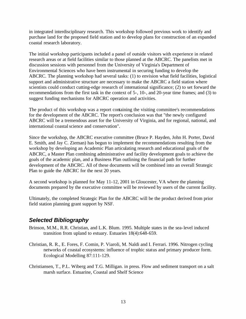
in integrated interdisciplinary research. This workshop followed previous work to identify and purchase land for the proposed field station and to develop plans for construction of an expanded coastal research laboratory. The initial workshop participants included a panel of outside visitors with experience in related research areas or at field facilities similar to those planned at the ABCRC. The panelists met in discussion sessions with personnel from the University of Virginia's Department of Environmental Sciences who have been instrumental in securing funding to develop the ABCRC. The planning workshop had several tasks: (1) to envision what field facilities, logistical support and administrative structure are necessary to make the ABCRC a field station where scientists could conduct cutting-edge research of international significance; (2) to set forward the recommendations from the first task in the context of 5-, 10-, and 20-year time frames; and (3) to suggest funding mechanisms for ABCRC operation and activities. The product of this workshop was a report containing the visiting committee's recommendations for the development of the ABCRC. The report's conclusion was that "the newly configured ABCRC will be a tremendous asset for the University of Virginia, and for regional, national, and international coastal science and conservation". Since the workshop, the ABCRC executive committee (Bruce P. Hayden, John H. Porter, David E. Smith, and Jay C. Zieman) has begun to implement the recommendations resulting from the workshop by developing an Academic Plan articulating research and educational goals of the ABCRC, a Master Plan combining administrative and facility development goals to achieve the goals of the academic plan, and a Business Plan outlining the financial path for further development of the ABCRC. All of these documents will be combined into an overall Strategic Plan to guide the ABCRC for the next 20 years. A second workshop is planned for May 11-12, 2001 in Gloucester, VA where the planning documents prepared by the executive committee will be reviewed by users of the current facility. Ultimately, the completed Strategic Plan for the ABCRC will be the product derived from prior field station planning grant support by NSF.
Selected Bibliography Brinson, M.M., R.R. Christian, and L.K. Blum. 1995. Multiple states in the sea- level induced
transition from upland to estuary. Estuaries 18(4):648-659. Christian, R. R., E. Fores, F. Comin, P. Viaroli, M. Naldi and I. Ferrari. 1996. Nitrogen cycling
networks of coastal ecosystems: influence of trophic status and primary producer form. Ecological Modelling 87:111-129.
Christiansen, T., P.L. Wiberg and T.G. Milligan. in press. Flow and sediment transport on a salt
marsh surface. Estuarine, Coastal and Shelf Science
14
Day, F.P. 1996. Effects of nitrogen availability on plant biomass along a barrier island dune chronosequence. Castanea 61:369-381.
Hayden, B.P., Santos, M.C.F.V., Shao, G., and Kochel, R.C. 1995. Geomorphological controls
on coastal vegetation at the Virginia Coast Reserve. Geomorphology 13:283-300. McGlathery, K.J., I.C. Anderson and A.C. Tyler. in press. Magnitude and variability of benthic
and pelagic metabolism in a temperate coastal lagoon. Marine Ecology Progress Series Moncrief, N.D., N.E. Cockett, A.D. Neff, W.L. Thomas and R.D. Dueser. 1997. Polymorphic
microsatellites in the meadow vole Microtus pennsylvanicus: conservation of loci across species of rodents. Molecular Ecology 6:299-301.
Osgood, D.T. and J.C. Zieman. 1998. The influence of subsurface hydrology on nutrient supply
and smooth cordgrass (Spartina alterniflora) production in a developing barrier island marsh. Estuaries 21:767-783.
Silliman, B.R., and J.C. Zieman. in press. Top-down control of Spartina alterniflora production
by periwinkle grazing. Ecology Young, D.R., G. Shao and J.H. Porter. 1995. Spatial and temporal growth dynamics of barrier
island shrub thickets. American Journal of Botany 82: 638-645.
Data Collection & Management Policies The information management policy for the Anheuser Busch Coastal Research Center is based on the following three principles:
• Scientific information is a resource that provides maximum benefits when it is shared. • Producers of data and other information products have a right to first use of the data they
produce. • Users of scientific data and other information products have an obligation to properly
acknowledge the producers of the data they use. The full policy, which spells out the responsibilities of station users, station information managers and data users is available at: http://www.abcrc.virginia.edu/data/policy.html. In the area of data and information management, the ABCRC already has a large database associated with the VCR/LTER project. Since its inception, the VCR/LTER has agreed to undertake management of data from non-LTER sources for the ABCRC, since it benefits their researchers, as well as non-LTER researchers at the ABCRC. A result of this policy is the inclusion of comparative datasets from Mountain Lake and Powdermill Biological Stations, as well as on-site datasets collected by non-LTER researchers. We are currently in the process of integrating ABCRC and VCR/LTER WWW servers and information systems to better provide this support. Additionally, we have a Memorandum of Partnership with the Virginia Museum of Natural History for the archiving of physical specimens.

15
To serve a widely distributed array of investigators, the ABCRC information systems make extensive use of the WWW for both input and output. A relational database is linked to online forms to provide a user- friendly and efficient interface for researchers. Use of a database allows us to minimize the level of duplication among inputs, so that investigators need not provide redundant information. For example, changes to addresses in the personnel database automatically show up when data are accessed. Similarly, named locations defined in our biodiversity database can also be used to locate datasets and projects (Fig. 3). For the period the period 1 Jan. 1999 through Dec. 29, 1999 the LTER WWW site averaged 1,809 requests by 443 visitors totaling 61 MB per day. Since mid-1997 we have been logging requests for datasets. Under our data license agreement, each download requires giving your name, email and a brief statement of why you want the data. We have received (and automatically granted) 160 of these "serious" data requests. Understandably, a majority of the requests were from researchers and students associated with the ABCRC (68%), but 32% of requests were from researchers outside the ABCRC. There were eight international requests from Italy, Spain, Thailand and Peru. Fifteen percent of requests cited educational use (classwork, examples etc.). It should be noted that these requests do not include many of our more popular databases (such as graphical descriptions of weather and tides and GPS locations), and electronic texts, which are available without filling out a license agreement.
Figure 3. Entity relationship diagram describing links between major data tables. This system allows us to reduce redundancy while improving quality.
Projects
Datasets
Variables
Codes
Personnel
E-Mail Groups
Locations Observations
Species
WWW URLs
Data
Biodiversity Database