Project: ADER 12.4.1/27.X.2015 Solutions for Agricultural ... · Project: ADER 12.4.1/27.X.2015....
18
Project: ADER 12.4.1/27.X.2015 Solutions for Agricultural Land Organization and Sustainable Agricultural Land Use, Based on Landslide and Gully Inventories 1. Project objective: 12.4.: Methods of inventory, monitoring, protection, amelioration and sustainable use of natural resources of agro-ecosystems (soil, water, climate). Expected results to achieve the project objective: Providing solutions for soil erosion and sustainable agricultural exploitation, illustrated by GIS techniques based on digital elevation model of the land, thematic maps of: soils, slopes, cadastre and landslide risk of some representative watersheds. Developing improved environmental and agricultural good practice guidelines on sustainable land use on the slopes of selected watersheds. ACADEMY OF AGRICLTURAL AND FORESTRY SCIENCES „GHEORGHE IONESCU-SISESTI” BUCHAREST RESEARCH AND DEVELOPMENT STATION FOR SOIL EROSION CONTROL “MIRCEA MOTOC” PERIENI, VASLUI COUNTY, ROMANIA Tel. +40 373550155; Fax. +40 235412837; www.cesperieni.ro E-mail: [email protected]
-
Upload
nguyenkhanh -
Category
Documents
-
view
220 -
download
0
Transcript of Project: ADER 12.4.1/27.X.2015 Solutions for Agricultural ... · Project: ADER 12.4.1/27.X.2015....

Project: ADER 12.4.1/27.X.2015Solutions
for Agricultural Land Organization and Sustainable Agricultural
Land Use, Based
on Landslide and Gully Inventories
1.
Project objective: 12.4.:
Methods of inventory, monitoring, protection, amelioration and sustainable use of natural resources of agro-ecosystems (soil, water, climate).
Expected results to achieve the project objective:
Providing solutions for soil erosion and sustainable agricultural exploitation, illustrated by GIS techniques based on digital elevation model of the land, thematic maps of: soils, slopes, cadastre and landslide risk of some representative watersheds.
Developing improved environmental and agricultural good practice guidelines on sustainable land use on the slopes of selected watersheds.
ACADEMY OF AGRICLTURAL AND FORESTRY SCIENCES
„GHEORGHE IONESCU-SISESTI”
BUCHARESTRESEARCH AND DEVELOPMENT STATION FOR SOIL EROSION CONTROL
“MIRCEA MOTOC”
PERIENI, VASLUI
COUNTY, ROMANIATel. +40 373550155; Fax. +40 235412837;
www.cesperieni.ro
E-mail: [email protected]

Funding: State Budget –
Romanian Ministry of Agriculture and Rural Development, Programme "Agriculture and Rural Development" for the years 2015-2018.
Total effective budget of project:
584.587,81 Lei, from which:-
Phase
I -
2015, 27.X.2015 -
30.XI.2015:
25.350,00
Lei-
Phase II -
2016, 01.XII.2015 -
01.XI.2016:
184.237,81 Lei-
Phase III -
2017, 02.XI.2016 -
31.X.2017:
187.500,00
Lei-
Phase IV -
2018, 01.XI.2017-
31.X.2018):
187.500,00
Lei
Contract duration: 36 months
Project leader: Research and Development Station for Soil Erosion Control "Mircea
Motoc“
Perieni
(RDSSEC "MM" Perieni)
Partner 1: "Stefan cel
Mare" University of Suceava.
ACADEMY OF AGRICLTURAL AND FORESTRY SCIENCES
„GHEORGHE IONESCU-SISESTI”
BUCHARESTRESEARCH AND DEVELOPMENT STATION FOR SOIL EROSION CONTROL
“MIRCEA MOTOC”
PERIENI, VASLUI
COUNTY, ROMANIATel. +40 373550155; Fax. +40 235412837;
www.cesperieni.ro
E-mail: [email protected]

RESULTSDocumentary and field study to identify three representative perimeters: Baltati (8,449.6ha),
Banca (12,975.2ha), Vutcani (6,943.2ha) in Vaslui County and two
additional perimeters (Tiglaul –
339,7ha and Coada Gastii –
305,5ha) in Suceava County Perimetrul Bălţaţi
Perimetrul Vutcani
Perimetrul Banca
ACADEMY OF AGRICLTURAL AND FORESTRY SCIENCES
„GHEORGHE IONESCU-SISESTI”
BUCHARESTRESEARCH AND DEVELOPMENT STATION FOR SOIL EROSION CONTROL
“MIRCEA MOTOC”
PERIENI, VASLUI
COUNTY, ROMANIATel. +40 373550155; Fax. +40 235412837;
www.cesperieni.ro
E-mail: [email protected]

The geographical information system of the "Baltati" perimeter (8,449.2ha), partially overlapped on the territory of five communes (Solesti, Botesti, Tatarani, Tanacu and Oltenesti) from Vaslui County and
comprising 23 maps in GIS format
Landslides and gullies map of Baltati perimeter
Map of agricultural exploitations in Baltati perimeter
Cadastral map (landuse categories) of Baltati perimeter

The geographical information system of the "Banca" perimeter (12,975.2 ha), partially overlapped on the territory
of four communes (Banca, Zorleni, Şuletea
and Epureni) in Vaslui
County and comprising 23 maps
in GIS format
Digital elevation model of Banca perimeterCadastral map of Banca perimeter
Slope map (degrees) of Banca perimeterMap of agricultural exploitations in Baltati perimeter
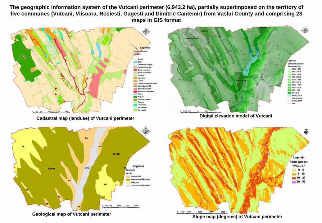
The geographic information system of the Vutcani perimeter (6,943.2 ha), partially superimposed on the territory of five communes (Vutcani, Viisoara, Rosiesti, Gagesti and Dimitrie
Cantemir) from Vaslui County and comprising 23 maps in GIS format
Geological map of Vutcani perimeter Slope map (degrees) of Vutcani perimeter
Cadastral map (landuse) of Vutcani perimeter Digital elevation model of Vutcani

Map of average landslide hazard factor Km of "Baltati" perimeter, scale 1:5000.Map of homogeneous areas of landslide risk of "Baltati" perimeter, scale 1:5000
Map of average landslide hazard factor Km of "Baltati" perimeter
Map of homogeneous areas of landslide risk of "Baltati" perimeter

Map of average landslide hazard factor Km of "Banca" perimeter, scale 1:5000.Map of homogeneous areas of landslide risk of "Banca" perimeter, scale 1:5000
Map of homogeneous areas of landslide risk of "Banca" perimeter
Map of average landslide hazard factor Km of "Banca" perimeter

Map of average landslide hazard factor Km of „Vutcani" perimeter, scale 1:5000.Map of homogeneous areas of landslide risk of „Vutcani" perimeter, scale 1:5000
Map of average landslide hazard factor Km of „Vutcani" perimeter
Map of homogeneous areas of landslide risk of „Vutcani" perimeter

Six thematic maps realized in the geographic information system of the Tiglăul and Coada Gastii watersheds.
Database of 8 input variables in the sediment system.
Map of the actual geomorphological processes in the Tiglaul and Coada Gastii micro-watersheds.
Data geobase containing information needed to calculate the displaced sediment volumes.
Morphological analysis of the apex area of the Gurguiata gully gravel/alluvial fan.
Analysis of electrical resistivimetry of the deposits at the apex of the Gurguiata Mare gravel fan with two Wenner and Dipole profiles.
ACADEMY OF AGRICLTURAL AND FORESTRY SCIENCES
„GHEORGHE IONESCU-SISESTI”
BUCHARESTRESEARCH AND DEVELOPMENT STATION FOR SOIL EROSION CONTROL
“MIRCEA MOTOC”
PERIENI, VASLUI
COUNTY, ROMANIATel. +40 373550155; Fax. +40 235412837;
www.cesperieni.ro
E-mail: [email protected]

The cuantifying of siltation contribution of slope-gully contact area in Gurguiata
gully. B. Variation of material removed
by bank processes and incision processes along the gully;
C. Percentage weight of the two categories of processes along the gully
channel.
Transverse profiles of resistivimetry in the aluvial fan area and the Coada Gastii gully bottom.

Analysis of the drilling in sediments of Gurguiata
Mare aluvial
fan.
Form Factor Analysis and Hydraulic Efficiency in Gully Development.
Electric resistivimetry
profiles at the apex of the Gurguiata
Mare alluvial fan.
A link has been established between the parameters defining the sediment circuit and the results obtained were discussed in the regional framework of the Moldavian Plateau and in the context of the historical evolution.
There were approached:a) the concept of sediment budget;b) calculation of the sediment budget of the selected microwatersheds;c) Interpretation of results in a regional context and some estimates of the historical variability of sediment balance.
ACADEMY OF AGRICLTURAL AND FORESTRY SCIENCES
„GHEORGHE IONESCU-SISESTI”
BUCHARESTRESEARCH AND DEVELOPMENT STATION FOR SOIL EROSION CONTROL
“MIRCEA MOTOC”
PERIENI, VASLUI
COUNTY, ROMANIATel. +40 373550155; Fax. +40 235412837;
www.cesperieni.ro
E-mail: [email protected]

Implementation of the sustainable agricultural anti-erosion organization / exploitation plan of the "Baltati" perimeter, Vaslui
County, comprising three maps illustrating the solutions
and explanatory
notes containing the data needed to implement the proposed measures.
Solutions for drawing grass strips and contour stripcrops
Solutions for correction
of the route of technological earthen roads for
conservaton purposes
Solutions for afforestation
of degraded pastures and
planting
of shelter belts (windbreaks)

Implementation of the sustainable agricultural anti-erosion organization / exploitation plan of the "Banca" perimeter, Vaslui
County, comprising three maps illustrating the solutions
and explanatory
notes containing the data needed to implement the proposed measures.
Solutions for drawing grass strips and contour stripcrops
Solutions for correction
of the route of technological earthen roads for
conservaton purposes
Solutions for afforestation
of degraded pastures and
planting
of shelter belts (windbreaks)

Solutions for afforestation
of degraded pastures and
planting
of shelter belts (windbreaks)
Solutions for correction
of the route of technological earthen roads for
conservaton purposes
Solutions for drawing grass
strips and contour
stripcrops
Implementation of the sustainable agricultural anti-erosion organization / exploitation plan of the „Vutcani" perimeter, comprising three maps illustrating the solutions
and explanatory
notes containing the data needed to implement the proposed measures.

During the implementation of the project, 54 farmers / representatives of commercial companies with agricultural profile and local authorities of Solesti, Botesti, Tatarani, Tanacu, Oltenesti, Banca, Zorleni, Suletea, Epureni, Vutcani, Viisoara, Rosiesti, Gagesti
and Dimitrie
Cantemir, from Vaslui
County, were informed about the project's objectives.
Symposium "Precision Agriculture and Future Technologies, Current Needs and Changing and Adapting the Profession of Modern Farmer", SCDA Braila, April 20, 2018.
Workshop “The Influence of technological links on the growth and development of hemp plants, topinambur
and sorghum in the conditions of the agricultural year 2017 -
2018", S.C.D.A. Secuieni, 02.07.2018.
Scientific meeting "Contributions of Professor Stelian
Munteanu, member of the Romanian Academy, to the progress of the development of torrential basins", Aula of the Romanian Academy, September 6, 2018.
6 August 2018, at the SCDCES "MM" Perieni, Vaslui
County, working meeting with farmers and local decision-makers from the studied perimeters.
ACADEMY OF AGRICLTURAL AND FORESTRY SCIENCES
„GHEORGHE IONESCU-SISESTI”
BUCHARESTRESEARCH AND DEVELOPMENT STATION FOR SOIL EROSION CONTROL
“MIRCEA MOTOC”
PERIENI, VASLUI
COUNTY, ROMANIATel. +40 373550155; Fax. +40 235412837;
www.cesperieni.ro
E-mail: [email protected]

September 23-28, 2018, Paris, France, participation in the XXIth
International Soil Tillage Research Organization (ISTRO) Conference with the oral support of a scientific paper.
Three brochures / guides of good practice on the anti-erosion exploitation of agricultural land were published, each in 1,000 copies:
"The protection and sustainable use of soil on sloping land in areas of drought phenomenon".
"Basic rules and measures on soil conservation on sloping agricultural land".
"Solutions for the organization of agricultural land and sustainable agricultural exploitation based on the inventory of landslides and ravines".
ACADEMY OF AGRICLTURAL AND FORESTRY SCIENCES
„GHEORGHE IONESCU-SISESTI”
BUCHARESTRESEARCH AND DEVELOPMENT STATION FOR SOIL EROSION CONTROL
“MIRCEA MOTOC”
PERIENI, VASLUI
COUNTY, ROMANIATel. +40 373550155; Fax. +40 235412837;
www.cesperieni.ro
E-mail: [email protected]
ACADEMY OF AGRICLTURAL AND FORESTRY SCIENCES
„GHEORGHE IONESCU-SISESTI”
BUCHARESTRESEARCH AND DEVELOPMENT STATION FOR SOIL EROSION CONTROL
“MIRCEA MOTOC”
PERIENI, VASLUI
COUNTY, ROMANIATel. +40 373550155; Fax. +40 235412837;
www.cesperieni.ro
E-mail: [email protected]
DISSEMINATION / APPLICATION OF RESULTS
1. Providing farmers and decision-makers in the "Bălţaţi", "Banca" and "Vutcani" perimeters of the plans for anti-erosion organizing of the territory and for sustainable agricultural exploitation by posting on www.cesperieni.ro
and, on request, in any necessary format and unconditional on-site support for implementation;
2. On-site information to the managers of the 54 agricultural companies and local decision-makers on project outcomes and on our intentions of free of charge support for implementation.
3. Working meeting dated 6.VIII.2018 at SCDCES MM Perieni
headquarters where farmers and decision-makers from the three perimeters were
invited;
4. Distribute the three published brochures / guides in 1,000 copies.