Production Asset Protection Using GIS and Remote...
11
1 Production Asset Protection Using GIS and Remote Sensing Techniques; the Shell Nigeria Experience. (6663) Bola Lasisi, Chika Onwuteaka & Abimbola Olumuyiwa – Nigeria. Shell Petroleum Development Company of Nigeria Limited, Port Harcourt. Nigeria By SCOPE OF THE PAPER Introduction: Production assets and Niger Delta terrain overview Key threats to hydro carbon production facilities. Why is Shell concerned? Crude Theft: Environmental, health, safety, security, social, economics, etc consequences. Assets’ vulnerabilities and challenges. Efforts at asset protection & GI technical apps deployment. Facilities right of way (RoW) encroachment quantification, analysis & follow up actions. Conclusion & recommendations.
Transcript of Production Asset Protection Using GIS and Remote...

1
Production Asset Protection Using GIS and Remote Sensing Techniques; the Shell
Nigeria Experience.
(6663)
Bola Lasisi, Chika Onwuteaka & Abimbola Olumuyiwa – Nigeria.
Shell Petroleum Development Company of Nigeria Limited,
Port Harcourt.
Nigeria
By
SCOPE OF THE PAPER
� Introduction: Production assets and Niger Delta terrain overview
� Key threats to hydro carbon production facilities.
� Why is Shell concerned?
� Crude Theft: Environmental, health, safety, security, social, economics, etc consequences.
� Assets’ vulnerabilities and challenges.
� Efforts at asset protection & GI technical apps deployment.
� Facilities right of way (RoW) encroachment quantification, analysis & follow up actions.
� Conclusion & recommendations.

2
INTRODUCTION: NIGER DELTA TERRAIN OVERVIEW
Key Statistics
� Coastline of >900km – Lagos to Bakassi.
� Highly undulating galloping swamp terrain.
� Diverse vegetation of Low/high mangrove forest, raffia palm trees, shrub,
etc.
� Complex and numerous network of rivers, creeks and creeklets.
� Complex & sensitive ecosystem with vast variety of flora and fauna.
INTRODUCTION: PRODUCTION ASSETS IN THE NIGER DELTA
Key Statistics
� > 6000km of minor/major Oil & Gas P/lines
� 5000+ wellheads
� >200 Production Facilities; F/stns, Compressor Stns, Gas plants etc.
� Ca.150 Manifolds
Crude Lifecycle

3
MAIN THREATS TO THE OIL & GAS FACILITIES
Sabotage
Crude theft
Encroachment Envi
ronm
enta
l de
grad
atio
n, p
ollu
tion
,
ozon
e laye
r de
plet
ion
& rev
enue
los
s.WHY IS SHELL CONCERNED? SABOTAGE
• Threat/loss of lives.
• Damage to production facilities.
• Environmental destruction.
• Pollution/health challenges.
• Revenue losses: Repairs, replacement,
deferment, etc
• Destruction of aquatic lives/farms & social
impacts.
Consequences

4
CRUDE THEFT: COMMONLY CALLED “BUNKERING” IN NIGERIA
Hit Point
� Criminal evacuation of HC from a production facility to an Illegal destination.
� Vulnerable Hit Points:
� Well heads
� Flow lines
� Delivery lines
� Trunk lines.
� Dimension: Local and international
Local
International
EVACUATION CONTAINERS: VARIOUS SIZES, TYPES & MAKES
5
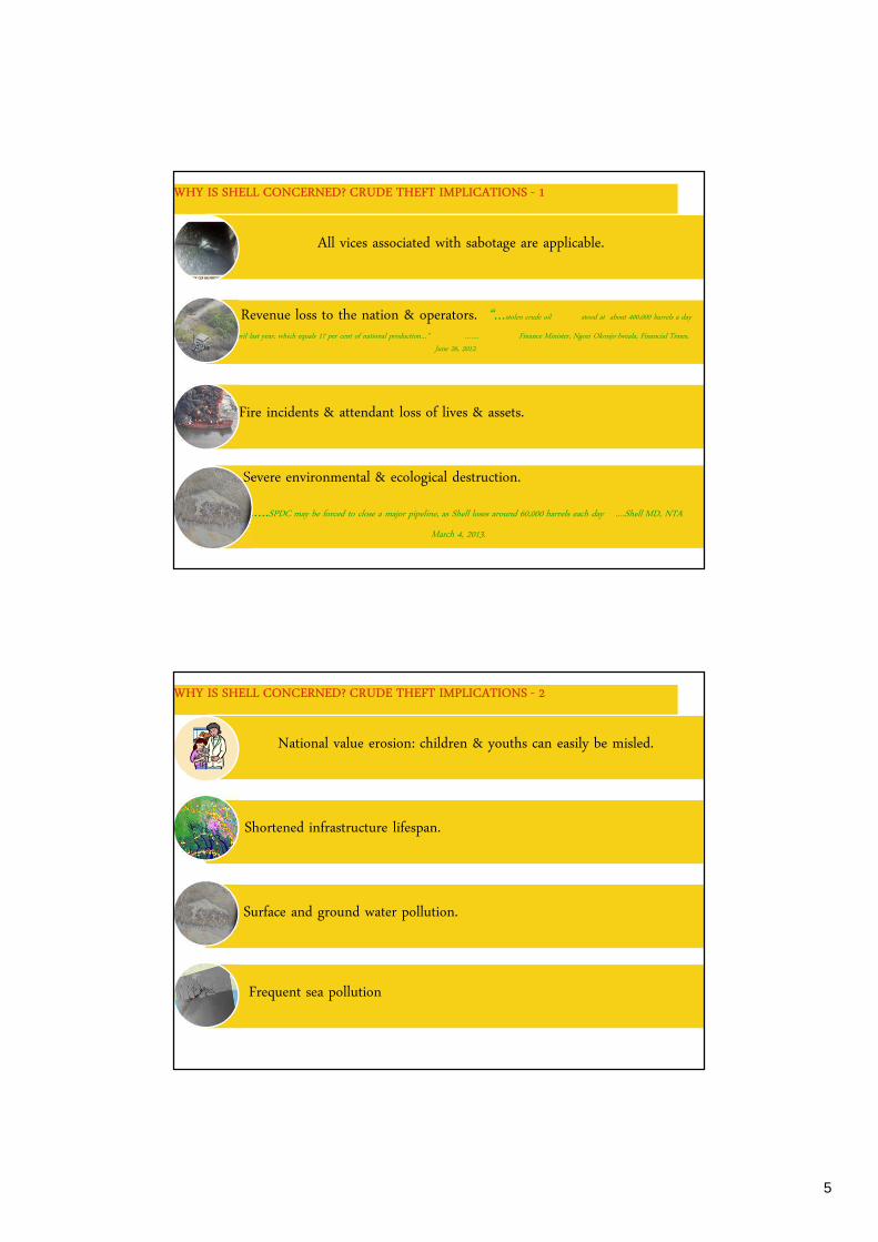
WHY IS SHELL CONCERNED? CRUDE THEFT IMPLICATIONS - 1
All vices associated with sabotage are applicable.
Revenue loss to the nation & operators. “…stolen crude oil stood at about 400,000 barrels a day
in April last year, which equals 17 per cent of national production…” ……. Finance Minister, Ngozi Okonjo-Iweala, Financial Times,
June 26, 2012.
Fire incidents & attendant loss of lives & assets.
Severe environmental & ecological destruction.
…..SPDC may be forced to close a major pipeline, as Shell loses around 60,000 barrels each day ….Shell MD, NTA
March 4, 2013.
WHY IS SHELL CONCERNED? CRUDE THEFT IMPLICATIONS - 2
National value erosion: children & youths can easily be misled.
Shortened infrastructure lifespan.
Surface and ground water pollution.
Frequent sea pollution
6
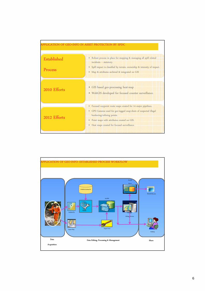
APPLICATION OF GEO-INFO IN ASSET PROTECTION BY SPDC
• Robust process in place for mapping & managing all spill related
incidents – statutory.
• Spill impact is classified by terrain, ownership & intensity of impact.
• Map & attributes archived & integrated on GIS
Established
Process
• GIS based geo-processing heat-map
• WebGIS developed for focused counter surveillance.2010 Efforts
• Focused waypoint route maps created for 14 major pipelines.
• GPS Cameras used for geo-tagged snap-shuts of suspected illegal
bunkering/refining points.
• Point maps with attributes created on GIS.
• Heat maps created for focused surveillance.
2012 Efforts
APPLICATION OF GEO-INFO: ESTABLISHED PROCESS WORKFLOW
Data
Acquisition
Data Editing, Processing & Management Share
Impact Map
ArcGIS
Server
ArcSDE
FINDER: Attribute Db
Import Tool
Incident Pts
WebGIS Browser
Desktop
ArcMap:
Editing/ Services

7
APPLICATION OF GEO-INFORMATION: SPILL/BUNKERING PTS GIS MAPS
Spill Pts
Sabotage/Theft Pts
- Cause of >90%
Spills.
Spill Point Attributes
� Every Spill Pt Completes with Associated Attribute Information – for
Robust Geo-spatial Analysis
2010 Heat Map: Instrumental to Focused Surveillance & Facilities
Protection
Key Vulnerable Arterial P/lines Identified
APPLICATION OF GEO-INFO: 2012 – 2013 MAJOR P/L SURVEILLANCE
PlanningWaypoint
Mapping
Surveillance Over
flights/ Geo-photo
Capture
Data
Review/Analysis
Geo-foto GIS
Mapping
Geo-spatial
Analysis
Guided Pipeline Route Map
What Did We See?
Hotspot Map !!!

8
WHY IS SHELL CONCERNED? ENCROACHMENT
• Comfort seeking squatters
• Speculative squatters
• Unsuspecting buyer
• Improvised public utilities
• Criminal intentions
Types or Why?
• Risk of accidental damage.
• Risk to lives & properties.
• Environmental destruction.
• Obstacles to facilities’ maintenance & Isolation in an
emergency.
• Loss of crude, assets & revenue.
Consequences
P/Lines Prone to Encroachment
APPLICATION OF GEO-INFO: ENCROACHMENT MAPPING
Identify: Creation of
Overview Map
Assess: Land Use/Cover
Classification By Remote
Sensing
Define: Use hi-Res
Imagery & RoW to
Identify Actual
Encroachment
Execute: Delineate &
Demarcate
Dialogue/Evacuate:
Engage Squatters
Operate: Handover to
Ops for Periodic
Surveillance
Buffered Pipeline Right-of-Way Analysis using Landsat Imagery
Ranking:
High
Medium
Low
9
APPLICATION OF GEO-INFO: BENEFITS
� Reduction of personnel exposure.
� Most of the work are done in-house with available expertise, data, software tools and hardware.
� Mitigating efforts for crude theft & encroachment were more focused.
� Rapid turnaround encroachment & crude theft analysis.
� Very significant cost saving when compared with other options.
� Periodic trend analysis possible since data on GIS are re-usable.
OUR CHALLENGES & LIMITATIONS
� Managing expectations; demand for GI apps in SPDC beyond available resources.
� Accurate encroachment mapping requires up-to-date metre/sub-metre optical satellite imagery; this is constrained
by cloud cover in the Niger Delta region.
� Crude theft and other criminal activities against HC facilities not abating.
…. crude oil theft still impacts on the Nigerian economy irrespective of successes recorded in minimizing their occurrences ….. Mrs.
Diezani Alison-Madueke, Minister of Petroleum Resources (This Day newspaper, March 12 2013).
10
CONCLUSION & RECOMMENDATION
Surveying and Geo-informatics are in regular demand at every phase of hydrocarbon search and development - > 80% of E&P assets
have spatial component.
Advancements in GIS, remote sensing and computing power (hard & software) have further grown the application & value of GI in
recent times in geometrical progression.
Applications of GI today, are limited ONLY by skills, creativity and capacity of practitioners in one hand and resources (Budget)
made available by policy makers.
As in the above examples, effective use of GI and collaboration with allied professionals will continue to add tremendous values,
visibility and worth of GI practitioners.
However, it is worth noting, that the protection of oil & gas facilities and preservation of our fragile environment go beyond
technology solutions – all hands MUST be on the deck.
ACKNOWLEDGEMENT
� The Contributions of the following key players are appreciated:
� John Macgregor – Head Geomatics/Chief Surveyor.
� Samuel Ezugworie – GeoSolutions Mgr.
� Nedo Osayande - General Mgr, Sustainable Development & Community Relations.
� Ramesh Chennareddy – formerly Senior GIS Analyst, SPDC, Port Harcourt , Nigeria
� Authors Information:
� Bola Lasisi. Head Geo-information Management, Shell Petroleum Dev. Company of Nigeria Limited,
Telephone: +234-807-0322408
Email: [email protected]
� Abimbola Olumuyiwa, Geo-information Analyst, Shell Petroleum Dev. Company of Nigeria Limited,
Telephone: +234-807-2042255
Email: [email protected]
� Chika Onwuteaka, Remote Sensing Analyst, Shell Petroleum Dev. Company of Nigeria Limited,
Telephone: +234-803-3410285
Email: [email protected]

11
Thank you !!!
SCOPE FOR FURTHER GI APPLICATION, BUT NOT IN SCOPE
� Use of Remote Sensing techniques for change detection and analysis of environmental impacts of third party
interference on oil & gas production facilities in the Niger Delta.